Embed Size (px)
Citation preview

Chicago Region Environmental and Transportation Efficiency Program
Final Feasibility Plan
Amendment 1
(Modified) January 2011

CREATE Program Feasibility Plan Amendment 1
Chicago Region Environmental and TransportationEfficiency (CREATE) Program
FINAL F ASIBILITY PLAN ( END ME NT
AAR, President & CEO. 11/;:>-/07
Da of~PfOVal
The following persons may be contacted for additional information concerning this document:
Mr. Bernardo Bustamante, P.E.Create Program ManagerFederal Highway Administration200 W Adams Street, Suite 330Chicago, Illinois 60606
Telephone: 312-391-8765
Mr. George WeberBureau Chief, Bureau of RailroadsIllinois Department of TransportationDivision of Public and IntermodalTransportation100 W. Randolph St., Suite 6-600Chicago, IL 60601Telephone: 312-793-4222
Ms. Luann HamiltonDeputy CommissionerChicago Department of Transportation30 N. LaSalle, 5th FloorChicago, IL 60602Telephone: 312-744-1987
CREATE ProgramFeasibility Plan Amendment 1
Page 2

CREATE Program Feasibility Plan Amendment 1
CREATE Program
Feasibility Plan Amendment 1
Page 3
Reason for Modification
When the Chicago Region Environmental and Transportation Efficiency (CREATE) Program
was initially reviewed by the Federal Highway Administration (FHWA), it was determined that a
tiered environmental process would be required to ensure that the overall proposed program was
analyzed from an environmental perspective, consistent with National Environmental Policy Act
(NEPA) requirements, prior to analyzing the project-specific proposals. In order to meet the
intent of tiering, the FHWA developed a program-specific environmental strategy, known as the
SPEED Strategy, for the CREATE Program. Integral components of the SPEED Strategy are the
Feasibility Plan and Preliminary Screening (FP&PS) documents. The FP&PS were prepared in
lieu of preparing a Tier 1 Environmental Impact Statement for the CREATE Program.
The FP&PS contains a list of projects that includes the scope (objective/intent, work description,
and preliminary purpose and need) of each project, the goals and objectives of the CREATE
Program, and the resultant net benefits realized through the implementation of the entire
CREATE Program. Revisions to the CREATE Program have the potential to invalidate the
FP&PS through changing the overall scope of the program, changing the goals and objectives of
the program, and/or changing the net benefits of the program.
If CREATE Program revisions are necessary due to unforeseen circumstances, the process for
revising the program needs to ensure that the integrity of the FP&PS is maintained as a legally
grounded basis for subsequent project-level NEPA decisions. Revisions include deleting
proposed projects, adding proposed projects or revising the proposed projects within the
CREATE Program. During implementation of the CREATE program, FHWA recognized that
some revisions were small and the overall impact was minor and easily discerned. Consequently,
more than one process for documenting changes was established. A major revision would be
considered an FP&PS amendment while a minor one would be considered a FP&PS
modification. These terms are also used in the planning process for changes to a Transportation
Improvement Plan, and the concept is similar. A third process is also available to accommodate
emergency revisions where time is critical and the revisions may occur due to unforeseeable
events.
A modification to the November 2009 CREATE final feasibility plan is necessary at this point as
a result of revisions of several component projects within the CREATE program due to
constructability issues with several projects. Additionally, although the Tower projects were part
of the total number of the CREATE program of projects, these projects were not included in the
original list of Component projects and did not have the Preliminary Screening document
associated with each Tower project. This modification will include the 12 Preliminary Screening
worksheets in the Final Preliminary Screening section. The reason for inclusion of these projects
now is that the CREATE partners would like to have the option to request federal participation.
Revised Component Projects:

CREATE Program Feasibility Plan Amendment 1
CREATE Program
Feasibility Plan Amendment 1
Page 4
The complete list of CREATE Projects as modified can be found on Page 63. Here are the
changes to the list since the revised Feasibility Plan Amendment 1 was published in November
2009:
1. Inclusion of the final preliminary screening for the Tower rail projects that establishes the
objective/intent, the work description and the limits of the proposed work for each
Tower rail project No change in scope was involved since the Feasibility Plan was
approved in August 2005.
2. Project limits on the B9 portion of linked project B9/EW1 have been extended
geographically west and south to encompass additional scope to compensate for the
inability to construct a portion of the previously approved WA7 project. The additional
work is to perform track and signal improvements on the existing connection between
the CN Joliet Sub and the B&OCT (CSX) McCook Subdivision at CP Canal. On the
south end it includes extension and upgrade of the B&O Siding compass south of 87th
St.
3. Project B13 (Blue island Junction Connection) has been deleted from the Program
because a portion and associated benefits were included in the B12 revision in the
Feasibility Plan Amendment 1 and the remaining portion no longer provides intention of
the goals and objectives of the CREATE program.
4. The preliminary purpose and need and project limits for the project P4 have been revised.
The project limits have been extended to 117th St on the south. The additional scope of
work will provide sufficient mainline capacity to accommodate the additional Amtrak
trains along with freight traffic.
5. Project limits on project WA7 have been extended geographically both north to 15th Pl.
and west to Albany Avenue and some scope has been reduced and transferred to the B9
project due to constructability issues in the previous WA7 plan.
6. Costs have been updated throughout the document on the basis of continually advancing
engineering design and due to the increase in construction materials and equipment
costs.
7. Program Level Goals and Strategies had been revised to clarify the disposition of the St
Charles Airline.
Validity of CREATE Program goals, objectives and benefits
The original goals and strategies for the CREATE Program, as outlined in Section 1.1 of the
Final Feasibility Plan Amendment 1, are still valid, and will still be met by the Program as
modified here.
Benefits from the CREATE program fall under the same categories as originally described.
While costs have gone up due to inflation over 7 years, benefits have also increased
commensurately. Updated costs for each component project are included under the final
preliminary & screening section. A current review and refresh of the CREATE benefits study is
in process, and there is no reason to believe that CREATE‘s benefit cost ratio will do anything
but improve. CREATE is still an attractive project for achieving congestion reduction, air

CREATE Program Feasibility Plan Amendment 1
CREATE Program
Feasibility Plan Amendment 1
Page 5
Abstract
This CREATE Program - Feasibility Plan is the first step in the Systematic, Project Expediting,
Environmental Decision-making (SPEED) Strategy developed for the CREATE Program by the
Federal Highway Administration Illinois Division Office. The Feasibility Plan is an ensemble of
existing documents and includes the Joint Statement of Understandings, the Amendments To
Joint Statement of Understandings, the Program Level Goals and Strategies, the Component
Project Chronology and Selection Rationale, a List of Component Projects, an Outreach
Summary for this program to date, a Public Involvement Summary for this document and the
Preliminary Screening, a description of the National Public Benefits as a result of CREATE, and
a description of the Local and Regional Benefits as a result of CREATE.
Table of Contents
Cover Page 1
Signature Page 2
Reason for Modification 3
Revised Corridors 4
Revised Component Projects 4
Validity of CREATE Program Goals, Objectives and Benefits 5
Abstract 5
Table of Contents 6
Executive Summary 8
SPEED Strategy 10
SPEED Strategy Flowchart 12
Joint Statement of Understandings 13
Regarding The Proposed CREATE Project
Joint Statement Regarding CREATE Governance Structure 31
Amendment To Joint Statement Of Understandings Regarding 35

CREATE Program Feasibility Plan Amendment 1
CREATE Program
Feasibility Plan Amendment 1
Page 5
quality improvements, safety improvements, passenger rail delay reductions and local, regional
and national economic benefits.
Abstract
This CREATE Program - Feasibility Plan is the first step in the Systematic, Project Expediting,
Environmental Decision-making (SPEED) Strategy developed for the CREATE Program by the
Federal Highway Administration Illinois Division Office. The Feasibility Plan is an ensemble of
existing documents and includes the Joint Statement of Understandings, the Amendments To
Joint Statement of Understandings, the Program Level Goals and Strategies, the Component
Project Chronology and Selection Rationale, a List of Component Projects, an Outreach
Summary for this program to date, a Public Involvement Summary for this document and the
Preliminary Screening, a description of the National Public Benefits as a result of CREATE, and
a description of the Local and Regional Benefits as a result of CREATE.
Table of Contents
Cover Page 1
Signature Page 2
Reason for Modification 3
Revised Corridors 4
Revised Component Projects 4
Validity of CREATE Program Goals, Objectives and Benefits 5
Abstract 5
Table of Contents 6
Executive Summary 8
SPEED Strategy 10
SPEED Strategy Flowchart 12
Joint Statement of Understandings 13
Regarding The Proposed CREATE Project

CREATE Program Feasibility Plan Amendment 1
CREATE Program
Feasibility Plan Amendment 1
Page 6
Joint Statement Regarding CREATE Governance Structure 31
Amendment To Joint Statement Of Understandings Regarding 35
The Proposed CREATE Project
Second Amendment To Joint Statement Of Understandings 38
Regarding The Proposed Create Project
Third Amendment To Joint Statement Of Understandings 41
Regarding The Proposed Create Project
Program Level Goals and Strategies 53
Component Project Chronology and Selection Rationale 56
List of Component Projects 63
Outreach Summary 72
Public Involvement Summary for the Draft Feasibility Plan and 73
Draft Preliminary Screening
Appendix A – National Public Benefits A-1
Appendix B – Local and Regional Benefits B-1
Appendix C – CREATE Plan Presentation Schedule C-1
Appendix D – CREATE Endorsements D-1
Appendix E – CREATE Press and Media Coverage E-1
Appendix F - Public Involvement Summary for the Final Feasibility Plan F-1
and Draft Preliminary Screening (Amendment 1- 2009)

CREATE Program Feasibility Plan Amendment 1
CREATE Program
Feasibility Plan Amendment 1
Page 7
Executive Summary
The CREATE Program is a first-of-its-kind public/private partnership that provides an
extraordinary transportation improvement opportunity for one of the world‘s busiest and most
complex rail networks. This multi-modal program (freight rail, passenger rail and highway)
capitalizes on a rare, but fragile spirit of collaboration amongst competitors to provide significant
benefits to the Chicago region and the nation.
With this in mind, the Federal Highway Administration (FHWA) Illinois Division Office, in
cooperation with the Illinois Department of Transportation and the Chicago Department of
Transportation, developed the Systematic, Project Expediting, Environmental Decision-making
(SPEED) Strategy to address the CREATE Program in total (see page 10 for description of the
SPEED process and page 12 for the SPEED flow chart). The SPEED Strategy supports
systematic decision-making, provides an expeditious method of moving low risk component
projects forward, and assesses potential environmental impacts in a proportional, graduated way.
The SPEED Strategy began with the development of this document, the CREATE Program –
Feasibility Plan (see the first green box in the SPEED flowchart on page 12). The CREATE
Program – Feasibility Plan is an ensemble of existing documents. The following chapters are
included in the Feasibility Plan:
SPEED Strategy - describes the SPEED Strategy including how and why the strategy
was developed and how the process is to be carried out. Also included is a SPEED
Strategy flow chart.
Joint Statement of Understanding (JSU) – describes the program scope, the core
responsibilities of the partners, the key relationships between partners, and summarizes
how changes in scope and overall budget will be managed.
Program Level Goals and Strategies – describes the goals and strategies for the
CREATE Program as a whole.
Component Project Chronology and Selection Rationale – describes the rationale and
history of how component projects were selected to be part of the CREATE Program.
List of Component Projects – lists the component projects selected as part of the
CREATE Program.
Outreach Summary – describes the public outreach efforts that have taken place to date.
Public Involvement Summary – describes the public involvement activities in respect to
this document.
National Public Benefits – describes the national public benefits that will result from the
implementation of CREATE.

CREATE Program Feasibility Plan Amendment 1
CREATE Program
Feasibility Plan Amendment 1
Page 8
Local and Regional Benefits - describes the local and regional benefits that will result
from the implementation of CREATE.
CREATE Plan Presentation Schedule – lists the presentations given on the CREATE
Plan.
CREATE Endorsements – lists the people and organizations that have endorsed the
CREATE program.
The cost estimate for the CREATE Program which is included in the Joint Statement of
Understandings, the Amendment To Joint Statement of Understandings Regarding the Proposed
CREATE Project, and Appendices A, B and E was prepared by the Illinois Department of
Transportation (IDOT), the Chicago Department of Transportation (CDOT) and the participating
railroads. The cost estimate has not been reviewed or verified by the US DOT. Additionally, the
cost estimates for the CREATE projects included in the Preliminary Screening were prepared by
the IDOT, the CDOT and the participating railroads. Although the cost estimates have been
updated for this amendment, the cost estimates have not been reviewed or verified by the US
DOT.
If federal funds are provided for the implementation of the CREATE Program, the US DOT will
require the IDOT, the CDOT and the participating railroads to provide conceptual design cost
estimates for each project within six months of receiving any portion of the federal funds
provided for implementation. The cost estimates for each component project will be reviewed
and verified by the US DOT before federal participation.

CREATE Program Feasibility Plan Amendment 1
CREATE Program
Feasibility Plan Amendment 1
Page 9
SPEED Strategy
All Federal Actions, including projects and programs entirely or partly financed, assisted,
conducted, regulated, or approved by a federal agency, are covered under the National
Environmental Policy Act of 1969 (NEPA). The primary objectives of NEPA are that an Agency
have available and fully consider detailed information regarding environmental effects at the
time a decision is made and that this same information be made available to interested and/or
affected persons, agencies and organizations before decisions are made and before actions are
taken. The CREATE program will be partly financed with federal funds and is considered a
Federal Action that falls under NEPA.
As described in the Executive Summary, the CREATE Program is a first-of-its-kind
public/private partnership that provides an extraordinary transportation improvement opportunity
for one of the world‘s busiest and most complex rail networks. This multi-modal program
(freight rail, passenger rail and highway) capitalizes on a rare spirit of collaboration amongst
competitors to provide significant benefits to the Chicago region and the nation.
However, along with this partnership comes environmental challenges which must be overcome
to succeed both with CREATE and the NEPA process. Environmental challenges include the
partners‘ expectations that for CREATE to be successful, the component projects will be
implemented without delays, the CREATE objectives will be achieved and the benefits from
CREATE will be maximized. At the same time, for the NEPA process to be successful, the
public confidence in the integrity of the process must be maintained, impacts must be avoided or
minimized, and environmental benefits must be maximized.
The traditional methods to handle the environmental analysis for the component projects would
be on a project-by-project basis or with a Tiered or Programmatic Environmental Impact
Statement (EIS) for the CREATE Program as a whole. Each of these methods has their
advantages and disadvantages. The project-by-project method, while seeming logical in the eyes
of the partners in that it would allow them to pick and choose projects for construction
sequencing and would allow a quick start to the low risk projects, could be vulnerable to legal
challenges related to segmentation. If challenged legally, major delays could then be
experienced. If a Tiered EIS is utilized, vulnerability to legal challenges due to segmentation
would be limited. However, the Tiered EIS approach would be considered overkill for the low
risk projects and would delay the start of these low risk projects until the completion of the
Tiered EIS. Thus, a new NEPA compliant decision-making strategy needed to be developed for
CREATE to succeed.
With this in mind, the FHWA Illinois Division Office, in cooperation with the Illinois
Department of Transportation and the Chicago Department of Transportation, developed the
Systematic, Project Expediting, Environmental Decision-making (SPEED) Strategy (see flow
chart on page 8). The SPEED Strategy addresses the CREATE Program in total, it supports
systematic decision-making, it provides an expeditious method of moving low risk component
projects forward, and it assesses potential environmental impacts in a proportional, graduated
way.

CREATE Program Feasibility Plan Amendment 1
CREATE Program
Feasibility Plan Amendment 1
Page 10
The SPEED Strategy began with the development of this document, the CREATE Program –
Feasibility Plan (see the first green box in the SPEED flowchart on page 8). The CREATE
Program – Feasibility Plan is an ensemble of existing documents and includes the Program Level
Goals and Strategies, the Joint Statement of Understanding, the Component Project Chronology
and Selection Rationale, a List of Component Projects, a public Outreach Summary for this
program to date, a Public Involvement Summary for this document, a description of the National
Public Benefits as a result of CREATE and a description of the Local and Regional Benefits as a
result of CREATE.
The next step in the SPEED Strategy was the CREATE Program – Component Project
Preliminary Screening (see the second green box in the SPEED flowchart on page 8). This step
established each project through identifying its objective/intent, a work description and project
limits. Each component project was subjected to three tests during this screening: 1) logical
termini, 2) independent utility, and 3) restriction of alternatives. The outputs of this screening
are the identification of linked projects and a preliminary Purpose and Need for all stand-alone
component projects and linked projects.
All stand-alone component projects and linked projects identified in the screening step are then
processed through an Environmental Class of Action Determination (ECAD). The FHWA
Illinois Division and the Illinois Department of Transportation (IDOT) jointly developed the
ECAD process. The ECAD process evaluates and documents the expected impacts from a
proposed action and allows FHWA to make a determination of what environmental class of
action the project should be processed at (categorical exclusion (CE), Environmental Assessment
(EA), or EIS). During the required public involvement process for the ECADs, if a component
project includes an alternative that results in road closures, those alternatives, as well as possible
mitigation measures, will be presented at those meetings for public review and comment. The
final decision to implement those closures will be made based on this public input. If the FHWA
determines through the ECAD that the project is classified as a CE, the project then can proceed
to authorization for detailed design and construction. If FHWA determines through the ECAD
that the project should be elevated to an EA, an EA would need to be completed to determine if
any significant impacts are involved in the implementation of the project. If the EA does not
identify any significant impacts, a Finding of No Significant Impacts (FONSI) is issued by the
FHWA and the project can proceed to authorization for detailed design and construction. If the
ECAD process or an EA identifies significant impacts as a result of implementing a project, an
EIS is required. After completion and approval by FHWA of the Draft and Final EIS, the
FHWA will issue a Record of Decision (ROD). If a build alternative is selected in the ROD, the
project can then proceed to authorization for detailed design and construction.
The SPEED Strategy provides methodical project screening and decision making and
proportionally assesses impacts while still enabling rapid start-up of the low risk projects and
limiting risks of delays from legal challenges based on segmentation issues.

CREATE Program Feasibility Plan Amendment 1
CREATE Program
Feasibility Plan Amendment 1
Page 11
SPEED Strategy Flowchart
1
SPEED Strategy

CREATE Program Feasibility Plan Amendment 1
CREATE Program
Feasibility Plan Amendment 1
Page 12
JOINT STATEMENT OF UNDERSTANDINGS
REGARDING THE PROPOSED CREATE PROJECT
PREAMBLE
The Chicago Regional Environmental and Transportation Efficiency Project (CREATE) (the
Project) is a joint effort of (i) the Association of American Railroads (AAR), acting for and on
behalf of The Burlington Northern and Santa Fe Railway Company (BNSF), Canadian National
Railway Company (CN), Canadian Pacific Railway Company (CP), CSX Transportation, Inc.
(CSX), Norfolk Southern Railway Company (NS), Union Pacific Railroad Company (UP), and
Commuter Rail Division of the Regional Transportation Authority (Metra), (ii) the Illinois
Department of Transportation (IDOT), and (iii) the Chicago Department of Transportation
(CDOT) (AAR, IDOT and CDOT are referred to collectively as the ―Stakeholders‖), to
restructure, modernize and expand the freight and passenger rail facilities and highway grade
separations in the Chicago metropolitan area (the ―Region‖) while reducing the environmental
and social impacts of rail operations on the general public. The National Railroad Passenger
Corporation (Amtrak) has been consulted in connection with the Project and may subsequently
join in this effort, if it chooses to do so, on terms mutually agreeable to it and the parties hereto.
The Stakeholders recognize that the Region, as a place in the nation where six of the seven
Class 1 freight railroads converge, is the predominant rail transportation hub of the United States.
Nearly a quarter of the nation‘s rail shipments move to or through the Region. The Region‘s rail
traffic (freight and passenger, including commuter) and highway traffic (commercial and
personal) are all estimated to increase substantially in the future.

CREATE Program Feasibility Plan Amendment 1
CREATE Program
Feasibility Plan Amendment 1
Page 13
Over the past five years, the railroad industry has spent over $1.2 billion benefiting the Region
for capital replacement and infrastructure improvements. Further, with the creation of the
Chicago Transportation Coordination Office (CTCO) and subsequent improvements in train
planning and communications, the time required to move freight across the Region has improved
significantly. However, to further improve velocity and to accommodate the growing demands
placed upon it, including increasing intermodal traffic, railroad infrastructure in the Region must
be enhanced. Expanded rail capacity will also remove the growth pressure on further highway
improvements.
Freight transportation efficiency in the Region has a ripple effect on the movement of goods
throughout the United States, into Canada and Mexico, and to other international destinations.
Much of the traffic handled in Chicago moves to or from the Nation‘s coasts, including to or
from every major seaport in the USA and Canada. Capacity and efficiency improvements in the
Region are vital to both economic and security interests of the USA and, due to greatly increased
international flows under NAFTA, also to the rest of the continent.
Chicago‘s growing passenger rail service is an integral part of the Region‘s and the nation‘s
transportation services. It benefits the community by removing automobile traffic from
roadways and, by virtue of removing automobile traffic, reducing automobile emissions. This, in
turn, reduces air pollution across the metropolitan area. Existing at-grade rail crossings diminish
the reliability, capacity, and growth capabilities of commuter and intercity passenger rail lines,
especially on the south and southwest parts of the Region. The Project‘s proposed rail-over-rail
grade separations will enable service to be added to these lines, improving reliability and
reducing travel times. Proposed grade crossing improvements and rail/rail and rail/road grade
separations also will improve safety.

CREATE Program Feasibility Plan Amendment 1
CREATE Program
Feasibility Plan Amendment 1
Page 14
The Project will include the development of five rail transportation corridors (the ―Corridors‖),
as depicted in the drawing attached hereto as Exhibit A. Four of the Corridors (the Central
Corridor, the Beltway Corridor, the Western Avenue Corridor, and the East-West Corridor) will
be primarily for handling freight traffic in the Chicago metropolitan area. The Passenger
Express Corridor will be primarily for handling commuter and interstate passenger traffic. The
individual components (the ―Components‖) included in the Project are set out in the book
entitled ‗CREATE: Chicago Region Environmental And Transportation Efficiency Project,‖
dated June 6, 2003 (the ―Plan‖), which is incorporated herein by reference. The development of
the Corridors will include the upgrading of existing track structure, the double-tracking or triple-
tracking of certain lines, the construction of grade separations and flyovers, the installation of
new or improved signaling, and various other additions and improvements totaling
approximately 70 discrete projects within the Corridors. The Project also will include certain
improvements (e.g., grade separation projects) on existing rail lines outside the Corridors.
This document is a Joint Statement of Understandings agreed upon by the Stakeholders as a basis
for seeking funding for the Project.
I. Objectives
The Project has the following overall objectives:
1. To improve safety at proposed grade-separated locations and in rail operations;
2. To eliminate or to reduce many points of direct conflict between rail Corridors
and the Region‘s street and highway network, by grade-separating the crossing

CREATE Program Feasibility Plan Amendment 1
CREATE Program
Feasibility Plan Amendment 1
Page 15
points, and reducing conflicts at other crossing points by improving the velocity
and flow of rail traffic;
3. To eliminate points of conflict between rail corridors, especially among the five
principal Corridors, reducing congestion, delays, and adverse social and
environmental impacts resulting from current inefficiencies, with points where
Metra and Amtrak service are restricted by freight operations addressed in the
Project by rail-over-rail grade separations;
4. To reduce fuel consumption by, and emissions from, both locomotives and
waiting autos and trucks;
5. To limit the growth of traffic congestion on the Region‘s highways;
6. To reroute rail freight and intercity passenger operations off the rail corridor
known as the St. Charles Airline, thereby reducing impacts of rail operations on
the south lakefront and providing additional acreage for open space and other land
uses;
7. To modernize and increase the capacity of rail facilities (track, signals, bridges,
and yards) to more efficiently handle today‘s rail traffic and to meet the demands
of future traffic increases;
8. To connect the Corridors to each other more effectively and to foster the smooth
and efficient flow of goods and people within and through the Region, as well as
to and from other parts of the United States, including international traffic moving
through the country‘s major ports; and

CREATE Program Feasibility Plan Amendment 1
CREATE Program
Feasibility Plan Amendment 1
Page 16
9. To generally improve the efficiency and reliability of the Corridors to better serve
national security.
II. Terms and Conditions
The Project is subject to the following overall Terms and Conditions, and the Stakeholders agree
to pursue federal, state, local and private funding (in addition to the Railroads‘ funds)
(―Additional Funding‖) on the basis of such Terms and Conditions:
1. The individual railroad members of AAR participating in the Project are BN, CN,
CP, CSX, NS, UP, Metra, and Amtrak if it chooses to participate on mutually
acceptable terms (collectively, the Participating Railroads). It is anticipated that
the proposed Corridor construction will generally be on property owned by the
Participating Railroads and the Switching Railroad subsidiaries of some of them,
namely The Belt Railway Company of Chicago, the Baltimore & Ohio Chicago
Terminal, and the Indiana Harbor Belt Railroad. The Participating Railroads
agree to cause such Switching Railroads to take such actions as may be required
to implement the Project on the terms set forth herein. In some instances the
Project will require that third-party properties be acquired for the Project. The
Participating Railroads and Amtrak will be the principal users of the Project lines.
2. The City of Chicago will participate in the Project through its Department of
Transportation (CDOT), as will the State of Illinois through the Illinois
Department of Transportation (IDOT).

CREATE Program Feasibility Plan Amendment 1
CREATE Program
Feasibility Plan Amendment 1
Page 17
3. In order to coordinate the Project and to assure compliance with governmental
requirements, there will be a joint governance structure (Governance Structure),
as agreed to by the Stakeholders.
4. The Project will include the construction and/or improvement of numerous
individual Components, many of which have independent utility. However, the
Project shall constitute one integrated Project that has been designed to foster
improved commuter and intercity rail passenger service, improved street traffic
fluidity through grade separations and other highway enhancements, a more
efficient rail freight transportation system within and through the Region, with
improved safety and security. Prior to or during implementation, it is anticipated
that refinements in the planned Components will likely be necessary. However,
Components shall not be added to or deleted from the Project or materially
changed, without the unanimous consent of all Stakeholders.
5. Although the Participating Railroads will realize substantial benefits as a result of
the Project, the general public will achieve the preponderance of the benefits
through improved safety, air quality, security, and automobile commuting times,
reduced truck congestion, continued growth of the Region‘s economy, and more
efficient movement of rail freight across the nation and to Canada and Mexico
and other international destinations. The Stakeholders agree that funding of the
Project should be supplied by the various parties hereto in a manner
commensurate with the distribution of these and other benefits. They further
agree that substantial governmental funding will be necessary to implement the
Project. IDOT and CDOT agree that the Project is a high priority for them and

CREATE Program Feasibility Plan Amendment 1
CREATE Program
Feasibility Plan Amendment 1
Page 18
commit to seek all necessary funding, and to expend such funding, if obtained, on
the Project.
6. The preliminary estimated total cost of the design and construction of the Project
is $1.534 billion. Such estimate, which is based upon conceptual engineering,
includes the estimated costs of environmental assessment and remediation,
acquisition of third-party properties (or interests therein) required for the Project
and relocation costs with respect thereto, and provision for project management,
inflation and contingencies. The overall cost estimate will be refined as further
information is developed. The Participating Railroads are willing to make a
capital contribution over the construction period in an amount which reflects the
benefits (as determined by the Participating Railroads and agreed to by CDOT
and IDOT prior to the execution of this Joint Statement) they are expected to
receive from the Project. Except as provided in paragraph 7 of this Section II, the
parties hereto agree that the Participating Railroads‘ direct monetary contribution
to the Project shall be $232 million (Railroad Financial Contribution) based upon
the agreement by the parties hereto as to the value of the expected benefits to the
Participating Railroads. Except as provided in Section IV hereof, the Railroad
Financial Contribution to the Project shall be contingent upon a binding
commitment that establishes the availability, on terms and conditions satisfactory
to the Participating Railroads, of all Additional Funding and of third-party
properties necessary to complete the entire Project. If such commitment cannot
be obtained by the targeted date for commencement of construction of the Project,
changes in these Terms and Conditions, including changes in the timing for

CREATE Program Feasibility Plan Amendment 1
CREATE Program
Feasibility Plan Amendment 1
Page 19
funding the Railroad Financial Contribution and Component sequencing,
satisfactory to all the Stakeholders, would be required for the Project to proceed.
Additional Funding sources satisfactory to the Participating Railroads sufficient to
pay for the balance of the then-current estimated project cost must be secured in
order for the Railroads to be obligated to make the Railroad Financial
Contribution. The Participating Railroads voluntarily are committing to
contribute the Railroad Financial Contribution during Component construction for
the benefits they will receive during the life of the Project, and they will own and
maintain the railroad infrastructure Components once completed. Accordingly, it
is the understanding of the parties hereto that the Railroad Financial Contribution
to the Project shall be limited as stated above. Furthermore, the parties hereto do
not intend that there be special user fees, taxes or other similar assessments
targeted toward the Participating Railroads or their customers for the purpose of
funding the publicly funded portion of the Project.
7. Since the Railroad Funding Contribution is limited to $232 million, any increases
in the estimated project cost developed as the result of final engineering and
refining the estimated cost must be funded from Additional Funding; provided,
however, that during the construction phase, the party having responsibility for
construction of each Component as indicated on Exhibit B will be responsible for
the on-budget and on-time completion of such Component in accordance with the
plans and cost estimates based on final engineering, subject to events beyond the
control of such party, including reasonably unforeseeable site conditions and
force majeure. Additionally, an event beyond the control of such party would

CREATE Program Feasibility Plan Amendment 1
CREATE Program
Feasibility Plan Amendment 1
Page 20
occur when the lowest responsive and responsible public bid for a rail-to-rail
grade separation project Component is above the final engineering estimate;
provided, however, that the responsible party will, at the direction of the
Stakeholders, use reasonable efforts to redesign the Component and/or to seek
different assumptions reasonably acceptable to all Stakeholders that are
incorporated into the design or staging of that Component. To the extent possible
under applicable funding, savings on any Component (including unused
contingency reserves), except on rail infrastructure Components of CN, may be
used to offset overruns on other Components, such savings being first applied to
Components in the same category (i.e., Railroad Components, Metra
Components, and Public Components, all as further described in Exhibit B, which
shall each constitute separate categories), and then subject to the approval of all
the Stakeholders across such categories of Components. Because CN is the only
Participating Railroad vacating its current route through Chicago and constructing
a new route, CN savings, if any, on anticipated expenditures for rails, ties, ballast,
signals, and related items on any of its rail infrastructure Components along the
new Central Corridor route may be used only to offset overruns on such items on
other rail infrastructure Components along the Central Corridor, and not for any
other Project Component of any category. It is believed that the estimated Project
cost includes sufficient contingencies to cover reasonably unforeseeable
conditions, including force majeure. However, in the event of a cost overrun as
the result of events beyond the control of the responsible party, including
reasonably unforeseeable site conditions and force majeure that exceeds such

CREATE Program Feasibility Plan Amendment 1
CREATE Program
Feasibility Plan Amendment 1
Page 21
contingencies, additional funding from sources other than the Participating
Railroads will be required.
8. The Stakeholders note that the success of the Project will be dependent upon
public support, and agree to work cooperatively with each other, and with the
appropriate federal, state, and regional officials, especially the other affected local
governmental entities of the Region, to develop broad support for the Project.
CDOT and IDOT shall take the lead in developing such public support.
9. To the extent that properties belonging to third parties need to be acquired
(temporarily or permanently) in order to permit construction of the Project, CDOT
and IDOT will take the lead in acquiring, and will acquire, such property (or
interests therein), by voluntary transaction, condemnation or otherwise. All costs
associated with such acquisition (including, without limitation, costs of land
acquisition, permitting, environmental mitigation, and any relocation assistance)
will be treated as costs of the Project. Notwithstanding the foregoing, if any
Participating Railroad is liable for environmental mitigation of a pre-existing
environmental condition on any such property, such Railroad shall be required to
pay for such mitigation to the extent that it would be liable therefor in the absence
of the Project; provided, however, that any additional mitigation costs resulting
from the specific Project requirements or the Project construction shall be a
Project cost. All such properties (or such interests) needed for highway-rail grade
separation shall be retained by or transferred to the appropriate public entity. Any
property (or such interests) so acquired that is needed for railroad rights-of-way or
facilities shall be conveyed to the Participating Railroad(s) or Switching Railroad

CREATE Program Feasibility Plan Amendment 1
CREATE Program
Feasibility Plan Amendment 1
Page 22
that owns or controls such Corridor segment, subject to appropriate easements and
other customary conditions and restrictions for publicly-owned highways and
bridges, as a capital contribution to the Project (in addition to the Additional
Funding). The Participating Railroads will convey to the public agency owning
any highway or bridge, as a capital contribution to the Project (in addition to the
Railroad Financial Contribution), appropriate rights, including easements or other
property interests (subject to appropriate easements for Railroad access and other
customary conditions and restrictions) in any Railroad property required for any
project, highway or bridge that is to be publicly owned.
10. CDOT and IDOT shall also take the lead, with Participating Railroad assistance,
in obtaining necessary environmental or regulatory approvals, and in performing
any necessary environmental mitigation, as a cost of the Project. Notwithstanding
the foregoing, if any Participating Railroad is liable for environmental mitigation
of a pre-existing environmental condition on any property owned or controlled by
a party hereto that is to be used for the Project, such Railroad shall be required to
pay for such mitigation to the extent that it would be liable therefore in the
absence of the Project; provided, however, that any additional mitigation costs
resulting from the specific Project requirements or the Project construction shall
be a Project cost. The Participating Railroads shall jointly or individually obtain
any regulatory approvals needed from the Surface Transportation Board.
11. In accordance with the agreed Governance Structure, the Participating Railroads
will be responsible for the design, construction and/or implementation of all
Railroad Components, Metra will be responsible for design, construction and/or

CREATE Program Feasibility Plan Amendment 1
CREATE Program
Feasibility Plan Amendment 1
Page 23
implementation of all Metra Components, and IDOT or CDOT (or their
designees) will be responsible for the design and construction of all Public
Components. After completion of construction, each Component shall become
the property of the party that owns or controls (via easement or otherwise)
substantially all of the property on which it is constructed or installed, with the
public highway portions or grade crossing safety overpasses of each grade
separation owned by the appropriate public body. Each owner shall then be
responsible for maintenance, operation, management and dispatch on its property.
12. CDOT and IDOT will be responsible for the Project Component entitled Viaduct
Improvement/Grade Crossing Safety Program on Exhibit B hereto, receiving
Project Component funding based upon an allocation to be approved by IDOT
and CDOT.
13. In each case, the Participating Railroads, IDOT and CDOT shall each be
permitted to review the design, construction and/or implementation of the Project
Components developed by the other parties, with approvals needed from affected
parties. Reviews must be accomplished in a reasonable amount of time, as
determined by the Stakeholders, and approvals shall not be unreasonably
withheld. In each case, the party responsible for construction shall ensure that
construction does not unreasonably impair traffic flows, whether by highway or
rail.
14. Sequencing of the Components shall be approximately as indicated on Exhibit C
hereto, subject to such changes as may be agreed to by all the Stakeholders.

CREATE Program Feasibility Plan Amendment 1
CREATE Program
Feasibility Plan Amendment 1
Page 24
15. The Stakeholders acknowledge CN‘s need to access the CWI line for its Central
Corridor operations and agree that the line shall be available for CN‘s use upon:
(1) the satisfactory completion, in Metra and NS‘ reasonable judgment, of the
Project‘s 74th
Street and Englewood Components, or (2) prior to the completion of
the Components, should Metra and NS determine in their sole and absolute
discretion, after consulting with CN, to grant CN access to their respective
properties. The Stakeholders further acknowledge the City‘s interest in the
termination of rail operations on the St. Charles Airline. The Stakeholders agree
that the termination of such operations shall occur upon (1) the satisfactory
completion, in CN‘s judgment, of all elements of the Central Corridor, or
(2) CN‘s determination, in consultation with the other owners of the St. Charles
Airline, that the Central Corridor is completed to the level necessary for operation
thereover.
III. Scope of Work
The scope of work for the Project is outlined in the Plan. CDOT and IDOT will coordinate a
process to obtain comments from other governmental entities and civic organizations regarding
the implementation of specific Components. Any changes in scope will require the approval of
all Stakeholders.
IV. Additional Design
IDOT has agreed to contribute $10 million and, upon IDOT‘s payment of such $10 million, the
Participating Railroads have agreed to contribute $2.5 million, to developing more detailed
engineering for the Components to be identified by the parties hereto within thirty (30) days of

CREATE Program Feasibility Plan Amendment 1
CREATE Program
Feasibility Plan Amendment 1
Page 25
the date hereof. The necessary documentation for such funding will be promptly executed by the
parties hereto. Such contributions shall be credited against the respective parties‘ obligations
hereunder.
V. Definitive Agreements
Except for the provisions of Article IV, which shall be enforceable upon execution of this
Statement, the terms of this Joint Statement of Understandings will be implemented and become
enforceable to the extent effectuated by definitive agreements, containing such terms and
conditions as are mutually satisfactory to the parties hereto. If such definitive agreements have
not been executed by December 31, 2004, this Statement shall be of no further force or effect.
VI. Counterparts
This Joint Statement of Understandings may be executed in two or more counterparts, each of
which shall be deemed an original and all of which together shall be considered one and the
same statement.

CREATE Program Feasibility Plan Amendment 1
CREATE Program
Feasibility Plan Amendment 1
Page 26
VII. Effective Date
This Joint Statement shall be effective upon receiving the authorized signatures of each of the
parties below.
VIII. Signatures
Illinois Department of Transportation: /s/ Timothy W. Martin
Date: 6/13/03
Chicago Department of Transportation: /s/ Miguel d‘Escoto
Date: 6/13/03
Association of American Railroads: /s/ Ed Hamberger
Date: 6/13/03

CREATE Program Feasibility Plan Amendment 1
CREATE Program
Feasibility Plan Amendment 1
Page 27
Exhibit A

CREATE Program Feasibility Plan Amendment 1
CREATE Program
Feasibility Plan Amendment 1
Page 28
Exhibit B
The CREATE Project falls into three categories (Project Categories): Railroad improvements,
excluding the grade separation of intersecting rail lines (Railroad Components); rail-over-rail
separations (Passenger Components); and public improvements, including highway grade
separations, and the Viaduct Improvement/Grade Crossing Safety Program (Public
Components), all as described more specifically below. The party listed below shall be
responsible for the construction of the designated Component in accordance with the JSU.
Project Responsible Entity Project Category
Viaduct Program CDOT/IDOT Public Component
Highway Grade Separation
Components
CDOT/IDOT Public Component
Safety Program CDOT/IDOT Public Component
Land acquisition, relocation,
environmental assessments and
remediation for the CREATE
Project
CDOT/IDOT Public Component
B1 CP/Metra Railroad Component
B2 UP Railroad Component
B3 UP Railroad Component
B4 IHB, as directed by Owners Railroad Component
B5 IHB, as directed by Owners Railroad Component
B6 CSX Railroad Component
B8 CSX Railroad Component
B9 CSX Railroad Component
B12 CSX Railroad Component
B13 CN Railroad Component
B15 IHB, as directed by Owners Railroad Component
B16 UP Railroad Component
WA1 UP Railroad Component
WA2 CSX Railroad Component
WA3 NS Railroad Component
WA4 BNSF Railroad Component
WA5 BNSF Railroad Component
WA-8 NA Railroad Component
WA10 CSX Railroad Component
WA11 CSX Railroad Component
EW1 BRC, as directed by Owners Railroad Component
EW2 BRC, as directed by Owners Railroad Component
EW3 NS Railroad Component
EW4 NS Railroad Component
C-1; C-2;C-3 CN Railroad Component

CREATE Program Feasibility Plan Amendment 1
CREATE Program
Feasibility Plan Amendment 1
Page 29
Project Responsible Entity Project Category
C-4, C-5; C-6; CN Railroad Component
C-7 CN Railroad Component
C-8 CN Railroad Component
C-9 CN Railroad Component
C-10 CN Railroad Component
C-11 CN Railroad Component
C-12 CN Railroad Component
C-13 NS Railroad Component
P1 Metra Passenger
Component
P2 Metra Passenger
Component
P3 Metra Passenger
Component
P4 NS Passenger
Component
P5 Metra Passenger
Component
P6 Metra Passenger
Component
P7 Metra Passenger
Component

CREATE Program Feasibility Plan Amendment 1
CREATE Program
Feasibility Plan Amendment 1
Page 30
JOINT STATEMENT REGARDING
CREATE GOVERNANCE STRUCTURE
This Joint Statement Regarding CREATE Governance Structure is entered into in order to
implement the JSU (as defined below) and in particular to describe the Governance Structure (as
defined in the JSU) agreed to by the Stakeholders (as defined in the JSU) as contemplated by
Section II, Paragraph 3 of the JSU.
Statement of Purpose:
Describes the core responsibilities of the organizations involved in the
implementation of the CREATE Project as described in the Joint Statement of
Understandings (JSU) dated June __, 2003, between (i) the Association of American
Railroads (AAR), acting for and on behalf of Burlington Northern and Santa Fe
Railway Company (BNSF), Canadian National Railway Company (CN), Canadian
Pacific Railway Company (CP), CSX Transportation, Inc. (CSX), Norfolk Southern
Railway Company (NS), Union Pacific Railroad Company (UP), and Commuter Rail
Division of the Regional Transportation Authority (Metra), (ii) the State of Illinois,
through the Illinois Department of Transportation (IDOT), and (iii) the City of
Chicago, through the Chicago Department of Transportation (CDOT); The National
Railroad Passenger Corporation (Amtrak) has been consulted in connection with the
Project and may subsequently join in this effort, if it chooses to do so on terms
mutually agreeable to it and the parties hereto;
Outlines key relationships between those organizations, and,
Summarizes how changes in scope or overall budget will be managed.
The Illinois Department of Transportation (IDOT) will be the lead public agency in the
programming and grant administration of all public grant funds. The CREATE Project falls into
three categories (Project Categories): Railroad improvements, excluding the grade separation of
intersecting rail lines (Railroad Components); rail-to-rail separations (Metra Components); and
public improvements, including rail-to-highway separations, and the Viaduct
Improvement/Grade Crossing Safety Program (Public Components), all as described more
specifically in the chart in Exhibit B of the JSU. To the extent that any matters of project
administration and cost management affect only a Project Category (excluding changes of scope
or sequencing), they may be resolved by the Component Project Managers (as defined below)
responsible for the Components in such Project Category.
Metra, Class I Railroads, IHB, BRC and IDOT/CDOT Component Project Managers
(Component Project Managers):
Designated by the entity listed in the chart in Exhibit B of the JSU (Railroad, IDOT, or
CDOT) responsible for managing, directing the design, cost estimating, and construction of a
Component of the CREATE Project.

CREATE Program Feasibility Plan Amendment 1
CREATE Program
Feasibility Plan Amendment 1
Page 31
Manages from preliminary engineering through final design, construction, and final audit
individual Project Components, as identified in the JSU or as may be modified by the
Stakeholder Committee from time to time.
Directs the construction of the Project Components for which the Project Manager is
responsible (see following chart) within the approved budgets, subject to force majeure relief
and other conditions not reasonably foreseeable (as further described in the JSU), and in
compliance with IDOT grant terms and conditions.
Submits, through the Project Office, all levels of engineering for review by CTCO and other
involved railroads or public agencies for verification that scope and cost estimate
assumptions accurately portray the manner in which the Component can be constructed, both
from the perspective of train performance and work window availability.
Advises the Project Office of Project Component status and costs incurred to date, at
frequencies set by the Project Office.
Advises the Project Office, in advance of committing to the change, of any anticipated cost
overrun that will affect the overall Project cost or any scope change, whether or not the
change or overrun is expected to require an IDOT grant amendment.
Works with Public Information Working Group through the Project Office on potential and
ongoing community concerns and community information needs.
CTCO:
Advises the Project Office and Component Project Managers whether scope and cost
estimate assumptions accurately portray the manner in which the Component can be
constructed, taking into consideration the need to maintain train performance and provide
appropriate work windows.
Approves the assumptions regarding train operation and performance incorporated into final
designs, construction assumptions, and, as may be appropriate, estimates of Component
costs before final authority is given to the Component Project Manager to construct.
Coordinates with the Project Office and the involved Component Project Manager to
maximize train flows during construction while minimizing costs associated with schedule
or work window conflicts.
Reviews and comments on operational impacts of proposed Component scope changes, as
may be requested by Project Office.
Project Office:
Administratively, retained by AAR, but responsible to Stakeholder Committee.
Costs paid for out of the CREATE Project budget.
Includes accounting and engineering skills to track budget and construction progress
information received from Component Project Managers; prepares progress reports for
Management Committee; and, anticipates problems and identifies opportunities to solve
problems or improve processes.
Coordinates Component Project Manager work with CTCO to maximize train flows during
construction while minimizing costs associated with schedule or work window conflicts.

CREATE Program Feasibility Plan Amendment 1
CREATE Program
Feasibility Plan Amendment 1
Page 32
Approves final designs, construction assumptions and final estimates of Component costs
submitted by Component Project Manager before final authority is given to Component
Project Manager to solicit bids or to construct.
Assists Component Project Managers with IDOT grant application, award, and management
processes, giving as much additional support as may be required or requested.
Assists Component Project Managers‘ accounting personnel with grant or cash-flow
questions, and identifies possible solutions if problems need to be elevated.
Coordinates and monitors project schedules with Component Project Managers and CTCO,
advising Management Committee of schedule status and anticipated problems.
Analyzes or initiates requests related to project scope and/or cost changes affecting the
overall Project, making recommendation to Management Committee if action is proposed.
Responsible for preparing reports for Component Project Managers on:
Grant compliance requirements, identifying any problems with same being experienced or
caused by a Component Project Manager; and,
Costs to date (including obligations) and projected by Component against the overall budget.
Facilitates Component Project Manager meetings with Public Information Working Group
and assists in anticipating, addressing and mitigating community concerns.
Management Committee:
Comprised of one member from CTCO, Metra, BNSF, UP, NS, CSX, CP, CN, AAR, CDOT
and IDOT.
Makes decisions by unanimous agreement, although any member may elevate an issue to the
Stakeholder Committee.
Provides direction to Project Office consistent with Stakeholder Committee decisions and, at
a minimum, attempts to develop recommendations for Stakeholder Committee action,
including reviewing and approving Project Office invoices and proposed changes in Project
scope and budgets.
Any member of the Management Committee or its representative can elevate to the
Management Committee any decision of the Project Office and no action shall be taken on
such decision until resolved by such Committee.
Public Information Working Group:
Comprised of one member from CTCO, Metra, BNSF, UP, NS, CSX, CP, CN, AAR, CDOT
and IDOT.
Assists Project Office and Component Project Managers in identifying potential and ongoing
community concerns and community information needs.
Coordinates with the Advocacy Committee, as may be required from time to time.
CREATE Program Feasibility Plan Amendment 1
CREATE Program
Feasibility Plan Amendment 1
Page 33
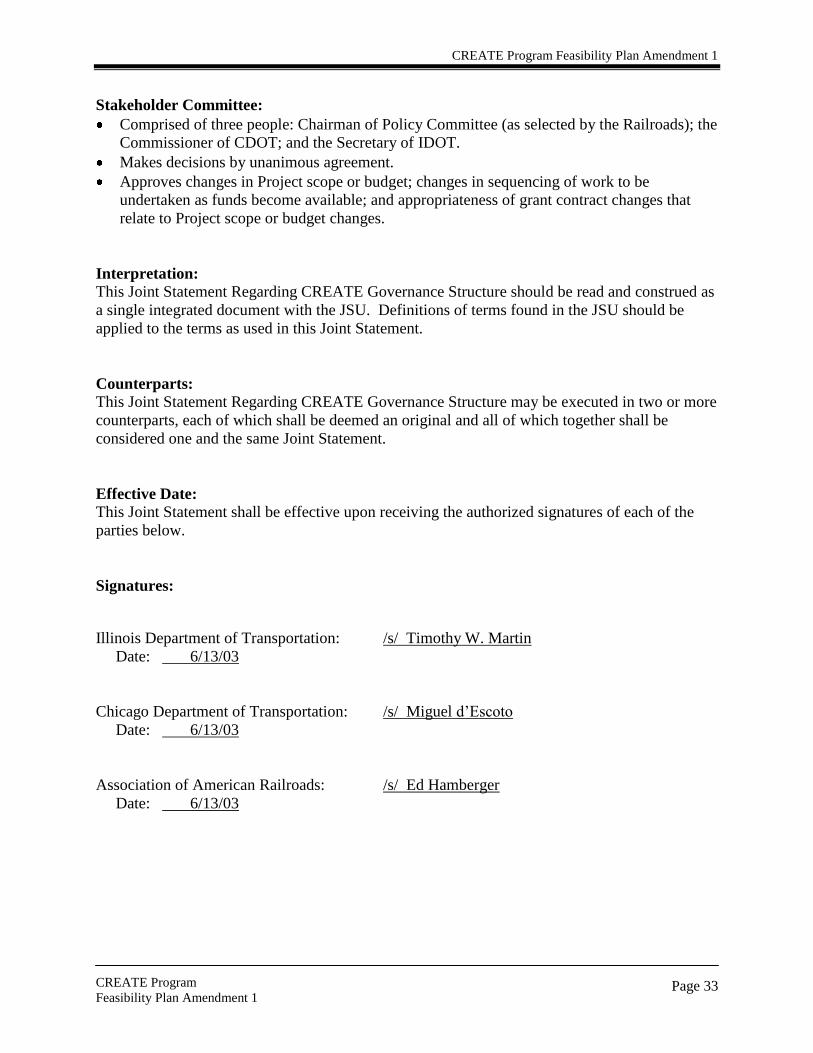
Stakeholder Committee:
Comprised of three people: Chairman of Policy Committee (as selected by the Railroads); the
Commissioner of CDOT; and the Secretary of IDOT.
Makes decisions by unanimous agreement.
Approves changes in Project scope or budget; changes in sequencing of work to be
undertaken as funds become available; and appropriateness of grant contract changes that
relate to Project scope or budget changes.
Interpretation: This Joint Statement Regarding CREATE Governance Structure should be read and construed as
a single integrated document with the JSU. Definitions of terms found in the JSU should be
applied to the terms as used in this Joint Statement.
Counterparts:
This Joint Statement Regarding CREATE Governance Structure may be executed in two or more
counterparts, each of which shall be deemed an original and all of which together shall be
considered one and the same Joint Statement.
Effective Date:
This Joint Statement shall be effective upon receiving the authorized signatures of each of the
parties below.
Signatures:
Illinois Department of Transportation: /s/ Timothy W. Martin
Date: 6/13/03
Chicago Department of Transportation: /s/ Miguel d‘Escoto
Date: 6/13/03
Association of American Railroads: /s/ Ed Hamberger
Date: 6/13/03
CREATE Program Feasibility Plan Amendment 1
CREATE Program
Feasibility Plan Amendment 1
Page 34
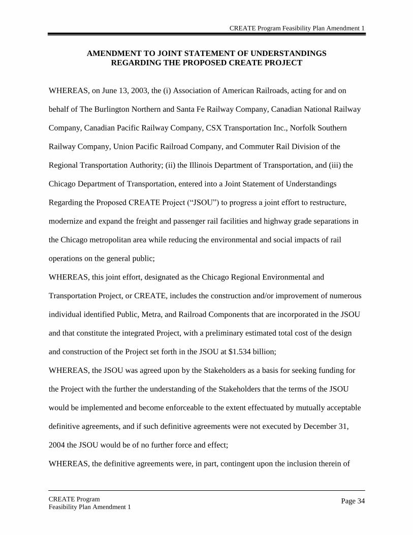
AMENDMENT TO JOINT STATEMENT OF UNDERSTANDINGS
REGARDING THE PROPOSED CREATE PROJECT
WHEREAS, on June 13, 2003, the (i) Association of American Railroads, acting for and on
behalf of The Burlington Northern and Santa Fe Railway Company, Canadian National Railway
Company, Canadian Pacific Railway Company, CSX Transportation Inc., Norfolk Southern
Railway Company, Union Pacific Railroad Company, and Commuter Rail Division of the
Regional Transportation Authority; (ii) the Illinois Department of Transportation, and (iii) the
Chicago Department of Transportation, entered into a Joint Statement of Understandings
Regarding the Proposed CREATE Project (―JSOU‖) to progress a joint effort to restructure,
modernize and expand the freight and passenger rail facilities and highway grade separations in
the Chicago metropolitan area while reducing the environmental and social impacts of rail
operations on the general public;
WHEREAS, this joint effort, designated as the Chicago Regional Environmental and
Transportation Project, or CREATE, includes the construction and/or improvement of numerous
individual identified Public, Metra, and Railroad Components that are incorporated in the JSOU
and that constitute the integrated Project, with a preliminary estimated total cost of the design
and construction of the Project set forth in the JSOU at $1.534 billion;
WHEREAS, the JSOU was agreed upon by the Stakeholders as a basis for seeking funding for
the Project with the further the understanding of the Stakeholders that the terms of the JSOU
would be implemented and become enforceable to the extent effectuated by mutually acceptable
definitive agreements, and if such definitive agreements were not executed by December 31,
2004 the JSOU would be of no further force and effect;
WHEREAS, the definitive agreements were, in part, contingent upon the inclusion therein of

CREATE Program Feasibility Plan Amendment 1
CREATE Program
Feasibility Plan Amendment 1
Page 35
binding commitments establishing the availability, on terms and conditions satisfactory to the
Participating Railroads of all Additional Funding (in excess of the Railroad Financial
Contribution) necessary to complete the entire Project;
WHEREAS, although it is presently deemed unlikely that the availability of the Additional
Funding will be established by December 31, 2004, the Stakeholders desire that efforts to
establish the availability of Additional Funding continue until June 30, 2005, and that the JSOU
remain in effect among the Stakeholders through such date; and
WHEREAS, the Participating Railroads are also willing to commence the construction and/or
improvement of certain Railroad Components prior to the execution by the Stakeholders of
definitive agreements regarding the Project, provided that the cost of completion of such
Railroad Components are credited against the respective Participating Railroad‘s obligations
under the JSOU.
NOW THEREFORE, the Stakeholders, as the date hereof, amend the JSOU as follows:
1. Section V of the JSOU is amended by deleting, on the fifth line, the date of
―December 31, 2004‖ and inserting in lieu thereof the date of June 30, 2005.
2. The following subsection 16 is added at the end of Section II:
―To the extent that any Participating Railroad undertakes the construction
and/or improvement of an individual Railroad or Metra Component after
October 1, 2004 and prior to the execution of the definitive agreements
described in Section V hereof, the investment of the Participating Railroad in
the design, construction, and/or implementation of such Railroad or Metra
Component shall be considered a contribution of the Participating Railroads to
the Project and shall be credited against the Railroad Financial Contribution

CREATE Program Feasibility Plan Amendment 1
CREATE Program
Feasibility Plan Amendment 1
Page 36
hereunder, provided that the Stakeholders approve the design, budget and
sequence for such Railroad or Metra Component construction and/or
improvement and such construction and/or improvement is otherwise in
accordance with the terms and conditions set forth herein. For each such
credited construction and/or improvement, the Stakeholders (through the
Management Committee described in the Joint Statement Regarding CREATE
Governance Structure executed by the Stakeholders on June 13, 2003) shall
thereafter also seek a determination from the U.S. Department of
Transportation that the construction and/or improvement meet eligibility
requirements for federal funding.‖
3. Except as otherwise provided herein, capitalized terms shall have the same meaning
as in the JSOU.
4. This Amendment to the JSOU may be executive in two or more counterparts, each of
which shall be deemed an original and all of which together shall be considered one
and the same statement.
5. This Amendment to the JSOU shall be effective upon receiving the authorized
signatures of each of the parties below.
Illinois Department of Transportation: _/s/ Timothy W. Martin_______________
Date: ____12/23/04___________
Chicago Department of Transportation: _/s/ Miguel d‘Escoto_________________
Date: ____12/23/04___________
Association of American Railroads: _/s/ Edward R. Hamberger____________
Date: ____12/23/04___________

CREATE Program Feasibility Plan Amendment 1
CREATE Program
Feasibility Plan Amendment 1
Page 37
SECOND AMENDMENT TO JOINT STATEMENT OF UNDERSTANDINGS
REGARDING THE PROPOSED CREATE PROJECT
WHEREAS, on June 13, 2003 the (i) Association of American Railroads, acting for and on
behalf of The Burlington Northern and Santa Fe Railway Company, Canadian National Railway
Company, Canadian Pacific Railway Company, CSX Transportation, Inc., Norfolk Southern
Railway Company, Union Pacific Railroad Company, and Commuter Rail Division of the
Regional Transportation Authority; (ii) the Illinois Department of Transportation, and (iii) the
Chicago Department of Transportation, entered into a Joint Statement of Understandings
Regarding the Proposed CREATE Project (―JSOU‖) to progress a joint effort to restructure,
modernize and expand the freight and passenger rail facilities and highway grade separations in
the Chicago metropolitan area while reducing the environmental and social impacts of rail
operations on the general public;
WHEREAS, this joint effort, designated as the Chicago Regional Environmental and
Transportation Project, or CREATE, includes the construction and/or improvement of numerous
individual identified Public, Metra, and Railroad Components that are incorporated in the JSOU
and that constitute the integrated Project, with a preliminary estimated total cost of the design
and construction of the Project set forth in the JSOU at $1.534 billion;
WHEREAS, the JSOU was agreed upon by the Stakeholders as a basis for seeking funding for
the Project with the further understanding of the Stakeholders that the terms of the JSOU would
be implemented and become enforceable to the extent effectuated by mutually acceptable
definitive agreements; and if such definitive agreements were not executed by December 31,
2004 (which was extended by an amendment to the JSOU to June 30, 2005), the JSOU would be
of no further force and effect;

CREATE Program Feasibility Plan Amendment 1
CREATE Program
Feasibility Plan Amendment 1
Page 38
WHEREAS, although it is presently deemed unlikely that the availability of the Additional
Funding will be established by June 30, 2005, the Stakeholders desire that efforts to establish the
availability of Additional Funding continue until December 31, 2005 and that the JSOU remain
in effect among the Stakeholders through such date;
WHEREAS, the JSOU envisioned that Amtrak may subsequently join in the effort on mutually
satisfactory terms and conditions; and
WHEREAS, Amtrak has reached a mutually satisfactory agreement with the Participating
Railroads as to Amtrak‘s current level of participation in the effort.
NOW THEREFORE, the Stakeholders, as the date hereof, amend the JSOU as follows:
1. Section V of the JSOU, as amended, is further amended by deleting, in the fifth
line, the date of ―June 30, 2005‖ and inserting in lieu thereof the date of
―December 31, 2005‖.
2. In the first paragraph of the PREAMBLE of the JSOU the last sentence is
stricken and the words ―National Railroad Passenger Corporation (Amtrak)‖
are added after ―(CSX),‖ in the fifth line.
3. Except as otherwise provided herein, capitalized terms shall have the same
meaning as in the JSOU.
4. This Amendment to the JSOU may be executed in two or more counterparts,
each of which shall be deemed an original and all of which together shall be
considered one and the same statement.

CREATE Program Feasibility Plan Amendment 1
CREATE Program
Feasibility Plan Amendment 1
Page 39
5. This Amendment to the JSOU shall be effective upon receiving the authorized
signatures of each of the parties below.
Illinois Department of Transportation: /s/ Timothy W. Martin
Date: June 24, 2005
Chicago Department of Transportation: /s/ Cheri Heramb
Date: June 24, 2005
Association of American Railroads: /s/ Ed Hamberger
Date: June 24, 2005

CREATE Program Feasibility Plan Amendment 1
CREATE Program
Feasibility Plan Amendment 1
Page 40
THIRD AMENDMENT TO JOINT STATEMENT OF UNDERSTANDINGS
REGARDING THE PROPOSED CREATE PROGRAM
WHEREAS, on June 13, 2003 the (i) Association of American Railroads, acting for and on
behalf of The Burlington Northern and Santa Fe Railway Company (hereinafter referred to as
―BNSF Railway Company‖), Canadian National Railway Company, Canadian Pacific Railway
Company, CSX Transportation, Inc., Norfolk Southern Railway Company, Union Pacific
Railroad Company, and Commuter Rail Division of the Regional Transportation Authority (and,
by amendment dated June 24, 2005, the National Railroad Passenger Corporation); (ii) the
Illinois Department of Transportation, and (iii) the City of Chicago, acting by and through its
Department of Transportation (―City‖), entered into a Joint Statement of Understandings
Regarding the Proposed CREATE Project (hereinafter referred to as ―Program‖) (―JSOU‖) to
progress a joint effort to restructure, modernize and expand the freight and passenger rail
facilities and highway grade separations in the Chicago metropolitan area while reducing the
environmental and social impacts of rail operations on the general public; and
WHEREAS, this joint effort, designated as the Chicago Region Environmental and
Transportation Efficiency Program, or CREATE, includes the construction and/or improvement
of numerous individual identified Public, Metra, and Railroad Components that are incorporated
in the JSOU and that constitute the entire Program, with a preliminary estimated total cost of the
design and construction of the Program set forth in the JSOU at $1.534 billion; and
WHEREAS, the JSOU was agreed upon by the Stakeholders as a basis for seeking funding for
the Program with the further understanding of the Stakeholders that the terms of the JSOU would
be implemented and become enforceable to the extent effectuated by mutually acceptable
definitive agreements; and if such definitive agreements were not executed by December 31,

CREATE Program Feasibility Plan Amendment 1
CREATE Program
Feasibility Plan Amendment 1
Page 41
2004 (which was extended by two previous amendments to the JSOU to December 31, 2005),
the JSOU would be of no further force and effect; and
WHEREAS, notwithstanding that the availability of Additional Funding was not established as
of December 31, 2005, the Stakeholders believe that certain identified Program benefits can be
realized by the completion of a portion of the Program Components comprising elements of the
entire Program (―Initial Components‖); and
WHEREAS, the Stakeholders are willing to move forward toward implementation of the Initial
Components under certain specific terms and conditions and subject to certain contingencies as
described herein; and
WHEREAS, the parties are further willing to support efforts to continue to seek the Additional
Funding necessary to implement the entire Program as contemplated by the JSOU.
NOW THEREFORE, the Stakeholders, as of the date hereof, hereby agree to amend the JSOU as
follows:
1. The Components set forth and described in Attachment 1 hereto, with the total cost
shown as $331 million, comprise the Initial Components which will be moved
forward if the conditions and contingencies stated in Sections 2 through 7 below are
met.
2. The Participating Railroads‘ direct monetary contribution to the Initial Components is
limited to $101 million (―Initial Components Railroad Financial Contribution‖). The
Initial Components Railroad Financial Contribution shall be applied to any of the
Projects listed in Attachment 1 other than the Highway-Rail Grade Separations
Project shown as the first Project on Attachment 1 (―Highway-Rail Grade Separations
Project‖); provided, however, that Amtrak‘s contribution shall be applied only to

CREATE Program Feasibility Plan Amendment 1
CREATE Program
Feasibility Plan Amendment 1
Page 42
Project P-1. (Metra‘s contribution is subject to the receipt of necessary State of
Illinois transportation funding which has yet to be authorized.)
3. Public funds consisting of federal funds in the amount of $100 million, or so much
thereof as may be made available to IDOT by actions of the federal government
including but not limited to obligation limitations, recissions, and allocations (positive
or negative) of revenue aligned budget authority, shall be contributed to any of the
Projects comprising the Initial Components, other than the Highway-Rail Grade
Separations Project. Such funds shall be administered and contributed through and
by IDOT and shall constitute a portion of the Initial Components Additional Funding.
The Initial Components Railroad Financial Contribution shall be contingent upon the
availability and receipt of such public funds.
4. As set forth in Attachment 1, the cost of the Projects, other than the Highway-Rail
Grade Separations Project, is $231 million. To cover the full costs of such Projects,
funding from City in the amount of $30 million is anticipated; and such funding shall
constitute a portion of the Initial Components Additional Funding. While City
believes such public funding will be forthcoming, the funding shall be subject to
City‘s legislative authorization and the availability of federal and state funds (other
than those contemplated in Sections 2 and 3 above) but shall not be a condition for
the Initial Components Railroad Financial Contribution or the other portions of the
Initial Components Additional Funding; provided, however, that the definitive
agreements referenced in Section 6 below will address any changes in the event that
any or all of such funding from City is not realized.

CREATE Program Feasibility Plan Amendment 1
CREATE Program
Feasibility Plan Amendment 1
Page 43
5. Public funding for the Highway-Rail Grade Separations Project in the amount of $100
million shall be from IDOT and subject to Illinois legislative authorization. Such
funding shall constitute a portion of the Initial Components Additional Funding;
however, such funding shall not be a condition for the Initial Components Railroad
Financial Contribution or the other portions of the Initial Components Additional
Funding described herein; provided, however, that the definitive agreements
referenced in Section 6 below will address any changes necessary in the event that
any or all of such funding from IDOT is not realized. Funding for the Highway-Rail
Grade Separations Project will be provided as set forth in Attachment 1. The City‘s
funding could be expended on the Highway-Rail Grade Separations Project if: (a)
such funding is necessary to complete such Project; (b) at least $25 million of City‘s
funding has been made available for the other Projects listed in Attachment 1, other
than OP-5; and (c) all of the Stakeholders agree.
6. Pursuant to Article V of the JSOU, the terms of the JSOU, as amended, will be
implemented and become enforceable to the extent effectuated by definitive
agreements, containing such terms and conditions as are mutually satisfactory to the
Stakeholders. Article V of the JSOU, as previously amended, is hereby further
amended by deleting, in the fifth line, the date of ―December 31, 2005‖ and inserting
in lieu thereof the date of ―December 31, 2009‖. Such definitive agreements will
include, without limitation, agreements as to the amount of work to be completed, the
sequence, the schedule, and the funding requirements for the progression of each of
the Projects in Attachment 1 and the availability, on terms and conditions satisfactory
to the Stakeholders, of the public funding referenced in Section 3 above and of all

CREATE Program Feasibility Plan Amendment 1
CREATE Program
Feasibility Plan Amendment 1
Page 44
third party properties necessary to complete the Initial Components. The definitive
agreement among the Stakeholders to replace this JSOU, as amended, shall also
address: (a) the process for prioritizing or modifying the Projects in the event that the
aggregate costs exceed the Initial Components Railroad Financial Contribution and
the Initial Components Additional Funding, due to any shortfalls in federal funding to
be contributed to the Program or due to the unavailability of any or all of the
anticipated public funding from City or from IDOT; and (b) an appropriate
governance structure for the Initial Components which takes into account the extent
to which each of the Stakeholders have met their respective contribution targets
hereunder.
7. Notwithstanding the provisions of Article IV of the JSOU, as amended, the Initial
Components Railroad Financial Contribution and the Initial Components Additional
Funding shall be in addition to, and not offset by, any IDOT or Participating Railroad
financial contribution made in accordance with said Article IV.
8. The Stakeholders agree to advocate that priority for any additional public funding
received for a subsequent phase of the CREATE Program be given to Project P-2.
This provision shall not be construed to prohibit securing or expending designated
funding for other CREATE Projects in the Initial Components or any subsequent
Components.
9. In the first and second lines of the PREAMBLE of the JSOU, the word ―Project‖ is
stricken and the word ―Program‖ is inserted in lieu thereof; and, in the JSOU and all
three amendments thereto (including the titles of the documents), the term ―Project‖

CREATE Program Feasibility Plan Amendment 1
CREATE Program
Feasibility Plan Amendment 1
Page 45
when used to refer to the CREATE Program shall be deleted and the term ―Program‖
shall be inserted in lieu thereof.
10. In the JSOU and all three amendments thereto, the term ―Chicago Department of
Transportation‖ shall be replaced by ―City of Chicago, acting by and through its
Department of Transportation‖ and the term ―CDOT‖ shall be replaced by ―City‖
wherever such terms appear.
11. Paragraph 7 of Article II of the JSOU is amended by striking the following in the
tenth and eleventh lines: ―rail-to-rail grade separation.‖
12. Paragraph 9 of Article II of the JSOU is amended by adding the following after the
words ―environmental mitigation‖ in the sixth line: ―demolition of existing buildings,
securing of parcels,‖.
13. Paragraph 5 of Article II of the JSOU is amended by adding at the end thereof the
following sentence: ―The Stakeholders acknowledge that all such government
funding will represent a capital contribution to the Program and not payment in
exchange for services or property provided, or to be provided, by the Participating
Railroads.‖
14. Except to the extent inconsistent with the terms of this Third Amendment, all of the
provisions of the JSOU will apply to the Initial Components as if: (a) the Initial
Components were the Program; (b) the Initial Components Railroad Financial
Contribution were the Railroad Financial Contribution; (c) the Initial Components
Additional Funding were the Additional Funding and (d) Attachment 1 hereto were
the Plan and Exhibit C with respect to the identification of the Components.

CREATE Program Feasibility Plan Amendment 1
CREATE Program
Feasibility Plan Amendment 1
Page 46
15. Except as otherwise provided herein, capitalized terms shall have the same meaning as
in the JSOU.
16. The JSOU (including the provisions of Article V regarding definitive agreements), as
previously amended and as further amended hereby, is reinstated by the Stakeholders
and remains in full force and effect with respect to the Initial Components. In all
other respects, no party shall have any other liability or obligation under the JSOU, as
amended; provided, however, that: (1) the Stakeholders will continue to support
efforts to seek the Additional Funding necessary to move forward the entire Program
originally contemplated by the JSOU; and (2) if the Additional Funding is realized,
the Stakeholders further agree to work, at such time, in good faith to effect a
definitive agreement for the entire Program which, taking into account any changed
circumstances, reflects as closely as possible the objectives, understandings, and
railroad contribution limitations regarding the entire Program as set forth in the
original JSOU.
17. This Third Amendment to the JSOU may be executed in two or more counterparts,
each of which shall be deemed an original and all of which together shall be
considered one and the same statement.
18. This Third Amendment to the JSOU shall be effective upon receiving the authorized
signatures of each of the parties below.

Illinois Department of Transportation:
By: /s/ Milton R. Sees
Date: 2/9/09
City of Chicago, acting by and through its Department of Transportation:
By: /s/ Thomas G. Byrne
Date: 12/16/08
Association of American Railroads:
By: /s/ Edward R. Hamberger
Date: 11/24/08

CREATE Program Feasibility Plan Amendment 1
CREATE Program
Feasibility Plan Amendment 1
Page 48

CREATE Program Feasibility Plan Amendment 1
CREATE Program
Feasibility Plan Amendment 1
Page 49

CREATE Program Feasibility Plan Amendment 1
CREATE Program
Feasibility Plan Amendment 1
Page 50

CREATE Program Feasibility Plan Amendment 1
CREATE Program
Feasibility Plan Amendment 1
Page 51

CREATE Program Feasibility Plan Amendment 1
CREATE Program
Feasibility Plan Amendment 1
Page 52
Program Level Goals and Strategies
1.1 Goals and Strategies
Chicago, the nation‘s preeminent rail hub, consists of 2,796 miles of existing rail network
encompassing an area of 16,000 acres. Currently 37,500 rail cars per day travel through the
Chicago hub each year, with this number expected to increase to 67,000 per day by 2020. The
existing system experiences motorist, passenger and freight rail delays and congestion on a daily
basis. If changes to the system are not implemented, these issues will only get worse. Failure to
address these issues will have major effects not only locally but nationally. The local effects
alone are enormous:
If rail capacity issues are not addressed studies show that Chicago will lose $2 billion in
production and 17,000 jobs in the next two decades.
If rail capacity issues are not addressed, freight that is carried by rail will now move to
truck, increasing congestion and increasing air pollutant emissions on our highways. The
demands upon the local roads and highways in the Chicago region will be overwhelming
if this freight is moved from steel wheel to rubber tire.
If rail capacity issues are not addressed, delay to METRA passengers will increase.
Currently 73 million local passenger trips are logged annually, relieving substantial stress
on the highway system.
The national implications of a failure to act are likewise debilitating:
When multiplier effects are included, the Chicago rail network is associated with 5
million jobs nationwide, $782 billion in output and $217 billion in annual wages. For
over 150 years, Chicago has been the rail capital of the nation and the world.
Chicago is the only city in the country where six major North American railroads meet to
interchange freight. Failing to address these infrastructure issues will trickle down to
inefficiencies throughout the nationwide freight network.
Seven of the rail lines entering Chicago are part of the Strategic Rail Corridor Network,
rail lines that are critical to national defense.
The State of Illinois and the City of Chicago have joined with the passenger and freight railroads
serving the Chicago region to establish Program Level Goals and Strategies of the CREATE
Program to address these issues. The Program level goals of the CREATE Program were
developed and are as follows:
Improve the efficiency and reliability of local and national passenger and freight rail
service in and through the Chicago region;
Reduce motorist, passenger rail and freight rail delays to travel in and through the
Chicago region;
Reduce highway and rail traffic congestion in the Chicago region;
Improve rail-highway grade crossing safety in the Chicago region;
Provide national, regional and local economic benefits;

CREATE Program Feasibility Plan Amendment 1
CREATE Program
Feasibility Plan Amendment 1
Page 53
Provide environmental (air quality) benefits for the Chicago region; and
Provide national, regional and local energy benefits.
The following sections describe the strategies developed in the CREATE Program to achieve
these identified goals.
1.1.1 Goal: Improve the efficiency and reliability of local and national passenger and
freight rail service in and through the Chicago region
Strategies:
Provide a rail transportation system that will meet future rail traffic demands.
Reduce passenger rail to freight rail conflict points.
Provide rail traffic operations upgrades.
Increase passenger rail capacity.
Improve intermodal operations (rail to truck transfers).
1.1.2 Goal: Reduce motorist, passenger rail and freight rail delays to travel in and
through the Chicago region.
Strategies:
Encourage passenger rail ridership.
Reduce rail to highway conflict points.
Reduce passenger rail to freight rail conflict points.
Provide rail traffic operations upgrades.
1.1.3 Goal: Reduce highway and rail traffic congestion in the Chicago region.
Strategies:
Reduce rail to highway conflict points.
Reduce passenger rail to freight rail conflict points.
Provide rail traffic operations upgrades.
Encourage passenger rail ridership.
1.1.4 Goal: Improve rail-highway grade crossing safety in the Chicago region.
Strategies:
Reduce rail to highway conflict points.
Encourage passenger rail ridership.

CREATE Program Feasibility Plan Amendment 1
CREATE Program
Feasibility Plan Amendment 1
Page 54
1.1.5 Goal: Provide national, regional and local economic benefits.
Strategies:
Achievement of goals 1.1.1 through 1.1.3 above. This will:
o reduce the size of inventories required to be kept by rail customers;
o maximize freight rail customer responsiveness and flexibility to their own
customers;
o result in time savings (economic savings) for motorist, passenger and freight rail;
o encourage increased ridership of passenger rail (thus helping more to reduce
delays and congestion); and
o reduce investment in new highway construction.
Achievement of goal 1.1.4 above. This will:
o Reduce accidents and associated cost of property damage, personal injuries, and
fatalities.
Closing of the St. Charles Airline. This will result in residential and commercial
development in this area and will provide a permanent tax revenue increase.
Re-routing of existing rail traffic away from the St. Charles Airline. This will allow for
possible re-purposing this corridor to serve future public needs.
Successful implementation of the CREATE Program. This will provide construction
related economic benefits such as jobs, materials, and services. This will also prevent the
loss of production and jobs in the next two decades.
1.1.6 Goal: Provide environmental (air quality) benefits for the Chicago region.
Strategies: Achievement of goals 1.1.1 through 1.1.3 above. This will:
o reduce train emissions due to reduction in train idling times caused by delays; and
o reduce motor vehicle emissions due to reduction idling times caused by delays.
1.1.7 Goal: Provide national, regional and local energy benefits.
Strategies: Achievement of goals 1.1.1 through 1.1.3 above. This will:
o Reduce the amount of energy consumption from trains and motor vehicles due to
reduction in idling times caused by delays.
1.2 Conclusion
The Goals and Strategies described above were then used in the decision-making process to
identify transportation improvement projects that would successfully achieve the stated goals.
The full implementation of these projects will improve the efficiency and reliability of the
passenger and freight rail service, reduce delays and congestion, improve safety, and provide
economic, environmental and energy benefits for the region.

CREATE Program Feasibility Plan Amendment 1
CREATE Program
Feasibility Plan Amendment 1
Page 55
Component Project Chronology and Selection Rationale Early Studies and Public Planning Efforts:
The Chicago Area Transportation Study (CATS), which is also the Chicago region‘s
Metropolitan Planning Organization (MPO), has long recognized the need to consider rail freight
in its regional planning efforts. It has published brochures and convened committee meetings to
foster a greater understanding regarding the significance of this sector in the Chicago region and
to develop plans for freight transportation improvements.
A June 1990 CATS report entitled ―Freight Movements and Urban Congestion in the Chicago
Area‖ sought to ―solicit participation from the freight industry… and to recommend or
incorporate freight oriented measures into the comprehensive program‖1. While the report
projected future growth, it focused on the impact of grade crossings, viaduct clearance
limitations and truck congestion on highways.
In 1993, the Chicagoland Chamber of Commerce set up an Intermodal Task Force, consulting
with the City of Chicago Department of Transportation (CDOT), the City of Chicago
Department of Planning and Development (DPD), CATS and the Illinois Department of
Transportation (IDOT). They provided testimony on the need for greater freight planning as part
of the 2010 Transportation Plan public hearing process, and indicated the need for freight
planning to be included in the 2020 plan2.
Even earlier studies had been prepared proposing elimination of the St. Charles Airline which
runs through an area south of Chicago‘s central business district where new residential growth
has been occurring. The line runs under McCormick Place and then west parallel to 16th
Street,
crossing the Metra Rock Island Main Line and then west over the South Branch of the Chicago
River. This line restricts development in the area and gives rise to commuter/freight conflicts
with Metra‘s operation in and out of LaSalle Street Station.
CDOT and IDOT studied alternative routes to eliminate the St. Charles Airline as early as 1984
with up to six possible routes being considered3. In the mid 1990s, a proposed route was
developed using an out of service section of a Norfolk Southern (NS) line in the Grand Crossing
neighborhood connecting to the Conrail (CR) Chicago Line near 73rd Street. In May 1994, a
report prepared by DPD was presented to the Chicago Plan Commission requesting the
Commission to call for negotiations that would result in abandonment of the St. Charles Airline
and a plan for redevelopment of the area4. The report lists the extensive public benefits to be
realized from this action.
1 ―FREIGHT MOVEMENTS AND URBAN CONGESTION IN THE CHICAGO AREA – Report on Freight
Activities for Operation Green Light‖, John P. Reilly, Chief Freight Planner, Chicago Area Transportation Study,
June 1990. 2 ―Recent Actions of the Chicagoland Chamber of Commerce‘s Intermodal Task Force‖, Intermodal Task Force,
October 6, 1993. 3 ―Replacing St. Charles Airline/Bridgeport District IC‖, Illinois Department of Transportation Memorandum,
January 26, 1990. 4 ―REPORT OF THE CHAIRMAN ON THE PROPOSED ABANDONMENT OF THE ST. CHARLES AIR
LINE‖, Chicago Plan Commission, May 25, 1994.

CREATE Program Feasibility Plan Amendment 1
CREATE Program
Feasibility Plan Amendment 1
Page 56
Three years later, a civic organization, Lambda Alpha International, convened a one day
symposium on the St. Charles Airline issue and invited railroad officials, planners, developers,
financial analysts and other civic groups to consider the issue and make recommendations. The
report on the results of this Community Assistance Panel Program prophetically recommends
that ―It is necessary to examine rail consolidation on a more comprehensive basis by determining
the actual costs and implications associated with relocation, traffic patterns, aging infrastructure,
dated buildings, and the effect on Union Pacific, Wisconsin Central, Metra, Amtrak and others…
The railroad participants need internal systems that can effectively address issues pertaining to
operating control‖5.
1998 - Industry Mergers and Severe Winter Focus Public Attention on Need for Freight
Planning
During the winter of 1998-1999, a severe snowstorm paralyzed the freight rail service in Chicago
and the resulting freight congestion hampered Metra service. At the same time, the Canadian
National Railway was seeking federal approval from the Surface Transportation Board (STB) to
acquire the Illinois Central, which was the major freight user of the St. Charles Airline. The City
of Chicago urged the STB to not permit the merger until the abandonment of the St. Charles
Airline had been resolved, since increased rail traffic from the merger would have negative
community impacts6. The pending purchase and split of Conrail by NS and CSX also was
expected to result in traffic flow changes that needed to be considered.
In early 1999, the Association of American Railroads (AAR) created the Chicago Planning
Group (CPG), made up of members of each Class I freight railroad servicing the Chicago region,
plus the Belt Railway Company, Illinois Harbor Belt Railroad, Amtrak and Metra, to study and
recommend solutions to the congestion that limited rail operations in the region. An article
written by a former Federal Railroad Administrator for an industry magazine captures the almost
historical significance of the establishment of the CPG, the importance of the region to the
national rail freight network, and the need for a comprehensive plan to address growth and
minimize congestion7. At the same time, U.S. Congressman William Lipinski, whose district is
crisscrossed by at-grade railroad tracks, called publicly for an Alameda corridor type program for
the Chicago region to address freight and passenger traffic congestion8.
The CPG studied potential improvements including improved signaling, expansion of main track
capacity, and grade separation of some Metra operations from freight routes on the south and
southwest side of Chicago. The CPG also collected lists of highway rail grade crossings that
were problematic for rail operations and highway users and created a grade separation priority
listing. As noted in Crain‘s Chicago Business, one of the biggest issues to be addressed was rail
and highway crossings9. The proposed rail infrastructure and highway grade separation project
5 ―THE ST. CHARLES AIRLINE: A ONCE AND FUTURE GREENWAY?‖, Community Assistance Panel
Program Report, March 4, 1997. 6 ―Fight over train tracks threatens rail merger‖, CRAIN‘S Chicago Business, Kevin Knapp, December 14, 1998.
7 ―VIEWPOINT – One small step in Chicago‖, Gil Carmichael.
8 ―A plan to uncork rail bottleneck‖, Chicago Tribune, John Schmeltzer, April 7, 1999.
9 ―Untangling Chicago‘s snarled rail system‖, CRAIN‘S Chicago Business, Kevin Knapp, June 14, 1999.

CREATE Program Feasibility Plan Amendment 1
CREATE Program
Feasibility Plan Amendment 1
Page 57
lists were completed in a study dated June 199910
. However, in the absence of a means to
evaluate the effectiveness of proposed improvements and their potential for public benefits, the
plan did not move forward. To aid in studying the Chicago Terminal, the CPG authorized the
development of a computer model to simulate freight and passenger operations in Chicago.
1999 – 2001 CTCO Established and Planning Continues
In late 1999, the Chicago Transportation Coordination Office (CTCO) was established by the
CPG to develop managerial solutions wherever possible to railroad operating problems in
Chicago, to work with public agencies on the public impacts of rail service, and to assist in
continuing the capital planning process. Housed in a Metra facility on the south side of
downtown, the CTCO first attacked operational problems that could be resolved without capital
expenditures. Coordination and communication was improved between railroads to minimize
train idling in neighborhoods due to trains waiting for another railroad‘s crew to take over
operation of the train, or waiting for track space to clear up in a freight yard.
An emergency operations process was established so that when a flood in the Midwest, a strike
on the West Coast, a blizzard in the region or a bridge outage in the East disrupted normal freight
train patterns, agreed upon re-routings and staging outside of the region would minimize
congestion and ensure the network would become fluid as soon as feasible. When Chicago
officials raised concerns that ―911‖ emergency routes were periodically being blocked by trains,
a process was set up to minimize such occurrences, and also to advise emergency responders
when a problem kept the crossing blocked longer than an agreed upon amount of time.
Finally, between 1998 and 2003, the railroad industry was investing over $1.2 billion of capital
in infrastructure replacements or improvements for the region. To minimize the disruption this
construction could cause, the CTCO regularly reviewed all railroad‘s proposed construction
schedules and coordinated projects to ensure undue disruption would not occur due to such
construction.
While such efforts did much to reduce delays, there was still agreement that capital
improvements were needed to address the concerns raised. In spring of 2000, a civic planning
organization, the Metropolitan Planning Council, sponsored a conference of business leaders and
experts to discuss the region‘s freight infrastructure, what other regions of the country were
doing to address freight mobility, and what future conditions could be anticipated. After this
conference, a Freight Transportation Working Group was set up by civic groups to research the
issue further and make recommendations to the region‘s planners and leaders.
In December 2000, Mayor Daley of the City of Chicago wrote the STB noting the importance of
the region to the nation‘s rail industry and the economy, but stressing the need for coordinated
10
―Report of the Infrastructure Committee to the Chicago Planning Committee‖, June 1999.

CREATE Program Feasibility Plan Amendment 1
CREATE Program
Feasibility Plan Amendment 1
Page 58
planning11
. The STB responded in January 2001 with a letter to the AAR asking that further
coordination and planning occur12
.
In spring 2001, the Chicago Rail Task Force was established, including representatives from
freight railroads and CDOT with goals that included improving communication, addressing
community issues, and developing solutions to long-term regional rail issues. The task force
continued to meet throughout the year and sought a plan that would address growth and
congestion twenty years hence.
2002: Computer Model Analyzes Improvements and Public Involvement
In April 2002, Business Leaders for Transportation published a report entitled ―Critical Cargo: A
Regional Freight Action Agenda‖13
. This group was led by Chicago Metropolis 2020
(established by the Commercial Club of Chicago), the Chicagoland Chamber of Commerce and
the Metropolitan Planning Council and was a follow up to the 2000 conference noted earlier. The
report cites the significance of rail freight to the region and makes three recommendations:
1. ―Organize public/private support for a package of priority capital improvements to
the region‘s freight network that will expand capacity, lessen gridlock, and support
job expansion‖, including joint-use freight corridors, construction of 40 highway/rail
grade separations and upgrading of 55 miles of intermodal connector highways.
2. ―Secure $20 million in federal funding support over the next two years to cover the
public portion of planning for the priorities above.‖
3. Establish a public/private entity to plan, coordinate and finance improvements to the
region‘s freight transportation system.
The report was well received and the press covered its findings.
The CPG retained a consultant to run computer simulation of the region‘s rail network. The
simulation was done using software called Rail Traffic Controller (RTC) developed by Berkley
Simulation, a company based in Berkley, CA.
The simulation model covered 893 miles of main and terminal track in the region, consisting of
119 interlockings, 4698 control points, and nearly 3000 freight and passenger trains with
operations defined over a 96-hour period of actual operation in mid November 1999.
Operational data was collected for the 96 hour base period which ran from Wednesday at noon to
Sunday at noon to test both weekday and weekend operations. From the base period operational
data the first simulation model (known as the Base Case) was completed in January 2001. After
11
December 20, 2000 letter from Mayor Richard M. Daley to Linda Morgan, Chairman of the Surface
Transportation Board. 12
January 26, 2001 letter from Linda Morgan, Chairman of the Surface Transportation Board to Edward R.
Hamberger, President and CEO, Association of American Railroads. 13
―CRITICAL CARGO – A Regional Freight Action Agenda for jobs, economic growth and quality of life in
metropolitan Chicago‖, Business Leaders for Transportation, April 2002.
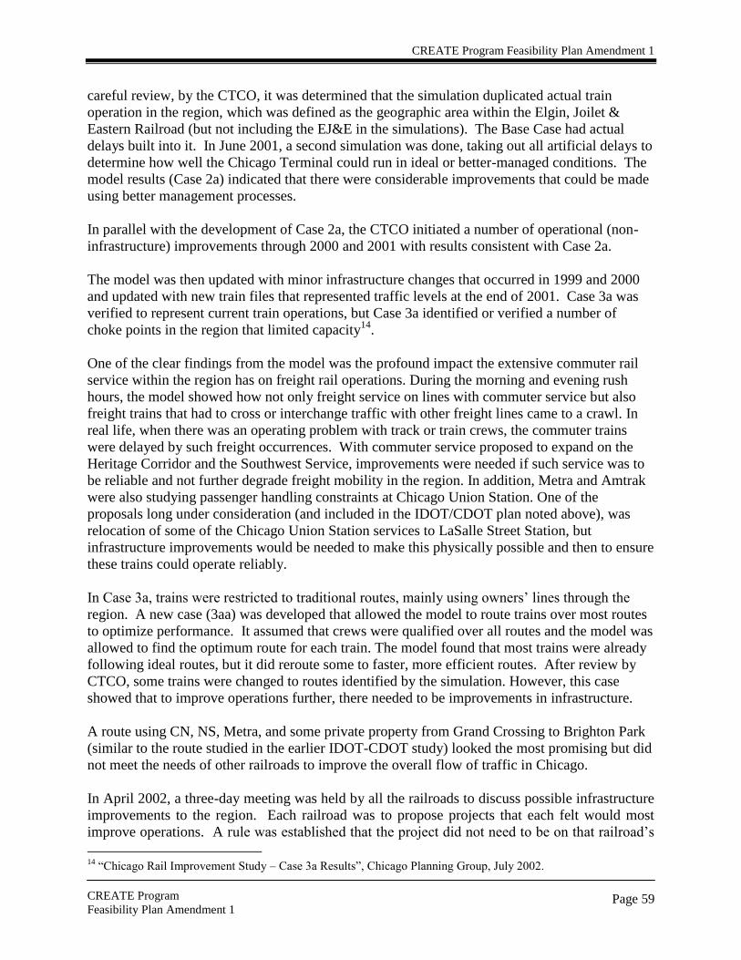
CREATE Program Feasibility Plan Amendment 1
CREATE Program
Feasibility Plan Amendment 1
Page 59
careful review, by the CTCO, it was determined that the simulation duplicated actual train
operation in the region, which was defined as the geographic area within the Elgin, Joilet &
Eastern Railroad (but not including the EJ&E in the simulations). The Base Case had actual
delays built into it. In June 2001, a second simulation was done, taking out all artificial delays to
determine how well the Chicago Terminal could run in ideal or better-managed conditions. The
model results (Case 2a) indicated that there were considerable improvements that could be made
using better management processes.
In parallel with the development of Case 2a, the CTCO initiated a number of operational (non-
infrastructure) improvements through 2000 and 2001 with results consistent with Case 2a.
The model was then updated with minor infrastructure changes that occurred in 1999 and 2000
and updated with new train files that represented traffic levels at the end of 2001. Case 3a was
verified to represent current train operations, but Case 3a identified or verified a number of
choke points in the region that limited capacity14
.
One of the clear findings from the model was the profound impact the extensive commuter rail
service within the region has on freight rail operations. During the morning and evening rush
hours, the model showed how not only freight service on lines with commuter service but also
freight trains that had to cross or interchange traffic with other freight lines came to a crawl. In
real life, when there was an operating problem with track or train crews, the commuter trains
were delayed by such freight occurrences. With commuter service proposed to expand on the
Heritage Corridor and the Southwest Service, improvements were needed if such service was to
be reliable and not further degrade freight mobility in the region. In addition, Metra and Amtrak
were also studying passenger handling constraints at Chicago Union Station. One of the
proposals long under consideration (and included in the IDOT/CDOT plan noted above), was
relocation of some of the Chicago Union Station services to LaSalle Street Station, but
infrastructure improvements would be needed to make this physically possible and then to ensure
these trains could operate reliably.
In Case 3a, trains were restricted to traditional routes, mainly using owners‘ lines through the
region. A new case (3aa) was developed that allowed the model to route trains over most routes
to optimize performance. It assumed that crews were qualified over all routes and the model was
allowed to find the optimum route for each train. The model found that most trains were already
following ideal routes, but it did reroute some to faster, more efficient routes. After review by
CTCO, some trains were changed to routes identified by the simulation. However, this case
showed that to improve operations further, there needed to be improvements in infrastructure.
A route using CN, NS, Metra, and some private property from Grand Crossing to Brighton Park
(similar to the route studied in the earlier IDOT-CDOT study) looked the most promising but did
not meet the needs of other railroads to improve the overall flow of traffic in Chicago.
In April 2002, a three-day meeting was held by all the railroads to discuss possible infrastructure
improvements to the region. Each railroad was to propose projects that each felt would most
improve operations. A rule was established that the project did not need to be on that railroad‘s
14
―Chicago Rail Improvement Study – Case 3a Results‖, Chicago Planning Group, July 2002.

CREATE Program Feasibility Plan Amendment 1
CREATE Program
Feasibility Plan Amendment 1
Page 60
route. The projects could be on the switch carriers or even on the lines of roads with which the
proposing railroad interchanged.
Over a hundred projects were proposed, but it soon became apparent that many railroads had
proposed the same projects and that 88% of the projects fell on a group of tracks, later identified
as the Beltway, East West, Western Ave. and Passenger Corridors. During the next few months,
through a collaborative and iterative process, the projects were refined with better cost estimates
and design changes. Some were set aside as the railroads felt they represented excess capacity in
areas that currently were not congested. The final group of projects was developed in August
2002. After careful review by all the freight railroads, Metra and Amtrak, the plan was not
approved, as there was no consensus on the plan.
During the fall and winter of 2002/2003, work groups continued to work to refine the plan to be
acceptable to all parties. The route that had been earlier studied by IDOT and CDOT and later
by the CN and NS was reviewed and modified. A route named the Central Corridor was
engineered and added to the August 2002 plan with other projects dropped on the Beltway
Corridor due to the capacity created on the Central Corridor. Some changes were also made in
the grade separation projects due to traffic flow diversion to the Central Corridor. CDOT also
requested the inclusion of additional improvements in the plan, and budgets for viaduct repair
and crossing safety improvements15
.
As part of the CTCO‘s work with the City of Chicago on ―911‖ grade crossings, a list of such
critical crossings within the City was developed and provided to the CTCO. This list was
considered when assembling the top priority crossings for grade separation. An Illinois
Commerce Commission working paper on grade crossing delay identified the thirty crossings in
the region that were estimated to delay the greatest number of vehicles and the thirty that caused
the greatest amount of time delay. These lists were considered in identifying high priority
crossings for separations. The DuPage Council of Mayors had its list of priority crossings for
grade separations, which was also considered. Also, the Critical Cargo report included a listing
of 19 grade crossings that CATS had identified as problems, based largely on US DOT
calculations of relative risk for accidents at individual crossings.
A new case of the simulation model was prepared, 5aa, which utilized 2002 train traffic volumes,
process improvements, full implementation of the CREATE program, and allowed the model to
find the optimum route for each train. Case 5aa demonstrated that many of the choke points had
been addressed with quantifiable operational improvements. IDOT and CDOT then reviewed
the plan, proposed minor changes and a final plan, as revised, was issued June 6, 200316
. It is
this collection of components that are the subject of this process. At least two more simulation
runs of the model will be developed that include future levels of train traffic volumes for the no
build and full implementation of the CREATE program. The results from these simulations will
be used to assess the impacts of each project during the NEPA process.
15
September 20, 2002 letter from Miguel d‘Escoto, Commissioner, Chicago Department of Transportation to
Edward R. Hamberger, President and CEO, Association of American Railroads. 16
―CREATE – Chicago Region Environmental And Transportation Efficiency Project‖, June 6, 2003.
Subsequently, the June 6 plan was slightly revised and an August 1, 2003 version was completed.

CREATE Program Feasibility Plan Amendment 1
CREATE Program
Feasibility Plan Amendment 1
Page 61
Later in June 2003, IDOT, CDOT and AAR entered into a ―Joint Statement of Understandings
Regarding the Proposed CREATE Project‖ (JSU)17
(17). The JSU outlines the significance of
rail mobility to the region, the commitment of the parties to pursue a combination of public and
private funding for the proposed project, and which parties are responsible for constructing
which components.
Component projects shall not be added to or deleted from the Program or materially changed,
without the unanimous consent of all Stakeholders. Changes in sequencing of the component
projects as described in the JSU are subject to agreement by all of the Stakeholders. Any
Management Committee Member that identifies a need for significant modification to an existing
component project, or the addition or deletion of a component project, must submit the proposal
to the Management Committee for review and approval. If approved, the Management
Committee will submit these changes to the Stakeholder Committee for final approval.
Subsequent to this approval, there would be a determination of the need to revise this Feasibility
Plan. The Preliminary Screening document would be modified to reflect the change. An ECAD
would be prepared if an existing component project was significantly modified or a new
component project was added.
17
―Joint Statement of Understandings Regarding the Proposed CREATE Project‖
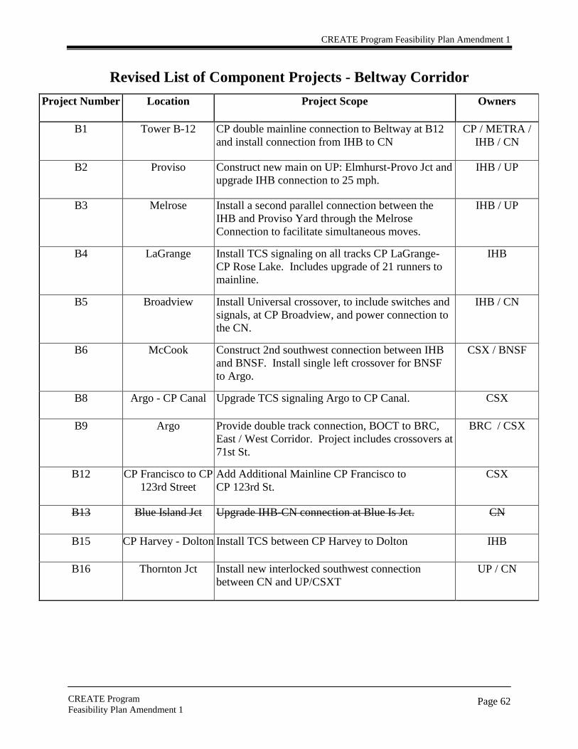
CREATE Program Feasibility Plan Amendment 1
CREATE Program
Feasibility Plan Amendment 1
Page 62
Revised List of Component Projects - Beltway Corridor
Project Number Location Project Scope Owners
B1 Tower B-12 CP double mainline connection to Beltway at B12
and install connection from IHB to CN
CP / METRA /
IHB / CN
B2 Proviso Construct new main on UP: Elmhurst-Provo Jct and
upgrade IHB connection to 25 mph.
IHB / UP
B3 Melrose Install a second parallel connection between the
IHB and Proviso Yard through the Melrose
Connection to facilitate simultaneous moves.
IHB / UP
B4 LaGrange Install TCS signaling on all tracks CP LaGrange-
CP Rose Lake. Includes upgrade of 21 runners to
mainline.
IHB
B5 Broadview Install Universal crossover, to include switches and
signals, at CP Broadview, and power connection to
the CN.
IHB / CN
B6 McCook Construct 2nd southwest connection between IHB
and BNSF. Install single left crossover for BNSF
to Argo.
CSX / BNSF
B8 Argo - CP Canal Upgrade TCS signaling Argo to CP Canal. CSX
B9 Argo Provide double track connection, BOCT to BRC,
East / West Corridor. Project includes crossovers at
71st St.
BRC / CSX
B12 CP Francisco to CP
123rd Street
Add Additional Mainline CP Francisco to
CP 123rd St.
CSX
B13 Blue Island Jct Upgrade IHB-CN connection at Blue Is Jct. CN
B15 CP Harvey - Dolton Install TCS between CP Harvey to Dolton IHB
B16 Thornton Jct Install new interlocked southwest connection
between CN and UP/CSXT
UP / CN

CREATE Program Feasibility Plan Amendment 1
CREATE Program
Feasibility Plan Amendment 1
Page 63
Western Ave Corridor
Project Number Location Project Scope Owners
WA1 Ogden Jct Re-align & Signalize Ogden Jct for double track
connection from UP to BOCT & CJ Mains
CSX / NS / UP
WA2 Ogden Jct Install TCS signaling on BOCT between Ogden Jct
and 75th Street (Forest Hill)
CSX
WA3 Ogden Jct Install TCS signaling CJ tracks between Ogden Jct
and CP518, add additional mainline along Ashland
Ave Yard, and extension of Yard Switching Lead
NS
WA4 BNSF Chicago
Sub to BNSF
Chillicothe
Sub
Construct connection directly linking BNSF Chicago
and Chillicothe Subs.
BNSF / CN / NS
CSX
WA5 Corwith Tower Upgrade track, signal, and reconfigure Corwith
Interlocking and remote CN Corwith Tower
BNSF / CN
WA7 Brighton Park Install connections in Northwest and Southwest
quadrants for movement between CN Joliet Line and
B&OCT (Western Avenue Corridor.)
TBD
WA10 Blue Island Jct Install universal interlocked connections between
BOCT and CN to facilitate directional running.
CN / CSX
WA11 Dolton Upgrade and reconfigure Dolton interlocking. IHB / CSX / UP
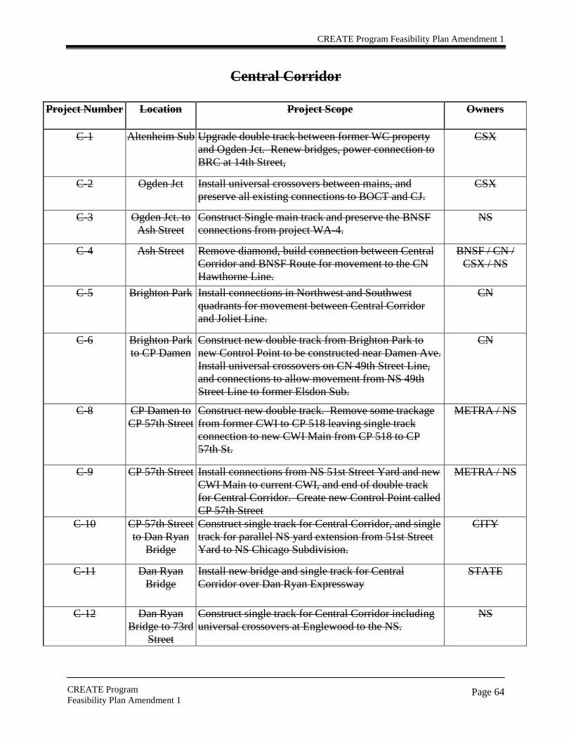
CREATE Program Feasibility Plan Amendment 1
CREATE Program
Feasibility Plan Amendment 1
Page 64
Central Corridor
Project Number Location Project Scope Owners
C-1 Altenheim Sub Upgrade double track between former WC property
and Ogden Jct. Renew bridges, power connection to
BRC at 14th Street,
CSX
C-2 Ogden Jct Install universal crossovers between mains, and
preserve all existing connections to BOCT and CJ.
CSX
C-3 Ogden Jct. to
Ash Street
Construct Single main track and preserve the BNSF
connections from project WA-4.
NS
C-4 Ash Street Remove diamond, build connection between Central
Corridor and BNSF Route for movement to the CN
Hawthorne Line.
BNSF / CN /
CSX / NS
C-5 Brighton Park Install connections in Northwest and Southwest
quadrants for movement between Central Corridor
and Joliet Line.
CN
C-6 Brighton Park
to CP Damen
Construct new double track from Brighton Park to
new Control Point to be constructed near Damen Ave.
Install universal crossovers on CN 49th Street Line,
and connections to allow movement from NS 49th
Street Line to former Elsdon Sub.
CN
C-8 CP Damen to
CP 57th Street
Construct new double track. Remove some trackage
from former CWI to CP 518 leaving single track
connection to new CWI Main from CP 518 to CP
57th St.
METRA / NS
C-9 CP 57th Street Install connections from NS 51st Street Yard and new
CWI Main to current CWI, and end of double track
for Central Corridor. Create new Control Point called
CP 57th Street
METRA / NS
C-10 CP 57th Street
to Dan Ryan
Bridge
Construct single track for Central Corridor, and single
track for parallel NS yard extension from 51st Street
Yard to NS Chicago Subdivision.
CITY
C-11 Dan Ryan
Bridge
Install new bridge and single track for Central
Corridor over Dan Ryan Expressway
STATE
C-12 Dan Ryan
Bridge to 73rd
Street
Construct single track for Central Corridor including
universal crossovers at Englewood to the NS.
NS

CREATE Program Feasibility Plan Amendment 1
CREATE Program
Feasibility Plan Amendment 1
Page 65
East – West Corridor
Project Number Location Project Scope Owners
EW1 Clearing Yard Construct 2 new main tracks, reconstruct
thoroughfare, and rearrange connections.
BRC
EW2 80th St Improve track & signals for flexibility of routes from
the Dan Ryan to Forest Hill & 74th St.
BRC / METRA /
NS / UP
EW3 Pullman Jct. Re-align Pullman Jct. to incorporate BRC and NS
mains from Pullman to 80th Street
BRC / NS
EW4 CP 509 Improve connection from East-West Corridor to NS
Mainline at CP 509
BRC / NS

CREATE Program Feasibility Plan Amendment 1
CREATE Program
Feasibility Plan Amendment 1
Page 66
Passenger Express Corridor
Project Number Location Project Scope Owners
P1 Englewood Grade separate Metra over NS METRA / NS
P2 74th Street Grade separate Metra over BRC and connect Metra to
Rock Island route.
BRC / METRA /
NS
P3 75th Street
(Forest Hill)
Grade separate BOCT over BRC / Metra / NS. BRC / CSX / NS
/ METRA
P4 Grand Crossing Install interlocked connection between CN and NS.
Construct additional capacity for passenger operations
on the NS Chicago Subdivision. Construct double
track connection along new alignment from CP 57th
St.to NS Chicago Subdivision.
Install interlocked southwest connection between CN
and NS. Construct new main line capacity between
Grand Crossing and CP518 (Pershing Ave.) Project
may include track on new alignment. Includes all
associated signal work, grading work, crossovers, and
other bridge work. Also includes connection from
CN to unused NS bridge in the Grand Crossing Area.
CN / NS /
METRA
P5 Brighton Park Grade Separate CN over CSX / NS. CN / CSX / NS
P6 CP Canal Grade Separate CN over IHB. CN / CSX
P7 Chicago Ridge Grade Separate Metra/NS over IHB. CSX / METRA /
NS

CREATE Program Feasibility Plan Amendment 1
CREATE Program
Feasibility Plan Amendment 1
Page 67
Tower Component Projects
Project Number Location Project Scope Owners
T1
Tower T1 (21st Street Interlocking)
Automate 21st Street Tower
(remote); upgrade track and
signals at the 21st Street
Interlocking.
Amtrak / CN
T2
Tower T2 (CN Blue Island Interlocking)
Automate the CN Blue
Island Tower (remote);
upgrade track and signals at
the CN Blue Island
Interlocking.
IHB / CN / B&OCT
T3
Tower T3 (Rondout Interlocking)
Automate Rondout Tower
(remote); upgrade track and
signals at the Rondout Street
Interlocking.
METRA /CP /CN
T4
Tower T4 (A-5 Interlocking)
Automate A-5 Tower
(remote), upgrade track and
signals at the A-5
Interlocking.
METRA / CP
T5
Tower T5 (B-17 Interlocking)
Automate the B-17 Tower
(remote); upgrade track and
signals at the B-17
Interlocking.
METRA / CP
T6
Tower T6 (Calumet Interlocking)
Automate the Calumet
Tower (remote); upgrade
track and signals at the
Calumet Interlocking.
CSX / IHB/NS
T7
Tower T7 (16th Street Interlocking)
Automate 16th Street Tower
(remote); upgrade track and
signals at the 16th Street
Interlocking.
CN / METRA
T8
Tower T8 (Gresham Interlocking)
Automate the Gresham
Tower (remote); upgrade
track and signals at the
Gresham Interlocking.
METRA / CRL

CREATE Program Feasibility Plan Amendment 1
CREATE Program
Feasibility Plan Amendment 1
Page 68
Project Number Location Project Scope Owners
T9 Tower T9 (Metra
Blue Island
Interlocking)
Automate the Metra Blue Island Tower
(remote); upgrade track and signals at the
Metra Blue Island Interlocking.
CSX / METRA
T10 Tower T10
(Kensington
Interlocking)
Automate Kensington Tower (remote);
upgrade track and signals at the
Kensington Street Interlocking.
CN / METRA and
CSS&SB (NICTD)
T11
Tower T11 (Hick
Interlocking)
Automate the Hick Tower (remote);
upgrade track and signals at the Hick
Interlocking, including controls for the
Hick Movable Bridge
NS
T12 Tower T12
(Deval
Interlocking)
Automate the Deval Tower (remote);
upgrade track and signals at the Deval
Interlocking.
UP / CN

CREATE Program Feasibility Plan Amendment 1
CREATE Program
Feasibility Plan Amendment 1
Page 69
Other Projects
Project Number Location Project Scope Owners
1 Chicago Various Technology Improvements related to
Visibility and Electronic Requests.
Railroads
2 Chicago Various Elimination of 10 Towers through upgrade
and remoting to new location. Note:
Corwith Tower, 21st Street, 16th Street, and
Dolton are included in the Corridor
Projects.
Railroads
3 Chicago Various Viaduct Improvement Program * IDOT/CDOT
4 Chicago Various Grade Crossing Safety Program ** IDOT/CDOT
*The Viaduct Improvement Program could include rehabilitation/reconstruction of viaducts, as
well as potential viaduct removals.
** The Grade Crossing Safety Program could include rehabilitation/reconstruction of grade
crossings, as well as potential grade crossing closures.

CREATE Program Feasibility Plan Amendment 1
70
List of Chicago Area Road Crossings for Grade Separation Projects
Project
Number
Owner
Line
Speed
Crossing
M. P.
DOT #
RRDT
F, A, C
Crossing
AADT
Lanes
Corridor
GS1 BRC BRC 25 63rd Street 4.13 869221F 30,0,0 HVY 4
GS2 BRC BRC 25 Central Ave 1.41 326918E 30,0,0 HVY 6
GS3a1 NS CJ 10 Morgan 0.63 243177N 53,0,0 MED 2 Western
GS4 IHB IHB 40 Central Ave, Chicago Ridge 20 163578S 77,0,0 HVY 4 Beltway
GS-52 CSX Blue Island Sub 20 127th Street, Blue Island DC 16.0 163419K 22,0,0 HVY 4 Western
GS5a3
IHB IHB Main 25 Grand Ave., Franklin Park
38.8 326729H 32,0,0 HVY
4 Beltway
CN Waukesha 25 15.5 689633V 8,0,0 4 Central
GS6 UP Geneva Sub 50/40 25th Ave Melrose 11.7 174010L 25,0,60 HVY 4
GS74 BNSF BNSF 70 Belmont Road, Downers Grove 22.61 079537J 40,6,97 HVY 4
GS8a5 UP Geneva Sub 70 5
th Avenue, Maywood 10.5 173998Y 25,0,60 MED 4
GS9 BRC BRC 25 Archer Ave, Chicago 8 843806F 26,0,0 HVY 4
GS10 IHB IHB 25 47th/East Ave, LaGrange 30.09 326851A 56,0,0 HVY 4 Beltway
1 This project proposal was refined by determining that a grade separation will be considered only at Morgan Street rather than considering a grade separation at either Morgan
Street or Racine Avenue. This decision was documented and approved by the CREATE Stakeholder Committee in Resolution #01-04. 2 This project proposal was removed from the CREATE Program per conversations between IDOT, CDOT, CSX and Mayor Donald Peloquin (City of Blue Island). This decision
was documented and approved by the CREATE Stakeholder Committee in Resolution #02-04. 3 The project at Grand Avenue in Franklin Park, identified in the CREATE Program as Project GS-5a, is not included in the CREATE SPEED Strategy process. An ECAD was
signed for this project on April 10, 2001. During the development of the CREATE Program, Mayor Daniel Pritchett of Franklin Park requested that the project be added to the
CREATE Program. Subsequently, Project GS5a was identified by the CREATE Partners as a previously planned project whose implementation would improve rail operations in
the Chicago Region. It was determined that Project GS5a would be included in the CREATE Program even though the project was already under development and its
implementation was planned prior to the development of the CREATE Program. This decision was documented and approved by the CREATE Stakeholder Committee in
Resolution #05-04. Project GS5a has independent utility and does not restrict alternatives on any other project within the CREATE program, and therefore does not influence any
of the projects or project alternatives in the SPEED Strategy. GS5a is currently under construction and is scheduled to be completed in October 2006. 4 The project proposal at Belmont Road in Downers Grove, identified in the CREATE Program as Project GS7, is not included in the CREATE SPEED Strategy process. An
Environmental Assessment was completed for this project on May 1, 2002 and was issued a Finding of No Significant Impact (FONSI) on June 5, 2002. During the development
of the CREATE Program, Project GS7 was identified by the CREATE Partners as a previously planned project whose implementation would improve rail operations in the
Chicago Region. It was determined that Project GS7 would be included in the CREATE Program even though the project was already under development and its implementation
was planned prior to the development of the Program. Project GS7 has independent utility and does not restrict alternatives on any other project within the CREATE program, and
therefore does not influence any of the projects or project alternatives in the SPEED Strategy. The project is awaiting funding and is not under construction at this time. 5 This project proposal was revised per Ronald Serpico‘s (President, Village of Melrose Park) letter dated November 14, 2003, requesting that no grade separation be considered at
19th
Avenue, and agreement by Mayor Ralph W. Conner (Village of Maywood) to support the consideration of a grade separation at 5th
Avenue in Maywood. This decision was
documented and approved by the CREATE Stakeholder Committee in Resolution #03-04.

CREATE Program Feasibility Plan Amendment 1
71
Project
Number
Owner
Line
Speed
Crossing
M. P.
DOT #
RRDT
F, A, C
Crossing
AADT
Lanes
Corridor
IHB IHB East Ave., LaGrange 30.05 326850T 56,0,0 HVY 4 Beltway
GS11 BRC BRC 25 Columbus, Chicago 12.9 843823W 32,0,0 HVY 4 East West
GS12 UP Geneva Sub 60/45 1st Avenue, Maywood 10.3 173996K 25,0,60 HVY 4
GS13 IHB IHB 30 31st Street, LaGrange Park 31.4 326859E 56,0,0 HVY 4 Beltway
GS14 IHB IHB 40 71st Street, Bridgeview 25.8 163586J 77,0,0 MED 2 Beltway
GS-156 NS Chicago Dist 25 Torrence Ave., Chicago B5073 478712Y 24,0,0 HVY 4
GS15a7
NS Chicago Dist 25 Torrence Ave., Chicago B5073 478712Y 24,0,0 HVY 4
NS Chicago Dist 25 130th
Street, Chicago B507.4 478713F 24,0,0 HVY 4
GS16 CPRS Elgin sub 70/40 Irving Park Road, Bensenville B0.3 372159V 18,0,0 HVY 4
GS17 CSX Barr Sub 30 Western Ave, Blue Island DC 14.6 163415H 41,0,0 HVY 4
GS18 BNSF BNSF 70 Harlem, Berwyn 10.13 079493L 40,6,97 HVY 4
GS19 CSX Blue Island Sub 40 71st Street, Chicago DC 22.9 163446G 33,0,0 HVY 2 Western
GS20 CSX Blue Island Sub 20 87th Street, Chicago DC 21.0 163437H 22,0,0 HVY 4 Western
GS-216 NS Chicago Dist 25 130
th Street, Chicago B507.4 474813F 24,0,0 HVY 4
GS21a8 UP Village Grove Sub 25 95th Street, Chicago 10.63 86721E 77,0,0 MED 4 Western
GS22 IHB IHB 40 115th Street, Alsip 17.3 163576D 77,0,0 MED 4 Beltway
GS23a9
IHB IHB Main 30 Cottage Grove, Dolton
10.5 326886B 32,0,0 MED 2
CSX Barr Sub 9.97 163616D 27,0,0 MED 2
GS24 BNSF BNSF 70 Maple Ave, Brookfield 12.73 079503P 40,6,97 MED 2
GS25 UP Geneva Sub 70/40 Roosevelt Road, West Chicago 33.02 174983M 75,0,60 HVY 4
6 The CREATE Program initially listed GS15 and GS21 as separate project proposals. Torrence Avenue and 130
th Street will be spanned with one bridge, therefore the CREATE
Program was revised to list Projects GS15 and GS21 as one project identified as GS15a. This decision was documented and approved by the CREATE Stakeholder Committee in
Resolution #07-04. 7 The project at Torrence Avenue and 130th Street in Chicago, identified in the CREATE Program as Project GS15a, is not included in the CREATE SPEED Strategy process. An
ECAD was signed for this project in October 7, 2002. During the development of the CREATE Program, Project GS15a was identified by the CREATE Partners as a previously
planned project whose implementation would improve rail operations in the Chicago Region. It was determined that Project GS15a would be included in the CREATE Program
even though the project was already under development and its implementation was planned prior to the development of the Program. Project GS15a has independent utility and
does not restrict alternatives on any other project within the CREATE program, and therefore does not influence any of the projects or project alternatives in the SPEED Strategy.
GS-15a is currently under construction and is scheduled to be completed in 2008/2009. 8 This project proposal was added to the CREATE Program per request by State Senator Monique Davis and formally identified in a letter dated October 1, 2004 from the
CREATE Stakeholder Committee to Alderman Brookins (21st Ward). This decision was documented and approved by the CREATE Stakeholder Committee in Resolution #06-04.
9 This project proposal was revised per Mayor William Shaw‘s (Village of Dolton) letter dated April 22, 2004, requesting that no grade separation be considered at 19
th Avenue,
but that a grade separation be considered at Cottage Grove. This decision was documented and approved by the CREATE Stakeholder Committee in Resolution #04-04.

CREATE Program Feasibility Plan Amendment 1
CREATE Program
Final Feasibility Plan
Page 72
Outreach Summary
Upon announcement of the CREATE Program in June 2003, the partners began meeting with
elected officials at each level of government. Meetings were held with civic and business
organizations interested in freight issues. The partners also reached out to groups that would
benefit from CREATE. Public presentations were accomplished for any interested parties. The
Public Information/Advocacy Committee meets once a month to discuss issues and to continue
the momentum for public participation.
Elected Officials
At the local level, affected aldermen in the City of Chicago were briefed on the CREATE
Program by a CDOT representative and a railroad employee from the line that affected that ward.
Then, all 50 aldermen were notified via letter about the program.
The Metropolitan Mayors Caucus, a coalition of mayors from 270 communities in Northeastern
Illinois that work together on issues of mutual concern, has joined with the CREATE partners to
work with all of the affected suburban communities. Two working groups have been established.
The North Suburban Working Group (communities north of I-290) is chaired by Mayor Pritchett
of Franklin Park. The South Suburban Working Group (communities south of I-290) is chaired
by Mayor Peloquin of Blue Island. Several meetings have been hosted to discuss the program.
At the State level, affected Senators and Representatives were briefed on the CREATE Program
by IDOT and CDOT representatives. Additionally, presentations for the Illinois General
Assembly Transportation Committees are currently being scheduled. Both the House and Senate
transportation chairmen have received briefings on CREATE. State legislators have been
receiving individual briefings on the program. Over 30 have been completed.
At the Federal level, affected congressional representatives were contacted prior to the June 2003
announcement. The three CREATE stakeholders, the Illinois Department of Transportation‘s
Secretary, the Chicago Department of Transportation‘s Commissioner, and the President and
CEO of the Association of American Railroads, met personally with the Illinois Congressional
Delegation. Meetings were held with select House and Senate transportation committee leaders.
There have been three subsequent meetings with legislators, congressional staff and Department
of Transportation officials in Washington, D.C.
The partners have provided numerous tours of CREATE project locations for all levels of
government.
Public Outreach
The CREATE partners approached groups directly or were contacted to give presentations.
Groups included civic, public interest, business associations, and engineering societies. The
CREATE partners participated in over 35 public or organizational presentations from July
through December 2003, and 30 from January to August 2004. A complete list of presentations

CREATE Program Feasibility Plan Amendment 1
CREATE Program
Final Feasibility Plan
Page 73
is attached. The CREATE partners have secured endorsements from many of the business, civic,
and governmental organizations. (See Appendix D)
Media outreach has been used to distribute information about the program to the general public
and has been successful in alerting many interested groups about the program. A list of media
coverage is included in Appendix E.
A plan to reach out to local organizations such as chambers of commerce, rotary clubs,
community organizations, etc. is currently being drafted.
During the environmental, preliminary engineering, and final design processes, the CREATE
partners and their consultants will hold community meetings to explain the projects and get
feedback to guide implementation.

CREATE Program Feasibility Plan Amendment 1
CREATE Program
Final Feasibility Plan
Page 74
Public Involvement Summary
for the
Draft Feasibility Plan and Draft Preliminary Screening
Two identical Public Meetings were held on May 25, 2005 at Kennedy-King College,
6800 South Wentworth Avenue, Chicago, Illinois and on May 26, 2005 at the Blue Island
Recreation Center, 2805 West 141st Street, Blue Island, Illinois from 3:00 p.m. to 7:00
p.m. The purpose of the meetings was to present the Draft Feasibility Plan and Preliminary
Screening, provide an overview of the CREATE Program, describe the environmental process
being used for the Program and obtain public input.
Legal notices were placed in the May 11, 2005 editions of the Daily Southtown and
Chicago Defender, and the May 12, 2005 editions of the Chicago Sun-Times and Hoy
Chicago. Display advertisements were placed in the May 18, 2005 edition of Hoy
Chicago, May 19, 2005 edition of the Daily Southtown, and May 20, 2005 editions of the
Chicago Sun-Times and Chicago Defender. Copies of the legal notices, display advertisements,
and certificates of publication are attached as Exhibit A. Letters of invitation were sent to
Chicago Aldermen. A copy of the mailing list and typical letter are attached as Exhibit B.
The meetings were held in an open house format beginning with a sign-in table at the meeting. A
total of 30 people signed the attendance register at the May 25 meeting, and 11 people signed the
attendance register at the May 26 meeting. A copy of the public meeting attendance register is
included as Exhibit C. Each attendee was provided with a project brochure, then directed to view
the audio-visual (AV) computer slide presentation that lasted approximately 15 minutes. The
presentation described the CREATE Program history, provided an overview of the entire
CREATE Program, discussed the need for improvements, depicted the component project
locations, and provided an overview of the environmental process that is being used for the
CREATE Program.
At the conclusion of the AV presentation, the attendees were directed to a second room where
the exhibits were on display. Representatives from the Illinois Department of
Transportation, the Chicago Department of Transportation, the Federal Highway Administration,
the railroad companies, and TranSystems Corporation were available to provide information and
answer questions.
Comment sheets were made available for those choosing to provide written comments during the
meeting or for mailing after the meeting. Two written comments were received during the
meetings and two comments were received after the meetings. Copies of the written comments
and responses are attached as Exhibit D. The predominant topic of discussion at the meetings
focused on the provision of jobs for residents living in the neighborhoods where the projects are
located.

CREATE Program Final Feasibility Plan
CREATE Program
Final Feasibility Plan
Page 75
EXHIBIT A
Legal Notices, Display Advertisements, and
Certifications of Publication

CREATE Program Final Feasibility Plan
CREATE Program
Final Feasibility Plan
Page 76
EXHIBIT B
Typical Letter and Mailing List to
Chicago Alderman

CREATE Program Final Feasibility Plan
CREATE Program
Final Feasibility Plan
Page 77
EXHIBIT C
Public Meeting Attendance Registers

CREATE Program Final Feasibility Plan
CREATE Program
Final Feasibility Plan
Page 78
EXHIBIT D
Written Comments
And Responses
.

CREATE Program Final Feasibility Plan
CREATE Program
Final Feasibility Plan A-1
Appendix A – National Public Benefits1
September 23, 2003
The Chicago Region Environmental and Transportation Efficiency Program:
National Public Benefits
Overview
Major U.S. and Canadian railroads, in cooperation with city and state governments, have
proposed the Chicago Region Environmental and Transportation Efficiency (CREATE)
Program. CREATE will include numerous improvements to both railroad infrastructure and the
local highway system in the Chicago region. The most important of these improvements are:
Grade separation of six railroad-railroad
crossings (rail-rail ―flyovers‖), to
eliminate train interference and associated
delay, primarily between passenger and
freight trains;
Grade separation of 25 highway-rail
crossings, to reduce motorist delay,
improve safety, eliminate crossing
accidents, decrease energy consumption,
and reduce air pollution; and
Additional rail connections, crossovers,
trackage, and other improvements to
expedite passenger and freight train
movements in five rail corridors traversing
the Chicago region (see Figure 1).
The CREATE Program — structured as a public-private partnership including local and state
government, the federal government, and the freight and passenger railroads serving Chicago —
will require six years to complete and cost an estimated $1.5 billion. It will produce significant
local, regional, and national benefits. This paper provides an overview of estimated national
benefits of the CREATE Program.
The National Significance of the CREATE Program
The quality of transportation infrastructure has long been a major contributor to our nation‘s
economic growth and the development of international trade. Since its emergence as an
important commercial center and a key transportation hub for both passengers and freight in the
mid-19th century, Chicago has relied upon its transportation system to support the region‘s —
and much of the nation‘s — economic activity.
1Appendix A was prepared by the CREATE Partners (IDOT, CDOT and the Participating Railroads) with no
involvement of the US DOT. The US DOT has not verified this information.

CREATE Program Final Feasibility Plan
CREATE Program
Final Feasibility Plan A-2
Today, Chicago is by far the busiest rail freight gateway in the United States. Chicago handles
more than 37,500 rail freight cars each day. Twenty years from now, that number is expected to
have increased to 67,000 cars per day. CREATE will help both railroads and the Chicago area
cope with this sharp increase in freight volume, while concurrently producing substantial
improvements for motorists and rail passengers.
The importance of the Chicago region
to U.S. rail movements is readily
apparent from the major
lines radiating from Chicago on the
maps of rail mixed carload (Figure 2)
and intermodal traffic
(Figure 3)1.
Each year, the CREATE corridors
handle rail freight valued at
approximately $350 billion2, including
significant volumes of NAFTA traffic
moving across the integrated North
American rail system. More than 60
percent of the rail freight moving
through the Chicago region is high-
value traffic, including intermodal
service and finished vehicles — traffic
with the most demanding service
requirements3.
The multiplier effects of these trade
flows and services result in
approximately 5 million jobs, $782
billion in output, and $217 billion in
wages nationwide4. The traffic
handled by the CREATE corridors
accounts for approximately $10
billion (29 percent) of the revenues
earned by U.S. Class I freight
railroads.
1 Rail traffic maps are from AASHTO‘s Freight-Rail Bottom Line Report, pp. 24–25. Unit train traffic of coal and
grain is not included. 2 A set of appendices containing detailed information from the analyses that support this and other figures presented
in this paper is available upon request. 3
On a value basis, this traffic accounts for over 50 percent of the finished vehicles handled by rail throughout the
United States, and about 60 percent of rail intermodal freight. 4 Represents the value of goods and services exchanged as a result of the initial $350 billion change in demand.

CREATE Program Final Feasibility Plan
CREATE Program
Final Feasibility Plan A-3
The economic activity of the CREATE corridors extends far beyond the Chicago region,
affecting every state. Some 58 percent of the jobs and 61 percent of the CREATE Program‘s rail
freight flows originate and/or terminate outside of Illinois. After Illinois, the four states most
affected are California (8 percent of trade value), Texas (7 percent), Ohio (3 percent) and New
Jersey (3 percent) (Figure 4).
Chicago is also home to a vibrant rail
passenger system. Amtrak served more than
2 million intercity passengers traveling to or
from Chicago in 2002, on an average of
some 50 trains per day.
The Chicago area‘s rail network is also
critical to our nation‘s security. Seven of the
rail lines entering Chicago are part of the
national Strategic Rail Corridor Network
(StracNet) under the Railroads for National
Defense program.
National Public Benefits Generated By CREATE
In recent decades, changes in the U.S. economy have driven businesses to rely increasingly on
transportation to enable them to draw from more distant suppliers and to reach new markets —
while managing their businesses to minimize inventories and maximize responsiveness and
flexibility.
Inventory Reductions
The CREATE Program will expedite the movement of rail cargo — with a value of more than
$350 billion in the first year — through the Chicago region, saving money for rail customers
who will be able to reduce their inventory levels. The estimated inventory savings have a present
value of $40 million. Moreover, the improved reliability of rail service via Chicago will allow
rail customers to make further reductions in their inventories in future years, producing
additional savings which have not been estimated. Highways and Highway Congestion Relief
Chicago‘s role as a major transportation hub means the Chicago region is increasingly
interrelated not just with Illinois and the Midwest, but with the rest of the United States and the
international marketplace. Because what happens in Chicago in terms of transportation greatly
affects the rest of the nation, the ability of Chicago-area transportation infrastructure to meet new
demands has become critical to the competitiveness and efficiency of businesses throughout the
nation. Attaining this ability will require that adequate investments are made to provide the
necessary transportation capacity.

CREATE Program Final Feasibility Plan
CREATE Program
Final Feasibility Plan A-4
In January 2003, highway and transportation agencies of the individual states, through their
American Association of State Highway and Transportation Officials (AASHTO)5, released the
Freight-Rail Bottom Line Report, which analyzed whether the U.S. freight rail system‘s capacity
can keep pace with the expected huge growth in transportation demand over the next 20 years.
The extensive report highlights the freight rail industry‘s benefits to our nation, estimates rail
investment needs and the capability of railroads to meet those needs, and, importantly, quantifies
the consequences of not investing adequately in freight rail.
The report concludes that public policy would be well served by public sector funding that
helped freight rail reach its potential. Largely because of its cost effectiveness, freight rail
(including intermodal) is crucial to the global competitiveness of U.S. industries and can be a
critical factor in retaining and attracting industries that are central to state and regional
economies. It can dramatically reduce highway-related costs. It is fuel-efficient and generates
less air pollution per ton-mile than trucking, and is a preferred mode for hazardous materials
shipments because of its positive safety record. Freight rail is also vital to military mobilization
and provides critically needed transportation system redundancy in national emergencies.
The report emphasizes that ―[t]he present need is to treat the key elements at the top of the
system: nationally significant corridor choke points, intermodal terminals and connectors, and
urban rail interchanges. Investments at this level hold the most promise of attracting and
retaining freight-rail traffic through improvements in service performance.‖6
The CREATE
Program is precisely the type of strategic investment envisioned by AASHTO.
In fact, two of the specific corridors analyzed in the Freight-Rail Bottom Line Report traverse
Chicago: Southern California to New York/New Jersey via Chicago, which connects the nation‘s
largest three metropolitan areas and its largest two ports, and Detroit to Mexico7. The east-west
route through Chicago handles much of the nation‘s intermodal traffic and is a vital link in
―landbridge‖ services between Asia and the Northeast/Mid-Atlantic region, while the north-south
route is a key NAFTA corridor. AASHTO projects that by 2020, railroads will carry 67 percent
of the tonnage in the Southern California–New York/New Jersey corridor and 52 percent of the
tonnage in the Detroit–Mexico corridor. Without an investment of public funds, rail tonnage
could be reduced by up to 38 percent — resulting in an additional 2.7 billion vehicle-miles
traveled by trucks in these two corridors.
Nationally, the report estimates that an investment of $30 billion in public funds in freight rail
infrastructure would yield tremendous returns, including at least $10 billion in reduced highway
needs8
and $238 billion in reduced highway user costs (decreased travel time, operating costs,
5 AASHTO is a nonprofit, nonpartisan association representing highway and transportation departments in the 50
states, the District of Columbia and Puerto Rico. 6 AASHTO, Freight-Rail Bottom Line Report, p. 5.
7 ibid, pp. 111, 120.
8 The ―highway needs‖ figure here does not include the costs of improvements to bridges, interchanges, local roads,
new roads or system enhancements. If these were included, the estimates could double.

CREATE Program Final Feasibility Plan
CREATE Program
Final Feasibility Plan A-5
and accident costs)9
over 20 years. These findings led AASHTO to conclude that ―relatively
small investments in the nation‘s freight railroads can be leveraged into relatively large public
benefits for the nation‘s highway infrastructure, highway users, and freight shippers.‖10
The analysis estimated investment costs and benefits at the national level, assuming that freight
railroads carry 2.9 billion tons in 2020 — an increase of 888 million tons, or 44 percent, from
2000 — thereby maintaining their current share of intercity freight traffic. While the returns for
an individual investment — even one as significant as CREATE — may not be precisely
proportionate, the relationships developed in AASHTO‘s national analysis can be used to
approximate the national public benefits of CREATE: the public expenditure can be expected to
yield more than $10 billion in reduced highway needs and highway user costs for the nation over
a 20-year period.
9 Estimated using the Federal Highway Administration‘s Highway Economic Requirements System (HERS)
simulation model. HERS is used by the U.S. Department of Transportation as the basis for its reports to Congress on
highway investment needs. 10
AASHTO, Freight-Rail Bottom Line Report, p. 62.

CREATE Program Final Feasibility Plan
CREATE Program
Final Feasibility Plan B-1
Appendix B – Local and Regional Benefits1
September 23, 2003
The Chicago Region Environmental and Transportation Efficiency Program:
Local and Regional Benefits Program Description
The Chicago Region Environmental and Transportation Efficiency (CREATE) Program will
include numerous improvements to both railroad infrastructure and the local road system in the
Chicago region, the most important of which are:
Grade separation of six railroad-railroad
crossings (rail-rail ―flyovers‖), to
eliminate train interference and associated
delay, primarily between passenger and
freight trains;
Grade separation of 25 highway-rail
crossings, to reduce motorist delay,
improve safety, eliminate crossing
accidents, decrease energy consumption,
and reduce air pollution; and
Additional rail connections, crossovers,
trackage, and other improvements to
expedite train movements in five rail
corridors traversing the Chicago region
(Figure 1).
The CREATE Program - structured as a public-private partnership including local and state
government, the Federal government, and the freight and passenger railroads serving Chicago -
will require six years to complete and cost an estimated $1.5 billion.
Scope of Economic Activity in the CREATE Corridors
Chicago is a major hub for rail freight shipments moving from, to, or through the Chicago
region. Each year, the CREATE corridors handle rail freight valued at approximately $350
billion2,1
including significant volumes of NAFTA traffic moving across the integrated North
American rail system. Over 60 percent of the rail freight moving through the Chicago region is
high value traffic - including intermodal service (both double stack and conventional) and
finished vehicles - traffic with the most demanding service requirements. On a value basis, this
1 The text for Appendix B was prepared by the CREATE Partners (IDOT, CDOT and the Participating Railroads)
with no involvement of the US DOT. 2 A set of appendices containing detailed information from the analyses that support this and other figures presented
in this paper is available upon request.

CREATE Program Final Feasibility Plan
CREATE Program
Final Feasibility Plan B-2
traffic accounts for over 50 percent of the finished vehicles handled by rail throughout the U.S.,
and about 60 percent of rail intermodal freight.
The multiplier effects of these trade flows and services result in approximately 5 million jobs,
$782 billion in output, and $217 billion in wages nationwide3. The traffic handled by the
CREATE corridors accounts for about $10 billion (29 percent) of the revenues earned by U.S.
Class I freight railroads. The enormous magnitude of the Chicago region‘s activity means that
even very small percentage improvements in efficiency can produce very large public benefits.
Additionally, the economic activity of the
CREATE corridors extends far beyond the
Chicago region, affecting every state. Some
58 percent of the jobs and 61 percent of the
CREATE Program‘s rail freight flows
originate and/or terminate outside of Illinois.
After Illinois, the four states most affected
are California (8 percent of trade value),
Texas (7 percent), Ohio (3 percent) and New
Jersey (3 percent) (Figure 2).
Chicago is also home to a vibrant rail
passenger system. Amtrak served more than
2 million intercity passengers traveling to
or from Chicago in 2002, on an average of
approximately 50 trains per day. In addition,
Chicago‘s commuter railroads, which
operate more than 770 trains each weekday,
carried nearly 73 million local passenger
trips including weekend passengers.
Program Benefits
The CREATE Program will produce
substantial, long-term national and regional
economic benefits, plus significant
environmental and energy benefits. The
Chicago region will receive at least $595
million4
in benefits related to rail passengers,
motorists, and safety, plus air quality
improvements valued at $1.1 billion;
construction-related benefits for the
Chicago region will total $2.2 billion.
3 Representing the value of goods and services exchanged as a result of the initial $350 billion change in demand.
4 Present value of 2003–2042 benefits, in 2003 dollars, using a 5.875 percent public real discount rate. The 40-year
planning horizon used for this analysis is sufficient to capture the majority of the benefits on a discounted basis.

CREATE Program Final Feasibility Plan
CREATE Program
Final Feasibility Plan B-3
Rail passenger service will be improved by the construction of six rail-to-rail flyovers, reducing
conflicts between freight and passenger trains and saving time for rail passengers. Improved
service will encourage additional commuters to shift to rail service, and reduce the need for
future highway construction. Motorists will experience reductions in delays as a result of the
construction of 25 new highway-rail grade separations, and the improved fluidity of rail
operations affecting remaining at-grade crossings. These improvements to the rail and highway
infrastructure will produce major safety benefits for the Chicago region, by reducing the number
of highway accidents and the number of accidents and injuries at highway-rail grade crossings.
The Chicago region will also benefit from the creation of an annual average of over 2,700
fulltime construction-related jobs and material and other purchases of $365 million during the 6-
year construction phase.
In addition to these readily-quantifiable benefits, the Chicago region will realize benefits from
several other sources. First, rail customers in the Chicago region will receive higher quality,
more reliable freight service. Second, public safety will be significantly enhanced, because six of
the 25 crossings are Chicago 911 ―Critical Crossings,‖5
and many of the crossings in suburban
areas are similarly vital for the provision of emergency services. Third, the conversion of the St.
Charles Airline route from rail use to mixed park, residential, and commercial use will provide
both economic and social benefits. Fourth, the improvements to the Chicago region‘s rail system
should permit the railroads, which have recently made substantial progress in reducing the
number of ―rubber tire interchanges,‖ to further improve their intermodal operations. To the
extent that these truck movements over the Chicago region‘s highways and streets can be
reduced further, the need for roadway maintenance expenditures by local governments and
municipalities will be diminished. Finally, the reduction in fuel consumption by railroads and
motorists will reduce emissions of major pollutants by thousands of tons annually.
For this analysis, the Chicago region‘s economy includes the 13 counties in three states that are
in the Chicago–Kenosha–Gary Consolidated Metropolitan Statistical Area (CMSA):
These long-term regional benefits are described in more detail below: Rail Commuter Time Savings
The CREATE Program improvements — especially the rail-to-rail flyovers, which will largely
separate rail passenger operations from rail freight operations — will result in more reliable
commuter rail service, reduced travel times, and increased capacity on the existing SouthWest
and Heritage lines, and will permit the use of the LaSalle Street Station — freeing capacity at
Chicago‘s Union Station. Faster travel times and improved reliability will enable the commuter
5 Crossings that have been identified by the City of Chicago as critical for delivery of emergency services.

CREATE Program Final Feasibility Plan
CREATE Program
Final Feasibility Plan B-4
rail service to attract additional passengers who would otherwise travel by personal auto, both
currently and in future years. The present value of the time that will be saved by current and
additional rail commuters is estimated to be $115 million on the SouthWest line and $17 million
on the Heritage line, for a total savings of $132 million. In addition, the time expected to be
saved by current rail commuters who switch to these two lines has a present value of up to
$58 million, producing a total time savings valued at up to $190 million.
New Highway Construction Reduced
The reduction in commuters traveling by personal auto will reduce vehicle-miles traveled (VMT)
by an estimated 29 million per year in the SouthWest Service, resulting in $66 million less
investment in highway construction to handle those trips. The Heritage Corridor improvements
will reduce highway travel by 5 million VMT annually, saving about $11 million in highway
investment. Thus, the CREATE Program will save at least $77 million in highway construction
that would otherwise be necessary. Additional savings will be realized as current commuter rail
users switch to these two lines and drive shorter distances.
Highway Accidents Reduced
In addition to the construction savings that result from less highway travel, there will be fewer
accidents, less damage to property, and fewer fatalities. The discounted value of these benefits is
$77 million for the SouthWest Service and $17 million for the Heritage Corridor, for a total
savings of $94 million.
Local Highway Delay Reduction
The CREATE Program proposes to separate 25 key grade crossings. The highway-rail grade
separation projects, together with the associated crossing closings, will reduce delays for
Chicago-area motorists at grade crossings. The present value of the reductions in driver delay at
the 25 crossings is $72 million6. In addition, as a result of train re-routings and more fluid train
movement, motorists who use 163 additional crossings will experience delay reductions with an
estimated discounted value of $130 million, for a total motorists‘ delay savings of $202 million.
Grade Crossing Accidents Reduced
Safety benefits for the 25 crossings were based on safety incident data collected between 1977
and 2001. The present value of the sum of incidents is estimated to be $32 million through 2042.
Energy and Environmental Benefits
The improvements in railroad operations that will result from the CREATE Program will reduce
the railroads‘ diesel fuel consumption by 7 million gallons in 2007, rising to 18 million gallons
in 2042 as rail traffic grows. In the first full year of operations, 2007, locomotive emissions will
be reduced by nearly 1,453 tons of oxides of nitrogen (NOx), 225 tons of carbon monoxide, 80
tons of volatile organic compounds (VOC), and 51 tons of particulate matter. By 2042, the
annual savings will reach 2,195 tons of NOx, 534 tons of CO, 121 tons of VOC, and 72 tons of
PM as a result of traffic growth7.
6 Chicago Planning Group: Grade Separations, July 5, 2002.
7 The estimated reduction in locomotive emissions reflects EPA‘s projections for average emissions factors for the
locomotive fleet under current emissions standards, which are being phased in (U.S. EPA, Emission Factors for
Locomotives, EPA420-F-97-051, Table 9, page 5).

CREATE Program Final Feasibility Plan
CREATE Program
Final Feasibility Plan B-5
Additionally, the decrease in highway vehicle delays that will result at the 25 highway-rail grade
crossings that are separated and at the 163 at-grade crossings is projected to result in significant
reductions in emissions from vehicular traffic, including 213 tons of CO, 24 tons of VOC, and 6
tons of NOx in 2007. By 2042, with expected increases in vehicular traffic, the reduction in
annual emissions will have reached 397 tons of CO, 45 tons of VOC, and 12 tons of NOx8.
The money requested of Congress would be money well spent to reduce NOx emissions, because
on the basis of Federal air quality funds provided per ton of NOx reduced, the CREATE Program
compares favorably with the Chicago metropolitan planning organization‘s (CATS) calculations
of the results of projects funded under CMAQ. If the CREATE Program were to be funded
purely on the basis of NOx reduction at the same rate that Chicago CMAQ projects were funded
in 2003, this would equate to $1.12 billion in Federal funds related just to NOx reducing aspects
of the CREATE Program (60,802 tons of NOx eliminated over 40 years).
Lakefront Land Use Increased
As part of the CREATE Program, the existing St. Charles Airline railway route will be converted
from rail use and its rail traffic will be shifted to other corridors primarily the Central Corridor.
Portions of the St. Charles Airline right-of-way will be converted to park land, while other
sections will be used for residential and commercial development. The City of Chicago will gain
additional ―green space‖ yet will also benefit from the multi-year construction projects,
involving both housing developments and retail establishments, and a substantial, permanent
increase in property tax revenues.
As part of the CREATE Program, rail traffic on the existing St. Charles Airline railway route
will be shifted to other corridors. This will allow the St. Charles Airline right-of-way to be re-
purposed to serve future public needs that enhance quality of life and support economic
development.
Construction Benefits During CREATE Program Construction
The CREATE Program will also produce a significant boost in construction employment and
related economic activity throughout the Chicago region over the course of the 6-year
construction phase. This demand will reverberate throughout the region‘s economy producing
additional economic activity; these effects were analyzed at three levels:
Direct effects include the purchases of materials used for construction and the payment of
wages and salaries to construction workers.
Indirect effects include the secondary effects that result when directly connected supply
industries purchase materials or labor to produce goods or services needed to meet the
new demand generated by the earlier, initial activity.
Induced effects result from the additional spending by the workers associated with direct
or indirect economic activity.
The construction-related benefits will include an estimated annual average of over 2,700 fulltime
job equivalents and over $365 million in output over the 6-year construction period. During the
peak year of construction, the CREATE Program would employ nearly 4,000 workers and
8 Vehicular emissions are based on current emission standards, and do not assume future reductions in emissions per
vehicle-mile traveled (VMT) as a result of possible legislative action or changes in pollution technologies.

CREATE Program Final Feasibility Plan
CREATE Program
Final Feasibility Plan B-6
generate economic activity valued at more than $525 million. Additional construction-related
benefits would accrue beyond the Chicago economic region — both throughout the United States
and in other countries.
Conclusion
The State of Illinois and the City of Chicago have joined with the passenger and freight railroads
serving the region to identify critically needed improvements to the Chicago region‘s rail and
highway transportation infrastructure. The resulting Chicago Region Environmental and
Transportation Efficiency Program, a public-private partnership, will improve rail passenger
service on the SouthWest and Heritage corridors, and construct 25 highway-rail grade separation
projects, which will reduce motorist delay, increase safety, and provide environmental and
energy benefits for the Chicago region‘s residents.

CREATE Program Final Feasibility Plan
CREATE Program
Final Feasibility Plan C-1
Appendix C – CREATE PLAN PRESENTATION SCHEDULE
2003 Presentations:
July 9 – Union League Club
July 17 - Northeastern Illinois Planning Commission
July 17 - Campaign for Sensible Growth
July18 – Northwestern Indiana Regional Planning Commission
July 22 – Affected Suburban Mayors
July 22 - Campaign for Sensible Growth Steering Committee
July 23 – Metropolitan Mayors Caucus
August 1 – Business Leaders for Transportation
August 18 – Illinois State Chamber of Commerce
August 20 – Illinois Section of the American Society of Civil Engineers
August 21- Metropolitan Planning Council’s Transportation Committee
August – United Neighborhood Organization
Sept. 8 – American Association of State Highway Transportation Officials (AASHTO) -
Annual Conference
Sept. 9 – Illinois Road and Transportation Builders Association - General Membership
Meeting
Sept. 11-12 – IDOT Planning Conference
Sept 11-12 – American Association of Port Authorities
Sept 14-16 – AASHTO Standing Committee on Rail Transportation
Sept 16 - Metropolitan Mayors Caucus Working Group
Sept 16 - DuPage Mayors and Managers
Sept. 24 - Women’s Transportation Seminar

CREATE Program Final Feasibility Plan
CREATE Program
Final Feasibility Plan C-2
2003 Presentations (Continued):
Sept 25 – Chicagoland Chamber of Commerce Transportation Committee
Sept 25 - Northwest Municipal Conference
Sept 25 – American Automobile Association
September - IDOT meeting with Federal Highway Administration
IDOT meeting with Federal Railroad Administration
October 3 – Chicagoland Electronic Commerce Initiative - Government Affairs
October 8 - Chicago Rail Task Force Meeting with Surface Transportation Board
October 11 – Midwest High Speed Rail Coalition
October – Meeting with Federal Highway Administrator Mary Peters
October 15 – Illinois Society of Professional Engineers
October 16 - French American Chamber of Commerce
October 17 – League of Women Voters
October 21-22 – Railway Age Passenger Trains on Freight Railroad Conference
October 23 – American Road and Transportation Builders Association
October 28 – High Speed Ground Transportation Association
October – Southland Chamber of Commerce
West Suburban Chamber
November 6 – University of Illinois at Chicago
November 10 – Chicago Central Area Committee
November 19 – Chicago Building Congress
November 20 - Blue Island Rail Simulation, Metropolitan Mayors Caucus
December 4 – Calumet Area Industrial Commission

CREATE Program Final Feasibility Plan
CREATE Program
Final Feasibility Plan C-3
2004 Presentations:
January 2-6 – National Research Council Conference and Exhibition
January 8 - CATS Policy Committee
January 12 & 13 – Transportation Research Board
February - Intermodal Association of Chicago
March 1 – United Transportation Union
March 10 – Friends of the Chicago River
March 20 – Midwest High Speed Rail Spring Conference
March 22-23 – Transportation Research Forum
March 23 -National Corn Producers Meeting
April 8 - Chicago Minority Business Council
April 8 - Federation of Women Contractors
April 8 - IDOT Annual Illinois Rail/Highway Meeting
April 14 - Railway Supply Institute Legislative Conference
April 20 – Winfield Chamber of Commerce
April 21 - Latin American Chamber of Commerce
April 22 - American Association of Port Authorities
April 27 - LaGrange Park Board
April 29 - DuPage Railroad Safety Council
May 13 - Wheaton Chamber of Commerce
May 20 - Latin American Chamber of Commerce
May 26-28 – Women in Transportation National Conference

CREATE Program Final Feasibility Plan
CREATE Program
Final Feasibility Plan C-4
2004 Presentations (Continued):
June 5 – United Transportation Union “Tri-State Railroad Conference"
June 15 – Bloomingdale, Itasca, Roselle, Bartlett, Addison Chambers of Commerce
July 1 - Institute of Transportation/ District IV Annual Meeting
July 13 – Metropolitan Planning Council - Freight Rail Investment and Rail Corridor
Development Opportunities
July 27 – American Public Transportation Association/AASHTO/Community
Transportation Association of America Conference
August 25 - Greater Auburn-Gresham Development Corporation
October 1 - IDOT Fall Planning Conference
October 8 – American Council of Engineering Companies
October 21 – Country Club Hills Chamber of Commerce
November – National League of Cities
2005 Presentations:
January 10 - Transportation Research Board
January 11 - Transportation Research Board
January 19 - Crystal Lake Chamber of Commerce
January 26 – Maywood Village Board
February 16 – National Traffic and Transportation Conference
February 19 – Geographic Society of Chicago
March 15 - Orland Park/ Homer Glenn / Tinley Park Chambers of Commerce
March 16 - Elmhurst League of Women Voters

CREATE Program Final Feasibility Plan
CREATE Program
Final Feasibility Plan C-5
2005 Presentations (Continued):
March 23 - Village of Dixmoor/Phoenix & Posen
April 6 - Center for Transportation Research’s Annual Symposium
April 12 - International Air Rail Organization
April 18 - Transportation Revenue Management Group
April 19 – AASHTO Standing Committee on the Environment
April 20 – Chicago Area Transportation Study (CATS) “Partners in Progress” Meeting
April 23 - CATS “ Partners in Progress” Meeting
April 26 - CATS “ Partners in Progress” Meeting
April 26 – AASHTO – FHWA Freight Transportation Partnership
April 27 - 17th
Ward Community Redevelopment Advisory Council Meeting
April 28 - Village of Steger & Steger Chamber of Commerce
April 28 – American Association of Port Authorities
May 5 – Greater Northern Michigan Avenue Association
May 25 – CREATE Draft Feasibility Plan and Draft Preliminary Screening public meeting
May 26 - CREATE Draft Feasibility Plan and Draft Preliminary Screening public meeting
June 15 – American Society of Civil Engineers
June 29 – CATS “Partners in Progress” Meeting
2006 Presentations (partial):
May 4 – North American Rail Shippers Association
June 14 – Alderman Freddrenna Lyle
July 17 – Metropolitan Mayors Caucus Transportation Committee
August 30 – Illinois Section – American Society of Civil Engineers

CREATE Program Final Feasibility Plan
CREATE Program
Final Feasibility Plan C-6
2006 Presentations (continued):
September 20 – Transportation for Illinois Coalition
October 17 – US Environmental Protection Agency – Region 5
October 27 – Hispanic American Construction Industry Association
November 6 – Rail-Volution
November 21 – Making the Chicago Region More Competitive in the Global Supply Chain
December 6 – Illinois Chamber of Commerce – Infrastructure Council
2007 Presentations:
January 17 - Chicago Chapter of the ASCE
January 22-26 – Transportation Research Board
February 14 – HACIA Briefing
February 21 - Air & Waste Management Association – Lake Michigan States
Section
February 22 – Chicago Mortgage Attorneys
March 1 - Illinois House Railroad Transportation Committee
March 14 – Archer Heights Civic Association, Chicago
April 4 - Illinois House Railroad Transportation Committee Hearing
April 5 - University of Illinois Spring Structures Conference
April 18-19 - National Surface Transportation Policy and Revenue Study
Commission
May 15 – Black Contractors United
May 16 – National Association of Purchasing Managers
June 28 – CREATE Civic & Congressional Stakeholder Meeting

CREATE Program Final Feasibility Plan
CREATE Program
Final Feasibility Plan C-7
2007 Presentations (continued):
July 7 – TRB Summer Conference
July - Mississippi Valley Conference
July 30 - American Superintendents Association National Meeting
August 2 - National TRB Local and Regional Rail Freight Transport Committee
August - Northwestern Transportation Center - CREATE Review and Brighton
Park
Aug. 9 - Texas Transportation Summit
Sept. 9 - Union League Club - Transportation Committee
Sept. 12 - ARTBA Conference Call
Sept. 12 - ASME Rail Transportation Division
Sept. 13 – American Council of Railroad Women
Oct. 10 – IL Chamber of Commerce – Infrastructure Council
Oct. 11 - Chicago Industrial Properties/Transportation & Logistics Conf.
Oct 17-18 – EPA Air Quality Conference
Oct. 18 – IL House Appropriations Public Safety Committee
October 23 - 2007 Railroad Environmental Conference – University of Illinois at Urbana-
Champaign
Nov. 9 – Metropolitan Mayors Caucus, CREATE Task Force
Nov. 14 – WisDOT Annual Freight Railroad Conference
Nov. 28 – Chicago Metropolitan Agency for Planning Board Meeting
Dec. 10 – French Railway Experts

CREATE Program Final Feasibility Plan
CREATE Program
Final Feasibility Plan C-8
2008 Presentations:
January 15 - Transportation Research Board
January – TRB Annual Meeting session: “Railroad Coordination in Chicago “
- Case for a Coordinated Approach to Railroad Operations in the Chicago
Area (P08-1044)
- Update on Chicago Region Environmental and Transportation Efficiency
Project (P08-1100)
- Development of Chicago Common Operational Picture (P08-1103)
January 17 – Midwest Association of Rail Shippers
January 17 – CREATE Project P1 Public Hearing
January 23 – WTS
February 21 – Civic Outreach Breakfast
February 26 – Teamwork Englewood
March 6 – Illinois Chamber of Commerce -- Infrastructure Council
March 20 - Federation of Women Contractors Monthly Meeting
March 25 – University of Illinois – Chicago – CREATE update
April 1 - Mississippi Valley Freight Conference, Indianapolis
April 7 –Transit Financial Learning Exchange (
May 30 - National League of Cities, Surface Transportation Executive Committee
June 3-5 – North America’s SuperCorridor Coalition, Inc.
June 16 – The Honorable James L. Oberstar
June 26 – Journal of Commerce, Real Estate Forum
September 5 - National Association of Regional Councils - Peer to Peer Freight
Planning Exchange

CREATE Program Final Feasibility Plan
CREATE Program
Final Feasibility Plan C-9
2008 Presentations (Continued):
September 16 - DC Congressional Briefing
September 18 - Railway Insurance Managers Association (RIMA) annual meeting
September 24 - American Railway Engineering and Maintenance of Way
Association (AREMA)
October 9 - Southwest Association of Rail Shippers (SWARS)
November 6th
- CREATE citywide briefing
November 11th
– Western Railway Club
2009 Presentations:
January 9 – National Railroad Construction and Maintenance Association
Conference
January 9 – Civic/Business Stakeholders Meeting
March 4-5 – Inland Ports Across North America Conference
March 11-13 - The 5th Annual Public Private Partnerships USA Summit
April 7 - Transit Financial Learning Exchange
April 15- Illinois Institute of Technology – Public Private Partnerships
May 11 - U.S. DOT/U.S. Department of Commerce – “Game Changers in the Supply Chain
Infrastructure: Are We Ready to Play?”
- Panel: National Freight Policy-Meeting Tomorrow's Demands

CREATE Program Feasibility Plan
CREATE Program
Final Feasibility Plan D-1
Appendix D – CREATE ENDORSEMENTS
Partners: State of Illinois, City of Chicago, and Association of American Railroads (Metra)
ENDORSEMENTS AS OF AUGUST 2005
Federal Legislators:
Speaker Hastert
Congressman Lipinski
Senator Durbin
State Legislators:
Senator Kirk Dillard (R-24th
District)
Senator Susan Garrett (D - 29th
District)
Senator Dave Sullivan (R-33rd
District)
Representative Suzanne Bassi (R-54th
District)
Representative Maria Berrios (D-39th
District)
Representative Rich Bradley (D-40th
District)
Representative John Fritchey (D-11th
District)
Representative Julie Hamos (D – 18th
District)
Representative Carolyn Krause (R-66th
District)
Representative Eileen Lyons (R-82nd
District)
Representative Harry Osterman (D-14th
District)
Representative Terry Parke (R-44th
District)
Representative Angelo ―Skip‖ Saviano (R-77)
Representative Tim Schmitz (R - 49th
District)
Representative Arthur Turner (D- 9th
District)
Representative Karen Yarbrough (D-7th
District)
Metropolitan Mayors Caucus
Northwest Municipal Conference
Mayor Michael Smith, New Lenox
President Rae Rupp Srch, Village of Villa Park
President Al Larson, Village of Schaumburg
Chambers of Commerce
Illinois Chamber of Commerce
Chicagoland Chamber of Commerce
Southland Chamber of Commerce
Key Trade and Membership Organizations
Consulate General of Belgium- Wallonia Trade Office
Consulting Engineers Council of Illinois
Environmental Law & Policy Center
Federation of Women Contractors
Illinois Road and Transportation Builders Association

CREATE Program Feasibility Plan
CREATE Program
Final Feasibility Plan D-2
Metropolitan Planning Council
Metropolis 2020
Midwest High Speed Rail Coalition`
Union League Club
United Transportation Union – Illinois Legislative Board
World Business Chicago
Businesses and Organizations
Accurate Steel Installers, Inc.
Aldridge Electric
Block Heavy & Highway Products
Bollinger, Lach & Associates
Bowman, Barrett & Associates Inc.
Bridge Technology Incorporated
Canino Electric Co.
Carr Lumber & Manufacturing (Randy Carr)
Central Blacktop Company
Clark Dietz, Inc.
DLK Civic Design
Edwards & Kelcey
Gallagher Asphalt
Harry O Hefter - Associates, Inc.
Infrastructure Engineering Inc.
Jade Carpentry Contractors Inc.
K-Five Construction Corp
Kristine Fallon Associates, Inc.
Law Office of Elias Gordan
Maintenance Coatings Co.
Marsh Inc.
Metro Commuter Newspaper
Molter Corp
Packer Technologies International, Inc.
Patrick Engineering
Perdel Contracting Corporation
Roughneck Concrete Drilling & Sawing Co.
Royal Crane Service
Schoenbeck Corporation
TranSystems Corporation
UTS Global, Inc.
ADDITIONAL ENDORSEMENTS SINCE 2005:
State Legislators
Senator Christine Radogno (R-41st District)
Senator Dale Risinger (R-37th
District)
CREATE Program Feasibility Plan
CREATE Program
Final Feasibility Plan D-3
Representative John D‘Amico (D-13th
District)
Representative Mary Flowers (D-31st District)
Representative Lou Lang (D-16th
District)
Representative Linda Chapa LaVia (D-83rd
District)
Representative Karen May (D-58th
District)
Representative Susana Mendoza (D-1st District)
Representative Rosemary Mulligan (R-65th
District)
Representative Elaine Nekritz (D-57th
District)
Representative Michael Tryon (R-64th
District)
Chambers of Commerce
Chicagoland Chamber of Commerce
Illinois State Black Chamber of Commerce
Metropolitan Planning Organizations
Chicago Metropolitan Agency for Planning
Key Trade and Membership Organizations
Chicago Southland Economic Development Corporation
Chicago United
Choose DuPage
Economic Development Council of the Bloomington-Normal Area
???Grain and Feed Association of Illinois
Illinois Corn Growers
Midwest Interstate Passenger Rail Commission
????Renewable Fuels Association
South Suburban Mayors & Managers Association
Springfield Convention and Visitors Bureau
Women‘s Business Development Center
Businesses and Organizations
Ames Construction
Banner Personnel
Cambridge Systematics, Inc.
Caterpillar Logistics Services, Inc.
Ford Motor Company
Potash Corp
Progress Rail Services
ProLogis
USG
Vulcan Materials

CREATE Program Feasibility Plan
CREATE Program
Final Feasibility Plan D-4
Universities and Colleges
Bradley University
Michigan State University
Michigan Technological University
Local Governments
City of Carbondale, IL
City of Centralia, IL
City of Effingham, IL

CREATE Program Feasibility Plan
CREATE Program
Final Feasibility Plan
E-1
Appendix E – CREATE PRESS AND MEDIA COVERAGE
June 2003
―Chicago‘s Clogged Rail System to be Overhauled‖, The Wall Street Journal, June 16, 2003
―Plan Aims to Unclog Area‘s Rail Congestion‖, Chicago Tribune, June 16, 2003
―Money is Missing Link in Rail Plan‖, Crain‘s Chicago Business, June 16, 2003
―Chicago, Railroads Join to Break Traffic Jams‖, Chicago Sun-Times, June 17, 2003
―Lipinski Wants Railroads to Pay More for Rehab‖, Chicago Tribune, June 17, 2003
―Chicago‘s 21st Century Train Hub‖, Chicago Tribune, June 17, 2003
―$1.5 billion Plan on Track for Easing Train Gridlock‖, The Daily Southtown, June 17, 2003
―Uncle Sam Comes Through on Rail Yard Congestion‖, Chicago Sun-Times, June 18, 2003
―Hastert Endorses Transit Projects‖, Crain‘s Chicago Business, June 23, 2003
―Chicago, RRs Finalize $1.5B Rail Realignment‖, Rail Business, June 23, 2003
―The Chicago Plan‖, Traffic World, June 23, 2003
―Hearing Addresses Rail Financing‖, AASHTO Journal, June 27, 2003
―House Subcommittee Panel Debates Rail Infrastructure Needs‖, Washington Letter on
Transportation, June 30, 2003
CBS 2 News- June 16th
– 11 a.m., 4:30 p.m., 10 p.m., June 17th
– 5 a.m.
NBC 5 News – June 16th
– 11 a.m., 4:30 p.m.
ABC 7 News – June 16th
- 4 p.m., 6 p.m., June 17th
– 5 a.m., 6:30 a.m.
WGN 9 News – June 16th
– 9 p.m., June 17th
– 5:30 am., 8 a.m.
August 2003
Not Just Power: U.S. Bridges Roads, Water and Sewage Systems in Sorry Shape, World News
Tonight with Peter Jennings (ABC News), August 20, 2003
July 2003
―Chicago Shows Capital Partnerships En Vogue‖, Rail Business, July 14, 2003
―Battling Trucks, Trains Gain Steam‖, The Wall Street Journal, July 25, 2003
―Chicago: If You Want to Know Railroads, You‘ve Got to Know Chicago‖, Trains Magazine-
Special Issue, July 2003
―The Chicago Plan: Relief at Last?‖, Railway Age, July 2003
September 2003
―Transit: Powwow on Key Projects This Week‖, Crain‘s Chicago Business, September 29, 2003
―Pulling Out the Stops‖, Chicago Tribune, September 30, 2003
―Big Fix for Chicago? Here‘s the Plan‖, Trains Magazine, September 2003
―Chicago Plans Ambitious Railway PPP Scheme‖, IRJ, September 2003
October 2003
―Ways to Boost Chicago Business‖, Chicago Sun-Times, October 7, 2003
―Rail Upgrades Key to Smooth-Rolling Economy‖, Chicago Sun Times, October 17, 2003
―It‘s Time to Invest in Region‘s Rail System‖, Daily Herald, October 17, 2003
―Rail Upgrade Crucial to the Region‖, Daily Southtown, October 19, 2003
―Lipinski Looks for Endorsement‖, Crain‘s Chicago Business, October 20, 2003
―Chicago Rail Plan Means Big Business to the Region‖, Metro Commuter, October 2003

CREATE Program Feasibility Plan
CREATE Program
Final Feasibility Plan
E-2
―Clearing Up Congestion in the Heartland‖, Logistics Today, October 2003
―Railroads Cooperate to Unclog Chicago Hub‖, Civil Engineering, October 2003
Cable Access- League of Women Voters, CREATE Presentation by Luann Hamilton
January 2004
―Train Fix gets Federal Muscle‖, Chicago Tribune, January 29, 2004
―Steam Builds to Fund Major Freight Rail Fixes‖, Chicago Tribune, January 26, 2004
―How the Chicago Plan Spells Relief‖, Railway Age, January 6, 2004
February 2004
―CREATE- A Big Step Towards High Speed Rail‖, Midwest Rail Report, February 2004
April 2004
―Engineering Contracts Awarded for Chicago Plan‖, Railway Age, April 21, 2004
―Legislators Eye Special Road Projects‖, CongressDaily, April 21, 2004
May 2004
―Many Problems with ‗Enhancement‘‖, The Star, May 16, 2004
June 2004
―Wanted: Transit Vision‖, Crain‘s, June 21st, 2004
August 2004
―Big Boost Coming for Transit and Road Plans‖, August 30, 2004
September 2004
―Rail Study Supports Bid for Aid; AAR-Financed Study Says Tax Incentives Can Help Shift
Freight from Highways to Railroads,‖ Journal of Commerce, September 26, 2004
―Getting Around: Study: Don‘t Keep on Truckin‘,‖ Chicago Tribune, September 20, 2004
October 2004
―Chicago‘s Money Bottleneck: Backers Say Massive Project to Improve Freight Flow Through
Chicago is Bottled Up in Washington,‖ Traffic World, October 11, 2004
―On the Record…with STB Chairman Roger Nober,‖ Railway Age, October, 2004
December 2004
―Cargo Congestion Worsens: Lengthening Delays on Local Rails, Highways,‖ Crain‘s,
December 20, 2004
―Overburdened Roads, Rails Could Stall Chicago Economy,‖ Chicago Sun-Times, December 20,
2004
―Chicago Metropolis 2020 Proposes Way to Avoid Congestion and Job Losses,‖ PR Newswire,
December 20, 2004
―8-4-8 Show,‖ Chicago Public Radio, December 21, 2004
―Aging US Rail Network is Stuck in a One-Track World: Record Freight Flows Highlight Issues
Facing a System that Helped Transform the Country in the 19th Century,‖ Financial Times,
London, September 13, 2004

CREATE Program Feasibility Plan
CREATE Program
Final Feasibility Plan
E-3
February 2005
― The City Winds Down,‖ The Economist, February 2005
April 2005 ―Southland Native Trying to Untie the Area's Rail Mess,‖ Daily Southtown, April 18, 2005
January 2006
Stuart Luman, ―At the Center of it all: CREATE,‖ Crain‘s Chicago Business, Page 12,
January 2, 2006
Response: A letter to the Editor, signed by Edward Hamberger, President of AAR, Crain‘s
Chicago Business, January 20, 2006
“Leaders letting area down on crucial rail plan,‖ Crain‘s Chicago Business, January 23, 2006
―Relative Speed,‖ Letter to the Editor by Edward Hamberger, President & CEO, Assn. of
American Railroads, Crain's Chicago Business, January 30, 2006
March 2006
Jim Giblin, ―Financing Create: Look elsewhere for funding solutions,‖ Crain‘s Chicago
Business Op-Ed, Page 24, March 20, 2006
―Railroads on track to revival,‖ Freight boom benefits Chicago, Chicago Tribune,
March 27, 2006
April 2006
―Solutions eyed for traffic /rail snags,‖ The Beverly Review, April 12, 2006
May 2006
―Stresses Importance of City‘s Rail System,‖ Southwest News-Herald, May 4, 2006
Craig Barner, ―Rail Upgrades: How to Relocate a Grand Railroad,‖ Midwest Construction,
May 2006
Rob Ernest, ―Trying to hit a moving target,‖ Changing rules can hamper agencies‘ quest for
federal funds. Trains Magazine, Pages 28-29, May 2006
July 2006
―Letter: State must help pay for rail improvements,‖ Journal-Standard, July 3, 2006
―Prepare for looming boost in freight traffic,‖ Chicago Sun-Times, July 5, 2006
―Freight rail operations need support,‖ News-Star, Pioneer Press, July 5, 2006
Jim Giblin, ―Creative Solutions needed to finance CREATE,‖ Progressive Railroading,
July 2006
September 2006
―Getting Freight Plan on Track,‖ Chicago Tribune, September 18, 2006
September 2006 (cont’d)
―Railroad Safety in Chicago area could be improved‖, ABC 7 News website & broadcast
coverage with General Assignment Reporter ―Paul Meincke‖, September 18, 2006 “Chicago Plan: Relief at Last?” Railwayage.com, September 18, 2006
―Rail Project Starts off Small‖, Chicago Tribune, September 19, 2006
―Bill May Improve Rail Lines‖, Southwest News Herald, September 28, 2006

CREATE Program Feasibility Plan
CREATE Program
Final Feasibility Plan
E-4
―Progressive Railroading‖, Pages 54 & 62, September 2006
October 2006
―Program to upgrade rails may help area roads,‖ Liberty Suburban Newspaper,
October 11, 2006
―Delays Plague Southwest Service,‖ Daily Southtown, October 18, 2006
John Gallagher, ―Stressed Out Service‖, Traffic World, October 30, 2006
November 2006
―Reducing wait for Freight,‖ Pioneer Local/Wilmette, November 30, 2006
December 2006
Larry Kaufman, ―Let the finger-pointing about CREATE begin,‖ Argus Rail Business,
December 4, 2006
―Getting CREATE-ive,‖ Journal of Commerce, Ted Prince, December 11, 2006
January 2007
―Checking in on last year‘s issues,‖ Crain‘s Magazine, Christina Galoozis, January 1, 2007
―IANA‘s Top Priorities for 2007,‖ Traffic World, January 22, 2007
February 2007
―Chicago rail plan ready to chug,‖ Indiana Economic Digest, Keith Benman, February 3, 2007
―Report calls for $8.8 billion a year for transportation,‖ Crain‘s Magazine, February 8, 2007
―Railroad Firms Bringing Aboard Lawmakers‘ Lobbyist Relatives,‖ Washington Post,
Elizabeth Williamson, February 8, 2007
―Feds release funds for Chicago‘s CREATE Program; seven projects slated to start
construction,‖ Progressive Railroading, February 16, 2007
―Historic Train Highlights Rail Travel‘s Past and Future,‖ The State Journal Register,
February 28, 2007
―Railroad Advocates Head to Springfield in Hopes of Additional Funding,‖ WBBM News
Radio 780
30-second item - WICS-TV (Springfield ABC Affiliate)
March 2007
―Lobbyists ride Amtrak special to Illinois capital to push for CREATE funding,‖ Trains
Magazine, Matt Van Hattem, March 1, 2007
―Railroad group presses for funding,‖ Rockford Register Star, Kiyoshi Martinez, March 2, 2007
―CREATE Train Rolls in Springfield to Lobby Legislators for Illinois‘ $100 Million Allotment,‖
Progressive Railroading Magazine, March 5, 2007
March 2007 (cont’d)
―State Must Join Efforts to Ease Train Congestion,‖ Franklin Park Herald-Journal,
March 8, 2007
―Bulldozers at the ready in Windy City,‖ Progressive Railroading, Jeff Stagl, March 8, 2007
―Underpass Work May Start in 08,‖ Downers Grove Reporter, March 13, 2007
―CAIC participates in CREATE Day‖, Calumet Area Industrial Commission Newsletter,

CREATE Program Feasibility Plan
CREATE Program
Final Feasibility Plan
E-5
March 20, 2007
April 2007
―Freight rail funds urged Lipinski testifies before state panel,‖ Chicago Tribune, Stanley Ziemba,
April 10, 2007
―Lipinski wants local railroad improvements,‖ Southwest News-Herald, Richard Sensenbrenner,
April 12, 2007
―On the Move,‖ Daily Southtown, April 12, 2007
―Rail executives, customers make urgent call for infrastructure improvements,‖ Traffic World,
John Boyd, April 23, 2007
―Illinois Legislature Urged to Match Funds for Chicago Rail Project,‖ Rail News,
April 24, 2007
―Lobbying in the Land of Lincoln,‖ Progressive Railroading, Jeff Stagl, April 2007
―Building Freight‘s Future,‖ Urban Land, Jerry Szatan, April 2007
May 2007
―CREATing a Plan: All Aboard,‖ Midwest Construction, Craig Barner, May 2007
July 2007
Midwest High Speed Rail Association e-newsletter, Brighton Park coverage, July 11, 2007
―Upgrade program running on rails,‖ Chicago Tribune, Jon Hilkevitch, July 16, 2007
CLTV – Interview with Jon Hilkevitch, July 16, 2007
August 2007
―Franklin Park: Transportation Celebration,‖ Franklin Park Herald-Journal, Cathryn Gran,
August 22, 2007
―A Grand Plan,‖ Chicago Sun-Times, Monifa Thomas, August 27, 2007
September 2007
―Franklin Park: Construction Complete,‖ Franklin Park Herald-Journal, Cathryn Gran,
September 5, 2007
―Rail deal offers city a remedy,‖ Crain‘s, Bob Tita, September 10, 2007
October 2007
―Why CN is adding ‗J‘,‖ The Journal of Commerce, Lawrence H. Kaufman, October, 22, 2007
November 2007
―Capacity to CREATE,‖ Progressive Railroading, Desiree Hanford, November, 2007
December 2007
―Chicago CREATE‘s Cooperative Program for Rail Improvements,‖ HDR Newsletter, Paula
Pienton, S.E., December 2007
―Heavy traffic on highway bill,‖ Crain‘s Chicago Business, Paul Merrion, December 10, 2007
―Globalization splits Chicago's economy,‖ Crain‘s Chicago Business, Greg Hinz,
December 17, 2007

CREATE Program Feasibility Plan
CREATE Program
Final Feasibility Plan
E-6
―Railroaded‖, Chicago Sun-Times, December 30, 2007
2008 – Partial coverage
April 2008
―Create Update: Belt Railway, NS Line Upgrades Underway,‖ Progressive Railroading, April
15, 2008
―To keep freight rolling, Ill. has to grease the hub,‖ Paul O‘Connor, Crain‘s Chicago Business,
April 21, 2008
―CN chief: Chicago will lose rail status if expansion blocked,‖ Crain‘s Chicago Business, Bob
Tita, April 22, 2008
―Attacking the gridlock,‖ Chicago Tribune editorial, April 24, 2008
―CREATE partners to break ground on signal system project,‖ Progressive Railroading editorial
staff, April 25, 2008
―Easing a Rail Bottleneck,‖ Chicago Tribune, John Hilkevitch, April 27, 2008
―Create partners to break ground on signal system project,‖ Progressive Railroading, April 28,
2008
―They‘re working on the railroad,‖ Southtown Star, Guy Tridgell, April 29, 2008
―To keep the freight rolling, Ill has to grease the hub,‖ ChicagoBusiness, Paul O‘Connor, April
29, 2008
―Nation needs infrastructure planning ‗overhaul‘, report states,‖ Progressive Railroading, April
30, 2008
May 2008
―Suburban rail acquisition likely to meet little federal opposition,‖ Crain‘s Chicago Business,
Bob Tita, May 2, 2008
―CREATE: posting incremental progress in Chicago,‖ Progressive Railroading, May 19, 2008
―CREATE Partners break ground for project in southwest Cook County, IL,‖ Railway Age, May,
2008
―Needed action to ease train congestion.‖ Daily Herald, May 14, 2008
―Biggert: Spend CREATE funds on the EJ&E, Southtown Star, Guy Tridgell, May 17, 2008
January 2009
―Signals indicate funding on track for plan to unsnarl rail traffic,‖ Crain‘s Chicago Business,
January 2, 2009
February 2009
―Freight Rail Component of economic stimulus funding, AAR says,‖ Progressive Railroading,
February 12, 2009
―Obama‘s Stimulus Package: Big Ideas, Grand Plans, Modest Budgets,‖ Michael Cooper,
New York Times, February 15, 2009
―CREATE partners complete Corwith interlocking project,‖ Progressive Railroading,
February 26, 2009
Midwestern Governor‘s Association highlights CREATE in Surface Transportation
Recommendations report
March 2009

CREATE Program Feasibility Plan
CREATE Program
Final Feasibility Plan
E-7
―Region‘s transportation wish list gets review,‖ Crain‘s Chicago Business, March 27, 2009
American Society of Civil Engineers released its 2009 Report Card for America's Infrastructure
and the CREATE program was cited as a case study
April 2009
―Untangling the Chicago Knot‖, Journal of Commerce, April 20, 2009
" Freight Train Network Suffers Lack of Modernization", The NewsHour with Jim Lehrer, April
21, 2009
―NRC‘s Baker provides insight on stimulus bill‘s rail-industry projects,‖ Progressive
Railroading, April 23, 2009
May 2009
―Rail gets a piece of stimulus funds,‖ Trains Magazine

CREATE Program Feasibility Plan
CREATE Program
Final Feasibility Plan
F-1
Appendix F – Public Involvement Summary for the Final Feasibility
Plan and Final Preliminary Screening (Amendment 1)
Public Information Notice #3
CREATE Program FP&PS Amendment 1
Date: August 12, 2009
The Federal Highway Administration, Illinois Department of Transportation, Chicago
Department of Transportation and Association of American Railroads have agreed to
modifications to the CREATE Program in response to changing needs. In particular, the full
Central Corridor, as defined in the original CREATE Feasibility Plan & Preliminary Screening
(FP&PS), is no longer required. Major portions of the southern half of the Central Corridor
are being retained, however, to provide a new direct route (over the NS Chicago Line) for
Amtrak trains from New Orleans and Carbondale into Chicago Union Station, while
minimizing impacts to Amtrak and freight service already using this line. These
improvements are now part of the P4 project. Also, the C5 project has been largely
retained and is now known as the WA7 project. The rationale for these changes is that the CN has an alternate route available and no longer requires the Central Corridor.
Revised documents, namely Amendment 1 to the CREATE Feasibility Plan and Amendment 1
to the CREATE Preliminary Screening document, are available by following this link. These
documents show new or modified content as markups and deleted content as strikethroughs. All other text has been retained from the original FP&PS documents.
You are invited to comment on the changes to these documents. You may submit comments:
1. Via email to [email protected]
2. Via telephone/voicemail at 312-793-3507
3. Via mail delivery at the address below:
Lawrence Wilson
Illinois Department of Transportation
100 W Randolph St., Suite 6-600
Chicago, IL 60601-3229
Comments must be received via email or telephone, or postmarked via mail
delivery, by September 11, 2009.
Thank you.

CREATE Program Feasibility Plan
CREATE Program
Final Feasibility Plan
F-2
Comments from the Public:

CREATE Program Feasibility Plan
CREATE Program
Final Feasibility Plan
F-3

CREATE Program Feasibility Plan
CREATE Program
Final Feasibility Plan
F-4

CREATE Program Feasibility Plan
CREATE Program
Final Feasibility Plan
F-5

CREATE Program Feasibility Plan
CREATE Program
Final Feasibility Plan
F-6

CREATE Program Feasibility Plan
CREATE Program
Final Feasibility Plan
F-7

CREATE Program Feasibility Plan
CREATE Program
Final Feasibility Plan
F-8

CREATE Program Feasibility Plan
CREATE Program
Final Feasibility Plan
F-9
Responses to the Public:

CREATE Program Feasibility Plan
CREATE Program
Final Feasibility Plan
F-10

CREATE Program Feasibility Plan
CREATE Program
Final Feasibility Plan
F-11

Chicago Region Environmental and Transportation Efficiency Program
Final Preliminary Screening
Amendment 1
(Modified) January 2011

CREATE Program Final Preliminary Screening
Chicago Region Environmental and TransportationEfficiency (CREATE) Program
FINAL PRELIMINARY SCREENING AMENDMENT 1)
~~~- ~~~~~~~~~~~~----IIP/di
IDO , ecret1(-3/
Date 0 7: roval
a:P
:f!2'--_-...;;.----=..=rJ;OT, Commissioner
Da(e of Approval
The following persons may be contacted for additional information concerning this document:
Mr. Bernardo Bustamante, P.E. Mr. George WeberCreate Program Manager Bureau Chief, Bureau of RailroadsFederal Highway Administration Illinois Department of Transportation200 W Adams Street, Suite 330 Division of Public and IntermodalChicago, Illinois 60606 Transportation
100 W. Randolph St., Suite 6-600Telephone: 312-391-8765 Chicago, IL 60601
Telephone: 312-793-4222Ms. Luann HamiltonDeputy CommissionerChicago Department of Transportation30 N. LaSalle, 5th FloorChicago, IL 60602Telephone: 312-744-1987
Abstract: This Component Project Preliminary Screening is the second step in the Systematic,Project Expediting, Environmental Decision-making (SPEED) Strategy developed for theCREATE Program by the Federal Highway Administration Illinois Division Office. ThisPreliminary Screening establishes the objective/intent, the work description and the limits of theproposed work for each component project. It tests for Logical Termini, Independent Utility andRestriction of Alternatives of each component project to determine if it can be environmentallyanalyzed as a stand-alone project or if it is linked to one or more other component projects. The
CREATE ProgramFinal Preliminary Screening
Page 2

CREATE Program Final Preliminary Screening
CREATE Program
Final Preliminary Screening
Page 3
results of this Preliminary Screening are the identification of component project linkages and the
development of a preliminary Purpose and Need for each stand-alone or “linked” project.

CREATE Program Final Preliminary Screening
CREATE Program
Final Preliminary Screening
Page 4
Table of Contents
Cover Page 1
Signature Page 2
Table of Contents 4
Executive Summary 5
Project Summary Table 7
Component Project Preliminary Screening Worksheets 22
Environmental Resources - GIS Level Screening 324
List of Preparers 336
List of Acronyms 338
CREATE Program Final Preliminary Screening
CREATE Program
Final Preliminary Screening
Page 5
Executive Summary
As part of the Systematic, Project Expediting, Environmental Decision-making (SPEED)
Strategy developed for the CREATE Program by the Federal Highway Administration (FHWA)
Illinois Division Office (see page 6 of the CREATE Program Feasibility Plan), the second step in
the process after development of the Feasibility Plan is to complete a Component Project
Preliminary Screening of each individual component project. This Component Project
Preliminary Screening establishes the objective/intent, the work description and the limits of the
proposed work for each component project. Each component project was then tested for Logical
Termini, Independent Utility and Restriction of Alternatives to determine if the component
project could be environmentally analyzed as a stand-alone project or should be linked to one or
more other component projects. The results of this screen are the identification of component
project linkages and the development of a preliminary Purpose and Need for each stand-alone or
“linked” project.
The FHWA Illinois Division Office developed a form to methodically and logically walk all
parties through this Preliminary Screening process. The form captures pertinent information
about the component project such as the objective of the project, the description of proposed
work, project limits, owners of the rail lines, the rail routes involved, and lists adjoining
CREATE component projects and other related projects in the vicinity.
The form includes queries to determine the logical termini of projects - does the proposed
project have sufficient length and scope to broadly address environmental issues? If it is
determined that the project does not have logical termini, the project limits are adjusted
accordingly. Once logical termini are established, the relationship between the component
project being analyzed and each adjoining CREATE project and/or other related projects listed
earlier in the form are evaluated to determine if there is a linkage between the two projects. The
linkage, or non-linkage, of the two projects is determined by testing independent utility - does
the project have independent utility or independent significance, i.e., is it usable and is it a
reasonable expenditure even if no additional transportation improvements in the area are made;
and restriction of alternatives - does the project restrict the consideration of alternatives for other
reasonably foreseeable transportation improvements? If no linkages are found, the component
project can proceed as a stand-alone project. A preliminary Purpose and Need for the project is
developed and added to the form to complete the process.
However, if it is determined that one or more projects are linked to the project being analyzed,
the second part of the form is completed. This portion of the form combines all the pertinent
information from each component project found to have linkage into one “linked” project. Once
again, adjoining CREATE projects and other potentially related transportation improvements are
listed. The relationship between these listed projects and the new “linked” project is evaluated to
determine if there are additional linkages. Any projects identified as having linkages are also
combined into the new “linked” project. This process continues until all linkages are identified.
After all linkages have been identified, a “linked” project preliminary Purpose and Need is
developed and the process is completed.

CREATE Program Final Preliminary Screening
CREATE Program
Final Preliminary Screening
Page 6
Representatives of the FHWA, Illinois Department of Transportation (IDOT), Chicago
Department of Transportation (CDOT), and the Railroads (CTCO) analyzed a total of 66 projects
through this process as documented in the following pages. The process resulted in the
identification of 46 stand-alone component projects and 6 “linked” projects. These 52 projects
will now proceed to the next step in the SPEED Strategy, the Environmental Class of Action
Determination (ECAD), where the Purpose and Need for each project will be refined, linkages
will be examined further, environmental impacts will be assessed, and the level of environmental
documentation will be determined.
Subsequently, project changes already approved have altered the numbers above. Including the
changes in this document, there are now 59 stand-alone component projects and 3 “linked
projects."
The cost estimates for the CREATE projects included in the Preliminary Screening were
prepared by the Illinois Department of Transportation (IDOT), the Chicago Department of
Transportation (CDOT) and the participating railroads. Although the cost estimates have been
updated for this amendment, some of the cost estimates have not been reviewed or verified by
the US DOT. If federal funds are provided for the implementation of the CREATE Program, the
US DOT will require the IDOT, the CDOT and the participating railroads to provide conceptual
design cost estimates for each component project within six months of receiving any portion of
the federal funds provided for implementation. The cost estimates for each component project
will be reviewed and verified by the US DOT before federal participation.

CREATE Program Final Preliminary Screening
CREATE Program
Final Preliminary Screening
Page 7
Project Summary Table
Project
Identifier
Preliminary Purpose & Need Description of Proposed Work/
Improvements
Const. $ R/W $
1 B1 (Tower B-
12)
The purpose of this proposed
action is to bypass through trains
around the CPR Bensenville Yard
on existing Metra tracks to
expedite through trains, relieve
congestion within the yard, and
reduce delays at at-grade crossings.
Install 4 sets of crossovers and
associated signaling west of
Metra Tower B-12 in the town of
Franklin Park, connecting the
Metra main tracks 1 and 2 with
the CPR #3 and 4 leads, to allow
parallel moves to the Beltway
Corridor from the Metra
Milwaukee West (Elgin
Subdivision) mainlines.
12.7 0
2 B2 (UP 3rd
Mainline)
The purpose of this proposed
action is to provide additional
capacity and reduce congestion
between Elmhurst and the IHB in
the Proviso Yard area to handle 56
Metra and 30 freight trains per day.
Construct an additional track on
the UP Geneva Subdivision
between Elmhurst and 25th Ave.
(3.5 miles), including the
construction of a bridge over
Addison Creek. Construct a
flyover connection between IHB
and UP connecting the IHB mains
with Proviso Yard and the new
third main track. The proposed
improvement upgrades the
connection track to IHB to 20
mph. Includes associated signal
work.
81.257.6 Yes –
TBD
3 B3 (Melrose
Connection)
The purpose of this proposed
action is to reduce conflicts and
delays on the Melrose connection
between UP and IHB.
Install a second parallel track at
Melrose between Proviso Yard
and the IHB mains, associated
crossovers and signal
modifications.
6.98.8 Yes –
TBD
4
B4/B5
(LaGrange
TCS/
Broadview)
The purpose of this proposed
action is to improve the flow of
traffic, increase train speeds and
increase corridor capacity between
CP LaGrange and CP Hill on the
Beltway Corridor and to CN
Freeport subdivision.
Install TCS signaling on tracks
#1, 2, and 21 between CP
LaGrange and CP Hill. Upgrade
track #21 to a main track from a
running track, increasing speed to
30 mph from “restricted speed”.
Create a new CP “Broadview”,
with universal crossovers to be
installed.
27.219.8 0
5 B6 (McCook
Connection)
The purpose of this proposed
action is to improve the speed and
capacity between the BNSF and
IHB at CP McCook.
Construct second southwest
connection between BNSF and
IHB/B&OCT(CSX). Extend
present connection an additional
7000 feet and increase speed to
25 mph. Add additional crossover
on IHB/B&OCT(CSX) trackage.
14 Yes -
TBD

CREATE Program Final Preliminary Screening
CREATE Program
Final Preliminary Screening
Page 8
Project
Identifier
Preliminary Purpose & Need Description of Proposed Work/
Improvements
Const. $ R/W $
Signalize to provide visibility and
electronic route request
capability.
6
B8 (Argo to
CP Canal
TCS)
The purpose of this proposed
action is to increase train speeds
and capacity between CP Argo and
CP Canal.
Install TCS signaling.
4.23.2 0
7
B9/EW1
(Argo
Connections/
Clearing
Main Lines)
The purpose of this proposed
action is to increase capacity
between the CN Joliet Sub and the
Beltway, East-West and Western
Ave. Corridors. In addition, the
proposed action improves the
connection to the Beltway Corridor
at CP Argo, and builds the west
end of the new East-West Corridor
through Clearing Yard. The
purpose of this proposed action is
to provide a new East-West
Corridor for through trains at
Clearing Yard and improves
connection to Beltway Corridor at
CP Argo.
Perform track and signal
improvements on the existing
connection between the CN Joliet
Sub and the B&OCT (CSX)
McCook Subdivision at CP
Canal; Create a double track
connection between the BRC and
IHB/B&OCT(CSX) at Argo by
installing new crossovers and
upgrading lead tracks. Construct
two new main tracks (~35,000
feet of total new trackage) around
Clearing Yard between Hayford
and CP Argo. Also, extend and
upgrade the B&O Siding compass
south to 87th
St. Any BRC tracks
utilized for new mainline will be
replaced with additional track on
current yard property. Associated
signal work. Includes modifying
highway bridges at Cicero and
Pulaski Streets.
8655
0
Maybe
– TBD
8
B12 (3rd
Mainline
123rd
Street to
CP
Francisco)
The purpose of this proposed
action is to increase capacity and
decrease average travel time
between CP Francisco and CP
123rd St.
A third main will be constructed
along the Beltway Corridor,
including constructing new track
and the upgrading of some
existing track, between CP
Francisco and CP 123rd St.
Includes a new Rail bridge over
127th
Street. Includes associated
signal work.
23.919.1 0
9
B13 (Blue
Island
Junction
Connection)
The purpose of this proposed
action is to increase train speeds
through Blue Island Junction
between IHB and CN.
Upgrade CN connecting track and
associated switches between CN
Elsdon Subdivision and IHB and
increase speeds to 25 mph.
Includes associated signal work.
3.5 0
9 B15 (TCS
Blue Island
The purpose of this proposed
action is to increase train speeds
Install TCS signaling between CP
Harvey and Dolton, and install 13.13 0

CREATE Program Final Preliminary Screening
CREATE Program
Final Preliminary Screening
Page 9
Project
Identifier
Preliminary Purpose & Need Description of Proposed Work/
Improvements
Const. $ R/W $
Yard
Running
Tracks)
around Blue Island Yard, between
CP Harvey and Dolton.
power switches at School St. and
at the Northwest connection at
Ashland Ave.
10
B16
(Thornton
Junction
Connection)
The purpose of this proposed
action is to reestablish a former
connection to connect the Beltway
and Western Avenue Corridors.
Install new interlocked
connection between CN and
UP/CSX in the southwest
quadrant of the current crossing at
Thornton Junction. Includes
associated signal work.
4.1 Yes –
TBD0
12
C-1/C-2
(Altenheim
Subdivision/
Ogden
Junction)
The purpose of this proposed
action is to restore the Altenheim
Subdivision of B&OCT(CSX) to
mainline standards and improve
the efficiency of operations of the
Altenheim Subdivision.
Upgrade existing double track on
the Altenheim Subdivision
between the CN/Waukesha
Subdivision and Ogden Junction.
Add a power connection to the
BRC at 14th St. Reconstruct all
bridges. Includes associated
signal work. Install universal
crossovers near the east end of the
double-tracked Altenheim
Subdivision.
30.6 0
13
C-3/C-4/WA-
4 (Ogden
Junction to
Ash Street/
Ash
Street/BNSF
Connector)
The purpose of this proposed
action is to establish a new
movement between B&OCT(CSX)
Altenheim Subdivision and CN
Freeport Subdivision, allowing CN
trains direct access and increased
capacity to the WA Corridor.
Also, improve safety by
eliminating long reverse moves
between the BNSF Chicago and
BNSF Chillicothe Subdivisions.
Construct a new mainline where
the former Panhandle main
existed, paralleling the Western
Avenue Corridor. Includes
associated signal work,
crossovers, and rail over highway
and rail over water bridge
rehabilitation. Construct
connection to Freeport
Subdivision and B&OCT(CSX)
Blue Island Subdivision.
Construct new track between 21st
Street and 32nd Street.
15.7 0
14
C-5/C-6/C-
8/C-9/C-
10/C-11/C-
12/P-4
(Central
Corridor from
Brighton Park
to Grand
Crossing)
The purpose of this proposed
action is to increase rail capacity,
reduce circuitous routing, and
improve the efficiency of train
movements, while also providing
CN with a route across Chicago
that has sufficient clearance for
double-stack trains.
Construct single and double main
track between Brighton Park and
Grand Crossing, including
bridges over B&OCT at 49th
Street, Dan Ryan Expressway at
62nd
Street, and at several city
streets along the Chicago skyway
between 63rd
and 73rd
Streets.
This work includes rehabilitation
of existing track, new track on
existing ROW and track on new
alignment in the vicinity of 47th
Street and Oakley, in the vicinity
of 49th
and Union, and between
the intersection of 57th
and Lowe
97 Yes -
TBD

CREATE Program Final Preliminary Screening
CREATE Program
Final Preliminary Screening
Page 10
Project
Identifier
Preliminary Purpose & Need Description of Proposed Work/
Improvements
Const. $ R/W $
and the intersection of 62nd
and
Wells. Includes all associated
signal work, grading work,
crossovers, and other bridge
work. Also includes connection
to unused NS track in the Grand
Crossing Area.
EW-1
EW-1 was linked to B-9. See B-
9/EW-1 above in Row 7.
11
EW2/P2/P3/
GS19
(80th
Street to
Forest
Hill/74th
Street
Flyover/75th
Street
Flyover)
The purpose of this proposed
action is to reduce congestion and
delays between 80th
Street and
Forest Hill, increase capacity for
Metra, and eliminate rail traffic
conflicts between the Metra
Southwest service and the
B&OCT(CSX), the NS and the
BRC Mainline (Belt Junction),
which allows access to LaSalle
Street Station instead of Union
Station.
Reconfigure the BRC Main tracks
between 80th
Street and Belt
Junction, eliminate Belt Junction,
reconfigure and build a third BRC
track, and construct a flyover on
new alignment to connect the
Metra Southwest service to the
Rock Island Line. Includes
associated signals, tracks,
crossovers, and bridge work.
This work includes track on new
alignment between the
intersection of 74th
and Normal
and the intersection of 75th
and
Parnell. It includes constructing a
bridge that significantly reduces
conflicts between B&OCT(CSX)
and NS, and Metra. It also
includes constructing a double-
tracked bypass of NS Landers
Yard for Metra, extending to
Ashburn; and a connection from
Landers Yard to the BRC
mainlines. It also includes grade
separating 71st St from the
B&OCT (CSX).
496625
Yes –
TBD
3.2 M
12
EW3
(Pullman
Junction)
The purpose of this proposed
action is to improve train
operations from Rock island
Junction and 80th
St, through at
Pullman Junction.
Construct a new mainline track
(East-West Corridor) from Rock
Island Junction to Pullman
Junction. Realign Pullman
Junction and add crossovers to
connect BRC and NS mains from
Pullman Junction to 80th St. as
part of the East-West Corridor.
Includes associated signal work.
6.8 0
13 EW4 (CP 509
Connection)
The purpose of this proposed
action is to improve train speeds
Connect the BRC and NS signal
systems and minor track 0.3 0

CREATE Program Final Preliminary Screening
CREATE Program
Final Preliminary Screening
Page 11
Project
Identifier
Preliminary Purpose & Need Description of Proposed Work/
Improvements
Const. $ R/W $
from NS Mainline to BRC
Mainline at CP 509.
realignment and grading.
14
P1
(Englewood
Flyover)
The purpose of this proposed
action is to eliminate significant
rail delays between Metra’s Rock
Island District and NS freight, and
AMTRAK operations at
Englewood Interlocking.
Construct a triple-tracked bridge
to carry Metra operations over the
four tracks of NS, and a possible
future fifth track for a High Speed
Rail connection to Indiana (to be
built by others.) and the single
track of the proposed new Central
Corridor (CN).
131.0 –0
P2
P-2 was linked to EW-2. See EW-
2/P-2/P-3 above in Row 15.
P3
P-3 was linked to EW-2/P-2. See
EW-2/P-2/P-3 above in Row 15.
P4
P-4 was linked to C-5/C-6/C-8/C-
9/C-10/C-11/C-12. See C-5/C-6/C-
8/C-9/C-10/C-11/C-12/P-4 above
in Row 14.
15
P4 (Pershing
Ave. to
Grand
Crossing)
The purpose of this proposed
action is to provide a new direct
route for Amtrak trains from New
Orleans or Carbondale into
Chicago Union Station., and to
provide sufficient mainline
capacity to accommodate the
additional Amtrak trains along
with freight traffic.
Construct new mainline capacity
between 117th St and CP518
(Pershing Ave.) This work
includes track on new alignment
between the intersection of 57th
and Lowe and the intersection of
62nd
and Wells. Work may
include railroad on a new
alignment. Includes all associated
signal work, grading work,
crossovers, and other bridge
work.
87.1 Yes -
TBD
19
16
P5 (Brighton
Park Flyover)
The purpose of this proposed
action is to reduce congestion and
delays by eliminating passenger
and freight train conflicts at
Brighton Park.
Construct a double-tracked bridge
to separate the CN Joliet
Subdivision/Metra Heritage
Corridor from the Western
Avenue Corridor. and proposed
Central Corridor (five tracks).
Includes associated signal and
bridge work.
90 Yes -
TBD
20
17
P6 (CP
Canal)
The purpose of this proposed
action is to reduce congestion and
delays by eliminating passenger
and freight train conflicts at CP
Canal.
Construct a double-tracked bridge
to separate two CN main tracks
from the Beltway Corridor (two
existing tracks and a future track),
so that passenger trains operated
by Metra and Amtrak on CN’s
line, as well as CN’s freight
traffic, can avoid conflicts with
90 Maybe -
TBD

CREATE Program Final Preliminary Screening
CREATE Program
Final Preliminary Screening
Page 12
Project
Identifier
Preliminary Purpose & Need Description of Proposed Work/
Improvements
Const. $ R/W $
the 76 daily freight trains on the
Beltway Corridor. Includes
associated signal work.
21
18
P7 (Chicago
Ridge)
The purpose of this proposed
action is to reduce congestion and
delays by eliminating passenger
and freight train conflicts at
Chicago Ridge.
Construct a grade separation
between the NS/Metra Southwest
Service and the Beltway Corridor
(two existing tracks and a future
track). May include and grade
separation of an existing at-grade
crossing at Ridgeland Avenue in
Chicago Ridge. Includes
associated signal work. May
include construction of a new
Metra Station.
58.4 Yes -
TBD
22
19
WA1 (Ogden
Junction)
The purpose of this proposed
action is to improve train flows and
increase capacity between
B&OCT(CSX)/NS and UP at
Ogden Junction.
Reconfigure and signalize Ogden
Junction for double-track
connection from UP to
B&OCT(CSX) and NS mains.
Speeds will be increased from 15
to 25 mph by adding electronic
request technology. Includes
closure of one street underpass
(Arthington Street). Includes
minor track construction,
additional crossovers and
associated signal work.
33.616.8 0
23
20
WA2 (Ogden
Junction to
75th
Street)
The purpose of this proposed
action is to increase train speeds,
increase capacity, improve
utilization of trackage and reduce
congestion on the Western Avenue
Corridor from Ogden Junction
south to 75th Street.
Install new TCS signaling on the
B&OCT(CSX), to include
replacing hand-throw crossovers
with power-operated switches. 40.119.1 0
24
21
WA3 (Ogden
Junction to
CP 518)
The purpose of this proposed
action is to increase train speeds,
reduce congestion and add capacity
along the NS (CR&I/CJ) mains
between Ogden Junction and CP
518.
Install TCS signaling along the
NS mains from Ogden Junction to
CP 518, add a mainline to the
Ashland Avenue Yard, extend the
Ashland Ave. Yard lead, and
automate hand-throw crossovers.
26.2 Yes -
TBD
WA4
WA-4 was linked to C-3/C-4. See
C-3/C-4/WA-4 above in Row 13.
15.1
22 WA4
The purpose of this proposed
action is to efficiently connect the
BNSF Chicago and BNSF
Construct new track from
Western Avenue Interlocking on
the BNSF Chicago Sub to CP46
15.2 0

CREATE Program Final Preliminary Screening
CREATE Program
Final Preliminary Screening
Page 13
Project
Identifier
Preliminary Purpose & Need Description of Proposed Work/
Improvements
Const. $ R/W $
Chillicothe Subdivisions to
eliminate the safety issue of long
reverse moves.
on the Chillicothe Sub. Rehab
bridge over the Chicago Sanitary
and Ship Canal, and install
switches to cross the CN Freeport
Sub. Install crossovers between
new track and B&OCT(CSX)
Blue Island Subdivision. Install
CTC signaling over length of
project.
25
23
WA5
(Corwith
Tower)
The purpose of this proposed
action is to improve train
operations through Corwith
Interlocking.
Automate Corwith Tower
(remote), upgrade track and
signals and reconfigure the
Corwith Interlocking.
14 0
24 WA7
The purpose of this proposed
action is to connect the Western
Ave. Corridor with the CN Joliet
Subdivision.
Install connection in the
northwest and southwest
quadrants of the Brighton Park
Interlocking for movements
between the B&OCT (CSX)
Western Ave. Corridor and the
CN Joliet Sub. Includes
associated signal work.
8.0 Yes -
TBD
26
25
WA10 (Blue
Island
Junction)
The purpose of this proposed
action is to provide new access
allowing better flexibility and
efficient utilization of the Western
Avenue Corridor, East/West
Corridor and a portion of the
Beltway Corridor.
Install universal interlocked
connections between the
B&OCT(CSX) Blue Island
Subdivision and the CN Elsdon
Subdivision at Blue Island
Junction. Also includes
associated signal work.
7.4 0
27
26
WA11
(Dolton)
The purpose of this proposed
action is to increase train speeds,
capacity, and reliability at Dolton
Interlocking.
Upgrade and reconfigure the
B&OCT(CSX)/UP connection at
Dolton Interlocking, and
construct a third main with direct
access from B&OCT(CSX) and
Barr Yard to the UP main.
Includes addition of crossovers on
IHB Mainline and automate
Dolton Tower (remote). Includes
associated signal work.
17.4 0Yes -
TBD
27
Tower T1
(21st Street
Interlocking)
The purpose of this proposed
action is to reduce the signal
systems’ failure rate due to
antiquated infrastructure, increase
reliability of train operations at key
crossings throughout the region,
and reduce Amtrak and Metra
delays due to periodic signal
failures, which require hand
Automate 21st Street Tower
(remote); upgrade track and
signals at the 21st Street
Interlocking.
0.5 0

CREATE Program Final Preliminary Screening
CREATE Program
Final Preliminary Screening
Page 14
Project
Identifier
Preliminary Purpose & Need Description of Proposed Work/
Improvements
Const. $ R/W $
flagging of the interlocking.
28
Tower T2
(CN Blue
Island
Interlocking)
The purpose of this proposed
action is to reduce the signal
systems’ failure rate due to
antiquated infrastructure. Reduces
delay due to periodic signal
failures, which require hand
flagging of the interlocking.
Increase reliability of train
operations at key crossings
throughout the region.
Automate the CN Blue Island
Tower (remote); upgrade track
and signals at the CN Blue Island
Interlocking.
3.0 0
29
Tower T3
(Rondout
Interlocking)
The purpose of this proposed
action is to reduce the signal
systems’ failure rate due to
antiquated infrastructure. Reduce
Amtrak and Metra delay due to
periodic signal failures, which
require hand flagging of the
interlocking. Increase reliability of
train operations at key crossings
throughout the region.
Automate Rondout Tower
(remote); upgrade track and
signals at the Rondout Street
Interlocking.
2.5 0
30
Tower T4 (A-
5
Interlocking)
The purpose of this proposed
action is to reduce the signal
systems’ failure rate due to
antiquated infrastructure. Reduce
Amtrak and Metra delay due to
periodic signal failures, which
require hand flagging of the
interlocking. Increase reliability of
train operations at key crossings
throughout the region.
Automate A-5 Tower (remote),
upgrade track and signals at the
A-5 Interlocking.
3.0 0
31
Tower T5 (B-
17
Interlocking)
The purpose of this proposed
action is to reduce the signal
systems’ failure rate due to
antiquated infrastructure. Reduce
Amtrak and Metra delay due to
periodic signal failures, which
require hand flagging of the
interlocking. Increase reliability of
train operations at key crossings
throughout the region.
Automate the B-17 Tower
(remote); upgrade track and
signals at the B-17 Interlocking.
3.0 0
32
Tower T6
(Calumet
Interlocking)
The purpose of this proposed
action is to reduce the signal
systems’ failure rate due to
antiquated infrastructure. Reduce
Amtrak and Metra delay due to
periodic signal failures, which
require hand flagging of the
interlocking. Increase reliability of
train operations at key crossings
throughout the region.
Automate the Calumet Tower
(remote); upgrade track and
signals at the Calumet
Interlocking.
2.5 0

CREATE Program Final Preliminary Screening
CREATE Program
Final Preliminary Screening
Page 15
Project
Identifier
Preliminary Purpose & Need Description of Proposed Work/
Improvements
Const. $ R/W $
33
Tower T7
(16th Street
Interlocking)
The purpose of this proposed
action is to reduce the signal
systems’ failure rate due to
antiquated infrastructure. Reduce
Amtrak and Metra delay due to
periodic signal failures, which
require hand flagging of the
interlocking. Increase reliability of
train operations at key crossings
throughout the region.
Automate 16th Street Tower
(remote); upgrade track and
signals at the 16th Street
Interlocking.
0.5 0
34
Tower T8
(Gresham
Interlocking)
The purpose of this proposed
action is to reduce the signal
systems’ failure rate due to
antiquated infrastructure. Reduce
Amtrak and Metra delay due to
periodic signal failures, which
require hand flagging of the
interlocking. Increase reliability of
train operations at key crossings
throughout the region.
Automate the Gresham Tower
(remote); upgrade track and
signals at the Gresham
Interlocking.
4.0 0
35
Tower T9
(Metra Blue
Island
Interlocking)
The purpose of this proposed
action is to reduce the signal
systems’ failure rate due to
antiquated infrastructure. Reduce
Amtrak and Metra delay due to
periodic signal failures, which
require hand flagging of the
interlocking. Increase reliability of
train operations at key crossings
throughout the region.
Automate the Metra Blue Island
Tower (remote); upgrade track
and signals at the Metra Blue
Island Interlocking.
5.0 0
36
Tower T10
(Kensington
Interlocking)
The purpose of this proposed
action is to reduce the signal
systems’ failure rate due to
antiquated infrastructure. Reduce
Amtrak and Metra delay due to
periodic signal failures, which
require hand flagging of the
interlocking. Increase reliability of
train operations at key crossings
throughout the region.
Automate Kensington Tower
(remote); upgrade track and
signals at the Kensington Street
Interlocking.
1.5 0
37
Tower T11
(Hick
Interlocking)
The purpose of this proposed
action is to reduce the signal
systems’ failure rate due to
antiquated infrastructure. Reduce
Amtrak and Metra delay due to
periodic signal failures, which
require hand flagging of the
interlocking. Increase reliability of
train operations at key crossings
throughout the region.
Automate the Hick Tower
(remote); upgrade track and
signals at the Hick Interlocking,
including controls for the Hick
Movable Bridge. 4.5 0
38 Tower T12
(Deval
The purpose of this proposed
action is to reduce the signal
Automate the Deval Tower
(remote); upgrade track and 6.6 0

CREATE Program Final Preliminary Screening
CREATE Program
Final Preliminary Screening
Page 16
Project
Identifier
Preliminary Purpose & Need Description of Proposed Work/
Improvements
Const. $ R/W $
Interlocking) systems’ failure rate due to
antiquated infrastructure. Reduce
Amtrak and Metra delay due to
periodic signal failures, which
require hand flagging of the
interlocking. Increase reliability of
train operations at key crossings
throughout the region.
signals at the Deval Interlocking.
28
39
GS1 (Belt
Railway
Company
crossing of
63rd
Street)
The purpose of this proposed
action is to reduce roadway
congestion and improve safety at
the at-grade crossing of 63rd Street
by the BRC 59th
Street Line.
Construct a grade-separation
structure to route highway either
over or under the railroad.
17 68.7 11.5
29
40
GS2 (Belt
Railway
Company
crossing of
Central
Avenue)
The purpose of this proposed
action is to reduce roadway
congestion and improve safety at
the at-grade crossing of Central
Ave. by the BRC.
Construct a grade-separation
structure to route highway either
over or under the railroad.
17 54 22.1
30
GS-3 (NS
crossing of
Racine Ave.
or Morgan
St.) 1
The purpose of this proposed
action is to reduce roadway
congestion and improve safety at
the at-grade crossing of Racine
Ave. or Morgan St. by the NS.
Construct a grade-separation
structure to route highway either
over or under the railroad. 15
Yes –
TBD
30
41
GS3a (NS
crossing of
Morgan
Street)
The purpose of this proposed
action is to reduce roadway
congestion and improve safety at
the at-grade crossing of Morgan St.
by the NS.
Construct a grade-separation
structure to route highway either
over or under the railroad.
15 71.6 9.2
31
42
GS4 (IHB
crossing of
Central
Avenue)
The purpose of this proposed
action is to reduce roadway
congestion and improve safety at
the at-grade crossing of Central
Ave. by the B&OCT(CSX).
Construct a grade-separation
structure to route highway either
over or under the railroad. 15 47.3 8.3
32
GS-5 (CSX
crossing of
127th
Street)2
The purpose of this proposed
action is to reduce roadway
congestion and improve safety at
the at-grade crossing of 127th St.
Construct a grade-separation
structure to route highway either
over or under the railroad. 15
Yes -
TBD
1 This project proposal was refined by determining that a grade separation will be considered only at Morgan Street
rather than considering a grade separation at either Morgan Street or Racine Avenue. This decision was documented
and approved by the CREATE Stakeholder Committee in Resolution #01-04. 2 This project proposal was removed from the CREATE Program per conversations between IDOT, CDOT, CSX
and Mayor Donald Peloquin (City of Blue Island). This decision was documented and approved by the CREATE
Stakeholder Committee in Resolution #02-04.

CREATE Program Final Preliminary Screening
CREATE Program
Final Preliminary Screening
Page 17
Project
Identifier
Preliminary Purpose & Need Description of Proposed Work/
Improvements
Const. $ R/W $
by the B&OCT(CSX) Blue Island
Subdivision.

CREATE Program Final Preliminary Screening
CREATE Program
Final Preliminary Screening
Page 18
32
43
GS5a (IHB
and CN
crossing of
Grand
Avenue)3
The purpose of this proposed action
is to reduce roadway congestion and
improve safety at the at-grade
crossing of Grand Avenue by the
IHB and the CN.
Construct a grade-separation
structure to route highway either
over or under the railroad. 49
Yes-
TBD
33
44
GS6 (UP
crossing of
25th
Avenue)
The purpose of this proposed action
is to reduce roadway congestion and
improve safety at the at-grade
crossing of 25th
Ave. by the UP.
Construct a grade-separation
structure to route highway either
over or under the railroad. 15 32.9 1.2
34
45
GS7 (BNSF
crossing of
Belmont
Road)4
The purpose of this proposed action
is to reduce roadway congestion and
improve safety at the at-grade
crossing of Belmont Road by the
BNSF.
Construct a grade-separation
structure to route highway either
over or under the railroad. 15 52.7
Yes –
TBD
35
GS-8 (UP
crossing of
19th
Avenue)5
The purpose of this proposed action
is to reduce roadway congestion and
improve safety at the at-grade
crossing of 19th
Ave. by the UP.
Construct a grade-separation
structure to route highway either
over or under the railroad. 15 Yes –
TBD
35
46
GS8a (UP
crossing of
5th
Avenue)
The purpose of this proposed action
is to reduce roadway congestion and
improve safety at the at-grade
crossing of 5th
Ave. by the UP.
Construct a grade-separation
structure to route highway either
over or under the railroad. 15 46.4 10.1
3 The project at Grand Avenue in Franklin Park, identified in the CREATE Program as Project GS-5a, is not
included in the CREATE SPEED Strategy process. An ECAD was signed for this project on April 10, 2001.
During the development of the CREATE Program, Mayor Daniel Pritchett of Franklin Park requested that the
project be added to the CREATE Program. Subsequently, Project GS5a was identified by the CREATE Partners as
a previously planned project whose implementation would improve rail operations in the Chicago Region. It was
determined that Project GS-5a would be included in the CREATE Program even though the project was already
under development and its implementation was planned prior to the development of the CREATE Program. This
decision was documented and approved by the CREATE Stakeholder Committee in Resolution #05-04. Project GS-
5a has independent utility and does not restrict alternatives on any other project within the CREATE program, and
therefore does not influence any of the projects or project alternatives in the SPEED Strategy. GS5a is currently
under construction and is scheduled to be completed in October 2006. 4 The project proposal at Belmont Road in Downers Grove, identified in the CREATE Program as Project GS-7, is
not included in the CREATE SPEED Strategy process. An Environmental Assessment was completed for this
project on May 1, 2002 and was issued a Finding of No Significant Impact (FONSI) on June 5, 2002. During the
development of the CREATE Program, Project GS-7 was identified by the CREATE Partners as a previously
planned project whose implementation would improve rail operations in the Chicago Region. It was determined that
Project GS-7 would be included in the CREATE Program even though the project was already under development
and its implementation was planned prior to the development of the CREATE Program. Project GS-7 has
independent utility and does not restrict alternatives on any other project within the CREATE program, and
therefore does not influence any of the projects or project alternatives in the SPEED Strategy. The project is
awaiting funding and is not under construction at this time. 5 This project proposal was revised per Ronald Serpico’s (President, Village of Melrose Park) letter dated November
14, 2003, requesting that no grade separation be considered at 19th
Avenue, and agreement by Mayor Ralph W.
Conner (Village of Maywood) to support the consideration of a grade separation at 5th
Avenue in Maywood. This
decision was documented and approved by the CREATE Stakeholder Committee in Resolution #03-04.

CREATE Program Final Preliminary Screening
CREATE Program
Final Preliminary Screening
Page 19
36
47
GS9 (Belt
Railway
Company
crossing of
Archer
Avenue)
The purpose of this proposed action
is to reduce roadway congestion and
improve safety at the at-grade
crossing of Archer Ave. by the
BRC.
Construct a grade-separation
structure to route highway either
over or under the railroad.
15 48.7 15.9
37
48
GS10 (IHB
crossing of
47th
Street
and East
Avenue)
The purpose of this proposed action
is to reduce roadway congestion and
improve safety at the at-grade
crossing of 47th
St. and East Ave. by
the IHB.
Construct a grade-separation
structure to route highway either
over or under the railroad.
15 48 7.1
38
49
GS11 (Belt
Railway
Company
crossing of
Columbus
Avenue)
The purpose of this proposed action
is to reduce roadway congestion and
improve safety at the at-grade
crossing of Columbus Ave. by the
BRC.
Construct a grade-separation
structure to route highway either
over or under the railroad.
15 35.8 303
30
50
GS12 (UP
crossing of
1st Avenue)
The purpose of this proposed action
is to reduce roadway congestion and
improve safety at the at-grade
crossing of 1st Ave. by the UP.
Construct a grade-separation
structure to route highway either
over or under the railroad. 15 62.5 14.4
40
51
GS13 (IHB
crossing of
31st Street)
The purpose of this proposed action
is to reduce roadway congestion and
improve safety at the at-grade
crossing of 31st St. by IHB.
Construct a grade-separation
structure to route highway either
over or under the railroad. 15 61.7 15
41
52
GS14 (IHB
crossing of
71st Street)
The purpose of this proposed action
is to reduce roadway congestion and
improve safety at the at-grade
crossing of 71st St. by the
B&OCT(CSX).
Construct a grade-separation
structure to route highway either
over or under the railroad.
15 52.527.0 5.30.2
42
GS-15/GS-
21 (NS
crossing of
Torrence
Avenue and
130th
Street)6
To reduce roadway congestion and
improve safety at the at-grade
crossings of Torrence Ave. and
130th
Street by the NS.
Construct grade-separation
structures to route highway under
the railroad.
30 Yes -
TBD
6 The CREATE Program initially listed GS15 and GS21 as separate project proposals. Torrence Avenue and 130
th
Street will be spanned with one bridge, therefore the CREATE Program was revised to list Projects GS15 and GS21
as one project identified as GS15a. This decision was documented and approved by the CREATE Stakeholder
Committee in Resolution #07-04.

CREATE Program Final Preliminary Screening
CREATE Program
Final Preliminary Screening
Page 20
42
53
GS15a (NS
crossing of
Torrence
Avenue and
130th
Street)7
The purpose of this proposed action
is to reduce roadway congestion and
improve safety at the at-grade
crossing of Torrence Ave. and 130th
St. by the NS.
Construct a grade-separation
structure to route highway either
over or under the railroad.
68 161.9 3.5
43
54
GS16 (CP
crossing of
Irving Park
Road)
The purpose of this proposed action
is to reduce roadway congestion and
improve safety at the at-grade
crossing of Irving Park Road by the
CPR.
Construct a grade-separation
structure to route highway either
over or under the railroad. 15
100.364.0 7.8
44
55
GS17 (CSX
crossing of
Western
Avenue)
The purpose of this proposed action
is to reduce roadway congestion and
improve safety at the at-grade
crossing of Western Ave. by the
B&OCT(CSX).
Construct a grade-separation
structure to route highway either
over or under the railroad.
15 51.1 5
45
56
GS18
(BNSF
crossing of
Harlem
Avenue)
The purpose of this proposed action
is to reduce roadway congestion and
improve safety at the at-grade
crossing of Harlem Ave. by the
BNSF.
Construct a grade-separation
structure to route highway either
over or under the railroad.
15 64.4 35.8
47
57
GS20 (CSX
crossing of
87th
Street)
The purpose of this proposed action
is to reduce roadway congestion and
improve safety at the at-grade
crossing of 87th St. by the
B&OCT(CSX).
Construct a grade-separation
structure to route highway either
over or under the railroad. 15 28.6 15.2
GS-21 See GS-15/GS-21 above in Row 42.
48
58
GS21a (UP
crossing of
95th
Street)8
The purpose of this proposed action
is to reduce roadway congestion and
improve safety at the at-grade
crossing of 95th
St. by the UP.
Construct a grade-separation
structure to route highway either
over or under the railroad. 15 51 9
7 The project at Torrence Avenue and 130th Street in Chicago, identified in the CREATE Program as Project
GS15a, is not included in the CREATE SPEED Strategy process. An ECAD was signed for this project in October
7, 2002. During the development of the CREATE Program, Project GS15a was identified by the CREATE Partners
as a previously planned project whose implementation would improve rail operations in the Chicago Region. It was
determined that Project GS-15a would be included in the CREATE Program even though the project was already
under development and its implementation was planned prior to the development of the Program. Project GS-15a
has independent utility and does not restrict alternatives on any other project within the CREATE program, and
therefore does not influence any of the projects or project alternatives in the SPEED Strategy. GS15a is currently
under construction and is scheduled to be completed in 2008/2009. 8 This project proposal was added to the CREATE Program per request by State Senator Monique Davis and
formally identified in a letter dated October 1, 2004 from the CREATE Stakeholder Committee to Alderman
Brookins (21st Ward). This decision was documented and approved by the CREATE Stakeholder Committee in
Resolution #06-04

CREATE Program Final Preliminary Screening
CREATE Program
Final Preliminary Screening
Page 21
49
59
GS22 (IHB
crossing of
115th
Street)
The purpose of this proposed action
is to reduce roadway congestion and
improve safety at the at-grade
crossing of 115th St. by the
B&OCT(CSX).
Construct a grade-separation
structure to route highway either
over or under the railroad. 15 31.5 17.2
50
GS-23 (UP
crossing of
144th
Street)9
The purpose of this proposed action
is to reduce roadway congestion and
improve safety at the at-grade
crossing of 144th St. by the
UP/CSX.
Construct a grade-separation
structure to route highway either
over or under the railroad. 15
Yes -
TBD
50
60
GS23a (IHB
and CSX
crossing of
Cottage
Grove)
The purpose of this proposed action
is to reduce roadway congestion and
improve safety at the at-grade
crossing of Cottage Grove by the
IHB and CSX.
Construct a grade-separation
structure to route highway either
over or under the railroad. 15 41.8 4
51
61
GS24
(BNSF
crossing of
Maple
Avenue)
The purpose of this proposed action
is to reduce roadway congestion and
improve safety at the at-grade
crossing of Maple Ave. by the
BNSF.
Construct a grade-separation
structure to route highway either
over or under the railroad. 15 45.7 19.6
52
62
GS25 (UP
crossing of
Roosevelt
Road)
The purpose of this proposed action
is to reduce roadway congestion and
improve safety at the at-grade
crossing of Roosevelt Road by the
UP.
Construct a grade-separation
structure to route highway either
over or under the railroad. 33.6 33 7.7
Total Program Construction Cost (20092010) 2.6472.83B
The updated estimated total cost of the design and construction of the Program as of 2010 is
$3.05 3.2 billion. This estimate, which is based upon conceptual engineering, includes revised
costs of environmental assessment and remediation, right of way, and provision for project
management, inflation and contingencies.
9 This project proposal was revised per Mayor William Shaw’s (Village of Dolton) letter dated April 22, 2004,
requesting that no grade separation be considered at 19th
Avenue, but that a grade separation be considered at
Cottage Grove. This decision was documented and approved by the CREATE Stakeholder Committee in Resolution
#04-04.

CREATE Program Final Preliminary Screening
22
CREATE Component Project Preliminary Screening Worksheet
CREATE Component Project Profile
Project Identifier
B1 (Tower B12)
Objective, Intent of Project Bypass through trains around the CPR Bensenville Yard on existing Metra tracks to expedite through trains, relieve congestion within the yard, and reduce delays at at-grade crossings.
Description of Proposed
Work/ Improvements
Install 4 sets of crossovers and associated signaling west of Metra Tower B12 in the town of Franklin Park, connecting the Metra main tracks 1 and 2 with the CPR #3 and #4 leads, to allow parallel moves to the Beltway Corridor from the Metra Milwaukee West (Elgin Subdivision) mainlines.
Location: Owner(s)
Route/Line
Project Limits
Local Community
Metra, CPR, IHB, CN
Metra: Milwaukee West, CPR: Elgin subdivision, IHB Mainline, CN Waukesha subdivision.
Project located within the CPR Elgin subdivision right-of-way between the grade crossings of Scott Street on the Elgin subdivision, and Chestnut St. on the IHB Mainline and the CN Waukesha subdivision.
Franklin Park, IL
Potential Environmental Issues
Needing Further Study
No issues appear to need greater detail than normally accomplished through ECAD process.
Project Status
Engineering: Preliminary layout and estimate. Ground survey and detailed signal design needs to be completed.
Estimated Project Costs
(Level of Confidence)
Const $ 12.7 Million R/W $ 0 Contingencies $ TBD
Planning Estimate Preliminary Engineering Estimate
Adjoining CREATE
Projects
(Proj.#, Line, distance)
A. B3
B. GS5a
C.
D.
Other Related Projects
(Nature of Relationship)
E.
F.
G.
H.
Comments/Notes:

CREATE Program Final Preliminary Screening
23
Individual Component Project Logical Termini Test – Determine 1) sufficient length and scope; 2) independent utility; and 3) restriction of
alternatives.
1) Sufficient Length & Scope Determination
Does the proposed project have sufficient length and scope to broadly address environmental issues? If no, modify project limits. After project limits are modified, ensure project profile is accurate, then proceed to project linkage test.
Y/N
Y
2) Independent Utility and 3) Restriction of Alternatives Determination
Discussion
Y/N
Rationale
Linkage to Project B3
Independent Utility? Does the
project have independent utility or independent significance, i.e., be usable and be a reasonable expenditure even if no additional transportation improvements in the area are made?
Significant distance between these two projects and neither has an impact on the other. (3.5 miles)
Y Project B1 is to bypass through trains around the CPR Bensenville Yard on existing Metra mainlines to expedite through trains, relieve congestion within the yard, and reduce delays at at-grade crossings. B1 is fully usable without B3.
Restriction of Alternatives? Does the project restrict the consideration of alternatives for other reasonably foreseeable transportation improvements?
3.5 miles away from B1 N Project B1 does not restrict alternatives in B3.

CREATE Program Final Preliminary Screening
24
Linkage to Project GS5a Independent Utility? The crossovers in project B1 would not
be affected, with or without the construction of GS5a.
Y
Project B1 is to bypass through trains around the CPR Bensenville Yard on existing Metra mainlines to expedite through trains, relieve congestion within the yard, and reduce delays at at-grade crossings. B1 is fully usable without the GS5a project.
Restriction of Alternatives? None N
Project B1 does not restrict alternatives in the GS5a project.
Linkage to Project C Independent Utility?
Restriction of Alternatives?
Linkage to Project D Independent Utility?
Restriction of Alternatives?
Linkage to Project E Independent Utility?
Restriction of Alternatives?
Linkage to Project F Independent Utility?
Restriction of Alternatives?
Linkage to Project G Independent Utility?
Restriction of Alternatives?
Linkage to Project H Independent Utility?
Restriction of Alternatives?
If no linkages,
prepare
Component Project
Preliminary Purpose and
Need
Statement.
Project is now ready to
be processed through an
ECAD
The purpose of this proposed action is to bypass through trains around the CPR Bensenville Yard on existing Metra tracks to expedite through trains, relieve congestion within the yard, and reduce delays at at-grade crossings. Form Completed: 01/16/04 Form Revised: 10/29/04 Form Revised: 05/08/09
If linkages, go to next
page
NONE

CREATE Program Final Preliminary Screening
25
CREATE Component Project Preliminary Screening Worksheet
CREATE Component Project Profile
Project Identifier
B2 (UP 3rd Mainline)
Objective, Intent of Project Provide additional capacity and reduce congestion between Elmhurst and the IHB in the Proviso Yard area to handle 56 Metra and 30 freight trains per day.
Description of Proposed
Work/ Improvements
Construct an additional track on the UP Geneva Subdivision between Elmhurst and 25th Ave. (3.5 miles), including the construction of a bridge over Addison Creek. Construct a flyover connection between IHB and UP connecting the IHB mains with Proviso Yard and the new third main track. The proposed improvement upgrades the connection track to IHB to 20 mph. Also, passenger depots at Berkeley and Bellwood will be replaced in kind, including new platforms and pedestrian safety improvements. Includes associated signal work.
Location: Owner(s)
Route/Line
Project Limits
Local Community
UP, IHB
UP Geneva Subdivision, Metra/UP West Line, IHB Mainline
From near 25th Avenue in Melrose Park west along the current UP ROW to the west end of Proviso Yard near I-294.
Elmhurst, Melrose Park, Bellwood and Berkeley, IL
Potential Environmental Issues
Needing Further Study
No issues appear to need greater detail than normally accomplished through ECAD process. A drainage ditch may need to be relocated. Potential in-stream work and wetlands impact.
Project Status
Engineering: Preliminary layout and estimate. Ground survey and detailed signal design needs to be completed.
Estimated Project Costs
(Level of Confidence)
Construction $ 57.6 81.2Million R/W $ Yes - TBD Contingencies $ TBD
Planning Estimate
Preliminary Engineering Estimate
Adjoining CREATE
Projects
(Proj.#, Line, distance)
A. B3
B. B4/B5
C. GS6
D.
Other Related Projects
(Nature of Relationship)
E.
F.
G.
H.
Comments/Notes:

CREATE Program Final Preliminary Screening
26
Individual Component Project Logical Termini Test – Determine 1) sufficient length and scope; 2) independent utility; and 3) restriction of
alternatives.
1) Sufficient Length & Scope Determination
Does the proposed project have sufficient length and scope to broadly address environmental issues? If no, modify project limits. After project limits are modified, ensure project profile is accurate, then proceed to project linkage test.
Y/N
Y
2) Independent Utility and 3) Restriction of Alternatives Determination
Discussion
Y/N
Rationale
Linkage to Project B3
Independent Utility? Does the
project have independent utility or independent significance, i.e., be usable and be a reasonable expenditure even if no additional transportation improvements in the area are made?
B2 and B3 are physically close to each other, but are on separate routes and would not affect each other.
Y Project B2 is to provide additional capacity and reduce congestion between Elmhurst and the IHB by bypassing Proviso Yard. B2 is fully usable without B3.
Restriction of Alternatives? Does the project restrict the consideration of alternatives for other reasonably foreseeable transportation improvements?
None N B2 does not restrict alternatives in B3.
Linkage to Project
B4/B5
Independent Utility? None Y Project B2 is to provide additional capacity and reduce congestion between Elmhurst and the IHB by bypassing Proviso Yard. B2 is fully usable without B4/B5.
Restriction of Alternatives? Project B2 would only cause signal software programming considerations in B4/B5.
N Project B2 does not restrict alternatives in B4/B5.

CREATE Program Final Preliminary Screening
27
Linkage to Project GS6 Independent Utility? None Y Project B2 is to provide
additional capacity and reduce congestion between Elmhurst and the IHB by bypassing Proviso Yard. B2 is fully usable without GS6.
Restriction of Alternatives? B2 would only cause design considerations in the implementation of GS6 and would not restrict consideration of reasonable alternatives.
N Project B2 does not restrict alternatives in GS6.
Linkage to Project D Independent Utility?
Restriction of Alternatives?
Linkage to Project E Independent Utility?
Restriction of Alternatives?
Linkage to Project F Independent Utility?
Restriction of Alternatives?
Linkage to Project G Independent Utility?
Restriction of Alternatives?
Linkage to Project H Independent Utility?
Restriction of Alternatives?
If no linkages,
prepare
Component Project
Preliminary Purpose and
Need
Statement.
Project is now ready to
be processed through an
ECAD
The purpose of this proposed action is to provide additional capacity and reduce congestion between Elmhurst and the IHB in the Proviso Yard area to handle 56 Metra and 30 freight trains per day. Form Completed: 01/16/04 Form Revised: 03/30/04 Form Revised: 05/08/09 Form Revised: 11/19/10
If linkages, go to next
page
NONE

CREATE Program Final Preliminary Screening
28
CREATE Component Project Preliminary Screening Worksheet
CREATE Component Project Profile
Project Identifier
B3 (Melrose Connection) Objective, Intent of Project Reduce conflicts and delays on Melrose connection between UP and IHB.
Description of Proposed
Work/ Improvements
Install a second parallel track at Melrose between Proviso Yard and the IHB mains, associated crossovers and signal modifications.
Location: Owner(s)
Route/Line
Project Limits
Local Community
UP and IHB
IHB Mainline
A new track (1000 to 1500 feet) will be extended from the City Lead track, paralleling the South Wye track to a new connection with the IHB No. 21 track at CP Hill.
Bellwood, IL
Potential Environmental Issues
Needing Further Study
No issues appear to need greater detail than normally accomplished through ECAD process.
Project Status
Engineering: Preliminary layout and estimate. Ground survey and detailed signal design needs to be completed.
Estimated Project Costs
(Level of Confidence)
Construction $ 6.9 8.8 Million R/W $ No Contingencies $ TBD
Planning Estimate
Preliminary Engineering Estimate
Adjoining CREATE
Projects
(Proj.#, Line, distance)
A. B1
B. B2
C. B4/B5
D. GS6
Other Related Projects
(Nature of Relationship)
E.
F.
G.
H.
Comments/Notes:

CREATE Program Final Preliminary Screening
29
Individual Component Project Logical Termini Test – Determine 1) sufficient length and scope; 2) independent utility; and 3) restriction of
alternatives.
1) Sufficient Length & Scope Determination
Does the proposed project have sufficient length and scope to broadly address environmental issues? If no, modify project limits. After project limits are modified, ensure project profile is accurate, then proceed to project linkage test.
Y/N
Y
2) Independent Utility and 3) Restriction of Alternatives Determination
Discussion
Y/N
Rationale
Linkage to Project B1
Independent Utility? Does the
project have independent utility or independent significance, i.e., be usable and be a reasonable expenditure even if no additional transportation improvements in the area are made?
Significant distance between these two projects and neither has an impact on the other. (3.5 miles)
Y
Project B3 is to reduce conflicts and delays on Melrose connection between UP and IHB. B3 is fully usable without B1.
Restriction of Alternatives? Does the project restrict the consideration of alternatives for other reasonably foreseeable transportation improvements?
3.5 miles away from B3
N
Project B3 does not restrict alternatives in B1.
Linkage to Project B2 Independent Utility? B2 and B3 are physically close to each other, but are on separate routes and would not affect each other. Y
Project B3 is to reduce conflicts and delays on Melrose connection between UP and IHB. B-3 is fully usable without B2.
Restriction of Alternatives? None N
Project B3 does not restrict alternatives in B2.

CREATE Program Final Preliminary Screening
30
Linkage to Project
B4/B5
Independent Utility? None
Y
Project B3 is to reduce conflicts and delays on Melrose connection between UP and IHB. B3 is fully usable without B4/B5.
Restriction of Alternatives? Project B3 would only cause signal software programming considerations in B4/B5.
N Project B3 does not restrict alternatives in B4/B5.
Linkage to Project GS6 Independent Utility? GS6 and B3 are physically close to each other, but are on separate routes and would not affect each other. Y
Project B3 is to reduce conflicts and delays on Melrose connection between UP and IHB. B3 is fully usable without GS6.
Restriction of Alternatives? None N
Project B3 does not restrict alternatives in GS-6.
Linkage to Project E Independent Utility?
Restriction of Alternatives?
Linkage to Project F Independent Utility?
Restriction of Alternatives?
Linkage to Project G Independent Utility?
Restriction of Alternatives?
Linkage to Project H Independent Utility?
Restriction of Alternatives?
If no linkages,
prepare
Component Project
Preliminary Purpose and
Need
Statement.
Project is now ready to
be processed through an
ECAD
The purpose of this proposed action is to reduce conflicts and delays on the Melrose connection between UP and IHB. Form Completed: 01/21/04 Form Revised: 03/30/04 Form Revised: 05/08/09
If linkages, go to next
page
NONE

CREATE Program Final Preliminary Screening
31
CREATE Component Project Preliminary Screening Worksheet
CREATE Component Project Profile
Project Identifier
B4 (LaGrange TCS)
Objective, Intent of Project To improve the flow of traffic, increase train speeds and increase corridor capacity between CP LaGrange and CP Hill on the Beltway Corridor.
Description of Proposed
Work/ Improvements
Install TCS signaling on tracks #1, 2, and 21 between CP LaGrange and CP Rose. Upgrade track #21 to a main track from a running track, increasing speed to 30 mph from “restricted speed”. Power up switches on West Pass siding track.
Location: Owner(s)
Route/Line
Project Limits
Local Community
IHB
IHB Mainline
Between CP LaGrange and CP Rose along the Beltway Corridor.
Bellwood, Broadview, LaGrange Park, LaGrange, McCook, Melrose Park
Potential Environmental Issues
Needing Further Study
No issues appear to need greater detail than normally accomplished through ECAD process.
Project Status
Engineering: Preliminary layout and estimate. Ground survey and detailed signal design needs to be completed.
Estimated Project Costs
(Level of Confidence)
Construction $ 18.26.5 Million R/W $ 0 Contingencies $ TBD
Planning Estimate
Preliminary Engineering Estimate
Adjoining CREATE
Projects
(Proj.#, Line, distance)
A. B2
B. B3
C. B5
D. GS13
Other Related Projects
(Nature of Relationship)
E. I-290 IDOT Project – possible reconstruction of IHB bridge over I-290.
F.
G.
H.
Comments/Notes:

CREATE Program Final Preliminary Screening
32
Individual Component Project Logical Termini Test – Determine 1) sufficient length and scope; 2) independent utility; and 3) restriction of
alternatives.
1) Sufficient Length & Scope Determination
Does the proposed project have sufficient length and scope to broadly address environmental issues? If no, modify project limits. After project limits are modified, ensure project profile is accurate, then proceed to project linkage test.
Y/N
Y
2) Independent Utility and 3) Restriction of Alternatives Determination
Discussion
Y/N
Rationale
Linkage to Project B2
Independent Utility? Does the
project have independent utility or independent significance, i.e., be usable and be a reasonable expenditure even if no additional transportation improvements in the area are made?
None
Y
Project B4 is to improve the flow of traffic, increase train speeds and increase corridor capacity between CP LaGrange and CP Rose on the Beltway Corridor. B4 is fully usable without B2.
Restriction of Alternatives? Does the project restrict the consideration of alternatives for other reasonably foreseeable transportation improvements?
Project B2 would only cause signal software programming considerations in B4.
N
Project B4 does not restrict alternatives in B2.

CREATE Program Final Preliminary Screening
33
Linkage to Project B3 Independent Utility? None
Y
Project B4 is to improve the flow of traffic, increase train speeds and increase corridor capacity between CP LaGrange and CP Rose on the Beltway Corridor. B4 is fully usable without B3.
Restriction of Alternatives? Project B3 would only cause signal software programming considerations in B4.
N Project B4 does not restrict alternatives in B3.
Linkage to Project B5 Independent Utility? The purpose of B4 is to upgrade the signal system along the corridor, and B-5 upgrades the switches at a connection along the corridor.
N
Project B4 is to improve the flow of traffic, increase train speeds and increase corridor capacity between CP LaGrange and CP Rose on the Beltway Corridor. B4 is not fully usable without B5. Therefore the projects are linked.
Restriction of Alternatives? None N
Project B4 does not restrict alternatives in B5.
Linkage to Project GS13 Independent Utility? The physical characteristic of track layout does not change and thus does not affect the design of GS13.
Y
Project B4 is to improve the flow of traffic, increase train speeds and increase corridor capacity between CP LaGrange and CP Rose on the Beltway Corridor. B4 is fully usable without GS13.
Restriction of Alternatives? None N
Project B4 does not restrict alternatives in GS13.
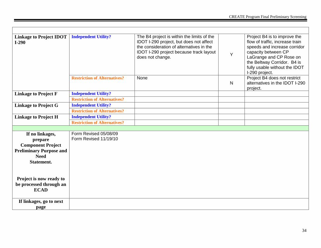
CREATE Program Final Preliminary Screening
34
Linkage to Project IDOT
I-290
Independent Utility? The B4 project is within the limits of the IDOT I-290 project, but does not affect the consideration of alternatives in the IDOT I-290 project because track layout does not change.
Y
Project B4 is to improve the flow of traffic, increase train speeds and increase corridor capacity between CP LaGrange and CP Rose on the Beltway Corridor. B4 is fully usable without the IDOT I-290 project.
Restriction of Alternatives? None N
Project B4 does not restrict alternatives in the IDOT I-290 project.
Linkage to Project F Independent Utility?
Restriction of Alternatives?
Linkage to Project G Independent Utility?
Restriction of Alternatives?
Linkage to Project H Independent Utility?
Restriction of Alternatives?
If no linkages,
prepare
Component Project
Preliminary Purpose and
Need
Statement.
Project is now ready to
be processed through an
ECAD
Form Revised 05/08/09 Form Revised 11/19/10
If linkages, go to next
page

CREATE Program Final Preliminary Screening
35
List Component Projects
that Constitute the
Linked Project
B4 and B5
CREATE Linked Project Profile
Project Identifier
B4/B5 (LaGrange TCS/Broadview) Objective, Intent of
Project
To improve the flow of traffic, increase train speeds and increase corridor capacity between CP LaGrange and CP Hill on the Beltway Corridor and to CN Freeport subdivision.
Description of
Proposed Work/
Improvements
Install TCS signaling on tracks #1, 2, and 21 between CP LaGrange and CP Rose Lake. Upgrade track #21 to a main track from a running track, increasing speed to 30 mph from “restricted speed”. Power up switches on West Pass siding track. Create a new CP “Broadview”, with universal crossovers to be installed.
Location: Owner(s)
Route/Line
Project Limits
Local Community
IHB and CN
IHB Mainline
Between CP LaGrange and CP Rose along the Beltway Corridor. (From near the intersection of Erie St. and Eastern Ave. in Bellwood, IL to near the intersection of Ogden Ave. and S. Tilden Ave. in LaGrange, IL.)
Bellwood, Broadview, LaGrange Park, LaGrange, McCook, and Melrose Park IL
Potential Environmental
Issues Needing Further
Study
No issues appear to need greater detail than normally accomplished through ECAD process.
Project Status
Engineering: Preliminary layout and estimate. Ground survey and detailed signal design needs to be completed.
Estimated Project
Costs
(Level of Confidence)
Construction $ 27.219.8 Million R/W $ 0 Contingencies $ TBD
Planning Estimate
Preliminary Engineering Estimate
Adjoining CREATE
Projects
(Proj.#, Line, distance)
A. B2
B. B3
C. GS13
D. B6
E. GS10

CREATE Program Final Preliminary Screening
36
Other Related
Projects
(Nature of
Relationship)
EF. I-290 IDOT Project – possible reconstruction of IHB bridge over I-290.
FG.
GH.
HI.
Comments:
Individual Component Project Logical Termini Test – Determine 1) sufficient length and scope; 2) independent utility; and 3) restriction of
alternatives.
1) Sufficient Length & Scope Determination
Does the proposed project have sufficient length and scope to broadly address environmental issues? If no, modify project limits. After project limits are modified, ensure project profile is accurate, then proceed to project linkage test.
Y/N
Y
2) Independent Utility and 3) Restriction of Alternatives Determination
Discussion
Y/N
Rationale

CREATE Program Final Preliminary Screening
37
Linkage to Project B2 Independent Utility? Does the project have independent utility or independent significance, i.e., be usable and be a reasonable expenditure even if no additional transportation improvements in the area are made?
Project B2 would only cause signal software programming considerations in B4/B5.
Y
Project B4/B5 is to improve the flow of traffic, increase train speeds and increase corridor capacity between CP LaGrange and CP Rose on the Beltway Corridor and to CN Freeport subdivision. B4/B5 is fully usable without B2.
Restriction of Alternatives? Does the project restrict the consideration of alternatives for other reasonably foreseeable transportation improvements?
None
N
Project B4/B5 does not restrict alternatives in B2.
Linkage to Project B3 Independent Utility? None
Y
Project B4/B5 is to improve the flow of traffic, increase train speeds and increase corridor capacity between CP LaGrange and CP Rose on the Beltway Corridor and to CN Freeport subdivision. B4/B5 is fully usable without B3.
Restriction of Alternatives? Project B3 would only cause signal software programming considerations in B4/B5.
N Project B4/B5 does not restrict alternatives in B-3.
Linkage to Project GS13 Independent Utility? None
Y
Project B4/B5 is to improve the flow of traffic, increase train speeds and increase corridor capacity between CP LaGrange and CP Rose on the Beltway Corridor and to CN Freeport subdivision. B-4/B5 is fully usable without GS13.

CREATE Program Final Preliminary Screening
38
Restriction of Alternatives? The physical characteristic of track layout does not change and thus does not affect the design of GS13.
N Project B4/B5 does not restrict alternatives in GS13.
Linkage to Project IDOT
I-290
Independent Utility? The B4/B5 project is within the limits of the IDOT I-290 project, but does not affect the consideration of alternatives in the IDOT I-290 project because track layout does not change
Y
Project B4/B5 is to improve the flow of traffic, increase train speeds and increase corridor capacity between CP LaGrange and CP Rose on the Beltway Corridor and to CN Freeport subdivision. B4/B5 is fully usable without the IDOT I-290 project.
Restriction of Alternatives? None N
Project B-4/B-5 does not restrict alternatives in the IDOT I-290 project.
Linkage to Project B6 Independent Utility? Significant distance between these two projects and neither has an impact on the other. (2.5 miles)
Y
Project B4/B5 is to improve the flow of traffic, increase train speeds and increase corridor capacity between CP LaGrange and CP Rose on the Beltway Corridor and to CN Freeport subdivision. B4/B5 is fully usable without B6.
Restriction of Alternatives? None N
Project B4/B5 does not restrict alternatives in B6.
Linkage to Project GS10 Independent Utility? None
Y
Project B4/B5 is to improve the flow of traffic, increase train speeds and increase corridor capacity between CP LaGrange and CP Rose on the Beltway Corridor and to CN Freeport subdivision. B4/B5 is fully usable without GS10.
Restriction of Alternatives? None N
Project B4/B5 does not restrict alternatives in GS10.
Linkage to Project G Independent Utility?

CREATE Program Final Preliminary Screening
39
Restriction of Alternatives?
Linkage to Project H Independent Utility?
Restriction of Alternatives?
Linked Project
Preliminary Purpose and
Need
Project is now ready to
be processed through an
ECAD
The purpose of this proposed action is to improve the flow of traffic, increase train speeds and increase corridor capacity between CP LaGrange and CP Rose on the Beltway Corridor and to CN Freeport subdivision. Form Completed: 01/21/04 Form Revised: 03/31/04 Form Revised 05/08/09 Form Revised 11/19/10

CREATE Program Final Preliminary Screening
40
CREATE Component Project Preliminary Screening Worksheet
CREATE Component Project Profile
Project Identifier
B6 (McCook Connection) Objective, Intent of Project Improve the speed and capacity between the BNSF and IHB at CP McCook.
Description of Proposed
Work/ Improvements
Construct second southwest connection between BNSF and IHB/B&OCT(CSX). Extend present connection an additional 7000 feet and increase speed to 25 mph. Add additional crossover on IHB/B&OCT(CSX) trackage. Signalize to provide visibility and electronic route request capability.
Location: Owner(s)
Route/Line
Project Limits
Local Community
BNSF and B&OCT(CSX)
IHB Mainline and BNSF Chillicothe Subdivision
From the BNSF to IHB/B&OCT(CSX) trackage just south of CP McCook.
McCook, IL
Potential Environmental Issues
Needing Further Study
No issues appear to need greater detail than normally accomplished through ECAD process.
Project Status
Engineering: Preliminary layout and estimate. Ground survey and detailed signal design needs to be completed.
Estimated Project Costs
(Level of Confidence)
Construction $ 14 Million R/W $ No Contingencies $ TBD
Planning Estimate
Preliminary Engineering Estimate
Adjoining CREATE
Projects
(Proj.#, Line, distance)
A. B4/B5
B. B8
C.
D.
Other Related Projects
(Nature of Relationship)
E.
F.
G.
H.
Comments/Notes:

CREATE Program Final Preliminary Screening
41
Individual Component Project Logical Termini Test – Determine 1) sufficient length and scope; 2) independent utility; and 3) restriction of
alternatives.
1) Sufficient Length & Scope Determination
Does the proposed project have sufficient length and scope to broadly address environmental issues? If no, modify project limits. After project limits are modified, ensure project profile is accurate, then proceed to project linkage test.
Y/N
Y
2) Independent Utility and 3) Restriction of Alternatives Determination
Discussion
Y/N
Rationale
Linkage to Project
B4/B5
Independent Utility? Does the
project have independent utility or independent significance, i.e., be usable and be a reasonable expenditure even if no additional transportation improvements in the area are made?
Significant distance between these two projects and neither has an impact on the other. (2.5 miles) Y
Project B6 is to improve the speed and capacity between the BNSF and IHB at CP McCook. B6 is fully usable without B4/B5.
Restriction of Alternatives? Does the project restrict the consideration of alternatives for other reasonably foreseeable transportation improvements?
None
N
Project B6 does not restrict alternatives in B4/B5.
Linkage to Project B8 Independent Utility? Project B6 would only cause signal software programming considerations in B8. Y
Project B6 is to improve the speed and capacity between the BNSF and IHB at CP McCook. B6 is fully usable without B8.
Restriction of Alternatives? None N
Project B6 does not restrict alternatives in B8.

CREATE Program Final Preliminary Screening
42
Linkage to Project C Independent Utility?
Restriction of Alternatives?
Linkage to Project D Independent Utility?
Restriction of Alternatives?
Linkage to Project E Independent Utility?
Restriction of Alternatives?
Linkage to Project F Independent Utility?
Restriction of Alternatives?
Linkage to Project G Independent Utility?
Restriction of Alternatives?
Linkage to Project H Independent Utility?
Restriction of Alternatives?
If no linkages,
prepare
Component Project
Preliminary Purpose and
Need
Statement.
Project is now ready to
be processed through an
ECAD
The purpose of this proposed action is to improve the speed and capacity between the BNSF and IHB at CP McCook. Form Completed: 01/21/04 Form Revised: 03/30/04 Form Revised 05/08/09
If linkages, go to next
page
NONE

CREATE Program Final Preliminary Screening
43
CREATE Component Project Preliminary Screening Worksheet
CREATE Component Project Profile
Project Identifier
B8 (Argo to CP Canal TCS) Objective, Intent of Project To increase train speeds and capacity between CP Argo and CP Canal.
Description of Proposed
Work/ Improvements
Install TCS signaling.
Location: Owner(s)
Route/Line
Project Limits
Local Community
B&OCT(CSX)
IHB Mainline
Between CP Canal and CP Argo. (From near the intersection of Pielet Drive and West 59th St. in Summit, IL to near the intersection of Archer Ave. and West 63rd St. Place in Argo, IL.)
Summit, IL
Potential Environmental Issues
Needing Further Study
No issues appear to need greater detail than normally accomplished through ECAD process. Project is within the I&M Canal National Heritage Corridor.
Project Status
Engineering: Preliminary layout and estimate. Ground survey and detailed signal design needs to be completed.
Estimated Project Costs
(Level of Confidence)
Construction $ 3.24.2 Million R/W $ 0 Contingencies $ TBD
Planning Estimate
Preliminary Engineering Estimate
Adjoining CREATE
Projects
(Proj.#, Line, distance)
A. B6
B. B9/EW1
C. P6
D.
Other Related Projects
(Nature of Relationship)
E.
F.
G.
H.
Comments/Notes:

CREATE Program Final Preliminary Screening
44
Individual Component Project Logical Termini Test – Determine 1) sufficient length and scope; 2) independent utility; and 3) restriction of
alternatives.
1) Sufficient Length & Scope Determination
Does the proposed project have sufficient length and scope to broadly address environmental issues? If no, modify project limits. After project limits are modified, ensure project profile is accurate, then proceed to project linkage test.
Y/N
Y
2) Independent Utility and 3) Restriction of Alternatives Determination
Discussion
Y/N
Rationale
Linkage to Project B6
Independent Utility? Does the
project have independent utility or independent significance, i.e., be usable and be a reasonable expenditure even if no additional transportation improvements in the area are made?
Project B6 would only cause signal software programming considerations in B8.
Y
Project B8 is to increase train speeds and capacity between CP Argo and CP Canal. B8 is fully usable without B6.
Restriction of Alternatives? Does the project restrict the consideration of alternatives for other reasonably foreseeable transportation improvements?
None
N
Project B8 does not restrict alternatives in B6.
Linkage to Project
B9/EW1
Independent Utility? Project B9/EW1 would only cause signal software programming considerations in B8.
Y
Project B8 is to increase train speeds and capacity between CP Argo and CP Canal. B8 is fully usable without B9/EW1.
Restriction of Alternatives? None N
Project B8 does not restrict alternatives in B9/EW1.

CREATE Program Final Preliminary Screening
45
Linkage to Project P-6 Independent Utility? Project P6 would only cause signal software programming considerations in B8.
Y
Project B8 is to increase train speeds and capacity between CP Argo and CP Canal. B8 is fully usable without P6.
Restriction of Alternatives? None N
Project B8 does not restrict alternatives in P6.
Linkage to Project D Independent Utility?
Restriction of Alternatives?
Linkage to Project E Independent Utility?
Restriction of Alternatives?
Linkage to Project F Independent Utility?
Restriction of Alternatives?
Linkage to Project G Independent Utility?
Restriction of Alternatives?
Linkage to Project H Independent Utility?
Restriction of Alternatives?
If no linkages,
prepare
Component Project
Preliminary Purpose and
Need
Statement.
Project is now ready to
be processed through an
ECAD
The purpose of this proposed action is to increase train speeds and capacity between CP Argo and CP Canal. Form Completed: 01/21/04 Form Revised: 03/30/04 Form Revised 05/08/09 Form Revised 11/18/10
If linkages, go to next
page
NONE

CREATE Program Final Preliminary Screening
46
CREATE Component Project Preliminary Screening Worksheet
CREATE Component Project Profile
Project Identifier
B9 (Argo Connections) Objective, Intent of Project Improve connection between the East-West and Beltway Corridors at CP Argo.
Description of Proposed
Work/ Improvements
Create a double track connection between the BRC and IHB/B&OCT(CSX) at CP Argo by installing new crossovers and upgrading lead tracks. Provide additional improvements to remove switching activities from the IHB mains.
Location: Owner(s)
Route/Line
Project Limits
Local Community
B&OCT(CSX) and BRC
IHB Mainline
IHB Mainline between 62nd Street and 71st Street.
Summit, and Bedford Park and Bridgeview, IL
Potential Environmental Issues
Needing Further Study
No issues appear to need greater detail than normally accomplished through ECAD process. Project is within the I&M Canal National Heritage Corridor.
Project Status
Engineering: Preliminary layout and estimate. Ground survey and detailed signal design needs to be completed.
Estimated Project Costs
(Level of Confidence)
Construction $ 22.79.8 Million R/W $ 0 Contingencies $ TBD
Planning Estimate
Preliminary Engineering Estimate
Adjoining CREATE
Projects
(Proj.#, Line, distance)
A. B8
B. GS14
C. EW1
D.
Other Related Projects
(Nature of Relationship)
E.
F.
G.
H.
Comments/Notes:

CREATE Program Final Preliminary Screening
47
Individual Component Project Logical Termini Test – Determine 1) sufficient length and scope; 2) independent utility; and 3) restriction of
alternatives.
1) Sufficient Length & Scope Determination
Does the proposed project have sufficient length and scope to broadly address environmental issues? If no, modify project limits. After project limits are modified, ensure project profile is accurate, then proceed to project linkage test.
Y/N
Y
2) Independent Utility and 3) Restriction of Alternatives Determination
Discussion
Y/N
Rationale
Linkage to Project B8
Independent Utility? Does the
project have independent utility or independent significance, i.e., be usable and be a reasonable expenditure even if no additional transportation improvements in the area are made?
Project B9 would only cause signal software programming considerations in B8.
Y
Project B9 is to improve the connection between the East-West and Beltway Corridors at CP Argo. B9 is fully usable without B8.
Restriction of Alternatives? Does the project restrict the consideration of alternatives for other reasonably foreseeable transportation improvements?
None
N
Project B9 does not restrict alternatives in B-8.
Linkage to Project GS14 Independent Utility? Significant distance between these two projects and neither has an impact on the other. (0.8 mile) Y
Project B9 is to improve the connection between the East-West and Beltway Corridors at CP Argo. B9 is fully usable without GS14.
Restriction of Alternatives? None
N
Project B-9 does not restrict alternatives in GS-14.

CREATE Program Final Preliminary Screening
48
Linkage to Project EW1 Independent Utility? Project B9 will physically connect to project EW1 and is not fully usable without EW1.
N
Project B9 to improve the connection between the East-West and Beltway Corridors at CP Argo. B9 is not fully usable without EW1. Therefore the projects are linked.
Restriction of Alternatives? The physical connection between these two projects would restrict the design and utility of both projects.
Y
Project B9 does restrict alternatives in EW1. Therefore the projects are linked.
Linkage to Project D Independent Utility?
Restriction of Alternatives?
Linkage to Project E Independent Utility?
Restriction of Alternatives?
Linkage to Project F Independent Utility?
Restriction of Alternatives?
Linkage to Project G Independent Utility?
Restriction of Alternatives?
Linkage to Project H Independent Utility?
Restriction of Alternatives?
If no linkages,
prepare
Component Project
Preliminary Purpose and
Need
Statement.
Project is now ready to
be processed through an
ECAD
Form Revised 05/08/09 Form Revised 11/19/10
If linkages, go to next
page

CREATE Program Final Preliminary Screening
49
List Component Projects
that Constitute the
Linked Project
B9 and EW1
CREATE Linked Project Profile
Project Identifier
B9/EW1 (Argo Connections/ Clearing Main Lines) Objective, Intent of
Project
Create a new East-West Corridor that provides dedicated route for through trains at Clearing Yard and improves connection to Beltway Corridor at CP Argo.
Description of
Proposed Work/
Improvements
Create a double track connection between the BRC and IHB/B&OCT(CSX) at Argo by installing new crossovers and upgrading lead tracks. Construct two new main tracks (~35,000 feet of total new trackage) around Clearing Yard between Hayford and CP Argo. Any existing BRC yard tracks utilized for new mainline will be replaced with additional track on current yard property. Associated signal work. Includes modifying highway bridges at Cicero and Pulaski Streets. Perform track and signal improvements on the existing connection between the CN Joliet Sub and the B&OCT (CSX) McCook Subdivision at CP Canal; Create a double track connection between the BRC and IHB/B&OCT(CSX) at Argo by installing new crossovers and upgrading lead tracks. Construct two new main tracks (~35,000 feet of total new trackage) around Clearing Yard between Hayford and CP Argo. Also, extend and upgrade the B&O Siding compass south to 87th St. Any BRC tracks utilized for new mainline will be replaced with additional track on current yard property. Includes associated signal work. Includes modifying highway bridges at Cicero and Pulaski Streets.
Location: Owner(s)
Route/Line
Project Limits
Local Community
B&OCT(CSX) and BRC
IHB Mainline and BRC Clearing Yard
IHB Mainline between the Sanitary and Ship Canal (CP Canal) and 87th St. 62nd Street and 71st Street and BRC Clearing Yard from IHB/BRC connection at the intersection of 65th and 76th Avenue to the intersection of 75th and Hohman Streets.
Summit, Bedford Park and Bridgeview, IL and in Chicago Community Areas - Ashburn, Chicago Lawn, Clearing and West Lawn
Potential Environmental
Issues Needing Further
Study
No issues appear to need greater detail than normally accomplished through ECAD process. Project is within the I&M Canal National Heritage Corridor.
Project Status
Engineering: Preliminary layout and estimate. Ground survey and detailed signal design needs to be completed.
Estimated Project
Costs
(Level of Confidence)
Construction $ 86.0 Million R/W $ –0 Contingencies $ TBD
Planning Estimate
Preliminary Engineering Estimate

CREATE Program Final Preliminary Screening
50
Adjoining CREATE
Projects
(Proj.#, Line, distance)
A. B8
B. GS14 C. EW2/P2/P3/GS19
D. P6
Other Related
Projects
(Nature of
Relationship)
E. Chicago – St. Louis Corridor Improvement Study
F.
G.
H.
Comments:
Individual Component Project Logical Termini Test – Determine 1) sufficient length and scope; 2) independent utility; and 3) restriction of
alternatives.
1) Sufficient Length & Scope Determination
Does the proposed project have sufficient length and scope to broadly address environmental issues? If no, modify project limits. After project limits are modified, ensure project profile is accurate, then proceed to project linkage test.
Y/N
Y
2) Independent Utility and 3) Restriction of Alternatives Determination
Discussion Y/N Rationale

CREATE Program Final Preliminary Screening
51
Linkage to Project B8 Independent Utility? Does the project have independent utility or independent significance, i.e., be usable and be a reasonable expenditure even if no additional transportation improvements in the area are made?
Project B9/EW1 would only cause signal software programming considerations in B-8.
Y
Project B9/EW1 is to create a new East-West Corridor that provides dedicated route for through trains at Clearing Yard and improves connection to Beltway Corridor at CP Argo. B9/EW1 is fully usable without B8.
Restriction of Alternatives? Does the project restrict the consideration of alternatives for other reasonably foreseeable transportation improvements?
None
N
Project B9/EW1 does not restrict alternatives in B8.
Linkage to Project GS14 Independent Utility? Significant distance between these two projects and neither has an impact on the other. (0.8 mile)
Y
Project B9/EW1 is to create a new East-West Corridor that provides dedicated route for through trains at Clearing Yard and improves connection to Beltway Corridor at CP Argo. B9/EW1 is fully usable without GS14.
Restriction of Alternatives? None N
Project B9/EW1 does not restrict alternatives in GS14.
Linkage to Project
EW2/P2/P3/GS19
Independent Utility? Significant distance between these two projects and neither has an impact on the other.
Y
Project B9/EW1 is to create a new East-West Corridor that provides dedicated route for through trains at Clearing Yard and improves connection to Beltway Corridor at CP Argo. B9/EW1 is fully usable without EW2/P2/P3/GS19.
Restriction of Alternatives? None N
Project B9/EW1 does not restrict alternatives in EW2/P2/P3/GS19.
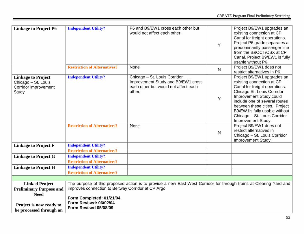
CREATE Program Final Preliminary Screening
52
Linkage to Project P6 Independent Utility? P6 and B9/EW1 cross each other but would not affect each other.
Y
Project B9/EW1 upgrades an existing connection at CP Canal for freight operations. Project P6 grade separates a predominantly passenger line from the B&OCT/CSX at CP Canal. Project B9/EW1 is fully usable without P6.
Restriction of Alternatives? None N
Project B9/EW1 does not restrict alternatives in P6.
Linkage to Project Chicago – St. Louis Corridor improvement Study
Independent Utility? Chicago – St. Louis Corridor Improvement Study and B9/EW1 cross each other but would not affect each other.
Y
Project B9/EW1 upgrades an existing connection at CP Canal for freight operations. Chicago St. Louis Corridor Improvement Study could include one of several routes between these cities. Project B9/EW1is fully usable without Chicago – St. Louis Corridor Improvement Study.
Restriction of Alternatives? None
N
Project B9/EW1 does not restrict alternatives in Chicago – St. Louis Corridor Improvement Study.
Linkage to Project F Independent Utility?
Restriction of Alternatives?
Linkage to Project G Independent Utility?
Restriction of Alternatives?
Linkage to Project H Independent Utility?
Restriction of Alternatives?
Linked Project
Preliminary Purpose and
Need
Project is now ready to
be processed through an
The purpose of this proposed action is to provide a new East-West Corridor for through trains at Clearing Yard and improves connection to Beltway Corridor at CP Argo. Form Completed: 01/21/04 Form Revised: 06/02/04 Form Revised 05/08/09

CREATE Program Final Preliminary Screening
53
ECAD Form Revised 11/19/10

CREATE Program Final Preliminary Screening
54
CREATE Component Project Preliminary Screening Worksheet
CREATE Component Project Profile
Project Identifier
B12 (3rd
Mainline 123rd
Street to CP Francisco)
Objective, Intent of Project To increase capacity and decrease average travel time between CP Francisco and CP 123rd St and the Cal Sag Channel.
Description of Proposed
Work/ Improvements
A third main will be constructed along the Beltway Corridor, including constructing new track and the upgrading of some existing track, between CP 123rd St. and the Cal Sag Channel. Includes a new Rail bridge over 127th Street. Includes associated signal work.
Location: Owner(s)
Route/Line
Project Limits
Local Community
B&OCT(CSX)
IHB Mainline
Between Cal Sag Channel and CP 123rd St.
Alsip and Blue Island
Potential Environmental Issues
Needing Further Study
No issues appear to need greater detail than normally accomplished through ECAD process.
Project Status
Engineering: Preliminary layout and estimate. Ground survey and detailed signal design needs to be completed.
Estimated Project Costs
(Level of Confidence)
Construction $ 23.9 19.1Million R/W $ 0 Contingencies $ TBD
Planning Estimate
Preliminary Engineering Estimate
Adjoining CREATE
Projects
(Proj.#, Line, distance)
A. B13
B. GS22
C. WA10
D.
Other Related Projects
(Nature of Relationship)
E.
F.
G.
H.
Comments/Notes:

CREATE Program Final Preliminary Screening
55
Individual Component Project Logical Termini Test – Determine 1) sufficient length and scope; 2) independent utility; and 3) restriction of
alternatives.
1) Sufficient Length & Scope Determination
Does the proposed project have sufficient length and scope to broadly address environmental issues? If no, modify project limits. After project limits are modified, ensure project profile is accurate, then proceed to project linkage test.
Y/N
Y
2) Independent Utility and 3) Restriction of Alternatives Determination
Discussion
Y/N
Rationale
Linkage to Project B13
Independent Utility? Does the
project have independent utility or independent significance, i.e., be usable and be a reasonable expenditure even if no additional transportation improvements in the area are made?
Project B13 would only cause signal software programming considerations in B12.
Y
Project B12 is to increase capacity and decrease average travel time between CP Francisco and CP 123rd
St. B12 is fully usable without B13.
Restriction of Alternatives? Does the project restrict the consideration of alternatives for other reasonably foreseeable transportation improvements?
None
N
Project B12 does not restrict alternatives in B13.
Linkage to Project GS22 Independent Utility? Significant distance between these two projects and neither has an impact on the other. (1.5 miles)
Y
Project B12 is to increase capacity and decrease average travel time between CP Francisco and CP 123rd
St. B12 is fully usable without GS22.
Restriction of Alternatives? None N
Project B12 does not restrict alternatives in GS22.

CREATE Program Final Preliminary Screening
56
Linkage to Project
WA10
Independent Utility? WA10 and B12 are physically close to each other, but are on separate routes and would not affect each other.
Y
Project B12 is to increase capacity and decrease average travel time between CP Francisco and CP 123rd
St. B12 is fully usable without WA10.
Restriction of Alternatives? None N
Project B12 does not restrict alternatives in WA10.
Linkage to Project D Independent Utility?
Restriction of Alternatives?
Linkage to Project E Independent Utility?
Restriction of Alternatives?
Linkage to Project F Independent Utility?
Restriction of Alternatives?
Linkage to Project G Independent Utility?
Restriction of Alternatives?
Linkage to Project H Independent Utility?
Restriction of Alternatives?
If no linkages,
prepare
Component Project
Preliminary Purpose and
Need
Statement.
Project is now ready to
be processed through an
ECAD
The purpose of this proposed action is to increase capacity and decrease average travel time between CP Francisco and CP 123rd St. Form Completed: 01/21/04 Form Revised: 03/30/04 Form Revised: 05/08/09 Form Revised: 11/23/10
If linkages, go to next
page
NONE

CREATE Program Final Preliminary Screening
57
CREATE Component Project Preliminary Screening Worksheet
CREATE Component Project Profile
Project Identifier
B13 (Blue Island Junction Connection) Objective, Intent of Project To increase train speeds through Blue Island Junction between IHB and CN.
Description of Proposed
Work/ Improvements
Upgrade rail on CN connecting track and upgrade existing crossover at CP Broadway. associated switches between CN Elsdon Subdivision and IHB and increase speeds to 25 mph. Includes associated signal work.
Location: Owner(s)
Route/Line
Project Limits
Local Community
B&OCT(CSX) and CN
IHB Mainline and CN Elsdon Subdivision
From CP Francisco to CP Broadway, along the Beltway Corridor and the CN connecting track.
Blue Island, IL
Potential Environmental Issues
Needing Further Study
No issues appear to need greater detail than normally accomplished through ECAD process.
Project Status
Engineering: Preliminary layout and estimate. Ground survey and detailed signal design needs to be completed.
Estimated Project Costs
(Level of Confidence)
Construction $ 3.5 Million R/W $ 0 Contingencies $ TBD
Planning Estimate
Preliminary Engineering Estimate
Adjoining CREATE
Projects
(Proj.#, Line, distance)
A. B12
B. WA10
C. B16
D. B15
Other Related Projects
(Nature of Relationship)
E.
F.
G.
H.
Comments/Notes:

CREATE Program Final Preliminary Screening
58
Individual Component Project Logical Termini Test – Determine 1) sufficient length and scope; 2) independent utility; and 3) restriction of
alternatives.
1) Sufficient Length & Scope Determination
Does the proposed project have sufficient length and scope to broadly address environmental issues? If no, modify project limits. After project limits are modified, ensure project profile is accurate, then proceed to project linkage test.
Y/N
Y
2) Independent Utility and 3) Restriction of Alternatives Determination
Discussion
Y/N
Rationale
Linkage to Project B12
Independent Utility? Does the
project have independent utility or independent significance, i.e., be usable and be a reasonable expenditure even if no additional transportation improvements in the area are made?
Project B13 would only cause signal software programming considerations in B12.
Y
Project B13 is to increase train speeds through Blue Island Junction between IHB and CN. B13 is fully usable without B12.
Restriction of Alternatives? Does the project restrict the consideration of alternatives for other reasonably foreseeable transportation improvements?
None
N
Project B13 does not restrict alternatives in B12.
Linkage to Project
WA10
Independent Utility? WA10 and B13 are physically close to each other, but are on separate routes and would not affect each other. Y
Project B13 is to increase train speeds through Blue Island Junction between IHB and CN. B13 is fully usable without WA10.
Restriction of Alternatives? None N
Project B13 does not restrict alternatives in WA10.

CREATE Program Final Preliminary Screening
59
Linkage to Project B16 Independent Utility? Significant distance between these two projects and neither has an impact on the other. (5.5 miles) Y
Project B13 is to increase train speeds through Blue Island Junction between IHB and CN. B13 is fully usable without B16.
Restriction of Alternatives? None N
Project B13 does not restrict alternatives in B16.
Linkage to Project B15 Independent Utility? Significant distance between these two projects and neither has an impact on the other (2 miles), and B-15 would only cause signal software programming considerations in B-13.
Y
Project B13 is to increase train speeds through Blue Island Junction between IHB and CN. B13 is fully usable without B15.
Restriction of Alternatives? None N
Project B13 does not restrict alternatives in B15.
Linkage to Project E Independent Utility?
Restriction of Alternatives?
Linkage to Project F Independent Utility?
Restriction of Alternatives?
Linkage to Project G Independent Utility?
Restriction of Alternatives?
Linkage to Project H Independent Utility?
Restriction of Alternatives?
If no linkages,
prepare
Component Project
Preliminary Purpose and
Need
Statement.
Project is now ready to
be processed through an
ECAD
The purpose of this proposed action is to increase train speeds through Blue Island Junction between IHB and CN. Form Completed: 01/21/04 Form Revised: 03/30/04 Form Revised: 05/08/09
If linkages, go to next
page
NONE

CREATE Program Final Preliminary Screening
60
CREATE Component Project Preliminary Screening Worksheet
CREATE Component Project Profile
Project Identifier
B15 (TCS Blue Island Yard Running Tracks) Objective, Intent of Project To increase train speeds around Blue Island Yard, from CP Harvey to Dolton.
Description of Proposed
Work/ Improvements
Install TCS signaling between CP Harvey and Dolton, and install power switches at School St. and at the Northwest connection at Ashland Ave.
Location: Owner(s)
Route/Line
Project Limits
Local Community
IHB
IHB Mainline
Between the CPs on either side of Blue Island Yard (CP Harvey and Dolton). (From the intersection of Western Ave. and 140th St. in Blue Island, IL to the intersection of 140th St. and Indiana Ave. in Dolton, IL.)
Blue Island, Riverdale and Dolton, IL
Potential Environmental Issues
Needing Further Study
No issues appear to need greater detail than normally accomplished through ECAD process.
Project Status
Engineering: Preliminary layout and estimate. Ground survey and detailed signal design needs to be completed.
Estimated Project Costs
(Level of Confidence)
Construction $ 14.0 13.0Million R/W $ 0 Contingencies $ TBD
Planning Estimate
Preliminary Engineering Estimate
Adjoining CREATE
Projects
(Proj.#, Line, distance)
A. B13 B. WA11
C.
D.
Other Related Projects
(Nature of Relationship)
E.
F.
G.
H.
Comments/Notes:

CREATE Program Final Preliminary Screening
61
Individual Component Project Logical Termini Test – Determine 1) sufficient length and scope; 2) independent utility; and 3) restriction of
alternatives.
1) Sufficient Length & Scope Determination
Does the proposed project have sufficient length and scope to broadly address environmental issues? If no, modify project limits. After project limits are modified, ensure project profile is accurate, then proceed to project linkage test.
Y/N
Y
2) Independent Utility and 3) Restriction of Alternatives Determination
Discussion
Y/N
Rationale
Linkage to Project B13
Independent Utility? Does the
project have independent utility or independent significance, i.e., be usable and be a reasonable expenditure even if no additional transportation improvements in the area are made?
Significant distance between these two projects and neither has an impact on the other (2 miles), and B-13 would only cause signal software programming considerations in B-15.
Y
Project B15 is to increase train speeds around Blue Island Yard, from CP Harvey to Dolton. B15 is fully usable without B13.
Restriction of Alternatives? Does the project restrict the consideration of alternatives for other reasonably foreseeable transportation improvements?
None
N
Project B15 does not restrict alternatives in B13.
Linkage to Project
WA11
Independent Utility? WA11 would only cause signal software programming considerations in B-15.
Y
Project B15 is to increase train speeds around Blue Island Yard, from CP Harvey to Dolton. B15 is fully usable without WA-11.
Restriction of Alternatives? None N
Project B15 does not restrict alternatives in WA11.

CREATE Program Final Preliminary Screening
62
Linkage to Project C Independent Utility?
Restriction of Alternatives?
Linkage to Project D Independent Utility?
Restriction of Alternatives?
Linkage to Project E Independent Utility?
Restriction of Alternatives?
Linkage to Project F Independent Utility?
Restriction of Alternatives?
Linkage to Project G Independent Utility?
Restriction of Alternatives?
Linkage to Project H Independent Utility?
Restriction of Alternatives?
If no linkages,
prepare
Component Project
Preliminary Purpose and
Need
Statement.
Project is now ready to
be processed through an
ECAD
The purpose of this proposed action is to increase train speeds around Blue Island Yard, between CP Harvey and Dolton.
Form Completed: 01/21/04 Form Revised: 03/30/04 Form Revised: 05/08/09 Form Revised : 11/27/10
If linkages, go to next
page
NONE

CREATE Program Final Preliminary Screening
63
CREATE Component Project Preliminary Screening Worksheet
CREATE Component Project Profile
Project Identifier
B16 (Thornton Junction Connection) Objective, Intent of Project To reestablish a former connection to connect the Beltway and Western Avenue Corridors.
Description of Proposed
Work/ Improvements
Install new interlocked connection between CN and UP/CSX in the southwest quadrant of the current crossing at Thornton Junction. Includes associated signal work.
Location: Owner(s)
Route/Line
Project Limits
Local Community
CN and UP/CSX
CN Elsdon Subdivision and UP Villa Grove Subdivision
In the southwest quadrant of the Thornton Interlocking. (Near State Street and 168th Street)
South Holland, IL
Potential Environmental Issues
Needing Further Study
No issues appear to need greater detail than normally accomplished through ECAD process.
Project Status
Engineering: Preliminary layout and estimate. Ground survey and detailed signal design needs to be completed.
Estimated Project Costs
(Level of Confidence)
Construction $ 4.1 Million R/W $ Yes - TBD Contingencies $ TBD
Planning Estimate
Preliminary Engineering Estimate
Adjoining CREATE
Projects
(Proj.#, Line, distance)
A. B13
B. WA11
C. GS-23
D.
Other Related Projects
(Nature of Relationship)
E.
F.
G.
H.
Comments/Notes:

CREATE Program Final Preliminary Screening
64
Individual Component Project Logical Termini Test – Determine 1) sufficient length and scope; 2) independent utility; and 3) restriction of
alternatives.
1) Sufficient Length & Scope Determination
Does the proposed project have sufficient length and scope to broadly address environmental issues? If no, modify project limits. After project limits are modified, ensure project profile is accurate, then proceed to project linkage test.
Y/N
Y
2) Independent Utility and 3) Restriction of Alternatives Determination
Discussion
Y/N
Rationale
Linkage to Project B13
Independent Utility? Does the
project have independent utility or independent significance, i.e., be usable and be a reasonable expenditure even if no additional transportation improvements in the area are made?
Significant distance between these two projects and neither has an impact on the other. (5.5 miles)
Y
Project B16 is to establish a connection between the Beltway and Western Avenue Corridors. B16 is fully usable without B13.
Restriction of Alternatives? Does the project restrict the consideration of alternatives for other reasonably foreseeable transportation improvements?
None
N
Project B16 does not restrict alternatives in B13.
Linkage to Project
WA11
Independent Utility? Significant distance between these two projects and neither has an impact on the other. (4.5 miles) Y
Project B16 is to establish a connection between the Beltway and Western Avenue Corridors. B16 is fully usable without WA11.
Restriction of Alternatives? None N
Project B16 does not restrict alternatives in WA11.

CREATE Program Final Preliminary Screening
65
Linkage to Project GS-
23
Independent Utility? Significant distance between these two projects and neither has an impact on the other. (3.5 miles) Y
Project B-16 is to establish a connection between the Beltway and Western Avenue Corridors. B-16 is fully usable without GS-23.
Restriction of Alternatives? None N
Project B-16 does not restrict alternatives in GS-23.
Linkage to Project D Independent Utility?
Restriction of Alternatives?
Linkage to Project E Independent Utility?
Restriction of Alternatives?
Linkage to Project F Independent Utility?
Restriction of Alternatives?
Linkage to Project G Independent Utility?
Restriction of Alternatives?
Linkage to Project H Independent Utility?
Restriction of Alternatives?
If no linkages,
prepare
Component Project
Preliminary Purpose and
Need
Statement.
Project is now ready to
be processed through an
ECAD
The purpose of this proposed action is to reestablish a former connection to connect the Beltway and Western Avenue Corridors. Form Completed: 01/21/04 Form Revised: 03/30/04 Form Revised 05/08/09 Form Revised 11/03/10
If linkages, go to next
page
NONE

CREATE Program Final Preliminary Screening
66
CREATE Component Project Preliminary Screening Worksheet
CREATE Component Project Profile
Project Identifier
C-1 (Altenheim Subdivision) Objective, Intent of Project To restore the Altenheim Subdivision of B&OCT(CSX) to mainline standards.
Description of Proposed
Work/ Improvements
Upgrade existing double track on the Altenheim Subdivision between the CN/Waukesha Subdivision and Ogden Junction. Add a power connection to the BRC at 14th St. Reconstruct all bridges. Includes associated signal work.
Location: Owner(s)
Route/Line
Project Limits
Local Community
B&OCT(CSX)
B&OCT(CSX) Altenheim Subdivision
Madison St. on the west and Ogden Junction on the east.
Oak Park, IL and Forest Park, IL and Chicago Community Areas – Austin and North Lawndale
Potential Environmental Issues
Needing Further Study
No issues appear to need greater detail than normally accomplished through ECAD process.
Project Status
Engineering: Preliminary layout and estimate. Ground survey and detailed signal design needs to be completed.
Estimated Project Costs
(Level of Confidence)
Construction $ 28.9 R/W $ 0 Contingencies $ TBD
Planning Estimate
Preliminary Engineering Estimate
Adjoining CREATE
Projects
(Proj.#, Line, distance)
A. C-2
B. WA-1
C. C-3/C-4/WA-4
D.
Other Related Projects
(Nature of Relationship)
E. IDOT I-290 Project – possible need to acquire ROW from the railroad.
F.
G.
H.
Comments/Notes:

CREATE Program Final Preliminary Screening
67
Individual Component Project Logical Termini Test – Determine 1) sufficient length and scope; 2) independent utility; and 3) restriction of
alternatives.
1) Sufficient Length & Scope Determination
Does the proposed project have sufficient length and scope to broadly address environmental issues? If no, modify project limits. After project limits are modified, ensure project profile is accurate, then proceed to project linkage test.
Y/N
Y
2) Independent Utility and 3) Restriction of Alternatives Determination
Discussion
Y/N
Rationale
Linkage to Project C-2
Independent Utility? Does the
project have independent utility or independent significance, i.e., be usable and be a reasonable expenditure even if no additional transportation improvements in the area are made?
C-2 would not be constructed without C-1.
N
Project C-1 is to restore the Altenheim Subdivision of B&OCT(CSX) to mainline standards. C-2 is not fully usable without C-1. Therefore the projects are linked.
Restriction of Alternatives? Does the project restrict the consideration of alternatives for other reasonably foreseeable transportation improvements?
None
Y
Project C-2 does not restrict alternatives in C-1.
Linkage to Project WA-1 Independent Utility? WA-1 upgrades the connection between UP and CSX/NS. C-1 restores out of service Altenheim Subdivision and would not require the implementation of WA-1.
Y
Project C-1 is to restore the Altenheim Subdivision of B&OCT(CSX) to mainline standards. C-1 is fully usable without WA-1.
Restriction of Alternatives? None
N
Project C-1 does not restrict alternatives in WA-1.

CREATE Program Final Preliminary Screening
68
Linkage to Project C-
3/C-4/WA-4
Independent Utility? C-3/C-4/WA-4 adds capacity (new track) to existing WA Corridor and is independent of C-1/C-2. Y
Project C-1 is to restore the Altenheim Subdivision of B&OCT(CSX) to mainline standards. C-1 is fully usable without C-3/C-4/WA-4.
Restriction of Alternatives? None N
Project C-1 does not restrict alternatives in C-3/C-4/WA-4.
Linkage to Project
IDOT I-290
Independent Utility? None
Y
Project C-1 is to restore the Altenheim Subdivision of B&OCT(CSX) to mainline standards. C-1 is fully usable without the IDOT I-290 project.
Restriction of Alternatives? The C-1 corridor is within the project limits of the I-290 project, but does not affect the consideration of alternatives in the I-290 project.
N
Project C-1 does not restrict alternatives in IDOT I-290 project.
Linkage to Project E Independent Utility?
Restriction of Alternatives?
Linkage to Project F Independent Utility?
Restriction of Alternatives?
Linkage to Project G Independent Utility?
Restriction of Alternatives?
Linkage to Project H Independent Utility?
Restriction of Alternatives?
If no linkages,
prepare
Component Project
Preliminary Purpose and
Need
Statement.
Project is now ready to be
processed through an
ECAD
If linkages, go to next
page

CREATE Program Final Preliminary Screening
69
List Component Projects
that Constitute the
Linked Project
C-1 and C-2
CREATE Linked Project Profile
Project Identifier
C-1/C-2 (Altenheim Subdivision/Ogden Junction) Objective, Intent of
Project
To restore the Altenheim Subdivision of B&OCT(CSX) to mainline standards and improve the efficiency of operations of the Altenheim Subdivision.
Description of
Proposed Work/
Improvements
Upgrade existing double track on the Altenheim Subdivision between the CN/Waukesha Subdivision and Ogden Junction. Add a power connection to the BRC at 14th St. Reconstruct all bridges. Includes associated signal work. Install universal crossovers near the east end of the double-tracked Altenheim Subdivision.
Location: Owner(s)
Route/Line
Project Limits
Local Community
B&OCT(CSX)
B&OCT(CSX) Altenheim Subdivision
From Madison St. in Forest Park, IL to Ogden Junction near 12th St. in Chicago.
Oak Park and Forest Park, IL and Chicago Community Areas – Austin and North Lawndale.
Potential Environmental
Issues Needing Further
Study
No issues appear to need greater detail than normally accomplished through ECAD process.
Project Status
(Percent Design
Complete)
Engineering: Preliminary layout and estimate. Ground survey and detailed signal design needs to be completed.
Estimated Project
Costs
(Level of Confidence)
Construction $ 30.6 Million R/W $ 0 Contingencies $ TBD
Planning Estimate
Preliminary Engineering Estimate
Adjoining CREATE
Projects
(Proj.#, Line, distance)
A. C-3/C-4/WA-4
B. WA-1
C.
D.

CREATE Program Final Preliminary Screening
70
Other Related
Projects
(Nature of
Relationship)
E. IDOT I-290 Project – possible need to acquire ROW from the railroad.
F.
G.
H.
Comments:
Individual Component Project Logical Termini Test – Determine 1) sufficient length and scope; 2) independent utility; and 3) restriction of
alternatives.
1) Sufficient Length & Scope Determination
Does the proposed project have sufficient length and scope to broadly address environmental issues? If no, modify project limits. After project limits are modified, ensure project profile is accurate, then proceed to project linkage test.
Y/N
Y
2) Independent Utility and 3) Restriction of Alternatives Determination
Discussion Y/N
Rationale
Linkage to Project C-
3/C-4/WA-4
Independent Utility? Does the
project have independent utility or independent significance, i.e., be usable and be a reasonable expenditure even if no additional transportation improvements in the area are made?
C-3/C-4/WA-4 adds capacity (new track) to existing WA Corridor and is independent of C-1/C-2.
Y
Project C-1/C-2 is to restore the Altenheim Subdivision of B&OCT(CSX) to mainline standards. C-1/C-2 is fully usable without C-3/C-4/WA-4.
Restriction of Alternatives? Does the project restrict the consideration of alternatives for other reasonably foreseeable transportation improvements?
None
N
Project C-1/C-2 does not restrict alternatives in C-3/C-4/WA-4.

CREATE Program Final Preliminary Screening
71
Linkage to Project WA-1 Independent Utility? WA-1 upgrades the connection between UP and CSX/NS. C-1/C-2 restores out of service Altenheim Subdivision and would not require the implementation of WA-1.
Y
Project C-1/C-2 is to restore the Altenheim Subdivision of B&OCT(CSX) to mainline standards. C-1/C-2 is fully usable without WA-1.
Restriction of Alternatives? None N
Project C-1/C-2 does not restrict alternatives in WA-1.
Linkage to Project IDOT
I-290
Independent Utility? None
Y
Project C-1/C-2 is to restore the Altenheim Subdivision of B&OCT(CSX) to mainline standards. C-1/C-2 is fully usable without the IDOT I-290 project.
Restriction of Alternatives? The C-1/C-2 corridor is within the project limits of the I-290 project, but does not affect the consideration of alternatives in the I-290 project.
N
Project C-1/C-2 does not restrict alternatives in IDOT I-290 project.
Linkage to Project D Independent Utility?
Restriction of Alternatives?
Linkage to Project E Independent Utility?
Restriction of Alternatives?
Linkage to Project F Independent Utility?
Restriction of Alternatives?
Linkage to Project G Independent Utility?
Restriction of Alternatives?
Linkage to Project H Independent Utility?
Restriction of Alternatives?
Linked Project
Preliminary Purpose and
Need
Project is now ready to
be processed through an
ECAD
The purpose of this proposed action is to restore the Altenheim Subdivision of B&OCT(CSX) to mainline standards and improve the efficiency of operations of the Altenheim Subdivision. Form Completed: 01/21/04 Form Revised: 06/02/04

CREATE Program Final Preliminary Screening
72
CREATE Component Project Preliminary Screening Worksheet
CREATE Component Project Profile
Project Identifier
C-3 (Ogden Junction to Ash Street)
Objective, Intent of Project Increase capacity from Ash St. to Ogden Junction.
Description of Proposed
Work/ Improvements
Construct a new mainline where the former Panhandle main existed, paralleling the Western Avenue Corridor. Includes associated signal work, crossovers, and rail bridge rehabilitation.
Location: Owner(s)
Route/Line
Project Limits
Local Community
NS
Old Panhandle ROW
From a connection to the Altenheim Subdivision and to B&OCT(CSX) at Ogden Junction south to the Brighton Park Interlocking.
Chicago Community Areas – Brighton Park and McKinley Park
Potential Environmental Issues
Needing Further Study
No issues appear to need greater detail than normally accomplished through ECAD process.
Project Status
Engineering: Preliminary layout and estimate. Ground survey and detailed signal design needs to be completed.
Estimated Project Costs
(Level of Confidence)
Construction $ 4.5 Million R/W $ 0 Contingencies $ TBD
Planning Estimate
Preliminary Engineering Estimate
Adjoining Projects
(Proj.#, Line, distance)
A. C-1/C-2
B. WA-1
C. C-4
D. WA-4
Other Related Projects
(Nature of Relationship)
E. Brighton Park Interlocking
F.
G.
H.
Comments/Notes:

CREATE Program Final Preliminary Screening
73
Individual Component Project Logical Termini Test – Determine 1) sufficient length and scope; 2) independent utility; and 3) restriction of
alternatives.
1) Sufficient Length & Scope Determination
Does the proposed project have sufficient length and scope to broadly address environmental issues? If no, modify project limits. After project limits are modified, ensure project profile is accurate, then proceed to project linkage test.
Y/N
Y
2) Independent Utility and 3) Restriction of Alternatives Determination
Discussion
Y/N
Rationale
Linkage to Project C-
1/C-2
Independent Utility? Does the
project have independent utility or independent significance, i.e., be usable and be a reasonable expenditure even if no additional transportation improvements in the area are made?
C-3 adds capacity (new track) to existing WA Corridor and is independent of C-1/C-2.
Y
Project C-3 is to construct a new single main track from Ash St. to Ogden Junction to increase capacity. C-3 is fully usable without C-1/C-2.
Restriction of Alternatives? Does the project restrict the consideration of alternatives for other reasonably foreseeable transportation improvements?
None
N
Project C-3 does not restrict alternatives in C-1/C-2.
Linkage to Project WA-1 Independent Utility? Project WA-1 would only cause signal software programming considerations in C-3. Y
Project C-3 is to construct a new single main track from Ash St. to Ogden Junction to increase capacity. C-3 is fully usable without WA-1.
Restriction of Alternatives? None N
Project C-3 does not restrict alternatives in WA-1.

CREATE Program Final Preliminary Screening
74
Linkage to Project C-4 Independent Utility? None
N
Project C-3 is to construct a new single main track from Ash St. to Ogden Junction to increase capacity. C-3 is not fully usable without C-4. Therefore the projects are linked.
Restriction of Alternatives? C-4 would not be built if C-3 were not. Y
Project C-3 does restrict alternatives in C-4. Therefore the projects are linked.
Linkage to Project WA-4 Independent Utility? WA-4 and C-4 have linkage to each other due to areas of common trackage in each project. C-4 is linked to C-3 (see above) and thus WA-4 is linked to C-3.
Y
Project C-3 is to construct a new single main track from Ash St. to Ogden Junction to increase capacity. C-3 is not fully usable without WA-4, due to WA-4’s linkage to C-4. Therefore the projects are linked.
Restriction of Alternatives? None N
Project C-3 does not restrict alternatives in WA-4.
Linkage to Project
Brighton Park
Interlocking
Independent Utility? Project C-3 would only cause signal software programming considerations in the Brighton Park Interlocking project.
Y
Project C-3 is to construct a new single main track from Ash St. to Ogden Junction to increase capacity. C-3 is fully usable without the Brighton Park Interlocking.
Restriction of Alternatives? None N
Project C-3 does not restrict alternatives in Brighton Park Interlocking.
Linkage to Project F Independent Utility?
Restriction of Alternatives?
Linkage to Project G Independent Utility?
Restriction of Alternatives?
Linkage to Project H Independent Utility?
Restriction of Alternatives?

CREATE Program Final Preliminary Screening
75
If no linkages,
prepare
Component Project
Preliminary Purpose and
Need
Statement.
Project is now ready to
be processed through an
ECAD
If linkages, go to next
page

CREATE Program Final Preliminary Screening
76
List Component Projects
that Constitute the
Linked Project
C-3, C-4 and WA-4
CREATE Linked Project Profile
Project Identifier
C-3/C-4/WA-4 (Ogden Junction to Ash Street/ Ash Street/BNSF Connector)
Objective, Intent of
Project
Establish a new movement between B&OCT(CSX) Altenheim Subdivision and CN Freeport Subdivision, allowing CN trains direct access and increased capacity to the WA Corridor. Also, improve safety by eliminating long reverse moves between the BNSF Chicago and BNSF Chillicothe Subdivisions.
Description of
Proposed Work/
Improvements
Construct a new mainline where the former Panhandle main existed, paralleling the Western Avenue Corridor. Includes associated signal work, crossovers, and rail over highway and rail over water bridge rehabilitation. Construct connection to Freeport Subdivision and B&OCT(CSX) Blue Island Subdivision. Construct new track between 21st Street and 32nd Street.
Location: Owner(s)
Route/Line
Project Limits
Local Community
B&OCT(CSX), NS and CN
Old Panhandle ROW
From a connection to the Altenheim Subdivision and to B&OCT(CSX) at Ogden Junction south to the Brighton Park Interlocking.
Chicago Community Areas – Brighton Park, McKinley Park, North Lawndale and South Lawndale
Potential Environmental
Issues Needing Further
Study
No issues appear to need greater detail than normally accomplished through ECAD process.
Project Status
Engineering: Preliminary layout and estimate. Ground survey and detailed signal design needs to be completed.
Estimated Project
Costs
(Level of Confidence)
Construction $ 15.7 Million R/W $ 0 Contingencies $ TBD
Planning Estimate
Preliminary Engineering Estimate
Adjoining
CREATE Projects (Proj.#, Line,
distance)
A. C-1/C-2
B. C-5/C-6/C-8/C-9/C-10/C-11/C-12/P-4
C. WA-1
D. WA-2
E. WA-5

CREATE Program Final Preliminary Screening
77
Other Related
Projects
(Nature of
Relationship)
F. Brighton Park Interlocking
G.
H.
I.
Comments:
Individual Component Project Logical Termini Test – Determine 1) sufficient length and scope; 2) independent utility; and 3) restriction of
alternatives.
1) Sufficient Length & Scope Determination
Does the proposed project have sufficient length and scope to broadly address environmental issues? If no, modify project limits. After project limits are modified, ensure project profile is accurate, then proceed to project linkage test.
Y/N
Y
2) Independent Utility and 3) Restriction of Alternatives Determination
Discussion Y/N Rationale
Linkage to Project C-
1/C-2
Independent Utility? Does the project have independent utility or independent significance, i.e., be usable and be a reasonable expenditure even if no additional transportation improvements in the area are made?
C-3/C-4/WA-4 adds capacity (new track) to existing WA Corridor and is independent of C-1/C-2.
Y
Project C-3/C-4/WA-4 is to connect B&OCT(CSX) Altenheim Subdivision and CN Freeport Subdivision allowing CN trains direct access and increase capacity to the WA Corridor. C-3/C-4/WA-4 is fully usable without C-1/C-2.
Restriction of Alternatives? Does the project restrict the consideration of alternatives for other reasonably foreseeable transportation improvements?
None
N
Project C-3/C-4/WA-4 does not restrict alternatives in C-1/C-2.

CREATE Program Final Preliminary Screening
78
Linkage to Project C-
5/C-6/C-8/C-9/C-10/C-
11/C-12/P-4
Independent Utility? Trains utilizing C-5/C-6/C-8/C-9/C-10/C-11/C-12/P-4 would still be able to switch to existing tracks at Brighton Park and near Ash Street if C-3/C-4/WA-4 is not implemented.
Y
Project C-3/C-4/WA-4 is to connect B&OCT(CSX) Altenheim Subdivision and CN Freeport Subdivision allowing CN trains direct access and increase capacity to the WA Corridor. C-3/C-4/WA-4 is fully usable without C-5/C-6/C-8/C-9/C-10/C-11/C-12/P-4.
Restriction of Alternatives? None
N
Project C-3/C-4/WA-4 does not restrict alternatives in C-5/C-6/C-8/C-9/C-10/C-11/C-12/P-4.
Linkage to Project WA-1 Independent Utility? Project WA-1 would only cause signal software programming considerations in C-3/C-4/WA-4.
Y
Project C-3/C-4/WA-4 is to connect B&OCT(CSX) Altenheim Subdivision and CN Freeport Subdivision allowing CN trains direct access and increase capacity to the WA Corridor. C-3/C-4/WA-4 is fully usable without WA-1.
Restriction of Alternatives? None
N
Project C-3/C-4/WA-4 does not restrict alternatives in WA-1.
Linkage to Project WA-2 Independent Utility? Project C-3/C-4/WA-4 would only cause signal software programming considerations in WA-2.
Y
Project C-3/C-4/WA-4 is to connect B&OCT(CSX) Altenheim Subdivision and CN Freeport Subdivision allowing CN trains direct access and increase capacity to the WA Corridor. C-3/C-4/WA-4 is fully usable without WA-2.

CREATE Program Final Preliminary Screening
79
Restriction of Alternatives? None N
Project C-3/C-4/WA-4 does not restrict alternatives in WA-2.
Linkage to Project WA-5 Independent Utility? Significant distance between these two projects and neither has an impact on the other. (~ 1 mile)
Y
Project C-3/C-4/WA-4 is to connect B&OCT(CSX) Altenheim Subdivision and CN Freeport Subdivision allowing CN trains direct access and increase capacity to the WA Corridor. C-3/C-4/WA-4 is fully usable without WA-5.
Restriction of Alternatives? None N
Project C-3/C-4/WA-4 does not restrict alternatives in WA-5.
Linkage to Project
Brighton Park
Interlocking
Independent Utility? Project C-3/C-4/WA-4 would only cause signal software programming considerations in the Brighton Park Interlocking project.
Y
Project C-3/C-4/WA-4 is to connect B&OCT(CSX) Altenheim Subdivision and CN Freeport Subdivision allowing CN trains direct access and increase capacity to the WA Corridor. C-3/C-4/WA-4 is fully usable without the Brighton Park Interlocking.
Restriction of Alternatives? None N
Project C-3/C-4/WA-4 does not restrict alternatives in Brighton Park Interlocking.
Linkage to Project G Independent Utility?
Restriction of Alternatives?

CREATE Program Final Preliminary Screening
80
Linked Project
Preliminary Purpose and
Need
Project is now ready to
be processed through an
ECAD
The purpose of this proposed action is to establish a new movement between B&OCT(CSX) Altenheim Subdivision and CN Freeport Subdivision, allowing CN trains direct access and increased capacity to the WA Corridor. Also, improve safety by eliminating long reverse moves between the BNSF Chicago and BNSF Chillicothe Subdivisions. Form Completed: 01/21/04 Form Revised: 06/02/04

CREATE Program Final Preliminary Screening
81
CREATE Component Project Preliminary Screening Worksheet
CREATE Component Project Profile
Project Identifier
C-5 (Brighton Park)
Objective, Intent of Project Construct Central Corridor through Brighton Park Interlocking and connections to the CN Joliet Subdivision.
Description of Proposed
Work/ Improvements
Install connections in the northwest and southwest quadrants of the Brighton Park Interlocking for movements between the Central Corridor and the existing Joliet Sub. Upgrade Western Avenue Industrial Track to mainline standards. Includes associated signal work.
Location: Owner(s)
Route/Line
Project Limits
Local Community
NS and CN
NS Western Avenue Industrial track and CN Joliet Subdivision/Metra Heritage Corridor
Archer Avenue to 35th Street on the Panhandle and Brighton Park to Rockwell on the CN Joliet Subdivision.
Chicago Community Area – Brighton Park.
Potential Environmental Issues
Needing Further Study
No issues appear to need greater detail than normally accomplished through ECAD process.
Project Status
Engineering: Preliminary layout and estimate. Ground survey and detailed signal design needs to be completed.
Estimated Project Costs
(Level of Confidence)
Construction $ 5.4 Million R/W $ Yes - TBD Contingencies $ TBD
Planning Estimate
Preliminary Engineering Estimate
Adjoining CREATE
Projects
(Proj.#, Line, distance)
A. C-3/C-4/WA-4
B. C-6
C. C-8
D. C-9
E. C-10 F. C-11
G. C-12
H. P-4 I. WA-2
J. P-5

CREATE Program Final Preliminary Screening
82
Other Related Projects
(Nature of Relationship)
K.
L.
M.
N.
Comments/Notes:
Individual Component Project Logical Termini Test – Determine 1) sufficient length and scope; 2) independent utility; and 3) restriction of
alternatives.
1) Sufficient Length & Scope Determination
Does the proposed project have sufficient length and scope to broadly address environmental issues? If no, modify project limits. After project limits are modified, ensure project profile is accurate, then proceed to project linkage test.
Y/N
Y
2) Independent Utility and 3) Restriction of Alternatives Determination
Discussion Y/N Rationale
Linkage to Project C-
3/C-4/WA-4
Independent Utility? Does the
project have independent utility or independent significance, i.e., be usable and be a reasonable expenditure even if no additional transportation improvements in the area are made?
Trains utilizing C-5 would still be able to switch to existing tracks at Brighton Park and near Ash Street if C-3/C-4/WA-4 is not implemented. Y
Project C-5 is construct Central Corridor through Brighton Park Interlocking and connections to the CN Joliet Subdivision. C-5 is fully usable without C-3/C-4/WA-4.
Restriction of Alternatives? Does the project restrict the consideration of alternatives for other reasonably foreseeable transportation improvements?
None
N
Project C-5 does not restrict alternatives in C-3/C-4/WA-4.

CREATE Program Final Preliminary Screening
83
Linkage to Project C-6 Independent Utility? Mainline and Southwest quadrant
connection is not usable without C-6.
N
Project C-5 is to construct Central Corridor through Brighton Park Interlocking and connections to the CN Joliet Subdivision. C-5 is not fully usable without C-6. Therefore the projects are linked.
Restriction of Alternatives? Without C-5, C-6 has no useful northern connection. Y
Project C-5 does restrict alternatives in C-6. Therefore the projects are linked.
Linkage to Project C-8 Independent Utility? Mainline and Southwest quadrant connection is not usable without C-6 and C-8.
N
Project C-5 is to construct Central Corridor through Brighton Park Interlocking and connections to the CN Joliet Subdivision. C-5 is not fully usable without C-6 and C-8. Therefore the projects are linked.
Restriction of Alternatives? See Note in C-6 above.
Y
Project C-5 does restrict alternatives in C-6 and C-8. Therefore the projects are linked.
Linkage to Project C-9 Independent Utility? Mainline and Southwest quadrant connection is not usable without C-6, C-8 and C-9.
N
Project C-5 is to construct Central Corridor through Brighton Park Interlocking and connections to the CN Joliet Subdivision. C-5 is not fully usable without C-6, C-8, and C-9. Therefore the projects are linked.
Restriction of Alternatives? None
Y
Project C-5 does restrict alternatives in C-6, C-8, and C-9. Therefore the projects are linked.

CREATE Program Final Preliminary Screening
84
Linkage to Project C-10 Independent Utility? Mainline and Southwest quadrant
connection is not usable without C-6,C-8, C-9 and C-10.
N
Project C-5 is to construct Central Corridor through Brighton Park Interlocking and connections to the CN Joliet Subdivision. C-5 is not fully usable without C-6, C-8, C-9, and C-10. Therefore the projects are linked.
Restriction of Alternatives? None
Y
Project C-5 does restrict alternatives in C-6, C-8, C-9 and C-10. Therefore the projects are linked.
Linkage to Project C-11 Independent Utility? Mainline and Southwest quadrant connection is not usable without C-6,C-8, C-9, C-10 and C-11.
N
Project C-5 is to construct Central Corridor through Brighton Park Interlocking and connections to the CN Joliet Subdivision. C-5 is not fully usable without C-6, C-8, C-9, C-10 and C-11. Therefore the projects are linked.
Restriction of Alternatives? None
Y
Project C-5 does restrict alternatives in C-6, C-8, C-9, C-10 and C-11. Therefore the projects are linked.

CREATE Program Final Preliminary Screening
85
Linkage to Project C-12 Independent Utility? Mainline and Southwest quadrant
connection is not usable without C-6, C-8, C-9, C-10, C-11 and C-12.
N
Project C-5 is to construct Central Corridor through Brighton Park Interlocking and connections to the CN Joliet Subdivision. C-5 is not fully usable without C-6, C-8, C-9, C-10, C-11 and C-12. Therefore the projects are linked.
Restriction of Alternatives? None
Y
Project C-5 does restrict alternatives in C-6, C-8, C-9, C-10, C-11, and C-12. Therefore the projects are linked.
Linkage to Project P-4 Independent Utility? Mainline and Southwest quadrant connection is not usable without C-6, C-8, C-9, C-10, C-11, C-12 and P-4.
N
Project C-5 is to construct Central Corridor through Brighton Park Interlocking and connections to the CN Joliet Subdivision. C-5 is not fully usable without C-6, C-8, C-9, C-10, C-11 C-12 and P-4. Therefore the projects are linked.
Restriction of Alternatives? None N
Project C-5 does restrict alternatives in P-4.
Linkage to Project WA-2 Independent Utility? C-5 and WA-2 are physically close to each other, but are on separate routes and would not affect each other.
Y
Project C-5 is to construct Central Corridor through Brighton Park Interlocking and connections to the CN Joliet Subdivision. C-5 is fully usable without WA-2.
Restriction of Alternatives? None N
Project C-5 does not restrict alternatives in WA-2.

CREATE Program Final Preliminary Screening
86
Linkage to Project P-5 Independent Utility? P-5 is to grade separate the Metra
Heritage corridor from the WA and Central Corridors.
Y
Project C-5 is to construct Central Corridor through Brighton Park Interlocking and connections to the CN Joliet Subdivision. C-5 is fully usable without P-5.
Restriction of Alternatives? None N
Project C-5 does not restrict alternatives in P-5.
Linkage to Project Independent Utility?
Restriction of Alternatives?
If no linkages,
prepare
Component Project
Preliminary Purpose and
Need
Statement.
Project is now ready to
be processed through an
ECAD
If linkages, go to next
page

CREATE Program Final Preliminary Screening
87
List Component Projects
that Constitute the
Linked Project
C-5, C-6, C-8, C-9, C-10, C-11, C-12 and P-4
CREATE Linked Project Profile
Project Identifier
C-5/C-6/C-8/C-9/C-10/C-11/C-12/P-4 (Central Corridor from Brighton Park to Grand Crossing)
Objective, Intent of
Project
Increase rail capacity, reduce circuitous routing, reduce community impacts of rail operations, improve the efficiency of train movements, while also providing CN with a route across Chicago that has sufficient clearance for double-stack trains.
Description of
Proposed Work/
Improvements
Construct single and double main track between Brighton Park and Grand Crossing, including bridges over B&OCT at 49th Street, Dan Ryan Expressway at 62nd Street, and at several city streets along the Chicago skyway between 63rd and 73rd Streets. This work includes rehabilitation of existing track, new track on existing ROW and track on new alignment in the vicinity of 47th Street and Oakley, in the vicinity of 49th and Union, and between the intersection of 57th and Lowe and the intersection of 62nd and Wells. Includes all associated signal work, grading work, crossovers, and other bridge work. Also includes connection to unused NS track in the Grand Crossing Area.
Location: Owner(s)
Route/Line
Project Limits
Local Community
NS, Metra, CN, City of Chicago, IDOT
NS Panhandle, CN 49th Street Line, Metra CWI, NS Chicago Line, and NS former NKP Line
Brighton Park at 35th Street to Grand Crossing at 83rd Street
Chicago Community Areas – Avalon Park, Brighton Park, Chatham, Englewood, Fuller Park, Greater Grand Crossing, and New City.
Potential Environmental
Issues Needing Further
Study
Yes – requires ROW acquisition and displacements.
Project Status Engineering: Preliminary layout and estimate.
Estimated Project
Costs
(Level of Confidence)
Construction $ 97 Million R/W $ Yes - TBD Contingencies $ TBD
Planning Estimate
Preliminary Engineering Estimate
Adjoining CREATE
Projects
(Proj.#, Line, distance)
A. C-3/C-4/WA-4
B. P-1
C. EW-2/P-2
D. P-5

CREATE Program Final Preliminary Screening
88
E. WA-2
Other Related
Projects
(Nature of
Relationship)
F. IDOT Dan Ryan Project
G. Brighton Park Interlocking
H.
I.
Comments:
Individual Component Project Logical Termini Test – Determine 1) sufficient length and scope; 2) independent utility; and 3) restriction of
alternatives.
1) Sufficient Length & Scope Determination
Does the proposed project have sufficient length and scope to broadly address environmental issues? If no, modify project limits. After project limits are modified, ensure project profile is accurate, then proceed to project linkage test.
Y/N
Y
2) Independent Utility and 3) Restriction of Alternatives Determination
Discussion Y/N Rationale
Linkage to Project C-
3/C-4/WA-4
Independent Utility? Does the project have independent utility or independent significance, i.e., be usable and be a reasonable expenditure even if no additional transportation improvements in the area are made?
Trains utilizing C-5/C-6/C-8/C-9/C-10/C-11/C-12/P-4 would still be able to switch to existing tracks at Brighton Park and near Ash Street if C-3/C-4/WA-4 is not implemented.
Y
Project C-5/C-6/C-8/C-9/C-10/C-11/C-12/P-4 is to connect the CN Chicago Subdivision with the CN Joliet and Freeport Subdivisions. C-5/C-6/C-8/C-9/C-10/C-11/C-12/P-4 is fully usable without C-3/C-4/WA-4.
Restriction of Alternatives? Does the project restrict the consideration of alternatives for other reasonably foreseeable transportation improvements?
None
N
Project C-5/C-6/C-8/C-9/C-10/C-11/C-12/P-4 does not restrict alternatives in C-3/C-4/WA-4.

CREATE Program Final Preliminary Screening
89
Linkage to Project P-1 Independent Utility? None
Y
Project C-5/C-6/C-8/C-9/C-10/C-11/C-12/P-4 is to connect the CN Chicago Subdivision with the CN Joliet and Freeport Subdivisions. C-5/C-6/C-8/C-9/C-10/C-11/C-12/P-4 is fully usable without P-1.
Restriction of Alternatives? C-5/C-6/C-8/C-9/C-10/C-11/C-12/P-4 would only cause design considerations in the implementation of P-1 and would not restrict consideration of reasonable alternatives.
N
Project C-5/C-6/C-8/C-9/C-10/C-11/C-12/P-4 does not restrict alternatives in P-1.
Linkage to Project EW-
2/P-2
Independent Utility? EW-2/P-2 has independent utility in that it reduces congestion and delays between 80th Street and Forest Hill, and separates Metra Southwest service from BRC Mainline (Belt Junction), which allows access to LaSalle Street Station instead of Union Station. EW-2/P-2 is fully usable without C-5/C-6/C-8/C-9/C-10/C-11/C-12/P-4.
Y
Project C-5/C-6/C-8/C-9/C-10/C-11/C-12/P-4 is to connect the CN Chicago Subdivision with the CN Joliet and Freeport Subdivisions. C-5/C-6/C-8/C-9/C-10/C-11/C-12/P-4 is fully usable without EW-2/P-2.
Restriction of Alternatives? None
N
Project C-5/C-6/C-8/C-9/C-10/C-11/C-12/P-4 does not restrict alternatives in EW-2/P-2.
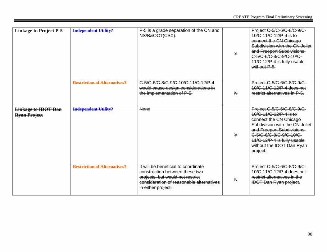
CREATE Program Final Preliminary Screening
90
Linkage to Project P-5
Independent Utility? P-5 is a grade separation of the CN and NS/B&OCT(CSX).
Y
Project C-5/C-6/C-8/C-9/C-10/C-11/C-12/P-4 is to connect the CN Chicago Subdivision with the CN Joliet and Freeport Subdivisions. C-5/C-6/C-8/C-9/C-10/C-11/C-12/P-4 is fully usable without P-5.
Restriction of Alternatives? C-5/C-6/C-8/C-9/C-10/C-11/C-12/P-4 would cause design considerations in the implementation of P-5. N
Project C-5/C-6/C-8/C-9/C-10/C-11/C-12/P-4 does not restrict alternatives in P-5.
Linkage to IDOT Dan
Ryan Project
Independent Utility? None
Y
Project C-5/C-6/C-8/C-9/C-10/C-11/C-12/P-4 is to connect the CN Chicago Subdivision with the CN Joliet and Freeport Subdivisions. C-5/C-6/C-8/C-9/C-10/C-11/C-12/P-4 is fully usable without the IDOT Dan Ryan project.
Restriction of Alternatives? It will be beneficial to coordinate construction between these two projects, but would not restrict consideration of reasonable alternatives in either project.
N
Project C-5/C-6/C-8/C-9/C-10/C-11/C-12/P-4 does not restrict alternatives in the IDOT Dan Ryan project.

CREATE Program Final Preliminary Screening
91
Linkage to Project
Brighton Park
Interlocking
Independent Utility? Brighton Park Interlocking has begun construction and would only cause signal software programming considerations in C-5/C-6/C-8/C-9/C-10/C-11/C-12/P-4. Y
Project C-5/C-6/C-8/C-9/C-10/C-11/C-12/P-4 is to connect the CN Chicago Subdivision with the CN Joliet and Freeport Subdivisions. C-5/C-6/C-8/C-9/C-10/C-11/C-12/P-4 is fully usable without the Brighton Park Interlocking project.
Restriction of Alternatives? None
N
Project C-5/C-6/C-8/C-9/C-10/C-11/C-12/P-4 does not restrict alternatives in the Brighton Park Interlocking project.
Linkage to Project WA-2 Independent Utility? C-5/C-6/C-8/C-9/C-10/C-11/C-12/P-4 and WA-2 are physically close to each other, but are on separate routes and would not affect each other.
Y
Project C-5/C-6/C-8/C-9/C-10/C-11/C-12/P-4 is to connect the CN Chicago Subdivision with the CN Joliet and Freeport Subdivisions. C-5/C-6/C-8/C-9/C-10/C-11/C-12/P-4 is fully usable without WA-2.
Restriction of Alternatives? None N
Project C-5/C-6/C-8/C-9/C-10/C-11/C-12/P-4 does not restrict alternatives in WA-2.
Linked Project
Preliminary Purpose and
Need
Project is now ready to
be processed through an
ECAD
The purpose of this proposed action is to increase rail capacity, reduce circuitous routing, reduce community impacts of rail operations, improve the efficiency of train movements, while also providing CN with a route across Chicago that has sufficient clearance for double-stack trains. Form Completed: 01/21/04 Form Revised: 06/02/04

CREATE Program Final Preliminary Screening
92
CREATE Component Project Preliminary Screening Worksheet
CREATE Component Project Profile
Project Identifier
EW2 (80th
Street to Forest Hill) Objective, Intent of Project Reduce congestion and delays between 80th Street and Forest Hill.
Description of Proposed
Work/ Improvements
Reconfigure the BRC Main tracks between 80th Street and Belt Junction, eliminate Belt Junction, and reconfigure and build a third BRC mainline. Includes associated signal, track, crossovers, and bridge work.
Location: Owner(s)
Route/Line
Project Limits
Local Community
BRC, NS, UP
BRC Mainline
From Forest Hill (along the Western Avenue Corridor) on the west to 80th St. on the east.
Chicago Community Areas – Auburn Gresham and Chatham
Potential Environmental Issues
Needing Further Study
No issues appear to need greater detail than normally accomplished through ECAD process.
Project Status
Engineering: Preliminary layout and estimate. Ground survey and detailed signal design needs to be completed.
Estimated Project Costs
(Level of Confidence)
Construction $ 100 Million R/W $ Yes - TBD Contingencies $ TBD
Planning Estimate
Preliminary Engineering Estimate
Adjoining CREATE
Projects
(Proj.#, Line, distance)
A. P-2
B. B-9/EW-1
C. EW-3
D. P-3
E. WA-2
F. GS-11
Other Related Projects
(Nature of Relationship)
G.
H.
I.
J.
Comments/Notes:

CREATE Program Final Preliminary Screening
93
Individual Component Project Logical Termini Test – Determine 1) sufficient length and scope; 2) independent utility; and 3) restriction of
alternatives.
1) Sufficient Length & Scope Determination
Does the proposed project have sufficient length and scope to broadly address environmental issues? If no, modify project limits. After project limits are modified, ensure project profile is accurate, then proceed to project linkage test.
Y/N
Y
2) Independent Utility and 3) Restriction of Alternatives Determination
Discussion
Y/N
Rationale
Linkage to Project P-2
Independent Utility? Does the
project have independent utility or independent significance, i.e., be usable and be a reasonable expenditure even if no additional transportation improvements in the area are made?
EW-2 cannot be achieved without the implementation of P-2.
N
Project EW-2 is to reduce congestion and delays between 80th Street and Forest Hill. EW-2 is not fully usable without P-2. Therefore the projects are linked.
Restriction of Alternatives? Does the project restrict the consideration of alternatives for other reasonably foreseeable transportation improvements?
EW-2 cannot be achieved without the implementation of P-2.
Y
Project EW-2 does restrict alternatives in P-2. Therefore the projects are linked.
Linkage to Project B-
9/EW-1
Independent Utility? Significant distance between these two projects and neither has an impact on the other. Y
Project EW-2 is to reduce congestion and delays between 80th Street and Forest Hill. EW-2 is fully usable without B-9/EW-1.
Restriction of Alternatives? None N
Project EW-2 does not restrict alternatives in B-9/EW-1.

CREATE Program Final Preliminary Screening
94
Linkage to Project EW-3 Independent Utility? Significant distance between these two projects and neither has an impact on the other. Y
Project EW-2 is to reduce congestion and delays between 80th Street and Forest Hill. EW-2 is fully usable without EW-3.
Restriction of Alternatives? None N
Project EW-2 does not restrict alternatives in EW-3.
Linkage to Project P-3 Independent Utility? P-3 is to separate the Metra from the B&OCT(CSX) at 75th Street and is independent. Y
Project EW-2 is to reduce congestion and delays between 80th Street and Forest Hill. EW-2 is fully usable without P-3.
Restriction of Alternatives? P-3 is to separate the Metra from the B&OCT(CSX) at 75th Street and would not restrict consideration of reasonable alternatives for EW-2, or vice versa.
N
Project EW-2 does not restrict alternatives in P-3.
Linkage to Project WA-2 Independent Utility? Project EW-2 would only cause signal software programming considerations in WA-2. Y
Project EW-2 is to reduce congestion and delays between 80th Street and Forest Hill. EW-2 is fully usable without WA-2.
Restriction of Alternatives? None N
Project EW-2 does not restrict alternatives in WA-2.
Linkage to Project GS-
11
Independent Utility? None Y Project EW-2 is to reduce congestion and delays between 80th Street and Forest Hill. EW-2 is fully usable without GS-11.
Restriction of Alternatives? EW-2 would only cause design considerations in GS-11 and would not restrict consideration of reasonable alternatives.
N Project EW-2 does not restrict alternatives in GS-11.
Linkage to Project G Independent Utility?
Restriction of Alternatives?
Linkage to Project H Independent Utility?
Restriction of Alternatives?

CREATE Program Final Preliminary Screening
95
If no linkages,
prepare
Component Project
Preliminary Purpose and
Need
Statement.
Project is now ready to be
processed through an
ECAD
If linkages, go to next
page

CREATE Program Final Preliminary Screening
96
List Component Projects
that Constitute the
Linked Project
EW-2 and P-2
CREATE Linked Project Profile
Project Identifier
EW-2/P-2 (80th
Street to Forest Hill/74th
Street Flyover) Objective, Intent of
Project
Reduce congestion and delays between 80th Street and Forest Hill, and separate Metra Southwest service from BRC Mainline (Belt Junction), which allows access to LaSalle Street Station instead of Union Station.
Description of
Proposed Work/
Improvements
Reconfigure the BRC Main tracks between 80th Street and Belt Junction, eliminate Belt Junction, reconfigure and build a third BRC track, and construct Metra Flyover to connect southwest service to the Rock Island Line. Includes associated signals, tracks, crossovers, and bridge work. This work includes track on new alignment between the intersection of 74th and Normal and the intersection of 75th and Parnell.
Location: Owner(s)
Route/Line
Project Limits
Local Community
BRC, NS, UP, Metra
BRC Mainline, Metra Southwest Service
From Forest Hill (along the Western Avenue Corridor) on the west to 80th St. on the east and to the intersection of 74th Street and Normal.
Chicago Community Areas – Auburn Gresham, Chatham, Englewood and Greater Grand Crossing
Potential Environmental
Issues Needing Further
Study
Yes – requires ROW acquisition and displacements.
Project Status
Engineering: Preliminary layout and estimate. Ground survey and detailed signal design needs to be completed.
Estimated Project
Costs
(Level of Confidence)
Construction $ 191 Million R/W $ Yes - TBD Contingencies $ TBD
Planning Estimate
Preliminary Engineering Estimate
Adjoining Projects
(Proj.#, Line, distance)
A. B-9/EW-1
B. EW-3
C. WA-2
D. P-3
E. P-1
F. C-5/C-6/C-8/C-9/C-10/C-11/C-12/P-4
G. GS-11

CREATE Program Final Preliminary Screening
97
H. GS-21a
Other Related
Projects
(Nature of
Relationship)
I.
J.
K.
L.
Comments:
Individual Component Project Logical Termini Test – Determine 1) sufficient length and scope; 2) independent utility; and 3) restriction of
alternatives.
1) Sufficient Length & Scope Determination
Does the proposed project have sufficient length and scope to broadly address environmental issues? If no, modify project limits. After project limits are modified, ensure project profile is accurate, then proceed to project linkage test.
Y/N
Y
2) Independent Utility and 3) Restriction of Alternatives Determination
Discussion Y/N Rationale

CREATE Program Final Preliminary Screening
98
Linkage to Project B-
9/EW-1
Independent Utility? Does the project have independent utility or independent significance, i.e., be usable and be a reasonable expenditure even if no additional transportation improvements in the area are made?
Significant distance between these two projects and neither has an impact on the other.
Y
Project EW-2/P-2 is to reduce congestion and delays between 80th Street and Forest Hill, and separates Metra Southwest service from BRC Mainline (Belt Junction) and allows it to access LaSalle Street Station instead of Union Station. EW-2/P-2 is fully usable without B-9/EW-1.
Restriction of Alternatives? Does the project restrict the consideration of alternatives for other reasonably foreseeable transportation improvements?
None
N
Project EW-2/P-2 does not restrict alternatives in B-9/EW-1.
Linkage to Project EW-3 Independent Utility? Significant distance between these two projects and neither has an impact on the other.
Y
Project EW-2/P-2 is to reduce congestion and delays between 80th Street and Forest Hill, and separates Metra Southwest service from BRC Mainline (Belt Junction) and allows it to access LaSalle Street Station instead of Union Station. EW-2/P-2 is fully usable without EW-3.
Restriction of Alternatives? None N
Project EW-2/P-2 does not restrict alternatives in EW-3.
Linkage to Project WA-2 Independent Utility? Project EW-2/P-2 would only cause signal software programming considerations in WA-2.
Y
Project EW-2/P-2 is to reduce congestion and delays between 80th Street and Forest Hill, and separates Metra Southwest service from BRC Mainline (Belt Junction) and allows access to LaSalle Street Station instead of Union Station. EW-2/P-2 is fully usable without WA-2.

CREATE Program Final Preliminary Screening
99
Restriction of Alternatives? None N
Project EW-2/P-2 does not restrict alternatives in WA-2.
Linkage to Project P-3 Independent Utility? P-3 is to separate the Metra from the B&OCT(CSX) at 75th Street and is independent.
Y
Project EW-2/P-2 is to reduce congestion and delays between 80th Street and Forest Hill, and separates Metra Southwest service from BRC Mainline (Belt Junction) and allows it to access LaSalle Street Station instead of Union Station. EW-2/P-2 is fully usable without P-3.
Restriction of Alternatives? P-3 is to separate the Metra from the B&OCT(CSX) at 75th Street and would not restrict consideration of reasonable alternatives for EW-2/P-2, or vice versa. Revised on 6/30/05. Due to additional
analysis accomplished during the
preparation of the ECAD, the following
conclusion was determined:
P-3 is to separate the Metra from the B&OCT(CSX) at 75th Street and would restrict consideration of reasonable alternatives for EW-2/P-2.
Y
Project EW-2/P-2 does restrict alternatives in P-3.
Linkage to Project P-1 Independent Utility? Significant distance between these two projects and neither has an impact on the other.
Y
Project EW-2/P-2 is to reduce congestion and delays between 80th Street and Forest Hill, and separates Metra Southwest service from BRC Mainline (Belt Junction) and allows it to access LaSalle Street Station instead of Union Station. EW-2/P-2 is fully usable without P-1.
Restriction of Alternatives? None N
Project EW-2/P-2 does not restrict alternatives in P-1.
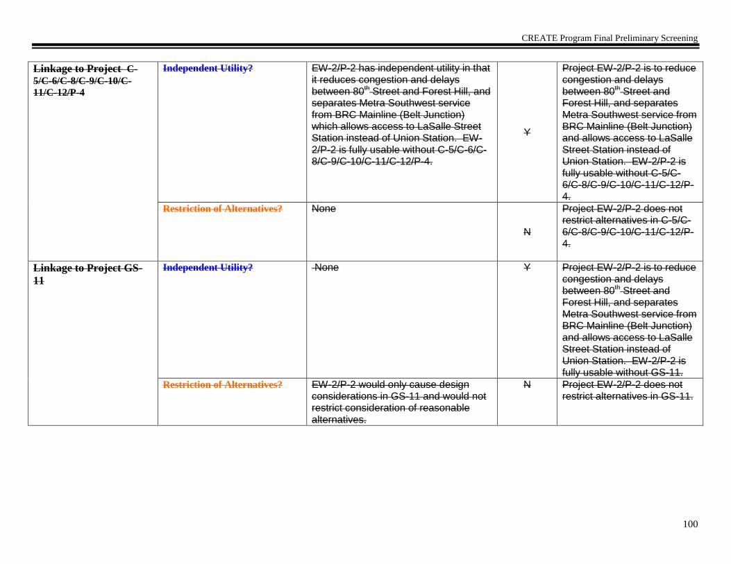
CREATE Program Final Preliminary Screening
100
Linkage to Project C-
5/C-6/C-8/C-9/C-10/C-
11/C-12/P-4
Independent Utility? EW-2/P-2 has independent utility in that it reduces congestion and delays between 80th Street and Forest Hill, and separates Metra Southwest service from BRC Mainline (Belt Junction) which allows access to LaSalle Street Station instead of Union Station. EW-2/P-2 is fully usable without C-5/C-6/C-8/C-9/C-10/C-11/C-12/P-4.
Y
Project EW-2/P-2 is to reduce congestion and delays between 80th Street and Forest Hill, and separates Metra Southwest service from BRC Mainline (Belt Junction) and allows access to LaSalle Street Station instead of Union Station. EW-2/P-2 is fully usable without C-5/C-6/C-8/C-9/C-10/C-11/C-12/P-4.
Restriction of Alternatives? None N
Project EW-2/P-2 does not restrict alternatives in C-5/C-6/C-8/C-9/C-10/C-11/C-12/P-4.
Linkage to Project GS-
11
Independent Utility? None Y Project EW-2/P-2 is to reduce congestion and delays between 80th Street and Forest Hill, and separates Metra Southwest service from BRC Mainline (Belt Junction) and allows access to LaSalle Street Station instead of Union Station. EW-2/P-2 is fully usable without GS-11.
Restriction of Alternatives? EW-2/P-2 would only cause design considerations in GS-11 and would not restrict consideration of reasonable alternatives.
N Project EW-2/P-2 does not restrict alternatives in GS-11.

CREATE Program Final Preliminary Screening
101
Linkage to Project GS-
21a
Independent Utility? The implementation of GS-21a would only affect train operations in EW-2/P-2. EW-2/P-2 would be fully useful without GS-21a.
Y Project EW-2/P-2 is to reduce congestion and delays between 80th Street and Forest Hill, and separates Metra Southwest service from BRC Mainline (Belt Junction) and allows access to LaSalle Street Station instead of Union Station. EW-2/P-2 is fully usable without GS-21a.
Restriction of Alternatives? N Project EW-2/P-2 does not restrict alternatives in GS-21a.
If no linkages, prepare
Component Project
Preliminary Purpose and
Need Statement.
Project is now ready to
be processed through an
ECAD.
If linkages, go to next
page

CREATE Program Final Preliminary Screening
102
List Component Projects
that Constitute the
Linked Project
EW-2, P-2 and P-3
CREATE Linked Project Profile
Project Identifier
EW-2/P-2/P-3 (80th
Street to Forest Hill/74th
Street Flyover/75th
Street Flyover)
Objective, Intent of
Project
Reduce congestion and delays between 80th Street and Forest Hill, increase capacity for Metra, and eliminate rail traffic conflicts between the Metra Southwest service and the B&OCT(CSX), the NS and the BRC Mainline (Belt Junction), which allows access to LaSalle Street Station instead of Union Station.
Description of
Proposed Work/
Improvements
Reconfigure the BRC Main tracks between 80th Street and Belt Junction, eliminate Belt Junction, reconfigure and build a third BRC track, and construct a flyover to connect the Metra Southwest service to the Rock Island Line. Includes associated signals, tracks, crossovers, and bridge work. This work includes track on new alignment between the intersection of 74th and Normal and the intersection of 75th and Parnell. It includes constructing a bridge that significantly reduces conflicts between B&OCT(CSX) and NS, and Metra. It also includes constructing a double-tracked bypass of NS Landers Yard for Metra, extending to Ashburn; and a connection from Landers Yard to the BRC mainlines.
Location: Owner(s)
Route/Line
Project Limits
Local Community
BRC, NS, UP, Metra, B&OCT(CSX)
BRC Mainline, Metra Southwest Service, NS/Metra Southwest Service line and B&OCT(CSX) Blue Island Subdivision
North limit: 71st St., South limit: 83rd St., East limit: Normal; West limit: Central Park. Project is mainly along 75th St. rail corridor.
Chicago Community Areas – Auburn Gresham, Chatham, Englewood and Greater Grand Crossing, Ashburn, Gresham, Chicago Lawn, and West Englewood
Potential Environmental
Issues Needing Further
Study
Yes – requires ROW acquisition and displacements.
Project Status
Engineering: Preliminary layout and estimate. Ground survey and detailed signal design needs to be completed.
Estimated Project
Costs
(Level of Confidence)
Construction $ 251 Million R/W $ Yes - TBD Contingencies $ TBD
Planning Estimate
Preliminary Engineering Estimate
Adjoining Projects A. B-9/EW-1
B. EW-3

CREATE Program Final Preliminary Screening
103
(Proj.#, Line, distance)
C. WA-2
D. P-7
E. P-1
F. C-5/C-6/C-8/C-9/C-10/C-11/C-12/P-4
G. GS-11
H. GS-21a
Other Related
Projects
(Nature of
Relationship)
I.
J.
K.
L.
Comments:
Individual Component Project Logical Termini Test – Determine 1) sufficient length and scope; 2) independent utility; and 3) restriction of
alternatives.
1) Sufficient Length & Scope Determination
Does the proposed project have sufficient length and scope to broadly address environmental issues? If no, modify project limits. After project limits are modified, ensure project profile is accurate, then proceed to project linkage test.
Y/N
Y
2) Independent Utility and 3) Restriction of Alternatives Determination
Discussion Y/N Rationale

CREATE Program Final Preliminary Screening
104
Linkage to Project B-
9/EW-1
Independent Utility? Does the project have independent utility or independent significance, i.e., be usable and be a reasonable expenditure even if no additional transportation improvements in the area are made?
Significant distance between these two projects and neither has an impact on the other.
Y
Project EW-2/P-2/P-3 is to reduce congestion and delays between 80th Street and Forest Hill, increase capacity for Metra, and eliminate rail traffic conflicts between the Metra Southwest service and the B&OCT(CSX), the NS and the BRC Mainline (Belt Junction), which allows access to LaSalle Street Station instead of Union Station. EW-2/P-2/P-3 is fully usable without B-9/EW-1.
Restriction of Alternatives? Does the project restrict the consideration of alternatives for other reasonably foreseeable transportation improvements?
None
N
Project EW-2/P-2/P-3 does not restrict alternatives in B-9/EW-1.
Linkage to Project EW-3 Independent Utility? Significant distance between these two projects and neither has an impact on the other.
Y
Project EW-2/P-2/P-3 is to reduce congestion and delays between 80th Street and Forest Hill, increase capacity for Metra, and eliminate rail traffic conflicts between the Metra Southwest service and the B&OCT(CSX), the NS and the BRC Mainline (Belt Junction), which allows access to LaSalle Street Station instead of Union Station. EW-2/P-2/P-3 is fully usable without EW-3.
Restriction of Alternatives? None N
Project EW-2/P-2/P-3 does not restrict alternatives in EW-3.

CREATE Program Final Preliminary Screening
105
Linkage to Project WA-2 Independent Utility? Project EW-2/P-2 would only cause signal software programming considerations in WA-2.
Y
Project EW-2/P-2/P-3 is to reduce congestion and delays between 80th Street and Forest Hill, increase capacity for Metra,and eliminate rail traffic conflicts between the Metra Southwest service and the B&OCT(CSX), the NS and the BRC Mainline (Belt Junction), which allows access to LaSalle Street Station instead of Union Station. EW-2/P-2/P-3 is fully usable without WA-2.
Restriction of Alternatives? None N
Project EW-2/P-2/P-3 does not restrict alternatives in WA-2.
Linkage to Project P-7 Independent Utility? Significant distance between these two projects and neither has an impact on the other. (4 miles)
Y
Project EW-2/P-2/P-3 is to reduce congestion and delays between 80th Street and Forest Hill, increase capacity for Metra, and eliminate rail traffic conflicts between the Metra Southwest service and the B&OCT(CSX), the NS and the BRC Mainline (Belt Junction), which allows access to LaSalle Street Station instead of Union Station. EW-2/P-2/P-3 is fully usable without P-7.
Restriction of Alternatives? None
N
Project EW-2/P-2/P-3 does not restrict alternatives in P-7.

CREATE Program Final Preliminary Screening
106
Linkage to Project P-1 Independent Utility? Significant distance between these two projects and neither has an impact on the other.
Y
Project EW-2/P-2/P-3 is to reduce congestion and delays between 80th Street and Forest Hill, increase capacity for Metra, and eliminate rail traffic conflicts between the Metra Southwest service and the B&OCT(CSX), the NS and the BRC Mainline (Belt Junction), which allows access to LaSalle Street Station instead of Union Station. EW-2/P-2/P-3 is fully usable without P-1.
Restriction of Alternatives? None N
Project EW-2/P-2/P-3 does not restrict alternatives in P-1.
Linkage to Project C-
5/C-6/C-8/C-9/C-10/C-
11/C-12/P-4
Independent Utility? EW-2/P-2/P-3 has independent utility in that it reduce congestion and delays between 80th Street and Forest Hill, increase capacity for Metra, and eliminate rail traffic conflicts between the Metra Southwest service and the B&OCT(CSX), the NS and the BRC Mainline (Belt Junction), which allows access to LaSalle Street Station instead of Union Station. EW-2/P-2/P-3 is fully usable without C-5/C-6/C-8/C-9/C-10/C-11/C-12/P-4.
Y
Project EW-2/P-2/P-3 is to reduce congestion and delays between 80th Street and Forest Hill, increase capacity for Metra, and eliminate rail traffic conflicts between the Metra Southwest service and the B&OCT(CSX), the NS and the BRC Mainline (Belt Junction), which allows access to LaSalle Street Station instead of Union Station. EW-2/P-2/P-3 is fully usable without C-5/C-6/C-8/C-9/C-10/C-11/C-12/P-4.
Restriction of Alternatives? None N
Project EW-2/P-2/P-3 does not restrict alternatives in C-5/C-6/C-8/C-9/C-10/C-11/C-12/P-4.

CREATE Program Final Preliminary Screening
107
Linkage to Project GS-
11
Independent Utility? None Y Project EW-2/P-2/P-3 is to reduce congestion and delays between 80th Street and Forest Hill, increase capacity for Metra, and eliminate rail traffic conflicts between the Metra Southwest service and the B&OCT(CSX), the NS and the BRC Mainline (Belt Junction), which allows access to LaSalle Street Station instead of Union Station. EW-2/P-2/P-3 is fully usable without GS-11.
Restriction of Alternatives? EW-2/P-2/P-3 would only cause design considerations in GS-11 and would not restrict consideration of reasonable alternatives.
N Project EW-2/P-2/P-3 does not restrict alternatives in GS-11.
Linkage to Project GS-
21a
Independent Utility? The implementation of GS-21a would only affect train operations in EW-2/P-2/P-3. EW-2/P-2/P-3 would be fully useful without GS-21a.
Y Project EW-2/P-2/P-3 is to reduce congestion and delays between 80th Street and Forest Hill, increase capacity for Metra, and eliminate rail traffic conflicts between the Metra Southwest service and the B&OCT(CSX), the NS and the BRC Mainline (Belt Junction), which allows access to LaSalle Street Station instead of Union Station. EW-2/P-2/P-3 is fully usable without GS-21a.
Restriction of Alternatives? N Project EW-2/P-2/P-3 does not restrict alternatives in GS-21a.

CREATE Program Final Preliminary Screening
108
Linked Project
Preliminary Purpose and
Need
Project is now ready to
be processed through an
ECAD
The purpose of this proposed action is to reduce congestion and delays between 80th Street and Forest Hill, increase capacity for Metra, and eliminate rail traffic conflicts between the Metra Southwest service and the B&OCT(CSX), the NS and the BRC Mainline (Belt Junction), which allows access to LaSalle Street Station instead of Union Station.
Form Completed: 01/22/04 Form Revised: 10/29/04 Form Revised: 6/30/05

CREATE Program Final Preliminary Screening
109
CREATE Component Project Preliminary Screening Worksheet
CREATE Component Project Profile
Project Identifier
EW2 (Ashburn to the Dan Ryan) Objective, Intent of Project Reduce congestion and delays between the Dan Ryan and Ashburn.
Description of Proposed
Work/ Improvements
Reconfigure the BRC, Metra, NS, and UP tracks between the Dan Ryan and Ashburn, eliminate Belt Junction, and reconfigure and build a third BRC mainline. Also construct a double-tracked bypass of NS Landers Yard for Metra, extending to Ashburn; and a connection from Landers Yard to the BRC mainlines. Includes associated signal, track, crossovers, and bridge work.
Location: Owner(s)
Route/Line
Project Limits
Local Community
BRC, NS, UP
BRC Mainline
From Ashburn on the west to the Dan Ryan on the east.
Chicago Community Areas – Ashburn, Auburn Gresham, Chatham, Roseland and Washington Heights
Potential Environmental Issues
Needing Further Study
No issues appear to need greater detail than normally accomplished through ECAD process.
Project Status
Engineering: Preliminary layout and estimate. Ground survey and detailed signal design needs to be completed.
Estimated Project Costs
(Level of Confidence)
Construction $ 130 Million R/W $ Yes - TBD Contingencies $ TBD
Planning Estimate
Preliminary Engineering Estimate
Adjoining CREATE
Projects
(Proj.#, Line, distance)
A. P2
B. B9/EW1
C. EW3
D. P3
E. WA2
F. GS11
Other Related Projects
(Nature of Relationship)
G.
H.
I.
J.
Comments/Notes:

CREATE Program Final Preliminary Screening
110
Individual Component Project Logical Termini Test – Determine 1) sufficient length and scope; 2) independent utility; and 3) restriction of
alternatives.
1) Sufficient Length & Scope Determination
Does the proposed project have sufficient length and scope to broadly address environmental issues? If no, modify project limits. After project limits are modified, ensure project profile is accurate, then proceed to project linkage test.
Y/N
Y
2) Independent Utility and 3) Restriction of Alternatives Determination
Discussion
Y/N
Rationale
Linkage to Project P2
Independent Utility? Does the
project have independent utility or independent significance, i.e., be usable and be a reasonable expenditure even if no additional transportation improvements in the area are made?
EW2 cannot be achieved without the implementation of P2.
N
Project EW2 is to reduce congestion and delays between the Dan Ryan and Ashburn. EW2 is not fully usable without P2. Therefore the projects are linked.
Restriction of Alternatives? Does the project restrict the consideration of alternatives for other reasonably foreseeable transportation improvements?
EW2 cannot be achieved without the implementation of P2.
Y
Project EW2 does restrict alternatives in P2. Therefore the projects are linked.
Linkage to Project
B9/EW1
Independent Utility? Significant distance between these two projects and neither has an impact on the other. Y
Project EW2 is to reduce congestion and delays between the Dan Ryan and Ashburn. EW2 is fully usable without B9/EW1.
Restriction of Alternatives? None N
Project EW2 does not restrict alternatives in B9/EW1.

CREATE Program Final Preliminary Screening
111
Linkage to Project EW3 Independent Utility? Significant distance between these two projects and neither has an impact on the other. Y
Project EW2 is to reduce congestion and delays between the Dan Ryan and Ashburn. EW2 is fully usable without EW3.
Restriction of Alternatives? None N
Project EW2 does not restrict alternatives in EW3.
Linkage to Project P3 Independent Utility? P3 is to separate the Metra from the B&OCT(CSX) at 75th Street and is independent. Y
Project EW2 is to reduce congestion and delays between the Dan Ryan and Ashburn. EW2 is fully usable without P3.
Restriction of Alternatives? P3 is to separate the Metra from the B&OCT(CSX) at 75th Street and would not restrict consideration of reasonable alternatives for EW2, or vice versa.
N
Project EW2 does not restrict alternatives in P3.
Linkage to Project WA2 Independent Utility? Project EW2 would only cause signal software programming considerations in WA2. Y
Project EW2 is to reduce congestion and delays between the Dan Ryan and Ashburn. EW2 is fully usable without WA2.
Restriction of Alternatives? None N
Project EW2 does not restrict alternatives in WA2.
Linkage to Project GS11 Independent Utility? None Y Project EW2 is to reduce congestion and delays between the Dan Ryan and Ashburn. EW2 is fully usable without GS11.
Restriction of Alternatives? EW2 would only cause design considerations in GS11 and would not restrict consideration of reasonable alternatives.
N Project EW2 does not restrict alternatives in GS11.
Linkage to Project
GS21a
Independent Utility? The implementation of GS21a would only affect train operations in EW2. EW2 would be fully useful without GS21a.
Y Project EW2 is to reduce congestion and delays between the Dan Ryan and Ashburn. EW2 is fully usable without GS21a.

CREATE Program Final Preliminary Screening
112
Restriction of Alternatives? N Project EW2 does not restrict alternatives in GS21a.
Linkage to Project G Independent Utility?
Restriction of Alternatives?
Linkage to Project H Independent Utility?
Restriction of Alternatives?
If no linkages,
prepare
Component Project
Preliminary Purpose and
Need
Statement.
Project is now ready to be
processed through an
ECAD
Form Revised: 05/04/09 Form Revised: 05/11/09
If linkages, go to next
page

CREATE Program Final Preliminary Screening
113

CREATE Program Final Preliminary Screening
114
List Component Projects
that Constitute the
Linked Project
EW-2 and P-2
CREATE Linked Project Profile
Project Identifier
EW2/P2 (Dan Ryan to Ashburn/74th
Street Flyover) Objective, Intent of
Project
Reduce congestion and delays between the Dan Ryan and Ashburn, and separate Metra Southwest service from BRC Mainline (Belt Junction), which allows access to LaSalle Street Station instead of Union Station.
Description of
Proposed Work/
Improvements
Reconfigure the BRC, Metra, NS and UP Main tracks between the Dan Ryan and Ashburn, eliminate Belt Junction, reconfigure and build a third BRC track, and construct Metra Flyover to connect southwest service to the Rock Island Line. Also construct a double-tracked bypass of NS Landers Yard for Metra, extending to Ashburn; and a connection from Landers Yard to the BRC mainlines. Includes associated signals, tracks, crossovers, and bridge work. This work includes track on new alignment between the intersection of 74th and Normal and the intersection of 75th and Parnell.
Location: Owner(s)
Route/Line
Project Limits
Local Community
BRC, NS, UP, Metra
BRC Mainline, Metra Southwest Service
From Ashburn (along the Western Avenue Corridor) on the west to the Dan Ryan on the east and to the intersection of 74th Street and Normal.
Chicago Community Areas – Ashburn, Auburn Gresham, Chatham, Englewood, Greater Grand Crossing, Roseland and Washington Heights.
Potential Environmental
Issues Needing Further
Study
Yes – requires ROW acquisition and displacements.
Project Status
Engineering: Preliminary layout and estimate. Ground survey and detailed signal design needs to be completed.
Estimated Project
Costs
(Level of Confidence)
Construction $ 270 Million R/W $ Yes - TBD Contingencies $ TBD
Planning Estimate
Preliminary Engineering Estimate
Adjoining Projects
(Proj.#, Line, distance)
A. B9/EW1
B. EW3
C. WA2
D. P3

CREATE Program Final Preliminary Screening
115
E. P1
F. C-5/C-6/C-8/C-9/C-10/C-11/C-12/P4
G. GS11
H. GS21a
Other Related
Projects
(Nature of
Relationship)
I.
J.
K.
L.
Comments:
Individual Component Project Logical Termini Test – Determine 1) sufficient length and scope; 2) independent utility; and 3) restriction of
alternatives.
1) Sufficient Length & Scope Determination
Does the proposed project have sufficient length and scope to broadly address environmental issues? If no, modify project limits. After project limits are modified, ensure project profile is accurate, then proceed to project linkage test.
Y/N
Y
2) Independent Utility and 3) Restriction of Alternatives Determination
Discussion Y/N Rationale

CREATE Program Final Preliminary Screening
116
Linkage to Project
B9/EW1
Independent Utility? Does the project have independent utility or independent significance, i.e., be usable and be a reasonable expenditure even if no additional transportation improvements in the area are made?
Significant distance between these two projects and neither has an impact on the other.
Y
Project EW2/P2 is to reduce congestion and delays between the Dan Ryan and Ashburn, and separates Metra Southwest service from BRC Mainline (Belt Junction) and allows it to access LaSalle Street Station instead of Union Station. EW2/P2 is fully usable without B9/EW1.
Restriction of Alternatives? Does the project restrict the consideration of alternatives for other reasonably foreseeable transportation improvements?
None
N
Project EW2/P2 does not restrict alternatives in B9/EW1.
Linkage to Project EW3 Independent Utility? Significant distance between these two projects and neither has an impact on the other.
Y
Project EW2/P2 is to reduce congestion and delays between the Dan Ryan and Ashburn, and separates Metra Southwest service from BRC Mainline (Belt Junction) and allows it to access LaSalle Street Station instead of Union Station. EW2/P2 is fully usable without EW3.
Restriction of Alternatives? None N
Project EW2/P2 does not restrict alternatives in EW3.
Linkage to Project WA2 Independent Utility? Project EW2/P2 would only cause signal software programming considerations in WA2.
Y
Project EW2/P2 is to reduce congestion and delays between the Dan Ryan and Ashburn, and separates Metra Southwest service from BRC Mainline (Belt Junction) and allows access to LaSalle Street Station instead of Union Station. EW2/P2 is fully usable without WA2.

CREATE Program Final Preliminary Screening
117
Restriction of Alternatives? None N
Project EW2/P2 does not restrict alternatives in WA2.
Linkage to Project P3 Independent Utility? P3 is to separate the Metra from the B&OCT(CSX) at 75th Street and is independent.
Y
Project EW2/P2 is to reduce congestion and delays between the Dan Ryan and Ashburn, and separates Metra Southwest service from BRC Mainline (Belt Junction) and allows it to access LaSalle Street Station instead of Union Station. EW2/P2 is fully usable without P3.
Restriction of Alternatives? P3 is to separate the Metra from the B&OCT(CSX) at 75th Street and would not restrict consideration of reasonable alternatives for EW/P2, or vice versa. Revised on 6/30/05. Due to additional
analysis accomplished during the
preparation of the ECAD, the following
conclusion was determined:
P3 is to separate the Metra from the B&OCT(CSX) at 75th Street and would restrict consideration of reasonable alternatives for EW-2/P-2
P3 is to separate the Metra from the B&OCT(CSX) at 75th Street and would not restrict consideration of reasonable alternatives for EW2/P2, or vice versa.
Y
Project EW2/P2 does restrict alternatives in P3.
Linkage to Project P1 Independent Utility? Significant distance between these two projects and neither has an impact on the other.
Y
Project EW2/P2 is to reduce congestion and delays between the Dan Ryan and Ashburn, and separates Metra Southwest service from BRC Mainline (Belt Junction) and allows it to access LaSalle Street Station instead of Union Station. EW2/P2 is fully usable without P1.

CREATE Program Final Preliminary Screening
118
Restriction of Alternatives? None N
Project EW2/P2 does not restrict alternatives in P1.
Linkage to Project C-
5/C-6/C-8/C-9/C-10/C-
11/C-12/P4
Independent Utility? EW2/P2 has independent utility in that it reduces congestion and delays between the Dan Ryan and Ashburn, and separates Metra Southwest service from BRC Mainline (Belt Junction) which allows access to LaSalle Street Station instead of Union Station. EW-2/P-2 is fully usable without C-5/C-6/C-8/C-9/C-10/C-11/C-12/P4.
Y
Project EW2/P2 is to reduce congestion and delays between the Dan Ryan and Ashburn, and separates Metra Southwest service from BRC Mainline (Belt Junction) and allows access to LaSalle Street Station instead of Union Station. EW2/P2 is fully usable without C-5/C-6/C-8/C-9/C-10/C-11/C-12/P4.
Restriction of Alternatives? None N
Project EW-2/P-2 does not restrict alternatives in C-5/C-6/C-8/C-9/C-10/C-11/C-12/P4.
Linkage to Project GS11 Independent Utility? None Y Project EW2/P2 is to reduce congestion and delays between the Dan Ryan and Ashburn, and separates Metra Southwest service from BRC Mainline (Belt Junction) and allows access to LaSalle Street Station instead of Union Station. EW2/P2 is fully usable without GS11.
Restriction of Alternatives? EW-2/P-2 would only cause design considerations in GS-11 and would not restrict consideration of reasonable alternatives.
N Project EW2/P2 does not restrict alternatives in GS11.

CREATE Program Final Preliminary Screening
119
Linkage to Project
GS21a
Independent Utility? The implementation of GS21a would only affect train operations in EW2/P2. EW2/P2 would be fully useful without GS21a.
Y Project EW2/P2 is to reduce congestion and delays between the Dan Ryan and Ashburn, and separates Metra Southwest service from BRC Mainline (Belt Junction) and allows access to LaSalle Street Station instead of Union Station. EW2/P2 is fully usable without GS21a.
Restriction of Alternatives? N Project EW2/P2 does not restrict alternatives in GS21a.
Linked Project
Preliminary Purpose and
Need
Project is now ready to
be processed through an
ECAD
The purpose of this proposed action is to reduce congestion and delays between the Dan Ryan and Ashburn, and separate Metra Southwest service from BRC Mainline (Belt Junction), which allows access to LaSalle Street Station instead of Union Station.
Form Completed: 01/22/04 Form Revised: 10/29/04 Form Revised: 05/04/09 Form Revised: 05/11/09

CREATE Program Final Preliminary Screening
120
List Component Projects
that Constitute the
Linked Project
EW2, P2 and P3
CREATE Linked Project Profile
Project Identifier
EW2/P2/P3 (Dan Ryan to Ashburn/74th
Street Flyover/75th
Street Flyover)
Objective, Intent of
Project
Reduce congestion and delays between the Dan Ryan and Ashburn, increase capacity for Metra, and eliminate rail traffic conflicts between the Metra Southwest service and the B&OCT(CSX), the NS and the BRC Mainline (Belt Junction), which allows access to LaSalle Street Station instead of Union Station.
Description of
Proposed Work/
Improvements
Reconfigure the BRC Main tracks between the Dan Ryan and Belt Junction, eliminate Belt Junction, reconfigure and build a third BRC track, and construct a flyover to connect the Metra Southwest service to the Rock Island Line. Also construct a double-tracked bypass of NS Landers Yard for Metra, extending to Ashburn; and a connection from Landers Yard to the BRC mainlines. Includes associated signals, tracks, crossovers, and bridge work. This work includes track on new alignment between the intersection of 74th and Normal and the intersection of 75th and Parnell. It includes constructing a bridge that significantly reduces conflicts between B&OCT(CSX) and BRC, Metra and NS.
Location: Owner(s)
Route/Line
Project Limits
Local Community
BRC, NS, UP, Metra, B&OCT(CSX)
BRC Mainline, Metra Southwest Service, NS/Metra Southwest Service line and B&OCT(CSX) Blue Island Subdivision
North limit: 71st St., South limit: 100th St.., East limit: the Dan Ryan.; West limit: Central Park Ave.
Chicago Community Areas – Auburn Gresham, Chatham, Englewood and Greater Grand Crossing, Ashburn, Gresham, Chicago Lawn, West Englewood, Roseland and Washington Heights.
Potential Environmental
Issues Needing Further
Study
Yes – requires ROW acquisition and displacements.
Project Status
Engineering: Preliminary layout and estimate. Ground survey and detailed signal design needs to be completed.
Estimated Project
Costs
(Level of Confidence)
Construction $ 444 Million R/W $ Yes - TBD Contingencies $ TBD
Planning Estimate
Preliminary Engineering Estimate
Adjoining Projects
(Proj.#, Line, distance)
A. B9/EW1
B. EW3
C. WA2
D. P7
E. P1

CREATE Program Final Preliminary Screening
121
F. C-5/C-6/C-8/C-9/C-10/C-11/C-12/P4
G. GS11
H. GS21a
I. GS19
Other Related
Projects
(Nature of
Relationship)
J.
K.
L.
M.
Comments:
Individual Component Project Logical Termini Test – Determine 1) sufficient length and scope; 2) independent utility; and 3) restriction of
alternatives.
1) Sufficient Length & Scope Determination
Does the proposed project have sufficient length and scope to broadly address environmental issues? If no, modify project limits. After project limits are modified, ensure project profile is accurate, then proceed to project linkage test.
Y/N
Y

CREATE Program Final Preliminary Screening
122
2) Independent Utility and 3) Restriction of Alternatives Determination
Discussion Y/N Rationale
Linkage to Project
B9/EW1
Independent Utility? Does the
project have independent utility or independent significance, i.e., be usable and be a reasonable expenditure even if no additional transportation improvements in the area are made?
Significant distance between these two projects and neither has an impact on the other.
Y
Project EW2/P2/P3 is to reduce congestion and delays between the Dan Ryan and Ashburn, increase capacity for Metra, and eliminate rail traffic conflicts between the Metra Southwest service and the B&OCT(CSX), the NS and the BRC Mainline (Belt Junction), which allows access to LaSalle Street Station instead of Union Station. EW2/P2/P3 is fully usable without B9/EW1.
Restriction of Alternatives? Does the project restrict the consideration of alternatives for other reasonably foreseeable transportation improvements?
None
N
Project EW2/P2/P3 does not restrict alternatives in B9/EW1.
Linkage to Project EW3 Independent Utility? Significant distance between these two projects and neither has an impact on the other.
Y
Project EW2/P2/P3 is to reduce congestion and delays between the Dan Ryan and Ashburn, increase capacity for Metra, and eliminate rail traffic conflicts between the Metra Southwest service and the B&OCT(CSX), the NS and the BRC Mainline (Belt Junction), which allows access to LaSalle Street Station instead of Union Station. EW2/P2/P3 is fully usable without EW3.

CREATE Program Final Preliminary Screening
123
Restriction of Alternatives? None N
Project EW2/P2/P3 does not restrict alternatives in EW3.
Linkage to Project WA2 Independent Utility? Project EW2/P2 would only cause signal software programming considerations in WA2.
Y
Project EW2/P2/P3 is to reduce congestion and delays between the Dan Ryan and Ashburn, increase capacity for Metra, and eliminate rail traffic conflicts between the Metra Southwest service and the B&OCT(CSX), the NS and the BRC Mainline (Belt Junction), which allows access to LaSalle Street Station instead of Union Station. EW2/P2/P3 is fully usable without WA2.
Restriction of Alternatives? None N
Project EW2/P2/P3 does not restrict alternatives in WA2.
Linkage to Project P7 Independent Utility? Significant distance between these two projects and neither has an impact on the other. (4 miles)
Y
Project EW2/P2/P3 is to reduce congestion and delays between the Dan Ryan and Ashburn, increase capacity for Metra, and eliminate rail traffic conflicts between the Metra Southwest service and the B&OCT(CSX), the NS and the BRC Mainline (Belt Junction), which allows access to LaSalle Street Station instead of Union Station. EW2/P2/P3 is fully usable without P7.
Restriction of Alternatives? None
N
Project EW2/P2/P3 does not restrict alternatives in P7.

CREATE Program Final Preliminary Screening
124
Linkage to Project P1 Independent Utility? Significant distance between these two projects and neither has an impact on the other.
Y
Project EW2/P2/P3 is to reduce congestion and delays between the Dan Ryan and Ashburn, increase capacity for Metra, and eliminate rail traffic conflicts between the Metra Southwest service and the B&OCT(CSX), the NS and the BRC Mainline (Belt Junction), which allows access to LaSalle Street Station instead of Union Station. EW2/P2/P3 is fully usable without P1.
Restriction of Alternatives? None N
Project EW2/P2/P3 does not restrict alternatives in P1.
Linkage to Project C-
5/C-6/C-8/C-9/C-10/C-
11/C-12/P4
Independent Utility? EW2/P2/P3 has independent utility in that it reduce congestion and delays between the Dan Ryan and Ashburn, increase capacity for Metra, and eliminate rail traffic conflicts between the Metra Southwest service and the B&OCT(CSX), the NS and the BRC Mainline (Belt Junction), which allows access to LaSalle Street Station instead of Union Station. EW2/P2/P3 is fully usable without C-5/C-6/C-8/C-9/C-10/C-11/C-12/P4.
Y
Project EW2/P2/P3 is to reduce congestion and delays between the Dan Ryan and Ashburn, increase capacity for Metra, and eliminate rail traffic conflicts between the Metra Southwest service and the B&OCT(CSX), the NS and the BRC Mainline (Belt Junction), which allows access to LaSalle Street Station instead of Union Station. EW-2/P-2/P-3 is fully usable without C-5/C-6/C-8/C-9/C-10/C-11/C-12/P4.
Restriction of Alternatives? None N
Project EW-2/P-2/P-3 does not restrict alternatives in C-5/C-6/C-8/C-9/C-10/C-11/C-12/P4.

CREATE Program Final Preliminary Screening
125
Linkage to Project GS11 Independent Utility? None Y Project EW2/P2/P3 is to reduce congestion and delays between the Dan Ryan and Ashburn, increase capacity for Metra, and eliminate rail traffic conflicts between the Metra Southwest service and the B&OCT(CSX), the NS and the BRC Mainline (Belt Junction), which allows access to LaSalle Street Station instead of Union Station. EW2/P2/P3 is fully usable without GS11.
Restriction of Alternatives? EW2/P2/P3 would only cause design considerations in GS11 and would not restrict consideration of reasonable alternatives.
N Project EW2/P2/P3 does not restrict alternatives in GS11.
Linkage to Project
GS21a
Independent Utility? The implementation of GS21a would only affect train operations in EW2/P2/P3. EW2/P2/P3 would be fully useful without GS21a.
Y Project EW2/P2/P3 is to reduce congestion and delays between the Dan Ryan and Ashburn, increase capacity for Metra, and eliminate rail traffic conflicts between the Metra Southwest service and the B&OCT(CSX), the NS and the BRC Mainline (Belt Junction), which allows access to LaSalle Street Station instead of Union Station. EW2/P2/P3 is fully usable without GS21a.
Restriction of Alternatives? N Project EW2/P2/P3 does not restrict alternatives in GS21a.

CREATE Program Final Preliminary Screening
126
Linkage to Project GS19 Independent Utility? None. Y Project EW2/P2/P3 is to reduce congestion and delays between the Dan Ryan and Ashburn, increase capacity for Metra, and eliminate rail traffic conflicts between the Metra Southwest service and the B&OCT(CSX), the NS and the BRC Mainline (Belt Junction), which allows access to LaSalle Street Station instead of Union Station. EW2/P2/P3 is fully usable without GS19.
Restriction of Alternatives? EW2/P2/P3 is to separate the Metra from the B&OCT(CSX) at 71th Street and would restrict consideration of reasonable alternatives for GS19, and vice versa.
Y Project EW2/P2/P3 does restrict alternatives in GS19.
Linked Project
Preliminary Purpose and
Need
Project is now ready to
be processed through an
ECAD
The purpose of this proposed action is to reduce congestion and delays between the Dan Ryan and Ashburn, increase capacity for Metra, and eliminate rail traffic conflicts between the Metra Southwest service and the B&OCT(CSX), the NS and the BRC Mainline (Belt Junction), which allows access to LaSalle Street Station instead of Union Station.
Form Completed: 01/22/04 Form Revised: 10/29/04 Form Revised: 6/30/05 Form Revised: 05/04/09 Form Revised: 08/07/09

CREATE Program Final Preliminary Screening
127
List Component Projects
that Constitute the
Linked Project
EW2, P2, P3 and GS19
CREATE Linked Project Profile
Project Identifier
EW2/P2/P3/GS19 (Dan Ryan to Ashburn/74th
Street Flyover/75th
Street Flyover/71
st St Highway Rail Grade Separation)
Objective, Intent of
Project
Reduce congestion and delays between the Dan Ryan and Ashburn, increase capacity for Metra, and eliminate rail traffic conflicts between the Metra Southwest service and the B&OCT(CSX), the NS and the BRC Mainline (Belt Junction), which allows access to LaSalle Street Station instead of Union Station.
Description of
Proposed Work/
Improvements
Reconfigure the BRC Main tracks between the Dan Ryan and Belt Junction, eliminate Belt Junction, reconfigure and build a third BRC track, and construct a flyover to connect the Metra Southwest service to the Rock Island Line. Also construct a double-tracked bypass of NS Landers Yard for Metra, extending to Ashburn; and a connection from Landers Yard to the BRC mainlines. Includes associated signals, tracks, crossovers, and bridge work. This work includes track on new alignment between the intersection of 74th and Normal and the intersection of 75th and Parnell. It includes constructing a bridge that significantly reduces conflicts between B&OCT(CSX) and BRC, Metra and NS. It also includes grade separating 71st St from the B&OCT (CSX).
Location: Owner(s)
Route/Line
Project Limits
Local Community
BRC, NS, UP, Metra, B&OCT(CSX), City of Chicago
BRC Mainline, Metra Southwest Service, NS/Metra Southwest Service line and B&OCT(CSX) Blue Island Subdivision
North limit: 69th St., South limit: 100th St.., East limit: the Dan Ryan.; West limit: Central Park Ave.
Chicago Community Areas – Auburn Gresham, Chatham, Englewood and Greater Grand Crossing, Ashburn, Gresham, Chicago Lawn, West Englewood, Roseland and Washington Heights.
Potential Environmental
Issues Needing Further
Study
Yes – requires ROW acquisition and displacements.
Project Status
Engineering: Preliminary layout and estimate. Ground survey and detailed signal design needs to be completed.
Estimated Project
Costs
(Level of Confidence)
Construction $ 496625 Million R/W $ Yes – TBD3.2 Million Contingencies $ TBD Included above
Planning Estimate
Preliminary Engineering Estimate
Adjoining Projects A. B9/EW1
B. EW3

CREATE Program Final Preliminary Screening
128
(Proj.#, Line, distance)
C. WA2
D. P7
E. P1
F. C-5/C-6/C-8/C-9/C-10/C-11/C-12/P4
G. GS11
H. GS21a
I.
Other Related
Projects
(Nature of
Relationship)
J.
K.
L.
M.
Comments:
Individual Component Project Logical Termini Test – Determine 1) sufficient length and scope; 2) independent utility; and 3) restriction of
alternatives.
1) Sufficient Length & Scope Determination
Does the proposed project have sufficient length and scope to broadly address environmental issues? If no, modify project limits. After project limits are modified, ensure project profile is accurate, then proceed to project linkage test.
Y/N
Y

CREATE Program Final Preliminary Screening
129
2) Independent Utility and 3) Restriction of Alternatives Determination
Discussion Y/N Rationale
Linkage to Project
B9/EW1
Independent Utility? Does the
project have independent utility or independent significance, i.e., be usable and be a reasonable expenditure even if no additional transportation improvements in the area are made?
Significant distance between these two projects and neither has an impact on the other.
Y
Project EW2/P2/P3/GS19 is to reduce congestion and delays between the Dan Ryan and Ashburn, increase capacity for Metra, and eliminate rail traffic conflicts between the Metra Southwest service and the B&OCT(CSX), the NS and the BRC Mainline (Belt Junction), which allows access to LaSalle Street Station instead of Union Station. EW2/P2/P3/GS19 is fully usable without B9/EW1.
Restriction of Alternatives? Does the project restrict the consideration of alternatives for other reasonably foreseeable transportation improvements?
None
N
Project EW2/P2/P3/GS19 does not restrict alternatives in B9/EW1.

CREATE Program Final Preliminary Screening
130
Linkage to Project EW3 Independent Utility? Significant distance between these two projects and neither has an impact on the other.
Y
Project EW2/P2/P3/GS19 is to reduce congestion and delays between the Dan Ryan and Ashburn, increase capacity for Metra, and eliminate rail traffic conflicts between the Metra Southwest service and the B&OCT(CSX), the NS and the BRC Mainline (Belt Junction), which allows access to LaSalle Street Station instead of Union Station. EW2/P2/P3/GS19 is fully usable without EW3.
Restriction of Alternatives? None N
Project EW2/P2/P3/GS19 does not restrict alternatives in EW3.
Linkage to Project WA2 Independent Utility? Project EW2/P2/P3/GS19 would only cause signal software programming considerations in WA2.
Y
Project EW2/P2/P3/GS19 is to reduce congestion and delays between the Dan Ryan and Ashburn, increase capacity for Metra, and eliminate rail traffic conflicts between the Metra Southwest service and the B&OCT(CSX), the NS and the BRC Mainline (Belt Junction), which allows access to LaSalle Street Station instead of Union Station. EW2/P2/P3/GS19 is fully usable without WA2.
Restriction of Alternatives? None N
Project EW2/P2/P3/GS19 does not restrict alternatives in WA2.

CREATE Program Final Preliminary Screening
131
Linkage to Project P7 Independent Utility? Significant distance between these two projects and neither has an impact on the other. (4 miles)
Y
Project EW2/P2/P3/GS19 is to reduce congestion and delays between the Dan Ryan and Ashburn, increase capacity for Metra, and eliminate rail traffic conflicts between the Metra Southwest service and the B&OCT(CSX), the NS and the BRC Mainline (Belt Junction), which allows access to LaSalle Street Station instead of Union Station. EW2/P2/P3/GS19 is fully usable without P7.
Restriction of Alternatives? None
N
Project EW2/P2/P3/GS19 does not restrict alternatives in P7.
Linkage to Project P1 Independent Utility? Significant distance between these two projects and neither has an impact on the other.
Y
Project EW2/P2/P3/GS19 is to reduce congestion and delays between the Dan Ryan and Ashburn, increase capacity for Metra, and eliminate rail traffic conflicts between the Metra Southwest service and the B&OCT(CSX), the NS and the BRC Mainline (Belt Junction), which allows access to LaSalle Street Station instead of Union Station. EW2/P2/P3/GS19 is fully usable without P1.
Restriction of Alternatives? None N
Project EW2/P2/P3/GS19 does not restrict alternatives in P1.

CREATE Program Final Preliminary Screening
132
Linkage to Project C-
5/C-6/C-8/C-9/C-10/C-
11/C-12/P4
Independent Utility? EW2/P2/P3/GS19 has independent utility in that it reduce congestion and delays between the Dan Ryan and Ashburn, increase capacity for Metra, and eliminate rail traffic conflicts between the Metra Southwest service and the B&OCT(CSX), the NS and the BRC Mainline (Belt Junction), which allows access to LaSalle Street Station instead of Union Station. EW2/P2/P3/GS19 is fully usable without C-5/C-6/C-8/C-9/C-10/C-11/C-12/P4.
Y
Project EW2/P2/P3/GS19 is to reduce congestion and delays between the Dan Ryan and Ashburn, increase capacity for Metra, and eliminate rail traffic conflicts between the Metra Southwest service and the B&OCT(CSX), the NS and the BRC Mainline (Belt Junction), which allows access to LaSalle Street Station instead of Union Station. EW-2/P-2/P-3 is fully usable without C-5/C-6/C-8/C-9/C-10/C-11/C-12/P4.
Restriction of Alternatives? None N
Project EW2/P2/P3/GS19 does not restrict alternatives in C-5/C-6/C-8/C-9/C-10/C-11/C-12/P4.
Linkage to Project GS11 Independent Utility? None Y Project EW2/P2/P3/GS19 is to reduce congestion and delays between the Dan Ryan and Ashburn, increase capacity for Metra, and eliminate rail traffic conflicts between the Metra Southwest service and the B&OCT(CSX), the NS and the BRC Mainline (Belt Junction), which allows access to LaSalle Street Station instead of Union Station. EW2/P2/P3/GS19 is fully usable without GS11.

CREATE Program Final Preliminary Screening
133
Restriction of Alternatives? EW2/P2/P3/GS19 would only cause design considerations in GS11 and would not restrict consideration of reasonable alternatives.
N Project EW2/P2/P3/GS19 does not restrict alternatives in GS11.
Linkage to Project
GS21a
Independent Utility? The implementation of GS21a would only affect train operations in EW2/P2/P3/GS19. EW2/P2/P3/GS19 would be fully useful without GS21a.
Y Project EW2/P2/P3/GS19 is to reduce congestion and delays between the Dan Ryan and Ashburn, increase capacity for Metra, and eliminate rail traffic conflicts between the Metra Southwest service and the B&OCT(CSX), the NS and the BRC Mainline (Belt Junction), which allows access to LaSalle Street Station instead of Union Station. EW2/P2/P3/GS19 is fully usable without GS21a.
Restriction of Alternatives? N Project EW2/P2/P3/GS19 does not restrict alternatives in GS21a.
Linked Project
Preliminary Purpose and
Need
Project is now ready to
be processed through an
ECAD
The purpose of this proposed action is to reduce congestion and delays between the Dan Ryan and Ashburn, increase capacity for Metra, and eliminate rail traffic conflicts between the Metra Southwest service and the B&OCT(CSX), the NS and the BRC Mainline (Belt Junction), which allows access to LaSalle Street Station instead of Union Station.
Form Completed: 01/22/04 Form Revised: 10/29/04 Form Revised: 6/30/05 Form Revised: 05/04/09 Form Revised: 08/07/09

CREATE Program Final Preliminary Screening
134
CREATE Component Project Preliminary Screening Worksheet
CREATE Component Project Profile
Project Identifier
EW3 (Pullman Junction)
Objective, Intent of Project Improve train operations at Pullman Junction. Improve train operations from Rock Island Junction and 80th St, through at Pullman Junction.
Description of Proposed
Work/ Improvements
Realign Pullman Junction and add crossovers to connect BRC to the NS mains. from Pullman Junction to 80th St. into the East-West Corridor. Includes associated signal work. Construct a new mainline track (East-West Corridor) from Rock Island Junction to Pullman Junction. Realign Pullman Junction and add crossovers to connect BRC and NS mains from Pullman Junction to 80th St. as part of into the East-West Corridor. Includes associated signal work.
Location: Owner(s)
Route/Line
Project Limits
Local Community
NS and BRC
NS CWI and BRC Mainline
Within the Pullman Junction interlocking. From Rock Island Junction on the east to west of the Dan Ryan Expressway, along the BRC mainline.
Chicago Community Areas – Burnside, Calumet Heights, Pullman and South Deering, East Side and South Chicago.
Potential Environmental Issues
Needing Further Study
No issues appear to need greater detail than normally accomplished through ECAD process.
Project Status
Engineering: Preliminary layout and estimate. Ground survey and detailed signal design needs to be completed.
Estimated Project Costs
(Level of Confidence)
Construction $ 6.8 Million R/W $ 0 Contingencies $ TBD
Planning Estimate
Preliminary Engineering Estimate
Adjoining CREATE
Projects
(Proj.#, Line, distance)
A. EW2/P2/P3/GS19
B. EW4
C P4
D.
Other Related Projects
(Nature of Relationship)
E.
F.
G.
H.
Comments/Notes:

CREATE Program Final Preliminary Screening
135
Individual Component Project Logical Termini Test – Determine 1) sufficient length and scope; 2) independent utility; and 3) restriction of
alternatives.
1) Sufficient Length & Scope Determination
Does the proposed project have sufficient length and scope to broadly address environmental issues? If no, modify project limits. After project limits are modified, ensure project profile is accurate, then proceed to project linkage test.
Y/N
Y
2) Independent Utility and 3) Restriction of Alternatives Determination
Discussion
Y/N
Rationale
Linkage to Project
EW2/P2/P3/GS19
Independent Utility? Does the
project have independent utility or independent significance, i.e., be usable and be a reasonable expenditure even if no additional transportation improvements in the area are made?
Significant distance between these two projects and neither has an impact on the other.
Y
Project EW3 is to add flexibility at Pullman Junction. EW3 is fully usable without EW2/P2/P3.
Restriction of Alternatives? Does the project restrict the consideration of alternatives for other reasonably foreseeable transportation improvements?
None
N
Project EW3 does not restrict alternatives in EW2/P2/P3.
Linkage to Project EW4 Independent Utility? Possible signal programming will need to be coordinated between these two projects.
Y
Project EW3 is to add flexibility at Pullman Junction. EW3 is fully usable without EW4.
Restriction of Alternatives? None N
Project EW3 does not restrict alternatives in EW4.

CREATE Program Final Preliminary Screening
136
Linkage to Project P4 Independent Utility? Project EW3 crosses over Project P4, but the two do not affect each other in any way.
Y Project EW3 is fully usable without P4.
Restriction of Alternatives? None
N Project EW3 does not restrict alternatives in P4.
Linkage to Project D Independent Utility?
Restriction of Alternatives?
Linkage to Project E Independent Utility?
Restriction of Alternatives?
Linkage to Project F Independent Utility?
Restriction of Alternatives?
Linkage to Project G Independent Utility?
Restriction of Alternatives?
Linkage to Project H Independent Utility?
Restriction of Alternatives?
If no linkages,
prepare
Component Project
Preliminary Purpose and
Need
Statement.
Project is now ready to
be processed through an
ECAD
The purpose of this proposed action is to mprove train operations from Rock island Junction and 80th St, through at Pullman Junction.The purpose of this proposed action is to improve train operations at Pullman Junction. Form Completed: 01/22/04 Form Revised: 06/02/04 Form Revised: 05/08/09 Form Revised: 11/23/10
If linkages, go to next
page
NONE

CREATE Program Final Preliminary Screening
137
CREATE Component Project Preliminary Screening Worksheet
CREATE Component Project Profile
Project Identifier
EW4 (CP 509 Connection) Objective, Intent of Project To improve train speeds from NS Mainline to BRC Mainline at CP 509.
Description of Proposed
Work/ Improvements
Connect the BRC and NS signal systems and minor track realignment and grading.
Location: Owner(s)
Route/Line
Project Limits
Local Community
NS and BRC
NS Chicago Line and BRC Mainline
From CP 509 to Rock Island Junction (near intersection of 95th Street and Commercial).
Chicago Community Areas – Calumet Heights, East Side, South Chicago and South Deering
Potential Environmental Issues
Needing Further Study
No issues appear to need greater detail than normally accomplished through ECAD process.
Project Status
Engineering: Preliminary layout and estimate. Ground survey and detailed signal design needs to be completed.
Estimated Project Costs
(Level of Confidence)
Construction $ 0.3 Million R/W $ 0 Contingencies $ TBD
Planning Estimate
Preliminary Engineering Estimate
Adjoining CREATE
Projects
(Proj.#, Line, distance)
A. EW3
B.
C.
D.
Other Related Projects
(Nature of Relationship)
E.
F.
G.
H.
Comments/Notes:

CREATE Program Final Preliminary Screening
138
Individual Component Project Logical Termini Test – Determine 1) sufficient length and scope; 2) independent utility; and 3) restriction of
alternatives.
1) Sufficient Length & Scope Determination
Does the proposed project have sufficient length and scope to broadly address environmental issues? If no, modify project limits. After project limits are modified, ensure project profile is accurate, then proceed to project linkage test.
Y/N
Y
2) Independent Utility and 3) Restriction of Alternatives Determination
Discussion
Y/N
Rationale
Linkage to Project EW3
Independent Utility? Does the
project have independent utility or independent significance, i.e., be usable and be a reasonable expenditure even if no additional transportation improvements in the area are made?
Possible signal programming will need to be coordinated between these two projects.
Y
Project EW4 is to improve train speeds from NS Mainline to BRC Mainline at CP 509. EW4 is fully usable without EW3.
Restriction of Alternatives? Does the project restrict the consideration of alternatives for other reasonably foreseeable transportation improvements?
None
N
Project EW4 does not restrict alternatives in EW3.
Linkage to Project B Independent Utility?
Restriction of Alternatives?
Linkage to Project C Independent Utility?
Restriction of Alternatives?
Linkage to Project D Independent Utility?
Restriction of Alternatives?

CREATE Program Final Preliminary Screening
139
Linkage to Project E Independent Utility?
Restriction of Alternatives?
Linkage to Project F Independent Utility?
Restriction of Alternatives?
Linkage to Project G Independent Utility?
Restriction of Alternatives?
Linkage to Project H Independent Utility?
Restriction of Alternatives?
If no linkages,
prepare
Component Project
Preliminary Purpose and
Need
Statement.
Project is now ready to
be processed through an
ECAD
The purpose of this proposed action is to improve train speeds from NS Mainline to BRC Mainline at CP 509. Form Completed: 01/22/04 Form Revised: 06/02/04 Form Revised: 05/08/09
If linkages, go to next
page
NONE

CREATE Program Final Preliminary Screening
140
CREATE Component Project Preliminary Screening Worksheet
CREATE Component Project Profile
Project Identifier
P1 (Englewood Flyover63rd and State)
Objective, Intent of Project Eliminate significant rail delays between Metra’s Rock Island District and NS freight and AMTRAK operations at Englewood Interlocking.
Description of Proposed
Work/ Improvements
Construct a triple-tracked bridge to carry Metra operations over the four tracks of NS and a possible fifth track for a High Speed Rail connection to Indiana.
Location: Owner(s)
Route/Line
Project Limits
Local Community
NS and Metra
NS Chicago Line and Metra Rock Island
From 57th Pl. to 69th St. along the Metra Rock Island District. The project is located at the Englewood interlocking (on the tracks elevated over 63rd and State Streets).
Chicago Community Areas - Englewood and Greater Grand Crossing
Potential Environmental Issues
Needing Further Study
No issues appear to need greater detail than normally accomplished through ECAD process.
Project Status
Engineering: Preliminary layout and estimate. Ground survey and detailed signal design needs to be completed.
Estimated Project Costs
(Level of Confidence)
Construction $ 146.3 140.0 131.0 Million R/W $ 00.1 (temporary easements only) Contingencies $ TBD
Planning Estimate
Preliminary Engineering Estimate
Adjoining CREATE
Projects
(Proj.#, Line, distance)
A. EW2/P2/P3/GS19
B. C-5/C-6/C-8/C-9/C-10/C-11/C-12/P-4 P4
C.
D.
Other Related Projects
(Nature of Relationship)
E.
F.
G.
H.
Comments/Notes:

CREATE Program Final Preliminary Screening
141
Individual Component Project Logical Termini Test – Determine 1) sufficient length and scope; 2) independent utility; and 3) restriction of
alternatives.
1) Sufficient Length & Scope Determination
Does the proposed project have sufficient length and scope to broadly address environmental issues? If no, modify project limits. After project limits are modified, ensure project profile is accurate, then proceed to project linkage test.
Y/N
Y
2) Independent Utility and 3) Restriction of Alternatives Determination
Discussion
Y/N
Rationale
Linkage to Project
EW2/P2/P3/GS19
Independent Utility? Does the project have independent utility or independent significance, i.e., be usable and be a reasonable expenditure even if no additional transportation improvements in the area are made?
Significant distance between these two projects and neither has an impact on the other.
Y
Project P1 is to eliminate significant rail delays between Metra’s Rock Island District and NS freight and AMTRAK operations at Englewood63rd and State. P1 is fully usable without EW2/P2/P3/GS19.
Restriction of Alternatives? Does the project restrict the consideration of alternatives for other reasonably foreseeable transportation improvements?
None
N
Project P1 does not restrict alternatives in EW2/P2/P3/GS19.

CREATE Program Final Preliminary Screening
142
Linkage to Project C-
5/C-6/C-8/C-9/C-10/C-
11/C-12/P-4 P4
Independent Utility? None
Y
Project P-1 is to eliminate significant rail delays between Metra’s Rock Island District and NS freight and AMTRAK operations at Englewood 63rd and State. P1 is fully usable without C-5/C-6/C-8/C-9/C-10/C-11/C-12/P-4 P4.
Restriction of Alternatives? C-5/C-6/C-8/C-9/C-10/C-11/C-12/P- P4 would only cause design considerations in the implementation of P1 and would not restrict consideration of reasonable alternatives.
N
Project P-1 does not restrict alternatives in C-5/C-6/C-8/C-9/C-10/C-11/C-12/P-4 P4.
Linkage to Project C Independent Utility?
Restriction of Alternatives?
Linkage to Project D Independent Utility?
Restriction of Alternatives?
Linkage to Project E Independent Utility?
Restriction of Alternatives?
Linkage to Project F Independent Utility?
Restriction of Alternatives?
Linkage to Project G Independent Utility?
Restriction of Alternatives?
Linkage to Project H Independent Utility?
Restriction of Alternatives?

CREATE Program Final Preliminary Screening
143
If no linkages,
prepare
Component Project
Preliminary Purpose and
Need Statement.
Project is now ready to
be processed through an
ECAD
The purpose of this proposed action is to eliminate significant rail delays between Metra’s Rock Island District and NS freight, and AMTRAK operations at Englewood Interlocking 63rd and State. Form Completed: 01/22/04 Form Revised: 06/02/04 Form Revised 05/08/09 Form Revised 11/23/10
If linkages, go to next
page
NONE

CREATE Program Final Preliminary Screening
144
CREATE Component Project Preliminary Screening Worksheet
CREATE Component Project Profile
Project Identifier
P4 (Pershing Ave to Grand Crossing)
Objective, Intent of
Project
Provide a new direct route for head-end movement of New Orleans - Carbondale Amtrak trains into Union Station. Also provide capacity relief on the NS Chicago Line to allow expedited movement of new and existing Amtrak trains. The purpose of this proposed action is to provide a new direct route for Amtrak trains from New Orleans or Carbondale into Chicago Union Station, and to provide sufficient mainline capacity to accommodate the additional Amtrak trains along with freight traffic.
Description of
Proposed Work/
Improvements
Construct new main line capacity between Grand Crossing and CP518 (Pershing Ave.) This work includes track on new alignment between the intersection of 57th and Lowe and the intersection of 62nd and Wells. Work may include railroad on a new alignment. Includes all associated signal work, grading work, crossovers, and other bridge work. Also includes connection from CN to unused NS bridge in the Grand Crossing Area.
Location: Owner(s)
Route/Line
Project Limits
Local Community
NS, Metra, CN, IDOT
Metra CWI, NS Chicago Line, CN Chicago Sub and NS former Nickel Plate Line Bridge
Pershing Ave to Grand Crossing at 83rd 117th Street
Chicago Community Areas – Avalon Park, Chatham, Englewood, Fuller Park, Grand Boulevard, Greater Grand Crossing, and New City, Burnside, Roseland and Pullman.
Potential Environmental
Issues Needing Further
Study
Yes – requires ROW acquisition and displacements.
Project Status Engineering: Preliminary layout and estimate.
Estimated Project
Costs
(Level of Confidence)
Construction $ 97 Million R/W $ Yes - TBD Contingencies $ TBD
Planning Estimate
Preliminary Engineering Estimate
Adjoining CREATE
Projects
(Proj.#, Line, distance)
A. P1
B. EW2/P2/P3/GS19
C. WA3
D. EW3
E.
Other Related
Projects
F.
G.

CREATE Program Final Preliminary Screening
145
(Nature of
Relationship)
H.
I.
Comments:
Individual Component Project Logical Termini Test – Determine 1) sufficient length and scope; 2) independent utility; and 3) restriction of
alternatives.
1) Sufficient Length & Scope Determination
Does the proposed project have sufficient length and scope to broadly address environmental issues? If no, modify project limits. After project limits are modified, ensure project profile is accurate, then proceed to project linkage test.
Y/N
Y
2) Independent Utility and 3) Restriction of Alternatives Determination
Discussion Y/N Rationale
Linkage to Project P-1 Independent Utility? None
Y
Project P4 is to connect the CN Chicago Sub with the NS Chicago Line and the Metra C&WI. P4 is fully usable without P1.
Restriction of Alternatives? None
N
Project P4 does not restrict alternatives in P1.

CREATE Program Final Preliminary Screening
146
Linkage to Project
EW2/P2/P3/GS19
Independent Utility? EW2/P2/P3/GS19 has independent utility in that it reduces congestion and delays between the Dan Ryan and Forest Hill, and separates Metra Southwest service from BRC Mainline (Belt Junction), which allows access to LaSalle Street Station instead of Union Station. EW2/P2/P3/GS19 is fully usable without P4.
Y
Project P4 is to connect the CN Chicago Sub with the NS Chicago Line and the Metra C&WI. P4 is fully usable without EW2/P2/P3/GS19.
Restriction of Alternatives? None
N
Project P4 does not restrict alternatives in EW2/P2/P3/GS19.
Linkage to Project WA3
Independent Utility? WA3 upgrades industrial track to mainline status between CP518 (Pershing Ave.) and Brighton Park.
Y
P4 is to connect the CN Chicago Sub with the NS Chicago Line and the Metra C&WI. P4 is fully usable without WA3.
Restriction of Alternatives? None
N
Project P4 does not restrict alternatives in WA3.
Linkage to Project EW3
Independent Utility? EW3 goes over the CN. The existing connection between the CN and the East-West Corridor is not impacted by either EW3 or P4.
Y
P4 is fully usable without EW3.
Restriction of Alternatives? None
N Project P4 does not restrict alternatives on EW3.

CREATE Program Final Preliminary Screening
147
Linked Project
Preliminary Purpose and
Need
Project is now ready to
be processed through an
ECAD
The purpose of this proposed action is to increase rail capacity, reduce circuitous routing, improve the efficiency of train movements, while providing Amtrak with a head end route directly into Chicago Union Station. Form Completed: 01/21/04 Form Revised: 06/02/04 Form Revised: 06/03/09 Form Revised: 08/10/09 Form Revised: 01/12/11

CREATE Program Final Preliminary Screening
148
CREATE Component Project Preliminary Screening Worksheet
CREATE Component Project Profile
Project Identifier
P5 (Brighton Park Flyover) Objective, Intent of Project Reduce congestion and delays by eliminating passenger and freight train conflicts at Brighton Park.
Description of Proposed
Work/ Improvements
Construct a double-tracked bridge to carry CN Joliet Subdivision/Metra Heritage Corridor over the Western Avenue Corridor and proposed Central Corridor (five tracks). Includes associated signal and bridge work.
Location: Owner(s)
Route/Line
Project Limits
Local Community
CN, NS, B&OCT(CSX)
CN Joliet Subdivision/Metra Heritage Corridor, B&OCT(CSX) Blue Island Subdivision, and NS CJ Mains., and proposed Central Corridor
On either side of the current Brighton Park Interlocking (between the intersection of Rockwell and 37th Streets and the intersection of Oakley and 36th Streets Leavitt and 35th Streets).
Chicago Community Areas - Brighton Park and McKinley Park
Potential Environmental Issues
Needing Further Study
No issues appear to need greater detail than normally accomplished through ECAD process.
Project Status
Engineering: Preliminary layout and estimate. Ground survey and detailed signal design needs to be completed.
Estimated Project Costs
(Level of Confidence)
Construction $ 90 Million R/W $ Yes - TBD Contingencies $ TBD
Planning Estimate
Preliminary Engineering Estimate
Adjoining CREATE
Projects
(Proj.#, Line, distance)
A. C-5/C-6/C-8/C-9/C-10/C-11/C-12/P-4
B. WA2
C. WA3
D. P6
E. WA7
Other Related Projects
(Nature of Relationship)
EF. Brighton Park Interlocking
FG. Chicago – St. Louis Corridor improvements
GH.
HI.
Comments/Notes:
CREATE Program Final Preliminary Screening
149

CREATE Program Final Preliminary Screening
150
Individual Component Project Logical Termini Test – Determine 1) sufficient length and scope; 2) independent utility; and 3) restriction of
alternatives.
1) Sufficient Length & Scope Determination
Does the proposed project have sufficient length and scope to broadly address environmental issues? If no, modify project limits. After project limits are modified, ensure project profile is accurate, then proceed to project linkage test.
Y/N
Y
2) Independent Utility and 3) Restriction of Alternatives Determination
Discussion
Y/N
Rationale
Linkage to Project C-
5/C-6/C-8/C-9/C-10/C-
11/C-12/P-4
Independent Utility? Does the
project have independent utility or independent significance, i.e., be usable and be a reasonable expenditure even if no additional transportation improvements in the area are made?
P-5 is a grade separation of the CN (Metra) and NS/B&OCT(CSX)/Central Corridor.
Y
Project P-5 is to reduce congestion and delays by eliminating passenger and freight train conflicts at Brighton Park. P-5 is fully usable without C-5/C-6/C-8/C-9/C-10/C-11/C-12/P-4.
Restriction of Alternatives? Does the project restrict the consideration of alternatives for other reasonably foreseeable transportation improvements?
C-5/C-6/C-8/C-9/C-10/C-11/C-12/P-4 would cause design considerations in the implementation of P-5. N
Project P-5 does not restrict alternatives in C-5/C-6/C-8/C-9/C-10/C-11/C-12/P-4.
Linkage to Project WA2 Independent Utility? Project P5 would only cause signal software programming considerations in WA-2.
Y
Project P5 is to reduce congestion and delays by eliminating passenger and freight train conflicts at Brighton Park. P5 is fully usable without WA2.
Restriction of Alternatives? None N
Project P5 does not restrict alternatives in WA2.

CREATE Program Final Preliminary Screening
151
Linkage to Project WA3 Independent Utility? In the vicinity of the Brighton Park
flyover, project WA-3 is signal changes only.
Y
Project P5 is to reduce congestion and delays by eliminating passenger and freight train conflicts at Brighton Park. P5 is fully usable without WA3.
Restriction of Alternatives? None N
Project P5 does not restrict alternatives in WA3.
Linkage to Project P6 Independent Utility? Significant distance between these two projects and neither has an impact on the other. (7.6 miles)
Y
Project P5 is to reduce congestion and delays by eliminating passenger and freight train conflicts at Brighton Park. P5 is fully usable without P6.
Restriction of Alternatives? None N
Project P5 does not restrict alternatives in P6.
Linkage to Project WA7 Independent Utility? P5 is to separate the CN Joliet Sub from the freight railroads that cross at Brighton Park. WA7 is to provide a new connection between the freight lines and the CN Joliet Sub.
Y
Project P5 is to reduce delays by eliminating passenger and freight train conflicts at Brighton Park. P5 is fully usable without WA7.
Restriction of Alternatives? None N
Project P5 does not restrict alternatives in WA7.
Linkage to Project
Brighton Park
Interlocking
Independent Utility? Brighton Park Interlocking has begun construction and would only cause signal software programming considerations in P5. Y
Project P5 is to reduce congestion and delays by eliminating passenger and freight train conflicts at Brighton Park. P5 is fully usable without Brighton Park Interlocking project.
Restriction of Alternatives? None
N
Project P5 does not restrict alternatives in Brighton Park Interlocking project.

CREATE Program Final Preliminary Screening
152
Linkage to Project
Chicago – St. Louis
Corridor improvement
Study
Independent Utility? P5 is on one of the routes being studied under the Chicago – St. Louis Corridor Improvement Study. Regardless of the outcome of this study P5 is still required to eliminate freight conflicts with commuter rail and intercity passenger rail services that still may be using this route.
Y
Project P5 separates passenger services from the CREATE Western Avenue Corridor. Chicago St. Louis Corridor Improvement Study could include one of several routes between these cities. Project P5 is fully usable without Chicago – St. Louis Corridor Improvement Study.
Restriction of Alternatives? None
N
The Chicago – St. Louis Corridor Improvement Study does not restrict alternatives in Project P5.
Linkage to Project H Independent Utility?
Restriction of Alternatives?
If no linkages,
prepare
Component Project
Preliminary Purpose and
Need
Statement.
Project is now ready to
be processed through an
ECAD
The purpose of this proposed action is to reduce congestion and delays by eliminating passenger and freight train conflicts at Brighton Park.
Form Completed: 01/29/04 Form Revised: 06/02/04 Form Revised: 05/08/09 Form Revised: 11/23/10
If linkages, go to next
page
NONE

CREATE Program Final Preliminary Screening
153
CREATE Component Project Preliminary Screening Worksheet
CREATE Component Project Profile
Project Identifier
P6 (CP Canal) Objective, Intent of Project Reduce congestion and delays by eliminating passenger and freight train conflicts at CP Canal.
Description of Proposed
Work/ Improvements
Construct a double-tracked bridge to carry two CN main tracks over the Beltway Corridor (two existing tracks and a future track), so that passenger trains operated by Metra and Amtrak on CN’s line, as well as CN’s freight traffic, can avoid conflicts with the 76 daily freight trains on the Beltway Corridor trains. Includes associated signal work.
Location: Owner(s)
Route/Line
Project Limits
Local Community
CN, B&OCT(CSX)
CN Joliet Subdivision/Metra Heritage Corridor, IHB Mainline
On either side of the current CP Canal Interlocking in Summit, Illinois (First Avenue on east and 63rd Street on the west).
Summit, IL
Potential Environmental Issues
Needing Further Study
No issues appear to need greater detail than normally accomplished through ECAD process. Project is within the I&M Canal National Heritage Corridor.
Project Status
Engineering: Preliminary layout and estimate. Ground survey and detailed signal design needs to be completed.
Estimated Project Costs
(Level of Confidence)
Construction $ 90 Million R/W $ Maybe - TBD Contingencies $ TBD
Planning Estimate
Preliminary Engineering Estimate
Adjoining CREATE
Projects (Proj.#, Line, distance)
A. B8
B. P5
C. B9/EW1
D.
Other Related Projects
(Nature of Relationship)
E. Chicago – St. Louis Corridor Improvement Study
F.
G.
H.
Comments/Notes:

CREATE Program Final Preliminary Screening
154
Individual Component Project Logical Termini Test – Determine 1) sufficient length and scope; 2) independent utility; and 3) restriction of
alternatives.
1) Sufficient Length & Scope Determination
Does the proposed project have sufficient length and scope to broadly address environmental issues? If no, modify project limits. After project limits are modified, ensure project profile is accurate, then proceed to project linkage test.
Y/N
Y
2) Independent Utility and 3) Restriction of Alternatives Determination
Discussion
Y/N
Rationale
Linkage to Project B8
Independent Utility? Does the
project have independent utility or independent significance, i.e., be usable and be a reasonable expenditure even if no additional transportation improvements in the area are made?
Project P6 would only cause signal software programming considerations in B8.
Y
Project P6 is to Reduce congestion and delays by eliminating passenger and freight train conflicts at CP Canal. P6 is fully usable without B8.
Restriction of Alternatives? Does the project restrict the consideration of alternatives for other reasonably foreseeable transportation improvements?
None
N
Project P6 does not restrict alternatives in B8.
Linkage to Project P5 Independent Utility? Significant distance between these two projects and neither has an impact on the other. (7.6 miles)
Y
Project P6 is to Reduce congestion and delays by eliminating passenger and freight train conflicts at CP Canal. P6 is fully usable without P5.
Restriction of Alternatives? None N
Project P6 does not restrict alternatives in P5.

CREATE Program Final Preliminary Screening
155
Linkage to Project
B9/EW1
Independent Utility? P6 is to separate the CN Joliet Sub from the CREATE Beltway Corridor. B9/EW1 is to upgrade an existing connection between the CREATE Beltway Corridor and the CN Joliet Sub.
Y
Project P6 is to reduce delays by eliminating passenger and freight train conflicts at CP Canal. P6 is fully usable without B9/EW1.
Restriction of Alternatives? None N
Project P6 does not restrict alternatives in B9/EW1.
Linkage to Project D Independent Utility?
Restriction of Alternatives?
Linkage to Project
Chicago – St. Louis
Corridor Improvement
Study
Independent Utility? P6 is on one of the routes being studied under the Chicago – St. Louis Corridor Improvement Study. Regardless of the outcome of this study P6 is still required to eliminate freight conflicts with commuter rail and intercity passenger rail services that still may be using this route.
Y
Project P6 separates passenger services from the CREATE Beltway Corridor. Chicago St. Louis Corridor Improvement Study could include one of several routes between these cities. Project P6 is fully usable without Chicago – St. Louis Corridor Improvement Study.
Restriction of Alternatives? None
N
The Chicago – St. Louis Corridor Improvement Study does not restrict alternatives in Project P6.
Linkage to Project F Independent Utility?
Restriction of Alternatives?
Linkage to Project G Independent Utility?
Restriction of Alternatives?
Linkage to Project H Independent Utility?
Restriction of Alternatives?
If no linkages,
prepare
Component Project
Preliminary Purpose and
Need
The purpose of this proposed action is to reduce congestion and delays by eliminating passenger and freight train conflicts at CP Canal.

CREATE Program Final Preliminary Screening
156
Statement.
Project is now ready to
be processed through an
ECAD
Form Completed: 01/29/04 Form Revised: 03/30/04 Form Revised: 05/08/09 Form Revised: 11/23/10
If linkages, go to next
page
NONE

CREATE Program Final Preliminary Screening
157
CREATE Component Project Preliminary Screening Worksheet
CREATE Component Project Profile
Project Identifier
P7 (Chicago Ridge) Objective, Intent of Project Reduce congestion and delays by eliminating passenger and freight train conflicts at Chicago Ridge.
Description of Proposed
Work/ Improvements
Construct a grade-separated structure to carry separate the NS/Metra Southwest Service tracks from the Beltway Corridor (two existing tracks and a future track). and an at-grade crossing at May include and grade separation of an existing at-grade crossing at Ridgeland Avenue in Chicago Ridge. Includes associated signal work. May Will include Metra Station work.
Location: Owner(s)
Route/Line
Project Limits
Local Community
B&OCT(CSX) and NS
NS Manhattan Line, Metra SouthWest Service and IHB Mainline
On either side of the current Chicago Ridge Interlocking in Chicago Ridge, Illinois (I-294 on west and Mayfield Avenue on east).
Chicago Ridge, IL
Potential Environmental Issues
Needing Further Study
Potentially significant due to displacements. Noise impacts from elevating the railroads should be expected as well, in this populated area. Some property may need to be acquired for construction of the bridge.
Project Status
Estimated Project Costs
(Level of Confidence)
Construction $ 90.0 Million R/W $ Yes - TBD Contingencies $ TBD
Planning Estimate
Preliminary Engineering Estimate
Adjoining CREATE
Projects
(Proj.#, Line, distance)
A. EW2/P2/P3/GS19
B. GS4
C.
D.
Other Related Projects
(Nature of Relationship)
E.
F.
G.
H.
Comments/Notes:

CREATE Program Final Preliminary Screening
158
Individual Component Project Logical Termini Test – Determine 1) sufficient length and scope; 2) independent utility; and 3) restriction of
alternatives.
1) Sufficient Length & Scope Determination
Does the proposed project have sufficient length and scope to broadly address environmental issues? If no, modify project limits. After project limits are modified, ensure project profile is accurate, then proceed to project linkage test.
Y/N
Y
2) Independent Utility and 3) Restriction of Alternatives Determination
Discussion
Y/N
Rationale
Linkage to Project
EW2/P2/P3/GS19
Independent Utility? Does the
project have independent utility or independent significance, i.e., be usable and be a reasonable expenditure even if no additional transportation improvements in the area are made?
Significant distance between these two projects and neither has an impact on the other. (4 miles)
Y P7 is to reduce congestion and delays by eliminating passenger and freight train conflicts at Chicago Ridge. P-7 is fully usable without EW2/P2/P3/GS19.
Restriction of Alternatives? Does the project restrict the consideration of alternatives for other reasonably foreseeable transportation improvements?
None N Project P7 does not restrict alternatives in EW2/P2/P3/GS19.
Linkage to Project GS4 Independent Utility? Significant distance between these two projects and neither has an impact on the other. (> 1 mile)
Y P7 is to reduce congestion and delays by eliminating passenger and freight train conflicts at Chicago Ridge. P7 is fully usable without GS-4.
Restriction of Alternatives? None N Project P7 does not restrict alternatives in GS4.

CREATE Program Final Preliminary Screening
159
Linkage to Project C Independent Utility?
Restriction of Alternatives?
Linkage to Project D Independent Utility?
Restriction of Alternatives?
Linkage to Project E Independent Utility?
Restriction of Alternatives?
Linkage to Project F Independent Utility?
Restriction of Alternatives?
Linkage to Project G Independent Utility?
Restriction of Alternatives?
Linkage to Project H Independent Utility?
Restriction of Alternatives?
If no linkages,
prepare
Component Project
Preliminary Purpose and
Need
Statement.
Project is now ready to
be processed through an
ECAD
The purpose of this proposed action is to reduce congestion and delays by eliminating passenger and freight train conflicts at Chicago Ridge. Form Completed: 01/29/04 Form Revised: 03/30/04 Form Revised: 05/08/09 Form Revised: 08/10/09 Form Revised 01/12/11
If linkages, go to next
page
NONE

CREATE Program Final Preliminary Screening
160
CREATE Component Project Preliminary Screening Worksheet
CREATE Component Project Profile
Project Identifier
WA1 (Ogden Junction) Objective, Intent of Project Improve train flows and increase capacity between B&OCT(CSX)/NS and UP at Ogden Junction.
Description of Proposed
Work/ Improvements
Reconfigure and signalize Ogden Junction for double-track connection from UP to B&OCT(CSX) and NS mains. Speeds will be increased from 15 to 25 mph by adding electronic request technology. Includes closure of one street underpass (Arthington Street). Includes minor track construction, additional crossovers and associated signal work. Also includes a new bridge over Taylor St., and other bridge repairs/reconstruction.
Location: Owner(s)
Route/Line
Project Limits
Local Community
B&OCT(CSX), NS, UP
B&OCT(CSX) Blue Island Subdivision, NS CJ Mainlines, and UP Rockwell Subdivision
From just south of West 15th St., where new crossovers will be installed to Arthington St., as well as west on the connecting track known as the Altenheim Subdivision. From Kedzie Interlocking on the north to the BNSF Chicago Sub on the south.
Chicago Community Areas – East Garfield Park, Humboldt Park, Lower West Side, Near West Side, North Lawndale and West Town
Potential Environmental Issues
Needing Further Study
No issues appear to need greater detail than normally accomplished through ECAD process.
Project Status
Engineering: Preliminary layout and estimate. Ground survey and detailed signal design needs to be completed.
Estimated Project Costs
(Level of Confidence)
Construction $ 33.6 Million R/W $ 0 Contingencies $ TBD
Planning Estimate
Preliminary Engineering Estimate
Adjoining Projects
(Proj.#, Line, distance)
A. C-1/C-2
B. C-3/C-4/WA4
C. WA2
D. WA3
E. WA7
Other Related Projects
(Nature of Relationship)
F.
G.
H.
I.
Comments/Notes:

CREATE Program Final Preliminary Screening
161
Individual Component Project Logical Termini Test – Determine 1) sufficient length and scope; 2) independent utility; and 3) restriction of
alternatives.
1) Sufficient Length & Scope Determination
Does the proposed project have sufficient length and scope to broadly address environmental issues? If no, modify project limits. After project limits are modified, ensure project profile is accurate, then proceed to project linkage test.
Y/N
Y
2) Independent Utility and 3) Restriction of Alternatives Determination
Discussion Y/N Rationale
Linkage to Project C-
1/C-2
Independent Utility? Does the project have independent utility or independent significance, i.e., be usable and be a reasonable expenditure even if no additional transportation improvements in the area are made?
WA-1 upgrades the connection between UP and CSX/NS. C-1/C-2 restores out of service Altenheim Subdivision and installs universal crossovers, therefore it would not require the implementation of WA-1.
Y
Project WA-1 is to improve train flows and increase capacity between B&OCT(CSX)/NS and UP at Ogden Junction. WA-1 is fully usable without C-1/C-2.
Restriction of Alternatives? Does the project restrict the consideration of alternatives for other reasonably foreseeable transportation improvements?
None
N
Project WA-1 does not restrict alternatives in C-1/C-2.
Linkage to Project C-
3/C-4/WA4
Independent Utility? Project WA-1 would only cause signal software programming considerations in C-3/C-4/WA-4. WA1 and WA4 are in close proximity, but neither has an impact on the other.
Y
Project WA1 is to improve train flows and increase capacity between B&OCT(CSX)/NS and UP at Ogden Junction. WA1 is fully usable without C-3/C-4/WA4.
Restriction of Alternatives? None N
Project WA1 does not restrict alternatives in C-3/C-4/WA4.
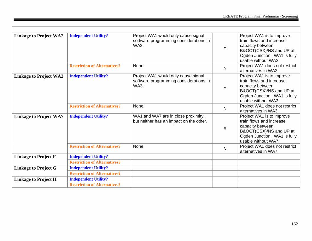
CREATE Program Final Preliminary Screening
162
Linkage to Project WA2 Independent Utility? Project WA1 would only cause signal
software programming considerations in WA2.
Y
Project WA1 is to improve train flows and increase capacity between B&OCT(CSX)/NS and UP at Ogden Junction. WA1 is fully usable without WA2.
Restriction of Alternatives? None N
Project WA1 does not restrict alternatives in WA2.
Linkage to Project WA3 Independent Utility? Project WA1 would only cause signal software programming considerations in WA3.
Y
Project WA1 is to improve train flows and increase capacity between B&OCT(CSX)/NS and UP at Ogden Junction. WA1 is fully usable without WA3.
Restriction of Alternatives? None N
Project WA1 does not restrict alternatives in WA3.
Linkage to Project WA7 Independent Utility? WA1 and WA7 are in close proximity, but neither has an impact on the other.
Y
Project WA1 is to improve train flows and increase capacity between B&OCT(CSX)/NS and UP at Ogden Junction. WA1 is fully usable without WA7.
Restriction of Alternatives? None N
Project WA1 does not restrict alternatives in WA7.
Linkage to Project F Independent Utility?
Restriction of Alternatives?
Linkage to Project G Independent Utility?
Restriction of Alternatives?
Linkage to Project H Independent Utility?
Restriction of Alternatives?

CREATE Program Final Preliminary Screening
163
If no linkages,
prepare
Component Project
Preliminary Purpose and
Need
Statement.
Project is now ready to
be processed through an
ECAD
The purpose of this proposed action is to improve train flows and increase capacity between B&OCT(CSX)/NS and UP at Ogden Junction. Form Completed: 01/29/04 Form Revised: 06/02/04 Form Revised: 05/14/09 Form Revised 11/23/10
If linkages, go to next page NONE

CREATE Program Final Preliminary Screening
164
CREATE Component Project Preliminary Screening Worksheet
CREATE Component Project Profile
Project Identifier
WA2 (Ogden Junction to 75th
Street)
Objective, Intent of Project Increase train speeds, increase capacity, improve utilization of trackage and reduce congestion on the Western Avenue Corridor from Ogden Junction south to 75th Street.
Description of Proposed
Work/ Improvements
Install new TCS signaling on the B&OCT(CSX), to include replacing hand-throw crossovers with power-operated switches.
Location: Owner(s)
Route/Line
Project Limits
Local Community
B&OCT(CSX)
B&OCT(CSX) Blue Island Subdivision
Ogden Junction near Taylor St. to 75th St. along the Western Avenue Corridor.
Chicago Community Areas – Brighton Park, Chicago Lawn, East Garfield Park, Gage Park, Lower West Side, McKinley Park, Near West Side, New City, North Lawndale, South Lawndale, and West Englewood
Potential Environmental Issues
Needing Further Study
No issues appear to need greater detail than normally accomplished through ECAD process.
Project Status
Engineering: Preliminary layout and estimate. Ground survey and detailed signal design needs to be completed.
Estimated Project Costs
(Level of Confidence)
Construction $40.119.1 Million R/W $ 0 Contingencies $ TBD
Planning Estimate
Preliminary Engineering Estimate
Adjoining CREATE
Projects
(Proj.#, Line, distance)
A. EW2/P2/P3/GS19
B. WA1
C. WA3
D. GS19
E. C-3/C-4/WA4
F. P5
G. C-5/C-6/C-8/C-9/C-10/C-11/C-12/P4 GS11
H. WA7
Other Related Projects
(Nature of Relationship)
I. Brighton Park Interlocking
J.
K.
Comments/Notes:

CREATE Program Final Preliminary Screening
165
Individual Component Project Logical Termini Test – Determine 1) sufficient length and scope; 2) independent utility; and 3) restriction of
alternatives.
1) Sufficient Length & Scope Determination
Does the proposed project have sufficient length and scope to broadly address environmental issues? If no, modify project limits. After project limits are modified, ensure project profile is accurate, then proceed to project linkage test.
Y/N
Y
2) Independent Utility and 3) Restriction of Alternatives Determination
Discussion
Y/N
Rationale
Linkage to Project
EW2/P2/P3/GS19
Independent Utility? Does the
project have independent utility or independent significance, i.e., be usable and be a reasonable expenditure even if no additional transportation improvements in the area are made?
Project EW2/P2/P3/GS19 would only cause signal software programming considerations in WA2.
Y
Project WA2 is to increase train speeds, increase capacity, improve utilization of trackage and reduce congestion on the Western Avenue Corridor from Ogden Junction south to 75th Street. WA2 is fully usable without EW2/P2/P3/GS19.
Restriction of Alternatives? Does the project restrict the consideration of alternatives for other reasonably foreseeable transportation improvements?
None
N
Project WA2 does not restrict alternatives in EW2/P2/P3/GS19.

CREATE Program Final Preliminary Screening
166
Linkage to Project WA1 Independent Utility? Project WA1 would only cause signal
software programming considerations in WA2.
Y
Project WA2 is to increase train speeds, increase capacity, improve utilization of trackage and reduce congestion on the Western Avenue Corridor from Ogden Junction south to 75th Street. WA2 is fully usable without WA1.
Restriction of Alternatives? None N
Project WA2 does not restrict alternatives in WA1.
Linkage to Project WA3 Independent Utility? Project WA3 would only cause signal software programming and switch automation considerations in WA-2.
Y
Project WA2 is to increase train speeds, increase capacity, improve utilization of trackage and reduce congestion on the Western Avenue Corridor from Ogden Junction south to 75th Street. WA2 is fully usable without WA3.
Restriction of Alternatives? None N
Project WA2 does not restrict alternatives in WA-3.
Linkage to Project GS19 Independent Utility? GS19 is to grade separate 71st Street over this area and neither project impacts the other. GS19 would only cause minor signal changes in WA2.
Y
Project WA2 is to increase train speeds, increase capacity, improve utilization of trackage and reduce congestion on the Western Avenue Corridor from Ogden Junction south to 75th Street. WA2 is fully usable without GS19.
Restriction of Alternatives? None N
Project WA2 does not restrict alternatives in GS19.

CREATE Program Final Preliminary Screening
167
Linkage to Project C-
3/C-4/WA-4
Independent Utility? Project C-3/C-4/WA-4 would only cause signal software programming considerations in WA-2.
Y
Project WA-2 is to increase train speeds, increase capacity, improve utilization of trackage and reduce congestion on the Western Avenue Corridor from Ogden Junction south to 75th Street. WA-2 is fully usable without C-3/C-4/WA-4.
Restriction of Alternatives? None N
Project WA-2 does not restrict alternatives in C-3/C-4/WA-4.
Linkage to Project P5 Independent Utility? In the vicinity of the Brighton Park flyover (P5), project WA2 is signal changes only.
Y
Project WA2 is to increase train speeds, increase capacity, improve utilization of trackage and reduce congestion on the Western Avenue Corridor from Ogden Junction south to 75th Street. WA2 is fully usable without P5.
Restriction of Alternatives? None N
Project WA2 does not restrict alternatives in P5.
Linkage to Project GS11 Independent Utility? GS11 is to grade Columbus Ave over the BRC and neither project impacts the other.
Y
Project WA2 is to increase train speeds, increase capacity, improve utilization of trackage and reduce congestion on the Western Avenue Corridor from Ogden Junction south to 75th Street. WA2 is fully usable without GS11.
Restriction of Alternatives? None N
Project WA2 does not restrict alternatives in GS11.

CREATE Program Final Preliminary Screening
168
Linkage to Project WA7 Independent Utility? Project WA7 would only cause signal
software programming considerations in WA-2.
Y
Project WA2 is to increase train speeds, increase capacity, improve utilization of trackage and reduce congestion on the Western Avenue Corridor from Ogden Junction south to 75th Street. WA2 is fully usable without WA7.
Restriction of Alternatives? None N
Project WA2 does not restrict alternatives in WA7.
Linkage to Project C-
5/C-6/C-8/C-9/C-10/C-
11/C-12/P4
Independent Utility? C-5/C-6/C-8/C-9/C-10/C-11/C-12/P4 and WA-2 are physically close to each other, but are on separate routes and would not affect each other.
Y
Project WA2 is to increase train speeds, increase capacity, improve utilization of trackage and reduce congestion on the Western Avenue Corridor from Ogden Junction south to 75th Street. WA2 is fully usable without C-5/C-6/C-8/C-9/C-10/C-11/C-12/P4.
Restriction of Alternatives? None N
Project WA2 does not restrict alternatives C-5/C-6/C-8/C-9/C-10/C-11/C-12/P4.
Linkage to Project
Brighton Park
Interlocking
Independent Utility? Brighton Park Interlocking has begun construction and would only cause signal software programming considerations in WA2.
Y
Project WA2 is to increase train speeds, increase capacity, improve utilization of trackage and reduce congestion on the Western Avenue Corridor from Ogden Junction south to 75th Street. WA2 is fully usable without Brighton Park Interlocking project.

CREATE Program Final Preliminary Screening
169
Restriction of Alternatives? None
N
Project WA2 does not restrict alternatives in Brighton Park Interlocking project.
If no linkages,
prepare
Component Project
Preliminary Purpose and
Need
Statement.
Project is now ready to
be processed through an
ECAD
The purpose of this proposed action is to increase train speeds, increase capacity, improve utilization of trackage and reduce congestion on the Western Avenue Corridor from Ogden Junction south to 75th Street. Form Completed: 01/29/04 Form Revised: 06/02/04 Form Revised: 05/14/09 Form Revised: 11/23/10
If linkages, go to next
page
NONE

CREATE Program Final Preliminary Screening
170
CREATE Component Project Preliminary Screening Worksheet
CREATE Component Project Profile
Project Identifier
WA3 (Ogden Junction to CP 518)
Objective, Intent of Project Increase train speeds, reduce congestion and add capacity along the NS (CR&I/CJ) mains between Ogden Junction and CP 518.
Description of Proposed
Work/ Improvements
Install TCS signaling along the NS mains from Ogden Junction to CP 518, add a mainline to the Ashland Avenue Yard, extend the Ashland Ave. Yard lead, and automate hand-throw crossovers.
Location: Owner(s)
Route/Line
Project Limits
Local Community
NS
NS CJ Mainline
Ogden Junction and Control Point 518 (near intersection of 40th Street and Canal)
Chicago Community Areas – Armour Square, Bridgeport, and McKinley Park.
Potential Environmental Issues
Needing Further Study
No issues appear to need greater detail than normally accomplished through ECAD process.
Project Status
Engineering: Preliminary layout and estimate. Ground survey and detailed signal design needs to be completed.
Estimated Project Costs
(Level of Confidence)
Construction $ 26.2 Million R/W $ Yes - TBD Contingencies $ TBD
Planning Estimate
Preliminary Engineering Estimate
Adjoining CREATE
Projects
(Proj.#, Line, distance)
A. WA1
B. WA2
C. P5
D. GS3a
E. WA7
Other Related Projects
(Nature of Relationship)
F. Brighton Park Interlocking
G.
H.
I.
Comments/Notes:

CREATE Program Final Preliminary Screening
171
Individual Component Project Logical Termini Test – Determine 1) sufficient length and scope; 2) independent utility; and 3) restriction of
alternatives.
1) Sufficient Length & Scope Determination
Does the proposed project have sufficient length and scope to broadly address environmental issues? If no, modify project limits. After project limits are modified, ensure project profile is accurate, then proceed to project linkage test.
Y/N
Y
2) Independent Utility and 3) Restriction of Alternatives Determination
Discussion Y/N Rationale
Linkage to Project WA1
Independent Utility? Does the project have independent utility or independent significance, i.e., be usable and be a reasonable expenditure even if no additional transportation improvements in the area are made?
Project WA1 would only cause signal software programming considerations in WA3.
Y
Project WA3 is to increase train speeds, reduce congestion and add capacity along the NS (CR&I/CJ) mains between Ogden Junction and CP 518. WA3 is fully usable without WA1.
Restriction of Alternatives? Does the project restrict the consideration of alternatives for other reasonably foreseeable transportation improvements?
None
N
Project WA3 does not restrict alternatives in WA1.
Linkage to Project WA2 Independent Utility? Project WA2 would only cause signal software programming considerations in WA3.
Y
Project WA3 is to increase train speeds, reduce congestion and add capacity along the NS (CR&I/CJ) mains between Ogden Junction and CP 518. WA3 is fully usable without WA2.
Restriction of Alternatives? None N
Project WA3 does not restrict alternatives in WA2.

CREATE Program Final Preliminary Screening
172
Linkage to Project P5 Independent Utility? In the vicinity of the Brighton Park
flyover (P5), project WA3 is signal changes only.
Y
Project WA3 is to increase train speeds, reduce congestion and add capacity along the NS (CR&I/CJ) mains between Ogden Junction and CP 518. WA3 is fully usable without P5.
Restriction of Alternatives? None N
Project WA3 does not restrict alternatives in P5.
Linkage to Project GS3a Independent Utility? None
Y
Project WA3 is to increase train speeds, reduce congestion and add capacity along the NS (CR&I/CJ) mains between Ogden Junction and CP 518. WA3 is fully usable without GS3a.
Restriction of Alternatives? WA3 would only cause design considerations in the implementation of GS3a and would not restrict consideration of reasonable alternatives.
N
Project WA3 does not restrict alternatives in GS3a.
Linkage to Project WA7 Independent Utility? WA3 and WA7 are in close proximity, but neither has an impact on the other.
Y
Project WA3 is to improve train flows and increase capacity along the NS CJ lines. WA3 is fully usable without WA7.
Restriction of Alternatives? None N
Project WA3 does not restrict alternatives in WA7.

CREATE Program Final Preliminary Screening
173
Linkage to Project
Brighton Park
Interlocking
Independent Utility? Brighton Park Interlocking has begun construction and would only cause signal software programming considerations in WA3.
Y
Project WA3 is to increase train speeds, reduce congestion and add capacity along the NS (CR&I/CJ) mains between Ogden Junction and CP 518. WA3 is fully usable without the Brighton Park Interlocking project.
Restriction of Alternatives? None
N
Project WA3 does not restrict alternatives in the Brighton Park Interlocking project.
Linkage to Project G Independent Utility?
Restriction of Alternatives?
Linkage to Project H Independent Utility?
Restriction of Alternatives?
If no linkages,
prepare
Component Project
Preliminary Purpose and
Need
Statement.
Project is now ready to
be processed through an
ECAD
The purpose of this proposed action is to increase train speeds, reduce congestion and add capacity along the NS (CR&I/CJ) mains between Ogden Junction and CP 518.
Form Completed: 01/29/04 Form Revised: 06/02/04 Form Revised: 05/14/09 Form Revised: 11/23/10
If linkages, go to next
page
NONE

CREATE Program Final Preliminary Screening
174
CREATE Component Project Preliminary Screening Worksheet
CREATE Component Project Profile
Project Identifier
WA4 (Western Ave to Ash Street)
Objective, Intent of Project Efficiently connect the BNSF Chicago and BNSF Chillicothe Subdivisions to eliminate the safety issue of long reverse moves.
Description of Proposed
Work/ Improvements
Construct new track from Western Avenue Interlocking on the BNSF Chicago Sub to CP 46 on the Chillicothe Sub. Rehab bridge over the Chicago Sanitary and Ship Canal, and install switches to cross the CN Freeport Sub. Install crossovers between new track and B&OCT(CSX) Blue Island Subdivision. Install CTC signaling over length of the project.
Location: Owner(s)
Route/Line
Project Limits
Local Community
BNSF, NS, CSX and CN
Former Panhandle ROW
Western Ave Interlocking to CP 46 near California Ave.
Chicago – Douglas Park, South Lawndale, Little Village, and Brighton Park
Potential Environmental Issues
Needing Further Study
No issues appear to need greater detail than normally accomplished through ECAD process.
Project Status
Engineering: Preliminary layout and estimate. Detailed signal and track design need to be completed.
Estimated Project Costs
(Level of Confidence)
Construction $ 15.2 Million R/W $ 0 Contingencies $ 3.6 Million
Planning Estimate
Preliminary Engineering Estimate
Adjoining CREATE
Projects
(Proj.#, Line, distance)
A. WA2
B. C3/C4
C. WA5
D. WA7
E.
Other Related Projects
(Nature of Relationship)
G. WA1
H.
I.
J.
Comments/Notes:

CREATE Program Final Preliminary Screening
175
Individual Component Project Logical Termini Test – Determine 1) sufficient length and scope; 2) independent utility; and 3) restriction of
alternatives.
1) Sufficient Length & Scope Determination
Does the proposed project have sufficient length and scope to broadly address environmental issues? If no, modify project limits. After project limits are modified, ensure project profile is accurate, then proceed to project linkage test.
Y/N
Y
2) Independent Utility and 3) Restriction of Alternatives Determination
Discussion
Y/N
Rationale
Linkage to Project WA2 Independent Utility? Project WA2 would only cause signal software programming considerations in WA4.
Y
Project WA4 is to construct a connection directly linking BNSF Chicago and Chillicothe Subs. WA4 is fully usable without WA2.
Restriction of Alternatives? None N
Project WA4 does not restrict alternatives in WA2.
Linkage to Project C-
3/C-4
Independent Utility? Project C3/C4 would only cause signal software programming considerations in WA4. Y
Project WA4 is to construct a connection directly linking BNSF Chicago and Chillicothe Subs. WA4 is fully usable without C3/C4.
Restriction of Alternatives? None N
Project WA4 does not restrict alternatives in C3/C4.
Linkage to Project WA5 Independent Utility? Project WA5 would only cause signal software programming in WA4.
Y
Project WA4 is to construct a connection directly linking BNSF Chicago and Chillicothe Subs. WA4 is fully usable without WA5.

CREATE Program Final Preliminary Screening
176
Restriction of Alternatives? None
N Project WA4 does not restrict alternatives in project WA5.
Linkage to Project WA7 Independent Utility? Project WA7 would only cause signal software programming considerations in WA4. Y
Project WA4 is to construct a connection directly linking BNSF Chicago and Chillicothe Subs. WA4 is fully usable without WA7.
Restriction of Alternatives? None
N Project WA4 does not restrict alternatives in WA7.
Linkage to Project WA1
Independent Utility? Does the project have independent utility or independent significance, i.e., be usable and be a reasonable expenditure even if no additional transportation improvements in the area are made?
Project WA1 would have no effect on WA4
Y
Project WA1 is to increase train speeds, increase capacity, improve utilization of trackage and reduce congestion on the north end of the Western Avenue Corridor. WA1 is fully usable without WA4.
Restriction of Alternatives? Does the project restrict the consideration of alternatives for other reasonably foreseeable transportation improvements?
None
N
Project WA4 does not restrict alternatives in WA1.
If no linkages,
prepare
Component Project
Purpose and Need

CREATE Program Final Preliminary Screening
177
Statement.
Project is now ready to
be processed through an
ECAD

CREATE Program Final Preliminary Screening
178
CREATE Component Project Preliminary Screening Worksheet
CREATE Component Project Profile
Project Identifier
WA5 (Corwith Tower) Objective, Intent of Project To improve train operations through Corwith Interlocking.
Description of Proposed
Work/ Improvements
Automate Corwith Tower (remote), upgrade track and signals and reconfigure the Corwith Interlocking.
Location: Owner(s)
Route/Line
Project Limits
Local Community
BNSF and CN
BNSF Chillicothe Subdivision and CN Joliet Subdivision/Metra Heritage Corridor
Within the Corwith Interlocking limits. (Near 36th Street and South Central Park Avenue)
Chicago Community Areas - Brighton Park, North Lawndale, and South Lawndale
Potential Environmental Issues
Needing Further Study
No issues appear to need greater detail than normally accomplished through ECAD process.
Project Status
Engineering: Preliminary layout and estimate. Ground survey and detailed signal design needs to be completed.
Estimated Project Costs
(Level of Confidence)
Construction $ 14 Million R/W $ 0 Contingencies $ TBD
Planning Estimate
Preliminary Engineering Estimate
Adjoining CREATE
Projects
(Proj.#, Line, distance)
A. C-3/C-4/WA4
B.
C.
D.
Other Related Projects
(Nature of Relationship)
E. Brighton Park Interlocking Project
F.
G.
H.
Comments/Notes:

CREATE Program Final Preliminary Screening
179
Individual Component Project Logical Termini Test – Determine 1) sufficient length and scope; 2) independent utility; and 3) restriction of
alternatives.
1) Sufficient Length & Scope Determination
Does the proposed project have sufficient length and scope to broadly address environmental issues? If no, modify project limits. After project limits are modified, ensure project profile is accurate, then proceed to project linkage test.
Y/N
Y
2) Independent Utility and 3) Restriction of Alternatives Determination
Discussion Y/N Rationale
Linkage to Project C-
3/C-4/WA-4
Independent Utility? Does the project have independent utility or independent significance, i.e., be usable and be a reasonable expenditure even if no additional transportation improvements in the area are made?
Significant distance between these two projects and neither has an impact on the other. (~ 1 mile)
Y
Project WA5 is to improve train operation through Corwith Interlocking by automating the Corwith Tower (remote). WA5 is fully usable without C-3/C-4/WA-4.
Restriction of Alternatives? Does the project restrict the consideration of alternatives for other reasonably foreseeable transportation improvements?
None
N
Project WA5 does not restrict alternatives in C-3/C-4/WA-4.
Linkage to Project
Brighton Park
Interlocking
Independent Utility? Brighton Park Interlocking has begun construction and would only cause signal software programming considerations in WA5. Y
Project WA5 is to improve train operation through Corwith Interlocking by automating the Corwith Tower (remote). WA5 is fully usable without the Brighton Park Interlocking project.
Restriction of Alternatives? None N
Project WA5 does not restrict alternatives in the Brighton Park Interlocking project.

CREATE Program Final Preliminary Screening
180
Linkage to Project C Independent Utility?
Restriction of Alternatives?
Linkage to Project D Independent Utility?
Restriction of Alternatives?
Linkage to Project E Independent Utility?
Restriction of Alternatives?
Linkage to Project F Independent Utility?
Restriction of Alternatives?
Linkage to Project G Independent Utility?
Restriction of Alternatives?
Linkage to Project H Independent Utility?
Restriction of Alternatives?
If no linkages,
prepare
Component Project
Preliminary Purpose and
Need
Statement.
Project is now ready to
be processed through an
ECAD
The purpose of this proposed action is to improve train operations through Corwith Interlocking. Form Completed: 01/30/04 Form Revised: 06/02/04
Form Revised: 05/14/09
If linkages, go to next
page
NONE

CREATE Program Final Preliminary Screening
181
CREATE Component Project Preliminary Screening Worksheet
CREATE Component Project Profile
Project Identifier
WA7 (Brighton Park)
Objective, Intent of Project Connect the Western Avenue Corridor with the CN Joliet Subdivision.
Description of Proposed
Work/ Improvements
Install connections in the northwest and southwest quadrants of the Brighton Park Interlocking for movements between the Western Avenue Corridor and the existing Joliet Sub. Includes associated signal work.
Location: Owner(s)
Route/Line
Project Limits
Local Community
NS, B&OCT (CSX) and CN
B&OCT (CSX) and CN Joliet Subdivision/Metra Heritage Corridor
Archer Avenue to 15th Place 35th Street on the B&OCT (CSX) and between Western Avenue and Brighton Park to Albany Ave. Rockwell on the CN Joliet subdivision and between Western Avenue and Brighton Park to California Ave. on the CN Freeport Subdivision and the BNSF Chicago Subdivision.
Chicago Community Area – Brighton Park, Douglas Park, South Lawndale, Little Village.
Potential Environmental Issues
Needing Further Study
No issues appear to need greater detail than normally accomplished through ECAD process.
Project Status
Engineering: Preliminary layout and estimate. Ground survey and detailed signal design needs to be completed.
Estimated Project Costs
(Level of Confidence)
Construction $ 8.0 Million R/W $ Yes - TBD Contingencies $ TBD
Planning Estimate
Preliminary Engineering Estimate
Adjoining CREATE
Projects
(Proj.#, Line, distance)
A. WA2
B. P5
C. WA1
D. WA3
E. WA4 F
G.
H. I.
J.

CREATE Program Final Preliminary Screening
182
Other Related Projects
(Nature of Relationship)
K.
L.
M.
N.
Comments/Notes:
Individual Component Project Logical Termini Test – Determine 1) sufficient length and scope; 2) independent utility; and 3) restriction of
alternatives.
1) Sufficient Length & Scope Determination
Does the proposed project have sufficient length and scope to broadly address environmental issues? If no, modify project limits. After project limits are modified, ensure project profile is accurate, then proceed to project linkage test.
Y/N
Y
2) Independent Utility and 3) Restriction of Alternatives Determination
Discussion Y/N Rationale
Linkage to Project WA2
Independent Utility? Does the
project have independent utility or independent significance, i.e., be usable and be a reasonable expenditure even if no additional transportation improvements in the area are made?
Trains utilizing WA7 would still be able to switch to existing tracks at Brighton Park and near Ash Street if WA2 is not implemented. Y
Project WA7 installs connections between the B&OCT (CSX) and the existing Joliet Sub. WA7 is fully usable without WA2.
Restriction of Alternatives? Does the project restrict the consideration of alternatives for other reasonably foreseeable transportation improvements?
None
N
Project WA7 does not restrict alternatives in WA2.

CREATE Program Final Preliminary Screening
183
Linkage to Project P5 Independent Utility? P5 is to grade separate the Metra
Heritage corridor from the Western Ave Corridor. Y
Project WA7 installs connections between the B&OCT (CSX) and the existing Joliet Sub. WA7 is fully usable without P5.
Restriction of Alternatives? None N
Project WA7 does not restrict alternatives in P5.
Linkage to Project WA1 Independent Utility? WA7 and WA1 are in close proximity, but neither has an impact on the other.
Y
Project WA7 is to connect the CN Joliet Sub and the Western Avenue Corridor. WA7 is fully usable without WA1.
Restriction of Alternatives? None N
Project WA7 does not restrict alternatives in WA1.
Linkage to Project WA3 Independent Utility? WA7 and WA3 are in close proximity, but neither has an impact on the other.
Y
Project WA7 is to connect the CN Joliet Sub and the Western Avenue Corridor. WA7 is fully usable without WA3.
Restriction of Alternatives? None N
Project WA7 does not restrict alternatives in WA3.
Linkage to Project WA4 Independent Utility? Project WA4 would only cause signal software programming considerations in WA7. Y
Project WA7 is to connect the CN Joliet Sub and the Western Avenue Corridor. WA7 is fully usable without WA4.
Restriction of Alternatives? None N
Project WA7 does not restrict alternatives in WA4.
Linkage to Project Chicago – St. Louis Corridor improvement Study
Independent Utility? Chicago – St. Louis Corridor Improvement Study and WA7 cross each other but would not affect each other.
Y
Project WA7 is to connect the CN Joliet Sub and the Western Avenue Corridor. Project WA7 is fully usable without Chicago – St. Louis Corridor Improvement Study.

CREATE Program Final Preliminary Screening
184
Restriction of Alternatives? None
N
Project WA7 does not restrict alternatives in Chicago – St. Louis Corridor Improvement Study.
If no linkages,
prepare
Component Project
Preliminary Purpose and
Need
Statement.
Project is now ready to
be processed through an
ECAD
Form Created 05/14/09
Form Revised 01/12/11
If linkages, go to next
page

CREATE Program Final Preliminary Screening
185
CREATE Component Project Preliminary Screening Worksheet
CREATE Component Project Profile
Project Identifier
WA10 (Blue Island Junction)
Objective, Intent of Project Provide new access allowing better flexibility and efficient utilization of the Western Avenue Corridor, East/West Corridor and a portion of the Beltway Corridor.
Description of Proposed
Work/ Improvements
Install universal interlocked connections between the B&OCT(CSX) Blue Island Subdivision and the CN Elsdon Subdivision at Blue Island Junction. Includes removal of one CN track over IHB Mainline. Also includes associated signal work.
Location: Owner(s)
Route/Line
Project Limits
Local Community
CN and B&OCT(CSX)
B&OCT(CSX) Blue Island Subdivision and CN Elsdon Subdivision
Just north of Blue Island Junction (between Cal-Sag Channel and Vermont Street) to just north of 123rd 119th St on the CN Elsdon Subdivision.
Blue Island and Merrionette Park, IL
Potential Environmental Issues
Needing Further Study
No issues appear to need greater detail than normally accomplished through ECAD process.
Project Status
Engineering: Preliminary layout and estimate. Ground survey and detailed signal design needs to be completed.
Estimated Project Costs
(Level of Confidence)
Construction $ 7.4 Million R/W $ 0 Contingencies $ TBD
Planning Estimate
Preliminary Engineering Estimate
Adjoining Projects
(Proj.#, Line, distance)
A. B12
B. B13
C. GS-5
D. T2
E. T9
Other Related Projects
(Nature of Relationship)
F.
G.
H.
I.
Comments/Notes:

CREATE Program Final Preliminary Screening
186
Individual Component Project Logical Termini Test – Determine 1) sufficient length and scope; 2) independent utility; and 3) restriction of
alternatives.
1) Sufficient Length & Scope Determination
Does the proposed project have sufficient length and scope to broadly address environmental issues? If no, modify project limits. After project limits are modified, ensure project profile is accurate, then proceed to project linkage test.
Y/N
Y
2) Independent Utility and 3) Restriction of Alternatives Determination
Discussion Y/N Rationale
Linkage to Project B12
Independent Utility? Does the project have independent utility or independent significance, i.e., be usable and be a reasonable expenditure even if no additional transportation improvements in the area are made?
Both projects, although close together, are on completely separate routes and will not impact each other.
Y
Project WA10 is to provide access to multiple routes for better flexibility and efficient utilization of the Western Avenue Corridor, East/West Corridor and a portion of the Beltway Corridor. WA10 is fully usable without B12.
Restriction of Alternatives? Does the project restrict the consideration of alternatives for other reasonably foreseeable transportation improvements?
None
N
Project WA-10 does not restrict alternatives in B12.
Linkage to Project B13 Independent Utility? B13 only increases train speeds through Blue Island Junction between IHB and CN and would not have an effect on WA10.
Y
Project WA10 is to provide access to multiple routes for better flexibility and efficient utilization of the Western Avenue Corridor, East/West Corridor and a portion of the Beltway Corridor. WA10 is fully usable without B13.
Restriction of Alternatives? None N
Project WA10 does not restrict alternatives in B13.

CREATE Program Final Preliminary Screening
187
Linkage to Project GS-5 Independent Utility? These two projects are separated by 0.5 mile and neither has an impact on the other.
Y
Project WA-10 is to provide access to multiple routes for better flexibility and efficient utilization of the Western Avenue Corridor, East/West Corridor and a portion of the Beltway Corridor. WA-10 is fully usable without GS-5.
Restriction of Alternatives? None N
Project WA-10 does not restrict alternatives in GS-5.
Linkage to Project T2 Independent Utility? Project T2 has no impact on Project WA10. It will be controlled by a separate interlocking.
Y Project WA10 is to provide improved interconnectivity between B&OCT and CN north of project T2. Project T2 is to improve train reliability by reducing signal failure rates in the CN Blue Island Interlocking. WA10 is fully usable without T2.
Restriction of Alternatives? None N Project Wa10 does not restrict alternatives in T2.
Linkage to Project T9 Independent Utility? Project T9 has no impact on Project WA10. The projects serve separate routes.
Y Project WA10 is to provide improved interconnectivity between B&OCT and CN on a separate route.Project T9 is to improve train reliability by reducing signal failure rates in the Metra Blue Island Interlocking. Wa10 is fully usable without T9.
Restriction of Alternatives? None N Project WA10 does not restrict alternatives in T9.
Linkage to Project F Independent Utility?
Restriction of Alternatives?
Linkage to Project G Independent Utility?
Restriction of Alternatives?
Linkage to Project H Independent Utility?
Restriction of Alternatives?

CREATE Program Final Preliminary Screening
188
If no linkages,
prepare
Component Project
Preliminary Purpose and
Need
Statement.
Project is now ready to
be processed through an
ECAD
The purpose of this proposed action is to provide new access allowing better flexibility and efficient utilization of the Western Avenue Corridor, East/West Corridor and a portion of the Beltway Corridor. Form Completed: 01/30/04 Form Revised: 03/30/04 Form Revised: 01/12/11
If linkages, go to next
page
NONE

CREATE Program Final Preliminary Screening
189
CREATE Component Project Preliminary Screening Worksheet
CREATE Component Project Profile
Project Identifier
WA11 (Dolton) Objective, Intent of Project Increase train speeds, capacity, and reliability at Dolton Interlocking.
Description of Proposed
Work/ Improvements
Upgrade and reconfigure the B&OCT(CSX)/UP connection at Dolton Interlocking, and construct a third main with direct access from B&OCT(CSX) and Barr Yard to the UP main. Includes addition of crossovers on IHB Mainline and automate Dolton Tower (remote). Includes associated signal work.
Location: Owner(s)
Route/Line
Project Limits
Local Community
IHB, B&OCT(CSX), UP and NS
IHB Mainline, B&OCT(CSX) Barr Subdivision, UP Villa Grove Subdivision, and NS Hot Metal Track
From Cottage Grove on the east to the Dolton Interlocking on the west. From Riverdale Interlocking on the north to south of Sibley Blvd.to and including the Dolton Interlocking limits. (Between 136th Street and 142nd Street)
Chicago Community Areas: Riverdale; also Dolton, IL, Riverdale, IL
Potential Environmental Issues
Needing Further Study
No issues appear to need greater detail than normally accomplished through ECAD process.
Project Status
Engineering: Preliminary layout and estimate. Ground survey and detailed signal design needs to be completed.
Estimated Project Costs
(Level of Confidence)
Construction $ 17.4 Million R/W $ 0 Contingencies $ TBD
Planning Estimate
Preliminary Engineering Estimate
Adjoining CREATE
Projects
(Proj.#, Line, distance)
A. B15
B. B16
C. GS-23
D. GS23a
Other Related Projects
(Nature of Relationship)
E.
F.
G.
H.
Comments/Notes:

CREATE Program Final Preliminary Screening
190
Individual Component Project Logical Termini Test – Determine 1) sufficient length and scope; 2) independent utility; and 3) restriction of
alternatives.
1) Sufficient Length & Scope Determination
Does the proposed project have sufficient length and scope to broadly address environmental issues? If no, modify project limits. After project limits are modified, ensure project profile is accurate, then proceed to project linkage test.
Y/N
2) Independent Utility and 3) Restriction of Alternatives Determination
Discussion
Y/N
Rationale
Linkage to Project B15
Independent Utility? Does the
project have independent utility or independent significance, i.e., be usable and be a reasonable expenditure even if no additional transportation improvements in the area are made?
Project B15 would only cause signal software programming considerations in WA11.
Y
Project WA11 is to increase train speeds, capacity, and reliability at Dolton Interlocking. WA11 is fully usable without B15.
Restriction of Alternatives? Does the project restrict the consideration of alternatives for other reasonably foreseeable transportation improvements?
None
N
Project WA11 does not restrict alternatives in B15.
Linkage to Project B16 Independent Utility? Significant distance between these two projects and neither has an impact on the other. (4.5 miles) Y
Project WA11 is to increase train speeds, capacity, and reliability at Dolton Interlocking. WA11 is fully usable without B16.
Restriction of Alternatives? None N
Project WA11 does not restrict alternatives in B16.

CREATE Program Final Preliminary Screening
191
Linkage to Project GS-
23
Independent Utility? GS-23 (144th Street) is approximately 2000 feet south of WA-11 and neither project would affect the other. Y
Project WA-11 is to increase train speeds, capacity, and reliability at Dolton Interlocking. WA-11 is fully usable without GS-23.
Restriction of Alternatives? None N
Project WA-11 does not restrict alternatives in GS-23.
Linkage to Project
GS23a
Independent Utility? GS23a and WA11 overlap but the projects do not impact each other.
Y
Project GS23a is to grade separate Cottage Grove Ave and the CSX/IHB. WA11 is fully usable without GS23a.
Restriction of Alternatives? None N
Project WA11 does not restrict alternatives in GS23a.
Linkage to Project E Independent Utility?
Restriction of Alternatives?
Linkage to Project F Independent Utility?
Restriction of Alternatives?
Linkage to Project G Independent Utility?
Restriction of Alternatives?
Linkage to Project H Independent Utility?
Restriction of Alternatives?
If no linkages,
prepare
Component Project
Preliminary Purpose and
Need
Statement.
Project is now ready to
be processed through an
ECAD
The purpose of this proposed action is to increase train speeds, capacity, and reliability at Dolton Interlocking. Form Completed: 01/30/04 Form Revised: 03/30/04 Form Revised: 05/14/09 Form Revised: 11/23/10
If linkages, go to next
page
NONE

CREATE Program Final Preliminary Screening
192
CREATE Component Project Purpose and Need Screening Worksheet
CREATE Component Project Profile
Project Identifier
Tower T1 (21st Street Interlocking)
Objective, Intent of Project
Reduces the signal systems’ failure rate due to antiquated infrastructure. Increases reliability of train operations at key crossings throughout the region. Reduces Amtrak and Metra delay due to periodic signal failures, which require hand flagging of the interlocking.
Description of Proposed
Work/ Improvements
Automate 21st Street Tower (remote); upgrade track and signals at the 21st Street Interlocking.
Location: Owner(s)
Route/Line
Project Limits
Local Community
Amtrak, CN
Amtrak CUS South and CN Freeport Subdivision/Metra Heritage Corridor
Within the 21st Street Interlocking limits (Lumber Street to 23rd Street and Canal Street to 18th Street)
Chicago Community Areas – Lower West Side and Armour Square
Potential Environmental Issues
Needing Further Study
None
Project Status
Project is complete
Estimated Project Costs
(Level of Confidence)
Construction $500,000 R/W $0 Contingencies $0
Planning Estimate
Preliminary Engineering Estimate
Adjoining CREATE
Projects
(Proj.#, Line, distance)
A. None
B.
C.
D.
Other Related Projects
(Nature of Relationship)
E.
F.
G.
H.
Comments:

CREATE Program Final Preliminary Screening
193
Individual Component Project Logical Termini Test – Determine 1) sufficient length and scope; 2) independent utility; and 3) restriction of
alternatives.
1) Sufficient Length & Scope Determination
Does the proposed project have sufficient length and scope to broadly address environmental issues? If no, modify project limits. After project limits are modified, ensure project profile is accurate, and then proceed to project linkage test.
Y/N
Y
2) Independent Utility and 3) Restriction of Alternatives Determination
Discussion
Y/N
Rationale
Linkage to Project A
Independent Utility? Does the
project have independent utility or independent significance, i.e., be usable and be a reasonable expenditure even if no additional transportation improvements in the area are made?
Restriction of Alternatives? Does the project restrict the consideration of alternatives for other reasonably foreseeable transportation improvements?
Linkage to Project B Independent Utility?
Restriction of Alternatives?
Linkage to Project C Independent Utility?
Restriction of Alternatives?
Linkage to Project D Independent Utility?
Restriction of Alternatives?
Linkage to Project E Independent Utility?

CREATE Program Final Preliminary Screening
194
Restriction of Alternatives?
Linkage to Project F Independent Utility?
Restriction of Alternatives?
Linkage to Project G Independent Utility?
Restriction of Alternatives?
Linkage to Project H Independent Utility?
Restriction of Alternatives?
If no linkages,
prepare
Component Project
Purpose and Need
Statement.
Project is now ready to
be processed through an
ECAD
The purpose of this proposed action is to reduce the signal systems’ failure rate due to antiquated infrastructure. Reduce Amtrak and Metra delay due to periodic signal failures, which require hand flagging of the interlocking. Increase reliability of train operations at key crossings throughout the region. Form Completed 12/01/10
If linkages, go to next
page

CREATE Program Final Preliminary Screening
195
CREATE Component Project Purpose and Need Screening Worksheet
CREATE Component Project Profile
Project Identifier
Tower T2 (CN Blue Island Interlocking)
Objective, Intent of Project
Reduces the signal systems’ failure rate due to antiquated infrastructure. Increases reliability of train operations at key crossings throughout the region. Reduces delay due to periodic signal failures, which require hand flagging of the interlocking.
Description of Proposed
Work/ Improvements
Automate the CN Blue Island Tower (remote); upgrade track and signals at the CN Blue Island Interlocking.
Location: Owner(s)
Route/Line
Project Limits
Local Community
CN, B&OCT and IHB
CN Elsdon Subdivision, B&OCT Blue Island Subdivision and IHB/B&OCT McCook Subdivision
Within the CN Blue Island Interlocking limits (Vermont St., Francisco Ave., 139th Street, Western Avenue
Blue Island
Potential Environmental Issues
Needing Further Study
No issues appear to need greater detail than normally accomplished through ECAD process.
Project Status
Engineering: Preliminary layout and estimate.
Estimated Project Costs
(Level of Confidence)
Construction $3,000,000 R/W $0 Contingencies $0
Planning Estimate
Preliminary Engineering Estimate
Adjoining CREATE
Projects
(Proj.#, Line, distance)
A. B12
B. B15
C. GS17
D. T9
E. WA10
Other Related Projects
(Nature of Relationship)
F.
G.
H.
I.
Comments:

CREATE Program Final Preliminary Screening
196
Individual Component Project Logical Termini Test – Determine 1) sufficient length and scope; 2) independent utility; and 3) restriction of
alternatives.
1) Sufficient Length & Scope Determination
Does the proposed project have sufficient length and scope to broadly address environmental issues? If no, modify project limits. After project limits are modified, ensure project profile is accurate, and then proceed to project linkage test.
Y/N
Y
2) Independent Utility and 3) Restriction of Alternatives Determination
Discussion
Y/N
Rationale
Linkage to Project B12
Independent Utility? Does the
project have independent utility or independent significance, i.e., be usable and be a reasonable expenditure even if no additional transportation improvements in the area are made?
Project B12 has no impact on Project T2.
Y
Project T2 is to improve train reliability by reducing signal failure rates in the CN Blue Island Interlocking. Project B12 is to add a third main track to the B&OCT/IHB west of the T2 limits. T2 is fully usable without B12.
Restriction of Alternatives? Does the project restrict the consideration of alternatives for other reasonably foreseeable transportation improvements?
None
N
Project T2 does not restrict alternatives in B12.

CREATE Program Final Preliminary Screening
197
Linkage to Project B15 Independent Utility? Project B15 has no impact on Project
T2. The two projects are 2 miles apart.
Y
Project T2 is to improve train reliability by reducing signal failure rates in the CN Blue Island Interlocking. Project B15 is to upgrade signals on the IHB mains east of the project area. T2 is fully usable without B15.
Restriction of Alternatives? None N
Project T2 does not restrict alternatives in B15.
Linkage to Project GS17 Independent Utility? Project GS17 and Project T2 are one mile apart but have no impact on each other.
Y
Project T2 is to improve train reliability by reducing signal failure rates in the CN Blue Island Interlocking. GS17 is to grade separate Western Ave from the B&OCT tracks. T2 is fully usable without GS17.
Restriction of Alternatives? None N
Project T2 does not restrict alternatives in GS17.
Linkage to Project T9 Independent Utility? Project T9 has no impact on Project T2. The two projects serve different lines.
Y
Project T2 is to improve train reliability by reducing signal failure rates in the CN Blue Island Interlocking. T9 is to upgrade the Metra interlocking on the Rock Island District. T2 is fully usable without T9.
Restriction of Alternatives? None N
Project T2 does not restrict alternatives in T9.

CREATE Program Final Preliminary Screening
198
Linkage to Project
WA10
Independent Utility? Project WA10 has no impact on Project T2. It will be controlled by a separate interlocking.
Y
Project T2 is to improve train reliability by reducing signal failure rates in the CN Blue Island Interlocking. Project WA10 is to provide improved interconnectivity between B&OCT and CN north of project T2. T2 is fully usable without WA10.
Restriction of Alternatives? None N
Project T2 does not restrict alternatives in WA10.
Linkage to Project F Independent Utility?
Restriction of Alternatives?
Linkage to Project G Independent Utility?
Restriction of Alternatives?
Linkage to Project H Independent Utility?
Restriction of Alternatives?
If no linkages,
prepare
Component Project
Purpose and Need
Statement.
Project is now ready to
be processed through an
ECAD
The purpose of this proposed action is to reduce the signal systems’ failure rate due to antiquated infrastructure. Reduce delay due to periodic signal failures, which require hand flagging of the interlocking. Increase reliability of train operations at key crossings throughout the region. Form Completed 12/01/10
If linkages, go to next
page

CREATE Program Final Preliminary Screening
199
CREATE Component Project Purpose and Need Screening Worksheet
CREATE Component Project Profile
Project Identifier
Tower T3 (Rondout Interlocking)
Objective, Intent of Project
Reduces the signal systems’ failure rate due to antiquated infrastructure. Increases reliability of train operations at key crossings throughout the region. Reduces Amtrak and Metra delay due to periodic signal failures, which require hand flagging of the interlocking.
Description of Proposed
Work/ Improvements
Automate Rondout Tower (remote); upgrade track and signals at the Rondout Street Interlocking.
Location: Owner(s)
Route/Line
Project Limits
Local Community
Metra, CP and CN
CP C&M Subdivision, Metra Milwaukee North Line and CN Leithton Subdivision
Within the Rondout Interlocking limits (Near Rockland Road and Laura Lane)
Lake County/Rondout
Potential Environmental Issues
Needing Further Study
No issues appear to need greater detail than normally accomplished through ECAD process.
Project Status
Engineering: Preliminary layout and estimate.
Estimated Project Costs
(Level of Confidence)
Construction $2,500,000 R/W $0 Contingencies $0
Planning Estimate
Preliminary Engineering Estimate
Adjoining CREATE
Projects
(Proj.#, Line, distance)
A. None
B.
C.
D.
Other Related Projects
(Nature of Relationship)
E.
F.
G.
H.
Comments:

CREATE Program Final Preliminary Screening
200
Individual Component Project Logical Termini Test – Determine 1) sufficient length and scope; 2) independent utility; and 3) restriction of
alternatives.
1) Sufficient Length & Scope Determination
Does the proposed project have sufficient length and scope to broadly address environmental issues? If no, modify project limits. After project limits are modified, ensure project profile is accurate, and then proceed to project linkage test.
Y/N
2) Independent Utility and 3) Restriction of Alternatives Determination
Discussion
Y/N
Rationale
Linkage to Project A
Independent Utility? Does the
project have independent utility or independent significance, i.e., be usable and be a reasonable expenditure even if no additional transportation improvements in the area are made?
Restriction of Alternatives? Does the project restrict the consideration of alternatives for other reasonably foreseeable transportation improvements?
Linkage to Project B Independent Utility?
Restriction of Alternatives?
Linkage to Project C Independent Utility?
Restriction of Alternatives?
Linkage to Project D Independent Utility?
Restriction of Alternatives?
Linkage to Project E Independent Utility?

CREATE Program Final Preliminary Screening
201
Restriction of Alternatives?
Linkage to Project F Independent Utility?
Restriction of Alternatives?
Linkage to Project G Independent Utility?
Restriction of Alternatives?
Linkage to Project H Independent Utility?
Restriction of Alternatives?
If no linkages,
prepare
Component Project
Purpose and Need
Statement.
Project is now ready to
be processed through an
ECAD
The purpose of this proposed action is to reduce the signal systems’ failure rate due to antiquated infrastructure. Reduce Amtrak and Metra delay due to periodic signal failures, which require hand flagging of the interlocking. Increase reliability of train operations at key crossings throughout the region. Form Completed 12/01/10
If linkages, go to next
page

CREATE Program Final Preliminary Screening
202
CREATE Component Project Purpose and Need Screening Worksheet
CREATE Component Project Profile
Project Identifier
Tower T4 (A-5 Interlocking)
Objective, Intent of Project
Reduces the signal systems’ failure rate due to antiquated infrastructure. Increases reliability of train operations at key crossings throughout the region. Reduces Amtrak and Metra delay due to periodic signal failures, which require hand flagging of the interlocking.
Description of Proposed
Work/ Improvements
Automate A-5 Tower (remote), upgrade track and signals at the A-5 Interlocking.
Location: Owner(s)
Route/Line
Project Limits
Local Community
Metra and CP
CP C&M and CP Elgin Subdivision, Metra Milwaukee North, Milwaukee West and North Central Service
Within the A-5 Interlocking limits (Near Cortland St., Lawndale Ave., Wabansia St. and Pulaski Road)
Chicago Community Areas – Hermosa, Logan Square and Humboldt Park
Potential Environmental Issues
Needing Further Study
No issues appear to need greater detail than normally accomplished through ECAD process.
Project Status
Engineering: Preliminary layout and estimate.
Estimated Project Costs
(Level of Confidence)
Construction $3,000,000 R/W $0 Contingencies $0
Planning Estimate
Preliminary Engineering Estimate
Adjoining CREATE
Projects
(Proj.#, Line, distance)
A. None
B.
C.
D.
Other Related Projects
(Nature of Relationship)
E.
F.
G.

CREATE Program Final Preliminary Screening
203
H.
Comments:
Individual Component Project Logical Termini Test – Determine 1) sufficient length and scope; 2) independent utility; and 3) restriction of
alternatives.
1) Sufficient Length & Scope Determination
Does the proposed project have sufficient length and scope to broadly address environmental issues? If no, modify project limits. After project limits are modified, ensure project profile is accurate, and then proceed to project linkage test.
Y/N
2) Independent Utility and 3) Restriction of Alternatives Determination
Discussion
Y/N
Rationale
Linkage to Project A
Independent Utility? Does the project have independent utility or independent significance, i.e., be usable and be a reasonable expenditure even if no additional transportation improvements in the area are made?
Restriction of Alternatives? Does the project restrict the consideration of alternatives for other reasonably foreseeable transportation improvements?
Linkage to Project B Independent Utility?
Restriction of Alternatives?

CREATE Program Final Preliminary Screening
204
Linkage to Project C Independent Utility?
Restriction of Alternatives?
Linkage to Project D Independent Utility?
Restriction of Alternatives?
Linkage to Project E Independent Utility?
Restriction of Alternatives?
Linkage to Project F Independent Utility?
Restriction of Alternatives?
Linkage to Project G Independent Utility?
Restriction of Alternatives?
Linkage to Project H Independent Utility?
Restriction of Alternatives?
If no linkages,
prepare
Component Project
Purpose and Need
Statement.
Project is now ready to
be processed through an
ECAD
The purpose of this proposed action is to reduce the signal systems’ failure rate due to antiquated infrastructure. Reduce Amtrak and Metra delay due to periodic signal failures, which require hand flagging of the interlocking. Increase reliability of train operations at key crossings throughout the region. Form Completed 12/01/10
If linkages, go to next
page

CREATE Program Final Preliminary Screening
205
CREATE Component Project Purpose and Need Screening Worksheet
CREATE Component Project Profile
Project Identifier
Tower T5 (B-17 Interlocking)
Objective, Intent of Project
Reduces the signal systems’ failure rate due to antiquated infrastructure. Increases reliability of train operations at key crossings throughout the region. Reduces Metra delay due to periodic signal failures, which require hand flagging of the interlocking.
Description of Proposed
Work/ Improvements
Automate the B-17 Tower (remote); upgrade track and signals at the B-17 Interlocking.
Location: Owner(s)
Route/Line
Project Limits
Local Community
CP and Metra
CP Elgin / C&M Subdivision and Metra Milwaukee West line
Within the B-17 Interlocking limits (York Road, Irving Park Road, Mannheim Street and Green Street)
Bensenville
Potential Environmental Issues
Needing Further Study
No issues appear to need greater detail than normally accomplished through ECAD process.
Project Status
Engineering: Preliminary layout and estimate.
Estimated Project Costs
(Level of Confidence)
Construction $3,000,000 R/W $0 Contingencies $0
Planning Estimate
Preliminary Engineering Estimate
Adjoining CREATE
Projects
(Proj.#, Line, distance)
A. B1
B. GS16
C.
D.
Other Related Projects
(Nature of Relationship)
E.
F.
G.
H.
Comments:

CREATE Program Final Preliminary Screening
206
Individual Component Project Logical Termini Test – Determine 1) sufficient length and scope; 2) independent utility; and 3) restriction of
alternatives.
1) Sufficient Length & Scope Determination
Does the proposed project have sufficient length and scope to broadly address environmental issues? If no, modify project limits. After project limits are modified, ensure project profile is accurate, and then proceed to project linkage test.
Y/N
Y
2) Independent Utility and 3) Restriction of Alternatives Determination
Discussion
Y/N
Rationale
Linkage to Project B1
Independent Utility? Does the
project have independent utility or independent significance, i.e., be usable and be a reasonable expenditure even if no additional transportation improvements in the area are made?
Project B1 has no impact on Project T5. The projects are about two miles apart and have no functional overlap.
Y
Project T5 is to improve train reliability by reducing signal failure rates in the B-17 interlocking. B1 is to add crossovers between the Metra mains and the IHB near Tower B12. T5 is fully usable without B1.
Restriction of Alternatives? Does the project restrict the consideration of alternatives for other reasonably foreseeable transportation improvements?
None
N
Project T5 does not restrict alternatives in B1.

CREATE Program Final Preliminary Screening
207
Linkage to Project GS16 Independent Utility? Project GS16 has no impact on Project
T5.
Y
Project T5 is to improve train reliability by reducing signal failure rates in the B-17 interlocking. GS16 is to grade separate Irving Park Rd. from the CP north of the T5 project area. T5 is fully usable without GS16.
Restriction of Alternatives? None N
Project T5 does not restrict alternatives in GS16.
Linkage to Project C Independent Utility?
Restriction of Alternatives?
Linkage to Project D Independent Utility?
Restriction of Alternatives?
Linkage to Project E Independent Utility?
Restriction of Alternatives?
Linkage to Project F Independent Utility?
Restriction of Alternatives?
Linkage to Project G Independent Utility?
Restriction of Alternatives?
If no linkages,
prepare
Component Project
Purpose and Need
Statement.
Project is now ready to
be processed through an
ECAD
The purpose of this proposed action is to reduce the signal systems’ failure rate due to antiquated infrastructure. Reduce Amtrak and Metra delay due to periodic signal failures, which require hand flagging of the interlocking. Increase reliability of train operations at key crossings throughout the region. Form Completed 12/01/10
If linkages, go to next
page

CREATE Program Final Preliminary Screening
208
CREATE Component Project Purpose and Need Screening Worksheet
CREATE Component Project Profile
Project Identifier
Tower T6 (Calumet Interlocking)
Objective, Intent of Project
Reduces the signal systems’ failure rate due to antiquated infrastructure. Increases reliability of train operations at key crossings throughout the region. Reduces delay due to periodic signal failures, which require hand flagging of the interlocking.
Description of Proposed
Work/ Improvements
Automate the Calumet Tower (remote); upgrade track and signals at the Calumet Interlocking.
Location: Owner(s)
Route/Line
Project Limits
Local Community
CSX and IHB/NS
CSX Barr Subdivision and IHB/NS Kankakee line
Within the Calumet Interlocking limits (Kennedy Ave, 148th Street and Euclid Avenue)
East Chicago, Indiana
Potential Environmental Issues
Needing Further Study
No issues appear to need greater detail than normally accomplished through ECAD process.
Project Status
Engineering: Preliminary layout and estimate.
Estimated Project Costs
(Level of Confidence)
Construction $2,500,000 R/W $0 Contingencies $0
Planning Estimate
Preliminary Engineering Estimate
Adjoining CREATE
Projects
(Proj.#, Line, distance)
A. none
B.
C.
D.
Other Related Projects
(Nature of Relationship)
E.
F.
G.
H.
Comments:

CREATE Program Final Preliminary Screening
209
Individual Component Project Logical Termini Test – Determine 1) sufficient length and scope; 2) independent utility; and 3) restriction of
alternatives.
1) Sufficient Length & Scope Determination
Does the proposed project have sufficient length and scope to broadly address environmental issues? If no, modify project limits. After project limits are modified, ensure project profile is accurate, and then proceed to project linkage test.
Y/N
2) Independent Utility and 3) Restriction of Alternatives Determination
Discussion
Y/N
Rationale
Linkage to Project A
Independent Utility? Does the
project have independent utility or independent significance, i.e., be usable and be a reasonable expenditure even if no additional transportation improvements in the area are made?
Restriction of Alternatives? Does the project restrict the consideration of alternatives for other reasonably foreseeable transportation improvements?
Linkage to Project B Independent Utility?
Restriction of Alternatives?
Linkage to Project C Independent Utility?
Restriction of Alternatives?
Linkage to Project D Independent Utility?
Restriction of Alternatives?
Linkage to Project E Independent Utility?

CREATE Program Final Preliminary Screening
210
Restriction of Alternatives?
Linkage to Project F Independent Utility?
Restriction of Alternatives?
Linkage to Project G Independent Utility?
Restriction of Alternatives?
Linkage to Project H Independent Utility?
Restriction of Alternatives?
If no linkages,
prepare
Component Project
Purpose and Need
Statement.
Project is now ready to
be processed through an
ECAD
The purpose of this proposed action is to reduce the signal systems’ failure rate due to antiquated infrastructure. Reduce Amtrak and Metra delay due to periodic signal failures, which require hand flagging of the interlocking. Increase reliability of train operations at key crossings throughout the region. Form Completed 12/01/10
If linkages, go to next
page

CREATE Program Final Preliminary Screening
211
CREATE Component Project Purpose and Need Screening Worksheet
CREATE Component Project Profile
Project Identifier
Tower T7 (16th
Street Interlocking)
Objective, Intent of Project
Reduces the signal systems’ failure rate due to antiquated infrastructure. Increases reliability of train operations at key crossings throughout the region. Reduces Amtrak and Metra delay due to periodic signal failures, which require hand flagging of the interlocking.
Description of Proposed
Work/ Improvements
Automate 16th Street Tower (remote); upgrade track and signals at the 16th Street Interlocking.
Location: Owner(s)
Route/Line
Project Limits
Local Community
CN and Metra
CN Chicago and Freeport Subdivision/Metra Rock Island Corridor
Within the 16th Street Interlocking limits (Clark Street, 18th Street, 14th Street and Chicago River)
Chicago Community Areas – Near South Side
Potential Environmental Issues
Needing Further Study
No issues appear to need greater detail than normally accomplished through ECAD process.
Project Status
Project is in concept stage.
Estimated Project Costs
(Level of Confidence)
Construction $500,000 R/W $0 Contingencies $0
Planning Estimate
Preliminary Engineering Estimate
Adjoining CREATE
Projects
(Proj.#, Line, distance)
A. T1
B.
C.
D.
Other Related Projects
(Nature of Relationship)
E.
F.
G.
H.
Comments:

CREATE Program Final Preliminary Screening
212
Individual Component Project Logical Termini Test – Determine 1) sufficient length and scope; 2) independent utility; and 3) restriction of
alternatives.
1) Sufficient Length & Scope Determination
Does the proposed project have sufficient length and scope to broadly address environmental issues? If no, modify project limits. After project limits are modified, ensure project profile is accurate, and then proceed to project linkage test.
Y/N
2) Independent Utility and 3) Restriction of Alternatives Determination
Discussion
Y/N
Rationale
Linkage to Project T1
Independent Utility? Does the
project have independent utility or independent significance, i.e., be usable and be a reasonable expenditure even if no additional transportation improvements in the area are made?
Project T1 has no impact on Project T7.
Y
Project T7 is to improve train reliability by reducing signal failure rates in the Metra 16th St. interlocking. Project T1 is to improve train reliability by reducing signal failure rates in the Amtrak 21st St. interlocking. T7 is fully usable without T1.
Restriction of Alternatives? Does the project restrict the consideration of alternatives for other reasonably foreseeable transportation improvements?
None
N
Project T7 does not restrict alternatives in T1.
Linkage to Project B Independent Utility?
Restriction of Alternatives?
Linkage to Project C Independent Utility?
Restriction of Alternatives?
Linkage to Project D Independent Utility?
Restriction of Alternatives?

CREATE Program Final Preliminary Screening
213
Linkage to Project E Independent Utility?
Restriction of Alternatives?
Linkage to Project F Independent Utility?
Restriction of Alternatives?
Linkage to Project G Independent Utility?
Restriction of Alternatives?
Linkage to Project H Independent Utility?
Restriction of Alternatives?
If no linkages,
prepare
Component Project
Purpose and Need
Statement.
Project is now ready to
be processed through an
ECAD
The purpose of this proposed action is to reduce the signal systems’ failure rate due to antiquated infrastructure. Reduce Amtrak and Metra delay due to periodic signal failures, which require hand flagging of the interlocking. Increase reliability of train operations at key crossings throughout the region. Form Completed 12/01/10
If linkages, go to next
page

CREATE Program Final Preliminary Screening
214
CREATE Component Project Purpose and Need Screening Worksheet
CREATE Component Project Profile
Project Identifier
Tower T8 (Gresham Interlocking)
Objective, Intent of Project
Reduces the signal systems’ failure rate due to antiquated infrastructure. Increases reliability of train operations at key crossings throughout the region. Reduces Metra delay due to periodic signal failures, which require hand flagging of the interlocking.
Description of Proposed
Work/ Improvements
Automate the Gresham Tower (remote); upgrade track and signals at the Gresham Interlocking.
Location: Owner(s)
Route/Line
Project Limits
Local Community
Metra & CRL
Metra Rock Island Service and CRL main
Within the Gresham Interlocking limits (Aberdeen, 93rd Street and 87th Street )
Chicago Community Areas – Auburn Gresham and Washington Heights
Potential Environmental Issues
Needing Further Study
None
Project Status
Complete
Estimated Project Costs
(Level of Confidence)
Construction $4,000,000 R/W $0 Contingencies $0
Planning Estimate
Preliminary Engineering Estimate
Adjoining CREATE
Projects
(Proj.#, Line, distance)
A. None
B.
C.
D.
Other Related Projects
(Nature of Relationship)
E.
F.
G.
H.
Comments:

CREATE Program Final Preliminary Screening
215
Individual Component Project Logical Termini Test – Determine 1) sufficient length and scope; 2) independent utility; and 3) restriction of
alternatives.
1) Sufficient Length & Scope Determination
Does the proposed project have sufficient length and scope to broadly address environmental issues? If no, modify project limits. After project limits are modified, ensure project profile is accurate, and then proceed to project linkage test.
Y/N
2) Independent Utility and 3) Restriction of Alternatives Determination
Discussion
Y/N
Rationale
Linkage to Project A
Independent Utility? Does the
project have independent utility or independent significance, i.e., be usable and be a reasonable expenditure even if no additional transportation improvements in the area are made?
Restriction of Alternatives? Does the project restrict the consideration of alternatives for other reasonably foreseeable transportation improvements?
Linkage to Project B Independent Utility?
Restriction of Alternatives?
Linkage to Project C Independent Utility?
Restriction of Alternatives?
Linkage to Project D Independent Utility?
Restriction of Alternatives?
Linkage to Project E Independent Utility?

CREATE Program Final Preliminary Screening
216
Restriction of Alternatives?
Linkage to Project F Independent Utility?
Restriction of Alternatives?
Linkage to Project G Independent Utility?
Restriction of Alternatives?
Linkage to Project H Independent Utility?
Restriction of Alternatives?
If no linkages,
prepare
Component Project
Purpose and Need
Statement.
Project is now ready to
be processed through an
ECAD
The purpose of this proposed action is to reduce the signal systems’ failure rate due to antiquated infrastructure. Reduce Amtrak and Metra delay due to periodic signal failures, which require hand flagging of the interlocking. Increase reliability of train operations at key crossings throughout the region. Form Completed 12/01/10
If linkages, go to next
page

CREATE Program Final Preliminary Screening
217
CREATE Component Project Purpose and Need Screening Worksheet
CREATE Component Project Profile
Project Identifier
Tower T9 (Metra Blue Island Interlocking)
Objective, Intent of Project
Reduces the signal systems’ failure rate due to antiquated infrastructure. Increases reliability of train operations at key crossings throughout the region. Reduces Metra delay due to periodic signal failures, which require hand flagging of the interlocking.
Description of Proposed
Work/ Improvements
Automate the Metra Blue Island Tower (remote); upgrade track and signals at the Metra Blue Island Interlocking.
Location: Owner(s)
Route/Line
Project Limits
Local Community
Metra and CSX
Metra Rock Island Service and CSX Barr Subdivision
Within the Metra Blue Island Interlocking limits (139th Street, Kedzie, Western and 130th Street)
Blue Island
Potential Environmental Issues
Needing Further Study
No issues appear to need greater detail than normally accomplished through ECAD process.
Project Status
Engineering: Preliminary layout and estimate
Estimated Project Costs
(Level of Confidence)
Construction $5,000,000 R/W $0 Contingencies $0
Planning Estimate
Preliminary Engineering Estimate
Adjoining CREATE
Projects
(Proj.#, Line, distance)
A. B12
B. B15
C. GS17
D. T2
E. WA10
Other Related Projects
(Nature of Relationship)
E.
F.
G.

CREATE Program Final Preliminary Screening
218
H.
Comments:
Individual Component Project Logical Termini Test – Determine 1) sufficient length and scope; 2) independent utility; and 3) restriction of
alternatives.
1) Sufficient Length & Scope Determination
Does the proposed project have sufficient length and scope to broadly address environmental issues? If no, modify project limits. After project limits are modified, ensure project profile is accurate, and then proceed to project linkage test.
Y/N
Y
2) Independent Utility and 3) Restriction of Alternatives Determination
Discussion
Y/N
Rationale
Linkage to Project B12
Independent Utility? Does the project have independent utility or independent significance, i.e., be usable and be a reasonable expenditure even if no additional transportation improvements in the area are made?
Project B12 has no impact on Project T9. They are on different routes.
Y
Project T9 is to improve train reliability by reducing signal failure rates in the Metra Blue Island Interlocking. Project B12 is to add a third main track to the B&OCT/IHB along a different line. T9 is fully usable without B12.
Restriction of Alternatives? Does the project restrict the consideration of alternatives for other reasonably foreseeable transportation improvements?
None
N
Project T9 does not restrict alternatives in B12.

CREATE Program Final Preliminary Screening
219
Linkage to Project B15 Independent Utility? Project B15 has no impact on Project
T9. They are on different routes.
Y
Project T9 is to improve train reliability by reducing signal failure rates in the Metra Blue Island Interlocking. Project B15 is to upgrade signals on the IHB mains along a different route. T9 is fully usable without B15.
Restriction of Alternatives? None N
Project T9 does not restrict alternatives in B15.
Linkage to Project GS17 Independent Utility? Project GS17 and Project T9 are on different routes and have no impact on each other.
Y
Project T9 is to improve train reliability by reducing signal failure rates in the Metra Blue Island Interlocking. GS17 is to grade separate Western Ave from the B&OCT tracks along a different route. T9 is fully usable without GS17.
Restriction of Alternatives? None N
Project T9 does not restrict alternatives in GS17.
Linkage to Project T2 Independent Utility? Project T2 has no impact on Project T9. The two projects serve different lines.
Y
T9 is to upgrade the Metra interlocking on the Rock Island District. Project T2 is to improve train reliability by reducing signal failure rates in the CN Blue Island Interlocking. T9 is fully usable without T2.
Restriction of Alternatives? None N
Project T9 does not restrict alternatives in T2.

CREATE Program Final Preliminary Screening
220
Linkage to Project
WA10
Independent Utility? Project WA10 has no impact on Project T9. The projects serve separate routes.
Y
Project T9 is to improve train reliability by reducing signal failure rates in the Metra Blue Island Interlocking. Project WA10 is to provide improved interconnectivity between B&OCT and CN on a separate route. T9 is fully usable without WA10.
Restriction of Alternatives? None N
Project T9 does not restrict alternatives in WA10.
Linkage to Project F Independent Utility?
Restriction of Alternatives?
Linkage to Project G Independent Utility?
Restriction of Alternatives?
Linkage to Project H Independent Utility?
Restriction of Alternatives?
If no linkages,
prepare
Component Project
Purpose and Need
Statement.
Project is now ready to
be processed through an
ECAD
The purpose of this proposed action is to reduce the signal systems’ failure rate due to antiquated infrastructure. Reduce Amtrak and Metra delay due to periodic signal failures, which require hand flagging of the interlocking. Increase reliability of train operations at key crossings throughout the region. Form Completed 12/01/10
If linkages, go to next
page

CREATE Program Final Preliminary Screening
221
CREATE Component Project Purpose and Need Screening Worksheet
CREATE Component Project Profile
Project Identifier
Tower T10 (Kensington Interlocking)
Objective, Intent of Project
Reduces the signal systems’ failure rate due to antiquated infrastructure. Increases reliability of train operations at key crossings throughout the region. Reduces Amtrak and Metra delay due to periodic signal failures, which require hand flagging of the interlocking.
Description of Proposed
Work/ Improvements
Automate Kensington Tower (remote); upgrade track and signals at the Kensington Street Interlocking.
Location: Owner(s)
Route/Line
Project Limits
Local Community
CN, Metra and CSS&SB (NICTD)
CN Chicago Subdivision, Metra Electric District and CSS&SB main
Within the Kensington Interlocking limits (Cottage Grove Ave., 113th Street)
Chicago Community Areas – Roseland, Riverdale, West Pullman and Pullman
Potential Environmental Issues
Needing Further Study
None
Project Status
Project complete.
Estimated Project Costs
(Level of Confidence)
Construction $1,500,000 R/W $0 Contingencies $0
Planning Estimate
Preliminary Engineering Estimate
Adjoining CREATE
Projects
(Proj.#, Line, distance)
A. None
B.
C.
D.
Other Related Projects
(Nature of Relationship)
E.
F.
G.
H.
Comments:

CREATE Program Final Preliminary Screening
222
Individual Component Project Logical Termini Test – Determine 1) sufficient length and scope; 2) independent utility; and 3) restriction of
alternatives.
1) Sufficient Length & Scope Determination
Does the proposed project have sufficient length and scope to broadly address environmental issues? If no, modify project limits. After project limits are modified, ensure project profile is accurate, and then proceed to project linkage test.
Y/N
Y
2) Independent Utility and 3) Restriction of Alternatives Determination
Discussion
Y/N
Rationale
Linkage to Project A
Independent Utility? Does the
project have independent utility or independent significance, i.e., be usable and be a reasonable expenditure even if no additional transportation improvements in the area are made?
Restriction of Alternatives? Does the project restrict the consideration of alternatives for other reasonably foreseeable transportation improvements?
Linkage to Project B Independent Utility?
Restriction of Alternatives?
Linkage to Project C Independent Utility?
Restriction of Alternatives?
Linkage to Project D Independent Utility?
Restriction of Alternatives?
Linkage to Project E Independent Utility?

CREATE Program Final Preliminary Screening
223
Restriction of Alternatives?
Linkage to Project F Independent Utility?
Restriction of Alternatives?
Linkage to Project G Independent Utility?
Restriction of Alternatives?
Linkage to Project H Independent Utility?
Restriction of Alternatives?
If no linkages,
prepare
Component Project
Purpose and Need
Statement.
Project is now ready to
be processed through an
ECAD
The purpose of this proposed action is to reduce the signal systems’ failure rate due to antiquated infrastructure. Reduce Amtrak and Metra delay due to periodic signal failures, which require hand flagging of the interlocking. Increase reliability of train operations at key crossings throughout the region. Form Completed 12/01/10
If linkages, go to next
page

CREATE Program Final Preliminary Screening
224
CREATE Component Project Purpose and Need Screening Worksheet
CREATE Component Project Profile
Project Identifier
Tower T11 (Hick Interlocking)
Objective, Intent of Project
Reduces the signal systems’ failure rate due to antiquated infrastructure. Increases reliability of train operations at key crossings throughout the region. Reduces Amtrak delay due to periodic signal failures, which require hand flagging of the interlocking.
Description of Proposed
Work/ Improvements
Automate the Hick Tower (remote); upgrade track and signals at the Hick Interlocking, including controls for the Hick Movable Bridge.
Location: Owner(s)
Route/Line
Project Limits
Local Community
NS
NS Chicago Line
Within the Hick Interlocking limits (Cline Avenue and Michigan Avenue)
East Chicago, Indiana
Potential Environmental Issues
Needing Further Study
None
Project Status
Complete
Estimated Project Costs
(Level of Confidence)
Construction $4,500,000 R/W $0 Contingencies $0
Planning Estimate
Preliminary Engineering Estimate
Adjoining CREATE
Projects
(Proj.#, Line, distance)
A. none
B.
C.
D.
Other Related Projects
(Nature of Relationship)
E.
F.
G.
H.
Comments:

CREATE Program Final Preliminary Screening
225
Individual Component Project Logical Termini Test – Determine 1) sufficient length and scope; 2) independent utility; and 3) restriction of
alternatives.
1) Sufficient Length & Scope Determination
Does the proposed project have sufficient length and scope to broadly address environmental issues? If no, modify project limits. After project limits are modified, ensure project profile is accurate, and then proceed to project linkage test.
Y/N
Y
2) Independent Utility and 3) Restriction of Alternatives Determination
Discussion
Y/N
Rationale
Linkage to Project A
Independent Utility? Does the
project have independent utility or independent significance, i.e., be usable and be a reasonable expenditure even if no additional transportation improvements in the area are made?
Restriction of Alternatives? Does the project restrict the consideration of alternatives for other reasonably foreseeable transportation improvements?
Linkage to Project B Independent Utility?
Restriction of Alternatives?
Linkage to Project C Independent Utility?
Restriction of Alternatives?
Linkage to Project D Independent Utility?
Restriction of Alternatives?
Linkage to Project E Independent Utility?

CREATE Program Final Preliminary Screening
226
Restriction of Alternatives?
Linkage to Project F Independent Utility?
Restriction of Alternatives?
Linkage to Project G Independent Utility?
Restriction of Alternatives?
Linkage to Project H Independent Utility?
Restriction of Alternatives?
If no linkages,
prepare
Component Project
Purpose and Need
Statement.
Project is now ready to
be processed through an
ECAD
The purpose of this proposed action is to reduce the signal systems’ failure rate due to antiquated infrastructure. Reduce Amtrak and Metra delay due to periodic signal failures, which require hand flagging of the interlocking. Increase reliability of train operations at key crossings throughout the region. Form Completed 12/01/10
If linkages, go to next
page

CREATE Program Final Preliminary Screening
227
CREATE Component Project Purpose and Need Screening Worksheet
CREATE Component Project Profile
Project Identifier
Tower T12 (Deval Interlocking)
Objective, Intent of Project
Reduces the signal systems’ failure rate due to antiquated infrastructure. Increases reliability of train operations at key crossings throughout the region. Reduces Metra delay due to periodic signal failures, which require hand flagging of the interlocking.
Description of Proposed
Work/ Improvements
Automate the Deval Tower (remote); upgrade track and signals at the Deval Interlocking.
Location: Owner(s)
Route/Line
Project Limits
Local Community
UP and CN
UP Harvard and Milwaukee Subdivisions, CN Waukesha Subdivision and Metra UP Northwest and North Central Service
Within the Deval Interlocking limits (Rand Road, Thacker, Seeger and Graceland Ave.)
Des Plaines
Potential Environmental Issues
Needing Further Study
None
Project Status
Complete
Estimated Project Costs
(Level of Confidence)
Construction $6,600,377 R/W $0 Contingencies $0
Planning Estimate
Preliminary Engineering Estimate
Adjoining CREATE
Projects
(Proj.#, Line, distance)
A. none
B.
C.
D.
Other Related Projects
(Nature of Relationship)
E.
F.
G.
H.

CREATE Program Final Preliminary Screening
228
Comments:
Individual Component Project Logical Termini Test – Determine 1) sufficient length and scope; 2) independent utility; and 3) restriction of
alternatives.
1) Sufficient Length & Scope Determination
Does the proposed project have sufficient length and scope to broadly address environmental issues? If no, modify project limits. After project limits are modified, ensure project profile is accurate, and then proceed to project linkage test.
Y/N
Y
2) Independent Utility and 3) Restriction of Alternatives Determination
Discussion
Y/N
Rationale
Linkage to Project A
Independent Utility? Does the
project have independent utility or independent significance, i.e., be usable and be a reasonable expenditure even if no additional transportation improvements in the area are made?
Restriction of Alternatives? Does the project restrict the consideration of alternatives for other reasonably foreseeable transportation improvements?
Linkage to Project B Independent Utility?
Restriction of Alternatives?
Linkage to Project C Independent Utility?

CREATE Program Final Preliminary Screening
229
Restriction of Alternatives?
Linkage to Project D Independent Utility?
Restriction of Alternatives?
Linkage to Project E Independent Utility?
Restriction of Alternatives?
Linkage to Project F Independent Utility?
Restriction of Alternatives?
Linkage to Project G Independent Utility?
Restriction of Alternatives?
Linkage to Project H Independent Utility?
Restriction of Alternatives?
If no linkages,
prepare
Component Project
Purpose and Need
Statement.
Project is now ready to
be processed through an
ECAD
The purpose of this proposed action is to reduce the signal systems’ failure rate due to antiquated infrastructure. Reduce Amtrak and Metra delay due to periodic signal failures, which require hand flagging of the interlocking. Increase reliability of train operations at key crossings throughout the region. Form Completed 12/01/10
If linkages, go to next
page

CREATE Program Final Preliminary Screening
230
CREATE Component Project Preliminary Screening Worksheet
CREATE Component Project Profile
Project Identifier
GS1 (Belt Railway Company crossing of 63rd
Street)
Objective, Intent of Project To reduce roadway congestion and improve safety at the at-grade crossing of 63rd Street by the BRC 59th Street Line.
Description of Proposed
Work/ Improvements
Construct a grade-separation structure to route highway either over or under the railroad.
Location: Owner(s)
Route/Line
Project Limits
Local Community
BRC and IDOT/CDOT
BRC 59th Street Line (DOT crossing #869221F)
73rd Avenue to Sayre Avenue.
Summit, also Chicago Community Area – Clearing
Potential Environmental Issues
Needing Further Study
No issues appear to need greater detail than normally accomplished through ECAD process.
Project Status
Engineering: Preliminary layout and estimate.
Estimated Project Costs
(Level of Confidence)
Construction $ 17 68.7 Million R/W $ Yes - TBD 11.5 Contingencies $ TBD included above
Planning Estimate
Preliminary Engineering Estimate
Adjoining CREATE
Projects
(Proj.#, Line, distance)
A. *
B.
C.
D.
Other Related Projects
(Nature of Relationship)
E.
F.
G.
H.
Comments/Notes: * Significant distance between this project and any other CREATE projects and neither has an impact on the other. (> 1 mile)

CREATE Program Final Preliminary Screening
231
Individual Component Project Logical Termini Test – Determine 1) sufficient length and scope; 2) independent utility; and 3) restriction of
alternatives.
1) Sufficient Length & Scope Determination
Does the proposed project have sufficient length and scope to broadly address environmental issues? If no, modify project limits. After project limits are modified, ensure project profile is accurate, then proceed to project linkage test.
Y/N
Y
2) Independent Utility and 3) Restriction of Alternatives Determination
Discussion
Y/N
Rationale
Linkage to Project A
Independent Utility? Does the
project have independent utility or independent significance, i.e., be usable and be a reasonable expenditure even if no additional transportation improvements in the area are made?
Restriction of Alternatives? Does the project restrict the consideration of alternatives for other reasonably foreseeable transportation improvements?
Linkage to Project B Independent Utility?
Restriction of Alternatives?
Linkage to Project C Independent Utility?
Restriction of Alternatives?
Linkage to Project D Independent Utility?
Restriction of Alternatives?

CREATE Program Final Preliminary Screening
232
Linkage to Project E Independent Utility?
Restriction of Alternatives?
Linkage to Project F Independent Utility?
Restriction of Alternatives?
Linkage to Project G Independent Utility?
Restriction of Alternatives?
Linkage to Project H Independent Utility?
Restriction of Alternatives?
If no linkages,
prepare
Component Project
Preliminary Purpose and
Need
Statement.
Project is now ready to
be processed through an
ECAD
The purpose of this proposed action is to reduce roadway congestion and improve safety at the at-grade crossing of 63rd Street by the BRC 59th Street Line. Form Completed: 01/30/04 Form Revised: 06/02/04 Form Revised: 05/14/09
If linkages, go to next
page
NONE

CREATE Program Final Preliminary Screening
233
CREATE Component Project Preliminary Screening Worksheet
CREATE Component Project Profile
Project Identifier
GS2 (Belt Railway Company crossing of Central Avenue) Objective, Intent of Project To reduce roadway congestion and improve safety at the at-grade crossing of Central Ave. by the BRC.
Description of Proposed
Work/ Improvements
Construct a grade-separation structure to route highway either over or under the railroad.
Location: Owner(s)
Route/Line
Project Limits
Local Community
BRC, CDOT (Archer Ave.)
BRC (DOT crossing #326918E)
West 52nd Street to West 55th Street
Chicago Community Area – Garfield Ridge
Potential Environmental Issues
Needing Further Study
No issues appear to need greater detail than normally accomplished through ECAD process.
Project Status
Engineering: Preliminary layout and estimate.
Estimated Project Costs
(Level of Confidence)
Construction $ 54 Million R/W $ Yes - TBD 22.1 Contingencies $ TBD included above
Planning Estimate
Preliminary Engineering Estimate
Adjoining Projects
(Proj.#, Line, distance)
A. *
B.
C.
D.
Other Related Projects
(Nature of Relationship)
E.
F.
G.
H.
Comments/Notes:
* Significant distance between this project and any other CREATE projects and neither has an impact on the other. (> 1 mile)

CREATE Program Final Preliminary Screening
234
Individual Component Project Logical Termini Test – Determine 1) sufficient length and scope; 2) independent utility; and 3) restriction of
alternatives.
1) Sufficient Length & Scope Determination
Does the proposed project have sufficient length and scope to broadly address environmental issues? If no, modify project limits. After project limits are modified, ensure project profile is accurate, then proceed to project linkage test.
Y/N
Y
2) Independent Utility and 3) Restriction of Alternatives Determination
Discussion
Y/N
Rationale
Linkage to Project A
Independent Utility? Does the
project have independent utility or independent significance, i.e., be usable and be a reasonable expenditure even if no additional transportation improvements in the area are made?
Restriction of Alternatives? Does the project restrict the consideration of alternatives for other reasonably foreseeable transportation improvements?
Linkage to Project B Independent Utility?
Restriction of Alternatives?
Linkage to Project C Independent Utility?
Restriction of Alternatives?
Linkage to Project D Independent Utility?
Restriction of Alternatives?

CREATE Program Final Preliminary Screening
235
Linkage to Project E Independent Utility?
Restriction of Alternatives?
Linkage to Project F Independent Utility?
Restriction of Alternatives?
Linkage to Project G Independent Utility?
Restriction of Alternatives?
Linkage to Project H Independent Utility?
Restriction of Alternatives?
If no linkages,
prepare
Component Project
Preliminary Purpose and
Need
Statement.
Project is now ready to
be processed through an
ECAD
The purpose of this proposed action is to reduce roadway congestion and improve safety at the at-grade crossing of Central Ave. by the BRC. Form Completed: 02/03/04 Form Revised: 06/02/04 Form Revised: 05/14/09
If linkages, go to next
page
NONE

CREATE Program Final Preliminary Screening
236
CREATE Component Project Preliminary Screening Worksheet
CREATE Component Project Profile
Project Identifier
GS-3 (NS crossing of Morgan Street)
Objective, Intent of Project To reduce roadway congestion and improve safety at the at-grade crossing of Racine Ave. or Morgan St. by the NS.
Description of Proposed
Work/ Improvements
Construct a grade-separation structure to route highway either over or under the railroad.
Location: Owner(s)
Route/Line
Project Limits
Local Community
NS and CDOT
CJ (DOT crossing #243177N)
West 38th Place to West Exchange Ave.
Chicago Community Area – McKinley Park
Potential Environmental Issues
Needing Further Study
No issues appear to need greater detail than normally accomplished through ECAD process.
Project Status
Engineering: Preliminary layout and estimate.
Estimated Project Costs
(Level of Confidence)
Construction $ 15 Million R/W $ Yes - TBD Contingencies $ TBD
Planning Estimate
Preliminary Engineering Estimate
Adjoining CREATE
Projects
(Proj.#, Line, distance)
A. WA-3
B.
C.
D.
Other Related Projects
(Nature of Relationship)
E.
F.
G.
H.
Comments/Notes:

CREATE Program Final Preliminary Screening
237
Individual Component Project Logical Termini Test – Determine 1) sufficient length and scope; 2) independent utility; and 3) restriction of
alternatives.
1) Sufficient Length & Scope Determination
Does the proposed project have sufficient length and scope to broadly address environmental issues? If no, modify project limits. After project limits are modified, ensure project profile is accurate, then proceed to project linkage test.
Y/N
Y
2) Independent Utility and 3) Restriction of Alternatives Determination
Discussion
Y/N
Rationale
Linkage to Project WA-3
Independent Utility? Does the
project have independent utility or independent significance, i.e., be usable and be a reasonable expenditure even if no additional transportation improvements in the area are made?
None
Y
Project GS-3 is to reduce roadway congestion and improve safety at the at-grade crossing of Morgan St. by the NS. GS-3 is fully usable without WA-3.
Restriction of Alternatives? Does the project restrict the consideration of alternatives for other reasonably foreseeable transportation improvements?
WA-3 would only cause design considerations in the implementation of GS-3 and would not restrict consideration of reasonable alternatives.
N
Project GS-3 does not restrict alternatives in WA-3.
Linkage to Project B Independent Utility?
Restriction of Alternatives?
Linkage to Project C Independent Utility?
Restriction of Alternatives?
Linkage to Project D Independent Utility?
Restriction of Alternatives?

CREATE Program Final Preliminary Screening
238
Linkage to Project E Independent Utility?
Restriction of Alternatives?
Linkage to Project F Independent Utility?
Restriction of Alternatives?
Linkage to Project G Independent Utility?
Restriction of Alternatives?
Linkage to Project H Independent Utility?
Restriction of Alternatives?
If no linkages,
prepare
Component Project
Preliminary Purpose and
Need
Statement.
Project is now ready to
be processed through an
ECAD
The purpose of this proposed action is to reduce roadway congestion and improve safety at the at-grade crossing of Morgan St. by the NS. Form Completed: 02/04/04 Form Completed: 06/02/04
If linkages, go to next
page
NONE

CREATE Program Final Preliminary Screening
239
CREATE Component Project Preliminary Screening Worksheet
CREATE Component Project Profile
Project Identifier
GS3a (NS crossing of Morgan Street)
Objective, Intent of Project To reduce roadway congestion and improve safety at the at-grade crossing of Morgan St. by the NS.
Description of Proposed
Work/ Improvements
Construct a grade-separation structure to route highway either over or under the railroad.
Location: Owner(s)
Route/Line
Project Limits
Local Community
NS and CDOT
CJ (DOT crossing #243177N)
West 38th Place to West Exchange Ave.
Chicago Community Area – McKinley Park
Potential Environmental Issues
Needing Further Study
No issues appear to need greater detail than normally accomplished through ECAD process.
Project Status
Engineering: Preliminary layout and estimate.
Estimated Project Costs
(Level of Confidence)
Construction $ 15 71.6 Million R/W $ Yes - TBD 9.2 Million Contingencies $ TBD Included above
Planning Estimate
Preliminary Engineering Estimate
Adjoining CREATE
Projects
(Proj.#, Line, distance)
A. WA3
B.
C.
D.
Other Related Projects
(Nature of Relationship)
E.
F.
G.
H.
Comments/Notes:

CREATE Program Final Preliminary Screening
240
Individual Component Project Logical Termini Test – Determine 1) sufficient length and scope; 2) independent utility; and 3) restriction of
alternatives.
1) Sufficient Length & Scope Determination
Does the proposed project have sufficient length and scope to broadly address environmental issues? If no, modify project limits. After project limits are modified, ensure project profile is accurate, then proceed to project linkage test.
Y/N
Y
2) Independent Utility and 3) Restriction of Alternatives Determination
Discussion
Y/N
Rationale
Linkage to Project WA3
Independent Utility? Does the
project have independent utility or independent significance, i.e., be usable and be a reasonable expenditure even if no additional transportation improvements in the area are made?
None
Y
Project GS3a is to reduce roadway congestion and improve safety at the at-grade crossing of Morgan St. by the NS. GS3a is fully usable without WA3.
Restriction of Alternatives? Does the project restrict the consideration of alternatives for other reasonably foreseeable transportation improvements?
WA3 would only cause design considerations in the implementation of GS3a and would not restrict consideration of reasonable alternatives.
N
Project GS3a does not restrict alternatives in WA-3.
Linkage to Project B Independent Utility?
Restriction of Alternatives?
Linkage to Project C Independent Utility?
Restriction of Alternatives?
Linkage to Project D Independent Utility?
Restriction of Alternatives?
Linkage to Project E Independent Utility?

CREATE Program Final Preliminary Screening
241
Restriction of Alternatives?
Linkage to Project F Independent Utility?
Restriction of Alternatives?
Linkage to Project G Independent Utility?
Restriction of Alternatives?
Linkage to Project H Independent Utility?
Restriction of Alternatives?
If no linkages,
prepare
Component Project
Preliminary Purpose and
Need
Statement.
Project is now ready to
be processed through an
ECAD
The purpose of this proposed action is to reduce roadway congestion and improve safety at the at-grade crossing of Morgan St. the NS. Form Completed: 10/29/04 Form Revised: 05/14/09
If linkages, go to next
page
NONE

CREATE Program Final Preliminary Screening
242
CREATE Component Project Preliminary Screening Worksheet
CREATE Component Project Profile
Project Identifier
GS4 (IHB crossing of Central Avenue)
Objective, Intent of Project To reduce roadway congestion and improve safety at the at-grade crossing of Central Ave. by the B&OCT(CSX).
Description of Proposed
Work/ Improvements
Construct a grade-separation structure to route highway either over or under the railroad.
Location: Owner(s)
Route/Line
Project Limits
Local Community
B&OCT(CSX) and Cook County (portions maintained by others)
IHB mainline (DOT crossing #163578S)
West 107th Street to West 110th Street.
Chicago Ridge and Oak Lawn, IL
Potential Environmental Issues
Needing Further Study
No issues appear to need greater detail than normally accomplished through ECAD process.
Project Status
Engineering: Preliminary layout and estimate.
Estimated Project Costs
(Level of Confidence)
Construction $ 15 47.3 Million R/W $ Yes - TBD 8.3 Contingencies $ TBD Included above
Planning Estimate
Preliminary Engineering Estimate
Adjoining CREATE
Projects
(Proj.#, Line, distance)
A. P7
B. GS22
C.
D.
Other Related Projects
(Nature of Relationship)
E.
F.
G.
H.
Comments/Notes:

CREATE Program Final Preliminary Screening
243
Individual Component Project Logical Termini Test – Determine 1) sufficient length and scope; 2) independent utility; and 3) restriction of
alternatives.
1) Sufficient Length & Scope Determination
Does the proposed project have sufficient length and scope to broadly address environmental issues? If no, modify project limits. After project limits are modified, ensure project profile is accurate, then proceed to project linkage test.
Y/N
Y
2) Independent Utility and 3) Restriction of Alternatives Determination
Discussion
Y/N
Rationale
Linkage to Project P7
Independent Utility? Does the
project have independent utility or independent significance, i.e., be usable and be a reasonable expenditure even if no additional transportation improvements in the area are made?
Significant distance between these two projects and neither has an impact on the other. (> 1 mile)
Y GS4 is to reduce roadway congestion and improve safety at the at-grade crossing of Central Ave. by the B&OCT(CSX). GS4 is fully usable without P7.
Restriction of Alternatives? Does the project restrict the consideration of alternatives for other reasonably foreseeable transportation improvements?
None N Project GS4 does not restrict alternatives in P7.
Linkage to Project GS22 Independent Utility? Significant distance between these two projects and neither has an impact on the other. (> 1 mile)
Y GS4 is to reduce roadway congestion and improve safety at the at-grade crossing of Central Ave. by the B&OCT(CSX). GS-4 is fully usable without GS-22.
Restriction of Alternatives? None N Project GS4 does not restrict alternatives in GS22.

CREATE Program Final Preliminary Screening
244
Linkage to Project C Independent Utility?
Restriction of Alternatives?
Linkage to Project D Independent Utility?
Restriction of Alternatives?
Linkage to Project E Independent Utility?
Restriction of Alternatives?
Linkage to Project F Independent Utility?
Restriction of Alternatives?
Linkage to Project G Independent Utility?
Restriction of Alternatives?
Linkage to Project H Independent Utility?
Restriction of Alternatives?
If no linkages,
prepare
Component Project
Preliminary Purpose and
Need
Statement.
Project is now ready to
be processed through an
ECAD
The purpose of this proposed action is to reduce roadway congestion and improve safety at the at-grade crossing of Central Ave. by the B&OCT(CSX). Form Completed: 02/06/04 Form Revised: 03/31/04 Form Revised: 05/14/09
If linkages, go to next
page
NONE

CREATE Program Final Preliminary Screening
245
CREATE Component Project Preliminary Screening Worksheet
CREATE Component Project Profile
Project Identifier
GS-5 (CSX crossing of 127th
Street)
Objective, Intent of Project To reduce roadway congestion and improve safety at the at-grade crossing of 127th St. by the B&OCT(CSX) Blue Island Subdivision.
Description of Proposed
Work/ Improvements
Construct a grade-separation structure to route highway either over or under the railroad.
Location: Owner(s)
Route/Line
Project Limits
Local Community
B&OCT(CSX) and IDOT
Blue Island Subdivision (DOT crossing #163419K)
Sacramento Ave. to Maple Ave.
Blue Island, IL
Potential Environmental Issues
Needing Further Study
No issues appear to need greater detail than normally accomplished through ECAD process.
Project Status
Engineering: Preliminary layout and estimate.
Estimated Project Costs
(Level of Confidence)
Construction $ 15 Million R/W $ Yes - TBD Contingencies $ TBD
Planning Estimate
Preliminary Engineering Estimate
Adjoining Projects
(Proj.#, Line, distance)
A. WA-10
B.
C.
D.
Other Related Projects
(Nature of Relationship)
E.
F.
G.
H.
Comments/Notes:

CREATE Program Final Preliminary Screening
246
Individual Component Project Logical Termini Test – Determine 1) sufficient length and scope; 2) independent utility; and 3) restriction of
alternatives.
1) Sufficient Length & Scope Determination
Does the proposed project have sufficient length and scope to broadly address environmental issues? If no, modify project limits. After project limits are modified, ensure project profile is accurate, then proceed to project linkage test.
Y/N
Y
2) Independent Utility and 3) Restriction of Alternatives Determination
Discussion
Y/N
Rationale
Linkage to Project WA-
10
Independent Utility? Does the
project have independent utility or independent significance, i.e., be usable and be a reasonable expenditure even if no additional transportation improvements in the area are made?
These two projects are separated by 0.5 mile and neither has an impact on the other.
Y
Project GS-5 is to reduce roadway congestion and improve safety at the at-grade crossing of 127th St. by the B&OCT(CSX). GS-5 is fully usable without WA-10.
Restriction of Alternatives? Does the project restrict the consideration of alternatives for other reasonably foreseeable transportation improvements?
None
N
Project GS-5 does not restrict alternatives in WA-10.
Linkage to Project B Independent Utility?
Restriction of Alternatives?
Linkage to Project C Independent Utility?
Restriction of Alternatives?
Linkage to Project D Independent Utility?
Restriction of Alternatives?
Linkage to Project E Independent Utility?

CREATE Program Final Preliminary Screening
247
Restriction of Alternatives?
Linkage to Project F Independent Utility?
Restriction of Alternatives?
Linkage to Project G Independent Utility?
Restriction of Alternatives?
Linkage to Project H Independent Utility?
Restriction of Alternatives?
If no linkages,
prepare
Component Project
Preliminary Purpose and
Need
Statement.
Project is now ready to
be processed through an
ECAD
The purpose of this proposed action is to reduce roadway congestion and improve safety at the at-grade crossing of 127th St. by the B&OCT(CSX) Blue Island Subdivision. Form Completed: 02/06/04 Form Revised: 03/30/04
If linkages, go to next
page
NONE

CREATE Program Final Preliminary Screening
248
CREATE Component Project Preliminary Screening Worksheet
CREATE Component Project Profile
Project Identifier
GS5a (IHB and CN crossing of Grand Avenue) COMPLETED
Objective, Intent of Project To reduce roadway congestion and improve safety at the at-grade crossing of Grand Avenue by the IHB and CN.
Description of Proposed
Work/ Improvements
Construct a grade-separation structure to route highway either over or under the railroad.
Location: Owner(s)
Route/Line
Project Limits
Local Community
IHB, CN, and Franklin Park
IHB Mainline (DOT crossing #326729H) and CN Waukesha Subdivision (DOT crossing #689633V)
Washington Street to Maple Street
Franklin Park, IL
Potential Environmental Issues
Needing Further Study
No issues appear to need greater detail than normally accomplished through ECAD process.
Project Status
Engineering: Preliminary layout and estimate.
Estimated Project Costs
(Level of Confidence)
Construction $ TBD 49 Million final cost R/W $ Yes - TBD Contingencies $ TBD
Planning Estimate
Preliminary Engineering Estimate
Adjoining Projects
(Proj.#, Line, distance)
A. B1
B.
C.
D.
Other Related Projects
(Nature of Relationship)
E.
F.
G.
H.
Comments/Notes:

CREATE Program Final Preliminary Screening
249
Individual Component Project Logical Termini Test – Determine 1) sufficient length and scope; 2) independent utility; and 3) restriction of
alternatives.
1) Sufficient Length & Scope Determination
Does the proposed project have sufficient length and scope to broadly address environmental issues? If no, modify project limits. After project limits are modified, ensure project profile is accurate, then proceed to project linkage test.
Y/N
Y
2) Independent Utility and 3) Restriction of Alternatives Determination
Discussion
Y/N
Rationale
Linkage to Project B1
Independent Utility? Does the
project have independent utility or independent significance, i.e., be usable and be a reasonable expenditure even if no additional transportation improvements in the area are made?
The construction of GS5a would not affect the crossovers in project B1.
Y
Project GS5a is to reduce roadway congestion and improve safety at the at-grade crossing of Grand Avenue by the IHB and CN. GS5a is fully usable without the B1 project.
Restriction of Alternatives? Does the project restrict the consideration of alternatives for other reasonably foreseeable transportation improvements?
None
N
Project GS5a does not restrict alternatives in the B1 project.
Linkage to Project B Independent Utility?
Restriction of Alternatives?
Linkage to Project C Independent Utility?
Restriction of Alternatives?
Linkage to Project D Independent Utility?
Restriction of Alternatives?
Linkage to Project E Independent Utility?

CREATE Program Final Preliminary Screening
250
Restriction of Alternatives?
Linkage to Project F Independent Utility?
Restriction of Alternatives?
Linkage to Project G Independent Utility?
Restriction of Alternatives?
Linkage to Project H Independent Utility?
Restriction of Alternatives?
If no linkages,
prepare
Component Project
Preliminary Purpose and
Need
Statement.
Project is now ready to
be processed through an
ECAD
The purpose of this proposed action is to reduce roadway congestion and improve safety at the at-grade crossing of Grand Avenue by the IHB and the CN. Form Completed: 10/29/04 Form Revised: 05/14/09
If linkages, go to next
page
NONE

CREATE Program Final Preliminary Screening
251
CREATE Component Project Preliminary Screening Worksheet
CREATE Component Project Profile
Project Identifier
GS6 (UP crossing of 25th
Avenue) Objective, Intent of Project To reduce roadway congestion and improve safety at the at-grade crossing of 25th Ave. by the UP.
Description of Proposed
Work/ Improvements
Construct a grade-separation structure to route highway either over or under the railroad.
Location: Owner(s)
Route/Line
Project Limits
Local Community
UP (RR);l IDOT (N of crossing) and Melrose Park (S of crossing)
Geneva Subdivision (DOT crossing #174010L)
West Lake Street to Saint Charles Road.
Melrose Park and Bellwood, IL
Potential Environmental Issues
Needing Further Study
No issues appear to need greater detail than normally accomplished through ECAD process.
Project Status
Engineering: Preliminary layout and estimate.
Estimated Project Costs
(Level of Confidence)
Construction $ 15 $32.9 Million R/W $ Yes – TBD 1.2 Million Contingencies $ TBD Included Above
Planning Estimate
Preliminary Engineering Estimate
Adjoining CREATE
Projects
(Proj.#, Line, distance)
A. B2
B. B3
C.
D.
Other Related Projects
(Nature of Relationship)
E.
F.
G.
H.
Comments/Notes:

CREATE Program Final Preliminary Screening
252
Individual Component Project Logical Termini Test – Determine 1) sufficient length and scope; 2) independent utility; and 3) restriction of
alternatives.
1) Sufficient Length & Scope Determination
Does the proposed project have sufficient length and scope to broadly address environmental issues? If no, modify project limits. After project limits are modified, ensure project profile is accurate, then proceed to project linkage test.
Y/N
Y
2) Independent Utility and 3) Restriction of Alternatives Determination
Discussion Y/N Rationale
Linkage to Project B2
Independent Utility? Does the project have independent utility or independent significance, i.e., be usable and be a reasonable expenditure even if no additional transportation improvements in the area are made?
None Y Project GS6 is to reduce roadway congestion and improve safety at the at-grade crossing of 25th Ave. by the UP. GS6 is fully usable without B2.
Restriction of Alternatives? Does the project restrict the consideration of alternatives for other reasonably foreseeable transportation improvements?
B2 would only cause design considerations in the implementation of GS6 and would not restrict consideration of reasonable alternatives.
N Project GS6 does not restrict alternatives in B2.
Linkage to Project B3 Independent Utility? GS6 and B3 are physically close to each other, but are on separate routes and would not affect each other.
Y Project GS6 is to reduce roadway congestion and improve safety at the at-grade crossing of 25th Ave. by the UP. GS6 is fully usable without B3.
Restriction of Alternatives? None N Project GS6 does not restrict alternatives in B3.
Linkage to Project C Independent Utility?
Restriction of Alternatives?

CREATE Program Final Preliminary Screening
253
Linkage to Project D Independent Utility?
Restriction of Alternatives?
Linkage to Project E Independent Utility?
Restriction of Alternatives?
Linkage to Project F Independent Utility?
Restriction of Alternatives?
Linkage to Project G Independent Utility?
Restriction of Alternatives?
Linkage to Project H Independent Utility?
Restriction of Alternatives?
If no linkages,
prepare
Component Project
Preliminary Purpose and
Need
Statement.
Project is now ready to
be processed through an
ECAD
The purpose of this proposed action is to reduce roadway congestion and improve safety at the at-grade crossing of 25th Ave. by the UP. Form Completed: 02/06/04 Form Revised: 03/30/04 Form Revised: 05/14/09
If linkages, go to next
page
NONE
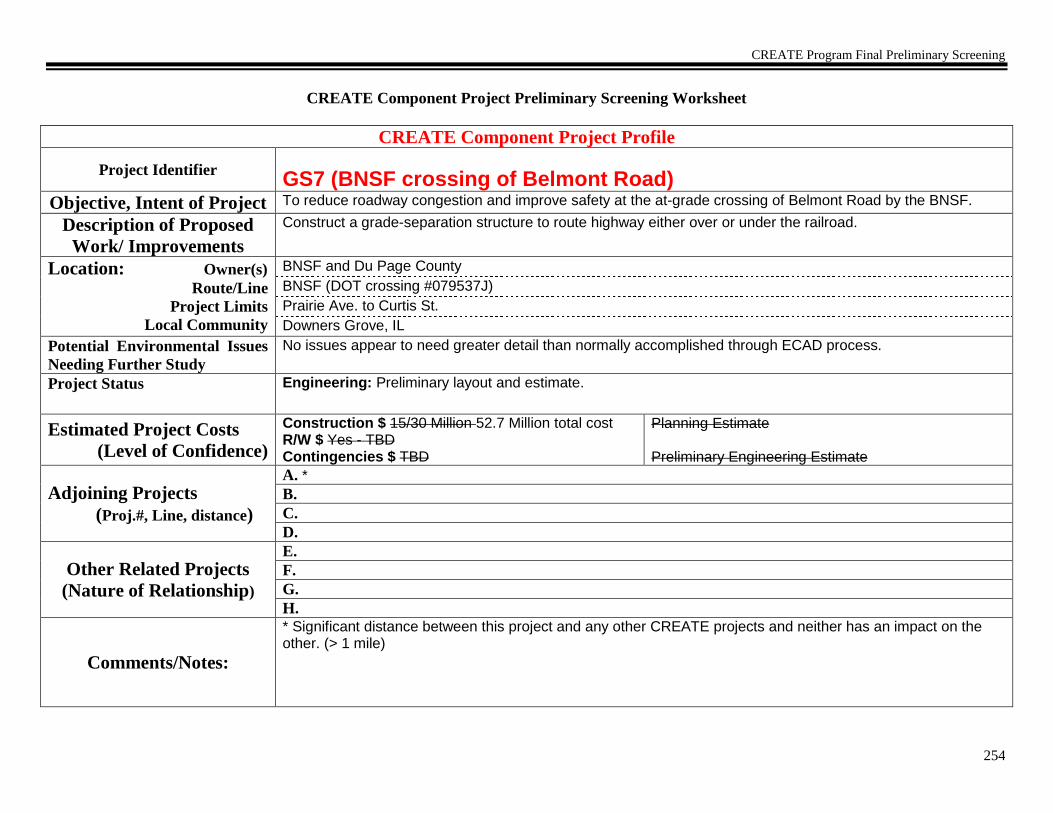
CREATE Program Final Preliminary Screening
254
CREATE Component Project Preliminary Screening Worksheet
CREATE Component Project Profile
Project Identifier
GS7 (BNSF crossing of Belmont Road) Objective, Intent of Project To reduce roadway congestion and improve safety at the at-grade crossing of Belmont Road by the BNSF.
Description of Proposed
Work/ Improvements
Construct a grade-separation structure to route highway either over or under the railroad.
Location: Owner(s)
Route/Line
Project Limits
Local Community
BNSF and Du Page County
BNSF (DOT crossing #079537J)
Prairie Ave. to Curtis St.
Downers Grove, IL
Potential Environmental Issues
Needing Further Study
No issues appear to need greater detail than normally accomplished through ECAD process.
Project Status
Engineering: Preliminary layout and estimate.
Estimated Project Costs
(Level of Confidence)
Construction $ 15/30 Million 52.7 Million total cost R/W $ Yes - TBD Contingencies $ TBD
Planning Estimate
Preliminary Engineering Estimate
Adjoining Projects
(Proj.#, Line, distance)
A. *
B.
C.
D.
Other Related Projects
(Nature of Relationship)
E.
F.
G.
H.
Comments/Notes:
* Significant distance between this project and any other CREATE projects and neither has an impact on the other. (> 1 mile)

CREATE Program Final Preliminary Screening
255
Individual Component Project Logical Termini Test – Determine 1) sufficient length and scope; 2) independent utility; and 3) restriction of
alternatives.
1) Sufficient Length & Scope Determination
Does the proposed project have sufficient length and scope to broadly address environmental issues? If no, modify project limits. After project limits are modified, ensure project profile is accurate, then proceed to project linkage test.
Y/N
Y
2) Independent Utility and 3) Restriction of Alternatives Determination
Discussion
Y/N
Rationale
Linkage to Project A
Independent Utility? Does the
project have independent utility or independent significance, i.e., be usable and be a reasonable expenditure even if no additional transportation improvements in the area are made?
Restriction of Alternatives? Does the project restrict the consideration of alternatives for other reasonably foreseeable transportation improvements?
Linkage to Project B Independent Utility?
Restriction of Alternatives?
Linkage to Project C Independent Utility?
Restriction of Alternatives?
Linkage to Project D Independent Utility?
Restriction of Alternatives?
Linkage to Project E Independent Utility?

CREATE Program Final Preliminary Screening
256
Restriction of Alternatives?
Linkage to Project F Independent Utility?
Restriction of Alternatives?
Linkage to Project G Independent Utility?
Restriction of Alternatives?
Linkage to Project H Independent Utility?
Restriction of Alternatives?
If no linkages,
prepare
Component Project
Preliminary Purpose and
Need
Statement.
Project is now ready to
be processed through an
ECAD
The purpose of this proposed action is to reduce roadway congestion and improve safety at the at-grade crossing of Belmont Road by the BNSF. Form Completed: 02/09/04 Form Revised: 03/30/04 Form Revised: 05/14/09
If linkages, go to next
page
NONE

CREATE Program Final Preliminary Screening
257
CREATE Component Project Preliminary Screening Worksheet
CREATE Component Project Profile
Project Identifier
GS-8 (UP crossing of 19th
Avenue)
Objective, Intent of Project To reduce roadway congestion and improve safety at the at-grade crossing of 19th Ave. by the UP.
Description of Proposed
Work/ Improvements
Construct a grade-separation structure to route highway either over or under the railroad.
Location: Owner(s)
Route/Line
Project Limits
Local Community
UP and Melrose Park
Geneva Subdivision (DOT crossing #174009S)
W. Lake St. to Saint Charles Road.
Melrose Park, IL
Potential Environmental Issues
Needing Further Study
No issues appear to need greater detail than normally accomplished through ECAD process.
Project Status
Engineering: Preliminary layout and estimate.
Estimated Project Costs
(Level of Confidence)
Construction $ 15 Million R/W $ Yes - TBD Contingencies $ TBD
Planning Estimate
Preliminary Engineering Estimate
Adjoining Projects
(Proj.#, Line, distance)
A. *
B.
C.
D.
Other Related Projects
(Nature of Relationship)
E.
F.
G.
H.
Comments/Notes:
* Significant distance between this project and any other CREATE projects and neither has an impact on the other. (> 0.5 mile)

CREATE Program Final Preliminary Screening
258
Individual Component Project Logical Termini Test – Determine 1) sufficient length and scope; 2) independent utility; and 3) restriction of
alternatives.
1) Sufficient Length & Scope Determination
Does the proposed project have sufficient length and scope to broadly address environmental issues? If no, modify project limits. After project limits are modified, ensure project profile is accurate, then proceed to project linkage test.
Y/N
Y
2) Independent Utility and 3) Restriction of Alternatives Determination
Discussion
Y/N
Rationale
Linkage to Project A
Independent Utility? Does the
project have independent utility or independent significance, i.e., be usable and be a reasonable expenditure even if no additional transportation improvements in the area are made?
Restriction of Alternatives? Does the project restrict the consideration of alternatives for other reasonably foreseeable transportation improvements?
Linkage to Project B Independent Utility?
Restriction of Alternatives?
Linkage to Project C Independent Utility?
Restriction of Alternatives?
Linkage to Project D Independent Utility?
Restriction of Alternatives?
Linkage to Project E Independent Utility?

CREATE Program Final Preliminary Screening
259
Restriction of Alternatives?
Linkage to Project F Independent Utility?
Restriction of Alternatives?
Linkage to Project G Independent Utility?
Restriction of Alternatives?
Linkage to Project H Independent Utility?
Restriction of Alternatives?
If no linkages,
prepare
Component Project
Preliminary Purpose and
Need
Statement.
Project is now ready to
be processed through an
ECAD
The purpose of this proposed action is to reduce roadway congestion and improve safety at the at-grade crossing of 19th Ave. by the UP. Form Completed: 02/09/04 Form Revised: 03/30/04
If linkages, go to next
page
NONE

CREATE Program Final Preliminary Screening
260
CREATE Component Project Preliminary Screening Worksheet
CREATE Component Project Profile
Project Identifier
GS8a (UP crossing of 5th
Avenue)
Objective, Intent of Project To reduce roadway congestion and improve safety at the at-grade crossing of 5th Ave. by the UP.
Description of Proposed
Work/ Improvements
Construct a grade-separation structure to route highway either over or under the railroad.
Location: Owner(s)
Route/Line
Project Limits
Local Community
UP (RR), IDOT (5th Ave) and Maywood (St Charles Rd.P)
Geneva Subdivision (DOT crossing #173998Y)
W. Lake St. to Oak St
Maywood, IL
Potential Environmental Issues
Needing Further Study
No issues appear to need greater detail than normally accomplished through ECAD process.
Project Status
Engineering: Preliminary layout and estimate.
Estimated Project Costs
(Level of Confidence)
Construction $ 15 46.4 Million R/W $ Yes - TBD 10.1 Million Contingencies $ TBD Included above
Planning Estimate
Preliminary Engineering Estimate
Adjoining Projects
(Proj.#, Line, distance)
A. *
B.
C.
D.
Other Related Projects
(Nature of Relationship)
E.
F.
G.
H.
Comments/Notes:
* Significant distance between this project and any other CREATE projects and neither has an impact on the other. (> 0.5 mile)

CREATE Program Final Preliminary Screening
261
Individual Component Project Logical Termini Test – Determine 1) sufficient length and scope; 2) independent utility; and 3) restriction of
alternatives.
1) Sufficient Length & Scope Determination
Does the proposed project have sufficient length and scope to broadly address environmental issues? If no, modify project limits. After project limits are modified, ensure project profile is accurate, then proceed to project linkage test.
Y/N
Y
2) Independent Utility and 3) Restriction of Alternatives Determination
Discussion
Y/N
Rationale
Linkage to Project A
Independent Utility? Does the
project have independent utility or independent significance, i.e., be usable and be a reasonable expenditure even if no additional transportation improvements in the area are made?
Restriction of Alternatives? Does the project restrict the consideration of alternatives for other reasonably foreseeable transportation improvements?
Linkage to Project B Independent Utility?
Restriction of Alternatives?
Linkage to Project C Independent Utility?
Restriction of Alternatives?
Linkage to Project D Independent Utility?
Restriction of Alternatives?
Linkage to Project E Independent Utility?

CREATE Program Final Preliminary Screening
262
Restriction of Alternatives?
Linkage to Project F Independent Utility?
Restriction of Alternatives?
Linkage to Project G Independent Utility?
Restriction of Alternatives?
Linkage to Project H Independent Utility?
Restriction of Alternatives?
If no linkages,
prepare
Component Project
Preliminary Purpose and
Need
Statement.
Project is now ready to
be processed through an
ECAD
The purpose of this proposed action is to reduce roadway congestion and improve safety at the at-grade crossing of 5th Ave. by the UP. Form Completed: 10/29/04 Form Revised: 05/14/09
If linkages, go to next
page
NONE

CREATE Program Final Preliminary Screening
263
CREATE Component Project Preliminary Screening Worksheet
CREATE Component Project Profile
Project Identifier
GS9 (Belt Railway Company crossing of Archer Avenue) Objective, Intent of Project To reduce roadway congestion and improve safety at the at-grade crossing of Archer Ave. by the BRC.
Description of Proposed
Work/ Improvements
Construct a grade-separation structure to route highway either over or under the railroad.
Location: Owner(s)
Route/Line
Project Limits
Local Community
BRC and IDOT (roadway maintained by others)
BRC (DOT crossing #843806F)
S. Kenneth to S. Keating.
Chicago Community Areas – Archer Heights and Garfield Ridge
Potential Environmental Issues
Needing Further Study
No issues appear to need greater detail than normally accomplished through ECAD process.
Project Status
Engineering: Preliminary layout and estimate.
Estimated Project Costs
(Level of Confidence)
Construction $ 15 48.7 Million R/W $ Yes - TBD 15.9 Million Contingencies $ TBD Included Above
Planning Estimate
Preliminary Engineering Estimate
Adjoining Projects
(Proj.#, Line, distance)
A. *
B.
C.
D.
Other Related Projects
(Nature of Relationship)
E.
F.
G.
H.
Comments/Notes:
* Significant distance between this project and any other CREATE projects and neither has an impact on the other. (> 1 mile)

CREATE Program Final Preliminary Screening
264
Individual Component Project Logical Termini Test – Determine 1) sufficient length and scope; 2) independent utility; and 3) restriction of
alternatives.
1) Sufficient Length & Scope Determination
Does the proposed project have sufficient length and scope to broadly address environmental issues? If no, modify project limits. After project limits are modified, ensure project profile is accurate, then proceed to project linkage test.
Y/N
Y
2) Independent Utility and 3) Restriction of Alternatives Determination
Discussion
Y/N
Rationale
Linkage to Project A
Independent Utility? Does the
project have independent utility or independent significance, i.e., be usable and be a reasonable expenditure even if no additional transportation improvements in the area are made?
Restriction of Alternatives? Does the project restrict the consideration of alternatives for other reasonably foreseeable transportation improvements?
Linkage to Project B Independent Utility?
Restriction of Alternatives?
Linkage to Project C Independent Utility?
Restriction of Alternatives?
Linkage to Project D Independent Utility?
Restriction of Alternatives?
Linkage to Project E Independent Utility?

CREATE Program Final Preliminary Screening
265
Restriction of Alternatives?
Linkage to Project F Independent Utility?
Restriction of Alternatives?
Linkage to Project G Independent Utility?
Restriction of Alternatives?
Linkage to Project H Independent Utility?
Restriction of Alternatives?
If no linkages,
prepare
Component Project
Preliminary Purpose and
Need
Statement.
Project is now ready to
be processed through an
ECAD
The purpose of this proposed action is to reduce roadway congestion and improve safety at the at-grade crossing of Archer Ave. by the BRC. Form Completed: 02/09/04 Form Revised: 06/02/04 Form Revised: 05/14/09
If linkages, go to next
page
NONE

CREATE Program Final Preliminary Screening
266
CREATE Component Project Preliminary Screening Worksheet
CREATE Component Project Profile
Project Identifier
GS10 (IHB crossing of 47th
Street and East Avenue)
Objective, Intent of Project To reduce roadway congestion and improve safety at the at-grade crossing of 47th St. and East Ave. by the IHB.
Description of Proposed
Work/ Improvements
Construct a grade-separation structure to route highway either over or under the railroad.
Location: Owner(s)
Route/Line
Project Limits
Local Community
IHB, Cook County (East Ave N of intersection), IDOT (portion to west of crossing maintained by others)
IHB (DOT crossing #326851A)
South 9th Ave. to Deyo Ave.
La Grange, Brookfield and McCook, IL
Potential Environmental Issues
Needing Further Study
No issues appear to need greater detail than normally accomplished through ECAD process.
Project Status
Engineering: Preliminary layout and estimate.
Estimated Project Costs
(Level of Confidence)
Construction $ 15 Million 48.0 Million R/W $ Yes - TBD 7.1 Million Contingencies $ TBD
Planning Estimate
Preliminary Engineering Estimate
Adjoining CREATE
Projects
(Proj.#, Line, distance)
A. * B4/B5
B.
C.
D.
Other Related Projects
(Nature of Relationship)
E.
F.
G.
H.
Comments/Notes:
* Significant distance between this project and any other CREATE projects and neither has an impact on the other. (> 1 mile)
CREATE Program Final Preliminary Screening
267
Individual Component Project Logical Termini Test – Determine 1) sufficient length and scope; 2) independent utility; and 3) restriction of
alternatives.
1) Sufficient Length & Scope Determination
Does the proposed project have sufficient length and scope to broadly address environmental issues? If no, modify project limits. After project limits are modified, ensure project profile is accurate, then proceed to project linkage test.
Y/N
Y
2) Independent Utility and 3) Restriction of Alternatives Determination
Discussion
Y/N
Rationale
Linkage to Project
B4/B5
Independent Utility? Does the
project have independent utility or independent significance, i.e., be usable and be a reasonable expenditure even if no additional transportation improvements in the area are made?
Project B4/B5 would only cause signal programming considerations for project GS10
Project B4/B5 is a signal system and track improvement project. GS10 is fully usable without Project B4/B5
Restriction of Alternatives? Does the project restrict the consideration of alternatives for other reasonably foreseeable transportation improvements?
None
Project GS10 does not restrict alternatives in Project B4/B5.
Linkage to Project B Independent Utility?
Restriction of Alternatives?
Linkage to Project C Independent Utility?
Restriction of Alternatives?
Linkage to Project D Independent Utility?
Restriction of Alternatives?
Linkage to Project E Independent Utility?

CREATE Program Final Preliminary Screening
268
Restriction of Alternatives?
Linkage to Project F Independent Utility?
Restriction of Alternatives?
Linkage to Project G Independent Utility?
Restriction of Alternatives?
Linkage to Project H Independent Utility?
Restriction of Alternatives?
If no linkages,
prepare
Component Project
Preliminary Purpose and
Need
Statement.
Project is now ready to
be processed through an
ECAD
The purpose of this proposed action is to reduce roadway congestion and improve safety at the at-grade crossing of 47th St. and East Ave. by the IHB. Form Completed: 02/09/04 Form Revised: 03/30/04 Form Revised: 05/14/09
If linkages, go to next
page
NONE

CREATE Program Final Preliminary Screening
269
CREATE Component Project Preliminary Screening Worksheet
CREATE Component Project Profile
Project Identifier
GS11 (Belt Railway Company crossing of Columbus Avenue) Objective, Intent of Project To reduce roadway congestion and improve safety at the at-grade crossing of Columbus Ave. by the BRC.
Description of Proposed
Work/ Improvements
Construct a grade-separation structure to route highway either over or under the railroad.
Location: Owner(s)
Route/Line
Project Limits
Local Community
BRC and IDOT (maintained by others)
BRC (DOT crossing #843823W)
S. Western to S. Washtenaw.
Chicago Community Area – Ashburn
Potential Environmental Issues
Needing Further Study
No issues appear to need greater detail than normally accomplished through ECAD process.
Project Status
(Percent Design Complete)
Engineering: Preliminary layout and estimate.
Estimated Project Costs
(Level of Confidence)
Construction $ 15 35.8 Million R/W $ Yes – TBD 3.3 Million Contingencies $ TBD Included above
Planning Estimate
Preliminary Engineering Estimate
Adjoining Projects
(Proj.#, Line, distance)
A. P3
B. EW2/P2/P3/GS19
C.
D.
Other Related Projects
(Nature of Relationship)
E.
F.
G.
H.
Comments/Notes:

CREATE Program Final Preliminary Screening
270
Individual Component Project Logical Termini Test – Determine 1) sufficient length and scope; 2) independent utility; and 3) restriction of
alternatives.
1) Sufficient Length & Scope Determination
Does the proposed project have sufficient length and scope to broadly address environmental issues? If no, modify project limits. After project limits are modified, ensure project profile is accurate, then proceed to project linkage test.
Y/N
Y
2) Independent Utility and 3) Restriction of Alternatives Determination
Discussion Y/N Rationale
Linkage to Project P3
Independent Utility? Does the project have independent utility or independent significance, i.e., be usable and be a reasonable expenditure even if no additional transportation improvements in the area are made?
None Y GS11 is to reduce roadway congestion and improve safety at the at-grade crossing of Columbus Ave. by the BRC. GS11 is fully usable without P3.
Restriction of Alternatives? Does the project restrict the consideration of alternatives for other reasonably foreseeable transportation improvements?
P3 would only cause design considerations in the implementation of GS11 and would not restrict consideration of reasonable alternatives.
N Project GS11 does not restrict alternatives in P3.
Linkage to Project
EW2/P2/P3/GS19
Independent Utility? None Y GS11 is to reduce roadway congestion and improve safety at the at-grade crossing of Columbus Ave. by the BRC. GS11 is fully usable without EW2/P2/P3/GS19.

CREATE Program Final Preliminary Screening
271
Restriction of Alternatives? EW2/P2/P3/GS19 would only cause
design considerations in GS11 and would not restrict consideration of reasonable alternatives.
N Project GS11 does not restrict alternatives in EW2/P2/P3/GS19.
Linkage to Project C Independent Utility?
Restriction of Alternatives?
Linkage to Project D Independent Utility?
Restriction of Alternatives?
Linkage to Project E Independent Utility?
Restriction of Alternatives?
Linkage to Project F Independent Utility?
Restriction of Alternatives?
Linkage to Project G Independent Utility?
Restriction of Alternatives?
Linkage to Project H Independent Utility?
Restriction of Alternatives?
If no linkages,
prepare
Component Project
Preliminary Purpose and
Need
Statement.
Project is now ready to
be processed through an
ECAD
The purpose of this proposed action is to reduce roadway congestion and improve safety at the at-grade crossing of Columbus Ave. by the BRC. Form Completed: 02/09/04 Form Revised: 06/02/04 Form Revised: 05/14/09 Form Revised 08/10/09
If linkages, go to next
page
NONE

CREATE Program Final Preliminary Screening
272
CREATE Component Project Preliminary Screening Worksheet
CREATE Component Project Profile
Project Identifier
GS12 (UP crossing of 1st
Avenue)
Objective, Intent of Project To reduce roadway congestion and improve safety at the at-grade crossing of 1st Ave. by the UP.
Description of Proposed
Work/ Improvements
Construct a grade-separation structure to route highway either over or under the railroad. Possibly also grade separate intersection of Lake St. and 1st Ave.
Location: Owner(s)
Route/Line
Project Limits
Local Community
UP and IDOT (Lake St. maintained by others)
Geneva Subdivision (DOT crossing #173996K)
Randolph to Erie St.
Maywood, IL
Potential Environmental Issues
Needing Further Study
No issues appear to need greater detail than normally accomplished through ECAD process.
Project Status
Engineering: Preliminary layout and estimate.
Estimated Project Costs
(Level of Confidence)
Construction $ 15 Million 62.5 Million R/W $ Yes – 14.4 Million Contingencies $ TBD Included above
Planning Estimate
Preliminary Engineering Estimate
Adjoining CREATE
Projects
(Proj.#, Line, distance)
A. *
B.
C.
D.
Other Related Projects
(Nature of Relationship)
E.
F.
G.
H.
Comments/Notes:
* Significant distance between this project and any other CREATE projects and neither has an impact on the other. (> 1 mile)

CREATE Program Final Preliminary Screening
273
Individual Component Project Logical Termini Test – Determine 1) sufficient length and scope; 2) independent utility; and 3) restriction of
alternatives.
1) Sufficient Length & Scope Determination
Does the proposed project have sufficient length and scope to broadly address environmental issues? If no, modify project limits. After project limits are modified, ensure project profile is accurate, then proceed to project linkage test.
Y/N
Y
2) Independent Utility and 3) Restriction of Alternatives Determination
Discussion
Y/N
Rationale
Linkage to Project A
Independent Utility? Does the
project have independent utility or independent significance, i.e., be usable and be a reasonable expenditure even if no additional transportation improvements in the area are made?
Restriction of Alternatives? Does the project restrict the consideration of alternatives for other reasonably foreseeable transportation improvements?
Linkage to Project B Independent Utility?
Restriction of Alternatives?
Linkage to Project C Independent Utility?
Restriction of Alternatives?
Linkage to Project D Independent Utility?
Restriction of Alternatives?
Linkage to Project E Independent Utility?

CREATE Program Final Preliminary Screening
274
Restriction of Alternatives?
Linkage to Project F Independent Utility?
Restriction of Alternatives?
Linkage to Project G Independent Utility?
Restriction of Alternatives?
Linkage to Project H Independent Utility?
Restriction of Alternatives?
If no linkages,
prepare
Component Project
Preliminary Purpose and
Need
Statement.
Project is now ready to
be processed through an
ECAD
The purpose of this proposed action is to reduce roadway congestion and improve safety at the at-grade crossing of 1st Ave. by the UP. Form Completed: 02/10/04 Form Revised: 03/31/04 Form Revised: 05/14/09
If linkages, go to next
page
NONE

CREATE Program Final Preliminary Screening
275
CREATE Component Project Preliminary Screening Worksheet
CREATE Component Project Profile
Project Identifier
GS13 (IHB crossing of 31st
Street)
Objective, Intent of Project To reduce roadway congestion and improve safety at the at-grade crossing of 31st St. by IHB.
Description of Proposed
Work/ Improvements
Construct a grade-separation structure to route highway either over or under the railroad.
Location: Owner(s)
Route/Line
Project Limits
Local Community
IHB and IDOT
IHB (DOT crossing #326859E)
Kemmen Ave. to Sherwood Rd.
LaGrange Park, IL
Potential Environmental Issues
Needing Further Study
No issues appear to need greater detail than normally accomplished through ECAD process.
Project Status
Engineering: Preliminary layout and estimate.
Estimated Project Costs
(Level of Confidence)
Construction $ 15 Million 61.7 Million R/W $ Yes – TBD 15.0 Million Contingencies $ TBD Included above
Planning Estimate
Preliminary Engineering Estimate
Adjoining CREATE
Projects
(Proj.#, Line, distance)
A. B4/B5
B.
C.
D.
Other Related Projects
(Nature of Relationship)
E.
F.
G.
H.
Comments/Notes:

CREATE Program Final Preliminary Screening
276
Individual Component Project Logical Termini Test – Determine 1) sufficient length and scope; 2) independent utility; and 3) restriction of
alternatives.
1) Sufficient Length & Scope Determination
Does the proposed project have sufficient length and scope to broadly address environmental issues? If no, modify project limits. After project limits are modified, ensure project profile is accurate, then proceed to project linkage test.
Y/N
Y
2) Independent Utility and 3) Restriction of Alternatives Determination
Discussion
Y/N
Rationale
Linkage to Project
B4/B5
Independent Utility? Does the
project have independent utility or independent significance, i.e., be usable and be a reasonable expenditure even if no additional transportation improvements in the area are made?
None
Y
Project GS13 is to reduce roadway congestion and improve safety at the at-grade crossing of 31st St. by IHB. GS13 is fully usable without B4/B5.
Restriction of Alternatives? Does the project restrict the consideration of alternatives for other reasonably foreseeable transportation improvements?
The physical characteristic of track layout does not change and thus does not affect the design of GS13. N
Project GS13 does not restrict alternatives in B4/B5.
Linkage to Project B Independent Utility?
Restriction of Alternatives?
Linkage to Project C Independent Utility?
Restriction of Alternatives?
Linkage to Project D Independent Utility?
Restriction of Alternatives?
Linkage to Project E Independent Utility?

CREATE Program Final Preliminary Screening
277
Restriction of Alternatives?
Linkage to Project F Independent Utility?
Restriction of Alternatives?
Linkage to Project G Independent Utility?
Restriction of Alternatives?
Linkage to Project H Independent Utility?
Restriction of Alternatives?
If no linkages,
prepare
Component Project
Preliminary Purpose and
Need
Statement.
Project is now ready to
be processed through an
ECAD
The purpose of this proposed action is to reduce roadway congestion and improve safety at the at-grade crossing of 31st St. by IHB. Form Completed: 02/10/04 Form Revised: 03/31/04 Form Revised: 05/14/09
If linkages, go to next
page
NONE
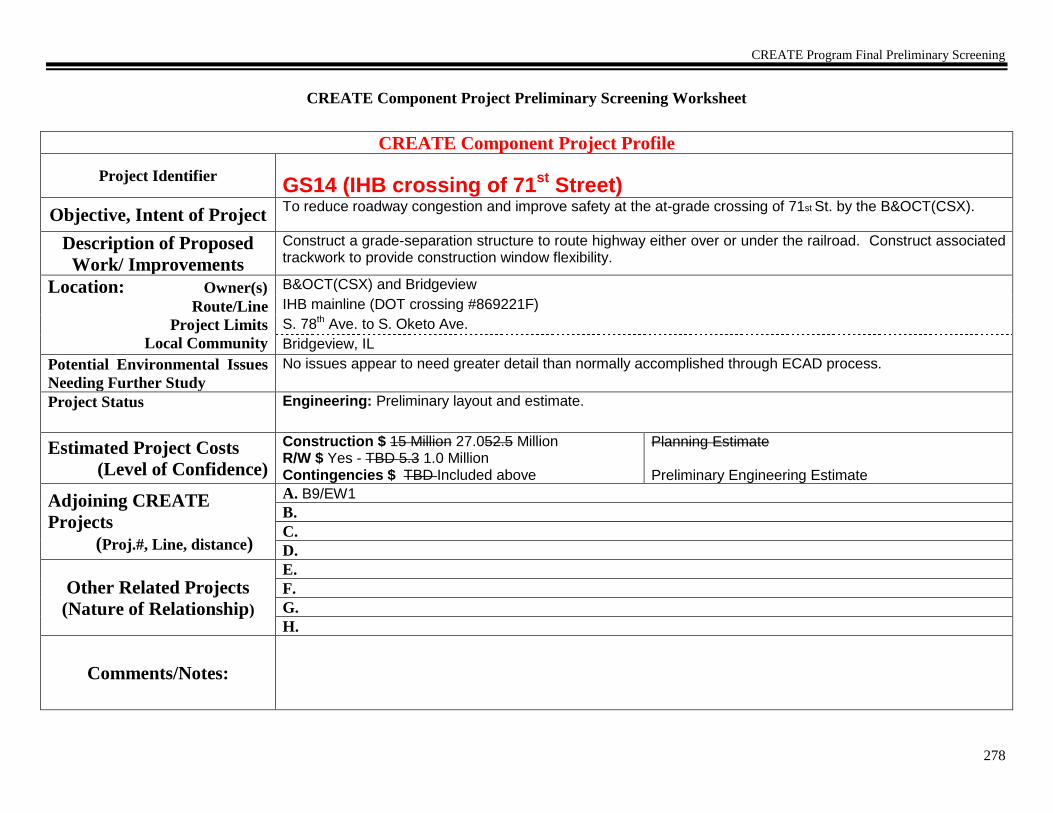
CREATE Program Final Preliminary Screening
278
CREATE Component Project Preliminary Screening Worksheet
CREATE Component Project Profile
Project Identifier
GS14 (IHB crossing of 71st
Street)
Objective, Intent of Project To reduce roadway congestion and improve safety at the at-grade crossing of 71st St. by the B&OCT(CSX).
Description of Proposed
Work/ Improvements
Construct a grade-separation structure to route highway either over or under the railroad. Construct associated trackwork to provide construction window flexibility.
Location: Owner(s)
Route/Line
Project Limits
Local Community
B&OCT(CSX) and Bridgeview
IHB mainline (DOT crossing #869221F)
S. 78th Ave. to S. Oketo Ave.
Bridgeview, IL
Potential Environmental Issues
Needing Further Study
No issues appear to need greater detail than normally accomplished through ECAD process.
Project Status
Engineering: Preliminary layout and estimate.
Estimated Project Costs
(Level of Confidence)
Construction $ 15 Million 27.052.5 Million R/W $ Yes - TBD 5.3 1.0 Million Contingencies $ TBD Included above
Planning Estimate
Preliminary Engineering Estimate
Adjoining CREATE
Projects
(Proj.#, Line, distance)
A. B9/EW1
B.
C.
D.
Other Related Projects
(Nature of Relationship)
E.
F.
G.
H.
Comments/Notes:

CREATE Program Final Preliminary Screening
279
Individual Component Project Logical Termini Test – Determine 1) sufficient length and scope; 2) independent utility; and 3) restriction of
alternatives.
1) Sufficient Length & Scope Determination
Does the proposed project have sufficient length and scope to broadly address environmental issues? If no, modify project limits. After project limits are modified, ensure project profile is accurate, then proceed to project linkage test.
Y/N
Y
2) Independent Utility and 3) Restriction of Alternatives Determination
Discussion
Y/N
Rationale
Linkage to Project
B9/EW1
Independent Utility? Does the
project have independent utility or independent significance, i.e., be usable and be a reasonable expenditure even if no additional transportation improvements in the area are made?
These projects overlap but have no impact on each other.
Y
Project GS14 is to reduce roadway congestion and improve safety at the at-grade crossing of 71st St. by the B&OCT(CSX). GS14 is fully usable without B9/EW1.
Restriction of Alternatives? Does the project restrict the consideration of alternatives for other reasonably foreseeable transportation improvements?
None
N
Project GS14 does not restrict alternatives in B9/EW1.
Linkage to Project B Independent Utility?
Restriction of Alternatives?
Linkage to Project C Independent Utility?
Restriction of Alternatives?
Linkage to Project D Independent Utility?
Restriction of Alternatives?
Linkage to Project E Independent Utility?

CREATE Program Final Preliminary Screening
280
Restriction of Alternatives?
Linkage to Project F Independent Utility?
Restriction of Alternatives?
Linkage to Project G Independent Utility?
Restriction of Alternatives?
Linkage to Project H Independent Utility?
Restriction of Alternatives?
If no linkages,
prepare
Component Project
Preliminary Purpose and
Need
Statement.
Project is now ready to
be processed through an
ECAD
The purpose of this proposed action is to reduce roadway congestion and improve safety at the at-grade crossing of 71st St. by the B&OCT(CSX). Form Completed: 02/10/04 Form Revised: 03/31/04 Form Revised: 05/14/09 Form Revised: 01/12/11
If linkages, go to next
page
NONE

CREATE Program Final Preliminary Screening
281
CREATE Component Project Preliminary Screening Worksheet
CREATE Component Project Profile
Project Identifier
GS-15 (NS crossing of Torrence Avenue) Objective, Intent of Project To reduce roadway congestion and improve safety at the at-grade crossing of Torrence Ave. by the NS.
Description of Proposed
Work/ Improvements
Construct a grade-separation structure to route highway either over or under the railroad.
Location: Owner(s)
Route/Line
Project Limits
Local Community
NS, CDOT and IDOT
Chicago District (DOT crossing #478712Y)
E 134th St. to E 126th St.
Chicago Community Areas – Hegewisch and South Deering
Potential Environmental Issues
Needing Further Study
No issues appear to need greater detail than normally accomplished through ECAD process.
Project Status
Engineering: Preliminary layout and estimate.
Estimated Project Costs
(Level of Confidence)
Construction $ 15 Million R/W $ Yes - TBD Contingencies $ TBD
Planning Estimate
Preliminary Engineering Estimate
Adjoining CREATE
Projects
(Proj.#, Line, distance)
A. GS-21
B.
C.
D.
Other Related Projects
(Nature of Relationship)
E.
F.
G.
H.
Comments/Notes:

CREATE Program Final Preliminary Screening
282
Individual Component Project Logical Termini Test – Determine 1) sufficient length and scope; 2) independent utility; and 3) restriction of
alternatives.
1) Sufficient Length & Scope Determination
Does the proposed project have sufficient length and scope to broadly address environmental issues? If no, modify project limits. After project limits are modified, ensure project profile is accurate, then proceed to project linkage test.
Y/N
Y
2) Independent Utility and 3) Restriction of Alternatives Determination
Discussion
Y/N
Rationale
Linkage to Project GS-
21
Independent Utility? Does the
project have independent utility or independent significance, i.e., be usable and be a reasonable expenditure even if no additional transportation improvements in the area are made?
None
Y
GS-15 is to reduce roadway congestion and improve safety at the at-grade crossing of Torrence Ave. by the Norfolk Southern (NS). GS-15 is fully usable without GS-21.
Restriction of Alternatives? Does the project restrict the consideration of alternatives for other reasonably foreseeable transportation improvements?
Project GS-21 will be implemented concurrent with GS-15.
Y
Project GS-15 does restrict alternatives in GS-21. Therefore the project are linked.
Linkage to Project B Independent Utility?
Restriction of Alternatives?
Linkage to Project C Independent Utility?
Restriction of Alternatives?
Linkage to Project D Independent Utility?
Restriction of Alternatives?
Linkage to Project E Independent Utility?

CREATE Program Final Preliminary Screening
283
Restriction of Alternatives?
Linkage to Project F Independent Utility?
Restriction of Alternatives?
Linkage to Project G Independent Utility?
Restriction of Alternatives?
Linkage to Project H Independent Utility?
Restriction of Alternatives?
If no linkages,
prepare
Component Project
Preliminary Purpose and
Need
Statement.
Project is now ready to
be processed through an
ECAD
The purpose of this proposed action is to reduce roadway congestion and improve safety at the at-grade crossing of Torrence Ave. by the NS.
If linkages, go to next
page
Yes

CREATE Program Final Preliminary Screening
284
List Component Projects
that Constitute the
Linked Project
GS-15 and GS-21
CREATE Linked Project Profile
Project Identifier
GS-15/GS-21 (NS crossing of Torrence Avenue and 130th
Street) Objective, Intent of
Project
To reduce roadway congestion and improve safety at the at-grade crossings of Torrence Ave. and 130th Street by the NS.
Description of
Proposed Work/
Improvements
Construct grade-separation structures to route highway under the railroad.
Location: Owner(s)
Route/Line
Project Limits
Local Community
NS and CDOT
Chicago District (DOT crossing #478712Y and crossing #478713F)
E 134th St. to E 126th St. and S.Escanaba to a point 1500 ft. west of the crossing (Ext. of S Crandon).
Chicago – Hegewisch and South Deering
Potential Environmental
Issues Needing Further
Study
CDOT has completed an ECAD for this project. The ECAD will need to be evaluated to determine if it remains valid.
Project Status
Engineering: Preliminary layout and estimate
Estimated Project
Costs
(Level of Confidence)
Construction $ 30/68 Million R/W $ Yes - TBD Contingencies $ TBD
Planning Estimate
Preliminary Engineering Estimate
Adjoining CREATE
Projects
(Proj.#, Line, distance)
A. *
B.
C.
D.
Other Related
Projects
(Nature of
E.
F.
G.

CREATE Program Final Preliminary Screening
285
Relationship) H.
Comments:
* Significant distance between this project and any other CREATE projects and neither has an impact on the other. (> 1 mile)
Individual Component Project Logical Termini Test – Determine 1) sufficient length and scope; 2) independent utility; and 3) restriction of
alternatives.
1) Sufficient Length & Scope Determination
Does the proposed project have sufficient length and scope to broadly address environmental issues? If no, modify project limits. After project limits are modified, ensure project profile is accurate, then proceed to project linkage test.
Y/N
2) Independent Utility and 3) Restriction of Alternatives Determination
Discussion
Y/N
Rationale
Linkage to Project A Independent Utility? Does the
project have independent utility or independent significance, i.e., be usable and be a reasonable expenditure even if no additional transportation improvements in the area are made?
Restriction of Alternatives? Does the project restrict the consideration of alternatives for other reasonably foreseeable transportation improvements?
Linkage to Project B Independent Utility?
Restriction of Alternatives?

CREATE Program Final Preliminary Screening
286
Linkage to Project C Independent Utility?
Restriction of Alternatives?
Linkage to Project D Independent Utility?
Restriction of Alternatives?
Linkage to Project E Independent Utility?
Restriction of Alternatives?
Linkage to Project F Independent Utility?
Restriction of Alternatives?
Linkage to Project G Independent Utility?
Restriction of Alternatives?
Linkage to Project H Independent Utility?
Restriction of Alternatives?
Linked Project
Preliminary Purpose and
Need
Project is now ready to
be processed through an
ECAD
To reduce roadway congestion and improve safety at the at-grade crossings of Torrence Ave. and 130th Street by the NS. Form Completed: 02/11/04 Form Revised: 03/31/04

CREATE Program Final Preliminary Screening
287
CREATE Component Project Preliminary Screening Worksheet
CREATE Component Project Profile
Project Identifier
GS15a (NS crossing of Torrence Avenue and 130th
Street)
Objective, Intent of Project To reduce roadway congestion and improve safety at the at-grade crossing of Torrence Ave. and 130th St. by the NS.
Description of Proposed
Work/ Improvements
Construct a grade-separation structure to route highway either over or under the railroad.
Location: Owner(s)
Route/Line
Project Limits
Local Community
NS, CDOT and IDOT (maintained by others)
NS Chicago District (DOT crossing #478712Y and #478713F)
E 134th St. to E 126th St. and S.Escanaba to a point 1500 ft. west of the crossing (Ext. of S Crandon).
Chicago – Hegewisch and South Deering
Potential Environmental Issues
Needing Further Study
No issues appear to need greater detail than normally accomplished through ECAD process.
Project Status
Engineering: Preliminary layout and estimate.
Estimated Project Costs
(Level of Confidence)
Construction $ 68 161.9 Million R/W $ Yes – TBD 3.5 Million Contingencies $ TBD Included above
Planning Estimate
Preliminary Engineering Estimate
Adjoining CREATE
Projects
(Proj.#, Line, distance)
A. *
B.
C.
D.
Other Related Projects
(Nature of Relationship)
E.
F.
G.
H.
Comments/Notes:
* Significant distance between this project and any other CREATE projects and neither has an impact on the other. (> 1 mile)

CREATE Program Final Preliminary Screening
288
Individual Component Project Logical Termini Test – Determine 1) sufficient length and scope; 2) independent utility; and 3) restriction of
alternatives.
1) Sufficient Length & Scope Determination
Does the proposed project have sufficient length and scope to broadly address environmental issues? If no, modify project limits. After project limits are modified, ensure project profile is accurate, then proceed to project linkage test.
Y/N
Y
2) Independent Utility and 3) Restriction of Alternatives Determination
Discussion
Y/N
Rationale
Linkage to Project A
Independent Utility? Does the
project have independent utility or independent significance, i.e., be usable and be a reasonable expenditure even if no additional transportation improvements in the area are made?
Restriction of Alternatives? Does the project restrict the consideration of alternatives for other reasonably foreseeable transportation improvements?
Linkage to Project B Independent Utility?
Restriction of Alternatives?
Linkage to Project C Independent Utility?
Restriction of Alternatives?
Linkage to Project D Independent Utility?
Restriction of Alternatives?
Linkage to Project E Independent Utility?

CREATE Program Final Preliminary Screening
289
Restriction of Alternatives?
Linkage to Project F Independent Utility?
Restriction of Alternatives?
Linkage to Project G Independent Utility?
Restriction of Alternatives?
Linkage to Project H Independent Utility?
Restriction of Alternatives?
If no linkages,
prepare
Component Project
Preliminary Purpose and
Need
Statement.
Project is now ready to
be processed through an
ECAD
The purpose of this proposed action is to reduce roadway congestion and improve safety at the at-grade crossing of Torrence Ave. and 130th St. by the NS. Form Completed: 10/29/04 Form Revised: 05/14/09
If linkages, go to next
page
None

CREATE Program Final Preliminary Screening
290
CREATE Component Project Preliminary Screening Worksheet
CREATE Component Project Profile
Project Identifier
GS16 (CP crossing of Irving Park Road) Objective, Intent of Project To reduce roadway congestion and improve safety at the at-grade crossing of Irving Park Road by the CPR.
Description of Proposed
Work/ Improvements
Construct a grade-separation structure to route highway either over or under the railroad.
Location: Owner(s)
Route/Line
Project Limits
Local Community
CPR and IDOT
C&M Subdivision of CPR (DOT crossing #372159V)
N Addison St. to Greenlawn Ave.
Bensenville, IL
Potential Environmental Issues
Needing Further Study
No issues appear to need greater detail than normally accomplished through ECAD process.
Project Status
Engineering: Preliminary layout and estimate.
Estimated Project Costs
(Level of Confidence)
Construction $ 100.364.0 Million R/W $ Yes - TBD 7.8 Million Contingencies $ TBD Included above
Planning Estimate
Preliminary Engineering Estimate
Adjoining CREATE
Projects
(Proj.#, Line, distance)
A.
B.
C.
D.
Other Related Projects
(Nature of Relationship)
E. O’Hare Airport Expansion Project O’Hare Modernization Program (OMP)
F.
G.
H.
Comments/Notes:

CREATE Program Final Preliminary Screening
291
Individual Component Project Logical Termini Test – Determine 1) sufficient length and scope; 2) independent utility; and 3) restriction of
alternatives.
1) Sufficient Length & Scope Determination
Does the proposed project have sufficient length and scope to broadly address environmental issues? If no, modify project limits. After project limits are modified, ensure project profile is accurate, then proceed to project linkage test.
Y/N
Y
2) Independent Utility and 3) Restriction of Alternatives Determination
Discussion
Y/N
Rationale
Linkage to Project
O’Hare Airport
Expansion O’Hare Modernization Program (OMP)
Independent Utility? Does the
project have independent utility or independent significance, i.e., be usable and be a reasonable expenditure even if no additional transportation improvements in the area are made?
None
Y
GS16 is to reduce roadway congestion and improve safety at the at-grade crossing of Irving Park Road by the CPR. GS16 is fully usable without the O’Hare Modernization ProgramAirport Expansion project.
Restriction of Alternatives? Does the project restrict the consideration of alternatives for other reasonably foreseeable transportation improvements?
The Environmental Study of this project should be closely coordinated with the O’Hare Modernization Programcurrent O’Hare Airport Expansion EIS.
N
Project GS16 does not restrict alternatives in the O’Hare Modernization ProgramAirport Expansion project.
Linkage to Project B Independent Utility?
Restriction of Alternatives?
Linkage to Project C Independent Utility?
Restriction of Alternatives?
Linkage to Project D Independent Utility?
Restriction of Alternatives?
Linkage to Project E Independent Utility?
CREATE Program Final Preliminary Screening
292
Restriction of Alternatives?
Linkage to Project F Independent Utility?
Restriction of Alternatives?
Linkage to Project G Independent Utility?
Restriction of Alternatives?
Linkage to Project H Independent Utility?
Restriction of Alternatives?
If no linkages,
prepare
Component Project
Preliminary Purpose and
Need
Statement.
Project is now ready to
be processed through an
ECAD
The purpose of this proposed action is to reduce roadway congestion and improve safety at the at-grade crossing of Irving Park Road by the CPR. Form Completed: 02/11/04 Form Revised: 03/31/04 Form Revised: 05/14/09 Form Revised 11/23/10
If linkages, go to next
page

CREATE Program Final Preliminary Screening
293
CREATE Component Project Preliminary Screening Worksheet
CREATE Component Project Profile
Project Identifier
GS17 (CSX crossing of Western Avenue)
Objective, Intent of Project To reduce roadway congestion and improve safety at the at-grade crossing of Western Ave. by the B&OCT(CSX).
Description of Proposed
Work/ Improvements
Construct a grade-separation structure to route highway either over or under the railroad.
Location: Owner(s)
Route/Line
Project Limits
Local Community
B&OCT(CSX) and IDOT
Barr Subdivision (DOT crossing #163415H)
138th St. to Broadway.
Blue Island, IL
Potential Environmental Issues
Needing Further Study
No issues appear to need greater detail than normally accomplished through ECAD process.
Project Status
Engineering: Preliminary layout and estimate.
Estimated Project Costs
(Level of Confidence)
Construction $ 15 Million 51.1 Million R/W $ Yes – TBD 5.0 Million Contingencies $ TBD (Included above)
Planning Estimate
Preliminary Engineering Estimate
Adjoining CREATE
Projects
(Proj.#, Line, distance)
A. *
B.
C.
D.
Other Related Projects
(Nature of Relationship)
E.
F.
G.
H.
Comments/Notes:
* Significant distance between this project and any other CREATE projects and neither has an impact on the other. (> 1 mile)

CREATE Program Final Preliminary Screening
294
Individual Component Project Logical Termini Test – Determine 1) sufficient length and scope; 2) independent utility; and 3) restriction of
alternatives.
1) Sufficient Length & Scope Determination
Does the proposed project have sufficient length and scope to broadly address environmental issues? If no, modify project limits. After project limits are modified, ensure project profile is accurate, then proceed to project linkage test.
Y/N
Y
2) Independent Utility and 3) Restriction of Alternatives Determination
Discussion
Y/N
Rationale
Linkage to Project A
Independent Utility? Does the
project have independent utility or independent significance, i.e., be usable and be a reasonable expenditure even if no additional transportation improvements in the area are made?
Restriction of Alternatives? Does the project restrict the consideration of alternatives for other reasonably foreseeable transportation improvements?
Linkage to Project B Independent Utility?
Restriction of Alternatives?
Linkage to Project C Independent Utility?
Restriction of Alternatives?
Linkage to Project D Independent Utility?
Restriction of Alternatives?
Linkage to Project E Independent Utility?

CREATE Program Final Preliminary Screening
295
Restriction of Alternatives?
Linkage to Project F Independent Utility?
Restriction of Alternatives?
Linkage to Project G Independent Utility?
Restriction of Alternatives?
Linkage to Project H Independent Utility?
Restriction of Alternatives?
If no linkages,
prepare
Component Project
Preliminary Purpose and
Need
Statement.
Project is now ready to
be processed through an
ECAD
The purpose of this proposed action is to reduce roadway congestion and improve safety at the at-grade crossing of Western Ave. by the B&OCT(CSX). Form Completed: 02/11/04 Form Revised: 03/31/04 Form Revised: 05/14/09
If linkages, go to next
page
NONE

CREATE Program Final Preliminary Screening
296
CREATE Component Project Preliminary Screening Worksheet
CREATE Component Project Profile
Project Identifier
GS18 (BNSF crossing of Harlem Avenue) Objective, Intent of Project To reduce roadway congestion and improve safety at the at-grade crossing of Harlem Ave. by the BNSF.
Description of Proposed
Work/ Improvements
Construct a grade-separation structure to route highway either over or under the railroad.
Location: Owner(s)
Route/Line
Project Limits
Local Community
BNSF and IDOT (maintained by others)
BNSF (DOT crossing #079493L)
32nd St. to 35th St.
Berwyn, IL
Potential Environmental Issues
Needing Further Study
No issues appear to need greater detail than normally accomplished through ECAD process.
Project Status
Engineering: Preliminary layout and estimate.
Estimated Project Costs
(Level of Confidence)
Construction $ 15 Million 64.4 Million R/W $ Yes - TBD 35.8 Million Contingencies $ TBD (Included above)
Planning Estimate
Preliminary Engineering Estimate
Adjoining CREATE
Projects (Proj.#, Line, distance)
A. *
B.
C.
D.
Other Related Projects
(Nature of Relationship)
E.
F.
G.
H.
Comments/Notes:
* Significant distance between this project and any other CREATE projects and neither has an impact on the other. (> 1 mile)

CREATE Program Final Preliminary Screening
297
Individual Component Project Logical Termini Test – Determine 1) sufficient length and scope; 2) independent utility; and 3) restriction of
alternatives.
1) Sufficient Length & Scope Determination
Does the proposed project have sufficient length and scope to broadly address environmental issues? If no, modify project limits. After project limits are modified, ensure project profile is accurate, then proceed to project linkage test.
Y/N
Y
2) Independent Utility and 3) Restriction of Alternatives Determination
Discussion
Y/N
Rationale
Linkage to Project A
Independent Utility? Does the
project have independent utility or independent significance, i.e., be usable and be a reasonable expenditure even if no additional transportation improvements in the area are made?
Restriction of Alternatives? Does the project restrict the consideration of alternatives for other reasonably foreseeable transportation improvements?
Linkage to Project B Independent Utility?
Restriction of Alternatives?
Linkage to Project C Independent Utility?
Restriction of Alternatives?
Linkage to Project D Independent Utility?
Restriction of Alternatives?
Linkage to Project E Independent Utility?

CREATE Program Final Preliminary Screening
298
Restriction of Alternatives?
Linkage to Project F Independent Utility?
Restriction of Alternatives?
Linkage to Project G Independent Utility?
Restriction of Alternatives?
Linkage to Project H Independent Utility?
Restriction of Alternatives?
If no linkages,
prepare
Component Project
Preliminary Purpose and
Need
Statement.
Project is now ready to
be processed through an
ECAD
The purpose of this proposed action is to reduce roadway congestion and improve safety at the at-grade crossing of Harlem Ave. by the BNSF. Form Completed: 02/11/04 Form Revised: 03/31/04 Form Revised: 05/14/09
If linkages, go to next
page
NONE

CREATE Program Final Preliminary Screening
299
CREATE Component Project Preliminary Screening Worksheet
CREATE Component Project Profile
Project Identifier
GS19 (CSX crossing of 71st Street)
Objective, Intent of Project To reduce roadway congestion and improve safety at the at-grade crossing of 71st St. by the B&OCT(CSX).
Description of Proposed
Work/ Improvements
Construct a grade-separation structure to route highway either over or under the railroad.
Location: Owner(s)
Route/Line
Project Limits
Local Community
B&OCT(CSX) and CDOT
Blue Island Subdivision (DOT crossing #163446G)
S Western Ave. to S. Seeley Ave.
Chicago Community Areas – Chicago Lawn and West Englewood
Potential Environmental Issues
Needing Further Study
No issues appear to need greater detail than normally accomplished through ECAD process.
Project Status
Engineering: Preliminary layout and estimate.
Estimated Project Costs
(Level of Confidence)
Construction $ 15 Million 28.6 Million R/W $ Yes - TBD 23.7 Million Contingencies $ TBD (Included above)
Planning Estimate
Preliminary Engineering Estimate
Adjoining CREATE
Projects (Proj.#, Line, distance)
A. WA2
B. EW2/P2/P3
C.
D.
Other Related Projects
(Nature of Relationship)
E.
F.
G.
H.
Comments/Notes:

CREATE Program Final Preliminary Screening
300
Individual Component Project Logical Termini Test – Determine 1) sufficient length and scope; 2) independent utility; and 3) restriction of
alternatives.
1) Sufficient Length & Scope Determination
Does the proposed project have sufficient length and scope to broadly address environmental issues? If no, modify project limits. After project limits are modified, ensure project profile is accurate, then proceed to project linkage test.
Y/N
Y
2) Independent Utility and 3) Restriction of Alternatives Determination
Discussion
Y/N
Rationale
Linkage to Project WA2
Independent Utility? Does the
project have independent utility or independent significance, i.e., be usable and be a reasonable expenditure even if no additional transportation improvements in the area are made?
Project GS19 would only cause signal software programming considerations in WA2.
Y
Project GS19 is to reduce roadway congestion and improve safety at the at-grade crossing of 71st St. by the B&OCT(CSX). GS19 is fully usable without WA2.
Restriction of Alternatives? Does the project restrict the consideration of alternatives for other reasonably foreseeable transportation improvements?
None
N
Project GS19 does not restrict alternatives in WA2.
Linkage to Project B Independent Utility?
Restriction of Alternatives?
Linkage to Project C Independent Utility?
Restriction of Alternatives?
Linkage to Project D Independent Utility?
Restriction of Alternatives?

CREATE Program Final Preliminary Screening
301
Linkage to Project E Independent Utility?
Restriction of Alternatives?
Linkage to Project F Independent Utility?
Restriction of Alternatives?
Linkage to Project G Independent Utility?
Restriction of Alternatives?
Linkage to Project H Independent Utility?
Restriction of Alternatives?
If no linkages,
prepare
Component Project
Preliminary Purpose and
Need
Statement.
Project is now ready to
be processed through an
ECAD
The purpose of this proposed action is to reduce roadway congestion and improve safety at the at-grade crossing of 71st St. by the B&OCT(CSX). Form Completed: 02/11/04 Form Revised: 06/02/04 Form Revised: 05/14/09
If linkages, go to next
page
NONE

CREATE Program Final Preliminary Screening
302
CREATE Component Project Preliminary Screening Worksheet
CREATE Component Project Profile
Project Identifier
GS20 (CSX crossing of 87th
Street)
Objective, Intent of Project To reduce roadway congestion and improve safety at the at-grade crossing of 87th St. by the B&OCT(CSX).
Description of Proposed
Work/ Improvements
Construct a grade-separation structure to route highway either over or under the railroad.
Location: Owner(s)
Route/Line
Project Limits
Local Community
B&OCT(CSX) and IDOT (Maintained by others)
Blue Island Subdivision (DOT crossing #163437H)
S Western Ave. to S Fairfield Ave.
Chicago Community Area – Ashburn
Potential Environmental Issues
Needing Further Study
No issues appear to need greater detail than normally accomplished through ECAD process.
Project Status
Engineering: Preliminary layout and estimate.
Estimated Project Costs
(Level of Confidence)
Construction $ 15 Million38.6 Million R/W $ Yes – TBD 15.2 Million Contingencies $ TBD Included above
Planning Estimate
Preliminary Engineering Estimate
Adjoining CREATE
Projects (Proj.#, Line, distance)
A. *
B.
C.
D.
Other Related Projects
(Nature of Relationship)
E.
F.
G.
H.
Comments/Notes:
* Significant distance between this project and any other CREATE projects and neither has an impact on the other. (> 1 mile)

CREATE Program Final Preliminary Screening
303
Individual Component Project Logical Termini Test – Determine 1) sufficient length and scope; 2) independent utility; and 3) restriction of
alternatives.
1) Sufficient Length & Scope Determination
Does the proposed project have sufficient length and scope to broadly address environmental issues? If no, modify project limits. After project limits are modified, ensure project profile is accurate, then proceed to project linkage test.
Y/N
Y
2) Independent Utility and 3) Restriction of Alternatives Determination
Discussion
Y/N
Rationale
Linkage to Project A
Independent Utility? Does the
project have independent utility or independent significance, i.e., be usable and be a reasonable expenditure even if no additional transportation improvements in the area are made?
Restriction of Alternatives? Does the project restrict the consideration of alternatives for other reasonably foreseeable transportation improvements?
Linkage to Project B Independent Utility?
Restriction of Alternatives?
Linkage to Project C Independent Utility?
Restriction of Alternatives?
Linkage to Project D Independent Utility?
Restriction of Alternatives?
Linkage to Project E Independent Utility?

CREATE Program Final Preliminary Screening
304
Restriction of Alternatives?
Linkage to Project F Independent Utility?
Restriction of Alternatives?
Linkage to Project G Independent Utility?
Restriction of Alternatives?
Linkage to Project H Independent Utility?
Restriction of Alternatives?
If no linkages,
prepare
Component Project
Preliminary Purpose and
Need
Statement.
Project is now ready to
be processed through an
ECAD
The purpose of this proposed action is to reduce roadway congestion and improve safety at the at-grade crossing of 87th St. by the B&OCT(CSX). Form Completed: 02/11/04 Form Revised: 06/02/04 Form Revised: 05/14/09
If linkages, go to next
page
NONE

CREATE Program Final Preliminary Screening
305
CREATE Component Project Preliminary Screening Worksheet
CREATE Component Project Profile
Project Identifier
GS21a (UP crossing of 95th
Street)
Objective, Intent of Project To reduce roadway congestion and improve safety at the at-grade crossing of 95th St. by the UP.
Description of Proposed
Work/ Improvements
Construct a grade-separation structure to route highway either over or under the railroad.
Location: Owner(s)
Route/Line
Project Limits
Local Community
UP and IDOT (Maintained by others)
UP Villa Grove Subdivision (DOT crossing #867231E)
Wentworth Avenue to Parnell Avenue
Chicago Community Area – Washington Heights
Potential Environmental Issues
Needing Further Study
No issues appear to need greater detail than normally accomplished through ECAD process.
Project Status
Engineering: Preliminary layout and estimate.
Estimated Project Costs
(Level of Confidence)
Construction $ 15 Million 51.0 Million R/W $ Yes – TBD 9.0 Million Contingencies $ TBD (Included above)
Planning Estimate
Preliminary Engineering Estimate
Adjoining CREATE
Projects
(Proj.#, Line, distance)
A. EW2/P2/P3/GS19
B.
C.
D.
Other Related Projects
(Nature of Relationship)
E. Chicago Transit Authority Red Line Extension Project
F.
G.
H.
Comments/Notes:

CREATE Program Final Preliminary Screening
306
Individual Component Project Logical Termini Test – Determine 1) sufficient length and scope; 2) independent utility; and 3) restriction of
alternatives.
1) Sufficient Length & Scope Determination
Does the proposed project have sufficient length and scope to broadly address environmental issues? If no, modify project limits. After project limits are modified, ensure project profile is accurate, then proceed to project linkage test.
Y/N
Y
2) Independent Utility and 3) Restriction of Alternatives Determination
Discussion
Y/N
Rationale
Linkage to Project
EW2/P2/P3/GS19
Independent Utility? Does the
project have independent utility or independent significance, i.e., be usable and be a reasonable expenditure even if no additional transportation improvements in the area are made?
The implementation of GS21a would only affect train and highway operations and would be fully useful without EW2/P2/P3/GS19.
Y Project EW2/P2/P3/GS19 is to reduce congestion and delays between 80th Street and Forest Hill, and separates Metra Southwest service from BRC Mainline (Belt Junction) and allows access to LaSalle Street Station instead of Union Station. GS21a is fully usable without EW2/P2/P3/GS19.
Restriction of Alternatives? Does the project restrict the consideration of alternatives for other reasonably foreseeable transportation improvements?
N Project GS21a does not restrict alternatives in EW2/P2/P3/GS19.

CREATE Program Final Preliminary Screening
307
Linkage to Project
Chicago Transit
Authority Red Line
Extension
Independent Utility? The implementation of GS21a would only affect train and highway operations, and would be fully useful without the Chicago Transit Authority Red Line Extension Project. Y
The Chicago Transit
Authority Red Line Extension
is to provide additional transit
service south from 95th
to
130th
St. GS21a is fully
usable without the Chicago
Transit Authority Red Line
Extension.
Restriction of Alternatives?
N
Project GS21a does not
restrict alternatives in the
Chicago Transit Authority
Red Line Extension Project.
Linkage to Project C Independent Utility?
Restriction of Alternatives?
Linkage to Project D Independent Utility?
Restriction of Alternatives?
Linkage to Project E Independent Utility?
Restriction of Alternatives?
Linkage to Project F Independent Utility?
Restriction of Alternatives?
Linkage to Project G Independent Utility?
Restriction of Alternatives?
Linkage to Project H Independent Utility?
Restriction of Alternatives?
If no linkages,
prepare
Component Project
Preliminary Purpose and
Need
Statement.
Project is now ready to
The purpose of this proposed action is to reduce roadway congestion and improve safety at the at-grade crossing of 95th St. by the UP.
CREATE Program Final Preliminary Screening
308
be processed through an
ECAD
Form Completed: 10/29/04 Form Revised: 05/14/09 Form Revised 01/12/11
If linkages, go to next
page
NONE

CREATE Program Final Preliminary Screening
309
CREATE Component Project Preliminary Screening Worksheet
CREATE Component Project Profile
Project Identifier
GS22 (IHB crossing of 115th
Street)
Objective, Intent of Project To reduce roadway congestion and improve safety at the at-grade crossing of 115th St. by the B&OCT(CSX).
Description of Proposed
Work/ Improvements
Construct a grade-separation structure to route highway either over or under the railroad.
Location: Owner(s)
Route/Line
Project Limits
Local Community
B&OCT(CSX) and Cook County
IHB mainline (DOT crossing #163576D)
S Leamington Ave. to Cicero Ave.
Alsip, IL
Potential Environmental Issues
Needing Further Study
No issues appear to need greater detail than normally accomplished through ECAD process.
Project Status
Engineering: Preliminary layout and estimate.
Estimated Project Costs
(Level of Confidence)
Construction $ 15 Million 31.5 Million R/W $ Yes - TBD 12.2 Million Contingencies $ TBD (Included above)
Planning Estimate
Preliminary Engineering Estimate
Adjoining CREATE
Projects
(Proj.#, Line, distance)
A. B12
B. GS4
C.
D.
Other Related Projects
(Nature of Relationship)
E.
F.
G.
H.
Comments/Notes:

CREATE Program Final Preliminary Screening
310
Individual Component Project Logical Termini Test – Determine 1) sufficient length and scope; 2) independent utility; and 3) restriction of
alternatives.
1) Sufficient Length & Scope Determination
Does the proposed project have sufficient length and scope to broadly address environmental issues? If no, modify project limits. After project limits are modified, ensure project profile is accurate, then proceed to project linkage test.
Y/N
Y
2) Independent Utility and 3) Restriction of Alternatives Determination
Discussion
Y/N
Rationale
Linkage to Project B12
Independent Utility? Does the
project have independent utility or independent significance, i.e., be usable and be a reasonable expenditure even if no additional transportation improvements in the area are made?
Significant distance between these two projects and neither has an impact on the other. (1.5 miles)
Y
Project GS22 is to reduce roadway congestion and improve safety at the at-grade crossing of 115th St. by the B&OCT(CSX). GS22 is fully usable without B12.
Restriction of Alternatives? Does the project restrict the consideration of alternatives for other reasonably foreseeable transportation improvements?
None
N
Project GS22 does not restrict alternatives in B12.
Linkage to Project GS4 Independent Utility? Significant distance between these two projects and neither has an impact on the other. (> 1 mile)
Y
Project GS22 is to reduce roadway congestion and improve safety at the at-grade crossing of 115th St. by the B&OCT(CSX). GS22 is fully usable without GS4.
Restriction of Alternatives? None N
Project GS22 does not restrict alternatives in GS4.

CREATE Program Final Preliminary Screening
311
Linkage to Project C Independent Utility?
Restriction of Alternatives?
Linkage to Project D Independent Utility?
Restriction of Alternatives?
Linkage to Project E Independent Utility?
Restriction of Alternatives?
Linkage to Project F Independent Utility?
Restriction of Alternatives?
Linkage to Project G Independent Utility?
Restriction of Alternatives?
Linkage to Project H Independent Utility?
Restriction of Alternatives?
If no linkages,
prepare
Component Project
Preliminary Purpose and
Need
Statement.
Project is now ready to
be processed through an
ECAD
The purpose of this proposed action is to reduce roadway congestion and improve safety at the at-grade crossing of 115th St. by the B&OCT(CSX). Form Completed: 02/11/04 Form Revised: 03/31/04 Form Revised: 05/14/09
If linkages, go to next
page
NONE

CREATE Program Final Preliminary Screening
312
CREATE Component Project Preliminary Screening Worksheet
CREATE Component Project Profile
Project Identifier
GS-23 (UP crossing of 144th
Street)
Objective, Intent of Project To reduce roadway congestion and improve safety at the at-grade crossing of 144th St. by the UP/CSX.
Description of Proposed
Work/ Improvements
Construct a grade-separation structure to route highway either over or under the railroad.
Location: Owner(s)
Route/Line
Project Limits
Local Community
UP/CSX and Dolton
Villa Grove Subdivision (DOT crossing #167451S)
Chicago Rd. to S Edbrooke Ave.
Dolton, IL
Potential Environmental Issues
Needing Further Study
No issues appear to need greater detail than normally accomplished through ECAD process.
Project Status
Engineering: Preliminary layout and estimate.
Estimated Project Costs
(Level of Confidence)
Construction $ 15 Million R/W $ Yes - TBD Contingencies $ TBD
Planning Estimate
Preliminary Engineering Estimate
Adjoining CREATE
Projects
(Proj.#, Line, distance)
A. B-16
B. WA-11
C.
D.
Other Related Projects
(Nature of Relationship)
E.
F.
G.
H.
Comments/Notes:

CREATE Program Final Preliminary Screening
313
Individual Component Project Logical Termini Test – Determine 1) sufficient length and scope; 2) independent utility; and 3) restriction of
alternatives.
1) Sufficient Length & Scope Determination
Does the proposed project have sufficient length and scope to broadly address environmental issues? If no, modify project limits. After project limits are modified, ensure project profile is accurate, then proceed to project linkage test.
Y/N
Y
2) Independent Utility and 3) Restriction of Alternatives Determination
Discussion
Y/N
Rationale
Linkage to Project B-16
Independent Utility? Does the
project have independent utility or independent significance, i.e., be usable and be a reasonable expenditure even if no additional transportation improvements in the area are made?
Significant distance between these two projects and neither has an impact on the other. (3.5 miles)
Y
Project GS-23 is to reduce roadway congestion and improve safety at the at-grade crossing of 144th St. by the UP/CSX. GS-23 is fully usable without B-16.
Restriction of Alternatives? Does the project restrict the consideration of alternatives for other reasonably foreseeable transportation improvements?
None
N
Project GS-23 does not restrict alternatives in B-16.
Linkage to Project WA-
11
Independent Utility? GS-23 and WA-11 are separated by approximately 2000 feet and neither project would affect the other.
Y
Project GS-23 is to reduce roadway congestion and improve safety at the at-grade crossing of 144th St. by the UP/CSX. GS-23 is fully usable without WA-11.
Restriction of Alternatives? None N
Project GS-23 does not restrict alternatives in WA-11.

CREATE Program Final Preliminary Screening
314
Linkage to Project C Independent Utility?
Restriction of Alternatives?
Linkage to Project D Independent Utility?
Restriction of Alternatives?
Linkage to Project E Independent Utility?
Restriction of Alternatives?
Linkage to Project F Independent Utility?
Restriction of Alternatives?
Linkage to Project G Independent Utility?
Restriction of Alternatives?
Linkage to Project H Independent Utility?
Restriction of Alternatives?
If no linkages,
prepare
Component Project
Preliminary Purpose and
Need
Statement.
Project is now ready to
be processed through an
ECAD
The purpose of this proposed action is to reduce roadway congestion and improve safety at the at-grade crossing of 144th St. by the UP/CSX. Form Completed: 02/11/04 Form Revised: 03/31/04
If linkages, go to next
page
NONE

CREATE Program Final Preliminary Screening
315
CREATE Component Project Preliminary Screening Worksheet
CREATE Component Project Profile
Project Identifier
GS23a (IHB and CSX crossing of Cottage Grove)
Objective, Intent of Project To reduce roadway congestion and improve safety at the at-grade crossing of Cottage Grove by the IHB and CSX.
Description of Proposed
Work/ Improvements
Construct a grade-separation structure to route highway either over or under the railroad.
Location: Owner(s)
Route/Line
Project Limits
Local Community
IHB, CSX and Dolton Cook County
IHB Mainline (DOT crossing #326886B) and CSX Barr Subdivision (DOT crossing #163613D)
138th St to Main St
Dolton, IL
Potential Environmental Issues
Needing Further Study
No issues appear to need greater detail than normally accomplished through ECAD process.
Project Status
Engineering: Preliminary layout and estimate.
Estimated Project Costs
(Level of Confidence)
Construction $ 15 Million 41.8 Million R/W $ Yes – TBD 4.0 Million Contingencies $ TBD (Included above)
Planning Estimate
Preliminary Engineering Estimate
Adjoining CREATE
Projects
(Proj.#, Line, distance)
A. *
B.
C.
D.
Other Related Projects
(Nature of Relationship)
E.
F.
G.
H.
Comments/Notes:
* Significant distance between this project and any other CREATE projects and neither has an impact on the other. (> 0.5 mile)

CREATE Program Final Preliminary Screening
316
Individual Component Project Logical Termini Test – Determine 1) sufficient length and scope; 2) independent utility; and 3) restriction of
alternatives.
1) Sufficient Length & Scope Determination
Does the proposed project have sufficient length and scope to broadly address environmental issues? If no, modify project limits. After project limits are modified, ensure project profile is accurate, then proceed to project linkage test.
Y/N
Y
2) Independent Utility and 3) Restriction of Alternatives Determination
Discussion
Y/N
Rationale
Linkage to Project A
Independent Utility? Does the
project have independent utility or independent significance, i.e., be usable and be a reasonable expenditure even if no additional transportation improvements in the area are made?
Restriction of Alternatives? Does the project restrict the consideration of alternatives for other reasonably foreseeable transportation improvements?
Linkage to Project B Independent Utility?
Restriction of Alternatives?
Linkage to Project C Independent Utility?
Restriction of Alternatives?
Linkage to Project D Independent Utility?
Restriction of Alternatives?
Linkage to Project E Independent Utility?

CREATE Program Final Preliminary Screening
317
Restriction of Alternatives?
Linkage to Project F Independent Utility?
Restriction of Alternatives?
Linkage to Project G Independent Utility?
Restriction of Alternatives?
Linkage to Project H Independent Utility?
Restriction of Alternatives?
If no linkages,
prepare
Component Project
Preliminary Purpose and
Need
Statement.
Project is now ready to
be processed through an
ECAD
The purpose of this proposed action is to reduce roadway congestion and improve safety at the at-grade crossing of Cottage Grove by the IHB and CSX. Form Completed: 10/29/04 Form Revised: 05/14/09
If linkages, go to next
page
NONE

CREATE Program Final Preliminary Screening
318
CREATE Component Project Preliminary Screening Worksheet
CREATE Component Project Profile
Project Identifier
GS24 (BNSF crossing of Maple Avenue)
Objective, Intent of Project To reduce roadway congestion and improve safety at the at-grade crossing of Maple Ave. by the BNSF.
Description of Proposed
Work/ Improvements
Construct a grade-separation structure to route highway either over or under the railroad.
Location: Owner(s)
Route/Line
Project Limits
Local Community
BNSF and Brookfield
BNSF (DOT crossing #079530P)
Ogden Ave. to Sheridan Ave.
Brookfield, IL
Potential Environmental Issues
Needing Further Study
No issues appear to need greater detail than normally accomplished through ECAD process.
Project Status
Engineering: Preliminary layout and estimate.
Estimated Project Costs
(Level of Confidence)
Construction $ 15 Million 45.7 Million R/W $ Yes - TBD 19.6 Million Contingencies $ TBD (Included above)
Planning Estimate
Preliminary Engineering Estimate
Adjoining CREATE
Projects
(Proj.#, Line, distance)
A. *
B.
C.
D.
Other Related Projects
(Nature of Relationship)
E.
F.
G.
H.
Comments/Notes:
* Significant distance between this project and any other CREATE projects and neither has an impact on the other. (> 1 mile)

CREATE Program Final Preliminary Screening
319
Individual Component Project Logical Termini Test – Determine 1) sufficient length and scope; 2) independent utility; and 3) restriction of
alternatives.
1) Sufficient Length & Scope Determination
Does the proposed project have sufficient length and scope to broadly address environmental issues? If no, modify project limits. After project limits are modified, ensure project profile is accurate, then proceed to project linkage test.
Y/N
Y
2) Independent Utility and 3) Restriction of Alternatives Determination
Discussion
Y/N
Rationale
Linkage to Project A
Independent Utility? Does the
project have independent utility or independent significance, i.e., be usable and be a reasonable expenditure even if no additional transportation improvements in the area are made?
Restriction of Alternatives? Does the project restrict the consideration of alternatives for other reasonably foreseeable transportation improvements?
Linkage to Project B Independent Utility?
Restriction of Alternatives?
Linkage to Project C Independent Utility?
Restriction of Alternatives?
Linkage to Project D Independent Utility?
Restriction of Alternatives?
Linkage to Project E Independent Utility?

CREATE Program Final Preliminary Screening
320
Restriction of Alternatives?
Linkage to Project F Independent Utility?
Restriction of Alternatives?
Linkage to Project G Independent Utility?
Restriction of Alternatives?
Linkage to Project H Independent Utility?
Restriction of Alternatives?
If no linkages,
prepare
Component Project
Preliminary Purpose and
Need
Statement.
Project is now ready to
be processed through an
ECAD
The purpose of this proposed action is to reduce roadway congestion and improve safety at the at-grade crossing of Maple Ave. by the BNSF. Form Completed: 02/11/04 Form Revised: 03/31/04 Form Revised: 05/14/09
If linkages, go to next
page
NONE

CREATE Program Final Preliminary Screening
321
CREATE Component Project Preliminary Screening Worksheet
CREATE Component Project Profile
Project Identifier
GS25 (UP crossing of Roosevelt Road)
Objective, Intent of Project To reduce roadway congestion and improve safety at the at-grade crossing of Roosevelt Road by the UP.
Description of Proposed
Work/ Improvements
Construct a grade-separation structure to route highway either over or under the railroad.
Location: Owner(s)
Route/Line
Project Limits
Local Community
UP and IDOT
Geneva Subdivision (DOT crossing #174983M)
1000 feet either side of the crossing of Roosevelt Road
West Chicago, IL
Potential Environmental Issues
Needing Further Study
This project is currently under environmental study by DuPage County.
Project Status
Engineering: Preliminary layout and estimate.
Estimated Project Costs
(Level of Confidence)
Construction $ 33.6 Million 33.0 Million R/W $ Yes – TBD 2.7 Million Contingencies $ TBD (Included above)
Planning Estimate
Preliminary Engineering Estimate
Adjoining CREATE
Projects (Proj.#, Line, distance)
A. *
B.
C.
D.
Other Related Projects
(Nature of Relationship)
E.
F.
G.
H.
Comments/Notes:
* Significant distance between this project and any other CREATE projects and neither has an impact on the other. (> 1 mile)

CREATE Program Final Preliminary Screening
322
Individual Component Project Logical Termini Test – Determine 1) sufficient length and scope; 2) independent utility; and 3) restriction of
alternatives.
1) Sufficient Length & Scope Determination
Does the proposed project have sufficient length and scope to broadly address environmental issues? If no, modify project limits. After project limits are modified, ensure project profile is accurate, then proceed to project linkage test.
Y/N
Y
2) Independent Utility and 3) Restriction of Alternatives Determination
Discussion
Y/N
Rationale
Linkage to Project A
Independent Utility? Does the
project have independent utility or independent significance, i.e., be usable and be a reasonable expenditure even if no additional transportation improvements in the area are made?
Restriction of Alternatives? Does the project restrict the consideration of alternatives for other reasonably foreseeable transportation improvements?
Linkage to Project B Independent Utility?
Restriction of Alternatives?
Linkage to Project C Independent Utility?
Restriction of Alternatives?
Linkage to Project D Independent Utility?
Restriction of Alternatives?
Linkage to Project E Independent Utility?

CREATE Program Final Preliminary Screening
323
Restriction of Alternatives?
Linkage to Project F Independent Utility?
Restriction of Alternatives?
Linkage to Project G Independent Utility?
Restriction of Alternatives?
Linkage to Project H Independent Utility?
Restriction of Alternatives?
If no linkages,
prepare
Component Project
Preliminary Purpose and
Need
Statement.
Project is now ready to
be processed through an
ECAD
The purpose of this proposed action is to reduce roadway congestion and improve safety at the at-grade crossing of Roosevelt Road by the UP. Form Completed: 02/11/04 Form Revised: 03/31/04 Form Revised: 05/14/09
If linkages, go to next
page
NONE

CREATE Program Final Preliminary Screening
CREATE Program
Final Preliminary Screening 324
Environmental Resources – GIS Level Screening
IDOT District 1 staff performed a Geographic Information System (GIS) level screening of each
Component and Linked project to identify environmental resources/issues that have potential for
involvement. IDOT staff utilized their own GIS databases, as well as databases from other agencies such
as the Illinois Department of Natural Resources (IDNR), the Illinois Historic Preservation Agency
(IHPA), and the U.S. Environmental Protection Agency.
The results of this GIS level screening are summarized in the following table. For each Component or
Linked project, the environmental resources or issues are listed in which the GIS analysis identified a
potential for involvement. Future field reviews and surveys may determine that additional environmental
resources or issues, not identified through this GIS level screening, are involved. Also, future field
reviews and surveys may determine that fewer resources or issues identified through this GIS screening
are involved.
The following abbreviations for environmental resources or issues are utilized in this table:
Relocations: Relocations – Business or Residential
Change in Travel Patterns: Not Abbreviated
Economic: Economic Impacts – business access
EJ: Environmental Justice
LU & ED: Change in Land Use & Economic Development
Com. Cohesion: Community Cohesion
Pub. Fac.: Public Facilities and Services
Title VI: Title VI and Other Protected Groups
Access to Pub. Trans.: Access to Public Transportation
Farmland: Farmland > 1.5 miles from a municipal boundary, Prime Farmland
Arch. Sites: Archaeological Sites
Hist. Brdg.: Historic Bridges
Hist. Bldgs.: Historic Buildings
Hist. Dist.: Historic Districts
I&M Canal: I&M Canal National Heritage Corridor
Tree Survey: Not Abbreviated
Prairie: Prairie Remnants
T&E: Threatened and Endangered Species
Nat. Areas: Natural Areas
Nat. Pres.: Nature Preserves
Class 1 Streams: Not Abbreviated
Permits: Not Abbreviated
Floodplains: 100-Year Floodplain, Regulatory Floodway
Wetlands: Wetlands near project site
Special Waste: UST (Underground Storage Tank) – on site, LUST (Leaking Underground Storage Tank)
– 1000 feet, RCRA – on site, CERCLIS – 1 mile, Asbestos – bridges, HAA and PESAs
4(f): Recreational lands involved
6(f): 6(f) – LAWCON, OSLAD
AQ: Air Quality
Noise: Not Abbreviated

CREATE Program Final Preliminary Screening
CREATE Program
Final Preliminary Screening 325
Environmental Resources – GIS Level Screening
Summary Table
Project
Identifier
Description of Proposed Work/
Improvements
Environmental Resources/Issues Potential
Involvement*
1 B1 (Tower B-
12)
Install 4 sets of crossovers and associated
signaling west of Metra Tower B-12 in the
town of Franklin Park, connecting the Metra
main tracks 1 and 2 with the CPR #3 and 4
leads, to allow parallel moves to the Beltway
Corridor from the Metra Milwaukee West
(Elgin Subdivision) mainlines.
Relocations; Changes in Travel Patterns,
Economic; EJ; LU & ED; Com. Cohesion; Pub.
Fac.; Title VI; Hist. Bldgs.; Hist. Dist.; Tree
Survey; T&E; Special Waste; AQ; Noise
2 B2 (UP 3rd
Mainline)
Construct an additional track on the UP Geneva
Subdivision between Elmhurst and 25th Ave.
(3.5 miles), including the construction of a
bridge over Addison Creek. The proposed
improvement upgrades the connection track to
IHB to 25 mph. Includes associated signal
work.
EJ; Title VI; Arch. Sites; Tree Survey; Permits;
Wetlands; Special Waste; AQ; Noise
3 B3 (Melrose
Connection)
Install a second parallel track at Melrose
between Proviso Yard and the IHB mains,
associated crossovers and signal modifications.
Relocations; Economic; EJ; Com. Cohesion;
Title VI; Arch. Sites; Tree Survey; T&E;
Permits; Floodplains; Wetlands; Special Waste;
AQ
4
B4/B5
(LaGrange
TCS/
Broadview)
Install TCS signaling on tracks #1, 2, and 21
between CP LaGrange and CP Hill. Upgrade
track #21 to a main track from a running track,
increasing speed to 30 mph from “restricted
speed”. Create a new CP “Broadview”, with
universal crossovers to be installed.
Relocations; Changes in Travel Patterns;
Economic; EJ; LU & ED; Com. Cohesion; Title
VI; Access to Pub. Trans.; Arch. Sites; Hist.
Bldgs.; Hist. Dist.; Tree Survey; T&E;
Wetlands; Special Waste; 4(f); 6(f); Noise; AQ
5 B6 (McCook
Connection)
Construct second southwest connection
between BNSF and IHB/B&OCT(CSX).
Extend present connection an additional 7000
feet and increase speed to 25 mph. Add
additional crossover on IHB/B&OCT(CSX)
trackage. Signalize to provide visibility and
electronic route request capability.
EJ; Title VI; Access to Pub. Trans.;
Arch. Sites; I&M Canal; Tree Survey; Permits;
Wetlands; Special Waste
6
B8 (Argo to
CP Canal
TCS)
Install TCS signaling. Relocations; Changes in Travel Patterns;
Economic; EJ; LU & ED; Com. Cohesion; Title
VI; Access to Pub. Trans.; Arch. Sites; Hist.
Brdg.; Hist. Bldgs.; Hist. Dist.; I&M Canal;
Tree Survey; T&E; Permits; Wetlands; Special
Waste; Noise; AQ

CREATE Program Final Preliminary Screening
CREATE Program
Final Preliminary Screening 326
Project
Identifier
Description of Proposed Work/
Improvements
Environmental Resources/Issues Potential
Involvement*
7
B9/EW1
(Argo
Connections/
Clearing Main
Lines)
Create a double track connection between the
BRC and IHB/B&OCT(CSX) at Argo by
installing new crossovers and upgrading lead
tracks. Construct two new main tracks (~35,000
feet of total new trackage) around Clearing
Yard between Hayford and CP Argo. Any
BRC tracks utilized for new mainline will be
replaced with additional track on current yard
property. Associated signal work. Includes
modifying highway bridges at Cicero and
Pulaski Streets.
Change in Travel Patterns; EJ; Com. Cohesion;
Public Facilities; Title VI; Access to Pub.
Trans.; Arch. Sites; Hist. Bldgs.; I&M Canal;
Tree Survey; Permits; Wetlands; Special Waste
8
B12 (3rd
Mainline
123rd Street to
CP Francisco)
A third main will be constructed along the
Beltway Corridor, including constructing new
track and the upgrading of some existing track,
between CP Francisco and CP 123rd St.
Includes a new Rail bridge over 127th Street.
Includes associated signal work.
Change in Travel Patterns; EJ; Title VI;
Arch. Sites; Tree Survey; Permits; Special
Waste
9
B13 (Blue
Island Junction
Connection)
Upgrade CN connecting track and associated
switches between CN Elsdon Subdivision and
IHB and increase speeds to 25 mph. Includes
associated signal work.
Relocations; Changes in Travel Patterns;
Economic; EJ; LU & ED; Com. Cohesion; Title
VI; Access to Pub. Trans.; Arch. Sites; Hist.
Brdg.; Hist. Bldgs.; Hist. Dist.; Tree Survey;
Permits; Wetlands; Special Waste; Noise; AQ
910
B15 (TCS
Blue Island
Yard Running
Tracks)
Install TCS signaling between CP Harvey and
Dolton, and install power switches at School St.
and at the Northwest connection at Ashland
Ave.
Relocations; Changes in Travel Patterns;
Economic; EJ; LU & ED; Com. Cohesion; Title
VI; Access to Pub. Trans.; Arch. Sites; Hist.
Brdg.; Hist. Bldgs.; Hist. Dist.; Tree Survey;
T&E; Nat. Areas; Floodplains, Wetlands;
Special Waste; Noise; AQ
101
B16 (Thornton
Junction
Connection)
Install new interlocked connection between CN
and UP/CSX in the southwest quadrant of the
current crossing at Thornton Junction. Includes
associated signal work.
Relocations; Changes in Travel Patterns;
Economic; EJ LU & ED; Com. Cohesion; Pub.
Fac.; Title VI; Access to Pub. Trans.; Hist.
Brdg.; Tree Survey; T&E; Special Waste; 4(f);
6(f); Noise; AQ
12
C-1/C-2
(Altenheim
Subdivision/O
gden Junction)
Upgrade existing double track on the
Altenheim Subdivision between the
CN/Waukesha Subdivision and Ogden
Junction. Add a power connection to the BRC
at 14th St. Reconstruct all bridges. Includes
associated signal work. Install universal
crossovers near the east end of the double-
tracked Altenheim Subdivision.
Relocations; Changes in Travel Patterns;
Economic; EJ; LU & ED; Com. Cohesion; Title
VI; Access to Pub. Trans.; Arch. Sites; Hist.
Brdg.; Hist. Bldgs.; Hist. Dist.; Tree Survey;
T&E; Special Waste; 4(f); 6(f); Noise; AQ

CREATE Program Final Preliminary Screening
CREATE Program
Final Preliminary Screening 327
Project
Identifier
Description of Proposed Work/
Improvements
Environmental Resources/Issues Potential
Involvement*
13
C-3/C-4/WA-4
(Ogden
Junction to
Ash Street/
Ash
Street/BNSF
Connector)
Construct a new mainline where the former
Panhandle main existed, paralleling the
Western Avenue Corridor. Includes associated
signal work, crossovers, and rail over highway
and rail over water bridge rehabilitation.
Construct connection to Freeport Subdivision
and B&OCT(CSX) Blue Island Subdivision.
Construct new track between 21st Street and
32nd Street.
Relocations; Changes in Travel Patterns;
Economic; EJ; LU & ED; Com. Cohesion; Pub.
Fac.; Title VI; Access to Pub. Trans.; Arch.
Sites; Hist. Brdg.; Hist. Bldgs.; Hist. Dist.; Tree
Survey; T&E; Permits; Wetlands; Special
Waste; Noise; AQ
14
C-5/C-6/C-
8/C-9/C-10/C-
11/C-12/P-4
(Central
Corridor from
Brighton Park
to Grand
Crossing)
Construct single and double main track
between Brighton Park and Grand Crossing,
including bridges over B&OCT at 49th Street,
Dan Ryan Expressway at 62nd Street, and at
several city streets along the Chicago skyway
between 63rd and 73rd Streets. This work
includes rehabilitation of existing track, new
track on existing ROW and track on new
alignment in the vicinity of 47th Street and
Oakley, in the vicinity of 49th and Union, and
between the intersection of 57th and Lowe and
the intersection of 62nd and Wells. Includes all
associated signal work, grading work,
crossovers, and other bridge work. Also
includes connection to unused NS track in the
Grand Crossing Area.
Relocations; EJ; Title VI; Hist. Bldgs.; Tree
Survey; Prairie; Wetlands; Special Waste; 4(f);
AQ; Noise
EW1
EW1 was linked to B9. See B9/EW1 above in
Row 7.
15
11
EW2/P2/P3/
GS19 (80th
Street to Forest
Hill/74th
Street
Flyover/75th
Street Flyover/
71st St
Highway Rail
Grade
Separation)
Reconfigure the BRC Main tracks between 80th
Street and Belt Junction, eliminate Belt
Junction, reconfigure and build a third BRC
track, and construct a flyover to connect the
Metra Southwest service to the Rock Island
Line. Includes associated signals, tracks,
crossovers, and bridge work. This work
includes track on new alignment between the
intersection of 74th
and Normal and the
intersection of 75th
and Parnell. It includes
constructing a bridge that significantly reduces
conflicts between B&OCT(CSX) and NS, and
Metra. It also includes constructing a double-
tracked bypass of NS Landers Yard for Metra,
extending to Ashburn; and a connection from
Landers Yard to the BRC mainlines. It also
includes grade separating 71st St from the
B&OCT (CSX).
Relocations; Change in Travel Patterns;
Economic; EJ; LU & ED; Com. Cohesion;
Pub. Fac.; Title VI; Hist. Bldgs.; Hist. Dist.;
Tree Survey; Permits; Wetlands;
Special Waste; 4(f); AQ; Noise

CREATE Program Final Preliminary Screening
CREATE Program
Final Preliminary Screening 328
Project
Identifier
Description of Proposed Work/
Improvements
Environmental Resources/Issues Potential
Involvement*
16
12
EW3 (Pullman
Junction)
Realign Pullman Junction and add crossovers to
connect BRC and NS mains from Pullman
Junction to 80th St. into the East-West
Corridor. Includes associated signal work.
Relocations; Changes in Travel Patters;
Economic; EJ; LU & ED; Com. Cohesion; Title
VI; Access to Pub. Trans.; Hist. Brdg.; Hist.
Bldgs.; Hist. Dist.; Tree Survey; T&E; Special
Waste; Noise; AQ
17
13
EW4 (CP 509
Connection)
Connect the BRC and NS signal systems and
minor track realignment and grading.
Relocations; Changes in Travel Patterns;
Economic; EJ; LU & ED; Com. Cohesion; Title
VI; Arch. Sites; Hist. Brdg.; Hist. Bldgs.; Hist.
Dist.; Tree Survey; T&E; Permits; Wetlands;
Special Waste; Noise; AQ
18
14
P1
(Englewood
Flyover)
Construct a triple-tracked bridge to carry Metra
operations over the four tracks of NS, a
possible fifth track for a High Speed Rail
connection to Indiana and the single track of
the proposed new Central Corridor (CN).
EJ; Title VI; Access to Pub. Trans.; Tree
Survey; Nat. Areas; Special Waste; AQ; Noise
P2
P2 was linked to EW2. See EW2/P2/P3/GS19
above in Row 15.
P3
P3 was linked to EW2/P2. See
EW2/P2/P3/GS19 above in Row 15.
15
6
P4 (Pershing
Ave to Grand
Crossing)
Construct new main line capacity between
Grand Crossing and CP518 (Pershing Ave.)
This work includes track on new alignment
between the intersection of 57th
and Lowe and
the intersection of 62nd
and Wells. Includes all
associated signal work, grading work,
crossovers, and other bridge work. Also
includes connection from CN to unused NS
bridge in the Grand Crossing Area.
Relocations; EJ; Title VI; Hist. Bldgs.; Tree
Survey; Prairie; Wetlands; Special Waste; 4(f);
AQ; Noise
19
16
P5 (Brighton
Park Flyover)
Construct a double-tracked bridge to carry CN
Joliet Subdivision/Metra Heritage Corridor
Relocations; Changes in Travel Patterns;
Economic; EJ; LU & ED; Com. Cohesion; Title

CREATE Program Final Preliminary Screening
CREATE Program
Final Preliminary Screening 329
Project
Identifier
Description of Proposed Work/
Improvements
Environmental Resources/Issues Potential
Involvement*
over the Western Avenue Corridor and
proposed Central Corridor (five tracks).
Includes associated signal and bridge work.
VI; Hist. Bldgs.; Hist. Dist.; Tree Survey; T&E;
Special Waste; Noise; AQ
20
17 P6 (CP Canal)
Construct a double-tracked bridge to carry two
CN main tracks over the Beltway Corridor (two
existing tracks and a future track), so that
passenger trains operated by Metra and Amtrak
on CN’s line, as well as CN’s freight traffic,
can avoid conflicts with the 76 daily freight
trains on the Beltway Corridor. Includes
associated signal work.
Relocations; Changes in Travel Patterns;
Economic; EJ; LU & ED; Com. Cohesion,
Access to Pub. Trans.; Arch. Sites; Tree Survey;
T&E; Wetlands; Special Waste
21
18
P7 (Chicago
Ridge)
Construct a grade-separated structure to carry
NS/Metra Southwest Service either over or
under the Beltway Corridor (two existing tracks
and a future track) and an at-grade crossing at
Ridgeland Avenue in Chicago Ridge. Includes
associated signal work. May include
construction of a new Metra Station.
Relocations; Changes in Travel Patterns;
Economic; EJ; LU & ED; Com. Cohesion; Pub.
Facilities; Title VI; Access to Pub. Trans.; Arch.
Sites; Tree Survey; T&E; Natural Area; Nature
Preserves; Class 1 Streams, Permits; Wetlands;
Special Waste; 4(f), 6(f); Noise; AQ
22
19
WA1 (Ogden
Junction)
Reconfigure and signalize Ogden Junction for
double-track connection from UP to
B&OCT(CSX) and NS mains. Speeds will be
increased from 15 to 25 mph by adding
electronic request technology. Includes closure
of one street underpass (Arthington Street).
Includes minor track construction, additional
crossovers and associated signal work.
Relocations; Changes in Travel Patterns;
Economic; EJ; LLU & ED; Com. Cohesion;
Title VI; Access to Pub. Trans.; Hist. Brdg.;
Hist. Bldgs.; Hist. Dist.; Tree Survey; Special
Waste; Noise; AQ
23
20
WA2 (Ogden
Junction to
75th Street)
Install new TCS signaling on the
B&OCT(CSX), to include replacing hand-
throw crossovers with power-operated
switches.
Relocations; Changes in Travel Patterns;
Economic; EJ; LU & ED; Com. Cohesion; Title
VI; Arch. Sites; Hist. Brdg.; Tree Survey;
Permits; Special Waste; Noise; AQ
24
21
WA3 (Ogden
Junction to CP
518)
Install TCS signaling along the NS mains from
Ogden Junction to CP 518, add a mainline to
the Ashland Avenue Yard, extend the Ashland
Ave. Yard lead, and automate hand-throw
crossovers.
Relocations; Changes in Travel Patterns;
Economic; EJ; LU & ED; Com. Cohesion; Title
VI, Arch. Sites; Hist. Brdg.; Hist. Bldgs., Hist.
Dist.; Tree Survey; Permits; Special Waste;
Noise; AQ
22 WA4 (Western
Ave to Ash
Construct new track from Western Avenue
Interlocking on the BNSF Chicago Sub to CP
Changes in Travel Patterns; EJ; Pub. Fac.; Title
VI; Access to Pub. Trans.; Hist. Dist.; Tree

CREATE Program Final Preliminary Screening
CREATE Program
Final Preliminary Screening 330
Project
Identifier
Description of Proposed Work/
Improvements
Environmental Resources/Issues Potential
Involvement*
Street) 46 on the Chillicothe Sub. Rehab bridge over
the Chicago Sanitary and Ship Canal, and
install switches to cross the CN Freeport Sub.
Install crossovers between new track and
B&OCT(CSX) Blue Island Subdivision. Install
CTC signaling over length of the project.
Survey; Permits; Special Waste; Noise;
25
23
WA5 (Corwith
Tower)
Automate Corwith Tower (remote), upgrade
track and signals and reconfigure the Corwith
Interlocking.
Relocations; Changes in Travel Patterns;
Economic; EJ; LU & ED; Com. Cohesion; Title
VI; Arch. Sites; Hist. Brdg.; Hist. Bldgs.; Hist.
Dist.; Tree Survey; Wetlands; Special Waste;
Noise; AQ
26
24
WA10 (Blue
Island
Junction)
Install universal interlocked connections
between the B&OCT(CSX) Blue Island
Subdivision and the CN Elsdon Subdivision at
Blue Island Junction. Includes removal of one
CN track over IHB Mainline. Also includes
associated signal work.
Relocations; Changes in Travel Patterns;
Economic; EJ; LU & ED; Com. Cohesion; Title
VI; Arch. Sites; Hist. Brdg.; Tree Survey; T&E;
Class 1 Streams; Permits; Special Waste; Noise;
AQ
27
25
WA11
(Dolton)
Upgrade and reconfigure the
B&OCT(CSX)/UP connection at Dolton
Interlocking, and construct a third main with
direct access from B&OCT(CSX) and Barr
Yard to the UP main. Includes addition of
crossovers on IHB Mainline and automate
Dolton Tower (remote). Includes associated
signal work.
Relocations; Changes in Travel Patterns;
Economic; EJ; LU & ED; Com. Cohesion; Title
VI; Access to Pub. Trans.; Hist. Brdg.; Hist.
Bldgs.; Hist. Dist.; Tree Survey; Permits;
Wetlands; Special Waste; 4(f); 6(f); Noise; AQ
28
26
GS1 (Belt
Railway
Company
crossing of
63rd Street)
Construct a grade-separation structure to route
highway either over or under the railroad.
Relocations; Changes in Travel Patterns;
Economic; EJ; LU & ED; Com. Cohesion; Pub.
Fac.; Title VI; Access to Pub. Trans.; I&M
Canal; Tree Survey; T&E; Special Waste;
Noise; AQ
29
27
GS2 (Belt
Railway
Company
crossing of
Central
Avenue)
Construct a grade-separation structure to route
highway either over or under the railroad.
Relocations; Changes in Travel Patterns;
Economic; EJ; LU & ED; Com. Cohesion; Title
VI; Access to Pub. Trans.; Tree Survey; T&E;
Special Waste; Noise; AQ
30 GS-3 (NS
crossing of
Construct a grade-separation structure to route
Morgan St. or Racine Ave either over or under
TBD

CREATE Program Final Preliminary Screening
CREATE Program
Final Preliminary Screening 331
Project
Identifier
Description of Proposed Work/
Improvements
Environmental Resources/Issues Potential
Involvement*
Morgan St. or
Racine Ave)1
the railroad.
30
28
GS3a (NS
crossing of
Morgan Street)
Construct a grade-separation structure to route
Morgan Street either over or under the railroad.
Relocations; Changes in Travel Patterns;
Economic; EJ; LU & ED; Com. Cohesion; Title
VI; Access to Pub. Trans.; Farmland; Arch.
Sites; Tree Survey; T&E; Special Waste
31
29
GS4 (IHB
crossing of
Central
Avenue)
Construct a grade-separation structure to route
highway either over or under the railroad.
Relocations; Changes in Travel Patterns;
Economic; EJ; LU & ED; Com. Cohesion; Title
VI; Access to Pub. Trans.; Arch. Sites; Tree
Survey; T&E; Nat. Areas; Nat. Pres.; Permits;
Wetlands; Special Waste; 4(f); 6(f); Noise; AQ
32
GS-5 (CSX
crossing of
127th
Street)2
Construct a grade-separation structure to route
highway either over or under the railroad.
Relocations; Economic; Title IV; Tree Survey;
4(f); 6(f); AQ; Noise
32
30
GS5a (IHB
and CN
crossing of
Grand
Avenue)3
Construct a grade-separation structure to route
highway either over or under the railroad.
Relocations; Changes in Travel Patterns;
Economic; EJ; LU & ED; Com. Cohesion; Pub.
Fac.; Title VI; Access to Pub. Trans.; Arch.
Sites; T&E; Special Waste; AQ; Noise
1 This project proposal was refined by determining that a grade separation will be considered only at Morgan Street
rather than considering a grade separation at either Morgan Street or Racine Avenue. This decision was documented
and approved by the CREATE Stakeholder Committee in Resolution #01-04. 2 This project proposal was removed from the CREATE Program per conversations between IDOT, CDOT, CSX
and Mayor Donald Peloquin (City of Blue Island). This decision was documented and approved by the CREATE
Stakeholder Committee in Resolution #02-04. 3 The project at Grand Avenue in Franklin Park, identified in the CREATE Program as Project GS-5a, is not
included in the CREATE SPEED Strategy process. An ECAD was signed for this project on April 10, 2001.
During the development of the CREATE Program, Mayor Daniel Pritchett of Franklin Park requested that the
project be added to the CREATE Program. Subsequently, Project GS-5a was identified by the CREATE Partners as
a previously planned project whose implementation would improve rail operations in the Chicago Region. It was
determined that Project GS-5a would be included in the CREATE Program even though the project was already
under development and its implementation was planned prior to the development of the CREATE Program. This
decision was documented and approved by the CREATE Stakeholder Committee in Resolution #05-04. Project GS-
5a has independent utility and does not restrict alternatives on any other project within the CREATE program, and
therefore does not influence any of the projects or project alternatives in the SPEED Strategy. GS-5a is currently
under construction and is scheduled to be completed in October 2006.

CREATE Program Final Preliminary Screening
CREATE Program
Final Preliminary Screening 332
Project
Identifier
Description of Proposed Work/
Improvements
Environmental Resources/Issues Potential
Involvement*
33
32
GS6 (UP
crossing of
25th Avenue)
Construct a grade-separation structure to route
highway either over or under the railroad.
Relocations; Changes in Travel Patterns;
Economic; EJ; LU & ED; Com. Cohesion; Title
VI; Access to Pub. Trans.; Arch. Sites; Tree
Survey; T&E; Permits; Wetlands; Special
Waste; Noise; AQ
34
33
GS7 (BNSF
crossing of
Belmont
Road)4
Construct a grade-separation structure to route
highway either over or under the railroad.
Environmental Document Complete. An
Environmental Assessment was completed on
May 1, 2002 and was issued a Finding of No
Significant Impact (FONSI) signed on June 5,
2002.
35
GS-8 (UP
crossing of
19th Avenue)5
Construct a grade-separation structure to route
highway either over or under the railroad.
TBD
35
34
GS8a (UP
crossing of 5th
Avenue)
Construct a grade-separation structure to route
highway either over or under the railroad.
Relocations; Changes in Travel Patterns;
Economic; EJ; LU & ED; Com. Cohesion; Pub.
Fac.; Title VI; Access to Pub. Trans.; Arch
Sites; Hist. Bldgs.; Tree Survey; T&E; Special
Waste; 4(f); 6(f); Noise; AQ
36
35
GS9 (Belt
Railway
Company
crossing of
Archer
Avenue)
Construct a grade-separation structure to route
highway either over or under the railroad.
Relocations; Changes in Travel Patterns;
Economic; EJ; LU & ED; Com. Cohesion; Title
VI; Access to Pub. Trans.; Pedestrian and
Bicycle Facilities; Tree Survey; T&E; Special
Waste; Noise; AQ
37
36
GS10 (IHB
crossing of
47th Street and
East Avenue)
Construct a grade-separation structure to route
highway either over or under the railroad.
Relocations; Economic; EJ; Title VI; Hist.
Bldgs.; Hist. Dist.; Tree Survey; Permits;
Wetlands; Special Waste; 4(f); 6(f); AQ; Noise
4 The project proposal at Belmont Road in Downers Grove, identified in the CREATE Program as Project GS-7, is
not included in the CREATE SPEED Strategy process. An Environmental Assessment was completed for this
project on May 1, 2002 and was issued a Finding of No Significant Impact (FONSI) on June 5, 2002. During the
development of the CREATE Program, Project GS-7 was identified by the CREATE Partners as a previously
planned project whose implementation would improve rail operations in the Chicago Region. It was determined that
Project GS-7 would be included in the CREATE Program even though the project was already under development
and its implementation was planned prior to the development of the CREATE Program. Project GS-7 has
independent utility and does not restrict alternatives on any other project within the CREATE program, and
therefore does not influence any of the projects or project alternatives in the SPEED Strategy. The project is
awaiting funding and is not under construction at this time. 5 This project proposal was revised per Ronald Serpico’s (President, Village of Melrose Park) letter dated November
14, 2003, requesting that no grade separation be considered at 19th
Avenue, and agreement by Mayor Ralph W.
Conner (Village of Maywood) to support the consideration of a grade separation at 5th
Avenue in Maywood. This
decision was documented and approved by the CREATE Stakeholder Committee in Resolution #03-04.

CREATE Program Final Preliminary Screening
CREATE Program
Final Preliminary Screening 333
Project
Identifier
Description of Proposed Work/
Improvements
Environmental Resources/Issues Potential
Involvement*
38
37
GS11 (Belt
Railway
Company
crossing of
Columbus
Avenue)
Construct a grade-separation structure to route
highway either over or under the railroad.
Relocations; Changes in Travel Patterns;
Economic; EJ; LU & ED; Com. Cohesion; Title
VI; Tree Survey; T&E; Special Waste; Noise;
AQ
39
38
GS12 (UP
crossing of 1st
Avenue)
Construct a grade-separation structure to route
highway either over or under the railroad.
Relocations; Changes in Travel Patterns;
Economic; EJ; LU & ED; Com. Cohesion; Pub.
Fac.; Title VI; Access to Pub. Trans.; Arch.
Sites; Hist. Bldgs.; Hist. Dist.; Tree Survey;
T&E; Wetlands; Special Waste; 4(f); 6(f);
Noise; AQ
40
39
GS13 (IHB
crossing of
31st Street)
Construct a grade-separation structure to route
highway either over or under the railroad.
Relocations; Changes in Travel Patterns;
Economic; EJ; LU & ED; Com. Cohesion; Pub.
Fac.; Title VI; Tree Survey; T&E; Permits;
Special Waste; 4(f); 6(f); Noise; AQ
41
40
GS14 (IHB
crossing of
71st Street)
Construct a grade-separation structure to route
highway either over or under the railroad.
Relocations; Changes in Travel Patterns;
Economic; EJ; LU & ED; Com. Cohesion; Title
VI; I&M Canal; Tree Survey; T&E; Special
Waste; Noise; AQ
42
GS-15/GS-21
(NS crossing
of Torrence
Avenue and
130th
Street)6
Construct grade-separation structures to route
highway under the railroad.
TBD
42
41
GS15a (NS
crossing of
Torrence
Avenue and
130th
Street)7
Construct a grade-separation structure to route
highway either over or under the railroad.
Environmental Process Complete. ECAD
signed on
6 The CREATE Program initially listed GS-15 and GS-21 as separate project proposals. Torrence Avenue and 130
th
Street will be spanned with one bridge, therefore the CREATE Program was revised to list Projects GS-15 and GS-
21 as one project identified as GS-15a. This decision was documented and approved by the CREATE Stakeholder
Committee in Resolution #07-04. 7 The project at Torrence Avenue and 130th Street in Chicago, identified in the CREATE Program as Project GS-
15a, is not included in the CREATE SPEED Strategy process. An ECAD was signed for this project in October 7,
2002. During the development of the CREATE Program, Project GS-15a was identified by the CREATE Partners
as a previously planned project whose implementation would improve rail operations in the Chicago Region. It was
determined that Project GS-15a would be included in the CREATE Program even though the project was already

CREATE Program Final Preliminary Screening
CREATE Program
Final Preliminary Screening 334
Project
Identifier
Description of Proposed Work/
Improvements
Environmental Resources/Issues Potential
Involvement*
43
42
GS16 (CP
crossing of
Irving Park
Road)
Construct a grade-separation structure to route
highway either over or under the railroad.
Relocations; Changes in Travel Patterns;
Economic; EJ; LU & ED; Com. Cohesion; Title
VI; Access to Pub. Trans.; Hist. Brdg.; Hist.
Bldgs.; Hist. Dist.; Tree Survey; T&E;
Wetlands; Special Waste; 4(f); 6(f); Noise; AQ
44
43
GS17 (CSX
crossing of
Western
Avenue)
Construct a grade-separation structure to route
highway either over or under the railroad.
Relocations; Changes in Travel Patterns;
Economic; EJ; LU & ED; Com. Cohesion; Title
VI; Access to Pub. Trans.; Arch. Sites; Hist.
Bldgs.; Hist. Dist.; Tree Survey; T&E; Permits;
Special Waste; Noise; AQ
45
44
GS18 (BNSF
crossing of
Harlem
Avenue)
Construct a grade-separation structure to route
highway either over or under the railroad. Relocations; Changes in Travel Patterns; Economic; EJ; LU & ED; Com. Cohesion; Title VI; Access to Pub. Trans.; Hist. Bldgs.; Hist. Dist.; Tree Survey; T&E; Special Waste; 4(f); 6(f); Noise; AQ
46
GS19 (CSX
crossing of
71st Street)
Construct a grade-separation structure to route
highway either over or under the railroad.
GS19 was linked to EW2/P2/P3. See
EW2/P2/P3/GS19 above in Row 15.
Relocations; Changes in Travel Patterns;
Economic; EJ; LU & ED; Com. Cohesion; Title
VI; Tree Survey; T&E; Special Waste; Noise;
AQ
47
45
GS20 (CSX
crossing of
87th Street)
Construct a grade-separation structure to route
highway either over or under the railroad.
Relocations; Changes in Travel Patterns;
Economic; EJ; LU & ED; Com. Cohesion;
Access to Pub. Trans.; Hist. Bldgs.; Hist. Dist.;
Tree Survey; T&E; Special Waste; 4(f); 6(f)
48 GS-21
GS-21 was linked to GS-15. See GS-15/GS-21
above in Row 42.
48
46
GS21a (UP
crossing of
95th
Street)8
Construct a grade-separation structure to route
highway either over or under the railroad.
Relocations; Changes in Travel Patterns;
Economic; EJ; LU & ED; Com. Cohesion; Pub.
Fac.; Title VI; Hist. Brdg.; Tree Survey; T&E;
Special Waste; 4(f); 6(f); Noise; AQ
49
47
GS22 (IHB
crossing of
115th
Street)
Construct a grade-separation structure to route
highway either over or under the railroad.
Relocations; Changes In Travel Patterns;
Economic; EJ; LU & ED; Com. Cohesion; Title
VI; Pedestrian and Bicycle Facilities; Tree
under development and its implementation was planned prior to the development of the Program. Project GS-15a
has independent utility and does not restrict alternatives on any other project within the CREATE program, and
therefore does not influence any of the projects or project alternatives in the SPEED Strategy. GS-15a is currently
under construction and is scheduled to be completed in 2008/2009. 8 This project proposal was added to the CREATE Program per request by State Senator Monique Davis and
formally identified in a letter dated October 1, 2004 from the CREATE Stakeholder Committee to Alderman
Brookins (21st Ward). This decision was documented and approved by the CREATE Stakeholder Committee in
Resolution #06-04.

CREATE Program Final Preliminary Screening
CREATE Program
Final Preliminary Screening 335
Project
Identifier
Description of Proposed Work/
Improvements
Environmental Resources/Issues Potential
Involvement*
Survey; T&E; Wetlands; Special Waste; Noise;
AQ
50
GS-23 (UP
crossing of
144th
Street)9
Construct a grade-separation structure to route
highway either over or under the railroad.
TBD
50
48
GS23a (IHB
and CSX
crossing of
Cottage
Grove)
Construct a grade-separation structure to route
highway either over or under the railroad.
Relocations; Changes in Travel Patterns;
Economic; EJ; LU & ED; Com. Cohesion; Title
VI; Tree Survey; T&E; Permits; Wetlands;
Special Waste; Noise; AQ
51
49
GS24 (BNSF
crossing of
Maple
Avenue)
Construct a grade-separation structure to route
highway either over or under the railroad.
Relocations; Changes in Travel Patterns;
Economic; EJ; LU & ED; Com. Cohesion; Title
VI; Arch. Sites; Hist. Brdg.; Hist. Dist.; Tree
Survey; T&E; Special Waste; Noise; AQ
52
50
GS25 (UP
crossing of
Roosevelt
Road)
Construct a grade-separation structure to route
highway either over or under the railroad.
Relocations; Changes in Travel Patterns;
Economic; EJ; LU & ED; Com. Cohesion; Title
VI; Pedestrian and Bicycle Facilities; Farmland;
Hist. Brdg.; Tree Survey; T&E; Wetlands;
Special Waste; 4(f); 6(f); Noise; AQ
* Potential involvement in environmental resources or issues noted above is based on GIS preliminary screenings of
projects. Involvement of additional resources or issues not listed above may be determined through field reviews
and surveys. Also, involvement of fewer resources or issues than listed above may be determined through field
reviews and surveys.
9 This project proposal was revised per Mayor William Shaw’s (Village of Dolton) letter dated April 22, 2004,
requesting that no grade separation be considered at 19th
Avenue, but that a grade separation be considered at
Cottage Grove. This decision was documented and approved by the CREATE Stakeholder Committee in Resolution
#04-04.

CREATE Program Final Preliminary Screening
CREATE Program
Final Preliminary Screening 336
List of Preparers of the
Feasibility Plan and Preliminary Screening Federal Highway Administration – Illinois Division Office
Jon-Paul Kohler J.D. Stevenson
Planning and Program Development Manager Environmental Programs Engineer
Paul D. Schneider, P.E. Norman R. Stoner, P.E.
Interim Engineering Project Manager Division Administrator
Bernardo O. Bustamante, P.E. (Amendment 1)
CREATE Program Manager
Illinois Department of Transportation – Headquarters
Kathy Ames, John Schwalbach,
Deputy Director Bureau Chief
Office of Planning and Programming Bureau of Railroads
Frank Hartl Walt Zyznieuski
High Speed Rail Manager Air Quality Specialist
Bureau of Railroads Bureau of Design and Environment
Lawrence Wilson (Amendment 1)
Rail Planning Section Chief
Bureau of Railroads
Illinois Department of Transportation – District 1
Sam Mead Vanessa Ruiz
Interim Environmental Unit Head Environmental Specialist
Bureau of Programming Bureau of Programming
Mitchell Rogers
Air Quality & Noise Specialist
Bureau of Programming
Chicago Department of Transportation
Joe Alonzo, Laura Guillot Wilkison
Coordinating Planner Project Coordinator, Legislation & Policy
CREATE Program Final Preliminary Screening
CREATE Program
Final Preliminary Screening 337
Bureau of Administration & Planning Bureau of Administration & Planning
Luann Hamilton
Director of Transportation Planning
Bureau of Administration & Planning
Jerry Isenburg, Consultant Merrill Travis, Consultant
Lower Cost Solutions Lower Cost Solutions
Railroads - Chicago Transportation Coordination Office (CTCO)
Chuck Allen Mike Hilleary
Superintendent/CTCO Superintendent/CTCO
Norfolk Southern Corporation Indiana Harbor Belt Railroad Co.
Patricia J. Casler Bob Holmstrom
Director, Suburban Services Superintendent/CTCO
Burlington Northern Santa Fe Railway Canadian National Railway Co.
Vickie Chilcutt Joe Spano
Director/CTCO Superintendent/CTCO
Burlington Northern & Santa Fe Railway Co. Belt Railway Company of Chicago
Bob Denny Earl Wacker
Superintendent/CTCO Director/CTCO
Canadian Pacific Railway CSX Corporation
Dave Grewe
Superintendent/CTCO
Union Pacific Railroad

CREATE Program Final Preliminary Screening
CREATE Program
Final Preliminary Screening 338
List of Acronyms
AAR - American Association of Railroads
B - Beltway Corridor
B&OCT - Baltimore and Ohio Chicago Terminal Railroad Company
BNSF - The Burlington Northern and Santa Fe Railway Company
BRC - The Belt Railway Company of Chicago, a switching carrier owned by UP, NSF,
NS, CSX, CN and CP
C - Central Corridor
CDOT - Chicago Department of Transportation
CJ - Chicago Junction
CN - Canadian National Railway Company
CP - Control Point
CPR - Canadian Pacific Railway
CR&I/CJ - Chicago River & Indiana, former railroads now operated by NS
CSX - CSX Transportation Company
CTCO - Chicago Transportation Coordination Office
CWI - former Chicago and Western Indiana Railroad Company
Diamond - The point where two railroad lines cross
ECAD - Environmental Class of Action Determination
EW - East-West Corridor
FHWA - Federal Highway Administration
FRA - Federal Railroad Administration
FTA - Federal Transit Administration
GS - Grade Separation
GIS - Geographic Information System
ICC - Illinois Commerce Commission
IDNR - Illinois Department of Natural Resources
IDOT - Illinois Department of Transportation
IHPA - Illinois Historic Preservation Agency
IHB - Indiana Harbor Belt Railroad Company, a switching carrier owned jointly by
NS, CSX and CPR.
IHPA - Illinois Historic Preservation Agency
LUST - Leaking Underground Storage Tank
NS - Norfolk Southern Corporation
P - Passenger Corridor
ROW – R/W - Right of Way
T - Towers
TBD - To Be Determined
TCS - Traffic Control System
UP - Union Pacific Railroad
US DOT - United States Department of Transportation
UST - Underground Storage Tank
WA - Western Avenue