Embed Size (px)
Citation preview

INTERACTIVE PLANNING AND MANAGEMENT
FINAL
Guadalupe-Nipomo Dunes Restoration Plan
Prepared for:
Guadalupe Fund Committee August, 2001

Final Restoration Plan
for
Natural Resources Impacted
by the Guadalupe Oil Field Diluent Release
August 2001
Prepared for: Guadalupe Fund Committee:
Office of Spill Prevention and Response
California Department of Fish and Game and
State Coastal Conservancy
Prepared by:
Interactive Planning and Management 30 W. Mission Street, Suite 4
Santa Barbara, CA 93101 (805) 687-7032
FAX (805) 687-7832

i
TABLE OF CONTENTS Section Page 1. Introduction and Overview
A. Introduction 1-1 B. Restoration Plan Overview 1-1 C. History of Guadalupe Oil Field Production 1-2 D. Planning Area Description 1-3 E. Restoration Plan Review Process 1-3 F. Restoration Projects Summary Table 1-4
2. Nature and Context of Injured Resources and Settlement A. Description of Diluent Contamination and Remediation Efforts 2-1 B. Involvement of Regulatory Agencies 2-2 C. Settlement of the State Plaintiff's Claims for Damages, Civil Penalties and Costs 2-2 D. Guadalupe Natural Resources Restoration Trust 2-5
3. Environmental Setting and Description of Injured Resources A. Surficial Geology 3-1 B. Surface and Groundwater Interactions 3-2 C. Onshore Biological Resources 3-3 D. Oceanography and Marine Water Quality 3-6 E. Marine Biological Resources 3-7 F. Land Use, Recreation, and Visual Context 3-9
4. Restoration Plan Goals, Objectives, and Process Overview A. Purpose and Overall Goals of the Plan 4-1 B. Objectives 4-1 C. Process Overview and Public Involvement 4-1
1. Restoration Subcommittee Role 4-1 2. Public Advisory Committee and Scoping Process 4-2
D. Restoration Alternatives including the “No Action” Alternative 4-3 5. Project Evaluation Framework
A. Screening and Evaluation Criteria and Alternative Approaches to Dune and Resource Restoration
5-1
1. Geographic Criteria 5-1 2. Threshold Criteria 5-1 3. Additional Criteria 5-1
B. Proposal Categorization 5-2 C. Post-Submittal Evaluation 5-4 D. Future Environmental Review 5-4
6. Restoration Alternatives and Framework A. Guadalupe-Nipomo Dunes Projects / Program 6-1
1. Guadalupe-Nipomo Dunes Interim Projects 6-1 2. Stewardship Collaborative Work Plan 6-7 3. Stewardship Collaborative Endowment 6-8 4. Guadalupe-Nipomo Dunes Long-Term Projects 6-13
i. Most Preferred Projects 6-13 ii. Moderately Preferred Projects 6-17

ii
Section Page iii. Least Preferred Projects 6-20
5. Guadalupe-Nipomo Dunes Already Funded Projects 6-20 B. Non-Guadalupe-Nipomo Dunes Projects 6-20
i. Most Preferred Projects 6-20 ii. Least Preferred Projects 6-24
7. Program Implementation and Monitoring A. Implementation Framework 7-1
1. Guadalupe-Nipomo Dunes Interim Projects 7-2 2. Work Plan Development and Long-Term Projects 7-3 3. Non-Guadalupe-Nipomo Dunes Projects 7-4
B. Program Scheduling and Costs 7-4 C. Monitoring, Adaptive Management, and Feedback 7-4
8. Appendices A. Supportive Information 8-1
A-1. Past Remediation Projects (partial list) 8-1 A-2. Onshore Biological Resources 8-3 A-3. Restoration Alternatives 8-8
Guadalupe-Nipomo Dunes Least Preferred Projects 8-8 Already Funded Projects 8-12 Non-Guadalupe-Nipomo Dunes Least Preferred Projects 8-15
B. References and Sources 8-24 C. Persons and Organizations Contacted 8-28 D. Public Review Process 8-29
List of Figures Figure 1 - Oblique Aerial View of Dunes 1-2 Figure 2 - Regional Map 1-5 Figure 3 - Guadalupe Oil Field Diluent Contamination 2-3 Figure 4 - Heavy equipment activity removing contaminated materials 2-5 Figure 5 – Surf Fishing Activity near Santa Maria River Mouth 3-9 Figure 6 - Projects Locations / Legend 4-4 Figure 7 - Project Evaluation and Implementation Framework 5-3 Figure 8 - Dunes Exotic Pest and Plant Removal and Restoration 6-2 Figure 9 - Example of GIS Efforts Currently Under Development 6-6 Figure 10 - Guadalupe-Nipomo Dunes Stewardship Collaborative Projects 6-9 Figure 11 - Project Implementation Framework 7-2 List of Tables Table 1 - Project Summary Table 1-6 Table 2 - Chronology of Events and Remedial Actions at the Guadalupe Oil Field 2-4 Table 3 - Public Advisory Committee Membership 4-2 Table 4 - Interim Funding Request / Guadalupe Dunes Park and Point Sal 6-5

iii
Restoration Plan Participants Restoration Plan Subcommittee Elena Eger, State Coastal Conservancy, Co-manager Michael Sowby, DFG Office of Spill Prevention and Response, Co-manager Public Advisory Committee
Organization Individual Audubon Society, Morro Coast Chapter John Perkins Surfer's Environmental Alliance Mark Massara Dunes Center Liz Scott-Graham Nature Conservancy Kara Smith Center for Natural Land Management Sherry Teresa Agencies Individual Cachuma Resource Conservation District Gerald Czarnecki California State Parks Department Dennis Doberneck City of Guadalupe Sam Arca City of San Luis Obispo Allen Settle County of San Luis Obispo, Planning Department John Nall Guadalupe Dunes National Wildlife Refuge Chris Barr Regional Water Quality Control Board Gerhardt Hubner San Luis Obispo Coast District, State Parks Joe Mette San Luis Obispo County Board of Supervisors Katcho Achadjian San Luis Obispo County Land Conservancy Ray Belknap Santa Barbara County Parks Department Steve Strachan Santa Barbara County Planning & Development Department Luis Perez U.S. Fish & Wildlife Service Diane Noda Restoration Subcommittee Individual California DFG - Office of Spill Prevention & Response Michael Sowby State Coastal Conservancy Elena Eger
Participating Agency Staff California Department of Fish and Game Melissa Boggs Kathy Verrue-Slater State Coastal Conservancy Carol Arnold

Chapter 1 – Introduction and Overview Final Restoration Plan
1-1
1. Introduction and Overview A. Introduction This Final Restoration Plan summarizes the restoration planning process conducted by the California Department of Fish and Game (CDFG) and the California Coastal Conservancy (Conservancy) and describes proposed natural resource restoration projects designed to restore resources injured as a result of numerous diluent releases at the Guadalupe Oil Field. The draft document provided the public an opportunity to review and comment on the range of proposed restoration projects. As a Final Plan, this document outlines possible restoration projects that will be funded from a settlement reached between various State Agencies and Unocal Corporation, of which $9 million was dedicated to fund projects to restore, replace, rehabilitate and/or acquire the equivalent of the natural resources and related services that were injured, lost, or destroyed by diluent releases at the Guadalupe Oil Field. This document also describes the affected environment and resources injured by the releases. The settlement required Unocal Corporation to place the $9 million into the Guadalupe Natural Resources Restoration Trust to fund restoration projects to be selected by the CDFG and the Conservancy. The CDFG is the State Trustee for fish, wildlife and their habitat pursuant to Fish and Game Code section 1802. Additionally, the CDFG has authority to assess natural resource damages and implement restoration under the Lempert-Keene-Seastrand Oil Spill Prevention and Response Act, Government Code § 8670.1 et seq.. The Conservancy is authorized pursuant to Division 21 of the Public Resources Code § 31000 et seq., to implement a program of agricultural protection, area restoration, and resource enhancement in the coastal zone and areas affecting the coastal zone; to acquire land for park, recreation, fish and wildlife habitat in the coastal zone; and to implement public access to the coast. Additionally, pursuant to a Memorandum of Understanding ("MOU") entered into by the CDFG and the Conservancy, the restoration projects must be located in the geographical area of San Luis Obispo County and/or Santa Barbara County, as near as possible to the Guadalupe Oil Field. The MOU also required the establishment of a Public Advisory Committee to advise the CDFG and the Conservancy regarding the selection and management of restoration projects and to review proposals for these projects. The CDFG and the Conservancy comprise the Restoration Subcommittee referred to in this draft plan. The purpose of the Guadalupe-Nipomo Dunes Restoration Plan is to comprehensively set forth a programmatic approach to restore the biological resources that were injured as a result of the spill and to undertake restoration programs in such a manner that the settlement funds are utilized cost-effectively to maximize the physical recovery of injured and similar resources. The restoration plan includes an endowment component that is intended to increase the capacity for long term management of the selected restoration projects and stewardship of the dune complex for the foreseeable future. This Restoration Plan does not address the long-term site cleanup required by the settlement or the mitigation required per various agency permits, for impacts resulting from the remediation activities at the Guadalupe Oil Field. B. Restoration Plan Overview The purpose of the Restoration Plan is to notify the public of the restoration projects under consideration by the CDFG and the Conservancy (also referred to as the "Restoration Plan Subcommittee") to restore resources injured by the diluent releases. The goal of this effort will be to enhance restoration of the biological resources that were injured as a result of the spill and to undertake projects, including an

Chapter 1 – Introduction and Overview Final Restoration Plan
1-2
endowment component, in such a manner that the settlement funds are utilized cost-effectively to maximize the physical recovery of injured resources or services they provided. In addition, the endowment component is intended to increase the capacity for long-term stewardship of the dunes for the foreseeable future.
Figure 1-Oblique Aerial View of Dunes
Photo Courtesy of San Luis Obispo Land Conservancy
The projects described in this plan were submitted by members of the Public Advisory Committee. Subsection IE includes a Summary Table of the projects submitted to the Restoration Plan Subcommittee. C. History of Guadalupe Oil Field Production Oil exploration and production began in the area with the Sand Dune Oil Company in October 1947. Their efforts were limited to the southwest portion of the Former Guadalupe Oil Field (GOF), as it is known today. The Oil Company was purchased in 1948 by the Continental Oil Company, which completed the first commercial well. Continental completed five additional wells and shut down the field in October 1949. By July 1950, a 28 well field expansion had begun. Unocal Corporation acquired a 49 percent interest in the field in 1951. By March 1953, field production was up to 2,000 barrels per day (bpd) from 34 wells. Unocal purchased the remaining 51 percent of ownership of the field in June 1953. Diluent, a crude oil thinner, was introduced in the 1950's to assist in the production and transportation of the heavy crude1. Unocal oil production operations continued until March 1990, with gradual field expansion up to 215 potential producing wells in 1988 and field-wide oil production rates of approximately 4,500 bpd2. As many as 23 wells remained in operation until April 1994 using steam injection for enhanced recovery. In addition to the oil wells and associated pipelines, typical oil field infrastructure was constructed over the site. The infrastructure included tank batteries, surface impoundments, steam generators, weigh meter stations, roads, and electric power distribution equipment. The use of most of these facilities has been discontinued and the oil field infrastructure is currently being abandoned.
1 Levine Fricke, 1996 b 2 Guadalupe Oil Field Remediation and Abandonment Project Final Environmental Impact Report March 1998 Fig 1.3-1

Chapter 1 – Introduction and Overview Final Restoration Plan
1-3
The crude oil produced from the site was extremely viscous, with a density that causes the crude oil to behave like asphalt at ambient conditions. To enhance the flow characteristics of the crude, two main methods were used; diluent mixing and steam injection. Diluent is similar to kerosene/diesel mixture and contains low levels of volatile compounds (e.g., benzene, toluene, ethyl benzene, and total xylenes [BTEX]) that are frequently associated with petroleum products. Unocal records indicate that diluent was used at the oil field from about 1955 to 1990 (LF, 1966b). During the time period that diluent was utilized, numerous leaks occurred throughout the oilfield. D. Planning Area Description The Guadalupe-Nipomo Dunes is one of the largest dune complexes along the California coast, measuring approximately 15,500 acres. It lies approximately 15 miles south of San Luis Obispo and 10 miles west of the city of Santa Maria (See Figure 2). The area has been designated as a National Natural Landmark by the U.S. Secretary of the Interior because of the presence of extensive sand dunes, dune uplands, lakes, and wetlands. The overall Guadalupe-Nipomo dunes complex is a popular recreation destination as well as being the site of oil exploration and development over the past fifty years. Public access is provided via Oso Flaco Lake Natural Area, and at Rancho Guadalupe County Park just south of the Guadalupe Oil Field. The City of Guadalupe is located approximately three miles east of the site; the Nipomo mesa is approximately five miles to the northeast, and Santa Maria is approximately ten miles to the east. Figure 2 provides an overview of the geographical context of the Dunes. Within the Guadalupe-Nipomo Dunes, oil exploration has taken place at what is now referred to as the Former Guadalupe Oil Field. It is part of the Unocal LeRoy Lease which covers approximately 3,000 acres within the dunes. Most of the lease is within San Luis Obispo County, though a small portion extends into Santa Barbara County along the southern boundary. The Guadalupe Oil Field is bounded on two sides by surface waters; the Pacific Ocean on the western side and the Santa Maria River and estuary/lagoon system on the southern side. Agricultural land is located to the east; and the Guadalupe-Nipomo Dunes Preserve (including the newly created Guadalupe-Nipomo Dunes National Wildlife Refuge [formerly the Mobil Coastal Preserve], Oso Flaco, Dunes Lake, etc.) is located to the north. Freshwater ponds and marshes are also present in the immediate area. E. Restoration Plan Review Process The public review process for the Guadalupe-Nipomo Dunes Restoration Plan consisted of the formal notification of all known interested parties, and press release. Specifically all members of the Public Advisory Committee, individuals and organizations submitting proposals, and attendees of the Public Scoping Workshop were notified by mail of the availability of the Draft Plan. This notice referenced the availability of the document at local public libraries, on both the State Coastal Conservancy and Department of Fish and Game websites, and as hard-bound copies available from local and State Department of Fish and Game offices. A 30-day public review process was established and ran from May 7,2001 to June 7,2001. Five letters were received during the public review period. Of the comments received none requested that either specific or general changes be made to the Draft Plan. For this reason, the Final Restoration Plan reflects the substance, conclusions, recommendations and framework articulated in the Draft Plan. As such, it provides the basis for the Restoration Subcommittee to undertake the steps outlined herein to begin implementation of the Restoration Plan consistent with state and federal laws and the settlement reached between the various State of California agencies and Unocal. For additional material regarding this review process the reader is referred to the Appendix.

Chapter 1 – Introduction and Overview Final Restoration Plan
1-4
F. Restoration Projects Summary Table The table on the following pages summarizes the restoration proposals received to date and categorizes them based upon the application of Screening and Evaluation Criteria (See Chapter 5). At the current time these proposals have not yet been finalized or funded. Upon further review and refinement, the Restoration Plan Subcommittee will determine which projects and endowments will receive funding for implementation.

Chapter 1 – Introduction and Overview Final Restoration Plan
1-5
Figure 2- Regional Map

Summary Table Final Restoration Plan
1-6
Table 1 - Project Summary Table3 Stewardship Collaborative Endowment Projects
Project Title Applicant/Contact Key Elements Nexus Dollar Request Stewardship Collaborative Endowment for Guadalupe Nipomo Dunes Restoration Project
Dunes Center Stewardship Collaborative Christopher Barr, Chairperson
To provide current & future owners of protected lands the resources to fund ongoing restoration, monitoring, enhancement and stewardship of dune habitats in perpetuity. Applies ecosystem and multi-species approach in context of science-based decision-making framework
Restores and enhances resources damaged by spill.
$5,000,000
Guadalupe Dunes Park and Point Sal Endowments
Santa Barbara County Parks Department, via Center for Natural Lands Management Colleen Lund, Director
Fund biotic surveys, habitat restoration, reporting and limited public services; Construction and maintenance of fences to prevent damage from cattle grazing; Construction of kiosk at Guadalupe Dunes Park; and Purchase field equipment for support staff. Provision of interpretive signs, trail markers, trail design and maintenance and community outreach
Site is integral part of Guadalupe Nipomo Dunes. Site serves as nesting area for snowy plovers and California Least Tern.
$510,000 for Guadalupe Dunes Park $1,272,000 for Point Sal
Endowment Implementation of Guadalupe-Nipomo Dunes Management Program and On-Going Operations of Dunes Center
Dunes Center, Elizabeth Scott-Graham
Management Program that is intended to provide the over arching framework for ongoing and coordinated management, restoration and monitoring of the resources; and Providing the resources to enable these landowners and managers to cooperate in restoration activities is a critical task if restoration is to be successful in the long term.
The resources affected by the diluent spill and the management plan is all encompassed within the Guadalupe-Nipomo Dunes ecological complex.
$1,500,000
Former Oil Field Management Plan and Endowment
County of San Luis Obispo, John Euphrat
To retain expertise to develop a long-term management plan for the site. Includes monitoring of restored habitat areas, continuing the program to remove invasive species and planning for construction of improvements for public access, and public environmental education.
This site is the location of the chronic leaks and spills that has led to the creation of this funding program.
$1,075,000
Collaborative Work Program Project Project Title Applicant/Contact Key Elements Nexus Dollar Request
Stewardship Collaborative Work Program Planning Process
Stewardship Collaborative, Christopher Barr, Chairperson
To develop a Work Plan for implementing a restoration, monitoring, enhancement and stewardship program in the Guadalupe-Nipomo dunes. Develop and approve by-laws; document existing and planned restoration activities; identify needs for additional multi-species information for restoration; define working relationship between the Collaborative and the Dunes Center's Scientific/Technical Advisory Committee; and conduct training on the Property Analysis Record.
Restores and enhances the natural resources damaged by the spill.
$100,000 to The Dunes Center
3 Please note: The project descriptions and funding requests contained within this Plan are tentative and subject to refinement, approval and/or modification by the Restoration Subcommittee.

Summary Table Final Restoration Plan
1-7
Project Title Applicant/Contact Key Elements Nexus Dollar Request Analysis Record.
Interim Projects to be undertaken within Collaborative Work Plan Project Title Applicant/Contact Key Elements Nexus Dollar Request
Exotic Plant Removal Dunes Exotic Pest Plant Removal and Restoration
Stewardship Collaborative, Christopher Barr, Chairperson
Remove exotic species that are threatening the habitat of sensitive species and otherwise pristine areas of the dunes, including Beach Grass, Veldt Grass, Pampas Grass and Ice Plant.
This project is designed to begin restoration of the natural biota in the impacted area.
$250,000
Exotic Plant Removal Guadalupe Dunes Park and Point Sal
Stewardship Collaborative, Christopher Barr, Chairperson
Monitoring program for snowy plover and California Least Tern; Removal of European beach grass and ice plant at Guadalupe Dunes; Removal of non-native grasses, trees and shrubs at Point Sal; Data recording, mapping, and reporting systems.
Habitat restoration at and adjacent to Guadalupe Dunes to add to the knowledge base necessary for the Collaborative's design of its Work Program.
$105,100
Access Management for Resource Protection Dune Resource Protection and Management Project
Santa Barbara County Parks Coleen Lund The Nature Conservancy Kara Smith Center for Natural Lands Management Sherry Teresa
Provide ongoing management funds to protect the coastal dune habitat and ensure proper long-term management and maintenance of Ranch Guadalupe Dunes County Park and the County's Point Sal properties Eliminate necessity of charging public user fees Rancho Guadalupe Dunes County Park
• enhance public access • add new naturalist tours • provide interpretive materials • establish a kiosk system
Point Sal • open the site to public access • establish a kiosk system • provide interpretive materials
Both sites are within close proximity to the Guadalupe-Nipomo Dunes and contain resources similar to those that were injured by the diluent spill.
Ranch Guadalupe Dunes County Park $510,000. Point Sal $1,243,000 Total $1,753,000
Habitat Restoration Protect, Maintain and Enhance Beach Specticle-Pod, Surf Thistle and La Graciosa Thistle Habitats
California Polytechnic State University, Department of biology, V.L. Holland, Director
Coordinate among agencies involved in recovery activities; Conduct plant survey, monitor all populations and habitats in the Guadalupe-Nipomo Dunes; Protect and enhance existing populations.
These species all occur in habitats on the former Guadalupe Oil Field.
$74,000
Mapping Guadalupe Dunes Land Management GIS Development and Maintenance
Stewardship Collaborative, Christopher Barr, Chairperson
To provide a landscape based GIS model for management of restoration efforts in the Guadalupe Dunes: Prepare an air photo base; Incorporate existing GIS maps into a unified structure; Prepare a digitized map of Land Management Units and associated database.
This project relates directly to the loss of habitat in the Unocal lease from excavation of clean-up sites.
$66,000

Summary Table Final Restoration Plan
1-8
Most Preferred Long-Term Projects to be undertaken within Collaborative Work Plan Project Title Applicant/Contact Key Elements Nexus Dollar Request
Western Snowy Plover Monitoring and Management Program
Guadalupe-Nipomo Dunes National Wildlife Refuge, Christopher J. Barr, Refuge Manager
The establishment of a Refuge Wildlife Biologist and temporary Biological Technician positions; Form a coordinated and systematic monitoring and banding program for the species; Monitor nest sites to determine nest success, fledgling rates, and to document potential nest failures; Coordinate a volunteer monitoring program similar to the plover patrol program being conducted in Half Moon Bay; and Fund interpretive signs in English and Spanish to be utilized throughout the management area.
The Guadalupe-Nipomo Dunes National Wildlife Refuge is located adjacent to the resources damaged by the Unocal spill. This program will assist in meeting the recovery goals for the Snowy Plover.
$250,000
Purchasing and Remodeling of Research Institute
Dunes Center, Elizabeth Scott-Graham
The new building needs to be paid for and remodeled into offices, labs workstations and field station for scientist and researchers involved in work on the Guadalupe-Nipomo dunes Complex and related resources.
The project directly restores and enhances the natural resources by facilitating research, study and project guidance and evaluation of the restoration work that will go on in the dunes in perpetuity.
$220,000
Endowment of Scientific Advisory Committee Expenses
Dunes Center, Elizabeth Scott-Graham
Creation of an endowment to help pay for expenses of volunteer researchers who will serve on the Scientific and Technical Advisory Committee.
The project directly restores and enhances the natural resources by facilitating research, study and evaluation of the restoration work that will go on in the dunes in perpetuity.
$150,000
City to the Beach Interpretive Multi-Use Trail
City of Guadalupe Susan Ostrov John L. Wallace and Associates
Build a multi-use bicycle/pedestrian trail from the City of Guadalupe to the County Beach along the Santa Maria River Trail would link the Dunes Center, LeRoy Park, downtown Guadalupe, and the beach
The City of Guadalupe is the nearest community to the Guadalupe Oil Fields. This project will be protecting the natural resources equivalent to the injured resources of the oil spill..
$812,000
Nipomo Dunes Wetland Evaluation Project
Tenera Environmental Services, San Luis Obispo Jim Blecha
Complete biological, chemical, bathymetric, and hydrographic surveys of the major wetland components of the Nipomo Dunes: Pismo Marsh, Oceano Lagoon, the Dune Lakes (including Black Lake), Oso Flaco Lakes, and the marine intertidal unconsolidated shore wetland between the Santa Maria River and Pismo Creek.
The wetland areas proposed for study are freshwater wetlands, similar to the freshwater wetlands documented as
Survey Costs $270,000 5-Year Monitoring Costs

Summary Table Final Restoration Plan
1-9
Project Title Applicant/Contact Key Elements Nexus Dollar Request
California Polytechnic State University, San Luis Obispo, Biological Sciences Department Cal Poly Project Manager Dr. Mark Moline
River and Pismo Creek. wetlands documented as having been impacted by diluent releases from the oilfield.
Costs $150,000
Moderately Preferred Long-Term Projects to be undertaken within Collaborative Work Plan
Project Title Applicant/Contact Key Elements Nexus Dollar Request
Implementation of the U.S. Fish and Wildlife Service Recovery Plan for the Marsh Sandwort and Gambel's Watercress
Stewardship Collaborative, Christopher Barr, Chairperson
• A comprehensive recovery plan for the Marsh Sandwort (Arenia paludicola) and Gambel's Watercress (Rorippa gambelii) adopted by the U.S. Fish and Wildlife Service;
• Establish agreements with public and private landowners for access;
• Stabilize dunes in the dune lakes and Oso Flaco area; • Increase the existing populations; and • Evaluate the progress and update Recovery Guidelines.
The diluent spill in the dunes ground water basin and its associated cleanup has the potential to directly affect these species.
$85,500
Matching Funds for Interpretative/Education Center
Dunes Center, Elizabeth Scott-Graham
Phase 1: Provide partial funding for the next phase of the New Dunes Center construction of Interpretative/Education Center; and Phase 2: Extension of the exhibit, meeting and education space to the west, including a second story outdoor dunes overlook.
Stewardship Collaborative's sole focus is the conservation of the Dunes ecosystem and, hence, all Dunes Center activities are directly related to the resources and services of the Dunes Ecosystem.
$75,000
Oceano Lagoon Restoration Oceano Community Services District Mitch Cooney
Deepen the Lagoon channel to its original depth and strategically remove bulrushes and make improvements to the tide gate Expected Benefits:
• increase water flow • enhance habitat for bass, bluegill, and trout • control mosquitoes
Primary Goal is to increase habitat value so as to increase the number of birds, fishes, and other animals.7
The Oceano Lagoon is one of the five principal wetland areas within the boundaries of the Nipomo Dunes and Wetland Complex.
$462,250
Oceano Lagoon / Stream Maintenance
San Luis Obispo County Department of Planning and Building Chuck Stevenson
The project proposes to conduct a study of the Oceano Lagoon and stream channel to determine the dynamics of the water system and assess habitat values, and recommend alternative methods for abating a serious mosquito problem or undertaking channel maintenance to maintain habitat values through the prevention of erosion and preservation of stream channels.
Oceano Lagoon and Creek are one of several important riparian areas that traverse the Guadalupe-Nipomo dunes. Maintaining the water quality in the lagoon could benefit both habitat values and human health
$100,000

Summary Table Final Restoration Plan
1-10
Projects Already Funded from other Sources
Project Title Applicant/Contact Key Elements Nexus Dollar Request
Purchase of Critical Habitat - Santa Maria Estuary Acquisition
San Luis Obispo County John Euphrat
Purchase of Santa Maria River Estuary properties that are not part of the oil field site. Purchase of active grazing leases so that the land can be retired from cattle grazing.
The goal of this land purchase and restoration of these habitats to pre-leak condition is to improve both river water quality and the value of the riparian habitat.
$2,000 per acre Cost of Purchasing these lands $800,000 to $2,000,000
Black Canyon Land Acquisition
Land Conservancy of San Luis Obispo County Ray Belknap
Implement those recommendations of a U.S. Fish and Wildlife Service Recovery Plan for the Marsh Sandwort and Gambel's Watercress that involve land acquisition. The 1992 Land Conservancy Enhancement Plan called for the purchase of four parcels in Black Canyon. The project entails purchasing two parcels in Black Canyon.
The diluent spill in the dune ground water basin and its associated cleanup has the potential to directly affect the Marsh Sandwort and Gambel's Watercress.
$1,000,000
Morro Palisades Morro Estuary Greenbelt Alliance Acquire Morro Palisades Implement Morro Bay Kangaroo Rat Recovery Plan and take action to restore habitat
The central dune scrub community on the Morro Bay parcel has a similar plant community composition to the impacted dune scrub community on the Guadalupe Oil Field.
Property Acquisition Cost $2,000,000 Restoration Costs $55,000
Most Preferred Non-Guadalupe / Nipomo Dunes Projects
Project Title Applicant/Contact Key Elements Nexus Dollar Request
School Lake and Wetlands Restoration Project
City of Guadalupe, Susan Ostrov, John Wallace & Associates
Implement the restoration of water quality, flora and fauna habitats, improve drainage and flood control, land use planning, community access and pedestrian circulation, and provide educational and recreational opportunities; and Cleanup the shoreline surrounding the wetlands and improve the quality of the water within the wetland.
The proposed project will improve surface and subsurface water quality, and improve habitat for species impacted by the oil spill.
$190,000
Mahoney Wetlands and Sand Dune Preserve
Santa Barbara County Planning and Development Department
Acquisition of sensitive habitat at fair market value, development of a management plan and restoration plan including opportunities for children's outdoor education and public access, implementation of management plan recommendations and establishment of an endowment for long-term operations and maintenance.
To protect water quality of wetlands and the groundwater of the Santa Maria Valley, as well as protect sand dunes and sensitive species that are also present at the diluent site.
699,610
Enhancement of Riparian Habitat within the Santa Maria Levee System
Cachuma Resource Conservation District, Gerald Czarnecki, District Manager
To enhance riparian habitat within the Santa Maria River levee system from Fugler Point to Guadalupe by installing linear planting of willows and other wetland plants.
Protection of the Santa Maria levee system.
370,000
Nipomo Native Garden Nipomo Native Garden This project salvages, preserves, and provides an evolving living sanctuary for local native species and examples of their habitat. The
The Project seeks to restore and preserve examples of the
$437,500

Summary Table Final Restoration Plan
1-11
Project Title Applicant/Contact Key Elements Nexus Dollar Request
Charles Gulyash sanctuary for local native species and examples of their habitat. The additional proposed visitor center serves to directly and actively restore a level of human/plant habitat interaction diminished or lost due to the diluent spill in the Guadalupe Dunes
and preserve examples of the exact habitat types that were damaged by Unocal's diluent spill and removed from human use by the mitigation efforts.
Nipomo Creek Watershed Restoration
Central Coast Salmon Enhancement Inc. Connie O'Henley San Luis Obispo County John Euphrat
The project will result in a watershed organization and protection program that includes:
• development of a watershed organization • implementation of a biological and habitat assessment of
the watershed • implementation of a volunteer water quality monitoring
program • development of a prioritized restoration plan • several restoration projects • implementation of a permanent land protection program
The restoration and protection of the Nipomo Creek and its watershed will provide long-term protection to the water quality of the Santa Maria River extending to the estuary as well as providing habitat for plant and animal species impacted by the spill.
$1,421,000
Pacific Wildlife Rehab Center Pacific Wildlife Care Barbie Dugan
Pacific Wildlife Care and The Marine Mammal Center have agreed to work together with Duke Energy North America to develop a wildlife rehabilitation center to serve both organizations. The facility will include an intake room, hospital area, and isolation room. Additional rooms include laundry and storage areas as well as shared administrative offices, a volunteer training room, and meeting/media room. There will be bird holding rooms and a wash and rinse area as well as outdoor space for pools, caging, and a pad for the Mobil Oiled Bird Cleaning and Rehabilitation Trailer (MOBCART).
Pacific Wildlife Care rehabilitates many animals from the Guadalupe-Nipomo Dunes Complex, including migratory species coming from other areas In addition, many of the wildlife species cared for by Pacific Wildlife Care are representative of the same species that were "injured" in the Guadalupe Dunes.
$819,420
Least Preferred Long Term and Non-Guadalupe-Nipomo Dunes Projects Least Preferred Long Term Projects Least Preferred Non-Guadalupe / Nipomo Dunes Projects
• Oso Flaco Lake Habitat Restoration • Environmental Education Work Packages • Guadalupe-Nipomo Dunes Restoration Project (Oceano Area) • Macro-Invertebrate Study
• Santa Maria River to the Sea Nature Center • Irish Hills Natural Area Conservation Project • City of Santa Maria Flood Detention Basin • Harford Pier Repairs and Improvements • Los Osos Acquisitions • Oil and Grease Filters in Meadow Creek Watershed] • Pismo Lake Restoration Alternatives

Chapter 2 – Nature and Context of Injured Resources and Settlement Final Restoration Plan
2-1
2. Nature and Context of Injured Resources and Settlement4 A. Description of Diluent Contamination and Remediation Efforts During the time diluent was used at the site, numerous leaks developed in the tanks and pipelines used to distribute diluent throughout the GOF. Over time, these leaks have led to serious contamination of the dunes and ground water below the site. State Agencies have documented that as much as 12 million gallons of diluent was released into the dunes and groundwater beneath the oil field. Figure 3 indicates the areas within the Guadalupe Oil Field site where contamination has been identified and mapped. At the water table in the dune sand aquifer (about 10 to 130 feet (ft) below ground surface), diluent has accumulated in plumes at more than 80 different locations throughout the oil field5. The contamination consists of both "separate-phase" and "dissolved-phase" diluent. Since diluent is lighter than water and has a low solubility, most of the diluent spilled to the shallow dune aquifer remains as separate-phase (or "free product") that "floats" on top of the water. Separate-phase diluent is also present in the soil column above the ground water (the vadose zone). As the ground water passes through these areas, some of the diluent dissolves into the water ("dissolved phase") and moves downstream with the ground water flow, generally from east to west. This has resulted in ground water contamination beneath much of the oil field. In a number of areas, diluent has entered surface water bodies in and adjacent to the site. In addition to the dissolved-phase contamination present in the ground water, separate-phase diluent has accumulated on the surface of the ground water in many plumes throughout the GOF. Different types of diluents were used at the Guadalupe Oil Field. As such, different plumes on site have different chemical compositions and differ in the degree of weathering. This adds to the complexity of diluent toxicity at the GOF. Regarding the toxicity of the diluent to fish and wildlife, the CDFG conducted toxicity tests that concluded that the exceedances of injury thresholds (acute lethality, photoenhanced lethality, and sublethal injury) occurred in the majority of aquatic habitats sampled at the site6. These aquatic habitat types included Scirpus Marsh Ponds (Ponds A, B, and C), the Santa Maria River and estuary, Dune Slacks and the intertidal area. Further, the results of that analysis also indicate that sublethal injuries may occur at concentrations below the detection limit of 0.05 ppm total petroleum hydrocarbons (TPH). Therefore, the absence of detectable TPH (at a reporting limit of 0.05 ppm) may not indicate the absence of chronic, sublethal injuries at the site. Additionally, CDFG documented distributions and habitat use by a variety of threatened or endangered species overlap with areas of contamination that exceed injury threshold concentrations. These special status species include California red-legged frog, two-striped garter snake, tidewater goby, brown pelican, California least tern, peregrine falcon, and western snowy plover. Comparisons of CDFG laboratory toxicity data and site contaminant concentrations, coupled with the geographic distributions of biota
4 The following sections have been cited from the Guadalupe Oil Field Remediation and Abandonment Project Final Environmental Impact Report March 1998 5 Levine Fricke Recon. 1997. Data Gap Analysis for the Dune Sand Aquifer, Surface Stains, and Sumps, Guadalupe Oil Field, California. April 15, 1997. Prepared for Unocal Corporation, Santa Maria by Levine Fricke Recon, Inc. 6 Hagler Bailly, Inc. 1997. Guadalupe Oil Field NRDA: Preliminary Aquatic Injury Thresholds and Comparison to Site Exposure Data. Prepared for California Department of Fish and Game Office of Oil Spill Prevention and Response by Hagler Bailly, Inc.

Chapter 2 – Nature and Context of Injured Resources and Settlement Final Restoration Plan
2-2
utilizing contaminated habitats, support the conclusion that organisms in the vicinity of the Guadalupe Oil Field have been exposed to diluent at concentrations that cause lethal and sub-lethal injuries.7 A number of past remedial activities have been conducted, many under emergency permits in order to protect Santa Maria River and ocean water quality. Table 1 presents a chronology of events that have taken place at the GOF relating to the diluent contamination. The table includes a summary of the first-observed diluent releases, some of the field investigations that have been conducted, and many of the actions taken to remediate diluent releases and/or to prevent further releases. For further information please see Appendix A-1 for a narrative description of several past remediation projects. In addition to the remedial actions listed in Table 1, a Final Environmental Impact Report was prepared, dated March 1998, which evaluated Unocal’s proposed remediation and abandonment project for the GOF and analyzed the anticipated significant impacts of the proposed project and range of alternatives. Additionally, the Regional Water Quality Control Board issued a Cleanup and Abatement Order (CAO), No. 98-38 on April 3, 1998, which was amended on July 13, 1998, and incorporated into the settlement. The CAO requires Unocal to implement a phased approach to regulating site cleanup. This CAO established requirements for Phase 1 and required Unocal to remediate priority sites (e.g. eliminating discharges of diluent to surface waters [river, ocean, and wetlands]) while performing field-scale pilot tests to identify other technologies to remediate the rest of the contamination throughout the GOF. Chapter 3 of this Plan provides a more detailed description of the environmental setting of affected resources, resource injuries, and damage assessment. B. Involvement of Regulatory Agencies On March 23, 1994, a lawsuit was filed by California State Attorney General Daniel Lungren and the CDFG, California Regional Water Quality Control Board Central Coast Region (RWQCB), California Department of Toxic Substances Control (DTSC), and the Conservancy against Union Oil Company of California. This action arose out of the discharges of diluent, into the land, environment, and waters of the State at the GOF. The State plaintiffs alleged in this action that on numerous occasions since Unocal began using diluent at the GOF, diluent had leaked from the pipelines and storage tanks at numerous locations into the waters of the State, including groundwater, surface water and marine water, directly and indirectly.8 The CAO was further amended on November 6, 1998.
C. Settlement of the State Plaintiff's Claims for Damages, Civil Penalties and Costs The parties agreed to settle all of the State plaintiff's monetary claims, subject to the provisions in paragraph 6 of the Stipulated Judgment dated July 20, 1998, for $43,800,000. As part of this settlement, the State plaintiffs agreed $9,000,000 would be dedicated as natural resource damages to fund projects to restore, replace, rehabilitate and/or acquire the equivalent of the natural resources and related services that were injured, lost, or destroyed by diluent releases at the Guadalupe Oil Field. The funds for natural resource damages would be used to reimburse plaintiffs for design, implementation, permitting (as necessary), monitoring and oversight associated with the funded projects. The funds were placed into the
7 Hagler Bailly, Inc. 1997. Guadalupe Oil Field NRDA: Preliminary Aquatic Injury Thresholds and Comparison to Site Exposure Data. Prepared for California Department of Fish and Game Office of Oil Spill Prevention and Response by Hagler Bailly, Inc. 8 The State plaintiffs alleged claims under Water Code subsections 13350(a)(2) and 13350(a)(3); Fish and Game Code sections 5650, 5650.1, 12015, 12016, and 2014; Government Code sections 8670.25.5, 8670.00(a)(4), 8670.66(a)(3), 8670.56.5, and 12607; Harbors and Navigation Code section 151; Health and Safety Code sections 25249.5, 25249.6, 25189.2(c), 25189(d), 25189(d), 25189(b), and 25143.10; Business and Professions Code section 17200; Civil Code sections 3479, 3480, and 3481; as well as claims for common law natural resource damages and negligence.

Chapter 2 – Nature and Context of Injured Resources and Settlement Final Restoration Plan
2-3
Guadalupe Natural Resources Restoration Trust with interest accruing to the Trust. In addition to its monetary claims the settlement included an injunctive relief provision which required Unocal to remediate the GOF in phases and comply with the Water Board's Clean Up and Abatement Order No. 98-38.
Figure 3 - Guadalupe Oil Field Diluent Contamination

Chapter 2 – Nature and Context of Injured Resources and Settlement Final Restoration Plan
2-4
Table 2. Chronology of Events and Remedial Actions at the Guadalupe Oil Field9 Event Location Date First occurrence of diluent noted in beach sands and surf
West of 5X Area January 1988
Occurrence of diluent noted in beach sands and surf West of 5X Area January 1990 Occurrence of diluent on ground surface C-12 Area February 1990 5X Site Phase 1 Investigation 5X Area February 1990 Diluent seepage to ground surface C-12 Area February 1990 5X Site Phase 2 investigation 5X Area March 1990 Slurry wall installed 5X Area March 1990 Ground water and product extraction system installed 5X Area June 1990 C-12 Phase 1 investigation C-12 Area March 1991 C-12 Phase 2 investigation C-12 Area August 1991 Installation of barrier wall C-12 Area Late 1991 Diluent observed in beach sands 5X Area January 1992 Diluent observed in beach sands 5X Area December 1992 C-12 Phase 3 investigation C-12 Area January 1993 5X Phase 3 soil and ground water investigation 5X Area March 1993 Phase 1 investigation Lease wide April to June 1993 M-12 Phase 2 investigation M-12 Area June 1993 Phase 3 Investigation Diluent Tanks,
Compressor Plant, Tank Battery 9
June to December 1993
Diluent released to surf 5X Area January and April 1994
Beach Excavation project and HDPE wall installation 5X Area September to December 1994
Santa Maria River comes to within 40 ft. of HDPE wall 5X Area March 1995 ADL Site Assessment Lease wide October 1995 Sheet pile wall installed to protect HDPE wall: Phase 1 5X Area November 1995 LeRoy Sump remediation project South of 5X Area December 1995 Santa Maria River breached South of 5X Area February 1996 Sheet pile wall installed to protect HDPE wall: Phase 2 5 X Area October 1996 Plume Excavation * 5 X west January 2000 Plume Excavation * C8 North and South July 2000 Plume Excavation * 8X November 1999 Plume Excavation * Leroy 3 sump November 1999 Plume Excavation * A2A North September 2000 Plume Excavation * A1/2X November 2000 Plume Excavation * Leroy 6 sump October 2000 Plume Excavation * 5X east November 2000 Installation of extraction system (Start of operations) Diluent Tank Area August 1999 Installation of extraction system (Start of operations) Tank Battery 9 August 1999 Installation of extraction system (Start of operations) Compressor Plant August 1999 Installation of a biosparging system Down gradient of Tank August 1999
9 Source Cannon and Associates in addition to personal communication with Melissa Boggs, OSPR, December 2000.
Chapter 2 – Nature and Context of Injured Resources and Settlement Final Restoration Plan
2-5
(Start of operations) Battery 8 Installation of Phytoremediation system (Completed)** C8 North December 2000 Installation of Phytoremediation system (Completed)** C8 South December 2000 Installation of Phytoremediation system O13 Area Willows planted in
June 1999 and June 2000 cottonwood to be planted in 2001.
Removal of GOF infrastructure All oil wells have been abandoned and pipelines are being decommissioned and removed.
Decommissioning activities ongoing.
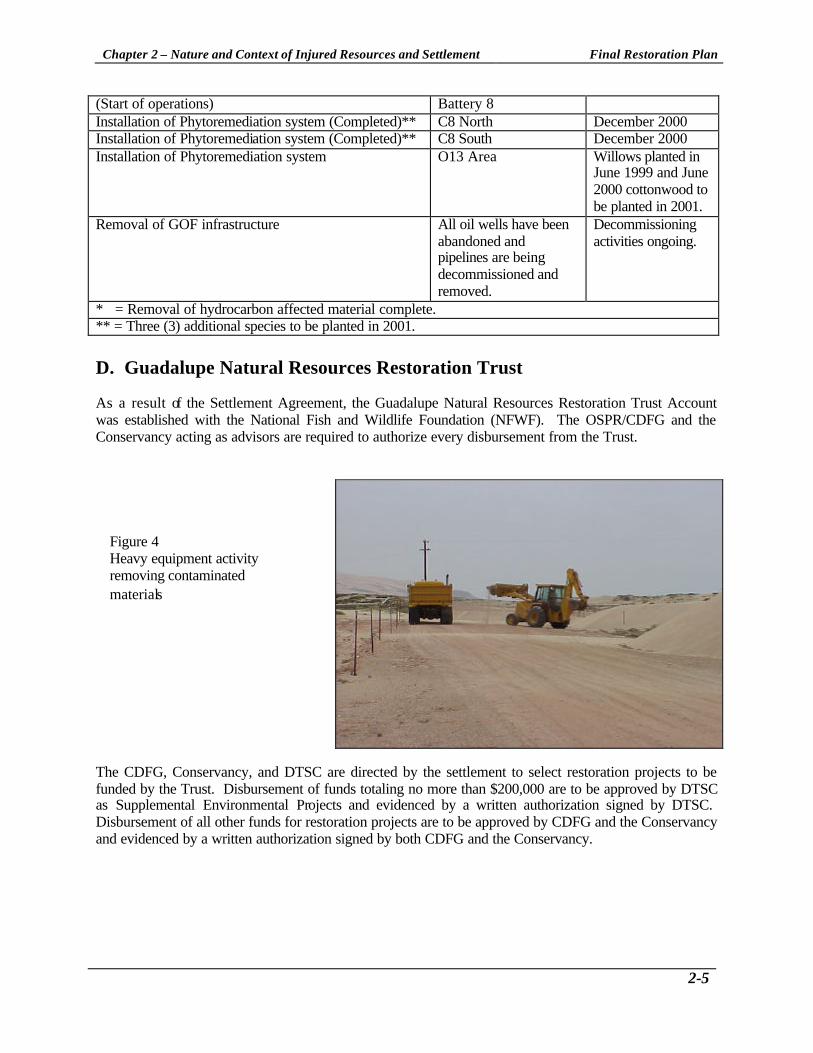
* = Removal of hydrocarbon affected material complete. ** = Three (3) additional species to be planted in 2001. D. Guadalupe Natural Resources Restoration Trust As a result of the Settlement Agreement, the Guadalupe Natural Resources Restoration Trust Account was established with the National Fish and Wildlife Foundation (NFWF). The OSPR/CDFG and the Conservancy acting as advisors are required to authorize every disbursement from the Trust.
The CDFG, Conservancy, and DTSC are directed by the settlement to select restoration projects to be funded by the Trust. Disbursement of funds totaling no more than $200,000 are to be approved by DTSC as Supplemental Environmental Projects and evidenced by a written authorization signed by DTSC. Disbursement of all other funds for restoration projects are to be approved by CDFG and the Conservancy and evidenced by a written authorization signed by both CDFG and the Conservancy.
Figure 4 Heavy equipment activity removing contaminated materials

Chapter 3 – Environmental Setting and Description of Injured Resources Final Restoration Plan
3-1
3. Environmental Setting and Description of Injured Resources10 This section of the Restoration Plan outlines the baseline conditions, which generally characterize the Plan area as well as the nature of injuries, which have resulted from the diluent leaks throughout the Unocal site. For additional information, the reader is referred to the Final Environmental Impact Report on the Guadalupe Oil Field Remediation and Abandonment Project as well as the Final Draft Remedial Action Plan To Address Separate-Phase and Dissolved-Phase Diluent at the Guadalupe Oil Field, San Luis Obispo County, California. These documents are on file with the RWQCB, CDFG, and the Conservancy. A. Surficial Geology Environmental Setting The Guadalupe-Nipomo Dunes is located in a geologically unique area comprised of stable and unstable dunes lying within one of the larger coastal valleys of California at the juncture between the Coast Ranges and the Transverse Ranges. Between Mussel Rock, just North of Point Sal, and Pismo Beach is the area collectively known as the Guadalupe-Nipomo Dunes. However, this area is divided into several subunits. The Guadalupe subunit lies entirely on the alluvial plain of the Santa Maria River between the Santa Maria River mouth and Oso Flaco Lake. The foredunes and areas of active dunes within this 20-mile reach of shoreline have been created and are controlled by three factors - the large volumes of sand discharged in the Santa Maria River; restricted alongshore sediment transport volumes; and the local wind climate with the strong northwesterlies that moves sand in a near shore normal direction from the beach inland. The Guadalupe Oil Field is also subject to ground shaking; potential for landslides; fault rupture; tsunamis; and, liquefaction. Resource Injuries and Damage Assessment Soil contamination includes both surface soils and soils at the ground water level (at the capillary fringe). The capillary fringe refers to the zone from the top of the water table up to the limit of capillary rise of the water. This zone may be extended upwards as the water level changes and in some areas, the soils may be "smeared" by the vertical movement of separate-phase diluent at the top of the water table. Small-scale variations in soil type can have a significant affect on the presence of contaminants and contaminant migration. As a result, it can be difficult to interpret the results of chemical analyses of soil samples. Rapid changes in diluent concentrations have been observed over relatively small depth changes. The presence of the smear zone and the small-scale variations create the potential for a long-term source area extending across the soil-water interface. When the water table rises, it contacts more of the smear zone and leaches additional contaminants into the ground water. As part of the damage assessment, CDFG conducted a study on the chemistry and toxicity of field collected sediment. Sediment samples were collected from two of the marsh ponds on the GOF and along the bank of the Santa Maria River. The toxicity of field collected sediments and river bank soil was evaluated using standardized short-term laboratory tests. Survival of the test species was significantly reduced in only one marsh pond sediment sample. However, the mortality rate was within expected control ranges and as such was not deemed significant. Measured TPH concentrations in the sediment/bank soil samples were all below detectable levels therefore the absence of toxicity was consistent with the lack of TPH in the samples.11
10 The following sections have been cited from the Guadalupe Oil Field Remediation and Abandonment Project Final Environmental Impact Report March 1998 11 Hagler Bailly, Inc. 1997. Guadalupe Oil Field NRDA: Chemistry and Toxicity of Diluent Site Water, and Sediment.

Chapter 3 – Environmental Setting and Description of Injured Resources Final Restoration Plan
3-2
B. Surface and Groundwater Interactions Environmental Setting The Santa Maria River flows across the valley from east to west and discharges into the Pacific Ocean adjacent to the Restoration Plan project area. The river abuts the Guadalupe Oil Field site to the south and discharges into the Pacific Ocean on the site's western boundary. The river previously discharged south of the site, but, during spring 1995, the river shifted to the northwest and traversed the site. Surface water is also present in several ground water-dependent habitats; dune slacks, marsh, dune willow scrub, and ponds. These are located in areas in which groundwater is within six feet of the ground surface. Surface water is present in the marsh adjacent to the estuary and in three semi-permanent pools. Additional pools may be present in dune slacks after precipitation12. Ground water is present and varies in depths from less than 10 ft to over 100 ft below ground surface (bgs), depending upon the location of the dunes and proximity of the ocean. The saturated thickness of the dune sand aquifer varies from less than 5 ft to about 20 ft13. The direction of flow is generally westward to the Pacific Ocean with components of flow to the north and south. The range in depth-to-water is a function of surface morphology, not ground water elevation. The surface water elevation in the Santa Maria River estuary is likely to affect the relationship between surface water and ground water. This elevation depends on a number of factors including season, precipitation, upstream reservoir releases, irrigation, and whether the sandbar at the beach impounds the river. The presence of total petroleum hydrocarbons (TPH) in dune slack surface water indicates that the surface water and ground water are closely connected hydraulically14. Similarly, subsurface springs are known to discharge into the Santa Maria River. Resource Injuries and Damage Assessment The interaction between groundwater and surface water bodies was investigated as part of the Natural Resources Damage Assessment (NRDA) effort designed to look at the pathway of the diluent to surface resources. Numerous soil and water investigations have been conducted throughout the GOF beginning in 1990 when there was a release of diluent at the beach area. At the GOF, the presence and extent of diluent contamination is generally measured using TPH, which provides an overall understanding of the total contamination but not of individual hydrocarbon constituents. In most cases where the ground water is contaminated, the source has been a surface release that has migrated downwards over time. As part of the damage assessment, CDFG evaluated potential toxicity from contaminated groundwater discharging to surface waters (the marsh ponds and the Santa Maria River), as is the case with diluent plumes known as B12, C8, and the N-13 spring area. These studies indicated that the surface waters continued to be exposed to petroleum discharges at concentrations that may reduce the survival, growth, and/or reproduction of aquatic organisms.15 As part of the damage assessment the agencies conducted a number of groundwater and surface water investigations at the GOF. Agency consultants conducted aquifer tests, a vadose zone infiltration study, a water level study in the vicinity of surface water bodies on the GOF, investigated contaminant migration near the Santa Maria River and the N13 plume area, ran a groundwater model of the Guadalupe Dunes
12 Levine Fricke, Inc. 1996a. Final Draft Remedial Action Plan To Address Separate-Phase and Dissolved-Phase Diluent At the Guadalupe Oil Field, San Luis Obispo County, California. March 18, 1996. Prepared for Unocal of Orcutt, California. 13 Levine Fricke, Inc. 1996a. Final Draft Remedial Action Plan To Address Separate-Phase and Dissolved-Phase Diluent At the Guadalupe Oil Field, San Luis Obispo County, California. March 18, 1996. Prepared for Unocal of Orcutt, California. 14 Levine Fricke, Inc. 1996a. Final Draft Remedial Action Plan To Address Separate-Phase and Dissolved-Phase Diluent At the Guadalupe Oil Field, San Luis Obispo County, California. March 18, 1996. Prepared for Unocal of Orcutt, California. 15 Hagler Bailly, Inc. 1997. Guadalupe Oil Field NRDA: Chemistry and Toxicity of Diluent Site Water, and Sediment.
Chapter 3 – Environmental Setting and Description of Injured Resources Final Restoration Plan
3-3
and the surrounding area, conducted geophysical investigations at the site and the agency consultants estimated the volume of diluent in the subsurface at the GOF. Regarding the latter investigation, the consultants calculated a conservative estimate of volume of subsurface diluent. They conservatively estimated 12.1 million gallons of free phase diluent existed in the subsurface at the water table beneath the GOF.16 Additionally, they estimated another 88,700 gallons of diluent existed in the subsurface which included 77,000 gallons held in the soil of the vadose zone, 9,000 gallons dissolved in groundwater, and 2,700 gallons sorbed to the soil in the saturated zone.17 This equaled a total estimated volume of diluent that existed in the subsurface beneath the GOF to be 12.2 million gallons. Separate-Phase Diluent Diluent is present as a separate-phase product in at least 60 different locations on the GOF Site. Because diluent is lighter than water, the separate-phase product "floats" on top of the water and can be referred to as a light non-aqueous phase liquid (LNAPL). The thickness of separate-phase diluent at the site ranges from thin visible sheens to as much as six feet in places. The significance of the separate-phase diluent is that it indicates high levels of contamination, it requires specific types of remedial actions, and its continued presence can act as a long-term "source" of contamination to the underlying ground water. Separate-phase diluent migrates at a much slower rate than the ground water velocity due to its viscosity, its sorption to soil particles, its degradation, and the behavior of the individual chemical constituents. Dissolved-Phase Diluent Dissolved ground water contamination, as measured by TPH, is present over a significant portion of the oil field site. Dissolved phase diluent is present around the areas of separate-phase diluent and in additional areas without the separate-phase diluent. Over the years, some of the dissolved-phase plumes have migrated from their likely source areas and have co-mingled with other dissolved-phase plumes. As a result, much of the ground water in the dune sand aquifer at the GOF is affected by dissolved-phase diluent. Diluent in Surface Water Surface water samples have been collected from several areas including the vicinity of the LeRoy 2X well sump, the Santa Maria River estuary/lagoon, the freshwater marshes adjacent to the estuary, from the M-12 dune slack, a surface spring south of the O-13 pad, from the near shore surf zone, and elsewhere on the GOF. TPH has been detected in all these areas. C. Onshore Biological Resources Environmental Setting The onshore biological resources discussed in this section are described separately for upland and wetland habitats. Appendix A-2 contains additional specific information regarding sensitive species, entitled "Sensitive Species of the Guadalupe-Nipomo Dunes and Vicinity and Their Occurrence within the Guadalupe Oil Field and Adjacent Areas Including the Lower Santa Maria River." Uplands - Overview Upland habitats include sandy beach, foredunes, and backdunes. The sandy beach and foredunes are key habitats for three endangered avian species (Western Snowy Plover, American Peregrine Falcons,
16 Komex H2O Science, Inc and R. Stollar. 1998. Estimate of the Volume of Diluent in the Subsurface at the Guadalupe Oil Field, San Luis Obispo, California. 17 Traylor, R. and J. W. Rohrer. 1998. Executive Summary of Selected Komex H2O Science Assessment Activities at the Former Unocal Guadalupe Oil Field.

Chapter 3 – Environmental Setting and Description of Injured Resources Final Restoration Plan
3-4
California Least Tern). The foredune and backdune habitats have extraordinary richness of flowering plant species compared to other coastal dunes and support a large number of species only found in the Guadalupe-Nipomo Dunes region, several of which are identified as sensitive species. Uplands - Sandy Beach Sandy Beach habitat is found along the shore between the intertidal zone and where vegetation becomes established forming the foredunes or pioneer dunes. There is no vegetation established on the sandy beach. Several invertebrate species (predominantly crustaceans and worms) are adapted to the wave action and shifting sands of the intertidal zone and are able to bury themselves quickly or deeply to avoid displacement or permanent burial. The invertebrates that are able to survive the extremes of this habitat attract numerous shorebirds that become most abundant during fall and winter. Uplands - Foredunes Foredunes are the first vegetated terrestrial communities located above the high tide line. Due to the harsh coastal environment, only plants adapted to strong winds, salt spray and burial under moving sand can grow here. Low-growing plants with deep and/or spreading root systems are typical in the foredune habitat. There is often a distinct zonation of vegetation within the foredunes. Growing adjacent to the beach are low growing, salt tolerant species. These species are often called "pioneer" species and influence the initial formation of dune hummocks. Away from the immediate shore, as physical conditions become milder, established plants help hold sand in place and higher, more developed dune hummocks form that gradually transition to more stabilized backdunes and dune scrub. These higher, more vegetated foredunes support a variety of low-growing perennial species. Uplands - Backdunes (Including Active Dunes) There is no clear boundary between foredune and backdune vegetation. Low-growing forms of common backdune shrub species are often found on the more stabilized vegetated dunes near the shore. In addition, many of the pioneer dune species, such as beach bur and beach evening primrose, are commonly found in the understory or between shrubs in dune scrub habitats some distance from the beach. In general, the backdunes of the Guadalupe Oil Field are characterized by large sand dunes supporting dune scrub vegetation which is dominated by shrub species such as mock heather, dune lupine (Lupinus chamissonis), coastal buckwheat (Eriogonum parvifolium), and/or Blochman's senecio (Senecio blocmmaniae). One or more of these species usually dominates the dune scrub habitats on the site. The shrub-dominated backdune plant communities are interspersed with active unvegetated dunes (open sand habitats) and low-lying (swales) areas dominated by grass-like plants and other low herbs, sometimes accompanied by trees or large shrubs such as willows and cottonwoods. The open sand habitats are large unvegetated areas where accelerated sand movement and exposure to the wind and other elements create a hostile environment for plant establishment. Wetlands The CDFG has found the U.S. Fish and Wildlife Service (USFWS) wetland definition and classification system to be the most biologically valid of those definitions and classification systems presently utilized in California.18 The USFWS definition is as follows:
18 California Department of Fish and Game. Fish and Game Code 1999 2nd ed.

Chapter 3 – Environmental Setting and Description of Injured Resources Final Restoration Plan
3-5
"Wetlands are lands transitional between terrestrial and aquatic systems where the water table is usually at or near the surface or the land is covered by shallow water. For purposes of this classification, wetlands must have one or more of the following three attributes: (1) at least periodically, the land supports predominantly hydrophytes; (2) the substrate is predominantly undrained hydric soil; and (3) the substrate is non-soil and is saturated with water or covered by shallow water at some time during the growing season of each year."19
The California Coastal Act defines wetlands under Section 30121 as lands within the coastal zone that may be covered periodically or permanently with shallow water, including salt marshes, fresh- and brackish-water marshes, swamps, mudflats, and fens. These areas are identified as environmentally sensitive habitats and it is required that the biological productivity and the quality of such areas be maintained and, when feasible, restored.
Aquatic and Transitional Habitats Aquatic habitats are open or closed bodies of water that are generally adjacent to or included within wetlands, whereas transitional habitats span the boundary between wetland and upland habitats. Within this general category, two sub-habitats occur: dune swale habitats and Santa Maria River floodplain habitats. Aquatic and Transitional Habitats - Dune Swale Habitats Dune swales are low places among the dunes that are moister and support vegetation that is distinct from the dune scrub or open sand of the surrounding dunes20. Conditions are moister primarily because of the shallow water table, although other factors may contribute, including reduced wind and insolation, drainage from upslope areas, and the greater retention of water in the soil due to the accumulation of fine sediments and organic matter. Dune swales provide a range of habitats, depending primarily on depth to the water table. Habitats encountered in dune swales include small lakes or ponds, marshes, willow scrub/woodlands, mesic swale communities, and upland dune scrub. To some extent, these habitat/community types may also represent a long-term successional sequence associated with the infilling of a dune swale and a progressively deeper water table 21. Where succession is occurring, a mixture of two or more community types, reflecting a transition from wetter to drier conditions, is expected. Aquatic and Transitional Habitats - Santa Maria River Floodplain Habitats Migration of the river channel within its present floodplain has increased the diversity of vegetation and wildlife habitats, as former segments of the river channel have become cut off and are undergoing succession. The habitats found within the Santa Maria River Floodplain can be classified as follows: Estuary/Lagoon/Riverine Habitats; Scirpus Marsh/Ponds; Intermittently Flooded Marsh; Willow Scrub/Woodland; and, Mesic Floodplain Communities (Meadows).
19 U.S. National Fish and Wildlife Service. Classification of Wetlands and Deepwater Habitats of the United States; FWS/OBS79/31. December 1979. 20 Ferren, W.R. Jr., P.L. Fiedler, R.A. Leidy, K.D. Lafferty, and L.A.K. Mertes. 1995. Wetlands of California. Part II: Classification and Description of Wetlands of the Central and Southern California Coast and Coastal Watersheds. Madroño. 43:125-182. 21 Holland V.L., D. Keil, and L.D. Oyler. 1995. Botanical Study of the Nipomo Dunes Preserve. Surveys conducted between March 1990 and December 1992. March 1995. Prepared for the Nature Conservancy, Nipomo Dunes Preserve Office.

Chapter 3 – Environmental Setting and Description of Injured Resources Final Restoration Plan
3-6
Resource Injuries and Damage Assessment Part of the damage assessment conducted by CDFG included conducting a number of toxicity tests to determine if the diluent was toxic to the onshore biological resources in the many different habitat types. For example, laboratory studies were conducted to determine if diluent contaminated water was toxic to field collected sand crabs (Emerita analoga) a crustacean in the intertidal, an important ecological receptor because they constitute the largest fraction of the intertidal biomass at the Guadalupe site. Diluent was toxic to the sand crabs. Mortality of sand crabs increased with increasing concentration of TPH and mortality occurred sooner at higher TPH concentrations. Diluent exposure also reduced the growth of the sand crabs.22 It should be noted that Entrix conducted a beach study prior to the installation of the HDPE wall and remediation of the 5x plume that showed that fewer macro-invertebrates were present in the intertidal area adjacent to the 5x plume relative to the rest of the intertidal area on the beach. Additionally, CDFG conducted a number of toxicity tests to determine if sunlight increased the toxicity of the diluent to Mysidopsis bahia (a marine crustacean), southern leopard frogs (surrogates for the threatened California red-legged frog), tidewater silverslide (surrogate for the tidewater goby, recently proposed for delisting) and Ceriodaphnia dubia a fresh water flea. Regarding the photoenhanced toxicity of diluent to Mysidopsis, significant increases in mortality occurred. They concluded the toxicity increased substantially when the diluent water mixtures (Water Accommodated Fraction or WAF) interacted with solar radiation.23 Results from the southern leopard frog toxicity test showed relatively limited irradiance was necessary to initiate photoenhanced toxicity.24 Results from the tidewater silverside, an estuarine fish, also indicated significant mortality occurred during ultraviolet radiation exposure as well as impaired growth.25 Results from the Ceriodaphnia toxicity test concluded the WAF toxicity increased when the organisms were exposed to ultraviolet radiation.26 D. Oceanography and Marine Water Quality27 Environmental Setting A number of factors influence the marine environment immediately offshore of the Guadalupe Oil Field. These include coastal geomorphology, oceanographic processes, and contaminant input. Oceanographic processes are dominated by a highly energetic wave field. This wave energy leads to increased turbulence and mixing in nearshore waters and causes significant sediment resuspension and sand transport within the littoral zone, where wave-induced sediment transport occurs. The littoral zone in the study region is also influenced by suspended sediment and freshwater input from the Santa Maria River. Farther offshore, bands of counter currents move ocean waters in alternating directions along the central California coast. Lastly, wind-driven upwelling alters the vertical distribution of water properties in the study region and contributes to the remarkably high productivity of marine waters there.
22 Hagler Bailly, Services, Inc. 1997. Diluent Toxicity to Sand Crabs and Mysids. 23 Cleveland, L., E.E. Little, R.D. Hurtubise, and M.G. Barron. 1998 Photoenhanced Toxicity of Diluent to Mysidopsis bahia. 24 Little, E.E., R.D. Hurtubise, and L. Cleveland. 1998. Photoenhanced Toxicity of Diluent to the Frog, Rana sphenocephala. 25 Little, E.E., L. Cleveland, and R. Hurtubise. 1998. Assessment of the Photoenhanced Toxicity of Diluent to the Tidewater Silverside. 26 Hurtubise, R.D., E.E. Little, L. Cleveland, and M.G. Barron. 1998. Sublethal Effects of Photoenhanced Toxicity of Diluent on Ceriodaphnia dubia Reproduction. 27 The following section has been cited from the Guadalupe Oil Field Remediation and Abandonment Project Final Environmental Impact Report March 1998 Volume II Technical Appendices Appendix H - Oceanography and Marine Water Quality.

Chapter 3 – Environmental Setting and Description of Injured Resources Final Restoration Plan
3-7
Resource Injuries and Damage Assessment Prior to excavating the beach plumes, which was completed in November 2000, diluent which was present in the coastal portion of the Guadalupe Field represented one of the major potential sources of anthropogenic (human-generated) hydrocarbon contamination to marine waters at the project site. Five of the sixteen remediation areas were adjacent to the beach (e.g. 5X and 7X), and several other sites are in close proximity. Because of their proximity to the coast, these sites posed potential contamination hazards to marine waters. One hazard is from long-term chronic exposure of marine organisms to contaminants entrained in westward migrating ground water. Another is the short-term acute exposure to separate-phase diluent that arises from a direct release into marine waters. Before the excavation of the 5X west site and installation of the HDPE wall at this site, diluent was released into the marine environment on several occasions. The release resulted from seepage within contaminated sands that was exacerbated by tidal pumping. Recent quantitative investigations of ground water flow into the coastal waters of other regions have indicated that exchange from tidal pumping is much larger than previously thought28. Also mechanical erosion of diluent-containing beach strata during high tides and waves in winter storms resulted in marine releases29. E. Marine Biological Resources Environmental Setting Plankton Plankton are free-floating organisms that drift with ocean currents. Generally, phytoplankton and zooplankton are the two broad categories of plankton30. In coastal and offshore environments, phytoplankton distribution is generally limited to the sea surface to approximately the 100 meters (m) of depth. This depth range roughly corresponds to the effective range of light penetration for photosynthesis. Zooplankton, however, can occur throughout the depth range from surface to bottom. Fish The fish resources off the coast of central California are comprised of both year-round residents and seasonal migrants. Fish resources in the area are dynamic and extremely rich and are comprised of over 500 species of fish31. Large numbers of shellfish and other invertebrate species also occur in the area with the most important being crabs, shrimp, bivalves, abalone, sea urchins, and squid. The high level of diversity is reflective of the complex hydrographic, physical, and geologic conditions of the region that provide a wide variety of habitats for fish resources. The distribution of fishes in the area fluctuates on a daily, seasonal, and annual basis for many reasons including feeding, reproduction, and migration32.
28 Moore, W.S. 1996. Large groundwater inputs to coastal waters revealed by 226Ra enrichments. Nature 380:612-614. 29 Levine Fricke, Inc. 1994. Remedial Action Plan Beach Project Guadalupe Oil Field San Luis Obispo County, California. April 8, 1994. LF 2058-94.05. 11pp+appendices. 30 Phytoplankton, which are single-celled plants, are capable of photosynthesis and form an important trophic base for many marine systems. There are several categories of zooplankton. Holoplankton includes animals that remain planktonic throughout their life. Meroplankton are larval stages benthic invertebrates while icthyoplankton are larval stages of fish. Zooplankton is a primary link between phytoplankton and larger marine organisms in many food webs. 31 Minerals Management Service (MMS). 1996. Final Environmental Impact Statement for the Outer Continental Shelf Oil and Lease Program: 1997-2002. Report No. 96-0043, U.S. Department of the Interior, Washington, DC. 32 Minerals Management Service (MMS). 1996. Final Environmental Impact Statement for the Outer Continental Shelf Oil and Lease Program: 1997-2002. Report No. 96-0043, U.S. Department of the Interior, Washington, DC.

Chapter 3 – Environmental Setting and Description of Injured Resources Final Restoration Plan
3-8
Benthic Invertebrate - Intertidal and Shallow Subtidal - Soft Substrates Sandy beaches are the predominant intertidal habitat in the Guadalupe Oil Field. Because of the inherent difficulties in conducting ecological studies in sand, far less is known about invertebrate communities that live there than those found on rocky substrates. Sand dwelling organisms are very motile, difficult to mark, and cannot be easily monitored over time. Immigration and emigration rates are high and often contribute to the high level of temporal and spatial patchiness in density that is often reported33. In addition, studies are difficult to conduct in unstable sediments in a high-energy environment. Marine Mammals Twenty-seven marine mammal species were reported in central California by Dohl et. al34. The species are migrants that pass through the area on their way to calving or feeding grounds; or seasonal visitors that remain for a few weeks to feed on a particular food source; or residents of the area. Twenty-one of the observed mammals are cetaceans (i.e., whales, dolphins, and porpoises). Carnivores are represented by seven species of pinnipeds (i.e., seals and sea lions) and one species of fissiped, the threatened sea otter. Marine mammals are characterized by extensive distributional ranges35. Several marine mammal species reach their southern limit of their ranges in the area while other species are at their northern range limits36. Resource Injuries and Damage Assessment As part of the CDFG damage assessment, studies evaluating the degree of exposure of barred surfperch to diluent began in January 1994 in response to concerns about exposure to petroleum hydrocarbons in marine biota. The CDFG study reported TPH concentrations in surfperch muscle and skin ranged from 1 to 15 ppm in the Guadalupe Beach area and averaged 6.84 ppm. Based on this report a health advisory on catching and eating fish in the Guadalupe Beach/Nipomo Dunes Area was posted in July 1994. In August 1995 a final report was submitted to CDFG entitled “Report on Recovery of Hydrocarbons from California Barred Surfperch (Amphistichus argenteus), Mussels (Mytilus), and Crabs (Emerita analoga) Taken at Guadalupe Beach in August , 1994.” In this report they concluded TPH concentrations in surfperch muscle and skin ranged from 0.08 to 4.98 ppm and TPH concentrations in whole sand crab tissue ranged from 3.2 to 7.3 ppm. The data suggested that surfperch could be exposed to diluent by eating sand crabs near the release site. The CDFG consultant also conducted a laboratory exposure study in which they studied uptake and depuration of diluent WAF’s in Atlantic salmon. Findings included volatile aromatic hydrocarbons such as toluene and benzene were rapidly absorbed and excreted by the fish. Another surfperch study was conducted in 1995 and they found TPH levels 60 to 95% lower than those reported for 1994 suggesting that remediation activities may have reduced exposure.37
33 Thompson, B., J. Dixon, S. Schroeter, and D.J. Reish. 1993. "Benthic Invertebrates." Chap. 8. In: M.D. Dailey, D.J. Reish, and J.W. Anderson [Eds.]. Ecology of the Southern California Bight: A Synthesis and Interpretation. Berkeley: University of California Press. pp 369-458. 34 Dohl, T.P., R.C. Guess, M.L. Duman, R.C. Helm. 1983. Cetaceans of Central and Northern California, 1980-1983: Status, Abundance, and Distribution. U.S. Department of the Interior Mineral Management Service, Pacific OCS Region, Camarillo, California. 284 pp. 35 Gaskin, D.E. 1982. The Ecology of Whales and Dolphins. London: Heineman Educational Books Ltd. 459 pp. 36 Hubbs, C.L. 1960. The marine vertebrates of the outer coast. Syst. Zool. 9:134-147; Bonnell, M.L. and M.D. Daily. 1993. "Marine Mammals." In: M.D. Dailey, D.J. Reish, and J.W. Anderson [Eds.]. Ecology of the Southern California Bight, A Synthesis and Interpretation. Berkeley: University of California Press. pp. 604-681. 37 Hagler Bailly Services, Inc. 1997. Data and Literature Review: Evaluation of Petroleum Hydrocarbon Residues In Fish.

Chapter 3 – Environmental Setting and Description of Injured Resources Final Restoration Plan
3-9
F. Land Use, Recreation, and Visual Content Environmental Setting The existing environment within the southern San Luis Obispo County and northern Santa Barbara County region contains a variety of natural landform features, including the Guadalupe-Nipomo Dunes Complex, the Santa Maria River, and related sensitive resource areas, such as Oso Flaco Lake and the Dune Lakes, and prime agricultural land in the Santa Maria Valley. Within this region, land uses include agriculture, coastal recreation, residential suburban and rural developments in the City of Guadalupe and the Callender-Garrett Village, and energy related uses such as the Santa Maria Refinery. The Guadalupe-Nipomo Dunes Complex is within the Coastal Zone, where scenic resources are protected in laws, regulations, and policies. In addition, the dunes represent a resource of national, regional, and local significance. In designating the Guadalupe-Nipomo Dunes Complex as a National Landmark, the Secretary of the Interior stated that "... The area [is] one of the most scenically attractive areas in southern California"38. According to the visual sensitivity criteria outlined in the Guadalupe-Nipomo Dunes Final EIR, views of the Guadalupe-Nipomo Dunes and views from the dunes are defined as being highly sensitive. That a substantial part of the Guadalupe-Nipomo Dunes Complex is a regional tourist attraction also indicates high visual sensitivity. At the northern end of the dunes, there are two contiguous state parks, Oceano Dunes State Vehicular Recreation Area (SVRA) and Pismo State Beach, totaling 3,000 acres of beaches, wetlands, and sand dunes. Combined, the two parks receive over one million visitors per year.
Additional access to the Dunes area is provided by Rancho Guadalupe Dunes Park within Santa Barbara County, immediately south of the Santa Maria River, as well as at the unimproved Point Sal access. A kiosk regulates access to Rancho Guadalupe and charges a $3.00 access fee. Users of the area include fishermen, bird watching enthusiasts, and other day users. Currently the parking lot at the beach is experiencing erosion problems and needs regular maintenance to keep the parking area open to the vehicles. The only other recreation facility in proximity to the dunes is LeRoy County Park, at the northwest corner of Guadalupe and about 4,500 ft from the eastern edge of the dunes. This community park is a day-use
38 San Luis Obispo County (SLO). 1994. Notice of Preparation of a Draft Environmental Impact Report for the Unocal / Guadalupe Oil Field. Department of Planning and Building.
Figure 5 Surf Fishing Activity near Santa Maria River Mouth.

Chapter 3 – Environmental Setting and Description of Injured Resources Final Restoration Plan
3-10
facility offering children's play equipment, picnic facilities, a community building, and parking lot. No day use figures are readily available. Given the indications that the public is highly interested in the scenic qualities of the dunes, views from segments of travel routes near the dunes that serve as primary access to them are also to be accorded high sensitivity. Views from urban and rural residential areas are highly and moderately sensitive, respectively. A limited portion of the dunes is visible from some residential areas in Guadalupe and from residences along the southern bluffs of the Nipomo Mesa. Resource Injuries and Damage Assessment Beach closures during the numerous beach excavation projects impacted recreational uses. Additionally, remediation structures present at the Guadalupe-Nipomo Dunes present a noticeable contrast to the natural environment present at the Dunes. Visitors to the Guadalupe-Nipomo Dunes traditionally expect to see natural vistas that are unobstructed by modern anthropogenic structures. The presence of anthropogenic remediation structures may negatively affect a visitor's experience at the Dune's and reduce utility value in the near term. While the Rancho Guadalupe Dunes Park is largely unimproved, warning signs alert users to remediation activities at the neighboring oil field to the north. As part of the damage assessment, CDFG conducted a number of studies evaluating recreational impacts from the diluent releases and cleanup activities. Recreational impacts evaluated included reduction in beach use in the area of the GOF and included evaluating reduced quality of beach use. Public use injuries included loss of fishing opportunities due to the fish advisory, reduced beach use and sightseeing, impacts to surfers and impacts to “passive uses” such as the existence value, that is the value obtained simply by knowing that a resource or service exists. They concluded that most individuals visiting the area had some awareness of the issues related to the diluent spills.39 Results indicated visitors likely experienced impacts from the diluent releases such as reduced visits to the site and reduced quality of visits to the site.40
39 Hagler Bailly Services, Inc. 1997. Final Report Recreation Impacts from Diluent Releases and Cleanup Activities at the Guadalupe-Nipomo Dunes Preserve: Focus Groups October 21-23, 1996. 40 Hagler Bailly Services, Inc. 1998. Evaluation of Chronic Recreation Impacts at Guadalupe Beach.

Chapter 4 – Restoration Plan Goals, Objectives, and Process Overview Final Restoration Plan
4-1
4. Restoration Plan Goals, Objectives, and Process Overview A. Purpose and Overall Goals of the Plan The purpose of the Guadalupe-Nipomo Dunes Restoration Plan is to comprehensively set forth a programmatic approach to restore the biological resources that were injured as a result of the spill and to undertake restoration in such a manner that the settlement funds are utilized cost-effectively to maximize the physical recovery of injured and like resources. In addition, the projects include an endowment component that is intended to increase the capacity for long-term management of the selected restoration projects and stewardship of the dune complex for the foreseeable future. The resources that are the target of the restoration projects and endowment programs contained within this document include the wetland and dune habitats, and the associated species, resources, and associated services that were injured as a result of the diluent spill at the Guadalupe Oil Field. Restoration projects are defined as any action to restore or rehabilitate any injured, lost, damaged, or destroyed natural resource (and the services provided by that natural resource), or any action that replaces or acquires the equivalent of the injured, lost, or destroyed natural resource (and affected services) as a result of the diluent releases at Guadalupe Oil Field. Per the settlement agreement, restoration projects must be in the geographical area of San Luis Obispo County and/or Santa Barbara County as near as possible to the Guadalupe Oil Field. B. Objectives The objectives of this Restoration Plan are to evaluate, refine, and integrate separate but related project proposals into a pragmatic framework for action in terms of: 1) physical habitat restoration efforts, 2) education programs, 3) land acquisition, 4) physical improvements to existing structures and services that serve general public and visitors to the dunes. Another primary objective is to provide this information to the public for review and comment. These objectives have been advanced through the application of a set of screening and evaluation criteria (See Chapter 5) that focuses the Restoration Plan on a subset of the programs and projects seeking funding with the highest chance of achieving these objectives. In addition, a pro-active implementation framework and adaptive management approach will also be used in the future to “fine-tune” specific projects receiving funding within the Stewardship Collaborative component of the planning effort. C. Process Overview and Public Involvement 1. Restoration Subcommittee Role As part of the settlement agreement, $9,000,000 was set aside and placed into the Guadalupe Natural Resources Restoration Trust, to be administered by the Restoration Subcommittee. As noted earlier, the Subcommittee is comprised of the California Department of Fish and Game Office of Spill Prevention and Response, and the State Coastal Conservancy. These two agencies, acting together, are responsible for evaluation of potential projects and the actual disbursement of the funds. 2. Public Advisory Committee and Scoping Process In order to identify potential restoration projects, the Restoration Subcommittee asked members of the Public Advisory Committee (PAC) to propose projects and to assist with community outreach and evaluation of projects. The PAC is comprised of the following organizations and agency representatives:

Chapter 4 – Restoration Plan Goals, Objectives, and Process Overview Final Restoration Plan
4-2
Table 3 Public Advisory Committee Membership
Organization Individual Audubon Society, Morro Coast Chapter John Perkins Surfer's Environmental Alliance Mark Massara Dunes Center Liz Scott-Graham Nature Conservancy Kara Smith Center for Natural Land Management Sherry Teresa Agencies Individual Cachuma Resource Conservation District Gerald Czarnecki California State Parks Department Dennis Doberneck City of Guadalupe Sam Arca City of San Luis Obispo Allen Settle County of San Luis Obispo, Planning Department John Nall Guadalupe Dunes National Wildlife Refuge Chris Barr Regional Water Quality Control Board Gerhardt Hubner San Luis Obispo Coast District, State Parks Joe Mette San Luis Obispo County Board of Supervisors Katcho Achadjian San Luis Obispo County Land Conservancy Ray Belknap Santa Barbara County Parks Department Steve Strachan Santa Barbara County Planning & Development Department
Luis Perez
U.S. Fish & Wildlife Service Diane Noda Restoration Subcommittee Individual California DFG - Office of Spill Prevention & Response Michael Sowby State Coastal Conservancy Elena Eger
Initial project proposals were requested from the PAC and submitted to the Restoration Subcommittee between February and March 2000. A total of 23 initial proposals were submitted consisting of specific proposals (both interim and long term projects) and endowment requests. The location of these projects are depicted in Figure 6, Project Locations. Some of the specific proposals have already been funded from other sources, while those without funding were dispersed over a wide geographic range, some of which were located outside of the Dunes area. These initial proposals were reviewed in light of the screening and selection criteria 41. Additional refinements were made to the initial proposals that fit the geographic screening criteria and which could show a nexus to the injured resources. The proposals were then further assessed with the screening and selection criteria in mind. In April of 2000, the Restoration Subcommittee prepared a Draft Scoping Document for initial review and comment by the PAC. Within the Scoping Document, proposals
41 Restoration project proposals were reviewed based upon explicit screening/selection criteria that require projects to be located within San Luis Obispo and Santa Barbara Counties, as near as possible to the Guadalupe Oil Field. Additionally, projects must be technically feasible; restore, rehabilitate, replace or acquire the equivalent of the injured natural resources or the services those resources provided; and must comply with relevant and applicable laws and safety requirements. Other criteria include: avoidance of collateral injuries; likelihood of success; benefits to multiple resources or services; time to provide the benefits; duration and protection of benefits; potential for collaborative funding from other sources; benefits relative to costs; and total cost.

Chapter 4 – Restoration Plan Goals, Objectives, and Process Overview Final Restoration Plan
4-3
were described, consolidated and classified into most and least preferred and as endowment-based versus project specific. The PAC was then convened in May 2000 and provided feedback to the Restoration Subcommittee on the projects and the system of classification. The Restoration Subcommittee also proposed that the various endowment requests submitted by the PAC be combined to fund projects in the Guadalupe-Nipomo Dunes meeting the Restoration Planning Criteria. The PAC concurred and recommended that a significant portion of the settlement monies be used to fund a restoration endowment for projects which meet the restoration criteria and which directly benefit the Guadalupe-Nipomo Dunes. Referred to under the umbrella of Collaborative Projects, the Collaborative Group Framework reorganizes individual project proposals to consolidate multiple proposals each requesting funds for endowments under a single management entity. This approach also sought to capture economies of scale regarding program management and implementation, and to prioritize the remaining specific proposals in a manner that maximizes the capacity of the funding effort to achieve its stated goals. A Revised Draft Scoping Document was then prepared and circulated to members of the public who had expressed an interest in the dune restoration process. The revised Scoping Document served as the focus of a June 21, 2000 public scoping meeting at which time, interested members of the public, governmental agencies, and other interested organizations were provided with an opportunity to comment on and submit additional restoration project proposals or to refine the ones that had originally been submitted. Approximately 50 individuals attended the meeting, many of whom made comments and further refined proposals already submitted or submitted additional proposals. An additional 23 proposals were submitted by various organizations. The Restoration Subcommittee then reviewed the full range of proposals and applied the screening and evaluation criteria described in Chapter 5. This Restoration Plan presents the projects in a framework that facilitates their integration and implementation in such a manner that will advance the goals of the restoration effort and achieve the objectives set forth above.

Chapter 4 – Restoration Plan Goals, Objectives, and Process Overview Final Restoration Plan
4-4
Figure 6 - Project Locations
Legend on Following Page

Chapter 4 – Restoration Plan Goals, Objectives, and Process Overview Final Restoration Plan
4-5
Figure 6 Legend

Chapter 5 – Project Evaluation Framework Final Restoration Plan
5-1
5. Project Evaluation Framework A. Screening and Evaluation Criteria and Alternative Approaches to
Dune and Resource Restoration.
The Department of Fish and Game and the California Coastal Conservancy, acting in their capacity as the Restoration Subcommittee used the evaluation criteria listed below to screen projects submitted by the Public Advisory Committee and by members of the general public. The list below represents the principal areas of evaluation by the Restoration Subcommittee. The criteria are not ranked in order of priority, except that the geographic nexus and the threshold criteria must be met before a project is reviewed using any of the remaining additional criteria. These criteria will be further used to finalize the list of projects, and proposed endowment proposals and provide an appropriate level of funding consistent with the funding resources available to the Restoration Subcommittee from the settlement.
1. Geographic Criteria
Restoration projects shall be in the geographic area of San Luis Obispo County and/or Santa Barbara County, as near as possible to the Guadalupe Oil Field.
2. Threshold Criteria
a. Technical feasibility of the alternative: The project must be technically and procedurally sound. The Restoration Subcommittee will consider the level of uncertainty or risk involved in implementing the project. Proven track record demonstrating the success of projects utilizing a similar or identical restoration technique can be used to satisfy this evaluation standard.
b. Consistency with the restoration goals: The proposed alternative must meet the Restoration Subcommittee’s intent to restore, rehabilitate, replace, or acquire the equivalent of the injured natural resources or the services those resources provided. In addition, a project could provide compensation for the interim loss of those resources and services.
c. Compliance with laws : The proposed alternatives must comply with all applicable laws.
d. Public health and safety: The proposed alternatives cannot pose a threat to the health and safety of the public.
3. Additional Criteria
a. Relationship to injured resources and services: Projects that restore, rehabilitate, replace, enhance, or acquire the equivalent of the same or similar resources and services injured by the spill are preferred to projects that benefit other comparable resources or services. The Restoration Subcommittee considers the types of resources or services injured by the spill and the connection or nexus of project benefits to those injured services.
b. Avoidance of injury: The proposed alternative should avoid or minimize adverse impacts to the environment and associated natural resources. The adverse impacts may have resulted from the original oil spill incident or may have caused in the future as collateral injuries when implementing, or as a result of implementing, the project alternative. The Restoration Subcommittee considers the avoidance of future short-term and long-term injuries as well as mitigating past injuries when evaluating project concepts.
c. Likelihood of success: The Restoration Subcommittee considers the potential for success and the level of expected return of resources and resource services. The Restoration Subcommittee also considers the

Chapter 5 – Project Evaluation Framework Final Restoration Plan
5-2
ability to monitor and evaluate the success of the project and the ability to correct or adaptively manage a project over time.
e. Multiple benefits: The Restoration Subcommittee considers the extent to which the proposed alternative benefits more than one natural resource or resource service. This can be measured in terms of the quality and associated quality of the types of natural resources or service benefits expected from the alternative.
f. Time to provide benefits: The Restoration Subcommittee considers the time until benefits will be provided to the ecosystem and/or public.
g. Duration of Benefits: The Restoration Subcommittee considers the expected duration of benefits from the proposed alternative.
h. Protection of alternative: The Restoration Subcommittee considers the opportunities to protect the implemented alternative and resulting benefits over time through conservation easements, land acquisition, or other types of resources dedication.
i. Opportunities for collaboration: The Restoration Subcommittee considers the possibility of matching funds, in-kind services, or volunteer assistance. Coordination with other ongoing or proposed projects is also considered here.
j. Benefits relative to costs: The Restoration Subcommittee considers the relationship of expected project cost to the expected resource and service benefits from each alternative seeking the least costly (i.e., most cost efficient) means to deliver an equivalent amount of benefits.
k. Total cost and accuracy of estimate: The Restoration Subcommittee evaluates the estimated total cost of each alternative and the probable validity of the estimate. The total cost estimate should include costs to design, implement, monitor, and manage the alternative. The validity of the cost estimate is evaluated based on the completeness, accuracy, and reliability of the methods used to estimate costs, as well as the track record of the person or entity submitting the cost estimate to accurately estimate costs.
B. Proposal Categorization The flow chart below organizes the project proposals into three categories: 1) Guadalupe-Nipomo Dunes Projects; 2) Non-Guadalupe-Nipomo Dunes Projects; and 3) Already Funded By Another Source Projects. The first category, noted on the left of the flow chart is the Guadalupe-Nipomo Dunes Projects, and envisions long-term coordination of restoration projects within the Dunes. It includes a Collaborative Endowment component, and requires that a Collaborative Work Plan be developed which will identify the long-term restoration needs of the system and prioritize Interim and Long Term Projects. The Collaborative's goal is to integrate and coordinate the restoration efforts in the dunes. The Stewardship Collaborative is currently working closely with the Restoration Subcommittee to develop and implement the Collaborative Work Plan. However, the Restoration Subcommittee remains responsible for ensuring that Interim and Long Term Projects meet the Restoration Planning Criteria.
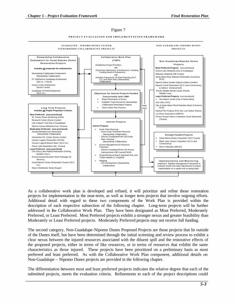
Chapter 5 – Project Evaluation Framework Final Restoration Plan
5-3
Figure 7
L o n g T e r m P r o j e c t sIncludes all Project Proposals in Dunes:
Most Preferred: (non-prioritized)W. Snowy Plover Monitoring (FWS)
Research Center (Dunes Center)
City to Beach Trail (City of Guadalupe)
Nipomo Dunes Wetlands Eval. (Tenera)
Moderately Preferred: (non-prioritized)Sandwort/Watercress Restoration
(Stewardship Collaborative)
Interpretive Ed. Center (Dunes Center)
Oceano Lagoon Restoration (OCSD)
Oceano Lagoon/Stream Maint. (SLO Co.)
Pismo Lake Restoration Alts. (Tenera)
Least Preferred: (non-prioritized)Oso Flaco Lake Habitat Restoration (Fishing
Buddies Assn.)
Environmental Education Work Packages (R.Stevens)
Guad-Nipomo Dunes Restoration-Oceano (SLOCo.)
Macro Intertebrate Study (Dugan)
N o n - G u a d a l u p e / N i p o m o D u n e s
Pro jec ts
Most Preferred Projects: (non-prioritized)
School Lake Wetlands (City of Guadalupe)
Mahoney Wetlands (SB County)
Santa Maria River Riparian Restoration (CachumaRCD)
Nipomo Native Garden (Nipomo Native Garden)
Nipomo Creek Restoration (SLO Land Conservancy& Salmon Enhancement)
Pacific Wildlife Rehab Center (PacificWildlife Care)
Least Preferred Projects: (non-prioritized)
Ø Sea Nature Center (City of Santa Maria)
Irish Hills (TNC)
City of Santa Maria Flood Detention Basin (CachumaRCD)
Harford Pier Projects (Port San Luis Harbor District)
Los Osos Acquisitions (MEGA)
Oil and Grease Filters in Meadow Creek Watershed(Tenera)
G U A D A L U P E - N I P O M O D U N E S S Y S T E M
S T E W A R D S H I P C O L L A B O R A T I V E P R O J E C T S
S t e w a r d s h i p C o l l a b o r a t i v e
E n d o w m e n t f o r G u a d - N i p o m o D u n e sR e s t o r a t i o n P r o j e c t s
Includes all proposals for endowments:
Stewardship Collaborative Endowment(Stewardship Collaborative)
Pt. Sal/Rancho Guadalupe Endowment(SB Co. / CNLM)
Dunes Center Endowment(Dunes Center)
Guadalupe Oil Field Endowment(SLO Co.)
I n te r im Pro jec ts
Interim Projects
Ø Exotic Plant Removal:- Dune Exotic Pest/Plant Removal (Stewardship Collaborative)- Rancho Guadalupe/Point Sal Exotic Plant Removal (Stewardship Collaborative)
Ø Access Management for ResourceProtection:- Rancho Guadalupe/Point Sal Access Improvements (SB County/CNLM)
Ø Protect/Enhance Beach Specticle-Pod, andThistle habitats (J. Langford)
Ø Mapping:- GIS Development (Stewardship Collaborative)
C o l l a b o r a t i v e W o r k P l a n
( C W P )
Establishes Project Priorities;and
Determines Mechanics of Endowment, includingFunding Need of Endowment;
andIncludes Proposal for Oil Field Planning (SLO
Co.) and Work Plan (StewardshipCollaborative)
N O N - G U D A D L U P E - N I P O M O D U N E S
P R O J E C T S
P R O J E C T E V A L U A T I O N A N D I M P L E M E N T A T I O N F R A M E W O R K
I m p l e m e n t a t i o n a n d M o n i t o r i n g :Implement Adaptive Management Framework toevaluate results and make adjustments to projectimplemetation on a regular and on-going basis.
Already Funded Projects
Ø Santa Maria Estuary Acquisition (SLO County)
Ø Black Lake Canyon Acquisition (SLO LandConservancy)
Ø Morro Palisades (MEGA)
Objectives for Interim Projects Funded
Concurrently with CWP:§ Begin Restoration of Dunes
§ Establish Track Record for StewardshipCollaborative Restoration Projects
§ Inform Work Plan ProcessFeed-back
As a collaborative work plan is developed and refined, it will prioritize and refine those restoration projects for implementation in the near-term, as well as longer term projects that involve ongoing efforts. Additional detail with regard to these two components of the Work Plan is provided within the description of each respective subsection of the following chapter. Long-term projects will be further addressed in the Collaborative Work Plan. They have been designated as Most Preferred, Moderately Preferred, or Least Preferred. Most Preferred projects exhibit a stronger nexus and greater feasibility than Moderately or Least Preferred projects. Moderately Preferred projects may not receive full funding. The second category, Non-Guadalupe-Nipomo Dunes Proposed Projects are those projects that lie outside of the Dunes itself, but have been determined through the initial screening and review process to exhibit a clear nexus between the injured resources associated with the diluent spill and the restorative effects of the proposed projects, either in terms of like resources, or in terms of resources that exhibit the same characteristics as those injured. These projects have been prioritized on a preliminary basis as most preferred and least preferred. As with the Collaborative Work Plan component, additional details on Non-Guadalupe – Nipomo Dunes projects are provided in the following chapter. The differentiation between most and least preferred projects indicates the relative degree that each of the submitted projects, meets the evaluation criteria. Refinements to each of the project descriptions could

Chapter 5 – Project Evaluation Framework Final Restoration Plan
5-4
result in a given project receiving a higher relative ranking. The Restoration Subcommittee retains the authority for the final evaluation, ranking, and funding of any project(s) submitted. C. Post Submittal Evaluation In the early stages of the project evaluation process, the Restoration Subcommittee provided comments back to project sponsors indicating areas where specific proposals might be improved to be more responsive to the above criteria. The Restoration Subcommittee sought to re-organize some of the individual endowment requests to be more integrated and responsive in terms of minimizing overlap, multiple layers of administration and redundant management needs. The resulting outcome was the development of a consolidated endowment program that minimized these concerns and resulted in a more streamlined and integrated process for endowment administration, project funding and adaptive management. Parallel to the efforts to refine the endowment projects, the Restoration Subcommittee reviewed the projects proposed and classified them as most preferred, moderately preferred and least preferred. In addition, those projects more distant from the dunes complex received lower ranking than those in close proximity. This relative ranking was utilized to indicate those projects that were clearly consistent with the screening and evaluation criteria (most or moderately preferred) and those that were not sufficiently responsive to the criteria to expect funding as a part of this plan. This Restoration Plan, therefore, only focuses on those projects that were considered most preferred or moderately preferred. For additional consideration to be given to those low-priority projects additional changes are warranted to enhance their relative responsiveness to the abovementioned screening and evaluation criteria. D. Future Environmental Review As programs and projects are further reviewed and ultimately receive a commitment for actual funding, each project sponsor will take full responsibility for acquiring all local, regional and state permits and project entitlements. Through this process, each applicant and grantee will also be responsible for complying with the specific environmental review requirements that are associated with those entitlements to use. Therefore, additional environmental review of the elements, projects or programs associated with this plan will be responsibility of each implementing organization or permitting/authorizing agency.

Chapter 6 - Restoration Alternatives and Framework Final Restoration Plan
6-1
6. Restoration Alternatives and Framework This section summarizes the restoration alternatives and the framework developed by the Restoration Subcommittee in collaboration with the PAC. Additionally, this section includes the descriptions of the separate endowment proposals and program elements that have been submitted by project proponents. It is anticipated that additional refinements to these projects and programs will take place based upon public comments, and the Work Plan to be developed by the Stewardship Collaborative The restoration alternatives may be broken into two broad categories: Guadalupe-Nipomo Dunes projects/endowment and Non-Guadalupe-Nipomo Dunes projects. The Guadalupe-Nipomo Dunes projects include: 1) interim restoration projects which can be commenced initially pending finalization of the Restoration Plan and which will establish a track record for the Stewardship Collaborative; 2) long-term dune restoration projects that would be further refined and implemented following completion of the Collaborative Work Plan; and 3) an endowment to fund long term projects, ongoing monitoring and maintenance of interim and long term projects, associated dune management activities, and additional restoration/stewardship activities. The Non-Guadalupe projects are additional restoration projects located outside the Guadalupe Nipomo Dunes. A. GUADALUPE-NIPOMO DUNES PROJECTS / WORK PROGRAM 1. Guadalupe-Nipomo Dunes Interim Projects Interim projects are project proposals with a clear nexus to the dunes that should be funded concurrently with the development of the Collaborative Work Plan, discussed in the next section. Each of these projects is designed to achieve three objectives:
• To begin the process of dune restoration; • To establish a track record of stewardship and effective project implementation; and, • To provide the basis for monitoring, feedback, and adaptive management that will inform the
overall planning process as to the effectiveness of specific efforts at dune restoration. The project descriptions that follow are restoration projects that can be commenced concurrently with the development of the Collaborative Work Plan. The projects will provide information which will inform and assist in the refinement of the Collaborative Work Plan. The Restoration Subcommittee proposes to provide an initial level of funding for the projects in this category pending completion of the Restoration Work Plan. The funding levels will be refined based upon experience and monitoring, as well as the refinement of other projects currently listed under the category of Long Term Projects. The Dunes Center on behalf of the Stewardship Collaborative, will oversee and manage the interim projects for the Restoration Subcommittee to establish a track record before taking on additional responsibilities related to any long term aspects of the interim projects, implementation of long term projects, and use and management of the endowment. It is anticipated that the long term aspects of the interim projects (e.g., long term monitoring and maintenance) will be addressed in the Collaborative Work Plan. Current categories of interim projects include: Exotic Plant Removal, Access Management for Resource Protection, Habitat Restoration, and Mapping.

Chapter 6 - Restoration Alternatives and Framework Final Restoration Plan
6-2
Exotic Plant Removal Dunes Exotic Pest & Plant Removal and Restoration42 Project Description The purpose of this project is to remove exotic species that are threatening the habitat of sensitive species and otherwise pristine areas of the dunes. These exotic plants include Beach Grass, Veldt Grass, Pampas Grass and ice plant. This project proposes to continue the hand removal of exotic plant species for two years. This will allow time for a long-term management plan to be developed describing long-term goals. The project includes two elements, removal of exotic plant species plus reseeding where appropriate and a continuation of the cattle grazing experiment.
Figure 8 - Dunes Exotic Pest and Plant Removal and Restoration
The area covered by this grant includes all of the public and private land (protected by easements) from Oceano to Point Sal (except for the Unocal lease). Specifically, this project will:
• Continue exotic removal in high-quality areas. The Land Conservancy of San Luis Obispo County has completed a planning process that included technical workshops and public input to date to define priorities for the removal of exotic plant species from the dunes. The Land Conservancy has also purchased equipment, developed a trained crew in cooperation with the California Conservation Corps, obtained access agreements and has developed field procedures for removing the exotic plant species. This protocol involves sending hand-crews into remote areas of the dunes to remove the exotic species either by hand or through the use of herbicides.
42 Project Applicant: Stewardship Collaborative; Contact: Elizabeth Scott-Graham
San Luis Obispo County Land Conservancy spraying some beach grass stands.Photo Courtesy of SLO Land Conservancy

Chapter 6 - Restoration Alternatives and Framework Final Restoration Plan
6-3
• Continue the cattle grazing experiment for an additional two years. The second element of this proposal is to continue for two years what has become a very important tool in exotic species management, using cattle as a land management tool43.
Nexus A great deal of the damage caused by the spill is on the surface of the dunes. This project is designed to begin restoration of the natural biota in the impacted area. Request: The total budget request for this proposal is $250,000.00. This would provide funding for two years of fieldwork (at approximately $10,000/month) plus $10,000 to continue the cattle -grazing project at TOSCO Refinery for two years. Access Management for Resource Protection Dune Resource Protection and Management Project 44,45
Project Description The purpose of this Dune Resource Protection and Maintenance Project will be to reduce impacts, provide protection, and maintain the natural resources that are located on the Rancho Guadalupe Dunes County Park and the Santa Barbara County’s Point Sal properties. Further, this project will enhance the public’s enjoyment of these properties, which have been reduced in quality due to the periodic beach closures, visual and other aesthetic impairments, pollution, noise and reduced beach access, all associated with the oil field’s contamination and cleanup activities. This enhancement of the public’s enjoyment will be in the form of better-managed and maintained public areas and the prevention of potential user fees. Specifically, the tasks associated with this project will seek to :
• Provide ongoing management funds to, in perpetuity, protect and maintain the fragile and rare coastal dune habitat and to ensure the proper long-term management and maintenance of Rancho Guadalupe Dunes County Park;
• Provide ongoing maintenance funds to, in perpetuity, protect and maintain the fragile and rare coastal dune and rocky shoreline habitats of Point Sal, and to ensure the proper long-term management and maintenance of the County’s Point Sal properties;
• Eliminate, in perpetuity, the potential necessity of charging public user fees; and, • Enable the properties to participate in the restoration and enhancement programs included under
the Stewardship Collaborative application.
43 The Land Conservancy has undertaken a pilot program at the TOSCO refinery on Highway 1 that shows promise in using cattle in a short duration (one to two day) intensive grazing to suppress the grass while leaving the shrubs. 44 Project Applicant, County of Santa Barbara in cooperation with the Nature Conservancy and the Center for Natural Lands Management; Contact: Coleen Lund, SB County Parks, Kara Smith, TNC, and Sherry Teresa , CNLM 45 This project is also described in section 3 - Stewardship Collaborative Endowment as one of the four endowment requests folded into the Stewardship Collaborative Endowment. It is proposed that some level of interim funding will be provided to implement aspects of this project pending completion of the Work Plan.

Chapter 6 - Restoration Alternatives and Framework Final Restoration Plan
6-4
Public access to the Rancho Guadalupe Dunes County Park will be enhanced through road maintenance. In addition, new naturalist tours will be added, interpretive materials provided, and a kiosk system established. At the Point Sal properties, similar activities will both further open the area to the public and improve the habitat resources found there. Public access to the site, when opened, will be a major impetus for additional visitation. In addition, an informational kiosk, signs and interpretive literature will introduce the habitat to new visitors. Nexus Both the Rancho Guadalupe Dunes County Park and the Point Sal properties are within or in close proximity to the Guadalupe-Nipomo Dunes and contain resources similar to those that were injured by the diluent pill. Request: The County of Santa Barbara is requesting $510,000 for Rancho Guadalupe Dunes County Park and $1,243,000 for Point Sal, for a total endowment of $1,753,000. Habitat Restoration Interim Funding Request / Guadalupe Dunes Park and Point Sal46 Project Description This funding is proposed to support tasks at Guadalupe Dunes Park and Point Sal during the two-year period projected for development of the Work Plan. The tasks during this interim period are the same as those to be covered in the Work Plan for the Stewardship Collaborative including Biotic Surveys, Habitat Restoration and Reporting. Such basic management tasks as those proposed should not be deferred for the two- year period. Furthermore, continued efforts on these tasks will add to the knowledge base necessary for the Collaborative’s design of its Work Plan. Biotic Surveys - The species of greatest concern at Guadalupe Dunes Park are western snowy plover and California least tern as the Park is an important nesting area. An initial monitoring program has been developed for these species which will provide background to further development of the management and monitoring protocol. At Point Sal, animal surveys for listed amphibians, certain vegetation (aphanisma, surf thistle, sand mesa manzanita) surveys and insect surveys are planned. Habitat Restoration - At Guadalupe Dunes, European beach grass covers a small portion of the site but is likely to expand without immediate action. Several of the dune hummocks are also dominated by ice plant that requires timely eradication. At Point Sal, a number of nonnative grasses, trees and shrubs have invaded the property. Reporting - Both sites require the continued maintenance and development of data recording, mapping, and reporting systems. Request: The request for two years of work in these three areas totals $105,100. The breakdown is as follows including contingencies and administration.
46 Project Applicant: Stewardship Collaborative; Contact: Elizabeth Scott-Graham

Chapter 6 - Restoration Alternatives and Framework Final Restoration Plan
6-5
Table 4 - Interim Funding Request / Guadalupe Dunes County Park and Point Sal
Task
Guadalupe Dunes Park
Point Sal
Total
Biotic Surveys 21,800 12,200 34,000 Habitat Restoration 28,500 15,900 44,400 Reporting 8,400 18,300 26,700 Total 58,700 46,400 105,100
Protect, Maintain, and Enhance Beach Specticle -Pod, Surf Thistle and La Graciosa Thistle Habitats47 Project Description The purpose of this project is to undertake initial activities for the recovery and enhancement of Dithyrea maritima (beach spectaclepod), Cirsium rhothophilum (surf thistle) and Cirsium loncholepis (LaGraciosa thistle), State of California Threatened plant species. These activities include: • Coordinate Among Agencies Involved in Recovery Activities. Activities and information will be
coordinated among involved parties, including the Department of Fish and Game, California Department of Parks and Recreation, San Luis Obispo County, U.S. Fish and Wildlife Service, U.S. Army Corps of Engineers, U.S. Air Force, California Native Plant Society, California Polytechnic State University, property owners, and other individuals knowledgeable about those species and their habitats.
• Conduct Plant Survey, Monitor all Populations and Habitats in the Guadalupe-Nipomo Dunes. Comprehensive surveys will be conducted at least in areas with known historical occurrences and habitats in the Guadalupe-Nipomo Dunes. Populations will be mapped and census counts made and data reported to the California Natural Diversity Data Base. If new populations are found, they shall be mapped. Monitoring to track all populations shall be conducted at least annually, during the species life history periods. Habitat characteristics shall be measured and recorded, including potential biological factors potentially impacting the species, i.e. competition from invasive species, dune destabilization, cattle.
• Protect and Enhance Existing Populations. Existing populations shall be protected and enhanced by habitat management, such as test removal of exotics, and protective agreements with landowners.
Nexus The surf thistle, beach spectacle pod and La Graciosa thistle all occur in habitats on the former Guadalupe Oil Field where diluent spills and the subsequent decommissioning and remediation activities may impact these species or habitat. Unocal is responsible for all impacts to these species on site during remediation activities, however, study is necessary on populations of these species throughout the Guadalupe-Nipomo
47 Project Applicant: California Polytechnic State University, Department of Biology/JEN Ecological Services; Contact: V.L. Holland and Jennifer Langford

Chapter 6 - Restoration Alternatives and Framework Final Restoration Plan
6-6
Dunes for their continued survival. This proposal would include all areas with willing landowners throughout the Guadalupe-Nipomo Dunes, excluding the former Guadalupe Oil Field. Request: For useful information on the life cycles of these species, a study needs to be funded for at least 5 years. The total five-year budget for this project is $74,000. This budget is the same as that proposed for the Marsh Sandwort and Gambel's watercress in the "Draft Recovery Plan for the Marsh Sandwort and Gambel's Watercress," May 1997, U.S. Fish and Wildlife Service, Region 1 (Tasks 11,21,22,23,151). Mapping Guadalupe Dunes Land Management GIS Development and Maintenance48
Project Description The purpose of this project is to provide a landscape based GIS model for management of restoration efforts in the Guadalupe Dunes. The “Land Management Unit” map and related database will track restoration activities geographically, provide a method for prioritizing restoration actions, and facilitate success monitoring of restoration actions.
Figure 9 - Example of GIS Efforts Currently under Development
Source: Land Conservancy of San Luis Obispo, Restoration Program CD The Land Conservancy is currently involved with a limited exotic removal project under a grant with San Luis Obispo County. As part of this work, the Duneshave been analyzed with respect to endangered
48 Project Applicant: Stewardship Collaborative; Contact: Elizabeth Scott-Graham
This GIS model will be an important building block of the Work Plan concept. This concept of a GIS model needs to proceed immediately as an independent project to guide ongoing restoration by members of the Stewardship Collaborative. The area covered by this grant includes all of the public and private land from Oceano to Point Sal. All landowners in this region will be contacted, their land surveyed and priorities for restoration established regardless of ownership (except for the Unocal lease).

Chapter 6 - Restoration Alternatives and Framework Final Restoration Plan
6-7
species locations and weeds threats. The results of this work have been delineation of land management units. These units consist of sites of homogenous vegetation and management needs, and they have been delineated for much of the northern Dune properties. This project will include the following elements.
• Prepare an air photo base that can be used with the existing GIS maps. The product will be a set of digital ortho-rectified color image mosaic for use in a GIS.
• Incorporate existing GIS maps into a unified structure. The Nature Conservancy has prepared several layers for a GIS. These layers will be converted in format and projection to match that data held by State Parks. State Parks data will be merged with The Nature Conservancy model to create the base layers necessary for resource management.
• Prepare a digitized map of Land Management Units and associated Database. The product will be a fully functioning GIS management model for the dunes complex.
Nexus This project relates directly to the loss of habitat in the Unocal lease from excavation of clean-up sites. For habitat restoration and protection to be successful on such a large scale, specialized tools such as the one proposed will be absolutely necessary. Request: The proposed request is for $66,000.00. 2. Stewardship Collaborative Work Plan49 Project Description A Work Plan will be developed by the Stewardship Collaborative which will provide: (1) additional refinement of and address long-term aspects of interim projects, such as long term management and monitoring; (2) detail and prioritize long term projects and recommend up-front funding levels for such projects; and (3) provide detailed recommendations and description of how the endowment (interest monies) will be used to monitor, manage, and maintain dunes resources. This program element is the first step in implementing the Restoration Plan Request: Interim funding of $100,000.00 to develop the initial Work Plan.
49 Project Applicant: Stewardship Collaborative; Contact: Elizabeth Scott-Graham

Chapter 6 - Restoration Alternatives and Framework Final Restoration Plan
6-8
3. Stewardship Collaborative Endowment Several preliminary proposals originally submitted for separate endowments were consolidated into a single Stewardship Collaborative Endowment. A working group known as the Dunes Stewardship Collaborative was formed and is comprised of various members of the PAC including those that originally submitted separate endowment proposals to the Restoration Subcommittee. The Dunes Stewardship Collaborative is an alliance of landowners within the dunes dedicated to a comprehensive and integrated dune restoration effort. The Dunes Stewardship Collaborative consists of the following agencies and organizations.
• Guadalupe-Nipomo Dunes National Wildlife Refuge (U.S. FWS) • California State Parks Department – San Luis Obispo Coast District • California State Parks Department – Oceano Dunes District • County of San Luis Obispo • County of Santa Barbara • City of Guadalupe • The Dunes Center • Center for Natural Lands Management • Land Conservancy of San Luis Obispo
The role of the Dunes Stewardship Collaborative is to develop a detailed Collaborative Work Plan which will include: recommendations regarding the endowment framework including the allocation of up-front funds for long term projects and use of the interest on the remaining funds for long term monitoring, management, and maintenance of interim and long-term projects and additional stewardship activities. As such, the Dunes Stewardship Collaborative will be responsible for reviewing all projects and the endowment within the dunes itself to be included in a yearly work plan to be accomplished through endowment based funding. It will also be responsible for providing the overall management of the projects provided with endowment funding. Figure 8, below, clarifies the relationships between the Work Plan, Endowment Projects Interim and Long-term Projects. The Dunes Stewardship Collaborative has established operating procedures to guide its work, and a draft Work Plan to accomplish its objectives. The Work Plan is broken down into four phases, each dealing with a specific aspect of the endowment, interim projects, long term projects, future project review, and management activities. The paragraphs below summarize the original four endowment requests that have been combined into the Stewardship Collaborative Endowment. The Stewardship Collaborative will utilize these descriptions to inform the Collaborative Work Plan planning process. The funding request for the Collaborative Work Plan planning process is the first step in the planning, management and implementation of endowment monies.

Chapter 6 - Restoration Alternatives and Framework Final Restoration Plan
6-9
Figure 10
L o n g T e r m P r o j e c t sIncludes all Project Proposals in Dunes:
G U A D A L U P E - N I P O M O D U N E S
S T E W A R D S H I P C O L L A B O R A T I V E P R O J E C T S
S t e w a r d s h i p C o l l a b o r a t i v e
E n d o w m e n t f o r G u a d - N i p o m o D u n e s
R e s t o r a t i o n P r o j e c t s
Includes all proposals for endowments:
S t e w a r d s h i p C o l l a b o r a t i v e E n d o w m e n t
(Stewardsh ip Co l labora t ive)
P t . S a l / R a n c h o G u a d a l u p e E n d o w m e n t
( S B C o . / C N L M )
D u n e s C e n t e r E n d o w m e n t
( D u n e s C e n t e r )
G u a d a l u p e O i l F i e l d E n d o w m e n t
( S L O C o . )
I n t e r i m P r o j e c t s
C o l l a b o r a t i v e W o r k P l a n
( C W P )
Estab l i shes Pro jec t P r io r i t i es ;
a n d
D e t e r m i n e s M e c h a n i c s o f E n d o w m e n t , i n c l u d i n gF u n d i n g N e e d o f E n d o w m e n t ;
a n d
Inc ludes P roposa l f o r O i l F ie ld P lann ing (SLOC o . ) a n d W o r k P l a n ( S t e w a r d s h i pCo l labora t i ve )
Object ives for Inter im Projects FundedConcurrent ly wi th CWP:
F e e d -
b a c k
DUNE CENTER COLLABORATIVE ENDOWMENT50 Project Description The Dunes Center, through its Dune Council, established a Dune Center Collaborative to undertake a cooperative and long-term program of dune restoration. This collaborative strongly supports a permanent endowment to fund dune restoration. All of the participants have undertaken individual projects over the years and have found that without a long-term source of stable funding, the success of these projects is most often short lived. The property managers care for some 11,000 plus acres in the 15,500-acre Dunes. The purpose of this project is to establish an endowment to provide the current and future owners of protected lands in the dunes complex the resources to fund ongoing restoration, monitoring, enhancement and stewardship of the dune habitats in perpetuity. The project will develop the mechanisms to carry out ongoing restoration, monitoring, research, enhancement, and re-vegetation across jurisdictional boundaries, taking a multi-species and ecosystem approach. This is essential to achieving the highest level of restoration benefits to the dunes complex. The Dunes Center, which does not hold title to Dune lands and which will not participate in the restoration work, is prepared, under the Dunes Management Program, to coordinate the creation of the
50 This Project was originally called the Stewardship Collaborative Endowment which has been expanded in this final plan to incorporate additional endowments; to avoid confusion it is referred to herein as the Dune Center Collaborative Endowment; Contact: Elizabeth Scott-Graham

Chapter 6 - Restoration Alternatives and Framework Final Restoration Plan
6-10
Work Plan, for the Collaborative. The Center has staff to coordinate the implementation of the plans that will be created by the Collaborative. The development of the procedures and processes of the Scientific and Technical Advisory Committee will result in science-based resource management decision making. Nexus This project not only restores and enhances the natural resources damaged by the spill, it provides the means to coherently begin this restoration work by developing the mechanisms for the Collaborative to carry out its work. Request: The Dune Center Collaborative Endowment request is for a $5,000,000 endowment. By providing this level of endowment, it assures that the work that is carried out in perpetuity. GUADALUPE DUNES COUNTY PARK AND POINT SAL ENDOWMENT51 Project Description Santa Barbara County and the Center for Natural Lands Management worked with the Dune Center Collaborative to integrate management of biotic surveys, habitat restoration, reporting and limited public services for the entire dunes complex. This endowment project encompasses the permanent stewardship through the creation of, or addition to, an endowment for the referenced properties for needed stewardship tasks not included in the Dune Center Collaborative’s proposal nor funded from any other source. Santa Barbara County regularly applies for and receives grants for capital improvements at the properties, however, such grants do not cover ongoing maintenance. An important task contributing to management costs is construction and maintenance of fences to prevent additional damage from cattle grazing at Point Sal and reconstruction and maintenance of the entry fencing at Guadalupe Dunes to protect the property from unwanted traffic from visitation particularly during nesting season of the Snowy Plover and Least Terns. Additional protection and outreach will be provided through the construction of a kiosk at Point Sal and continued manning and maintenance of the kiosk at Guadalupe Dunes County Park. Consistent patrolling of the areas is necessary particularly during nesting and other times critical to sensitive biological resources. Other public improvements are needed for the enjoyment by and education of the public concerning the resources present on these properties. Interpretive signs, trail markers, train design and maintenance, beaches, community outreach, sanitation control, maintenance of toilets, and trail design are part of coastal access protection as well. Each of these improvements is necessary to accommodate the public while at the same time protecting habitat. Other public areas north of the Guadalupe Oil Field include: Oso Flaco lake and US Fish and Wildlife Service refuge. Oso Flaco Lake has beach access across the dunes, even for physically disabled. The USFWS refuge does not provide formal public access to the beach. However, visitors can walk across Oso Flaco, to the beach and down the beach the whole of the Dunes.
51 Project Applicant: Santa Barbara County Parks through its proposed habitat manager, the Center for Natural Lands Management; Contact: Coleen Lund

Chapter 6 - Restoration Alternatives and Framework Final Restoration Plan
6-11
Field equipment for purposes of monitoring the protection and office space for support staff at the properties are part of the request for Point Sal. All properties require a certain level of administration and overhead to function adequately. Nexus Rancho Guadalupe Dunes County Park, located immediately south of the Santa Maria River and the Guadalupe oil field, is the site of nesting snowy plovers and the California least tern. In addition, the Park accommodates multiple recreational activities and approximately 60,000 visits a year. The Park is an integral part of the Guadalupe-Nipomo Dunes ecological unit and contains beaches and active coastal dues adjacent to the riparian corridor formed by the Santa Maria River. Point Sal marks the southern end of the Guadalupe-Nipomo Dunes, and is therefore part of the same dunes ecosystem as the Park and other dunes properties. Request: The request is for a total of $1,782,000 of which $510,000 is for the Guadalupe Dunes Park for activities that are not funded through the Dune Center Collaborative or through any other source. Further, the request is for all or part of $1,272,000 for Point Sal that presently has no funding for stewardship activities of any kind. Both sums are to be permanent endowments for the benefit of these properties. ENDOWMENT IMPLEMENTATION OF GUADALUPE-NIPOMO DUNES MANAGEMENT PROGRAM AND ON-GOING OPERATIONS OF DUNES CENTER52 Project Description The existence of the Dunes Center with its research institute, Dunes Program Management staff positions and public education capabilities is working to ensure the success of restoration of damaged resources in the dunes. By providing the leadership to create the Dunes Center Collaborative, the Dunes Center has helped develop a strategy for making the most effective use of the Unocal Spill Restoration funds. The Dunes Center is carrying out a quasi-public responsibility in implementing the Dunes Management Program. All of the lands managed by the Dunes Center Collaborative members were purchased with public funds. The dunes is a single ecosystem and impacts to one area of the dunes impacts all areas. In working toward a unified approach to species restoration, using independent scientific information and monitoring techniques, the Dunes Center and the Dunes Center Collaborative seek the most cost-effective way to restore habitat. In addition to providing the leadership in cresting the Dunes Center Collaborative, the Dunes Center has agreed to assume the responsibility to raising $5 million dollars in funds to match the Dunes Center Collaborative’s request for a $5 million endowment from Restoration Fund Committee. Raising these funds will take considerable staff time and effort. The endowment income will not accrue to the benefit of the Dunes Center’s financial stability or resources. Nexus The resources affected by the diluent spill and the Management Plan are all encompassed within the Guadalupe-Nipomo Dunes ecological complex. The splintered ownership and multiple, varied interests of the owners make coordinated management of the resources challenging. The Coastal Conservancy has
52 Project Applicant: Dunes Center; Contact: Elizabeth Scott-Graham

Chapter 6 - Restoration Alternatives and Framework Final Restoration Plan
6-12
adopted the Guadalupe-Nipomo Dunes Management Program that is intended to provide the over arching framework for ongoing and coordinated management, restoration and monitoring of the resources. All of the natural resources damaged by the Unocal spill exists in the parcels of dune lands managed by both private and public entities. Providing the resources to enable these landowners and managers to cooperate in restoration activities is a critical task if restoration is to be successful in the long term. Request: This request is for $1,500,000.00 FORMER OIL FIELD MANAGEMENT PLAN AND ENDOWMENT53 Project Description The County’s December 10, 1998 approval of the remediation and abandonment project requires Unocal to transfer title of the oil field to a public agency or conservancy organization by the end of the Phase I clean up project. Phase I should end by the year 2003. Unocal is required to restore the site prior to the end of Phase I. However, no provision has been made for funding a management program once title to the site is passed to a public agency or land conservancy. The 3,000-acre former oil field is one of the largest pieces of property in the Dunes Complex that is not yet protected. The County proposes to use the settlement funds to retain expertise to develop a long-term management plan for the site. The management plan would be developed to be integrated into the Management Plan developed for the Dunes Preserve by The Nature Conservancy and the U.S. Fish and Wildlife Service. Management opportunities that should be included in the Plan include monitoring of restored habitat areas, continuing the program to remove invasive species and planning for construction of improvements for public access to limited portions of the site and public environmental education. Nexus This site is the location of the chronic leaks and spills that has led to the creation of this funding program. All types of habitats on the site, sandy beach, fore dunes, stable back dunes, wetlands, riparian and estuarine habitats have all been affected by these chronic leaks. The management plan would identify the remedial needs of these habitats at the site and, further, will prepare the site for its ultimate use (e.g., limited public access/environmental education, wildlife refuge). The endowment would be used to implement the management plan opportunities at a steady yearly rate. Request: The plan preparation is budgeted at $75,000. A $1,000,000 endowment that would release from $50,000 to $75,000 per year for plan implementation would also be needed. Total cost is therefore projected to be $1,075,000.
53 Project Applicant: County of San Luis Obispo; Contact: John Euphrat

Chapter 6 - Restoration Alternatives and Framework Final Restoration Plan
6-13
4. Guadalupe-Nipomo Dunes - Long Term Projects Long-term projects are those proposals that meet the selection and screening criteria and would generally require more planning to refine and integrate the projects and typically take a longer period to implement. They are largely oriented toward long term monitoring and management, habitat restoration, and the development of increased organizational or infrastructural capacity to restore the resources injured by the diluent spill or resources similar to those injured. Also included in this class of projects are property acquisition and improvements. Projects are categorized as “most preferred”, “moderately preferred” and “least preferred”. There is no further prioritization within these three sub-categories. Only most preferred and moderately preferred projects are described within this section. Least preferred projects are described in Appendix A-3. The most preferred projects have a greater nexus to the injured resources than the moderately preferred projects and would be given a higher priority for funding. However, moderately preferred projects may still be approved for partial funding and/or supplant most preferred projects if changes are made to the assumptions under which they are described or if higher priority projects are withdrawn or otherwise found to be infeasible pursuant to the Work Plan planning process. Least preferred projects are ones that do not meet the selection criteria. i. MOST PREFERRED PROJECTS
Western Snowy Plover Monitoring and Management Program54 Project Description U.S. Fish and Wildlife Service, Guadalupe-Nipomo Dunes National Wildlife Refuge propose an endowment to fund monitoring and management for the Western Snowy Plover (SNPL) throughout the Nipomo Dunes Complex. The endowment will allow for a coordinated and systematic approach to monitoring and managing local populations of SNPL through the establishment of a Refuge Wildlife Biologist, and temporary biological technician positions to be funded from the endowment. The positions would coordinate SNPL management activities throughout the dune properties being managed as part of the Stewardship Collaborative. The establishment of these positions would work in partnership with other SNPL monitors to form a coordinated and systematic monitoring and banding program for the species. This program would further the work being accomplished on other properties such as State Parks. As we well know SNPL management is difficult and labor-intensive work to monitor nest sites to determine nest success, fledgling rates, and to document potential nest failures due to human and wildlife caused sources. This program would enhance the work being conducted and provide additional resources to identify and carry out habitat enhancement, and identify necessary actions needed to improve nesting and fledgling success of the species. These two positions would also coordinate a volunteer monitoring program similar to the successful plover patrol program being conducted in Half Moon Bay, CA. The volunteers will be stationed at strategic points along the beach areas to interpret SNPL management and the species needs to the general public. The volunteers will monitor avian and mammalian predators to document predator activity and document potential losses due to predation as well as interact with the public to provide information on ways the public can minimize disturbance to nesting birds. A flyer will be developed with the endowment explaining the SNPL management program with commonly asked questions regarding the species and how the recreating public can minimize impacts to the species.
54 Project Applicant: Western Snowy Plover Monitoring and Management Program; Contact: Christpoher J. Barr, Refuge Manager

Chapter 6 - Restoration Alternatives and Framework Final Restoration Plan
6-14
The endowment will also fund interpretive signs in English and Spanish to be utilized throughout the management area to inform the public of sensitive areas. SNPL management supplies would also be funded by this endowment including symbolic fencing, predator enclosures, and banding supplies. The establishment of these two positions through an endowment would benefit both private and public entities and provide the additional resources these landowners and managers need in order to effectively manage for the species. Nexus The Guadalupe-Nipomo Dunes National Wildlife Refuge is located adjacent to the resources damaged by the Unocal spill. The opportunity exists to fund an endowment in order to more efficiently and cooperatively manage for SNPL. This program will assist in meeting the recovery goals for the species. Request: This request is for $250,000 to fund one permanent Refuge Wildlife Biologist and a temporary Biological Technician positions for two years to kick off the coordinated SNPL monitoring and management program, along with funding supplies and materials necessary to improve management for the species. Purchasing and Remodeling of Research Institute, and Endowment of Scientific Advisory Committee Expenses55 Project Description The Dunes Center is creating a research institute to facilitate research on the dunes, the restoration and monitoring work of the Dunes Collaborative and to be a repository for all research conducted on the dunes. Toward that end, the Dunes Center has acquired, by a $100,000.00 loan, the property adjacent to its new Dunes Center offices and Interpretive/Education Center building and land. The new building needs to be paid for and remodeled into offices, labs workstations and field station for scientist and researchers involved in work on the Guadalupe-Nipomo Dunes Complex and related resources. The second part of this project involves the creation of an endowment to help pay for expenses of volunteer researchers who will serve on the Scientific and Technical Advisory Committee which is critical to the effective restoration of the dunes. Nexus The project directly restores and enhances the natural resources by facilitating research, study and project guidance and evaluation of the restoration work that will go on in the dunes in perpetuity. Encouraging direct and ongoing involvement of the scientific community is a key element to the work of the Collaborative and it is a key element of the Dunes Management Plan approved by the Coastal Conservancy. Request: Purchasing and remodeling - $220,000.00 and Scientific Advisory Committee Expense Reimbursement Endowment Fund - $150,00.00
55 Project Applicant: Dunes Center; Contact: Elizabeth Scott-Graham

Chapter 6 - Restoration Alternatives and Framework Final Restoration Plan
6-15
City to the Beach - Interpretive Multi-Use Trail56 Project Description This application seeks the funding to build a multi-use bicycle/pedestrian trail from the City of Guadalupe to the County Beach along the Santa Maria River. The proposed trail would link the Dunes Center, LeRoy Park, downtown Guadalupe, and the beach. The trail is a component of the overall County Regional Park System, which will link the City of Santa Maria and the City of Guadalupe to the County Beach. The trail would include "furniture" such as benches, as well as interpretive exhibits explaining the natural resources of the riparian habitat, dunes, estuary, beach, and ocean. The trail will not only be used for recreation, but will be a bicycle route for those in the Guadalupe and Santa Maria communities who do not own a vehicle, so that they can commute to jobs or other destinations within or between the two cities. It is conceivable that the trail will also become a coastal destination for tourists and residents of nearby communities from Santa Barbara to San Luis Obispo County and local schools. The proposed interpretive multi-use trail will be used for coastal recreation through a river area that has not before been accessible and for commuting by residents of Guadalupe and Santa Maria, once the trail is connected with the Santa Maria's Trails. The proposed trail will help educate the public of the wondrous natural resources available right in their own backyards. The interpretive multi-use trail would provide recreational uses, which include walking, jogging, and bicycling which are also alternative modes of transportation and decrease vehicle emissions. The City of Guadalupe has some right-of -way easements and developer easements such as the existing easements of "Point Sal Dunes" developments for the trail, but additional easements will need to be acquired to complete the project. Further research will be needed among the Dunes Center, City, and County to determine the extent of using existing City right-of-way easements, development easements, additional private easements along the levee, acquisition costs, and finalizing construction costs. This trail, at least in part, is foreseen by the City of Guadalupe Local Coastal Plan. Nexus The City of Guadalupe is in direct geographic and hydrologic proximity to the Guadalupe Oil Fields. The City to the Beach, an interpretive multi-use trail is located within the Santa Maria Watershed and Santa Maria Groundwater Basin. The City is also located adjacent to the Nipomo Dunes and the Pacific Ocean Coastal Waters and is the nearest community to the Guadalupe Oil Fields. The trail would provide a link to coastal access for over 100,000 (verify) residents of Santa Maria and Guadalupe, in an area where much of the coastline has been spoiled by diluent spills. This project will be protecting the natural resources equivalent to the injured resources of the oil spill. The easements for the trail will be wide enough to incorporate the trail, its amenities, and valuable land to preserve the resources. The project provides a remedy to the indirect loss to human resources to recreational activities and tourism. The Guadalupe Dunes Center and the City of Guadalupe will coordinate the project. Request: The cost of this project is estimated at $812,000.
56 Project Applicant: City of Guadalupe; Contact: Susan Ostrov, John L. Wallace & Associates
Chapter 6 - Restoration Alternatives and Framework Final Restoration Plan
6-16
Nipomo Dunes Wetlands Evaluation57 Project Description This is a proposal to complete biological, chemical, bathymetric and hydrographic surveys of the major wetland components of the Nipomo Dunes: Pismo Marsh, Oceano Lagoon, the Dune Lakes (including Black Lake), Oso Flaco Lakes and the marine intertidal unconsolidated shore wetland between the Santa Maria River and Pismo Creek, a distance of approximately 10 miles. The wetlands at the mouth of the Santa Maria River are not included in this proposal. The freshwater wetlands share several common characteristics, and potentially a common historical source, but each has its own set of biotic and abiotic factors that affect the nature and condition of the associated biological communities. The biology and physiography of these wetlands have not been studied in sufficient detail to establish current baseline conditions, the critical starting point for assessing any future impacts or the success of future restorations to this unique ecosystem. The goals of this resource evaluation are to:
• perform an assessment of the biological, physical, and chemical properties of the various wetlands;
• describe the resources at these wetland sites so that biologically unique or sensitive regions can be identified;
• conduct qualitative and quantitative surveys that will provide a useful baseline for assessing impacts to the biological resources and protect against further degradation to these environments;
• assess seasonal variation in bird, and where appropriate, fish communities; • determine factors associated with species richness for plants, invertebrates, fishes, and birds; • make specific recommendations for restoration or enhancement of the biological integrity of these
wetlands; and, • design an annual monitoring program for the wetlands which can be implemented at low cost
using trained volunteers. Nexus The wetland areas proposed for study are freshwater wetlands, similar to the freshwater wetlands documented as having been impacted or "injured" by diluent releases from the Unocal Guadalupe oilfield. Similarly, the sandy intertidal zone was documented as having been impacted by diluent releases. It also appears that a major impact of the operation of the Unocal Guadalupe oilfield was to freshwater wetlands and the lagoon at the mouth of the Santa Maria River. Prior to 1973, Unocal pumped oilfield production wastewater, with a high sulfur content, into the Santa Maria River upstream from the mouth. The effects of these discharges on water quality and wildlife in this wetland and lagoon at the mouth of the river are unknown but observations indicated an adverse impact on the flora and fauna of the Santa Maria River wetland.
57 Project Applicant: Tenera Environmental Services, San Luis Obispo; Contact: Jim Blecha, Tenera Project Manager and Dr. Mark Moline, Cal Poly Project Manager

Chapter 6 - Restoration Alternatives and Framework Final Restoration Plan
6-17
Request: The expected cost of these surveys, including the sandy beach assessment, is $270,000. The cost for monitoring these areas for a 5-year period is $150,000. ii. MODERATELY PREFERRED
Implementation of the U.S. Fish & Wildlife Service Recovery Plan for the Marsh Sandwort and Gambel's Watercress58 Project Description The purpose of this project is to implement recommendations of the Recovery Plan for the Marsh Sandwort (Arenaria paludicola) and Gambel’s Watercress (Rorippa gambelii) adopted by the U.S. Fish and Wildlife Service September 28, 1998. This plan provides a comprehensive program for recovery of these species. Several of the recommendations relate directly to restoration activities in the dunes. This recently adopted Recovery Plan contains a number of specific recommendations for recovery of these plants. This proposal is to implement selective recommendations of the Plan that are listed as Priority 1 items, involve direct restoration activities within the dunes, and are recommended for implementation during the first two years of recovery. This proposal seeks to:
• Establish agreements with public and private landowners for access to property for introduction of the species and/or research and monitoring.
• Stabilize dunes in the dune lakes and Oso Flaco area. • Increase the existing populations, and • Evaluate the progress and update Recovery Guidelines.
The Land Conservancy proposes to work with all of the resource agencies to implement the recommendations of the Plan, undertaking those activities appropriate for the Land Conservancy directly while assisting in the coordination with agencies for their own areas of expertise. Nexus A great deal of the damage caused by the spill is on the surface of the dunes. This includes the historical damage caused by roads and pipelines as well as the damage that will be caused by excavation clean-up activities. The Sandwort and Watercress are endangered species dependent on saturated wetland peat soils of coastal dunes. The habitat of these species depends on high ground water quality and quantity. The diluent spill in the dunes ground water basin and its associated cleanup has the potential to directly impact these species. Request: The total two-year budget request for this project is $85,500.00. This is based on the recommendations of the Recovery Plan.
58 Project Applicant: Stewardship Collaborative; Contact: Elizabeth Scott-Graham
Chapter 6 - Restoration Alternatives and Framework Final Restoration Plan
6-18
Matching Funds for Interpretative / Education Center "CREF" Grant Award59 Project Description The project is to provide partial funding for the next phase of the New Dunes Center construction of Interpretative/Education Center, supplementing monies awarded by the Santa Barbara County Board of Supervisors through the Coastal Resources Enhancement Fund (CREF) administered through Santa Barbara County. The second phase of our development program is an extension of the exhibit, meeting and education space to the west, including a second story outdoor dunes overlook. The Center has received $168,000 from CREF funds that must be dispersed by January of 2001. The Center has been awarded other CREF grants in the past for state-of-the-art exhibit and curriculum development programs. Nexus The project helps restore and enhance the natural resources by serving to implement the Management Plan, the Stewardship Collaborative’s restoration work, and by creating a sense of stewardship for the resources. No other organization has as its sole focus the conservation of the dunes ecosystem and hence all Dunes Center activities are directly related to the resources and services. Request: $75,000.00 Oceano Lagoon Restoration60 Project Description Through deepening of the Lagoon channel to its original depth and the strategic removal of bulrushes and improvement of the tide gate: 1) water flow will increase, 2) habitat for bass, bluegill, and trout will be enhanced, and 3) mosquitoes will be controlled. The primary goal, however, is an increased habitat value that should result in an increase in the number of birds, fishes, and other animals. The components of this restoration program will include:
• Biological assessment of the current biological and ecological condition of the lagoon wetlands; • Preparation of a specific restoration plan, developed adaptively based on the results of the
biological surveys and the specific requirements of the various permitting agencies; • Channel deepening to increase water flow which will result in improved water quality and fish
and wildlife habitat; • Vegetation removal, primarily bulrush, from various areas to increase water flow, decrease
sedimentation and increase open-water habitat while maintaining areas of bulrushes beside the main channel;
• Tide-gate repair; • Installation of water filtering devices for primary treatment of water entering the wetland from
urban sources; and • Post-construction monitoring program to evaluate the success of the restoration and to
recommend remedial action to insure its long-term success. 59 Project Applicant: Dunes Center; Contact: Elizabeth Scott-Graham 60 Project Applicant: Oceano Community Services District; Contact: Mitch Cooney

Chapter 6 - Restoration Alternatives and Framework Final Restoration Plan
6-19
Other components of the project may include increased access to the wetlands via improved footpaths and a viewing platform with interpretive displays. Unforeseen events are anticipated and the project will be adaptively managed so that these circumstances can be mitigated. Nexus The Oceano Lagoon is one of the five principal wetland areas within the boundaries of the Nipomo Dunes and Wetland Complex. Prior to 1973, Unocal pumped its oilfield wastewater, into the Santa Maria River which is approximately 3000 yards upstream from the mouth. Starting in 1975, Unocal was again permitted to discharge a maximum of three million, twenty-five thousand gallons per day into the river. The effect of this discharge on the water quality and wildlife in this wetland and lagoon at the mouth of the river is significant. Observations in this area indicate the discharged water may have had an adverse impact on the flora and fauna of the wetland. Request: $462,250.00 Oceano Lagoon / Stream Maintenance61 Project Description The project proposes to conduct a study of the Oceano Lagoon and stream channel to determine the dynamics of the water system and assess habitat values, leading to recommendations regarding alternative methods for abating a serious mosquito problem or undertaking channel maintenance to maintain habitat values through the prevention of erosion and preservation of stream channels. Nexus Oceano Lagoon and Creek are one of several important riparian areas that traverse the Guadalupe-Nipomo dunes, which also include Oso Flaco Creek and the Santa Maria River. Resources that will benefit from this proposal include the wetlands, wildlife habitat and passive recreation values related to the visual quality of the lagoon. Maintaining the water quality in the lagoon could benefit both habitat values and human health. The focus of the project is the avoidance of adverse short-term and long-term impacts and injuries to the environment, in the process of determining appropriate strategies for addressing the issues of public health, erosion, and channel maintenance. Request $100,000.00 iii. LEAST PREFERRED PROJECTS Several projects submitted did not meet the full range of screening or selection criteria. These project proposals (listed below) are described in appendix A-3 for reference purposes.
• Oso Flaco Lake Habitat Restoration • Environmental Education Work Packages
61 Project Applicant: San Luis Obispo County Department of Planning and Building; Contact: Chuck Stevenson

Chapter 6 - Restoration Alternatives and Framework Final Restoration Plan
6-20
• Guadalupe-Nipomo Dunes Restoration Project (Oceano Area) • Macro-Invertebrate Study
5. Guadalupe-Nipomo Dunes - Already Funded Projects In addition to the projects listed above, several other projects were also submitted for consideration as a part of the Guadalupe-Nipomo Dunes Restoration Planning process. In the course of review, these projects received their funding from other sources. Therefore, they do not qualify for funding as a part of this Restoration Plan. These projects include:
• Purchase of Critical Habitat – Santa Maria Estuary Acquisition; • Black Canyon Land Acquisition; and, • Acquisition of the Morro Palisades Ecological Reserve
Project descriptions for these projects are contained in Appendix A-3 for reference purposes. B. NON-GUADALUPE-NIPOMO DUNES PROJECTS As noted earlier in this section, a number of proposals were submitted for projects that are outside the Guadalupe Dunes. Like projects within the dunes, they are classified as most and least preferred. The most preferred projects meet the selection criteria and were deemed to have a strong nexus to the injured resources. They are designed to manage, restore and/or enhance resources that are similar to those injured by the diluent releases, or enhance resources that provide habitat to plant and/or animal species that were impacted as a result of the diluent releases. Least preferred projects do not meet the selection criteria. Only most preferred projects are anticipated to receive funding under this restoration program. Descriptions of the least preferred non-Guadalupe dunes projects are contained in Appendix A-3. i. MOST PREFERRED PROJECTS City of Guadalupe School Lake and Wetlands Restoration Project62 Project Description The 24-acre Guadalupe School Lake Wetlands are located in the eastern portion of the City of Guadalupe. The Guadalupe School Lake and Wetlands are primarily located adjacent to City Hall that was a K-8 school built in the 1930's. The level of degradation is notable. The Audubon Society has designated the master site a “hotspot” in need of restoration. The goal of the Guadalupe School Lake and Wetlands Restoration project is multifaceted and will implement the restoration of water quality, flora and fauna habitats, improve drainage and flood control, land use planning, community access and pedestrian circulation, and provide educational and recreational opportunities. In addition, the project may provide jobs to “at risk” community members. The project proposes to cleanup the shoreline surrounding the wetlands and improve the quality of he water within the wetland. The removal of invasive plants will be accomplished and replanting of naive vegetation species will be conducted to restore wild life habitat. The aquatic habitat will be restored to provide clean, and healthy wildlife habitat in the Guadalupe Lake and Wetlands. Freshwater aquatic habitat and both surface and subsurface water quality will be enhanced through the project, thereby
62 Project Applicant: John L. Wallace & Assocs. for the City of Guadalupe; Contact: Susan Ostrov

Chapter 6 - Restoration Alternatives and Framework Final Restoration Plan
6-21
resulting in beneficial results for drinking water and agriculture water supplies in the area. Endangered species are expected to occur within the restoration. Nexus The proposed project will improve surface and subsurface water quality, improve habitat for species impacted by the oil spill, improve drainage and flood control and provide community access to the lake and wetlands area. Request: The project seeks a funding level of $190,000.00 to meet the existing funding shortfall. Currently, the Regional Water Quality Control Board and Coastal Resource Agency Grants do not provide adequate funding for the project costs. Mahoney Wetlands and Sand Dune Preserve63 Project Description The project proposes to acquire a preserve of up to 152 acres (the Mahoney parcel, APN 111-220-22), including 40 acres of wetland and 80 acres of ancient sand dunes and other habitat for sensitive species in close proximity to the Guadalupe Oil Spill site. The project would involve acquisition of sensitive habitat at fair market value, development of a management plan and restoration plan including opportunities for children’s outdoor education and public access, implementation of management plan recommendations and establishment of an endowment for long-term operations and maintenance. Preservation of the site would provide protection for multiple habitats and species that the site shares in common with the Guadalupe Oil Spill site, including wetland and dunes. Nexus The Mahoney Wetland and Sand Dune Preserve project concept is consistent with the restoration goals of the Guadalupe Oil Field Settlement. Acquisition and restoration of this parcel would protect water quality of wetlands and the groundwater of the Santa Maria Valley, as well as protect sand dunes and sensitive species that are also present at the diluent site64. The Mahoney parcel is within the Santa Maria groundwater basin, in close proximity to the impacted site, approximately 9 miles east of the Guadalupe Oil Field diluent spill. The proposed project would forever protect and replace comparable resources to those injured by the spill at Guadalupe Oil Field. Request: $699,610
63 Project Applicant: Santa Barbara County Planning and Development Department; Contact: 64 These include ancient sand dunes and freshwater ponds and pools that support migratory waterfowl and shorebirds such as western grebe, great egret, snowy egret, green heron, mallard, northern pintail, cinnamon teal, gadwall, American widgoen, killdeer, black-necked stilt, lesser yellowlegs, whimbrel, and long-billed dowitcher that are also present at the Guadalupe Dunes. Other species in common ate blacktail jackrabbits, ground squirrels, loggerhead shrike (California Species of Special concern {CSC}), horned lark (CSC), red-tailed hawk, golden eagle (CSC), white-tailed kite (“special animal” list), and American kestrel. The vernal pool complex at the proposed project site contains unusual amphibian and reptile species once widespread in the Santa Maria Valley, but now largely eliminated form most sites throughout the region such as the recently listed California tiger salamander (FE).

Chapter 6 - Restoration Alternatives and Framework Final Restoration Plan
6-22
Enhancement of Riparian Habitat within the Santa Maria Levee System65 Project Description This project would enhance riparian habitat within the Santa Maria River levee system from Fugler Point to Guadalupe by installing linear planting of willows and other wetland plants. This planting would average approximately 50 feet in width and would provide habitat for numerous species wildlife, including the endangered Willow Flycatcher. It would also provide a heavily vegetated corridor connecting the dune areas with the upland interior. Other benefits would include protection of the levees that may preclude the need for extremely expensive armoring repairs. Project would also be in cooperation with the FCD Nexus Protection of the Santa Maria levee system is critical in maintaining the integrity of the drainage system, not only for the health and safety of the valley residents, but the also to protect critical estuarine and riverine habitats. Request: $370,000 Nipomo Native Garden66 Project Description Coastal habitat and ecosystems are being lost at an accelerating rate to land speculation and development, invasive exotics, and industrial age spills and accidents. This project salvages and provides an evolving living sanctuary for, and preserves, local native species and examples of their habitat. The additional proposed visitor center serves to directly and actively restore a level of human/plant habitat interaction diminished or lost due to the diluent spill in the Guadalupe Dunes. The six year old, twelve-acre Nipomo Native Garden features plants found growing on the Nipomo Mesa at the time of European discovery of California. These plantings are being organized in an associative framework of discrete local plant communities that will rebuild and preserve the plant dynamics as well as attract animal life common to these systems67. This organizing principle both guides the development of the garden and demonstrates the unique character and rich biological heritage of the Nipomo Mesa. It also facilitates the mitigation and restoration of environments that have been lost or impacted by the urbanization of the Nipomo Mesa, and by the Unocal diluent spill in the Guadalupe dunes. The visitor center will provide facilities for instruction, demonstrations, plant propagation and research, evening programs, mini landscape techniques and examples; all as a means of promoting native plants and their habitat.
65 Project Applicant: Cachuma Resource Conservation District; Contact: Gerald Czarnecki, District Manager 66 Project Applicant: Nipomo Native Garden; Contact: Charles Gulyash 67 This project will provide a comprehensive association of seven plant communities, each comprised solely of species native to the Nipomo Mesa/Guadalupe dunes. It will act as a reservoir of this genetic diversity, as wildlife habitat, as an educational resource, as a research laboratory and as a large scale, long-term demonstration of native plant restoration.

Chapter 6 - Restoration Alternatives and Framework Final Restoration Plan
6-23
Nexus The spill of diluent has impacted not only the dune environment but also wetlands and riparian habitat, particularly along the Santa Maria River. The restoration and protection of the Nipomo Creek and its watershed will provide long-term protection to the water quality of the Santa Maria River extending to the estuary as well as providing habitat for plant and animal species impacted by the spill. Request: The cost of this watershed program will be $1,421,000. Construction of a Wildlife Rehabilitation Facility on the Central Coast, San Luis Obispo County, California68 Background Each year Pacific Wildlife Care volunteers rescue and provide rehabilitative care for approximately 1,000 birds, mammals, reptiles, and amphibians along the Central Coast. The services offered by Pacific Wildlife Care are not provided by any other organization or government agency in this county. Currently, there is no oiled wildlife care facility between Santa Cruz and Orange County equipped to respond in the event of an oil spill. In order to provide the highest level of standardized care for both oiled and non-oiled wildlife, it is essential that Pacific Wildlife Care convert from private home-based care to a center-based facility. Pacific Wildlife Care will use Guadalupe Restoration Project settlement funds to construct a wildlife rehabilitation facility on the central coast. The result will enable Pacific Wildlife Care to provide the “best achievable treatment” for impaired wildlife in San Luis Obispo and northern Santa Barbara counties. A center would allow us to double or even triple our capacity to care for injured, sick, oiled, and orphaned wildlife. Pacific Wildlife Care can do a much more efficient job, save more lives, educate more people, and maximize the use of time and money by having a functional wildlife rehabilitation center. Description of Project Pacific Wildlife Care and The Marine Mammal Center have agreed to work together with Duke Energy North America to develop a wildlife rehabilitation center to serve both organizations. The facility has been designed to provide an affordable, fully functional center that can be easily expanded as future needs are identified and additional funds are raised. Pacific Wildlife Care plans to build a 2500 square-foot wildlife hospital. The facility will include an intake room, hospital area, and isolation room. Additional rooms include laundry and storage areas as well as shared administrative offices, a volunteer training room, and meeting/media room. There will be bird holding rooms and a wash and rinse area as well as outdoor space for pools, caging, and a pad for the Mobil Oiled Bird Cleaning and Rehabilitation Trailer (MOBCART). Nexus Pacific Wildlife Care rehabilitates many animals from the Guadalupe-Nipomo Dunes Complex, including migratory species coming from other areas of the county that utilized the Guadalupe Dunes area during their migration. In addition, many of the wildlife species cared for by Pacific Wildlife Care are representative of the same species that were “injured” in the Guadalupe Dunes. In essence, by the rehabilitation and ultimate release of these species, Pacific Wildlife Care is continually restoring and rehabilitating the equivalent of the same “resources” injured in the spill. 68 Project Applicant: Pacific Wildlife Care, Contact: Barbie Dugan
Chapter 6 - Restoration Alternatives and Framework Final Restoration Plan
6-24
Request: The general preliminary estimate needed to complete the project was $819,420. ii. LEAST PREFERRED PROJECTS
Several projects submitted did not meet the selection criteria. These project proposals (listed below) are described in Appendix A-3.
• Pismo Lake Restoration Alternatives • Santa Maria River to the Sea Nature Center • City of Santa Maria Flood Detention Basin • Oil and Grease Filters in Meadow Creek Watershed • Irish Hills Natural Area Conservation Project • Harford Pier Repairs and Improvements • Los Osos Acquisitions

Chapter 6 – Restoration Alternatives and Framework Final Restoration Plan
6-25
ERRATA SHEET FOR NON-GUADALUPE-NIPOMO DUNES PROJECTS NIPOMO CREEK WATERSHED PROJECT The project description information for the Nipomo Creek Watershed Project, a Non-Guadalupe-Nipomo Dunes most preferred project was inadvertently omitted from this section of the Final Restoration Plan and has been inserted below. Nipomo Creek Watershed Project1 Project Description The Land Conservancy of San Luis Obispo (LC) and Central Coast Salmon Enhancement Inc. (CCSE) are collaborating in the development and implementation of the Nipomo Creek Watershed Program. The program will be a multi-year effort to focus riparian restoration and enhancement activities in the Nipomo Creek Watershed. The program will involve the creation of a community watershed forum, a volunteer water quality monitoring program, a riparian habitat assessment, and a restoration opportunities analysis. The LC will be the lead project manager and the CCSE will be the lead for developing the community watershed forum, establishing the water quality monitoring program and administering the development of the habitat assessment. The LC will be the lead in developing the restoration opportunities analysis. Task 1, will involve development of the Nipomo Watershed Forum by conducting community outreach, establishing a steering committee, holding community-wide meetings, and developing a Work Plan that will help establish a long-term watershed management plan. Task II will establish a volunteer water quality monitoring program that will identify monitoring locations, parameters, and protocols, will involve recruiting and training volunteers, and will include conducting the monitoring and database maintenance. Task III will involve implementingt a biological habitat assessment by conducting habitat inventories on Nipomo Creek and all other blue line tributaries in the Nipomo Creek watershed where access is granted. The survey will follow the Salmonid Stream Habitat Restoration Manual’s protocol for Habitat Typing and Channel Typing. Task IV will be to conduct the Restoration Opportunities Analysis which will compile information from Tasks I – III, gather additional information from land owners to develop a Watershed Characterization Report which will detail prospective restoration opportunities along the Nipomo Creek Watershed. Nexus Nipomo Creek Watershed is a subwatershed of the larger Santa Maria/Sisquoc River Watershed system. The headwaters of Nipomo creek are found in the Nipomo foothills, also known as the Temettate Ridge, which is a subset of the larger Coast Ranges which run most of the length of California. Nipomo Creek is typically a perennial stream, except in periods of drought. The tributaries that drain into Nipomo Creek flow on a seasonal basis. This proposed project will improve Water quality and habitat for many of the same species that were likely injured by the contamination at the Guadalupe Oil Field such as California red-legged frogs, migratory and resident birds, and steelhead trout (if found). Request $1,421,000 (includes requested funds to implement restoration projects to be identified in Task IV).
1 Project Applicant: Land Conservancy of San Luis Obispo and Central Coast Salmon Enhancement Inc.; Contact Brian Stark, Land Conservancy

Chapter 7 – Project Implementation and Monitoring Final Restoration Plan
7-1
7. Project Implementation and Monitoring The Restoration Subcommittee is responsible for determining what projects and programs receive funding and the circumstances or conditions that will facilitate project or program implementation. Because final decisions have not been made with regard to the selection and funding of specific projects, this section of the Plan is based upon the following assumptions: Ø The various proposals for endowment programs will be consolidated into a single endowment to
be managed by the Dunes Stewardship Collaborative.
Ø The Dunes Stewardship Collaborative will develop a Work Plan which will integrate the Guadalupe Dunes interim and long term projects, recommend funding levels, and address funding requirements for the long term management and oversight of the projects and dunes resources.
Ø The Dunes Stewardship Collaborative Work Plan will be available for public review and must be approved by the Restoration Subcommittee prior to implementation.
Ø Interim projects will inform the Work Plan planning process and establish a track record for the Dunes Stewardship Collaborative.
Ø Interim projects will focus on exotic plant removal, access management, species/habitat enhancement, and GIS development.
Ø Long Term projects within the dunes will be selected from those currently classified as most preferred and moderately preferred subject to overall funding limitations. These projects will be further developed and prioritized in the Work Plan planning process.
Ø The Dunes Stewardship Collaborative may propose and develop additional dunes projects not currently included as a part of the Restoration Plan through the Work Plan planning process69 as knowledge of the dunes and resource needs is increased. These projects must meet the planning criteria and must be approved by the Restoration Subcommittee prior to implementation.
Ø Non-Guadalupe-Nipomo Dunes projects will be selected from those currently classified as most preferred subject to overall funding limitations.
A. Implementation Framework For the purposes of this Final Restoration Plan, it is assumed for illustrative purposes that approximately $ 6,000,000 to $7,000,000 will be directed towards Guadalupe-Nipomo Dunes projects to be funded out of the Stewardship Collaborative Endowment. A portion of these projects may be funded from the principal and the remaining projects along with the long term oversight and stewardship of dunes resources will be funded out of the interest earned on the principal amount. The remaining $2,000,000 to $3,000,000 will be directed toward Non-Guadalupe/Nipomo Dunes Projects. The Dunes Stewardship Collaborative will recommend the allocation of the endowment principal and interest toward implementation of the interim and long-term projects and project oversight through the Work Plan planning process. The Work Plan must be ratified and approved by the Restoration Subcommittee. The flowchart below provides a graphic example of this implementation framework. Representatives of the Dunes Stewardship Collaborative will be responsible for the day-to-day management of dunes projects in accordance with the Work Plan.
69 This may include modification of least preferred projects so they meet the restoration criteria.

Chapter 7 – Project Implementation and Monitoring Final Restoration Plan
7-2
For Non-Guadalupe-Nipomo Dunes projects, each project proponent would work directly with the Restoration Committee to finalize and implement their respective project within the funding limitations established by the Restoration Subcommittee.
Figure 11
P R O J E C T I M P L E M E N T A T I O N F R A M E W O R K5 - y e a r T i m e H o r i z o n
G u a d a l u p e - N i p o m o D u n e s
Set t l ement Fund
Endowment Pro jects
Inter im Projects
Non-Guada lupe Pro jec ts
Year 1(Start-up)
Year 2 Year 3 Year 4 Year 5
Long Term Pro jec ts se lec ted by Co l labora t ive Work Group(2-3 Projects f rom l is t at lower r ight funded wi th monies f rom Endowment. Choice and
project speci f ics wi l l be informed by Col laborat ive's experience with Inter im Projects
C o l l a b o r a t i v e W o r k
P l a n I n i t i a t e s P r o c e s s
a n d I n t e r i m P r o j e c t s
Exotic Plant Removal
Habitat Restoration
Access Management and Resource Management
GIS Mapping
? ??
Includes such projects as:� W. Snowy Plover Monitoring� Research Center� City to Beach Trail� Nipomo Dunes Wetlands Evaluation� Sandwort/Watercress Restoration� Interpretive Ed. Center� Oceano Lagoon Restoration� Oceano Lagoon/Stream Maint.� Pismo Lake Restoration Alts.
� School Lake Wetlands� Mahoney Wetlands� Santa Maria River Riparian Restoration� Nipomo Native Garden� Nipomo Creek Restoration� Pacific Wildlife Rehab Center
1. Guadalupe –Nipomo Dunes Interim Projects Concurrent with the development of the Work Plan, the Dunes Stewardship Collaborative will refine and prioritize the Dunes Interim Projects described herein. Additionally, the Dunes Collaborative will recommend funding levels for the interim projects based on considerations of the overall funding available and the long term stewardship of the dunes resources. The Restoration Subcommittee must approve the project priorities and specific funding allocations prior to implementation. The Interim Projects can go forward without a final agreement on the selection of long-term projects. It is anticipated that the Dunes Stewardship Collaborative may further evaluate (utilizing the restoration criteria in Chapter 5) and refine the interim projects described in this Final Restoration Plan. In applying the criteria, the Collaborative will reflect the following underlying interests: Ø the project responds to a critical need for timely action to initiate or continue restoration or habitat
enhancement ("time is of the essence"); Ø the project will establish a track record of stewardship, sustainability and/or effective project
implementation (feeds into a "success story");

Chapter 7 – Project Implementation and Monitoring Final Restoration Plan
7-3
Ø the project will provide a basis for monitoring, feedback, and adaptive management (contributes to the ability/capacity to measure success);
Ø the project will inform the overall process regarding the relative or absolute effectiveness of specific dune restoration efforts (makes subsequent projects better); and
Ø the project is proposed within the Guadalupe-Nipomo Dunes itself (geographic nexus). Accordingly, after further evaluation of the projects and available funds, the Dunes Stewardship Collaborative may: Ø Recommend the project as submitted be submitted to the Restoration Subcommittee for
implementation; Ø Request additional information and/or suggest modifications in the specific proposal and schedule
further review; Ø Recommend the project not be implemented at this time but be considered as a long term project
for review at a later date; or, Ø Recommend the project not be funded.
Following approval by the Restoration Subcommittee, the selected projects would then be carried out by members of the Dunes Stewardship Collaborative and other project proponents. Project applicants will be responsible for obtaining appropriate permits, compliance with the California Environmental Quality Act, and reporting and monitoring requirements. Additionally, it is anticipated that the long term aspects of the interim projects will be addressed in the Dunes Stewardship Collaborative Work Plan. The Collaboration will review, prioritize, and provide recommendations to the Restoration Subcommittee and will oversee and coordinate the projects being implemented. 2. Work Plan Development and Long-Term Projects The next phase of program implementation would entail development of a Work Plan which would further refine and prioritize the long term projects described herein. Additionally, the Work Plan will recommend the level of funding for the long term projects and the long term oversight and stewardship of dunes resources. This includes recommending the amount of the endowment principal versus endowment interest to be allocated for projects and the amount of the endowment funds that must be retained in perpetuity so that sufficient interest is available for long term oversight and stewardship of dunes resources. The Dunes Stewardship Collaborative would use a similar review process as implemented for interim projects to select and prioritize long-term projects and integrate the four endowment requests70 into a single endowment. Some suggested prioritization criteria for evaluating and implementing long-term projects and integrating the separate endowment requests could include the following considerations: Ø The existence of clear thresholds for evaluating project or endowment program success; Ø The project’s or endowment’s capacity to contribute to the success of other related or similar
projects; Ø A high level of self sufficiency, sustainability and cost-effectiveness; Ø The project’s or program’s ability to obtain matching or supplemental funding from other
agencies or sources; and, Ø The ability to build institutional capacity or infrastructure to further the goals of the restoration
planning effort.
70 The endowments include: Dune Restoration and management Point Sal/Rancho Guadalupe endowment Dune Center Endowment Guadalupe Oil Field Endowment

Chapter 7 – Project Implementation and Monitoring Final Restoration Plan
7-4
Through the Work Plan planning process the Collaborative Working Group will refine and prioritize long-term projects, consolidate the endowment requests, and develop a long term budget recommendation based on the endowment funds available. The Work Plan must be ratified and approved by the Restoration Subcommittee prior to implementation of the Work Plan. It is anticipated that members of the Dunes Stewardship Collaborative will implement the long term projects following approval of the Work Plan by the Restoration Subcommittee. Project applicants will be responsible for obtaining appropriate permits, compliance with the California Environmental Quality Act, and reporting and monitoring requirements. 3. Non-Guadalupe-Nipomo Dunes Projects The Non-Guadalupe-Nipomo Dunes projects will be prioritized and preliminary funding levels will be established by the Restoration Subcommittee following review of public comments on this Final Restoration Plan. Final determination of the funding allocation to project proponents will be made on a case-by-case basis directly through coordination between the project proponent and the Restoration Subcommittee. Each project proposal would be further evaluated and final refinements made prior to the Subcommittees designation of funding level. Each selected project will then be funded and implemented directly through an agreement with the Restoration Subcommittee. Project applicants will also be responsible for obtaining appropriate permits, compliance with the California Environmental Quality Act, and reporting and monitoring requirements. B. Program Scheduling and Costs A final schedule and cost allocation will be developed and adopted by the Restoration Subcommittee following: publication of this Final Restoration Plan and receipt of solicited refinements to specific project and program proposals. C. Monitoring, Adaptive Management, and Feedback Monitoring and feedback are critical elements to the effective implementation of interim and long-term projects, as well as the focus of endowment efforts over the long term. Each restoration project that is implemented utilizing Settlement funds will be expected to include a monitoring and adaptive management component and meet pre-determined performance criteria. Each interim project will be reviewed and evaluated to determine not only its ability to meet pre-determined performance criteria, but also its capacity to inform the Collaborative Work Plan planning process. For this reason, each project will be required to submit regular progress reports with each draw upon restoration funds, as well as annual monitoring reports detailing the success of the project or program in meeting its individual objectives, and the objectives of the restoration plan as a whole. The reports will be made available to the Public Advisory Committee for review and comment. This framework will be implemented for both Dune Stewardship Collaborative-sponsored projects as well as non-dunes projects. The specific format of monitoring and reporting requirements will be developed prior to the release of any funds from the restoration settlement account for project implementation.

Chapter 8 – Appendices Final Restoration Plan
8-1
8. Appendices A. Supportive Information A-1. Past Remediation Projects (partial list) 5X Installation of Bentonite Wall In January 1990, a plume located under the 5X area was identified to be leaking diluent into the marine environment. A remedial plan was developed to impede the migration of the diluent plume toward the ocean. The plan consisted of the construction of a subsurface bentonite/soil barrier slightly above the high tide line. The bentonite wall was installed in March 1990. The wall was approximately 800 feet (ft) long by 18 ft deep by 4 ft wide. The wall created a relatively impermeable barrier extending from below the ground water level to the ground surface to prevent further migration of diluent. Fifteen wells were installed on the landward side of the wall to extract diluent and prevent it from flowing around the bentonite wall. 5X West Beach Excavation Due to further release of diluent between 1992 and 1994, it was determined by the regulatory agencies that remediation of the beach site was required. The U.S. Coast Guard issued a directive to Unocal in February 1994 to secure marine releases. In August 1994, an emergency permit was issued by the California Coastal Commission to conduct remedial activities to secure all marine releases immediately. Remediation began in September 1994, after the nesting, seasons for the snowy plover and California least turn. Contaminated sand in the beach area was excavated to a depth of about 20ft and removed from the beach to a treatment area. About 136,000 yd3 of contaminated sand were treated using thermal desorption units (TDUs), which vaporize the diluent and incinerate the vapors. A total of ten extraction wells were installed east of the cofferdam to collect diluent approaching the excavation site. Extracted diluent was pumped to a temporary storage tank and then treated. During the project, soil samples were collected and tested to estimate the volume of diluent recovered from the beach in the contaminated sand. A total of about 250,000 gallons of diluent were removed from the excavation area. 5X HDPE Wall Installation Concurrently with the beach excavation project, the original bentonite wall was removed and replaced with a high-density polyethylene (HDPE) barrier wall. The HDPE was installed at the top of the beach was designed to act as a barrier to prevent separate-phase diluent from migrating to the beach and the ocean. The barrier was installed from 6 ft. below msl to above the high tide elevation. Extraction wells installed behind the HDPE wall were installed to pump out diluent and contaminated ground water accumulating behind the barrier. 5X Sheetpile Wall Installation During 1995, the Santa Maria River changed course such that the outlet moved further north along the beach, eventually reaching the 5X area. This presented a serious threat to the HDPE wall, so a steel sheetpile wall was installed to protect the HDPE wall from the river. Sheetpile was installed in the phases during December 1995 (Phase 1), October/November 1996 (Phase 2), and February 1997 (Phase 3). Phase 1 involved construction of 370 ft of sheetpile wall in front of the southern portion of the HDPE wall, and during Phase 2, the wall was extended to the north by 1,033 ft and 450 ft to the southeast. The sheetpile installation involved transporting the sheetpile with a forklift from staging areas and driving the piles with a crane-mounted hydraulic vibrating hammer. The individual piles were driven to a depth of

Chapter 8 – Appendices Final Restoration Plan
8-2
approximately -33ft msl. The sheetpile wall was installed with a top elevation of approximately 15 ft msl. During Phase 3, the wall was strengthened with H-beam walers. The HDPE and sheetpile protection walls are intended to remain in place as long as there is hydrocarbon affected soils behind (i.e., to the east of) the HDPE wall. Unocal has estimated that the projected life of the wall is 15 years; however, the California Coastal Commission permit for the wall expired on January 1, 1999. C12 PVC Wall Installation During the spring and summer of 1991, the C12 area separate-phase plume was migrating towards the river and lagoon area. In November 1991, Unocal installed a PVC wall about 100ft west of the C12 oil well to limit migration of the plume towards the river. The wall consisted of a one-piece 80-millimeter PVC membrane measuring 6 ft wide by 275 ft long. Steel rods were wired to the bottom of the membrane to assist with the placement of the membrane. When completed, the membrane extended 4 ft below and 2 ft above the ground water table. LeRoy Well #2 Sump Removal During the spring and summer of 1995 when the Santa Maria River migrated north, a former production sump associated with the abandoned LeRoy Well #2 was exposed approximately 800 ft south of the 5X HDPE wall. The sump released a sheen into the lagoon and river. In November 1995, a Cleanup and Abatement Order was issued by the California Department of Fish and Game (CDFG), EPA issued an Administrative Order for the emergency removal of the sump, and the California Coastal Commission issued an Emergency Permit. As a result, Unocal excavated the sump area to remove the contamination. The sump foot print area was approximately 50 ft wide by 350 ft long, and 2,840 yd3 of material were excavated. The total area of foredunes disturbed by the project was 52,500 sq ft, excluding the clearing of a pre-existing access road. The contaminated sand was hauled to a stockpile facility located at Tank Battery 9 and covered with plastic sheeting for treatment later.

Chapter 8 – Appendices Final Restoration Plan
8-3
A-2. Onshore Biological Resources Sensitive Species of the Nipomo Dunes and Vicinity and Their Occurrence Within the Guadalupe Oil Field and Adjacent Areas Including the Lower Santa Maria River71
71 Arthur D. Little. Guadalupe Oil Field Remediation and Abandonment Project Final Environmental Impact Report, March 1998; Holland et al., 1995; Holland 1994; Entrix 1996; Scott 1996; surveys conducted by SAIC biologists in 1996 and 1997.

Chapter 8 – Appendices Final Restoration Plan
8-4

Chapter 8 – Appendices Final Restoration Plan
8-5

Chapter 8 – Appendices Final Restoration Plan
8-6

Chapter 8 – Appendices Final Restoration Plan
8-7

Chapter 8 – Appendices Final Restoration Plan
8-8
A-3. Restoration Alternatives Guadalupe-Nipomo Dunes Least Preferred Projects Oso Flaco Lake Habitat Restoration72 Project Description The Buddies will assist in sustaining, protecting and rebuilding the water quality and overall environmental health of Oso Flaco Lake and other nearby wetland ecosystems. We will also conduct a unique, less-biased dock/fish survey instrument to determine values on the fishing experience. These responsibilities are included but not limited to:
• Collecting and managing ecological data • Analyze and interpret data • Create informational resources for visitors, sports fishing persons and nearby farming operations • Maintain day-to-day operations to remediate lake conditions • Assist in educating the public on the resources
General Maintenance of the area will include:
• Personal greeting and information resources • Posting signage • Painting (using natural dyes, of course) • Roping off sensitive areas • Litter removal • Removing/replacing evasive, non-indigenous plants
Initially, the Buddies will employ two individuals, one full-time Project Director and a part-time Project Coordinator. We will augment paid staff with volunteers and student assistants. Nexus Oso Flaco Lake is within the general nexus of the proposed settlement. Funding from Unocal will help bring the Oso Flaco Lake into compliance with the "no net loss" of wetlands section, of the Clean Water Act. Additionally, Oso Flaco Lake is an 800 acre natural area refuge to four plants designated as threatened by the state. The Western Plover, Least Tern, and California Turns, coots, mallards and a whole host of different migratory birds seasonally use the lake as a resting area. Based on several preliminary interviews at the lake, many persons believe the fish (no one seems to know what kind) in the lake to be contaminated. Evaluation of the fishery is necessary. Upon completion of the analysis and sampling of the fishery, eradication and restocking of sport fish may be a viable solution. Request This project will need to be financed for a period of four years to realize its objectives. Metrics for success cannot be accurately measured in less than a three to five year period. Total projected budget will be $441,580. The Buddies are requesting $252,580.
72 Project Applicant: The Central Coast Fishing Buddies Association; Contact: Isaiah Brown III, Roderic Buck, and Reginald Fagan.

Chapter 8 – Appendices Final Restoration Plan
8-9
Environmental Education Work Packages73 Project Description This project will prepare work packages that focus upon local examples of environmental systems, processes, and management alternatives. This instructional material will consist of databases and workbooks for each example, appropriately designed for incorporation into environmental education programs from elementary to university levels. We will carry out trial demonstrations of the work packages, several of which will be including in an Internet-based course on Coastal Resources and a related field excursion. Nexus The extensive documentation recently done in connection with the Guadalupe Oil Field investigations and other local Environmental Impact Reports (EIRs) will largely be unused for educational purposes if it is not further developed into accessible work packages that minimize the additional input necessary for teachers. In addition to compiling data from previous studies, we will initiate several research projects that will complement the databases and help ensure that the teaching material is scientifically sound and updated. This project can ideally be done in cooperation with other planned projects within the Dunes Stewardship Collaborative and Center, such as those for GIS development and interpretive/education center. Request Database compilation (wages and overhead for assistants) $25,000 Map digitizing costs (wages and overhead for assistants) $5,000 Purchases of selected digitized maps and databases $3,000 Travel (fieldwork, meetings, and contacts) $8,000 Other field costs $4,000 Analyses (grain size, geochemical, mineralogical) $10,000 GIS, Internet, and Homepage software and technical assistance $12,000 Other materials $5,000 Excursion costs $4,000 Network seminar costs $2,000 Workpage and database distribution costs (CD copies) $3,000 Other (telephone, mail, and communication costs) $2,000 Total $83,000 Guadalupe-Nipomo Dunes Restoration Project (Oceano Area)74 Project Description The community of Oceano is located in the northern portion of the Guadalupe-Nipomo dunes complex. There are substantial areas of the community located adjacent to the dunes that are not opened to vehicular usage that are in need of restoration and revegetation.
73 Project Applicant and Contact: Rodney Stevens 74 Project Applicant: County of San Luis Obispo, Department of Planning and Building; Contact: James Caruso
Chapter 8 – Appendices Final Restoration Plan
8-10
One such area extends from the Pier Ave. entrance to the dunes, south approximately 1/4 mile to Arroyo Grande Creek. The prevailing northwest wind off the water constantly erodes the foredunes in this area, blowing sand onto neighboring private properties. In the past, property owners have brought heavy equipment onto the dunes to remove the sand. An effective restoration project on the foredunes in this area could stop or substantially reduce the need for this practice or through the evaluation; an even more environmentally appropriate approach could be identified. The proposed project would evaluate the need for dune stabilization and restoration of approximately 10 acres of degraded foredune habitat. The following work will be necessary for this restoration/revegetation project:
Phase 1: Evaluation of alternative means of achieving dune stabilization and restoration for this area. The study could identify and compare full or partial elimination of vegetation as an appropriate approach to management of this area. This would include identification of the need and frequency of mechanical removal of sand, need for sand fencing and maintenance, etc. Finally, the study could identify on-going maintenance costs and who should assume this responsibility based upon the approach selected.
Phase 2: Based upon the selected alternative, site preparation including planting of vegetation (as determined to be appropriate based on historic patterns, benefits to be achieved, etc.) This may include installation and maintenance of fences/barriers/boardwalks to protect revegetation area.)
Phase 3: An on-going maintenance activity for a three-year period to ensure the purpose of the program has been achieved. This should include identification of the areas and approved equipment for sand relocation as periodically needed.
Phase 4: Monitoring (5 years) of planted vegetation. Nexus The area to be restored is the same type of habitat as the foredunes at the Guadalupe Oil Field. The restoration site is located within the Nipomo-Guadalupe dunes complex. Estimated Costs The preliminary estimate of the cost of this program includes: 1) preparation of the alternative evaluation and restoration plan; 2) implementation of the plan through recontouring and replanting of the target area or other approach determined to be preferable by the agencies in consultation with the residents; 3) monitoring of the area for at least 5 years; replacement of vegetation as needed during the five year monitoring period; 4) evaluation of on-going maintenance costs and who should assume this responsibility. The total cost of the requested portion of this project is $350,000. It is proposed in phases, with each phase to be addressed following the previous phase.

Chapter 8 – Appendices Final Restoration Plan
8-11
Macro-Invertebrate Study75 Project Description Goals of proposed study:
• Determine which components of the macrofauna community of the sandy beach were affected by the oil spill and subsequent cleanup activities at Guadalupe Oil Field by analyzing samples collected previously (June 1996) at clean and contaminated sites.
• Investigate the recovery rate of those components of the macrofauna community affected by the spill and cleanup by collecting and analyzing new community samples collected at the same sites at a similar time of year (June) over a period of several years.
• Identify community components, which exhibit limited or no recovery from the effects of the spill and cleanup activities using the results of the previously collected and the ongoing community samples.
• Develop and test techniques to enhance the recovery of those sensitive components of the macrofauna communities at Guadalupe Oil Field, including additions of macrophyte wrack of different types and translocations of sensitive invertebrate species.
Nexus In June 1996, a team of UCSB biologists conducted a study designed to investigate possible changes in the structure and composition of the macrofauna community of the sandy beaches affected by the UNOCAL / Guadalupe Oil Field spill. Invertebrate macrofauna inhabiting exposed sandy beaches at Guadalupe Oil Field and San Antonio Creek were sampled by a team of biologists contracted by OSPR as part of the NRDA process for that oil spill. Sampling sites were selected on the basis of morphodynamic state and distance from the spill area. Nine sites with morphodynamically similar beach types (modally high intermediate, dune-backed beaches) were sampled during a single tide series (1 week) using standard techniques for macrofauna community sampling on exposed sandy beaches. Three sites were sampled near the contaminated area north of the Santa Maria River mouth. Two sites to the south and two sites well north of the Santa Maria River mouth were sampled. We also sampled two sites on the beaches near San Antonio Creek, one to the north and to the south of the river mouth. All animals collected were preserved and archived and are available for immediate analysis. The availability of quantitative macrofauna samples collected from morhpodynamically comparable beaches at clean and contaminated sites presents an unprecedented and timely opportunity to examine the effects of and recovery from petroleum hydrocarbon contamination upon the structure of the beach macrofauna community on an exposed sandy beach on the California coast. The basic analysis of the 1996 samples will enable us to investigate the relative sensitivity of different macrofaunal taxa to chronic hydrocarbon contamination. Understanding the potential sensitivity of different macrofauna species to chronic petroleum hydrocarbon exposure will allow a greatly improved understanding of restoration needs for exposed sandy beach habitats. In addition, such information could lead to the development of better indices for impact and damage assessment of sandy beaches. Request Funding request is unspecified in project summary. 75 Project Applicant: Marine Science Institute, University of California, Santa Barbara; Contact: Dr. Jennifer Dugan and Dr. Steve Schroeter.

Chapter 8 – Appendices Final Restoration Plan
8-12
Already Funded Projects
Purchase of Critical Habitat - Santa Maria Estuary Acquisition76 Project Description One of the most critical pieces of property in the Dunes Complex is the Santa Maria River Estuary. Purchase and preservation of this property is extremely important to the Dunes Vision Statement prepared by The Nature Conservancy. The Coastal Conservancy has been awarded a grant of more than $400,000 from the water quality portion of the Guadalupe settlement to study the issues of the lower Santa Maria River including the estuary. Purchase of the properties not part of the oil field site must take place if this very important element of the dunes system is to be preserved. While no firm dollar figures are available, it is assumed that at least $1 million to $4 million will be needed. The properties that make up the river estuary are held by several different owners. In addition to the fees, several grazing leases are currently active. It is very important to include the grazing leases so that the land can be retired from cattle grazing. The acreage of the most important lands is not known at this time. However, it is expected to range from 400 to 1,000 acres. Nexus The chronic spills and leaks from the oil field affected several different types of habitats. For many years, low-level concentrations of petroleum hydrocarbons were found to be seeping into the Santa Maria River. This seepage, along with filling of river wetlands and cattle grazing, has had a detrimental effect on the river water quality and riparian corridor. The goal of this land purchase and restoration of these habitats to pre-leak condition is to improve both river water quality and the value of the riparian habitat. Request A rough estimate of $2,000 per acre seems to be reasonable. Therefore, the expected costs of purchasing these lands would be $800,000 - $2,000,000. Black Canyon Land Acquisition77 Project Description The purpose of this project is to implement those recommendations of a recently adopted U.S. Fish and Wildlife Service Recovery Plan for the Marsh Sandwort (Arenaria paludicola) and Gambel’s Watercress (Rorippa gambelii) that involve land acquisition. The Recovery Plan, which builds on recommendations made by he Land Conservancy in their 1992 Enhancement Plan, provides a comprehensive program for the recovery of these species. Several of the recommended actions that require immediate restoration have been included in the Dune Center Collaborative proposal. There is one recommendation included in the Plan, however, for which no budget is included. There is no budget for land acquisition, a recommendation made in 1992 Land Conservancy Enhancement Plan.
76 Project Applicant: County of San Luis Obispo; Contact: John Euphrat 77 Project Applicant: Land Conservancy of San Luis Obispo County; Contact: Ray Belknap

Chapter 8 – Appendices Final Restoration Plan
8-13
In the Enhancement Plan, the coastal Conservancy recommended the purchase of four properties in the Black Canyon region. The purchase was deemed necessary to protect the wetlands from sedimentation and to protect the quality of water in the wetlands. Sedimentation has been identified as the principal threat to the wetlands. This proposal is to purchase two parcels in Black Canyon. The enhancement Plan called for the purchase of four parcels. We have commitment for a gift of one parcel. We have a commitment from the Regional Board to buy one more. This request is to purchase the remaining two parcels and complete the Black Canyon Enhancement Plan. Nexus A great deal of the damage caused by the spill is on the surface of the dunes. This includes the historical damage caused by roads and pipes leading to the wells that caused the damage as well as the damage that will be caused by excavation clean-up activities. The sandwort and watercress are endangered species dependent on saturated wetland peat soils of coastal dune wetlands. The habitat of these species depends on high ground water quality and quantity. The diluent spill in the dune ground water basin and its associated cleanup has the potential to directly affect these species. Request This request is for $1,000,000.00 to complete implementation of the Black Lake Canyon Enhancement Plan and recommendations of the U.S. Fish and Wild Life Recovery Plan. Acquisition of the Morro Palisades Ecological Reserve78 Project Description 1. Acquire Morro Palisades The target acquisition is the 204-acre parcel (APN:074-229-22; 074-229-23) known as the Morro Palisades property. The Morro Palisades property is located along the stabilized sand dune complex along the northern base of the Irish Hills on the southern fringe of the community of Los Osos. The parcel has no improvements, is zoned for residential development, and is within the Urban Service Line of the community of Los Osos. The property lies at a key location. The Morro Palisades property is at the center of a multi-agency effort to preserve the dune complex and to establish a green belt linking Montaña de Oro and Morro Bay State Parks. The purchase would prevent habitat fragmentation, which could compromise the long-term viability of the regional preserve system and jeopardize the continued existence of several listed species. Ultimately, acquisition of the Morro Palisades would solidify linkage between currently protected areas and would aid in the conservation of numerous rare species. 78 Project Applicant: Morro Estuary Greenbelt Alliance; Contact: ??

Chapter 8 – Appendices Final Restoration Plan
8-14
2. Implement Morro Bay kangaroo rat recovery plan and take action to restore habitat Several actions are anticipated following acquisition of the property. These include signage and access control. A management plan to guide actions for the enhancement for endangered species will be prepared. Anticipated early management actions include fire management to expand Morro Bay kangaroo rat habitat and exotic species control, primarily Veldt grass (Erharta calycina) which is spreading along the existing informal trail system. Nexus The proximity of the Morro Bay dune to the Guadalupe dunes on the San Luis Obispo coast means their ecological communities are similar; they share in common many sensitive species. Sensitive plant taxa common to the two dune systems and reported from the Morro Palisades property include: Monterey Spineflower Chorizanthe pungens var. pungens Blochman Leafy Daisy Erigeron blochmaniae Suffrutescent wallflower Erysimum capitatum ssp. lompocense Dune almond Prunus fasciculata var. punctata The central dune scrub community on the Morro Bay parcel has a similar plant community composition to the heavily impacted dune scrub community on the Guadalupe Oil Field, protection of this parcel can serve as a replacement for acreage damaged in the oil spill and its remediation. The CNDDB lists central dune scrub as rare and threatened at the state level and rare globally. The similarity of species and community structure between the two areas enables each area to serve as a genetic reservoir and potential restoration bank for the other in the event of unforeseen disaster. Request A total acquisition cost of six million dollars is based on the upper scale of previous public sales of development acreage in coastal Morro Bay. The impact of the known endangered natural resources on the Palisades property on these estimates is unknown. The $55,000 estimate for fencing, signage and restoration actions is a conservative estimate. An itemized breakdown includes: Signage $1,000 (DFG estimate) Fencing $12,000 (DFG estimate) Management Plan $18,000 Exotic species removal $24,000 (5 ac. x 4 years @ $1,200 ac.) Total $55,000

Chapter 8 – Appendices Final Restoration Plan
8-15
Non-Guadalupe-Nipomo Dunes Least Preferred Projects
Pismo Lake Restoration Alternatives79 Project Description The northernmost wetland component of the Nipomo Dunes and Wetlands complex (NDWC) is Pismo Lake. Pismo Lake is located within the city limits of Pismo Beach and is primarily a freshwater marsh with riparian habitat along the southern and southeastern borders. The area was acquired by the State of California and dedicated as an ecological reserve in 1977. Additional land was acquired by the State in 1980 bringing the total area of the reserve to approximately 60 acres. Pismo Lake is surrounded by commercial and residential development. As a result, the risk of loss of habitat and ecological functionality is much greater here than at the other four wetland areas within the NDWC that are in less developed areas. This is a proposal for a biological, chemical, and bathymetric survey of Pismo Lake. The objective of the proposed project is to evaluate the effectiveness of a previously completed restoration by comparing the results of the proposed biological, chemical, and bathymetric survey of the restored wetland with results from studies performed before the restoration in 1982. The need for restoration resulted from several sources of erosion that led to sedimentation of the Lake and reduction of open water areas. The project will investigate these sources of erosion and determine if they still represent potential problems for the Lake. There has also been considerable development in the area surrounding Pismo Lake since the studies and restoration that were done soon after the formation of the ecological reserve. The project will assess the areas surrounding the Lake to determine if any additional problems or sources of erosion have been created because of development. The goals of this study are to:
• perform an assessment of the biological, physical, and chemical properties of Pismo Lake; • review previous data from studies in Pismo Lake to obtain pre-restoration data and a
characterization of the area prior to the work; • conduct an analysis comparing pre-restoration with existing conditions in the marsh; • determine the effectiveness of the previous restoration; • compare the goals of the restoration with management recommendations for Pismo Lake made at
the time it was established as an Ecological Reserve; and • make recommendations for further restoration work based on our analysis and current conditions
in the marsh. A survey of current conditions in the marsh will be used for a comparison with conditions before restoration and an analysis of the effectiveness of the restoration efforts. The survey will primarily focus on the aquatic organisms found in the marsh, including invertebrates, fishes, amphibians, reptiles, and birds. Plants, including planktonic forms, will also be surveyed. Estimates of the current coverage of vegetation and open water areas will be compared with pre-restoration data to determine the long-term effectiveness of the restoration efforts. In conjunction with the biological surveys, detailed bathymetric surveys of the bottom profiles of the Lake will be done using a hydroacoustic sounder and GPS unit. Chemical analysis of sediment and water samples will also be conducted. Pismo Lake will be surveyed at least two times, winter and summer, over a two-year period although it may be visited more often for bird surveys. Results of these surveys will provide a detailed description of the plant, invertebrate, fish and
79 Project Applicant: TENERA Environmental & California Polytechnic State University San Luis Obispo, Biological Sciences Department; Contact: TENERA-James Blecha / Cal Poly SLO - Dr. Mark Moline

Chapter 8 – Appendices Final Restoration Plan
8-16
bird communities that will be used in analyzing the effectiveness of the previous restoration project. Surveys of the immediate surrounding watershed will be done to identify sources of erosion and other potential problems. The surveys will also be used to determine if previously identified sources of erosion still exist and the potential for further restoration to remedy the problems. Nexus Pismo Lake is one of the five principal wetlands within the boundaries of the Nipomo-Dunes Wetlands Complex (NDWC). This system is bounded on the north by the City of Pismo Beach and on the south by the southern edge of the Santa Maria River flood plain. It is a freshwater marsh, similar to other freshwater wetlands within the Guadalupe-Nipomo Dunes Wetland Complex documented as having been impacted by diluent releases. In addition to impacts resulting from diluent spills, it appears that a major impact of the operation of the Unocal Guadalupe oilfield was to freshwater wetlands and the lagoon at the mouth of the Santa Maria River. Before 1973, Unocal pumped its oilfield production wastewater, which had high sulfur content, into the Santa Maria River approximately 3,000 yards upstream from the mouth. Hydrogen sulfide was observed bubbling to the surface near this discharge. Between 1975 and 1977, Unocal was again permitted to discharge a maximum of approximately three million gallons per day into the river. The effects of these discharges on water quality and wildlife in this wetland and lagoon at the mouth of the river can be reasonably assumed significant. In fact, observations of this area indicated that the discharged water might have had an adverse impact on the flora and fauna of the wetland. Request The costs for each component of the proposed study are presented below. The costs do not include labor for educational outreach programs and training of volunteers used in the monitoring program. Tenera Environmental will donate matching funds for these tasks in the form of labor hours. We would also propose that a minimum of $50,000 be set aside for restoration efforts that may be indicated because of these studies. TASK DESCRIPTION COST Winter and summer biological surveys for two years.
Bird survey, fish abundance / biomass, invertebrates botanical, amphibians and reptiles, report preparation including recommendations for periodic monitoring programs.
$45,000
Physical site assessment Aerial photography, hydroacoustic bathymetry w/GPS, sediment analysis, water chemistry, report and map preparation
$10,500
Assessment of watershed Surveys to identify sources of run-off, erosion, etc.
$3,000
Periodic monitoring of biological and physical parameters
A 5 year monitoring program to assess any changes in physical or ecological condition and annual report of results
$6,000 / yr $30,000* for 5 years
Total
$88,500
Future restoration Funding set aside for restoration that may be indicated as a result of this study
$100,000**
* costs of the monitoring can be significantly reduced using trained volunteers ** not included in budget estimate

Chapter 8 – Appendices Final Restoration Plan
8-17
Santa Maria River to the Sea Nature Center80 Project Description The City of Santa Maria and its partners will create the Sea Nature Center at a city-owned building located in Preisker Park, about two blocks from the Santa Maria River. The walk from the Center through the Park to the River takes about five minutes, which also connects to the proposed multi-use trail along the Santa Maria River levee. Land will be purchased along the River, rehabilitated as necessary and enhanced with interpretive trail. Curriculum and exhibits will be developed to educate the public on the environment and recreation activities , especially as it relates to the water shed from the mountains to the ocean. The City will operate the Center for the first five years, or until a non-profit organization, which will be formed by the partners, is ready to take over operations. A group will be formed to advocate for the environment and to actively pursue projects that can help preserve or enhance the environment. The project will include several elements: 1. Educational and leisure curriculum through an Environmental Educator; 2. Renovation of a 1,500 sq ft building located at Preisker Park; 3. Renovation of a 2,500 sq ft fenced yard at the Santa Maria Nature Center; 4. Acquisition of seven acres of Santa Maria River Bed natural area; 5. Creation of a citizen support group to oversee the coordination of the program. The proposed project will provide an educational understanding of the terrestrial ecosystem, which adjoin the marine environment. In order to understand coastal impacts, it is necessary to understand onshore and upland activities. The concept of watershed can be used to study and educate about the relationship marine and terrestrial systems. The Santa Maria River Nature Center project is uniquely suited to provide the public and upper elementary students with an opportunity to explore these relationships. Targeted participants for the curriculum-based project will be 4th, 5th, and 6th grade students as well as residents and tourists. The project focus will be on education for use in schools and for family-oriented education and leisure. Based on the present commitments of the three local elementary school districts, the projected attendance is 10,000 visitors annually. Nexus The proposed project will forever protect and replace resources in the Santa Maria River comparable to those injured in he spill. This includes river habitat that supports migratory waterfowl and shore birds that are present at the Guadalupe Dunes. Other species in common include small mammals such as blacktail jackrabbits and ground squirrels, reptiles and amphibians. The Santa Maria River Nature Center project will provide an understanding of the of the critical link between the upper watershed and the sea for area residents and will acquire and protect a seven acre parcel in the Santa Maria River. Request A total of $1,548,000.00 is requested for this project.
80 Project Applicant: Santa Maria Recreation and Parks Department; Contact: Mary Martone

Chapter 8 – Appendices Final Restoration Plan
8-18
City of Santa Maria Flood Detention Basin81 Project Description Project #1 (new proposal): The City of Santa Maria and the surrounding farmlands are protected from flooding by a complex series of channels, floodwater surge basins, and debris basins. Five of the sites are located at the urban/farm interface. They vary in size from about one to five acres. All have impounded water throughout the year. All of the sites are used by migrating and nesting waterfowl and numerous upland bird species. However, they lack adequate food, nesting, and escape cover to optimize their use. This project would include the development of plans, environmental and permit processing, an implementation of the necessary improvements to ensure maximum use by wildlife. Other benefits would include the bio scrubbing of pollutants, outdoor education, and other passive activities such as bird viewing. The project would be designed and constructed in cooperation with the Santa Barbara County Flood Control District (FCD) and the City of Santa Maria. (The FCD is the maintenance authority, and they are supportive of the concept). Estimated Cost: Planning and Review $ 25,000 Environmental Processing $ 7,500 Permits $ 4,000 *Construction $200,000 Plant Maintenance (2 years) $ 50,000 Gross Expenditure $286,000 * Approximately 50% of the construction cost would be for fencing to minimize access from feral animals and vandals Project #2 (submitted previously): This project would enhance riparian habitat within the Santa Maria River levee system from Fugler Point to Guadalupe by installing a linear planting of willows and other wetland plants. This planting would average approximately 50 feet in width and would provide habitat for numerous species of wildlife, including the endangered Willow Flycatcher. It would also provide a heavily vegetated corridor connecting the dune areas with the upland interior. Other benefits would include protection of the levees that may preclude the need for extremely expensive armoring repairs. This project would also be in cooperation with the FCD. Estimated Cost: Planning and Review $ 40,000 Environmental Processing $ 30,000 *Construction $250,000 Maintenance (2 years) $ 50,000 Gross Expenditure $370,000 * Some of the reach will require irrigation until the plants are established.
81 Project Applicant: Cachuma Resource Conservation District; Contact: Gerald Czarnecki

Chapter 8 – Appendices Final Restoration Plan
8-19
Oil and Grease Filters in Meadow Creek Watershed82 Project Description Polluted surface runoff is the leading cause of water quality impairments in California. Petroleum hydrocarbons, present in surface runoff, are known stressors to the existence and health of aquatic organisms, with many hydrocarbon compounds (e.g., benzene) known as carcinogens and teratogens. Exposure to hydrocarbons can affect organisms through a variety of mechanisms, including direct toxicity, physical coating, habitat disruption, physiological and behavioral impairment, and bioaccumulation. While volatile aromatic hydrocarbons (BTEXs) and polycyclic aromatic hydrocarbons (PAHs) are the components within the total petroleum hydrocarbon (TPH) complex that are most toxic to water-column organisms, the former are known to evaporate readily upon exposure to the environment. Hydrocarbons are introduced into aquatic systems via a number of pathways, with urban stormwater runoff arguably chief among these. As human populations within a watershed area increase, so does associated development and the expanse of impervious surfaces such as roadways and parking lots. TPHs, originating largely from the operation of automobiles and motorized equipment, accumulate throughout the year on roadways. Constructed stormwater drains throughout the Meadow Creek watershed capture this contaminant-laden surface runoff during rainfall events and discharge it to the creek. At some locations, installed oil and grease separator units' extract much of the TPH load before its entry into the Meadow Creek system. However, in many locations drains exist without separators or filters, or are inadequately designed to capture existing runoff flows. Although Best Management Practices (BMPs) are currently required for stormwater management measures associated with large construction sites or large cities (Phase I of the EPA Stormwater Program), no numeric effluent limitations are currently established for stormwater drain effluent. Tenera Environmental proposes to retrofit existing stormwater DI's with oil and grease filter units at selected locations within the Meadow Creek watershed, and particularly, near the Pismo Lake and Oceano Lagoon systems. In doing so, petroleum hydrocarbon levels within these water bodies / natural areas will be reduced, thereby improving the quality and health of aquatic species and their habitats. Petroleum hydrocarbon filters are protective of several beneficial uses of surface water, and their installation is consistent with water quality objectives of the California SWRCB and RWQCB's. Nexus The project would represent an appropriate use of mitigation funds, as it clearly includes a water quality improvement focus, and a spill type-nexus. The two proposed project locations, Pismo Lake and Oceano Lagoon, are two of the major wetland areas within the Guadalupe-Nipomo Dunes Wetland Complex (GNDWC). These two wetland areas are surrounded by development and subject to the greater risk of losing their aesthetic and ecological values as a result than other wetland areas of the GNDWC. As components of the GNDWC the project locations provide a geographical nexus with other impacts to the dune and wetland areas of the GNDWC. Request This preliminary cost estimate may vary somewhat based on logistics, equipment, and materials, and based on the date at which the contract is awarded and funded. The following costs are based on the installation of 15 filter units, although the project could be expanded to include additional units, or abbreviated to include fewer units, if necessary. 82 Project Applicant: TENERA Environmental; Contact: John Steinbeck

Chapter 8 – Appendices Final Restoration Plan
8-20
Project Element Company Estimated Cost Identify eligible DI's Tenera $2,000 Water sampling grabs Tenera $6,000 Sample processing BC Laboratories $6,000 Filter units (installed 3' box) Garcia Construction $13,500 Maintenance (5 years) KriStar $18,500 Letter reports Tenera $2,500 Education/PR Tenera Donated Time Proposed Project Total $48,500 Tenera will donate partial labor costs to the project. In the event that a special interest group, already painting stormdrains in the Meadow Creek area, is not identified, the SLO Land Conservancy will loan, and potentially donate, painting equipment and materials to the project. Costs could be further reduced by coordination with local volunteer water sampling programs. Irish Hills Natural Area Conservation Project83 Project Description The purpose of the Irish Hills Natural Area Conservation Project is to ensure the long-term protection of the region of San Luis Obispo county known as the Irish Hills, which was identified in a recent study funded by the Packard Foundation as one of the County’s most important areas to conserve, as a result of its ecological, scenic, and agriculture resources and the pending Threats to those resources. Specifically, the project will work with willing landowners to acquire key properties in this 50,000 region, to ensure that the Irish Hills will always be a place where the land stays healthy, where wildlife flourishes, and where people can go to recreate and rejuvenate. Nexus Located along the San Luis Bay, this project is in close proximity to the Guadalupe Oil Field, which is located along the southern end of the Bay and is consistent with the established restoration goals (as acquiring ecologically unique and rich Central coast habitat that was lost as a result of oil field contamination and cleanup activities) of the Restoration committee. The benefits of this project would be in-perpetuity, as this would permanently protect lands within the Irish Hills region . As currently contemplated, the land protected pursuant to this project would be added to the existing Montana de Oro State Park, thus increasing the public’s recreational opportunities, or held by a conservation group for its long-term protection from residential, commercial, or industrial development. Request The project applicants propose that the Guadalupe Fund Committee provide, in total, $1,000,000.00 of highly leveraged monies (to be matched by approximately $9,000,000.00 by TNC, the Bay Foundation, CCNHA, and others) from the Guadalupe Fund, for protection of approximately 7,000 acres within the proposed Irish Hills Natural Area. 83 Project Applicant: Common Ground - A coalition of the Bay Foundation, Central Coast Natural History Association, and The Nature Conservancy; Contact: Kara Woodruff Smith

Chapter 8 – Appendices Final Restoration Plan
8-21
Harford Pier Repairs and Improvements84 Project Description Harford Pier is an important facility for the commercial and sport fishing industry. Fish markets, fish buyers, hoists, docks, and landings on the pier serve as a network of support facilities between land and sea. The historic pier was originally constructed in 1873 and is need of continual maintenance and repair. Five areas of the pier need work: 1. Replace Floating Public Landing ($75,000). Fabricate and drive two new steel guide piles;
replace draw works that raise and lower landing; and reconstruct stairs, intermediate fixed landing, and floating dock. This is the only floating landing in Port San Luis. Except for the aluminum gangway it is in poor shape.
2. Replace Public Hoist #2 ($62,000). Purchase and install a modern, faster (20+ feet per minute), and stronger (up to 6,000 pounds capacity) hoist. Hoist #2 is the largest hoist on the pier. A port employee fabricated it 20 years ago. Commercial fishing boats use this hoist to offload catches and heavy gear. It is rusted and there are frequent breakdowns. Fishers complain that it is slow (13-18 feet per minute) and not strong enough (4,000 pound capacity).
3. Replace Fish Cleaning Station ($25,000). Demolish the ailing wood facility, rusted sink, and leaking plumbing. Replace it with a new (fiberglass?) wood structure on a concrete slab with new stainless steel sink and water-conserving valves. This is the only fish cleaning station in the harbor and it is need of repair. It is used every day by pier fishers and sportfishers from charter boats.
4. Replace Diesel Line ($93,000). Replace the entire 1,400-foot, 2-inch diesel line. The diesel line begins at the 12,000-gallon underground storage tank in the parking lot and transports fuel to a station on the southwest corner of Harford Pier. The rusty, steel line is over 20 years old. Two sections developed leaks and had to be replaced. Port San Luis is the closest place to Guadalupe where fishing boats can get diesel fuel.
5. Construct Skiff Racks and Hoist ($128,000). Expand pier deck on the southeast corner to accommodate a new hoist, landing, and racks for another 36+ skiffs. 230 boats are moored in the harbor but there are only 36 skiff rack spaces. There is a strong demand fro more skiff racks for fishers.
Nexus The Harford Pier is several miles from the spill site; however, there is a close nexus between the fishing industry and the oil spill. The oil spill closed the near-shore fishing area where many Port San Luis fishing boats fished. This project compensates for the interim loss of fishing grounds by repairing and improving port facilities. It improves public health and safety by fixing old facilities and equipment. It protects the ocean environment from leaks in a diesel fuel line. Request $383,000.
84 Project Applicant: Port San Luis Harbor District; Contact: Jay Elder

Chapter 8 – Appendices Final Restoration Plan
8-22
Los Osos Acquisitions 85 Project Description 1. Acquire Coastal Dune Habitats Representative of acquisitions sought are a 42.75-acre parcel (APN: 074-022-61) and the 47-acre parcel (APN: 074-022-58,59) on the ocean side of the community of Los Osos. The property is located in the stabilized sand dune complex inland from the Morro sand spit, and upslope to the southern ridgeline. The parcels have no improvements. The 42.75 acre western parcel is surrounded on three sides by the Morro Dunes natural preserve unit of the Montaño de Oro State Park. Development of a planned resort at this site fragments and threatens the biological integrity of the Morro sand spit. The purchase of these properties are linked by the same ownership. A comprehensive purchase of the assets held by the partnership, Morro Bay and Land, is more economical and more attractive to the owners. The properties have been owned for more than 25 years by the same real estate partnership. The properties lie in a key location. Development of the western parcel would destroy a pristine view shed of the Morro estuary. Their purchase would prevent habitat fragmentation, which could compromise the long-term viability of the regional preserve system and jeopardize the continued existence of several listed species. It also includes a narrow but significant strip of bay shoreline wetlands that support species only known from Morro Bay. Maritime chaparral dominated by federally listed Morro manzanita is the primary vegetation of the upper slopes while central dune scrub and coastal sage scrub is the characteristic vegetation of the western parcel. The estimated sales price is unknown. The 90 acres were offered for sale in 1997 as undivided interest with the 538 acre tideland and 18 acre bay shore property for 2.5 million dollars. 2. Habitat Restoration following purchase Several actions are anticipated following acquisition of the property. These include signage and access control, and a program to remove invasive exotic species as they appear. A series of informal trail and jeep tracks cross the western property. Nexus The proximity of the Morro Bay dune to the Guadalupe-Nipomo dunes on the San Luis Obispo coast means their ecological communities are similar, they share many sensitive species. Sensitive plant taxa are common to the two dune systems, and reported from the Morro Palisades property include: Monterey Spineflower Chorizanthe pungens var. pungens Blochman Leafy Daisy Erigeron blochmaniae Suffrutescent wallflower Erysimum capitatum ssp. lompocense Dune almond Prunus fasciculata var. punctata
85 Project Applicant: Morro Estuary Greenbelt Alliance; Contact: ??

Chapter 8 – Appendices Final Restoration Plan
8-23
The central dune scrub community in the Morro Bay dunes has a similar plant community composition to the heavily impacted dune scrub community on the Guadalupe Oil Field, protection here can serve as a replacement for acreage damaged in the oil spill and its remediation. The CNDDB lists central dune scrub as rare and threatened at the state level and rare globally. Request A total acquisition cost of 3.5 million dollars is based on the upper scale of previous public sales of development acreage in coastal Morro Bay. The estimate is greater than the offering price of the properties in 1996. The impact of the known sensitive natural resources on the property on these estimates is unknown. The $28,000 estimate for fencing, signage and restoration actions is a conservative estimate. A itemized breakdown includes: Signage $1,000 (DFG estimate) Fencing $8,000 (DFG estimate) Management Plan $4,000 Exotic species removal $15,000 (4 ac. x 3 years @ $1,200 ac.)

Chapter 8 – Appendices Final Restoration Plan
8-24
B. References and Sources Arthur D. Little, Inc. (ADL). 1996a. Evaluation of Existing Data and Supplementary Investigation of Contamination At the Guadalupe Dunes Oil Field, Final Report. January 1996. Prepared for San Luis Obispo County Department of Planning and Building. Bonnell, M.L. and M.D. Daily. 1993. "Marine Mammals." In: M.D. Dailey, D.J. Reish, and J.W. Anderson [Eds.]. Ecology of the Southern California Bight, A Synthesis and Interpretation. Berkeley: University of California Press. pp. 604-681. Breaker, L.C. and C.N.K. Mooers. 1986. Oceanic variability off the central California coast. Prog. Oceanogr. 17:61-135. California Department of Fish and Game. Fish and Game Code 1999 2nd ed. Cleveland, L., E.E. Little, R.D. Hurtubise, and M.G. Barron. 1998 Photoenhanced Toxicity of Diluent to Mysidopsis bahia . Cooper, W.S. 1967. Coastal Dune of California . Geologic Society of America Memoir #104. Denver: Geologic Society of America. 131p. Dohl, T.P., R.C. Guess, M.L. Duman, R.C. Helm. 1983. Cetaceans of Central and Northern California, 1980-1983: Status, Abundance, and Distribution. U.S. Department of the Interior Mineral Management Service, Pacific OCS Region, Camarillo, California. 284 pp. Dohl, T.P., R.C. Guess, M.L. Duman, R.C. Helm. 1983. Cetaceans of Central and Northern California, 1980-1983: Status, Abundance, and Distribution. U.S. Department of the Interior Mineral Management Service, Pacific OCS Region, Camarillo, California. 284 pp. Dohl, T.P., R.C. Guess, M.L. Duman, R.C. Helm. 1983. Cetaceans of Central and Northern California, 1980-1983: Status, Abundance, and Distribution. U.S. Department of the Interior Mineral Management Service, Pacific OCS Region, Camarillo, California. 284 pp. Entrix, Inc. 1995. Summary of Nearshore Water Sampling for Diluent at Guadalupe Beach. May 31, 1995. Prepared for Unocal Corporation of Orcutt, California. Project No. 307411. Entrix, Inc. 1995a. Guadalupe Remediation Project Preliminary Pre-Construction Supratidal, Intertidal, and Subtidal Macroinvertebrate Survey Data Report Pursuant to California Coastal Commission Emergency Coastal Development Permit No. E-94-12, Condition 12. January 25, 1995. Prepared for Unocal Corporation, Orcutt, California. Project No. 307411. Everts Coastal. 1995. Santa Maria River Migration at the Coast: Channel Migration Estimates and Channel Management Plan, Final Report. September 21, 1995. Prepared for Levine-Fricke, Inc. for Unocal. 14 pp+ appendices. Ferren, W.R. Jr., P.L. Fiedler, R.A. Leidy, K.D. Lafferty, and L.A.K. Mertes. 1995. Wetlands of California. Part II: Classification and Description of Wetlands of the Central and Southern California Coast and Coastal Watersheds. Madroño. 43:125-182.

Chapter 8 – Appendices Final Restoration Plan
8-25
Ford, R.G. 1985. Oil Slick Sizes and Length of Coastline Affected: a Literature Survey and Statistical Analysis, Final Report. OCS Study MMS 85-0105. U.S. Dept. of the Interior Minerals Management Service, Pacific OCS Region, Camarillo, California. 34pp. Gaskin, D.E. 1982. The Ecology of Whales and Dolphins. London: Heineman Educational Books Ltd. 459 pp. Guadalupe Oil Field Remediation and Abandonment Project Final Environmental Impact Report March 1998 Guadalupe Oil Field Remediation and Abandonment Project Final Environmental Impact Report March 1998 Volume II Technical Appendices Appendix H - Oceanography and Marine Water Quality. Hagler Bailly, Inc. 1997. Guadalupe Oil Field NRDA: Chemistry and Toxicity of Diluent Site Water, and Sediment. Hagler Bailly, Inc. 1997. Guadalupe Oil Field NRDA: Preliminary Aquatic Injury Thresholds and Comparison to Site Exposure Data. Hagler Bailly, Services, Inc. 1997. Data and Literature Review: Evaluation of Petroleum Hydrocarbon Residues in Fish. Hagler Bailly, Services, Inc. 1997. Diluent Toxicity to Sand Crabs and Mysids. Hagler Bailly, Services, Inc. 1997. Final Report Recreation Impacts from Diluent Releases and Cleanup Activities at the Guadalupe-Nipomo Dunes Preserve: Focus Groups October 21-23, 1996. Hagler Bailly, Services, Inc. 1998. Evaluation of Chronic Recreation Impacts at Guadalupe Beach. Holland V.L., D. Keil, and L.D. Oyler. 1995. Botanical Study of the Nipomo Dunes Preserve. Surveys conducted between March 1990 and December 1992. March 1995. Prepared for the Nature Conservancy, Nipomo Dunes Preserve Office. Hubbs, C.L. 1960. The marine vertebrates of the outer coast. Syst. Zool. 9:134-147; Bonnell, M.L. and M.D. Daily. 1993. "Marine Mammals." In: M.D. Dailey, D.J. Reish, and J.W. Anderson [Eds.]. Ecology of the Southern California Bight, A Synthesis and Interpretation. Berkeley: University of California Press. pp. 604-681. Hubbs, C.L. 1977. First record of mating of ridley turtles in California with notes on commensals, characters, and systematics. Calif. Fish and Game 63(4):262-267. Hurtubise, R.D., E.E. Little, L. Cleveland, and M.G. Barron. 1998. Sublethal Effects of Photoenhanced Toxicity of Diluent on Ceriodaphnia dubia Reproduction. Komex H2O Science, Inc. and R. Stollar. 1998. Estimate of the Volume of Diluent in the Subsurface at the Guadalupe Oil Field San Luis Obispo, California. Levine Fricke Recon. 1997. Data Gap Analysis for the Dune Sand Aquifer, Surface Stains, and Sumps, Guadalupe Oil Field, California. April 15, 1997. Prepared for Unocal Corporation, Santa Maria by Levine Fricke Recon, Inc.

Chapter 8 – Appendices Final Restoration Plan
8-26
Levine Fricke,Inc. 1996a. Final Final Remedial Action Plan To Address Separate-Phase and Dissolved-Phase Diluent At the Guadalupe Oil Field, San Luis Obispo County, California. March 18, 1996. Prepared for Unocal of Orcutt, California. Levine Fricke, 1996b Final Final Feasibility [sic] Study To Address Separate-Phase and Dissolved-Phase Diluent At the Guadalupe Oil Field, San Luis Obispo County, California. Volume I: Text, Tables, and Figures. March 18, 1996. Prepared for Unocal of Orcutt, California by Levine Fricke, Inc. Levine Fricke, Inc. 1994. Remedial Action Plan Beach Project Guadalupe Oil Field San Luis Obispo County, California. April 8, 1994. LF 2058-94.05. 11pp+appendices. Little, E.E., L. Cleveland, and R. Hurtubise. 1998. Assessment of the Photoenhanced Toxicity of Diluent to the Tidewater Silverside. Little, E.E., R.D. Hurtubise, and L. Cleveland. 1998. Photoenhanced Toxicity of Diluent to the Frog, Rana sphenocephala . Mager, A. 1984. Status Review: Marine Turtles. Under Jurisdiction of the Endangered Species Act of 1973. U.S. Department of Commerce, National Oceanic and Atmospheric Administration, Protected Species Management Branch. 90 pp. Marcotte, B.M. 1980. "The Meiobenthos of Fjords: A Review and Prospectus." In: H.J. Freeland, D.M. Famer, and C.D. Levings [Eds.]. Fjord Oceanography. New York: Plenum Publishing Corporation. Minerals Management Service (MMS). 1996. Final Environmental Impact Statement for the Outer Continental Shelf Oil and Lease Program: 1997-2002. Report No. 96-0043, U.S. Department of the Interior, Washington, D.C. Minerals Management Service (MMS). 1996. Final Environmental Impact Statement for the Outer Continental Shelf Oil and Lease Program: 1997-2002. Report No. 96-0043, U.S. Department of the Interior, Washington, D.C. Minerals Management Service (MMS). 1996. Final Environmental Impact Statement for the Outer Continental Shelf Oil and Lease Program: 1997-2002. Report No. 96-0043, U.S. Department of the Interior, Washington, D.C. Mooers, C.N.K., and A.R. Robinson. 1984. Turbulent jets and eddies in the California Current and inferred cross-shore transports. Science. 223(51). Moore, W.S. 1996. Large groundwater inputs to coastal waters revealed by 226Ra enrichments. Nature 380:612-614. Ross, J.P. 1982. "Historical Decline of Loggerhead, Ridley, and Leatherback Sea Turtles." In: K.A. Bjorndal [Ed.] Biology and Conservation of Sea Turtles. Washington DC: Smithsonian Institution Press. pp. 189-195. San Luis Obispo County (SLO). 1994. Notice of Preparation of a Final Environmental Impact Report for the Unocal / Guadalupe Oil Fie ld. Department of Planning and Building. San Luis Obispo County. 1992. Local Coastal Program Policy Document. A Portion of the San Luis Obispo County Land Use Element of the General Plan.

Chapter 8 – Appendices Final Restoration Plan
8-27
Tenera, Inc. 1995b. Subtidal Observations Mussel Rock Area, South of Unocal Guadalupe Beach Site. Prepared for the Nature Conservancy, August 16, 1995. 5pp. Thompson, B., J. Dixon, S. Schroeter, and D.J. Reish. 1993. "Benthic Invertebrates." Chap. 8. In: M.D. Dailey, D.J. Reish, and J.W. Anderson [Eds.]. Ecology of the Southern California Bight: A Synthesis and Interpretation. Berkeley: University of California Press. pp 369-458. Traylor, R. and J. W. Rohrer. 1998. Executive Summary of Selected Komex H2O Science Assessment Activities at the Former Unocal Guadalupe Oil Field. U.S. Air Force (USAF). 1996. Final Report on the successful creation of wetlands and restoration of uplands at San Antonio Terrace, Vandenberg Air Force Base, California. Unpublished report prepared for the Department of the Air Force by Earth Tech, SAIC, and FLx. U.S. National Fish and Wildlife Service. Classification of Wetlands and Deepwater Habitats of the United States; FWS/OBS79/31. December 1979. U.S. Geological Survey (USGS). 1977. Evaluation of Ground-Water Quality in the Santa Maria Valley California. July 1977, Water-Resources Investigations 76-128. REPORT PREPARATION TEAM: INTERACTIVE Planning & Management 30 West Mission Street, Suite 4 Santa Barbara, CA 93101 (805) 687-7032 (805) 687-7832 (FAX) John C. Jostes, MPA, AICP Principal Project Manager Mark E. Zegler, Research Associate Christine K. Lee, Research Associate

Chapter 8 – Appendices Final Restoration Plan
8-28
C. Persons and Organizations Contacted Organization Point of Contact Cachuma Resource Conservation District
Gerald Czarnecki, District Manager
California Polytechnic State University, Department of Biology
V.L. Holland, Director
California Polytechnic State University, San Luis Obispo, Biological Sciences Department
Cal Poly Project Manager, Dr. Mark Moline
Center for Natural Lands Management
Sherry Teresa
Central Coast Salmon Enhancement Inc.
Connie O'Henley
City of Guadalupe
Susan Ostrov, John Wallace & Associates
County of San Luis Obispo
John Euphrat
Dunes Center
Elizabeth Scott-Graham
Guadalupe-Nipomo Dunes National Wildlife Refuge
Christopher J. Barr, Refuge Manager
Land Conservancy of San Luis Obispo County
Ray Belknap
Morro Estuary Greenbelt Alliance
The Nature Conservancy
Kara Smith
Nipomo Native Garden
Charles Gulyash
Oceano Community Services District
Mitch Cooney
Pacific Wildlife Rehabilitation Center
Barbie Dugan
San Luis Obispo County
John Euphrat
San Luis Obispo County Department of Planning and Building
Chuck Stevenson
Santa Barbara County Parks Department
Coleen Lund, Director
Santa Barbara County Parks Department, via Center for Natural Lands Management
Colleen Lund, Director
Santa Barbara County Planning and Development Department
Stewardship Collaborative
Elizabeth Scott Graham
Tenera Environmental Services, San Luis Obispo
Tenera Project Manager, Jim Blecha

Chapter 8 – Appendices Final Restoration Plan
8-29
D. Public Review Documents

May 7, 2001 To: Guadalupe Public Advisory Committee (PAC), Members of the General Public and Interested Public Agencies Subject: Notice of Completion and Availability of Draft Guadalupe-Nipomo Dunes Restoration Plan The Draft Restoration Plan for the Guadalupe-Nipomo Dunes has been completed and is available for public review. The public review period will last from May 7, 2001 to June 7, 2001. The documents are available on the web or as hard copies. This Draft Restoration Plan summarizes the restoration planning process conducted by the California Department of Fish and Game Office of Spill Prevention and Response (DFG) and the California Coastal Conservancy (Conservancy) and describes proposed natural resource restoration projects designed to restore resources injured as a result of diluent (a refined petroleum product) releases at the Guadalupe Oil Field, located in southwest San Luis Obispo County. This document also describes the affected environment and resources injured by the releases. This Draft Restoration Plan provides the public an opportunity to review and comment on the range of proposed restoration projects. The restoration projects will be funded from a settlement reached between various State Agencies and Unocal Corporation, of which $9 million was dedicated to fund projects to restore, replace, rehabilitate and/or acquire the equivalent of the natural resources and related services that were injured, lost, or destroyed by diluent releases at the Guadalupe Oil Field. This Draft Restoration Plan does not address the long-term site cleanup required by the settlement or the mitigation required per various agency permits, for impacts resulting from the remediation activities at the Guadalupe Oil Field. The document is available on the web or as a hard copy. Hard copies of the document are available from the DFG as noted below. The document can also be found on the DFG and Conservancy web sites at the following addresses: http://www.dfg.ca.gov/ospr/index/html and http://www.scc.ca.gov. During the public review period, any comments regarding the Draft Restoration Plan should be sent to the address below by June 7, 2001 so that they may be incorporated into the Final Restoration Plan. To request a hard copy, to send comments, or if you have questions please contact Mike Sowby with DFG at:
Department of Fish and Game, Office of Spill Prevention and Response
Attn: Mike Sowby P.O. Box 944209
Sacramento, CA 94244-2090 [email protected]
(916) 324-7629 Hard copies of the document are also on file at the San Luis Obispo Public Library and the City of Guadalupe Public Library. Sincerely, Michael Sowby Guadalupe Fund Committee Office of Spill Prevention and Response