Embed Size (px)
Citation preview

DOE/EIS-0463
FINALNORTHERN PASS
TRANSMISSION LINE PROJECT ENVIRONMENTAL IMPACT
STATEMENT
VOLUME 2: APPENDICES
U.S. DEPARTMENT OF ENERGYOFFICE OF ELECTRICITY DELIVERY
AND ENERGY RELIABILITYWASHINGTON, DC
AUGUST 2017

Department of Energy Washington, DC 20585
August 2017
Dear Sir/Madam:
Enclosed is the final Northern Pass Transmission Line Project Environmental Impact Statement (DOE/EIS-0463) prepared by the Department of Energy (DOE) pursuant to the National Environmental Policy Act of 1969 (NEPA) and its implementing regulations. The United States Forest Service (USFS) – White Mountain National Forest, United States Environmental Protection Agency (EPA) – Region 1, United States Army Corps of Engineers (USACE) – New England District, and the New Hampshire Office of Energy and Planning (NHOEP) are cooperating agencies in the preparation of the EIS. The proposed DOE action in the final EIS is to issue a Presidential permit to the Applicant, Northern Pass LLC, to construct, operate, maintain, and connect a new electric transmission line across the U.S./Canada border in northern New Hampshire (NH). DOE has prepared this final EIS to evaluate the potential environmental impacts in the United States of the proposed action and the range of reasonable alternatives, including the No Action alternative. Under the No Action alternative, the Presidential permit would not be granted, and the proposed transmission line would not cross the U.S./Canada border. In addition to its Presidential permit application to DOE, Northern Pass LLC applied to the USFS for a special use permit that would authorize Northern Pass LCC to construct, own, operate and maintain an electric transmission line to cross portions of the White Mountain National Forest under its jurisdiction. The final EIS will be used by the Forest Supervisor of the White Mountain National Forest to inform the Record of Decision in regard to this requested use. DOE will use the EIS to ensure that it has the information it needs for informed decision-making.
The final EIS will also be posted on the project EIS website, http://www.northernpasseis.us/ and DOE’s NEPA website at https://energy.gov/nepa/listings/environmental-impact-statements-eis.
Sincerely,
Brian Mills Transmission Permitting and Technical Assistance, Office of Electricity Delivery and Energy Reliability U.S. Department of Energy

FINAL NORTHERN PASS TRANSMISSION LINE PROJECT
ENVIRONMENTAL IMPACT STATEMENT DOE/EIS-0463
Volume 2: Appendices
U.S. DEPARTMENT OF ENERGY OFFICE OF ELECTRICITY DELIVERY
AND ENERGY RELIABILITY
COOPERATING AGENCIES
United States Forest Service – White Mountain National Forest United States Environmental Protection Agency– Region 1
United States Army Corps of Engineers – New England District New Hampshire Office of Energy and Planning
August 2017

COVER SHEET RESPONSIBLE FEDERAL AGENCY: U.S. Department of Energy (DOE), Office of Electricity Delivery and Energy Reliability
COOPERATING AGENCIES: United States Forest Service (USFS) – White Mountain National Forest (WMNF); United States Environmental Protection Agency (EPA) – Region 1; United States Army Corps of Engineers (USACE) – New England District; and New Hampshire Office of Energy and Planning (NHOEP)
TITLE: Northern Pass Transmission Line Project Environmental Impact Statement (DOE/EIS-0463)
LOCATION: Coös, Grafton, Belknap, Merrimack, and Rockingham counties in New Hampshire
CONTACTS: For additional information on this Environmental Impact Statement (EIS) contact:
Mr. Brian Mills, National Environmental Policy Act (NEPA) Document Manager Office of Electricity Delivery and Energy Reliability, OE-20 U.S. Department of Energy 1000 Independence Ave. SW Washington, DC 20585 Telephone: (202) 586-8267 [email protected]
For general information on the DOE NEPA process, please write or call:
Mr. Brian Costner, Acting Director Office of NEPA Policy and Compliance, GC-54 U.S. Department of Energy 1000 Independence Ave. SW Washington, DC 20585 [email protected] Telephone: (202) 586-4600 or leave a message at (800) 472-2756
ABSTRACT: Northern Pass Transmission, LLC (Northern Pass) has applied to the DOE for a Presidential permit to construct, operate, maintain, and connect a 192-mile (309-km) electric transmission line across the United States (U.S.)/Canada border in northern New Hampshire (NH). This final EIS addresses the potential environmental impacts of the Project (Proposed Action), the No Action Alternative, and ten additional action alternatives (Alternatives 2 through 6, with variations). The NH portion of the Project would be a single circuit ±320 kilovolt (kV) high voltage direct current (HVDC) transmission line running approximately 158 miles (254 km) from the U.S. border crossing with Canada in Pittsburg, NH, to a new direct current-to-alternating current (DC-to-AC) converter station to be constructed in Franklin, NH. From Franklin, NH, to the Project terminus at the Public Service of New Hampshire’s existing Deerfield Substation located in Deerfield, NH, the Project would consist of 34 miles (55 km) of 345 kV AC electric transmission line. The total length of the Project would be approximately 192 miles (309 km).
PUBLIC COMMENTS: In preparing this final EIS, DOE considered comments received during the scoping period, which extended from February 11, 2011 to June 14, 2011, and was reopened from June 15, 2011 to November 5, 2013 (DOE accepted and considered all comments during the scoping period from February 11, 2011 to November 5, 2013), and the public comment period on the draft EIS (July 31, 2015 through April 4, 2016). Comments on the draft EIS were accepted during the 45-day period

following publication of EPA’s Notice of Availability (NOA) in the Federal Register on July 31, 2015; the public comment period was extended until April 4, 2016 following publication of EPA’s NOA of the supplement in the Federal Register on November 20, 2015. DOE held four public meetings on the draft EIS in Colebrook, NH on March 7, 2016; Waterville Valley, NH on March 9, 2016; Concord, NH on March 10, 2016; and Whitefield, NH on March 11, 2016. All comments were considered during preparation of this final EIS. Appendix L in Volume 3 of this EIS contains the comments received on the draft EIS and DOE’s responses to these comments. This final EIS contains revisions and new information based in part on comments received on the draft EIS. Vertical bars in the margins marking changed text indicate the locations of these revisions and new information. Deletions are not indicated. Appendices J and K in Volume 2 and Appendix L in Volume 3 are entirely new parts of this EIS; therefore, they do not contain bars indicating changes from the draft EIS.
The EIS analyzes the potential environmental impacts of DOE issuing a Presidential permit for the proposed Northern Pass Project, which is DOE’s proposed federal action. DOE will use the EIS to inform its decision on whether to issue a Presidential permit. Additionally, Northern Pass has applied to the USFS for a special use permit (SUP) authorizing Northern Pass to construct, operate, and maintain an electric power transmission line crossing portions of the WMNF. The WMNF Forest Supervisor will use the EIS to inform its decision regarding: 1) whether to issue a SUP under the Federal Land Policy and Management Act; 2) the selection of an alternative; 3) any need to amend the Forest Plan; and 4) what specific terms and conditions should apply if a SUP is issued.
Copies of the final EIS are available for public review at 30 local libraries and town halls, or a copy can be requested from Mr. Brian Mills. The EIS is also available on the Northern Pass EIS website (http://www.northernpasseis.us/). DOE will announce its decision on the Proposed Action in a Record of Decision (ROD) in the Federal Register no sooner than 30 days after the EPA publishes the NOA of the final EIS. The USFS will announce its draft decision on the Proposed Action in a draft ROD in the Federal Register shortly after the EPA publishes the NOA of the final EIS.
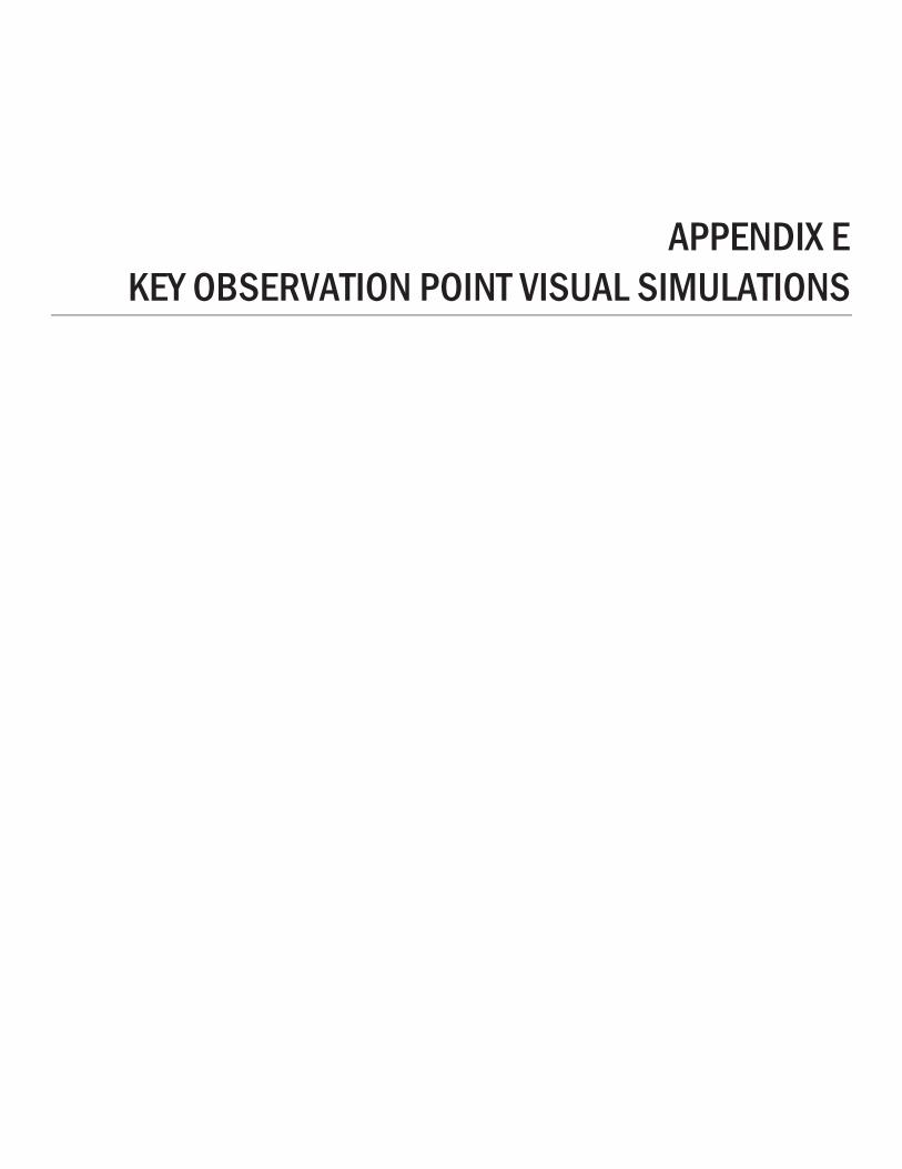
APPENDIX E KEY OBSERVATION POINT VISUAL SIMULATIONS

Appendix E. Key Observation Point Visual Simulations
U.S. Department of Energy August 2017
E-1
APPENDIX E. KEY OBSERVATION POINT (KOP) VISUAL SIMULATIONS
The visual simulations for 22 key observation points (KOPs) are presented here to represent how the Project might appear after approximately five growing seasons. Each KOP is identified by a code that is composed of two letters representing the town where the viewpoint is located and a number representing its location within the town. After the number, a sheet designated with the lower case “a” documents the viewpoint and simulation attributes. The sheets designated with a lower case “b,” “c,” “d,” or “e” show the existing visual condition and simulated condition for various action alternatives, as indicated. The KOPs are arranged alphabetically in this appendix and their locations are shown on Map E-1.
Additional information about the visual simulations and KOPs is available on the EIS website (http://www.northernpasseis.us/library/final-eis/visual-impact-assessment), and in the Visual Impact Assessment (http://www.northernpasseis.us/library/final-eis/technical-reports).
KOP selection. These 22 KOPs represent the geographic distribution and landscape diversity of views toward the Project. They were selected from 73 photographic simulations prepared for the visual impact assessment to represent impacted views from a range of distances and landscape contexts, with some emphasis placed on designated scenic resources. These viewpoints were selected from among more than a thousand viewpoints documented photographically and with systematic field observations during both leaf-on and leaf-off conditions. In general, the contrast of lattice structures with green leaf-on conditions is higher than with the grayer leaf-off conditions. However, when there is snow cover, the transmission route becomes more apparent from greater distances. Simulation photographs were selected to represent conditions with greater visual impact.
Limitations to simulation veracity. Simulations use the best available information as of October 2015 and represent the visual condition after approximately five growing seasons. If the Northern Pass Transmission Line Project specifications change, the visual conditions may be different.
Simulation viewing notes. The simulation is properly printed on an 11-by-17 inch sheet at actual size. If viewed on a computer monitor, use the highest screen resolution. The simulated image is at the proper perspective when viewed at 23.5 inches from the eye, or at a distance of approximately twice the image height.
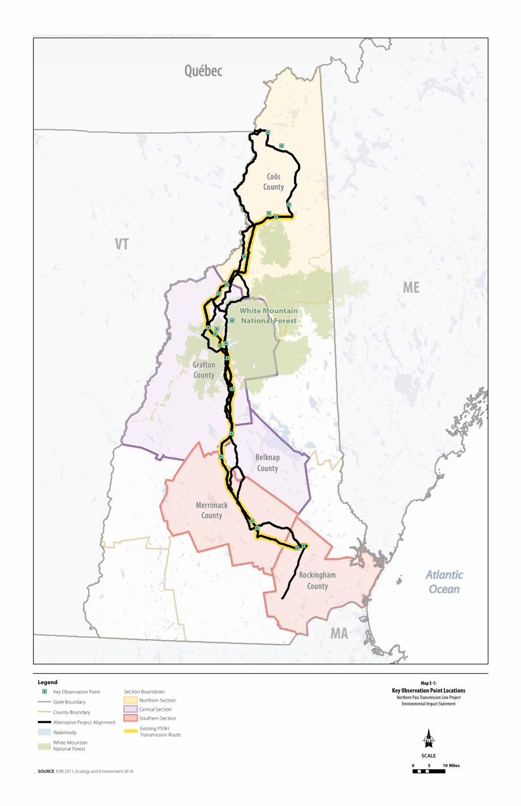
Path: M:\Washington\Northern_Pass\Maps\MXD\Alternatives\Ver13\11x17_Portrait_KOPs_Ver13_2017-05-30.mxd
SOURCE: ESRI 2011; Ecology and Environment 2014.
Legend Map E-1:Key Observation Point Locations
Northern Pass Transmission Line ProjectEnvironmental Impact Statement
SCALE
"/
"/
"/
"/
"/
"/
"/
"/
"/
"/
"/
"/
"/
"/
"/
"/
"/
"/
"/
"/
"/
"/
AtlanticOcean
White MountainNational Forest
BelknapCounty
CoösCounty
GraftonCounty
MerrimackCounty
RockinghamCounty
VT
MA
ME
Québec
0 5 10 Miles
"/ Key Observation Point
State Boundary
County Boundary
Alternative Project Alignment
Waterbody
White MountainNational Forest
Section Boundaries
Northern Section
Central Section
Southern Section
Existing PSNH Transmission Route

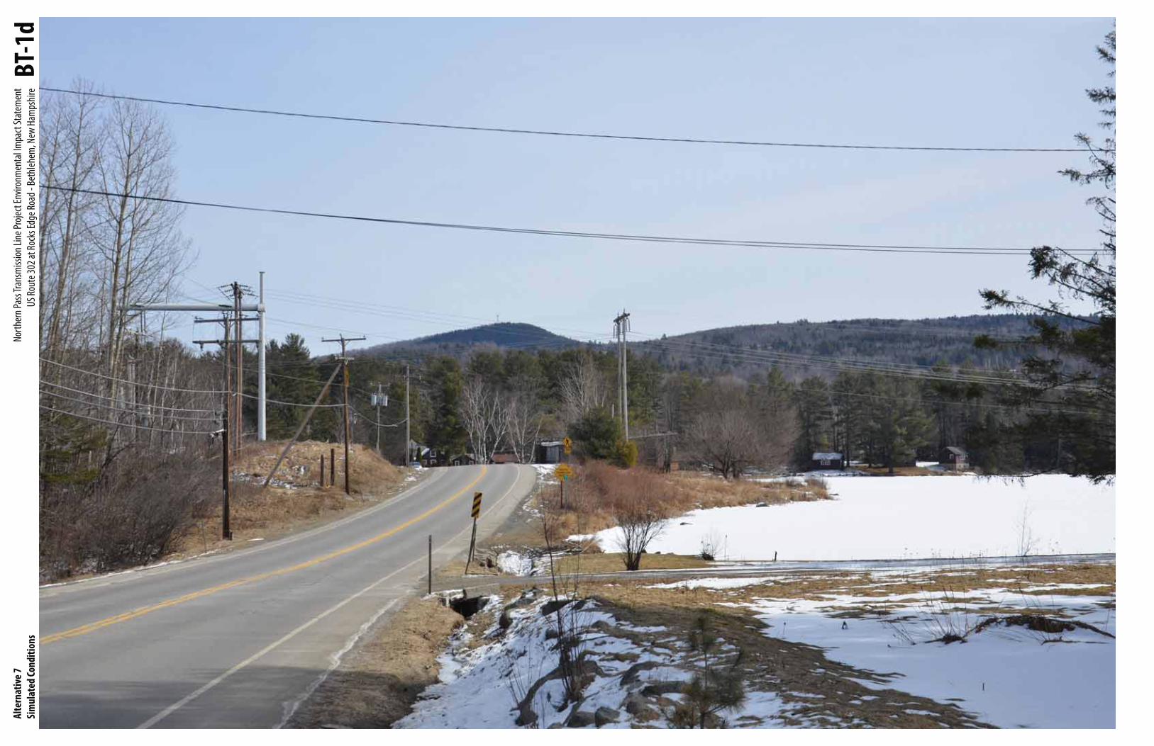
Base PhotographDate: 03-18-2013
Time: 1:29 pm
Meteorological Visibility:
Plymouth Airport - 10 miles
Image Size: 4,928 x 3,264 pixels
Camera Properties Camera Make/Model: Nikon D7000
Sensor Dimensions: 23.6 mm x 15.6 mm
Lens Make/Model: Nikkor DX AF-S 35 mm
Lens Focal Length: 35 mm
35 mm Equivalent Focal Length: 52.5 mm
Approximate Angles of View:
37° wide and 25° high
Camera Height: 1.5 meters (5 feet)
Viewpoint InformationLocation: US Route 302, Bethlehem
Latitude/Longitude: 44.282812°, -71.728359°
Viewpoint Elevation: 1,097 feet
Viewpoint Name: BT-1
Orientation: Looking East
Looking toward Alternative 2 Mile Markers: 80-81
Looking toward Alternative 7 Mile Markers: 80-81
Alternatives Simulated from this ViewpointAlternative 1 - No Action Transmission Line Information
Distance to Nearest Visible Structure: 579 feet
Number of Visible Existing Structures: 2
Alternative 2 Transmission Line Information
Distance to Nearest Visible Structure: 509 feet
Number of Visible Transmission Structures: 3
Alternative 3 Transmission Line Information
The transmission line is buried in this view and there is no
discernible visual change from the Existing Condition.
Alternatives 4a, 4b and 4c Transmission Line Information
The Project is not visible from this viewpoint.
Alternatives 5a, 5b and 5c Transmission Line Information
There is no visible change from Alternative 2.
Alternatives 6a and 6b Transmission Line Information
The Project is not visible from this viewpoint.
Alternative 7 - Proposed Action Transmission Line Information
Distance to Nearest Visible Structure: 686 feet
Number of Visible Transmission Structures: 3
General InformationSimulation Viewing NotesThe simulation is properly printed on an
11-by-17 inches sheet at actual size. If viewed
on a computer monitor, use the highest
screen resolution. The simulated image is
at the proper perspective when viewed at
23.5 inches from the eye, or at a distance of
approx. twice the image height.
Project Design The simulations for Alternative 2 through
6b are based on the best information
available in March 2014. The simulations
for Alternative 7 are based on the best
information available on October 2015.
Viewpoint BT-1aNorthern Pass Transmission Line Project Environmental Impact Statement
US Route 302 at Rocks Edge Road - Bethlehem, New Hampshire
BT-1

Alte
rnat
ives
1 , 3
, 4a,
4b, 4
c, 6a
and
6bEx
istin
g/Si
mul
ated
Cond
ition
sNo
rther
n Pas
s Tra
nsm
ission
Line
Proje
ct En
viron
men
tal Im
pact
Stat
emen
t U
S Rou
te 30
2 at R
ocks
Edge
Road
- Be
thleh
em, N
ew H
amps
hire
BT-1
b

Alte
rnat
ives 2
, 5a,
5b an
d 5c
Sim
ulat
ed Co
nditi
ons
North
ern P
ass T
rans
miss
ion Li
ne Pr
oject
Envir
onm
enta
l Impa
ct St
atem
ent
US Ro
ute 3
02 at
Rock
s Edg
e Roa
d - Be
thleh
em, N
ew H
amps
hire
BT-1
c
Alte
rnat
ive 7
Sim
ulat
ed Co
nditi
ons
North
ern P
ass T
rans
miss
ion Li
ne Pr
oject
Envir
onm
enta
l Impa
ct St
atem
ent
US R
oute
302 a
t Roc
ks Ed
ge Ro
ad -
Beth
lehem
, New
Ham
pshir
e BT
-1d

Base PhotographDate: 03-18-2013
Time: 2:00 pm
Meteorological Visibility:
Plymouth Airport - 10 miles
Image Size: 4,928 x 3,264 pixels
Camera Properties Camera Make/Model: Nikon D7000
Sensor Dimensions: 23.6 mm x 15.6 mm
Lens Make/Model: Nikkor DX AF-S 35 mm
Lens Focal Length: 35 mm
35 mm Equivalent Focal Length: 52.5 mm
Approximate Angles of View:
37° wide and 25° high
Camera Height: 1.5 meters (5 feet)
Viewpoint InformationLocation: Route 116, Bethlehem
Latitude/Longitude: 44.323242°, -71.678027°
Viewpoint Elevation: 1,015 feet
Viewpoint Name: BT-6
Orientation: Looking Northeast
Looking toward Alternative 2 Mile Markers: 76
Looking toward Alternative 7 Mile Markers: 76
Alternatives Simulated from this ViewpointAlternative 1 - No Action Transmission Line Information
Distance to Nearest Visible Structure: 101 feet
Number of Visible Existing Structures: 9
Alternative 2 Transmission Line Information
Distance to Nearest Visible Structure: 74 feet
Number of Visible Transmission Structures: 16
Alternative 3 Transmission Line Information
The transmission line is buried in this view and there is no
discernible visual change from the Existing Condition.
Alternatives 4a, 4b and 4c Transmission Line Information
The Project is not visible from this viewpoint.
Alternatives 5a, 5b and 5c Transmission Line Information
There is no visible change from Alternative 2.
Alternatives 6a and 6b Transmission Line Information
The Project is not visible from this viewpoint.
Alternative 7 - Proposed Action Transmission Line Information
Distance to Nearest Visible Structure: 101 feet
Number of Visible Transmission Structures: 15
General InformationSimulation Viewing NotesThe simulation is properly printed on an
11-by-17 inches sheet at actual size. If viewed
on a computer monitor, use the highest
screen resolution. The simulated image is
at the proper perspective when viewed at
23.5 inches from the eye, or at a distance of
approx. twice the image height.
Project Design The simulations for Alternative 2 through
6b are based on the best information
available in March 2014. The simulations
for Alternative 7 are based on the best
information available on October 2015.
Viewpoint BT-6aNorthern Pass Transmission Line Project Environmental Impact Statement
Route 116/Presidential Range Trail - Bethlehem, New Hampshire
BT-6

Alte
rnat
ives
1 , 3
, 4a,
4b, 4
c, 6a
and
6bEx
istin
g/Si
mul
ated
Cond
ition
sNo
rther
n Pas
s Tra
nsm
ission
Line
Proje
ct En
viron
men
tal Im
pact
Stat
emen
t Ro
ute 1
16/P
resid
entia
l Ran
ge Tr
ail -
Beth
lehem
, New
Ham
pshir
e BT
-6b

Alte
rnat
ives 2
, 5a,
5b an
d 5c
Sim
ulat
ed Co
nditi
ons
North
ern P
ass T
rans
miss
ion Li
ne Pr
oject
Envir
onm
enta
l Impa
ct St
atem
ent
Rout
e 116
/Pre
siden
tial R
ange
Trail
- Be
thleh
em, N
ew H
amps
hire
BT-6
c

Alte
rnat
ive 7
Sim
ulat
ed Co
nditi
ons
North
ern P
ass T
rans
miss
ion Li
ne Pr
oject
Envir
onm
enta
l Impa
ct St
atem
ent
Rout
e 116
/Pre
siden
tial R
ange
Trail
- Be
thleh
em, N
ew H
amps
hire
BT-6
d

Base PhotographDate: 11-14-2013
Time: 2:22 pm
Meteorological Visibility:
Plymouth Airport - 10 miles
Image Size: 4,928 x 3,264 pixels
Camera Properties Camera Make/Model: Nikon D7000
Sensor Dimensions: 23.6 mm x 15.6 mm
Lens Make/Model: Nikkor DX AF-S 35 mm
Lens Focal Length: 35 mm
35 mm Equivalent Focal Length: 52.5 mm
Approximate Angles of View:
37° wide and 25° high
Camera Height: 1.5 meters (5 feet)
Viewpoint InformationLocation: Vintinner Road at NH Route 49,
Campton
Latitude/Longitude: 43.8508092°, -71.643359°
Viewpoint Elevation: 591 feet
Viewpoint Name: CA-1
Orientation: Looking Northwest
Looking toward Alternative 2 Mile Marker: 117
Looking toward Alternative 7 Mile Marker: n/a
Alternatives Simulated from this ViewpointAlternative 1 - No Action Transmission Line Information
Distance to Nearest Visible Structure: 758 feet
Number of Visible Existing Structures: 4
Alternative 2 Transmission Line Information
Distance to Nearest Visible Structure: 694 feet
Number of Visible Transmission Structures: 12
Alternative 3 Transmission Line Information
The transmission line is buried in this view and there is no
discernible visual change from the Existing Condition.
Alternatives 4a, 4b and 4c Transmission Line Information
The Project is not visible from this viewpoint.
Alternatives 5a, 5b and 5c Transmission Line Information
There is no visible change from Alternative 2.
Alternatives 6a and 6b Transmission Line Information
The Project is not visible from this viewpoint.
Alternative 7 - Proposed Action Transmission Line Information
The Project is not visible from this viewpoint.
General InformationSimulation Viewing NotesThe simulation is properly printed on an
11-by-17 inches sheet at actual size. If viewed
on a computer monitor, use the highest
screen resolution. The simulated image is
at the proper perspective when viewed at
23.5 inches from the eye, or at a distance of
approx. twice the image height.
Project Design The simulations for Alternative 2 through
6b are based on the best information
available in March 2014. The simulations
for Alternative 7 are based on the best
information available on October 2015.
Viewpoint CA-1aNorthern Pass Transmission Line Project Environmental Impact Statement
Vintinner Road at NH Route 49 - Campton, New Hampshire
CA-1
Alte
rnat
ives
1, 3,
4a, 4
b, 4c
, 6a,
6b an
d 7
Exist
ing/
Sim
ulat
ed Co
nditi
ons
North
ern P
ass T
rans
miss
ion Li
ne Pr
oject
Envir
onm
enta
l Impa
ct St
atem
ent
Vitinn
er Ro
ad at
NH
Rout
e 49 -
Cam
pton
, New
Ham
pshir
e CA
-1b

Alte
rnat
ives 2
, 5a,
5b an
d 5c
Sim
ulat
ed Co
nditi
ons
North
ern P
ass T
rans
miss
ion Li
ne Pr
oject
Envir
onm
enta
l Impa
ct St
atem
ent
Vintin
ner R
oad a
t NH
Rout
e 49 -
Cam
pton
, New
Ham
pshir
e CA
-1c

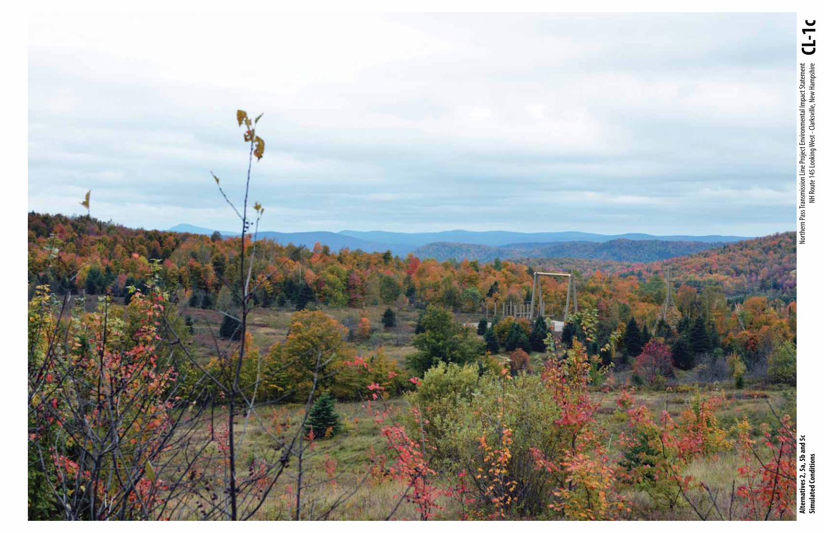
Base PhotographDate: 09-26-2013
Time: 3:13 pm
Meteorological Visibility:
Berlin Airport - 10 miles
Image Size: 4,928 x 3,264 pixels
Camera Properties Camera Make/Model: Nikon D7000
Sensor Dimensions: 23.6 mm x 15.6 mm
Lens Make/Model: Nikkor DX AF-S 35 mm
Lens Focal Length: 35 mm
35 mm Equivalent Focal Length: 52.5 mm
Approximate Angles of View:
37° wide and 25° high
Camera Height: 1.5 meters (5 feet)
Viewpoint InformationLocation: NH Route 145 Looking West, Clarksville
Latitude/Longitude: 45.009515°, -71.6415941°
Viewpoint Elevation: 1,937 feet
Viewpoint Name: CL-1
Orientation: Looking West
Looking toward Alternative 2 Mile Marker: 5
Looking toward Alternative 7 Mile Marker: 5
Alternatives Simulated from this ViewpointAlternative 1 - No Action Transmission Line Information
Distance to Nearest Visible Structure: 0 feet
Number of Visible Existing Structures: 0
Alternative 2 Transmission Line Information
Distance to Nearest Visible Structure: 1,450 feet
Number of Visible Transmission Structures: 5
Alternative 3 Transmission Line Information
The transmission line is buried in this view and vegetation clearing in the
ROW is discernible.
Alternatives 4a, 4b and 4c Transmission Line Information
The Project is not visible from this viewpoint.
Alternatives 5a, 5b and 5c Transmission Line Information
There is no visible change from Alternative 2.
Alternatives 6a and 6b Transmission Line Information
The Project is not visible from this viewpoint.
Alternative 7 - Proposed Action Transmission Line Information
Distance to Nearest Visible Structure: 1,450 feet
Number of Visible Transmission Structures: 5
General InformationSimulation Viewing NotesThe simulation is properly printed on an
11-by-17 inches sheet at actual size. If viewed
on a computer monitor, use the highest
screen resolution. The simulated image is
at the proper perspective when viewed at
23.5 inches from the eye, or at a distance of
approx. twice the image height.
Project Design The simulations for Alternative 2 through
6b are based on the best information
available in March 2014. The simulations
for Alternative 7 are based on the best
information available on October 2015.
Viewpoint CL-1aNorthern Pass Transmission Line Project Environmental Impact Statement
NH Route 145 Looking West - Clarksville, New Hampshire
CL-1Station

Alte
rnat
ives
1, 4a
, 4b,
4c, 6
a and
6b
Exist
ing/
Sim
ulat
ed Co
nditi
ons
North
ern P
ass T
rans
miss
ion Li
ne Pr
oject
Envir
onm
enta
l Impa
ct St
atem
ent
NH Ro
ute 1
45 Lo
oking
Wes
t - Cl
arks
ville,
New
Ham
pshir
e CL
-1b
Alte
rnat
ives 2
, 5a,
5b an
d 5c
Si
mul
ated
Cond
ition
sNo
rther
n Pas
s Tra
nsm
ission
Line
Proje
ct En
viron
men
tal Im
pact
Stat
emen
tNH
Rout
e 145
Look
ing W
est -
Clar
ksvil
le, N
ew H
amps
hire
CL-1
c

Alte
rnat
ive 3
Sim
ulat
ed Co
nditi
ons
North
ern P
ass T
rans
miss
ion Li
ne Pr
oject
Envir
onm
enta
l Impa
ct St
atem
ent
NH Ro
ute 1
45 Lo
oking
Wes
t - Cl
arks
ville,
New
Ham
pshir
e CL
-1d

Alte
rnat
ive 7
Sim
ulat
ed Co
nditi
ons
North
ern P
ass T
rans
miss
ion Li
ne Pr
oject
Envir
onm
enta
l Impa
ct St
atem
ent
NH Ro
ute 1
45 Lo
oking
Wes
t - Cl
arks
ville,
New
Ham
pshir
e CL
-1e

Base PhotographDate: 11-14-2013
Time: 10:06 am
Meteorological Visibility:
Concord Airport - 10 miles
Image Size: 4,928 x 3,264 pixels
Camera Properties Camera Make/Model: Nikon D7000
Sensor Dimensions: 23.6 mm x 15.6 mm
Lens Make/Model: Nikkor DX AF-S 35 mm
Lens Focal Length: 35 mm
35 mm Equivalent Focal Length: 52.5 mm
Approximate Angles of View:
37° wide and 25° high
Camera Height: 1.5 meters (5 feet)
Viewpoint InformationLocation: Loudon Road/NH Route 9, Concord
Latitude/Longitude: 43.224149°, -71.490034°
Viewpoint Elevation: 346 feet
Viewpoint Name: CO-1
Orientation: Looking South
Looking toward Alternative 2 Mile Marker: 168
Looking toward Alternative 7 Mile Marker: 173
Alternatives Simulated from this ViewpointAlternative 1 - No Action Transmission Line Information
Distance to Nearest Visible Structure: 737 feet
Number of Visible Existing Structures: 6
Alternative 2 Transmission Line Information
Distance to Nearest Visible Structure: 749 feet
Number of Visible Transmission Structures: 12
Alternative 3 Transmission Line Information
The transmission line is buried in this view and there is no
discernible visual change from the Existing Condition.
Alternatives 4a, 4b and 4c Transmission Line Information
The Project is not visible from this viewpoint.
Alternatives 5a, 5b and 5c Transmission Line Information
There is no visible change from Alternative 2.
Alternatives 6a and 6b Transmission Line Information
There is insufficient transmission line engineering to realistically simulate
how co-location would be implemented in this view.
Alternative 7 - Proposed Action Transmission Line Information
Distance to Nearest Visible Structure: 749 feet
Number of Visible Transmission Structures: 15
General InformationSimulation Viewing NotesThe simulation is properly printed on an
11-by-17 inches sheet at actual size. If viewed
on a computer monitor, use the highest
screen resolution. The simulated image is
at the proper perspective when viewed at
23.5 inches from the eye, or at a distance of
approx. twice the image height.
Project Design The simulations for Alternative 2 through
6b are based on the best information
available in March 2014. The simulations
for Alternative 7 are based on the best
information available on October 2015.
Viewpoint CO-1aNorthern Pass Transmission Line Project Environmental Impact Statement
Loudon Road/NH Route 9 - Concord, New Hampshire
CO-1

Alte
rnat
ives 1
, 3, 4
a, 4b
and
4cEx
istin
g/Si
mul
ated
Cond
ition
sNo
rther
n Pas
s Tra
nsm
ission
Line
Proje
ct En
viron
men
tal Im
pact
Stat
emen
tLo
udon
Road
/NH
Rout
e 9 -
Conc
ord,
New
Ham
pshir
e CO
-1b

Alte
rnat
ives 2
, 5a,
5b an
d 5c
Sim
ulat
ed Co
nditi
ons
North
ern P
ass T
rans
miss
ion Li
ne Pr
oject
Envir
onm
enta
l Impa
ct St
atem
ent
Loud
on Ro
ad/N
H Ro
ute 9
- Co
ncor
d, Ne
w Ha
mps
hire
CO-1
c

Alte
rnat
ive 7
Sim
ulat
ed Co
nditi
ons
North
ern P
ass T
rans
miss
ion Li
ne Pr
oject
Envir
onm
enta
l Impa
ct St
atem
ent
Loud
on Ro
ad/N
H Ro
ute 9
- Co
ncor
d, Ne
w Ha
mps
hire
CO-1
d
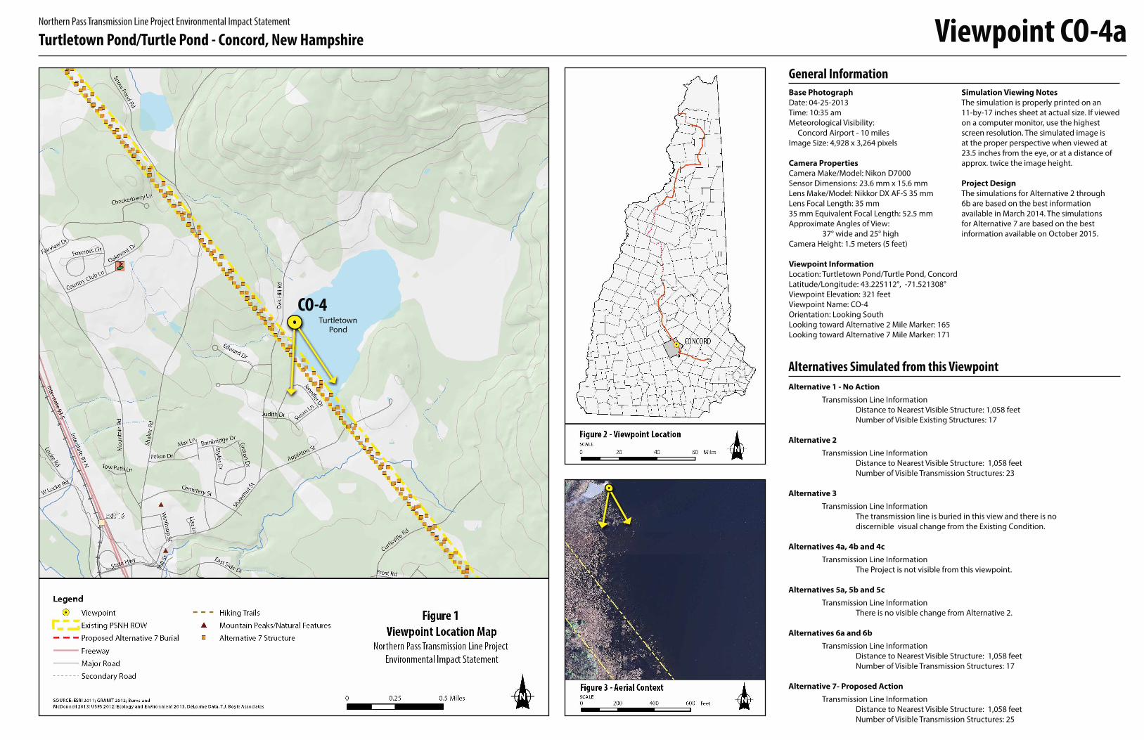
Base PhotographDate: 04-25-2013
Time: 10:35 am
Meteorological Visibility:
Concord Airport - 10 miles
Image Size: 4,928 x 3,264 pixels
Camera Properties Camera Make/Model: Nikon D7000
Sensor Dimensions: 23.6 mm x 15.6 mm
Lens Make/Model: Nikkor DX AF-S 35 mm
Lens Focal Length: 35 mm
35 mm Equivalent Focal Length: 52.5 mm
Approximate Angles of View:
37° wide and 25° high
Camera Height: 1.5 meters (5 feet)
Viewpoint InformationLocation: Turtletown Pond/Turtle Pond, Concord
Latitude/Longitude: 43.225112°, -71.521308°
Viewpoint Elevation: 321 feet
Viewpoint Name: CO-4
Orientation: Looking South
Looking toward Alternative 2 Mile Marker: 165
Looking toward Alternative 7 Mile Marker: 171
Alternatives Simulated from this ViewpointAlternative 1 - No Action Transmission Line Information
Distance to Nearest Visible Structure: 1,058 feet
Number of Visible Existing Structures: 17
Alternative 2 Transmission Line Information
Distance to Nearest Visible Structure: 1,058 feet
Number of Visible Transmission Structures: 23
Alternative 3 Transmission Line Information
The transmission line is buried in this view and there is no
discernible visual change from the Existing Condition.
Alternatives 4a, 4b and 4c Transmission Line Information
The Project is not visible from this viewpoint.
Alternatives 5a, 5b and 5c Transmission Line Information
There is no visible change from Alternative 2.
Alternatives 6a and 6b Transmission Line Information
Distance to Nearest Visible Structure: 1,058 feet
Number of Visible Transmission Structures: 17
Alternative 7- Proposed Action Transmission Line Information
Distance to Nearest Visible Structure: 1,058 feet
Number of Visible Transmission Structures: 25
General InformationSimulation Viewing NotesThe simulation is properly printed on an
11-by-17 inches sheet at actual size. If viewed
on a computer monitor, use the highest
screen resolution. The simulated image is
at the proper perspective when viewed at
23.5 inches from the eye, or at a distance of
approx. twice the image height.
Project Design The simulations for Alternative 2 through
6b are based on the best information
available in March 2014. The simulations
for Alternative 7 are based on the best
information available on October 2015.
Viewpoint CO-4aNorthern Pass Transmission Line Project Environmental Impact Statement
Turtletown Pond/Turtle Pond - Concord, New Hampshire
CO-4Turtletown
Pond

Alte
rnat
ives 1
, 3, 4
a, 4b
and
4cEx
istin
g/Si
mul
ated
Cond
ition
sNo
rther
n Pas
s Tra
nsm
ission
Line
Proje
ct En
viron
men
tal Im
pact
Stat
emen
tTu
rtlet
own P
ond/
Turtl
e Pon
d - Co
ncor
d, Ne
w Ha
mps
hire
CO-4
b

Alte
rnat
ives 2
, 5a,
5b an
d 5c
Sim
ulat
ed Co
nditi
ons
North
ern P
ass T
rans
miss
ion Li
ne Pr
oject
Envir
onm
enta
l Impa
ct St
atem
ent
Turtl
etow
n Pon
d/Tu
rtle P
ond -
Conc
ord,
New
Ham
pshir
e CO
-4c
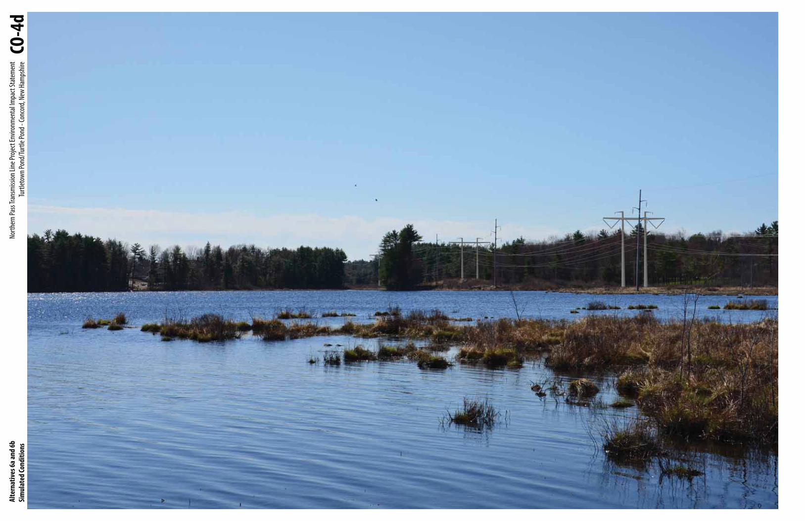
Alte
rnat
ives 6
a and
6bSi
mul
ated
Cond
ition
sNo
rther
n Pas
s Tra
nsm
ission
Line
Proje
ct En
viron
men
tal Im
pact
Stat
emen
tTu
rtlet
own P
ond/
Turtl
e Pon
d - Co
ncor
d, Ne
w Ha
mps
hire
CO-4
d

Alte
rnat
ive 7
Sim
ulat
ed Co
nditi
ons
North
ern P
ass T
rans
miss
ion Li
ne Pr
oject
Envir
onm
enta
l Impa
ct St
atem
ent
Turtl
etow
n Pon
d/Tu
rtle P
ond -
Conc
ord,
New
Ham
pshir
e CO
-4e
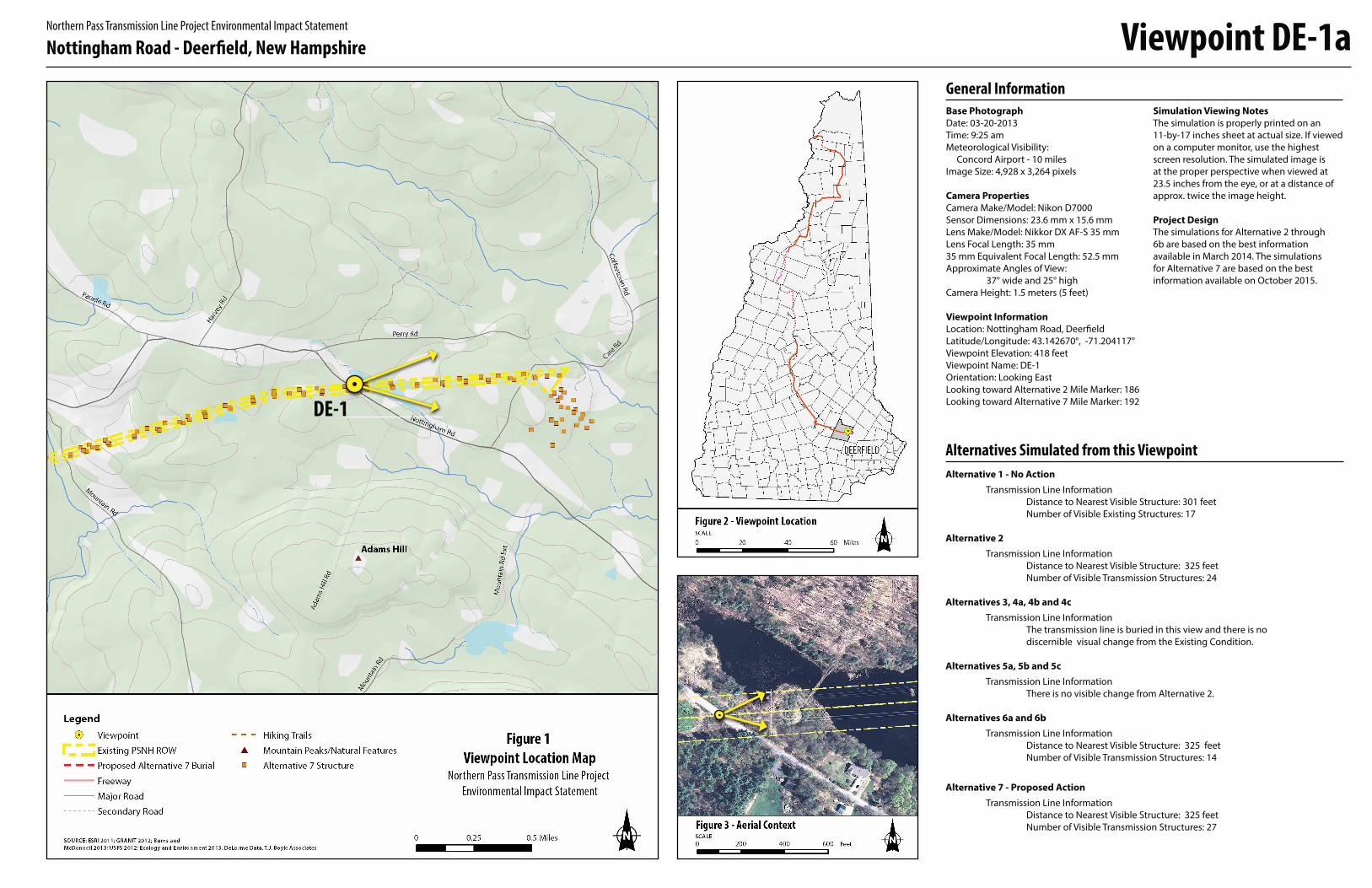
Base PhotographDate: 03-20-2013
Time: 9:25 am
Meteorological Visibility:
Concord Airport - 10 miles
Image Size: 4,928 x 3,264 pixels
Camera Properties Camera Make/Model: Nikon D7000
Sensor Dimensions: 23.6 mm x 15.6 mm
Lens Make/Model: Nikkor DX AF-S 35 mm
Lens Focal Length: 35 mm
35 mm Equivalent Focal Length: 52.5 mm
Approximate Angles of View:
37° wide and 25° high
Camera Height: 1.5 meters (5 feet)
Viewpoint InformationLocation: Nottingham Road, Deerfield
Latitude/Longitude: 43.142670°, -71.204117°
Viewpoint Elevation: 418 feet
Viewpoint Name: DE-1
Orientation: Looking East
Looking toward Alternative 2 Mile Marker: 186
Looking toward Alternative 7 Mile Marker: 192
Alternatives Simulated from this ViewpointAlternative 1 - No Action Transmission Line Information
Distance to Nearest Visible Structure: 301 feet
Number of Visible Existing Structures: 17
Alternative 2 Transmission Line Information
Distance to Nearest Visible Structure: 325 feet
Number of Visible Transmission Structures: 24
Alternatives 3, 4a, 4b and 4c Transmission Line Information
The transmission line is buried in this view and there is no
discernible visual change from the Existing Condition.
Alternatives 5a, 5b and 5c Transmission Line Information
There is no visible change from Alternative 2.
Alternatives 6a and 6b Transmission Line Information
Distance to Nearest Visible Structure: 325 feet
Number of Visible Transmission Structures: 14
Alternative 7 - Proposed Action Transmission Line Information
Distance to Nearest Visible Structure: 325 feet
Number of Visible Transmission Structures: 27
General InformationSimulation Viewing NotesThe simulation is properly printed on an
11-by-17 inches sheet at actual size. If viewed
on a computer monitor, use the highest
screen resolution. The simulated image is
at the proper perspective when viewed at
23.5 inches from the eye, or at a distance of
approx. twice the image height.
Project Design The simulations for Alternative 2 through
6b are based on the best information
available in March 2014. The simulations
for Alternative 7 are based on the best
information available on October 2015.
Viewpoint DE-1aNorthern Pass Transmission Line Project Environmental Impact Statement
Nottingham Road - Deerfield, New Hampshire
DE-1

Alte
rnat
ives 1
, 3, 4
a, 4b
and
4cEx
istin
g/Si
mul
ated
Cond
ition
sNo
rther
n Pas
s Tra
nsm
ission
Line
Proje
ct En
viron
men
tal Im
pact
Stat
emen
tNo
tting
ham
Road
- De
erfie
ld, N
ew H
amps
hire
DE-1
b

Alte
rnat
ives 2
, 5a,
5b an
d 5c
Sim
ulat
ed Co
nditi
ons
North
ern P
ass T
rans
miss
ion Li
ne Pr
oject
Envir
onm
enta
l Impa
ct St
atem
ent
Notti
ngha
m Ro
ad -
Deer
field,
New
Ham
pshir
e DE
-1c

Alte
rnat
ives 6
a and
6bSi
mul
ated
Cond
ition
sNo
rther
n Pas
s Tra
nsm
ission
Line
Proje
ct En
viron
men
tal Im
pact
Stat
emen
tNo
tting
ham
Road
- De
erfie
ld, N
ew H
amps
hire
DE-1
d

Alte
rnat
ive 7
Sim
ulat
ed Co
nditi
ons
North
ern P
ass T
rans
miss
ion Li
ne Pr
oject
Envir
onm
enta
l Impa
ct St
atem
ent
Notti
ngha
m Ro
ad -
Deer
field,
New
Ham
pshir
e DE
-1e