Embed Size (px)
Citation preview
. ,fS + 1*‘ 69
Final Report for m3 NASA Contract NAGW-1183
Entitled
MINERALOGY AND COMPOSITION OF ARCHEAN CRUST, GREENLAND: A PILOT STUDY
Principal Investigator: Alexander F. H. Goetz Professor and Director Center for the Study of Earth from Space (CSES)/CIRES Campus Box 449 University of Colorado Boulder, CO 80309-0449 Telephone: (303) 492-5086
Co-Inves tigator: Brian Curtiss Research Associate, CIRES Campus Box 449 University of Colorado Boulder, CO 80309-0449 Telephone: (303) 492-6718
Brian Curtiss P- T ~ x r n r e ; n ~ f n r
(BASA-CE-182859) H l b l E R A L O G Y A A C CCIIPOSI!IION N89-15480 CE BBCPEdN C t i C S I , G R E E L L A I D : 1 EIlCT STUOY I i n a l fiegort (Cclczradc Univ.) 13 KSCL 0 8 G
Unclas G3/46 0 1854EC
i
V Principal Investigator
https://ntrs.nasa.gov/search.jsp?R=19890006109 2018-11-24T02:32:51+00:00Z

Summarv
The Portable Instant Display and Analysis Spectrometer (PIDAS) (Goetz et al.,
1987) was taken to southwestern Greenland to investigate in situ the potential
application of AVIRIS to estimate the mineralogy and composition of rocks exposed
in Archean terranes. The goal was to determine the feasibility of using a high
spectral resolution scanner to find and study pristine rocks, those that have not been
altered by subsequent deformatior: and metamorphism. The application of AVIRIS
data to the problems in Greenland is logical. However, before a costly deployment
of the U-2 aircraft to Greenland is proposed, this study was undertaken to acquire
the spectral data necessary to verify that mineralogical mapping in the
environmental conditions found there is possible.
Although field conditions were far from favorable, all of the major objectives
of the study were addressed. One of the major concerns was that lichens would
obscure the rock surfaces. While lichens do cover a high percentage of many of the
rock outcrops, it was found that the spectral signature of the lichens was distinct
from the underlying rocks. Thus, a spectrum of a rock outcrop, with its partial cover
of lichens, can be un-mixed into rock and lichen components. The data acquired
during the course of this study supports the conclusion that areas of pristine
Archean crust can be differentiated from that which has experienced low grade
alteration associated with Proterizoic faulting. It was initially thought that high soil
moisture would hinder the usage of remote sensing. In almost all cases it was
found that wet areas occurred in areas covered by ice rafted material. Because the
mineralogical composition of this material gives no insight into the geology of the
bedrock, the increased soil moisture in these areas is of .little concern. Because these
materials have no relationship to the underlying bedrock, the differentiation of this

glacial float from the bedrock is one of the major problems that must be addressed
prior to the deployment of AVIRIS in Greenland.
Introduction
Areas of preserved Archean crust provide windows into the Earth's earliest
recorded geologic history. On the other hand, Archean terranes are complex, and
the original disposition and composition of their rock units have commonly been
modified by deformation and metamorphism. Therefore, a detailed inventory of
the mineral assemblages and chemistry present in these rocks is an initial constraint
essential to unraveling crustal history. The terrane is extensive and difficult to
traverse. The Airborne Visible Infrared Radiometer Imaging Spectrometer
(AVIRIS) and The Thermal Infrared Multispectral Scanner (TIMS) are instruments
that provide high enough spectral and spatial resolution to make possible the direct
identification of minerals present in exposed rocks, under favorable conditions,
allowing rapid estimation of rock mineralogy from which compositions can be
inferred over broad areas. This study was undertaken to determine if adequate
information can be acquired from reflectance spectra of outcrops which, in some
cases, are lichen covered and/or water saturated.
The Portable Instant Display and Analysis Spectrometer (PIDAS) (Goetz et al.,
1987) was used to investigate in situ the potential application of AVIRIS to estimate
the mineralogy and composition of rocks exposed in Archean terranes. Greenland
is an unique area because the 3600-3700 Ma white and grey Amitsoq gneisses and the
3800 Ma Isua supracrustral belt are the most extensive exposures known of earliest
Archean rocks (Baadsgaard et al., 1986). In addition, although deformation is
responsible for the predominance of strongly banded Amitsoq gneisses, the least
deformed Amitsoq gneisses are reported to be among the best preserved of early
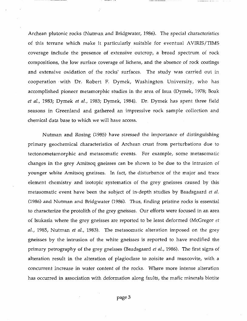
Archean plutonic rocks (Nutman and Bridgwater, 1986). The special characteristics
of this terrane which make it particularly suitable for eventual AVIRIS/TIMS
coverage include the presence of extensive outcrop, a broad spectrum of rock
compositions, the low surface coverage of lichens, and the absence of rock coatings
and extensive oxidation of the rocks' surfaces. The study was carried out in
cooperation with Dr. Robert F. Dymek, Washington University, who has
accomplished pioneer metamorphic studies in the area of Isua (Dymek, 1978; Boak
et al., 1983; Dymek et al., 1983; Dymek, 1984). Dr. Dymek has spent three field
seasons in Greenland and gathered an impressive rock sample collection and
chemical data base to which we will have access.
Nutman and Rosing (1985) have stressed the importance of distinguishing
primary geochemical characteristics of Archean crust from perturbations due to
tectonometamorphic and metasomatic events. For example, some metasomatic
changes in the grey Amitsoq gneisses can be shown to be due to the intrusion of
younger white Amitsoq gneisses. In fact, the disturbance of the major and trace
element chemistry and isotopic systematics of the grey gneisses caused by this
metasomatic event have been the subject of in-depth studies by Baadsgaard et a!.
(1986) and Nutman and Bridgwater (1986). Thus, finding pristine rocks is essential
to characterize the protolith of the grey gneisses. Our efforts were focused in an area
of Isukasia where the grey gneisses are reported to be least deformed (McGregor ef
al., 1985, Nutman et al., 1983). The metasomatic alteration imposed on the grey
gneisses by the intrusion of the white gneisses is reported to have modified the
primary petrography of the grey gneisses (Baadsgaard et al., 1986). The first signs of
alteration result in the alteration of plagioclase to zoisite and muscovite, with a
concurrent increase in water content of the rocks. Wh-ere more intense alteration
has occurred in association with deformation along faults, the mafic minerals biotite

and hornblende are altered to phengite and chlorite, while plagioclase is converted
to zoisite, phengite, quartz and carbonate. If it can be demonstrated that these
mineralogical changes are detectable spectrally, it may be possible to guide the field
geologist to areas where more adequate sampling can be accomplished. In other
words, AVIRIS/TIMS data might be used to "forage for pristine Archean crust," Le.,
the data would be used to pick out candidate pristine zones for further detailed field
and laboratory work.
Fieldwork
The primary objective of the fieldwork in the Isua area was to evaluate the
feasibility of using remote sensing data to solve a broad range of geologic problems.
This was accomplished by observing the amount of bedrock exposure, the extent to
which lichen obscured the various rock units, the amount of vegetation cover and
the spectral contrast between units. Our group (B. Curtiss (CU), B. Rivard (WU) )
joined Dr. Dymek's expedition and spent seven days in the eastern part of the Isua
supracrustal belt followed by eight days in the south-west extremity of the belt.
Initial work in the eastern part of the belt consisted of elaborating a rock and
vegetation classification scheme which was then used for the description of surfaces
on which spectral measurements were acquired. Reflectance measurements in the
450 nm to 2500 nm region of the spectrum were measured using the Portable
Instantaneous Display and Analysis Spectrometer, (PIDAS). Because of poor
weather conditions during these seven days, spectral data was acquired on only two
days.
Reflectance spectra and samples were obtained for the two upper members of
sequence B supracrustals, the felsic gneiss and garnet-biotite schists. Three transects
approximately 100 meters in length, and 30 meters apart, were laid out

perpendicular to the strike of these units. Reflectance spectra were measured at
approximately 5 meter intervals along each transect. A wide variety of surfaces,
including unvegetated weathered rock surfaces, weathered rock surfaces with
variable lichen covers, and wet rock surfaces were included. Additionally, field
reflectance spectra and samples were obtained for a wide range of boulder lithologies
and lichen types. While the weather did not permit the use of PIDAS to make
additional field spectral measurements, samples of the various lithologic units,
including the garbenschiefer and carbonate units, were collected.
The second camp site was located in the western segment of the Isukasia belt
in the vicinity of the sequence A type section. Once again, poor weather conditions
limited the days during which PIDAS data could be acquired. Because the poor
weather conditions did not allow the measurement of the reflectance spectra in the
field, samples were collected along the sequence A type section of the supracrustal
rocks (Nutman 1984). PIDAS reflectance measurements were made at a series of
sites located in the vicinity of the proterizoic Ataneq fault. These data were used to
examine the spectral changes associated with alteration along the fault.
Sky conditions and performance of the field spectrometer during the course
of the fieldwork were far worse than anticipated. There was one day of clear blue
skies, and three half days with some clouds. Additionally, many problems were
encountered in the operation of PIDAS under the environmental conditions found
in Greenland. These problems include IR spectrometer gains that were optimized
for mid-latitude summers, IR spectrometer grating drives that did not properly step
the gratings when the instrument was cold, and drift in the visible spectrometer
dark current. One of the major problems was associated with the thermoelectric
"coolers" mounted on each of the detector arrays. These coolers are intended to
provide temperature stabilization for the detectors. To maximize battery life and

because warm climates were assumed, the thermostats on the T.E.C.s were set to
about 23OC. Thus, when the ambient temperature is less than 23OC (as it was the
majority of the time in Greenland), the T.E. coolers are actually heating the detector
arrays. Because of the erratic nature of the T.E.C.s in heating mode, the signal /
noise under these conditions is about half of normal.
While the overall quality of the reflectance data acquired in the field was low,
it was sufficient to accomplish several of the objectives of the study. In many cases,
samples were collected in the field to assure that adequate reflectance measurements
could later be made in the laboratory. Additional reflectance measurements of rock
surfaces, both lichen covered and lichen free, were made in the laboratory using
PIDAS on return from Greenland.
Results
The presence of extensive lichen cover is one of the major problems that
must be addressed prior to the application of remote sensing to geological mapping
in Greenland. While lichen cover is pervasive in the coastal regions, the areas
closer to the ice sheet typically have only ten to fifty percent of the surface covered by
lichen. Laboratory reflectance measurements of lichen free (Figure l a and b) and
lichen covered regions (Figure 2a and b) of the same sample confirm that the
various forms of lichens all have a similar spectral shape in the short wave infrared
portion of the spectrum. While the rock substrate cannot be seen through the
lichen cover, the spectrum of the lichens is sufficiently distinct from any of the rock
spectra. Thus, the mixed signature of a partially lichen covered outcrop could be
unmixed into "rock" and "lichen" components.
The presence of moisture in surface soils regolith was determined to be of
minor consequence. All of the observed rock outcroppings were found to have very

600 600 1000 3200 1400 1600 IS00 2000 2200 2430 WAVELENGTH ( nm )
Figure la . Reflectance spectra of lichen free surfaces of the same samples shown in Figure 1. Samples IS40 and IS11 are both from the Garbenschiefer unit of the Isua supracrustal belt; sample RG47, a pegmatite, is an example of ice rafted material. As can be seem from a comparison to Figure 2, the presence of the lichen totally obscures the absorption features seen in these reflectance spectra. The spectra have been offset vertically for better viewing.
I I I I I
I- 1
I I I I I I I I I I I
2000 2200 2-100 1400 1G00 1800 WAVELENGTH ( i m ) ' - -
Figure lb. This figure shows the detail in the short wave infrared of the spectra show in Figure la. The spectra have been offset vertically for better viewing.
Page 7

.3
-,/(encrusting) -
I I I I I , I 1 l I I # / , I I I I
\YAVELENGTl-I ( 11111 )
Reflectance spectra of five lichen covered surfaces, sample numbers are noted on each spectrum. These spectra are representative of the four dominant type of lichen found in the Isua area: yellow, black, grey, and encrusting black. While there are slight differences in the visible region of the spectrum, the spectra are almost identical in the short wave infrared region.
600 800 7000 1200 1400 1600 i sm 2000 2200 2400
Figure 2a.
h
t 1 I I I I I , I I I
1400 1 600 1600 2000 2200 2400 WAVELENGTH ( 11111 )
Figure 2b. This figure shows the detail in the short wave infrared of the spectra show in Figure 2a. The three absorption features in thie 2100 - 2300 nm region are probably due to the presence of cellulose in the lichens. The spectra have been offset vertically for better viewing.

low porosity, and thus do not hold moisture for an appreciable period of time.
Those surfaces which were found to be wet were most often comprised of glacially
deposited material. While the reduction in the spectral contrast of these materials
resulting from surface moisture will hinder the spectral determination of their
mineralogy, these materials are totally unrelated to the underlying bedrock.
The ability to differentiate glacially deposited materials from bedrock outcrops
will be essential to the interpretation of any remotely sensed dataset. The surface
textures of these glacially deposited units is quite distinct from the bedrock
outcroppings. The outcroppings are topographically higher and tend to form broad
smooth surfaces without much small scale shadowing, while the glacial units
consist of close packed rounded boulders ( 0.5 - 2 meters in diameter) and have
considerably more small scale shadowing. The use of mixing models that utilize
shade as a component and a classification scheme that uses the spatial variation in
shading should provide a means to differentiate these two types of surfaces.
Reflectance spectra of outcroppings of the grey Amitsoq gneisses were
measured along a transect perpendicular to the Proterizoic Ataneq fault zone to
determine the spectral changes associated with low grade alteration which occurs
along the Ataneq and similar Proterizoic faults throughout Greenland. While the
quality of the reflectance spectra was low, the relative intensities of the absorption
features in the 2000 - 25000 nanometer region of the spectrum change as a function
of the distance form the fault (see Figures 3 and 4). The absorption feature at 2220
nm is indicative of muscovite and the feature at 2350 nm is consistant with the
presence of chlorite. The presence of muscovite in these rocks is indicative of the
first stages of alteration. The formation of chlorite is a result of more intense
alteration, commomly found in association with deformation along faults.

.
m 2 0.3- 0 Lo
0 -
I I I I
page 10

c
Recommendations
Reflectance spectra acquired in both the field and in the laboratory support the
conclusion that a high spectral resolution scanner, such as AVIRIS, would provide a
useful tool in the mapping of bedrock lithologies in southwest Greenland. The
problems introduced by extensive lichen cover and by the presence of large regions
of glacially deposited material can be overcome through the use of sophisticated
image processing techniques such as mixed signature modeling and texture analysis.
While lichen cover in the Isua region is relatively low, other areas in Greenland, in
particular the coastal regions, have much higher coverage. Traditional sensors,
such as Thematic Mapper, should be used to asses the degree of lichen cover prior to
the planning stage of a full scale deployment of AVIRIS.
References cited
Baadsgaard, H., A. P. Nutman, and D. Bridgwater, 1986. Geochronology and isotopic variation of the early Archean Amitsoq gneisses of the Isukasia area, southern West Greenland. Geochem Cosmochem Acta, 50, 2173-2183.
Boak, J. L., R. F. Dymek, and L. P. Gromet, 1983. Petrology and rare earth element geochemistry of classic metasedimentary rocks from the Isua supracrustal belt, West Greenland, Rapp.. Gronlands geol. Unders. 112, 23-33.
Dymek, R. F., 1978. Metamorphism of the Archean Malene supracrustals, Gothab District, West Greenland, Proc. 1978 Archean Geochem. Conf., edited by E. M. Smith and J. G. Williams, pp. 339-342, University of Toledo Press.
Dymek, R. F., 1984. Supracrustal rocks, polymetamorphism, and evolution of the SW Greenland Archean gneiss complex, in Patterns of Change in Earth Evolution, edited by H. D. Holland and A. F. Trendall, pp. 313-343, Springer- Verlag, Berlin.
Dymek, R. F., R. Weed, and L. P. Gromet, 1983. The Malene metasedimentary rocks on Rypeo, and their relationship to Amitsoq gneisses, Gronl. Geol. Unders. Rapp., 53-69.
Goetz, A. F. H., N. Page, and B. Curtiss, A high-resolution, self- contained reflectance spectrometer for field use, Applied Optics, in preparation.
page 11

McGregor, V. R., A. P. Nutman, and C. R. L. Friend, 1985. The Archean geology of the Godthabsford region, southern West Greenland, in Workshop on Early crustal genesis: the world's oldest rocks, LPI Techn. Rep. 86-04, pp. 113-169.
Nutman, A. P. and M. Rosing, 1985. Isukasia area-Regional geological setting, in Workshop on Early crustal genesis: the world's oldest rocks, LPI Techn. Rep. 85-04, pp. 171-18.
Nutman, A. P. and D. Bridgwater, 1986. Early Archean Amitsoq tonalities and granites of the Isukasia area, southern West Greenland: development of the oldest-known sial. Contr Mineral Petrol 94, 137-148.
page 12