Embed Size (px)
Citation preview
Final Scoping Report
THE PROPOSED DEVELOPMENT OF A NEW LANDFILL DISPOSAL SITE IN
MTHATHA, LOCATED NEAR QWEQWE VILLAGE, KING SABATA DALINDYEBO
MUNICIPALITY, EASTERN CAPE
14 April 2014
EIA Reference: OR/B/10/002/13

P:\01 TERRATEST\3249 - EIA for Mthatha Landfill Site - SB\07 REPORTS\FSR
April 2014
Page 2 of 123
FINAL SCOPING REPORT FOR THE PROPOSED MTHATHA
LANDFILL SITE, QWEQWE, KING SABATA DALINDYEBO
MUNICIPALITY, EASTERN CAPE
JEFFARES AND GREEN NO:
3249
DATE:
14 April 2014
REPORT STATUS:
Final
CARRIED OUT BY:
Jeffares and Green (Pty) Ltd
PO Box 27308
Greenacres
6057
Phone: (041) 363 1900
Fax: (041) 363 1922
COMMISSIONED BY:
Ikamva Consulting
PO Box 1217
Mthatha
5099
Phone: (047) 531 4044
Fax: 086 626 8914
AUTHOR:
Sarah Baxter
CLIENT CONTACT PERSON:
Thando Khesa
SYNOPSIS:
Final Scoping Report as part of the Environmental Authorisation and Waste License Application process for
the proposed new Mthatha Landfill Site, located near Qweqwe Village, King Sabata Dalindyebo Municipality,
Eastern Cape
KEY WORDS:
LANDFILL SITE, ENVIRONMENTAL AUTHORISATION, WASTE LICENSE APPLICATION, QWEQWE
VILLAGE, KING SABATA DALINDYEBO MUNICIPALITY, EASTERN CAPE
© COPYRIGHT: Jeffares and Green (Pty) Ltd.
QUALITY VERIFICATION:
This report has been prepared under the controls established by a quality management system that meets the requirements of ISO9001: 2008 which has been independently certified by DEKRA Certification under certificate number 90906882
Verification Capacity Name Signature Date
By Author Environmental
Scientist Sarah Baxter
11/04/2014
Checked by Executive Associate Magnus van
Rooyen
11/04/2014
Final Scoping Report Jeffares and Green (Pty) Ltd
P:\01 TERRATEST\3249 - EIA for Mthatha Landfill Site - SB\07 REPORTS\FSR
April 2014
Page 3 of 123
EXECUTIVE SUMMARY
The King Sabata Dalindyebo (KSD) Local Municipality has identified a need to establish a
new landfill site for the disposal of general wastes generated within the town of Mthatha and
its surrounds. The Municipality identified a 45 ha site under the jurisdiction of the Qweqwe
Traditional Authority as the preferred site for the proposed development. The proposed
landfill site would comprise a GMB+ site and would have the capacity to service the KSD
Municipality for the next 20 years.
Jeffares and Green (Pty) Ltd were appointed by Ikamva Consulting (the Project Managers,
on behalf of KSD Municipality) to undertake the necessary Environmental Authorisation (EA)
and Waste License Application process for the proposed development.
The proposed application has been undertaken in terms of Section 24 (5) of the National
Environmental Management Act, 1998 (NEMA - Act No. 107 of 1998) as part of an
Application for Environmental Authorisation, and a Waste Licence Application under the
National Environmental Management: Waste Act (NEM:WA) 2008 (Act No. 59 of 2008). The
proposed development triggers activities listed under GN R544 and R545 of the NEMA EIA
Regulations (2010) as well as Categories A and B of GN 921 of the NEM:WA. The proposed
development therefore requires a Scoping and Environmental Impact Assessment and
Waste License Application process to be conducted. The Competent Authority is the Eastern
Cape Department of Economic Development, Environmental Affairs and Tourism (DEDEAT).
The investigation, assessment and statement of the potential impacts of activities in this
Draft Scoping Report has followed the procedure as described in Regulations 26 to 35 of GN
R543 of the Environmental Impact Assessment Regulations, 2010.
The aim of the Environmental Scoping Phase is to provide information regarding the current
environmental, social and possible economic conditions on the site and to provide
information regarding the type and extent of the potential impacts resulting from the
proposed project. The identification of potential impacts has been undertaken in conjunction
with stakeholder and public involvement through a Public Participation Process.
A number of impacts associated with the proposed development have been identified
through the Scoping Phase. These will be investigated in more detail and mitigation
measures will be recommended in the EIA Phase. No fatal flaws have been identified.

Final Scoping Report Jeffares and Green (Pty) Ltd
P:\01 TERRATEST\3249 - EIA for Mthatha Landfill Site - SB\07 REPORTS\FSR
April 2014
Page 4 of 123
As per the requirements of Regulation 25 to 35 of GN R543, this Scoping Report contains
the following information:
A description of the proposed development;
A description of feasible and reasonable alternatives that have been identified. This
includes a description of the advantages and disadvantages that the proposed
development and its alternatives will have for the environment and the local
community;
A description of the property proposed for development;
A description of the environment that may be affected by the activity as well as the
manner in which the activity may be affected by the environment;
A description of environmental issues and potential impacts, including cumulative
impacts, that have been identified;
Details of the Public Participation Process;
Details of the need and desirability of the project; and
A Plan of Study for the EIA phase, setting out the proposed approach to impact
assessment.

Final Scoping Report Jeffares and Green (Pty) Ltd
P:\01 TERRATEST\3249 - EIA for Mthatha Landfill Site - SB\07 REPORTS\FSR
April 2014
Page 5 of 123
ACRONYMS AND ABBREVIATIONS
BID Background Information Document
CBO Community Based Organization
DEA Department of Environmental Affairs
DEDEAT Department of Economic Development, Environmental Affairs and
Tourism
DWA Department of Water Affairs
EAP Environmental Assessment Practitioner
EIA Environmental Impact Assessment
EMF Environmental Management Framework
EMPr Environmental Management Programme
GN Government Notice
HIA Heritage Impact Assessment
IAP Interested and Affected Party
IDP Integrated Development Plan
MEC Member of the Executive Council
NEMA National Environmental Management Act
NEM:WA National Environmental Management Waste Act
SDF Strategic Development Framework
WMA Waste Management Activity
WML Waste Management License
Final Scoping Report Jeffares and Green (Pty) Ltd
P:\01 TERRATEST\3249 - EIA for Mthatha Landfill Site - SB\07 REPORTS\FSR
April 2014
Page 6 of 123
DEFINITIONS
The National Environmental Management Act (NEMA) and the National Environmental
Management Waste Act (NEM:WA) provide definitions which are pertinent to the
management of waste.
“activity” means an activity identified in any notice published by the Minister or MEC in
terms of section 24D(1)(a) of the Act as a listed activity or specified activity;
“best practicable environmental option” means the option that provides the most benefit
or causes the least damage to the environment as a whole, at a cost acceptable to society,
in the long term as well as in the short term;
“commence” means the start of any physical activity on the site in furtherance of a listed
activity;
“community” means any group of persons or a part of such a group who share common
interests, and who regard themselves as a community;
‘‘constitution’’ means the Constitution of the Republic of South Africa, 1996;
‘‘container’’ means a disposable or re-usable vessel in which waste is placed for the
purposes of storing, accumulating, handling, transporting, treating or disposing of that waste,
and includes bins, bin-liners and skips
“cumulative impact”, in relation to an activity, means the impact of an activity that in itself
may not be significant, but may become significant when added to the existing and potential
impacts eventuating from similar or diverse activities or undertakings in the area;
‘‘disposal’’ means the burial, deposit, discharge, abandoning, dumping, placing or release
of any waste into, or onto, any land;
“EAP” means an environmental assessment practitioner as defined in section 1 of the Act;
“environment” means the surroundings within which humans exist and that are made up of:
(i) the land, water and atmosphere of the earth;
(ii) micro-organisms, plant and animal life;
(iii) any part or combination of (i) and (ii) and the interrelationships among and
between them; and
(iv) the physical, chemical, aesthetic and cultural properties and conditions of the
foregoing that influence human health and wellbeing.

Final Scoping Report Jeffares and Green (Pty) Ltd
P:\01 TERRATEST\3249 - EIA for Mthatha Landfill Site - SB\07 REPORTS\FSR
April 2014
Page 7 of 123
“environmental authorization”, means the authorization by a competent authority of a
listed activity in terms of this NEMA;
“environmental impact assessment”, means a systematic process of identifying,
assessing and reporting environmental impacts associated with an activity and includes
basic assessment and S&EIR;
‘‘environmentally sound management’’ means the taking of all practicable steps to ensure
that waste is managed in a manner that will protect health and the environment;
‘‘general waste’’ means waste that does not pose an immediate hazard or threat to health
or to the environment, and includes:
(a) domestic waste;
(b) building and demolition waste;
(c) business waste; and
(d) inert waste;
hazardous waste’’ means any waste that contains organic or inorganic elements or
compounds that may, owing to the inherent physical, chemical or toxicological
characteristics of that waste, have a detrimental impact on health and the environment;
‘‘high-risk activity’’ means an undertaking, including processes involving substances that
present a likelihood of harm to health or the environment;
‘‘holder of waste’’ means any person who imports, generates, stores, accumulates,
transports, processes, treats, or exports waste or disposes of waste;
“independent”, in relation to an EAP or a person compiling a specialist report or
undertaking a specialised process or appointed as a member of an appeal panel, means—
(a) that such EAP or person has no business, financial, personal or other interest in
the activity, application or appeal in respect of which that EAP or person is appointed
in terms of these Regulations other than fair remuneration for work performed in
connection with that activity, application or appeal; or
(b) that there are no circumstances that may compromise the objectivity of that EAP
or person in performing such work;
‘‘inert waste’’ means waste that:
(a) does not undergo any significant physical, chemical or biological transformation
after disposal;
(b) does not burn, react physically or chemically biodegrade or otherwise adversely
affect any other matter or environment with which it may come into contact; and
(c) does not impact negatively on the environment, because of its pollutant content
and because the toxicity of its leachate is insignificant;

Final Scoping Report Jeffares and Green (Pty) Ltd
P:\01 TERRATEST\3249 - EIA for Mthatha Landfill Site - SB\07 REPORTS\FSR
April 2014
Page 8 of 123
“listed activity”, means an activity identified in terms of section 24(2)(a) and (d) of the
NEMA;
plan of study for environmental impact assessment” means a document contemplated
in [regulation 28(1)(l)] regulation 28(1)(n), which forms part of a scoping report and sets out
how an environmental impact assessment must be conducted;
“pollution” means any change in the environment caused by -
(i) substances;
(ii) radioactive or other waves; or
(iii) noise, odours, dust or heat,
emitted from any activity, including the storage or treatment of waste or substances,
construction and the provision of services, whether engaged in by any person or an organ of
state, where that change has an adverse effect on human health or wellbeing or on the
composition, resilience and productivity of natural or managed ecosystems, or on materials
useful to people, or will have such an effect in the future.
‘‘priority waste’’ means a waste declared to be a priority waste in terms of section 14 of the
NEM:WA
“registered interested and affected party”, in relation to an application, means an
interested and affected party whose name is recorded in the register opened for that
application in terms of regulation 55;
“significant impact” means an impact that by its magnitude, duration, intensity or
probability of occurrence may have a notable effect on one or more aspects of the
environment;
“specialised process” means a process to obtain information which—
(a) is not readily available without undertaking the process; and
(b) is necessary for informing an assessment or evaluation of the impacts of an
activity, and includes risk assessment and cost benefit analysis;
“state department” means any department or administration in the national or provincial
sphere of government exercising functions that involve the management of the environment;
“sustainable development” means the integration of social, economic and environmental
factors into planning, implementation and decision making so as to ensure that development
serves present and future generations;
‘‘storage’’ means the accumulation of waste in a manner that does not constitute treatment
or disposal of that waste;
‘‘waste’’ means any substance, whether or not that substance can be reduced, re-used,
recycled and recovered—
Final Scoping Report Jeffares and Green (Pty) Ltd
P:\01 TERRATEST\3249 - EIA for Mthatha Landfill Site - SB\07 REPORTS\FSR
April 2014
Page 9 of 123
(a) that is surplus, unwanted, rejected, discarded, abandoned or disposed of;
(b) which the generator has no further use of for the purposes of production;
(c) that must be treated or disposed of; or
(d) that is identified as a waste by the Minister by notice in the Gazette, and includes
waste generated by the mining, medical or other sector, but—
(i) a by-product is not considered waste; and
(ii) any portion of waste, once re-used, recycled and recovered, ceases to be waste;
‘‘waste disposal facility’’ means any site or premise used for the accumulation of waste
with the purpose of disposing of that waste at that site or on that premise;
‘‘waste management activity’’ means any activity listed in Schedule 1 of the
NEM:NEM:WA or published by notice in the Gazette under section 19;
‘‘waste management control officer’’ means a waste management control officer
designated under section 58(1) under NEM:WA;
‘‘waste management licence’’ means a licence issued in terms of section 49 of the
NEM:WA;
‘‘waste management services’’ means waste collection, treatment, recycling and disposal
services

Final Scoping Report Jeffares and Green (Pty) Ltd
P:\01 TERRATEST\3249 - EIA for Mthatha Landfill Site - SB\07 REPORTS\FSR
April 2014
Page 10 of 123
TABLE OF CONTENTS
1 INTRODUCTION ..................................................................................................................................... 16
1.1 PROJECT LOCATION ........................................................................................................................... 17
1.2 SITE DESCRIPTION .............................................................................................................................. 21
1.3 PROJECT DESCRIPTION ...................................................................................................................... 21
1.3.1 Status Quo ...................................................................................................................................... 21
1.3.2 Proposed Future for Waste Disposal ............................................................................................... 22
1.3.3 End-use and Rehabilitation ............................................................................................................. 25
1.4 PROJECT PROPONENT ....................................................................................................................... 26
1.5 ENVIRONMENTAL ASSESSMENT PRACTITIONER ................................................................................ 26
1.6 TEAM MEMBERS ................................................................................................................................. 27
1.6.1 Magnus van Rooyen ....................................................................................................................... 27
1.6.2 Sarah Baxter ................................................................................................................................... 27
1.6.3 Cherize Mattheus ............................................................................................................................ 28
1.7 TERMS OF REFERENCE ....................................................................................................................... 28
2 APPROACH TO THE SCOPING PHASE ...................................................................................................... 32
2.1 DESCRIPTION OF THE SCOPING AND EIA PROCESS AND METHODOLOGY ....................................... 32
2.1.1 Scoping Phase ................................................................................................................................. 32
2.1.2 EIA Phase ........................................................................................................................................ 32
2.2 DETAILED DESCRIPTION OF SCOPING PHASE ................................................................................... 35
2.2.1 Integrated Application for Authorisation and Waste License ......................................................... 35
2.2.2 Land Owner Notification ................................................................................................................. 35
2.2.3 Compilation of Stakeholder Database ............................................................................................ 35
2.2.4 Stakeholder and Public Engagement .............................................................................................. 35
2.2.5 Plan of Study for EIA ....................................................................................................................... 37
2.2.6 Public Review of Draft Scoping Report ............................................................................................ 37
2.2.7 Authority Review and Acceptance of Final Scoping Report ............................................................ 37
3 LEGAL FRAMEWORK .............................................................................................................................. 38
3.1 THE NATIONAL ENVIRONMENTAL MANAGEMENT ACT (NO. 107 OF 1998) ...................................... 38
3.1.1 List of Activities identified in terms of Sections 24(2) and 24D ....................................................... 39
3.2 NATIONAL ENVIRONMENTAL MANAGEMENT: WASTE ACT (NO. 59 OF 2008) ................................. 40
3.2.1 Waste Management Activities Requiring a Waste License ............................................................. 40
3.2.2 Other Applicable Waste Regulations .............................................................................................. 41
3.3 NATIONAL WATER ACT (NO. 36 OF 1998) ........................................................................................ 41
3.4 NATIONAL ENVIRONMENTAL MANAGEMENT: AIR QUALITY ACT (NO. 39 OF 2004) ........................ 42
3.5 MUNICIPAL PLANNING DOCUMENTS .................................................................................................... 42
3.5.1 King Sabata Dalindyebo Integrated Development Plan .................................................................. 42
3.5.2 KSD Spatial Development Framework ............................................................................................ 43
3.5.3 KSD Integrated Waste Management Strategy................................................................................ 45
3.6 SUMMARY OF LEGAL FRAMEWORK ................................................................................................... 45
4 DESCRIPTION OF THE ENVIRONMENTAL BASELINE ................................................................................ 46
4.1 CLIMATE .............................................................................................................................................. 46
4.2 GEOLOGY AND SOILS ......................................................................................................................... 46
4.3 TOPOGRAPHY ..................................................................................................................................... 46
4.4 HYDROLOGY ....................................................................................................................................... 50
4.5 BIODIVERSITY ..................................................................................................................................... 50

Final Scoping Report Jeffares and Green (Pty) Ltd
P:\01 TERRATEST\3249 - EIA for Mthatha Landfill Site - SB\07 REPORTS\FSR
April 2014
Page 11 of 123
4.6 TERRESTRIAL CRITICAL BIODIVERSITY AREAS ................................................................................. 51
4.7 SITES OF ARCHAEOLOGICAL, CULTURAL AND HERITAGE SIGNIFICANCE ........................................ 55
4.8 NOISE .................................................................................................................................................. 55
4.9 VISUAL ENVIRONMENT ....................................................................................................................... 55
4.10 AIR QUALITY ....................................................................................................................................... 55
5 DESCRIPTION OF THE SOCIO-ECONOMIC BASELINE ............................................................................... 57
5.1 POPULATION INFORMATION ................................................................................................................ 57
5.2 ECONOMIC PROFILE ............................................................................................................................ 57
5.3 WASTE MANAGEMENT SERVICE DELIVERY AND INFRASTRUCTURE ................................................. 58
6 ALTERNATIVES ....................................................................................................................................... 60
6.1 ALTERNATE SITES FOR DEVELOPMENT ............................................................................................. 60
6.1.1 Preferred Alternative - Qweqwe Site .............................................................................................. 60
6.1.2 Alternate Site 1 – De Colgny Site ..................................................................................................... 61
6.1.3 Alternate Site 2 – Highbury Site ...................................................................................................... 61
6.1.4 Alternate Site 3 – Orange Grove Site .............................................................................................. 61
6.2 ALTERNATE DEVELOPMENT TYPES ................................................................................................... 63
6.2.1 Preferred Alternative – Establishment of a GMB+ Landfill Site ...................................................... 63
6.3 ALTERNATE LAYOUTS ........................................................................................................................ 64
6.3.1 Layout 1 – Preferred Layout ............................................................................................................ 65
6.3.2 Layout 2 – Alternate Layout 1 ......................................................................................................... 65
6.3.3 Layout 3 – Alternate Layout 2 ......................................................................................................... 66
6.4 ALTERNATE LEACHATE TREATMENT METHODS ................................................................................. 66
6.4.1 Preferred Alternative – Leachate Ponds ......................................................................................... 66
6.4.2 Municipal WWTW ........................................................................................................................... 66
6.4.3 Onsite WWTW ................................................................................................................................ 66
6.4.4 Evaporation ..................................................................................................................................... 67
6.5 NO GO ALTERNATIVE ......................................................................................................................... 67
7 NEED AND DESIRABILITY ....................................................................................................................... 68
7.1 NEED ................................................................................................................................................... 68
7.1.1 Question 1 ....................................................................................................................................... 69
7.1.2 Question 2 ....................................................................................................................................... 69
7.1.3 Question 3 ....................................................................................................................................... 70
7.1.4 Question 4 ....................................................................................................................................... 71
7.1.5 Question 5 ....................................................................................................................................... 72
7.1.6 Question 6 ....................................................................................................................................... 72
7.2 DESIRABILITY ...................................................................................................................................... 73
7.2.1 Question 7 ....................................................................................................................................... 73
7.2.2 Question 8: ...................................................................................................................................... 74
7.2.3 Question 9: ...................................................................................................................................... 74
7.2.4 Question 10 ..................................................................................................................................... 74
7.2.5 Question 11 ..................................................................................................................................... 75
7.2.6 Question 12 ..................................................................................................................................... 75
7.2.7 Question 13 ..................................................................................................................................... 76
7.2.8 Question 14 ..................................................................................................................................... 77
8 PUBLIC PARTICIPATION PROCESS .......................................................................................................... 79
8.1 OBJECTIVES ........................................................................................................................................ 79
8.2 APPROACH .......................................................................................................................................... 79

Final Scoping Report Jeffares and Green (Pty) Ltd
P:\01 TERRATEST\3249 - EIA for Mthatha Landfill Site - SB\07 REPORTS\FSR
April 2014
Page 12 of 123
8.3 KEY ISSUES FROM IAPS ..................................................................................................................... 79
8.4 COMMENT ON DRAFT SCOPING REPORT ........................................................................................... 80
9 IMPACT ASSESSMENT ............................................................................................................................ 84
9.1 CRITERIA FOR ASSESSING THE IMPACTS OF THE PROJECT ............................................................... 84
9.2 TOPOGRAPHY ...................................................................................................................................... 85
9.2.1 Description ...................................................................................................................................... 85
9.2.2 Potential Impacts ............................................................................................................................ 85
9.2.3 Significance Rating .......................................................................................................................... 85
9.2.4 Recommended Way Forward .......................................................................................................... 86
9.3 CLIMATE .............................................................................................................................................. 86
9.3.1 Description ...................................................................................................................................... 86
9.3.2 Potential Impacts ............................................................................................................................ 87
9.3.3 Significance Rating .......................................................................................................................... 87
9.3.4 Recommended Way Forward .......................................................................................................... 88
9.4 AIR QUALITY ....................................................................................................................................... 88
9.4.1 Description ...................................................................................................................................... 88
9.4.2 Potential Impacts ............................................................................................................................ 88
9.4.3 Significance Rating .......................................................................................................................... 89
9.4.4 Recommended Way Forward .......................................................................................................... 89
9.5 GEOLOGY ............................................................................................................................................ 90
9.5.1 Description ...................................................................................................................................... 90
9.5.2 Potential Impacts ............................................................................................................................ 90
9.5.3 Significance Rating .......................................................................................................................... 90
9.5.4 Recommended Way Forward .......................................................................................................... 91
9.6 GROUNDWATER .................................................................................................................................. 91
9.6.1 Description ...................................................................................................................................... 91
9.6.2 Potential Impacts ............................................................................................................................ 92
9.6.3 Significance Rating .......................................................................................................................... 92
9.6.4 Recommended Way Forward .......................................................................................................... 92
9.7 SURFACE WATER ............................................................................................................................... 93
9.7.1 Description ...................................................................................................................................... 93
9.7.2 Potential Impacts ............................................................................................................................ 93
9.7.3 Significance Rating .......................................................................................................................... 94
9.7.4 Recommended Way Forward .......................................................................................................... 94
9.8 FLORA AND FAUNA ............................................................................................................................. 95
9.8.1 Description ...................................................................................................................................... 95
9.8.2 Potential Impacts ............................................................................................................................ 96
9.8.3 Significance Rating .......................................................................................................................... 96
9.8.4 Recommended Way Forward .......................................................................................................... 96
9.9 SOCIO-ECONOMIC IMPACTS ............................................................................................................... 97
9.9.1 Description ...................................................................................................................................... 97
9.9.2 Potential Impacts ............................................................................................................................ 97
9.9.3 Significance Rating .......................................................................................................................... 98
9.9.4 Recommended Way Forward .......................................................................................................... 99
9.10 TRAFFIC ASPECTS .............................................................................................................................. 99
9.10.1 Description .................................................................................................................................. 99
9.10.2 Potential Impacts ........................................................................................................................ 99
9.10.3 Significance Rating ................................................................................................................... 100
9.10.4 Recommended Way Forward ................................................................................................... 100
9.11 NOISE ................................................................................................................................................ 100

Final Scoping Report Jeffares and Green (Pty) Ltd
P:\01 TERRATEST\3249 - EIA for Mthatha Landfill Site - SB\07 REPORTS\FSR
April 2014
Page 13 of 123
9.11.1 Description ................................................................................................................................ 100
9.11.2 Potential Impacts ...................................................................................................................... 101
9.11.3 Significance Rating ................................................................................................................... 101
9.11.4 Recommended Way Forward ................................................................................................... 101
9.12 VISUAL IMPACTS AND AESTHETICS .................................................................................................. 102
9.12.1 Description ................................................................................................................................ 102
9.12.2 Potential Impacts ...................................................................................................................... 102
9.12.3 Significance Rating ................................................................................................................... 102
9.12.4 Recommended Way Forward ................................................................................................... 102
9.13 CULTURAL AND HERITAGE IMPACTS ................................................................................................ 103
9.13.1 Description ................................................................................................................................ 103
9.13.2 Potential Impacts ...................................................................................................................... 103
9.13.3 Significance Rating ................................................................................................................... 103
9.13.4 Recommended Way Forward ................................................................................................... 104
10 PLAN OF STUDY FOR THE ENVIRONMENTAL IMPACT ASSESSMENT ..................................................... 105
10.1 INTRODUCTION TO THE EIA PHASE .................................................................................................. 105
10.2 PUBLIC PARTICIPATION PROCESS ................................................................................................... 105
10.3 REQUIRED SPECIALIST STUDIES ...................................................................................................... 105
10.3.1 Geotechnical Assessment ......................................................................................................... 106
10.3.2 Geo- hydrological Assessment .................................................................................................. 107
10.3.3 Traffic Impact Assessment ........................................................................................................ 109
10.3.4 Wetland Assessment ................................................................................................................ 109
10.3.5 Floodline Assessment ............................................................................................................... 110
10.4 POTENTIAL FURTHER SPECIALIST STUDIES THAT MAY BE REQUIRED .......................................... 110
10.4.1 Air Quality Impact Assessment ................................................................................................. 110
10.4.2 Noise Impact Assessment ......................................................................................................... 111
10.4.3 Visual Impact Assessment ........................................................................................................ 111
10.4.4 Heritage Impact Assessment .................................................................................................... 112
10.4.5 Social Impact Assessment ......................................................................................................... 113
10.5 INVESTIGATION OF ALTERNATIVES .................................................................................................. 114
10.5.1 Alternate Development Sites .................................................................................................... 114
10.5.2 Alternate Layouts ..................................................................................................................... 114
10.5.3 Alternate Leachate Treatment Methods .................................................................................. 114
10.5.4 No Go Alternative ..................................................................................................................... 114
10.6 LICENSING ......................................................................................................................................... 114
10.6.1 Waste License Application ........................................................................................................ 114
10.6.2 Water Use License .................................................................................................................... 115
10.7 ENVIRONMENTAL IMPACT ASSESSMENT METHODOLOGY ............................................................... 115
10.8 IMPACT ASSESSMENT METHODOLOGY ............................................................................................ 118
10.9 QUANTITATIVE DESCRIPTION OF IMPACTS ....................................................................................... 120
11 CONCLUSION ....................................................................................................................................... 122
12 REFERENCES ........................................................................................................................................ 123

Final Scoping Report Jeffares and Green (Pty) Ltd
P:\01 TERRATEST\3249 - EIA for Mthatha Landfill Site - SB\07 REPORTS\FSR
April 2014
Page 14 of 123
LIST OF APPENDICES
APPENDIX A - Curricula Vitae of the Project Team
APPENDIX B - Integrated Application Form
APPENDIX C - Layout Options
APPENDIX D - List of Interested and Affected Parties
APPENDIX E - Initial Public Participation Process
APPENDIX F - Comments received on Draft Scoping Report
APPENDIX G - Site Photos
LIST OF TABLES
TABLE 1: GEOGRAPHIC CO-ORDINATES OF THE PROPOSED DEVELOPMENT ............................................................................. 17
TABLE 2: LISTED ACTIVITIES TRIGGERED BY THE PROPOSED DEVELOPMENT ............................................................................. 28
TABLE 3: RECOMMENDED LAND-USE TYPES FOR EACH BIODIVERSITY MAPPED CATEGORY ......................................................... 52
TABLE 4: POPULATION DISTRIBUTION WITHIN KSD LOCAL MUNICIPALITY ............................................................................. 57
TABLE 5: BROAD ECONOMIC SECTOR SHARE OF EMPLOYMENT (2008) ............................................................................... 58
TABLE 6: COMMENTS RECEIVED AND RESPONSES FROM THE PROJECT TEAM BASED ON THE CIRCULATION OF THE DRAFT SCOPING
REPORT........................................................................................................................................................... 81
TABLE 7: CRITERIA USED FOR THE SIGNIFICANCE RATING .................................................................................................... 84
TABLE 8: SIGNIFICANCE RATING OF IMPACTS ON TOPOGRAPHY ........................................................................................... 85
TABLE 9: SIGNIFICANCE RATING OF IMPACTS RELATING TO LOCAL CLIMATE ............................................................................ 87
TABLE 10: SIGNIFICANCE RATING OF IMPACTS RELATING TO AIR QUALITY .............................................................................. 89
TABLE 11: SIGNIFICANCE RATING OF IMPACTS RELATING OF GEOLOGY ................................................................................. 90
TABLE 12: SIGNIFICANCE RATING OF IMPACTS RELATING TO GEO-HYDROLOGY ...................................................................... 92
TABLE 13: SIGNIFICANCE RATING OF IMPACTS RELATING TO SURFACE WATER ....................................................................... 94
TABLE 14: SIGNIFICANCE RATING OF IMPACTS RELATING TO BIODIVERSITY ............................................................................ 96
TABLE 15: SIGNIFICANCE RATING OF SOCIO-ECONOMIC IMPACTS ....................................................................................... 98
TABLE 16: SIGNIFICANCE RATING OF IMPACTS RELATING TO TRAFFIC IMPACTS ..................................................................... 100
TABLE 17: SIGNIFICANCE RATING OF IMPACTS RELATING TO NOISE IMPACTS ....................................................................... 101
TABLE 18: SIGNIFICANCE RATING OF IMPACTS RELATING TO VISUAL IMPACTS ...................................................................... 102
TABLE 19: SIGNIFICANCE RATING OF IMPACTS RELATING TO HERITAGE IMPACTS .................................................................. 103
TABLE 20: CRITERIA FOR THE IMPACT ASSESSMENT METHODOLOGY ................................................................................... 118
TABLE 21: EXAMPLE OF HOW A DESCRIBED IMPACT IS CHARACTERISED ............................................................................... 120
TABLE 22: IMPACT RISK CLASSES ................................................................................................................................ 120
LIST OF FIGURES
FIGURE 1: TOPOGRAPHIC MAP INDICATING THE LOCATION OF THE PROPOSED LANDFILL SITE IN RELATION TO MTHATHA ................. 18
FIGURE 2: AERIAL PHOTO INDICATING THE LOCATION OF THE PROPERTY PROPOSED FOR DEVELOPMENT ...................................... 19
FIGURE 3: MAP INDICATING THE LOCATION OF THE PROPOSED LANDFILL SITE AND ACCESS ROAD ............................................... 20
FIGURE 4: DIAGRAMMATIC OVERVIEW OF THE SCOPING AND EIA PROCESS ........................................................................... 34
FIGURE 5: KING SABATA DALINDYEBO MUNICIPALITY SPATIAL DEVELOPMENT FRAMEWORK MAP, INDICATING THE APPROXIMATE
LOCATION OF THE PROPOSED LANDFILL SITE (SDF, 2007) ......................................................................................... 44
FIGURE 6: MAP INDICATING THE GEOLOGY OF THE PROPOSED DEVELOPMENT SITE .................................................................. 48
FIGURE 7: MAP INDICATING THE TOPOGRAPHY OF THE PROPOSED DEVELOPMENT SITE ............................................................ 49

Final Scoping Report Jeffares and Green (Pty) Ltd
P:\01 TERRATEST\3249 - EIA for Mthatha Landfill Site - SB\07 REPORTS\FSR
April 2014
Page 15 of 123
FIGURE 8: MAP INDICATING THE VEGETATION OF THE PROPOSED DEVELOPMENT SITE (AS CLASSIFIED BY MUCINA AND RUTHERFORD,
2006) ............................................................................................................................................................ 53
FIGURE 9: MAP INDICATING THE CBA CLASSIFICATION OF THE PROPOSED DEVELOPMENT SITE (EASTERN CAPE BIODIVERSITY
CONSERVATION PLAN) ....................................................................................................................................... 54
FIGURE 10: MAP INDICATING THE LOCATION OF THE THREE ALTERNATE DEVELOPMENT SITES.................................................... 62

Final Scoping Report Jeffares and Green (Pty) Ltd
P:\01 TERRATEST\3249 - EIA for Mthatha Landfill Site - SB\07 REPORTS\FSR
April 2014
Page 16 of 123
1 INTRODUCTION
This report documents the Scoping Phase of the EIA process and includes:
Section 1 - A comprehensive project description, including: site locality and
proposed project design;
Section 2 - The approach and methodology adopted for the Environmental
Authorisation process;
Section 3 - A review of the relevant legislation;
Section 4 - A description of the baseline environment, including: climatic
conditions; geology and soils; topography; land use and land capability;
hydrology; geohydrology; biodiversity (flora and fauna); sites of archaeological,
cultural and heritage significance; visual aspects and regional socio-economic
structure;
Section 5 - A detailed assessment of alternatives;
Section 6 - A detailed project motivation / assessment of need and desirability;
Section 7 - A list of potential issues and concerns raised by stakeholders during
the public engagement process;
Section 8 - An assessment of identified impacts; and
Section 9 - A Plan of Study for the EIA Phase.
Jeffares and Green (Pty) Ltd has been appointed by Ikamva Consulting to undertake the
Environmental Authorisation and Waste License Application Process for the proposed
establishment of a new landfill site to service the King Sabata Dalindyebo (KSD) Municipal
area.
This application has been undertaken in terms of Section 24 (5) of the National
Environmental Management Act (NEMA), 1998 (Act No. 107 of 1998) as part of an
Environmental Authorisation; as well as for a Waste Licence in terms of the National
Environmental Management: Waste Act (NEM:WA) 2008 (Act No. 59 of 2008).
The Competent Authority responsible for consideration of the proposal for Environmental
Authorisation in terms of the NEMA is the Eastern Department of Economic Development,
Environmental Affairs and Tourism (DEDEAT).

Final Scoping Report Jeffares and Green (Pty) Ltd
P:\01 TERRATEST\3249 - EIA for Mthatha Landfill Site - SB\07 REPORTS\FSR
April 2014
Page 17 of 123
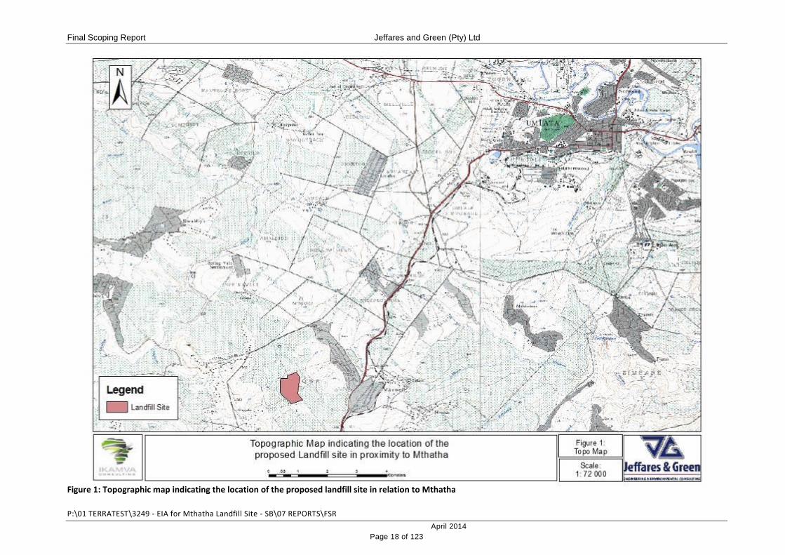
1.1 PROJECT LOCATION
The site proposed for development is located off the National Route 2 (N2) Freeway,
approximately 12km south-west of Mthatha. The area proposed for development is
approximately 45ha in extent. The proposed development site is under the ownership of the
Qweqwe Traditional Authority and is currently utilised as communal grazing land. A meeting
was held during October 2012 with the Qweqwe community members, during which a
resolution was signed indicating acceptance and support for the proposed development on
the communal land.
The geographic co-ordinates of the corners of the proposed development site are:
Table 1: Geographic co-ordinates of the proposed development
CORNER SOUTH EAST
SOUTH WEST 31° 40’ 17.06” S 28° 41’ 31.43” E
SOUTH EAST 31° 40’ 12.37” S 28° 41’ 44.25” E
NORTH WEST 31° 39’ 49.39” S 28° 41’ 20.35” E
NORTH EAST 31° 39’ 42.32” S 28° 41’ 37.49” E
Maps indicating the location of the proposed development site are contained in Figures 1, 2
and 3.
Final Scoping Report Jeffares and Green (Pty) Ltd
P:\01 TERRATEST\3249 - EIA for Mthatha Landfill Site - SB\07 REPORTS\FSR
April 2014
Page 18 of 123
Figure 1: Topographic map indicating the location of the proposed landfill site in relation to Mthatha

Final Scoping Report Jeffares and Green (Pty) Ltd
P:\01 TERRATEST\3249 - EIA for Mthatha Landfill Site - SB\07 REPORTS\FSR
April 2014
Page 19 of 123
Figure 2: Aerial photo indicating the location of the property proposed for development

Final Scoping Report Jeffares and Green (Pty) Ltd
P:\01 TERRATEST\3249 - EIA for Mthatha Landfill Site - SB\07 REPORTS\FSR
April 2014
Page 20 of 123
Figure 3: Map indicating the location of the proposed landfill site and access road
Final Scoping Report Jeffares and Green (Pty) Ltd
P:\01 TERRATEST\3249 - EIA for Mthatha Landfill Site - SB\07 REPORTS\FSR
April 2014
Page 21 of 123
1.2 SITE DESCRIPTION
The proposed development site is bounded to the southwest and northeast, by unnamed
drainage lines/erosion dongas. The property is entirely surrounded by communal grazing
land.
The site falls outside of the Town Planning Scheme and is therefore unzoned. The site has
been utilised for agricultural purposes in the past, including crop farming (terraces are in
evidence) and the grazing of livestock. No service infrastructure is currently in place on the
site.
The site is characterised by a ridge, running approximately northwest to southeast across
the middle of the property, sloping downwards, fairly steeply from this ridge towards the
drainage lines to the southwest and northeast.
Due to the high levels of disturbance on the site, following previous cultivation and the
current grazing activities, it is not anticipated that the vegetation of the site will have
significant conservation value. In addition, no wetland areas were identified on the site.
1.3 PROJECT DESCRIPTION
1.3.1 Status Quo
According to the KSD Integrated Waste Management Plan (dated February 2012), Mthatha
comprises:
18 931 formal service points, generating an average of 90 866kg of waste per day;
and
4 028 informal service points generating an average of 2 482kg per day.
Waste types (waste characterisation) generated in the KSD region fall into four categories:
Domestic;
Commercial;
Building rubble / construction and demolition waste; and
Garden refuse / greens.
Domestic and garden waste is currently collected together by the KSD Municipality and is
disposed of at the existing Mthatha Landfill Site. Commercial waste is generally sorted into
its recyclable fractions (cardboard, paper, metal and glass) at the point of generation and is

Final Scoping Report Jeffares and Green (Pty) Ltd
P:\01 TERRATEST\3249 - EIA for Mthatha Landfill Site - SB\07 REPORTS\FSR
April 2014
Page 22 of 123
collected by private contractors. Building rubble is partly removed by contractors to the
existing Municipal Landfill, where it is used as fill material or daily cover material. Largely,
however, this waste is illegally dumped in open spaces.
The existing Municipal Landfill Site servicing the Mthatha area within the KSD Municipal
Area is approaching capacity and is not licensed. Environmental and public health impacts
associated with this site are therefore significant and need to be corrected.
1.3.2 Proposed Future for Waste Disposal
A need has been identified to establish an adequately designed and licensed landfill site to
provide for the future disposal of general wastes generated within the KSD jurisdiction. The
KSD Municipality has therefore employed a suitably qualified project team to undertake the
design and authorisation of the new landfill site which will have the capacity to service the
Mthatha area for the next 20 years. The proposed landfill site will be issued the appropriate
licences and permits by the Eastern Cape DEDEAT and the Department of Water Affairs
(DWA).
The broad terms of reference supplied to the project designers by the Municipality require
the design of a cost-effective facility that will address environmental and public health
impacts. As such, the following are to be compiled:
Operating and maintenance manuals;
Health and safety measures; and
Environmental monitoring procedures.
The designers of the landfill have undertaken calculations which consider current and
projected future population size, economic status and waste removal service provision to
measure the impact on waste generation potential in the Municipality in the next 20 years.
Based on these calculations, the designers have determined that in order to meet the KSD
Municipality’s waste disposal needs for the next 20 years, the proposed new landfill will need
an airspace of 16.6ha (with a height of 20m, sloped at a 1:3 gradient), if no recycling is
implemented on the site. If recycling is implemented at a rate of 45%, then the total airspace
required is reduces to 9.6ha (with a height of 20m, sloped at a 1:4 gradient). Preliminary
indications are that the preferred development site can offer a feasible, functional landfill
footprint of 20ha and could therefore meet the needs of the Municipality for the next 20
years.

Final Scoping Report Jeffares and Green (Pty) Ltd
P:\01 TERRATEST\3249 - EIA for Mthatha Landfill Site - SB\07 REPORTS\FSR
April 2014
Page 23 of 123
Potential has been identified for the implementation of recycling activities on the site. There
are currently a number of informal recyclers in the Mthatha area which could be
mainstreamed and incorporated in the proposed new formal recycling facility. Based on
calculations by the project designers, it is anticipated that 40 – 45% of the waste stream
could be recycled or composted.
The proposed landfill site will be designed to receive approximately 50 000 tonnes of general
waste per annum and will comprise of the following components:
Hard standing areas and access roads;
Signage, security fencing and controlled access;
Tipping areas;
Lined waste cells;
Cover material;
Suitable drainage for clean and contaminated stormwater;
Administration buildings;
A weighbridge;
Recycling area / drop-off facility;
Composting area; and
Access road with an intersection off the N2 Freeway
In terms of service provision on the site, as there is currently no service infrastructure on the
site, completely new infrastructure will need to be established. Potable water is proposed to
be provided either from a new borehole or via a tanker service where by the KSD
Municipality will deliver water to the site, which will be stored in a storage tank. Electricity is
proposed to be supplied via an onsite generator which will be owned and operated by the
landfill operator. Sewage generated in the ablution facilities will disposed of via septic tanks,
with liquid being diverted into the leachate management system or the constructed wetland.
Systems for the control and management of gas, runoff and leachate will also be
incorporated into the design of the facility.
(i) Gas Management
Due to the nature of the waste (containing organic material and moisture) landfill gas will be
generated at the operational facility. Provision for the management of gas, with the aid of

Final Scoping Report Jeffares and Green (Pty) Ltd
P:\01 TERRATEST\3249 - EIA for Mthatha Landfill Site - SB\07 REPORTS\FSR
April 2014
Page 24 of 123
passive venting systems during the early stages of the operations, and active gas
extractions once landfill operations are underway, will be implemented on the site.
(ii) Uncontaminated Runoff Management
The runoff management system will comprise two parts, one to manage uncontaminated
runoff and another to manage contaminated runoff.
Uncontaminated runoff will be diverted around the site and into one of the natural drainage
lines located along the property boundary. Uncontaminated runoff will be prevented from
entering the landfill by means of a cut-off channel constructed along the boundary of the site.
This may be supplemented with a berm / bund, together with the ring road which would also
act as a drainage control feature.
Uncontaminated run-off from virgin areas of the landfill site, from completed covered areas
of the landfill and from within the cover excavations are to be directed off the landfill site into
the natural stream. Uncontaminated water might also need to be discharged into the
contaminated water dam for dilution purposes.
(iii) Contaminated Runoff Management
Contaminated run-off or potentially polluted water from exposed portions of the landfill will be
collected in open earth toe-drains along the toe of the landfill. These drains would discharge
into contaminated water or leachate retention ponds depending on the severity of
contamination. The main contaminated water ponds are to be located at the lower portions
of the site adjacent to the leachate treatment facility / constructed wetland. The water quality
in these dams would have to be monitored before releasing into the environment.
(iv) Leachate Management
Since it has been established that the landfill will produce significant volumes of leachate, a
comprehensive leachate management system for the collection, treatment and disposal of
leachate is to be provided. This would include a geosynthetic lined system at the base of the
waste body on top of the in situ soils to limit infiltration of leachate into the ground water. The
details of the lining system and the leachate collection system will be considered in depth

Final Scoping Report Jeffares and Green (Pty) Ltd
P:\01 TERRATEST\3249 - EIA for Mthatha Landfill Site - SB\07 REPORTS\FSR
April 2014
Page 25 of 123
during the feasibility and detail design phases of the project. This will be been done to
ensure compliance with the latest regulations1.
The preferred method for the treatment of leachate is biological co-treatment of sewage
(generated in the ablution facilities) and leachate in organic oxidation ponds / lagoons,
coupled with a constructed wetland or reed-bed system. It is likely that leachate will be
retained in these systems for between 50 and 100 days before being discharged to the
environment for disposal.
1.3.3 End-use and Rehabilitation
The objectives of the end-use design of the landfill are as follows:
(i) To create an aesthetically acceptable landform with gentle slopes (not exceeding a
1:3 gradient) that, as far as possible, blends in with the surrounding terrain; and
(ii) To maximise the landfill airspace available for waste disposal and hence the site life.
As an initial approach, the proposed final shape of the landfill has been determined
according to drainage and end-use requirements. The landfill is proposed to be shaped to
final contour levels, roughly following the original topography but ending up higher due to the
material filled in and raised above the natural contours. It is envisaged that the maximum
height of the landfill will be about 20m above the original ground profile. The upper surface of
the landfill is to have general slopes of at least 1:20 to promote rapid drainage off the landfill
surface.
Regarding the end-use of the site, it is envisaged to be returned to the local people as open
space or for the resumption of agricultural activities. The end-use of the site will however, be
discussed with all stakeholders during the EIA process and during the operations as part of
the ongoing public participation programme to ensure that the rehabilitated site is acceptable
to them.
Re-vegetation of the completed areas is to commence as soon as possible after capping.
Indigenous trees and shrubs typical to the surrounding area will be planted around the site
for screening purposes, as well as in any areas where the substrate will support tree growth.
Over the rest of the site, grass is to be established using indigenous grass types. The
1 National Environmental Management: Waste Act, 2008 (Act No. 59 of 2008): National Norms and Standards for the Disposal of Waste to Landfill (No. R636 of 23 August 2013).

Final Scoping Report Jeffares and Green (Pty) Ltd
P:\01 TERRATEST\3249 - EIA for Mthatha Landfill Site - SB\07 REPORTS\FSR
April 2014
Page 26 of 123
intention is to implement what is known as "the rising green wall effect" by progressively
grading and vegetating the side bunds and then working behind them. It is proposed that this
will especially be implemented on the Mthatha site to act as a wind screen minimizing the
effects of windblown litter.
1.4 PROJECT PROPONENT
Applicant name: King Sabata Dalindyebo Municipality
Contact Person Mr L.P. Maka
Physical address: Munitata Building, Sutherland Street, Mthatha
Postal address: PO Box 44, Mthatha
Postal code: 5099 Cell: 071 569 0558
Telephone: 047 501 4312 Fax: 047 531 3128
E-mail: [email protected]
1.5 ENVIRONMENTAL ASSESSMENT PRACTITIONER
Jeffares and Green (Pty) Ltd was appointed by Ikamva Consulting (on behalf of KSD
Municipality) to undertake the necessary environmental applications for the proposed
development.
The project is made up of several disciplines and is reflected in the project team assembled.
The assessment team is made up of:
Name Role
Magnus van Rooyen Project Manager
Sarah Baxter Environmental Assessment Practitioner
Cherize Mattheus Junior Environmental Assessment Practitioner
Primary contact for the project is tabulated below:
Company name : Jeffares and Green (Pty) Ltd
Contact Person Sarah Baxter

Final Scoping Report Jeffares and Green (Pty) Ltd
P:\01 TERRATEST\3249 - EIA for Mthatha Landfill Site - SB\07 REPORTS\FSR
April 2014
Page 27 of 123
Physical address: First Floor, Block 1, Greenacres Office Park, Second Avenue, Newton Park, 6045
Postal address: PO Box 27308, Greenacres
Postal code: 6057 Cell: 082 385 9881
Telephone: 041 363 1900 Fax: 041 363 1922
Email Address [email protected]
1.6 TEAM MEMBERS
The key members of the project team are detailed below and curricula vitae are presented in
Appendix A.
1.6.1 Magnus van Rooyen
Mr van Rooyen is an Executive Associate and the Regional Head of the Environmental
Division of a Jeffares & Green (Pty) Ltd. He is located in Pietermaritzburg, KwaZulu-Natal.
In addition to holding a Masters degree in Environmental Management, he also holds a BSc
degree in Botany and Zoology, an Honours Degree in Botany and a Post Graduate
Certificate in Education. He has 8 years’ experience in projects involving Environmental
Impact Assessments in various developmental sectors (Mining Sector, National Roads,
Pipelines, Dams, and Residential Developments), conducting of Specialist Biodiversity
Assessments associated with Environmental Impact Assessments and Project Feasibility
Studies. He has experience in the compilation of Resettlement Policy Framework Plans
associated with infrastructure development projects. Mr van Rooyen has experience in
working on various private and public sectors as well as rural and urban environments in
various countries. He is registered with the South African Council for Natural Scientific
Professionals (SACNASP Reg. No. 400335/11).
1.6.2 Sarah Baxter
Miss Baxter graduated from the School of Applied Environmental Sciences at the University
of KwaZulu-Natal, Pietermaritzburg, having completed a BSc undergraduate degree and a
post-graduate BSc Honours degree in Environmental Science. These comprise
multidisciplinary degrees and included courses in Natural Resource Management and
Sustainable Land Use, Environmental Modelling and Management, Biodiversity
Conservation, Ecosystem Ecology and Management and Geographic Information Systems
(GIS). Miss Baxter has five years’ professional experience as an environmental scientist in a

Final Scoping Report Jeffares and Green (Pty) Ltd
P:\01 TERRATEST\3249 - EIA for Mthatha Landfill Site - SB\07 REPORTS\FSR
April 2014
Page 28 of 123
wide range of projects for private, government and commercial clients requiring a number of
processes. These include Screening Assessments; Basic Assessments; Scoping and
Environmental Impact Assessment (EIA); Environmental Management Programmes
(construction and operation); Environmental Compliance Auditing (construction and
operation); Environmental Feasibility Assessments; Waste License Applications; Public
Participation Processes; Permit Applications; and Environmental Advice. She has been
employed by Jeffares & Green (Pty) Ltd since May 2012 in the position of Environmental
Scientist.
1.6.3 Cherize Mattheus
Miss Matthues is a graduate Environmental Assessment Practitioner. She has been with the
company for 5 months, following her qualification in 2012 with a Masters in Zoology from
Nelson Mandela Metropolitan University.
1.7 TERMS OF REFERENCE
The proposed development triggers activities listed under Government Notices 544 and 545
of the NEMA, as well as waste management activities listed in Categories A and B of
Government Notice 718 of the NEMWA, as detailed in the table below. Based on this, the
proposed development requires a Scoping and Environmental Impact Assessment (EIA) and
Waste License Application process to be conducted.
Table 2: Listed activities triggered by the proposed development
No. & date of
Notice: Activity numbers Description
No. R 544
18 June 2010 Activity 11
The construction of:
(iii) bridges
(xi) infrastructure or structures covering 50 square
meters or more
Where such construction occurs within a watercourse
or within 32 meters of a watercourse, measured from
the edge of a watercourse, excluding where such
construction will occur behind the development
setback line.
The proposed access road to the landfill site will cross
a donga / drainage line, requiring the establishment of
Final Scoping Report Jeffares and Green (Pty) Ltd
P:\01 TERRATEST\3249 - EIA for Mthatha Landfill Site - SB\07 REPORTS\FSR
April 2014
Page 29 of 123
a new bridge / causeway. In addition, sections of the
property boundary fall within 32 meters of the edge of
dongas / drainage lines. Should excavation for the
construction of the landfill site occur in these areas,
then this activity will be triggered.
No. R 544
18 June 2010 Activity 18
The infilling or depositing of any material of more than
5 cubic meters into, or the dredging, excavation,
removal or moving of soil, sand, shells, shell grit,
pebbles or rock or more than 5 cubic meters from:
(i) a watercourse;
But excluding where such infilling, depositing,
dredging, excavation, removal or moving;
a. is for maintenance purposes undertaken in
accordance with a management plan agreed
to by the relevant authority; or
b. occurs behind the development setback line.
As part of the construction of the access road, it will be
necessary to construct a donga / drainage line
crossing. This will require the excavation of in excess
of 5m3 of material from the watercourse.
No. R 544
18 June 2010 Activity 22
The construction of a road, outside urban areas,
(i) with a reserve wider than 13,5 meters, or
(ii) where no reserve exists where the road is
wider than 8 metres, or
(iii) for which an environmental authorisation was
obtained for the route determination in terms of
activity 5 in Government Notice 387 of 2006 or
activity 18 in Notice 545 of 2010.
The proposed development will require the
establishment of an access road between the landfill
site and the N2 Freeway. This road will be wider than 8
meters in order to accommodate the waste delivery
vehicles.
No. R 545
18 June 2010 Activity 15
Physical alteration of undeveloped, vacant or derelict
land for residential, retail, commercial, recreational,
industrial or institutional use where the total area to be
Final Scoping Report Jeffares and Green (Pty) Ltd
P:\01 TERRATEST\3249 - EIA for Mthatha Landfill Site - SB\07 REPORTS\FSR
April 2014
Page 30 of 123
transformed is 20 hectares or more; except where
such physical alteration takes place for:
(i) linear development activities; or
(ii) agriculture or afforestation where activity 16 in
this Schedule will apply.
The area proposed for development is approximately
45 ha in extent and currently comprises undeveloped
and vacant land.
No. 921
29 November
2013
Category A: Activity 1
The storage of general waste in lagoons.
It is proposed that leachate generated by the landfill
site will be directed into and stored on leachate ponds.
As the landfill site will accept general waste only, the
leachate generated by the facility can be deemed to be
general in nature.
No. 921
29 November
2013
Category A: Activity 3
The recycling of general waste at a facility that has an
operational area in excess of 500m2, excluding
recycling that takes place as an integral part of an
internal manufacturing process within the same
premises.
A Recycling Centre is proposed as part of the new
landfill site. Recycled wastes from the incoming
general waste stream will be diverted into this centre.
This centre will have an operational area in excess of
500m2.
No. 921
29 November
2013
Category A: Activity 12
The construction of a facility for a waste management
activity listed in Category A of this Schedule (not in
isolation to the associated waste management
activity).
The proposed leachate management system and
recycling centre trigger waste management activities
listed in Category A. The construction of these facilities
will trigger Activity 12.
No. 921
29 November
Category B: Activity 8
The disposal of general waste to land covering an area
in excess of 200m² and with a total capacity exceeding

Final Scoping Report Jeffares and Green (Pty) Ltd
P:\01 TERRATEST\3249 - EIA for Mthatha Landfill Site - SB\07 REPORTS\FSR
April 2014
Page 31 of 123
2013 25 000 tons.
The proposed development comprises a landfill site
which will be approximately 45 ha (45 000 m2) in extent
and with a capacity in excess of 25 000 tons, at which
general wastes will be disposed of to land.
No. 921
29 November
2013
Category B: Activity 10
Construction of a facility for a waste management
activity listed in Category B of this Schedule (not in
isolation to the associated waste management
activity).
The proposed landfill site triggers waste management
activities listed in Category B. The construction of this
facility will trigger Activity 10.
No. 921
29 November
2013
Category C: Activity 5
The extraction, recovery or flaring of landfill gas.
Gas generated in the landfill site will be extracted by
passive and active measures.
According to the Regulations this activity may not, therefore commence without
Environmental Authorisation (EA) and a Waste License from the Competent Authority. An
investigation, assessment and statement of potential impacts of the proposed activity must
follow the procedure as described in Regulations 26 to 35 of the Environmental Impact
Assessment Regulations, 2010.
The Eastern Cape Department of Economic Development, Environmental Affairs and
Tourism (DEDEAT) are the Competent Authority responsible for the issuing of an EA and
Waste License for this particular proposed project. An amended version of the Application
Form (following the repeal of GN 718 and its replacement with GN 921 of 29 November
2013) is contained in Appendix B.

Final Scoping Report Jeffares and Green (Pty) Ltd
P:\01 TERRATEST\3249 - EIA for Mthatha Landfill Site - SB\07 REPORTS\FSR
April 2014
Page 32 of 123
2 APPROACH TO THE SCOPING PHASE
2.1 DESCRIPTION OF THE SCOPING AND EIA PROCESS AND METHODOLOGY
A Scoping and EIA process is a planning and decision-making tool. It identifies potential
negative and positive impacts of a proposed project and recommends ways to enhance the
positive impacts and mitigate the negative impacts. The process is largely comprised of
three phases:
The Environmental Scoping Phase
The Environmental Impact Assessment Phase
The Decision Phase
2.1.1 Scoping Phase
The aim of the Environmental Scoping Phase is to provide information regarding the current
environmental, social and possible economic conditions on the site that is being applied for
and to provide information regarding the type and extent of the proposed project. During the
Scoping Phase all potential impacts, both positive and negative, associated with the
proposed development will be identified. This will be done through a process of site
assessment, desktop investigation and will be undertaken in conjunction with stakeholder
and public interest involvement through a Public Participation Process. The outcome of the
Scoping Phase will be a detailed Plan of Study for the EIA Phase, which will detail how the
identified impacts will be investigated in order to obtain a full understanding of and report on
the ecological and social sustainability and economic efficiency of the proposed
development and to facilitate balanced decision-making.
2.1.2 EIA Phase
During the EIA Phase, the Plan of Study will be implemented. This will include the
commissioning of various specialist studies for input into the assessment of impacts
identified during the Scoping Phase. Specialists will further aid in the compilation of
recommendations and mitigation measures for the minimisation of negative impacts and the
enhancement of positive impacts. This information will be compiled into an EIA Report which
will contain the Environmental Assessment Practitioner’s recommendations regarding the
authorisation of the proposed development as well as the possible mitigation and
management measures that needs to be implemented during the construction and
operational phases of the project.
Final Scoping Report Jeffares and Green (Pty) Ltd
P:\01 TERRATEST\3249 - EIA for Mthatha Landfill Site - SB\07 REPORTS\FSR
April 2014
Page 33 of 123
The EIA Report will be submitted to the Competent Authority for the decision making
process.
All work will be undertaken in compliance with the NEMA and the NEM:WA.
The Scoping and EIA process is illustrated in Figure 4.

Final Scoping Report Jeffares and Green (Pty) Ltd
P:\01 TERRATEST\3249 - EIA for Mthatha Landfill Site - SB\07 REPORTS\FSR
April 2014
Page 34 of 123
Figure 4: Diagrammatic overview of the Scoping and EIA process
We are here

Final Scoping Report Jeffares and Green (Pty) Ltd
P:\01 TERRATEST\3249 - EIA for Mthatha Landfill Site - SB\07 REPORTS\FSR
April 2014
Page 35 of 123
2.2 DETAILED DESCRIPTION OF SCOPING PHASE
2.2.1 Integrated Application for Authorisation and Waste License
An Application for an Integrated Environmental Authorisation and Waste Management
Licence was submitted to the Eastern Cape DEDEAT on 16 May 2013. Acknowledgment of
Receipt of the Application form was received on 3 July 2013 and Acceptance of the
Application was received on 25 August 2013. The application was assigned a file reference
number OR/B/10/002/13 (Appendix B). Subsequent to the submission of the above-
mentioned Application Form, the Waste Management Regulations (GN 718 of 3 July 2009)
have been repealed and replaced by GN 921 of 29 November 2013. An amended version of
the Application Form is attached in Appendix B.
2.2.2 Land Owner Notification
The preferred development site is under communal ownership, managed by the Qweqwe
Traditional Authority. During October 2012, the Department of Rural Development and Land
Reform facilitated the signing of a Community Resolution by the Qweqwe Municipality,
indicating their acceptance and support of the proposed landfill site at the preferred Qweqwe
Site. A copy of this Community Resolution document is included in Appendix B of this
Scoping Report.
2.2.3 Compilation of Stakeholder Database
The compilation of a stakeholder database entails the development and maintenance of an
electronic database for the duration of the project where stakeholders and affected parties
can register. The process begins with an initial scan of national, provincial and local
authorities to identify potential stakeholders. In addition, non-governmental organizations
(NGO’s) were identified and included in the database for notification of the project. Adjacent
landowners were searched and notified directly, when they could be located.
The identification and registration of stakeholders will be an on-going activity during the
Scoping and EIA phases of the project. Initial stakeholders were identified through the Public
Notification phase.
2.2.4 Stakeholder and Public Engagement
The NEMA EIA Regulations of 2010 (Sections 54-57) require an inclusive, transparent
process of engagement. Any and all persons who may be affected by and/or have an
interest in a proposed project are entitled to be informed and submit comments.

Final Scoping Report Jeffares and Green (Pty) Ltd
P:\01 TERRATEST\3249 - EIA for Mthatha Landfill Site - SB\07 REPORTS\FSR
April 2014
Page 36 of 123
Procedures for informing stakeholders about a project and engaging their participation have
become standard practice. The stakeholder consultation process was undertaken in English.
2.2.4.1 Notification:
(i) Site Notices
The NEMA EIA Regulations of 2010 require that a site notice be fixed at a place
conspicuous to the public at the boundary of the site where the activity to which the
application relates is to be undertaken, and on any alternative sites. The purpose of the site
notice is to notify neighbours of the project and to provide details for registration as a
stakeholder. Refer to Appendix E for a copy of the site notice placed and the photographs of
the site notices.
(ii) Advertisements
The NEMA EIA Regulations (2010) require that an advertisement be placed in either a local
newspaper or a Government Gazette. For the proposed project, an advert was placed in the
Daily Despatch on 30 July 2013. Refer to Appendix E for a copy of the newspaper
advertisement.
(iii) Background Information Documents (BIDs)
The purpose of the BID is to provide written background information on the proposed project,
outlining the environmental process as well as providing an opportunity for registration of
other stakeholders. A copy of the BID is contained in Appendix E.
According to the NEMA EIA Regulations (2010), written notice must be given to the:
Owners and occupiers of land adjacent to the site where the activity is to be
undertaken;
Owners and occupiers of land within a 100m radius of the boundary of the project;
Municipal ward councillor in which the site and alternate site is situated;
Municipality who has jurisdiction of the area;
Any organ of state having jurisdiction in respect of any respect of the activity; and
Any other party as required by the competent authority.
The BID’s were distributed to landowners and tenants, where they could be identified,
Authorities, Key Stakeholders and people responding to the above-mentioned site posters
and advertisement, requesting registration as an IAP.

Final Scoping Report Jeffares and Green (Pty) Ltd
P:\01 TERRATEST\3249 - EIA for Mthatha Landfill Site - SB\07 REPORTS\FSR
April 2014
Page 37 of 123
2.2.4.2 Comments and Responses:
Following publication of the adverts, placing of the site notices and circulation of the BID,
comments are generally received from IAPs.
2.2.5 Plan of Study for EIA
The Plan of Study for EIA lays out the process for and inputs into the detailed impact
assessment phase. The Plan of Study is the final product of the Scoping Phase, and it must
ensure that all issues raised during the stakeholder engagement process and technical
scoping are captured in the scope of work for the EIA such that they will be addressed, if
found significant, in the management plans. The Plan of Study for EIA for the proposed
development is contained in Section 9.
2.2.6 Public Review of Draft Scoping Report
The Draft Scoping Report and Plan of Study were made available to all registered IAPs for
comment for a period of 60 days, between 19 November 2013 and 10 February 2014. The
report was also made available in hard copy for public review and was also available on the
Jeffares and Green (Pty) Ltd Website (http://www.jgi.co.za/public-participation).
Hard copies of the report were sent to the following key stakeholders:
Department of Economic Development, Environmental Affairs and Tourism;
Department of Water Affairs;
Endangered Wildlife Trust (EWT).
South African Roads Agency Limited (SANRAL);
King Sabata Dalindyebo Local Municipality; and
OR Tambo District Municipality.
All comments received have been included into and responded to in Section 8.4 (Table 6) of
this final version of the Scoping Report for submission to the relevant authority.
2.2.7 Authority Review and Acceptance of Final Scoping Report
This final version of the Scoping Report and Plan of Study will be submitted to the DEDEAT.
Following review of the report, the DEDEAT may accept or rejected the Scoping Report. If
accepted, the project will proceed to the EIA Phase.

Final Scoping Report Jeffares and Green (Pty) Ltd
P:\01 TERRATEST\3249 - EIA for Mthatha Landfill Site - SB\07 REPORTS\FSR
April 2014
Page 38 of 123
3 LEGAL FRAMEWORK
3.1 THE NATIONAL ENVIRONMENTAL MANAGEMENT ACT (NO. 107 OF 1998)
The National Environmental Management Act (NEMA) (Act 107 of 1998) is a ‘principles-
based Act’ and is an overarching statute regulating various aspects of natural resource use,
integrated environmental management and pollution control. The Act provides for:
the right to an environment that is not harmful to the health and well-being of the
South African people;
sustainable development, environmental protection, equitable distribution of natural
resources; and
the formulation of environmental management frameworks.
Its definition of the environment includes the land and water of the earth, micro-organisms,
plant and animal life or a combination of those things, and the interrelationships among
them.
The Act aims to provide for co-operative environmental governance by establishing
principles for decision-making on matters affecting the environment, institutions that will
promote co-operative governance, and procedures for co-ordinating environmental functions
exercised by organs of state. Section 24 provides for the prohibition, restriction and control
of activities that are likely to have a detrimental effect on the environment.
The NEMA contains a set of principles that govern environmental management, and against
which all environmental management plans and actions are measured. Sustainable
development requires the consideration of all relevant factors including the following:
Environmental management must place people and their needs at the forefront of its
concern, and serve their physical, psychological, developmental, cultural and social
interests equitably;
That the disturbance of ecosystems and loss of biological diversity are avoided, or
where they cannot be altogether avoided, are minimized and remedied;
That pollution and degradation of the environment are avoided, or, where
unavoidable, are minimised and remedied;
That waste is avoided, or where unavoidable is minimised and reused or recycled
where possible and/or disposed of in a responsible manner;

Final Scoping Report Jeffares and Green (Pty) Ltd
P:\01 TERRATEST\3249 - EIA for Mthatha Landfill Site - SB\07 REPORTS\FSR
April 2014
Page 39 of 123
That a risk-adverse and cautious approach is applied, which takes into account the
limits of current knowledge about the consequences of decisions or actions;
That negative impacts on the environment and on people’s environmental rights be
anticipated and prevented, and where they cannot be altogether prevented, are
minimized and remedied;
The right of workers to refuse work that is harmful to human health or the
environment and to be informed of dangers must be respected and protected;
The role of women and youth in environmental management and development must
be recognised and their full participation therein must be promoted;
Responsibility for the environmental health and safety consequences of a policy,
programme, project, product, process, service or activity exists throughout its life
cycle;
The participation of interested and affected parties in environmental governance
must be promoted, and people must have the opportunity to develop the
understanding, skills and capacity necessary for achieving equitable and effective
participation;
The participation by vulnerable and disadvantaged persons must be ensured;
Decisions must take into account the interests, needs and values of all interested and
affected parties, and this includes recognising all forms of knowledge, including
traditional and ordinary knowledge;
That the cost of remedying pollution, environmental degradation and consequent
adverse health effects and of preventing, controlling or minimizing further pollution,
environmental damage or adverse health effects must be paid for by those
responsible for harming the environment;
Community well-being and empowerment must be promoted through environmental
education, the raising of environmental awareness, the sharing of knowledge and
experience and other appropriate means; and
Decisions must be taken in an open and transparent manner, and access to
information must be provided in accordance with the law.
3.1.1 List of Activities identified in terms of Sections 24(2) and 24D
The listed activities are found in three regulations or listing notices. GN R544, GN R545 and
GN R546 of 18 June 2010 (as amended). The relevant activities triggered by this particular
project are contained within in Listing Notices 1 and 2, which results in the need for the
completion of a Scoping and Environmental Impact Assessment process for the issuing of

Final Scoping Report Jeffares and Green (Pty) Ltd
P:\01 TERRATEST\3249 - EIA for Mthatha Landfill Site - SB\07 REPORTS\FSR
April 2014
Page 40 of 123
an Environmental Authorisation. The listed activities triggered by this proposed development
are summarised in Table 2.
3.2 NATIONAL ENVIRONMENTAL MANAGEMENT: WASTE ACT (NO. 59 OF 2008)
Waste management in South Africa is regulated by the National Environmental
Management: Waste Act (Act 59 of 2008) (NEM:WA). The objectives of the Act are, inter
alia:
to protect health, well-being and the environment by providing reasonable measures
for—
o minimising the consumption of natural resources;
o treating and safely disposing of waste as a last resort;
o preventing pollution and ecological degradation;
o securing ecologically sustainable development while promoting justifiable
economic and social development; and
o achieving integrated waste management reporting and planning;
to ensure that people are aware of the impact of waste on their health, well-being and
the environment; and
to give effect to section 24 of the Constitution in order to secure an environment that
is not harmful to health and well-being.
3.2.1 Waste Management Activities Requiring a Waste License
Section 19(1) of the NEM:WA declares that the Minister must publish a list of waste
management activities (WMA) which may lead to a detrimental effect on the environment.
These activities will require a Waste Management License (WML) prior to commencement of
the activity. This list was initially published in Government Notice No. 718 of 3 July 2009.
Subsequently, GN 718 has been repealed and replaced by GN 921 of 29 November 2013.
The proposed development triggers activities contained within Categories A, B and C of the
above-mentioned list. As such, a Scoping and EIA Process (in accordance to the regulations
contained in the NEMA) is required for the issuing of a Waste License. A summary of the
Waste Management Activities triggered by the proposed landfill development is contained in
Table 2.

Final Scoping Report Jeffares and Green (Pty) Ltd
P:\01 TERRATEST\3249 - EIA for Mthatha Landfill Site - SB\07 REPORTS\FSR
April 2014
Page 41 of 123
3.2.2 Other Applicable Waste Regulations
In addition to the NEM:WA and GN 921 of 29 NOVEMBER 2013, the following regulations
relating to waste management have been published and will be considered in this Report:
Waste Classification and Management Regulations in Government Gazette No. 634
of 23 August 2013, which provides for:
o The identification and categorisation of waste;
o The manner in which particular waste types must be dealt with and managed;
o Measures that are required for the environmentally sound management of
waste;
o Requirements in respect of waste management activities;
o The utilisation of waste by way of recovery, re-use and recycling;
o The control of waste management facilities;
o Labelling requirements in respect of waste management; and
o The location, planning and design of waste management activities.
National Norms and Standards for the Assessment of Waste for Landfill Disposal in
Government Gazette No. R635 of August 2013 and the National Norms and
Standards for the Disposal of Waste to Landfill in Government Gazette No. R636 of
23 August 2013, which together provide norms and standards for the storage,
treatment and disposal of waste, including the planning and operation of waste
treatment and waste disposal facilities.
Standards for Extraction, Flaring or Recovery of Landfill Gas in Government Notice
GN 924 of 29 November 2013, which aim at controlling the extraction, flaring and
recovery of landfill gas at facilities in order to prevent potential negative impacts on
the biophysical and socio-economic environments.
3.3 NATIONAL WATER ACT (NO. 36 OF 1998)
The National Water Act (Act No. 36 of 1998) (NWA) has sustainability and equity as the core
principles guiding the protection, use, development, conservation, management and control
of water resources. Basic human needs, the need to promote social and economic
development and the need to establish suitable institutions to are the aims of the NWA.
Chapter 3 provides for the protection of all water resources with Part 4 dealing with pollution
prevention. Section 19 encumbers the owner or person in control of land to take reasonable
precautions to prevent the contamination of water resources. The NWA, in this application is

Final Scoping Report Jeffares and Green (Pty) Ltd
P:\01 TERRATEST\3249 - EIA for Mthatha Landfill Site - SB\07 REPORTS\FSR
April 2014
Page 42 of 123
therefore a key document for the protection of water resources and the project must take
cognisance of leachate containment and pollution prevention in the design of the landfill.
Chapter 4 of the NWA deals with the use of water and the regulation thereof and further
defines water uses which will require a Water Use License or General Authorisation. Input
from the Department of Water Affairs will be sought regarding the need for a Water Use
License or application for a General Authorisation. Construction of the proposed landfill site
will not commence until such time as the appropriate water use authorisations are in place.
3.4 NATIONAL ENVIRONMENTAL MANAGEMENT: AIR QUALITY ACT (NO. 39 OF
2004)
The National Environmental Management Air Quality Act (Act No. 39 of 2004) (NEM:AQA)
was a landmark act which focused on the ambient air quality and the receptor as opposed to
the previous act which defined air quality by regulating the emissions which impact air
quality. As a result of the NEM:AQA, standards for ambient air quality have been developed
which are managed through the local municipalities or provincial municipalities.
The NEM:AQA enabled the publication of the Listed Activities and Minimum Emission
Requirements, which require emitters to apply for and obtain an Atmospheric Emissions
License (AEL) related to installations such as combustion installations in various industries.
As no combustion activities will be employed at the proposed landfill site, it will not be
necessary to apply for an AEL.
3.5 MUNICIPAL PLANNING DOCUMENTS
3.5.1 King Sabata Dalindyebo Integrated Development Plan
The Integrated Development Plan (IDP) for the King Sabata Dalindyebo (KSD) Local
Municipality has, as its ultimate objective, improved service delivery and betterment of the
community. As such, the principal aim of the IDP and the KSD Municipality is to present a
coherent plan for service delivery and a plan to improve the quality of life for its communities.
In terms of waste management within the municipal jurisdiction, the IDP document notes that
a formal refuse collection service is provided once a week to 27 562 households. A further
64 603 households currently make use of a communal or own refuse dump system.

Final Scoping Report Jeffares and Green (Pty) Ltd
P:\01 TERRATEST\3249 - EIA for Mthatha Landfill Site - SB\07 REPORTS\FSR
April 2014
Page 43 of 123
The Municipality is currently engaging in rehabilitation activities at two of their existing landfill
sites, in Mthatha and Mqanduli, in order to meet permit requirements. The IDP, however,
notes that the Mthatha Landfill Site is reaching capacity and that there is a need to establish
a new, permitted landfill site. The establishment of a new landfill site has been identified as a
Planned Environmental Project within the IDP. The Municipality has identified a number of
potential development sites and has implemented the required Feasibility Studies
(comprising geotechnical and geo-hydrological assessments) and Environmental
Authorisation processes. This document represents the Draft Scoping Report for the
development of the preferred alternate development site. Through the abovementioned
assessments and authorisation processes, the Municipality aims to design and establish a
landfill site that is environmentally friendly, compliant with all statutory requirements and that
provides economic opportunities to benefit SMME’s.
The proposed development of a permitted landfill site is therefore in line with the Municipal
IDP.
3.5.2 KSD Spatial Development Framework
The Spatial Development Framework (SDF) and associated Strategic Environmental
Assessment (SEA) are tools applied to guide land development decisions which seek to
improve the quality of life of the residents, while at the same time ensuring that the
environment is protected. The SDF and SEA in combination seek to identify opportunities
and constraints for development provided by the natural and social environments as well as
mechanisms to mitigate negative impacts. According to the SDF Map for the KSD
Municipality (Figure 5) the area in which the landfill site is proposed has not been designated
for a specific use.

Final Scoping Report Jeffares and Green (Pty) Ltd
P:\01 TERRATEST\3249 - EIA for Mthatha Landfill Site - SB\07 REPORTS\FSR
April 2014
Page 44 of 123
Figure 5: King Sabata Dalindyebo Municipality Spatial Development Framework Map, indicating the approximate location of the proposed landfill site (SDF, 2007)
Approximate location of the
proposed landfill site
Final Scoping Report Jeffares and Green (Pty) Ltd
P:\01 TERRATEST\3249 - EIA for Mthatha Landfill Site - SB\07 REPORTS\FSR
April 2014
Page 45 of 123
3.5.3 KSD Integrated Waste Management Strategy
In fulfilling its constitutional mandate as well as the requirements of their Integrated Waste
Management Strategy (IWMS), KSD Municipality as the local sphere of governance must
give effect to the provisions of the Constitution by guaranteeing an environment that is not
harmful to the health and well-being of its community, curtailing poor waste management
practices and ensuring sustainable development in the municipality`s area of jurisdiction.
The proposed development of a properly designed and located landfill site will contribute to
the fulfilling of these requirements.
3.6 SUMMARY OF LEGAL FRAMEWORK
The key environmental legislation in regard to the project are the NEMA, the NEM:WA and
the NWA. The NEMA requires that the proposed development receive Environmental
Authorisation from the Eastern Cape DEDEAT, as competent authority, prior to
commencement. The NEM:WA requires licensing for the disposal of general waste to land
and the construction of associated facilities. The Competent Authority for the issuing of the
Waste License is also the Eastern cape DEDEAT. The NWA requires the issuing of a Water
Use License for activities within a 500 meter radius of a water course and a General
Authorisation for disposing of waste in a manner that may detrimentally impact on a water
resource. Input regarding the need for Water Use License Applications will be sought from
the DWA.
In addition to the above regulations, the following Department of Water Affairs Guideline
Documents were also considered:
The Department of Water Affairs and Forestry, Second Edition, 1998. Waste
Management Series. Minimum Requirements for Waste Disposal by Landfill
The Department of Water Affairs and Forestry, Third Edition, 2005. Waste
Management Series. Minimum Requirements for Water Monitoring at Waste
Management Facilities.
Furthermore, the following guideline documents need to be consulted in the design of the
proposed landfill site:
National Norms and Standards for Disposal of Waste to Landfill (Government
Gazette No. R 636 of 23 August 2013).

Final Scoping Report Jeffares and Green (Pty) Ltd
P:\01 TERRATEST\3249 - EIA for Mthatha Landfill Site - SB\07 REPORTS\FSR
April 2014
Page 46 of 123
The proposed development will undergo authorisation, licensing and permitting according to
the requirements of the above Acts and Regulations. In addition, the proposed landfill site
will be in line with the municipal planning documents currently available in the KSD Local
Municipality as well as with the above-mentioned guideline documents.
4 DESCRIPTION OF THE ENVIRONMENTAL BASELINE
4.1 CLIMATE
The climate and local weather of the area are strongly influenced by topography. Average
annual temperature varies between 1.8°C in July and 25.3°C in January. The proposed
development site falls within a summer rainfall area, characterised by dry winters and wet
summers, with thunderstorms being common in summer. Average rainfall is approximately
877mm per year. The area experiences high levels of wind, with monthly averages ranging
between 12 and 15km/hour. Maximum wind speeds of 76km/hour are experienced at times.
Rainfall and winds will need to be carefully considered in the design and operation of the
facility with regards to how they impact upon leachate management, litter control and dust
suppression.
4.2 GEOLOGY AND SOILS
According to the 1:250 000 geological map (3128 UMTATA) published by the Council for
Geoscience, the regional geology of the Mthatha area is dominated by sandstones and
mudstones belonging to the Beaufort Group, with igneous intrusions in the form of dolerite
dykes and sills being common (Figure 6). The Beaufort Group is comprised of the Tarkastad
and Adelaide Subgroups, respectively.
A specialist Geotechnical Assessment will be conducted during the EIA Phase. This
assessment will provide more details on the underlying geology of the site and based on
this, its suitability for the proposed development. In addition, this report will include
recommendations regarding founding and erosion protection.
4.3 TOPOGRAPHY
The site is dominated by a ridge of higher ground which sits at an altitude of approximately
850 meters above sea level (masl). This ridge runs from the southeast corner of the
property, towards the centre of the property, where its alignment changes to run towards the

Final Scoping Report Jeffares and Green (Pty) Ltd
P:\01 TERRATEST\3249 - EIA for Mthatha Landfill Site - SB\07 REPORTS\FSR
April 2014
Page 47 of 123
northeast corner of the property. To either side of this ridge, to the southwest, the northwest
and the east, the property falls away steeply to drainage lines which run along the eastern
and western boundaries of the property. The altitude of these lowest points is approximately
790masl. Topography of the proposed development site is indicated in Figure 7.

Final Scoping Report Jeffares and Green (Pty) Ltd
P:\01 TERRATEST\3249 - EIA for Mthatha Landfill Site - SB\07 REPORTS\FSR
April 2014
Page 48 of 123
Figure 6: Map indicating the geology of the proposed development site
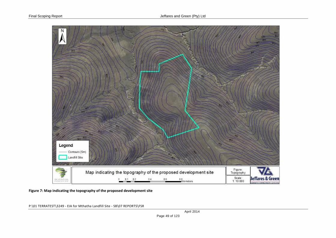
Final Scoping Report Jeffares and Green (Pty) Ltd
P:\01 TERRATEST\3249 - EIA for Mthatha Landfill Site - SB\07 REPORTS\FSR
April 2014
Page 49 of 123
Figure 7: Map indicating the topography of the proposed development site

Final Scoping Report Jeffares and Green (Pty) Ltd
P:\01 TERRATEST\3249 - EIA for Mthatha Landfill Site - SB\07 REPORTS\FSR
April 2014
Page 50 of 123
4.4 HYDROLOGY
To proposed landfill site is bounded to the west and east by two drainage lines / dongas,
which join to the north of the property. Flow within these systems is therefore from south to
north.
A third drainage line / donga which runs in an easterly direction is located near to the N2
Freeway. The proposed road which will provide access to the landfill site from the N2
Freeway will cross this drainage line.
Associated with the presence of these drainage lines, may be wetland and riparian areas. In
order to ensure the protection of these systems, it will be necessary to identify any wetland
areas, delineate their extent and apply and appropriate buffer zone of no development. An
investigation of riparian / wetland areas will be undertaken and will be reported on in the EIA
Report.
One of the major concerns associated with the development of landfill sites is the leaching of
contaminants from the site, resulting in contamination of groundwater reserves. In order to
assess this potential impact it will be necessary to determine the underlying geo-hydrology
and geology of the proposed development site. Once this has been determined, the
specialists will be able to provide detailed input regarding the suitability of the site for
development as well as make recommendations for the minimisation and prevention of
contamination associated with leaching. These specialist studies will be conducted and
reported on in the EIA Report.
4.5 BIODIVERSITY
The preferred development site comprises and is bounded on all four sides by communal
agricultural land which is utilised for the grazing of cattle, sheep and goats. According to
Mucina and Rutherford (2006) the area in which the proposed development site falls is
expected to comprise Mthatha Moist Grassland (Gs 14) (Figure 8). Landscape features are
described as undulating plains and hills supporting species-poor, sour, wiry grassland of
predominantly Eragrostis plana and Sporobolus africanus. This is typical of the proposed
development site which has been disturbed by past cultivation (evidenced by the presence
of terraces on the property) and, more recently, extensive grazing. In good condition these
grasslands would be expected to be dominated by Themeda triandra.

Final Scoping Report Jeffares and Green (Pty) Ltd
P:\01 TERRATEST\3249 - EIA for Mthatha Landfill Site - SB\07 REPORTS\FSR
April 2014
Page 51 of 123
This vegetation type is classified as Vulnerable by the South African National Biodiversity
Institute (SANBI), with only a small fraction statutorily conserved in the Luchaba and Nduli
Wildlife Reserves. More than 40% of this vegetation type has been transformed, primarily for
cultivation and plantations and this is the case with the site in question.
Mucina and Rutherford (2006) identify one biogeographically important plant taxon occurring
in this vegetation type:
Encephalartos frederici-guilielmi (White haired cycad) – classified as Near
Threatened and as a Sub-Escarpment Grassland Endemic which was not
encountered on the site.
The IUCN Red Data Species Database was queried and the following animal species were
identified as occurring in the Mthatha area:
Pronolagus crassicaudatus (Natal Red Rock Hare) – classified as Least Concern;
Duberria lutrix (Common slug eater) – classified as Least Concern; and
Pachydactylus maculatus (Spotted thick-toed gecko) – classified as Least Concern.
It must be noted that the above-mentioned list is based on a desktop investigation. More
detailed information will be included in the EIA Report.
4.6 TERRESTRIAL CRITICAL BIODIVERSITY AREAS
The Critical Biodiversity Area (CBA) Maps indicate areas of land as well as aquatic features
which must be safeguarded in their natural state if biodiversity is to persist and ecosystems
are to continue functioning. CBAs incorporate:
(i) areas that need to be safeguarded in order to meet national biodiversity thresholds;
(ii) areas required to ensure the continued existence and functioning of species and
ecosystems, including the delivery of ecosystem services; and/or
(iii) important locations for biodiversity features or rare species.
The proposed development site was queried in terms of the Eastern Cape Biodiversity
Conservation Plan. According to this database, the proposed development site falls within an
area designated as T2: Terrestrial Critical Biodiversity Area (CBA) Level 2 (Figure 9). This
means that the site is expected to contain vegetation listed as Endangered which equates to
a determination that the area of intact vegetation remaining of the vegetation type is within

Final Scoping Report Jeffares and Green (Pty) Ltd
P:\01 TERRATEST\3249 - EIA for Mthatha Landfill Site - SB\07 REPORTS\FSR
April 2014
Page 52 of 123
15% of the set representation target. The vegetation type of the proposed development site,
as mentioned above, is the Mthatha Moist Grasslands.
In the Eastern Cape Biodiversity Conservation Plan Technical Report (2007),
recommendations are made regarding permitted, conditionally-permitted and non-permitted
land-use types within each of the identified CBA’s. Recommendations for land-use in Level 2
CBA’s are summarised in the table below.
Table 3: Recommended land-use types for each biodiversity mapped category
PERMITTED CONDITIONAL NOT PERMITTED
Conservation Dry land and irrigation cropping (existing and fallow cultivated
land) Commercial Livestock
Game Farming Dry land and irrigated cropping
(conversion of virgin land)
Communal Livestock Dairy Farming
Timber
Low density rural settlement
Low density urban settlement
High density urban settlement
Development of a landfill site is not specified as a land-use type in this table, input will
therefore need to be sought from the relevant stakeholders regarding the suitability of the
proposed development type, and any conditions for development of the site.
Due to previous disturbances of the site for agricultural use, comprising past cropping and
current grazing, the vegetation of the site has been modified and bears limited resemblance
to the veld type identified above. It is the opinion of the EAP therefore, that the site has
limited conservation value. More detail on the vegetation, biodiversity and conservation
value of the site will be obtained through a specialist vegetation assessment during the EIA
Phase.

Final Scoping Report Jeffares and Green (Pty) Ltd
P:\01 TERRATEST\3249 - EIA for Mthatha Landfill Site - SB\07 REPORTS\FSR
April 2014
Page 53 of 123
Figure 8: Map indicating the vegetation of the proposed development site (as classified by Mucina and Rutherford, 2006)
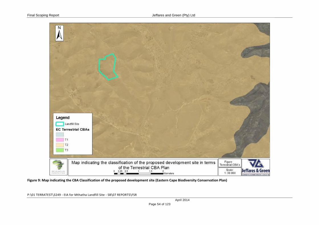
Final Scoping Report Jeffares and Green (Pty) Ltd
P:\01 TERRATEST\3249 - EIA for Mthatha Landfill Site - SB\07 REPORTS\FSR
April 2014
Page 54 of 123
Figure 9: Map indicating the CBA Classification of the proposed development site (Eastern Cape Biodiversity Conservation Plan)

Final Scoping Report Jeffares and Green (Pty) Ltd
P:\01 TERRATEST\3249 - EIA for Mthatha Landfill Site - SB\07 REPORTS\FSR
April 2014
Page 55 of 123
4.7 SITES OF ARCHAEOLOGICAL, CULTURAL AND HERITAGE SIGNIFICANCE
According to the National Heritage Resources Act No 25 of 1999, provisions are made to
protect national heritage and this forms an integral part of the environmental assessment
process. In order to give effect to this requirement, it will be necessary to determine whether
or not there are any heritage resources on the proposed development site. Input in this
regard will be sought from the South African Heritage Resources Agency (SAHRA) as well
as the Eastern Cape Heritage Resources Committee (ECHRC). Should it be required, a
Heritage Impact Assessment will be conducted. The results of this assessment will be
reported on in the EIA Report.
4.8 NOISE
Currently, there are no noise sources on the site. Current ambient noise sources include the
N2 Freeway to the south, and noises associated with neighbouring rural residential areas to
the east, northeast and west and agricultural activities (grazing of livestock). The proposed
development will alter this noise profile during the construction phase as a result of
increased plant and construction workers on the site. During the operational phase, noise
will be generated by waste delivery vehicles accessing the site, plant utilised in the daily
covering of waste and the presence of the operational work force.
Should the need arise, through the public participation process, a Noise Impact Assessment
will be conducted. This will be included and reported on in the EIA Report.
Recommendations for the minimisation of noise impacts will be included in the EIA Report
and associated Environmental Management Programme (EMPr).
4.9 VISUAL ENVIRONMENT
The current visual environment comprises an open landscape with rural residential
development interspersed with open spaces, typically grassland, which is utilised for
communal grazing of livestock. This visual landscape will be dramatically altered by the
proposed development. Should the need arise, through the public participation process, a
Visual Impact Assessment will be conducted. This will be included and reported on in the
EIA Report. Recommendations for the minimisation of visual impacts will be included in the
EIA Report and associated EMPr.
4.10 AIR QUALITY
Ambient air quality at the proposed development site is impacted upon at present by the
proximity of the N2 Freeway and the agricultural use of the property (grazing of livestock). It

Final Scoping Report Jeffares and Green (Pty) Ltd
P:\01 TERRATEST\3249 - EIA for Mthatha Landfill Site - SB\07 REPORTS\FSR
April 2014
Page 56 of 123
is anticipated that ambient air quality will be significantly and negatively impacted by the
proposed landfill development as a result of odour generation and increased dust. Should
the need arise through the public participation process, an Air Quality Assessment will be
conducted and reported on in the EIA Report. Recommendations for the minimisation of air
quality impacts will be included in the EIA Report and associated EMPr.

Final Scoping Report Jeffares and Green (Pty) Ltd
P:\01 TERRATEST\3249 - EIA for Mthatha Landfill Site - SB\07 REPORTS\FSR
April 2014
Page 57 of 123
5 DESCRIPTION OF THE SOCIO-ECONOMIC BASELINE
The information contained in this section was sourced from the King Sabata Dalindyebo
Local Municipality’s Integrated Development Plan (2012 - 2017).
5.1 POPULATION INFORMATION
The King Sabata Dalindyebo Local Municipality has an estimated population of 451 710
people, living in approximately 104 240 households. This translates to an average of 4
people per household.
Approximately 95% of these households are located in rural areas and village settlements.
KSD is therefore classified as a rural municipality. Table 4 below provides a breakdown of
the population according to race.
Table 4: Population distribution within KSD Local Municipality
Black Coloured Indian/Asian White Other TOTAL
Number 444 770 3 403 1 480 1 356 702 451 710
% of Population
98.4% 0.75% 0.33% 0.3% 0.16% 100%
Source: Stats SA Community Survey 2011
Between 2001 and 2011, the KSD Municipality experienced a net population increase from
416 347 to 451 710, an increase of 7.8%. This is attributed to the presence of Mthatha Town
which is a regional service centre, as well as the N2 Freeway which is a major transport
route acting as a gateway to a wide range of tourism offerings such as Coffee Bay and Hole
in the Wall. The Municipality is also an economic home to two of the largest economic
activities in the district, namely forestry and agriculture.
KSD has a very youthful population, with 74% of the population aged between 0 and 35
years of age. This means that the majority of the population are of a school-going age and
that dependency levels in the municipality are high. The Municipality has, as a result,
prioritised youth and skills development programmes.
5.2 ECONOMIC PROFILE
The KSD Municipality is the largest contributor to the O.R. Tambo District Municipality
economy. In 2007, the KSD workforce (made up of people aged between 15 and 64 years)
was made up of approximately 229 668 people, or 53% of the total population. Of these,

Final Scoping Report Jeffares and Green (Pty) Ltd
P:\01 TERRATEST\3249 - EIA for Mthatha Landfill Site - SB\07 REPORTS\FSR
April 2014
Page 58 of 123
28% (66 158) were employed, whilst only 15% (35 944) fell within the category of
“unemployed”. The remainder, 57% were classified as “not economically active”.
Varied topographical and climatic conditions in KSD Municipality contribute to diverse
agricultural activities including wool, beef and dairy, maize, vegetables, deciduous and
tropical fruits, forestry and fishing. The Municipality is also a popular tourism destination.
There are, therefore, a number of key contributors to the local economy, including
agriculture, forestry, fishing, tourism, construction and property development. Contribution to
the local economy by the various commercial sectors is summarised in Table 5 below.
Table 5: Broad Economic Sector Share of Employment (2008)
ECONOMIC SECTOR PERCENTAGE CONTRIBUTION
Agriculture, Forestry and Fishing 0.8%
Mining 0.3%
Manufacturing 2.1%
Electricity and Water 0.2%
Construction 2.9%
Wholesale and Retail Trade, Catering and Accommodation 7.9%
Transport and Communication 1.5%
Finance and Business Services 9.4%
Community, Social and Other Personal Services 26.8%
Other Government and Social Services 9.4%
Despite the wide range of economic sectors, indicators used to measure development within
the Municipality show that poverty has increased in the past decade. Conversely though,
there has been a slight increase in the quality of life for residents within the Municipal Area.
5.3 WASTE MANAGEMENT SERVICE DELIVERY AND INFRASTRUCTURE
The KSD Municipality has a predominantly rural landscape with a rural population residing in
traditional villages and homes. The main towns are located along the main access roads and
serve as rural service centres to the surrounding rural population. This has meant that
service delivery in the outlying rural areas is limited, with the main challenge to infrastructure
development being distance from the main service centres.

Final Scoping Report Jeffares and Green (Pty) Ltd
P:\01 TERRATEST\3249 - EIA for Mthatha Landfill Site - SB\07 REPORTS\FSR
April 2014
Page 59 of 123
In terms of waste management services, the KSD Municipality provides a formal waste
removal service to 27 562 households (26% of the total population) on a weekly basis. The
remaining 64% of the population make use of communal or home refuse dump systems.
As part of the Municipality’s formal waste management system, KSD operates two landfill
sites, at Mthatha and Mqanduli. These two sites are currently undergoing rehabilitation in
order to become compliant with the relevant legislation. The Mthatha Landfill Site is,
however, approaching capacity and a need has been identified to establish a new landfill site
to replace the existing facility. The proposed development will allow the KSD Municipality to
address this issue and to improve and expand waste management infrastructure and service
delivery within their region of jurisdiction.
Final Scoping Report Jeffares and Green (Pty) Ltd
P:\01 TERRATEST\3249 - EIA for Mthatha Landfill Site - SB\07 REPORTS\FSR
April 2014
Page 60 of 123
6 ALTERNATIVES
In terms of the definitions contained within the NEMA, alternatives are defined in relation to a
proposed activity as different means of meeting the general purposes and requirements of
the activity, and may include alternatives to –
the property on which, or location where, it is proposed to undertake the activity;
the type of activity to be undertaken;
the design or layout of the activity;
the technology to be used in the activity;
the operational aspects of the activity; and
the option of not implementing the activity.
Feasible and reasonable alternatives which have been identified for the proposed
development and that will be assessed in more detail are listed below.
6.1 ALTERNATE SITES FOR DEVELOPMENT
During 2009 the KSD Municipality contracted Arcus Gibb to conduct a Feasibility Study for
the proposed new Mthatha Landfill Site. As part of this Study, 9 potential development sites
were identified. These were reported on in a Pre-Feasibility Report titled Volume 1:
Identification and Ranking of Candidate Sites (February 2009). Based on this report, 3 sites
were identified for further geotechnical and geo-hydrological assessment. These were the
De Colgny site, Highbury site and Orange Grove site. The KSD Municipality has also,
subsequently identified a site at Qweqwe which is being pursued as the preferred site.
Geotechnical and geo-hydrological assessments of this preferred site are currently
underway and will be reported on in the EIA Phase.
The three sites investigated by Arcus Gibb, and the Qweqwe site most recently identified by
the KSD Municipality have been considered as alternate development sites.
6.1.1 Preferred Alternative - Qweqwe Site
The Qweqwe site is located on land owned and managed by the Qweqwe Traditional
Authority. The site is located approximately 15km southwest of the town of Mthatha along
the N2 Freeway. Currently, no formal access route to the proposed development site exists.
The site is utilised as communal grazing land for cattle, sheep and goats, although it has
been cultivated in the past as evidenced by the presence of terraces on the site. The site is
bounded to the southwest and northeast by seasonal drainage lines.

Final Scoping Report Jeffares and Green (Pty) Ltd
P:\01 TERRATEST\3249 - EIA for Mthatha Landfill Site - SB\07 REPORTS\FSR
April 2014
Page 61 of 123
6.1.2 Alternate Site 1 – De Colgny Site
The De Colgny candidate site is located on Farm 10/5 and can be accessed via a gravel
road that links with the R61 Road. The site is currently used for cattle and sheep grazing,
and is bound to the southeast by a Mission and to the southwest by the KSD FET College. A
water reservoir is located on top of the hill and two man-made surface water bodies delimit
the southwestern boundary of the site. The Mthatha Dam and a tributary of the Mthatha
River are located approximately 2km and 500m northeast and east of the site, respectively.
6.1.3 Alternate Site 2 – Highbury Site
The Highbury candidate site is located on Farm 48 and can be accessed via a gravel road
which links up with the R61 Road. This is an intermittently used dolerite borrow pit that is
partly vegetated by pioneer grass communities and scattered bush and trees. The site is
bound by gravel roads in the south and east and by the meandering Mthatha River
approximately 700m to the west. The topography of this site is very undulating,
characterised by numerous small-scale hills (often steep-sided and rocky) and valleys – the
result of poor borrow pit operation and management. Dolerite outcrops at the surface in
places, and large dolerite boulders are scattered across the site. Illegal dumping is taking
place immediately south of this site.
6.1.4 Alternate Site 3 – Orange Grove Site
The Orange Grove candidate site is located on Farm RE/38 and can be accessed via a
gravel road that links up with the Tutor Ndamase Road. The site is currently used for
grazing. The Mthatha River bounds the site in the east, approximately 550m away.
The location of the three alternate development sites is indicated in Figure 10 below.
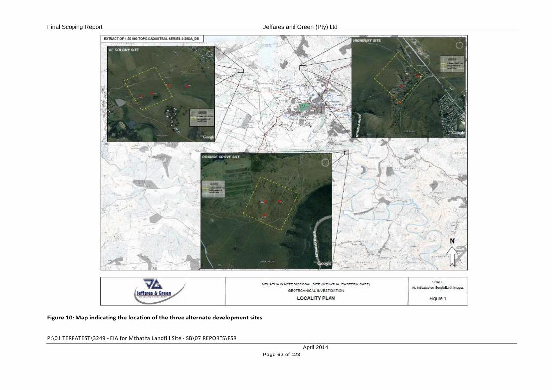
Final Scoping Report Jeffares and Green (Pty) Ltd
P:\01 TERRATEST\3249 - EIA for Mthatha Landfill Site - SB\07 REPORTS\FSR
April 2014
Page 62 of 123
Figure 10: Map indicating the location of the three alternate development sites

Final Scoping Report Jeffares and Green (Pty) Ltd
P:\01 TERRATEST\3249 - EIA for Mthatha Landfill Site - SB\07 REPORTS\FSR
April 2014
Page 63 of 123
6.2 ALTERNATE DEVELOPMENT TYPES
6.2.1 Preferred Alternative – Establishment of a GMB+ Landfill Site
A site for the disposal of general waste generated in the KSD Municipality is required. The
facility designers have proposed the establishment of a GMB+ facility as the preferred
option. This is broken down as follows:
(i) G = General Waste
General waste includes:
Domestic waste;
Uncontaminated building and demolition waste;
Business waste not containing hazardous waste;
Inert waste;
Waste tyres;
Garden waste;
Post-consumer packaging;
Non-infectious animal carcasses; and
Uncontaminated, excavated earth.
Hazardous wastes are not permitted at general landfill sites, these include:
Health Care Risk Wastes (HCRW);
Asbestos waste;
General waste, excluding domestic waste which contains hazardous waste or
hazardous chemicals;
Mixed hazardous chemical waste from analytical laboratories and laboratories from
academic institutions in containers less than 100 litres.
Unless further investigation demonstrates that significant quantities of hazardous waste will
be generated in Mthatha and disposed of illegally, there is no need to make specific
provision for hazardous waste disposal at the proposed site. Only general wastes will
therefore be accepted at the site.
(ii) M = Medium Size
General waste landfills are subdivided into 4 classes based on the magnitude of the waste
stream and the size of the operation. These classes are Communal (C), Small (S), Medium
(M) and Large (L). As the proposed landfill is required for the disposal of approximately

Final Scoping Report Jeffares and Green (Pty) Ltd
P:\01 TERRATEST\3249 - EIA for Mthatha Landfill Site - SB\07 REPORTS\FSR
April 2014
Page 64 of 123
50 000 tonnes of general waste per year (or 136 tonnes per day), it is classified as a Medium
(M) facility.
(iii) B+ = Significant Leachate Generation
The above-mentioned classes of landfill are further subdivided on the basis of the site’s
potential for leachate generation. Significant leachate generation depends on the water
balance of the site, which is dictated primarily by ambient climatic conditions. Other factors
such as the moisture content of the incoming wastes and ingress of either ground- or surface
water can also result in the generation of significant leachate.
A B- Landfill is a landfill that generates only sporadic leachate and does not require a
leachate management system. A B+ landfill is a landfill that generates significant leachate.
All B+ sites, with the exception of communal sites, require leachate management systems
comprising liners and leachate collection systems.
It has been determined by the project designers that the proposed site will have significant
leachate potential. A management system is therefore required. Environmental barriers or
liner systems will be introduced at the base of the landfill. All potential leachate will be
trapped by this barrier and drained towards a holding pond where it will undergo on-site
treatment.
(iv) Summary
In terms of the above criteria, the proposed landfill site is a GMB+ site:
G General Waste
M Medium size >150 but <500 tonnes per day.
B+ Significant leachate generation
No alternate development types have been considered as a direct need for a new, properly
designed and environmentally compliant landfill site to service the Mthatha area has been
identified. The required landfill site will need to be classified as a GMB+ site in order to meet
the needs of the Municipality and based on site specific water balance conditions. The
preferred alternative therefore represents the only way to meet this need.
6.3 ALTERNATE LAYOUTS
As the site is located on a hillock with steep sides, the core landfill area needs to be located
in the centre of the site, governed by the contours that will allow gravitational flow of leachate

Final Scoping Report Jeffares and Green (Pty) Ltd
P:\01 TERRATEST\3249 - EIA for Mthatha Landfill Site - SB\07 REPORTS\FSR
April 2014
Page 65 of 123
and potentially contaminated water to the holding ponds. Larger areas of the site could be
used but would require the construction of further pond and drainage systems.
The options presented below essentially differ in that the leachate ponds could be located on
either side of the hillock. This in turn would result in the relocation of the recycling and
composting areas.
The challenge remains to design a functional landfill site whilst mitigating a number of
impacts, i.e. visual exposure, climatic exposure (specifically high winds) and to overcome
drainage challenges and steep access roads.
6.3.1 Layout 1 – Preferred Layout
In the preferred layout option, the landfill area is located on the eastern and central portions
of the property, where the flatter, higher areas are located. The leachate treatment area is
located on the western portions of the property. The steepest slopes on the property
therefore lie between the landfill area and the leachate treatment area, facilitating the
movement of leachate and contaminated runoff under gravity. The Administration area,
which includes the weighbridge, public transfer area, and the composting area are located in
the southern portions of the property, near the site entrance, reducing the need to transport
compost around the site and therefore minimising costs.
6.3.2 Layout 2 – Alternate Layout 1
In this layout option, a large portion of the western side of the site will be used as a landfill.
On the southern side, a sizable area, although steep, is available for the placing of the
administration area. Due to the topography of the site, the full landfill area cannot be used
without the introduction of electrically driven leachate pumps and duplicated contaminated
water evaporation ponds. If this is to be avoided and to allow for the use of gravity for the
movement of leachates and contaminated water (which would be a much cheaper option
and will require less management and maintenance), the toe of the landfill would need to be
located well within the boundaries of the site, and upslope, minimising the area which could
be used for landfilling activities. The water flow pipes and channels would then be located in
the areas below the landfill. The leachate management facilities would be located on the
eastern side of the property.

Final Scoping Report Jeffares and Green (Pty) Ltd
P:\01 TERRATEST\3249 - EIA for Mthatha Landfill Site - SB\07 REPORTS\FSR
April 2014
Page 66 of 123
6.3.3 Layout 3 – Alternate Layout 2
Layout 3 is a variation on Layout 2, except that the administration area, public offloading
area and composting area is located well into the site on the eastern side and somewhat
down the slope to the northeast. This has the negative implication that composted and
recycled material will have to be brought back up the incline for reselling, adding to transport
costs. For this reason, Layout option 3 is not being pursued as the preferred option.
Drawings of the three layouts under consideration are contained in Appendix C.
6.4 ALTERNATE LEACHATE TREATMENT METHODS
6.4.1 Preferred Alternative – Leachate Ponds
Establishment of a series of oxidation ponds and constructed wetland systems/reed beds for
the biological co-treatment of sewage (generated at the onsite ablution facilities) and
leachate is considered to be the preferred alternative. Leachate and sewage would have a
retention time of 50 – 100 days in the ponds, during which time it would undergo an
oxidation breakdown process. Following this, the treated wastewater would be channelled
into a constructed wetland area to undergo final polishing before being released to the
drainage lines which run along the property boundary. This is being pursued as the preferred
alternative as it is the most cost effective, low-maintenance and effective method of
treatment.
6.4.2 Municipal WWTW
Leachate generated at the landfill would collect in a pond and pumped via a main sewer line
in the vicinity (if present and feasible) for treatment at the Municipal Wastewater Treatment
Works (WWTW). This is not being pursued as the preferred alternative as it is unlikely that a
bulk sewer line exists in the area. If a line were to be established, it is unlikely that the
Mthatha WWTW would have the capacity to treat the leachate to an adequate standard for
safe release to the environment.
6.4.3 Onsite WWTW
Establishment of an onsite activated sludge treatment plant and aerators to treat the
leachate prior to releasing it to the ponds and constructed wetlands. This would be a very
expensive and high-tech option, requiring maintenance and prone to breakdown and place a
management burden on the landfill site operators.

Final Scoping Report Jeffares and Green (Pty) Ltd
P:\01 TERRATEST\3249 - EIA for Mthatha Landfill Site - SB\07 REPORTS\FSR
April 2014
Page 67 of 123
6.4.4 Evaporation
Leachate could be captured in a pond and then recirculated back on to the landfill where it is
left to evaporate. This would require the use of pumps and is not the most practical option
available as too much runoff would be generated as a result of the liner system on the base
of the landfill. In addition, at the beginning of operations, when waste levels are low, the
landfill would have limited absorption capacity, especially if it coincides with the rainy
season.
6.5 NO GO ALTERNATIVE
The no-go option would be to not implement the proposed landfill site development on the
preferred site and to retain the current status quo. This would mean that the existing, un-
licenced and incorrectly designed landfill site currently utilised for the Mthatha area, would
continue to be used. It must be noted that this landfill site is approaching capacity, requiring
the identification of a new and suitable landfill site.

Final Scoping Report Jeffares and Green (Pty) Ltd
P:\01 TERRATEST\3249 - EIA for Mthatha Landfill Site - SB\07 REPORTS\FSR
April 2014
Page 68 of 123
7 NEED AND DESIRABILITY
The National Framework for Sustainable Development (NFSD) states that the “achievement
of sustainable development is not a once-off occurrence and its objectives cannot be
achieved by a single action or decision. It is an on-going process that requires a particular
set of values and attitudes in which economic, social and environmental assets that society
has at its disposal, are managed in a manner that sustains human well-being without
compromising the ability of future generations to meet their own need”.
In order to give appropriate consideration to these objectives, the NEMA EIA Regulations
(2010) require that the Need and Desirability of a proposed project be outlined as part of the
Scoping Report. The following section has been compiled according to the Need and
Desirability Guideline Document contained in GN 792 of 5 October 2012.
The Guideline Document promotes the concept that need and desirability be strategically
and democratically determined. The strategic context for informing need and desirability is
best addressed and determined therefore during the formulation of the sustainable
development vision, goals, and objectives of Integrated Development Plans (IDPs) and
Spatial Development Framework (SDFs) during which collaborative and participative
processes play an integral part, and are given effect to, in the democratic processes at local
government level. The need and desirability of a development must therefore be measured
against the vision, goals and objectives formulated in the areas IDP and SDF.
7.1 NEED
The above-mentioned Guideline Document states that though the need for development is
not disputable, the Applicant has to convince the Competent Authority that the proposed
development is a necessity.
In providing for the Need for a project, the Applicant has to explain how a development
would benefit the local/regional/national community. By emphasising how communities
would benefit from the development, the need for a project is emphasized.
The following questions are outlined in the Guideline Document as a guide that in answering
them addresses the requirements of considering the Need and Desirability of a proposed
project.
Final Scoping Report Jeffares and Green (Pty) Ltd
P:\01 TERRATEST\3249 - EIA for Mthatha Landfill Site - SB\07 REPORTS\FSR
April 2014
Page 69 of 123
7.1.1 Question 1
Question: Is the land use (associated with the activity being applied for) considered within
the timeframe intended by the existing approved SDF agreed to by the relevant
environmental authority? (i.e. is the proposed development in line with the projects and
programmes identified as priorities within the IDP).
Response: Yes, the EAP is of the opinion that the proposed development is in line with the
priorities identified in the current IDP.
The IDP for the KSD Local Municipality has, as its ultimate objective, improved service
delivery and betterment of the community. As such, the principal aim of the IDP and the KSD
Municipality is to present a coherent plan for service delivery and a plan to improve the
quality of life for its communities.
The IDP states that the Municipality is currently engaging in rehabilitation activities at two of
their existing landfill sites, in Mthatha and Mqanduli, in order to meet permit requirements.
The IDP, however, notes that the Mthatha Landfill Site is reaching capacity and that there is
a need to establish a new, permitted landfill site. The establishment of a new landfill site has
been identified as a Planned Environmental Project within the IDP and is reported on in the
IDP. The Municipality aims to design and establish a landfill site that is environmentally
friendly, compliant with all statutory requirements and that provides economic opportunities
to benefit SMME’s.
The proposed development of a permitted landfill site which is appropriately located is
therefore supportive of and in line with the objectives of the KSD IDP.
7.1.2 Question 2
Question: Should development, or if applicable, expansion of the town/area concerned in
terms of this land use (associated with the activity being applied for) occur here at this point
in time?
Response: Yes. A direct need has been identified by the KSD Municipality to establish a
new, permitted landfill which has been correctly designed, to provide for the disposal of
general wastes generated within the town of Mthatha and its surrounds. This need arises
due to the fact that the existing site is almost at capacity and that the existing landfill site is
an environmental and public-health risk (due to improper design and a lack of appropriate

Final Scoping Report Jeffares and Green (Pty) Ltd
P:\01 TERRATEST\3249 - EIA for Mthatha Landfill Site - SB\07 REPORTS\FSR
April 2014
Page 70 of 123
permitting). There is an urgent need, therefore to establish a new landfill site to service the
Mthatha area in the long term (next 20 years).
7.1.3 Question 3
Question: Does the community/area need the activity and the associated land use
concerned (is it a societal priority)? This refers to the strategic as well as local level (e.g.
development is a national priority, but within a specific local context it could be
inappropriate).
Response: The proposed development is a societal priority. The IDP identifies the direct
need for a new landfill site for the Mthatha Area. This proposed development will directly and
completely satisfy this need in the long term.
In addition to meeting the need for a waste disposal site in the KSD Municipal area, the
proposed development will go some way to meeting other societal requirements including:
(i) Short term job creation – The project will promote the creation of short term
employment through the construction phase, which will include earthworks, service
installation and construction of buildings. The number of potential employment
opportunities that will be created by the construction phase is not known at this point
however it is anticipated that both skilled and unskilled jobs will be created.
Permanent job creation during the operational phase is estimated to total 200
permanent jobs and 100 contract jobs. It is recommended that labour and employees
for both the construction and operational phases of the proposed development be
sourced from the local community as far as possible.
(ii) Long term job creation – the operational facility will create a number of permanent
employment opportunities. These include site guards, admin staff, plant operators,
waste pickers and operators at the recycling facility. The number of jobs that will be
created, and the income that will be generated by the operational landfill site, is not
currently known.
(iii) Creation of economic and investment opportunities - it is proposed to establish a
recycling facility as part of the proposed landfill site. The running and management of
this facility will be awarded to a local SMME, thus providing an economic opportunity
to small business owners. Opportunities exist for investment in this operation and the

Final Scoping Report Jeffares and Green (Pty) Ltd
P:\01 TERRATEST\3249 - EIA for Mthatha Landfill Site - SB\07 REPORTS\FSR
April 2014
Page 71 of 123
creation of other, related activities, such as education and conservation drives,
collection services, separation services, and potential capturing of landfill gas for
energy production etc.
(iv) Improved public health – at the existing site, litter is overflowing, representing a
public health risk to surrounding residents. The creation of a new and properly
managed landfill site will ensure the improved control of wastes and the minimisation
of health risks to the public. This will enable the KSD Municipality to ensure the local
community’s constitutional right to an environment that is not harmful to health.
(v) Improved environmental health – at the existing site, litter has become windblown
and leachate is poorly managed. The existing site therefore presents a number of
significant risks to the local surface and groundwater reserves. The establishment of
a new and properly managed landfill site will ensure the improved control of leachate
and litter as well as the minimisation of contamination, making local water reserves
safe for human and animal consumption.
7.1.4 Question 4
Question: Are the necessary services with appropriate capacity currently available (at the
time of application), or must additional capacity be created to cater for the development?
Response: The site has been utilised for agricultural activities in the past. Service
infrastructure on the property and in the surrounding area is therefore limited. Despite this,
the service infrastructure proposed for establishment on the site will, for the most part, not
require capacity provision by the Municipality, as explained below.
(i) Electricity – it is proposed that electricity for the site be supplied by an onsite
generator. This generator would be owned and operated by the landfill operator.
(ii) Water - potable water will either be sourced from a new borehole, which will be
drilled on the site; or it will be delivered to the site by the KSD Municipality by a
tanker, and stored in a storage tank.
(iii) Waste Disposal – waste generated by the administration areas and the workers on
the site will comprise general office and domestic waste. This waste will be
separated on site. Recyclable wastes will be fed into the onsite recycling facility, the
remaining non-recyclable waste will be landfilled.

Final Scoping Report Jeffares and Green (Pty) Ltd
P:\01 TERRATEST\3249 - EIA for Mthatha Landfill Site - SB\07 REPORTS\FSR
April 2014
Page 72 of 123
(iv) Sewage Disposal – sewage generated by the onsite ablution facilities will be
directed into septic tanks, with liquid being diverted into the leachate management
system or the constructed wetland.
(v) Access – access to the site will be off the N2 Freeway. In order to supply this access
between the Freeway and the proposed landfill, a new road will need to be
constructed. The road will need to be constructed of a durable material in order to
allow for disposal during all weather conditions.
Therefore, as the site will, for the most part not connect into municipal services, it will not
create capacity issues for the municipality.
7.1.5 Question 5
Question: Is this development provided for in the infrastructure planning of the municipality,
and if not what will the implication be on the infrastructure planning of the municipality
(priority and placement of services)?
Response: The proposed development forms an integral part of the municipality’s service
infrastructure plan as it is key to future waste management service provision within the
municipality.
The KSD Municipality’s IDP does not include a detailed infrastructure plan in which priority
areas for the establishment of infrastructure are identified. It must be noted, however, that
the proposed development will be largely “off the grid” and not reliant on municipal services.
Rather, electricity will be supplied from an onsite generator and water will be sourced from a
borehole.
7.1.6 Question 6
Question: Is this project part of a national programme to address an issue of national
concern or importance?
Response: No.
Final Scoping Report Jeffares and Green (Pty) Ltd
P:\01 TERRATEST\3249 - EIA for Mthatha Landfill Site - SB\07 REPORTS\FSR
April 2014
Page 73 of 123
7.2 DESIRABILITY
Desirability relates to the placement of an activity. The motivation must indicate why the
location of a development in this particular area would be more desirable than establishing in
another area.
7.2.1 Question 7
Question: Is the development the best practicable environmental option (BPEO) for this
land/site?
Response: The “best practicable environmental option” implies that the proposal provides
the most benefit and causes the least damage to the environment as a whole, at a cost
acceptable to society, in the long term as well as the short term. In determining the BPEO
adequate consideration must be given to opportunity costs.
The need for environmentally acceptable yet cost-effective waste disposal has become a
priority in South Africa. This is because increasing population and urbanization have resulted
in growing waste generation, placing pressure on the environment. There is also an
increasing awareness of environmental issues and a desire for a clean environment on the
part of the public. To ensure a cleaner environment, the Department of Water Affairs (DWA)
and the Department of Environmental Affairs (DEA), with whom responsibility for waste
disposal was vested, initiated a programme to meet both current and future waste disposal
needs. The aim of the programme is to protect the environment and the public from the
impacts of bad waste disposal practices. The first step was to implement a control system,
involving permits for disposal sites. To be eligible for a permit, a disposal site is required to
meet and maintain certain standards as set by the DWA and DEA. The design and location
of the proposed landfill site will be subject to the approval of the DWA and DEA. The project
engineers have therefore complied with the relevant minimum requirements, norms and
standards and waste-related regulations in the design of the facility. This will ensure the
mitigation and minimisation of any potential negative impacts associated with the
development. These include (but are not limited to):
Control of leachate and runoff to prevent contamination of surface and groundwater
resources;
Daily covering of waste to minimise wind-blown debris, odours and pests; and
Surface and ground water monitoring;

Final Scoping Report Jeffares and Green (Pty) Ltd
P:\01 TERRATEST\3249 - EIA for Mthatha Landfill Site - SB\07 REPORTS\FSR
April 2014
Page 74 of 123
Implementation of the above mitigation measures will minimise potential environmental
impacts to a level where they are acceptable to society in the long term. The proposed
development of a correctly designed and located landfill site therefore represents the BPEO.
7.2.2 Question 8:
Question: Would the approval of this application compromise the integrity of the existing
approved municipal IDP and SDF as agreed to by the relevant authorities?
Response: No, the proposed development is in line with and would assist in the
achievement of the mandates set out in both the IDP and SDF.
7.2.3 Question 9:
Question: Would the approval of this application compromise the integrity of the existing
environmental management priorities for the area (e.g. as defined in EMFs), and if so, can it
be justified in terms of sustainability considerations?
Response: the proposed development will not adversely affect any conservation priority
areas identified in any of the municipal planning documents currently available.
7.2.4 Question 10
Question: Does location factors favour this land use (associated with the activity applied for)
at this place? (This relates to the contextualisation of the proposed land use on this site
within its broader context).
Response: The development of the proposed landfill site is dependent on a number of
locational factors, which include:
Proximity to a main transport route;
Accessibility; and
Large areas of flat land.
The proposed development sites considered in this application satisfy all of these locational
requirements.
Environmental factors such as subsurface geology and groundwater need to be assessed in
determining the suitability of a site. This will be done following completion of the necessary
specialist studies and will be reported on in the EIA Report.
Final Scoping Report Jeffares and Green (Pty) Ltd
P:\01 TERRATEST\3249 - EIA for Mthatha Landfill Site - SB\07 REPORTS\FSR
April 2014
Page 75 of 123
7.2.5 Question 11
Question: How will the activity or the land use associated with the activity applied for,
impact on sensitive natural and cultural areas (built and rural/natural environment)?
Response: A number of watercourses occur in close proximity to the identified alternate
development sites. These may have riparian areas associated with them. As part of the EIA
Phase it will be necessary to delineate these systems and determine potential impacts on
them as a result of the proposed development. This work will be undertaken by a suitable
qualified and experienced specialist. Recommendations for the mitigation and minimisation
of these impacts will be put forward, together with an opinion on the suitability of the site for
the proposed development.
No obvious areas of cultural significance have been identified on any of the identified sites.
Input in this regard will be sought from SAHRA as well as the Eastern Cape Heritage
Association and should it be deemed necessary, a Heritage Impact Assessment will be
conducted. Recommendations for the mitigation and minimisation of these impacts will be
put forward, together with an opinion on the suitability of the site for the proposed
development.
7.2.6 Question 12
Question: How will the development impact on people’s health and wellbeing (e.g. i.t.o.
noise, odours, visual character and sense of place, etc.)?
Response:
(i) Noise - Currently, there are limited noise sources on the various development sites
under consideration. Current surrounding ambient noise sources include roads and
noises associated with neighbouring rural residential areas and agricultural activities
(cattle, sheep and goat grazing). The proposed development will alter this noise
profile during the construction phase as a result of plant and construction workers
operating on the site. During the operational phase, noise will be generated by waste
delivery vehicles accessing the site, plant utilised in the daily covering of waste and
the presence of the operational work force.
It may be necessary to conduct a Noise Impact Assessment in order to fully
determine the impact of noise on the surrounding population’s health and well-being.
This will be informed by comment received on the Scoping Report. Should a Noise

Final Scoping Report Jeffares and Green (Pty) Ltd
P:\01 TERRATEST\3249 - EIA for Mthatha Landfill Site - SB\07 REPORTS\FSR
April 2014
Page 76 of 123
Impact Assessment be conducted, it will be included and reported on in the EIA
Report. Recommendations for the minimisation of noise impacts will be included in
the EIA Report and associated Environmental Management Programme (EMPr).
(ii) Odour - Ambient air quality at the development sites under consideration are
impacted upon at present by the proximity of local roads and the agricultural use of
the property (grazing of livestock). It is anticipated that ambient air quality will be
significantly and negatively impacted by the proposed landfill development as a result
of odour generation and increased dust. This will have a direct and negative effect on
the local community’s health and well-being. Should the need arise through the
public participation process, an Air Quality Assessment will be conducted and
reported on in the EIA Report. Recommendations for the minimisation of air quality
impacts will be included in the EIA Report and associated EMPr.
(iii) Visual Character - The current visual environment of the various alternate sites
comprises an open landscape with rural residential development interspersed with
open spaces, typically grassland, which are utilised for communal grazing of
livestock. This visual landscape will be dramatically altered by the proposed
development. Should the need arise, through the public participation process, a
Visual Impact Assessment will be conducted. This will be included and reported on in
the EIA Report. Recommendations for the minimisation of visual impacts will be
included in the EIA Report and associated EMPr.
(iv) Sense of Place - The areas in which the landfill site development is proposed have
historically been utilised for agricultural purposes and have an associated rural and
agricultural “look and feel”. The establishment of a new landfill site on any of the
properties under consideration would contribute greatly to a change in the sense of
place of the area. The community will be afforded an opportunity to comment on this
impact in order to determine its significance.
7.2.7 Question 13
Question: Will the proposed activity or the land use associated with the activity applied for,
result in unacceptable opportunity costs?
Response: The opportunity cost is the cost of losing other alternatives when one alternative
is chosen. Assuming the best choice is made, it is the "cost" incurred by not enjoying the

Final Scoping Report Jeffares and Green (Pty) Ltd
P:\01 TERRATEST\3249 - EIA for Mthatha Landfill Site - SB\07 REPORTS\FSR
April 2014
Page 77 of 123
benefit that would be had by taking the second best choice available. In this case, as only
one type of development type is being considered, that of a GMB+ Landfill Site, the
opportunity costs for the alternate development sites, layouts, leachate treatment methods
and the no-go option will be considered.
(i) Alternate Development Sites
In terms of developing one site rather than another, all four of the sites are located on the
outskirts of Mthatha on land utilised for communal agriculture and under the management of
traditional authorities. The development of one site rather than another is therefore not likely
to have significant opportunity costs and site selection can be lead, in an unbiased fashion
by environmental factors such as suitable geology and geohydrology.
(ii) Alternate Layouts
Each of the layouts under consideration will make use of the best design principles in terms
of meeting the requirements of the current legislated norms and standards, requirements
and environmental regulations. Selection of a preferred layout therefore will not have
unreasonable opportunity costs and can be made based on the best practical and most
economically efficient layout.
(iii) Alternate Leachate Treatment Methods
In terms of selecting a preferred method for the treatment of leachate, each of methods
considered have been utilised successfully on other landfill sites. There are therefore no
significant opportunity costs associated with selecting one treatment method over another. It
is possible, therefore to select the most low-tech, cost effective and efficient method for the
treatment of leachate, as the preferred method, without losing anything by not selecting a
different method.
7.2.8 Question 14
Question: Will the proposed land use result in unacceptable cumulative impacts?
Response: The proposed project will have a number of cumulative impacts, including:
Increased traffic flows and heavy vehicle traffic on the access roads leading to the
development site;
Increased demand on water supply (whether supplied in tankers by the municipality
or abstracted from a local aquifer);
Alteration of the sense of place in the area;

Final Scoping Report Jeffares and Green (Pty) Ltd
P:\01 TERRATEST\3249 - EIA for Mthatha Landfill Site - SB\07 REPORTS\FSR
April 2014
Page 78 of 123
Job creation and economic upliftment of the area and the greater municipal area.
Reduction in general waste disposal through the introduction of recycling initiatives
Increased economic and investment opportunities.
Traffic Impacts and the alteration of the sense of place will be assessed by specialists and
reported on in detail in the EIA Report.
The volumes of water required by the proposed facility are not known at present. This
information will become available as the authorisation process progresses. Comment on the
impact of water supply to the site and its cumulative impact will be made once these
volumes are known.
Once each of these impacts has been assessed, an opinion on the significance of these
cumulative impacts will be provided.
Job creation, increased investment and increased recycling are positive cumulative impacts
which the KSD Municipality should seek to enhance as far as possible.

Final Scoping Report Jeffares and Green (Pty) Ltd
P:\01 TERRATEST\3249 - EIA for Mthatha Landfill Site - SB\07 REPORTS\FSR
April 2014
Page 79 of 123
8 PUBLIC PARTICIPATION PROCESS
8.1 OBJECTIVES
The objectives of the public participation process are to identify and inform potential IAPs of
the proposed development, to provide them with the opportunity to register any issues or
concerns regarding the proposal and to identify mitigatory and management options to
address issues and concerns raised where appropriate.
8.2 APPROACH
In undertaking the public participation process, all known, relevant facts pertaining to the
proposed project were made available to registered and identified IAPs so that they could
participate in a meaningful manner. The approach included:
On-going technical liaison with relevant local municipal officials and the project
facilitators regarding the proposed development;
Identifying potential IAPs during discussions with the project facilitators;
Giving written notice to organs of the state having jurisdiction over the proposal;
Giving written notice to NGO’s, CBO’s, etc. who might have an interest in the
proposal;
A newspaper advertisement was placed in The Witness in English on 8 May 2012
(Refer to Appendix E);
Posters were placed at the entrance to the site and along the property boundary on
11 May 2012; and
Preparing a Background Information Document (BID) for circulation to IAPs (Refer to
Appendix E); and
Keeping IAPs informed, keeping a register of all IAPs and allowing them the
opportunity to make comment on the proposed activity (see table below of registered
IAPs).
A number of IAPs were identified or identified themselves and made an input. A list of the
registered IAPs on the project is contained in Appendix D.
8.3 KEY ISSUES FROM IAPS
Following the publication of the advert and the placing of site posters, requests were
received to register certain individuals and groups as IAPs. This was done and a copy of the
BID was sent to these IAPs. Copies of the BID were also sent to key stakeholders and

Final Scoping Report Jeffares and Green (Pty) Ltd
P:\01 TERRATEST\3249 - EIA for Mthatha Landfill Site - SB\07 REPORTS\FSR
April 2014
Page 80 of 123
interest groups identified by the EAP. No comments were received on the BID. Copies of the
correspondence sent to registered IAPs is attached in Appendix E.
8.4 COMMENT ON DRAFT SCOPING REPORT
The Draft Scoping Report was made available to all registered IAPs for comment for a
period of 60 days, between 19 November 2013 and 10 February 2014. Hard copies of the
report were sent to key stakeholders and government departments. The report was also
made available digitally on the Jeffares and Green website. Hard and digital copies of the
report were sent to IAPs on request.
Comments received during this period have been summarised and responded to in the table
below. Hard copies of the comments received are attached in Appendix F.
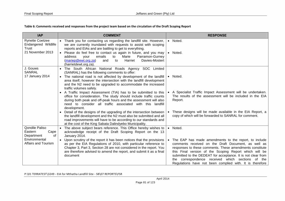
Final Scoping Report Jeffares and Green (Pty) Ltd
P:\01 TERRATEST\3249 - EIA for Mthatha Landfill Site - SB\07 REPORTS\FSR
April 2014
Page 81 of 123
Table 6: Comments received and responses from the project team based on the circulation of the Draft Scoping Report
IAP COMMENT RESPONSE
Rynette Coetzee Endangered Wildlife Trust 21 November 2013
Thank you for contacting us regarding the landfill site. However, we are currently inundated with requests to assist with scoping reports and EIAs and are battling to get to everything.
Please do feel free to contact us again in future, and you may address your emails to Marie Parramon-Gurney ([email protected]) and to Harriet Davies-Mostert (harrietdewt.org.za).
Noted.
Noted.
J. Gouws SANRAL 17 January 2014
The South African National Roads Agency SOC Limited (SANRAL) has the following comments to offer:
The national road is not affected by development of the landfill area itself, however the intersection with the landfill development and the N2 need to be upgraded to accommodate the increased traffic volumes safely.
A Traffic Impact Assessment (TIA) has to be submitted to this office for consideration. The study should include traffic counts during both peak and off-peak hours and the assessment will also need to consider all traffic associated with this landfill development.
Detail of the designs of the upgrading of the intersection between the landfill development and the N2 must also be submitted and all road improvements will have to be according to our standards and at the cost of the King Sabata Dalindyebo Municipality.
Noted.
A Specialist Traffic Impact Assessment will be undertaken. The results of the assessment will be included in the EIA Report.
These designs will be made available in the EIA Report, a copy of which will be forwarded to SANRAL for comment.
Qondile Paliso Eastern Cape Department of Environmental Affairs and Tourism
The above subject bears reference. This Office hereby wishes to acknowledge receipt of the Draft Scoping Report on the 13 January 2014.
Upon scrutiny of the report it has been notices that the provisions as per the EIA Regulations of 2010, with particular reference to Chapter 3, Part 3, Section 28 are not considered in the report. You are therefore advised to amend the report, and submit it as a final document
Noted.
The EAP has made amendments to the report, to include comments received on the Draft Document, as well as responses to these comments. These amendments constitute this Final version of the Scoping Report which will be submitted to the DEDEAT for acceptance. It is not clear from the correspondence received which sections of the Regulations have not been complied with. It is therefore

Final Scoping Report Jeffares and Green (Pty) Ltd
P:\01 TERRATEST\3249 - EIA for Mthatha Landfill Site - SB\07 REPORTS\FSR
April 2014
Page 82 of 123
impossible to make any further amendments in this regard.
C. Russell Department of Water Affairs 14 February 2014
The Draft Scoping Report compiled by Jeffares and Green Consulting dated December 2013 was addressed and comment refers.
The proposed landfill site should not be:
Located below the 1:50 year flood line of a river;
In close proximity to water bodies such as wetlands, vleis, pans, estuaries, and floodplains;
Situated in unstable areas;
Situated in or near sensitive ecological areas;
Situated in areas characterised by flat gradient, shallow or emergent groundwater;
Situated in areas characterised by steep gradients, shallow
Noted.
A Floodline Assessment is proposed to be undertaken during the EIA Phase of the project. The layout of the proposed landfill site will be amended as necessary to ensure that no portions of the proposed site will be located within the 1:50 year floodline.
A Wetland Delineation Assessment is proposed to be undertaken during the EIA Phase. The Wetland Specialist will recommend an appropriate buffer on any wetland areas identified, and the layout of the proposed landfill site will be amended as necessary to ensure that no development occurs within water bodies of their prescribed buffers.
A Geotechnical Assessment will be conducted and included in the EIA Report. This assessment will identify any areas of instability which should be avoided in terms of the proposed development. The layout of the proposed site will be amended as necessary, based on the findings of this assessment.
As stated previously, the entire site has been disturbed, as a result of past agricultural practices. It is the opinion of the EAP, therefore that the only potentially sensitive ecological areas on the site are those associated with watercourses (e.g. wetlands and riparian areas). A Specialist will undertake an identification and delineation exercise of these sensitive ecological areas. Appropriate buffers will be recommended. If necessary, the layout of the proposed development will be amended to accommodate these sensitive areas and their buffers.
These will be investigated by the Geotechnical and Geo-Hydrological Specialists. Based on the recommendations of the specialists regarding these types of areas, the layout of the development will be amended.
These will be investigated by the Geotechnical Specialist.

Final Scoping Report Jeffares and Green (Pty) Ltd
P:\01 TERRATEST\3249 - EIA for Mthatha Landfill Site - SB\07 REPORTS\FSR
April 2014
Page 83 of 123
bedrock with little soil cover, where stability of slopes could be a problem;
Situated on areas of groundwater recharge on account of topography and/or highly permeable soils;
Situated on areas overlying or adjacent to important or potentially important aquifers (Parson Aquifer Classification), where such aquifers are to be used for current or future water supply purposes.
The following documentation should also be forwarded for comments:
Geo-Hydrological Assessment;
Floodline Assessment;
Wetland Assessment.
It should be noted that Local Authorities are responsible for the implementation of legislation governing land development objectives and are therefore responsible for land use planning within areas of their jurisdiction and the appropriate zoning of land taking full cognizance of the environment.
If you have any queries regarding your activity please do not hesitate to contact this office.
Based on the recommendations of the specialist regarding these types of areas, the layout of the development will be amended.
These will be investigated by the Geo-Hydrological Specialist. Based on the recommendations of the specialist regarding these types of areas, the layout of the development will be amended.
These will be investigated by the Geo-Hydrological Specialist. Based on the recommendations of the specialist regarding these types of areas, the layout of the development will be amended.
This will be included in the EIA Report.
This will be included in the EIA Report.
This will be included in the EIA Report.
Noted.
Noted.
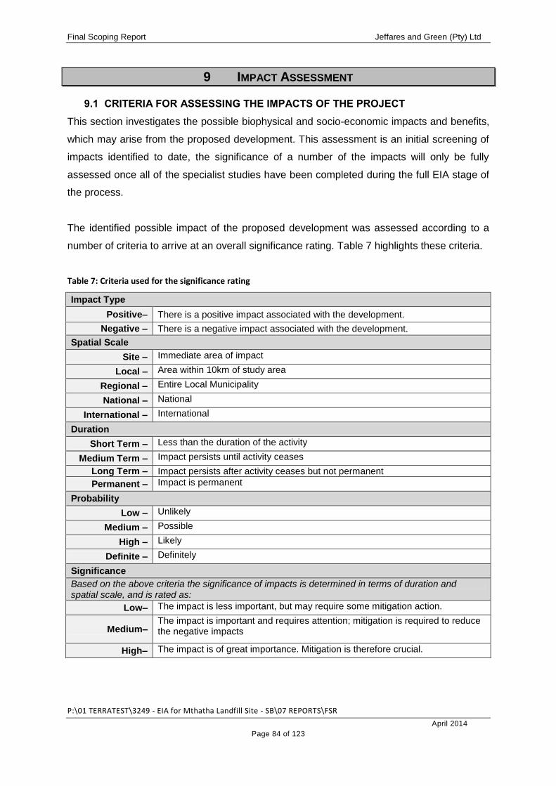
Final Scoping Report Jeffares and Green (Pty) Ltd
P:\01 TERRATEST\3249 - EIA for Mthatha Landfill Site - SB\07 REPORTS\FSR
April 2014
Page 84 of 123
9 IMPACT ASSESSMENT
9.1 CRITERIA FOR ASSESSING THE IMPACTS OF THE PROJECT
This section investigates the possible biophysical and socio-economic impacts and benefits,
which may arise from the proposed development. This assessment is an initial screening of
impacts identified to date, the significance of a number of the impacts will only be fully
assessed once all of the specialist studies have been completed during the full EIA stage of
the process.
The identified possible impact of the proposed development was assessed according to a
number of criteria to arrive at an overall significance rating. Table 7 highlights these criteria.
Table 7: Criteria used for the significance rating
Impact Type
Positive– There is a positive impact associated with the development.
Negative – There is a negative impact associated with the development.
Spatial Scale
Site – Immediate area of impact
Local – Area within 10km of study area
Regional – Entire Local Municipality
National – National
International – International
Duration
Short Term – Less than the duration of the activity
Medium Term – Impact persists until activity ceases
Long Term – Impact persists after activity ceases but not permanent
Permanent – Impact is permanent
Probability
Low – Unlikely
Medium – Possible
High – Likely
Definite – Definitely
Significance
Based on the above criteria the significance of impacts is determined in terms of duration and spatial scale, and is rated as:
Low– The impact is less important, but may require some mitigation action.
Medium– The impact is important and requires attention; mitigation is required to reduce the negative impacts
High– The impact is of great importance. Mitigation is therefore crucial.
Final Scoping Report Jeffares and Green (Pty) Ltd
P:\01 TERRATEST\3249 - EIA for Mthatha Landfill Site - SB\07 REPORTS\FSR
April 2014
Page 85 of 123
9.2 TOPOGRAPHY
9.2.1 Description
The site is dominated by a ridge of higher ground which sits at an altitude of approximately
850 meters above sea level (masl). This ridge runs from the south-east corner of the
property, towards the centre of the property, where its alignment changes to run towards the
north-east corner of the property. To either side of this ridge, to the south-west, the north-
west and the east, the property falls away steeply to drainage lines which run along the
eastern and western boundaries of the property. The altitude of these lowest points is
approximately 790masl.
9.2.2 Potential Impacts
Macro-topographic changes to the landscape will result from the development of the landfill
and will arise from:
The development of waste cells above ground level;
The deposition of waste to a level of 10m above ground level; and
The ongoing coverage and capping of waste cells.
Micro-topographic changes will also result from the installation of surface water diversion
structures and evaporation pond/leachate management system and associated drainage
requirements. These will be of a limited impact considering the more significant overall
change to the landscape resulting from the landfilling process.
9.2.3 Significance Rating
The table below provides a summary of the expected significance rating of the impacts on
the topography of the site as a result of the proposed development.
Table 8: Significance rating of impacts on Topography
CRITERION RATING EXPLANATION
Impact Type Negative
The alteration of the topography of the site will put the area at
increased risk of erosion, with the associated risk of
sedimentation of local watercourses.
Spatial Scale Site The alteration of topography will limited to the footprint of the
proposed development site.
Duration Permanent The impact is permanent
Probability Definite Alteration of the topography of the site is fundamental to the
proposed development. Use of the property as a landfill site

Final Scoping Report Jeffares and Green (Pty) Ltd
P:\01 TERRATEST\3249 - EIA for Mthatha Landfill Site - SB\07 REPORTS\FSR
April 2014
Page 86 of 123
cannot occur is the topography is not altered.
Significance High
The alteration of the sites topography is significant and
requires the implementation of mitigation measures to control
and minimise associated impacts.
9.2.4 Recommended Way Forward
The development of the landfill will result in significant local (site) topographic changes,
which, to the most part cannot be mitigated against. There are a number of mitigation
measures that can be investigated for implementation to ensure that the impact is minimised
where possible:
Cap and shape all waste cells on completion of filling;
Capped and shaped areas must be slightly convex so as to encourage runoff and
minimise infiltration. Slopes should not to exceed a gradient of 1 in 3;
Even out mounds and hollows during the contouring and shaping process to avoid
the creation of low points in which the ponding of water can occur; and
Capped waste cells are to be rehabilitated with indigenous vegetation.
These will be investigated in more detail during the EIA Phase.
9.3 CLIMATE
9.3.1 Description
The climate and local weather of the area are strongly influenced by topography. Average
annual temperature varies between 1.8°C in July and 25.3°C in January.
The proposed development site falls within a summer rainfall area, characterised by dry
winters and wet summers, with thunderstorms being common in summer. Average rainfall in
the region is approximately 877mm per year. Rainfall is of specific significance when it
comes to the management of leachate which is generated when water peculates through the
waste body.
The KSD region experiences wind throughout the year, with a monthly average of 12 – 15
km/hour. Maximum wind speed has been measured at 76km/hour. Wind is of significance in
the operation of a landfill site, especially with regards to the management and control of litter
and dust.
Final Scoping Report Jeffares and Green (Pty) Ltd
P:\01 TERRATEST\3249 - EIA for Mthatha Landfill Site - SB\07 REPORTS\FSR
April 2014
Page 87 of 123
9.3.2 Potential Impacts
Overall, the average climatic conditions experienced during most of the year are moderate
and are unlikely to have a significant impact on the project, however, the following potential
impacts have been identified:
Rainfall levels need to be considered in the planning and design of the leachate
management plan;
High intensity or long duration rainfall events may result in erosion, wash-aways and
creation of dongas, especially in those areas where vegetation has been cleared, or
where landfill construction is underway;
Windy conditions may result in erosion of exposed surfaces where vegetation has
been removed. This may cause a loss of soil material and localised deterioration of
local air quality;
Windy conditions may also result in waste which has not been properly covered, to
become windblown, resulting in litter and contamination of the surrounding
environment;
High winds may result in dust generation as a result of the storage and use of cover
material on the site; and
High temperatures may have an effect on the success of the rehabilitation
programme. High surface temperatures during the summer months when air
temperatures may reach 40ºC and may result in seed germination failure and an
unsuccessful rehabilitation programme.
9.3.3 Significance Rating
The table below provides a summary of the expected significance rating of the impacts
associated with the climate of the area.
Table 9: Significance rating of impacts relating to local climate
CRITERION RATING EXPLANATION
Impact Type Negative
Impacts include increased risk of contamination from
leachate, erosion, sedimentation, litter and dust generation.
These are negative in nature.
Spatial Scale Site and Local Impacts will be limited to the site and those areas immediately
surrounding the proposed development site.
Duration Permanent
The proposed landfill facility is intended as a permanent
development. As long as the facility is in operation, the
identified impacts will be in effect.

Final Scoping Report Jeffares and Green (Pty) Ltd
P:\01 TERRATEST\3249 - EIA for Mthatha Landfill Site - SB\07 REPORTS\FSR
April 2014
Page 88 of 123
Probability High
It is very likely that the identified impacts will occur as the
climatic conditions which will cause these impacts tend to
occur on a regular basis.
Significance Medium
Should the identified impacts occur, they will be easy to
reverse should the recommended mitigation measures be
implemented.
9.3.4 Recommended Way Forward
To minimise the potential impacts, the following should be investigated:
Properly designed and effective leachate management system;
Extent of un-vegetated, exposed surfaces should be kept to the minimum necessary
to enable work to proceed;
Ensure rehabilitation of non-active cells is undertaken continuously and as soon as
possible;
Re-vegetate long-term stockpiles, surface water diversion structures and other
berms;
After a high intensity or long duration rainfall event, identify and repair erosion and
wash-away sites immediately;
Dust abatement measures (i.e. dampening of roads, management of cover material
stockpiles) should be employed during windy conditions;
Waste must be adequately covered each day to minimise windblown litter; and
Correct site management and planning will ensure that adequate scheduling of
operational and rehabilitation procedures is undertaken to manage adverse climatic
conditions at certain times of the year.
These will be investigated in more detail during the EIA Phase.
9.4 AIR QUALITY
9.4.1 Description
Ambient air quality at the preferred development site is impacted upon at present by the
proximity of the N2 Freeway and the agricultural use of the property (grazing of livestock).
9.4.2 Potential Impacts
It is anticipated that ambient air quality will be significantly and negatively impacted by the
proposed landfill development as a result of odour generation and increased dust.
Final Scoping Report Jeffares and Green (Pty) Ltd
P:\01 TERRATEST\3249 - EIA for Mthatha Landfill Site - SB\07 REPORTS\FSR
April 2014
Page 89 of 123
9.4.3 Significance Rating
The table below provides a summary of the expected significance rating of the air quality
impacts associated with the proposed development. The determination of the significance of
these impacts is very difficult as air quality impacts have not been quantified.
Table 10: Significance rating of impacts relating to air quality
CRITERION RATING EXPLANATION
Impact Type Negative Air quality will be decreased as a result of the proposed
development.
Spatial Scale Site and Local Impacts will be restricted to the site and those areas
immediately surrounding the development site.
Duration Permanent
The proposed development is intended as a permanent
installation. As long as the facility is operational, there will be
negative air quality impacts.
Probability Definite The operational landfill will produce odours which will
adversely affect local air quality. This cannot be avoided.
Significance High
The deterioration of air quality could impact upon the health
and well-being of surrounding residents and sensitive
receptors. It is vital therefore that mitigation measures be
employed to minimise and control air quality impacts.
9.4.4 Recommended Way Forward
It is likely that an Air Quality Impact Assessment will need to be conducted for the proposed
development. This will be confirmed following input from key stakeholders and IAPs.
The Air Quality Impact Assessment would involve the screening of potential human health
risks associated with the development of the site as well as dispersion modelling studies
aimed at demarcating appropriate buffer zones and zones of influence around the proposed
site. Baseline air quality sampling, comprehensive air dispersion modelling, health risk
screening and buffer zone projections would need to be conducted. These assessments
would allow for the determination of a health buffer zone, a dust management zone and an
odour management zone. In addition, an Air Quality Management Plan would be compiled
for the proposed development.
Mitigation measures which could be investigated for implementation on the site to minimise
air quality impacts include:

Final Scoping Report Jeffares and Green (Pty) Ltd
P:\01 TERRATEST\3249 - EIA for Mthatha Landfill Site - SB\07 REPORTS\FSR
April 2014
Page 90 of 123
During the Design Phase, the production of landfill gas from the site should be
considered. A comprehensive Landfill Gas Management Plan should be established
including appropriate mitigation measures such as the installation of a Landfill gas
Collection System;
Ambient air sampling could be conducted during construction and following
commissioning of the site. If an Air Quality Assessment is conducted during the EIA
process, this could be considered as a description of the baseline conditions on the
site, against which future air quality can be compared;
If the health buffer zone is determined, it may be necessary to relocate any receptors
falling within this zone. Priority would need to be given to relocating sensitive
receptors such as schools, crèches, places of worship and clinics/hospitals; and
It is recommended that an on-site weather station be installed to collect
meteorological data. Parameters including wind speed and direction as well as
temperature are to be recorded at hourly intervals. This data would aid in the refining
of any identified buffer zones.
9.5 GEOLOGY
9.5.1 Description
The 1:250 000 geological maps indicate that the proposed development site is underlain by
the sediments of the Karoo Supergroup with the mudstones and lesser sandstones of the
Tarkastad and Adelaide subgroups (Beaufort Group) dominant, and some Ecca Group
shale.
9.5.2 Potential Impacts
If the geological conditions on the site are unsuitable, this would have implications for the
sub-surface movement of leachate and associated contamination of ground and surface
water reserves.
9.5.3 Significance Rating
The table below provides a summary of the expected significance rating of the geological
impacts associated with the proposed development. The determination of the significance of
these impacts is very difficult as geological impacts have not yet been quantified.
Table 11: Significance rating of impacts relating of Geology
CRITERION RATING EXPLANATION
Impact Type Negative Should the geology of the site be found to be unsuitable, this

Final Scoping Report Jeffares and Green (Pty) Ltd
P:\01 TERRATEST\3249 - EIA for Mthatha Landfill Site - SB\07 REPORTS\FSR
April 2014
Page 91 of 123
will result in contamination of local water resources as a result
of leaching. In addition, if the site is developed in spite of the
unsuitable geology, this will have cost implications as special
designs will need to be implemented and constructed to
ensure the containment of leachate.
Spatial Scale Site and Local
Should the geology be unsuitable, contamination risk will be
highest on the site and in the areas immediately surrounding
the site.
Duration Permanent
The proposed landfill site is intended as a permanent fixture. If
the subsurface conditions of the site are unsuitable, then as
long as the facility is in operation, there will be a
contamination risk.
Probability Unknown The results of the Geotechnical Assessment will supply this
information.
Significance High
If the geology of the site is unsuitable and the risk of
contamination is high, this could be viewed as a fatal flaw in
the project.
9.5.4 Recommended Way Forward
In order to determine the suitability of the identified sites for development as a landfill site, it
is necessary to undertake a detailed Geotechnical Assessment. Details regarding the
impacts of the proposed development on the subsurface conditions of the site and proposed
mitigation measures will be provided following completion of the Geotechnical Assessment.
9.6 GROUNDWATER
9.6.1 Description
The underlying lithology of the site, which is to be confirmed through a Geotechnical
Assessment, will affect the groundwater regime operating below the site; as groundwater
storage and movement tends to occur within joints, fractures or bedding planes within rock
masses.
In addition to determining subsurface geological conditions therefore, it will be necessary to
determine the presence and proximity of groundwater reserves in order to fully report on the
risk of groundwater contamination as a result of the leaching from the proposed landfill
development. A detailed Geo-Hydrological Assessment will therefore be undertaken and
reported on in the EIA Phase. Information on groundwater recharge, aquifer through-flow
Final Scoping Report Jeffares and Green (Pty) Ltd
P:\01 TERRATEST\3249 - EIA for Mthatha Landfill Site - SB\07 REPORTS\FSR
April 2014
Page 92 of 123
and aquifer potential will be provided in order to determine the strategic value of the
resource.
9.6.2 Potential Impacts
As an assessment of geo-hydrological conditions will only be completed during the EIA
Phase, it is difficult to predict with any certainty what impacts will occur in this regard. More
details will be provided in the EIA Report. it must be noted, however, that the proposed
landfill development has the potential to contaminate groundwater resources as a result of
leachate emanating from the decomposition of the waste material.
9.6.3 Significance Rating
The table below provides a summary of the expected significance rating of the geo-
hydrological impacts associated with the proposed development. The determination of the
significance of these impacts is very difficult as geo-hydrological impacts have not yet been
quantified.
Table 12: Significance rating of impacts relating to Geo-Hydrology
CRITERION RATING EXPLANATION
Impact Type Negative Unsuitable geo-hydrological conditions on the site will result in
increased risk of groundwater contamination.
Spatial Scale Site and Local Contamination risk will be highest on the site and in the areas
immediately surrounding the site.
Duration Permanent The proposed landfill site is intended as a permanent fixture
making the risk to contamination permanent.
Probability Unknown The results of the Geo-Hydrological Assessment will supply
this information.
Significance High
If the risk of contamination is high, this could be viewed as a
fatal flaw in the project. Proper design and monitoring of the
system will be vitally important.
9.6.4 Recommended Way Forward
New generation landfill design principles as well as sound operational and management
practices are essential to mitigate this potential impact. Key mitigation measures which
should be investigated are highlighted below:
Liner system: A GMB+ liner in accordance with the Minimum requirements should be
installed below each cell and extra care should be exercised to ensure continuation
of the liner between adjacent cells;
Final Scoping Report Jeffares and Green (Pty) Ltd
P:\01 TERRATEST\3249 - EIA for Mthatha Landfill Site - SB\07 REPORTS\FSR
April 2014
Page 93 of 123
Phased cell development: The site should be developed as a series of smaller cells,
each with its own stormwater diversion, subsoils drainage and monitoring systems.
Prior to development of new cells, the results of monitoring systems and site audits
should be reviewed by a geo-hydrologist to evaluate the performance of mitigatory
measures and management practices of the preceding cells. Where necessary,
additional geo-hydrological investigation should be carried out to ensure that the
groundwater monitoring network and preventative engineering measures are
adequate;
Leachate management: The implementation and proficient management of specific
engineering measures for the capturing and controlling leachate generated within the
landfill body is essential. All leachate collected from the leachate collection systems
will be piped and discharged into a lined leachate collection ponds with adequate
reserve storage capacity to cope with the combined flow of both the leachate
collection and detection layer in the event of failure of the liner; and
Monitoring: Groundwater monitoring points are to be established, and a regular
monitoring and reporting programme implemented. The sampling regime will be
specified in the permit conditions, which will be included in the EMPr. Samples will
need to be submitted to an accredited laboratory for measurement of a broad range
of both organic and inorganic contaminants.
9.7 SURFACE WATER
9.7.1 Description
To proposed landfill site is bounded to the west and east by two seasonal drainage lines,
which join to the north of the property. Flow within these systems is therefore from south to
north. Associated with the presence of these drainage lines, may be wetland and riparian
areas.
In addition to these, a third drainage line will be impacted upon by the proposed road which
will supply access to the landfill site off the N2 Freeway. It is necessary to construct a
crossing on this drainage line to provide access to the landfill site.
9.7.2 Potential Impacts
The landfill development has the potential to contaminate local surface resources as a result
of leachate emanating from the decomposition of the waste material, as well as
contaminated stormwater runoff.

Final Scoping Report Jeffares and Green (Pty) Ltd
P:\01 TERRATEST\3249 - EIA for Mthatha Landfill Site - SB\07 REPORTS\FSR
April 2014
Page 94 of 123
Construction within the drainage line could result in contamination, increased erosion and
sedimentation of the downstream system.
9.7.3 Significance Rating
The table below provides a summary of the expected significance rating of the hydrological
impacts associated with the proposed development.
Table 13: Significance rating of impacts relating to Surface Water
CRITERION RATING EXPLANATION
Impact Type Negative
If improperly designed, managed and monitored, the landfill
site could result in contamination of surface water as a result
of leaching and contaminated runoff.
Construction of the watercourse crossing could result in
contamination, increased erosion and sedimentation
Spatial Scale Site and Local If contamination of surface water resources occurs, this will
have impacts downstream of the development site.
Duration
Permanent
The proposed landfill site is intended as a permanent fixture.
As long as the facility is in operation, there will be a
contamination risk.
Short term Erosion and sedimentation impacts would be limited to the
construction phase.
Probability High Leachate and contaminants will occur on the site. Control of
these undesirable elements is key.
Significance High
Careful planning and the implementation of management
systems will be required to control and minimise
contamination risks.
9.7.4 Recommended Way Forward
Measures for the minimisation of erosion and the control of contamination whilst working in
watercourses will need to be included in the EMPr for implementation during the construction
of the watercourse crossing.
In order to ensure the protection of surface water and riparian systems, it will be necessary
to identify any wetland areas, delineate their extent and apply and appropriate buffer zone of
no development. An investigation of riparian/wetland areas (should any occur on the site) will
be undertaken and will be reported on in the EIA Report. In addition, the 1:50 and 1:100 year

Final Scoping Report Jeffares and Green (Pty) Ltd
P:\01 TERRATEST\3249 - EIA for Mthatha Landfill Site - SB\07 REPORTS\FSR
April 2014
Page 95 of 123
floodlines will need to be determined to inform the need for flood protection and minimisation
of contamination as a result of flood events.
The following mitigation measures are recommended for investigation. More detailed
measures will be included in the EIA Report following completion of the above-mentioned
specialist studies.
Lined surface water interceptor drains should be installed up-gradient of each cell to
prevent any surface run-off into the active landfill area and active landfill areas should
be limited to minimise rainfall recharge through these uncapped open zones;
Surface water monitoring points should be established and a regular monitoring and
reporting programme implemented. The sampling regime will be specified in the
permit conditions, which will be included in the EMPr;
Samples will need to be submitted to an accredited laboratory for measurement a
broad range of both organic and inorganic contaminants;
In order to quantify the impacts of the landfill on surface water quality, the water
monitoring programme developed for the site must allow for upstream and
downstream sampling locations. The programme will need to take cognisance of
natural water sources used by the local communities. The implementation of the
water monitoring programme will allow for the quantitative comparative assessments
of impacts associated with the facility on water quality. This is the standard practice
set by the regulatory authorities; and
Implementation of new generation landfill design principles and sound operational
and management practices will ensure that surface water resources are not
contaminated as a result of landfill operations.
9.8 FLORA AND FAUNA
9.8.1 Description
The preferred development site comprises and is bounded on all four sides by communal
agricultural land which is utilised for the grazing of cattle, sheep and goats. The preferred
development site falls in an area identified as supporting Mthatha Moist Grassland (Gs 14).
This vegetation type is classified as Vulnerable by the South African National Biodiversity
Institute (SANBI). The proposed development site has been disturbed by past cultivation
(evidenced by the presence of terraces on the property) and, more recently, extensive
grazing. It therefore is not a pristine representation of this vegetation type.

Final Scoping Report Jeffares and Green (Pty) Ltd
P:\01 TERRATEST\3249 - EIA for Mthatha Landfill Site - SB\07 REPORTS\FSR
April 2014
Page 96 of 123
A query of the IUCN Red Data Species database indicates that three species of least
Concern may occur in the area. This list is, however only based on a desktop level
investigation and may not, therefore be complete.
9.8.2 Potential Impacts
The development of the proposed landfill site will result in the total loss of the Mthatha Moist
Grassland (and associated faunal habitat), which is considered to have significant
conservation value.
9.8.3 Significance Rating
The table below provides a summary of the expected significance rating of the biodiversity
impacts associated with the proposed development. The determination of the significance of
these impacts is very difficult as geo-hydrological impacts have not yet been quantified.
Table 14: Significance rating of impacts relating to Biodiversity
CRITERION RATING EXPLANATION
Impact Type Negative Flora and associated faunal habitats would be lost as a result
of the development of a landfill site.
Spatial Scale Site Vegetation and habitat loss would be limited to the
development footprint.
Duration Permanent
The landfill site is intended to be a permanent fixture. As long
as the landfill site is operational, natural biodiversity on the
site will be altered.
Probability Definite The development of a landfill site requires the removal of
vegetation. It cannot be avoided.
Significance High
There will be the complete loss of vegetation and habitats
which potentially have high conservation value. This will need
to be offset through re-vegetation of completed cells with
indigenous vegetation.
9.8.4 Recommended Way Forward
The loss of vegetation cannot be prevented however, the rehabilitation and re-vegetation of
completed landfill cells has the potential to contribute to this grassland biome in the long
term. The following measures will reduce the potential impact:
Rare plant species (if they occur) must be removed from site prior to construction and
replanted in nearby open areas or in an on-site nursery;

Final Scoping Report Jeffares and Green (Pty) Ltd
P:\01 TERRATEST\3249 - EIA for Mthatha Landfill Site - SB\07 REPORTS\FSR
April 2014
Page 97 of 123
Completed cells must be landscaped and re-vegetated with local species as soon as
possible;
Development should be set back from drainage lines and scarp edges;
Further specialist studies to determine the exact status of fauna and flora on the site
is not deemed necessary at this stage, however, this will be confirmed based on
comment received from key stakeholders; and
A Re-vegetation and Alien Vegetation Management Plan should be prepared by a
suitably qualified individual as a condition of the environmental authorisation for use
in the rehabilitation of completed cells.
9.9 SOCIO-ECONOMIC IMPACTS
9.9.1 Description
The proposed landfill site is located within Ward 8, which is situated in the KSD Local
Municipality, which covers an area of approximately 301.77 square kilometres. The KSD
Municipality has an estimated population of 451 710 people, living in approximately 104 240
households
The economy of the KSD Municipality is varied, but most income is generated through a few
key contributors, including agriculture, forestry, fishing, tourism, construction and property
development. The town of Mthatha, located in the centre of the municipality, is a key service
and economic centre.
9.9.2 Potential Impacts
Employment and Economic Opportunities
The area of the proposed landfill site is surrounded by rural, agricultural communities which
currently experience high unemployment rates. It is not known at this time how many
personnel will be required for landfill construction and operation, however, the KSD
Municipality is committed to employing local people first for the jobs that do become
available.
Indirect economic opportunities may result from secondary landfill activities such as the
recycling plant, waste picking, waste separation and sorting, education and conservation
drives, etc. Substantial secondary employment opportunities would be dependent on the
broader local economic development in the area, which may be stimulated by the
development of a large regional waste disposal site.
Final Scoping Report Jeffares and Green (Pty) Ltd
P:\01 TERRATEST\3249 - EIA for Mthatha Landfill Site - SB\07 REPORTS\FSR
April 2014
Page 98 of 123
Property Devaluation
Lack of proper site management and control systems could have a negative effect on
property values in the areas adjacent to the proposed landfill site.
Change in sense of place
Sense of place relates to the nature of an area and the way in which those living there
interact with their social and natural environment. Factors that could possibly affect an
individual’s sense of place includes aesthetics, visibility, noise and lighting nuisance, traffic
disturbance and the changing nature of the landscape as a result of the development of an
area. Sense of place relates broadly to the change in the overall nature of the area.
In the context of the proposed landfill site, sense of place particularly relates to the proximity
of residential settlements to the proposed site, resulting in a number of consequences for the
communities in the surrounding area.
There will be a change in the nature of the area which will be experienced by the adjacent
rural communities. Comment in this regard will need to be sought from the community.]
Impact on future development plans
The proposed landfill site falls outside of any future use planning zones compiled by the KSD
Municipality.
9.9.3 Significance Rating
The table below provides a summary of the expected significance rating of the socio-
economic impacts associated with the proposed development. The determination of the
significance of these impacts is very difficult as no comments on this application have been
received from the local community.
Table 15: Significance rating of Socio-Economic Impacts
CRITERION RATING EXPLANATION
Impact Type Negative Loss of property values and altered sense of place.
Positive Creation of jobs and economic investment opportunities.
Spatial Scale Local Impacts will be limited to the area immediately surrounding
the development site.
Duration Permanent
The landfill site is intended to be a permanent fixture. As long
as the landfill site is operational, the socio-economic impacts
described will be in effect.
Final Scoping Report Jeffares and Green (Pty) Ltd
P:\01 TERRATEST\3249 - EIA for Mthatha Landfill Site - SB\07 REPORTS\FSR
April 2014
Page 99 of 123
Probability Definite The alteration of the land use and character will definitely
have socio-economic impacts. It cannot be avoided.
Significance High
The impacts will have a great effect. The negative impacts
identified require mitigation if they are to be borne by the
surrounding community. The positive impacts need to be
enhanced to ensure the community’s long term support of the
development.
9.9.4 Recommended Way Forward
In terms of mitigation measures, the following is recommended for further investigation:
Where possible, the landfill development must be linked to future local economic
development plans;
Appropriate site management and the implementation of buffer areas with compatible
land use should reduce the negative impact on the value of adjacent properties, and
will ensure that the local community and general area is not negatively affected by
the landfill operations;
A monitoring committee for the landfill must be established and maintained. This
committee requires representation from all relevant parties including community
members. The establishment of this committee will play an important role in allowing
communities to channel their interested and concerns, hence promoting the
principles of social and environmental justice;
Discussions with the local community with regard to possible end uses of the site
need to be undertaken at the time of imminent site closure; and
Proper site management and vegetation screening are mitigation measures that will
ensure that the impact on the receiving environment is reduced as far as possible.
9.10 TRAFFIC ASPECTS
9.10.1 Description
Access to the landfill site will be via a new gravel access road, which will join the N2
Freeway.
9.10.2 Potential Impacts
There will be an increase in the number of slow moving waste transport vehicles on
the N2 Freeway, moving between the site and Mthatha; and
Potential safety issues associated with heavy vehicles leaving and joining the N2
Freeway at the proposed new intersection.
Final Scoping Report Jeffares and Green (Pty) Ltd
P:\01 TERRATEST\3249 - EIA for Mthatha Landfill Site - SB\07 REPORTS\FSR
April 2014
Page 100 of 123
9.10.3 Significance Rating
The table below provides a summary of the expected significance rating of the traffic impacts
associated with the proposed development. The determination of the significance of these
impacts is very difficult as no comments on this application have been received from the
local community.
Table 16: Significance rating of impacts relating to Traffic Impacts
CRITERION RATING EXPLANATION
Impact Type Negative
Increased traffic volumes, increased numbers of heavy, slow
moving traffic, trucks turning off and on to the N2 Freeway,
with associated safety risks.
Spatial Scale Local Impacts will occur on the road network surrounding the
proposed landfill site.
Duration Permanent
The landfill site is intended to be a permanent fixture. As long
as the landfill site is operational, the traffic impacts described
will be in effect.
Probability Definite The operational landfill will require delivery vehicles. This will
result in traffic impacts.
Significance High Mitigation measures will need to be implemented to ensure
the safety of road users in vicinity of the landfill site.
9.10.4 Recommended Way Forward
The following is recommended for further investigation during the EIA Phase:
The access point off the N2 Freeway will require careful design to ensure the safety
of vehicles entering and leaving the facility. Approval of the proposed design will
need to be obtained from the South African National Roads Agency Limited
(SANRAL); and
Comment will be sought from SANRAL regarding the capacity of the road network to
deal with this increase as well as input regarding improved safety for road users
(including signage, rumble strips, etc.).
9.11 NOISE
9.11.1 Description
Currently, there are no noise sources on the site. Ambient noise sources include the N2
Freeway, and noises associated with neighbouring rural residential areas and agricultural
activities (cattle, sheep and goat grazing).

Final Scoping Report Jeffares and Green (Pty) Ltd
P:\01 TERRATEST\3249 - EIA for Mthatha Landfill Site - SB\07 REPORTS\FSR
April 2014
Page 101 of 123
9.11.2 Potential Impacts
The proposed development will alter this noise profile during the construction phase as a
result of increased plant and construction workers on the site. During the operational phase,
noise will be generated by waste delivery vehicles accessing the site, plant utilised in the
daily covering of waste and the presence of the operational work force.
9.11.3 Significance Rating
The table below provides a summary of the expected significance rating of the noise impacts
associated with the proposed development.
Table 17: Significance rating of impacts relating to Noise Impacts
CRITERION RATING EXPLANATION
Impact Type Negative The noise profile of the area will be altered and more
disturbance will be created
Spatial Scale Site and Local The impact will be limited to the development site and those
areas located directly adjacent to the site.
Duration Permanent
The landfill site is intended to be a permanent fixture. As long
as the landfill site is operational, noise impacts will be
generated.
Probability Definite Noise impacts are inescapable as heavy plant will be required
to work on the site
Significance Medium
It is not anticipated that noise levels generated by the site will
exceed regulated noise levels, and will therefore not have
impacts on well-being. However, it will have a nuisance factor
and must therefore be mitigated against.
9.11.4 Recommended Way Forward
The following mitigation measures are proposed for further investigation to ensure that noise
emanating from the site activities is reduced where possible:
Where applicable, acoustic treatment of equipment and machinery should be
implemented which may include silencers on air exhausts of jackhammers and drills,
maintenance of compressor and compactor motor exhausts and/or air hoses and
placing of generators sound-proof containers when in use;
Should noise complaints be received, a noise study may be required. Such an
investigation which should consider the applicability of noise attenuation that could
be offered by the use of physical barriers, i.e. acoustic screens, to separate the noise
source(s) from the noise-sensitive receptors. Such barriers could be in the form of

Final Scoping Report Jeffares and Green (Pty) Ltd
P:\01 TERRATEST\3249 - EIA for Mthatha Landfill Site - SB\07 REPORTS\FSR
April 2014
Page 102 of 123
wooden fences, brick / concrete walls or man-made earth bunds as long as they are
of a mass of at least 10 kg/m2 and are constructed with no holes or gaps.
9.12 VISUAL IMPACTS AND AESTHETICS
9.12.1 Description
The current visual environment comprises an open landscape with rural residential
development interspersed with open spaces, typically grassland, which is utilised for
communal grazing of livestock.
9.12.2 Potential Impacts
The visual landscape will be dramatically altered by the proposed development. this will
have an impact on the sense of place.
9.12.3 Significance Rating
The table below provides a summary of the expected significance rating of the visual
impacts associated with the proposed development.
Table 18: Significance rating of impacts relating to Visual Impacts
CRITERION RATING EXPLANATION
Impact Type Negative The sense of place will be lost and a rural agricultural view will
be replaced with an industrial view.
Spatial Scale Local Only the areas immediately adjacent to the development site
will be affected.
Duration Permanent
The landfill site is intended to be a permanent fixture. As long
as the landfill site is operational, noise impacts will be
generated.
Probability Definite
If the proposed landfill site should be constructed, there would
be no way to avoid the alteration of the visual character of the
site.
Significance Medium
The development will be visually intruding, but will not affect
quality of life or environmental health. Visual impacts can be
managed through the appropriate implementation of mitigation
measures.
9.12.4 Recommended Way Forward
Should the need arise, through the public participation process, a Visual Impact
Assessment will be conducted. This will be included and reported on in the EIA

Final Scoping Report Jeffares and Green (Pty) Ltd
P:\01 TERRATEST\3249 - EIA for Mthatha Landfill Site - SB\07 REPORTS\FSR
April 2014
Page 103 of 123
Report. Recommendations for the minimisation of visual impacts will be included in
the EIA Report and associated EMPr.
Green walls could be constructed to minimise visual impacts. Green walls
themselves can, however obstruct views and look out of scale and place because of
their shape and size. Green wall landscaping should try to replicate natural features
and not appear alien in the landscape. This can be aided by the use of indigenous
vegetation that mirrors the seasonal colour variations of the surrounding environs.
9.13 CULTURAL AND HERITAGE IMPACTS
9.13.1 Description
No above-ground structures of heritage importance are located on the site. It is not known if
any sub-surface artefacts or graves are present on the site.
9.13.2 Potential Impacts
Subsurface heritage artefacts and graves may be present on the site and uncovered by
earthmoving activities during the construction phase. These could potentially be destroyed or
damaged.
9.13.3 Significance Rating
The table below provides a summary of the expected significance rating of the heritage
impacts associated with the proposed development.
Table 19: Significance rating of impacts relating to Heritage Impacts
CRITERION RATING EXPLANATION
Impact Type Negative There is the potential that heritage resources could be
damaged or entirely destroyed as a result of the development.
Spatial Scale Site Risk to heritage resources will be confined to the development
footprint.
Duration Permanent Heritage resources would be permanently damaged or
destroyed.
Probability Unknown
This is dependent on whether or not there are subsurface
heritage resources on the property. This will be confirmed by
input from appropriate specialists.
Significance High The loss of heritage resources is serious and needs to be
avoided as far as possible.

Final Scoping Report Jeffares and Green (Pty) Ltd
P:\01 TERRATEST\3249 - EIA for Mthatha Landfill Site - SB\07 REPORTS\FSR
April 2014
Page 104 of 123
9.13.4 Recommended Way Forward
According to the National Heritage Resources Act No 25 of 1999, provisions are made to
protect national heritage and this forms an integral part of the environmental assessment
process. In order to give effect to this requirement, it will be necessary to determine whether
or not there are any heritage resources on the proposed development site. Input in this
regard will be sought from the SAHRA and the Eastern Cape Heritage Association. Should it
be required, a Heritage Impact Assessment must be conducted. The results of this
assessment will be reported on in the EIA Report.
Final Scoping Report Jeffares and Green (Pty) Ltd
P:\01 TERRATEST\3249 - EIA for Mthatha Landfill Site - SB\07 REPORTS\FSR
April 2014
Page 105 of 123
10 PLAN OF STUDY FOR THE ENVIRONMENTAL IMPACT ASSESSMENT
10.1 INTRODUCTION TO THE EIA PHASE
The Scoping Phase of the project concentrates on determining and describing impacts
associated with the proposed development and identifies the key issues which require
specialist investigations during the EIA phase.
During the EIA Phase, therefore the potential impacts identified in this report will be
confirmed and evaluated according to criteria given in this Plan of Study (PoS). This will be
done in order to determine the significance of the impacts. Mitigation measures to minimize
any significant negative impacts and maximize all positive impacts will be proposed.
10.2 PUBLIC PARTICIPATION PROCESS
The Public Participation Process will continue during the EIA Phase. IAPs will continue to be
informed of the progress regarding the specialist studies and the EIA, and will be asked for
comment on an on-going basis up to the submission of the Final EIA Report for Authority
review and decision-making. In line with the requirements of the NEM:WA, a second advert
will be placed in a local newspaper. This will inform IAPs of the commencement of the EIA
Phase and encourage registration on the project.
A register of the IAPs will be kept. The Draft EIA Report (containing all specialist studies) will
be made available to registered IAPs for a period of 60 days in order to allow comment on
the contents of the document. A Comments and Responses Report listing all issues raised,
together with an indication of how they were considered and/or addressed, will be appended
to the Final EIA Report.
The Final EIA Report will be submitted to DEDEAT once all IAPs have had a chance to
review the Draft EIA Report. Once the authorities have issued a decision on the proposed
project, the IAPs will be informed of the decision and of their right to appeal against the
decision.
10.3 REQUIRED SPECIALIST STUDIES
Five specialist studies have been identified to date which will need to be conducted during
the EIA Phase in order to assess and determine the suitability of the site for the proposed
development. The terms of reference for these studies is detailed below.

Final Scoping Report Jeffares and Green (Pty) Ltd
P:\01 TERRATEST\3249 - EIA for Mthatha Landfill Site - SB\07 REPORTS\FSR
April 2014
Page 106 of 123
10.3.1 Geotechnical Assessment
(i) Objective
The objective of the Geotechnical Assessment will be to determine the suitability of the site
for development as a landfill site from a geotechnical point of reference. This will be
undertaken through the identification of any fatal flaws.
(ii) Scope
The scope of works to be undertaken by the Geotechnical Specialist will include the
following:
Machine excavation of 24 trial pits. Trial pit locations were selected based on the
proposed layout;
Depth to bedrock (where encountered) at each of the trial pits will be recorded;
Characteristics of the subsoil profile will be recorded and reported on. All trial pits will
be profiled according to the methods outlined by Jennings et al (1973) and the Core
Logging Committee of South Africa (1976);
Samples will be taken at each of the trial pits for the following laboratory tests:
o Mod – Modified AASHTO is an indication of compaction density of a material
under the influence of variable water content percentages.
o California Bearing Ratios (CBRs) – used to measure the load bearing
capacity of soils, generally for soils used in the construction of roads.
o Road indicators – A suite of soil description tests, incorporating particle size
grading down to the 0.075mm fraction, soil mortar analysis and Atterberg
Limits.
o Foundation indicators - A suite of soil description tests, incorporating particle
size grading down to the 0.002mm fraction, soil mortar analysis and Atterberg
Limits incorporating potential clay activity.
o Lab permeability tests – Laboratory based permeability tests conducted on a
retrieved soil sample, usually Falling Head Permeability giving a resultant
value of hydraulic conductivity.
o Recompacted shear box tests – Measure of direct shear of a soil sample,
recompacted to an appropriate field density. Yields values for cohesion and
internal angle of friction.
o Dynamic Cone Penetrometer (DCP) tests will be undertaken adjacent to
every second trial pit (a total of 12 DCPs), sunk to 2 meters each. The DCP is
an instrument designed to provide a measure of the in situ density and
estimated allowable safe bearing capacity of a material.

Final Scoping Report Jeffares and Green (Pty) Ltd
P:\01 TERRATEST\3249 - EIA for Mthatha Landfill Site - SB\07 REPORTS\FSR
April 2014
Page 107 of 123
Based on the information obtained from these assessments, the specialist will make
inferences and conclusions relating to inherent ground stability, potential contaminant
ingress, erosion potential, suitability and volume of the materials for earthworks and ease of
excavation, position of the groundwater table where encountered and groundwater seepage.
(iii) Deliverable
The Geotechnical Specialist will supply a report which provides a description of in situ rock
conditions beneath the site, together with an opinion on the general suitability of the site for
development as a landfill.
10.3.2 Geo- hydrological Assessment
(i) Objective
The objective of the Geo-Hydrological Assessment will be to determine the suitability of the
site for development as a landfill site from a geo-hydrological perspective. This will be
undertaken through the identification of any fatal flaws.
(ii) Scope
The Geo-Hydrological Assessment would be undertaken through a number of phases.
These would include:
A Desktop Assessment
This would include an investigation of regional geology and geohydrology (groundwater
occurrence) as well as structural geology and aerial photo interpretation to determine the
presence of any geological structures in the area as these are often zones of heightened
groundwater potential and are therefore at greater risk of contamination as a result of landfill
activities.
In addition, an investigation of existing groundwater resources would be undertaken by
interrogating the National Groundwater Database maintained by the DWA to establish the
existence of any boreholes in close proximity to the proposed development site
The outcomes of these desktop assessments would inform the types and locations of field
surveys to be conducted.
Field Assessment and Hydrocensus
On the site, geological intrusions will be identified which could potentially be exploited as
zones of groundwater potential and which could be fatal flaws to the proposed landfill

Final Scoping Report Jeffares and Green (Pty) Ltd
P:\01 TERRATEST\3249 - EIA for Mthatha Landfill Site - SB\07 REPORTS\FSR
April 2014
Page 108 of 123
development. The topography of the site will be assessed in order to determine its effect on
groundwater flow patterns and the associated implications for contamination. Furthermore,
the presence and location of surface and groundwater resources will be verified through a
hydrocensus. As part of this census the depth to groundwater and the rate of discharge from
the resource will be measured and recorded.
Risk Assessment
A Risk Assessment will be undertaken to determine if the aquifer underneath and adjacent to
the development site will become polluted by leachate emanating from the site and
associated facilities. In carrying out the Risk Assessment, the following will need to be
considered:
o Evaluation of potential contaminants;
o Evaluation of the zone or barrier between the system and the aquifer; and
o Evaluation of the aquifer.
Based on this, an assessment of the vulnerability of the aquifer and its strategic value, will
be made.
Detailed Assessment
In accordance with the DWA Minimum Requirements, a Stage 2 – Detailed Geo-
Hydrological Assessment will be conducted. This will include:
o Geophysical survey;
o Aquifer assessment:
Borehole drilling
Aquifer testing
Water quality testing
o Augmented Risk Assessment and Impact Analysis
Based on the information obtained from these assessments, the specialist will make
inferences and conclusions relating to the inherent suitability of the site for development as a
landfill in terms of local geo-hydrological conditions. Any fatal flaws to the proposed
development will be identified.
(iii) Deliverable
The Geo-Hydrological Specialist will supply a report which provides a description of in situ
geo-hydrological conditions beneath the site, together with an opinion on the general
suitability of the site for development as a landfill.

Final Scoping Report Jeffares and Green (Pty) Ltd
P:\01 TERRATEST\3249 - EIA for Mthatha Landfill Site - SB\07 REPORTS\FSR
April 2014
Page 109 of 123
10.3.3 Traffic Impact Assessment
(i) Objective
To investigate the traffic impacts and assess the adequacy of the access point to the
proposed development site. This study has been requested by SANRAL.
(ii) Scope
The study will need to be conducted in line with any requirements contained within guideline
documents compiled by SANRAL. The study will most likely include traffic counts during both
peak and off-peak hours. The assessment will need to consider traffic associated with:
The transport of general waste to the landfill by municipal waste removal trucks;
Transport of general waste to the landfill by the public;
Transport of recyclables to the recycling facility by private contractors;
Transport of recyclables to the recycling facility by the public;
Public accessing the site to purchase compost; and
Delivery of cover material to the site (if deemed necessary).
The study will need to undertake an assessment of the design of the proposed intersection
between the development site and the N2 Freeway to determine its suitability and capacity
to safely deal with the above-mentioned traffic volumes.
(iii) Deliverables
The Specialist will need to deliver a report which provides an opinion on the suitability of the
proposed intersection between the proposed development site and the N2 Freeway. In
addition, any recommendations for the improvement of the intersection to increase the safety
of road users will need to be included. Mitigation measures to ensure the safety of all road
users in proximity to the proposed intersection will be recommended.
10.3.4 Wetland Assessment
Should any be identified on the property, it will be necessary to undertake a Wetland
Delineation Assessment. This would determine the exact extent of any wetlands on the
property to ensure that no development occurs within these sensitive systems. In addition,
the specialist may recommend a buffer which would be applied to these systems to ensure
protection of these systems. This assessment has been requested by DWA.

Final Scoping Report Jeffares and Green (Pty) Ltd
P:\01 TERRATEST\3249 - EIA for Mthatha Landfill Site - SB\07 REPORTS\FSR
April 2014
Page 110 of 123
10.3.5 Floodline Assessment
(i) Objective
To determine the maximum elevation of flood waters and calculate the inundation area for
each floodline in order to determine how flood events will impact upon the proposed
development and its associated infrastructure. This study has been requested by DWA.
(ii) Scope
The floodline assessment will; comprise the following steps:
Undertake a desktop study to gather the data requires for the peak discharge
calculations which will include catchment physiographic and climatic information for
the site;
Undertake a detailed site visit to obtain the remaining information required to
undertake a peak discharge calculation, including soil and vegetation characteristics.
In addition, any hydraulic structures on the watercourse that may impact upon the
floodline will be assessed for inclusion into the hydraulic modelling; and
Calculate the 1:50 and 1:100 year peak discharge values for the watercourses that
may impact on the landfill site and its infrastructure. Peak discharge values will be
calculated using one of the DWA’s approved methods, such as the Rational Method,
Unit Hydrograph or the SCS-SA Method.
(iii) Deliverables
A map indicating the layout of the proposed landfill site and its proposed infrastructure with
the calculated peak discharges for the 1:50 and 1:100 year flood events overlaid, in order to
indicate which parts of the proposed development will be affected. Recommendations for
flood protection will be included in the report.
10.4 POTENTIAL FURTHER SPECIALIST STUDIES THAT MAY BE REQUIRED
The need may arise during the EIA Phase to undertake further specialist assessments on
the site. These could include:
10.4.1 Air Quality Impact Assessment
(i) Objective
It is likely that an Air Quality Impact Assessment may be required to determine the impact of
odour and dust generated by the proposed landfill site on the environment and the well-
being of the neighbouring rural residential areas.
Final Scoping Report Jeffares and Green (Pty) Ltd
P:\01 TERRATEST\3249 - EIA for Mthatha Landfill Site - SB\07 REPORTS\FSR
April 2014
Page 111 of 123
(ii) Scope
To provide an assessment of the potential air quality impacts associated with the proposed
landfill development on the surrounding environment and the well-being of local residents.
The study would include:
Initial ambient air quality sampling to establish a baseline for air quality;
Preparation of an air emissions inventory from the new landfill site;
Atmospheric dispersion modelling, utilising local meteorological data, to determine
zones of influence around the proposed development site;
Buffer zone projection based on the above-mentioned modelling, including health
buffer zone (if deemed necessary), odour management zone and dust management
zone; and
Recommendation of mitigation measures.
(iii) Deliverables
A report detailing the predicted air quality impacts of the proposed development on the
surrounding environment and rural residential areas, in terms of health and well-being, dust
and odour.
An Air Quality Monitoring and Management Plan should be compiled to monitor, manage
and minimise the above-mentioned impacts. The zones of influence of each of these impacts
should be mapped, indicating their worst case scenario, to show the areas within which the
Monitoring and Management Plan needs to be implemented.
10.4.2 Noise Impact Assessment
It is unlikely that noise generated during the construction and operational phases will exceed
the legislated levels for environmental and public health and well-being. It is therefore not
anticipated that a Noise Impact Assessment will be requires. Should the need arise through
the Public Participation Process following circulation of this Draft Scoping Report, this Plan
of Study will be amended accordingly.
10.4.3 Visual Impact Assessment
(i) Objective
The aim of the Visual Impact Assessment would be to ensure that the visual consequences
of the proposed development are understood and considered.
Final Scoping Report Jeffares and Green (Pty) Ltd
P:\01 TERRATEST\3249 - EIA for Mthatha Landfill Site - SB\07 REPORTS\FSR
April 2014
Page 112 of 123
(ii) Scope
The study would involve an assessment of the visual quality and sense of place of the
landscape through a land survey. The visual impact would be assessed in terms of visual
intrusion (the nature of intrusion of the landfill site), the visual quality of the surrounding
environment and its compatibility with the landscape and surrounding landuse.
The height of the landfill would be modelled at a total height of 20 meters above ground
level. A viewshed of the site would then be generated by a model within a specified radius
(for example 10 km) of the development site.
(iii) Deliverables
A report in which the visual impacts of the landfill development are quantitatively and
qualitatively determined, including a modelled, visual representation of these impacts,
together with recommendations for the mitigation and minimisation of these impacts.
10.4.4 Heritage Impact Assessment
(i) Objective
Heritage resources are protected in terms of the National Heritage Resources Act (No. 25 of
1999). Heritage resources are not limited to archaeological artefacts, historical buildings and
graves, but also include intangible and invisible resources such as places, oral traditions and
rituals. Heritage resources also include any place or object of cultural significance, i.e. of
aesthetic, architectural, historical, scientific, social, spiritual, linguistic or technological value
or significance. The Heritage Impact Assessment will therefore need to identify these
resources on the site to ensure their protection in terms of the above-mentioned Act. The
need for this assessment will be informed by comment received from SAHRA.
(ii) Scope
A desktop assessment of the heritage database would be undertaken to determine if any
heritage resources are predicted to occur in the area. This would then be verified by a site
assessment. The site assessment would comprise a controlled-exclusive ground survey
which requires an inspection of the surface of the ground, wherever the surface is visible,
with no substantial effort to clear bush, turf, deadfall, leaves or other material that may cover
the surface and with no attempt to look beneath the surface beyond the inspection of rodent
burrows, cur banks and other exposures that are observed by accident, to discover any
heritage resources.

Final Scoping Report Jeffares and Green (Pty) Ltd
P:\01 TERRATEST\3249 - EIA for Mthatha Landfill Site - SB\07 REPORTS\FSR
April 2014
Page 113 of 123
(iii) Deliverables
Provide an assessment on the potential presence of heritage resources and their
significance (should they occur). Provide mitigation measures and a way forward to ensure
the protection of any heritage resources on the site. Should it be required, advice on
application for permits from SAHRA will be provided.
10.4.5 Social Impact Assessment
It may be necessary to conduct a Social Impact Assessment in order to determine the
impact of the proposed landfill site on the surrounding rural residential population, as the
proposed development constitutes a significant alteration of land use and aesthetic. The
need for a Social Impact Assessment will be determined based on the comments received in
response to this Draft Scoping Report. It must be noted, however, that the Qweqwe
Community has signed a Community Resolution indicating that they have no objection to the
proposed landfill development on the preferred site.
All specialist studies will be undertaken in compliance with regulation 33(2) of GN 385, and
will include:
details of –
the specialist who prepared the report; and
the expertise of that specialist to carry out the specialist study;
an indication of the scope of, and the rationale for the report;
a description of the methodology adopted in conducting the specialist study;
a description of all assumptions uncertainties or gaps in knowledge;
a description of all the impacts direct and secondary and the implications of the
impacts of the proposed project, including identified alternatives, on the receiving
environment;
a description of the cumulative impacts the proposed project, including identified
alternatives, would have on the receiving environment;
recommendations in respect of any mitigation measures that should be considered
by the applicant and the competent authority;
any other information requested by the competent authority.
All mitigation measures required will be defined for inclusion in the EMPr. This programme
will also include an Alien Vegetation Control Programme.

Final Scoping Report Jeffares and Green (Pty) Ltd
P:\01 TERRATEST\3249 - EIA for Mthatha Landfill Site - SB\07 REPORTS\FSR
April 2014
Page 114 of 123
10.5 INVESTIGATION OF ALTERNATIVES
Details regarding the alternatives that will be considered in more detail in the EIA Phase are
contained within Section 6 of this Draft Scoping Report. The alternatives that will be
considered are listed below.
10.5.1 Alternate Development Sites
Preferred Site – Qweqwe Site
Alternate Site 1 - De Colgny Site
Alternate Site 2 – Highbury Site
Alternate Site 3 – Orange Grove Site
10.5.2 Alternate Layouts
Preferred Layout – Layout 1
Alternate Layout 1 – Layout 2
Alternate Layout 2 – Layout 3
10.5.3 Alternate Leachate Treatment Methods
Preferred Method – Oxidation Ponds and Constructed Wetlands
Alternate Method 1 – Municipal WWTW
Alternate Method 2 – Onsite WWTW
Alternate Method 3 - Evaporation
10.5.4 No Go Alternative
The no-go option would be to not implement the proposed landfill site development on the
preferred site and to retain the current status quo. This would mean that the existing, un-
licenced and incorrectly designed landfill site currently utilised for the Mthatha area, would
continue to be used. It must be noted that this landfill site is approaching capacity, requiring
the identification of a new and suitable landfill site.
10.6 LICENSING
The establishment of the sewage package treatment plant will require a Waste Licence and
potentially, a Water Use Licence.
10.6.1 Waste License Application
In terms of the National Environmental Management: Waste Act, 2008 (Act No. 59 of 2008),
the proposed establishment of a new landfill site triggers activities listed under Categories A,
Final Scoping Report Jeffares and Green (Pty) Ltd
P:\01 TERRATEST\3249 - EIA for Mthatha Landfill Site - SB\07 REPORTS\FSR
April 2014
Page 115 of 123
B and C of GN 921 (of 29 November 2013) and thus requires a Waste License Application
as well as environmental authorisation.
An Application for Integrated Environmental Authorisation and Waste Management Licence
has been completed and submitted to the relevant Competent Authority.
10.6.2 Water Use License
It is likely that the proposed landfill site will require a Water Use License from the DWA in
order to discharge treated leachate from the facility to the environment. Input from the DWA
in this regard will be sought and the necessary steps will be taken to obtain the relevant
licenses/authorisations should the proposed development receive environmental
authorisation.
10.7 ENVIRONMENTAL IMPACT ASSESSMENT METHODOLOGY
The EIA process will be undertaken in line with the requirements of the promulgated EIA
Regulations of the NEMA.
The outcomes of the plan of study for EIA include the following:
Provide a description of the tasks that are undertaken as part of the EIA process,
including any specialist reports or specialised processes, and the manner in which
such tasks were undertaken;
Provide an indication of the stages at which the competent authority will be
consulted;
Provide a description of the proposed method of assessing the environmental issues
and alternatives, including the option of not proceeding with the activity;
Overview of the stakeholder engagement that was conducted during the EIA
process; and
Include any specific information required by the competent authority.
The purpose of the EIA and draft EMPr is to provide/determine:
An assessment of the environments likely to be affected by the proposed project;
An assessment of the nature, extent, duration, probability and significance of the
identified potential environmental, social and cultural impacts of the proposed project;
A comparative assessment of the identified land use and development alternatives
and their potential environmental, social and cultural impacts;
The appropriate mitigation measures for each significant impact of the proposed
project;
Final Scoping Report Jeffares and Green (Pty) Ltd
P:\01 TERRATEST\3249 - EIA for Mthatha Landfill Site - SB\07 REPORTS\FSR
April 2014
Page 116 of 123
Details of the stakeholder engagement process followed during the course of the
assessment and an indication of how the issues raised have been addressed;
Identification of knowledge gaps and reporting on the adequacy of predictive
methods, underlying assumptions and uncertainties encountered in compiling the
required information;
A description of the arrangements for monitoring and management of environmental
impacts; and
Inclusion of technical and supporting information as appendices, if available.
The EIA process will see the following deliverables submitted for stakeholder review
and approval by the responsible authority (DAEA) will include the following:
Specialist Investigations;
Environmental Impact Report; and
Environmental Management Programme.
The EIA Report will contain the following information:
Details of the EAP who compiled the report and their expertise to carry out an EIA;
Detailed description of the proposed activity;
Description of the property on which the activity is to be undertaken and the location
of the activity on the property;
A description of the environment that may be affected by the activity and the manner
in which the physical, biological, social, economic and cultural aspects of the
environment may be affected by the proposed activity (pre-development description
of the environment);
Details of the stakeholder engagement conducted during the scoping phase and the
on-going consultation during the EIA phase;
Description of the need and desirability of the proposed activity and identified
potential alternatives to the proposed activity, including advantages and
disadvantages that the proposed activity or alternatives may have on the
environment and the community that may be affected by the activity;
An indication of the methodology used in determining the significance of potential
environmental impacts;
A description and comparative assessment of all alternatives identified during the EIA
process;
A summary of the findings and recommendations of any specialist report or report on
a specialised process;

Final Scoping Report Jeffares and Green (Pty) Ltd
P:\01 TERRATEST\3249 - EIA for Mthatha Landfill Site - SB\07 REPORTS\FSR
April 2014
Page 117 of 123
A description of all environmental issues that were identified during the EIA process,
and assessment of the significance of each issue and an indication of the extent to
which the issue could be addressed by the adoption of mitigation measures;
An assessment of each identified potentially significant impact including cumulative
impacts, the nature of the impact, the extent and duration of the impact, the
probability of the impact occurring, the degree to which the impact can be reversed;
the degree to which the impact may cause irreplaceable loss of resources, and the
degree to which the impact can be mitigated;
A description of assumptions, uncertainties and gaps in knowledge;
An opinion as to whether the activity should or should not be authorised, and if the
opinion is that it should be authorised, any conditions that should be made in respect
of that authorisation;
An environmental impact statement which contains a summary of the key findings of
the environmental impact assessment and a comparative assessment of the positive
and negative implications of the proposed activity and identified alternatives;
A draft EMPr; and
Compilation of a specialist volume.
During the compilation of the EIA, a draft EMPr will be compiled in accordance with the
NEMA EIA Regulations (2010). The draft EMPr will provide the actions for the management
of identified environmental impacts emanating from the proposed project and a detailed
outline of the implementation programme to minimise and/or eliminate the anticipated
negative environmental impacts. The draft EMPr will provide strategies to be used to
address the roles and responsibilities of environmental management personnel on site, and
a framework for environmental compliance and monitoring. The draft EMPr will be complied
as part of the EIA.
The draft EMPr will include the following:
Details of the person who prepared the draft EMPr and the expertise of the person to
prepare and draft EMPr;
Information on any proposed management or mitigation measures that will be taken
to address the environmental impacts that have been identified in the EIA report,
including environmental impacts or objectives in respect of planning and design, pre-
construction and construction activities, operation or undertaking of the activities,
rehabilitation of the environment and closure where relevant;

Final Scoping Report Jeffares and Green (Pty) Ltd
P:\01 TERRATEST\3249 - EIA for Mthatha Landfill Site - SB\07 REPORTS\FSR
April 2014
Page 118 of 123
A detailed description of the aspects of the activity that are covered by the draft
EMPr;
An identification of the people who will be responsible for the implementation of the
measures;
Where appropriate, time periods within which the measures contemplated in the draft
EMPr must be implemented; and
Proposed mechanisms for monitoring compliance with the draft EMPr and reporting
thereon.
10.8 IMPACT ASSESSMENT METHODOLOGY
Impacts will be identified in terms of their nature, intensity, spatial scale, duration, probability
and impact rating to provide significance. Once mitigation measures are identified, the
efficacy of the mitigation measures will be assessed using the same methodology.
Impact assessment methodology is provided in Table 20 below.
Table 20: Criteria for the impact assessment methodology
Nature
Direct Indirect Cumulative
Positive
Negative
A. Intensity
No Impact
(NI)
There is no impact at all - not even a very low impact on a party or
system. 0
Very Low
(VL)
Impact is negligible within the bounds of impacts which could occur. In
the case of adverse impacts, almost no mitigation and/or remedial
activity is needed, and any minor steps which might be needed are
easy, cheap, and simple. In the case of beneficial impacts, alternative
means are almost all likely to be better, in one or a number of ways,
than this means of achieving the benefit. Three additional categories
must also be used where relevant. They are in addition to the
category represented on the scale, and if used, will replace the scale.
1
Low
(L)
Impact is of a low order and therefore likely to have little real effect. In
the case of adverse impacts: mitigation and/or remedial activity is
either easily achieved or little will be required, or both. In the case of
beneficial impacts, alternative means for achieving this benefit are
likely to be easier, cheaper, more effective, less time consuming, or
some combination of these.
2

Final Scoping Report Jeffares and Green (Pty) Ltd
P:\01 TERRATEST\3249 - EIA for Mthatha Landfill Site - SB\07 REPORTS\FSR
April 2014
Page 119 of 123
Medium
(M)
Impact is real but not substantial in relation to other impacts, which
might take effect within the bounds of those which could occur. In the
case of adverse impacts: mitigation and/or remedial activity are both
feasible and fairly easily possible. In the case of beneficial impacts:
other means of achieving this benefit are about equal in time, cost,
effort, etc.
3
High
(H)
Impact is of substantial order within the bounds of impacts, which
could occur. In the case of adverse impacts: mitigation and/or
remedial activity is feasible but difficult, expensive, time-consuming or
some combination of these. In the case of beneficial impacts, other
means of achieving this benefit are feasible but they are more difficult,
expensive, time-consuming or some combination of these.
4
Very High
(VH)
Of the highest order possible within the bounds of impacts which could
occur. In the case of adverse impacts: there is no possible mitigation
and/or remedial activity which could offset the impact. In the case of
beneficial impacts, there is no real alternative to achieving this benefit.
5
B. Spatial Scale
Isolated/
Proposed
Site
The impact will affect an area no bigger than the development site. 1
Study Area The impact will affect an area not exceeding the boundary of the
AfroProp property. 2
Local The impact will affect an area up to 5 km from the proposed
development site. 3
Regional/
Provincial
The spatial scale is moderate within the bounds of impacts possible,
and will be felt at a regional scale (District Municipality to Provincial
Level).
4
National/
Global The maximum extent of any impact. 5
C. Duration
Incidental The impact will be limited to isolated incidences that are expected to
occur very sporadically. 1
Short-term
The environmental impact identified will operate for the duration of the
construction phase or a period of less than 5 years, whichever is the
greater.
2
Medium term The environmental impact identified will operate for the duration of life
of plant. 3
Long term The environmental impact identified will operate beyond the life of
operation. 4

Final Scoping Report Jeffares and Green (Pty) Ltd
P:\01 TERRATEST\3249 - EIA for Mthatha Landfill Site - SB\07 REPORTS\FSR
April 2014
Page 120 of 123
Impact Risk = (Intensity + Spatial + Duration) x Probability
3 5
Permanent The environmental impact will be permanent. 5
D. Probability
Practically impossible 1
Unlikely 2
Could happen 3
Very Likely 4
It’s going to happen / has occurred 5
10.9 QUANTITATIVE DESCRIPTION OF IMPACTS
To allow for impacts to be described in a quantitative manner in addition to the qualitative
description given above, a rating scale of between 1 and 5 will be used for each of the
assessment criteria. Thus the total value of the impact is described below:
Table 20 below provides an example of how the rating tool is implemented.
Table 21: Example of how a described impact is characterised
Described Impact
Intensity Spatial Scale
Duration Probability Rating
Impact to air Low Local Medium-term Could Happen
2 3 3 3 1.6
Impact Risk = (2 + 3 + 3) x 3
3 5 = 2.67 x 0.60
= 1.60
= Very Low
Explanation: The intensity, spatial scale and duration are added to give a total of 8, that is
divided by 3 to give a criteria rating of 2,67. The probability (3) is divided by 5
to give a probability rating of 0,6. The criteria rating of 2,67 is then multiplied
by the probability rating (0,6) to give the final rating of 1,6.
Table 22: Impact Risk Classes
RATING IMPACT CLASS DESCRIPTION
0.1 – 1.0 1 Very Low
1.1 – 2.0 2 Low

Final Scoping Report Jeffares and Green (Pty) Ltd
P:\01 TERRATEST\3249 - EIA for Mthatha Landfill Site - SB\07 REPORTS\FSR
April 2014
Page 121 of 123
RATING IMPACT CLASS DESCRIPTION
2.1 – 3.0 3 Moderate
3.1 – 4.0 4 High
4.1 – 5.0 5 Very High

Final Scoping Report Jeffares and Green (Pty) Ltd
P:\01 TERRATEST\3249 - EIA for Mthatha Landfill Site - SB\07 REPORTS\FSR
April 2014
Page 122 of 123
11 CONCLUSION
The Scoping Phase was undertaken in line with the requirements of the NEMA EIA
Regulations R543. The proposed development requires environmental authorisation in terms
of the NEMA Regulations (GNR 545) as well as a Waste License Application in terms of the
NEM:WA (GN 921).
The proposed development site falls within the King Sabata Dalindyebo Local Municipality,
in an area which has historically been utilised for communal agriculture. The Municipality has
identified a need to establish a new general waste landfill site to service the town of Mthatha
and its surrounds for the next 20 years. The proposed landfill considered in this report will
meet this need and will allow for compliance with all relevant environmental and health and
safety regulations related to landfill operations. The landfill site is therefore anticipated to be
sustainable in the long term.
The Scoping Report has identified the main impacts associated with the proposed
development. During the EIA Phase, these issues will be addressed and investigated in
greater detail to determine their significance as well as to recommend appropriate mitigation
measures. The Plan of Study described in Section 10 describes the proposed methodology
that will be adopted in order to accomplish this. The Plan of Study also includes the terms of
reference for the proposed specialist studies, a description of the risk rating methodology to
be used and details of the overall deliverables of the EIA process.
No fatal flaws in terms of ecological, social or economic impacts associated with the
proposed development, have been identified to date.

Final Scoping Report Jeffares and Green (Pty) Ltd
P:\01 TERRATEST\3249 - EIA for Mthatha Landfill Site - SB\07 REPORTS\FSR
April 2014
Page 123 of 123
12 REFERENCES
1. Arcus Gibb, February 2009. EC – OR Tambo Waste Minimisation Project. King Sabata
Dalindyebo Municipality: Mthatha Landfill Feasibility Study: Pre-Feasibility Report.
Volume 1: Identification and Ranking of Candidate Sites. Project No.: J28276.
2. Kwezi V3 Engineers, October 2007. Disposal Site Census Report of Unauthorised
Disposal Sites in South Africa. Report No. 227870/PWO. Volume 1. For Department of
Environmental Affairs and Tourism.
3. Mucina, L. and Rutherford, M.C. (eds) (2006): The Vegetation of South Africa, Lesotho
and Swaziland. Strelitzia 19. Pretoria: South African National Biodiversity Institute.
4. King Sabata Dalindyebo Local Municipality: Integrated Development Plan 2012 – 2017.
5. King Sabata Dalindyebo Local Municipality: Spatial Development Framework: March
2007.