Embed Size (px)
Citation preview
FINAL TERMS OF REFERENCE
PROPOSED RANNEY FALLS GENERATING STATION G3 EXPANSION PROJECT
Submitted to: Ontario Power Generation Inc.
700 University Avenue Toronto, Ontario
M5G 1X6
By: SENES Consultants
121 Granton Drive, Unit 12 Richmond Hill, Ontario
L4B 3N4
Prepared by: January 2015
Jerry Fitchko, SENES Date Project Manager EA Consulting Team
Approved by: January 2015
Donald Gorber, SENES Date President
Reviewed by: January 2015 Gillian MacLeod Date Senior Environmental Specialist Ontario Power Generation Inc.
Accepted by: January 2015 Iskander Boulos Date Project Manager Ontario Power Generation Inc.
Final Terms of Reference – Proposed Ranney Falls G3 Project
TABLE OF CONTENTS Page No.
INTRODUCTION ......................................................................................................................... I
1.0 PROJECT ....................................................................................................................1-1 1.1 Scope of Project ...............................................................................................1-1 1.2 Background .......................................................................................................1-2
1.2.1 Purpose and Justification ......................................................................1-2 1.2.2 Alternatives and Alternative Means .......................................................1-2 1.2.3 Relationship of the Proposed Project to Existing Conditions ..................1-2 1.2.4 Federal and Provincial Approvals ..........................................................1-3 1.2.5 Conformance with Parks Canada Policy and Directives ........................1-4
1.3 Project Description ............................................................................................1-4
2.0 SITE DESCRIPTION ....................................................................................................2-1 2.1 Site Location and Size ......................................................................................2-1 2.2 Site-specific Land Use History ..........................................................................2-1 2.3 Climate/Air Quality ............................................................................................2-2 2.4 Geology/Physiography ......................................................................................2-2 2.5 Soils ..................................................................................................................2-2 2.6 Vegetation.........................................................................................................2-2 2.7 Significant Natural Features ..............................................................................2-3 2.8 Wildlife ..............................................................................................................2-3 2.9 Surface Water and Groundwater Hydrology and Quality ...................................2-3 2.10 TSW/Trent River Morphology, Bathymetry and Substrate .................................2-4 2.11 Aquatic Vegetation ............................................................................................2-4 2.12 Benthic Macroinvertebrates ..............................................................................2-4 2.13 Fisheries Resources .........................................................................................2-4 2.14 Species at Risk .................................................................................................2-4 2.15 Land and Water Uses .......................................................................................2-5 2.16 Socio-economics...............................................................................................2-5 2.17 Built Heritage and Archaeological Resources ...................................................2-5
3.0 ENVIRONMENTAL EFFECTS AND MITIGATION MEASURES ...................................3-1 3.1 Valued Ecosystem Components .......................................................................3-1
3.1.1 Landform and Soils ...............................................................................3-1 3.1.2 Vegetation .............................................................................................3-2 3.1.3 Wildlife ..................................................................................................3-2 3.1.4 Aquatic/Hydrological Resources ............................................................3-2 3.1.5 Pollution ................................................................................................3-3
3.2 Cultural Features ..............................................................................................3-3 3.2.1 Consultation ..........................................................................................3-3 3.2.2 Aesthetics ..............................................................................................3-4 3.2.3 Public Facilities and Services ................................................................3-4 3.2.4 Public Safety .........................................................................................3-4 3.2.5 Cultural Heritage ...................................................................................3-5 3.2.6 Socio-economics ...................................................................................3-5
4.0 CUMULATIVE ENVIRONMENTAL EFFECTS ..............................................................4-1
5.0 RESIDUAL IMPACTS ...................................................................................................5-1
6.0 SITE INSPECTION REQUIREMENTS .........................................................................6-1
350450 i January 2015
Final Terms of Reference – Proposed Ranney Falls G3 Project 7.0 MONITORING REQUIREMENTS .................................................................................7-1
8.0 REFERENCES .............................................................................................................8-1
9.0 ACRONYMS/ABBREVIATIONS ...................................................................................9-1
LIST OF FIGURES Page No.
Figure 1.1 Project Location ................................................................................................1-6 Figure 1.2 Aerial Photo of Ranney Falls GS Setting ...........................................................1-7 Figure 1.3 Aerial Photo of Existing Ranney Falls GS Showing Proposed Project
Infrastructure Layout .........................................................................................1-9 Figure 1.4 Schematic of Proposed Ranney Falls G3 Project Infrastructure Layout .......... 1-10
350450 ii January 2015
Final Terms of Reference – Proposed Ranney Falls G3 Project INTRODUCTION This document is the final Terms of Reference (ToR) for the Ranney Falls Generating Station G3 Expansion Project (Ranney Falls G3 Project or Project) proposed by Ontario Power Generation Inc. (OPG). This final ToR follows the guidance provided within the Parks Canada “Generic Terms of Reference for preparation of a Detailed Environmental Impact Analysis (DIA) Report pursuant to the Parks Canada Directive on Implementation of the Canadian Environmental Assessment Act 2012” (Generic ToR). As the proposed Ranney Falls G3 Project is on a federal waterway and subject to the federal Dominion Water Power Act administered by Parks Canada, it is not subject to the Ontario Environmental Assessment Act (V. Mitchell, MOE, 2012, pers. comm.). The proposed Project is also exempt from the Lower Trent Conservation (LTC) Permit for Development, Interference with Wetlands and Alterations to Shorelines and Watercourses under Ontario Regulation 163/06 of the Conservation Authorities Act (M. Lovejoy, LTC, 2012, pers. comm.). As part of the federal government plan for Responsible Resource Development, which seeks to modernize the regulatory system for project reviews, Canadian Environmental Assessment Act (S.C. 1992, c. 37) was recently repealed when the Canadian Environmental Assessment Act, 2012 (CEAA 2012) came into force. For projects on federal lands that are not designated projects, CEAA 2012 requires that before federal authorities make any decision that would allow a project to proceed, they must determine whether a project is likely to cause significant adverse environmental effects. As CEAA 2012 does not establish a process for determining whether the undertaking of a non-designated project is likely to cause significant adverse environmental effects, the involved federal departments, e.g., Parks Canada, Department of Fisheries and Oceans (DFO), Environment Canada, Transport Canada, must establish their own (or conduct joint efforts) for the environmental effects review process. As the proposed Ranney Falls G3 Project occurs within a Parks Canada protected heritage area, the Trent-Severn Waterway National Historic Site of Canada, Parks Canada is responsible for review of the draft DIA Report, determination of significance of effects, and approval of the Project with conditions, or rejection with explanation. Parks Canada – Ontario Waterways, Trent-Severn Waterway (Parks Canada – TSW) has determined that under section 67 of the CEAA 2012 a DIA will be required to assess potential environmental impacts of the proposed Ranney Falls G3 Project and to determine if proposed mitigation measures will address these impacts. A draft ToR was submitted in June 2014 to Parks Canada – TSW for review by the Federal Review Team which included Parks Canada – TSW, DFO, Environment Canada and Transport Canada. The draft ToR was also reviewed by the Ontario Ministry of Environment and Climate Change (MOECC) and Ontario Ministry of Natural Resources and Forestry (MNRF).
350450 I January 2015
Final Terms of Reference – Proposed Ranney Falls G3 Project This final ToR forms the basis for the environmental effects review process for the proposed Project. The draft DIA Report together with Technical Support Documents (TSDs) will be prepared by OPG based on the final ToR for review by the Federal Review Team, MOECC and MNRF. Based on technical information provided by OPG, DFO has determined that the proposed Project “is not likely to result in impacts to fish and fish habitat provided that additional mitigation measures are applied”. Based on the Letter of Advice (LOA) dated July 17, 2012, a formal approval from DFO is not required (C. Strand, DFO, 2012, pers. comm. and follow-up DFO Fisheries Protection e-mail dated July 31, 2014). Environment Canada, Canadian Wildlife Service (CWS), has approved the “Turtle Nesting Habitat Mitigation Plan” prepared by OPG to create and enhance access and nesting habitat for Northern Map Turtle (Graptemys geographica) and Eastern Snapping Turtle (Chelydra serpentina serpentina), both designated as Special Concern federally and provincially (K-A. Fagan, Environment Canada, 2012, pers. comm.). As the Trent River/Canal from Rice Lake to Lake Ontario is included in the Navigation Protection Act (NPA) List of Scheduled Waters, an application for approval of the proposed Project will be prepared by OPG in the form and manner, as well as contain the information, specified by Transport Canada.
350450 II January 2015
Final Terms of Reference – Proposed Ranney Falls G3 Project 1.0 PROJECT 1.1 SCOPE OF PROJECT The Ranney Falls Generating Station (GS) site was formerly leased by the Federal Government to the Seymour Power Company. With its purchase of the Seymour Power Company on March 9, 1916, ownership rights to the site were acquired by the Province. Ranney Falls GS G1 and G2 units were commissioned in August 22, 1922 and September 2, 1922, respectively. Unit G3, which started operation in 1926, was acquired by the Hydro-Electric Power Commission of Ontario from the Quinte and Trent Valley Power Company in 1937. Ranney Falls GS was transferred to OPG on April 1, 1999, and is managed by OPG’s Central Hydro Plant Group (CHPG) with remote operation from its North Bay Control Centre and maintained by its Campbellford Service Centre. OPG is proposing to expand the capacity of its Ranney Falls GS located on the TSW in the Municipality of Trent Hills (Trent Hills). There are two powerhouses on site. The main powerhouse has the G1 and G2 turbine units, each operating at approximately 5 MW during maximum flows. A secondary powerhouse, referred to as the “Pup”, contains the 0.72 MW G3 unit that has reached its end-of-life. Ranney Falls GS was first identified by Ontario Hydro (1992) to be within the scope of the Small Hydroelectric Assessment and Retrofit Program (SHARP) for assessment of its long-term viability as a generating resource. The SHARP was established as a formalized approach to address operational optimization of the 33 existing small and ageing hydroelectric stations within the hydraulic generation system. Based on the criteria for age, capacity and operating condition, the SHARP identified Ranney Falls GS as a potential opportunity for renewal and improvement. As a result, a Concept Phase Study for the Ranney Falls GS was undertaken by KST Hydroelectric Engineers (KST, 1992) to review all available project options and recommend a preferred alternative, as well as to identify the detailed engineering and environmental studies and their associated costs for the Definition Phase. Due to the cancellation of the SHARP, further work associated with the redevelopment of Ranney Falls GS was terminated. In 2005, OPG again initiated a site evaluation and an assessment of concept alternatives for Ranney Falls GS expansion focusing on the redevelopment of the secondary “Pup” powerhouse (Hatch Acres, 2006). As a result, OPG has identified an opportunity to expand its capacity by replacing the secondary “Pup” powerhouse with a new unit having an incremental capacity of up to 10 MW (OPG, 2011). The draft DIA Report will clearly define the scope of the proposed Project and will follow the direction provided within this final ToR. The report will provide a commitment for submission of an Environmental Management Plan (EMP) for review and approval by Parks Canada – TSW prior to commencement of work.
350450 1-1 January 2015
Final Terms of Reference – Proposed Ranney Falls G3 Project 1.2 BACKGROUND 1.2.1 Purpose and Justification The proposed Ranney Falls G3 Project is being undertaken by OPG to improve the efficient use of the available hydroelectric potential at the site, to reduce greenhouse gas emissions and to increase the amount of clean renewable energy from OPG’s CHPG, without any changes to the overall flow within the Trent River or to existing TSW water management. OPG conclude that The Panel on the Future of the Trent-Severn Waterway (PFTSW, 2008) encouraged the development of renewable resources as a sound public policy goal and supported vigorous effort to pursue green energy generating potential along the TSW. The proposed Project is consistent with the Provincial Policy Statement, which recommends that the use of existing infrastructure and public service facilities should be optimized, wherever feasible, before consideration is given to developing new infrastructure and public service facilities (OMMAH, 2014). Moreover, the operation of the new spillway will preclude the potential for flooding along the Trent Canal upstream of Locks #11 and #12. The purpose and justification for the proposed Project will be further elaborated in the draft DIA Report. 1.2.2 Alternatives and Alternative Means Maintaining the “status quo” would result in the loss of power production of 0.72 MW due to the decommissioning of the “Pup”, preclude the opportunity to expand the capacity of the Ranney Falls GS by replacing the “Pup” with a new unit having an incremental capacity of up to 10 MW (OPG, 2011) and mitigate the potential for flooding along the Trent Canal upstream of Locks #11 and #12. The alternatives and alternative means will be further elaborated in the draft DIA Report to explain the rationale for the selection of the proposed approach. 1.2.3 Relationship of the Proposed Project to Existing Conditions As indicated in Section 1.1, OPG is proposing to expand the capacity of the Ranney Falls GS by replacing the secondary “Pup” powerhouse with a new unit having an incremental capacity of up to 10 MW (OPG, 2011). The draft DIA Report will describe which components of the Ranney Falls GS operation will remain unchanged and the changes in its operation due to the proposed Project. This will include a discussion of the present and future role of the operation in terms of visitor service and experience.
350450 1-2 January 2015
Final Terms of Reference – Proposed Ranney Falls G3 Project 1.2.4 Federal and Provincial Approvals A number of permits, licences and approvals under federal legislation may be required for the proposed Ranney Falls G3 Project to proceed, including:
• Parks Canada licence to carry out the undertaking under the Dominion Water Power Act regulations;
• Parks Canada – TSW Work Permit under the Historic Canals Regulations pursuant to the Department of Transport Act;
• Fisheries Act authorization from the DFO for harm to fish and fish habitat with conditions for mitigation and compensation; DFO has determined that the proposed Project “will not likely result in impacts to fish and fish habitat”, a formal approval from DFO is not required (C. Strand, DFO, 2012, pers. comm. and follow up DFO Fisheries Protection e-mail dated July 31, 2014);
• NPA approval of any substantial interference with navigation, or determination of no interference with navigation, from Transport Canada for any works built or placed in, on, over, under, through or across “scheduled” waters;
• Species at Risk Act permit for the removal of plant species at risk (SAR), or damage or destruction of SAR habitat on federal lands in Ontario; and
• Explosives Transportation Permit from Natural Resources Canada under the Explosives Act.
Based on current information, a number of permits, licences and approvals under provincial legislation may be required. These approvals and permits may include:
• Permit for SAR plant removal, or disturbance or destruction of SAR habitat from the MNRF under the Endangered Species Act;
• Permits to Take Water for construction (including use of temporary settling pond) and dewatering if greater than 50,000 L/day from the MOECC (MOE, 2007) under the Ontario Water Resources Act;
• Environmental Compliance Approval (MOE, 2011) for air, noise, waste disposal and/or sewage works and wastewater for spill containment associated with the new facility from the MOECC under the Environmental Protection Act;
• Waste Manifest from the Ontario Ministry of Transportation under the Dangerous Goods Transportation Act;
• Letters of Clearance for archaeological resources from the Ontario Ministry of Tourism, Culture and Sport under the Ontario Heritage Act; and
• Fish Scientific Collectors Permit for fish removal and relocation from the MNRF under the Fish and Wildlife Conservation Act.
The draft DIA Report will identify the likely applicable federal and provincial permits and approvals for the proposed Project. A final determination cannot be made until the detailed design phase of the proposed Project is complete.
350450 1-3 January 2015
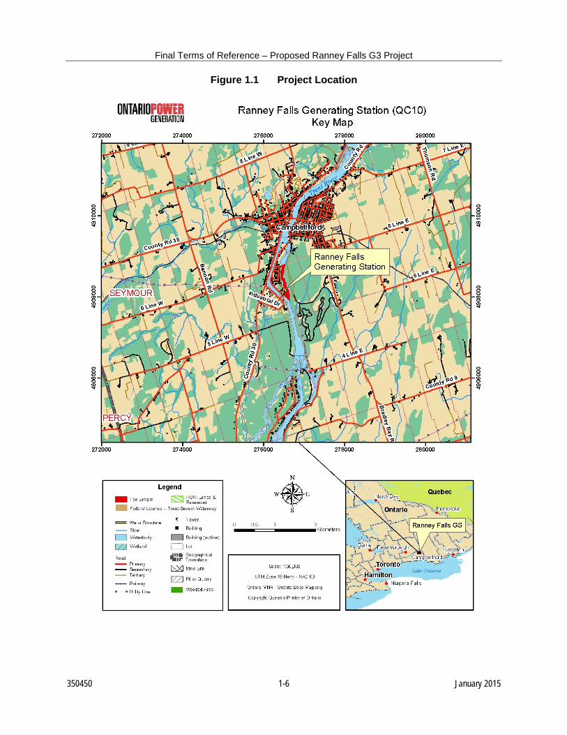
Final Terms of Reference – Proposed Ranney Falls G3 Project 1.2.5 Conformance with Parks Canada Policy and Directives The management plan for the Trent-Severn Waterway (TSW) National Historic Site of Canada received ministerial approval in 2000 (Parks Canada, 2000). The process to develop a new management plan began in late 2011, and was subsequently postponed following a review of the management plan cycle. The next management plan is scheduled for completion in 2018. The draft DIA Report will provide confirmation of conformance of the proposed Project to relevant Parks Canada policy and directives. Those policies and directives include: Parks Canada Guiding Principles and Operational Policies guides stewardship responsibility to ensure that the record of our past, the rich diversity of wild spaces and species, the beauty and grandeur of our lands and seas, and the cultural character of our communities are not inadvertently lost over time. This policy document guides these efforts, designation and management. National Historic Site Policy objectives are to foster knowledge and appreciation of Canada’s past through a program of historical commemoration and to ensure commemorative integrity of national historic sites are maintained by protecting and presenting these sites and their associated resources for future generations. Cultural Resources Management (CRM) Policy serves as the overall management policy for Parks Canada-administered national historic sites. As CRM Policy supports the management of cultural resources, it applies to conserving and preserving the national treasures that are under the stewardship of the Parks Canada Agency. Historic Canals Policy Regulations outlines respecting the management, maintenance, proper use and protection of the historic canals administered by the Parks Canada Agency. Historic Canals Policy fosters appreciation, enjoyment and understanding of Canada’s historic canals by providing for navigation; by managing cultural and natural resources for purposes of protection and presentation; and by encouraging appropriate uses. Canal Regulations outlines respecting the use and operations of canals. The PFTSW (2008) was mandated in 2007 to assess and make recommendations to the federal Minister of the Environment concerning the future contributions and management of the TSW. 1.3 PROJECT DESCRIPTION Ranney Falls GS is located on land owned by OPG on the Trent River and adjacent to Lock #12 on the TSW within the community of Campbellford in Trent Hills, Northumberland County (Figure 1.1). There are two powerhouses on site (Figure 1.2). The main powerhouse has the
350450 1-4 January 2015
Final Terms of Reference – Proposed Ranney Falls G3 Project G1 and G2 turbine units each operating at approximately 5 MW at maximum flows of 47.5 m3/s and 45.4 m3/s, respectively (OPG, 2011). The secondary “Pup” powerhouse contains the 0.72 MW G3 unit with a design flow of 8 m3/s. Total maximum flow is 100.9 m3/s. As indicated in Section 1.1, the G3 unit has reached its end-of-life. Both powerhouses share a common intake structure, with the G3 unit fed by a penstock from a channel branching off the main intake. The headwater of the Ranney Falls GS is the Trent Canal at the upstream end of Lock #12, with the tailwater being the Trent River. The average gross head is approximately 14.27 m. Dam #10 diverts flow down a 1.5 km section of canal to feed the Ranney Falls GS and the operational requirements of Locks #11 and #12. The average available flow is approximately 118 m3/s. River flow that is in excess to the generating station and lockage requirements is spilled through Dam #10 (upstream of the GS) to the original Trent River channel that flows 1.1 km to the Ranney Falls GS tailraces. Little if any flow currently occurs in the section of the Trent River between Dam #10 to the Ranney Falls GS tailrace from mid-June to late October due to the diversion of water through the Trent Canal. With its proposed increased capacity, all flow will be diverted through the Trent Canal and expanded Ranney Falls GS resulting in more water being diverted at Dam #10 into the Trent Canal.
350450 1-5 January 2015
Final Terms of Reference – Proposed Ranney Falls G3 Project
Figure 1.1 Project Location
350450 1-6 January 2015
Final Terms of Reference – Proposed Ranney Falls G3 Project
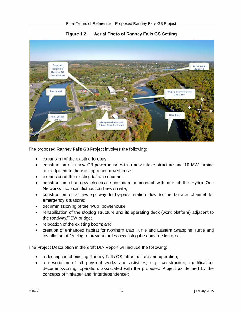
Figure 1.2 Aerial Photo of Ranney Falls GS Setting
The proposed Ranney Falls G3 Project involves the following:
• expansion of the existing forebay; • construction of a new G3 powerhouse with a new intake structure and 10 MW turbine
unit adjacent to the existing main powerhouse; • expansion of the existing tailrace channel; • construction of a new electrical substation to connect with one of the Hydro One
Networks Inc. local distribution lines on site; • construction of a new spillway to by-pass station flow to the tailrace channel for
emergency situations; • decommissioning of the “Pup” powerhouse; • rehabilitation of the stoplog structure and its operating deck (work platform) adjacent to
the roadway/TSW bridge; • relocation of the existing boom; and • creation of enhanced habitat for Northern Map Turtle and Eastern Snapping Turtle and
installation of fencing to prevent turtles accessing the construction area. The Project Description in the draft DIA Report will include the following:
• a description of existing Ranney Falls GS infrastructure and operation; • a description of all physical works and activities, e.g., construction, modification,
decommissioning, operation, associated with the proposed Project as defined by the concepts of “linkage” and “interdependence”;
350450 1-7 January 2015
Final Terms of Reference – Proposed Ranney Falls G3 Project
• a description of future changes/trends anticipated due to the proposed Project, e.g., current and anticipated future patterns of use;
• detailed maps, design plans, drawings and photographs of the existing and proposed facilities;
• a description of current and anticipated future utility service requirements and infrastructure, e.g., water supply, energy supply;
• quantification/estimation of current and future water and energy use, with confirmation that associated infrastructure has adequate capacity;
• a description of the current and future methodology/infrastructure for waste handling and disposal, e.g., garbage, construction waste, wastewater;
• quantification/estimation of current and future waste volumes, with confirmation that on and off-site infrastructure has adequate capacity;
• a description of any applicable conservation and efficiency programs associated with the proposed Project;
• a proposed Project schedule (construction is anticipated to last up to 30 months with the earliest possible in-service date in 2017);
• a description of general construction methods, materials and equipment to be used for the proposed Project;
• a description of clearing requirements for the proposed Project, e.g., quantification of area to be cleared, types and numbers/volume of vegetation to be removed;
• a description of excavation/fill requirements for the proposed Project, e.g., quantity/type of material to be removed/replaced and how and where it will be disposed of/obtained;
• a description of anticipated requirements/methodologies for excavation and dewatering; • a description of erosion and sediment control measures, with discharged groundwater to
be in compliance with section 36(3) of the Fisheries Act; • identification and quantification of all toxic/hazardous materials used as part of present
operations and maintenance, as well as future construction, operation and maintenance of the proposed Project;
• identification of methodology for storage, handling and disposal of fuels and toxic/hazardous materials;
• a description of the any impacts to surface water quality and flow, impacts to other stakeholders who discharge into the Trent River, impacts to base flows and groundwater levels, and mitigation measures;
• a description of how additional flow diverted through the Trent Canal might affect historical or approved ranges of water levels and flows, and if changes in levels and flows will impact existing wells, water intakes, sewage outfalls (dilution of effluent), and flooding of lands;
• a description of any potential impacts to water intakes and water supplies, wells and septic systems that may be impacted by changes to water levels;
• a description of temporary and permanent noise levels for nearby residents; • a description of dust controls for construction areas and access roads; • identification of control methods for dust, noise and flyrock if blasting is required;
350450 1-8 January 2015
Final Terms of Reference – Proposed Ranney Falls G3 Project
• identification of any requirements for off-site land use; and • submission of an EMP for review and approval by Parks Canada – TSW prior to
commencement of work.
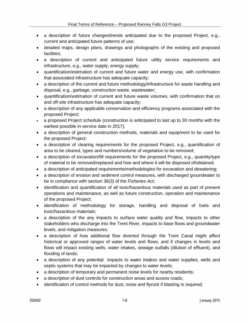
Figure 1.3 Aerial Photo of Existing Ranney Falls GS Showing Proposed Project Infrastructure Layout
350450 1-9 January 2015
Final Terms of Reference – Proposed Ranney Falls G3 Project
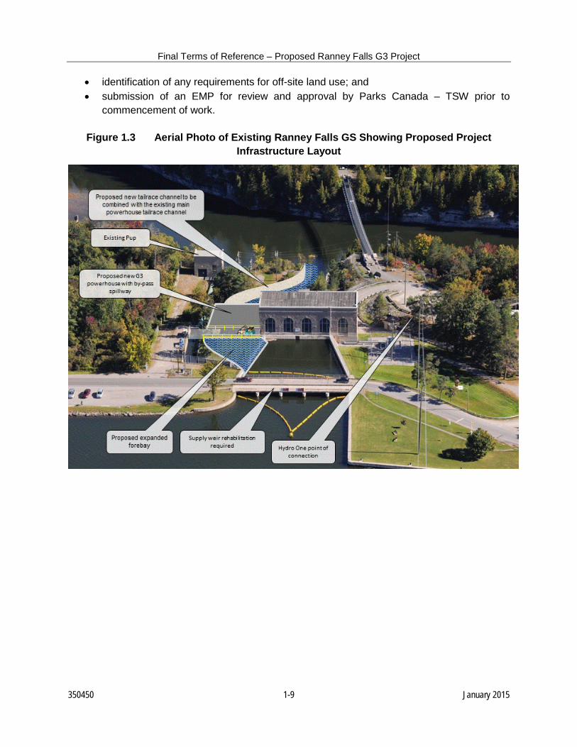
Figure 1.4 Schematic of Proposed Ranney Falls G3 Project Infrastructure Layout
Existing Tailrace
Expanded Forebay
Pup unit decommissioned and its Powerhouse left in place
Trent Canal
Flow
Trent River New Powerhouse
New Spillway
Expanded Tailrace
Existing Forebay
350450 1-10 January 2015
Final Terms of Reference – Proposed Ranney Falls G3 Project 2.0 SITE DESCRIPTION Since 2006, a number of site-specific environmental baseline studies have been undertaken for the previous design concepts for the proposed expansion of the Ranney Falls “Pup” powerhouse, including fisheries resources and fish habitat assessments, Walleye (Sander vitreus) spawning surveys, vegetation inventories, a breeding bird survey and incidental wildlife observations. Site-specific studies were also undertaken to assess the use of the Ranney Falls GS property as nesting habitat by Northern Map Turtle and Eastern Snapping Turtle (Bennett and Litzgus, 2007, 2008), both designated as species of Special Concern federally (COSEWIC, 2012) and provincially (MNRF, 2014). A Phase I Environmental Site Assessment was completed by LOPG (1995). The site-specific aquatic and terrestrial survey and other desk-top information was used to prepare a draft Project Description (Coker, 2007) and draft Environmental Impact Assessment (Coker et al., 2008) for the previously proposed project. However, the project was deferred by OPG prior to commencement of the formal Environmental Assessment (EA) and consultation process. Much of the information collected is still relevant for the current design. As part of this EA process, additional field studies were undertaken in 2011, including a geotechnical investigation at the Ranney Falls GS site (Knight Piésold Ltd., 2011a), a bathymetric evaluation, a Stage 1 archaeological assessment (Advance Archaeology, 2011), as well as a terrestrial survey of the remainder of the Ranney Falls GS property and adjacent significant woodland. A Phase I Environmental Site Assessment Update (SENES, 2012a) and a groundwater monitoring and environmental site assessment (SENES, 2012b) were undertaken in 2012. Moreover, the desk-top information has been updated and expanded based on additional data acquisition. These studies will be provided in the draft DIA report. 2.1 SITE LOCATION AND SIZE The proposed Ranney Falls G3 Project is located on OPG land on the Trent River and adjacent to Lock#12 on the TSW within the community of Campbellford in Trent Hills, Northumberland County (Figure 1.1). The Ranney Falls GS property is approximately 2 ha in size. Further discussion will be provided in the draft DIA report. 2.2 SITE-SPECIFIC LAND USE HISTORY Prior to the commissioning of the Ranney Falls GS G1 and G2 units on August 22, 1922 and September 2, 1922, the site was “green field” (LOPG, 1995; Advance Archaeology, 2011). Unit G3, which started operation in 1926, was acquired by the Hydro-Electric Power Commission of Ontario from the Quinte and Trent Valley Power Company in 1937. Ranney Falls GS was transferred to OPG on April 1, 1999. Further information will be provided in the draft DIA report.
350450 2-1 January 2015
Final Terms of Reference – Proposed Ranney Falls G3 Project 2.3 CLIMATE/AIR QUALITY The proposed Ranney Falls G3 Project is located within the Simcoe and Kawartha Lakes Climatic Region, as defined by Brown et al. (1974). Additional climatic information will be provided in the draft DIA Report (e.g., Ecoregions Working Group, 1989), as well as temperature and precipitation data for Trenton Airport and Peterborough Airport. Wind data will also be provided. Ambient air quality statistics for the MOECC monitoring station in Peterborough will also be provided in the draft DIA Report (MOE, 2012, 2013; MOECC, 2014). 2.4 GEOLOGY/PHYSIOGRAPHY The proposed Ranney Falls G3 Project is underlain by the Middle Ordovician Verulam Formation of the Simcoe Group consisting of light to dark grey, brown grey, interbedded, micritic to coarse-grained, fossiliferous limestone with inter-beds of calcareous shale (Johnson et al., 1992). Additional site-specific information on the geology of the proposed Project site (Knight Piésold Ltd., 2011b) will be provided in the draft DIA Report. The Ranney Falls GS property is located on limestone plains (Chapman and Putnam, 1972, with characteristics similar to the Prince Edward Peninsula physiographic region to the south (Chapman and Putnam, 1984). Additional information on physiography, as well as site-specific topography (OPG, 2011) and overburden thickness (Ontario Hydro, 1989; Knight Piésold Ltd., 2011a,b) will be provided in the draft DIA Report. 2.5 SOILS The soils on the Ranney Falls GS property are Farmington loam (Hoffman and Acton, 1974). Additional information on this soil type and its productivity (CLI, 1968), as well as soil quality (SENES, 2012b), will be provided in the draft DIA Report. 2.6 VEGETATION The proposed Project is located in the Huron-Ontario Forest Section of the Great Lakes- St. Lawrence Forest Region (Rowe, 1977). The natural vegetation is dominated by mixed woods forests, which are transitional between the southern deciduous forests and the northern coniferous forests. As indicated in Section 2.0, terrestrial field surveys have been undertaken of lands that may be directly or indirectly affected by construction activities, as well as the surrounding area, including the 120-m section adjacent to the identified significant woodlands (see Section 2.7). These surveys included classification of all vegetation communities using the Ecological Land Classification (ELC) System for Southern Ontario (Lee et al., 1998), an inventory of plant species and incidental observations of wildlife (see Section 2.8). The vegetation communities
350450 2-2 January 2015
Final Terms of Reference – Proposed Ranney Falls G3 Project identified and plant species inventoried during the field surveys will be presented in the draft DIA Report. 2.7 SIGNIFICANT NATURAL FEATURES There are a number of recognized natural areas situated within 10 km of the proposed Project based on Hall and Jones (1976), Van Patter and Hilts (1985), LTC (2001) and the MNRF Natural Heritage Information Centre (NHIC) database. These will be presented in the draft DIA Report. Based on the terrestrial surveys (see Section 2.6), the Ranney Falls GS property supports a number of functions and attributes that would potentially qualify portions of the property as significant wildlife habitat, including seasonal concentration areas, rare vegetation community, specialized habitats for wildlife, habitat of species of conservation concern and animal movement corridor. Trent Hills will be consulted to determine whether any mapping or criteria are available to identify features such as Significant Woodlands, Significant Wildlife Habitat and Significant Valleylands. These will also be presented in the draft DIA Report. 2.8 WILDLIFE The local study area provides woodland, riparian and urban habitat for wildlife. In this area, most wildlife species are fully habituated to human activities and are restricted to specialized habitats. As indicated in Section 2.6, incidental observations of wildlife species were undertaken during the terrestrial surveys. These observations will be presented in the draft DIA Report, together with those likely present based on distribution mapping (Dobbyn, 1994; Bird Studies Canada, 2010; Environment Canada, CWS, 2010/2011; Ontario Nature, 2010; NHIC database). 2.9 SURFACE WATER AND GROUNDWATER HYDROLOGY AND QUALITY The Ranney Falls GS property is located between the Trent Canal and Trent River. The Trent River and the TSW occur within the Northern Lake Ontario drainage basin in the Great Lakes-St. Lawrence Drainage System (Chapman and Putnam, 1984). The Trent River drainage basin drains more than 12,000 km2, including several hundred lakes. Additional information on site surface hydrology (Knight Piésold Ltd., 2011a), as well as TSW/Trent River hydrology (Water Survey of Canada data) and water quality (LTC data) will be provided in the draft DIA Report. Based on site-specific geotechnical investigations (Knight Piésold Ltd., 2011a), the groundwater table on the lower level of the Ranney Falls GS property is within the lower shale-poor bedrock domain at an approximate depth of 24 m. The water level readings indicate that groundwater flows from the southwest to the northeast and is directed towards the main powerhouse tailrace channel on the lower section of the property. Additional information on groundwater hydrology (Ontario Hydro, 1989; Knight Piésold Ltd., 2011a) and quality (SENES, 2012b) will be provided in the draft DIA Report.
350450 2-3 January 2015
Final Terms of Reference – Proposed Ranney Falls G3 Project 2.10 TSW/TRENT RIVER MORPHOLOGY, BATHYMETRY AND SUBSTRATE Based on field survey findings and other available information (CHS, 2007; Krishnappan, 2007), the morphology, bathymetry and substrate of the TSW and Trent River in the vicinity of the proposed Project will be presented in the draft DIA Report. 2.11 AQUATIC VEGETATION Aquatic vegetation present in the TSW (Saunders, 2006) and observed in the Trent River in the vicinity of the Ranney Falls GS tailraces during the fisheries surveys will be presented in the draft DIA Report. 2.12 BENTHIC MACROINVERTEBRATES Benthic macroinvertebrate community composition data for the Trent River are available near the OPG Frankfort GS approximately 36 km downstream of the Ranney Falls GS (Pope, 1998). As the substrate at the Frankfort GS is similar to that in the Trent River proximate to the Ranney Falls GS tailraces, it is likely that the benthic macroinvertebrate community composition at both locations would be similar. These data will be presented in the draft DIA Report. 2.13 FISHERIES RESOURCES Of the 73 fish species recorded in the TSW (Saunders, 2006), 35 species have been captured upstream and downstream (including Percy Reach) of Campbellford (Parks Canada – TSW and MNR data). Nine fish species were captured during the fisheries field surveys. This information will be presented in the draft DIA Report. 2.14 SPECIES AT RISK An investigation of SAR and reports of findings will be included in the draft DIA. Environment Canada, CWS, has approved the “Turtle Nesting Habitat Mitigation Plan” prepared by OPG to create and enhance access and nesting habitat for Northern Map Turtle and Eastern Snapping Turtle, both designated as Special Concern federally and provincially. MNRF has indicated that Lake Sturgeon (Acipenser fulvescens) (Great Lakes-Upper St. Lawrence population), designated as Threatened federally and provincially, and American Eel (Anguilla rostrata), designated as Special Concern federally and Threatened provincially, have been recorded historically in the proposed Ranney Falls G3 Project area. In addition, a review of best available information indicates that there are reported observations of Butternut (Juglans cinerea), designated as Endangered federally and provincially, Lake Sturgeon, Northern Map Turtle and Eastern Snapping Turtle in the immediate area (1 km) of the Ranney Falls GS property. There are also occurrences in the general area (5 km) of the Ranney Falls GS property of Blanding’s Turtle (Emydidea blandingii), Eastern Meadowlark (Sturnella magna), Bobolink (Dolichonyx oryzivorus) and Barn Swallow (Hirundo rustica), designated as Threatened federally and provincially; Eastern Musk Turtle (Sternotherus odoratus) and Golden-winged Warbler
350450 2-4 January 2015
Final Terms of Reference – Proposed Ranney Falls G3 Project (Vermivora chrysoptera), designated as Threatened federally and Special Concern provincially; and Black Tern (Chlidonias niger), designated as Not at Risk federally and Special Concern provincially. Although no other SAR have been documented in the area of the proposed Project, these species and others may be present and will be investigated and the findings presented in the draft DIA. 2.15 LAND AND WATER USES Based on Official Plan mapping (Trent Hills, 2001), 35% of the land within Trent Hills are designated as prime farm land, 30% rural lands, 20% greenlands, 10% urban areas and 5% aggregate resources. The Ranney Gorge Suspension Bridge provides public access from the Ranney Falls GS property to Ferris Provincial Park on the opposite side of the Trent River. A public parking area is available on the east side of the Ranney Falls GS property with a trail available to the bridge. TSW/Trent River water uses include general recreation, recreational boating, sportfishing, municipal water supply and wastewater treatment, and hydropower facilities. Use of TSW land beside the bridge will be required during the construction stage of the proposed Project. Additional information on land and water uses will be provided in the draft DIA Report. 2.16 SOCIO-ECONOMICS Community profiles of Northumberland County, Trent Hills and the community of Campbellford, as well as nearby First Nations and Métis communities, will be provided in the draft DIA Report. 2.17 BUILT HERITAGE AND ARCHAEOLOGICAL RESOURCES Ranney Falls GS is located on Parks Canada – TSW National Historic Site of Canada. Based on site investigations undertaken by the Ontario Ministry of Citizenship and Culture in partnership with Ontario Hydro in the early 1980s, Ranney Falls GS was ranked with those hydroelectric stations having the lowest heritage value (Class C) whose main attribute is their age (Simonton, 1984). The Ranney Falls GS site contributes to the cultural landscape of Lock #12 of the TSW National Historic Site of Canada. The proposed Project will be sympathetic to this and retain the existing hydroelectric infrastructure including the “Pup” structure. The existing Ranney Falls GS will continue to operate. Based on a Stage 1 Archaeological Assessment, Advance Archaeology (2011) determined that given that there are no known indicators to suggest that there is the potential for the presence of archaeological sites, artifacts, or anything else of cultural heritage significance on the proposes Project lands, and given that the degree of prior soil disturbance is so extensive across the entire site, the archaeological potential of the lands was very low. This information will also be further elaborated on in the draft DIA Report.
350450 2-5 January 2015
Final Terms of Reference – Proposed Ranney Falls G3 Project 3.0 ENVIRONMENTAL EFFECTS AND MITIGATION MEASURES For the proposed Ranney Falls G3 Project, the available environmental baseline information and site-specific study findings will provide the basis for the assessment of potential construction and operational effects on the environment, particularly those characteristics of the environment that are important to key visitor experience objectives. These effects will be quantified where feasible. Off-site requirements such as staging areas, temporary or permanent storage, use of Parks Canada lands, access roads or parking areas, will also be identified and quantified where feasible. For each environmental component presented in the following sections, an estimate of temporal and spatial limits of potential effects will be provided in the draft DIA Report, i.e., short-term construction period versus long-term operation. Recommended mitigation measures for these effects on the environment will be based on the OWA (2012) “Best Management Practices Guide for the Mitigation of Impacts of Waterpower Facility Construction”, standard environmental construction guidelines (e.g., Cheminfo, 2005), relevant government guidelines for proposed hydroelectric power plant development, including DFO “Guidelines for the Use of Explosives in or near Canadian Fisheries Waters” (Wright and Hopky, 1998), MOEE (1995), Milko (1988), Lynch-Stewart (2004) and Trent Hills (2005), as well as Federal Review Team, MOECC and MNRF recommendations, and other organization consultation. The significance of potential impacts will be based on their magnitude, duration and extent after the implementation of recommended mitigation measures. Prior to commencement of any construction activities, an EMP will be developed and submitted to Parks Canada – TSW for review and approval. 3.1 VALUED ECOSYSTEM COMPONENTS The identification and assessment of impacts will focus on landform and soils, vegetation, wildlife, aquatic/hydrological resources and pollution. 3.1.1 Landform and Soils The draft DIA Report will address physical changes to landform and soils, including erosion potential, that may result from excavation or other disturbance associated with the proposed Project. The effects assessment will take into account climatic influences, drilling and blasting activities, and soil conditions. To mitigate or obviate adverse effects, mitigation measures will be developed, e.g., following the recommendations of the blasting engineer and the DFO blasting guidelines (Wright and Hopky, 1998), development and implementation of a site-specific Erosion and Sediment Control Plan and Site Rehabilitation Plan.
350450 3-1 January 2015
Final Terms of Reference – Proposed Ranney Falls G3 Project 3.1.2 Vegetation The draft DIA Report will address loss of, or damage to, vegetation, changes in species composition or community structure, introduction of non-native species, and effects on rare, endangered or special resource species. To mitigate or obviate adverse effects, mitigation measures will be developed, e.g., implementation of standard vegetation clearing practices, restoration/enhancement measures prescribed in the Site Rehabilitation Plan (including native tree plantings) and the mitigation measures for the protection of proximate significant woodlands or their ecological functions. 3.1.3 Wildlife The draft DIA Report will address changes in wildlife species composition and distribution, habitat change/fragmentation, displacement, habituation, corridor impairment, and SAR (see Section 2.14) that may be affected. The Ranney Falls GS property supports a number of ecological functions and attributes that would potentially qualify portions of the property as significant wildlife habitat. To mitigate or obviate adverse effects, habitat protection and enhancement plans will be developed in consultation with the Federal Review Team, MOECC and MNRF as part of the Site Rehabilitation Plan. Environment Canada, CWS, has approved the “Turtle Nesting Habitat Mitigation Plan” prepared by OPG to create and enhance access and nesting habitat for Northern Map Turtle and Eastern Snapping Turtle, both designated as Special Concern federally and provincially (K-A. Fagan, Environment Canada, 2012, pers. comm.) This report will be included in the appendices of the draft DIA Report. 3.1.4 Aquatic/Hydrological Resources Predicted adverse effects on aquatic and hydrological resources due to the proposed Project will be identified and elaborated in the draft DIA Report, e.g., water quality impairment, aquatic habitat degradation, changes to plankton, benthic macroinvertebrate and fish populations and species composition. Any expected changes in water consumption/wastewater production will also be identified and evaluated for potential impacts to local and off-site aquatic and hydrological resources, including those associated with off-site waste disposal sites. To mitigate or obviate adverse effects, mitigation measures will be developed, e.g., following the recommendations of the blasting engineer and the DFO blasting guidelines (Wright and Hopky, 1998), development and implementation of a site-specific Erosion and Sediment Control Plan and Site Rehabilitation Plan, implementation of civil construction in the “dry” confined by cofferdams, use of modern conventional turbine design and lower intake velocities to minimize fish entrainment. Based on technical information provided by OPG, DFO has determined that the proposed Project “is not likely to result in impacts to fish and fish habitat provided that additional mitigation measures are applied”. Based on the LOA dated July 17, 2012, a formal approval from DFO is not required (C. Strand, DFO, 2012, pers. comm. and follow up DFO Fisheries Protection e-mail dated July 31, 2014). The LOA will be included in the appendices of the draft DIA.
350450 3-2 January 2015
Final Terms of Reference – Proposed Ranney Falls G3 Project 3.1.5 Pollution The draft DIA will identify and assess the potential for long- and short-term contaminant loadings to the air, soil and aquatic environments, taking into account existing groundwater, surface water and/or soil contamination. The potential effects of inadvertent spills will also be addressed. To mitigate or obviate adverse effects, mitigation measures will be developed, e.g., implementation of standard construction best management practices (e.g., Cheminfo, 2005), disposal of any surplus contaminated soil with MOECC approval, development and implementation of a site-specific Erosion and Sediment Control Plan and Site Rehabilitation Plan, implementation of a monitoring program to confirm that excess groundwater within the excavated tailrace is suitable for direct discharge to the Trent River and/or Trent Canal based on MOECC water management policies (MOEE, 1994), development and implementation of a Hazardous Materials Management Plan, Waste Management Plan and Spills Emergency Preparedness and Response Plan. 3.2 CULTURAL FEATURES The draft DIA Report will describe the influence of the proposed Project on humans and human-related facilities and values. The identification and assessment of impacts will focus on aesthetics, public facilities and services, public safety, cultural heritage and socio-economics. 3.2.1 Consultation A Consultation Plan has been implemented to ensure interested parties participate in the EA process by expressing their views, issues and concerns. Consultation has occurred with regulatory agencies, Trent Hills, potentially affected First Nations and Métis communities, and other interested people. In accordance with the Consultation Plan, follow-up meetings with First Nations and Métis communities, as well as consultation with the public and other stakeholders, will continue. MNRF Ontario Parks will be consulted on the potential impact to public access to Ferris Provincial Park and to identify any other potential impacts to Park values such as recreation. A Project-specific web site has been maintained providing a widely accessible venue for a large number of interested people to obtain and download proposed Project information and reports, as well as an e-mail and telephone number for interested people wishing to make comments or seeking further information. An informal Open House will be scheduled in the spring/summer of 2015 to inform the interested public about the proposed Project, describe the studies completed, present the results of the DIA undertaken for regulatory approvals, and solicit input on proposed design, mitigation and effects management. Correspondence relating to consultations will be included in the TSDs of the draft DIA Report.
350450 3-3 January 2015
Final Terms of Reference – Proposed Ranney Falls G3 Project 3.2.2 Aesthetics During construction, localized nuisance impacts, such as fugitive dust, typical combustion emissions from construction equipment, and noise/vibration, can potentially occur. To obviate or minimize any adverse effects, mitigation measures will be developed and provided in the draft DIA Report, e.g., use of water trucks and/or sprinklers for dust suppression (Cheminfo, 2006), proper equipment maintenance to minimize combustion emissions to the extent practicable (Cheminfo, 2005), proper maintenance and operation of equipment with use of noise baffling, as appropriate, and adherence to the Trent Hills (2005) Municipal Noise By-Law. The draft DIA Report will also address long-term aesthetics with respect proposed Project site aesthetics, scenic values, and near and distant views. 3.2.3 Public Facilities and Services Potable water and portable toilet facilities will be provided by the contractor. No increased demands on fire or police services are anticipated. A need for additional public facilities and services is not anticipated. The draft DIA Report will address potential for increased traffic during the construction period. A Traffic Management Plan and Access Management Plan will be prepared in consultation with Northumberland County and/or Trent Hills Public Works Departments. Mitigation measures that can be implemented to minimize potential adverse effects due to increased traffic including road restrictions, haul routes and traffic safety will be included in the draft DIA Report. During construction and operation of the proposed Project, there will be negligible impacts on vessel utilization of the Trent Canal during the navigation season. The anticipated slight increases in maximum flow velocities may have a minimal effect on vessel operation. The proposed Ranney Falls G3 Project includes a new spillway to by-pass full station flow to the expanded tailrace channel for emergency operations. The operation of the new spillway will preclude the potential for flooding along the Trent River upstream of Locks #11 and #12. 3.2.4 Public Safety The Ranney Gorge Suspension Bridge provides public access from the Ranney Falls GS property to Ferris Provincial Park on the opposite side of the Trent River. To minimize and/or manage the potential conflict between public and construction traffic access, an Access Management Plan will be developed in consultation with Ontario Parks and Friends of Ferris Provincial Park, which would include the use of appropriate public access signage and barriers. Additional mitigation measures to address public safety will be provided in the draft DIA Report.
350450 3-4 January 2015
Final Terms of Reference – Proposed Ranney Falls G3 Project The proposed Project will result in more water being diverted at Dam #10 into the Trent Canal in November, December, January and February. Parks Canada – TSW has indicated that although this is outside of the navigation system, users of the waterway and surrounding parklands should be consulted and educated about the changes in water velocities in the canal. This information will be disseminated during public consultation (see Section 3.2.1). Further, OPG will carry out a Dam Safety Risk Assessment of the proposed Project to assess and address new public safety hazards and to develop appropriate control measures. 3.2.5 Cultural Heritage Ranney Falls GS has been ranked at the lowest heritage value (Class C) whose main attribute is their age (Simonton, 1984). Ranney Falls GS as a cultural heritage landscape will be further elaborated upon in the draft DIA Report. Archaeological potential of the proposed Project lands has been assessed as very low (Advance Archaeology, 2011). This information will also be further elaborated upon in the draft DIA Report. 3.2.6 Socio-economics OPG anticipate that there will be little, if any, in-migration of workers to the local area due to the presence of a regional workforce and the relative short-term nature of the proposed Project. The construction work force will be 60 to 80 workers based on projects of similar size and scope. It is expected that Campbellford and the nearby Cities of Peterborough, Quinte West (Trenton) and Belleville will provide the majority of the required accommodation for the few in-migrant workers and supervisory staff. The majority, if not all, of the proposed Project construction worker needs (e.g., fuel, food, sundries) can be accommodated by Campbellford and the nearby communities. These communities should benefit positively from construction-related expenditures. OPG estimates that the contribution of the proposed Project construction phase to the local economy will be over $10 million. Additional information on socio-economic impacts will be provided in the draft DIA Report. During proposed Project operation, there will be no effects on the local economy. No additional jobs will be created.
350450 3-5 January 2015
Final Terms of Reference – Proposed Ranney Falls G3 Project 4.0 CUMULATIVE ENVIRONMENTAL EFFECTS The draft DIA Report will consider any cumulative environmental effects that are likely to result from the proposed Project in combination with other projects or activities that have been or will be carried out. Cumulative effects can be characterized as impacts on the natural and social environment which:
1. occur frequently in time or so densely in space that they cannot be “assimilated”, or 2. combine with effects of other activities in a synergistic manner (Sonntag et al., 1987;
CEARC, 1988). Hegmann et al. (1994) provides a reference guide for addressing cumulative effects. Geographic and temporal boundaries will be established for the cumulative effects assessment (CEA). The draft DIA Report will identify past, current and future projects/activities in the CEA study area and assess potential cumulative effects of these projects/activities in combination with the proposed Project. The CEA will only consider likely projects/activities. The CEA will clearly identify the main issues and areas of concern to be addressed, e.g., impacts on wildlife habitat use and travel corridors, present and future trends in human activity in the area, potential water quality impacts. Trends and/or current status of important ecosystem components will be evaluated, e.g., are populations currently stable, increasing or decreasing? Where available, relevant targets, goals or guidelines will be used in the CEA, e.g., Canadian Environmental Quality Guidelines (CCME, 1999). The sources of stress on valued ecosystem components will be identified and the relative contribution of the proposed Project will be assessed, e.g., whether the proposed Project will enhance or diminish ecological integrity. Any mitigation measures, both broad-scale and proposed Project-specific, that diminish cumulative effects and the residual cumulative effects after mitigation will be identified. Any uncertainties and knowledge deficiencies, as well as monitoring and follow-up requirements to address these uncertainties, will also be identified in the draft DIA Report.
350450 4-1 January 2015
Final Terms of Reference – Proposed Ranney Falls G3 Project 5.0 RESIDUAL IMPACTS The draft DIA Report will summarize the potential construction and operation effects on the terrestrial and aquatic environments, land and water uses, socio-economics and cultural heritage resources, the recommended mitigation/remedial measures to minimize or obviate these effects and the net residual effects.
350450 5-1 January 2015
Final Terms of Reference – Proposed Ranney Falls G3 Project 6.0 SITE INSPECTION REQUIREMENTS Environmental protection during proposed Project construction and operation will be ensured by adherence to the EMP, as well as compliance with regulatory standards and guidelines, and permit terms and conditions. The EMP, with oversight by the Environmental Monitor, will ensure that environmental protection will be achieved by addressing government agency requirements, OPG policy, proposed Project commitments and recommended mitigation measures to be undertaken. The EMP will include the Erosion and Sediment Control Plan, Spills Emergency Preparedness and Response Plan, Hazardous Materials Management Plan, Waste Management Plan, Site Rehabilitation Plan, Access Management Plan, Traffic Management Plan and Turtle Nesting Habitat Mitigation Plan. The EMP will be submitted to Parks Canada – TSW for review and approval prior to any work commencing on the proposed Project. Should the scope of work or work plan change following commencement of work, a revised EMP describing the mitigation measures to address the proposed changes will be provided to TSW – Parks Canada for review and approval. Parks Canada – TSW personnel will also visit the proposed Project site to confirm implementation of environmental protection measures during construction. A copy of the final DIA will be kept on site at all times.
350450 6-1 January 2015
Final Terms of Reference – Proposed Ranney Falls G3 Project 7.0 MONITORING REQUIREMENTS A monitoring program will be implemented to confirm that excess groundwater within the excavated tailrace is suitable for direct discharge to the Trent River and/or Trent Canal based on MOECC water management policies (MOEE, 1994). Any other monitoring requirements during proposed Project construction and operation will be identified and described in detail in the draft DIA Report. The potential for a cooperative monitoring program between OPG and Parks Canada – TSW will also be considered.
350450 7-1 January 2015
Final Terms of Reference – Proposed Ranney Falls G3 Project 8.0 REFERENCES Advance Archaeology 2011. Stage 1 Archaeological Assessment of the Ranney Falls
Generating Station G3 Expansion Project, in the Community of Campbellford, Municipality of Trent Hills, County of Northumberland (Part of Lot 8, Concession 5 in the Geographic Township of Seymour. Report to the Ontario Ministry of Tourism and Culture. 18 p.
Bennett, A. and J.D. Litzgus 2007. Summary Report of Ranney Falls Turtle Data. Laurentian
University, Department of Biology Report to Ontario Power Generation Inc. 12 p. Bennett, A. and J.D. Litzgus 2008. Nesting Activity at the Ranney Falls Generating Station, May
– August 2008. Laurentian University, Department of Biology Report to Ontario Power Generation Inc.
Bird Studies Canada 2006. Ontario Breeding Bird Atlas. www.birdsontario.org/atlas/atlasmain.html Brown, D.M., G.A. McKay and L.J. Chapman 1974. The Climate of Southern Ontario.
Environment Canada, Climatological Studies No. 5: 50 p. Canada Land Inventory (CLI) 1968. Soil Capability for Agriculture, Kingston 31 C. Environment
Canada. Canadian Council of Ministers of the Environment (CCME) 1999. Canadian Environmental
Quality Guidelines. Winnipeg, Manitoba. Canadian Environmental Assessment Research Council (CEARC) 1988. The Assessment of
Cumulative Effects: A Research Prospectus. Canadian Hydrographic Service (CHS) 2007. Trent-Severn Waterway. Murray Canal to Healy
Falls Locks. Fisheries and Oceans Canada, Small-Craft Nautical Chart 2021. Chapman, L.J. and D.F. Putnam 1972. Physiography of the South Central Portion of Southern
Ontario. Ontario Department of Mines and Northern Affairs, Ontario Research Foundation, Map 2226.
Chapman, L.J. and D.F. Putnam 1984. Physiography of Southern Ontario. Ontario Geological
Survey, Special Volume 2: 270 p. Cheminfo Services Inc. (Cheminfo) 2005. Best Practices for the Reduction of Air Emissions
from Construction and Demolition Activities. Construction and Demolition Multi-stakeholder Working Group Report to Environment Canada, Transboundary Issues Branch. 49 p.
350450 8-1 January 2015
Final Terms of Reference – Proposed Ranney Falls G3 Project Coker, G. 2007. Ranney Falls Generating Station Expansion Project Description. C. Portt and
Associates Draft Report to Ontario Power Generation Inc. 20 p. Coker, G., C. Portt, K. Ursic and K. Konze 2008. Ranney Falls Generating Station Expansion
Environmental Impact Assessment. C. Portt and Associates and Dougan & Associates Draft Report to Ontario Power Generation Inc. 47 p.
Committee on the Status of Endangered Wildlife in Canada (COSEWIC) 2012. Canadian
Wildlife Species at Risk, October 2012. Ottawa, Ontario. 98 p. Dobbyn, J. 1994. Atlas of the Mammals of Ontario. Federation of Ontario Naturalists, Don Mills,
Ontario. 118 p. Ecoregions Working Group 1989. Ecoclimatic Regions of Canada, First Approximation.
Ecoregion Working Group of the Canada Committee on Ecological Land Classification. Environment Canada, Ecological Land Classification Series No. 23: 119 p.
Environment Canada, Canadian Wildlife Service (CWS) 2010/2011. Species at Risk Web
Mapping Application. http://www.speciesatrisk.gc.ca/search/speciesDetails_e.cfm Hall, S.L. and R. Jones [Eds.] 1976. Northumberland County Environmentally Sensitive Areas
Study. Trent University, Department of Biology, Peterborough, Ontario. 181 p. Hatch Acres 2006. Site Evaluation and Concept Alternatives for Ranney Falls Generating
Station Expansion. Final Report to Ontario Power Generation. Hegmann, G., C. Cocklin, R. Creasey, S. Dupuis, A. Kennedy, L. Kingsley, W. Ross, H. Spaling
and D. Stalker 1999. Cumulative Effects Assessment Practitioner Guide. AXYS Environmental Consulting Ltd. and the CEA Working Group Report to the Canadian Environmental Assessment Agency, Hull, Quebec. 69 p.
Hoffman, D.W. and C.J. Acton 1974. The Soils of Northumberland County. Ontario Soil Survey
Report No. 42: 117 p. Johnson, M.D., D.K. Armstrong, B.V. Sanford, P.G. Telford and M.A. Rutka 1992. Paleozoic
and Mesozoic geology of Ontario, pp. 907-1008. In: P.C. Thurston, H.R. Williams, R.H. Sutcliffe and G.M. Stott [Eds.]. Geology of Ontario. Ontario Geological Survey, Special Volume 4, Part 2.
Knight Piésold Ltd. 2011a. Ontario Power Generation Inc. Ranney Falls Project. 2010 Ranney
Falls Geotechnical Report. OPG Report #R-QC10-10120-0001. 36 p.
350450 8-2 January 2015
Final Terms of Reference – Proposed Ranney Falls G3 Project Knight Piésold Ltd. 2011b. Ontario Power Generation Inc. Ranney Falls Project. Hydro
Development Project Geotechnical Baseline Report. OPG Report #R-QC10-10120-0002. 21 p.
Krishnappan, B.G. 2007. Determination of Erosion Potential in the Trent-Severn Waterway
Canal Upstream of the Ranney Falls Generating Station. Environment Canada, Aquatic Ecosystem Impacts Research Division, Burlington, Ontario. 12 p.
KST Hydroelectric Engineers (KST) 1992. Miscellaneous Hydraulic Studies Ranney Falls GS
Concept Phase Study Final. Report to Ontario Hydro. Work Order 0030, QC10-00120. 76 p.
Lake Ontario Plant Group (LOPG) 1995. Phase I Environmental Site Assessment – Ranney
Falls Generating Station, Campbellford, Ontario. Hydroelectric Business Unit Report to Ontario Hydro. 25 p.
Lee, H.T., W.D. Bakowsky, J. Riley, J. Bowles, M. Puddister, P. Uhlig and S. McMurray 1996.
Ecological Land Classification for Southern Ontario: First Approximation and its Application. Ontario Ministry of Natural Resources, Southcentral Science Section, Science Development and Transfer Branch, SCSS Field Guide FG-02: 225 p.
Lower Trent Conservation (LTC) 2001. Natural Heritage Report: Campbellford/Seymour/
Percy/Hastings - Quinte West - Belleville. 41 p. Lynch-Stewart, P. 2004. Environmental Assessment Best Practice Guide for Wildlife at Risk in
Canada. Lynch-Stewart & Associates Report to the Canadian Wildlife Service, Environment Canada. 63 p.
Milko, R. 1998. Migratory Birds Environmental Assessment Guideline. Environment Canada,
Canadian Wildlife Service. Ontario Hydro 1989. Trent River Ranney Falls GS Geotechnical Evaluation of Foundation
Conditions. Civil Engineering and Architecture Department, Report No. 89150: 15 p. Ontario Hydro 1992. Small Hydraulic Assessment and Retrofit Program (SHARP), Ranney
Falls Hydroelectric Generating Station (GS) Project, Concept Phase Environmental Evaluation. Environmental Studies and Assessments Department, Technical Memorandum 92/3: 20 p.
Ontario Ministry of the Environment (MOE) 2007. Guide to Permit to Take Water Application
Form. 21 p. Ontario Ministry of the Environment (MOE) 2011. Introductory Guide to Applying for an
Environmental Compliance Approval. 12 p.
350450 8-3 January 2015
Final Terms of Reference – Proposed Ranney Falls G3 Project Ontario Ministry of the Environment (MOE) 2012. Air Quality in Ontario Report for 2010. Ontario Ministry of the Environment (MOE) 2013. Air Quality in Ontario Report for 2011. Ontario Ministry of the Environment and Climate Change (MOECC) 2014. Air Quality in Ontario
2012 Report. 17 p. Ontario Ministry of Environment and Energy (MOEE) 1994. Water Management Policies,
Guidelines, Provincial Water Quality Objectives of the Ministry of Environment and Energy. 30 p.
Ontario Ministry of the Environment and Energy (MOEE) 1995. Guidelines for Evaluating
Construction Activities Impacting on Water Resources. 55 p. Ontario Ministry of Municipal Affairs and Housing (OMMAH) 2014. 2014 Provincial Policy
Statement Under the Planning Act. 50 p. Ontario Ministry of Natural Resources and Forestry (MNRF) 2014. Species at Risk in Ontario
(SARO) List. Updated October 1, 2014. 31 p. Ontario Nature 2010. Ontario’s Reptile and Amphibian
Atlas. http://www.ontarionature.org/protect/species/reptiles_and_amphibians/index.php Ontario Power Generation Inc. (OPG) 2011. Ranney Falls G3 Expansion Project – Concept
Study Report. Hydro Engineering Division Report No. HED-PROG-2011-152: 201 p. Ontario Waterpower Association (OWA) 2012. Best Management Practices Guide for the
Mitigation of Impacts of Waterpower Facility Construction. 86 p. Panel on the Future of the Trent-Severn Waterway, The (PFTSW) 2008. It’s all about the
Water. Report of The Panel on the Future of the Trent-Severn Waterway – A National Historic Site of Canada. 87 p.
Parks Canada 2000. Trent-Severn Waterway National Historic Site of Canada Management
Plan. 115 p. Pope, R.J. 1998. Monitoring Studies at the Constructed Habitat Below Ontario Hydro’s
Frankford Generating Station. Tarandus Associates Limited Report to Ontario Hydro, Report No. QC5-07015-0001: 76 p.
Rowe, J.S. 1972. Forest Regions of Canada. Canadian Forestry Service, Publication No. 1300: 172 p.
350450 8-4 January 2015
Final Terms of Reference – Proposed Ranney Falls G3 Project Saunders, K.E. 2006. Replacement Class Screening Report for Routine In-water Work
Projects: Dewatering and Minor Lock/Dam Maintenance, Bridge Maintenance and Repair, Boathouse Repairs and Removal, Dock Installation Repair and Removal, Launch Ramp Installation Maintenance and Removal, Shoreline Stabilization, Along the Rideau Canal and Trent-Severn Waterway. Prepared for Parks Canada Agency. 110 p.
SENES Consultants Limited (SENES) 2012a. Phase I Environmental Site Assessment Update,
Ranney Falls Generating Station, Campbellford, Ontario. Report to Ontario Power Generation.
SENES Consultants Limited (SENES) 2012b. Groundwater Monitoring and Amended
Environmental Site Investigation, OPG Facility at Ranney Falls, Campbellford, Ontario. Memorandum to Ontario Power Generation Inc. 10 p.
Simonton, J. 1984. Planning for Hydroelectric Generating Stations as a Cultural Resource.
Ontario Ministry of Citizenship and Culture, Architecture and Planning, Unpublished Report. 44 p.
Sonntag, N.C., R.R. Everitt, L.P. Rattie, D.L. Colnett, C.P. Wolf, J.C. Truett, A.H.J. Dorsey and
C.S. Holling 1987. Cumulative Effects Assessment: A Context for Further Research and Development. Canadian Environmental Assessment Research Council Background Paper.
Trent Hills, Municipality of (Trent Hills) 2001. Campbellford/Seymour/Percy/Hastings Joint
Official Plan. 53 p. Trent Hills, Municipality of (Trent Hills) 2005. The Corporation of the Municipality of Trent Hills
By-Law 2005-36 Being a By-Law to Prohibit and Regulate Certain Noises Within the Municipality of Trent Hills.
Van Patter, M. and S. Hilts 1985. Some Important Wetlands of Ontario South of the
Precambrian Shield. The Federation of Ontario Naturalists, Don Mills, Ontario.102 p. Wright, D.G. and G.E. Hopky 1998. Guidelines for the Use of Explosives in or near Canadian
Fisheries Waters. Can. Tech. Rpt. Fish. Aquat. Sci. 2107: 34 p.
350450 8-5 January 2015
Final Terms of Reference – Proposed Ranney Falls G3 Project 9.0 ACRONYMS/ABBREVIATIONS Acronyms $ Dollar # Number CCME Canadian Council of Ministers of the Environment c. Chapter CEA Cumulative effects assessment CEAA 2012 Canadian Environmental Assessment Act, 2012 CEARC Canadian Environmental Assessment Research Council Cheminfo Cheminfo Services Inc. CHL Cultural Heritage Landscape CHPG Central Hydro Plant Group CHS Canadian Hydrographic Service CLI Canada Land Inventory COSEWIC Committee on the Status of Endangered Wildlife in Canada CRM Policy Cultural Resources Management Policy CWS Canadian Wildlife Service DFO Department of Fisheries and Oceans DIA Detailed Environmental Impact Analysis EA Environmental Assessment Ed. Editor e.g. For example (exempli gratia) ELC Ecological Land Classification EMP Environmental Management Plan et al. And others (et alia)
Generic ToR “Generic Terms of Reference for preparation of a Detailed Environmental Impact Analysis (DIA) Report pursuant to the Parks Canada Directive on Implementation of the Canadian Environmental Assessment Act 2012”
GS Generating Station i.e. That is (id est) Inc. Incorporated KST KST Hydroelectric Engineers LOA Letter of Advice LOPG Lake Ontario Plant Group LTC Lower Trent Conservation Ltd. Limited MNRF Ontario Ministry of Natural Resources and Forestry MOE Ontario Ministry of the Environment MOECC Ontario Ministry of the Environment and Climate Change MOEE Ontario Ministry of Energy and Environment
350450 9-1 January 2015
Final Terms of Reference – Proposed Ranney Falls G3 Project NHIC Natural Heritage Information Centre NPA Navigation Protection Act OMMAH Ontario Ministry of Municipal Affairs and Housing OPG Ontario Power Generation Inc. OWA Ontario Waterpower Association Parks Canada – TSW Parks Canada – Ontario Waterways, Trent-Severn Waterway
pers. comm. Personal communication PFTSW The Panel on the Future of the Trent-Severn Waterway
Project Ranney Falls Generating Station G3 Expansion Project or Ranney Falls G3 Project
SAR Species at risk S.C. Statutes of Canada SENES SENES Consultants Limited or SENES Consultants SHARP Small Hydroelectric Assessment and Retrofit Program ToR Terms of Reference Trent Hills Municipality of Trent Hills TSD Technical Support Document TSW Trent-Severn Waterway Measurement Units ha hectare km kilometre km2 square kilometre m metre m3/s cubic metre per second MW megawatt % percent
350450 9-2 January 2015