Embed Size (px)
Citation preview

Draft ISOR for South Coast MPAs 3/29/2010
1
STATE OF CALIFORNIA FISH AND GAME COMMISSION INITIAL STATEMENT OF REASONS FOR REGULATORY ACTION (Pre-publication of Notice Statement) Amend Section 632 Title 14, California Code of Regulations Re: Marine Protected Areas I. Date of Initial Statement of Reasons: March 26, 2010 II. Dates and Locations of Scheduled Hearings: (a) Notice Hearing: Date: April 7, 2010 Location: Monterey, CA (b) Discussion Hearing: Date: TBD Location: TBD (c) Adoption Hearing: Date: TBD Location: TBD III. Description of Regulatory Action: (a) Statement of Specific Purpose of Regulation Change and Factual Basis
for Determining that Regulation Change is Reasonably Necessary: (1) Background and history of the Marine Life Protection Act
The proposed regulation change is intended to meet the goals described in the Marine Life Protection Act (MLPA, Stats. 1999, ch. 1015) within a portion of California’s State waters. The area covered in this proposal is the south coast region, defined as State waters from Point Conception in Santa Barbara County to the California-Mexico border. The MLPA goals address an overall concept of ecosystem-based management and the intent to improve upon California’s existing array of marine protected areas (MPAs). The MLPA specifically requires that the Department of Fish and Game (Department) prepare a master plan and that the Fish and Game Commission (Commission) adopt regulations based on the plan to achieve the MLPA goals.
The MLPA requires that the Commission adopt a Marine Life Protection Program that, in part, contains an improved marine
Draft ISOR for South Coast MPAs 3/29/2010
2
reserve (now state marine reserve) component [Fish and Game Code subsection 2853(c)(1)] and protects the natural diversity of marine life and the structure, function, and integrity of marine ecosystems [Fish and Game Code subsection 2853(b)(1)]. This protection may help provide sustainable resources as well as enhance functioning ecosystems that provide benefits to both consumptive and non-consumptive user groups. The program may include areas with various levels of protection (LOP), through Marine protected areas (MPA) that allow for specified commercial and recreational activities. These activities include but limited to fishing for certain species but not others, fishing with certain practices but not others, and kelp harvesting, provided that these activities are consistent with the objectives of the area and the goals and guidelines of the MLPA.
(2) Regional implementation of the Marine Life Protection Act Important in developing the proposed regulation was the consideration for the south coast MPAs to form a component of a statewide biological network. The concept of designing a statewide network is outlined in the Commission’s draft master plan (master plan) for MPAs, consistent with the guidance provided in the MLPA [Fish and Game Code subsection 2853(b)(6)]. Rather than attempting to design a single network for the entire state at one time, the draft master plan envisions the assembly of a statewide network from a series of regional processes across four coastal study regions and the San Francisco Bay region. The central and north central coast regional regulations were adopted in April 2007 and August 2009, respectively. Further background on the concept of biological connectivity, ecosystem protection, MPA classifications, as well as the legislative history and context, are included in the rulemaking files for the central coast (OAL File ID # 07-0711-01S) and north central coast (OAL File ID #2010-0106-02S). The south coast is the third of five study regions to be implemented through the MLPA.
(3) Implementation of the Marine Life Protection Act in the south coast
region
The planning process to implement the MLPA in the south coast was conducted pursuant to the processes defined in the Commission’s master plan for MPAs. A list of meetings held during the planning process is provided in Section III(e) of this document. The MLPA South Coast Regional Stakeholder Group (SCRSG)

Draft ISOR for South Coast MPAs 3/29/2010
3
began meeting in October 2008 to develop alternative MPA proposals for the south coast region. The SCRSG met during eight one- to two-day meetings and five work sessions between October 2008 and September 2009, before forwarding three proposals to the Blue Ribbon Task Force (BRTF) in October 2009. The BRTF was appointed by the Secretary of the California Natural Resources Agency to provide policy guidance and oversight to the process. Based on the six goals of the MLPA, the SCRSG developed regional objectives to meet those goals in the south coast region. They also identified design and implementation considerations based on the regional goals and objectives (Attachment 1). These goals and objectives were critical guidelines used by the SCRSG and others to propose MPAs for the south coast. For each proposal, the SCRSG developed objectives for individual MPAs and linked them to the regional goals and objectives. The Department contributed to the planning process by providing input to the SCRSG and BRTF throughout proposal development in the form of feasibility and design guidelines, and formal evaluations of MPA proposals based on those guidelines. The Department did not develop its own preferred alternative or recommend any particular alternative as a whole. The Department generated criteria to evaluate the feasibility of proposed MPA designs to ease public understanding, increase enforceability, and facilitate management. A memo outlining these guidelines was provided to the SCRSG following the first RSG meeting, in November 2008 (Attachment 2) and reiterated throughout the process. In addition to feasibility and design guidance, the Department provided guidance to the SCRSG regarding selection of appropriate MPA goals and objectives based on the design of each MPA. The Department also evaluated SCRSG-identified goals and objectives for individual MPAs to ensure they were appropriate and attainable, and evaluated the prospects of individual areas to help achieve the MLPA goals. The MLPA Master Plan Science Advisory Team (SAT) for the South Coast Study Region was appointed by the Department Director to provide scientific advice and guidelines to the BRTF and SCRSG for development of MPA proposals based on the best readily available science and the master plan. The SAT provided scientific evaluation of MPA proposals relative to the science guidelines and goals of the MLPA. In order to analyze the differences between no-take reserves and limited take conservation

Draft ISOR for South Coast MPAs 3/29/2010
4
areas and recommended parks, the SAT developed a ranking for LOP provided by an MPA based on the impact of allowed uses on ecological and ecosystem structure. LOPs are described in the master plan, and are reconsidered for each study region for evaluation purposes (Attachment 3).
The BRTF received the SCRSG proposals at a three day BRTF meeting occurring on October 20-22, 2009. The BRTF noted that all three SCRSG proposals achieved the requirements of the MLPA in different ways: they generally met the science guidelines of the master plan for MPAs, generally met Department feasibility criteria, and to the extent possible minimized socioeconomic impacts. Thus, the BRTF members unanimously voted to forward all three SCRSG proposals to the Commission for its review and consideration. At the same meeting, the BRTF began developing a preferred alternative, but due to time constraints, the meeting recessed until November 10, 2009. On that date, they completed the development of an Integrated Preferred Alternative (IPA) by integrating, and in some cases modifying, MPAs from each of the three SCRSG proposals (Attachments 4 and 5). The BRTF created the IPA with the intent to meet scientific guidelines and achieve the MLPA goals, while also bridging some of the remaining areas of divergence among the SCRSG proposals and minimizing socioeconomic impacts to the extent possible. Additionally, the BRTF resolved several outstanding feasibility issues that the Department had identified in the three SCRSG proposals when crafting the IPA. The BRTF voted to recommend that the Commission select the IPA as the regulatory preferred alternative for the south coast region (Attachment 5). The Commission received the BRTF recommendations at a joint meeting on December 9, 2009 and directed the Department to prepare this working draft regulatory package using the IPA as the Commission’s preferred alternative and the SCRSG proposals as regulatory alternatives. The SCRSG alternatives are described as Alternative 1 (SCRSG Proposal 1R), Alternative 2 (SCRSG Proposal 2R), and Alternative 3 (SCRSG Proposal 3R) (See attachments 6 - 8), and are described in Section IV(a) of this document.
(4) The proposed regulation
Summary The proposed regulation, also known as the IPA, includes a total of

Draft ISOR for South Coast MPAs 3/29/2010
5
35 MPAs for the south coast region (Figure 1, Table 1, and Attachment 4). Sub-options have been included in the proposed regulation that may increase the number of MPAs up to a total of 39. It should be noted that MPAs in the northern Channel Islands and Santa Barbara Island were designed and adopted prior to the implementation of the south coast regional MLPA planning process. These 13 MPAs and two special closures, adopted in 2004, were re-evaluated at the onset of the south coast regional planning process relative to the goals of the MLPA by applying the SAT guidelines. These MPAs were found to meet the goals of the MLPA, and were incorporated into the south coast regional proposals without modification, at the direction of the Commission (see Attachment 9). They are reflected in Figure 1, but are not included in Table 1. Additionally, two federal Safety Zonesa (military closures enacted by the United States Coast Guard and managed by the United States Navy) off of San Clemente Island that prohibit public access were recognized in the proposals as no-take areas, although these areas are not proposed for formal designation as MPAs (see Attachment 10). Thus, while the federal Safety Zones as well as the northern Channel Islands MPAs are part of the overall design of the MPA network, they are not under consideration for regulatory action. Thus, they will be addressed formally in an update to the master plan rather than in this rulemaking. Although changes to the northern Channel Islands MPAs are not under consideration, an error was identified in the existing regulations for the San Miguel Island Special Closure. A typographical error in the original rulemaking resulted in an incorrect longitudinal coordinate for the eastern boundary of the special closure, at Judith Rock. Thus, in California Code of Regulations [subsection 632(b)(61), Title 14, CCR] of the proposed regulation, 120° 23.30' W. longitude is corrected to 120° 25.30' W. longitude as intended in the original rulemaking. The three classifications of MPAs used in California to reflect differing allowed uses are: state marine reserve (SMR), state marine conservation area (SMCA), and state marine park (SMP). Public Resources Code Section 36710 lists the restrictions applied
a The federal Safety Zones were pending as military closures during the south coast regional planning process, and were often referred to as “pending military closures” during the process. These federal Safety Zones were enacted through temporary rule in December 2009.

Draft ISOR for South Coast MPAs 3/29/2010
6
in these classifications. The Commission has the statutory authority to designate SMRs and SMCAs; however the third MPA classification, SMP, may only be created, modified, or deleted under the authority of the Park and Recreation Commission [Public Resources Code 36725(b)]. Recommendation for SMP designation One MPA (Kashtayit) was recommended for designation as an SMP by stakeholders and the BRTF, with restrictions consistent with this designation. Pursuant to Commission authority [Public Resources Code 36725(a)], it would be adopted as an SMCA, although it could subsequently be designated as an SMP at the discretion of the State Park and Recreation Commission. If adopted, the master plan will be amended to reflect that it is intended to be a park, but will require action by the State Park and Recreation Commission.
Ongoing activities regulated by other agencies Pre-existing activities and artificial structures including but not limited to wastewater outfalls, piers and jetties, maintenance dredging, and beach nourishment occur throughout the heavily urbanized southern south coast study region. These are activities that may result in incidental take. However, these activities are regulated by other federal, state, and local agencies, whose jurisdiction cannot be pre-empted through designation of MPAs under MLPA. Out of the 35 MPAs in the proposed regulation, 23 have been identified as having various existing activities regulated by other agencies (refer to Table 1). These activities are specified within the proposed MPA regulations to make explicit that these regulated activities are allowed to continue under current permits. The Department provided details regarding these activities, and other unresolved issues requiring the Commission’s input, at the Commission’s March 4, 2010 meeting (Attachment 11).b The Commission has previously incorporated descriptions of permitted activities into regulations for specific MPAs. There are examples of how ongoing activities are authorized within existing Title 14, CCR. Most recently, in 2008 the Commission adopted language for the Morro Bay State Marine Recreational
b Activities related to an existing artificial structure were identified in the report (Attachment 11) as occurring within Campus Point SMR, with a recommendation to change the designation to an SMCA and specify that the permitted activities could continue. Information received subsequent to the report indicates that the artificial structure is outside the boundaries of the proposed SMR. Therefore, the regulation retains the SMR designation as proposed.

Draft ISOR for South Coast MPAs 3/29/2010
7
Management Area that specify activities permitted by other entities [subsections 632(b)(51)(C)(4) and 632(b)(51)(C)(5), Title 14, CCR]. In addition, permitted activities are also authorized in Ecological Reserves (Section 630, Title 14, CCR, and repeated for MPAs inside the Ecological Reserves in Section 632, Title 14, CCR). In line with this precedence, the proposed regulation incorporates allowances for specific ongoing activities in 23 MPAs (see Table 1, Attachment 11). It should be noted, however, that in cases where a State Marine Reserve (SMR) is proposed over the area of activity, designation as a State Marine Conservation Area (SMCA) is more appropriate than an SMR due to the incidental take associated with those activities, which conflicts with an SMR designation. Ten of the 23 MPAs with identified activities were proposed as SMRs by stakeholders. Therefore, the designation is changed from SMR to SMCA that only allows take associated with those activities identified. For purposes of this discussion, these are referred to as “no-take SMCAs” and reflected as a different color shown in Figure 1. The proposed regulation for MPAs within Ecological Reserves adds a reference to activities authorized pursuant to Section 630. Therefore, text that duplicates text in Section 630, Title 14, CCR, is deleted and incorporated by reference. Mandated water quality monitoring Mandated water quality monitoring activities required under the federal Clean Water Act and California Water Code have been identified as occurring throughout the southern California region, and include monitoring stations within the majority of MPAs proposed in this regulation. Monitoring includes sampling of water, sediments, and marine organisms using a variety of methods. Since monitoring and research is permissible in all MPA designations, the proposed regulation adds that a general provision to Section 632(a), Title 14, CCR, to clarify that this activity is authorized in all MPAs pursuant to a scientific collecting permit. Further, a clarification will be added to the master plan that for purposes of MPA management, the relation of wastewater discharge to allowable take is at the discretion of the state and regional water quality control boards. Research Agreements in Existing Regulation Existing regulations for three MPAs that have been retained or incorporated into IPA proposals contained language that allowed specified scientific institutions to manage and conduct research,

Draft ISOR for South Coast MPAs 3/29/2010
8
education, and scientific collecting activities for their faculty, students, and affiliates. Existing MPAs with these regulatory allowances are the Catalina Island Marine Institute SMR (renamed Blue Caverns SMCA in the proposed regulation), Dana Point SMR, and San Diego-Scripps SMCA. Proposed regulations for Blue Caverns SMCA, Dana Point SMCA, and San Diego-Scripps SMCA contain language authorizing the affiliated institutions to conduct scientific research pursuant to scientific collecting permits issued by the Department. Additionally, the Department intends to develop MOU agreements with affiliated institutions under the MLPA master plan. Naming of Bolsa Chica MPAs The IPA forwarded to the Commission by the BRTF includes Bolsa Chica SMCA and Bolsa Chica SMR. Due to ongoing activities that are incompatible with a SMR designation, Bolsa Chica SMR must be re-designated as an SMCA. Because this change results in two proposed MPAs with the same name, in order to avoid confusion, the proposed regulation includes modified names for each MPA, based on the geographic reference for each portion of the bay. Therefore, Bolsa Chica SMCA and Bolsa Chica SMR are re-named as “Bolsa Bay SMCA” and “Bolsa Chica Basin SMCA” respectively, to avoid confusion. Regulatory sub-options At the Commission’s March 4, 2010 meeting, the Commission directed the Department to develop regulatory sub-options for eleven of the proposed MPAs within the Commission’s preferred alternative, to provide alternatives to either boundaries or take regulations in the IPA that address Department feasibility concerns, or requested by the California Department of Parks and Recreation (State Parks) (Attachment 11). They also added sub-options for two existing MPAs not included in the IPA at the request of State Parks, for a total of thirteen MPAs with sub-options. These sub-options included the following choices:
Arrow Point to Lion’s Head Point SMCA boundaries- The proposed MPA utilizes the seaward boundary of a long-standing special closure, which is represented by an undulating line based on a specific distance from the coastline. The seaward boundary does not meet Department feasibility guidelines. Option 1: Retain coordinates as proposed (Figure 2a). Option 2: Use straight lines between coordinates to approximate the distance offshore (Figure 2b). Straight line coordinates are

Draft ISOR for South Coast MPAs 3/29/2010
9
recommended to facilitate enforcement and public understanding. The proposed straight lines intentionally avoid inclusion of Eagle Reef, a popular destination for recreational lobster diving.
Casino Point and Lover’s Cove SMCAs proposed permitted activities- Feeding of fish in the area offshore from the City of Avalon is a long-standing practice associated with local tourism, where fish and wildlife are provided food in order to attract the local species to enhance wildlife viewing. In the general rules and provisions governing MPAs in subsection 632(a), Title 14, CCR, feeding of fish is prohibited except in relation to fishing allowances within SMCA and state marine recreational management areas. As such, designation of an MPA at Casino Point and Lover’s Cove would prevent the practice from continuing. This was not considered during the SCRSG planning process, so the proposed regulation provides an option to allow or disallow this practice to continue within specific MPAs as follows: Option 1: Do not allow the feeding of fish. Option 2: Allow for the feeding of fish the purpose of wildlife viewing. Proposed option 2 requires an addition to the regulations in the general rules and provisions (subsection 632(a), Title 14, CCR) that allows for feeding of fish and wildlife for wildlife viewing purposes to be specified within regulations for individual MPAs.
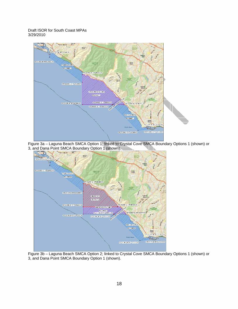
Laguna SMR boundaries and designation- A wastewater outfall pipe crosses the southern boundary of the SMR, and operation and maintenance activities associated with the outfall are incompatible with the SMR designation. However, the only area within the proposed Laguna SMR that would be affected by these operations lies within the southernmost 1.25 miles of coastline. Therefore, options are provided to allow for the continued operation of the outfall pipe by either revising the entire designation to an SMCA (option 1), dividing the geography into two no-fishing MPAs with an SMR designation along the majority of the area, with an SMCA designated along a band running across the southernmost 1.25 miles of the area which would increase the number of MPAs by one (option 2), or modifying the south-eastern boundary of the SMR to exclude the pipeline area (option 3). In addition, options are incorporated to address feasibility concerns raised in public comment and by Department enforcement and local enforcement partners. The proposed SMR boundaries adhere to Department feasibility guidelines; however, feedback received from

Draft ISOR for South Coast MPAs 3/29/2010
10
the public and local MPA management partners indicates that the angle of the coastline in this geography does not work well with strict north/south – east/west boundaries. This is particularly true for user groups accessing the area from shore, who generally fish without the aid of Global Positioning System units to identify coordinate-based boundaries. Therefore, options are provided to address feasibility of boundaries by modifying the northern and southern boundaries to be oriented perpendicular to the shore, in two different configurations (options 4 and 5). A summary of options 1-5 are provided below: Option 1: Retain coordinates as proposed and change designation to a non-fishing SMCA that allows for wastewater outfall operation and maintenance (Figure 3a). Option 2: Divide Option 1 geography into two MPAs, with an SMR north of the wastewater outfall pipe and create a non-fishing SMCA band at the southern portion of the proposal boundary, including the wastewater outfall pipe, which allows for operation and maintenance of the outfall (Figure 3b). This option would increase the number of MPAs by one. Option 3: Modify the southern boundary to exclude the pipe, by moving the southeast corner of the SMR northward to the nearest prominent rocks, which results in a nearshore line perpendicular to shore (Figure 3c). Option 4: Use the southern boundary in Option 3, and also modify the northern boundary in the nearshore area to be perpendicular to shore. Seaward, the boundaries adhere largely to the size and shape of the IPA (Option 1). This shape excludes the wastewater outfall pipe (Figure 3d). Option 5: This is a variation of option 4 in which the northern and southern boundaries extend perpendicular from shore out to state waters (Figure 3e). Robert E. Badham SMCA- This existing MPA is subsumed into Crystal Cove SMCA in the IPA. However, this MPA was named after Robert E. Badham as a result of a resolution passed by the Legislature. So an option is provided that divides the proposed Crystal Cove SMCA into two MPAs that retains the Crystal Cove SMCA name along State Parks lands and retains the historic name Robert E. Badham in the remaining area (See Crystal Cove SMCA Boundary options 3 and 4 below).
Crystal Cove SMCA boundaries-
Draft ISOR for South Coast MPAs 3/29/2010
11
Since this MPA shares a boundary with the Laguna SMR, some of the Laguna options will result in a change to the southern boundary of this MPA (Boundary options 1 and 2). Boundary Option 1: Retain coordinates as proposed (Figures 3a-3c; links to Laguna options 1, 2, and 3). Boundary Option 2: Modifies the southern boundary (Figures 3d-3e; links to Laguna options 4 and 5). Boundary Option 3: Divide Option 1 geography into two MPAs, with the northern boundary of Crystal Cove SMCA terminating at the State Park boundary, and the remaining area within the geography north of the boundary applies the original name of Robert E. Badham SMCA (Figure 3f). This option would increase the number of MPAs by one. Boundary Option 4: Divide Option 2 geography into two MPAs, with the northern boundary of Crystal Cove SMCA terminating at the State Park boundary, and the remaining area within the geography north of the boundary applies the original name of Robert E. Badham SMCA (Figure 3g). This option would increase the number of MPAs by one. Crystal Cove SMCA take regulations- State Parks has requested that the Commission consider prohibiting commercial fishing, contrary to that proposed in the IPA, based on the rationale that commercial take conflicts with the Crystal Cove State Park general plan for enhancing recreational activities. Therefore take options are provide for Crystal Cove as follows: Take Option A: Allow commercial take as proposed in the IPA. Take Option B: Prohibit commercial take. Dana Point SMCA boundaries- Since this MPA shares a boundary with the Laguna SMR, some of the Laguna options will result in a change to the northern boundary of this MPA (Boundary options 1 and 2). Boundary Option 1: Retain coordinates as proposed (Figures 3a-3b; links to Laguna options 1 and 2). Boundary Option 2: Modifies the northern boundary (Figures 3c-3e; links to Laguna options 3, 4 and 5).
Dana Point SMCA other access and collecting restrictions- The existing Dana Point SMCA is sited along the Dana Point Headlands and contains language derived from legislation that originally established the Dana Point Marine Life Refuge (reclassified as an SMCA per the MLPA). The existing regulations

Draft ISOR for South Coast MPAs 3/29/2010
12
prohibit entry into the intertidal zone for purposes of taking or possessing any species of fish, plant, or invertebrate, except under a scientific collecting permit issued by the Department, and specific approval from the director of the Dana Point SMCA to collect within the SMCA. The proposed regulation expands the coastal coverage of the Dana Point SMCA northward by over three linear miles, and allow for take from the shore. Therefore, the proposed regulation includes two options. Access Option A: Remove existing restrictions on entry, and scientific collecting oversight by the director of the Dana Point SMCA. Access Option B: Retain existing restrictions on entry, and scientific collecting oversight below the northern boundary of the existing SMCA only, which is southward of a line at latitude 33° 27.74' N.
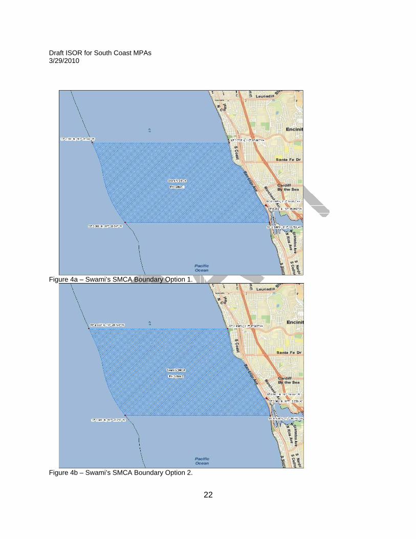
Swami’s SMCA boundaries- The proposed northern and southern boundaries for this MPA fall in the middle of beaches without visible and permanent landmarks. Because these beaches have very high visitation rates of more than three million people annually, many of which fish from the beach, Department enforcement have raised concerns that the public may find it difficult to locate the boundaries unless aligned with landmarks. To facilitate public understanding, the Department recommends moving the northern boundary northward to align with a river mouth (Option 2), and moving the southern boundary to the edge of State Parks land (end of state beach) (Option 3). Additionally, State Parks has requested the consideration of sub-options for this proposed MPA due to conflicts with current Parks unit management. State Parks states that the proposed modification of the existing MPA conflicts with State Beach classification and general plans. The proposed MPA will affect both Cardiff and San Elijo State Beaches. More than three million people visit these beaches annually. San Elijo State Beach provides 172 campsites. The classification of a State Park System unit forms the foundation on which all management and development policies are based. State Beaches are a class of State Recreational Areas which are operated to provide outdoor recreation opportunities. State Beaches provide swimming, boating, fishing, and other beach-oriented recreational activities. An SMCA with a LOP [i.e., that prohibits shore fishing] would conflict with one of the primary purposes of these park units. Therefore, State Parks recommends allowing shore-based fishing.

Draft ISOR for South Coast MPAs 3/29/2010
13
The proposed regulation provides sub-options that add shore-based fishing with hook and line gear as an allowed recreational take method in the SMCA (see sub-options for allowed take in options 3, and 4). These options meet Department feasibility guidelines but reduce the SAT LOP to moderate-low. Boundary Option 1: Retain coordinates as proposed in IPA (Figure 4a). Boundary Option 2: Move northern boundary northward to river mouth (Figure 4b). Boundary Option 3: Move southern boundary south to align with State Parks Beach boundary (Figure 4c). Boundary Option 4: Move northern boundary per Option 2 and southern boundary per Option 3 (Figure 4d). Take Option A: Recreational fishing regulations as proposed in IPA. Take Option B: Adds shore-base fishing with hook and line gear as an allowed recreational take method in the SMCA (State Parks request). San Diego Scripps Coastal and Matlahuayl SMCA Boundaries- In the IPA proposal, the Scripps Pier cuts diagonally across the boundary between these two proposed MPAs. Although the pier is not a fishing pier, it is common for recreational anglers fishing from boats to target fish for bait underneath the pier structure, presenting difficulties for enforcement and public understanding. The boundary as proposed will require re-designation of Matlahuayl from an SMR to and SMCA to allow for operation and maintenance of the pier structure. Therefore, the proposed regulation adds an option to move the shared boundary between the two MPAs southward to below the pier, as follows: San Diego-Scripps Coastal SMCA Option 1: Retain coordinates as proposed (Figure 5a; linked to Matlahuayl Option 1). San Diego-Scripps Coastal SMCA Option 2: Move the southern boundary south to below the base of Scripps Pier (Figure 5b; linked to Matlahuayl Option 2). Matlahuayl SMCA Option 1: Change designation to SMCA; retain coordinates as proposed in IPA(Figure 5a; linked to San Diego-Scripps Coastal SMCA Option 2). Matlahuayl SMR Option 2: Retain SMR designation, move northern boundary south below base of pier (Figure 5b; linked to San Diego-Scripps Coastal SMCA Option 2).
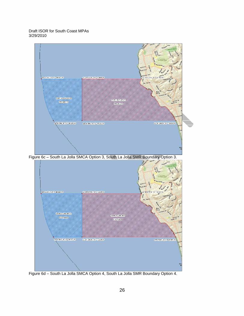
South La Jolla SMR/SMCA-
Draft ISOR for South Coast MPAs 3/29/2010
14
This inshore/offshore MPA complex has a shared northern and southern boundary. As proposed in the IPA, the northern boundary bisects an intertidal reef that is popular for recreational harvest of invertebrates at low tide. Additionally, the southern boundary falls in the middle of a public beach without a permanent and visible landmark. Both of these boundaries may lead to enforcement and public understanding challenges. Therefore, boundary options are provided to address feasibility concerns for the northern and southern boundaries: Option 1: Retain coordinates as proposed in IPA (Figure 6a). Option 2: Move northern boundary to north of the intertidal reef (Figure 6b). Option 3: Move southern boundary one block south to align with Palomar Ave. (Figure 6c). Option 4: Move both northern and southern boundaries per options 2 and 3 (Figure 6d). State Parks request to retain two existing MPAs Two existing MPAs (Refugio SMCA and Doheny Beach SMCA) are not retained in the original IPA of 35 MPAs submitted by the BRTF to the Commission for the proposed regulation. However, State Parks requests that these MPAs be retained, and has provided the following rationale: Refugio SMCA- Proposed removal of this existing MPA would decrease protection and open up the area to potential increased commercial extraction. The area includes significant natural values as well as sensitive archeological sites. The shallow relief reefs and interspersed sand substrate environments of this site contribute to high biological diversity. Culturally diverse as well, the area was once a popular trading ship anchorage, and prehistoric Chumash stone bowls have been found within this site. Refugio State Beach receives over 100,000 visitors each year and is popular for SCUBA diving, swimming, recreational fishing and sea kayaking. Existing interpretive programs include kayak and tidepool tours. The existing Refugio State Beach is impacted by commercial lobster trapping. Parks staff must regularly remove lobster traps that drift too close inshore and abandoned traps that lay within the park lease. Therefore, the following options are included in the proposed regulation: Option 1: Remove the existing Refugio SMCA from the proposed regulation, as per the IPA.
Draft ISOR for South Coast MPAs 3/29/2010
15
Option 2: Retain the existing regulations for Refugio SMCA within the proposed regulation (Figure 7). (Note that this would increase the number of MPAs by one.
Doheny Beach SMCA- Proposed removal of this existing MPA would decrease existing protection and decrease educational opportunity. Doheny State Beach includes an existing underwater recreation area and the Doheny Beach Marine Life Refuge, which was designated in 1969 by the Legislature specifically to protect tidepool invertebrates. The existing protections are moderate and do not affect commercial activities. Although relatively small, over 1.6 million people visited Doheny State Beach in 2008. Therefore, the following options are included in the proposed regulation: Option 1: Remove the existing Doheny Beach SMCA from the proposed regulation, as per the IPA. Option 2: Retain the existing regulations for Doheny Beach SMCA within the proposed regulation (Figure 8). Note that this would increase the number of MPAs by one.

Draft ISOR for South Coast MPAs 3/29/2010
16
Figure 1. Marine protected areas in proposed regulation known as IPA. The IPA as displayed includes 35 proposed new MPAs (alternatives within the proposed regulation provide option to add three MPAs not displayed here); the figure also shows 13 existing MPAs in the northern Channel Islands and Santa Barbara Island, which are not under re-consideration in this proposal, and two federal Safety Zones at San Clemente Island that are considered to contribute to the network but do not have an MPA designation.

Draft ISOR for South Coast MPAs 3/29/2010
17
Figure 2a – Arrow Point to Lion Head SMCA Boundary Option 1.
Figure 2b – Arrow Point to Lion Head SMCA Boundary Option 2.
Draft ISOR for South Coast MPAs 3/29/2010
18
Figure 3a – Laguna Beach SMCA Option 1; linked to Crystal Cove SMCA Boundary Options 1 (shown) or 3, and Dana Point SMCA Boundary Option 1 (shown).
Figure 3b – Laguna Beach SMCA Option 2; linked to Crystal Cove SMCA Boundary Options 1 (shown) or 3, and Dana Point SMCA Boundary Option 1 (shown).

Draft ISOR for South Coast MPAs 3/29/2010
19
Figure 3c – Laguna Beach SMCA Option 3; linked to Crystal Cove SMCA Boundary Options 1 (shown) or 3, and Dana Point SMCA Boundary Option 2 (shown).
Figure 3d – Laguna Beach SMCA Option 4; linked to Crystal Cove SMCA Boundary Options 2 (shown) or 4, and Dana Point SMCA Boundary Option 2 (shown).

Draft ISOR for South Coast MPAs 3/29/2010
20
Figure 3e – Laguna Beach SMCA Option 5; linked to Crystal Cove SMCA Boundary Options 2 (shown) or 4, and Dana Point SMCA Boundary Option 2 (shown).

Draft ISOR for South Coast MPAs 3/29/2010
21
Figure 3f – Crystal Cove SMCA Boundary Option 3: Divides area (from Boundary Option 1) into Robert E. Badham SMCA and Crystal Cove SMCA.
. Figure 3g – Crystal Cove SMCA Boundary Option 4: Divides area (from Boundary Option 2) into Robert E. Badham SMCA and Crystal Cove SMCA.
Draft ISOR for South Coast MPAs 3/29/2010
22
Figure 4a – Swami’s SMCA Boundary Option 1.
Figure 4b – Swami’s SMCA Boundary Option 2.

Draft ISOR for South Coast MPAs 3/29/2010
23
Figure 4c – Swami’s SMCA Boundary Option 3.
Figure 4d – Swami’s SMCA Boundary Option 4.

Draft ISOR for South Coast MPAs 3/29/2010
24
Figure 5a – San Diego-Scripps SMCA Boundary Option 1, Matlahuayl SMCA Boundary Option 1.
Figure 5b – San Diego-Scripps SMCA Boundary Option 2, Matlahuayl SMCA Boundary Option 2.

Draft ISOR for South Coast MPAs 3/29/2010
25
Figure 6a – South La Jolla SMCA Boundary Option 1, South La Jolla SMR Boundary Option 1.
Figure 6b – South La Jolla SMCA Boundary Option 2, South La Jolla SMR Boundary Option 2.
Draft ISOR for South Coast MPAs 3/29/2010
26
Figure 6c – South La Jolla SMCA Option 3, South La Jolla SMR Boundary Option 3.
Figure 6d – South La Jolla SMCA Option 4, South La Jolla SMR Boundary Option 4.

Draft ISOR for South Coast MPAs 3/29/2010
27
Figure 7 – Refugio SMCA Option 2 (Option 1 does not include this MPA in the IPA).
Figure 8 – Doheny Beach SMCA Option 2 (Option 1 does not include this MPA in the IPA).
Draft ISOR for South Coast MPAs 3/29/2010
28
Proposed Regulation Details Table 1 presents proposed MPAs in the IPA including the MPA designation, options for specific MPAs, proposed allowed take, other proposed regulated activities, and MLPA SAT assigned level of protection. In order to analyze the differences between no-take reserves and limited take conservation areas and recommended parks, the SAT developed a ranking for level of protection described in the master plan based on impact of allowed uses on ecological and ecosystem structure. Levels of protection are modified for each study region for evaluation purposes; and are appended to the master plan upon adoption of MPA proposals (Attachment 3). Other terms used in Table 1 include “pelagic finfish,” “finfish,” and “coastal pelagic species” with the following definitions: • Pelagic finfish are defined in subsection 632(a)(3) as: northern
anchovy (Engraulis mordax), barracudas (Sphyraena spp.), billfishes* (family Istiophoridae) (except that marlin is not allowed for commercial take), dolphinfish/dorado (Coryphaena hippurus), Pacific herring (Clupea pallasi), jack mackerel (Trachurus symmetricus), Pacific mackerel (Scomber japonicus), salmon (Oncorhynchus spp.), Pacific sardine (Sardinops sagax), blue shark (Prionace glauca), salmon shark (Lamna ditropis), shortfin mako shark (Isurus oxyrinchus), thresher sharks (Alopias spp.), swordfish (Xiphias gladius), tunas (family Scombridae), and yellowtail (Seriola lalandi).
• Finfish are defined in subsection 632(a)(2) as: any species of bony fish or cartilaginous fish (sharks, skates and rays). Finfish do not include amphibians, invertebrates, plants or algae. The definition of finfish provided in Section 159 does not apply to this Section.
• Coastal pelagic species are defined in Section 1.39 as: northern anchovy (Engraulis mordax), Pacific sardine (Sardinops sagax), Pacific mackerel (Scomber japonicus), jack mackerel (Trachurus symmetricus), and market squid (Loligo opalescens).
Draft ISOR for South Coast MPAs 3/29/2010
29
Table 1. Proposed regulation1 (Integrated Preferred Alternative) for marine protected areas (MPAs) in the south coast region (excluding the northern Channel Islands), including description of options, proposed allowed take, other proposed regulated activities, and SAT-assigned LOP. Marine protected areas are arranged geographically from north to south, including Catalina Island.
MPA Name & Designation
Description of MPA Options Proposed Allowed Take Other Proposed Regulated Activities2
SAT Level of
Protection Point Conception State Marine Reserve
IPA Take of all living marine resources is prohibited
--- Very High
Kashtayit State Marine Conservation Area3
IPA Take of all living marine resources is prohibited EXCEPT: 1) The recreational take of finfish
and invertebrates, except rock scallops and mussels,
2) The recreational take of giant kelp (Macrocystis pyrifera) by hand harvest
Allows maintenance of artificial structures and operation and maintenance of existing facilities pursuant to any required permits, or as otherwise authorized by the Department
Low
Naples State Marine Conservation Area
IPA Take of all living marine resources is prohibited EXCEPT: 1. The recreational take of
pelagic finfish and white seabass by spearfishing
2. The commercial take of giant kelp (Macrocystis pyrifera) by hand harvest, or by mechanical harvest
Allows operation and maintenance of artificial structures pursuant to any required permits, or as otherwise authorized by the Department
Low
Campus Point State Marine Reserve5
IPA
Take of all living marine resources is prohibited
---5 Very High
Draft ISOR for South Coast MPAs 3/29/2010
30
MPA Name & Designation
Description of MPA Options Proposed Allowed Take Other Proposed Regulated Activities2
SAT Level of
Protection OPTIONS EXIST (1-2) TO EXCLUDE OR INCLUDE REFUGIO Option 1: Exclude Refugio State Marine Conservation Area
1: IPA: Removes existing SMCA as reflected in IPA
N/A N/A N/A
Option 2: Refugio State Marine Conservation Area
2: Retaining existing SMCA and adding to IPA (State Parks option)
Take of all living marine resources is prohibited EXCEPT: 1. Only the following species may
be taken recreationally: finfish, chiones, clams, cockles, rock scallops, native oysters, crabs, lobster, ghost shrimp, sea urchins, mussels and marine worms except that no worms may be taken in any mussel bed unless taken incidentally to the take of mussels.
2. Only the following species may be taken commercially: finfish, crabs, ghost shrimp, jackknife clams, sea urchins, algae except giant kelp and bull kelp and worms except that no worms may be taken in any mussel bed, nor may any person pick up, remove, detach from the substrate any other organisms, or break up, move or destroy any rocks or other substrate or surfaces to which organisms are attached.
--- Low

Draft ISOR for South Coast MPAs 3/29/2010
31
MPA Name & Designation
Description of MPA Options Proposed Allowed Take Other Proposed Regulated Activities2
SAT Level of
Protection Goleta Slough State Marine Conservation Area4
IPA4 Take of all living marine resources is prohibited
Allows maintenance dredging, habitat restoration, research and education, maintenance of artificial structures, and operation and maintenance of existing facilities pursuant to any required permits, activities pursuant to Section 630, Title 14, CCR, or as otherwise authorized by the Department Swimming, wading, and diving are prohibited in waters below the mean high tide line in the Goleta Slough Ecological Reserve as defined within Section 630, , CCR.
Very High
Begg Rock State Marine Reserve
IPA Take of all living marine resources is prohibited
--- Very High
Point Dume State Marine Conservation Area
IPA Take of all living marine resources is prohibited EXCEPT: 1. The recreational take of
pelagic finfish, including Pacific bonito, and white seabass by spearfishing
2. The commercial take of coastal pelagic species by round haul net and swordfish by harpoon
--- High
Point Dume State Marine Reserve
IPA Take of all living marine resources is prohibited
--- Very High
Point Vicente State Marine Conservation Area4
IPA4 Take of all living marine resources is prohibited
Allows activities associated with the Palos Verdes Shelf Superfund Site remediation program pursuant to any required permits or as authorized by the Department
Very High

Draft ISOR for South Coast MPAs 3/29/2010
32
MPA Name & Designation
Description of MPA Options Proposed Allowed Take Other Proposed Regulated Activities2
SAT Level of
Protection Abalone Cove State Marine Conservation Area
IPA Take of all living marine resources is prohibited EXCEPT: 1. The recreational take of
pelagic finfish, including Pacific bonito, and white seabass by spearfishing only, and market squid by hand-held dip net
2. The commercial take of coastal pelagic species and Pacific bonito by round haul net, and swordfish by harpoon
Allows activities associated with the Palos Verdes Shelf Superfund Site remediation program pursuant to any required permits or as authorized by the Department
High
Bolsa Bay State Marine Conservation Area6
IPA Take of all living marine resources is prohibited EXCEPT: 1. The recreational take of finfish
by hook and line from shore only
Allows routine operation and maintenance, habitat restoration, maintenance dredging, research and education, and maintenance of artificial structures pursuant to any required permits, activities pursuant to Section 630, Title 14, CCR, or as otherwise authorized by the Department Boating, swimming, wading, and diving are prohibited; access restricted between 8:00 p.m. and 6:00 a.m.
Moderate Low
Bolsa Chica Basin State Marine Conservation Area4, 6
IPA4 Take of all living marine resources is prohibited
Allows routine operation and maintenance, habitat restoration, maintenance dredging, research and education, and maintenance of artificial structures pursuant to any required permits, activities pursuant to Section 630, Title 14, CCR, or as otherwise authorized by the Department2 Boating, swimming, wading, and diving prohibited; access restricted between
Very High
Draft ISOR for South Coast MPAs 3/29/2010
33
MPA Name & Designation
Description of MPA Options Proposed Allowed Take Other Proposed Regulated Activities2
SAT Level of
Protection 8:00 p.m. and 6:00a.m.
BOUNDARY OPTIONS (1-2) EXIST FOR ARROW POINT TO LION HEAD POINT (CATALINA ISLAND) Option 1: Arrow Point to Lions Head Point (Catalina Island) State Marine Conservation Area
1: Seaward boundary defined by distance from shore
Recreational take of marine invertebrates is prohibited; take of all other species is allowed
--- Low
Option 2: Arrow Point to Lions Head Point (Catalina Island) State Marine Conservation Area
2: Uses straight line boundaries to improve feasibility
Recreational take of marine invertebrates is prohibited; take of all other species is allowed
--- Low
Blue Cavern (Catalina Island) State Marine Conservation Area4
IPA4 Take of all living marine resources is prohibited
Allows maintenance of artificial structures pursuant to any required permits, or as otherwise authorized by the Department2
Very High
Bird Rock (Catalina Island) State Marine Conservation Area
IPA Take of all living marine resources is prohibited EXCEPT: 1. The recreational take of
pelagic finfish including Pacific bonito by hook and line or by spearfishing, white seabass by spearfishing and market squid by hand-held dip net
2. The commercial take of pelagic
--- High

Draft ISOR for South Coast MPAs 3/29/2010
34
MPA Name & Designation
Description of MPA Options Proposed Allowed Take Other Proposed Regulated Activities2
SAT Level of
Protection finfish by hook and line only and swordfish by harpoon
Long Point (Catalina Island) State Marine Reserve
IPA Take of all living marine resources is prohibited
--- Very High
TAKE OPTIONS (1-2) EXIST FOR CASINO POINT (CATALINA ISLAND) Option 1: Casino Point (Catalina Island) State Marine Conservation Area 4
1: IPA4 No allowance for feeding of as described in IPA
Take of all living marine resources is prohibited
Allows maintenance of artificial structures pursuant to any required permits or as otherwise authorized by the Department2
Very High
Option 2: Casino Point (Catalina Island) State Marine Conservation Area4
2: Adds allowance for feeding of fish and wildlife to IPA4
Take of all living marine resources is prohibited EXCEPT: feeding of fish and wildlife for wildlife viewing is allowed
Same as Option 1 Very High
TAKE OPTIONS (1-2) EXIST FOR LOVER’S COVE (CATALINA ISLAND) Option 1: Lover's Cove (Catalina Island) State Marine Conservation Area
1: IPA No allowance for feeding of as described in IPA
Take of all living marine resources is prohibited EXCEPT: recreational fishing from public pier by hook and line
Allows maintenance of artificial structures pursuant to any required permits or as otherwise authorized by the Department2
Moderate High
Option 2: Lover's Cove (Catalina Island) State Marine Conservation Area
2: Adds allowance for feeding of fish and wildlife to IPA
Take of all living marine resources is prohibited EXCEPT: recreational fishing from public pier by hook and line, and feeding of fish and wildlife for wildlife viewing is allowed
Same as Option 1 Moderate High

Draft ISOR for South Coast MPAs 3/29/2010
35
MPA Name & Designation
Description of MPA Options Proposed Allowed Take Other Proposed Regulated Activities2
SAT Level of
Protection Farnsworth Onshore (Catalina Island) State Marine Conservation Area
IPA Take of all living marine resources is prohibited EXCEPT: 1. The recreational take of
pelagic finfish, including Pacific bonito, and white seabass by spearfishing only, market squid by hand-held dip net, and marlin, tunas and dorado by trolling
2. The commercial take of coastal pelagic species by round haul net and swordfish by harpoon
--- High
Farnsworth Offshore (Catalina Island) State Marine Conservation Area
IPA Take of all living marine resources is prohibited EXCEPT: 1. The recreational take of
pelagic finfish, including Pacific bonito by hook and line or spearfishing, white seabass by spearfishing only, market squid by hand-held dip net, and marlin, tunas and dorado by trolling
2. The commercial take of coastal pelagic species by round haul net and swordfish by harpoon
--- High
Cat Harbor (Catalina Island) State Marine Conservation Area
IPA Take of all living marine resources is prohibited EXCEPT: 1. The recreational take of finfish
by hook and line or by spearfishing, squid by hook and line, and lobster and sea urchin
2. The commercial take of sea cucumbers by diving, and
Allows maintenance of artificial structures pursuant to any required permits or as otherwise authorized by the Department2
Moderate Low
Draft ISOR for South Coast MPAs 3/29/2010
36
MPA Name & Designation
Description of MPA Options Proposed Allowed Take Other Proposed Regulated Activities2
SAT Level of
Protection spiny lobster and sea urchin
3. Aquaculture of finfish is allowed pursuant to a valid State water bottom lease and valid permits
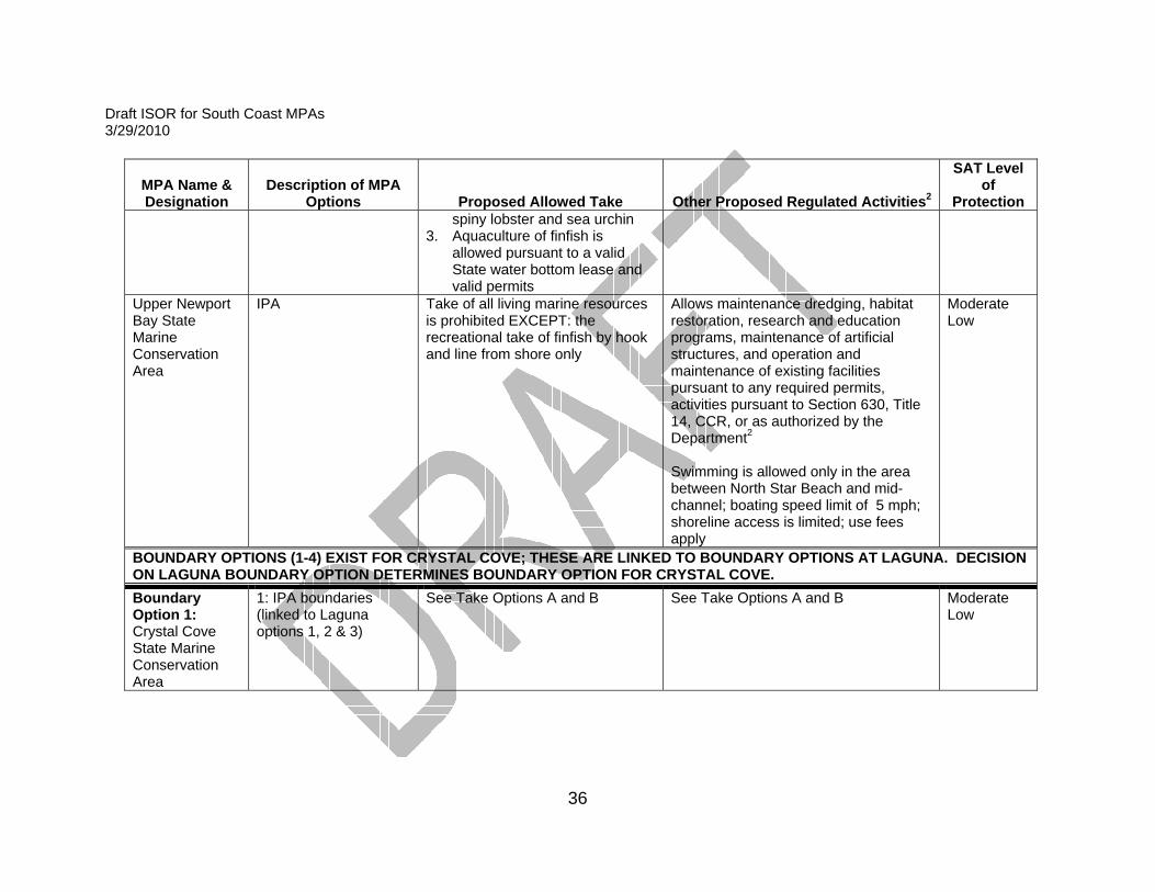
Upper Newport Bay State Marine Conservation Area
IPA Take of all living marine resources is prohibited EXCEPT: the recreational take of finfish by hook and line from shore only
Allows maintenance dredging, habitat restoration, research and education programs, maintenance of artificial structures, and operation and maintenance of existing facilities pursuant to any required permits, activities pursuant to Section 630, Title 14, CCR, or as authorized by the Department2 Swimming is allowed only in the area between North Star Beach and mid-channel; boating speed limit of 5 mph; shoreline access is limited; use fees apply
Moderate Low
BOUNDARY OPTIONS (1-4) EXIST FOR CRYSTAL COVE; THESE ARE LINKED TO BOUNDARY OPTIONS AT LAGUNA. DECISION ON LAGUNA BOUNDARY OPTION DETERMINES BOUNDARY OPTION FOR CRYSTAL COVE. Boundary Option 1: Crystal Cove State Marine Conservation Area
1: IPA boundaries (linked to Laguna options 1, 2 & 3)
See Take Options A and B See Take Options A and B Moderate Low

Draft ISOR for South Coast MPAs 3/29/2010
37
MPA Name & Designation
Description of MPA Options Proposed Allowed Take Other Proposed Regulated Activities2
SAT Level of
Protection Boundary Option 2: Crystal Cove State Marine Conservation Area
2: Southern boundary modified for feasibility (linked to Laguna options 4 & 5)
See Take Options A and B See Take Options A and B Moderate Low
Boundary Option 3: Robert E. Badham State Marine Conservation Area; and Crystal Cove State Marine Conservation Area
3: Divides the Boundary Option 1 geography into two MPAs to retain historic name for Robert E. Badham SMCA. (linked to Laguna options 1, 2 & 3)
See Take Options A and B See Take Options A and B Moderate Low
Boundary Option 4: Robert E. Badham State Marine Conservation Area; and Crystal Cove State Marine Conservation Area
4: Divides the Boundary Option 2 geography into two MPAs to retain historic name for Robert E. Badham SMCA (linked to Laguna options 4 & 5)
See Take Options A and B See Take Options A and B
Moderate Low

Draft ISOR for South Coast MPAs 3/29/2010
38
MPA Name & Designation
Description of MPA Options Proposed Allowed Take Other Proposed Regulated Activities2
SAT Level of
Protection TAKE OPTIONS (A & B) EXIST FOR CRYSTAL COVE. Take Option A: Crystal Cove State Marine Conservation Area
A: Take as proposed in the IPA
Take of all living marine resources is prohibited EXCEPT: 1. The recreational take of finfish
by hook and line or by spearfishing and lobster and sea urchin is allowed
2. The commercial take of coastal pelagic species by round haul net, spiny lobster by trap, and sea urchin
Allows beach nourishment or other sediment management activities and operation and maintenance of artificial structures pursuant to any required permits or as authorized by the Department2
Moderate Low
Take Option B: Crystal Cove State Marine Conservation Area
B: Does not allow commercial take (State Parks option)
Take of all living marine resources is prohibited EXCEPT: The recreational take of finfish by hook and line or by spearfishing, and lobster and sea urchin is allowed
Same as Take Option A Moderate Low
BOUNDARY OPTIONS (1-5) EXIST FOR LAGUNA; THESE ARE LINKED TO BOUNDARY OPTIONS FOR CRYSTAL COVE AND DANA POINT. DECISION ON LAGUNA BOUNDARY DETERMINE BOUNDARY OPTION FOR CRYSTAL COVE AND DANA POINT. Option 1: Laguna Beach State Marine Conservation Area4
1: IPA4 with designation as SMCA due to other regulated activities (outfall pipe)
Take of all living marine resources is prohibited
Boats may be launched and retrieved only in designated areas; anchoring restricted to daylight hours Allows operation and maintenance of artificial structures pursuant to any required permits or as authorized by the Department2
Very High
Take of all living marine resources is prohibited
Boats may be launched and retrieved only in designated areas; anchoring restricted to daylight hours
Very High Option 2: Laguna Beach State Marine Reserve and Laguna Beach
2: Divides the Option 1 geography into two MPAs (SMR/SMCA) with SMCA4 across southern 1.5 miles due
Take of all living marine resources is prohibited
Boats may be launched and retrieved only in designated areas; anchoring
Very High

Draft ISOR for South Coast MPAs 3/29/2010
39
MPA Name & Designation
Description of MPA Options Proposed Allowed Take Other Proposed Regulated Activities2
SAT Level of
Protection State Marine Conservation Area4
to other regulated activities (outfall pipe)
restricted to daylight hours Allows operation and maintenance of artificial structures pursuant to any required permits or as authorized by the Department2
Option 3: Laguna Beach State Marine Reserve
3: Modifies southern boundary from Option 1 to exclude outfall pipe, with SMR designation (linked with Dana Point Option 2)
Same as Option 1
Boats may be launched and retrieved only in designated areas; anchoring restricted to daylight hours
Very High
Option 4: Laguna Beach State Marine Reserve
4: Modified southern AND northern boundaries from Option 1 with SMR designation to exclude pipe and improve feasibility (linked with Crystal Cove Option 2 & Dana Point Option 2)
Same as Option 1 Same as Option 3
Very High
Option 5: Laguna Beach State Marine Reserve
4: Modified southern AND northern boundaries to extend Option 4 nearshore boundaries to state waters to improve feasibility (linked with Crystal Cove Option 2 & Dana Point Option 2)
Same as Option 1 Same as Option 3
Very High
BOUNDARY OPTIONS (1-2) EXIST FOR DANA POINT; THESE ARE LINKED TO BOUNDARY OPTIONS AT LAGUNA. DECISION ON BOUNDARY OPTION AT LAGUNA DETERMINES BOUNDARY OPTION FOR DANA POINT.
Draft ISOR for South Coast MPAs 3/29/2010
40
MPA Name & Designation
Description of MPA Options Proposed Allowed Take Other Proposed Regulated Activities2
SAT Level of
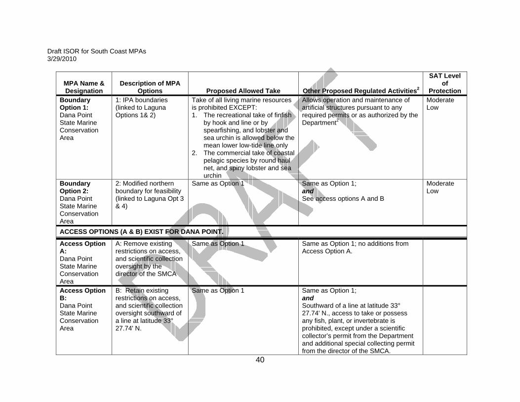
Protection Boundary Option 1: Dana Point State Marine Conservation Area
1: IPA boundaries (linked to Laguna Options 1& 2)
Take of all living marine resources is prohibited EXCEPT: 1. The recreational take of finfish
by hook and line or by spearfishing, and lobster and sea urchin is allowed below the mean lower low-tide line only
2. The commercial take of coastal pelagic species by round haul net, and spiny lobster and sea urchin
Allows operation and maintenance of artificial structures pursuant to any required permits or as authorized by the Department2
Moderate Low
Boundary Option 2: Dana Point State Marine Conservation Area
2: Modified northern boundary for feasibility (linked to Laguna Opt 3 & 4)
Same as Option 1 Same as Option 1; and See access options A and B
Moderate Low
ACCESS OPTIONS (A & B) EXIST FOR DANA POINT.
Access Option A: Dana Point State Marine Conservation Area
A: Remove existing restrictions on access, and scientific collection oversight by the director of the SMCA
Same as Option 1 Same as Option 1; no additions from Access Option A.
Access Option B: Dana Point State Marine Conservation Area
B: Retain existing restrictions on access, and scientific collection oversight southward of a line at latitude 33° 27.74' N.
Same as Option 1 Same as Option 1; and Southward of a line at latitude 33° 27.74' N., access to take or possess any fish, plant, or invertebrate is prohibited, except under a scientific collector’s permit from the Department and additional special collecting permit from the director of the SMCA.

Draft ISOR for South Coast MPAs 3/29/2010
41
MPA Name & Designation
Description of MPA Options Proposed Allowed Take Other Proposed Regulated Activities2
SAT Level of
Protection OPTIONS (1-2) EXIST TO EXCLUDE OR INCLUDE DOHENY BEACH.
Option 1: Exclude Doheny Beach State Marine Conservation Area
1: IPA: Removes existing SMCA as reflected in IPA
N/A N/A N/A
Option 2: Doheny Beach State Marine Conservation Area
2: Adds existing SMCA to IPA (per State Parks request)
Take of all living marine resources is prohibited EXCEPT: 1. Recreational take of: finfish,
chiones, clams, cockles, rock scallops, native oysters, crabs, lobster, ghost shrimp, sea urchins, mussels and marine worms except that no worms may be taken in any mussel bed unless taken incidentally to the take of mussels.
2. Commercial take is allowed.
--- Low
Batiquitos Lagoon State Marine Conservation Area4
IPA4 Take of all living marine resources is prohibited
Allows operation and maintenance, habitat restoration, research and education, maintenance dredging and maintenance of artificial structures pursuant to any required permits, or pursuant to Section 630, Title 14, CCR, or as authorized by the Department2 Boating, swimming, wading, and diving are prohibited
Very High
BOUNDARY OPTIONS (1-4) EXIST FOR SWAMI’S.

Draft ISOR for South Coast MPAs 3/29/2010
42
MPA Name & Designation
Description of MPA Options Proposed Allowed Take Other Proposed Regulated Activities2
SAT Level of
Protection Boundary Option 1: Swami's State Marine Conservation Area
1: IPA boundaries 1. See Take Options A and B See Take Options A and B High
Boundary Option 2: Swami's State Marine Conservation Area
2: Moves northern boundary of Option 1 north to river mouth to improve feasibility
See Take Options A and B See Take Options A and B High
Boundary Option 3: Swami's State Marine Conservation Area
3: Moves southern boundary of Option 1 south to edge of State Parks land (State Parks request) to improve feasibility
See Take Options A and B See Take Options A and B High
Boundary Option 4: Swami's State Marine Conservation Area
3: Moves northern boundary of Option 1 north to river mouth; AND moves southern boundary south to edge of State Parks land (State Parks request) to improve feasibility
See Take Options A and B See Take Options A and B High
TAKE OPTIONS (A & B) EXIST FOR SWAMI’S.
Take Option A: Swami's State Marine Conservation
A: Adds shorefishing to allowed take (State Parks request) – reduces LOP
Take of all living marine resources is prohibited EXCEPT: The recreational take of pelagic finfish, including Pacific bonito, and
Allows beach nourishment or other sediment management activities and operation and maintenance of artificial structures pursuant to any required
Moderate Low

Draft ISOR for South Coast MPAs 3/29/2010
43
MPA Name & Designation
Description of MPA Options Proposed Allowed Take Other Proposed Regulated Activities2
SAT Level of
Protection Area white seabass by spearfishing permits or as authorized by the
Department2 Take Option B: Swami's State Marine Conservation Area
B: Adds shorefishing to allowed take (State Parks request) – reduces LOP
Same as Take Option A, EXCEPT: ALSO allows recreational take by hook and line from shore only.
Same as Take Option A Moderate Low
San Elijo Lagoon State Marine Conservation Area4
IPA4 Take of all living marine resources is prohibited
Allows operations and maintenance, maintenance dredging, habitat restoration including sediment deposition, research and education, and maintenance of artificial structures pursuant to any required permits, or as authorized under Section 630, Title 14, CCR, or as authorized by the Department2 Boating, swimming, wading and diving are prohibited
Very High
BOUNDARY OPTIONS (1-2) EXIST FOR SAN DIEGO-SCRIPPS COASTAL; THESE ARE LINKED TO BOUNDARY OPTIONS AT MATLAHUAYL. DECISION ON SAN DIEGO-SCRIPPS COASTAL BOUNDARY OPTION DETERMINES BOUNDARY OPTION AND MPA DESIGNATION FOR MATLAHUAYL Option 1: San Diego-Scripps Coastal State Marine Conservation Area
1: IPA boundaries (Linked to Matlahuayl Option 1)
Take of all living marine resources is prohibited EXCEPT: 1. The recreational take of
coastal pelagic species except market squid by hook and line
Allows operation and maintenance of artificial structures pursuant to any required permits or as authorized by the Department2
Moderate Low
Option 2: San Diego-Scripps Coastal State Marine Conservation
2: Moves southern boundary from Option 1 below pier to improve feasibility (Linked to Matlahuayl Option 2)
Same as Option 1 Same as Option 1 Moderate Low

Draft ISOR for South Coast MPAs 3/29/2010
44
MPA Name & Designation
Description of MPA Options Proposed Allowed Take Other Proposed Regulated Activities2
SAT Level of
Protection Area
BOUNDARY OPTIONS (1-2) EXIST FOR MATLAHUAYL; THESE ARE LINKED TO BOUNDARY OPTIONS AT SAN DIEGO-SCRIPPS COASTAL. DECISION ON SAN DIEGO-SCRIPPS COASTAL BOUNDARY OPTION DETERMINES BOUNDARY OPTION AND MPA DESIGNATION FOR MATLAHUAYL Option 1: Matlahuayl State Marine Conservation Area4
1: IPA Boundary, designated as SMCA4 (Linked to San Diego-Scripps Coastal Option 1)
Take of all living marine resources is prohibited
Boats may be launched and retrieved only in designated areas; anchoring restricted to daylight hours Allows operation and maintenance of artificial structures pursuant to any required permits or as authorized by the Department2
Very High
Option 2: Matlahuayl State Marine Reserve
2: Moves northern boundary from Option 1 below pier to improve feasibility and retain SMR designation (Linked to San Diego-Scripps Coastal Option 2)
Same as Option 1
Boats may be launched and retrieved only in designated areas; anchoring restricted to daylight hours
Very High
BOUNDARY OPTIONS (1-4) EXIST FOR SOUTH LA JOLLA SMR; THESE ARE LINKE TO SOUTH LA JOLLA SMCA BOUNDARY OPTIONS. DECISION ON SOUTH LA JOLLA SMR BOUNDARY OPTION DETERMINES BOUNDARY OPTION FOR SOUTH LA JOLLA SMCA Option 1: South La Jolla State Marine Reserve
1: IPA boundaries Take of all living marine resources is prohibited
--- Very High

Draft ISOR for South Coast MPAs 3/29/2010
45
MPA Name & Designation
Description of MPA Options Proposed Allowed Take Other Proposed Regulated Activities2
SAT Level of
Protection Option 2: South La Jolla State Marine Reserve
2: Moves northern boundary from Option 1 north above intertidal reef to improve feasibility
Same as Option 1 --- Very High
Option 3: South La Jolla State Marine Reserve
3: Moves southern boundary from Option 1 south to major street to improve feasibility
Same as Option 1 --- Very High
Option 4: South La Jolla State Marine Reserve
4: Moves Option 1 northern boundary north above intertidal reef; AND Moves southern boundary south to major street to improve feasibility
Same as Option 1 --- Very High
BOUNDARY OPTIONS (1-4) EXIST FOR SOUTH LA JOLLA SMCA; THESE ARE LINKE TO SOUTH LA JOLLA SMR BOUNDARY OPTIONS. DECISION ON SOUTH LA JOLLA SMCA BOUNDARY OPTION DETERMINES BOUNDARY OPTION FOR SOUTH LA JOLLA SMR Option 1: South La Jolla State Marine Conservation Area
1: IPA boundaries Take of all living marine resources is prohibited EXCEPT: 1. The recreational take of
pelagic finfish including Pacific bonito by hook and line
--- High
Option 2: South La Jolla State Marine Conservation Area
2: Same northern boundary change as South La Jolla SMR Option 2
Same as Option 1 --- High
Option 3: South La Jolla
3: Moves southern boundary from Option 1
Same as Option 1 --- High

Draft ISOR for South Coast MPAs 3/29/2010
46
MPA Name & Designation
Description of MPA Options Proposed Allowed Take Other Proposed Regulated Activities2
SAT Level of
Protection State Marine Conservation Area
south to major street to improve feasibility
Option 4: South La Jolla State Marine Conservation Area
4: Moves Option 1 northern boundary north above intertidal reef; AND Moves southern boundary south to major street to improve feasibility
Same as Option 1 --- High
Famosa Slough State Marine Conservation Area4
IPA4 Take of all living marine resources is prohibited
Allows habitat restoration, maintenance dredging, and operation and maintenance of artificial structures pursuant to any required permits or as authorized by the Department2
Very High
Cabrillo State Marine Reserve
IPA Take of all living marine resources is prohibited
--- Very High
Tijuana River Mouth State Marine Conservation Area
IPA Take of all living marine resources is prohibited EXCEPT: 1. The recreational take of
coastal pelagic species except market squid by hand-held dip net
2. The commercial take of coastal pelagic species except market squid by round haul net
Allows beach nourishment or other sediment management activities and operation and maintenance of artificial structures pursuant to any required permits or as authorized by the Department2
High
1-This table does not include the 13 existing MPAs within the northern Channel Islands. The northern Channel Islands MPAs were retained without modification, at the direction of the Commission, and are not part of this rulemaking, although they are displayed in the maps and summaries.
2-Existing activities and operations permitted by other federal, state, or local entities, such as dredging, wastewater outfall operations, maintenance of artificial structures and sand replenishment and other sediment management activities have been identified as occurring within this proposed MPA, which may result in take of marine resources incidental to the activity. Operations or activities identified at the time of designation are included within the proposed regulation to make explicit that MPA designation is not intended to interfere with these permitted activities.

Draft ISOR for South Coast MPAs 3/29/2010
47
3-This area, recommended by stakeholders as an SMP, will be designated as SMCA, and could subsequently be designated a state marine park at the discretion of the State Park and Recreation Commission.
4-These MPAs, recommended by stakeholders as an SMR, will be designated as an SMCAs that allow no take, except as associated with activities regulated by other agencies, pursuant to any valid permits, allowed within the conservation area.
5-Activities related to an existing artificial structure were identified in the report (Attachment 11) as occurring within Campus Point SMR, with a recommendation to change the designation to an SMCA and specify that the permitted activities could continue. Information received subsequent to the report indicates that the artificial structure is outside the boundaries of the proposed SMR. Therefore, the regulation retains the SMR designation as proposed.
6-The names originally proposed (Bolsa Chica SMCA/SMCA) are identical. To avoid confusion, the names have been modified to reflect commonly-used terms for each of the respective areas: Bolsa Bay SMCA and Bolsa Chica Basin SMCA.
7-A preliminary wave energy permit has been granted by the Federal Energy Regulatory Commission (FERC) at Catalina, that includes part of the proposed expansion of Farnsworth Bank (Catalina) Offshore SMCA, which may need to be included in future regulations for this MPA.

Draft ISOR for South Coast MPAs 3/29/2010
48
The 35 MPAs in the proposed regulation, in combination with the existing Northern Channel Islands MPAs and federal Safety Zones, cover an area of approximately 387.3 square miles, representing approximately 16.5 percent of state waters within the south coast region (Attachment 4). Of this, more than 70 percent of the area is within SMRs or “very high LOP” SMCA that do not allow fishing, but allow for existing regulated activities to occur. These non-fishing MPAs cover approximately 274.1 square miles or approximately 11.7 percent of state waters within the south coast region. The remaining areas are primarily SMCAs that allow some fishing activity, covering an area of approximately 76.6 square miles, and federal Safety Zones consisting of approximately 36.7 square miles. It should be noted that sub-options exist within the proposed regulation that could increase the number of MPAs in the regulation. A selection to add Refugio and Doheny SMCAs (Option 2) would add an additional 1.03 square miles and 0.14 square miles, respectively, to the total area covered by the proposed regulation, for a total of 388.5 square miles. A selection of Options 3 or 4 for Crystal Cove SMCA (that divides the proposed Crystal Cove MPA into Crystal Cove SMCA and Robert E. Badham SMCA) would add an additional MPA with no change to the size, and Option 2 for Laguna SMR/SMCA would divide the proposed Laguna MPA into two MPAs, with no change to the size. The 35 new MPAs included in this proposed regulation (with sub-options that could lead to up to 39 MPAs) make up roughly 55 percent of the total area protected within the IPA, with the existing Channel Islands MPAs contributing approximately 45 percent of protected area, and the federal Safety Zone areas covering approximately 10 percent of the total area encompassed in the IPA. Many of the SMCAs allow the take of pelagic finfish (defined above), recreational take of white seabass by spearfishing, and commercial take of coastal pelagic species by round haul gear, which were considered by the SAT to offer high ecosystem protection (Attachment 3). In some SMCAs, take of other species such as spiny lobster, sea urchin, finfish, and kelp is allowed. With some exceptions, the SMCAs protect benthic fishes and invertebrates most likely to benefit from area protection. Many of the MPA proposals were advanced with recommendations from the stakeholders and BRTF to develop MOU agreements

Draft ISOR for South Coast MPAs 3/29/2010
49
between the Department and government entities, research institutions, or tribal governments and organizations. These MOU agreements are outside of this rulemaking process, although they may be considered and pursued under the guidance of the master plan (See Attachment 12).
(b) Authority and Reference Sections from Fish and Game Code for
Regulation:
Authority: Sections 200, 202, 203.1, 205(c), 219, 220, 1590, 1591, 2860. 2861, and 6750, Fish and Game Code; and Sections 36725(a) and 36725(e), Public Resources Code.
Reference: Sections 200, 202, 203.1, 205(c), 219, 220, 1570, 1583, 2861, 5521, 6653, 8420(e), and 8500, Fish and Game Code: and Sections 36700(e), 36710(e), and 36725(a) and 36725(e), Public Resources Code.
(c) Specific Technology or Equipment Required by Regulatory Change: None.
(d) Identification of Reports or Documents Supporting Regulation Change:
Attachment 1: Regional goals, objectives, and design and implementation considerations for the south coast regional component of a statewide MPA network (Also available at http://www.dfg.ca.gov/mlpa/pdfs/southcoastgoals0209.pdf)
Attachment 2: California Department of Fish and Game Feasibility Criteria and Evaluation Components for Marine Protected Area Proposals (November 12, 2008) (Also available at http://www.dfg.ca.gov/mlpa/pdfs/agenda_111808n.pdf)
Attachment 3: MLPA SAT Levels of Protection for the SCSR Attachment 4: Detailed description, objectives and rationale, and maps
of the preferred alternative (IPA) (Also available at http://www.dfg.ca.gov/mlpa/southcoastipa.asp)
Attachment 5: South Coast Blue Ribbon Task Force (BRTF) Motion for the Integrated Preferred Alternative (IPA) for the MLPA South Coast Study Region - adopted November 10, 2009 (Also available at www.dfg.ca.gov/mlpa/pdfs/southcoast_ipa_motion.pdf)

-50-
Attachment 6: Detailed description and maps of alternative 1: Round 3 SCRSG Revised MPA Proposal 1 (Also available at http://www.dfg.ca.gov/mlpa/southcoastipa.asp#prop1)
Attachment 7: Detailed description and maps of alternative 2: Round 3 SCRSG Revised MPA Proposal 2 (Also available at http://www.dfg.ca.gov/mlpa/southcoastipa.asp#prop2)
Attachment 8: Detailed description and maps of alternative 3: Round 3 SCRSG Revised MPA Proposal 3 (Also available at http://www.dfg.ca.gov/mlpa/southcoastipa.asp#prop3)
Attachment 9: Action of the California Fish and Game Commission Regarding Marine Protected Areas at the Northern Channel Islands and Santa Barbara Island in the MLPA South Coast Study Region (December 30, 2008) (Also available at http://www.dfg.ca.gov/mlpa/pdfs/agenda_011309c1.pdf)
Attachment 10: Actions of MLPA Blue Ribbon Task Force Taken on May 19, 2009 Regarding Military Use Areas and Pending Military Closures (May 19, 2009) (Also available at http://www.dfg.ca.gov/mlpa/pdfs/agenda_052109a1.pdf)
Attachment 11: Department of Fish and Game Report to the Fish and Game Commission on Unresolved Issues and Potential Options for the Integrated Preferred Alternative of the Marine Life Protection Act in the South Coast Study Region (March 2010) (Also available at http://www.dfg.ca.gov/mlpa/pdfs/scmpas_report_030310.pdf)
Attachment 12: MOUs recommended by the BRTF and SCRSG for development for MPAs adopted in the south coast region
Attachment 13: Detailed description and maps of existing MPAs (Proposal 0 (Zero)) in the south coast region (Also available at http://www.dfg.ca.gov/mlpa/southcoastipa.asp#prop0)
Attachment 14: Estimates of the Maximum Potential Economic Impacts of Marine Protected Area Networks in the Southern California Coast
(e) Public Discussions of Proposed Regulations Prior to Notice publication:

-51-
Table 2. Public meetings held during the south coast study region planning process.
Meeting Major Topic Meeting Dates Location
Public Open House Introduce public to MLPA planning process 6/23/2008 Santa Barbara Public Open House Introduce public to MLPA planning process 6/24/2008 Oxnard Public Open House Introduce public to MLPA planning process 6/25/2008 Santa Monica Public Open House Introduce public to MLPA planning process 7/8/2008 Huntington Beach Public Open House Introduce public to MLPA planning process 7/9/2008 Carlsbad Public Open House Introduce public to MLPA planning process 7/10/2008 San Diego
BRTF Provide guidance to SAT/SCRSG on planning process 9/8/2008 San Diego
SAT Develop science guidance 9/10/2008 Conference Call SAT Develop science guidance 9/15/2008 El Segundo
SCRSG Begin discussion and guidance for MPA proposal development 10/6-7/08 El Segundo
SAT Develop science guidance 11/12/2008 Los Angeles
SCRSG Begin discussion and guidance for MPA proposal development 11/18-19/08 Ventura
BRTF Provide guidance to SAT/SCRSG on planning process 12/10/2008 Sacramento
Joint BRTF and FGC
Provide guidance on how to consider the northern Channel Islands in the south coast planning process 12/11/2008 Sacramento
SAT Develop science guidance 12/17/2008 Los Angeles SCRSG Begin developing round 1 MPA arrays 1/13-14/09 San Diego
BRTF Discuss policy guidance for the south coast planning process 1/22/2009 Conference Call
SAT Review and discussion of evaluation methods for south coast planning process
1/23/09 and 1/27/09 Los Angeles
SCRSG RSG work session 1/29/2009 Los Angeles
SCRSG RSG work session 2/10/2009Huntington Beach
SIG Discuss opportunities for public involvement 2/13/2009 Conference Call SAT Consider military use areas in evaluations 2/24/2009 Conference Call BRTF Discussion of regional goals and objectives 2/26/2009 Santa Barbara
SCRSG Discussion and guidance for MPA proposals in development 3/3-4/09 Long Beach
SAT Review and discuss evaluations of SCRSG proposals for round 1
4/1/09 and 4/6/09 Los Angeles
SIG Discuss opportunities for public involvement 4/10/2009 Conference Call
BRTF Discussion and guidance for MPA proposals in development 4/15-16/09 Dana Point
SCRSG Discussion and guidance for MPA proposals in development 4/28/2009 Oxnard
SCRSG RSG work session 4/29/2009 Oxnard SAT Develop guidance for MPA proposals 5/5/2009 Teleconference/

-52-
Meeting Major Topic Meeting Dates Location
Webinar
SAT Develop guidance for MPA proposals 5/15/2009Teleconference/ Webinar
BRTF Develop guidance for MPA proposals 5/18-19/09Teleconference/ Webinar
SCRSG RSG work session 5/19-20/09 Santa Ana SCRSG Finalize round 2 MPA draft proposals 5/21/2009 Santa Ana
SIG Discuss opportunities for public involvement 5/29/2009 Conference Call
BRTF Provide guidance for MPA proposals 6/4/2009 Los Angeles SAT Evaluation of SCRSG draft MPA proposals 6/18/2009 Los Angeles Public Open House Solicit feedback on round 2 MPA proposals 6/29/2009 Carlsbad Public Open House Solicit feedback on round 2 MPA proposals 6/30/2009 San Diego Public Open House Solicit feedback on round 2 MPA proposals 7/1/2009 Laguna Public Open House Solicit feedback on round 2 MPA proposals 7/6/2009 San Pedro Public Open House Solicit feedback on round 2 MPA proposals 7/7/2009 Marina Del Rey Public Open House Solicit feedback on round 2 MPA proposals 7/8/2009 Oxnard Public Open House Solicit feedback on round 2 MPA proposals 7/9/2009 Santa Barbara Public Open House Solicit feedback on round 2 MPA proposals 7/13/2009 Avalon
BRTF Discussion and guidance for final MPA proposal development 7/28-29/09 Santa Monica
SCRSG Final MPA proposals development 8/3/2009 Carlsbad SCRSG RSG work session 8/4/2009 Carlsbad SCRSG Complete final MPA proposals 9/9/09-10/09 Los Angeles SAT Evaluation of final SCRSG MPA proposals 10/6/2009 Los Angeles
SCRSG and SIG Briefing regarding Attorney General Informal Advice Letter 10/14/2009
Teleconference/ Webinar
BRTF Receipt of SCRSG alternative MPA proposals and development of IPA
10/20-22/09; & 11-10-09
Long Beach and Los Angeles
BRTF Review of preferred alternative options 11/4/2009 Los Angeles
SAT Evaluation of IPA 11/9/2009Teleconference/ Webinar
Joint BRTF and FGC
Delivery of south coast recommendations for alternative MPA proposals 12/9/2009 Los Angeles
IV. Description of Reasonable Alternatives to Regulatory Action: (a) Alternatives to Regulation Change:
A range of alternatives to the proposed regulation was provided by the SCRSG and BRTF to meet the purposes of the proposed regulation but were not selected as the preferred alternative. While each alternative, with the exception of the no-change alternative, meets the goals and guidelines of the MLPA to varying degrees, and attempts to adhere to the SAT guidelines in

-53-
the master plan framework to the extent possible, no single alternative would be more effective in carrying out the purposes for which the regulation is proposed or would be as effective and less burdensome to the affected private persons than the proposed regulation. Detailed maps and information regarding specific proposed MPA boundaries and regulations in the alternatives to the proposed regulation are contained within attachments 6-8 and each alternative is summarized below. Alternative 1 – This is the SCRSG “Proposal 1R”, developed within SCRSG workgroups by constituents representing a variety of consumptive, non-consumptive, and environmental interests. It consists of 37 proposed MPAs, 13 existing MPAs and two special closures at the Channel Islands, and two federal Safety Zones, covering an area of approximately 397.5 square miles, representing approximately 16.9 percent of state waters within the south coast region (Attachment 6). Of this, 77.5 percent of the area is within no-take state marine reserves or “very high protection” SMCAs that do not allow fishing, covering approximately 307.8 square miles or approximately 13.1 percent of state waters within the south coast region. Details regarding specific proposed MPA boundaries and regulations are contained in Attachment 6. Alternative 2 – This is the “SCRSG Proposal 2R”, developed within SCRSG workgroups by constituents representing primarily commercial and recreational fishing interests along the south coast. It consists of 24 proposed MPAs, 13 existing MPAs and two special closures at the Channel Islands, and two federal Safety Zones covering an area of approximately 378.3 square miles, representing approximately 16.1 percent of state waters within the south coast region (Attachment 7). Of this, approximately 74.8 percent of the area is within no-take state marine reserves or “very high protection” SMCAs that do not allow fishing, covering approximately 282.8 square miles or approximately 12 percent of state waters within the south coast region. Details regarding specific proposed MPA boundaries and regulations are contained in Attachment 7. Alternative 3 – This is the “SCRSG Proposal 3R”, developed within SCRSG workgroups by constituents primarily representing non-consumptive and environmental interests along the south coast. It consists of 27 proposed MPAs, 13 existing MPAs and two special closures at the Channel Islands, and three federal Safety Zones covering an area of approximately 412.7 square miles, representing approximately 17.6 percent of state waters within the south coast region (Attachment 8). Of this, 71 percent of the area is within no-take state marine reserves or “very high protection” SMCAs and a

-54-
SMRMA that do not allow fishing, covering approximately 293 square miles or approximately 12.4 percent of state waters within the south coast region. Details regarding specific proposed MPA boundaries and regulations are contained in Attachment 8.
(b) No Change Alternative:
The no change alternative would leave existing MPAs in state waters of the south coast region unchanged (See Attachment 13 for a map and description of existing MPAs). This alternative does not address the goals and requirements of the Marine Life Protection Act.
(c) Consideration of Alternatives:
In view of information currently possessed, no reasonable alternative considered would be more effective in carrying out the purposes for which the regulation is proposed or would be as effective as and less burdensome to the affected private persons than the proposed regulation.
V. Mitigation Measures Required by Regulatory Action:
The proposed regulatory action will have not have a negative impact on the environment; therefore, no mitigation measures are needed. A full discussion of the proposed regulation and alternatives will be included in the Department of Fish and Game’s Draft Environmental Impact Report for Marine Protected Areas in the South Coast of California, scheduled for release in 2010.
VI. Impact of Regulatory Action:
The potential for significant statewide adverse economic impacts that might result from the proposed regulatory action has been assessed, and the following initial determinations relative to the required statutory categories have been made:
(a) Significant Statewide Adverse Economic Impact Directly Affecting
Businesses, Including the Ability of California Businesses to Compete with Businesses in Other States:
The Proposed Regulation will not have a significant statewide adverse economic impact directly affecting business including the ability of California businesses to compete with businesses in other states. The Proposed Regulation may have negative impacts on commercial and recreational fishing operations and businesses.

55
The impacts presented here do not represent a complete socioeconomic impact analysis, but rather what is generally referred to as a first order impact analysis, meaning that it only assesses potential impacts up to the dock (i.e., for commercial, commercial passenger fishing vessel and recreational fisheries). Furthermore, a key assumption of this analysis is that estimates represent maximum potential impacts. An assumption made in the analysis is that the Proposed Regulation completely eliminates fishing opportunities in areas closed to specific fisheries and that fishermen are unable to adjust or mitigate in any way. In other words, that all fishing in an area affected by a marine protected area (MPA) is lost completely, when in reality it is more likely that fishermen will shift their efforts to areas outside the MPA. The effect of such an assumption is most likely an overestimation of the impact, or a “worst case scenario.” The estimates of maximum potential impacts shown here rely on the survey work and subsequent geographic information system (GIS) data analysis conducted by Ecotrust and reported in various documents to the SAT, RSG, and BRTF. Ecotrust interviewed fishermen to determine both locations of fishing activities and the relative importance of each location. Ecotrust’s importance indices were combined with cost share information (gathered during the interviews) to measure the maximum potential impacts of prospective closures on stated and economic values for key commercial, commercial passenger fishing vessel and recreational fisheries. The methodology used to determine maximum potential impacts for the Proposed Regulation (IPA) is described in Attachment 14. The maximum potential impact (in real 2007 dollars) to commercial fisheries under the Proposed Regulation (see Table 3) excluding the impact of the Channel Islands MPAs is estimated to be $1,566,767 per year. In comparison, the estimated average annual baseline gross revenues for the study region from 2000–07 were estimated to be $48,001,110 and the estimated corresponding net economic revenue was $22,648,455. Using these values, the estimated maximum potential percentage reduction per year under the Proposed Regulation excluding the impact of the Channel Islands MPAs is estimated to be 6.9 percent. Table 3. Estimated annual maximum potential net economic impacts to commercial fisheries relative to the base scenario excluding the impact of the Channel Islands MPAs. The SCRSG proposal name is reflected in parentheses.
Proposed Regulation (IPA)
Fishery Baseline
GER Baseline
NER (Profit) Estimated
Profit Estimated Profit Loss

56
Loss ($) (%) Ca. Halibut (Hook & Line) $108,209 $51,508 $5,748 11.2% Ca. Halibut (Trawl) — — — — Coastal Pelagics $5,889,196 $2,613,331 $128,280 4.9% Ca. Spiny Lobster $6,360,856 $3,439,117 $399,973 11.6% N. Fishery (Hook & Line) $217,200 $105,125 $12,890 12.3% N. Fishery (Trap) $372,719 $182,413 $22,990 12.6% Rock Crab $1,469,292 $780,474 $50,484 6.5% Sablefish (Blackcod)a $286,809 $125,479 $65,101 51.9% Sea Cucumber (Dive) $500,296 $252,149 $22,441 8.9% Sea Cucumber (Trawl) — — — — Spot Prawn $1,741,435 $892,881 $71,973 8.1% Market Squid $22,459,304 $9,589,146 $299,105 3.1% Swordfish $366,725 $123,770 $10,589 8.6% Thornyheadb $648,920 $313,645 $221,136 70.5% Red Sea Urchin $7,580,148 $4,179,418 $256,058 6.1% All Fisheriesb $48,001,110 $22,648,455 $1,566,767 6.9%
a The sablefish and thornyhead trap fisheries data collected in this study indicated where those fisheries occur only inside state waters. These fisheries actually occur primarily outside of state waters and, because of this, the stated potential impacts may be overestimated throughout the study region. b Santa Barbara California halibut trawl and sea cucumber trawl are not included in this total.
The estimated maximum potential impact to commercial fisheries under the Proposed Regulation excluding the impact of the Channel Islands MPAs is also calculated by port, as seen in Figure 2. In addition, it should be noted that the potential impacts to specific fisheries also vary by port as well. Figure 2. Estimated annual maximum potential net economic impacts in commercial fisheries of the Proposed Regulation relative to the base scenario by port excluding the impact of the Channel Islands MPAs.

57
-30%
-25%
-20%
-15%
-10%
-5%
0%
SantaBarbara Ventura
PortHueneme San Pedro Dana Point Oceanside San Diego
Due to the aggregation of data necessary to maintain the confidentiality of individual fishermen’s financial data, the average impacts across fisheries may not be representative of the true maximum potential impact to an individual fisherman and may actually underestimate the maximum potential impact to specific individuals. That said, Ecotrust, as part of their assessment, was asked to provide summary information on any disproportionate impacts on individual fishermen and/or particular fisheries. This was based on lessons learned in the Central Coast study region, where significant disproportionate impacts were only discovered in the implementation phase, leaving limited options to lessen these impacts. Ecotrust evaluated whether there were individual fishermen interviewed who may be disproportionately affected by the Proposed Regulation. To assess these impacts, Ecotrust overlaid each fisherman’s fishing grounds weighted by ex-vessel revenue (for each fishery in which the individual participates) with those areas being considered for closure under the Proposed Regulation and then summarized the potential impact on each fisherman’s ex-vessel revenue across all fisheries in which the individual participates. It should be noted that the "worst case scenario" still applies in that individual fishermen are assumed not to adjust to different fishing grounds and the estimates presented here do not include impacts from Channel Island MPAs. Ecotrust then used a box plot analysis to identify individual outliers. In a box plot analysis, outliers are defined as extreme values that deviate significantly from the rest of the sample. Results of this analysis show that

58
the Proposed Regulation creates potentially disproportionate impacts to fishing areas for at least 10 fishermen. The maximum potential impacts to these individuals’ annual ex-vessel revenues range from 32.2–57.2 percent and the corresponding dollar values range from $2,460–$123,204. The median maximum potential impact is $21,381. Ecotrust also analyzed the maximum potential impacts to commercial passenger fishing vessel (CPFV) operators and recreational fishermen (i.e., dive, kayak and private vessel) in terms of percentage of the fishing grounds within the study region and percentage of stated importance values of fishing grounds within the study region. Estimated impacts represent impacts to areas of stated importance and not impacts on level of effort. Similar to the commercial estimates of maximum potential impact, these estimates assume all fishing activity that previously occurred in a closed area is “lost” and not replaced by movement to another location. Ecotrust calculated the maximum potential net economic impact for the CPFV fisheries as the average percentage reduction in net economic revenue (i.e., profit) for all ten species considered (Table 4). Table 4. Estimated annual maximum potential net economic impacts to CPFV fisheries relative to the base scenario excluding the impact of the Channel Islands MPAs.
Port Proposed
Regulation (IPA)
Estimated Profit Loss (%)
Santa Barbara 7.4%
Port Hueneme / Channel Islands Harbor 12.3% Santa Monica 4.4% San Pedro / Long Beach 6.1% Newport Beach 11.3% Dana Point 18.8% Oceanside 12.0% San Diego 25.2% Study Region 11.2%
Recreational fisheries were broken out by county and by user group (i.e., dive, kayak and private vessel). Please see Table 5 for additional details. While not economic losses, if realized, a loss in recreational fishing areas could lead to decreases in revenues to recreational fishing dependent businesses.

59
In the long term, the potential negative impacts may be balanced by potential positive impacts of sustainable fisheries, non-consumptive benefits, and ecosystem function in the reserve areas. In addition, potential benefits may be realized through adult fish spillover to areas adjacent to marine reserves and state marine conservation areas which prohibit bottom fishing for finfish, as well as through transport to distant sites. Table 5. Estimated percentage of stated value of total recreational fishing grounds affected by county for the Proposed Regulation excluding the impact of the Channel Islands MPAs.
County User group
Paci
fic
Bar
racu
da
Paci
fic B
onito
Ca.
Hal
ibut
Kel
p B
ass
(c
alic
o ba
ss)
Whi
te C
roak
er
Ca.
Spi
ny
Lobs
ter
Jack
Mac
kere
l
Roc
kfis
h
Roc
k C
rab
Dive 7.3% 11.9% 12.1% 9.0% 5.3%
Kayak 11.5% 12.0% 0.0% Santa
Barbara Private Vessel 0.4% 13.8% 11.6% 0.0% 2.1%
Dive 1.8% 19.9% 15.1% 15.4% 10.8%
Kayak 3.5% 15.9% 17.8% 13.6% 4.3% 15.6% 0.0% Ventura
Private Vessel 0.5% 0.0% 3.0% 2.8% 0.0% 12.1% 0.0% 1.3%
Dive 13.3% 45.5% 12.1% 13.0% 33.4% 9.7% 20.7%
Kayak 2.5% 3.6% 3.9% 9.2% 8.0% 4.6% 12.1% 0.0% Los
Angeles Private Vessel 3.3% 5.8% 1.8% 4.8% 0.0% 6.2% 0.8% 7.8%
Dive 13.4% 14.6% 30.8% 25.4% 17.0% 8.2%
Kayak 0.8% 13.2% 4.5% 6.9% 30.7% 0.0% 11.0% Orange
Private Vessel 3.6% 2.8% 2.3% 6.2% 11.0% 15.0% 3.1% 8.9%
Dive 16.1% 28.1% 25.6% 26.9% 41.3% 19.7% 15.1%
Kayak 23.4% 22.4% 21.4% 25.6% 13.6% 21.8% 25.0% 14.8% San
Diego Private Vessel 4.2% 2.9% 7.0% 13.0% 5.2% 9.6% 10.7% 7.3%

60
Table 5 (continued)
County User group
Scal
lops
Ca.
She
ephe
ad
Sand
Bas
s
Mar
ket S
quid
Surf
perc
h
Thre
sher
Sha
rk
Whi
te S
eaba
ss
Ca.
Yel
low
tail
Dive 4.7% 3.8% 0.0%
Kayak 21.6% 1.7% Santa
Barbara Private Vessel 0.0% 0.2% 5.5% 0.0%
Dive 10.0% 0.0% 11.6% 2.1% 0.6%
Kayak 25.0% 21.8% 11.2% 2.2% 13.8% 12.2% Ventura
Private Vessel 8.1% 2.5% 1.8%
Dive 21.0% 27.5% 10.5% 5.8% 10.4%
Kayak 5.5% 2.2% 4.9% 2.9% 9.5% 12.4% Los
Angeles Private Vessel 8.4% 0.4% 2.0% 6.1% 9.6% 4.7%
Dive 12.0% 59.8% 32.7% 11.4% 10.0%
Kayak 37.1% 6.6% 13.7% 9.1% 7.7% 17.7% Orange
Private Vessel 25.0% 2.0% 0.0% 4.2% 11.1% 2.4%
Dive 21.9% 29.8% 18.4% 20.6% 12.1%
Kayak 20.3% 18.9% 26.5% 23.7% 21.9% 21.7% San
Diego Private Vessel 9.1% 6.1% 9.2% 1.3% 11.6% 2.6%
(b) Impact on the Creation or Elimination of Jobs Within the State, the
Creation of New Businesses or the Elimination of Existing Businesses, or the Expansion of Businesses in California:
Each alternative has potential impacts on the creation and elimination of jobs related to commercial, CPFV and recreational fishing and non-consumptive activities. An estimate of the number of jobs eliminated as a direct result of the proposed action is difficult to determine. Commercial fishing operations are generally small businesses employing few individuals and, like all small businesses are subject to failure for a variety of causes. Additionally, the long-term intent of the proposed action is to increase sustainability in fishable stocks and subsequently the long-term viability of these same small businesses. Jobs related to the non-consumptive tourism and recreational industries would be expected to increase over time by some unknown factor based on expected improvements in site quality and increased visitation to certain locations.
(c) Cost Impacts on a Representative Private Person or Business:

61
The agency is not aware of any cost impacts that a representative private person or business would necessarily incur in reasonable compliance with the proposed action.
(d) Costs or Savings to State Agencies or Costs/Savings in Federal Funding
to the State:
Additional costs to State agencies for enforcement, monitoring, and management of MPAs are difficult to estimate and are dependent on not only the impacts of the proposed regulation, but also other regulations and processes. Costs associated with printing and installing new regulatory signage, and developing and printing public outreach materials will be incurred by the Department’s Marine Region and South Coast Region. However, partnerships with state and federal agencies, academic institutions and non-profit organizations are likely to continue to play an important role in assisting with MLPA implementation in coming years. Current cooperative efforts with the Channel Islands National Marine Sanctuary, Monterey Bay National Marine Sanctuary, and Gulf of the Farallones National Marine Sanctuary have provided funding for some existing State costs, and contributions are expected to increase with the adoption of this regulation. In addition to agency partnerships, during planning and implementation of the first and second MLPA study regions (i.e., central coast and north central coast study regions), substantial funding (in the millions) was contributed by private fund sources including MLPA Initiative partners, and through bond money distributed through the Ocean Protection Council (OPC). These contributions supported costs for baseline science and socioeconomic data collection, signage, and outreach and education, among other things, and allowed for a greater outcome than may have been possible with Department funding alone. While it is difficult to quantify the level of support that will be provided by partnerships in future years, the Department will continue to actively pursue and maximize such assistance. While the actual costs to the Department to implement the proposed regulations in the south coast are unknown, experience in implementing MPAs in the northern Channel Islands and the MLPA central coast and north central coast can inform prospective near-term expenditures using existing Department funds, and contributions from partners:
• For the Northern Channel Islands, which was the first portion of the MLPA South Coast Study Region to adopt MPAs, the Department spent approximately $3.6 million on post-design one-time costs, and an additional $0.9 million per year since 2004 for implementation, management, and enforcement of the central coast

62
MPAs. Partners contributed approximately $2.2 million in one-time costs, and $2.7 annually since the design phase was completed.
• In the MLPA central coast study region, the Department spent approximately $4.5 million on post-design one-time costs, and an additional $0.4 million per year since 2007 for implementation, management, and enforcement of the central coast MPAs. Partners have contributed approximately $2.4 million since the design phase was completed.
• The MLPA north central coast study region regulations are due to become effective in April 2010 and funds have not yet been expended on implementation at the time of this writing with the exception of $4 million provided by the OPC for a baseline data collection project and development of a monitoring plan.
The Department costs referenced above utilized available funds to the Department at that time. Certainly, changes requiring additional enforcement, monitoring or management will increase the recurring costs to the Department as compared to the current efforts, and total state costs would increase as new study regions are designated and become operational. For the south coast, the near-term cost to implement the proposed MPAs will include both one-time startup and baseline data collection costs, and recurring annual costs. A baseline data collection program methodology is currently being developed through the MPA Monitoring Enterprise and being implemented in the north central coast. The costs associated with baseline data collection and future monitoring to apply in the south coast will be determined through a similar process and therefore cannot be estimated at this time. In light of uncertainty regarding the cost for monitoring, funding due to the State’s current fiscal crisis, and the level of future funding from external partners, the estimated new funding requirements by the state for MLPA in the south coast are unknown at this time.
(e) Nondiscretionary Costs/Savings to Local Agencies:
None
(f) Programs mandated on Local Agencies or School Districts:
None
(g) Costs Imposed on Any Local Agency or School District that is Required
to be Reimbursed Under Part 7 (commencing with Section 17500) of Division 4, Government Code:

63
None (h) Effect on Housing Costs: None

64
Informative Digest/Policy Statement Overview
THIS WILL BE GENERATED ONCE THE COMMISSION PROVIDES GUIDANCE