Embed Size (px)
Citation preview

Assoc Prof John Webb
La Trobe University
26 May 2021
Fingerboards Mineral Sand Project
Inquiry and Advisory Committee (IAC) Panel Hearing
Groundwater

Issues of concern
• My review of the groundwater impact of the proposed Fingerboards Mineral Sands Mine identified 5 main issues of concern:• Uncertainties around drawdown in the Latrobe Group aquifer due to problems with
interpretation of the pumping test results
• Probability of increased groundwater mounding beneath the pits due to rainfall recharge
• Possible presence of acid sulphate soils
• Impacts of mining on spring-fed dams
• Installation of a comprehensive bore monitoring system and consideration of mitigation measures
• Additional information on these issues has become available in the groundwater expert witnesses conclave and in the evidence provided to this panel hearing by Joel Georgiou and Hugh Middlemis
• My evidence to this hearing on these issues will therefore be updated with the additional information

Background - geological history
• Dune sands (Pleistocene ~20,000 years ago)
• Haunted Hills Formation (terrestrial –~3 million years ago)
• Koscuiszko Uplift – doubled the height of the Australian Alps
• Coongulmerang Formation (shallow marine – 5-10 million years ago)
• Latrobe Valley Group (rivers and swamps) / Seaspray Group (shallow marine) –deposited 10-30 million years ago
• Latrobe Group – deposited by rivers 30-40 million years ago
• Palaeozoic/Mesozoic basement
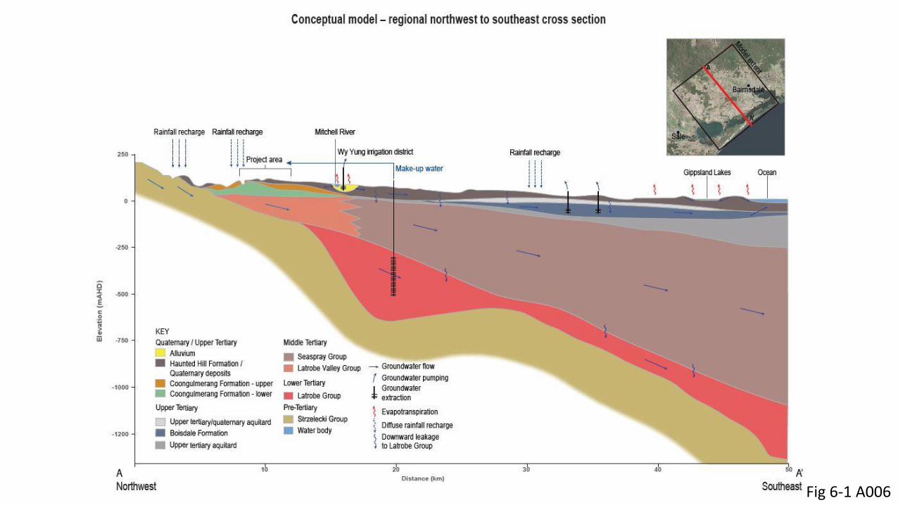
Fig 6-1 A006

Fig 3 A001

Drawdown in the Latrobe Group aquifer• Pumping tests
Price, M., 1985. Introducing groundwater, p. 137
Difference in the shape of the cone of depression depends on aquifer properties (S – storativity, T – transmissivity)

• Data on aquifer properties is provided by pumping tests
• For any aquifer, data can be assembled from pumping tests carried out in different areas and different times
• Groundwater modelling of a particular area should be based, wherever possible, on pumping test data from that area, as aquifer properties are almost always laterally inhomogeneous
• Groundwater modelling for the proposed Fingerboards mine used the result of a pumping test in the area, together with a range of likely values for the properties of this aquifer
• However, there are uncertainties with the interpretation of the pumping test results that affect the modelled drawdown within the Latrobe Group aquifer
Late stage of pumping test for Fingerboards
Project showed increased drawdown
Fig 2.41 A006B

Increased drawdown can be due to a nearby impermeable boundary
Domenico, P.A. and Schwartz, F.W., 1990. Physical and chemical hydrogeology, pp. 178-179.
The distance to the impermeable boundary can be estimated from the
time-drawdown plot
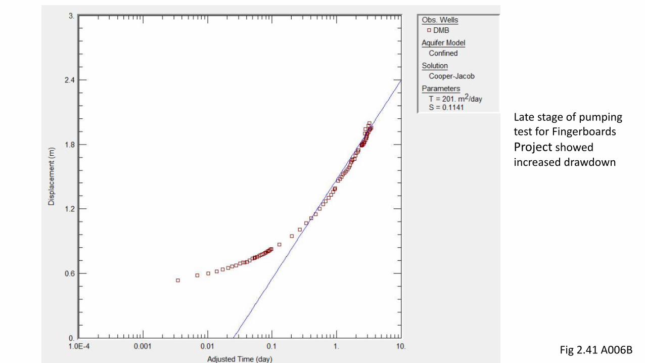
• Could be due to
• Impermeable boundary – possibly nearby basement high
• Lower permeability section within the gravel
• Gravels deposited by river channels often vary in thickness and permeability
• From the time-drawdown plot, the impermeable boundary/lower permeability gravel is ~60 m from the pumping bore – this calculation is approximate
Fig 2.48 A006B

• Late stage drawdown could also be due to interference from nearby pumping bore within the same aquifer (drawdown cones are summed where they intersect to determine overall drawdown)
Fig 3.6 A006B
However, nearest bore in Latrobe
Group to pumping bore is ~4.5 km
away
Pumping bore

Implications for groundwater drawdown in the Latrobe Group aquifer
• The aquifer may be less extensive than initially visualised
• Drawdown around basement highs and/or less permeable areas will be greater than currently modelled
• Already the borefield has been extended from its original location and it is acknowledged that the rate of pumping from the bores may be less than originally envisaged

Georgiou IAC presentation slide 16
Current modelling does not take any of these factors into account – shows symmetrical drawdown around borefield
The planned additional pumping test should provide the necessary data to determine what is causing the late stage drawdown in the previous test.
Depending on the results, there may be significant changes to the modelled drawdown within the Latrobe Group.
Groundwater mounding beneath the pits
• Modelling shows that groundwater mounds will develop beneath the site due to seepage from tailings
• The mounding could be significantly increased by direct rainfall recharge into the pits; this was not modelled
• The groundwater mound is predicted to ‘daylight’ into the pits, i.e. the mound will intersect the base of the pit
• This could affect the stability of the pit walls, and engineering works are required to prevent this happening
• These works include toe drains, sumps, subsurface drains and interception bores
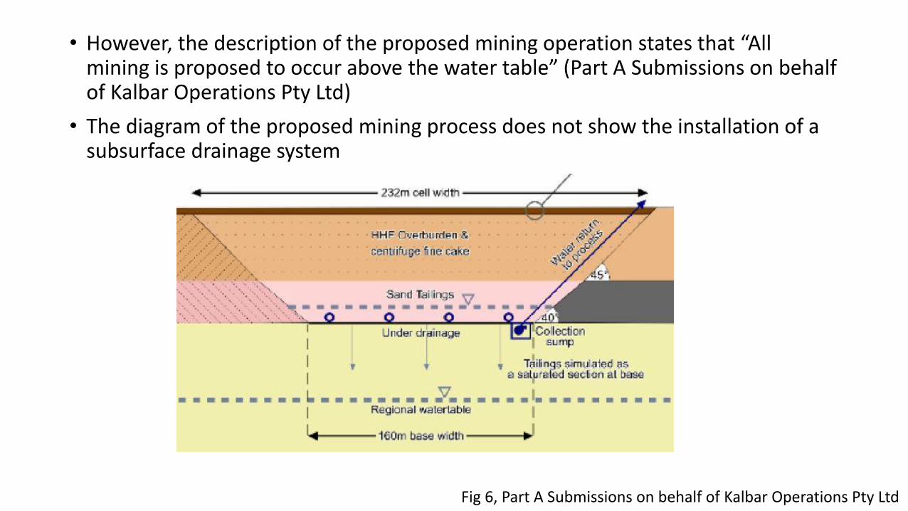
• However, the description of the proposed mining operation states that “All mining is proposed to occur above the water table” (Part A Submissions on behalf of Kalbar Operations Pty Ltd)
• The diagram of the proposed mining process does not show the installation of a subsurface drainage system
Fig 6, Part A Submissions on behalf of Kalbar Operations Pty Ltd
Presence of Acid Sulphate Soils (ASS)
• Acid sulphate soils contain grains of oxidisable sulphide minerals (usually pyrite) that release acidity and sulphate when exposed to the atmosphere
• The acidity can mobilise toxic heavy metals; if released into streams, this can result in fish kills
• Shallow marine sediments frequently contain pyrite; mineral sands deposits that were deposited in a shallow marine environment often contain pyrite and are, in this case, frequently classified as acid sulphate soils

• The mineral sands of the Coongulmerang Formation were deposited in shallow marine conditions and most likely originally contained significant amounts of pyrite.
• Uplift of the area and incision of the Mitchell River has lowered the watertableand most of the pyrite originally present has been oxidised
Fig 6-1 A006
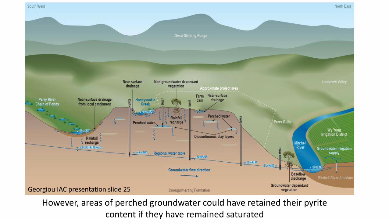
However, areas of perched groundwater could have retained their pyrite content if they have remained saturated
Georgiou IAC presentation slide 25
• Therefore Acid Sulphate Soils may exist at the site. The desktop study found that the presence of ASS at the Fingerboards mine site was unlikely but did not consider the influence of perched water tables.
• Analyses of sulphur found significant levels in a few samples, close to or above the trigger value of 0.03%, which identifies a sample as an Acid Sulphate Soil according to EPA Guidelines, provided the sulphur is present as Cr-reducible sulphur, i.e. as pyrite. No analyses of Cr-reducible sulphur were carried out.
• If water-saturated sediment is encountered at perched water tables during mining, the sediment must be analysed for Cr-reducible sulphur.
• If Cr-reducible sulphur levels in this sediment are >0.03%, the sediment is classified as an Acid Sulphate Soil and will require a management plan to comply with EPA ASS Guidelines, in order to prevent the release of acidity into the environment.
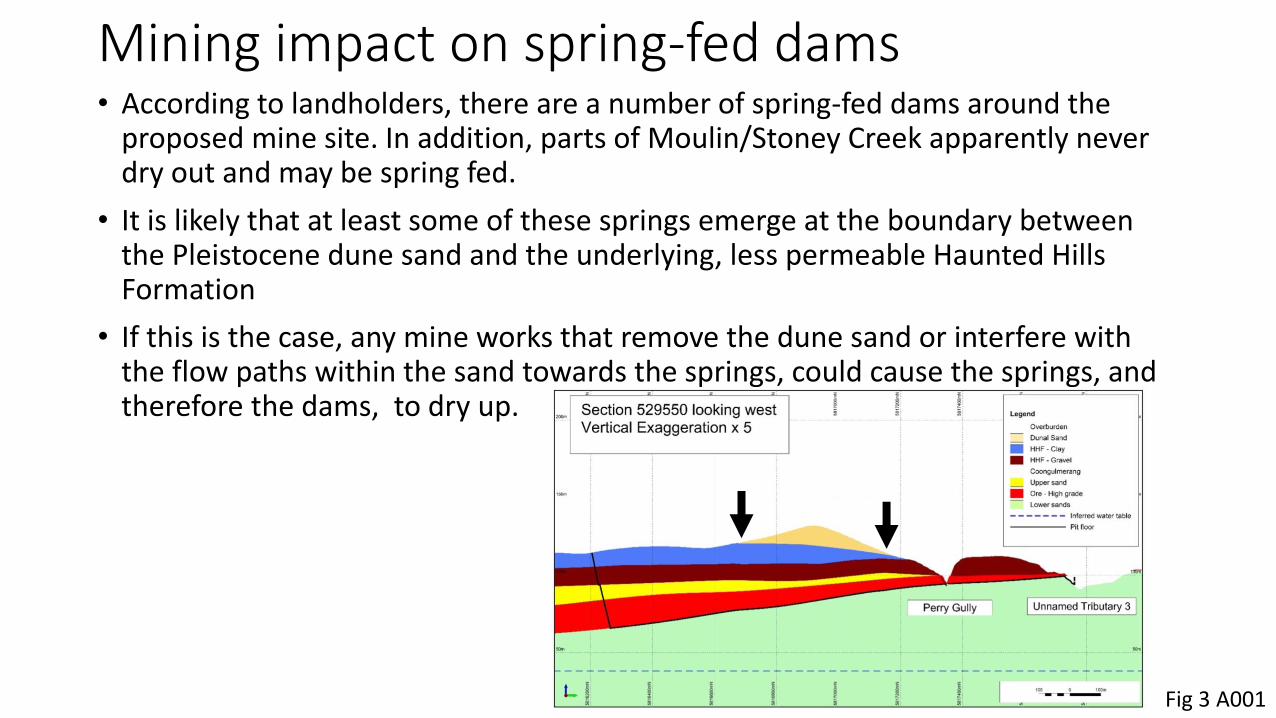
Mining impact on spring-fed dams• According to landholders, there are a number of spring-fed dams around the
proposed mine site. In addition, parts of Moulin/Stoney Creek apparently never dry out and may be spring fed.
• It is likely that at least some of these springs emerge at the boundary between the Pleistocene dune sand and the underlying, less permeable Haunted Hills Formation
• If this is the case, any mine works that remove the dune sand or interfere with the flow paths within the sand towards the springs, could cause the springs, and therefore the dams, to dry up.
Fig 3 A001

Monitoring
• A comprehensive system of monitoring bores needs to be installed to determine the actual groundwater impacts of the mining, and to check how closely these accord with the modelled impacts
• If the actual impacts deviate substantially from the modelled impacts, the modelling will have to be rerun with the new information.
• The monitoring data needs to be publicly available
• If the impacts are greater than expected, mitigation measures may be required, e.g. making good any loss of groundwater resources at third party bores or spring-fed dams

Conclusions
• The planned pumping test should be carried out as soon as possible
• The groundwater model should be updated with the new information from this test
• The mine plan needs to include subsurface drainage beneath the pits
• The possibility of encountering acid sulphate soils needs to be incorporated into the mine plan
• The potential impact of mining on spring-fed dams needs to be determined
• The locations of the monitoring bores need to be made available for consultation
• Mitigation measures for groundwater impacts need to be planned