Embed Size (px)
Citation preview
Inst
ituts
bros
chür
e
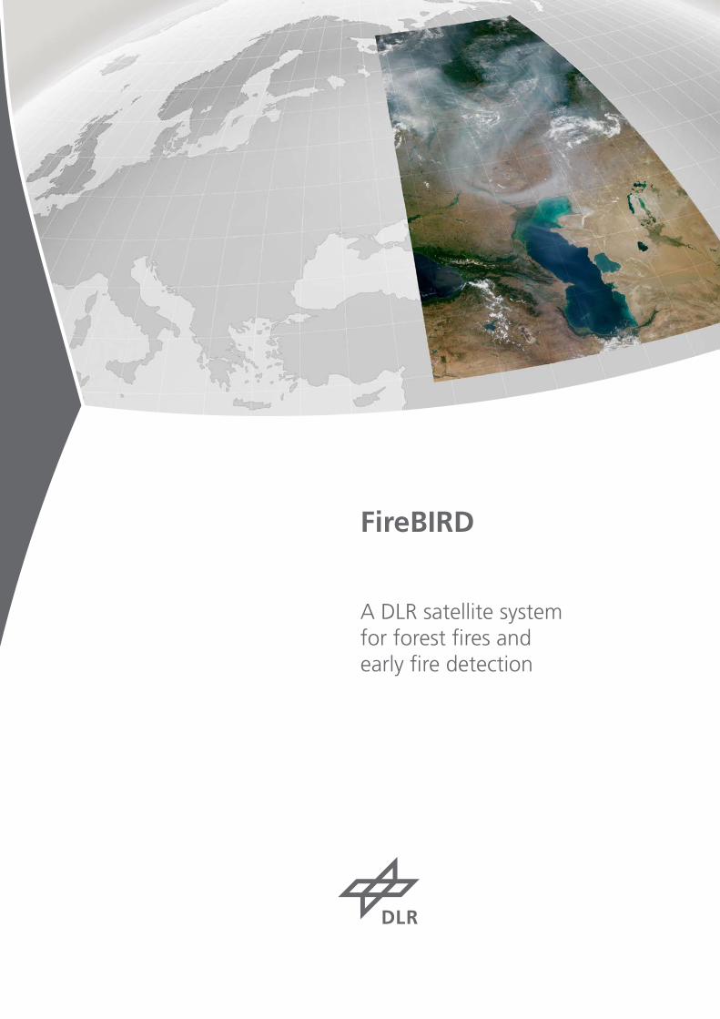
FireBIRD
A DLR satellite system for forest fires and early fire detection
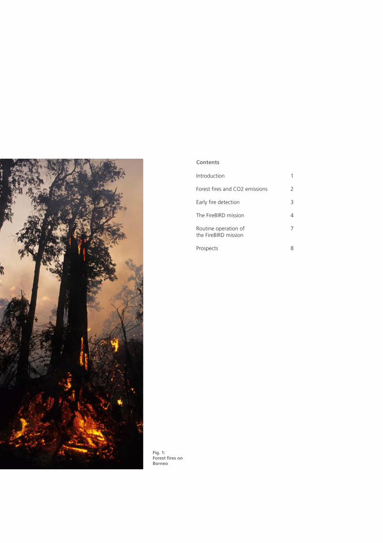
Fig. 1: Forest fires on Borneo
Contents
Introduction 1
Forest fires and CO2 emissions 2
Early fire detection 3
The FireBIRD mission 4
Routine operation of 7 the FireBIRD mission
Prospects 8

The release of greenhouse gases and aerosols from fires has a large influence on global climate: on average, fires are responsible for up to 30% of anthropo-genic CO2 emissions. Currently, however, there are no suitable instruments for more precisely estimating the quantity of emissions and thus their impact on the climate.
In the future, a further increase in the number of fires is expected, a conse-quence of global warming. This not only increases emissions which affect the climate, but also the specifications for early fire detection. As the severe Russian fires of summer 2010 demonstrated, rapid response is required if fires are to be detected as early as possible and quickly combatted in order to keep their negative consequences for people and the environment as low as possible.
The German Aerospace Center (DLR) is contributing to the FireBIRD constellation, which consists of the two satellite missi-ons TET-1 (Technology Test Platform) and BIROS (Berlin Infrared Optical System) and is dedicated to scientific investigation of the issues involved as well as to early fire detection from space. Commer-cial extension of this constellation, for example in cooperation with countries which are seriously plagued by fires, will revolutionize near-real-time fire warning worldwide.
Introduction
Fig. 2: Forest fires in Greece (MODIS)
Fig. 3: Burn scars in Pinheiro Grande, Portugal (IKONOS)
1
6,4±0,4
1,6±1,1
2,2±0,4
2,6±1,7
3,2±0,1
Fires arising from natural causes play an important role in many ecosystems. However, only about 10% of fires have natural causes (such as lightning strikes). Most fires are caused by people.
Deliberate burning of carbon-rich ecosys-tems is especially problematic. If tropical rain forests or drained swamps are clea-red by fire in order to convert the land for agriculture, the carbon bound up in the vegetation and peat is released and ac-cumulates in the atmosphere in the form of carbon dioxide and carbon monoxide. Although the regrowth of vegetation on this land again binds carbon, it does so to a far lower extent than did the original ecosystem.
According to the United Nations Food and Agriculture Organization (FAO), 7.3 million hectares of forest are destroyed annually worldwide, in most cases by
Forest Fires and CO2 Emissions
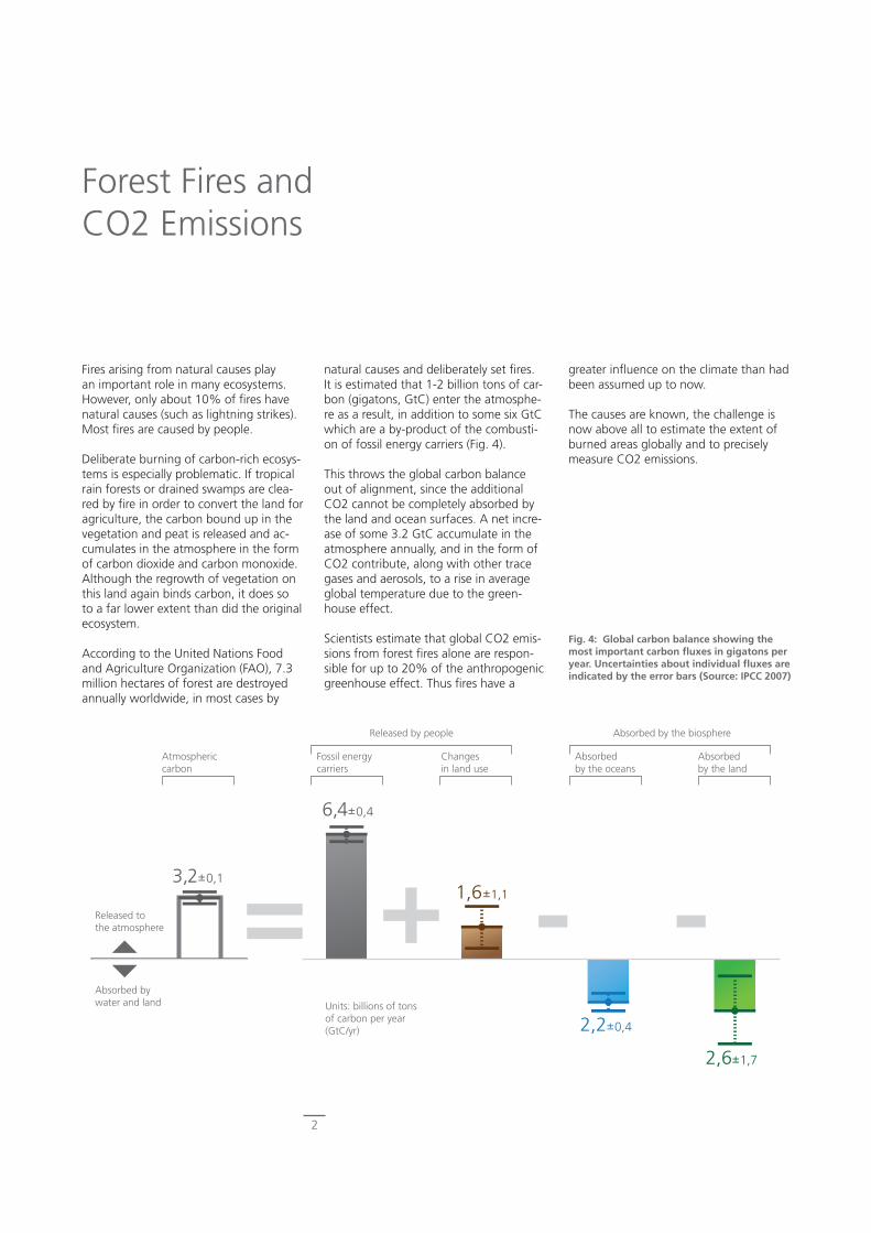
Fig. 4: Global carbon balance showing the most important carbon fluxes in gigatons per year. Uncertainties about individual fluxes are indicated by the error bars (Source: IPCC 2007)
natural causes and deliberately set fires. It is estimated that 1-2 billion tons of car-bon (gigatons, GtC) enter the atmosphe-re as a result, in addition to some six GtC which are a by-product of the combusti-on of fossil energy carriers (Fig. 4). This throws the global carbon balance out of alignment, since the additional CO2 cannot be completely absorbed by the land and ocean surfaces. A net incre-ase of some 3.2 GtC accumulate in the atmosphere annually, and in the form of CO2 contribute, along with other trace gases and aerosols, to a rise in average global temperature due to the green-house effect. Scientists estimate that global CO2 emis-sions from forest fires alone are respon-sible for up to 20% of the anthropogenic greenhouse effect. Thus fires have a
greater influence on the climate than had been assumed up to now.
The causes are known, the challenge is now above all to estimate the extent of burned areas globally and to precisely measure CO2 emissions.
Atmospheric carbon
Fossil energy carriers
Changes in land use
Absorbed by the oceans
Absorbed by the land
Absorbed by the biosphereReleased by people
Released to the atmosphere
Absorbed by water and land Units: billions of tons
of carbon per year (GtC/yr)
2
Early Fire Detection
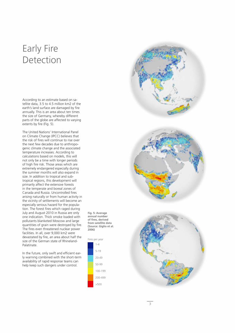
Fig. 5: Average annual number of fires, derived from satellite data (Source: Giglio et al. 2006)
According to an estimate based on sa-tellite data, 3.5 to 4.5 million km2 of the earth’s land surface are damaged by fire annually. This is an area about ten times the size of Germany, whereby different parts of the globe are affected to varying extents by fire (Fig. 5).
The United Nations’ International Panel on Climate Change (IPCC) believes that the risk of fires will continue to rise over the next few decades due to anthropo-genic climate change and the associated temperature increases. According to calculations based on models, this will not only be a time with longer periods of high fire risk. Those areas which are extremely endangered especially during the summer months will also expand in size. In addition to tropical and sub-tropical regions, this development will primarily affect the extensive forests in the temperate and boreal zones of Canada and Russia. Uncontrolled fires arising naturally or from human activity in the vicinity of settlements will become an especially serious hazard for the popula-tion. The forest fires which raged during July and August 2010 in Russia are only one indication. Thick smoke loaded with pollutants blanketed Moscow and large quantities of grain were destroyed by fire. The fires even threatened nuclear power facilities. In all, over 9,000 km2 were devastated by fire, an area about half the size of the German state of Rhineland-Palatinate.
In the future, only swift and efficient ear-ly warning combined with the short-term availability of rapid response teams can help keep such dangers under control.
1-4
5-19
20-49
50-99
100-199
200-499
>500
Fires per year
3
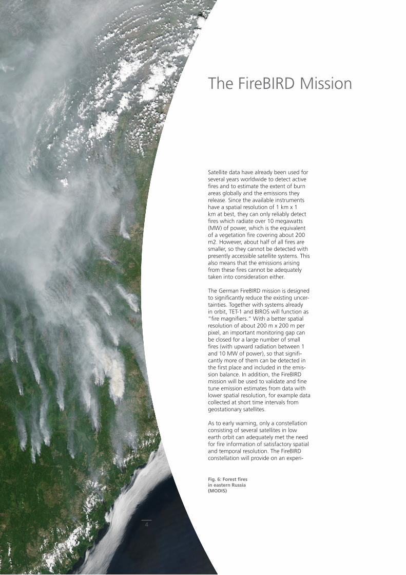
Fig. 6: Forest fires in eastern Russia (MODIS)
Satellite data have already been used for several years worldwide to detect active fires and to estimate the extent of burn areas globally and the emissions they release. Since the available instruments have a spatial resolution of 1 km x 1 km at best, they can only reliably detect fires which radiate over 10 megawatts (MW) of power, which is the equivalent of a vegetation fire covering about 200 m2. However, about half of all fires are smaller, so they cannot be detected with presently accessible satellite systems. This also means that the emissions arising from these fires cannot be adequately taken into consideration either.
The German FireBIRD mission is designed to significantly reduce the existing uncer-tainties. Together with systems already in orbit, TET-1 and BIROS will function as “fire magnifiers.” With a better spatial resolution of about 200 m x 200 m per pixel, an important monitoring gap can be closed for a large number of small fires (with upward radiation between 1 and 10 MW of power), so that signifi-cantly more of them can be detected in the first place and included in the emis-sion balance. In addition, the FireBIRD mission will be used to validate and fine tune emission estimates from data with lower spatial resolution, for example data collected at short time intervals from geostationary satellites.
As to early warning, only a constellation consisting of several satellites in low earth orbit can adequately met the need for fire information of satisfactory spatial and temporal resolution. The FireBIRD constellation will provide on an experi-
The FireBIRD Mission
4

Fig. 8: Overview of the BIROS mission
Mission Satellite Sensor
Orbit 560 Kilometer, sonnensynchron
Dimensions 83 x 54 x 62 centimeters infrared sensor(two channels)
mid infrared — 3,4 - 4,2 μm thermal infrared — 8,5 - 9,3 μm Inclination 97,6° Total mass ca. 130 kilograms
Mission operations
German Remote Sensing Data Center, German Space Opera-tions Center
Payload mass infrared sensor
ca. 14 kilograms optical sensor(three channels)
visible range - green — 0.5 μm visible range - red — 0.6 μmnear infrared range— 0.8 μm
Mission planning < 1,5 years Power 200 watt DC
Mission duration > 2,5 years Communications S-band, UHF
Fig. 7: The sensor array for TET-1 and BIROS
mental basis, so to speak as a precursor satellite mission for early fire detection, fire information with good spatial resolution at a maximal time delay of two hours for the coverage area. Toward this end, specific fire parameters will be determined already on board the satellite based on the recorded data. Local res-ponse teams can be directly informed via mobile telephones about the location of actively burning or incipient fires.
Both satellites, TET-1 and BIROS, are based on the technological experience gained by DLR during the BIRD mission of 2001 to 2004. BIRD was developed at the Optical Information Systems
department of the Institute of Robotics and Mechatronics in Berlin and delivers impressive images of both large and small fires worldwide. The smallest fire detected by BIRD had an area of 4 m2.
As in the case of BIRD, the heart of the TET-1 and BIROS payloads is a bispectral infrared sensor (Fig. 7) which records signals in the mid-infrared and thermal spectral ranges (3.4 – 4.2 μm and 8.5 – 9.3 μm). Another camera records the visible and near-infrared ranges in three channels.
5

Fig. 9: Major fire in the San Bernardino Mountains of Cali-fornia (Source: ISS)
Fig. 10: Detection of bushfire fire fronts near Sydney, Australia
MODIS – mid-infrared (MIR) spatial resolution 1 km x 1 km per pixel
BIRD - mid-infrared (MIR) spatial resolution 200 m x 200 m per pixel
0 K 650 K 1000 K
Detection of active fires
For improved spatial and temporal coverage, the two satellites will circle the earth at an altitude of about 570 km in solar-synchronous orbits with varying local equator crossing times. TET-1 is scheduled for launch in 2011, BIROS in 2013. TET-1 is a technology-testing platform financed by the DLR Space Management division and carries other payloads as well. BIROS is a minisatellite financed primarily by the German Ministry of Education and Research (BMBF).
6
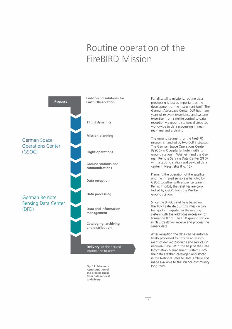
For all satellite missions, routine data processing is just as important as the development of the instrument itself. The German Aerospace Center DLR has many years of relevant experience and systems expertise, from satellite control to data reception via ground stations distributed worldwide to data processing in near-real-time and archiving.
The ground segment for the FireBIRD mission is handled by two DLR institutes: The German Space Operations Center (GSOC) in Oberpfaffenhofen with its ground station in Weilheim and the Ger-man Remote Sensing Data Center (DFD) with a ground station and payload data center in Neustrelitz (Fig. 13).
Planning the operation of the satellite and the infrared sensors is handled by GSOC together with a science team in Berlin. In orbit, the satellites are con-trolled by GSOC from the Weilheim ground station.
Since the BIROS satellite is based on the TET-1 satellite bus, this mission can be rapidly integrated in the existing system with the additions necessary for formation flight. The DFD ground station in Neustrelitz will receive and process the sensor data.
After reception the data can be automa-tically processed to provide an assort-ment of derived products and services in near-real-time. With the help of the Data Information Management System DIMS the data are then cataloged and stored in the National Satellite Data Archive and made available to the science community long-term.
Routine operation of the FireBIRD Mission
Fig. 11: Schematic representation of the process chain from data request to delivery
Data reception
Data processing
Data and information management
Cataloging, archiving and distribution
Delivery of the derived information to users
Request
Flight dynamics
Mission planning
Flight operations
Ground stations and communications
German Space Operations Center (GSOC)
German Remote Sensing Data Center (DFD)
End-to-end solutions for Earth Observation
7
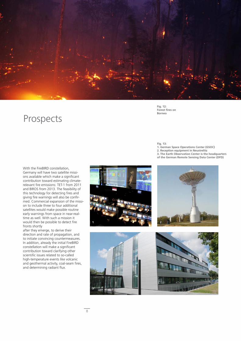
Fig. 12: Forest fires on Borneo
Fig. 13: 1. German Space Operations Center (GSOC) 2. Reception equipment in Neustrelitz 3. The Earth Observation Center is the headquarters of the German Remote Sensing Data Center (DFD)
1
3
2
With the FireBIRD constellation, Germany will have two satellite missi-ons available which make a significant contribution toward estimating climate-relevant fire emissions: TET-1 from 2011 and BIROS from 2013. The feasibility of this technology for detecting fires and giving fire warnings will also be confir-med. Commercial expansion of the missi-on to include three to four additional satellites would make possible routine early warnings from space in near-real-time as well. With such a mission it would then be possible to detect fire fronts shortly after they emerge, to derive their direction and rate of propagation, and to initiate convincing countermeasures. In addition, already the initial FireBIRD constellation will make a significant contribution toward clarifying other scientific issues related to so-called high-temperature events like volcanic and geothermal activity, coal-seam fires, and determining radiant flux.
Prospects
8

Quellennachweis: Bowman, D., Balch, J., Artaxo, P., Bond, W., Carlson, J., Cochrane, M., D’Antonio, C., DeFries, R., Doyle, J., Harrison, S., Johnston, F., Keeley, J., Krawchuk, M., Kull, C., Marston, J., Moritz, M., Prentice, I., Roos, C., Scott, A., Swetnam, T., van der Werf, G. & S. Pyne (2009): Fire in the Earth System. – In: Science 324, 481, DOI: 0.1126/science.1163886 FAO (2009): The State of the World’s Forests. Rome (also available at http://www.fao.org/docrep/011/i0350e/i0350e00.htm). Giglio, L., I. Csiszar & C. O. Justice (2006): Global distribution and seasonality of active fires as observed with the Terra and Aqua Moderate Resolution Imaging Spectroradiometer (MODIS) sensors. – In: Journal of Geophysical Research, 111, G02016, doi:10.1029/2005JG000142. Halle, W. (2010): BIROS Exposé (Berlin InfraRed Optical System), DLR, Berlin. IPCC (2007): Climate Change 2007: Synthesis Report. Contribution of Working Groups I, II and III to the Fourth Assessment Report of the Intergovernmental Panel on Climate Change. – In: Core Writing Team, Pachauri, R.K. and Reisinger, A. (Eds.), IPCC, Geneva, Switzerland. Oertel, D. (2005): ECOFIRE – Study on Scientific Assessment of Space-borne High Temperature Event Observing Mission Concepts, Final Report, (ESA/ESTEC Contract 17690/30/NL/FF) DLR, Berlin. Rücker, G., Hoffmann, A. & C. Mott (2005): Fire Recognition Satellite Sys-tem (FIRES) Market Study, FIRES Qualitative Market Analysis, Final Report, ZEBRIS GIS and Consulting GbR. Tansey, K., Grégoire, J. M., Defourny, P., Leigh, R., Pekel, J. F. O., van Bogaert, E. & E. Bartholomé (2008): A new, global, multi-annual (2000–2007) burnt area product at 1 km resolution. – In: Geophys. Res. Lett., 35, L01401, doi:10.1029/2007GL031567. Zhukov, B., Briess, K., Lorenz, E., Oertel, D. & W. Skrbek (2005): Detection and analysis of high-temperature events in the BIRD mission. – In: Acta Astronautica, 56 (1-2), S. 65-71. DOI: 10.1016/j.actaastro.2004.09.014.
Photo Credits:
Cover image: Rendering DLR-DFD-WV, NASA, MODIS Aqua 2010/217Fig.1: Photo by Prof. Florian Siegert, RSS GmbHFig.2: Processing DLR-DFD-WV, NASA, MODIS Aqua 2007/238Fig.3: European Space Imaging, IKONOS, 2003Fig.4: Graphic DLR-DFD-WV, nach: IPCC 2007Fig.5: Rendering DLR-DFD-WV, nach: Giglio et al. 2006Fig.6: Processing DLR-DFD-WV, NASA, MODIS Aqua 2008/200Fig.7: DLR BIROS ExposéFig.8: Photo DLRFig.9: Montage DLR-DFD-WV, NASA/JSC, ISS Digital Camera, ISS007-E-18087, ISS007-E-18088Fig.10: DLRFig.11: Graphic DLR-DFD-WVFig.12: Photo by Prof. Florian Siegert, RSS GmbHFig.13: 1. Photo DLR-GSOC, 2. Photo DLR-DFD, 3. Photo DLR-DFD-WV
Participating DLR Units and Contacts:
Satellite and Sensor Development
Institute of Robotics and MechatronicsOptical Information Systems DepartmentBerlin-AdlershofContact: Dr.-Ing. Andreas EckardtTelephone: +49 30 67055-539Telefax: +49 30 67055-532
Ground Segment:Space Operations and Astronaut Training Oberpfaffenhofen-WesslingContact: Dr. Martin WicklerTelephone: +49 8153 28-1276Telefax: +49 8153 28-1451
German Remote Sensing Data CenterNeustrelitzContact: Holger MaassTelephone: +49 3981 480-111Telefax: +49 3981 480-299
Applications: German Remote Sensing Data CenterOberpfaffenhofen-WesslingContact: Dr. Tanja KrausTelephone: +49 8153 28-1398Telefax: +49 8153 28-3444
Publisher
German Aerospace Center (DLR) e.V.
Science EditorDr. Tanja Kraus German Remote Sensing Data CenterWith contributions from colleagues at the DLR institu-tes: Robotics and Mechatronics, Atmospheric Physics,German Remote Sensing Data Center
LayoutGerman Remote Sensing Data Center Science Communication and Visualization Unit
PrinterDruckerei Thierbach KG, Mülheim/Ruhr
Copies (also partial) as well as other useonly with prior DLR permission
www.DLR.de
Imprint
Deutsches FernerkundungsdatenzentrumOberpfaffenhofen
www.DLR.de
DLR at a GlanceDLR is Germany’s national aeronautics and space research center. Its extensive research and development activities in the fields of aeronautics, space, energy, transportation and security are integra-ted in national and international cooperative ventures. In addition to this research, as Germany’s space agency the federal govern-ment has given DLR the responsibility to plan and implement the German space program. DLR is also the umbrella organization for Germany’s largest project management agencies.
Approximately 6,500 people are employed at DLR’s 13 locations, which include Köln (headquarters), Berlin, Bonn, Braunschweig, Bremen, Göttingen, Hamburg, Lampoldshausen, Neustrelitz, Oberpfaffenhofen, Stuttgart, Trauen and Weilheim. DLR also ope-rates offices in Brussels, Paris and Washington, D.C.
The DLR mission includes studying the earth and solar system and conducting research on preserving the environment and develo-ping environmentally responsible technologies, increasing mobility, communications and security. The DLR research portfolio extends from basic research to innovative applications and pioneering products. The scientific and technical expertise gained at DLR contributes to strengthening Germany’s industrial and technologi-cal position. DLR operates major research facilities both for its own projects and as a service for customers and partners. DLR also fosters the upcoming generation of scientists, provides competent advice to the political sector, and is a driving force in the regions where it has branches.
Fire
BIRD
-001
-DLR
-DE