Embed Size (px)
Citation preview
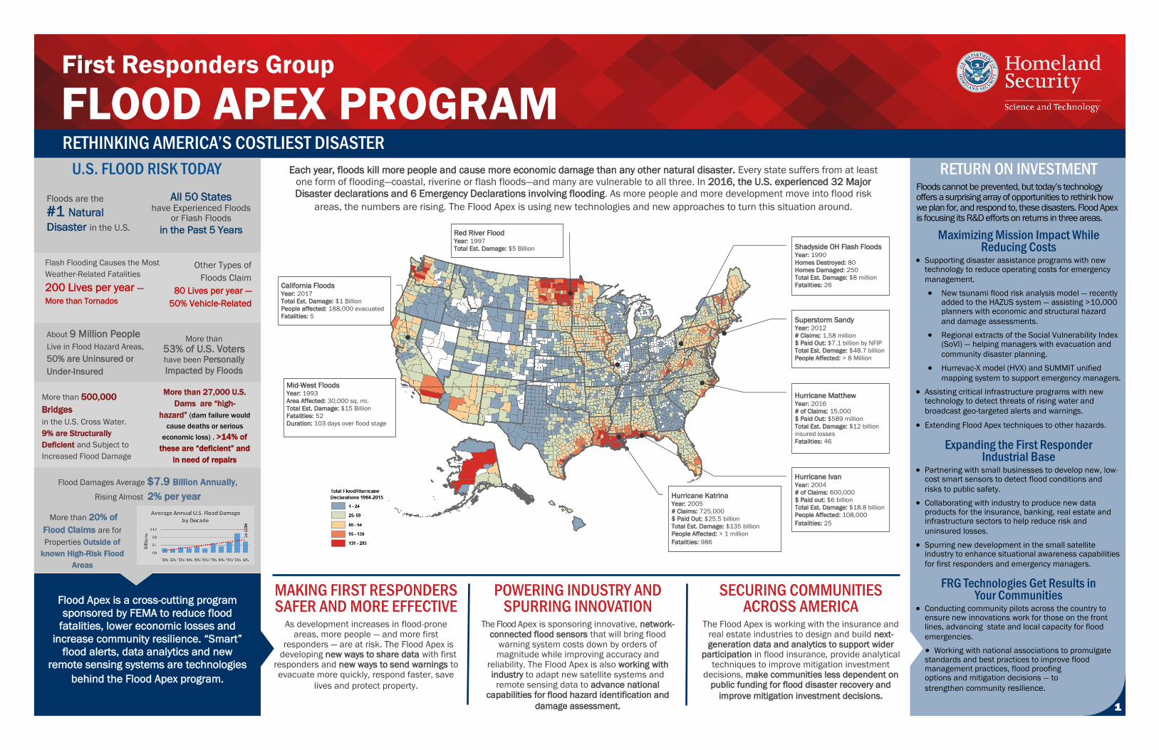
RETURN ON INVESTMENT Floods cannot be prevented, but today’s technology offers a surprising array of opportunities to rethink how we plan for, and respond to, these disasters. Flood Apex is focusing its R&D efforts on returns in three areas.
Maximizing Mission Impact While Reducing Costs
Supporting disaster assistance programs with newtechnology to reduce operating costs for emergency
management.
New tsunami flood risk analysis model — recentlyadded to the HAZUS system — assisting >10,000planners with economic and structural hazard
and damage assessments.
Regional extracts of the Social Vulnerability Index(SoVI) — helping managers with evacuation and
community disaster planning.
Hurrevac-X model (HVX) and SUMMIT unified
mapping system to support emergency managers.
Assisting critical infrastructure programs with newtechnology to detect threats of rising water and
broadcast geo-targeted alerts and warnings.
Extending Flood Apex techniques to other hazards.
Expanding the First Responder Industrial Base
Partnering with small businesses to develop new, low-cost smart sensors to detect flood conditions and
risks to public safety.
Collaborating with industry to produce new dataproducts for the insurance, banking, real estate andinfrastructure sectors to help reduce risk and
uninsured losses.
Spurring new development in the small satelliteindustry to enhance situational awareness capabilities
for first responders and emergency managers.
FRG Technologies Get Results in Your Communities
Conducting community pilots across the country toensure new innovations work for those on the frontlines, advancing state and local capacity for flood
emergencies.
Working with national associations to promulgatestandards and best practices to improve floodmanagement practices, flood proofingoptions and mitigation decisions — to
strengthen community resilience.
RETHINKING AMERICA’S COSTLIEST DISASTER
Each year, floods kill more people and cause more economic damage than any other natural disaster. Every state suffers from at least
one form of flooding—coastal, riverine or flash floods—and many are vulnerable to all three. In 2016, the U.S. experienced 32 Major
Disaster declarations and 6 Emergency Declarations involving flooding. As more people and more development move into flood risk
areas, the numbers are rising. The Flood Apex is using new technologies and new approaches to turn this situation around.
Flood Apex is a cross-cutting program
sponsored by FEMA to reduce flood
fatalities, lower economic losses and
increase community resilience. “Smart”
flood alerts, data analytics and new
remote sensing systems are technologies
behind the Flood Apex program.
SECURING COMMUNITIES ACROSS AMERICA
The Flood Apex is working with the insurance and real estate industries to design and build next-generation data and analytics to support wider
participation in flood insurance, provide analytical techniques to improve mitigation investment
decisions, make communities less dependent on public funding for flood disaster recovery and
improve mitigation investment decisions.
POWERING INDUSTRY AND SPURRING INNOVATION
The Flood Apex is sponsoring innovative, network-connected flood sensors that will bring flood
warning system costs down by orders of magnitude while improving accuracy and
reliability. The Flood Apex is also working with industry to adapt new satellite systems and
remote sensing data to advance national capabilities for flood hazard identification and
damage assessment.
MAKING FIRST RESPONDERS SAFER AND MORE EFFECTIVE
As development increases in flood-prone areas, more people — and more first
responders — are at risk. The Flood Apex is developing new ways to share data with first
responders and new ways to send warnings to evacuate more quickly, respond faster, save
lives and protect property.
Superstorm Sandy
Year: 2012
# Claims: 1.58 million
$ Paid Out: $7.1 billion by NFIP
Total Est. Damage: $48.7 billion
People Affected: > 8 Million
Hurricane Ivan
Year: 2004
# of Claims: 600,000
$ Paid out: $6 billion
Total Est. Damage: $18.8 billion
People Affected: 108,000
Fatalities: 25
Hurricane Katrina
Year: 2005
# Claims: 725,000
$ Paid Out: $25.5 billion
Total Est. Damage: $135 billion
People Affected: > 1 million
Fatalities: 986
Red River Flood Year: 1997
Total Est. Damage: $5 Billion
Hurricane Matthew
Year: 2016
# of Claims: 15,000
$ Paid Out: $589 million
Total Est. Damage: $12 billion
insured losses
Fatalities: 46
U.S. FLOOD RISK TODAY
Other Types of
Floods Claim
80 Lives per year —
50% Vehicle-Related
Flash Flooding Causes the Most
Weather-Related Fatalities
200 Lives per year —
More than Tornados
About 9 Million People
Live in Flood Hazard Areas,
50% are Uninsured or
Under-Insured
Mid-West Floods Year: 1993
Area Affected: 30,000 sq. mi.
Total Est. Damage: $15 Billion
Fatalities: 52
Duration: 103 days over flood stage
California Floods Year: 2017
Total Est. Damage: $1 Billion
People affected: 188,000 evacuated
Fatalities: 5
Flood Damages Average $7.9 Billion Annually,
Rising Almost 2% per year
Floods are the
#1 Natural
Disaster in the U.S.
Shadyside OH Flash Floods Year: 1990
Homes Destroyed: 80
Homes Damaged: 250
Total Est. Damage: $8 million
Fatalities: 26
More than 27,000 U.S.
Dams are “high-
hazard” (dam failure would
cause deaths or serious
economic loss) . >14% of
these are “deficient” and
in need of repairs
All 50 States have Experienced Floods
or Flash Floods
in the Past 5 Years
More than 500,000
Bridges
in the U.S. Cross Water.
9% are Structurally
Deficient and Subject to
Increased Flood Damage
More than 20% of
Flood Claims are for
Properties Outside of
known High-Risk Flood
Areas
More than
53% of U.S. Voters have been Personally
Impacted by Floods
1 1
First Responders Group
FLOOD APEX PROGRAM
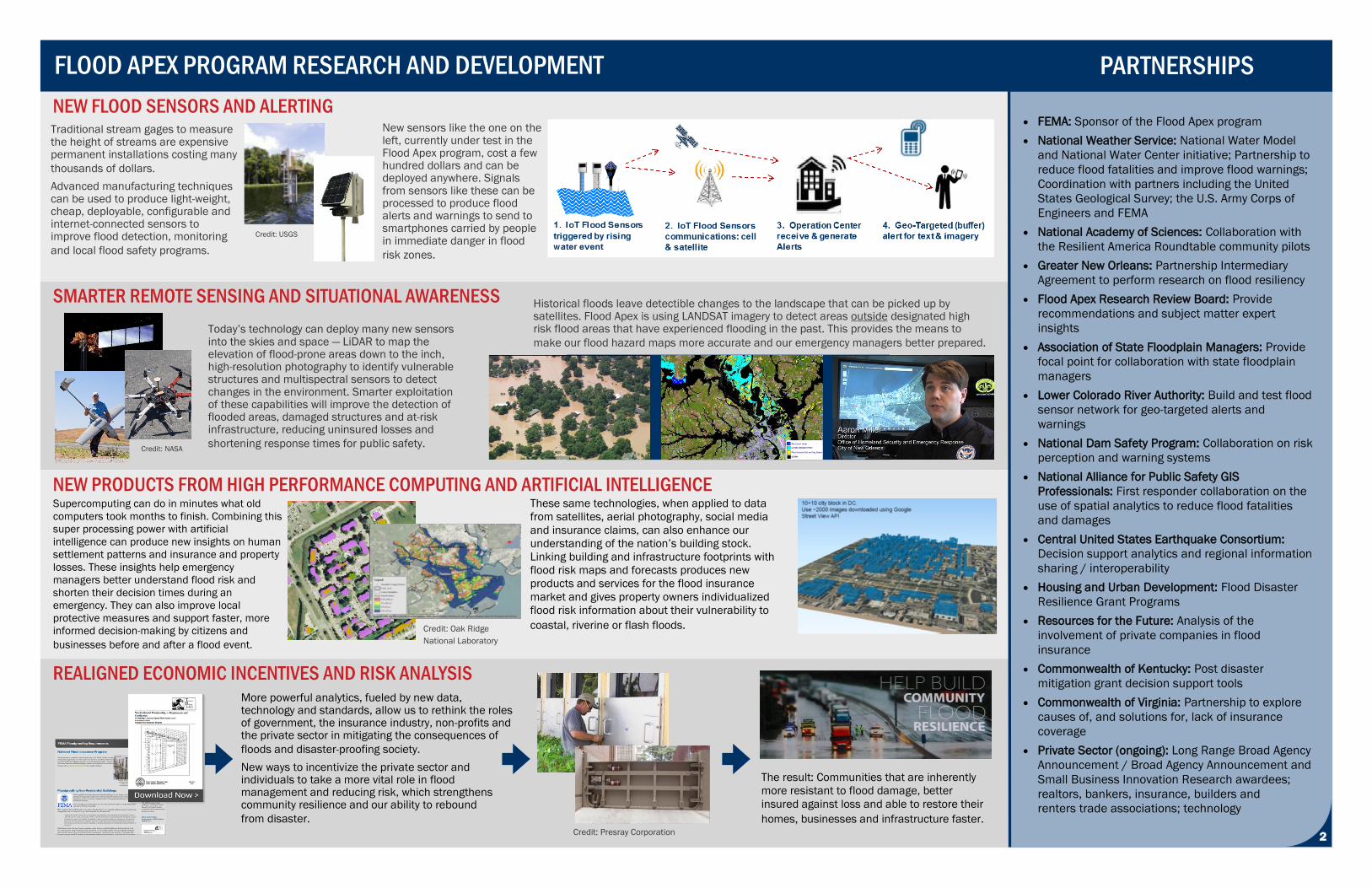
FEMA: Sponsor of the Flood Apex program
National Weather Service: National Water Model
and National Water Center initiative; Partnership to
reduce flood fatalities and improve flood warnings;
Coordination with partners including the United
States Geological Survey; the U.S. Army Corps of
Engineers and FEMA
National Academy of Sciences: Collaboration with
the Resilient America Roundtable community pilots
Greater New Orleans: Partnership Intermediary
Agreement to perform research on flood resiliency
Flood Apex Research Review Board: Provide
recommendations and subject matter expert
insights
Association of State Floodplain Managers: Provide
focal point for collaboration with state floodplain
managers
Lower Colorado River Authority: Build and test flood
sensor network for geo-targeted alerts and
warnings
National Dam Safety Program: Collaboration on risk
perception and warning systems
National Alliance for Public Safety GIS
Professionals: First responder collaboration on the
use of spatial analytics to reduce flood fatalities
and damages
Central United States Earthquake Consortium:
Decision support analytics and regional information
sharing / interoperability
Housing and Urban Development: Flood Disaster
Resilience Grant Programs
Resources for the Future: Analysis of the
involvement of private companies in flood
insurance
Commonwealth of Kentucky: Post disaster
mitigation grant decision support tools
Commonwealth of Virginia: Partnership to explore
causes of, and solutions for, lack of insurance
coverage
Private Sector (ongoing): Long Range Broad Agency
Announcement / Broad Agency Announcement and
Small Business Innovation Research awardees;
realtors, bankers, insurance, builders and
renters trade associations; technology
NEW FLOOD SENSORS AND ALERTING
Historical floods leave detectible changes to the landscape that can be picked up by sat-ellites. Flood Apex is using LANDSAT imagery to detect areas outside designated high risk flood areas that have experienced flooding the past. This provides the means to make our
flood hazard maps more accurate and our emergency managers better prepared.
SMARTER REMOTE SENSING AND SITUATIONAL AWARENESS
NEW PRODUCTS FROM HIGH PERFORMANCE COMPUTING AND ARTIFICIAL INTELLIGENCE
REALIGNED ECONOMIC INCENTIVES AND RISK ANALYSIS
Traditional stream gages to measure the height of streams are expensive permanent installations costing many
thousands of dollars.
Advanced manufacturing techniques can be used to produce light-weight, cheap, deployable, configurable and internet-connected sensors to improve flood detection, monitoring
and local flood safety programs.
Supercomputing can do in minutes what old
computers took months to finish. Combining this
super processing power with artificial
intelligence can produce new insights on human
settlement patterns and insurance and property
losses. These insights help emergency
managers better understand flood risk and
shorten their decision times during an
emergency. They can also improve local
protective measures and support faster, more
informed decision-making by citizens and
businesses before and after a flood event.
New sensors like the one on the left, currently under test in the Flood Apex program, cost a few hundred dollars and can be deployed anywhere. Signals from sensors like these can be processed to produce flood alerts and warnings to send to smartphones carried by people in immediate danger in flood
risk zones.
FLOOD APEX PROGRAM RESEARCH AND DEVELOPMENT
Today’s technology can deploy many new sensors into the skies and space — LiDAR to map the elevation of flood-prone areas down to the inch, high-resolution photography to identify vulnerable structures and multispectral sensors to detect changes in the environment. Smarter exploitation of these capabilities will improve the detection of flooded areas, damaged structures and at-risk infrastructure, reducing uninsured losses and
shortening response times for public safety.
These same technologies, when applied to data
from satellites, aerial photography, social media
and insurance claims, can also enhance our
understanding of the nation’s building stock.
Linking building and infrastructure footprints with
flood risk maps and forecasts produces new
products and services for the flood insurance
market and gives property owners individualized
flood risk information about their vulnerability to
coastal, riverine or flash floods.
Credit: USGS
Credit: NASA
Credit: Oak Ridge
National Laboratory
PARTNERSHIPS
1 2
More powerful analytics, fueled by new data, technology and standards, allow us to rethink the roles of government, the insurance industry, non-profits and the private sector in mitigating the consequences of
floods and disaster-proofing society.
New ways to incentivize the private sector and individuals to take a more vital role in flood management and reducing risk, which strengthens community resilience and our ability to rebound
from disaster. Credit: Presray Corporation
The result: Communities that are inherently
more resistant to flood damage, better
insured against loss and able to restore their
homes, businesses and infrastructure faster.
Historical floods leave detectible changes to the landscape that can be picked up by satellites. Flood Apex is using LANDSAT imagery to detect areas outside designated high risk flood areas that have experienced flooding in the past. This provides the means to
make our flood hazard maps more accurate and our emergency managers better prepared.