Embed Size (px)
DESCRIPTION
The publication documents the steps undertaken by the Bossaso Municipality in collaboration with UN-HABITAT towards a sustainable urban management. A strategic development plan for the city is indicated, and projects implemented are illustrated.
Citation preview
1
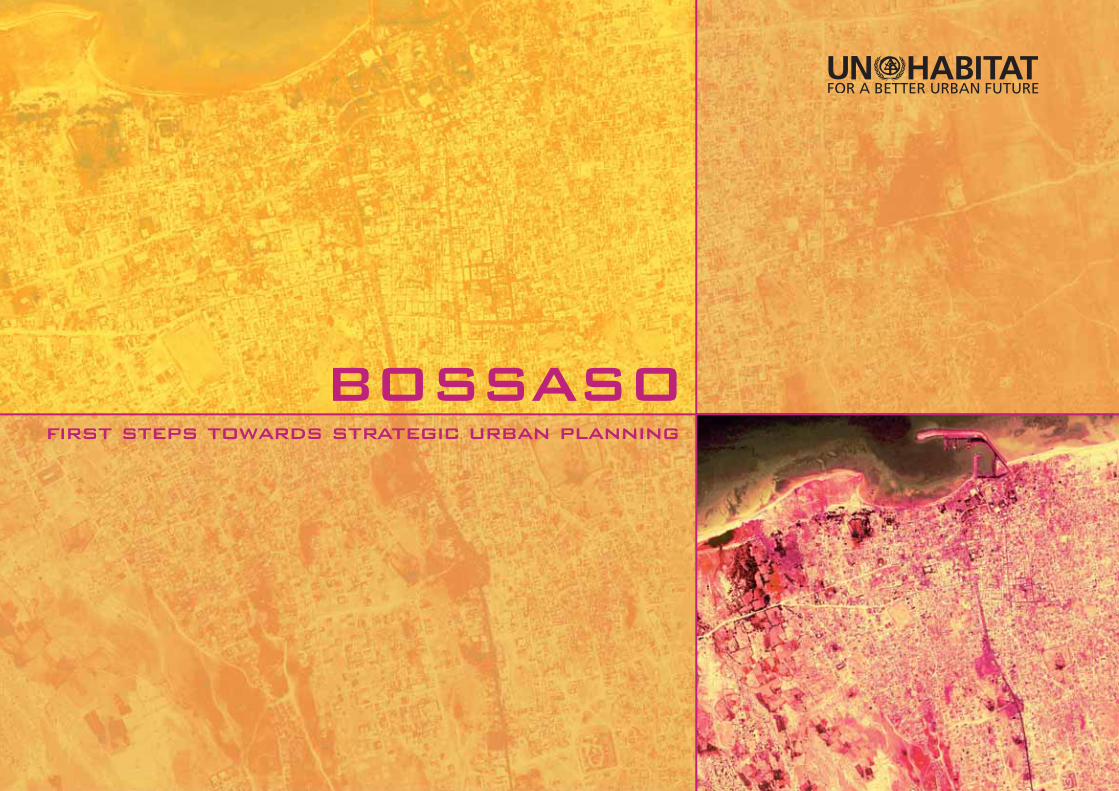
BOSSASOfirst steps towards strategic urban planning

2
United Nations Human Settlements Programme (UN-HABITAT), February 2009.PO Box 30030, GPO 00100, Nairobi, KenyaFax: +(254 20) 762 3120 (Central Offi ce) www.unhabitat.org
All pictures © UN-HABITAT Somalia offi ce.The Bossaso Satellite image is provided by DigitalGlobe © 2006 DigitalGlobe. ALL RIGHTS RESERVED.Excerpts from this publication, except the satellite image, may be reproduced without authorization, on condition that the source is indicated.
HS/1139/09E ISBN: 978-92-1-132105-0
DISCLAIMER
The designations employed and the presentation of material in this publication do not imply the expression of any opinion whatsoever on the part of the Secretariat of the United Nations concerning the legal status of any country, territory, city or area, or of its authorities, or concerning the delimitation of its frontiers or boundaries, or regarding its economic system or degree of development. Views expressed in this publication do not necessarily refl ect those of the United Nations Human Settlements Programme or the United Nations and its member states.
ACKNOWLEDGEMENTS
Author: Ombretta Tempra Design and layout: Ombretta TempraGraphics: Ombretta Tempra, Joana Cameira, and Alban LazeEditor: Edward Miller
Printing: UNON, Publishing Services Section, Nairobi, ISO 14001:2004-certifi ed

3
BOSSASO first steps towards strategic urban planning
4
INTRODUCTION
The city of Bossaso has been undertaking, in collaboration with UN-HABITAT, a series of steps towards effective and integrated urban development:
a city consultation built a common vision for the desired future of the city and identifi ed priority needs and related areas for strategic intervention.
an urban spatial analysis – an indispensable tool for strategic planning – gave a basic spatial understanding of the city, highlighting challenges and priority interventions from a spatial perspective.
an urban development plan was developed in consultation with the local authorities and urban development stakeholders. It proposes strategic interventions in the city for the achievement of balanced urban development.
tables were developed that contain methodological information and further details on the urban spatial analysis, city consultation, and projects implemented by UN-HABITAT in Bossaso.
Ë
Ë
Ë
Ë

5
TABLE OF CONTENTS
background ..................................................................................................................6
vision ........................................................................................................................11
strategies for development urban governance .........................................................................................14 economic development .................................................................................16 basic services ..............................................................................................18 strategic planning, urban poor, and IDP settlements ....................................22
spatial analysis land use .................... ......................................................................................26 urban density .................................................................................................27 transport network ..........................................................................................28 environment ..................................................................................................29
potential for development ...............................................................................30
strategic urban development plan .................................................................32
tables the cluster approach and the IDP strategy for Bossaso ................................36 IDP settlement upgrading .......................................................................... 38 permanent shelter for IDPs and urban poor ................................................. 40 reorganization of the port area of Bossaso ................................................ 42 road upgrading – netco road ................................................................... 44 urban spatial analysis ...................................................................................46 city consultation ..........................................................................................47 UN-HABITAT activities in Somalia ............................................................48
6
Bossaso rose in an area known by the ancient Egyptians as the Land of Punt,
already reached by trading expeditions in the 16th century BC. As The Periplus of the Erythraean Sea testifi ed in the 1st century AD, Greek merchants used to sail to this shore and left notes about its strategic
and geographical location.
The modern city of Bossaso was built at the same location an Arab trader named Qassim
settled in the 14th century. It is believed that he had a camel called Boosaas, from
which derived the current name of the town, previously called Bender Qassim (“Qassim’s
town”).
In 1895 Bossaso, together with Puntland and the central and southern regions of Somalia,
became part of Italian Somalia.
On 1 July 1960, the British andItalian Somali protectorates
unifi ed to form anindependent state.
In 1969, Somalia’s government was toppled in a coup d’état. Years of war followed. An unsuccessful invasion of Ethiopia by
Somalia was followed by the Soviet Union’s change of support from Somalia to the
Ethiopian government. Left without Soviet support, Somalia turned to the United States, which allowed Somalia’s self-
proclaimed president, Siad Barre, to stay in power through the end of the Cold War in 1991. When the Soviet Union collapsed, American support for the Somali government was withdrawn, and Barre was overthrown.
Following these events, Somalis remained without a strong government, and constant wars ravaged the southern part of Somalia.
Somalia remained unstable and, in 1998, Puntland declared autonomy. With the
collapse of the central government and with the formation of Puntland, Bossaso became the capital of the north-eastern region of
Somalia.
16th century BC
14th century
1895
1960
1969
1998
chronology BACKGROUND
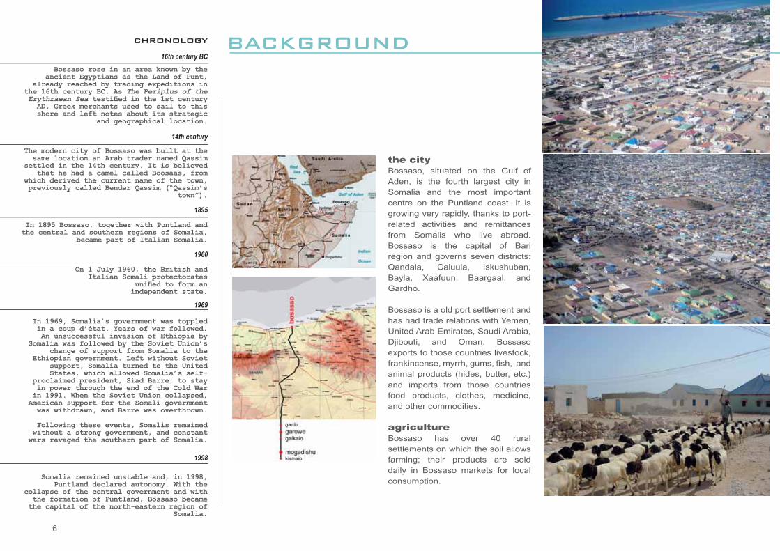
the cityBossaso, situated on the Gulf of Aden, is the fourth largest city in Somalia and the most important centre on the Puntland coast. It is growing very rapidly, thanks to port-related activities and remittances from Somalis who live abroad. Bossaso is the capital of Bari region and governs seven districts: Qandala, Caluula, Iskushuban, Bayla, Xaafuun, Baargaal, and Gardho.
Bossaso is a old port settlement and has had trade relations with Yemen, United Arab Emirates, Saudi Arabia, Djibouti, and Oman. Bossaso exports to those countries livestock, frankincense, myrrh, gums, fi sh, and animal products (hides, butter, etc.) and imports from those countries food products, clothes, medicine, and other commodities.
agriculture Bossaso has over 40 rural settlements on which the soil allows farming; their products are sold daily in Bossaso markets for local consumption.

7
population
Bossaso is the largest town in Puntland, with an estimated 250,000 inhabitants. The number of displaced people is considered to be 45,000 and growing.
The city’s population is increasing fast, due to the in-migration of IDPs and refugees leaving the war zones in the south, and to the enduring drought, which is pushing the nomadic population and their animals to the urban centres. The municipality estimates that on average 2,000 people migrate into the city every year.
Before the civil war, Bossaso’s population was estimated to be between 15,000 and 25,000 people.
climate In Bossaso the climate is very hot and humid, and temperatures in the summer can approach 50° C.
N
N 11o15’ E 49o30’
Sate
llite
imag
e by
© 2
006
Dig
italG
lobe
. ALL
RIG
HTS
RES
ERVE
D

8
the communication network
Since the start of the civil war in 1991, Bossaso has served as Somalia’s
main port, thanks to its strategic position on the Gulf of Aden, far from
the main confl ict areas in the south. It also has a two-lane highway,
which was built for the annual livestock shipments to the Middle East
and connects the city to Garowe and Mogadishu.
The exports are mainly goats and sheep, followed by cattle, camels,
fi sh, and frankincense. The imports include construction materials,
food, fuel, and qat. In recent years, Bossaso has evolved into a
refuelling station for maritime transport between the Red Sea and the
Persian Gulf ports.
Bossaso is also the most common departure point for boats carrying
illegal Somali and Ethiopian immigrants across the Gulf of Aden to
Yemen, Saudi Arabia, and other Persian Gulf states.
The Bender Qassim International Airport, which serves the city, is one
of Somalia’s main airports and is now being extended to became a
major regional hub.
BACKGROUND
Workers rest in front of a ship at Bossaso Port
9
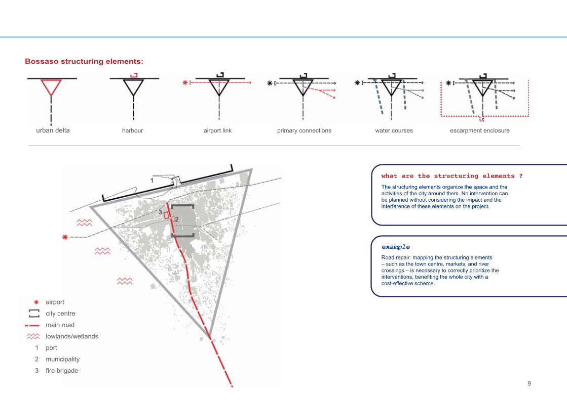
urban delta harbour airport link primary connections water courses escarpment enclosure
23
1
airport
city centre
main road
lowlands/wetlands
1 port
2 municipality
3 fi re brigade
what are the structuring elements ?
The structuring elements organize the space and the activities of the city around them. No intervention can be planned without considering the impact and the interference of these elements on the project.
example
Road repair: mapping the structuring elements – such as the town centre, markets, and river crossings – is necessary to correctly prioritize the interventions, benefi ting the whole city with a cost-effective scheme.
Bossaso structuring elements:
10

11
visionthe future
* the slogan for Bossaso’s development chosen by the participants of the city consultation
Safe, well-administered, and commercially successful city, taking full advantage of marine resources. The urban environment should be healthy,
clean, and green, with good social services and infrastructure*.

12Road in the centre of Bossaso

13
STRATEGIES FOR DEVELOPMENTbuilding the future
This section offers an overview of the problems that were identifi ed during the Bossaso City Consultation by the stakeholders in relation to key problem areas: governance, economic
development, basic services, and city strategic planning.
Livestock holding grounds on the eastern side of the city

14urban governance urban governance urban governance urban governance urban gover
problem
Weak administration and poor local council performance.
Poor skills of municipal staff. Lack of qualifi ed personnel. Clan interests prevail over the common interest.
Insuffi cient fi nancial resources.
objective
Effi cient, responsive, cooperative, and transparent administration.
Improved level and capacity of the municipal staff.
Increased fi nancial capacity of the municipality.
strategy
Revise the administrative structure of Bossaso Municipality.Improve the level of representation of the citizens in the local administration.
Set criteria for staff selection.Undertake performance evaluations.Improve staff morale.Train staff.
Increase tax collection. Improve the transparency of the fi nancial management of municipal resources.
According to the participants of the Bossaso City Consultation, the most urgent needs in the city are a good city administration and a qualifi ed local council that is responsive to the needs of the citizens. Proposed strategies and actions are presented on this page.
strategies for developmentbuilding the future
15rnance urban governance urban governance urban governance urban governance urban
key actions
Establish a committee for revising the roles and responsibilities of the mayor, councillors, and municipal staff within Bossaso Municipality.Establish eligibility criteria for the local councillors.Frequently broadcast the municipal activities and expenditures of the municipality in the local media.
Establish transparent criteria for municipal staff selection (qualifi cations, experience, etc.). Set up an open and transparent recruitment system (job advertisement, interviews, and candidate selection). Establish linkages between the municipality and the universities for the recruitment of graduating students.Improve the effi ciency of employees through incentives, allowances, grants, promotions, and training. Encourage the representation of all clans and civil society groups. Reduce the qat dependence of the municipal staff.Provide equipment.
Establish a fair and effective tax collection system, with the participation of all urban actors and the business community. Make public the records of the collected tax and the expenditures.Computerize the fi nancial management system, and provide municipal fi nance training for municipal staff.
urban governancelocal council and municipal staff
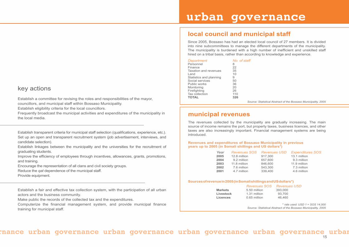
municipal revenuesThe revenues collected by the municipality are gradually increasing. The main source of income remains the port, but property taxes, business licences, and other taxes are also increasingly important. Financial management systems are being introduced.
Revenues and expenditures of Bossaso Municipality in previous years up to 2005 (in Somali shillings and US dollars*)
Year Revenues SOS Revenues USD Expenditures SOS2005 12.8 million 917,300 13.1 million2004 9.2 million 657,600 9.3 million2003 11.8 million 846,600 11.9 million2002 7.6 million 543,300 7.3 million2001 4.7 million 339,400 4.6 million
* rate used: USD 1 = SOS 14,000Source: Statistical Abstract of the Bossaso Municipality, 2005
Sources of revenue in 2005 (in Somali shillings and US dollars*)
Revenues SOS Revenues USD Markets 5.50 million 393,000Livestock 1.31 million 93,700Licences 0.65 million 46,460
Since 2005, Bossaso has had an elected local council of 27 members. It is divided into nine subcommittees to manage the different departments of the municipality. The municipality is burdened with a high number of ineffi cient and unskilled staff hired on a tribal basis, rather than according to knowledge and experience.
Department No. of staffPersonnel 8Finance 22Taxation and revenues 35Land 10Statistics and planning 9Social services 50Public works 36Monitoring 20Firefi ghting 26Tax collection 110TOTAL 326
Source: Statistical Abstract of the Bossaso Municipality, 2005

16
The second-highest priority raised at the Bossaso City Consultation is local economic development.
Bossaso is the main port of Puntland and the starting point for the main road crossing the country. It has a very active private sector: telecommunication companies, hotels, remittance banks, fi shery-, agriculture-, and livestock-related initiatives, vocational institutes, private clinics, construction companies, small manufacturers, and a number of small-scale enterprises. The large displaced community provides cheap labour and makes a valuable contribution to the local economy. Qualifi ed professionals who left Mogadishu and other areas in the southern region because of the war are also using their skills to develop the city. The investments and money from the diaspora and returnees should be strategically channelled into the local economy. Bossaso is one of the best examples of how Puntland is trying to overcome the social, institutional, and economic breakdown caused by the war; in spite of this, however, unemployment remains very high, and measures still need to be taken to boost the local economy.
The strategies proposed by the local actors during the Bossaso City Consultation are presented below.
strategies for developmentbuilding the future
problem
Economic development is constrained by the lack of quality, well-maintained infrastructure.
No economic management or planning by the government or the private sector.
Lack of an effi cient banking system.
objective
Establish adequate and well-managed urban infrastructure.
Expand the commercial potential of the city.
Establish a functioning and regulated banking system.
strategy
Upgrade and extend the existing road network and port facilities. Extend existing electricity and water lines.
Undertake strategic planning to enhance commercial development.
Regulate and institutionalize the informal banking system.Attract investment from new banks present in the region.
development economic development economic devel

17
economic development$economic development
key actions
Repair and decongest key existing roads. Reorganize and clear pathways and small lanes, formalize them into roads, and reconnect them with the main road network.Trace new roads in strategic locations, in line with the Bossaso urban development plan.Improve and expand the port’s storage capacity, access to the port, and port facilities such as a quarantine area for livestock.Support the electricity and water agencies in expanding and maintaining their networks, with the support of the municipality and international development agencies.
Set up meetings and consultations between local authorities and business people. Establish a chamber of commerce and register existing businesses. Identify areas with potential for economic development and service them.Develop long- and short-term action plans to be implemented in collaboration with all urban development actors, including development agencies. Encourage the regional and central authorities to participate in the city’s development.
Establish and enforce laws and regulations for the remittance and transfer banks. Register banks and exchange bureaux. Transform existing transfer banks into national banks.Reassure foreign banks on the benefi ts of operating in Puntland.
go to page 27
lopment economic development economic development economic development economic17
some data
Goods exported from Bossaso port in 2005 quantity unit sheep / goats 1,487,101 headscattle 90,544 headscamel 7,833 headsincense 18,760 tonshides / skins 15,675 bundles of 50 pieces
Source: Statistical Abstract of the Bossaso Municipality, 2005
Bossaso airport in 2004 arrived departed no. of fl ights 990 994passengers 847 857cargo (tons) 1,300 316qat (kgs) 194,585 n/a
18
problem
Illiteracy. Poor education system.
Bad health conditions of the population and high child mortality.
Insuffi cient access to affordable and suffi cient clean water for the poor.
Garbage is not collected effi ciently, and the city is not clean or tidy.Environmental degradation.
Poor sanitary conditions.Lack of adequate access to sanitation. Private wells and pit latrines are not in proximity to some residential areas.
objective
Well-educated children and youth, without discrimination.
Healthy citizens.
Adequate and affordable access to clean water for all.
Safe, clean, green, and healthy environment.
strategy
Increase access to education.Improve the quality of schools and teachers.
Improve access to clean water to reduce waterborne diseases and ensure suitable water consumption.
Improve the quality and accessibility of health facilities.
Establish an effi cient garbage collection system (long term).Remove existing garbage piles (short term).
Provide an adequate number of latrines in appropriate locations.
basic services basic services basic services basic services basic services 181
strategies for developmentbuilding the future
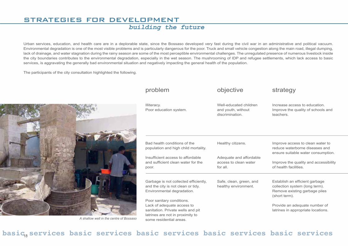
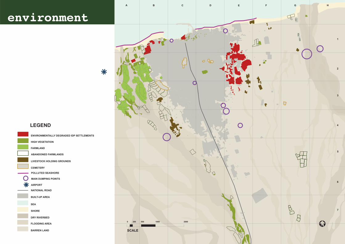
Urban services, education, and health care are in a deplorable state, since the Bossaso developed very fast during the civil war in an administrative and political vacuum. Environmental degradation is one of the most visible problems and is particularly dangerous for the poor. Truck and small vehicle congestion along the main road, illegal dumping, lack of drainage, and water stagnation during the rainy season are some of the most perceptible environmental challenges. The unregulated presence of numerous livestock inside the city boundaries contributes to the environmental degradation, especially in the wet season. The mushrooming of IDP and refugee settlements, which lack access to basic services, is aggravating the generally bad environmental situation and negatively impacting the general health of the population.
The participants of the city consultation highlighted the following.
A shallow well in the centre of Bossaso
19
key actions
Prepare an appropriate syllabus. Rehabilitate the existing schools (buildings and equipment), and construct new ones. Expand the number of faculties at the university. Increase access to the Islamic education system. Train the teachers.Establish a friendly environment in schools and universities.
Expand the water network in collaboration with the municipality, the water agency (GUMCO), and international agencies. Increase the capacity of the water agency. Rehabilitate water wells and boreholes. Raise awareness on polluted shallow wells. Conduct an awareness campaign on health risks.Provide well-trained doctors for public health centres. Rehabilitate hospitals and medical clinics, and equip them.
Establish an effi cient public-private partnership garbage collection system with the involvement of the municipality, private businessman, communities, and development agencies.
Provide an adequate sewage system in the long term.Provide an adequate number of latrines in IDP and urban poor settlements (to Sphere standards), in collaboration with landlords, the municipality, communities, and humanitarian agencies. Encourage better planning and management of water and sanitation infrastructure.
services basic services basic services
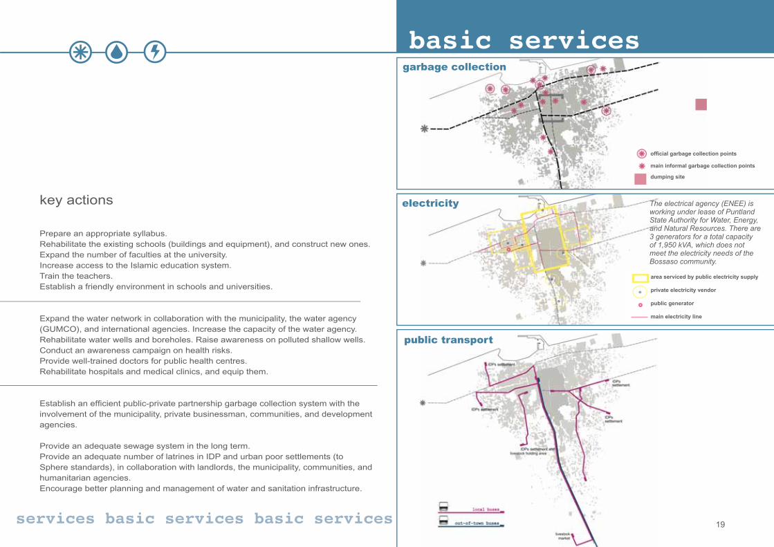
basic services
offi cial garbage collection points
main informal garbage collection points
dumping site
area serviced by public electricity supply
private electricity vendor
public generator
main electricity line
garbage collection
electricity
public transport
The electrical agency (ENEE) is working under lease of Puntland State Authority for Water, Energy, and Natural Resources. There are 3 generators for a total capacity of 1,950 kVA, which does not meet the electricity needs of the Bossaso community.
20
strategies for developmentbuilding the future
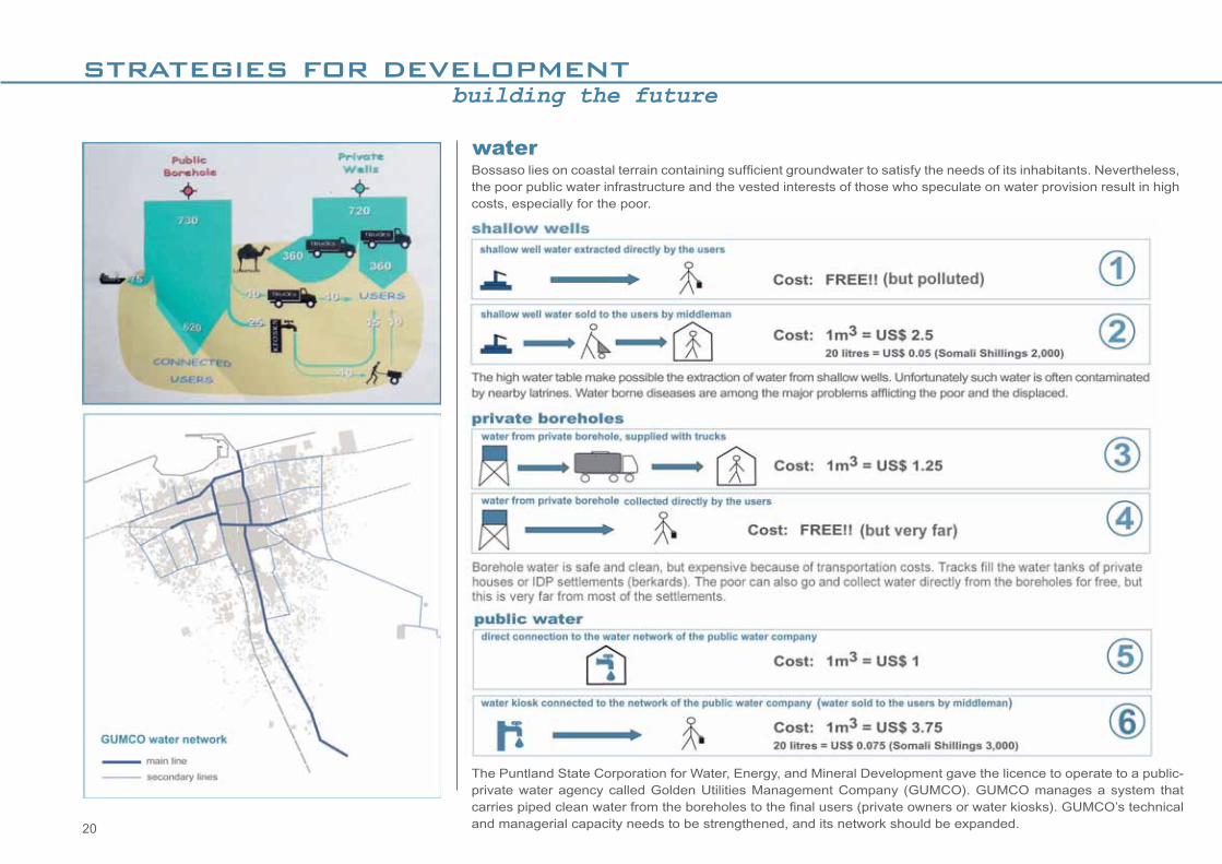
Bossaso lies on coastal terrain containing suffi cient groundwater to satisfy the needs of its inhabitants. Nevertheless, the poor public water infrastructure and the vested interests of those who speculate on water provision result in high costs, especially for the poor.
water
The Puntland State Corporation for Water, Energy, and Mineral Development gave the licence to operate to a public-private water agency called Golden Utilities Management Company (GUMCO). GUMCO manages a system that carries piped clean water from the boreholes to the fi nal users (private owners or water kiosks). GUMCO’s technical and managerial capacity needs to be strengthened, and its network should be expanded.

21
basic services
water supply and water cost
areas connected to public water supply
main water pipeline
public well
private well
public water tap
public water tap, not in use
public water tank
nu
mb
er o
f h
ou
ses
wit
h p
riva
te c
on
nec
tio
n:
few
so
me
man
y

22
THE CITY, THE SERVICES, AND THE POOR
fi lled vacant land within the town limits.limited consumption of land.shared facilities and services.easier and cost-effective administration.integration of communities.enhancement of local economic development opportunities.
This is the urban development model suggested for Bossaso!
ËËËËËË
The long-term development of a city is heavily infl uenced by the urban models informing its growth. Creating a compact city, which accommodates new expansions in the vacant space of the consolidated urban fabric, allows the effi cient and cost-effective maintenance of urban services and infrastructure. This reduces the cost of services for the urban poor as well as for the host community. The diagrams below represent two opposite types of development logic:
rapid urban expansion and great land consumption.increased cost of services and infrastructure.more diffi cult and expensive administration.encouraged social and economic segregation.
ËËËË
physical separation = social segregationintegration = social symbiosis
what we build is an expression of cultural and social values.isolating the poor means projecting the idea of rejecting the poor.building cities = building communities.integration of communities reduces social segregation and isolation.consolidation = increased opportunities for social support systems to fl ourish.
ËËËËË
segregation means:doubling of services = doubling of costs
establishing a separate settlement implies establishing all the services and infrastructure that goes with it.the doubling of infrastructure doubles the immediate installation costs and also the long-term maintenance costs.there is no opportunity to subsidize, rehabilitate, and share existing services.
Ë
Ë
Ë
The weak fi nancial and technical capacity of the administration coupled with the lack of established land administration tools render the urban development of Bossaso disorganized and chaotic. Some public buildings have been occupied and turned into private houses, and new buildings were constructed on public land, encroaching on roads and public spaces. Provision of urban services is insuffi cient and often inequitable.
The high infl ux of IDPs, refugees, and economic migrants makes the overall living conditions in the city even more precarious. The displaced settle randomly along the periphery of the town, renting out or occupying un-serviced land from private owners and in the process severely degrading the urban environment.
A comprehensive approach to the urban problems of the city for the benefi t of both the host community and the displaced is required. UN-HABITAT has undertaken a series of interventions along this line, which are illustrated in this publication.
urban development and the displaced
dispersed city1
consolidated settlements
new settlements
services
legend:
compact city2
consolidated settlements
new settlements
services
legend:
The drawing below shows the tight relationship between urban services and urban poor in the city of Bossaso.
23
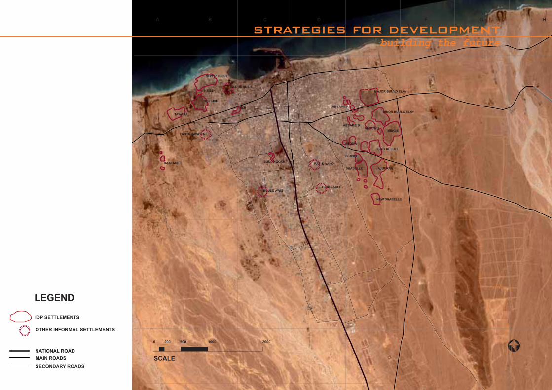
BUULO QOAHBAALADE
LANTA HAWEDA
BUULO AWISTUUR JAALE
RAF & RAHO
MAJOR BUULO ELAY
MINOR BUULO ELAY
MINGIS
GIRIBLE
ABSAME A
ABOUW 2
ABOUW 1
BIYO KULULE
AJUURANSHABELLE
NEW SHABELLE
ABSAME B
100 BUSH
10 BUSH
NEW 55 BUSH
INJI
OLD 55 BUSH
TAWAKAL
A B C D E F G H
0 200 500 1000 2000
SCALE
IDP SETTLEMENTS
LEGEND
SECONDARY ROADS
MAIN ROADS
NATIONAL ROAD
OTHER INFORMAL SETTLEMENTS
strategies for developmentbuilding the future

24

25
This section helps to develop a basic spatial understanding of the city and its main characteristics and dynamics. Spatial analysis is one of the most important tools for strategic
planning, because it enables all urban development stakeholders to plan and position their interventions according to an overall development strategy, maximizing the results of their
investments to benefi t the whole city. The weak urban management structures necessitate the involvement of all urban development actors in planning for development. A transparent planning
process maximizes the benefi ts of every urban intervention, public as well as private, for the direct benefi t of the investors and the city as a whole.
spatial analysis

26
0 200 500 1000 2000
SCALE
A B C D E F G H
1
2
3
4
5
6
7
land use
LEGEND
FLOODING AREA
SHORE
DRY RIVERBED
SEA
MAINLY RESIDENTIAL
NATIONAL ROAD
AIRPORT
PORT
MAINLY COMMERCIAL
IDP SETTLEMENTS
FARMLAND
INSTITUTIONAL AND PUBLIC
LIVESTOCK HOLDING GROUNDS
HEALTH
PRODUCTIVE
CEMETERY
EDUCATION
BARREN LAND
27
LEGEND
FLOODING AREA
SHORE
DRY RIVERBED
SEA
NATIONAL ROAD
AIRPORT
FEWER THAN 15 STRUCTURES PER HECTARE
OVER 25 STRUCTURES PER HECTARE
15 TO 25 STRUCTURES PER HECTARE
BARREN LAND
0 200 500 1000 2000
SCALE
A B C D E F G H
1
2
3
4
5
6
7
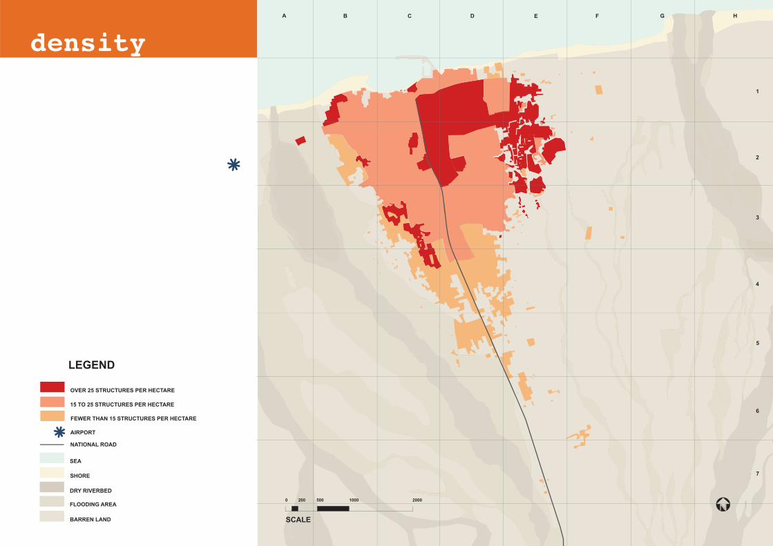
density

28
LEGEND
FLOODING AREA
SHORE
DRY RIVERBED
SEA
PORT
AIRPORT
BUILT-UP AREA
LIVESTOCK HOLDING GROUNDS
SECONDARY ROADS
BARREN LAND
FARMLANDS
IDP SETTLEMENTS
CEMETERY
MAIN ROADS
to Biyo Kulule
to Marero
to G
ardh
o - G
arow
e - Mo
gad
ishu
NATIONAL ROAD
0 200 500 1000 2000
SCALE
A B C D E F G H
1
2
3
4
5
6
7
transport network
29
LEGEND
FLOODING AREA
SHORE
DRY RIVERBED
SEA
NATIONAL ROAD
AIRPORT
BUILT-UP AREA
LIVESTOCK HOLDING GROUNDS
HIGH VEGETATION
BARREN LAND
ABANDONED FARMLANDS
FARMLAND
CEMETERY
MAIN DUMPING POINTS
POLLUTED SEASHORE
ENVIRONMENTALLY DEGRADED IDP SETTLEMENTS
0 200 500 1000 2000
SCALE
A B C D E F G H
1
2
3
4
5
6
7
environment

30
STRATEGIC URBAN DEVELOPMENT PLANdevelopment constraints and potential
CONGESTED ROADS
CONGESTED AREA – CITY CENTRE
CRITICAL TRAFFIC NODES TO BE DECONGESTED
road congestion
Road congestion is one of the main physical constraints to the city’s development. The most affected road is the main axis connecting the south with the Bossaso port. Encroachment of business activities, pedestrian and vehicular traffi c, and temporary and permanent structures on the road reserve hamper economic development in the city centre and cause pollution. The map indicates the roads and areas that the problem affects most.
accessibility to the port
Limited accessibility to the port area and poor port-related infrastructure are affecting the full development of the city’s most important asset.
BAD ACCESSIBILITY TO THE PORT – INADEQUATE INFRASTRUCTURE
bypass road
Bossaso Municipality traced a road on the eastern side of town to address the problems of road congestion and access to the port. The road has been opened but is not paved; it lacks street lights and other critical facilities such as water infrastructure and proper connection to the main roads. An effi cient connection between the bypass road and the port area is also missing.
BYPASS ROAD FOR HEAVY TRAFFIC DIRECTED TO THE PORT
warehouses and large-scale trade-related facilities
Trade and import-export are the backbone of the city’s economy. Adequate space has not been set aside for the infrastructure that can support and help achieve the full potential of this resource. Warehouses, holding grounds for livestock, space for trucks, garages, service areas, etc. would be best placed along the bypass road. This would protect the environment of the residential areas within town, reduce congestion, and allow for the necessary expansion of trade-related activities.
AREA FOR DEVELOPMENT OF WAREHOUSES AND TRADE-RELATED FACILITIES
degraded urban environment
Degradation of the urban environment is one of the main problems in Bossaso, affecting all neighbourhoods. Some of the most critical issues to be addressed: lack of effi cient garbage collection systems, improper disposal of waste from vehicle engines, and contamination by human waste of soil and underground water, which leads to waterborne diseases. The degradation is particularly bad and has severe implications for human life in the settlements occupied by IDPs and urban poor families, as can be seen in the frequent disease and fi re outbreaks.
DEGRADED URBAN ENVIRONMENT – IDP SETTLEMENTS
protection and expansion of agricultural reserves and recreational areas
Agricultural and recreational areas need to be preserved and enhanced. Food security, the urban economy, and social cohesion would benefi t from investments in such areas.
WETLANDS – AGRICULTURAL RESERVE
RECREATIONAL DEVELOPMENT
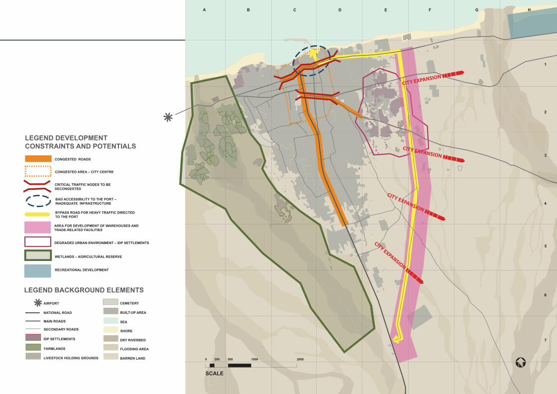
31
CITY EXPANSION
CITY EXPANSION
CITY EXPANSION
CITY EXPANSION
LEGEND BACKGROUND ELEMENTS
FLOODING AREA
SHORE
DRY RIVERBED
SEA
BUILT-UP AREA
BARREN LAND
CEMETERYAIRPORT
LIVESTOCK HOLDING GROUNDS
SECONDARY ROADS
FARMLANDS
IDP SETTLEMENTS
MAIN ROADS
NATIONAL ROAD
LEGEND DEVELOPMENT CONSTRAINTS AND POTENTIALS
CONGESTED ROADS
CONGESTED AREA – CITY CENTRE
BAD ACCESSIBILITY TO THE PORT – INADEQUATE INFRASTRUCTURE
BYPASS ROAD FOR HEAVY TRAFFIC DIRECTED TO THE PORT
AREA FOR DEVELOPMENT OF WAREHOUSES AND TRADE-RELATED FACILITIES
DEGRADED URBAN ENVIRONMENT – IDP SETTLEMENTS
WETLANDS – AGRICULTURAL RESERVE
CRITICAL TRAFFIC NODES TO BE DECONGESTED
RECREATIONAL DEVELOPMENT
0 200 500 1000 2000
SCALE
A B C D E F G H
1
2
3
4
5
6
7

32
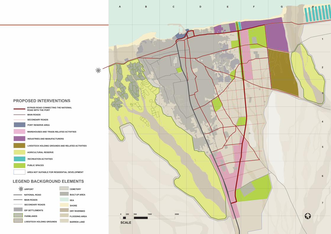
STRATEGIC URBAN DEVELOPMENT PLANkey interventions for the future development of the city
bypass roads and road network
An effi cient traffi c regulation system and proper road maintenance are required for the whole city. Nevertheless, the most urgent interventions should target the bypass road and the main roads.
The bypass road should be paved, the connection to the main road heading south should be better defi ned (e.g. roundabout, signboards, etc.), the electricity and water networks should be made accessible, and street lights should be put up. The access route to the port should be cleared of formal and informal structures that prevent the effi cient use of the port and obstruct loading and unloading activities.
The main roads should be cleared of structures and informal businesses encroaching on the road reserve. Small kiosks should be relocated to more suitable areas. Pedestrian walkways should be protected from vehicular traffi c and parking areas should be defi ned. Bus stops should be formalized. Where needed, one-way roads should be established. Drainage should be provided to areas subject to seasonal fl ooding.
Page xx gives an example of the suggested intervention for Netco Road, one of the most congested parts of Bossaso.
BYPASS ROAD CONNECTING THE NATIONAL ROAD WITH THE PORT
MAIN ROADS
SECONDARY ROADS
trade-related facilities
Modern cities need physical planning to ensure that productive areas and residential areas do not encroach on each other, preventing reciprocal development. Each function needs different infrastructure and services, as well as preliminary planning to ensure the adequate provision of such facilities in a cost-effective manner.
WAREHOUSES AND TRADE-RELATED ACTIVITIES
livestock holding grounds
Livestock production and trade are extremely lucrative for the country, accounting for a signifi cant share of the economy. In spite of this, livestock facilities are not well developed, and livestock holding grounds encroach on residential developments. This creates environmental pollution and poses severe health threats to the local population, especially the IDPs and the urban poor living on the eastern side of town. Moreover, city expansion progressively pushes the areas set aside for such activity farther out, preventing businessmen from investing in more permanent and effi cient infrastructure.
The strategic development plan proposes an alternative location for livestock-related activities. The area is close to water sources and is easily accessible from the port and the main road.
LIVESTOCK HOLDING GROUNDS AND RELATED ACTIVITIES
manufacturers
Bossaso hosts some manufacturers on the coastal strip on the eastern side of the town. Productive activities and basic processing of raw materials and marine resources need to be revitalized and enhanced. The plan suggests a location for such activities.
INDUSTRIES AND MANUFACTURERS
agricultural reserves, areas for recreational activities, and public spaces
The Bossaso strategic urban development plan has set aside areas for such activities.
The protection of the agricultural reserve is crucial for ensuring a sustainable source of food for the city, which currently imports most of its supplies from overseas or the south. Investments should be made to strengthen such resources.
The improvement of public spaces and recreational activities is important to increase social cohesion, increase interaction among different groups, encourage sports among youth and children, and upgrade the urban environment.
RECREATION ACTIVITIES
AGRICULTURAL RESERVE
PUBLIC SPACES
The strategic urban development plan suggested for Bossaso recommends that warehouses and other trade-related facilities (garages, petrol stations, service areas, etc.) be concentrated along the bypass road and on the more external tracts of the main road reserve. This will release the city centre from the pressure created by the presence of large-scale trade-related facilities and will allow for traffi c decongestion.
compact city development
UN-HABITAT recommends compact city development for Bossaso (see page 22 and 23). This will maximize the use of urban land and limit the cost of services and infrastructure, ensuring easier and cost-effective maintenance. Compact cities facilitate the integration of communities and enhance local economic development opportunities.
It is therefore important that for the coming decades the city does not experience residential expansion beyond the blue line marked on the strategic development plan.
AREA NOT SUITABLE FOR RESIDENTIAL DEVELOPMENT
port reserve area
See the proposed interventions on page 42 and 43.
PORT RESERVE AREA
33
LEGEND BACKGROUND ELEMENTS
FLOODING AREA
SHORE
DRY RIVERBED
SEA
BUILT-UP AREA
BARREN LAND
CEMETERYAIRPORT
LIVESTOCK HOLDING GROUNDS
SECONDARY ROADS
FARMLANDS
IDP SETTLEMENTS
MAIN ROADS
NATIONAL ROAD
PROPOSED INTERVENTIONS
BYPASS ROAD CONNECTING THE NATIONAL ROAD WITH THE PORT
MAIN ROADS
SECONDARY ROADS
WAREHOUSES AND TRADE-RELATED ACTIVITIES
INDUSTRIES AND MANUFACTURERS
RECREATION ACTIVITIES
AREA NOT SUITABLE FOR RESIDENTIAL DEVELOPMENT
LIVESTOCK HOLDING GROUNDS AND RELATED ACTIVITIES
AGRICULTURAL RESERVE
PUBLIC SPACES
PORT RESERVE AREA
0 200 500 1000 2000
SCALE
A B C D E F G H
1
2
3
4
5
6
7

34
35
tablesthe approach and the projects

36
THE APPROACH
The dire conditions of the displaced in Bossaso have concerned humanitarian agencies, leading them to develop common strategies and joint programmes to improve their outreach and effi ciency.
THE CLUSTER APPROACH
In line with the global Humanitarian Reform endorsed by the Inter-Agency Standing Committee, the Cluster Approach was introduced in Somalia in 2006. Several clusters are active in Bossaso. UN-HABITAT is working with the Protection Cluster and the Water and Sanitation Cluster, and is particularly active in the Shelter Cluster. UNHCR and UN-HABITAT co-chair the Shelter Cluster, which includes Danish Refugee Council, Norwegian Refugee Council, and other local and international NGOs. The Shelter Cluster has been very active in addressing the needs of the displaced; some of its achievements are presented in this publication.
THE JOINT UN/INGO IDP STRATEGY
In 2005, a joint UN/INGO strategy to address the needs of internally displaced persons in Somalia was prepared by UN agencies, in consultation with key government and NGO representatives.
The main strategic objectives for the improvement of the lives of the displaced are:
Better protection for the displaced from human rights abuses, physical violence, eviction, and fi re outbreaks. Improved living conditions in existing and temporary settlements, through settlement upgrading, improved access to basic services, and access to immediate income-generating opportunities.Provision of durable solutions for livelihoods, resettlement, and reintegration.
Ë
Ë
Ë
ADDRESSING THE NEEDS OF THE DISPLACED

37
38
THE ACHIEVEMENTS
BACKGROUND
The composition of the displaced communities is very diverse. A large portion of the Bossaso displaced families has been living in temporary settlements there for years, and some refer to themselves as part of the host community. A consistent percentage of IDPs declared in a recent survey that they have no intention of moving from Bossaso, even if peace is restored in the south. The unstable political situation in the country and the geographical location of Bossaso meanwhile continue to attract those who are displaced by confl ict and drought or are searching for better economic opportunities. As a result, at the beginning of 2009 an estimated 35,000 displaced people lived in the city in makeshift structures, with poor access to basic services and under threat of eviction.
IDP SETTLEMENT UPGRADINGTHE INTERVENTIONS
Improving the living conditions of the displaced in their current locations is one of the three main strategies for providing assistance to the neediest. This time-consuming but extremely effective exercise not only addresses the service and shelter needs of the displaced, but also has a positive impact on the safety and security of the people, as well as their livelihoods.
With funds form different agencies and donors, UN-HABITAT and other Shelter Cluster members – Danish Refugee Council, Norwegian Refugee Council, and UNHCR – have established an action team in charge of:
Replanning the informal settlements to allow suffi cient living space for the families, as well as space for roads, fi rebreaks, basic services, and infrastructureDistributing improved and less fl ammable temporary shelter kits to IDP familiesConducting basic training on settlement planning and fi re preventionNegotiating with local authorities and landowners land occupation arrangements for the IDPs
In 2008, 5 of the main IDP settlements were upgraded: Tawakal (hosting 134 families), New Shabelle (75 families), Bulo Elay (123 families), Ajuuran (511 families), and Biyo Kulule (350 families). After giving access to improved shelter and living conditions to these 1,193 families – corresponding to an estimated 7,160 people – the action team will intervene in other priority settlements.
Among the positive effects of the interventions, the reduction of fi re outbreaks in the settlements must be mentioned. In 2007, 14 of the 21 IDP settlements in Bossaso were affected by fi re, and over 1,800 families had their shelters and belongings destroyed. After the upgrading interventions and the provision of improved shelter kits in 2008, the number of families affected by fi re almost halved, and “only” 1,001 families were affected; none of the upgraded settlements was affected.
Ë
ËËË

39
An improved shelter kit costs USD 275 and measures 3x3 metres. The canvas is waterproof and fi re retardant; the metal sticks provide an alternative to wood,
with the intention of reducing tree cutting and desertifi cation. With the support of international agencies, the community builds the structures and maintains them.
The shelter kits are provided by Norwegian Refugee Council, UNHCR, and Danish Refugee Council. The action team implementing the project is composed of UN-
HABITAT and the above-mentioned agencies.
IMAGES (from left to right): 1. the action team explains to the community their role in the implementation
2 & 3. the settlement layout is demarcated on the ground 4. the community builds the structures of the shelters
5 & 6. the upgraded settlements

40
THE ACHIEVEMENTS
PERMANENT SHELTER FOR IDPs AND URBAN POORUN-HABITAT, UNHCR, Danish Refugee Council, and UN-OCHA, in collaboration with the Bossaso local authorities, the communities, and local counterparts, joined forces to help resettle displaced and urban poor families in Bossaso East. The intervention gave a new home with security of tenure, access to services, and livelihood opportunities to 112 displaced families from the most disadvantaged IDP settlements and 28 poor families from the local community. The project was part of the broader strategy to support a well-planned urban development on the eastern side of the town, presented on page 32 of this publication. The community and the authorities viewed the project as transparent and successful; it was also very well received by the benefi ciaries. A similar approach is now being replicated in the city to benefi t up to 450 vulnerable families.
THE STEPS
Discussions were held with the local authorities within the framework of the IDP strategy. The initial idea was to segregate the displaced by relocating them outside of town, but after negotiations the resettlement of IDPs within town was accepted (images on the left). This represented a signifi cant change in the attitude of the authorities towards the recognition of the rights and the status of the IDPs.A campaign for land donation was launched. Members of the business community and powerful clans of the city donated part of their land as charity. The ownership of this land was transferred to Bossaso Municipality.A complex benefi ciary selection process took place, presided over by a committee composed of all the relevant stakeholders and humanitarian agencies. Eligibility criteria were set, and a lottery identifi ed the fi nal benefi ciaries from among the eligible families. One hundred and twelve families of IDPs were selected from four of the most vulnerable settlements in the city. The municipality identifi ed 28 urban poor families.The municipal water network was extended to the settlements and access roads were traced.Local construction companies built the basic core of the shelters. This encompassed the boundary walls of the house, the foundation, a latrine, and a shower box.The benefi ciaries moved onto their plots and, while living in temporary shelters, constructed the fi rst room of their house. A local NGO took care of the logistics and daily supervision.Tenure documents were provided to the benefi ciaries.
After the project was completed, livelihood interventions took place, trees were planted, and a mosque and school were constructed next to the settlements by other humanitarian agencies. The benefi ciaries started to invest in their own properties, modifying the houses and adding pavement, water tanks, trees, etc. A benefi ciary satisfaction survey carried out in the settlements highlighted the appreciation the benefi ciaries had for the project and the improvements it brought to their lives.
1.
2.
3.
4.5.
6.
7.

41
step 3 step 4 step 4 step 5
step 6step 6

42
0 20 50 100 200SCALE NORTH
0 20 50 100 200SCALE NORTH
URBAN UPGRADING
BOSSASOPORT AREA
Limited accessibility to the port area and poor port-related infrastructure are affecting the full development of Bossaso’s most important asset. The images on the left offer an analysis of the existing situation: narrow and poorly paved alleys connect the national road to the port, temporary structures encroach on important spaces, empty spaces remain under-utilized, and the port surroundings are randomly organized.
On the right, the proposed interventions: structured access to the port from the main road and the bypass road, the possibility of introducing one-way traffi c to reduce congestion where existing roads are not wide enough to accommodate heavy traffi c, institutionalization of a Port Reserve Area in which new residences and small businesses are not allowed, creation of formal and well-structured areas for short-term parking, and areas for future port-related infrastructure, services, and facilities.
ANALYSIS OF THE EXISTING SITUATION
NATIONAL ROAD
LEGEND
BUILDINGS
TREES
OPEN SPACE
FENCES AND WALLS
TEMPORARY STRUCTURES – SHACKS
TRUCKS AREA
COMMERCIAL
INSTITUTIONAL
MIXED USE
FISHING BOATS AREA
PORT FACILITIES
SPACES FOR CIRCULATION
RELIGIOUS
SHORE
SEA
BUILT-UP AREA
LAND USE AND ACCESS
43
9
0 20 50 100 200SCALE NORTH
1
2
4
5
3
7
8
6
TO BY-PASS ROAD
MA
IN R
OA
D
LEGEND
BUILDINGS
TREES
OPEN SPACES
TEMPORARY STRUCTURES – SHACKS
SHORE
SEA
BUILT- UP AREA
ROADS AND ALLEYS
1 - NECFISH2 - MINISTRY OF FINANCE OFFICE 3 - FORMER GOVERNMENT RESIDENCE4 - PORT ADMINISTRATION OFFICE5 - SCHOOL6 - MAJOR MOSQUE7 - MINISTRY OF FISHERIES OFFICE8 - MUNICIPAL FIRE BRIGADE9 - TAXIS AND MINIVAN PARKING
PORT-RELATED STRUCTURES
TEMPORARY PARKING FOR TRUCKS AND OTHER PORT-RELATED FUNCTIONS
ADDITIONAL PORT-RELATED STRUCTURES, INFRASTRUCTURE, AND SERVICES
PORT RESERVE AREA
SECONDARY ACCESS
ACCESS TO THE PORT FROM MAIN ROAD
MAIN ACCESS TO THE PORT FROM BYPASS ROAD
ONE WAY
TWO WAYS
PROPOSED INTERVENTIONS
EXISTING FEATURES
PROPOSED INTERVENTIONS

44
ROAD UPGRADING
NETCO ROAD
As shown in the images above, Netco Road is one of the most congested areas in Bossaso. There are numerous public transport vehicles and private cars, and the heavy traffi c is not adequately regulated. Loading and off-loading take place in the middle of the road reserve, and temporary structures and other petty commercial activities block the route. Pedestrian walkways and an appropriate drainage system are absent.
UN-HABITAT, in collaboration with the municipality and the Netco business community, prepared a layout plan for the rehabilitation of the road. A section of it is shown below, together with a three-dimensional image of the proposed intervention.

45

46
URBAN SPATIAL ANALYSIS
objectives:representing with maps and drawings the basic urban elements of the city: roads, services, infrastructure, major natural elements, traffi c fl ows, main directions of urban expansion, key productive and commercial areas, public facilities, etc.
identifying and mapping the most vulnerable and problematic areas of the city by putting data into a spatial perspective.
providing to all urban development stakeholders a simple technical base for discussion to sustain the urban strategic planning process.
proposing an example of how the spatial analysis, combined with participatory planning, could be translated into specifi c projects integrated into a broader city development plan.
providing authorities, local and international agencies, and other public and private development actors with a fl exible and simple tool to help direct investments and interventions.
Ë
Ë
Ë
Ë
Ë
methodology:
The information presented in the urban spatial analysis is based on:
interviews with key municipal staff, offi cials from public institutions, and other key informers.
preliminary site visits with the support of the relevant informers.
the preparation of preliminary maps, to be further detailed.
a desk study of available documents.
the collection of additional visual material (photos, graphics, etc.).
additional site visits and surveys of the city.
the fi nalization of the maps, to include all information collected.
The information collected through the urban spatial analysis of the city of Bossaso is presented on pages 26–33.
Ë
Ë
Ë
Ë
Ë
Ë
Ë
Urban Spatial Analysis is a tool for understanding the dynamics, problems, and development opportunities of a city through its physical form.
The graphic below illustrates the strategic planning process. Initiated through the capacity-building and awareness-raising component of the UN-HABITAT Good Local Governance and Leadership Training Programme, the process was later sustained with the urban spatial analysis and action plans.
URBAN SPATIAL ANALYSIS AND STRATEGIC PLANNING
As shown in the graphic, Rapid Urban Spatial Analysis is just one of the fi rst steps of the planning process.
Planning is a continuous engagement with the needs and demands of an urban environment, complemented with capacity building, awareness raising, and continuous participative discussion among all stakeholders concerned.
To allow for the successful implementation of planning decisions, sustainable monitoring mechanisms have to be developed to prevent negative outcomes and overcome bottlenecks.
THE APPROACHwhat is the...?
47
THE APPROACHwhat is a...?
CITY CONSULTATION A city consultation is an event that brings together all the urban development actors of an urban centre to discuss, share points of view, deepen their understanding of the situation, explore solutions, and build consensus on issues of common interest.
Key principles of a city consultation:
Inclusiveness – to build a solid base for future cooperation, it is important to involve all key stakeholders, including marginalized groups and representatives of opposing political parties, factions, or clans. Everyone must have the opportunity to express his or her point of view.
Continuous process – a city consultation is not an outcome in itself or a point of arrival, but it is the start of a process for further action and cooperation. To create a solid base for future steps, clear agreements should be reached on the main issues discussed. The way forward should be understood by all, and clear action points should be defi ned.
Confl ict resolution – understanding different perspectives and interests is the basis for fi nding common ground for action. All parties should share knowledge, expertise, and resources, and be willing to compromise and work together on mutually acceptable solutions.
Gender balance – women and men should both be called upon to express their points of view on an equal-to-equal basis. Women and youth groups should be represented.
In the Somali context, where local institutions have limited coercive power and legal frameworks are not fully developed, it is particularly important to reach a broad consensus among all urban development actors on issues of common interest. City consultations in particular are fundamental steps towards realistic and sustainable city planning.
Ë
Ë
Ë
Ë
BOSASSO CITY CONSULTATION 5 March – 8 March 2005
List of participants
Central and local authorities
Ali Abdi AwareYusuf Mohamed Wacay Roble Omar Mohamoud Abdikadir Musse YusufSamatar Abdi Samatar Ahmed Mohamed AbdaleMusse Gelle YusufAbdinoor Mohamed SaidAli Mirre ArtanAli Jama FarahSaid Jibril ArisAbdulahi Said Au MusseAbdiweli Musse Aden
NGOs/CBOs and other institutions
Abdirisak Ahmed ShodeAbdulahi Yusuf TadumunHawa Ali JamaIbrahim Gurre
Traditional and religious leaders
Abshir Mohamed Idiris Sheikh Abdirisak Hussein IsseBotan Dhowre Sheikh Salad Qaxiyey-HifdiAhmed Mohamed Yusuf Sheikh DadAhmed Warsame Ali
IDP groups
Abdiweli Mohamed Abdi Farah Musse Ali Ardo Abdulahi Warsame
List of participants
Media and intellectuals’ associations
Khalif Mohamed Barre Farah Haji SaidMohamed Abshir Omar Omar Mohamed BarreMohamed Weyrah Maryan Mohamed HassanMahado Sheikh Ahmed Yusuf Mohamoud Haji Salado Ismail Mirrod
Businessmen and project committees
Yusuf Abshir CadamiAbdinasir Mohamed HusseinAhmed Abdi AbdaleBashir Abdulahi SalahAbdulladif Yusuf Barre
Bossaso local team
Ahmed Mohamed Hassan Abdikadir Gas Musse Mohamed Isse Yusuf Ibrahim Mohamed Abdikadir Bashir Shire Ahmed Bosteyo Said Yusuf Aden Osman Aden Jama Mohamoud Dulane
48
UN-HABITAT ACTIVITIES IN SOMALIA
UN-HABITAT has been active in Puntland since 1996 and the main focus of its activities has been in the fi elds of:
capacity building of public institutionsgovernance (local leadership training)provision and management of basic services (in particular water supply and solid waste)urban planningland management, mapping, and development of urban land information systemsmunicipal fi nance, asset management, and revenue collectionassistance to IDPs and returnees, in particular site review and planning, shelter provision, and secure tenure
Following are the main programmes and activities implemented by UN-HABITAT in recent years. For more information: www. unhabitat.org/somali region
ËËË
ËË
Ë
Ë
1. Urban Development Programme for the Somali Region Activities: (1) legal and institutional reforms – assessment of land tenure options for IDPs and returnees, analysis of the land legal framework; (2) municipal governance – organization of urban forums; (3) strategic urban planning and development control – development of resettlement plans for displaced population in major towns, capacity building for local authorities, development of town plans; (4) urban land management ; (5) municipal fi nance – training for municipal staff, assessment of municipal fi nance software options; (6) basic urban service delivery – assessment of solid waste systems, support to local authorities to set up improved solid waste management systems, technical and practical support to municipalities to set up waste collection systems; (7) local economic development – economic profi ling of four towns, support to authorities to set up public-private partnerships, labour-intensive employment generation projects; (8) local projects – construction and rehabilitation markets and slaughterhouses.
2. Emergency Assistance for IDPs and Returnees – Activities: (1) construction of houses for IDPs, returnees, and urban poor in Garowe, Bossaso, and Hargeisa through a self-help methodology; (2) provision of security of tenure; (3) training of returnees and IDPs in the labour-intensive production of local construction materials and construction skills; (4) provision of job opportunities; and (5) developing community settlement governance and management techniques.
3. Support to Improved Service Delivery in Somali Cities – Activities: (1) solid waste management projects; (2) provision of technical, economic, and legal guidance to municipalities and representatives of the local consortia to strengthen their capacity and create a common understanding of sustainable and integrated solid waste management; and (3) training on appropriate technical solutions for local institutions and businesses to promote pro-poor public-private partnerships and income-generating activities in the waste sector.
4. Support to Priority Areas in the Urban Sector Programme – Activities: (1) preparation of municipal fi nance training material; (2) municipal fi nance training; (3) rehabilitation of Hargeisa, Boroma, and Garowe municipal buildings; (4) extension of the Ministry of Interior building in Hargeisa; (5) assistance in developing the Hargeisa City Charter and urban laws; (6) production of multi-purpose base maps of a few cities, and (7) rapid spatial urban analysis for main towns. 5. Good Local Governance and Leadership Training Programme – Activities: (1) training material on good local governance; (2) training on leadership management skills, gender, and action planning; (3) awareness campaigns on good local governance; (4) implementation of priority projects.
6. The Somalia Urban Sector Profi le Study – An analysis of how to fi ll the gap between the EC’s Country Support Strategy and individual urban project interventions, providing an instrument for policy dialogue and a basis for determining interventions. 7. The Reconstruction of the Tsunami-affected Village of Xaafuun – Activities: (1) construction of over 200 houses for the affected population; (2) community buildings; and (3) development plan for the town.
49
THE URBAN DEVELOPMENT PROGRAMME FOR THE SOMALI REGION: ITS DONORS AND IMPLEMENTING PARTNERS
The Urban Development Programme for the Somali Region is an umbrella programme for all urban interventions in the Somali region. UN-HABITAT is the lead agency, and its partners are the Italian NGO Consortium UNA, the International Labour Organization, Oxfam-Novib, UNICEF, Danish Refugee Council, UNHCR, and a number of local NGOs. The programme is funded by the European Commission and UNDP, and co-funded by the Government of Italy, the Government of Japan, UNICEF, the Department for International Development of the United Kingdom, UNHCR, and the Humanitarian Response Fund. The programme receives support from WFP through food-for-work schemes.
SUDP activities encompass: urban governance, legal and institutional reform, donor coordination, urban management, land management, municipal fi nance, basic services and urban infrastructure (markets, slaughterhouses, roads, and municipal building rehabilitation), local economic development, urban planning support, shelter provision for displaced populations and the urban poor, slum upgrading, and solid waste management.
European Commission The EC is the main donor of the SUDP and supported several other UN-HABITAT interventions in the Somali region. The commission provides funding as well as technical and strategic guidance to programme design and implementation.
UNDP The UN Development Programme’s involvement in SUDP is part of its Governance and Financial Services Programme, under which long-term cooperation with UN-HABITAT exists. UNDP is the key coordinating agency for interventions in the region, and its partnership with UN-HABITAT extends to a wide range of programmes, most prominently the Joint Programme for Local Governance and Service Delivery.
Government of Italy The support of the Government of Italy has been consistent throughout UN-HABITAT’s presence in the Somali region. It funds part of SUDP’s core activities and service delivery programmes and is involved in the elaboration of the new Joint Programmes.
Government of Japan The Government of Japan funds the Assistance for the Resettlement of Returnees and Internally Displaced People programme in Hargeisa and Garowe.
Department for International Development
Through DFID, the Government of the United Kingdom funds a number of governance-related aspects of SUDP and the new Joint Programmes. DFID support also extends to activities related to the Community-Driven Development and Reconstruction Programme.
UNICEF The UN Children’s Fund partners with UN-HABITAT in the implementation of several activities, such as the Joint Programme for Local Governance and Service Delivery, and the Community-Driven Development and Reconstruction Programme. It also collaborates in strengthening the role of youth in local governance.
UNA The Italian NGO consortium UNA represents three Italian universities and a number of international NGOs. UNA takes the lead in the urban services component, which includes solid waste management and sanitation activities.
International Labour Organization
ILO is responsible for the local economic development component of the SUDP and partners with UN-HABITAT in a number of other programmes, such as the Joint Programme for Local Governance and Service Delivery and the IDP resettlement interventions.
Oxfam-Novib Under the SUDP, Oxfam-Novib expanded its capacity-building activities for local NGOs and community-based organizations.
World Food Programme WFP supports UN-HABITAT shelter activities by providing food-for-work at the construction sites of the shelter projects.
UNHCR The UN High Commissioner for Refugees is a key UN-HABITAT partner for the implementation of land-, shelter-, and IDP-related activities. UNHCR funds some IDP settlement upgrading components and supports joint research on land-related issues; in addition, UNHCR and UN-HABITAT are co-chairs of the Somali Shelter Cluster.
Swedish Agency for International Development
SIDA fi nancially supports UN-HABITAT for the implementation of shelter activities for IDPs and the urban poor in south central Somalia.
Danish Refugee Council DRC is one of the UN-HABITAT implementing partners, particularly concerning community development and IDP-related issues.
Norwegian Refugee Council NRC partners with UN-HABITAT in the implementation of shelter activities for IDPs and other vulnerable communities.

50
Contacts
UN-HABITAT Regional Office for Africa and the Arab StatesAlioune Badiane, [email protected], tel: +254 20 762 3075
Urban Development Programme for the Somali RegionDorothee von Brentano, O-i-C / Chief Technical [email protected], tel: +254 20 762 5030
UN-HABITAT [email protected]
European Commission
COOPERAZIONEI T A L I A N AITALIAN COOPERATION
Donors and Partners
Sat
ellit
e Im
age
by ©
200
6 D
igita
lGlo
be. A
LL R
IGH
TS R
ES
ER
VE
D