Embed Size (px)
Citation preview

First Stop Guide to the Records of the Registrar GeneralMarch 2013ISSN 2200-971X
Information contained
in this document was correct at
time of publication, but may have
been superseded

First Stop Guide to the Records of the Registrar General
Date of Publication March 2013
Copyright © March 2013
ISSN 2200-971X
Copyright in this document is held by Land and Property Information. Division 3 of the Commonwealth Copyright Act 1968 recognises that limited further use of this material can occur for the purposes of fair dealing – for example study, research or criticism. However, to make use of this material, other than as permitted by the Act, please write to Land and Property Information.
Disclaimer Information contained herein is of a general nature and is not intended to address the circumstances of any particular individual or entity. Advice from a professional adviser (e.g. a solicitor or licensed conveyancer, as appropriate) should be sought if there is doubt as to the applicability of this information to individual circumstances.
Land and Property Information1 Prince Albert RoadQueens SquareSydney NSW 2000
T: 1300 052 637T: + 61 2 9228 6666
www.lpi.nsw.gov.au
The First Stop Guide to the Records of the Registrar General is the first of five publications detailing searching and access to land titling records. The other titles in this series include:
• ABriefHistoryoftheRecordsoftheRegistrarGeneral• OldSystemInformationandSearchGuide• TorrensTitleInformationandSearchGuide• SearchingtheRegistrarGeneral’sMapsandPlans
Information contained
in this document was correct at
time of publication, but may have
been superseded

Land and Property Information – 3
Contents
1. Why search the land title records of the Registrar General? . . . . . . . . . . . . . . . . . . . . . . . . . .4
2. The First Stop Guide . . . . . . . . . . . . . . . . . . . . . . . . . . . . . . . . . . . . . . . . . . . . . . . . . . . . . . . . . . . . . . . . . . . . . . . . . . . . . . . .4
3. What information is available from the publications in this series? . . . . . . . . . . . . . . . .5
4. Where can I search land, property and spatial information? . . . . . . . . . . . . . . . . . . . . . . . . .6
5. Products and services . . . . . . . . . . . . . . . . . . . . . . . . . . . . . . . . . . . . . . . . . . . . . . . . . . . . . . . . . . . . . . . . . . . . . . . . . . . . . . .8
6. How can I buy copies over the counter? . . . . . . . . . . . . . . . . . . . . . . . . . . . . . . . . . . . . . . . . . . . . . . . . . . . .9
7. Common acronyms used at LPI . . . . . . . . . . . . . . . . . . . . . . . . . . . . . . . . . . . . . . . . . . . . . . . . . . . . . . . . . . . . . . .10
8. Glossary of common land titling terms. . . . . . . . . . . . . . . . . . . . . . . . . . . . . . . . . . . . . . . . . . . . . . . . . . . . .11
9. Useful links . . . . . . . . . . . . . . . . . . . . . . . . . . . . . . . . . . . . . . . . . . . . . . . . . . . . . . . . . . . . . . . . . . . . . . . . . . . . . . . . . . . . . . . . . . .22
10. Further reading . . . . . . . . . . . . . . . . . . . . . . . . . . . . . . . . . . . . . . . . . . . . . . . . . . . . . . . . . . . . . . . . . . . . . . . . . . . . . . . . . . . . .23
Information contained
in this document was correct at
time of publication, but may have
been superseded

4 – First Stop Guide to the Records of the Registrar General
Why search the land title records of the Registrar General?The most common reason for searching the land titling records of the Registrar General is to investigate ownership of a particular land parcel. This can be either a historical search of a past title (e.g. for genealogical or environmental purposes) or a current search of the present title (e.g. for conveyancing or rating purposes).
Other reasons for searching the records include establishing boundaries, easements and restrictions on land, and past owners or probable use of land.
Land parcels within New South Wales (NSW) can be distinguished into two registration systems known as Torrens title and Old System.
Torrens title is a registration system devised by Robert Richard Torrens and adopted in NSW in 1863 under the RealPropertyAct1862.
Old System is a system inherited from Great Britain, where any land alienated from the Crown prior to 1863 and not yet brought under the provisions of the RealPropertyAct1900 is classified as Old System.
1
The First Stop GuideThe First Stop Guide is the first of five publications that detail the history of and information about searching and accessing land titling records in NSW. These records are the responsibility of the Registrar General of NSW and are administered by Land and Property Information (LPI).
As the name suggests, this guide aims to be your ‘First Stop’ in helping you decide which publication(s) suits your particular searching needs.
2 Information contained
in this document was correct at
time of publication, but may have
been superseded

Land and Property Information – 5
What information is available from the publications in this series?
A Brief History of the Records of the Registrar General This publication offers a brief history of the Office of the Registrar General since its inception in 1843 and the records it holds which date back to 1792. It also describes how land was initially acquired and consequently managed.
Old System Information and Search GuideThe OldSystemInformationandSearchGuide focuses on explaining the intricacies of Old System records and the methods used to convert Old System land title to the State government guaranteed Torrens title.
This guide offers advice and tips on how to search the indexes and documents that have been registered with the Registrar General since NSW was founded. The guide specifically aims to describe how Old System land title information has been recorded historically and offer practical information on how to locate current and historical Old System information.
Old System is the most complicated of the three land titling systems in NSW and has many contradictions and curiosities. As such, the OldSystemInformationandSearchGuide should only be regarded as a search companion.
Torrens Title Information and Search GuideThe TorrensTitleInformationandSearchGuide has been developed to explain how Torrens title information has been recorded historically, and to offer practical information on how to locate current and historical Torrens title information.
The commencement of the RealPropertyAct1862 and the introduction of the Torrens Title System in 1863 was a welcome revolution for land management in NSW. Prior to its introduction, land was recorded under Old System which was time consuming, difficult and uncertain.
In comparison, the Torrens title provided a more efficient and straightforward method of transferring, leasing and recording any legal matters to do with land title. Most importantly, Torrens title gave the residents of NSW secure land ownership in the form of a State guarantee of title.
Searching the Registrar General’s maps and plansToday, surveying data is known as ‘spatial information’ and huge amounts of time and resources are invested in gathering and recording this data, as well as making it available to the public.
The maps and plans held by the Office of the Registrar General are used to locate land for the purpose of establishing title, defining boundaries and making survey particulars available to those that need them. They can also provide a valuable glimpse into the past. As well as survey information, many older maps and plans depict original grantee names, dates and descriptions that can provide a starting point for a genealogical study.
This publication has been prepared to provide a reference guide to the Registrar General’s map and plan resources as well as a research tool for historical inquiry.
3
A Torrens title may contain qualifications and limitations (noted on the title) which may affect the State guarantee as to ownership and/or boundary definition.
Information contained
in this document was correct at
time of publication, but may have
been superseded

6 – First Stop Guide to the Records of the Registrar General
Where can I search land, property and spatial information?LPI is focusing on electronic means to access, search and obtain copies of land, property and spatial information including:
Online• For land and property information visit our Online Shop http://shop.lpi.nsw.gov.au.
• For digital images of historical maps and plans go to the Historical Land Records Viewer (HLRV) www.six.nsw.gov.au.
• For NSW spatial information go to SIX Maps www.six.nsw.gov.au.
Approved information brokersFor details about the services provided by approved information brokers go to the LPI website www.lpi.nsw.gov.au.
Over the counter at LPI head office, Queens Square, SydneyYou can access, search and obtain copies of land, property and spatial information at Queens Square through:
• public search terminals
• over the counter:
– Property Information Delivery Service
– Old System Records and Enquiries (Off-line Property Information).
4
HYDE PARK
THE DOMAIN
THE ROYAL BOTANIC GARDENS
WYNYARDPARK
ARCHIBALDFOUNTAIN
SYDNEY AQUARIUM AND
WILDLIFE SYDNEY
SYDNEY CONVENTION
CENTRE
MARITIME MUSEUM
SYDNEY MINTMUSEUM
HYDE PARK BARRACKS
STATE LIBRARY OF NSW
NSW PARLIAMENT HOUSE
SYDNEY HOSPITALAND
SYDNEY EYE HOSPITAL
SYDNEY TOWER
SYDNEY TROPICAL
CENTRE
TO OPERA HOUSETO CIRCULAR QUAY
SYDNEY TOWNHALL
SUSSEX ST
SHELLEY ST
LIME ST
ERSKINE STERSKINE ST
KING ST KING ST
KIN
G ST
KIN
G S
T EX
ITEXIT
KING ST
KING ST
SUSSEX ST
KEN
T STK
ENT ST
DAR
LING
DR
MU
RR
AY ST
YOR
K ST
YOR
K ST
MARGARET ST
JAMISON ST
GEO
RG
E ST
PITT ST
ELIZABETH
ST
MAC
QU
ARIE ST
MAC
QU
ARIE ST
HO
SPITAL R
D
ELIZABETH
ST
ART GALLERY R
D
CO
LLEG
E ST
CASTLER
EAGH
ST
ANGEL PL HOSKING PL
LEES
CT
PITT ST M
ALLP
ITT ST
ASH
ST
HUNTER ST
CURTIN PL O’CONNELL ST
BLIGH S
T
SPRING ST
BENT ST
BENT ST
BENT ST
BENT ST
BOND ST
HUNTER ST
HUNTER ST
GEO
RG
E ST
GEO
RG
E ST
CAR
RIN
GTO
N S
T
WYN
YAR
D L
N
YOR
K LN
HAR
WO
OD
LN
HAR
WO
OD
ST
MU
RR
AY S
T
UNION LN
Metro Light Rail
COCKLE BAY
MARKET STMARKET ST
YOR
K ST
CLAR
ENC
E ST
CLAR
ENC
E STC
LAREN
CE ST
KEN
T ST
KEN
T ST
SLIP ST
HAR
BO
UR
ST
SUSSEX ST
SHELLEY ST
NA
PO
LEO
N ST
PRINCE ALBERT RD
WES
TER
N D
ISTR
IBU
TOR
FW
Y
PH
ILLIP LA
CAHILL EXP
CAHILL EXP
CASTLER
EAGH
ST
PH
ILLIP ST
SLIP STPedestrian Bridge
COCKLE BAY WHARF
SUSSEX LN
BRIDGE LA
BARRACK ST
ST MARY’S RD
PH
ILLIP ST
MARTIN PL
YOR
K ST
WES
TER
N D
ISTR
IBU
TOR
FW
Y
WESTERN DISTRIBUTOR FWY
CROS
S CI
TY
TUN
NEL
DRUITT PL
MULLINS ST
CO
UN
CIL PL
CUTHBERT
MAR
KET
RO
W
DRUITT LN
PARK STPARK ST
PARK ST
PARK ST
PARK ST
FootbridgeFootbridge
TO HARBOUR BRIDGE
HARBOURSIDEMONORAIL STN
CONVENTION CENTREMONORAIL STN
DARLING PARKMONORAIL STN
CITY CENTREMONORAIL STN
WYNYARDTRAIN STN
MARTIN PLACETRAIN STN
ST JAMESTRAIN STN
TOWN HALLTRAIN STN
FOU
R PO
INTS
SHER
IDAN
CAST
LERE
AGH
BOU
TIQU
E H
OTEL
IBIS
DAR
LIN
G H
ARB
OUR
LAND AND PROPERTYINFORMATIONLAND AND PROPERTYINFORMATION
QUEEN VICTORIA BUILDING
Land and Property Information, Queens Square, Sydney
Information contained
in this document was correct at
time of publication, but may have
been superseded

Land and Property Information – 7
Different information is available from different locations so please refer to the Products and Services list (page 8) or the relevant sections in the search guides for further information.
Advice may be obtained from the LPI Customer Service Centre T: 1300 052 637 or E:[email protected].
Land and Property Information (LPI) head office mapThe street address for LPI is 1 Prince Albert Road, Queens Square, Sydney. The public entrance to the Queens Square office (also known as the Land Titles Office building) is behind the Hyde Park Barracks Museum and courtyard.
Entry to LPI is directly across the road from Hyde Park. Pedestrian access is from Macquarie Street or Prince Albert Road.
For clients entering via the Prince Albert Road entrance (opposite Hyde Park), please proceed directly to the Client Services desk for land title queries.
For clients entering via the Hyde Park Barracks entrance, please proceed to the relevant Service Counter area for assistance.
Over the counter areas
Public search terminals
Client Service & Reception Ground Floor
Document Delivery Service Ground Floor
Over the counter areas Public tablesShelvesPublic search terminals
Land title search information locations in LPI head office
Information contained
in this document was correct at
time of publication, but may have
been superseded

8 – First Stop Guide to the Records of the Registrar General
Products and services
Product and serviceOnline Shop
Over the counter
Information Brokers
Fee to purchase
Free to view
Free view NSW State
Records
Free view State
Library NSW
Product and service also known as
Old Form Bound (Torrens title land) Vol 1- 8497
✓ ✓ ✓ ✓ ✓* ✓ ✓Old Form Bound (Torrens title land)
New Form Register (Torrens title land) Vol 8498 onwards
✓ ✓ ✓ ✓New Form Register (Torrens title land)
Title search ✓ ✓ ✓ ✓Computer Titles (Torrens title land)
Torrens Purchasers Index 1863-1971 ✓ ✓* ✓# ✓#
Owner inquiry from 1971 to date (Torrens title land)
✓ ✓ ✓
Street Address inquiry ✓ ✓ ✓ ✓
Index of Premises in a Complex ✓ ✓ ✓ ✓
Lease Premises Index search (Torrens title land)
Sub-Folio search ✓ ✓ ✓ ✓ Sub Folio inquiry (Torrens title land)
Document and plan status ✓ ✓ ✓ ✓ Torrens dealings
Primary application image ✓ ✓ ✓ ✓ Primary applications
Old System records e.g. Vendors and Purchasers Index, Grants Index, Miscellaneous Register, Changes of Name 1875-1967
✓ ✓ ✓ ✓* ✓# ✓#
Deeds pertaining to Old System records (prior to November 1992)
✓ ✓ ✓*
Deed image ✓ ✓ ✓ ✓ADIS Deeds Book 4000 Series to date
Deed name search ✓ ✓ ✓ ✓ADIS Deeds Index Search November 1992 onwards
Security Interest in Goods (SIGA) search ✓ ✓ ✓ ✓ SIGA searches
Causes, Writs and Orders (CWO) Search ✓ ✓ ✓ ✓ CWO searches
Plan image ✓ ✓ ✓ ✓
Crown plan image ✓ ✓ ✓ ✓ ✓
Property location map ✓ ✓ ✓ Cadastral Records Enquiry (CRE)
Deposited plan cross reference index ✓ ✓*County, parish and town maps (available through HLRV)
✓ ✓ ✓ ✓
* Queens Square only # Available late 2013
5 How can I buy copies of documents?
OnlineOnline ShopYou can access land titling records through LPI’s Online Shop http://shop.lpi.nsw.gov.au.
Document request serviceLPI’s Document Request Service provides access to records not digitised. If a record is not available online, the request is manually scanned and electonically delivered to the customer, usually within a 24 hour timeframe, Monday to Friday. This service is available through the Online Shop for dealings, Crown plans, primary applications and Old System deeds.
Information brokersLPI’s network of approved information brokers www.lpi.nsw.gov.au can provide titling information and copies of documents.
Over the counterYou can buy copies of documents over the counter at LPI Queens Square, Sydney with a ticket, which can be ordered in bulk or singularly at the cashiers (ground floor, west wing).
Tickets may be paid for by cash, EFTPOS, approved credit cards or money order. LPI only accepts MasterCard and Visa credit cards.
Tickets are printed in triplicate so once you have completed the necessary information (i.e. the plan, dealing or title number), keep the top section and take the other two sections to the Property Information Delivery Service or the Off-Line Property Information Section, where they will be retained and the order processed.
In the case of a manual document the third portion of the ticket will be returned with the copy to the Copy Collection Boxes when it is ready for you to collect.
For current pricing information please see our Land title fees on the website www.lpi.nsw.gov.au.
6
Information contained
in this document was correct at
time of publication, but may have
been superseded

Land and Property Information – 9
How can I buy copies of documents?
OnlineOnline ShopYou can access land titling records through LPI’s Online Shop http://shop.lpi.nsw.gov.au.
Document request serviceLPI’s Document Request Service provides access to records not digitised. If a record is not available online, the request is manually scanned and electonically delivered to the customer, usually within a 24 hour timeframe, Monday to Friday. This service is available through the Online Shop for dealings, Crown plans, primary applications and Old System deeds.
Information brokersLPI’s network of approved information brokers www.lpi.nsw.gov.au can provide titling information and copies of documents.
Over the counterYou can buy copies of documents over the counter at LPI Queens Square, Sydney with a ticket, which can be ordered in bulk or singularly at the cashiers (ground floor, west wing).
Tickets may be paid for by cash, EFTPOS, approved credit cards or money order. LPI only accepts MasterCard and Visa credit cards.
Tickets are printed in triplicate so once you have completed the necessary information (i.e. the plan, dealing or title number), keep the top section and take the other two sections to the Property Information Delivery Service or the Off-Line Property Information Section, where they will be retained and the order processed.
In the case of a manual document the third portion of the ticket will be returned with the copy to the Copy Collection Boxes when it is ready for you to collect.
For current pricing information please see our Land title fees on the website www.lpi.nsw.gov.au.
6
Information contained
in this document was correct at
time of publication, but may have
been superseded
10 – First Stop Guide to the Records of the Registrar General
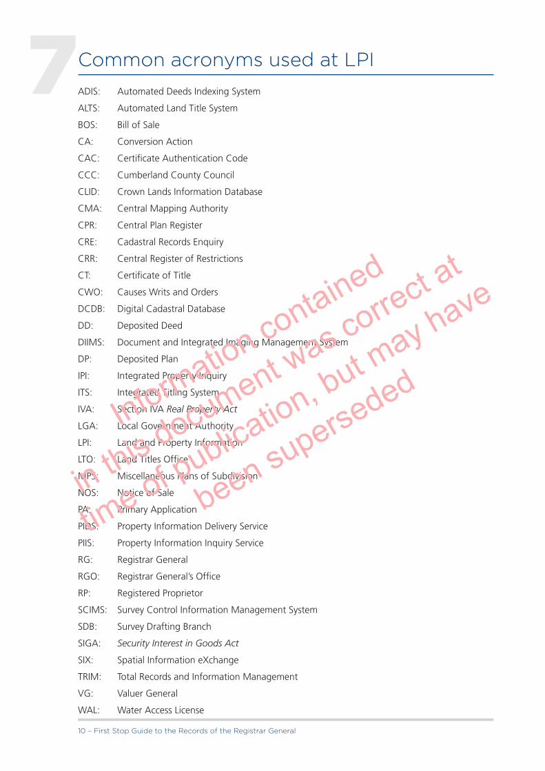
Common acronyms used at LPIADIS: Automated Deeds Indexing System
ALTS: Automated Land Title System
BOS: Bill of Sale
CA: Conversion Action
CAC: Certificate Authentication Code
CCC: Cumberland County Council
CLID: Crown Lands Information Database
CMA: Central Mapping Authority
CPR: Central Plan Register
CRE: Cadastral Records Enquiry
CRR: Central Register of Restrictions
CT: Certificate of Title
CWO: Causes Writs and Orders
DCDB: Digital Cadastral Database
DD: Deposited Deed
DIIMS: Document and Integrated Imaging Management System
DP: Deposited Plan
IPI: Integrated Property Inquiry
ITS: Integrated Titling System
IVA: Section IVA RealPropertyAct
LGA: Local Government Authority
LPI: Land and Property Information
LTO: Land Titles Office
MPS: Miscellaneous Plans of Subdivision
NOS: Notice of Sale
PA: Primary Application
PIDS: Property Information Delivery Service
PIIS: Property Information Inquiry Service
RG: Registrar General
RGO: Registrar General’s Office
RP: Registered Proprietor
SCIMS: Survey Control Information Management System
SDB: Survey Drafting Branch
SIGA: SecurityInterestinGoodsAct
SIX: Spatial Information eXchange
TRIM: Total Records and Information Management
VG: Valuer General
WAL: Water Access License
7
Information contained
in this document was correct at
time of publication, but may have
been superseded

Land and Property Information – 11
Glossary of common land titling termsAbstract of Title: A listing of documents comprising the chain of evidence to a person’s estate or interest in land.
Accretion: The acquisition of extra land from the sea or its inlets, or from a stream, by natural, gradual and imperceptible means.
Ad Medium Filum: The ‘middle thread’ of a non-tidal stream or road. There is a rebuttable rule of construction (not applicable to a public road) that the title to land abutting a non-tidal stream or road extends to the middle thread of the stream or road unless the rule of construction has been rebutted - known as the ‘ad medium filum rule’.
ADIS: Automated Deed Indexing System. The electronic index of the General Register of Deeds currently in use in LPI.
Alienated: The capacity for a piece of property or a property right to be transferred by grant or purchase from the Crown.
Allotment: The smallest subdivision of land in a section of a town or village map.
ALTS: The Automated Land Title System based on the computerised RealPropertyActRegister. Now superseded by the Integrated Titling System (ITS).
Appropriation: In relation to land, the taking of Crown Land by a Crown authority for the purpose of a public work, not effective against land or an easement held by the Commonwealth of Australia.
Appointment of Receivers: The act of making a person or firm responsible for the function of holding property for safe keeping or its administration for the sale and recovery of another person’s debt.
Armstrong Plans: This early series of plans bear the name of the nineteenth century surveyor John Armstrong who prepared and subsequently donated them to the office.
Assign: The act of transferring a property, interest or equity to the legal successor of ownership.
Association Property: The communal property created in a community, precinct or neighbourhood plan.
Attestation: The witnessing of the signature or execution of a document.
Bankrupt: A financially depleted person, i.e. a person against whose estate a sequestration (seizure) order has been made, or who has become bankrupt by virtue of the presentation of a debtor’s petition.
Beneficiary: A person acquiring land or other forms of property under a will.
Bill of Sale: A mortgage of goods and chattels (personal property) given in security for money borrowed - does not affect land.
Cadastre: Boundaries, roads, waterways, parcel identifiers and names, etc which define the subdivision pattern of a locality on the ground.
Caution: Warn or advise. See Qualified Title.
Cause: Any grounds for legal proceedings before a court.
Caveat: A caveat represents a caution noted on a legal file, litigation or title, warning of a person’s interest in the title.
Certificate of Title (CT): A document; the counterpart of the Register that provides a landowner with the right to deal with their land.
8
Information contained
in this document was correct at
time of publication, but may have
been superseded

12 – First Stop Guide to the Records of the Registrar General
Charge: A burden on land created for the purpose of securing the payment of an annuity, rent-charge or sum of money other than a debt.
Charting Map: Charting maps are the most current maps used by searchers for determining the spatial integrity and status of land.
Check Survey: Also known as examination surveys. Plans drawn by departmental surveyors to check and confirm the standard of work of other surveyors’ plans lodged for registration.
Community Plan: A plan of subdivision subject to the Community Land Development Act 1989 that divides land into two or more community development lots and at least one community property lot. Shows a subdivision of land consisting of private lots and common property, where the proposed future uses of the lots can be specified.
Community Scheme: A community, precinct or neighbourhood development subdividing land under the provisions of the Community Land Development Act 1989. Has up to three tiers of management called, ‘Community’, ‘Precinct’ and ‘Neighbourhood’ Associations.
Computer folio: A folio of the Register that is an electronic file not a manual folio.
Conditional Purchasers Index: This is an index of statutory transfers of un-alienated Crown Land under the Crown Lands Consolidation Act which were registered under the Registration of Deeds Act by the then Lands Department. This index was discontinued at the end of 1967.
Conversion Action: An action initiated by LPI to convert Old System land to Torrens title.
Covenant to Produce: This shows a list of Old System documents that need to be produced and handed over at settlement and is normally recorded in the second schedule of an Old Systems deed. (This record is useful for searchers as it provides a list of references for all the documents related to a title.)
Crown Authority Plans: Plans prepared between 1943 and 1958 for government authorities (including the former Rural Bank) and not requiring council approval. It was thought they were not eligible for registration in the plan series provided by the Conveyancing Act Regulations of 1930.
CRR: Central Register of Restrictions – a database developed by LPI to provide a centralised information database to record potential interests in land by government agencies or other authorities.
DCDB: Digital Cadastral Database – the legal digital parcel fabric (current subdivisional pattern) of the State supplied by LPI.
Dealing: Any instrument other than a grant or caveat which is registrable or capable of being made registrable under the provisions of the RealPropertyAct1900, or in respect of which any recording in the Register is by this or any other Act or any Act of the Parliament of the Commonwealth required or permitted to be made. This includes plans. When used generally, dealing refers to a transaction affecting land under the RealPropertyAct1900 evidenced by a transfer, mortgage or lease etc.
Dealings: The recording of the effect of a dealing against the relevant folio of the Register. Such recording usually results in a change of ownership or entry/removal of a second schedule notification.
Dealings File: The file of Real Property instruments registered with LPI since 1863.
Deceased Estate: Property belonging to a deceased (dead) person or persons.
Deed: Any legal document prepared for some purpose in relation to land which has been signed and executed. It may or may not be registered in the General Register of Deeds in LPI.
Delivery Box: An LPI client document delivery reference system whereby a numbered and keyed secure locked box is provided in which certificates of title, duplicate dealings and other documents are placed for an entitled party to accept delivery.
Information contained
in this document was correct at
time of publication, but may have
been superseded

Land and Property Information – 13
Delivery Direction: An instruction given on a dealing (for example) to deliver it and any other documentation to a particular party by post or delivery box.
Deposited Deed Index: The Conveyancing Act 1919 allowed for the permanent depositing of documents (deposited deeds, or DD’s) by the public with the Registrar General. This index was merged with ADIS in 1992, which was superseded by ITS in 2000.
Deposited Plan: A plan of land deposited in LPI, which was neither attached to a dealing or deed nor lodged for the purposes of a strata scheme. The Registrar General may, for convenience, number or re-number other plans as deposited plans or prepare deposited plans of his own motion.
Development Contract: Instruments, plans and drawings which are registered with a strata or community scheme and describe the manner in which the developer intends to further develop the land in the scheme.
Development Lots: A term used to specifically identify strata lots created in a staged development Strata Plan specifically for further subdivision development.
Devisee: A person acquiring land under a will.
Devolution of Law: The passing of title to land by the operation of law e.g. by a will or by the laws of distribution out of an intestate estate.
Discharge of Mortgage: An acknowledgement in writing by the mortgagee that the principal and interest secured by a mortgage have been repaid in full.
Dominant Tenement: Any land to which the benefit of an easement is appurtenant, also being the land which benefits from the use of the easement.
Draft: Hand written instruction, arising from a dealing, from which the information for a new manual folio of the Register (Vol. Fol.) is taken.
Easement: A right attached to land (the dominant tenement) to use other land (the servient tenement) for a specified non-exclusive purpose known to the law (e.g. right of carriageway, easement to drain water). However the law recognises an easement in favour of a statutory authority without a dominant tenement, described as an ‘easement in gross’.
Encumbrance: Any burden on land, e.g. mortgage or lien.
Epitome of Title: A summary of title listing the documents comprising an Old System (or common law) chain of title.
Equity of Redemption: The right of a mortgagor at common law to redeem the land conveyed by way of mortgage and so obtain a re-conveyance.
Estate: An interest in land, e.g. an Estate in Fee Simple or Leasehold Estate.
Estate in Fee Simple: The greatest estate in land that can be held against the Crown. It is characterised by its inheritability, i.e. it is capable of being passed to heirs and/or assigns forever or for so long as an owner can be found. The estate may be passed by a grant from the Crown; by deed, transfer or will; or by devolution of law etc.
Estate in Remainder: An estate limited to take effect and be enjoyed after another estate has been determined.
Execution: The act of signing and sealing a document or instrument in the presence of witnesses.
Executor: Person appointed by the testator to carry out the provisions of the will.
Fiduciary: A person who is under an obligation to act in another person’s interest, e.g. a trustee, executor or administrator.
Information contained
in this document was correct at
time of publication, but may have
been superseded

14 – First Stop Guide to the Records of the Registrar General
Field Book: Books containing a surveyor’s field notes taken during surveying. It may also include details of interest about the topography, soil types, vegetation, environmental features, occupations, improvements and meteorological conditions at the time of the surveys.
Field Plan: Plans filed with the Registrar General for various purposes prior to 1961, now redefined as deposited plans.
First Schedule: The part of a Torrens folio which sets out the ownership details (names of the registered proprietors, shares etc).
First Title: A reference to the first title to a land parcel after alienation from the Crown.
Folio of the Register: The record of title and interests, in respect of a parcel of land, kept by the Registrar General as part of the Register - it may be either a ‘manual’ folio or a ‘computer’ folio.
Folio Instruction: A direction from Crown Lands NSW, on how a new Torrens title for land held by the Crown will be issued. Folio instructions replaced the traditional Crown grant.
Freehold: The status of land held under an estate in fee simple following alienation from the Crown.
Good Root of Title: The starting point from which title to Old System land may be considered acceptable. It is usually a conveyance or mortgage for valuable consideration which is at least 30 years old at the time of the search.
Grant: The passing of ownership from the Crown to a private individual(s). The land is said to be ‘alienated from the Crown in fee’.
Head Title Reference: Head Title generally refers to the title that is for the ‘Fee Simple’ estate. Sometimes relating to land with leasehold estates. Reference to the title issued for the head (first) lease of which sub-leases are issued for premises (part).
Heirs and Assigns: Persons who succeed by bloodlines or nomination of Real Property and/or to whom property is transferred.
Hiatus: An unintended gap left between two land parcels, deeds or land titles.
Historical Land Records Viewer: A software application for searching and viewing images of historical maps, plans, titles and indexes.
Housing Commission Plans: Plans prepared by the Housing Commission not requiring Council’s approval. Accepted by the Registrar General between 1943 and 1958 and now re-catalogued as deposited plans.
Incomplete Purchase: A partially paid off purchase of Crown land.
Indefeasibility: The accepted premise that a Torrens title cannot be set aside because of some defect in the history of the title prior to the registration of an interest. A third party cannot be disadvantaged because of the fraud of a second party. The guarantee given to Torrens title by the State Government of NSW.
Instrument: Any grant, Certificate of Title, conveyance, assurance, deed, map, will, probate, or any other document in writing relating to the disposition, devolution or acquisition of land or evidencing title thereto.
Intestate: A situation where the deceased has not left a valid will.
ITS: Integrated Titling System – the electronic titling system developed by LPI.
IVA: An early form of Conversion Action under Sec IVA of the RealPropertyAct to convert land from Old System to Torrens title.
Joint Tenancy: A form of equal joint ownership of a parcel of land by two or more persons. The interest of a deceased proprietor automatically vests in the survivors.
Information contained
in this document was correct at
time of publication, but may have
been superseded

Land and Property Information – 15
Land: Land, messuages, tenements, and hereditaments corporeal and incorporeal of every kind and description; or any estate or interest therein, together with all paths, passages, ways, watercourses, liberties, privileges, easements, plantations, gardens, mines, minerals, quarries, and all trees and timber thereon or thereunder lying or being unless any such are specially excepted. Where these definitions are not applicable, or there is nothing evident in rebuttal, the common law definition applies, i.e. land extends from the centre of the earth to the sky, including not only the surface but also the soil beneath it and the air above it and all things growing on it or attached to it, but does not include minerals belonging to the Crown. For the definition of land in a strata scheme see Registrar General’s Directions for Strata Schemes http://rgdirections.lpi.nsw.gov.au.
Land Board: An independent panel set up to rule on disputes in relation to land and water management including floodplain management.
Land Titles: Those documents/deeds purporting to prove the ownership of either Torrens or Old System land.
Lease: An instrument creating an interest in land for a fixed term, usually in consideration of a payment of rent.
Leasehold Estate: The interest in land or premises held under a lease by a lessee.
Lessee: The person to whom land or premises is leased.
Lessor: The person, usually the registered proprietor, who leases land or premises in return for payment of rent.
Letters of Administration: An authorisation granted by the Court to persons to administer the estate of a deceased person who has died intestate, or who died testate without having appointed an executor.
Lien: In relation to a document, a right to retain the document until a debt is satisfied.
Life Estate: An estate of freehold land held during the life of the tenant or for the duration of another’s life.
Limitation: A recording in a folio of the Register to the effect that the description of the land in the folio has not been investigated by the Registrar General and the boundaries of which are not guaranteed until defined in a new plan of survey.
Limited Title: A Certificate of Title issued for land converted from Old System title whereby the boundaries have not been adequately defined in a plan of survey and/or have not been investigated in LPI. A limitation is recorded in the second schedule.
Litho Plans: Originally a print prepared from an inked wood or stone block or metal plate. Smaller than Roll Plans, plans produced by auctioneers as sale lithographs, acquired by the Registrar General, usually of Old System land without council approval between 1863 and 1965.
Local Council: The Council for a city, municipality or shire elected by property owners for the purpose of local government.
Lodgment: The acceptance by LPI of dealings, plans and other documents, either by hand or online, for processing and registration within the office.
Loose Leaf Register: Hard copy ‘New Form’ titles (after Vol.8497 Fol.198 to last register book, 1961-ALTS) filed singularly in a security area in LPI.
Lot: The description of land parcels or areas of subdivison within a deposited or strata plan.
LPI: Land and Property Information.
Management Statement: A statement lodged with a community scheme and some strata schemes which sets out the by-laws and other particulars governing participation in the development.
Information contained
in this document was correct at
time of publication, but may have
been superseded

16 – First Stop Guide to the Records of the Registrar General
Memorial: An inscription on a Register or Certificate of Title detailing registration of a dealing affecting that title.
Metes and Bounds: A traditional method of describing land in which the boundaries of land parcels are recorded in terms of direction and distance.
MHWM: Mean High Water Mark. The line defining the mean between the high tides at ordinary spring and neap tides.
Minor: A person under the age of 18 years. A minor does not have full legal capacity and cannot make a will.
Moiety: An archaic term used in law to mean ‘half’.
Monument: In surveying it means a natural or artificial object or point thereon or mark, which object, point or mark is used for the purpose of locating a boundary or a point thereon.
Mortgage: In relation to land held under common law, a conveyance of land subject to an equity of redemption. In relation to RealPropertyAct land, a charge on the land created merely for securing payment of a debt.
Mortgagee: The proprietor of a mortgage, i.e. the party lending the money.
Mortgagor: The proprietor of land, or any estate or interest in land, pledged as security for a debt.
MPS: Miscellaneous Plan of Subdivision – Old System (OS) and Torrens title (RP). These plans were discontinued in 1961. Existing plans were renumbered in the DP300,000 (RP) and DP150,000 (OS) series.
Neighbourhood Plan: A community scheme subdivision which is either non-staged and creates neighbourhood lots and neighbourhood association property; or a stand alone scheme; or as the final tier in a staged development.
Norton Plans: This early series of plans bear the name of the nineteenth century surveyor who prepared and subsequently donated them to the office.
Notice of Death: An application which declares the death of a joint tenant and by which the survivors automatically acquire the interest of the deceased pursuant to the RealPropertyAct1900.
Notification: A recording or other entry made in the second schedule of a folio of the Register.
Occupational Boundary: As applied to adverse possession of Real Property Act land, an occupation that represents or replaces an original boundary of a whole parcel.
Occupations: Physical features such as walls and fences associated with boundaries limiting the extent to which a parcel of land is occupied.
Old System: The system of land ownership inherited from Great Britain.
Old System Land: Land alienated from the Crown prior to 1863 and not yet brought under the provisions of the RealPropertyAct1900.
Ordinary Folio: A folio of the Register that is not a qualified folio or a limited folio.
Orientation: The alignment of directions in relation to a specified origin.
Overlap of Deeds: The situation arising where the metes and bounds descriptions of two parcels of land which nominally adjoin are in conflict, so that the deed for each includes land comprised in the other.
Owners Corporation: Comprises all proprietors of the lots from time to time in a strata scheme. It is responsible for the upkeep and maintenance of the building and other common property and the general finance and management of the scheme.
Information contained
in this document was correct at
time of publication, but may have
been superseded

Land and Property Information – 17
Parcel: An area of land defined by measurement as a lot in a deposited plan or as a Crown portion or allotment.
Parish: One of 7,515 areas formed by the division of 141 counties. Counties and parishes are administrative divisions of the state and are not separately disposable land parcels. Parishes are divided into separately disposable parcels called ‘portions’, these being the common basic units of land disposed of by the Crown. Other basic units are ‘allotments’ in government towns and villages.
Permanent Mark: A mark of a permanent nature (usually identified by a combination of letters and numbers) which provides the means for all surveys to be related to the State Survey Control Common Co-ordinate System. See also ‘Established Permanent Mark’ and ‘SCIMS’.
Perpetual (Lease): A lease forever, unlimited in time.
Personal Representative: The executor or administrator of an estate.
PIIS: Property Information Inquiry Service - a commercial business enterprise operated by LPI. The service enables the public to obtain certificates and clearances for conveyancing purposes.
Pipeline Plan: A plan defining land or the site of an easement vested or to be vested in an applicant for license under the PipelineAct1967.
Plans: Records the registration pattern of subdivision on various media, is given a legal identity and lots in the plan may be sold as such at this point.
Plot: To mark a course on a map or a small piece of land.
Portion: When referring to a parcel of land means the basic land unit capable of separate disposition created by the Crown within the boundaries of a parish. A typical description of such a land unit would be Portion 6, Parish of Sutherland, County of Cumberland. A portion may be further subdivided after alienation from the Crown, in which case that portion ceases to be a separately disposable parcel.
Possessory Title: Title acquired without formal conveyance but by reason of occupation or possession for a statutory period. The Common Law has always regarded possession, as prima facie evidence of ownership in fee, and a trespasser (or adverse occupier) if allowed to run an unmolested course of possession, will, in time, effectively bar the rights of the documentary owner to recover this land.
Power of Attorney: A legal document made by one person, who is called the ‘principal’, that allows another person to do things with the principal’s money, bank accounts, shares, real estate and other assets. This can include spending and managing the principal’s money, buying or selling shares for the principal, or buying, selling, leasing or mortgaging the principal’s house or other real estate. The person who does these things for the principal is called the ‘attorney’. A principal is sometimes called the ‘donor’ and an attorney is sometimes called the ‘donee’.
There are two types of powers of attorney: General Power of Attorney (also called an ordinary power of attorney) and Enduring Power of Attorney.
Precinct Plan: A subdivision of community development lots to create a precinct scheme within a community scheme (made up of precinct development lots and precinct association property). This allows for another tier of management and development in a community development scheme.
Prescribed Authority: A government, semi-government or corporate body authorised, as the dominant tenement of an easement, to put a positive covenant or restriction on the use of land. Authorisation for any body benefitting from a profit á prendre is not required as no dominant tenement is created.
Prescribed Diagram: A diagram attached to a community management statement showing the position of any existing or proposed service lines.
Information contained
in this document was correct at
time of publication, but may have
been superseded

18 – First Stop Guide to the Records of the Registrar General
Prescribed Functionary: A person who has an official appointment before whom a statutory declaration or other official document may be executed. Their authority to attest an execution is provided for in the laws of the state or country in which the document is executed. If executed in the State of NSW, the document must be attested to by a justice of the peace, a solicitor, a notary public or a commissioner for taking affidavits. If executed outside the State of NSW, strike out reference to the OathsAct1900 and insert reference to the equivalent local law. The document must then be signed in accordance with the local law.
Prescription: The acquisition of an easement by immemorial use (taken to be at least 12 years). While recognised by the courts, such easements are not certifiable under the RealPropertyAct1900.
Primary Application: An application to bring Old System land under the provisions of the Real PropertyAct1900.
Prior Title Reference: The reference number of the title from which a new folio was derived.
Produced: For example: Produced in the Office of the Registrar General. ‘Production’ has a corresponding meaning.
Profit á Prendre: A right to enter land you do not own and take or remove the produce or part of the soil of that land, e.g. rights of common, of pasture, of vesture and herbage, cropping, gravel or timber.
Prothonotary: Lawyer or the chief clerk in some courts of law.
Public Authority: Includes the Council of a local government area and any corporation prescribed as such by the regulations.
Public Road: A road opened or dedicated for the free right of passage of the public on foot or in a vehicle etc and declared as such under the Roads Act 1993.
Qualification: A condition that modifies, limits or restricts ‘fee simple’ ownership of title.
Qualified Title: A folio of the Register in which is recorded a ‘caution’ that has not been cancelled. A caution warns persons dealing with the registered proprietor that the land is held subject to any ‘subsisting interests’ that may exist under Old System.
Receiver: A person authorised to manage the affairs of a bankrupt, or a person appointed by a mortgagee to manage the financial affairs of the mortgagor. This applies to both individuals and companies.
Rescission: The act of rescinding. A termination of a contract either by an act of the parties to the contract or a court.
Reference Sheet: Another term for a cadastral map.
Register: The Register required by the RealPropertyAct1900 to be kept for the purposes of that Act.
Registered Plan: A category of plan of subdivision being a plan of survey containing five or more lots of land held under common law title, and registered by the Registrar General. This plan series was discontinued in 1961. Existing plans were renumbered in the DP37,000 series.
Registered Proprietor: The person(s) seized or possessed of the freehold or other estate or interest in land and recorded on the title as being the owner.
Registrar General: A statutory position originally constituted under the RegistrationofBirths,DeathsandMarriagesAct1855(19VicNo34) to register births, deaths and marriages but later to keep registers of many things including deeds, plans and titles.
Registration: To make an entry in a Register. Also the process of examining a document to ensure compliance with legislation prior to entry in the register. The recording of the effect of a dealing or plan against the relevant folio of the Register.
Information contained
in this document was correct at
time of publication, but may have
been superseded

Land and Property Information – 19
Re-lodgment: The subsequent lodgment of a dealing, plan or other document following uplifting and compliance with an LPI requisition.
Requisition: A form or letter requiring that certain action be taken, done, given, amended, furnished, etc to allow a dealing, plan or other document to be registered.
Residue: Land remaining in an otherwise cancelled folio of the Register, e.g. sites of roads remaining after the folio has been cancelled by subdivision.
Restrictive Covenant: Originally a covenant by the purchaser with the vendor not to use the land for a specified purpose or in a specified manner. To be enforceable against the purchaser and successors in title it must be restrictive in nature and may not impose a duty to do any positive act, whether or not it involves spending money. Now called a ‘restriction on the use of land’, it is usually created by Section 88B Instrument.
Resumption: The compulsory taking of land or an easement by the State of NSW or a statutory authority under an Act of the State by a notification in the NSW Government Gazette.
Resumption Application: An application to the Registrar General by a resuming authority to be recorded as the registered proprietor of land.
Reversion: The interest in an estate that reverts to the grantor or his/her heirs at the end of a period.
Riparian: Relating to rivers, streams or any other natural watercourse.
Riparian Rights: The rights of the proprietor of a parcel of land abutting a stream to use the water flowing through it.
Roll Plan: A plan of Old System subdivisions, usually of a larger size, that is rolled for storage.
Scheme: A plan adopted for residential development i.e. a community scheme, a precinct scheme, a neighbourhood scheme or a strata scheme.
SCIMS: Survey Control Information Management System - the computer database of the State Control Survey network. SCIMS allows access to survey control information including permanent marks and co-ordinates.
Search: To search is the act of inspecting the Register for title information required to prepare documents; or to satisfy inquiries on Reference Sheets, maps or plans for survey information required for the investigation of deposited plans or strata plans.
Search Sketch: A diagrammatic record of the documents forming the chain of title. It illustrates the land description in each successive deed.
Second Schedule: That part of a folio which lists exceptions, restrictions, easements and other interests or notifications affecting the land.
Section 88B Instrument: An instrument under the Conveyancing Act 1919 lodged with a Deposited Plan to create easements, restrictions on the use of land and positive covenants upon registration of the plan.
Strata (stratum): The concept of layer upon layer of lots stacked one on top of the other.
Stratum Lot: A parcel of land restricted in height and/or depth by reference to Australian Height Datum (AHD) or other datum approved by the Surveyor General.
Strata Lot: A lot defined in a plan lodged under strata scheme legislation. Includes lots wholly or partially inside a building; external lots (that may be wholly or partially covered) and open space lots.
Strata Plan: A plan lodged with and approved by LPI defining lots by cubic space(s) with the facility to provide common areas, subdivision, consolidation, etc.
Strata Scheme: A plan lodged under the StrataSchemes(FreeholdDevelopment)Act1973 and related Acts, creating strata lots and common property.
Information contained
in this document was correct at
time of publication, but may have
been superseded

20 – First Stop Guide to the Records of the Registrar General
Stratum Subdivision: The division of land in which at least one boundary between the lots in the subdivision is defined by a plane that is not vertical i.e. horizontal or inclined planes. This type of boundary results in the creation of lots on top of each other.
Sub-lease: A lease of a lease.
Subdivision: The division of land into parts for separate occupation and/or disposition. The land may be subdivided either vertically or by stratum.
Subdivision Certificate: The consent of the required authority (i.e. Local Council, accredited certifier or the Crown) to the subdivision of land. Endorsed in the panel on the plan.
Survey (Plan): A representation or drawing of land surveyed which has been prepared from the particulars recorded in a field book of a surveyor.
Survey Drafting Branch: A separate section set up within the Registrar General’s and Land Titles Office where plans were deposited, registered and land titles created for land within the plans.
Tenancy in Common: Each tenant has a share in the entirety which does not accrue to partners on death. It may be disposed of during life or transmitted on death, either by will or according to the laws governing distribution. The shares may be equal or unequal and may be created separately.
Tenure: The mode of holding or occupying unalienated Crown Land e.g. conditional purchase, perpetual lease etc.
Testator/Testatrix: A person who has died and left a will.
The Register: The Registrar General’s Office record of ownership, restrictions and encumbrances affecting RealPropertyAct land.
Title Conversion: The action taken within LPI to convert parcels of Old System land to Torrens title. It includes actions under Part IVA RealPropertyAct1900 and the more recent Conversion Actions (CAs).
Title Diagram: A diagram or plan endorsed on or referred to in a folio of the Register, illustrating the land in that folio.
Torrens: The system of title (or land) registration devised by Robert Richard Torrens.
Torrens title: A term used to describe the system of title (or land) registration devised by Robert Richard Torrens, and adopted in NSW in 1863 under the RealPropertyAct1862.
Torrens Title Purchasers Index: An alphabetical and chronological listing of persons becoming owners of Torrens land and leasehold estates. This manual index was created in 1863 (with the advent of the RealPropertyAct1862) when a register was established to record all Torrens title grants, purchases and registered lessees.
Transfer: The passing of any estate or interest in land under the RealPropertyAct1900, whether for valuable consideration or otherwise.
Transfer for Value: An interest in land transferred to another person for valuable consideration whether monetary or other valuable benefit or a near market price.
Transferee: The person to which the estate or interest is being transferred.
Transferor: The person transferring the estate or interest.
Transmission: The acquirement of title to or interest in land consequent on the death, will, intestacy or bankruptcy of a proprietor.
Transmission Application: An application which entitles executors, beneficiaries, etc to be registered as proprietors through the will or estate of a deceased person, pursuant to the Real PropertyAct1900.
Information contained
in this document was correct at
time of publication, but may have
been superseded

Land and Property Information – 21
Trustee: The person who holds property on trust for another. The prime duty of a trustee is to carry out the terms of the trust and preserve safely the trust property.
Trustee in Bankruptcy: An official appointed to manage the affairs of a bankrupt (as regards a person).
Unalienated Crown Land: Crown Land, under the care and control of the Minister administering the Crown Lands Act 1989, which is not subject to any tenure or resumption by a Government Gazettal.
Unregistered: A term applied to dealings or plans which have not been registered in LPI or put on public record.
WAL: Water Access Licence.
Wells Plans: This early series of plans bear the name of the nineteenth century surveyor William Henry Wells, who prepared and subsequently donated them to the office.
Will: A disposition or declaration by which the person making it (the testator) provides for the distribution or administration of property after his death.
Writ: An order directing an officer of the court to enforce a judgment in a specific manner. A Writ of Execution can mean a writ of levy for property, a writ for possession, a writ for delivery, a writ of sequestration or a writ in aid of any of these writs.
For additional information, the Registrar General’s Directions website provides a more comprehensive glossary: http://rgdirections.lpi.nsw.gov.au.
Information contained
in this document was correct at
time of publication, but may have
been superseded

22 – First Stop Guide to the Records of the Registrar General
Useful links
LPI websitewww.lpi.nsw.gov.au
Online Shophttp://shop.lpi.nsw.gov.au
Authorised Information Brokerswww.lpi.nsw.gov.au/land_titles/online_information/information_brokers
SIX Mapswww.six.nsw.gov.au
Historical Land Records Viewerhttp://images.maps.nsw.gov.au/pixel.htm
Registrar General’s DirectionsAn online guide to land title practice and procedures and requirements relating to the preparation of plans and documents intended for lodgment and registration with LPI. http://rgdirections.lpi.nsw.gov.au
BaselineThis portal incorporates LPI’s historical collections, cultural heritage sites and archival projects. The site has a number of FAQs relating to searching the records and archives of the Registrar General. www.baseline.nsw.gov.au
Mapping and Spatial Informationwww.lpi.nsw.gov.au/mapping_and_imagery
Property and Information Serviceswww.lpi.nsw.gov.au/land_titles/property_information
9
Information contained
in this document was correct at
time of publication, but may have
been superseded

Land and Property Information – 23
Further readingButt, P., Land Law 1996 3rd Edition, Federation Press
Kass, T., Jewels in the Crown – A History of the Bridge Street Plan Room and Crown Plans, Department of Lands, 2008
Kass, T., Sails to Satellites – The Surveyors General of NSW (1786-2007), Bathurst, Department of Lands, 2008
10
Information contained
in this document was correct at
time of publication, but may have
been superseded

24 – First Stop Guide to the Records of the Registrar General
Land and Property Information1 Prince Albert Road
Queens SquareSYDNEY NSW 2000
T: 1300 052 637T: +61 2 9228 6666F: +61 2 9233 4357
© March 2013 LPI (B) P13/10/008
Information contained
in this document was correct at
time of publication, but may have
been superseded