Embed Size (px)
Citation preview

PELAGIC FISH ABUNDANCE FROM SEMARANG (CENTRAL JAVA) TO SOUTH CHINA SEA IN APRIL 1993
D. PETIT, D. NUGROHO, M. POTIER
ABSTRACT An acoustic survey, from Semarang towards the South of China Sea, allows to describe the haline
situation and the distribution of abundance in pelagic fishes at the end of the wet season. At that moment, the fleet of Javanese seiners operates in the south-west of the Natuna Islands, on the depths of 50 meters. The analysis of haline vertical profiles shows the presence of three zones : the Java Sea with vertical gradients due to the coastal desalinization, Karimata Strait with isohaline water at 33.5% and the South of China Sea with deep water at 34%0. The last sector where the fleet was operating, was three times richer than the Javanese waters at that time. Without direct correlation with that, the zonation of the abundance (scattered or aggregated fishes) follows the zonation of salinity. The water of the strait is poorer, and the water of the Java Sea is richer while the desalinization is stronger. It seems that the richness of water is particularly related to the bathymetry by the presence of an semipelagic fauna when the bottom exceeds 30 meters. This semipelagic fauna commutes twice migration towards the surface during the night, behaviour which is more accentuated in this fishing zone than in the Java Sea. In the Karimata Strait, where the depth is less than 30 meters, the pelagic and benthic faunas are dominant. In the Java Sea a great aggregation of larva and juveniles has been detected particularly in the South of Belitung Island, that confirms the role of the basin in the reproduction of pelagic species. At that period of the year, it is the slopes of the basin which seem to be richer. These populations, thus, avoid the strong coastal desalinization but also its deeper part. All these observations do not seem to confirm the theory of Hardenberg, which assumes the existence of a migration between the South China Sea and the Java Sea. KEYWORDS : Java Sea, South China Sea, salinity, acoustics, pelagic fish, Carangidae, abundance, shoals, distribution.
ABSTRAK Survey akustik padu peluyaran duri Semurung menuju Laut Cina Selutan memberikun gamburun
tentang keadaan salinitas dun distribusi kelimpahan ikan pelagis pada ukhir musim hujan. Pada saat itu armada kapal pukat cincin yang berbasis di Jawa beroperasi di perairun sebelah tenggara Pulau Natuna dengan kedulamun sekitar 50 meter, Anulisis penampang teguk salinitas sepunjang jalur pelayarun memperlihatkan adanya tiga zona yang berbeda yaitu : zona Laut Jawa dengun gradient tegak salinitas rendah yang disebabkan adanya pengencerun puntai, zona Selat Karimata dengan isohaline 33.5 %o dan zona Laut Cina Selatan 34 %o. Pada zona terukhir ditemukan sejumlah armada penungkapan pukat cincin sekitar tiga kali lebih banyak dibandingkan di Laut Jawa. Tanpa perigujiun langsung terhadup korelasi hal tersebut, zona kelimpahan ikan (tersebur maupun berkelompok) diduga mengikuti zona sulinitas dimana kelimpahan di perairan Selat Karimata terlihat lebiii rendah, tetapi di Laut Jawa Iebih tinggi pada saat berlangsungnya salinitas rendah. Keadaun ini memperlihatkan bahwa kelimpahun tersebut berkaitun dengan kedalaman perairan serta munculnya kelumpok jenis semi pelagis pada kedalaman lebih dari 30 meter. Kelompok tersebut melakukan duu kali ruaya teguk keurah permukaan pada saat malam hari. dimana tingkah laku lebih menonjol di duerah penangkapun di perairun Laut Cina Selutan dibandingkan di Laut Jawa. Di perairan Selut Karimata, dimana kedalamun kurung dari 30 meter kelompok jenis bentik dan semi pelagis diduga lebih mendominusi kelimpahun ikan, sedungkan di Luut Juwu keberudaan kumpulan larva dan yuwanu terdeteksi terutama di perairan sebelah selatan Pulau Belitung. Keudaan ini meneguskan perunun lembah pada reproduksi jenis ikan pelugis. Puda waktu tersebut wilayah lekukun (slopejlembuh nampaknya memiliki kondisi yang lebih subur bugi populusi ikan pelagis untuk menghindari dari proses desalinisasi di pantui serta peruirun yang lebih dulum. Semua observasi ini tiduk menampakkan ketegusun teori Hardenberg (1937) yang menghipotesukun adanya ruayu ikan luyang dari Laut Cina Selatan menuju Laut Jawa. KATA KIJNCI : Laut Jawa, Laut Cina Selatan, akustik, ikan pelagis, Carangidae, kelimpahan, kelompok, distribusi.
Pelugicjìsh from Semarang to south China Seu 159
The fleet of Javanese fishery of small pelagic of the Java Sea achieves every year a seasonal change of location according to meteorological conditions and the migration of fish. These moving have been described by Boely et al. (1988) and Potier and Petit (1995). Operating in the Java Sea, particularly in the East, between July and December, the fleet moves towards the Makassar Strait in the beginning of the year. In March - April, this zone is deserted and during about three months, the seiners make very long trips toward the south of China Sea (at the South of Natuna Islands) to continue the fishing. In the same way fishing sectors of the Java Sea had been explored , it was interesting to discover the fishing zones in this region to evaluate as much as possible the local abundance. It was also worthwhile to know if a continuity of populations exists between the two basins, that of the South of the China Sea and that of the Java Sea. The reason of this curiosity is that the same dominant species are captured in the two regions (Decapterus russelli and D. macrosoma).
MATERIAL AND METHODS
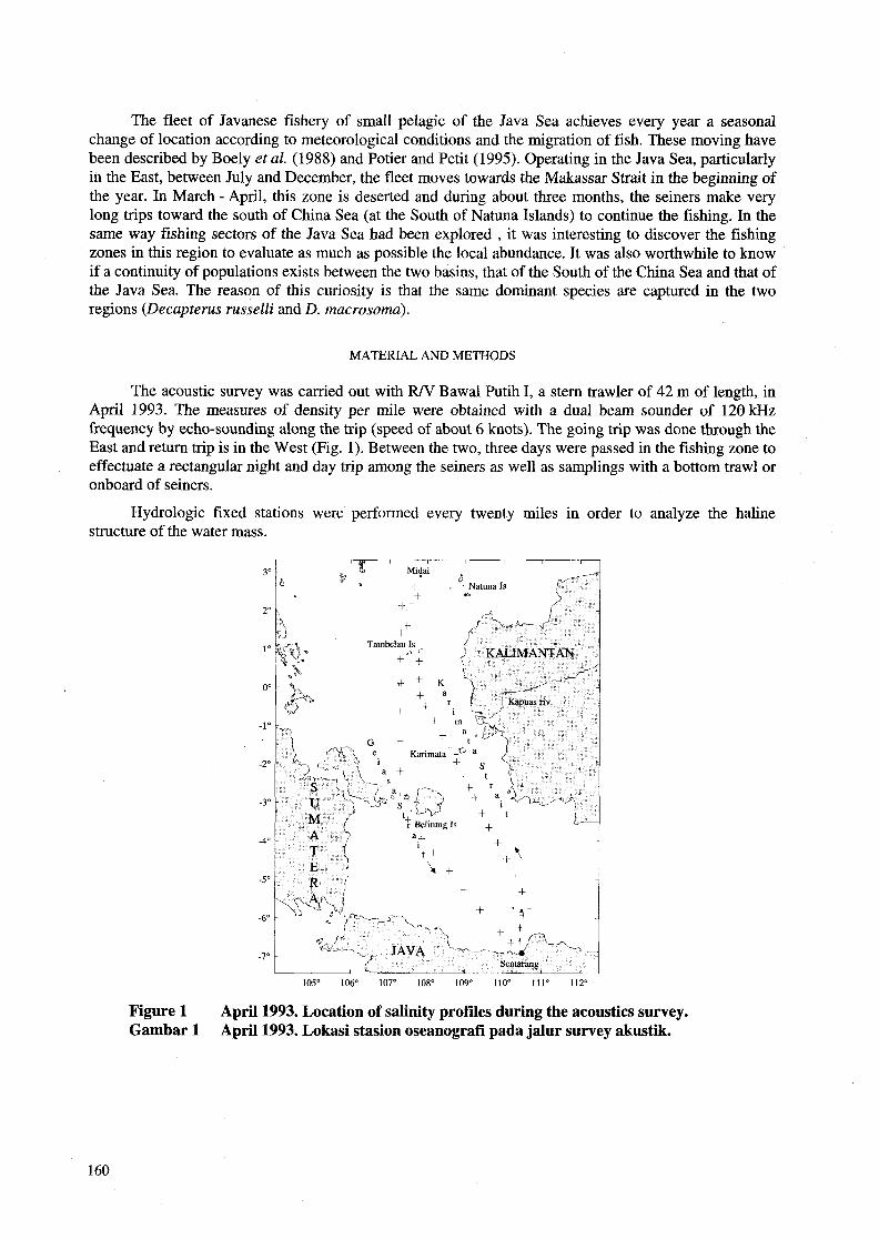
The acoustic survey was carried out with RN Bawal Putih 1, a stern trawler of 42 m of length, in April 1993. The measures of density per mile were obtained with a dual beam sounder of 120kHz frequency by echo-sounding along the trip (speed of about 6 knots). The going trip was done through the East and return trip is in the West (Fig. 1). Between the two, three days were passed in the fishing zone to effectuate a rectangular night and day trip among the seiners as well as samplings with a bottom trawl or onboard of seiners.
Hydrologic fixed stations were performed every twenty miles in order to analyze the haline structure of the water mass.
105' 106" 107" 108" 109' 110" 111" 112"
Figure 1 Gambar 1
April 1993. Location of salinity profiles during the acoustics survey. April 1993. Lokasi stasion oseanografi pada jalur survey akustik.
160
RESULTS
Salinity
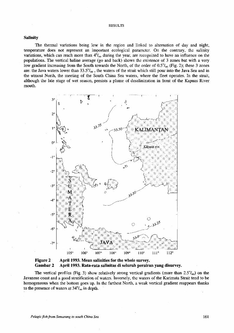
The thermal variations being low in the region and linked to alternation of day and night, temperature does not represent an important ecological parameter. O n the contrary, the salinity variations, which can reach more than 4"/,, during the year, are recognized to have an influence on the populations. The vertical haline average (go and back) shows the existence of 3 zones but with a very low gradient increasing from the South towards the North, of the order of 0.5"/,, (Fig. 2); these 3 zones are: the Java waters lower than 33.5'/,, , the waters of the strait which still pour into the Java Sea and in the utmost North, the meeting of the South China Sea waters, where the fleet operates. In the strait, although the late stage of wet season, persists a plume of desalinization in front of the Kapuas River mouth.
105" 106" 107" 108" 109" 110" 111" 112"
Figure 2 April 1993. Mean salinities for the whole survey. Gambar 2 April 1993. Rata-rata salinitas di seluruh perairan yang disurvey.
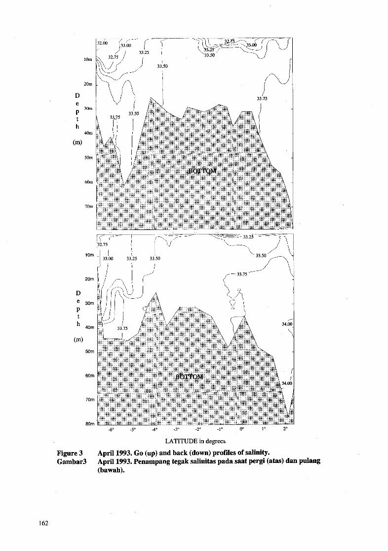
The vertical profiles (Fig. 3) show relatively strong vertical gradients (more than 2S0/,,) on the Javanese coast and a good stratification of waters. Inversely, the waters of the Karimata Strait tend to be homogeneous when the bottom goes up. In the farthest North, a weak vertical gradient reappears thanks to the presence of waters at 34%, in depth.
Pelagicfishfrom Semarang to south China Sea 161
20m
D e P t h
(m)
30m
40m
50m
60m
70m
1 Om
20m
D e 30m P t
40m
(m) 50m
60m
70m
80m
75
33.00 33.25 33.50
-6" -5" -4" -3" -2" -1" O" 1"
LATITUDE in degrees
Figure 3 Gambar3
April 1993. G o (up) and back (down) profiles of salinity. April 1993. Penampang tegak salinitas pada saat pergi (atas) dan pulang (bawah).
162
The to and from trips show that the desalinization and its movement concern particularly the East side of the strait. O n the Javanese coast during a period of ten days, the desalinization has been clearly progressing, thanks to the vertical mixing (homogenization).
Taking into consideration the superficial measures set up in the strait, Wyrtki (1961) described an invasion of the Javanese basin by neighbouring waters at 32.8%0 coming from the North. Although the observations of April 1993 concern the end of the wet season, the vertical profiles seem well to indicate that the desalinization is only superficial and that an important proportion of waters, pouring into the Java Sea, keeps a high salinity.
The abundance of fish
In the going trip as well in the return, the values of average density are low, if compared to those found in the same period along the Javanese coast (Petit et al., 1997) or in the two great surveys of October 1993 and February 1994 (Petit et al., 1995). In the going trip, the average values decrease as soon as the Java Sea is left and increase just when arriving at the fishing zone (Tab. 1). In the return trip, the same phenomenon is noted, taking into consideration that the average on 24 hours, which is high, before the last day, find its value strongly increased by the tneeting of a very important aggregation in the South of Belitung Island.
A detailed analyze of average schedules (Fig. 4) shows that except the strong densities found at the proximity of the fishing zone, the maxima are found in the vicinity of Karimunjawa islands, Karimata and the South of Belitung Island. There could be an island effect of about 40 miles range, but according to the established prospecting, this effect is not distinct from a nocturnal effect on the populations which exists more or less generally. The difference of behaviour between night and day, following the observed zones, is relatively clear. The night/day density ratio decreases when leaving the Java Sea (Tab. 1) and only becomes strong in the fishing zone (Lat. 2'30N).
Spatial structure of populations
The results of the spatio-temporal distribution of the densities analysis are not illustrated. The variograms on the going trip show the existence of a structure of approximately 9 miles of distance (dimension sensibly the same as the one in the Java Sea). At a greater scale, should exist another structure of 75 miles of range, which corresponds to the distance covered day and night and which only reflects the variations of nycthemeral abundance. On return trip, there could also exist another intermediary structure of about 40 miles. But more data are necessary to study it. The fishing zone presents a structure of small dimension (4 to 8 miles). The analysis of that structure is made moreover (Potier et al., 1997) in relation with the distribution of the aggregations and the seiners.
Vertical dis tribu tions
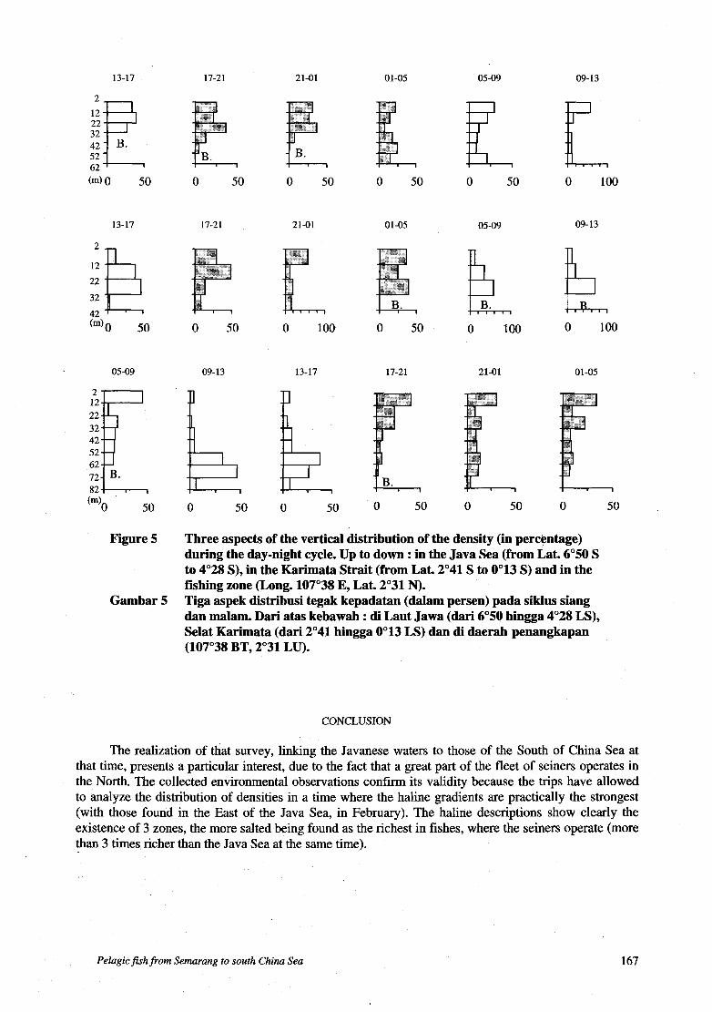
Their nycthemeral variations have been represented as percentage per layer of integration of 1 O m in 4 hours of interval.
The existence of a migratory behaviour is known from vertical moving of maximum of abundance. This simple model assumes that the analyzed population is homogeneous. In a milieu where coexist the pelagic and semipelagic fauna, that is apparently the case in every region, the different behaviours between the two faunas can lead to a change of distribution hardly interpretable. Taking into consideration the nycthemeral relations of density, in this case, can help to understand the observed phenomena.
The migrating movements between night and day have been noted in the same season in the Javanese basin (Petit etal., 1997). Along the survey, they appear through the variations of average density as well as in nycthemeral density ratio. To illustrate these movements, vertical distribution profiles are represented in the 3 sectors which, regarding the environmental conditions and level of abundance, appear as characteristics.
Pelagic fish from Semarang to sorrtk China Seo 163
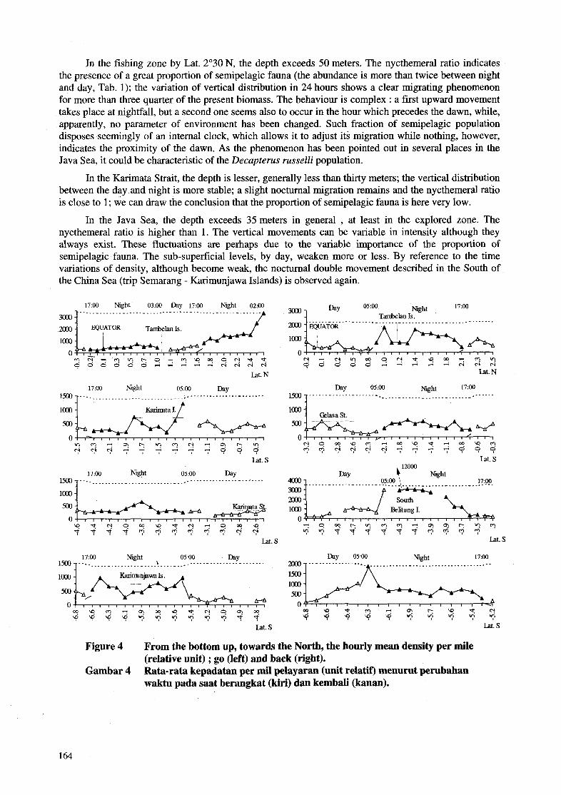
In the fishing zone by Lat. 2'30 N, the depth exceeds 50 meters. The nycthemeral ratio indicates the presence of a great proportion of semipelagic fauna (the abundance is more than twice between night and day, Tab. 1); the variation of vertical distribution in 24 hours shows a clear migrating phenomenon for more than three quarter of the present biomass. The behaviour is complex : a first upward movement takes place at nightfall, but a second one seems also to occur in the hour which precedes the dawn, while, apparently, no parameter of environment has been changed. Such fraction of semipelagic population disposes seemingly of an internal clock, which allows it to adjust its migration while nothing, however, indicates the proximity of the dawn. As the phenomenon has been pointed out in several places in the Java Sea, it could be characteristic of the Decupterus russe22i population.
In the Karimata Strait, the depth is lesser, generally less than thirty meters; the vertical distribution between the day and night is more stable; a slight nocturnal migration remains and the nycthemeral ratio is close to 1; we can draw the conclusion that the proportion of semipelagic fauna is here very low.
In the Java Sea, the depth exceeds 35 meters in general , at least in the explored zone. The nycthemeral ratio is higher than 1. The vertical movements can be variable in intensity although they always exist. These fluctuations are perhaps due to the variable importance of the proportion of semipelagic fauna. The sub-superficial levels, by day, weaken more or less. By reference to the time variations of density, although become weak, the nocturnal double movement described in the South of the China Sea (trip Semarang - Karimunjawa Islands) is observed again.
17:OO Night 03:OO Day 17:OO Night 02:OO ....................................................
mgz&???sYm?msc?;z 0 0 3 3 3 1 - 4
Lat. N
17:OO Night 05:OO Day 1500 ......................................................... I KarinrltaI. t
Lat. s 17:OO Night 05:OO B Y
1500 ................................................. -.. '. ...
loo0
? t q 9 ? ? ? " 1 9 4 ? t t P P 3 3 3 3 3 3 " ?
Lat. s
17:OO Night , 05:OO B Y - ............... ....... ................... -. .............
17:00
Tanbelan Is.
loo0
g z g ~ x ~ ~ ~ ~ ~ ~ ~ ~ Lat. N
Day 05:OO Night 17:OO .................... ...... . .......
........... 05:OO h Y ..- m
P
Day 0500 Niht 1700 .. - ............. ...... ................ 'A
Lat. s
Figure 4
Gambar 4
From the bottom up, towards the North, the hourly mean density per mile (relative unit) ; go (left) and back (right). Rata-rata kepadatan per mil pelayaran (unit relatif) menurut perubahan waktu pada saat berangkat (kiri) dan kembali (kanan).
164
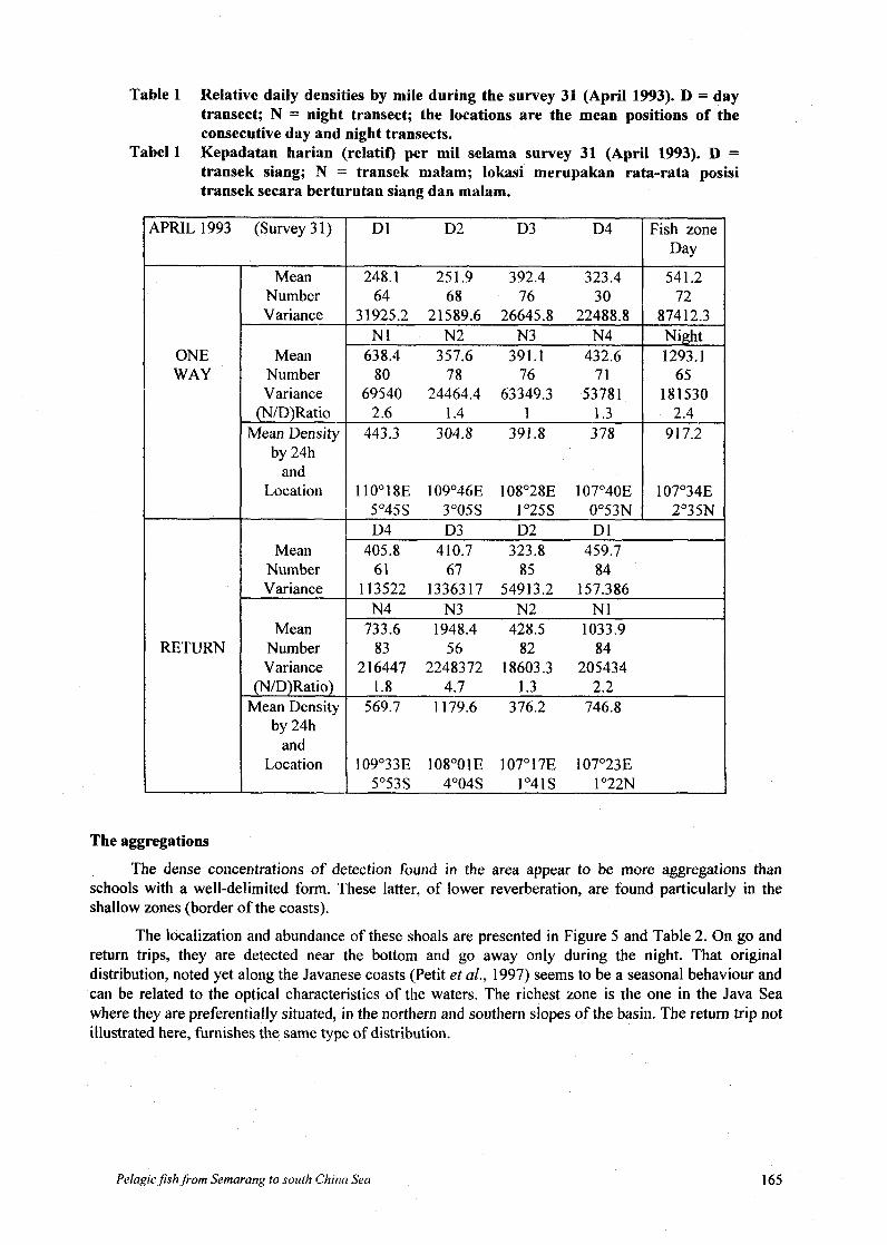
Table 1 Relative daily densities by mile during the survey 31 (April 1993). D = day transect; N = night transect; the locations are the mean positions of the consecutive day and night transects. Kepadatan harian (relatif) per mil selama survey 31 (April 1993). D = transek siang; N = transek malam; lokasi merupakan rata-rata posisi transek secara berturutan siang dan malam.
Tabel 1
(Survey 3 1)
Mean Number Variance
Mean Number Variance (N/D)Ratio
Mean Density by 24h and
Location
Mean Number Variance
Mean Number Variance
(N/D)Ratio) Mean Density
by 24h and
Locat ion
DI D2 D3 D4
248.1 251.9 392.4 323.4 64 68 76 30
31925.2 21589.6 26645.8 22488.8 NI N2 N3 N4 638.4 357.6 391.1 432.6 80 78 76 71
69540 24464.4 63349.3 53781 2.6 1.4 1 1.3 443.3 304.8 391.8 3 78
Fish zone Day 541.2 72
87412.3 Night 1293.1 65
181530
91 7.2 7 110'18E 109'46E 108'28E 107'40E I 107'348 1 5"45S 3"05S I"25S 0'53N I 2"35N D4 D3 D2 DI 405.8 410.7 323.8 459.7 61 67 85 84
113522 1336317 54913.2 157.386 N4 N3 N2 NI 733.6 1948.4 428.5 1033.9 83 56 82 84
216447 2248372 18603.3 205434 1.8 4.7 I .3 2.2 569.7 1179.6 376.2 746.8
109'33E 108"OlE 107'17E 107'23E 5'533 4'04s 1'41s 1 '22N
The aggregations
The dense concentrations of detection found in the area appear to be more aggregations than schools with a well-delimited form. These latter, of lower reverberation, are found particularly in the shallow zones (border of the coasts).
The localization and abundance of these shoals are presented in Figure 5 and Table 2. O n go and return trips, they are detected near the bottom and go away only during the night. That original distribution, noted yet along the Javanese coasts (Petit et al., 1997) seems to be a seasonal behaviour and can be related to the optical characteristics of the waters. The richest zone is the one in the Java Sea where they are preferentially situated, in the northern and southern slopes of the basin. The return trip not illustrated here, furnishes the same type of distribution.
Pelagicjsh from Semarang to south China Seu 165
In the Karimata Strait, the aggregations tend to be more numerous at night and the proportion of benthic aggregates is clearly higher. It seems that, here, the aggregations concern much more the benthic fauna than the pelagic one.
Coming near the fishing zone, the density of shoals increases. Their abundance at night and in open sea could result from a change of local behaviour induced by the light attraction of seiners. Whatever it may be, from South to North, w e can guess also here the existence of three zones : the Java Sea, with its shoals on the slopes, leaving the bottom at night, the area of the strait with shoals apparently benthic and the fishing zone of the South of China Sea with aggregations which have a behaviour linked to the alternation of day and night, such as in the Java Sea.
Table2 April 1993. Number, mean relative reverberation and number by mile of shoals along the go and back routes. (YO in water : percentage of shoals out of the 5 meters close to the bottom). April 1993. Jumlah, rata-rata pantulan relatif dan jumlah kelompok ikan per mil sepanjang jalur berangkat dan kembali (keberadaan kelompok ikan lima meter diatas dasar).
Tabel 2
Semarang to
Lat .3 O S
Lat .3 O S to
Lat. 1 ON
Lat. 1 ON to
Fishing zone
Fishing zone
I OUTWARD ROI I DAY INIGHT
Number 23 13 Reverberation 154 171 % in water 39 46
Number/mi le Number 3
Reverberat ion 269 % in water
Numberlmile Number 2
Reverberation 114 % in water
Numbedmile Number 10
Reverberation 173 YO in water 10
Numbedmile
208 64
All that precedes concerns aggregations of small dimension, of the order of dozen meters or more. In return trip, leaving the Gelasa Strait (or Gaspar Strait), there is a shallow zone (23 meters) slightly sloping towards the center of the Javanese basin. O n the depth of 25 meters, one of the highest aggregations among those detected during all the surveys has been found. The increase of density has begun towards midnight and continued till the dawn; At three o’clock in the morning, the values have culminated to 16,000 (relative unit per nautical mile), so a density 20 times higher than those measured at the same latitude in the going trip. A perpendicular trip at the followed route, during three miles did not allow to reach the borders. The aggregation is still in contact with the bottom, but 50% of the biomass are between 10 and 20meters. A sampling (pelagic trawl) has only caught some adult fishes (Selar crumenophthalmus) and the quasi totality of the catch was composed of juveniles and larvae. At dawn, the densities have considerably fallen to at least 1,000. This confirms that the shallow zones of Java Sea shelter nurseries of pelagics. Another strong aggregation, but of less importance, will be found near the cape of Mandalika, near Semarang, in February 1995, on analogous depth.
166
13-17
32 42 52 62 (m)O 50
13-17
o
32 42
50
05-09
52 62
Figure 5
Gambar 5
17-21
O 50
17-21
O 50
09- 13
L O 50
21-01
O 50
21-01
o 100
13-17
Ik O 50
O 1-05
O 50
O 1-05
O 50
17-21
O 50
05-09
E O 50
k o 100
05-09
21-01
O 50
09-13
IL o 100
!!i2 o 100
09- 13
O 1-05
O 50
Three aspects of the vertical distribution of the density (in percentage) during the day-night cycle. U p to down : in the Java Sea (from Lat. 6'50 S to 4'28 S), in the Karimata Strait (from Lat. 2'41 S to 0'13 S) and in the fishing zone (Long. 107'38 E, Lat. 2'31 N). Tiga aspek distribusi tegak kepadatan (dalam persen) pada siklus siang dan malam. Dari atas kebawah : di Laut Jawa (dari 6'50 hingga 4'28 LS), Selat Karimata (dari 2'41 hingga 0'13 LS) dan di daerah penangkapan (107'38 BT, 2'31 LU).
CONCLUSION
The realization of that survey, linking the Javanese waters to those of the South of China Sea at that time, presents a particular interest, due to the fact that a great part of the fleet of seiners operates in the North. The collected environmental observations confirm its validity because the trips have allowed to analyze the distribution of densities in a time where the haline gradients are practically the strongest (with those found in the East of the Java Sea, in February). The haline descriptions show clearly the existence of 3 zones, the more salted being found as the richest in fishes, where the seiners operate (more than 3 times richer than the Java Sea at the same time).
Pelagicfishfrom Semarang to south China Sea 167

But the study of the abundance and distribution of the fauna shows also that the haline zonation
. the rich zone, in the North, with a semipelagic dominance, presenting a very remarkable
. the poor zone of the Karimata Strait, where proportionally the pelagic and benthic faunas
. the Java Sea, where there is a much richer and semipelagic fauna of which the behaviour
The haline zonation is thus found associated to a fauna zonation, but abundance and salinity are not as much as correlated. The Java Sea appears in that time to be richer than the strait while the latter is more salted. The fishing realized in a considerable aggregation in the North-West of the Java Sea confirms its original character in the functioning of regional ecosystem. It is interesting to underline that after the encountered haline situation, such nursery is found in the basin where the conditions of desalinization persist in a prolonged way. A part of the detected biomass in the Java Sea corresponds to larvae and juveniles. The samplings with appropriate equipment, which was not available during the Project, could allow to better estimate, with acoustics prospecting at various thresholds, that part of the seasonal biomass.
The haline situation, as seen, is not the only important factor which determines the distribution of the abundance. In these three regions, it is clear that the increase of densities is due to the presence of semipelagic fauna; the appearance of this latter is related to the increase of the depth : the richest sector is the fishing zone, and it is the deepest zone. The poorest sector is found to be the shallowest, which is the Karimata Strait. Based on that notion, it could be supposed that in that season, the deepest zone of the Java Sea should be the richest. It is not the case. The maximum of abundance seems to be located in a bathymetric stripe between 25 and 40 meters, at the border of the strongest desalinization, but not in the deep zone, that could guarantee a better environment if those populations were sensitive to the low seasonal salinities. Due to the absence of other information for the moment, it seems that the majority of the fauna of the Java Sea occupies a preferential bathymetric stratum, in relation with its vital needs, which could be of tropic order and under the constraint of competitiveness with the presence of other species. Among the most caught species in the Java Sea, D. russelli is the species of which the capture remains ahead almost along the year (Potier and Sadhotomo, 1995). The preferential zonation, pointed out, seems to represent its habitat, at least for the remaining bulk in wet season. It is likely that a part of the stock of dry season, at the arrival of the rains, has to seek for shelter in the same bathymetric levels of neighbouring is lands.
Let us confront these observations with the theory of Hardenberg about the migration of layang (Decapterus spp.) (Hardenberg, 193 7). The different acoustic surveys realized during the Project have brought sufficient information in that domain, all the more interesting since it completes the information furnished by commercial captures. Until now, these surveys are lacking of precision as well as knowledge of capture places. In his theory, Hardenberg suggested the existence of different populations of layang in the Java Sea; one of them should come from the South of China Sea and should derive (eggs and larvae) and/or migrate (immature) to the Javanese basin during the west monsoon. Hardenberg did not differenciate between D. macrosorna, oceanic, and D. russelli, more neritic. Did he only wish to talk about the latter ? (the other species being absent in the Java Sea in wet season). He considered that the species seeks for clear waters higher than 32%0; but in wet season, although the whole strait is not entirely invaded by desalinized waters, the risk of desalinization is obvious and the waters, in consequence, are turbid. The drift, or the migration, of that species along almost 500 k m through waters not favourable is not impossible but unlikely in full desalinization. Could the movement take place in the inter-season ? The currents are less favourable. The interseason is approximately the period where this survey has been done. The haline conditions are favourable (waters at 33.5%0), but the likely obstacle is not found there. The last observations in the Java Sea, as in the South of the China Sea, seem to indicate that the species is semipelagic and that it has a liking for a bathymetry more important than in the strait. The shallowness of this latter seems to be an hindrance. As noticed, it does not seem that, there, exists a
should correspond to a zonation offish populations, at least in that season. They are :
nycthemeral migrating behaviour,
are dominant (the migrating behaviour is not clear),
is found to be the intermediary between the ones in the previous zones.
168

perfect continuity of populations between the Javanese basin and the South of China Sea. The fauna of the strait is thus of pelagic and benthic dominance, the semipelagic fauna, even if existing there, is of less importance than in the North and the South. To recall a drift from the North for explanation of appearance of eggs and larvae in the northern edge of Java Sea in wet season does not seem necessary regarding the huge aggregation of larvae and juveniles found in the South of Belitung Island. It was very near the “triangle of desalinized waters” pronounced on Sumatra which, according to Hardenberg, cannot contain the species, but perhaps its larvae. Works oriented precisely on the recognition of nursery in the Java Sea could clear up the interrogations on the migrating movements of the species, necessarily related to its reproduction.
REFERENCES Boely T., Potier M. and Nurhakim S., 1988. Study on the big purse seiners’ fishery in the Java Sea. IV The fishing
Hardenberg J.D.F., 1937. Preliminary report on a migration of fish in the Java Sea. Treubia, 16: 295-300. Petit D., Cotel P. and Nugroho D., 1997. Densities and behaviour of pelagic fish population along the coasts of Java
and Sumatra in wet season. in : Proceedings of the Acoustics Seminar AKUSTIKAN II, Petit D., Cotel P. and Nugroho D. (eds.), Java Sea Pelagic Fishery Assessment Project, Jakarta, Indonesia : 81-96.
Potier M. and Petit D., 1995. Fishing strategy and tactics in the Javanese seiners fisheries. in : BIODYNEX : Biology, Dynamics, Exploitation of the small pelagic fishes in the Java Sea, Potier M. and Nurhakim S. (eds.), Java Sea Pelagic Fishery Assessment Project, Jakarta, Indonesia : 171-184.
Potier M., Petitgas P. and Petit D., 1997. Tentative relation between acoustics and dynamics. A case study : the purse seine fishery of the Java Sea. in : Proceedings of the Acoustics Seminar AKUSTIKAN II, Petit D., Cotel P. and Nugroho D. (eds.), Java Sea Pelagic Fishery Assessment Project, Jakarta, Indonesia: 163-178.
Potier M. and Sadhotomo B., 1995. Exploitation of the large and medium seiners fisheries. In ; BIODYNEX : Biology, Dynamics, Exploitation of the small pelagic fishes in the Java Sea, Potier M. and Nurhakim S. (eds.), Java Sea Pelagic Fishery Assessment Project, Jakarta, Indonesia ; 195-214.
Wyrtki, 1961. Physical oceanography of the South-East Asian waters. Naga Rep. Scripps Inst. Oceanogr. Univ. Calif., 2 : 1-195.
method. J. Mar. Res. Fish. Inst., 47 : 69-86.
Pelagic fish from Semarang to south China Sea 169
DISCUSSION
(Chairman Dr. WIDODO)
Dr. NURZALI Q : - Yesterday, you told us that you focused your surveys on the eastern part of Java, because
there were no fish in the western part confirmed by the absence of fishermen. Now, you show us fish aggregations here (West part) and big schools there.. . Can you explain this contradiction ?
A : - These aggregations have been sampled; they were composed of juveniles and larvae. That could explain why fishermen were not on these concentrations. Some time ago, Hardenberg said there were migrations between the Java Sea and the South China Sea. We performed this survey in the South China Sea in order to make our own opinion on this hypothesis and to estimate if it is right or not.
Dr. ILAHUDE Q : - Is it possible that species from the Flores Sea, living in high salinity and entering the Java
Sea, can penetrate the Karimata Strait and its low salinity ? Can they mix together with high salinity populations of the South China Sea ?
A : - Our results are based from a single survey; thus, w e are not able and allowed either to solve the enigma. W e have seen, here, that the salinity was different between the Java Sea and the Karimata Strait. W e might think that the values of salinity met in the Karimata Strait were better and more favourable for fish that than those in the Java Sea. It might be then possible that fish from the South China Sea to enter the Java Sea. Meanwhile, depth remains an obstacle for the semi-pelagic populations whose habitat is referred to. W e may guess that the adults cannot break through the shallow Karimata Strait; only the juveniles and the larvae could drift in the currents.
Q : - Are there any other factors which influence the pelagic and semi-pelagic fish density and their behaviour besides the salinity, such as the temperature for instance ?
A : - W e may think that the temperature does not influence. Dr. Ilahude has put forward the same opinion. The variations of temperature are very low in these areas, about 1" or 2" C per year. The Karimata Strait is not similar to the Makassar Strait or else where upwelling can be found. In this region, w e have the same temperature all along the year and thus, this factor does not play on the distribution and the movement of the fish. W e focused this discussion on salinity because it is one of the few factors w e studied in deep. W e could discuss on turbidity, transparency and light penetration as well because it is obvious that this latter is an important factor for the reproduction in the Java Sea. But, the underwater transmission of light remains difficult to study.
170