Embed Size (px)
Citation preview

AD-R166 SI? CUYANOOR RIVER OHIO RESTORATION STUDY: NAIN REPORT /~FLOOD CONTROL IN THE VALLEY VIEWi'INDEPENDENCE RREA(U)
CORPS OF ENGINEERS BUFFALO NY BUFFALO DISTRICT DEC B5UNCLASSIFIED F/G±0/2 NL
Eh h7hEEEEhhmhhhhhEEEEI
EhmhEEEEEEEmhImEEEEmmhEEEEE-IEIEEEEmomhomEmEmhohmhEEmhEE

LU-UL6S
2b
*12 I ..A
1lI1~r.P REO TONTS HR
Draft Final Feasibility Reporton Flood Controlin the Valley View/ Independence Area
Cuyahoga River, OhioSRestoration Study
Main Report IYF"CS.*o .°.DODI,
ELECTE "
LLL
CID,US Army Corpsof EngineersBiifdo D-ric December 1985. . .. .. ' /\'.

-~~~~--F -77 .7 IL- ~~~~ ~,'. -
SECURITY CLASSIFICATION OF THIS PAGE (When Date Entered)REPORT DOCUMENTATION PAGE READ INSTRUCTIONS
BEFORE COMPLETING FORMI. REPORT NUMBER 2. GOVT ACCESSION NO. 3. RECIPIENT'S CATALOG NUMBER
4. TITLE (and Subtitle) S. TYPE OF REPORT & PERIOD COVERED
Cuyahoga River, Ohio {/Draft -
Restoration Study: Main Report 6. PERFORMINGORG.REPORTNUMBER4. '4. 6 EFRIGOG EOTNM
7,.. . AUTHOR(*) 8. CONTRACT OR GRANT NUMBER(e)
9. PERFORMING ORGANIZATION NAME AND ADDRESS 10. PROGRAM ELEMENT. PROJECT, TASKAREA & WORK UNIT NUMBERS
U.S. Army Engineer District, Buffalo1776 Niagara StreetBuffalo, NY 14207 __"_
I. CONTROLLING OFFICE NAME AND ADDRESS 12. REPORT DATE
December 198513. NUMBER OF PAGES
1414. MONITORING AGENCY NAME & ADDRESS(If different from Controlling Office) IS. SECURITY CLASS. (of this report)
1S. DECL ASSI FICATION! DOWNGRADINGSCHEDULE
16. DISTRIBUTION STATEMENT (of this Report)
Approved for public release, distribution unlimited
17. DISTRIBUTION STATEMENT (of the abetrec entered In Block 20, If different from Report)
IS. SUPPLEMENTARY NOTES
19. KEY WORDS (Continue on reverse side If necessary and Identify by block number)
FloodingFlood damage reductionCuyahoga River
20. ASTRACT (Coolthue m rerm oIdp ln ncteary and identify by block number)
a. Subject: Preliminary Feasibility Report (PFR) on Flood Control in theValley View/Independence Area - Cuyahoga River, Ohio, Restoration Study.
b. The primary water resources needed for which a solution was sought underthe Cuyahoga River Reports was to reduce flood damages at four specific sitesin the Valloy View/Independence Area.
DD , 1473 EDITIO OF I NOV S IS OBSOLETE
SECURITY CLASSIFICATION OF THIS PAGE (UWl..n Data Entered)
. . . ., ...-.-
°
CUYAHOGA RIVER, OHIORESTORATION STUDY
DRAFT FINAL FEASIBILITY REPORT rON..f
FLOOD CONTROL
TABLE OF CONTENTS
PARAGRAPH DESCRIPTION PACE
ACKNOWLEDGEMENTS iii
SECTION I - INTRODUCTION I
1 Geographical Setting I2 Study Authority I3 Purpose of Final Report 34 Scope of Study 45 Study Participants and Coordination 46 The Report 77 Prior Studies and Reports 7 .
SECTION II - EXISTING CONDITIONS 11
8 Physical Environment 119 Biological Environment 1410 Human Environment 15
SECTION III - PROBLEM IDENTIFICATION 21
I1 Problems and Needs 2112 Planning Constraints 2413 National Objective 2514 Specific Planning Objectives 2515 Conditions if No-Federal Action Taken 25
SECTION IV - PLAN FORMULATION 27
16 Plan Formulation Rationale 2717 General Formulation and Evaluation Criteria 2818 Development of Preliminary Alternative Plans 3019 Development of Detailed Alternative Plans 40
SECTION V - CONCLUSIONS 45
20 Conclusions 45 D
SECTION VI - TENTATIVE RECOMMENDATION 46
21 Tentative Recommendation 46
CodesDst d/ or
A ,,'Spec ia
7_ _
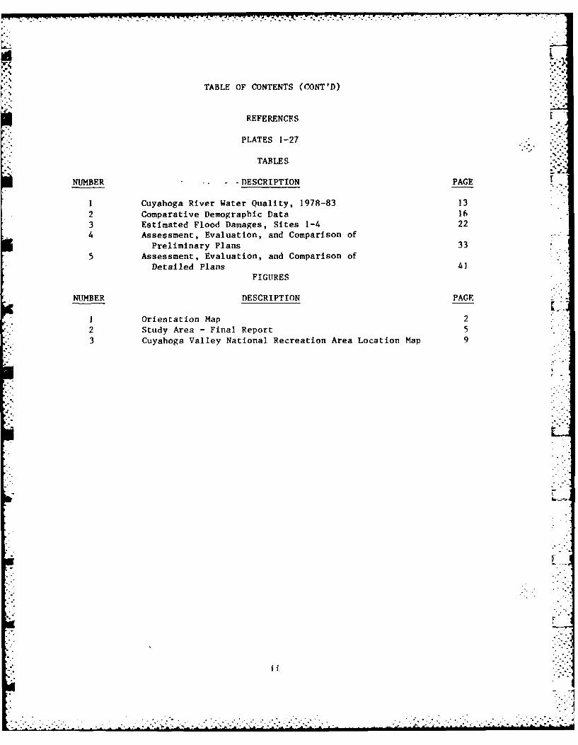
TABLE OF CONTENTS (CONT'D)
REFERENCES
PLATES 1-27
TABLES
NUMBER • - - DESCRIPTION PAGE [
1 Cuyahoga River Water Quality, 1978-83 13
2 Comparative Demographic Data 163 Estimated Flood Damages, Sites 1-4 224 Assessment, Evaluation, and Comparison of
Preliminary Plans 335 Assessment, Evaluation, and Comparison of
Detailed Plans 4]
FIGURES
NUMBER DESCRIPTION PACE
I Orientation Map 22 Study Area - Final Report 5
3 Cuyahoga Valley National Recreation Area Location Map 9
iii
.. . . . . . . .. . . . .-

ACKNOWLEDGEMENTS
* This Draft Final Feasibility Report was prepared through the efforts of many ,-individuals on the Interdisciplinary Team within the Buffalo District of the "Corps of Engineers. The following are the Corps personnel who were mostinstrumental in conducting the investigation and preparing the text presented
," herein: -
Richard Aguglia Project Manager, Plan Formulation BranchJames Conley Civil Engineer, Plan Formulation Branch "Philip Frapwell Interim Project Manager, Plan
Formulation BranchDaniel Kelly Chief, Plan Formulation BranchRoger Haberly EconomistWilliam Butler GeographerLawrence Sherman Hydraulic EngineerAlbert Fulco Hydraulic EngineerJackie France Hydraulic EngineerPaul Murawski Hydraulic Engineering TechnicanRodger Repp Civil Engineering TechnicianJames Wryk Civil Engineering TechnicianDavid Saunders Civil Engineering TechnicianSalvatore Nobile Civil Engineering TechnicianRobert Dragonette Real Estate SpecialistRobert Stefanski Real Estate Appraiser
The report itself was produced through the efforts of many other Corps per-sonnel, including the following who contributed significantly to its c...preparation:
Irving Stone Acting Chief, Drafting SectionJohn Acker Drafting SectionPaul Ehrensberger Drafting SectionMary Ann Schultz Word Processor LLinda Sauberan Word Processor
*The Buffalo District Commander during preparation of this Draft FinalFeasibility Report was Colonel Daniel R. Clark: the Chief of the EngineeringDivision was Kenneth R. Hallock: and the Chief of the Planning Division was
John Zorich.
Finally, the efforts of other individuals who participated in the study andreport preparation but whose names have not been mentioned above, are grate-fully acknowledged.
r
-. -..- .

SECTION I
INTRODUCTION
The purpose of this section is to introduce the reader to the Cuyahoga RiverRestoration Study - Final Report on Flood Control in the ValleyView/Independence area and to explain the content and organization of this
-report. The section presents information on the geographical setting of thestudy area, the study authority, the purpose of the study, the scope of thestudy, study participants and coordination, the organization of the report,and prior studies and reports in the area.
1. GEOGRAPHICAL SETTING
The Cuyahoga River is about 100 miles long and drains some 810 square milesof northeastern Ohio as shown on Figure I. The river begins at an elevationof about 1,300 feet, several miles northeast of Burton in Geauga County, andflows in a southerly direction towards Hiram Rapids, where the direction -.
changes southwesterly through Mantua, Kent, and Cuyahoga Falls, to theconfluence with the Little Cuyahoga River at Akron. From Akron, the riverflows north to Cleveland, to an elevation of about 570 feet. The lower 5.8 -miles are part of an existing Federal navigation project for ClevelandHarbor, one of Lake Erie's major ports.
The main tributaries of the Cuyahoga River are: Big, Mill, Brandywine,Tinkers, Yellow, and Chippawa Creeks; Mud Brook, Furnace Run, Little CuyahogaRiver, Congress Lake Outlet (Breakneck Creek), and West Branch CuyahogaRiver. The overall basin consists of rolling hills and many natural smalllakes and ponds. A relatively distinct escarpment near Cleveland divides thebasin between an upland plateau and the narrow lake plain.
2. STUDY AUTHORITY
* The Cuyahoga River Restoration Study was initiated by the Flood Control Act
of 1968 (Section 219) which authorized a survey of the Cuyahoga River fromUpper Kent to Portage Trail in Cuyahoga Falls, OH, in the interest of floodcontrol, pollution abatement, low-flow regulation, and other allied waterpurposes. No studies were completed under the 1968 authorization because ofadverse public reaction to the limited study scope as presented at the ini-tial public meeting on 16 September 1970. At this meeting, local interestsstated their desire for environmental and aesthetic improvement programs tocomplement existing and proposed flood control studies. This led to expan-sion of the scope of the study under the authority of Section 108 of the1970 River and Harbor Act, that instructed the Secretary of the Army, actingthrough the Chief of Engineers to "investigate, study, and undertake measuresin the interest of water quality, environmental quality, recreation, fish andwildlife, and flood control, for the Cuyahoga River Basin, OH. Such measuresshall include, but not be limited to, clearing, snagging, and removal ofdebris from the river's bed and banks; dredging and structural works to
.- improve streamflow and water quality; and bank stabilization by vegetationand other means."
. . . . .. . . . . . . .

L AKE4114-ERIE F
r JW
CUYAHOGA~E~s CONYIAGACUT
WESAE OUTDhO AE -
CCREEK
IrILAE~C
CLIYAHOCA COLHT
CUYAHA ET RAEN
FALLS
LTTrlE CIrANOGARIE CONCRESS LAKE AMTET
BOUNDARY '
I PORTGE COUNTYSTARK COUNTY
) ~~~SCALE OF MILES ________________
5 0 5 '0CUYAHOGA RIVER, OHIO
RESTORATION STUDY
ORIENTATION MAP
US. ARMY ENGINEER DISTRICT BUFFALO
DECEMBER 1985
FIGURE I
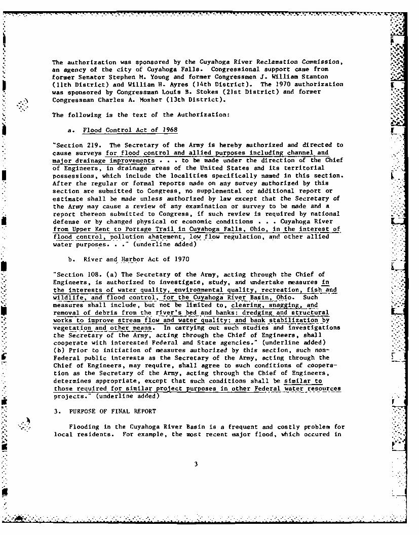
The authorization was sponsored by the Cuyahoga River Reclamation Commission, . e1
an agency of the city of Cuyahoga Falls. Congressional support came from
former Senator Stephen M. Young and former Congressmen J. William Stanton(lth District) and William H. Ayres (14th District). The 1970 authorization
was sponsored by Congressman Louis B. Stokes (21st District) and former
Congressman Charles A. Mosher (13th District).
The following is the text of the Authorization:
a. Flood Control Act of 1968
"Section 219. The Secretary of the Army is hereby authorized and directed to
cause surveys for flood control and allied purposes including channel and
major drainage improvements . . . to be made under the direction of the Chiefof Engineers, in drainage areas of the United States and its territorial
possessions, which include the localities specifically named in this section.
After the regular or formal reports made on any survey authorized by thissection are submitted to Congress, no supplemental or additional report or
estimate shall be made unless authorized by law except that the Secretary ofthe Army may cause a review of any examination or survey to be made and a
report thereon submitted to Congress, if such review is required by nationaldefense or by changed physical or economic conditions . . . Cuyahoga Riverfrom Upper Kent to Portage Trail in Cuyahoga Falls, Ohio, in the interest of
flood control, pollution abatement, low flow regulation, and other alliedwater purposes... (underline added) .
b. River and Harbor Act of 1970
"Section 108. (a) The Secretary of the Army, acting through the Chief of
Engineers, is authorized to investigate, study, and undertake measures in
the interests of water quality, environmental quality, recreation, fish andwildlife, and flood control, for the Cuyahoga River Basin, Ohio. Such
measures shall include, but not be limited to, clearing, snagging, andremoval of debris from the river's bed and banks: dredging and structuralworks to improve stream flow and water quality; and bank stabilization by
vegetation and other means. In carrying out such studies and investigations
the Secretary of the Army, acting through the Chief of Engineers, shallcooperate with interested Federal and State agencies." (underline added)(b) Prior to initiation of measures authorized by this section, such non-
Federal public interests as the Secretary of the Army, acting through theChief of Engineers, may require, shall agree to such conditions of coopera-tion as the Secretary of the Army, acting through the Chief of Engineers,determines appropriate, except that such conditions shall be similar to
those required for similar project purposes in other Federal water resourcesprojects." (underline added)
3. PURPOSE OF FINAL REPORT
Flooding in the Cuyahoga River Basin is a frequent and costly problem forlocal residents. For example, the most recent major flood, which occured in
3

September 1979 and which had a frequency of occurrence of about once in 40
years, caused in excess of $3 million in damages.* Local interests have
repeatedly requested assistance in alleviating these flood damages.
In response to these requests and in accordance with the authorizing resolu-
tions, the Buffalo District investigated the feasibility of providing flood
protection for the Cuyahoga River Basin in the Second Interim FeasibilityReport for the Cuyahoga River Resotration Study (CRRS). Five floodproneareas were identified in the study and corrective plans for these areas weredeveloped. The five areas investigated were: Lower Cuyahoga (from rivermile 5.8 to river mile 18.8), village of Mantua, Hudson Village, city ofStreetsboro, and Twinsburg. Types of improvements considered were:
channelization; reservoirs; and floodproofing. However, no plan was economi-
cally justified and the Second Interim Flood Control Study was terminated in1976. (Note: As will be discussed in subsequent sections of this report,flooding along Big Creek was investigated in the First Interim Report and a
flood control plan was recommended for implementation as an early actionitem.)
Subesquent to completion of the Second Interim Report, local interests in the
Valley View/Independence area (between river mile 11 and river mile 16 - seeFigure 2) requested that smaller-scale flood control measures, such as minor
channelization, clearing and snagging, debris removal, and/or ring levees beinvestigated for areas within their communities where high flood damages
occur. In addition, several flood events occurred subsequent to completionof the Second Interim Report which indicated that the damage-frequency curvesfor the Valley View/Independence area used in the previous study may havebeen too low, thus underestimating potential flood control benefits. Basedon the above, it was deemed appropriate to reevaluate the flooding problem in
the Valley View/Independence area with a view towards providing some limiteddegree of protection for concentrated damage areas in the Final Report for
* the CRRS.
4. SCOPE OF STUDY
The scope of this feasibility study on flood control is limited to for-mulation, assessment, and evaluation of plans to reduce flood damages in the
Valley View/Independence area. As will be discussed in Section III of theMain Report, "Problem Identification," the study scope was further reducedduring the early phase of the study to four specific locations within theValley View/Independence area where concentrated development exists and whichexperiences persistent and frequent flooding. Since the Second Interim Studyindicated that no flood control plan to protect the entire reach of the river
was economically justified, no further consideration was given to such aregional plan during the course of this feasibility study.
5. STUDY PARTICIPANTS AND COORDINATION
The decision to reevaluate the feasibility of providing some limited degree
of flood protection in the Valley View/Independence area was predicated onresponses to the Buffalo District Engineer's 3 January 1977 Public Noticerequesting public views on the future direction of the remainder of the
4

E RI
ORANCH
CLEVLANDVALLEY VIEW wrsr aviov AN.% INDEPENDENCE 1,E*
Il
CIYVHOG COMTYGEAUGA COUNTY
- -CUYAHOGA ICOUJNTY- RNPWf
I PENINSULAFURNAE RU
LCUYAHOGAO.4RIE C#(S RAENAL~
CUYAHOGA RIVER/
I - _nRTAGE COUNTY/
FI STARK COUNTY
SCALE OF MILES5 51 CUYAHOGA RIVER, 0OHI0
RESTORATION STUDY
STUDY AREA -FINAL REPORT
FU S ARMY ENG)NEER DISTRICT BUFFALODECEMBER 1985
FIGURE 2

-7 7-4.-717, Fo 7717 X
Cuyahoga River Restoration Study. Responses received indicated strong sup-port for this reanalysis from both private citizens and governmental agen-cies. A copy of the Public Notice and the responses received are presentedin Appendix C of the "Revised Plan of Study, Cuyahoga River RestorationStudy" (January 1978). Local interests continue to support the study, asindicated by recent expressions of local interest from the Cuyahoga CountyCommissioners who have also indicated their intent to act as the project 'slocal sponsor.
During the preliminary planning phase of this feasibility study coordinationwas initiated with various Federal, State, and local agencies in order to ridentify significant impacts of proposed flood control plans as early aspossible. Specifically, information was requested regarding existing or pro-posed land use plans, known cultural resources, and fish and wildlife resour-ces, including threatened and endangered species. Five responses werereceived as a result of this early request. The Northeast Ohio AreawideCoordinating Agency (NOACA) stated that reduction of flooding in the ValleyView/Independence area would improve water quality since sediment and otherpollutants are washed into the river when flooding occurs. The OhioDepartment of Natural Resources (ODNR) replied that they were not aware ofany rare or endangered species within the study area. The U.S. Fish andWildlife Service provided additional information on threatened or endangeredspecies that may be present in the study area. The State HistoricPreservation Officer (SHPO) provided information on known cultural resourcesin the area and recommended that further evaluation of cultural resources beundertaken as the study progressed. The SHPO reiterated this request duringthe detailed planning phase and a cultural reconnaissance study was con-ducted. The National Park Service, who is responsible for management of theCuyahoga Valley National Recreation Area (CVNRA) partially located within thestudy area, outlined their natural resource policies pertaining to floodingwithin the recreation area. In addition, the Park Service pro,-ided input indevelopment of several flood control plans for areas located wiL't' therecreation area throughout the entire study process.
The completed Preliminary Feasibility Report for this study, documenting the* results of the preliw~nary planning effort, was distributed to the political
leaders in the area and to various local, State, and Federal agencies fortheir review and comment. Loan copies of the report were also supplied tolocal libraries for review by the general public and various civic groups.
In addition, until the supply was exhausted, personal copies of the reportwere made available to study participants free of charge. With the excep-tion of requests for additional copies, no comments were received on thereport.
Following approval of this Draft Final Feasibility Report, a public meetingwill be held in the study area. The purposes of this meeting will be to pre-sent the results of the feasibility study, including the TentativelyRecommended Plan, and to solicit public comment. All comments made at this
.- '.- meeting will be given equal consideration in developing the final recommen-""" dation of this study.
6

6. THE REPORT
The overall organization of this report consists of a Main Report and sup-
porting documentation. The Main Report is written to give both the general
and technical reader a clear understanding of the study, the study results,
and the key decisions and conclusions. The supporting documentation provides
additional detailed information on the design, costs, and benefits of the
alternatives studied. It also includes copies of pertinent correspondence
with organizations and individuals significant in the development of this
study and minutes of the workshop meetings conducted during the course of
this study. Copies of the supporting documentation are available at the
Buffalo District Office.
7. PRIOR STUDIES AND REPORTS
Many studies of the water resources problems and needs in the Cuyahoga River
Watershed have been made. The following is a summary of the various reports
pertinent to the flooding problem in the Valley View/Independence area which
is the concern of this feasibility study:
a. Beginning in 1914, there have been 15 Corps of Engineers reports that
address improvements to and modification of the Cleveland Harbor commercial
navigation project at Lake Erie and the mouth of the Cuyahoga River. The
most recent of these reports is the "Cleveland Harbor, OH, Final
Reformulation Phase I Ceneral Design Memorandum" (July 1984, Revised December
1984). This report recommended modifications to the lakefront portion of the
harbor in the interest of moving bulk and general cargo more efficiently and
economically through the harbor. The report is currently at the office of
the Assistant Secretary of the Army for Civil Works awaiting transmittal to
* the Office of Management and Budget. The project was also included in the1985 Supplemental Appropriations Act (PL 99-88) and will be authorized for
. construction if an Omnibus Water Resources Bill is not passed by 15 May 1986.
b. The "Review of Reports on Cleveland Harbor" (February 1945) investi-
gated, among other things, the feasibility of constructing a settling basin
for sediment above the head of navigation either by means of a channel exten-
sion or a permanent reservoir in the valley south of Cleveland. The report
concluded that this work was not economically justified at that time.
c. In response to U.S. House of Representative's Committee resolutions
of 28 December 1946 and 9 June 1960, the Buffalo District prepared a report
entitled "Review of Reports for Flood Control and Allied Purposes, CuyaiogaRiver, OH" (I September 1969) recommending:
(1) Improvements for flood control and streambank erosion in the 9-milereach of the Cuyahoga River between the Harvard-Dension Bridge (approximate
river mile 7) and the mouth of Tinkers Creek (approximate river mile 16).
(2) Construction of a sediment settling basin in the vicinity of river
mile 8.0 (approximately 2 miles upstream from the head of commercial
navigation) in the interest of commercial navigation, pollution abatement,and Lake Erie restoration.
71

q.J
The report was returned to the Buffalo District in June 1970 as the necessarylocal assurances were not furnished to cover the cost-sharing requirementsfor a cash contribution in return for windfall benefits. For this reason,and because subsequent legislation for the Cuyahoga River Restoration Studyunder Section 108 of the 1970 River and Harbor Act provided for expandedstudy scope, no further action was taken on the 1q69 Review of Reports.
d. In August 1973, the Buffalo District completed the "Wastewater
Management Study for Cleveland-Akron Metropolitan and Three Rivers WatershedArea" which evaluated alternative plans for water quality improvement in theCuyahoga, Chagrin, and Rocky River watersheds and receiving Lake Erie by rtreatment of municipal and industrial wastewaters and urban storm runoff.
The findings of this study, which identified four alternative land and water-
oriented methods for wastewater treatment, along with the findings of similar
studies conducted by the Corps of Engineers in five other areas, were sub-mitted to both houses of Congress by the Secretary of the Army (SOA) byletter dated 28 April 1978. No recommendation for program implementation wasprovided by the SOA.
e. Section lOd of Public Law 92-500 directed the Corps of Engineers to
develop a program for the "restoration and environmental repair" of LakeErie. The resulting Lake Erie Wastewater Management Study (LEWWM), completedin 1982 by the Buffalo District, identified nutrient enrichment - par-ticularly phosphorus in all of its forms - as the primary cause of heavyeutrophication in the western basin of Lake Erie and marginal eutrophication
in the central and eastern basins. The study also determined that 44 percentof the phosphorus loading to Lake Erie is from nonpoint or diffuse sources
such as that attached to sediment. The Final Report, outlining a 10-yearconservation tillage program as the most cost effective method of reducingphosphorus pollution in Lake Erie, was sent forward to Congress "for itsinformation."
f. As previously discussed in Paragraph 2, the authority for the
Cuyahoga River Restoration Study (CRRS), under which this Final Report on -
*- Flood Control in the Valley View/Independence area is being conducted, wasprovided by Section 108 of the 1970 River and Harbor Act. A synopsis of
- accomplishments under this authority follows:
(1) The First Interim Report (September 1971) presented the scope of the
longer-term Framework Plan plus an Early-Action Program for the CuyahogaRiver Restoration Study. The Framework Plan presented a description of thebasin's resource problems and needs, and possible alternative means ofdealing with these problems and needs. Sources of pollution and other degra-dable conditions were sought out and identified. Current pollution abatementprograms were inventoried to determine their effects on pollution. TheEarly-Action Program consisted of four action programs that were considered
compatible with the overall framework plan and which could be constructed oraccomplished without additional study. The four early-action programs were:
(a) Recreational improvements such as canoe docks and landscaping atWaterworks Park-Cuyahoga Falls (river mile 49.0) and Fuller Park-Kent (rivermile 54.0). In a letter to Congress dated 25 September 1975, the Secretaryof the Army deferred these proposed recreational facilities. The Secretary -
8................................... "'.....* .**.****
- - * * -.. *-- *--. .- *.*. .*. .

also indicated that these facilities would be reviewed in subsequent studiesof the basin. As stated in the "Revised Plan of Study, Cuyahoga RiverRestoration Study" (January 1978). it was the consensus of the local offi-cials that present and future recreational needs have been identified andprograms for expansion to meet these needs have been outlined. Therefore,the need for improving the recreational facilities in the basin under theCuyahoga River Restoration Study will not be investigated further.
(b) Debris removal from Cleveland Harbor. The Secretary of the Armyalso deferred implementation of this program because he concluded that
* removal of debris outside the Federal channel should be prosecuted by non-Federal interests."
(c) Flood control and aesthetic improvements on Big Creek at theCleveland Zoological Park. Funds to begin advanced engineering and designfor this S25 million project were released in October 1975. The Phase IIGeneral Design Memorandum was completed in FY 79. Plans and Specificationswere essentially completed in FY 80. However, construction has not been ini-tiated due to lack of Federal funding which has been withheld because the -
project is not economically viable at the ever increasing Federal discountrate. Historically, a project would have proceeded based upon the discountrate that prevailed at the time construction funds were first appropriated.This reasoning has not held up for this project.
(d) Pilot sediment removal project on the upstream side of the dam atBrecksville, OH. On 16 July 1976, the Buffalo District Engineer recommendedthat the Pilot Sediment Removal Project be terminated. The project showedthat sediment removal was not a feasible means of improving water quality onthe upstream side of the Brecksville, OH, dam because the sediment in thisarea was relatively unpolluted, with no oxygen depletion. This recommen-dation was concurred with by the Division FngIneer and approved by the Officeof the Chief of Engineers by letter dated 9 December 1976.
(2) One of the actions under the Cuyahoga River Restoration Study was aninvestigation of the existing water quality conditions in the river basinentitled "Ecological Monitoring of the Cuyahoga River" (October 1974) byDr. John Olive of the University of Akron through a contract with the BuffaloDistrict. The purpose of this investigation was to establish the baselinebiological, chemical, and nhysical characteristics of the central CuyahogaRiver environment; to evaluate the river's existing and unaltered projected [environmental trends; and to extrapolate what the anticipated environmentalchanges would be as a result of implementing the Pilot Sediment RemovalProgram. This investigation included physiographic, chemical, physical, andbiological data collection from seven sites along the Cuyahoga River, one ofwhich was at the upstream side of the Brecksville Dam. The sampling periodfor this data collection program was from October 1q73 to September 1974.The results of this study indicated that: (1) sediment upstream of theBrecksville dam was nonpolluted to moderately polluted when compared to EPAsediment standards; (2) sediments which are deposited on the upstream side ofthe Brecksville Dam in August and September are scoured during the high flowregimes of February and March; and (3) the water at the Brecksville site was .-always well oxygenated and the dissolved oxygen level never fell below 5 ppm. L !
9
-i"- ' .' .'. - ° %' .,' .. "* ". -- - * '- - - . " " -- . - " . . - - - - - - -
IK". 44V
The results of this study were utilized in terminating the Pilot SedimentRemoval Project (an early-action program).
(3) The Second Interim Report (March 1976) identified the significantflooding problems within the Cuyahoga River Basin and developed correctiveplans for these problems. The flood problem areas studied in the "Second
* -;) Interim Report" were: Lower Cuyahoga, village of Mantua, Hudson Village.city of Streetsboro, and Twinsburg. In the report, it was concluded thatflood control plans were not economically justified for the flooding problemsin the Cuyahoga River Basin (excluding the Big Creek improvements). Further,it was recommended that, in general, the affected communities implement floodplain management programs to prevent increased flood damages. The Corps canassist the communities in developing their programs under the TechnicalAssistance portion of the Flood Plain Management Program.
(4) The Third Interim Report on Erosion and Sedimentation was initiatedin FY 77 and the Preliminary Feasibility Report was essentially completed inFY 80. The major portion of the preliminary feasibility investigation wasconducted by the Soil Conservation Service of USDA under an InteragencyAgreement. The results of the preliminary feasibility studies were thatupland (sheet and rill) erosion contribute significantly (approximately 50percent) to the Cuyahoga River sediment load (including Cleveland Harbor)while streambank erosion is a minor contributor (approximately 5 percent).The study also indicated that streambank erosion control plans were not eco-nomically justified and recommended that no further consideration be given tostreambank erosion control plans at this time. The preliminary feasibilitystudies also reevaluated the settling basin early-action project and deter-mined that, due to recent development in the area, the original disposalsites were no longer available and no alternate disposal site was availablein the immediate vicinity. In addition, coordination with local interestsindicated that local interests were still opposed to the settling basin pro-ject. Thus, the recommendation of the study was that no further con-sideration be given to the settling basin early-action project. The SoilConservation Service collected field data to complete the remaining uplanderosion studies in the summer of FY 80. This information was incorporated .'into a Public Information Report which was provided to local interests inDecember 1982.
g. In November 1977, the Buffalo District completed a Section 14 report ".entitled "Erosion of Cuyahoga Riverbank Along Stone Road in Valley View, ON."The purposes of this report were to develop a plan for the protection ofabout 300 feet of Stone Road in Valley View, OH, against further damage andpossible total destruction from the continuing erosion of the adjacent bankof the Cuyahoga River and to evaluate the economic feasibility of the protec-tion project. The investigation indicated that the erosion problem on theCuyahoga River along Stone Road was critical and the loss of Stone Road would "have a significant adverse impact on the physical and social well-being ofthe local residents. The investigation also indicated that the most economi-
-c cal solution to the problem was to relocate approximately 600 feet of StoneRoad away from the river. Since relocation costs are the res-onsibility oflocal interests no further Federal action was warranted.
10
..-- .- * , .
SECTION IIEXISTING CONDITIONS
The purpose of this section is to present the environmental settingwithout the project to permit impact assessment of the various alternatives. [The information presented will provide a data base for impact assessment andevaluation purposes.
8. PHYSICAL ENVIRONMENT
a. Location.
The study area consists of the Valley View/Independence area along the
Cuyahoga River from approximately river mile 11.0 to river mile 16.0 - seeFigure 2. As will be discussed in the following section of this report, thestudy area was further reduced during the early phase of the study to fourspecific sites within this area. Two sites are commercial/industrial areasabutting the west bank of the Cuyahoga River in the city of Independence,Cuyahoga County, OH (Sites I and 3); and two sites are residential areas bor-
" dering the east bank of the Ohio Canal in the village of Valley View,Cuyahoga County, OH (Sites 2 and 4). Plate 7 shows the location of the fourspecific project sites. .
b. Physiography/Topography.
The project area is situated on the western edge of the AppalachianPlateau. Gently to moderately sloped and rolling uplands are formed of gla-cial ground and end moraines. The soil materials of clay, silt, sand, andgravel till were laid down over bedrock shales and sandstone.
c. Geology.
Rock strata of the Devonian, Mississippian and Pennsylvanian sedimentarysystems are exposed throughout the Cuyaboga River Basin. These deposits are
,. economically important and support a shale and sandstone industry. OlderSilurian, Ordovician, and Cambrian systems are frequently encountered whendrilling for wells or other shafts.
" Surface exposures of Devonian Chagrin and Ohio shales, Mississippian Bedfordformation, Berea sandstone, and Cuyahoga Group shales and sandstones are best
* exposed in the lower valley and the gorges of adjoining tributaries. TheBerea sandstone is the more resistant of these rocks to the forces of erosionthat have shaped the valley. In general, this rock forms the abrupt edge ofthe Portage Escarpment to the east of the valley. It is also present to thewest but the relief is less abrupt.
Pennsylvanian age rocks of the Pottsville Formation are found to the south andeast in the study area lying unconformably on the Mississippian. Thecomplete series of Pottsville is a sequence of coals, shales, limestones, andsandstones. Sharon conglomerate, a sandstone, is the lower and morewidespread Pennsylvanian layer in the area (Cleveland Regional Sewer
District, 1976).
,'... 11-'
.o. ...................................... . . •..................... . ,. ..... .. .

d. Soils.
.Soils at Project Sites 2, 3, and 4 belong to the Chagrin-Tioga-Euclidassociation. These are nearly level, well-drained, and somewhat poorlydrained soils that formed in loamy and sandy alluvium and in silty and loamydeposits. They occupy flood plains and low stream terraces. Project Site I eoccupies urban land, described as nearly level and gently sloping areas that "-are predominately covered by buildings, structures, concrete, asphalt, and:' _ iother impervious surfaces. (USDA, Soil Conservation Service, 1980). %_
The following soils which are present within the project sites have beendesignated as prime farmlands (USDA, Soil Conservation Service, 1981):
- Chagrin silt loam, occasionally flooded (Sites 1, 2, 3, 4)- Euclid silt loam (Sites 2, 4)
- Sebring silt loam (Site 4)
Despite this designation, commercial/industrial and residential developmentpreclude extensive use of these soils for agriculture throughout much of theproject sites.
e. Climate.
The climate of the Cuyahoga River Basin is mainly humid, continental incharacter, with an annual average precipitation of 30.6 to 44.2 inches. Thebasin experiences strong, modifying influences from Lake Erie. Northwesterlywinds crossing Lake Erie tend to lower temperatures in the summer and raise .-them in the winter with an annual average of 49.8*F. Winds blowing acrossthe lake in winter often bring heavy snow squalls, sometimes as late as May. ,. 1Average annual snowfall varies from 46.7 to 109.3 inches per year.
Prevailing winds are from the southwest throughout the year with the averagevelocity being approximately 10 miles per hour. Damaging winds of 35 to 85miles per hour associated with thunderstorms occasionally occur in spring and Lsummer.
f. Water Quality.
All surface waters in Ohio are designated for Warmwater Habitat,Agricultural Water Supply, Industrial Water Supply, and Primary ContactRecreation. However, in lieu of Primary Contact Recreation, the CuyahogaRiver segment from its confluence with the Little Cuyahoga River near Akronto the Cleveland Southerly Sewage Treatment Plant (STP) (river mile 11.0) hasbeen designated for Secondary Contact Recreation. The four proposed projectsites border this river segment. In addition, the river segment from BathRoad in Northampton to Rockside Road in Valley View (Cuyahoga Valley NationalRecreation Area) has been designated State and National Resource Waters(Project Site 4 borders this river segment).
The Ohio Environmental Protection Agency (OEPA) requires that ambient waterquality be maintained for all substances determined to be toxic or to inter-fere with any of the river's designated uses. All other substances must be
12

limited to the standards associated with each designated use. Areas that donot meet general water quality standards must not be degraded for suchclassified waters (OEPA Water Quality Standards Chapter 3745*] of theAdministrative Code). Table I shows that mean levels of fecal coliform bac-teria, copper, iron, and cyanide exceed state water quality standards.
As of 1974, water quality in the Cuyahoga River between Bath Road and,- Rockside Road appears to be improving. Upstream sections of the river and " '
its tributaries currently support healthy benthic populations and diversebreeding populations of fish that could be available to repopulate themainstem of the river in the study area if water quality were enhanced signi-ficantly. Data has indicated that dissolved solids and chloride con-centrations are decreasing, and dissolved oxygen concentrations areincreasing. Visual observations have indicated that foam caused bydetergents has become less of a problem than formerly. Improved treatment ofwastewater by Akron industries and by the Botzum wastewater treatment plantprobably has been responsible for this improvement (Jack McCormick and
Associates, 1974).
Table I - Cuyahoga River Water Quality, 1978-83
OEPAParameter Mean Maximum Minimum Standard
DO (mg/l) : 8.7 ]3.4 : 6.5 : >4.0pH : 7.6 8.2 : 6.6 6.5-9.0Fecal Coliforms/100ml 19,272.8* 66,000.0* : 460.0 5,000.0Calcium (mg/l) 57.1 81.0 0.1Magnesium (mg/l) 15.0 : 19.7 11.5 :Cadmium (ug/l) : 4.3 20.0* 0.5 : 12.0Chromium (ug/1) 30.7 50.0 30.0 50.0Copper (ug/l) : 31.5* 210.0* 10.0 30.0Iron (ug/l) . 3,435.2* 33,500.0* : 260.0 1,000.0Lead (ug/l) : 21.3 225.0* : 2.0 : 30.0Nickel (ug/l) 79.3 : 100.0 30.0Zinc (ug/1) . 64.9 640.0* 10.0 130.0
Manganese (ug/1) 178.3 555.0 85.0Aluminum (ug/l) 283.3 600.0 200.0Chloride (mg/l) 102.5 212.0 2.3Sulfate (mg/l) : 84.3 116.0 66.0Cyanide (mg/l) 0.1* 3.8* 0.01 0.025
*exceeds State of Ohio water quality standard
SOURCE: OEPA, STORET Retrieval Data, 6 December 1983.
- g. Air Quality.
The project area lies within the Cleveland Air Quality Control Region (AOCR).Boundaries for each AQCR are set by consideration of air pollution levels,population density, geography, and common meteorological conditions. In
13
i.....................................................-..."......- ............ _...-....
L" "'L
t' )%
1982, a total of 117 ambient air quality monitors were operated in theCleveland AQCR measuring the following criteria pollutants: total suspendedparticulates (TSP); lead: sulfur dioxide (S02): oxides of nitrogen; carbonmonoxide (CO); ozone (03). (NOTE: The majority of the air quality moni- Ktoring stations (AQMS) are located within the city of Cleveland. SinceIndependence and Valley View are located outside of this primaril]ycommercial-industrial setting, pollutant levels can be expected to be -. "correspondingly lower).
According to OEPA's Ohio Air Quality 1982, the short-term (24 hour) airquality standard for TSP was exceeded on 5 days in 1982. The short-term(24-hour) standard for S02 was exceeded on I day, the short-term (8-hour)standard for CO was exceeded on 4 days, and the short-term (1-hour) standardfor 03 was exceeded on 6 days.
The 1982 TSP highest annual geometric mean concentration for Cuyahoga County- was 101 ug/m 3 which is above the primary standard of 75 ug/m3 . The
SO2 highest annual arithmetic mean concentration was 41 ug/m3 which is belowthe primary standard of 80 ug/m 3 . The N02 highest annual mean concentrationwas 56 ug/m 3 which is below the primary standard of 100 ug/m3 . According toOEPA, 1982 air quality standard violations were recorded in Cuyahoga Countyfor TSP (primary standard) and ozone. The AQMS nearest the project area -Parma, OH (approximately 5 miles northwest of Valley View) - recorded noviolations in 1982.
9. BIOLOGICAL ENVIRONMENT
a. Fish.
Sixty-eight species of fish were known to occur in the Cuyahoga Rivermainstream before 1950. Currently, few fish can survive the chronic organicpollution and frequent toxic conditions which characterize the river belowAkron. According to the U.S. Department of Interior, Bureau of Outdoor"L..Recreation, the river no longer constitutes a viable fishing resource.Investigations in 1971 and 1972 by Dr. Andrew White of John CarrollUniversity included samplings at Rockside Road and the base of Cuyahoga Fallsin Peninsula, OH. Fishes collected included the white sucker, golden shiner,emerald shiner, blacknose dace, creek chub, silverjaw minnow, fathead minnow,stoneroller, goldfish, stickleback, green sunfish, bluegill, and blackbullhead. The physical appearance of several of these fish indicated thatthey represented a true riverine population and were not accidental strayswashed into the river from adjacent lakes, ponds, or tributaries. Mostfishes collected were hardy species with rather broad ranges of tolerance.This represents a change from earlier 1968 studies in which no fish at allwere recorded below Akron.
b. Wildlife.
The Cuyahoga River Valley supports diverse and numerous fauna (a total of310 species). From Rockside Road on the north to the city of Akron on thesouth, the Cuyahoga Valley is estimated to include 23 species of amphibians,18 species of reptiles, and 41 species of mammals. The bird fauna consistsof 59 species that are permanent residents or that occur in the region
14
* * . * *. * * . * . * * * *. ~ * * *, * *

throughout the year, and 169 species that are transients, visitants, orseasonal residents (U.S. Department of the Interior, 1976).
The banks of the Cuyahoga River at Site 4 are heavily vegetated with trees,shrubs, and herbaceous vegetation. According to the USFWS (26 September r1985), several good denning trees and snags have been noted along Stone Roadbetween Stone Road Bridge and Canal Road. In addition, the area hasexcellent cover and nesting habitat. In a relatively short period, a 1SFWSbiologist surveying the site observed cardinal, downy woodpecker, black-capped chickadee, red-winged blackbird, mallard (on the river), song sparrow,English sparrow, tufted titmouse, fox squirrel, and woodchuck (USFWS, 24 May
-. 1985).
c. Threatened and Endangered Species.
'he proposed project sites are within the range of the following Federalendangered species:
Name/Status Habitat Distribution
Indiana hat Caves and Statewide, except Athens, Belmont,yot is sodali riparian Carroll, Coshocton, Gallia,
Guernsey, Harrison, Jackson,Jefferson, Lawrence, Meigs,Monroe, Morgan, Muskingum, Noble,Tuscarawas, Vinton, andWashington Counties.
To date, no critical habitat for this species has been identified within theproject area. Consultation with the Ohio Department of Natural Resources,Division of Natural Areas and Preserves has identified no records of rare or . -endangered species within the proposed project sites.
10. HUMAN ENVIRONMENT
a. Land Use.
Within the city of Independence and village of Valley View, land use is*. mixed residential, commercial, industrial, and recreational. In
Independence, 1,091 (17.7 percent) acres are residential, 626 (10.2 percent)acres are recreational, 364 (5.9 percent) acres are industrial, 86 (1.4
* percent) acres are commercial, and 959 (15.6 percent) acres are other uses.Over 49 percent of the total land area is undeveloped (city of Independence,1980). In Valley View, 1,993 (50 percent) acres are residential, 1,595 (40.0percent) acres are industrial, 311 (7.8 percent) acres are recreational, and88 (2.2 percent) acres are commercial (Cleveland Regional Sewer District,1976).
Within the proposed project area, land use at Sites 1 and 3 is primarilycommercial/industrial; at Sites 2 and 4 land use is primarily residential.
15

I'"E
h. Demography.
With a 1980 population of 1,498,400, Cuyahoga County is the largest county inOhio. About 38 percent of its population resides in the city of Cleveland.Independence and Valley View had a total population of 8,183 in 1980. Thepopulation of Independence decreased from 7,034 in 1970 to 6,607 in 1980 (adecrease of 6.1 percent), while the population of Valley View increased from1,422 in 1970 to 1,576 in 1980 (an increase of 9.8 percent). Table 2 pre-sents, in comparative form, basic demographic data for the project area.
Ic. Housing and Stuctures.
In 1980, the number of occupied housing units in Cuyahoga County was563,478 (39 percent renter-occupied). In Independence, there were 2,184 (7percent renter-occupied) housing units and, in Valley View, there were 492(14 percent renter-occupied) housing units. Median value of owner-occupiednoncondominium housing units was $53,200 for Cuyahoga County, $72,400 forIndependence, and $68,000 for Valley View (1980 Census of Population andHousing). A total 39 commercial/industrial structures are present in the
project area. A total of 106 housing units are present in the four projectsites.
Table 2 -Comparative Demographic Data
State of : Cuyahoga City of : Village ofOhio : County : Independence : Valley View
Total Population 10,797,600 1,498,400 : 6,607 1,576
Percent Female 51.7 52.7 52.0 : 50.3
Percent Non-white 11.1 24.4 0.9 0.1
Percent Over 60 : 15.4 18.3 : 23.3 12.4
Percent Under 20 32.4 29.3 : 25.6 : 33.9
Median Age : 34.0 : 36.2 41.2 : 31.5
SOURCE: 1980 Census of Population and Housing
d. Business and Industry.
The Cleveland, OH, SMSA is a diversified durable goods manufacturing F:area. In 1980, 255,000 persons in the four-county SMSA were employed inmanufacturing. This was about 28 percent of the q05,000 persons employed inthe area; in the U.S. as a whole, less than 22 percent of total employmentwas in the manufactuiring sector. The five largest industries in metropolitan "Cleveland are: Manufacturing (except Electrical): Fabricated Metal Products:Primary Metal Industries; Transportation Equipment: and Electrical andElectronic Equipment. The largest nonmanufacturing categories were Services
r 16
• --

VN
(IR7,000 persons; 20.7 percent of the total employment): Retail Trade(146,000; 16.1 percent); and Government (122,600; 13.5 percent) (GreaterCleveland Growth Association, 1983).
Sites I and 3 are commercial/industrial sites within the study area. A totalof 28 businesses currently operate within the two sites.
e. Employment and Income.
In 1980, the two largest general categories of employers in CuyahogaCounty were the service industries which employed 29.3 percent of the totalwork force and the manufacturing industries, which employed 28.7 percent ofthe labor force. The current unemployment rate for Cuyahoga County is about9 percent.
In 1980, median household income for Cuyahoga County was $18,009, or about L.101 percent of the State median of $17,754. In 1980, 11.3 percent of allpersons residing in Cuyahoga County were below the poverty level, compared tothe State level of 10.1 percent.
f. Transportation.
Highway access to Independence from Cleveland to the north and Akron tothe south is provided by two major interstate highways, 1-77 (Willow Freeway)and 1-480. Major east-west routes through the city are Granger Road (SRI7),Rockside Road, and Pleasant Valley Road. Canal Road (SR631), which followsthe Ohio Canal, is the major north-south vehicular transportation routethrough Valley View. Granger Road (SR-17), Rockside Road, Schrieher Road,Tinkers Creek Road, and Pleasant Valley Road provide east-west passagethrough the village.
Francis Drive, Charles Drive and Gleeson Road service the residential sub-division at Site 4. Francis and Charles Drives have outlets at both StoneRoad and Canal Road. Cleeson Road forms a dead end off Canal Road. StoneRoad crosses the Ohio Canal and the Cuyahoga River and enters the city ofIndependence. Stone Road Bridge across the Cuyahoga has been abandoned since1982.
The Chessie System Railroad, Norfolk and Western Railway, and Conrail are thethree major trunk line railroads that serve the Cleveland metropolitan area. [The Newburgh and South Shore Railroad, Cuyahoga Valley Railway, and RiverTerminal Railway operate switching lines. A major trunk line of the ChessieSystem Railroad follows the Cuyahoga River from Cleveland to Akron throughthe city of Independence. A spur line of the South Shore Railroad entersSite I from Cleveland.
The nearest air transportation terminals are the Cleveland-HopkinsInternational Airport and the Burke Lakefront Airport in Cleveland. TheBurke Lakefront Airport is used primarily for short, regional flights, whilethe larger Cleveland-Hopkins terminal is used by the major airlines for long-distance air travel.
17
I[
. ..* * *. .*.
L
g. Utilities.
The Cleveland Regional Sewer District is in the process of planning
interceptors that would eventually service the project area. The ClevelandWater Department with water lines on the east side of the Cuyahoga Valley
serves the area as far south as Northfield Center Township. Natural gas is
provided to the area by the East Ohio Gas Company which supplies gas fuel toan area of some 2,500 square miles, and has over 930,000 customers. The OhioBell Telephone Company provides telephone service to over 3.6 million people,
including the project area. Electricity is provided to the area by the [Cleveland Electric Illuminating Company.
h. Public Services and Facilities.
The city of Independence has a new fire station and equipment manned by
11 full-time firefighters, 7 of whom are trained paramedics, and 27 volun-teers. There are 17 full-time patrolmen and 4 deputies in the police depart-ment. The village of Valley View has 3 full-time plus 20 part-timefirefighters, and 8 full-time plus 5 part-time policemen. The Village Hallis located immediately southeast of Site 4.
i. Recreational Resources. L
In the late 1960's, the State of Ohio and the Cleveland and AkronMetropolitan Parks Districts initiated efforts to acquire property in theCuyahoga Valley. As a result of these efforts to preserve the valley, the
Cuyahoga Valley National Recreation Area (CVNRA) was established in 1974 byPublic Law 93-555 "for the purpose of preserving and protecting for publicuse and enjoyment, the historic, scenic, natural, and recreational values ofthe Cuyahoga River and the adjacent lands of the Cuyahoga Valley and for thepurpose of providing for the maintenance of needed recreational open spacenecessary in the urban environment..." Management of the CVNRA is the respon- , .
sibility of the National Park Service.
The recreation area extends from Rockside Road on the north to the city ofAkron on the south and includes 32,000 acres within its authorized boundries(see Figure 3). In 1983, attendence at the various CVNRA facilities wasestimated at 4.6 million visits. Site 4 borders the Canal Unit which con-tains some of the major historic resources of the valley. The watered por-
tion of the Ohio and Erie Canal and associated locks and structures is the .main focus of this unit. The primary theme for the management of the Canal
Unit is the history of settlement, growth and change, with secondary themesincluding natural history, history of transportation and active recreation
(canoeing, picnicking, towpath hiking, excursion train rides and cross-
country skiing).
According to the National Park Service, two of the four project sites affectthe National Recreational Area. Site 3 adjoins the northern boundary andcould affect potential access to the park from Old Rockside Road. Site 4 . . -
includes about 35 acres within the park, of which 8 acres (including theCanal Visitor Center at 6699 Canal Road) are Federally owned.
18

LAKE
COUNTY
CLEVELAND
CUYAHOGA VALLEY
RECREATION AREA
PORTAGEMEDINACOUNTY
COUNTY
-- SUMMIT -
COUNTY
SOURCE:
CUYAHOGA VALLEY 1975 - PAGE a
CUYAHOGA RIVER, OHIORESTORATION STUDYCUYAHOGA VALLEY
NATIONAL RECREATION AREALOCATION MAP
U S ARMY ENGINEER DISTRICT BUFFALODECEMBER 1985
19 FIGURE 3

j. Cultural Resources.
The Cuyahoga River Valley is one of Ohio's most significant archaeologi-
Ical resources. Almost every bluff along the river has evidenced signs ofprehistoric occupation. Major sites exist on the flood plain and important
type sites have been found on surrounding uplands.
* In 1975, an archaeological survey of the Lower Tinkers Creek area was con-* ducted by Dr. David Brose of the Cleveland M4useum of Natural History. This
survey discovered a number of archaeological sites in the area including four[-
within Site 4. According to the Ohio Historic Preservation Office (OHPO),..information on these sites indicate that (a) wide variety of cultural
resources are present in the project area. Furthermore, the context of at* least some of these sites is such that they are quite probably eligible for
listing on the National Register of Historic Places. There currently islisted a National Register District, the Terra Vista Prehistoric District,which is located south of the (proposed) protection area in (the) Valley, onthe north side of the confluence of Tinkers Creek and the Cuyahoga River."
* On this basis, OHPO recommended that a cultural resources reconnaissance sur-* vey of the project area be undertaken. This reconnaissance survey was con-
ducted in the summer/fall of 1985.
-The Cuyahoga River Valley was also an important transportation route andfocus for early settlers. The Ohio and Erie Canal ran from Cleveland southalong the Cuyahoga over the Old Portage and down the Tuscarawas and theMuskingum Rivers to the Ohio River. The entire canal was 308 miles in lengthand had 148 locks and 14 aqueducts. The first section opened (between
elevation) between the lake and the summit. Today, the Valley View section
* of the canal (including locks 37, 38, and 39), the Tinkers Creek Aqueduct,- Wilson's Mill (also known as Alexander Mill) are listed on the National* Register of Historic Places (National Park Service, 1976).
20
. * .. *. - * . . . . - -~.* -
SECTION III
PROBLEM IDENTIFICATION
The purpose of this section is to inform the reader of the water andrelated resource problems and needs in the study area and for which thisstudy seeks a solutl.n. The section discusses the need to reduce flood dama-
Z ges in the Valley View/Independence area: reviews the planning constraintsunder which this study was conducted; discusses the specific planning objec-tives of the study: and reviews the conditions that would exist if no Federalaction was taken.
11. PROBLEMS AND NEEDS
a. Flooding in the Valley View/Independence Area
As previously discussed, the Second Interim Study investigated the feasi-bility of providing flood protection measures in the lower reach of theCuyahoga River from river mile 5.8 to river mile 18.8 which includes theValley View/Independence area. Types of protection measures consideredincluded channelization, reservoirs, and floodproofing, all providing protec-tion for the entire reach of the river. flowever, no plan was economicallyfeasible and the study was terminated in 1976.
Subsequent to completion of the Second Interim Study, local residents in theValley View/Independence area requested that smaller-scale flood controlmeasures, such as minor channelization, clearing and snagging, debris remo-val, and/or ring levees he investigated for areas within their communitieswhere high flood damages occur. However, they did not identify the locationof these high damage areas. Therefore, the first step in the study processwas to identify these high damage areas and to define the extent of the flooddamages.
On 14 September 1979, flooding, with an estimated average recurrence Intervalof once in 40 years, occurred in the Valley View/Independence area, causingan estimated $3 million in flood damages. Aerial photographs during themaximum extent of the flooding were taken by the Ohio Department of NaturalResources and are provided as Plates 1-6. An examination of these pho-tographs indicates significant concentrations of structures experiencingflooding in four areas. They are:
(1) Site 1, primarily a commercial/industrial area, at river mile 11.5,north of Granger Road and west of the Willow Freeway (see Plates 2 and 3).
(2) Site 2, primarily a residential area, at river mile 12.9, to includethe Fosdick, Murray, Heinton Road area (see Plates 3 and 4). v
(3) Site 3, primarily a commercial/industrial area, at river mile 13.8,'. . north of Rockside Road and adjacent to the west bank of the Cuyahoga River
(see Plate 4).
21
S . ,,,*- .* . . ,.... . . ., . .. .. , . .. .. , . . . . - . .- - , . .- - -

(4) Site 4, primarily a residential area, at river mile 15.3, to includethe Francis and Charles Drive and Gleeson Road area (see Plate 5).
All other flooded reaches within the Valley View/Independence area either did
. not contain any structures (and thus flood damages were minor), or, if therewere structures present, they were isolated and potential flood damage reduc-tion benefits in these areas would not be of sufficient magnitude to supporta flood control project. Therefore, the first conclusion reached in thestudy was to limit the remainder of the effort to these four specific highdamage areas and to eliminate all other areas from further consideration.
Flood outlines and flood profiles under existing conditions for various stormevents were developed by Buffalo District personnel. Flood outlines depictthe overall extent of the flooding, and flood profiles indicate the watersurface elevation. The results of this analysis for the 50-year and 100-yearstorm events are shown on Plate 7. The boundaries for the four areas stillunder consideration (i.e., Sites 1-4) are also outlined on this plate.
With the location of the four high damage areas established, a preliminary
survey was conducted by Buffalo District personnel in the spring/summer of1982 augmented by additional, detailed field work in the spring/summer of1985 to define the extent of the existing flood damages. Table 3, following,summarizes existing flood damages to these areas. As indicated, averageannual flood damages range from about $35,700 for Site 2, $43,700 for Site 4,S52,700 for Site 1, to a high of about S94,000 for Site 3 (July 1985 pricelevels).
Table 3 - Estimated Flood Damages, Sites 1-4 V
(July 1985 Price Levels)
Flood Event Estimated Existing Flood Damages (1)(Frequency of Occurrence) : Site 1 (1) : Site 2 (1) Site 3 (1) : Site 4(2)
: ($1,000) : ($1,000) (Sl,000) : (Sl,O0O)
5-year 0.5 21.7 0 : 6.710-year 5.6 88.8 4.3 101.725-year 141.9 214.6 381.1 252.550-year 923.0 401.9 1,685.4 505.6100-year : 2,009.1 602.7 2,998.7 876.9500-year : 3,787.4 1,468.2 6,874.6 2,210.8Average Annual 52.7 35.7 94.0 43.7(2)
(1) Based on preliminary data updated from April 1982 price levels to July1985 price levels.
(2) Based on additional field data obtained during the detailed planning rphase.
b. Other Water Resources Problems Not Considered
The study categories of water quality, environmental quality, recreation,
fish and wildlife, and flood control listed in the 1970 study authorization
22
are very broad and interrelated. For this reason, it Is necessary to sub-divide these categories into eight specific water-related resource problems.These eight specific problems are as follows: water quality, recreation,water supply, flood control, erosion and sedimentation, debris removal, fishand wildlife, and aesthetics. "
The primary objective of the Final Report is to determine the feasibility ofreducing flood damages at four specific sites in the Valley View/Independencearea. The rationale for not addressing the remaining basin problems in thisreport are as follows:
(1) Water Quality - The Northeast Ohio Areawide Coordinating Agency iscurrently involved in a Section 208 Study (Public Law 92-500) in the CuyahogaRiver Watershed. The goal of this study is to identify development and mana-gement water quality programs that would control point and nonpoint sourcesof pollution, thereby reestablishing and maintaining the highest practicalwater quality in the Cuyahoga River Basin. To avoid duplication of effort,no further consideration was given to this aspect under the CRRS.
(2) Recreation - Various Federal, State, and local agencies arecurrently involved in recreational planning and implementation in theCuyahoga River Watershed. Of particular importance are the activities of theState of Ohio - Cleveland Metropolitan Parks Department, Akron Metropolitan 1Park District and Ohio Department of Natural Resources - and the NationalPark Service under their management of the Cuyahoga Valley NationalRecreation Area. Thus, since other Federal, State, and local agencies havetaken the lead in meeting both the immediate and long term recreation needsof the area, further study under the CRRS is not warrranted.
(3) Water Supply - The problems associated with providing a sufficientsupply of water for present and future needs of the Cuyahoga River Basin havebeen addressed by the Ohio Department of Natural Resources in their 1972 - .Northeast Ohio Water Development Plan. Therefore, there is no need to studythis problem under the CRRS.
(4) Flood Control - The remaining flood problems in the basin wereaddressed in previous reports for this study (i.e., the First Interim Reportaddressed flooding along Big Creek and the Second Interim Report addressed
the remaining flood problems in the basin).
(5) Erosion and Sedimentation - Addressed in the Third Interim Report L2'for this study.
(6) Debris Removal - Will be addressed in the Final Report as an alter-native measure to reduce flood damages in the Valley View/Independence area.
(7) Fish and Wildlife - Since there is no current interest on the partof other Federal, State, or local agencies to address this need under theCRRS, no further consideration was given to this aspect. However, althoughthis need will not be considered separately, all alternatives formulated forthe Final Report will be discussed and coordinated with the U.S. Fish and
23

- - ° --
Wildlife Service to assure that any required mitigation is incorporated intothe considered alternatives.
(8) Aesthetics - Since there is no current interest on the part of otherFederal, State, or local agencies to address this need under the CRRS, nofurther consideration was given to this aspect. However, all alternatives *°..
formulated for the Final Report will give full consideration to enhancing thephysical environment, where possible.
12. PLANNING CONSTRAINTSr
As previously discussed, the primary objective of the Final Report is todetermine the feasibility of reducing flood damages at four specific loca-tions in the Valley View/Independence area (i.e., Sites 1-4). Site 4,however, is located partially within the boundaries of the Cuyahoga ValleyNational Recreation Area (CVNRA) and several of the Park's management poll-cies impacted on the formulation of alternative plans to reduce flood damagesat this site. These policies, as listed in the National Park Service's"General Management Plan", July 1977, are as follows:
a. Environmentally compatible methods will be employed to restrain andretard the inevitable erosional and depositional transformation of the valley
.. due to ever-increasing stormwater runoff and periodic flooding. Wherever* possible, natural processes will be allowed to continue uninterrupted.
b. The restoration or repair of riverbanks in the valley for the pur--- poses of erosion and sedimentation control will be undertaken only where con-
sulting experts indicate that such actions are necessary to offset pastdamage caused by human activities or that excessive erosion, siltation, and
" "sedimentation may impair the achievement of water-quality standards.
c. If any existing impoundments, diversion channels, or canal walls opennaturally, the effects on the river basin ecosystem and the regional economy,as well as other relevant factors, will be immediately evaluated.
" Appropriate authorities will be encouraged to close such breaches if adverseimpacts are determined to outweigh benefits derived.
• .d. No new dams or diversions will be constructed or channelization*undertaken within the park boundary.
' Additionally, the National Park Service also stated their concern regarding" construction or changes in topography at Site 4 adversely affecting the Ohio
and Erie Canal's scenic character. (Note: The canal is located immediatelywest of Site 4 -see Plate 7.)
Throughout the course of this study, every attempt was made to ensure thatalternatives formulated to reduce flood damages at Site 4 were compatiblewith the stated policies and concerns of the National Park Service. In thosecases where this was not possible, such as levee plans which would adverselyaffect the aesthetics of the area, these adverse impacts were kept to aminimum. Further, the policies and concerns of the National Park Servicewere given significant weight in the evaluation of alternative plans.
24
. , . . . ..*. . . --*, , ,
.,.
13. NATIONAL OBJECTIVE
Current Federal policy, as developed by the President's Water ResourcesCouncil, requires that alternative water and related resource plans beformulated in accordance with the national objective of National EconomicDevelopment (NED). National Economic Development is achieved by increasingthe value of the nation's output of goods and services and improving economicefficiency consistent with protecting the Nation's environment, pursuant tonational environmental statutes, applicable executive orders, and otherFederal planning requirements. Therefore, in accordance with the guidanceestablished in Engineering Regulation 1105-2-30, "General Planning
Principles", dated 18 October 1985, this study was consistent with the- planning requirements of the Water Resources Council "Principles and
Guidelines" (P&G) and related policies.
*14. SPECIFIC PLANNING OBJECTIVES
Specific planning objectives are the national, State, and local water andrelated land resources management needs (opportunities and problems) specific
* to a study area that can be addressed to enhance National EconomicDevelopment. Uased on a review of the directives established by theauthorizing Legislation for the Cuyahoga River Restoration Study, previousreports for the area, statements by individuals in the private sector, inputfrom officials at many levels of Government, and an analysis of the problemsand needs of the study area, as discussed previously, the specific planningobjectives for this Final Report that have been identified are as follows:
(1) Enhance National Economic Development by reducing flood damages atfour specific sites in the Valley View/Independence area (i.e., Sites 1-4).
(2) Insure that proposed flood control plans minimize, to the fullest- extent possible, adverse impacts to the CVNRA.
15. CONDITIONS IF NO FEDERAL ACTION TAKEN (WITHOUT PROJECT CONDITIONS)
In any formulation, there is always the basic question . . . "Is there ajustified need for change?" Therefore, the conditions that would exist if noFederal action were taken was investigated for this study. Besides answeringthe basic question, these conditions will also provide a common basis for
- comparing alternative plans of improvement.
. As a result of no action, flooding at Sites 1-4 in the Valley View/Independencearea would continue, with average annual damages totaling about $230,000.However, since no new development is projected for these areas due to the
-. severe flooding problem, flood damages should not increase. As a result ofno Federal action, the trauma and inconvenience experienced by flood victims
* in these four areas would also continue. Further, during flood events, sedi-ment and other pollutants would continue to be washed into the Cuyahoga
" River.
25
"''-'i'' -. '-'v , :....- -. ..-.. . -7:.:..--.-.-...-.. . - ..... .'' ....... . ." . -""i 5 -"" . ." "" ' " " "-" ""- '- '- " " ' " "' "- -' ' m ' t 'n '- "" " " " " " : a.¢-. . '. . .- '

If no Federal action were taken, there would be no need for the monetaryinvestment that would be required to reduce flood damages at Sites 1-4.No Federal action would also result in no disturbance of the existingenvironment. The possibility of adverse impacts to the CVNRA would also beeliminated.
2-2 %1 "26

F-. . _ ". -
SECTION IV.' PLAN FORMULATION
The purpose of this section is to provide a summary of the plan for-mulation planning effort conducted for this feasibility study. The section I 1
" provides: a brief review of the alternatives addressed in the 19762n
d Interim Report; summarizes events necessitating that flood control' . measures be reevaluated for the Valley View/Independence area; discusses the
formulation methodology used in this evaluation; and discusses the develop-ment of preliminary and detailed alternative plans.
16. PLAN FORMULATION RATIONALE
a. Alternatives Addressed in the 2nd Interim Report (1976).
Three general types of measures to reduce flood damages in the lowerCuyahoga River Basin (from river mile 5.8 to river mile 18.8) were addressed
* in the 2nd Interim Report: reservoirs; floodproofing and zoning regulations:- and local protection. Reservoirs were eliminated from further consideration" early in the study because they were not compatible with the deteriorated* water quality of the lower river nor with the intended purpose of the
Cuyahoga Valley National Recreation Area. In addition, based on a cursoryexamination, it did not appear that a reservoir project would be economicallyfeasible because of the large first cost of the reservoir project in com-parison with the magnitude of the potential benefits resulting from such aproject. Similarly, floodproofing measures, which are designed to reduce
- flood damages although the area is still flooded, were also eliminated earlyin the study. This was because the various types of activities present inthe area require vast open areas (trucking freight companies, drive-in _theaters, lumber yards, etc.) and floodproofing measures were found to becostly and locally unappealing. Thus, floodproofing was neither economically
. feasible nor locally acceptable and was dropped from further consideration.However, it was recommended that local communities adopt flood plain zoningregulations to prevent increased flood damages in the area.
The only flood control alternatives addressed in detail for the Lower- Cuyahoga River were two local protection projects. These projects included
channelizing 6.5 miles of the lower river and modifying/reconstructingseveral bridges which tend to create jams and constrict flow. One plan was
- designed to provide protection from a 50-year flood and the other wasdesigned to provide protection from a 100-year flood. However, with costs of
" about $13.5 million and $14.5 million (April 1975 price levels) and annual. benefits of only about $477,000 and $490,000, respectively, the resulting
benefit-cost ratios were significantly below 1.0 (i.e., 0.56 and 0.55).Further, since neither plan was economically justified, they were alsodropped from further consideration. Therefore, one conclusion of the 2nd
- Interim Study was that there was no Federal interest in reducing flood dama- Fges in the Lower Cuyahoga River Basin.
27
* ..

b. Need to Reevaluate Flood Control Measures in the ValleyView/Independence Area.
The need to reevaluate the feasibility of reducing flood damages in theValley View/Independence area was discussed in previous sections of this MainReport. In summary, flood control plans analyzed in the 2nd Interim Reportconcentrated on providing protection for the entire Lower Cuyahoga RiverBasin (i.e., regional plans). However, no plan was economically lustified,and the study was terminated. Subsequent to completion of the 2n A InterimReport, local residents requested that smaller-scale flood control measures,such as minor channelization, clearing and snagging, debris removal, and/orring levees be investigated for areas within their communities where highflood damages occur. Based on subsequent analysis, the scope of the studywas further reduced to four specific locations within the ValleyView/Independence area (i.e., Sites 1-4).
Investigation of other water resources problems and needs, such asrecreation, water quality, water supply, fish and wildlife resources, aesthe-tics, and erosion and sedimentation was limited to a level of refinementnecessary to adequately assess potential impacts on each by proposed modifi-cation plans.
17. GENERAL FORMULATION AND EVALUATION CRITERIA
Federal policy on multiobjective planning, derived from both legislativeand executive authorities, establishes and defines the national objective forwater resource planning, specifies the range of impacts that must be assessed,and sets forth the conditions and criteria which must be applied when eval-uating plans. Plans must be formulated to meet the needs of the area withdue regard to benefits and costs, both tangible and intangible and effects onthe ecology and social well-being of the community.
The formulation of a plan, including the screening of alternatives, must ofnecessity be within the context of an appropriate framework and set of cri-teria. The planning framework is established in the Water Resource Council's"Economic and Environmental Principles and Guidelines for Water and RelatedLand Resources Implementation Studies," which requires the systematic
* preparation and evaluation of alternative solutions to problems, under theobjective of National Economic Development (NED). The process also requiresthat the impacts of a proposed action be measured and the results displayedor accounted for in terms of contributions to four accounts: NED,Environmental Quality (EQ), Regional Economic Development (RED), and OtherSocial Effects (OSE). The formulation process must be conducted without biasas to structural and nonstructural measures.
Within the structure of the overall planning framework other more specificcriteria relative to general policies, technical engineering, economic prin-ciples, social and environmental values, and local conditions must beestablished. These criteria, noted as "Technical," "Economic," and"Socioeconomic and Environmental" are as follows:
28

- '.'.. .- I-~ .. '. ..- - .- , - . .L-- -
I-
a. Technical Criteria.
(1) Levees will include 3 feet of freeboard over and above the designflood stage.
S . (2) Assume that levee sideslopes of 2.5:1 are adequate for all aspects.-of functional design.
(3) Standard Project Flood (SPF) Plan will not be evaluated becauseflooding is not of a catastrophic nature. The effects of the SPF, however,will be evaluated for the recommended plan, as warranted.
b. Economic Criteria.
(1) Tangible benefits should exceed project economic costs.
(2) Each separable unit of improvement or purpose should provide bene-fits at least equal to its cost unless justifiable on a noneconomic basis.
(3) Each plan, as ultimately formulated, should provide the maximum netbenefits possible within the formulation framework.
(4) The costs for alternative plans of development should be based on I .
preliminary layouts, estimates of quantities, and comparable unit prices.
(5) The benefits and costs should be in comparable economic terms to thefullest extent possible. -
(6) A 50-year economic life is used for the economic evaluation.
(7) The project evaluation period is a 50-year interval beyond the esti-mated implementation date of 1992.
(8) The base case for comparison of alternative plans is thedo-nothing ("no-action") plan.
(9) For levee plans, the level of protection for benefit evaluation willinclude one-half of the total freeboard (i.e., one-half of 3 feet, or, 1-1/2feet).
(10) For flood plain relocation plans, assume that all structures thatcan be physically relocated will be relocated. Additionally, the relocationsite will be within a 5-mile radius of the present site.
c. Socioeconomic and Environmental Criteria.
The criteria for socioeconomic and environmental considerations in waterresource planning are prescribed by the National Environmental Policy Act of1969 (PL 91-190) and Section 122 of the River and Harbor Act of 1970, (PL
" " 91-611). These criteria prescribe that all significant adverse and benefi-clal economic, social, and environmental effects of planned developments beconsidered and evaluated during plan formulation.
29

d. Design and Other Considerations.
(a ) For levee plans considered assume that: (a) an acceptable borrowarea that contains suitable semi-impervious material is within a 10-mileradius of the construction site; and (b) foundation material at the proposedlevee site will not present underseepage problems.
(2) Excavated Material Disposal - Assume that excavated material fromlevee construction will be placed in nearby open fields that are less than I
is included in the cost estimates for landscaping and reseeding the spoil
disposal areas.
(3) Cost Sharing - The Secretary of the Army is reviewing project cost-
sharing and financing across the entire spectrum of water resources develop-ment functions. The basic principle governing the development of specificcost-sharing policies is that whenever possible, the cost of services pro-duced by water projects should be paid for by their direct beneficiaries.Although only the traditional cost-sharing is presented here, the readershould be aware that other ratios may be required by the Secretary of theArmy before approving construction.
(a) Local Protection (Structural) - Federal responsibilities include 100percent of the construction costs for the flood control project. Non-Federalinterests are required to provide all lands, easements, and rights-of-way:relocate all utilities; and maintain the completed project.
(b) Non-Structural - Federal responsibilities include 80 percent of the Itotal project cost (construction cost, lands, easements and rights-of-way andutility relocations). Non-Federal responsibilities include 20 percent of thetotal project cost and maintaining the completed project.
(4) Local Sponsor - Formal assurances of local cooperation must be fur-nished by a municipality or other public agency fully authorized under State !laws to give such assurances and financially capable of fulfilling all items
of local cooperation. At the present time, the Cuyahoga County Commissionershave indicated their intent to become the local sponsor for a flood controlproject in the Valley View/Independence area and provide all items of localcooperation. r18. DEVELOPMENT OF PRELIMINARY ALTERNATIVE PLANS (POSSIBLE SOLUITIONS)
9..a. General.
Within the prescribed planning framework and established criteria,possible solutions were identified and evaluated in a two phase iterative i -process to address the needs of the study area and the overall planningobjectives. Each phase included the four functional planning tasks ofproblem identification, formulation of alternatives, impact assessment andevaluation. Each phase contained essentially the same sequence of tasks butemphasis shifted as the process proceeded.
30
I - .
This paragraph presents the results of the preliminary planning phase.The level of study performed is consistent with the preliminary planning X%.
objective of evaluating a broad range of possible solutions and identifyingthe best general plan (or plans) for satisfying the flood control needs atfour specific sites in the Valley View/Independence area (Sites 1-4) forfurther, detailed study.
The primary water resources need for which a solution is sought under this
authority is to reduce flood damages at four specific sites in the ValleyView/Independence area (Sites 1-4). As possible solutions to addressing this
need, 25 preliminary alternatives, in addition to the "No Action" option,were initially formulated and assessed. These alternatives fall into threebroad catagories: levee protection plans; floodproofing; and flood plainrelocation. These catagories are discussed below in general terms.
(1) Levee Protection Plans - At each site, a minimum of two levee pro-
tection plans were formulated: one would provide protection from a 100-yearflood and the other would provide protection from a 50-year flood. In both
cases, the proposed levee system would prevent flooding within the site up tothe design storm event; however, the areas outside the site would stillbecome flooded. At Site 4, several additional levee plans were also for-mulated which involved various combinations of the following three items:(1) removing the abandoned Stone Road bridge which restricts the flow of theriver (see Plate 7); (2) straightening the river just upstream of the StoneRoad bridge (from station 740+00 to 760+00); and/or (3) removing the gravel
bar in the river just downstream of the Stone Road bridge, (station 730+00).In this manner, the height of the proposed levee at Site 4 could be reducedwhile providing the same degree of protection. Further, since removing the
Stone Road bridge had the greatest effect of the three items in reducingflood damages at Site 4, an additional plan was formulated which includedjust this one item. It should be noted, however, that for all levee protec-
-tion plans, no consideration was given to internal flood control within thesite nor to diverting overland flow originating from outside the site. Thesetwo items were addressed in the detailed planning phase on those leveeprotection plans carried forward for further detailed analysis.
(2) Floodproofing Plans - At each site, two floodproofing plans wereformulated; one would provide protection from a 100-year flood and the otherwould provide protection from a 50-year flood. In both cases, structureswithin the sites would be modified such that flood damage to the structure
and/or contents is minimized even though the site itself is still flooded.In general, this required that the structure either be sealed, to preventflood water from entering, or that contents within the structure be raisedabove the level of flooding.
(3) Relocation Plans - Relocation plans developed during the preliminary rplanning phase involved removing all residential structures from the floodplain and converting the vacated land to recreational use. This method is - -
: "4 not applicable, however, to commercial structures since part of their busi- .-
ness is based on their location. Thus, relocation plans were only developedfor Sites 2 and 4, which are primarily residential areas but were not deve-loped for Sites I and 3 which are primarily commerical sites. Again, two
31
7 7

relocations plans were developed at each site; one plaw removed all residen-tial structures within the 50-year flood plain and the other plan removed allresidetitial structures within the 100-year flood plain.
It should he noted from the above discussion that no plans were developed
that involved clearing and snagging. This was because there were no areasalong the river where concentrations of brush, debris, ect., existed C-.. .which would effect the flow of the river. Thus, there is no need to consider C.'such plans at the present time.
b. Assessment, Evaluation, and Comparison of Preliminary Plans.
Table 4, following, provides a brief description of the 25 preliminaryplans formulated to reduce flood damages at four sites in the ValleyView/Independence area (Sites 1-4) along with their estimated costs. Thetable also compares the economic and environmental impacts of these 25 plans.The basis of comparison is the "No-Action" (do-nothing) plan. For additionaldetails, the reader is referred to the "Cuyahoga River, Ohio RestorationStudy - Preliminary Feasibility Report on Flood Control in the ValleyView/Independence Area", February 1984 (Revised April 1984).
c. Rationale for selecting plans for further detailed study (Plans 3A, 4A,and 4G) [
The primary consideration used in selecting those plans to carry forwardinto the detailed planning phase was economic efficiency. As such, only thoseplans that had benefit-to-cost ratios greater than 1.0 were carried forward.These plans were Plans 3A, 4A, and 4G with benefit/cost ratios of 1.0, 1.0and 1.5, respectively.
d. Rationale for eliminating plans from further consideration (Plans )A,1B, IC, ID, 2A, 2B, 2C, 2D, 2E, 2F, 3B, 3C, 3D, 4B, 4C, 4D, 4E, 4F, 4H, 41,4J, and 4K)
The primary consideration used in selecting those plans to elimin. fromfurther consideration was economic efficiency. As such, all plans wi "benefit-to-cost ratios less than 1.0 were dropped from further consideration.These plans were Plans ]A, lB, IC, ID, 2A, 2B, 2C, 2D, 2E, 2F, 3B, 3C, 3D,4B, 4C, 4D, 4E, 4F, 4H, 41, 4J, and 4K with benefit/cost ratios of 0.7, 0.5,<0.5, <0.9, 0.3., 0.3, <0.4, <0.4, 0.7, 0.7, 0.8, <0.2, <0.2, 0.9, 0.4, 0.4,0.8, 0.8, <0.7, <0.8, 0.9, and 0.9 respectively.
32
I'.
- ~32 ,[

i7 - ro .2
II 1 "f :i zl l"- : " "''
. . . .. .0. , , . .. i " a" : :
-"W
2. z .t
-.- lS" ' S, S2.-
C ... b..C AC It *t
Ut . s...e.. . .. S Ci -.
0 t I O----- S. - S...i
t ~ 0 01 - 0 1
C - ..c w .• a.-0.' . t e t ....
" bS45C £5 .L .+'-+ + - ..' ' ;c v. 00 C u : 1..- ~ti Sfl CC o.. C C -h --
" * .. .. C..s'.W..SC
545,, .. ..++
v |
i;~~1 • 10 o 1 ,, •2,ii:
rn, -,, .. ..-, ... + u,.o,+ , + + . +-
'+ ...:. . . .. 7 -" 2 ""* .... ... ... . ..* S S - iii ZJI.Io + i q .
S .C ... . . . .. . . . . +~* C £&4 tee* -e O l l+ !i - . , . ... . .. ..
- * tbS Ce.2 uu
a 0
C "C t ." t u b. ...
* - .. 3, 000 0.. .
C. tt 0.C Ct ~It
e c TI. .* 0 -
C e o,.,+
i. 1. . CCC . "
I IC... I. C u ta . I
. , - .;- . - - - , . .
a - I U il" - ."---
A2~

1. 4c0 1
05 - .0 9-1 14 -M - O
AS C 50.C
.0 - 0 C .4 "o* 5C.4 - A.4i004.*. ~ 54* 5.45
.*...4CO A CC
. S la S I
A C 00 044C .. 4....a-.-- .1 0CC cP 44.40 .f.... V
C, a0044 A. I 5**~ ~ 04445V * *
2 0 .82110.. SC
L IC IL C0 05 .0 5 0
keW Z& 0044a* 0 u ~.4* - o* W ..
~0 .10 .1 .4 5 4 'M0 0 15
3 a04C O4. 03A . . - .
OxC3 .. * 0-. 8.8jI~ ~ Z gac.0 00 444 444
aS v v ~ M C. Ct p'
** ~dNC.4 054. 1.0 M.. 0 .X .0 k. -1 I V 9.
a a a -.11 11 4 e 4u a 0. 0~t a ...*0u O 00 0. SCSO
CA0 .0 CC~~~~ 04 O.444 4104 Z5 4 p 0 O.
.. 0 .
0 005 a f
z 0~
1p 0. 0. 1
1. 0u -c.- 0 0
a *1 0~
* 4.0*
* ,. ~ o PC 50
a 0. a 0 0P 0a. * 4. -.p u. 14 888 8 0. .
I~~t ov a 2 c"
00 a- -. 0 0 -
0c . s o C A0.Iu uIo C u. V A O 4 S 0t0 . ~ 3
- ~t..A.. 540000 10.10 0480 0 "0 SO0 1 0
Pu 0c C. PpA Ct CP.4.i
zS 0 .A .0)C0 004 44
.. u2 p..- 0 1r 4 V-
.- -. a gto . .. C 1O~
0 1 .0 0 O C ~ to1 &0 0 a.~t...~ 8u0018 g.-18 8881 8
t1 It'l - %.0 14S~h "0C So
0 0
* 4 1t 0 a t31 0. *P AC P
a ~~~ pp . opC
p~~~ ~ CC 0 0 C 4
C PP .4.P .0000 333 35

-. 0 C
a 0A
a
A, . 0 .4 , 1 .0 0 4u
a o
uo 1.40 000 .0 a04 O~ 0. 0
.4 044 4' 8.-1. 81 A N 0Cu~04 -%Z P,0 W0 0 20 4 0
-i IV,
* .0 *IV Ia.*25.. -*4 a 4. a6 . - -- 6
-0 IVC
30034 8 -63
-0 0i aJ3 J
.6.44 IV a "MA U S 0 v4 .4,
.3 0.054, 1b
0t 44- Ct 1! I 0
.13..: -0
v . -o
8. ii81 8 ,
o.z o- -
o~S So0 00 m.9 01.. .....- -..
. ! C 91 9*1 09 C
-- - 3e a91.-. I z
.4~ ~~~~~ o~1. l..9. 9
so_ L!. Co O
o o s o0
9o
88-, 8os818 8" 8 o... - -
~44'9 9 .00 21 *90092 41 is
at .30 n24Pt. 2
v4C*49 oA A 1 2.9* - - e
Ct. o O k'2 S40~
o ~ ~~ ~ 8:1 4 ) 5 : 0 9
- . I tA4 -o I.994 I09 411
C. .C9'*%.999 94k
C . : A IQ *1 CC
62 o- t i45
4.~~1 94' s.... 0"C
t A0 !1" 9912VI
o' - .k *CA C .6 me CS
N Z 2 U61~ 1,6 j lw.1
* SM 37
. - 4 ~ - n .r ~ v .. .. - .* * .. . .. YO-7
1e U.0 Q a I
-. - 0. 4,AS 0
Ca~~ Z
0. 0. a0 -
0.400 S C 00
o 5O . 4,O .4040C aS S
A..4 50 C432 SC0
- 40 ~ 4 a
.0 o0 14C 1
mao Cu.0. .0
x a . 0 . 024 a- 0b
.0 0 .. L 0 4
- C.5440 . 0 C
40 -044L 00 0
CO 04.j AC.. U U
C.~1 01~V
40 C flU4.4 000 r..1r.. .0= - S.10
So a.C C..4 00 .444 .0 0 .0 *4.4
Table 4 -Assessment, Evaluation, and Comparison of Preliminary Plana (Cont'd)
Site 4Alternative Plan 4KC Alternative Plan 5
Item (50-Year Relocation - See Plate 17) ('No-Action")
1. Plan Description This plan is similar to Plan 4J except that The "No-Action" alternative represents theonly those structures within the 50-year base condition for evaluation of the 25floodplain would be relocated. Thus, 35 preliminary plans previously discussed..--residences would be relocated to site* out- Under this plan, flooding of Sites 1-4 inside the floodplain end one residence the Valley View/Independence area wouldwould be demolished. The two commercial continue as before. Estructures would be floodproofed. Thevacated land (25 acres) would be Incorpo-rated into the CVNRA. Based on preliminarydiscussions, the National Park Service in-tends to restore the area to natural conr-ditions with several small picnic areas.
2. Pirst Coat (1)(2)Federal $2,915,000 0Non-Federal 2,925,000 0Total i5,840,0000
3. Annual Charges (3)Federal $ 246,900 0Non-Federal 20,0 0To tel $ 455,000 0
4. Annual Benefits (4)Flood Reduction 4$ 62,800 0Relocation 292,000 0Recreation 0 0Total $404,600 0
5. Benefit-to-Cost Ratio (5) 0.9
6. Average Annual Net Benefits (5) -s 50.400
7. Significant Environmental Impacts(a) Beneficial Reduced flood damages; protected health and None
safety; increased terrestrial habitat; Inv-creased recreational opportunities; pro-tected business activity; reduction in non-
point water pollution sources.
(b) Adverse Disrupted community cohesion; impeded Continued flood damages; transport of sedicommunity end regional growth; decreased ments and other pollutants to the Cuyahogatax revenues. River by flood waters; endangered health
and safety; disrupted business and Indus-trial activity; depressed property valuesand tax revenues.
8. Carry Forward Into Detailed No YesPlanning
(1) Based on October 1983 price levels.
(2) Does not Include cost for mitigation of adverse environmental impacts that may be required.
(3) Based an October 1983 price levels, 8-1/8 percent interest rate, and 50-year economic life. Includes interest duringconstruction.
V*:
(4) Based on October 1983 price levels, 8-1/8 percent interest rate, and 50-year economic life.
(5) Based on October 1983 price levels, 8-1/8 percent interest rate, and 50-year economic life.
(6) Does not include cost to accommodate Internal drainage or overland flow from outside the area.
(7) Since this nonstructural plan would not provide flood protection for all structures within the sits, annual flood reduction* -. -benefits would be less than those for the corresponding levee plan. Further, since the plan would not be feasible (i.e., B/c less
then 1.0) even If all the annual flood reduction benefits for the corresponding levee plan were realized, a detailed benefit nal "sis was not conducted for this plan.
39
: :lfA Sf .iS

19. DEVELOPMENT OF DETAILED ALTERNATIVE PLANS
a. General.
As previously discussed, three structural plans, in addition to the
"No-Action" plan (Plan 5), were carried forward into the detailed planning
phase of the study. These plans were: Plan 3A (100-Year Levee Protection at
Site 3); Plan 4A (100-Year Levee Protecton at Site 4); and Plan 4G (Removing
the Stone Road Bridge). Emphasis in this phase was placed on refining the
designs, quantities and cost estimates for these plans. Further, additional rfield information was obtained to: refine water surface elevations asso-
ciated with the river under both with and without project conditions for
various flood events; and to update the real estate appraisal for structures
within Site 4.
During the detailed planning phase, several additional alternatives were
also formulated. The first two additional alternatives (Plans 4A(I) and4A(II)), involved relocating the proposed levee at Site 4 upland of the CVNRA
lands in this area. This was required because the National Park Service
* opposed Plan 4A, as originally formulated, due to its incompatability with
the Service's stated goals for the area. These goals center around enjoyment
of the historic Ohio and Erie Canal. Therefore Plan 4A was dropped from
* further consideration at the beginning of the detailed planning phase and
Plans 4A(I) and 4A(II) were considered instead.
The second set of plans added during the detailed planning phase involvedvarious modifications of Plan 4G. These modifications included just removing
the abandoned Stone Road bridge and its east abutment up to and including
channelization of the river in the immediate area. However, because the
refined water surface elevation data developed during the detailed planning' phase indicated that widening the channel to 250 feet in the immediate vici-
nity of the Stone Road bridge would have only minimal effect in reducing
flood damages at Site 4, Plan 4G was dropped from further consideration and
Plans 4G(I) through 4G(IX) were considered instead.
b. Assessment, Evaluation and Comparison of Detailed Plans.
Table 5, following, provides a brief description of the 12 plans con-
* sidered during the detailed planning phase to reduce flood damages at Sites 3and 4 in the Valley View/Independence area along with their estimated costs.
" The table also compares the economic impacts of these 12 plans. The basis of
" comparison is the "No-Action" (do-nothing) plan. (Note: As previouslydiscussed, Plans 4A and 4G were dropped from further consideration early in
the detailed planning phase and are not discussed in Table 5.)
c. Rationale for Tentatively Recommended Plan.
The primary criteria used in selecting a recommended plan is economic
efficiency. As such, to be eligible for consideration, an alternative must,
*. as a minimum, have a benefit-to-cost ratio greater than 1.0. However, asindicated in Table 5, no plan has a benefit-to-cost ratio greater than 1.0.Therefore, the Tentatively Recommended Plan is the "No-Action" (do-nothing)plan.
40
:-:~~~~~~~~~~~~~.-:.:-.:-...-....-....... .......... ........-. :..........-..........•.... :.....-.*. :... .:.:..::........2. " - -'. _ - _. *'* - . ' - ".- '. t. 2 . aA ' t-, S- A .I . ' . .. < -.< d-1<'-: *. * . ' '- - _,. ' '_ • _ '_ - - '

.% .... ............~~ ~~~.... .... .... .... .... .. .. .. .. . . . . . . . . . . . . . . . . . . . ., ,
,- ,
.0~ t.O
a 0.
I.. 4.0 :
- .-..
._ .
ad.. .4 , . a ..
. ... . ... ...
.... ... = ....5: . 00U-.0;+.+ -- oN.
. .- 9099 ++j
. . _.** S . -,. .0..A. -S =" 69:-.
o S, . + + . .. ++'. o . 05)61 . . '9 +.
- 2 , I, 011 C 0i -
00 ++S ... fl -,, 0 o
o .4 01 0
-,_ o 40. S' 9S .
'9t 9 0**--..0.0,.. ".0-.9
--.-- o "-:.
* .' 0
0. . - . - . . . .1- .. ..... i- , - .

... ... .. .. ....
SC3
.°.
x 0
, --.' -
0- -A-
ao 550
I ~ Z!~~~ a '.
-: + . , .0 , ..-.,
,.°. :. F +
'-: +a. : :
o 22,C
So --4
. .. *
8818 881 8 gg14 -Zo CtI
^ 11
i42
S, . 0 .. 4- : " .'
C - .S 9 2 :. .:
.4 I 90 0"54
-. 5.-. 5
- *t444 ,-5 ;4,O e ... .,s
... ".0l U 04..."- - -"-' "
44

C0 0@ .C
C = - g. vtC .
fC. -0 V I c
-a I '. .t
0 0
OC C AS. 0 00 04
00 0 0
ZS -e SO 0 N . 2
C. ~ ~ ~ 1 14SIn .ns. a

Table 5 - Assessment, Evaluation, and Comparison of Detailed Plans (Cont'd)
Item : Plan 5 "No-Action
1. Plan Description : The "No-Action" alternative represents the base: condition for evaluation of the 12 plans
previously discussed. Under this plan, floodt..'': of Sites 1-4 in the Valley View/IndependenceN area would continue as before.
2. First Cost (1)Federal 0Non-Federal 0Total 0
3. Annual Charges (2)Federal 0Non-Federal 0Total 0
4. Average Annual FloodReduction Benefits (3) 0
5. Benefit-to-Cost Ratio (3)
6. Average Annual Net Benefits (3)
7. Eligible for Considerationas the Selected Plan YES
(1) Unless otherwise noted, costs are based on July 1985 price levels. Further, esti-
mates do not include costs for mitigation of adverse environmental impacts that may ormay not be required.
(2) Unless otherwise noted, annual charges are based on July 1985 price levels, 8-5/8%interest rate and 50-year economic life. Includes interest during construction.
(3) Unless otherwise noted, based on July 1985 price levels, 8-5/8% interest rate and50-year economic life.
(4) Based on November 1984 price levels. Does not include costs for mitigation ofadverse environmental impacts that may or may not be required nor cost to accom-modate internal drainage or overland flow from outside the area.
(5) Based on November 1984 price levels, 8-5/8% interest rate and 50-year economic life.Includes interest during construction.
(6) Average annual flood reduction benefits not estimated for this plan. However, even " .*if all flood damages at the site ($50,100/year) were eliminated, the plan would .still not be economically justified.
(7) Costs are based on November 1984 price levels, 8-5/8% interest rate and 50-year eco-nomic life. Benefits are based on July 1985 price levels, 8-5/8% interest rate and • -50-year economic life.
44
-. ~~~ - d& C -
SECTION V
CONCLUSIONS
The primary purpose of this seciton is to provide a summary of the signi-
ficant conclusions reached during this feasibility study.
20. CONCLUSIONS
The Cuyahoga River is about 100 miles long and drains some 810 square Kmiles of northeastern Ohio as shown on Figure 1. The river begins at an ele-
vation of about 1,300 feet, several miles northeast of Burton in GeaugaCounty, and flows in a southerly direction towards Hiram Rapids, where thedirection changes southwesterly through Mantua, Kent, and Cuyahoga Falls, tothe confluence with the Little Cuyahoga River at Akron. From Akron, theriver flows north to Cleveland, to an elevation of about 570 feet. The lower5.8 miles are part of an existing Federal navigation project for ClevelandHarbor, one of Lake Erie's major ports.
The main tributaries of the Cuyahoga River are Big, Mill, Brandywine,Tinkers, Yellow, and Chippawa Creeks; Mud Brook, Furnace Run, Little CuyahogaRiver, Congress Lake outlet (Breakneck Creek), and West Branch CuyahogaRiver. The overall basin consists of rolling hills and many natural smalllakes and ponds. A relatively distinct escarpment near Cleveland divides thebasin between an upland plateau and the narrow lake plain.
The primary water resources need for which a solution is sought under thisauthority is to reduce flood damages at four specific sites in the ValleyView/Independence area (Sites 1-4). As possible solutions to addressing thisneed, 25 preliminary alternatives and 12 additional detailed alternatives, inaddition to the "No-Action" option, were formulated and assessed. Thesealternatives fell into four broad categories: levee protection, minor chan-nelization, floodproofing, and floodplain relocation with conversion of the
vacated land to recreational use. However, no plan was economicallyjustified (i.e., benefit-to-cost ratios for all plans were less than 1.0),and therefore the Tentative Recommended Plan is the "No-Action" (do-nothing)plan.
45
........... . * . . . . .*... . .. ... . . . ..

SECTION VI
RECOMMENDATION
21. TENTATIVE RECOMMENDATION
After consideration of environmental, social and economic effects aswell as engineering feasibility, I have concluded that the best overall planfor reducing flood damages in the Valley View/Independence area (Sites 1-4)is the "No-Action" (do-nothing) plan. I, therefore, recommend that thisstudy be terminated. In addition, as this is the final report to be preparedunder the Cuyahoga River Restoration Study study authority, I further recom-mend that the study authority be terminated.
DANIEL R. CLARKColonel, Corps of EngineersDistrict Commander .7
46
)i- ------.' ' i " . ... - .-i .-.-i ." . -..-' ' -° --.' ." . . .. ' i ' .'

BIBLIOGRAPHY
I. Ohio EPA, Ohio Air Quality 1982.
2. U.S. Bureau of the Census, Census of Population and Housing, 1980.
3. U.S. Army Corps of Engineers, Buffalo District, "Cuyahoga River, Ohio,
Restoration Study. Third Interim Preliminary Feasibility Report on
Erosion and Sedimentation," November 1979. ". *
4. Ohio Department of Natural Resources, The Cuyahoga Valley of Ohio, ARecreational Feasibility Study.
5. U.S. Department of the Interior, National Park Service, Environmental
Assessment, Ceneral Management Plan, Cuyahoga Valley NationalRecreation Area, Ohio, October 1976.
6. U.S. Department of Agriculture, Soil Conservation Service, Soil Survey
of Cuyahoga County, Ohio, December 1980.
7. U.S. Department of Agriculture, Soil Conservation Service, Prime
Farmland Map Units for Ohio, August 1981.
8. City of Independence Planning Commission, City of Independence Master
Plan Update, 1980.
9. U.S. Department of Commerce, Bureau of the Census, "1980 Census of
Population and Housing," 1980.
10. U.S. Department of the Interior, National Park Service, The NationalRegister of Historic Places, 1976.
11. Cleveland Regional Sewer District, "Cuyahoga Valley Interceptor Part II
Environmental Assessment," 1976.
12. Jack McCormick and Associates, "Water Quality and Aquatic Biota in the
Cuyahoga Valley Project Region," 1974.
13. Greater Cleveland Growth Association, Development Opportunities in
Greater Cleveland, January 1983.
14. U.S. Department of the Interior, National Park Service, "Statement for
Management for Cuyahoga Valley National Recreation Area, Cuyahoga andSummit Counties, Ohio," October 1984.
15. U.S. Department of the Interior, Fish and Wildlife Service, Final Fish Fand Wildlife Coordination Act Report, 24 May 1985.
•4 ~ "}
U..
. * . * ... .- - - *a~ .<~. '~. V. .. . V.V.. p > p aa...'.&tZS.t. U. tj&'. U.. ... ,.•' '..
,. %
S7 . A
*8
4~~1 0 .
$1, ko.4if le M.
Am I .

-
.
. . ..
•
.9.- "- •. '
*1,'€
-
. "-
L=
, " .%
",, _ \* . .. -" --
...
,V ' -' ..
.
--. /
-;;,: .. -
a I
-. .-.-
--2-7-
•. .. . ,%
.
- , ..
' .
.-
4: -(..,,,..-
4 . ) ..
' I . .-
" '444 ." -r -. OHIO CANALr
• C* . - -- ,. = :- ,-' ....
CUYAHOGA RIVER -"'.
-F tnt.RA 10[
- .. i 1" t L D Al
-T IF T.. -l, , * 4
. ,, .. A ' ., 4."
# I'
• .. -7
A -.
Cd .. 1'., . ' .-
". ".*. "*: .. ° -....
I . , ° ,
y ,t ;c' F . - -
F ~'Mr m *. rEk TORA]!OA-( 0 "T,', r ,tvll.,LFS 74,':
:... _ - , , . ,., .,,i > , ,, ., , ',,* . ,, ,, - M- S.7

-- . . . . . . . .0777 77 - - -7 - - -
INI
A*A
Ao~ kf AT 6r I"
FLOOD AREAS* tc.r3 ~±, MEhH , ')MILES 7.4 TO 9.8
AH'f E.*. 'IXEER OS rRICT BUIFFALOr-
PLATE I
4rr
w dK
k-S
4'
400 0 400

I
%0,,
"V "-'.Il .
ul 41J k
ASW.A4>xtc - ..\KV , . / )
-' " \,t "A""• '->6 -,Ant. ..
,AI, ,; Io .
J V
SC.A .OF FEE LE . , op.
" " k -" : ., " "S , , : . • ' .
ri 400 8.0. 0, Al. . ': " ",
DISTANCE FROM MOUTH IN MILES
:OLIMIT OF FLOODING FOR THE SEPT.MBER 14, 1979FLOOD (APPROXIMATELY 40 YEAR EVENT)
--------------- *. V-.. . . .. . . . . . .. . . . . . . . .... .. ,- ,' .-

0.t
OA-
Ile'
.1 4
MR E
CIN FO 'j EPj ER14 1979XWA' Ll~ ~~~ '\t" 'tPj'j r ) AM
-'- . - . .. .-- - .. . .
N.4
A#K
SILAT 1
Z .. .

MILL CREEK
2 0110 Ci
V 4--U -7-,PE
-7, 't
1~ 741 .~ - 5

OHIO CANAL A'CL F E~4S400' 0 40
4
,1 r
1~10
4A *'
* 480'
1 ~ ~ * oe
t.
'e 43,

-CL OF FEET LEGND
SCALE F FEETLEEND: V
400 0 400p80
(~) DISANC FRM MUTHIN ILE
~ LI~r F FLODIG FO TH SEPEMBR 4,197
FLOvAPOIAEY4 EREET
CUYAHOGA RI'f
RESTORATIO0
FLOOD AMILES I.
JOIN WIH C-CUS ARMY ENGINEER 01,I
DEC EMBER

LEGEND
0 DISTANCE FROM MOUTH IN MILES ..
0, ,~
L:. ~LI MIT OF FLOODING FOR THE SEPTEMBER 14, 1979FLOOD (APPROXIMATELY 40 YEAR EVENT)
%LLEY VIEW ***
CUYAHOGA RIVER, OHIO0RESTORATION STUDY
FLOOD AREASMILES 11.7 TO 12.9
C ,U S ARMY ENGINEER DISTRICT BUFFALO .
DECEMBER 1985
1; N % N- I
:2
JOIN WTH C4C
vqPf
A
4y* low
CUYAOGA IVER -l
/fJ 4
ae~
AC.~
y"loll,
,kit
Or
4'c

K ,SCALE OF F,...
400' 0
/~ 7%A
-- v
* 4' Irk
k 4,,
4- 4'
'A ~ o o
9IOHI CANA:-
14 l lfl.S

SCALEOF FET LGEND
S10CAONEEAEGN
CUYAHOGA RIVER, OHIORESTORATION STUDY
FLOOD AREASMILES 12.9 TO 14.2
U S ARMY ENGINEER DISTRICT BULFFALODECEMBER 1985

Ilk
414
4c" c
CUAHG RIE
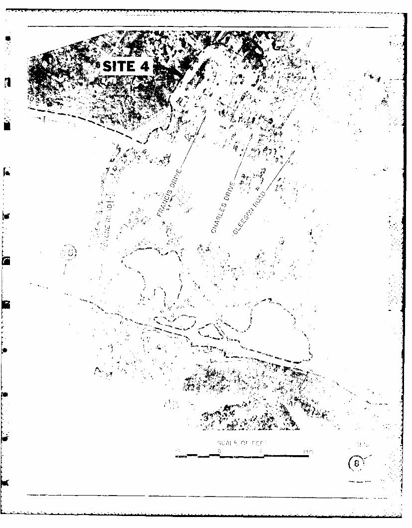
! SITE 4 "-1 .4 -A
er.:" / ,V ,,. ,/
E4 4,,
• . . .. . , ,<,, *. . I t ,
YA
ter CL .' .., .
, y '4 A' ."-4' "-..--" -<9. ,
5 t -
, , " ,A 2 ,4/.. - " % ( ,
(C . -, t i p s , " I. ' -' " -t " , " " . ..
0 0 -(,
• (0"

JOINWITHE-ECUYAHOGA RIVER, OHIOLEGEND: RESTORATION STUDY
DISTANCE FROM MOUTH IN MILES FLOOD AREASlEr MILES 14.2 TO 16.4
--- LIMIT OF FLOODING FOR THE SEPTEMBER 14, 1979FLOOD (APPROXIMATELY 40 YEAR EVENT) US ARMY ENGINEER DISTRICT BUFFALO
DECEMBER 1985
PLATE 5

owr'- or-
JOIN WITH E-E -
Ns -i
%2"4/- 4' " \ " -
.. " "" ' .
.4
- UAO GA RIE
, ,', :,, -.,;_,° .... !
-I.S I
• ,- . .. ..C . ; t ' . .. '
-. ,.. . , ,.. ., ,1,(. ,", : . . ' "
4 t,= " " ,. . .
CUVAiOGARiVE ""2 f 4
... .4: -6- .. , , " - - ' ..
- -- , - 94 '-t "'
,-.7
,. .
-- I,• ° .
" I >I,
:"

SCALE 0F400' 0
144
TINKERS CR1
4N4~
ISX,~ ~ '1W , a
- .- .- . - -~ 3A.A A r LX -

.I1 7 ' - I.- V ',
SCALE OF FEET LEGEND;0 400' B00, .._.DISTANCE FROM MOUTH IN MILES
-..- LIMIT OF FLOODING FOR THE SEPTEMBER 14, 1979 .57FLOOD (APPROXIMATELY 40 YEAR EVENT) "
4 7yr "'J
TINKERS CREEK :'
E ,~..
CUYAHOGA RIVER, OHIORESTORATION STUDY
FLOOD AREASMILES 16.4 TO 17.9
U S ARMY ENGINEER DISTRICT BUFFALO
DECEMBER 1985
PLATE 6

VALLEY VILV"' ; " .S
t. <.Y' " ,k--,; //~~ ", q; site 2, "/ ,.-J''.-.\k I
MILL CREEK ki -I ANAL
' " - - . " .,, . 4
iCUYAI:I-GiA RIVER"~
I-SITE i, , L
" .INDEPENDENCE o
"J3,. ]L :~ /SITE 3 1
FLOOD OUTLINES/ SCALE OF FEET
1600' 0 1600' 3200'
Z 620- CHESSIE SYSTEM BRIDGE OLD ROCKSIDE ROAD BRIDGE
0 GRANGER ROAD BRIDGE 100 YEAR FLOOD610 1 50 YEAR FLOOD (EXISTING CONDITIONS)
uj cl(EXISTIN3 CONDITIONS)
LL< ,- L x -- - ------- --
.
600-
590. "
,: >EXISTING CHANNEL BOTTOM
Wa 580- - -- --------
* z0 570
580+00 600-00 620-00 640+00 6C600 680'+00
Z z FLOOD PROFIL:::SCALE OF FEECI.
VERTICAL
20' 0 20'.
HORIZONTAL
1600' 0 160C ,
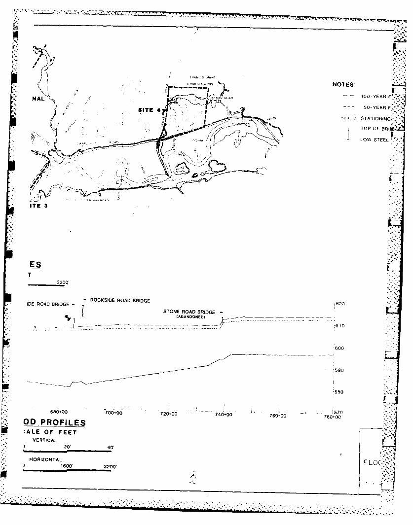
FRANCIS DRIVE
*.CHRLES DR" %N NOTES:K~ 100 -YEAR FNAL SC-'GLEESON AD
SITE 41 *-
9 Ub,',I) TATIONING:
TOP OF BRII~i
\ r AN'LOW STEEL
q-' AN-----
ITE 3
EST
3200'
DEROD ~ -G ROCKSIDE ROAD BRIDGE 620J TOE ROAD BRIDGE -
(ABANDONED)
610- - ~~- --------------- ,
600
590
680.00 700+00 720+00 740+00 7601+00 -' 0+57
OD PROFILES:ALE OF FEET
VERTICAL20' 40't
HORIZONTAL F LOC:,)1600' 3200'
.
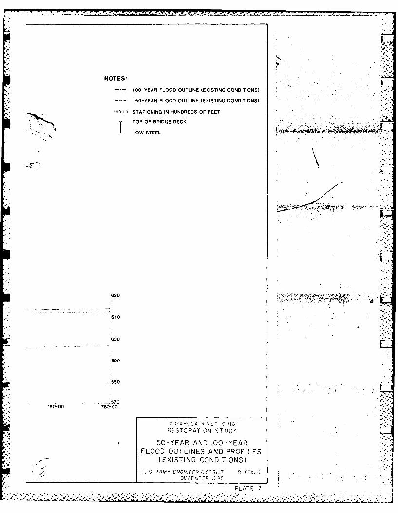
NOTES:
100-YEAR FLOOD OUTLINE (EXISTING CONDITIONS)
- -- 50-YEAR FLOOD OUTLINE (EXISTING CONDITIONS)
68010O STATIONING IN HUNDREDS OF FEET
T TOP OF BRIDGE DECK
I LOW STEEL '"'
1620- - 4 i-
610
'600
590
530
RESTORATION STUDY50-YEAR AND 100-YEAR
FLOOD OUTLINES AND PROFILES(EXISTING CONDITIONS)
.2USARMY ENJG1NEER O'STRiT BluFFA-i
PLATE 7

ZZ CL
2 din IL0 ,.L
4c
UU
MIw
00
00
o to

4r
0m0*2- - a.cc
909 * Z£ U.nA.. -
& 42--
01 . - a ~4a£ * 4 -4-4f4 ~ a
I., ~ ~ ZZ

77-~ T- -7 IL .7 l-- - C
LL U. I
>* >
z~
1ZL4 6zz a
40 r
SL
0
zI
oo-

b- ie4V ha
.~. .-
Waal000
W- o
ac UA
.0.
ha Ub
) / i

W-* ZZ
m ~ ~ I .~. o
0 w0rinw W& !9z WW L
''Aso 0
0. t.a. I5Z1- - D
0, j,6 C4 2
20 W*0 1 z
00l
LL
,, z w
-~ ~~~~~~ ~~~ I.- C . f .- t.a..c e. .a a a .

00 z
4L4'Co-j CLO I
w W L.. w R uiu
,0j c 0
Oot )- V) M
ww K
Mi 0 0
MiU
U.c U..
.0v
0 0z
0 J~
) / r
Uj"9
0 cc/
~1*.~ - . . .

.J LL"
16 LS .- a u IL CL0 .(E 'S
wl Or I!'12~ >S
w (3
U).-
1AJ oS 'o oo
10 U0
USoN____
zr-z-(f(
-K 4 1 ! , .-l - .. .

-- CV
-j oF- z1
I-. *) c -
-av"Osax-v
93~ 0
00W
ca lz 0
/Lw ::LW1j

W 'iLL-
0 4
crr
e~j e2-
za~ U4*
.c.

-n a. I
it
4c4
12)1
Lu -
II
em tza w
~FR§IM
tamw~
* k L ~ A-CUP
64-
0 Dim

0)
Q Ic >~ Z1
oL u
> 0' 0V
0/
00
5;; 0nj/
0 .

i 44c
z
;t z
z Z
oo
zz
0flFA)1
- 00
id,
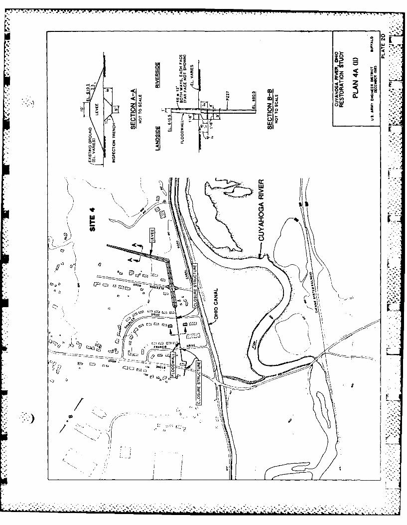
*00
X XU~I A
- .9 0 0
0w w- -- Iz ( l
ww a
0 00
-0V
000
(.Jc
E., I [ G
'E2.
.1r
/ ~l.

OHIO CANAL
CUYAHOGA RIVER
SCL O EET
200 0 200 400' 600.
CUYAHOGA RIVER, OHIORESTORATION STUDY
PLAN 4G(I)
U.S. ARMYt ENGINEER DISTRICT BUFFALODECEMBER 1985
PLATE 21
7.-.............................................. 7,-
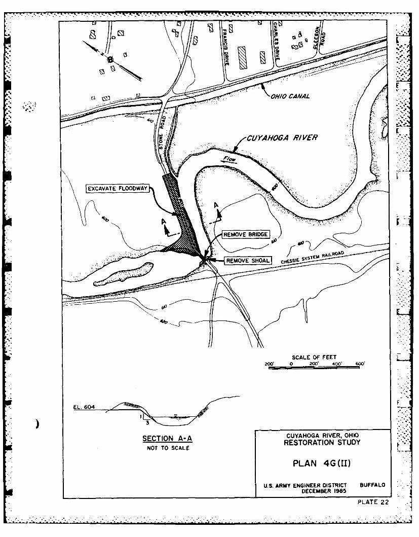
0 z gq CANAL
N0w
EXCVAT FLOA 440
REOV RIG
REMOSCAL OFOA FEETS
2W0 0 200 400 600
SECTION A-A CUYAHOGA RIVER, OHIONOT TOSCALERESTORATION STUDY
U.S. ARMY ENGINEER DISTRICT BUFFALODECEMBER 1985
PLATE 22

a0
OHIO CANAL
CUYAHOGA RIVER
SCALE OF FEET200 0 200 400' 600'
EL. 604
1K 33
) 250'CUYAHOGA RIVER, OHIO
SECTIN A-ARESTORATION STUDYNOT TO SCALE
PLAN 4G(111)
U.S. ARMY ENGINEER DISTRICT BUFFALODECEMBER 1985
PLATE 2.3 .

*00
OHIO CANAL
EXCSCALE OF FEETY
EL.WDE 604 LAN G(IV
RVESTOATONSTD
NOT~~SAL TO SCLEPLN ET(
EL.~LA 604PLN(GVTVEL ~LA 606PLAV1)VI
DECETIOR 198
PLATE 24

N. 0
SD OHIO CANAL
0 a
SAE OF TEET
200' 0 200, 400' 600'
) 150,CUYAHOGA RIVER, OHIO
SECTION A-A RESTORATION STUDYNOT TO SCALE
PLAN 4G(VII) -
U.S. ARMY ENGINEER DISTRICT BUFFALODECEMBER'1985
17-PLATE 25

WIDEN'~ CHN, L
6to
IL CUYHOGA V R . OHIO
REMVESHAL cssRE SOION STUDY
NO OSCALEOFEE
RESTORATAON STUD

L3 C3:
OHIO CANAL
RELOATECATNE
I,! ~ ~~BORROW _______98______________
NOTAL TO SCALE
RELATEA2E