Embed Size (px)
Citation preview

1
Flood Improvement and LID Modeling Using XP‐SWMM
Andrew Juan1, Nick Fang2, and Philip Bedient3
Rice University August, 2013
Introduction
First developed in 1971, the EPA's Storm Water Management Model (SWMM) has been widely used in
urban areas for planning, analysis, and design related to stormwater runoff, combined sewers, sanitary
sewers, and other drainage systems. XP‐SWMM, published by XP Solutions Inc., uses the EPA SWMM
model as the primary runoff hydrograph simulator for runoff quantity and quality. The major advantage
of XP‐SWMM over other software packages is its ability to combine a 1D river hydraulic model with a 2D
rainfall‐runoff model to generate floodplain maps. In addition, XP‐SWMM is approved by FEMA for the
hydrologic and hydraulic applications detailed in this study.
There are three separate modules present in XP‐SWMM: runoff, sanitary, and hydraulic. The runoff
module includes subcatchment areas for hydrologic modeling. The sanitary module allows for pollutant
loading and water quality analyses, and the hydraulic module is capable of simulating the hydraulics of
channels and storm sewers. Most of the work for Rice University’s flood improvement project was
accomplished in XP‐SWMM’s hydraulic module, while the LID modeling was conducted using the runoff
module.
Harris Gully Watershed
Rice University is located within the Harris Gully watershed, which covers a drainage area of
approximately 5 square miles, consisting mostly of fully‐developed residential and light commercial land
1 Graduate student, Civil and Environmental Engineering Department, Rice University, PH (713) 348‐4221, Email: [email protected] 2 Project Manager, Civil and Environmental Engineering Department, Rice University, PH (713) 348‐2398, Email: [email protected] 3 Professor, Civil and Environmental Engineering Department, Rice University, PH (713) 348‐4953, Email: [email protected]
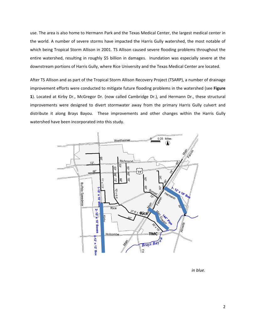
use. The a
the world
which bei
entire wa
downstre
After TS A
improvem
1). Locate
improvem
distribute
watershed
area is also ho
d. A number o
ing Tropical S
atershed, resu
am portions o
Allison and as
ment efforts w
ed at Kirby D
ments were d
e it along Br
d have been
Figure 1: Th
ome to Herm
of severe sto
Storm Allison
ulting in roug
of Harris Gull
part of the T
were conduct
r., McGregor
designed to d
rays Bayou.
incorporated
he Harris Gully
mann Park and
orms have im
in 2001. TS A
ghly $5 billio
y, where Rice
Tropical Storm
ted to mitigat
r Dr. (now ca
divert stormw
These impr
into this stud
y Watershed
d the Texas M
pacted the H
Allison cause
n in damage
e University a
m Allison Reco
te future floo
alled Cambrid
water away
rovements an
dy.
with drainag
Ri
Medical Cente
Harris Gully w
ed severe floo
s. Inundatio
and the Texas
overy Project
oding problem
dge Dr.), and
from the pri
nd other cha
ge improveme
ice
TMC
er, the largest
watershed, th
oding problem
on was espec
s Medical Cen
t (TSARP), a n
ms in the wat
Hermann Dr
imary Harris
anges within
ents depicted
t medical cen
he most nota
ms throughou
ially severe a
nter are locate
umber of dra
ershed (see F
r., these stru
Gully culver
n the Harris
in blue.
2
nter in
ble of
ut the
at the
ed.
ainage
Figure
ctural
rt and
Gully
3
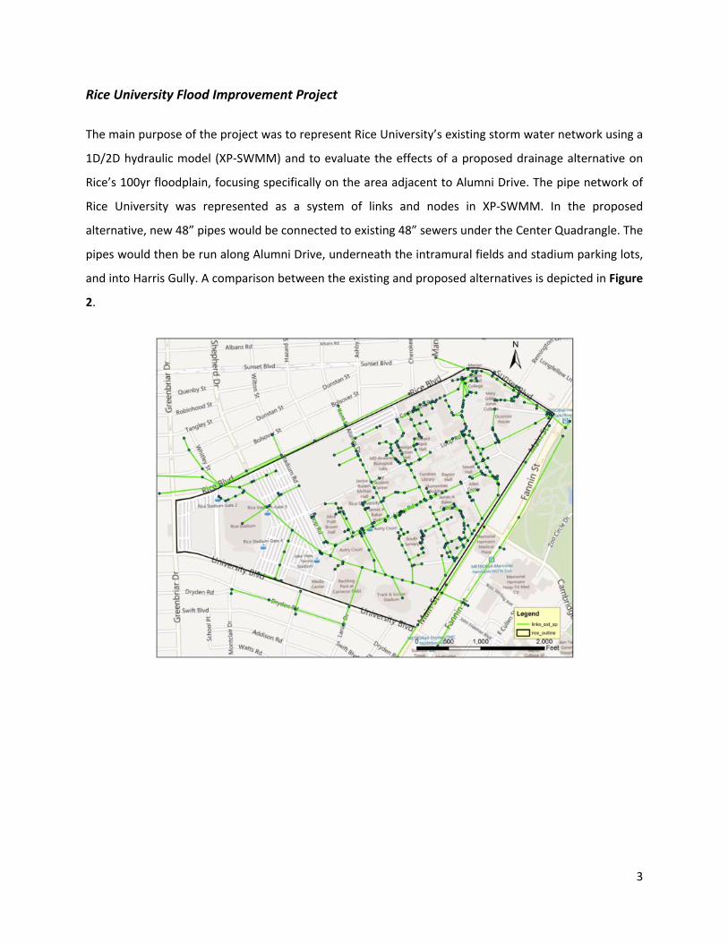
Rice University Flood Improvement Project
The main purpose of the project was to represent Rice University’s existing storm water network using a
1D/2D hydraulic model (XP‐SWMM) and to evaluate the effects of a proposed drainage alternative on
Rice’s 100yr floodplain, focusing specifically on the area adjacent to Alumni Drive. The pipe network of
Rice University was represented as a system of links and nodes in XP‐SWMM. In the proposed
alternative, new 48” pipes would be connected to existing 48” sewers under the Center Quadrangle. The
pipes would then be run along Alumni Drive, underneath the intramural fields and stadium parking lots,
and into Harris Gully. A comparison between the existing and proposed alternatives is depicted in Figure
2.

4
Figures 2(a) and (b): Existing (top) and proposed (bottom) storm water network on Rice Campus.
Changes to the existing network are highlighted in blue in 2b.
To create the base XP‐SWMM model, Tropical Storm Erin (August 16, 2007) was used. The primary
reason for the selection of this storm was the availability of high water marks at several locations
throughout the Rice campus. These records later proved to be instrumental in model calibration. The
rainfall data for this event were obtained from a HCOEM rain gauge at Holcombe (OEM400) that
recorded a total rainfall depth of 6.2 in. The rainfall data are shown in Figure 3 below.

Land use
highly imp
imperviou
represent
was categor
pervious area
usness—was
ted in XP‐SWM
Figure 3
rized within X
as, mainly the
categorized
MM.
: Cumulative
XP‐SWMM as
e buildings o
as LoFrictio
Rainfall from
s either HiFr
n Rice campu
on. Figure 4
m HCOEM Gau
riction or LoF
us. The rest o
shows Rice
uges.
Friction. HiFri
of the Rice—t
’s land use
iction repres
the areas of
characteristi
5
ented
lower
ics as

After runn
compared
generally
compariso
Figure 5:
Figure 4. L
ning the base
d with obser
corresponde
on between t
Comparison
and use chara
e model with
rved high wa
d well with th
the simulated
between XP‐S
acteristics of
TS Erin, the s
ater marks a
he observed h
d and observe
SWMM mode
Rice Universi
simulated wat
at various lo
high water m
ed water surfa
eled high wat
ity as represe
ter surface el
ocations. The
marks along Al
ace elevation
ter marks and
ented by XP‐SW
levations from
simulated i
lumni Drive. F
ns at Alumni D
d those observ
WMM.
m XP‐SWMM
nundation d
Figure 5 show
Drive for TS E
ved during TS
6
were
epths
ws the
rin.
S Erin.

To compa
design sto
inundatio
reduction
several of
and/or va
Biological
are the perfo
orm was simu
on levels along
n was observe
f the existing
aluable equip
Laboratories
Figure 6: 1
ormances of e
ulated. The pr
g Alumni Dr.
ed as illustrat
g buildings ad
pment and re
s as well as th
100‐yr flood l
existing and p
roposed alter
for the desig
ted in Figures
djacent to Alu
esearch mate
he Space Scien
levels from Ex
proposed con
rnative was fo
gn storm. In g
s 6 and 7. Thi
umni Drive, e
erial, such as
nce and Tech
xisting (left) a
nditions of th
ound to be su
general, appr
s flooding red
especially tho
s the Keith‐W
nology Buildi
and Proposed
he Rice camp
uccessful in re
oximately 0.5
duction woul
ose with base
Weiss Geolog
ing.
d (right) Condi
pus, the 100y
educing the o
5‐1ft of inund
ld be benefic
ement labora
ical and And
itions.
7
yr24hr
overall
dation
ial for
tories
erson
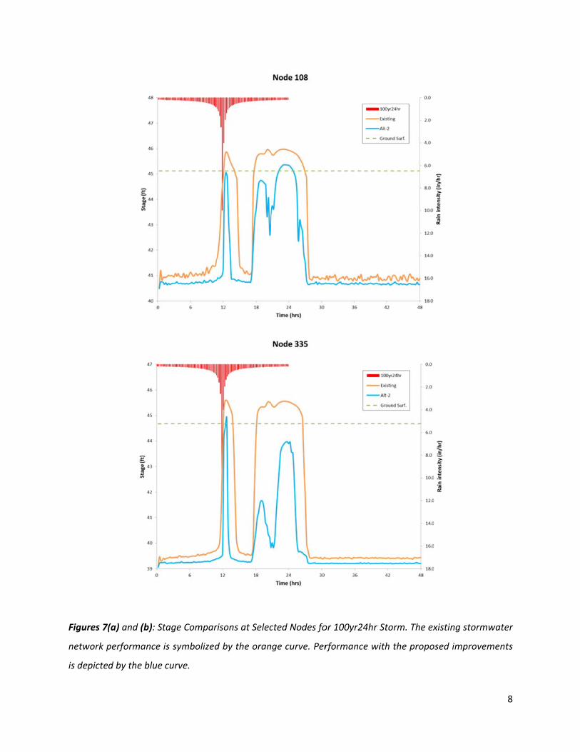
Figures 7(
network p
is depicte
(a) and (b): S
performance
d by the blue
tage Compar
is symbolized
curve.
risons at Selec
d by the oran
cted Nodes fo
ge curve. Per
or 100yr24hr S
rformance wi
Storm. The ex
ith the propo
xisting storm
osed improvem
8
water
ments
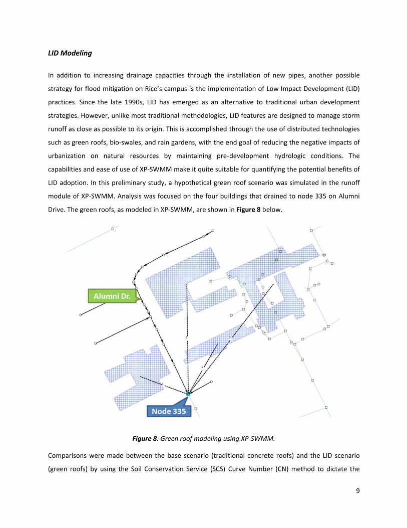
LID Mode
In additio
strategy f
practices.
strategies
runoff as
such as gr
urbanizat
capabilitie
LID adopt
module o
Drive. The
Comparis
(green ro
eling
on to increas
for flood miti
Since the la
s. However, u
close as poss
reen roofs, bi
ion on natu
es and ease o
tion. In this p
of XP‐SWMM.
e green roofs,
ons were ma
ofs) by using
sing drainage
gation on Ric
ate 1990s, LI
unlike most tr
sible to its ori
io‐swales, an
ural resourc
of use of XP‐S
preliminary st
. Analysis wa
, as modeled
Figure
ade between
g the Soil Co
capacities t
ce’s campus i
D has emerg
raditional me
igin. This is ac
d rain garden
es by main
SWMM make
tudy, a hypot
s focused on
in XP‐SWMM
8: Green roof
the base sce
nservation Se
hrough the i
is the implem
ged as an alt
thodologies,
ccomplished
ns, with the e
ntaining pre‐
it quite suita
thetical green
n the four bui
M, are shown
f modeling us
enario (tradit
ervice (SCS) C
installation o
mentation of
ternative to t
LID features
through the
end goal of re
‐developmen
able for quant
n roof scenar
ildings that d
in Figure 8 be
sing XP‐SWM
tional concre
Curve Numb
of new pipes,
Low Impact D
traditional ur
are designed
use of distrib
educing the n
t hydrologic
tifying the po
rio was simul
drained to no
elow.
MM.
ete roofs) and
er (CN) meth
, another po
Development
rban develop
d to manage s
buted techno
egative impa
c conditions.
otential bene
lated in the r
ode 335 on A
d the LID sce
hod to dictat
9
ossible
t (LID)
pment
storm
logies
acts of
. The
fits of
runoff
Alumni
enario
te the

hydrologi
models to
appropria
a Curve N
and mois
scenarios
For this p
while the
between
After sim
green roo
addition,
timing of
decreased
conclusive
c performanc
o simulate w
ate volume of
Number or CN
ture conditio
using Green
particular stud
e concrete ro
two differen
ulating sever
ofs were able
it was obser
peak flows. S
d peak flows
e, indicating t
Figure 9: Pre
ce of each ro
watershed run
f stormwater
, a paramete
ons on runof
Roofs and tra
dy, the green
oofs were rep
t runoff met
al design sto
e to reduce p
rved differen
Specifically, i
when compa
that more stu
eliminary Res
oof type. The
noff. The me
runoff for a g
r that represe
ff generation
aditional hydr
roofs in the
presented by
thods: the SW
rms (1in rain
peak flows as
nt routing me
t was found
ared to the k
udies need to
sults from Gre
e SCS CN met
ethod applies
given area by
ents the com
. Figure 9 pr
rologic mode
LID scenario
y SCS Curve
WMM runoff
fall, 2yr‐3hr,
s well as tota
ethods result
that the SWM
kinematic wa
be conducte
een Roofs vs.
thod is comm
s an empiric
y characterizi
bined impact
resents some
eling schemes
were represe
Number 77.
f method and
10yr‐12hr), i
al runoff volu
ted in discre
MM runoff m
ve method. T
ed to validate
Traditional M
monly used in
cal approach
ng its hydrolo
ts of soil type
e preliminary
s in XP‐SWMM
ented by SCS
Comparisons
d the kinema
nitial results
ume by appr
pancies in th
method result
These results
these finding
Models in XP‐S
n many hydro
to determin
ogic response
e, vegetative c
y results from
M.
Curve Numb
s were also
atic wave me
indicated tha
roximately 20
he magnitude
ted in delaye
s are by no m
gs.
SWMM.
10
ologic
e the
e with
cover,
m the
er 86,
made
ethod.
at the
0%. In
e and
d and
means

11
Conclusions and Work in Progress
Overall, XP‐SWMM was found to be instrumental in simulating and depicting the drainage conditions for
the Rice flood improvement project; and based on the preliminary results, it also has potential for
application in the design and evaluation of different LID features. Currently, Rice is in the process of
constructing several new buildings throughout campus, and it is likely that this activity will impact
existing hydrologic conditions. Therefore, it is paramount that more studies are conducted to further
improve our understanding of drainage performance at Rice. Future analyses may include performing a
more detailed hydrology/hydraulics study in the areas beyond Alumni Drive as well as the evaluation of
other LID features, including porous pavements, swales, and infiltration strips.


![[XPday.vn] XP? not Windows XP {presentation} (at) [XP Day Vietnam 2015]](https://img.pdfslide.net/doc/110x75/55c4e9e3bb61ebac3f8b47ae/xpdayvn-xp-not-windows-xp-presentation-at-xp-day-vietnam-2015.jpg)


![[XP Day Vietnam 2015] XP is not windows XP](https://img.pdfslide.net/doc/110x75/55a69cf71a28abd47d8b4735/xp-day-vietnam-2015-xp-is-not-windows-xp.jpg)