Embed Size (px)
Citation preview
Flood Management Case Study: Leuven and the River Dijle Valley
By The British Geographer
Place Context Leuven is located 30km east of Brussels and has a long history of floods. The two most devastating were in 1891 and 1946 both caused by combined snowmelt and extended periods of rainfall. In the case of the former, one third of the town, which populated 25000 people, was inundated. In the case of the latter, the inner city was protected by flood defense but other districts and suburbs were badly flooded. More recently in 1996, the town narrowly avoided a major flood. Discharge levels reached for short period of time 100-year levels and modern city flood defenses were almost overwhelmed. If it wasn’t for a sudden break in weather conditions it would have impossible to avoid sever floods. Causes of floods in Leuven Leuven is situated at the confluence of three rivers, the Dijle and two feeder tributaries, the Voer, and the Molenbeek. This creates a bottleneck of discharge converging on the town. The town is itself low lying, which increases the scale and severity of potential floods. The River Dijle is alluvial in its nature and in combination with a lowering of the water table as result of floodplain drainage the river has cut down and transports large quantities of sediment. This sediment chokes the channel, reducing capacity, especially within the town of Leuven.
A suburb of Leuven stands flooded
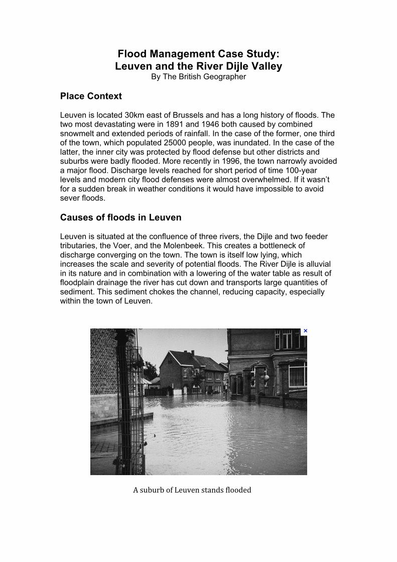
For the last 100 years or more agricultural development and urbanisation has slowly drained the floodplains and stripped land of forest. Urban environments, including impermeable surfaces and drainage infrastructure are designed to transfer water quickly into the river, increasing the likelihood of the flooding. Finally, increased population pressure with the towns university status has led to urbanization and more and more housing development have built over floodplains. Flood Management
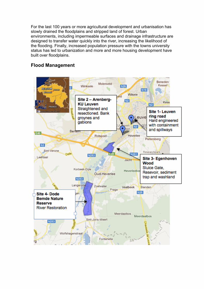
Site 1 – Leuven Ring Road Due to the importance and value of infrastructure and functions within the ring road at Leuven, comprehensive management plan consisting of hard engineering strategies has been developed. As the river Dijle and river Voer reach Leuven they are in part contained within subsurface channels. The Dijle channel flows openly thorough the town but diversion channels redistribute part of its discharge underground. In addition to containment there are spillway channels set to the side of the channel with slightly raised elevation. These channels only come into work when discharge levels are rising.
As we can see in the photographs above a number of schemes are deployed to restrict and control the flow within the ring road of Leuven. However, these schemes became seriously compromised in 1996 and so an additional scheme was needed. Site 2 Arenberg: KU Leuven Site 2 is situated approximately 1km upstream from the Leuven ring road and locates the stunning gothic Arenberg Kasteel and park estates. For the purpose of sympathetic bank protection a number of softer approaches in combination with resectioning has been deployed.
Containment: River Voer Spillways, elevated above the channel
Sluice gates and diversion channels
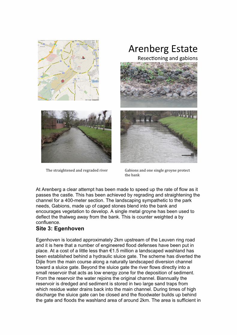
At Arenberg a clear attempt has been made to speed up the rate of flow as it passes the castle. This has been achieved by regrading and straightening the channel for a 400-meter section. The landscaping sympathetic to the park needs, Gabions, made up of caged stones blend into the bank and encourages vegetation to develop. A single metal groyne has been used to deflect the thalweg away from the bank. This is counter weighted a by confluence. Site 3: Egenhoven Egenhoven is located approximately 2km upstream of the Leuven ring road and it is here that a number of engineered flood defenses have been put in place. At a cost of a little less than €1.5 million a landscaped washland has been established behind a hydraulic sluice gate. The scheme has diverted the Dijle from the main course along a naturally landscaped diversion channel toward a sluice gate. Beyond the sluice gate the river flows directly into a small reservoir that acts as low energy zone for the deposition of sediment. From the reservoir the water rejoins the original channel. Biannually the reservoir is dredged and sediment is stored in two large sand traps from which residue water drains back into the main channel. During times of high discharge the sluice gate can be closed and the floodwater builds up behind the gate and floods the washland area of around 2km. The area is sufficient in
The straightened and regraded river Gabions and one single groyne protect the bank
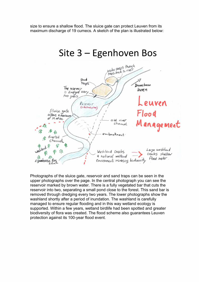
size to ensure a shallow flood. The sluice gate can protect Leuven from its maximum discharge of 19 cumecs. A sketch of the plan is illustrated below:
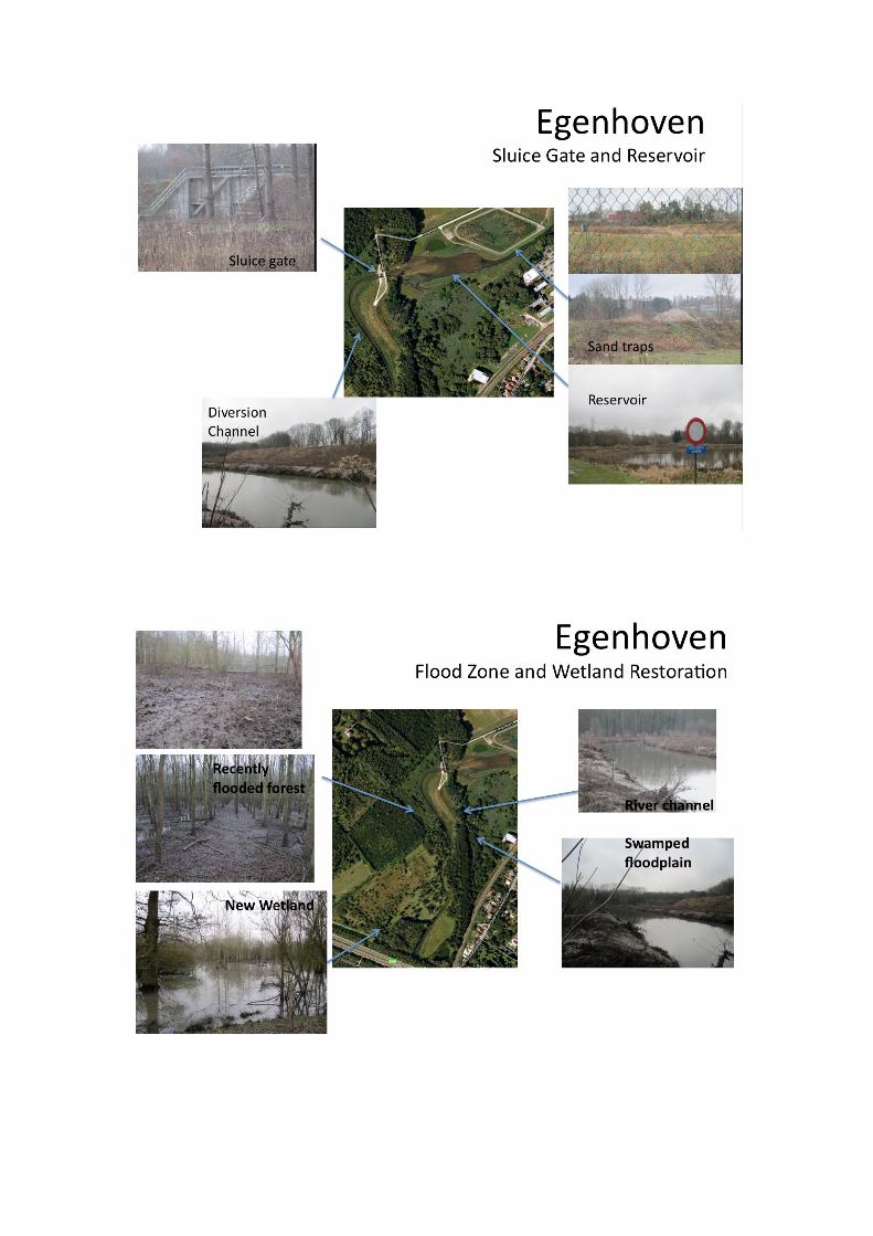
Photographs of the sluice gate, reservoir and sand traps can be seen in the upper photographs over the page. In the central photograph you can see the reservoir marked by brown water. There is a fully vegetated bar that cuts the reservoir into two, separating a small pond close to the forest. This sand bar is removed through dredging every two years. The lower photographs show the washland shortly after a period of inundation. The washland is carefully managed to ensure regular flooding and in this way wetland ecology is supported. Within a few years, wetland birdlife had been spotted and greater biodiversity of flora was created. The flood scheme also guarantees Leuven protection against its 100-year flood event.
Site 4 - The Dode Bemde River Restoration The Dode Bemde is an area of wetland habitat that supports a lake and a section of the Dijle valley. It was bought by an environmental agency in Belgium called Nature Punt, with the aim of restoring the section of river to an unregulated state. Farming in the Dijle valley has long been in slow decline. Therefore, Nature Punt was able to secure ownership of the floodplain farmland within the valley. The first task was to dismantle the drainage channel within the fields. In doing so, the water table would rise, causing greater frequency of saturation and a corresponding rise in the water level of the channel. In addition, greater channel roughness has developed because the riverbanks are no longer being managed and vegetation is no longer cut back. These small steps have brought about a significant change; meanders are now migrating in places at rates between 1 and 2 meters a year. The river flow has risen, along with the water table and greater frequency of flooding has occurred. Evaluating the Scheme Hard engineering at Leuven was an appropriate technology of its time. Developed in the 1950’s and 60’s, containment and spillways represented state of the art technology and no expense was spared in diverting the channel. The benefits were to restrict the possibility of flooding that in turn enabled the construction of modern transport infrastructure and town planning. Leuven today is a thriving university town that is attracting many high tech companies. Without these schemes, Leuven would certainly have suffered major floods. However, the event 1996, where discharge levels reached a record high revealed the shortfalls of the hard engineering. Despite their expense, they were struggling to contain the 100-year discharge levels and could easily have become overwhelmed. At site 2, hard engineering is used in a more sympathetic way that creates a more natural looking river. The river however, has been resectioned, through straightening and regrading. This speeds up the velocity and moves water quickly past the castle. At the time of construction this would have had high ecological impact. However, today, through the use soft approaches such as gabions and tree planting, adequate bank protection is provided. For the majority of time this is a perfectly adequate scheme but it was Arenberg that flooded in 1946 and 1996. There was a clear need for improved protection upstream. Site 3 at Egenhoven is a hard engineered scheme that began in 2004. It must be described as sympathetic to it physical environment and brings with it some ecological benefits. The river channel has been diverted to flow through a sluice gate and reservoir. Landscaping, gabions and riparian vegetation have also fostered a natural appearance. For quite small expense, the scheme provides adequate protection to safeguard Leuven form the 100-year flood event. It must be stated that the Dijle is not a large river but in Belgium it is recognised as a significant regional river. The costs are therefore
appropriate to the scale of the project and the project itself is now being used as a model of success around the world. The project has successfully developed and wetland environment in the washland and the environmental agency allow for frequent flooding to ensure the ecological evolution. However it is not without its problems. The biannual dredging of sediment from the reservoir is a massive disturbance to the reservoir, which must disturb nesting sites. However, the sediment is redistributed and sold back to local farmers. Site 4- The Dode Bemde must be seen independently as Nature Punt has funded it. This scheme shows a successful restoration project achieved at minimal cost. The only form of hard engineering deployed was the construction of dykes to protect one house and a single water-processing unit. The dismantling of field drainage almost single handedly restored the river through raising the water table. By allowing vegetation growth on the bank, channel roughness has increased and river is now freely migrating, all within a 5-year period. The river is also more prone to flooding and this created an enormous area that increases the storage capacity of the valley. To conclude, through a combination of hard and soft engineering, The River Dijle appears to be controlled. Hard engineering on its own has fallen short in safeguarding Leuven from its 100-year flood. River management agencies and environmental groups appear to have found the solution. Through a combination of simple floodplain restoration work and engineered channel management to create a washland, the Dijle valley has in part been restored offer water storage services to the city of Leuven. In doing so, a rich and more diverse river ecosystem is being created