Embed Size (px)
Citation preview
DISCLAIMERThe information shown on this map has been produced from the Townsville City Council's digital database. There is no warrantyimplied or expressed regarding the accuracy or completeness of the data. The data has been compiled for information and convenience only, and it is the responsibility of the user to verify all information before placing reliance on it. For accurate service locations please contact the Customer Services Centre on1300 878 001.This is not a legal document and is published for informationand convenience only. The Townsville City Council takes noresponsibility for any errors or omissions herein or for anyacts that may occur due to its use.
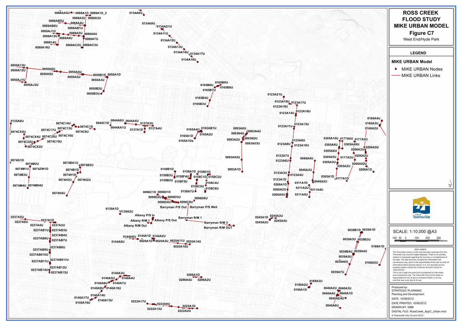
ROSS CREEK FLOOD STUDY
MIKE URBAN MODEL
LEGEND
´0096C1D 0096D1D
0158B1D
0245A1D
0305A1D
0134A8U
0093A1D
0039B1D
0168A1D
0158A1D
0044A6U 0044A4U
0206A1D
0165A1D
0093A6U
0123A1D
0074B1D
0237A1D
0139A1D
0074H1D
0039A1D
0222A1D
0137A1D0044C1D
0311A1D
0137A3U
0050B1D 0050A1D
0088A1D
0158D1D0158C1D
0266A1D0177A1D
0074C1D
0074G1D
0144A1D
0237A5U
0040A2U
0237A4U
0137A4U
0088A5U
0144A2U
0237A3U
0165A4U
0160A4U
0096D2U 0096D3U0096D4U 0096C8U
0158C5U 0158C6U
0160A3U
0165B3U
0160A2U
0305A9U
0093A4U
0020A1D
0222A8U
0158B3U
0296A1D
0158A7U
0296A4U
0158C2U
0311A5U
0177A2U
0266A2U
0096D8U
0074C6U
0237A6U
0093A2U 0177A6U0093N4U
0093N2U
0046A4U
0046A3U
0046A2U
0020A3U
0123A3U
0134A9U
0165B6U 0165B9U
0074M4U
0305A3U0305A2U
0158F4U
0135A8U
0311A2U0158F5U
0088A2U 0088A3U0088A4U
0039B4U
0168A2U
0222A2U
0074H3U
0088A9U0088A6U0088A7U
008814U
0050B2U
0050A3U
0050A4U
0074H2U
0039A7U
0040A3U
0039A4U0039A5U
0245A3U0245A4U
0158C4U
0039A3U 0039B3U
0050B3U
0311A4U
0040A4U
0144A6U
0140A3U
0144A9U
0140A5U 0140A4U0140A8U 0189A2U
0189A3U
0040A6U
0305A5U
0266A5U
0074B2U
0177A5U
0074M2U0074M1U
0158B2U
0296A2U
0040A1D0189A1D
0123A4U
0050A8U
0074H4U
0165B7U 0165B8U
0165B4U
0165A2U
0039A6U
0206A3U 0206A5U0305A6U
0074M3U
0206A2U
0123A8U
0123A7U0123A6U
0050A9U
0123A9U
0050A5U
0139A2U
0245A2U
0140A9U0140A7U
0074ZW1D
0134AD1U
0050A13U
0044AA1U
0237AB6U
0074CX5U0074CX4U
0237AB9U
0088AJ1U
0305A10U
0165AB1U
0093A02U
0222A13U
0237AB1U
0074C14U0074C13U
0237AB8U
0074M04U
0237AB3U
0123A18U0123A21U
0123A19U
0123A10U0093A03U 0305AA9U
0020A11U
0123A17U
0134A11U0134A12U
0134A13U
0088A12U
0074C20U0074C17U
0020A14U
0222A17U
0237AB4U0237AB7U
0088A16U
0088AB1U0088AB5U
0088AB6U
0088AA5U
0050AJ1U
0050A12U
0088AC2U 0088AC3U
0020A16U
0074C22U0074CX2U
0074C19U
0140A17U 0140A14U0140A13U
0140A10U
0040AE4U
0074C16U
0134A16U
0206A02U
0134A18U0134A17U
0050AJ2U
0140A16U
0123A14U
0123A11U
0165A1Da
0123A16U
0123A13U
0074BA1U
0088A1D_2
0237AB14U 0237AB12U0237AB11U
0237AB13U
0237AB011U0237AB010U
Albany R/M 1Albany P/S In
Albany R/M OutAlbany P/S Out Barryman R/M 3
Barryman R/M 1
Barryman R/M OUT
Barryman P/S Out Barryman P/S Well
100 0 100 200 30050Metres
Produced by:
DATE: 10/08/2012
STRATEGIC PLANNINGPlanning and Development
© Townsville City Council 2012DIGITAL FILE: RossCreek_AppC_Urban.mxdDRAWN BY: WBBDATE PRINTED: 10/08/2012
SCALE: 1:10,000 @A3
MIKE URBAN ModelMIKE URBAN NodesMIKE URBAN Links
West End/Hyde ParkFigure C7

DISCLAIMERThe information shown on this map has been produced from the Townsville City Council's digital database. There is no warrantyimplied or expressed regarding the accuracy or completeness of the data. The data has been compiled for information and convenience only, and it is the responsibility of the user to verify all information before placing reliance on it. For accurate service locations please contact the Customer Services Centre on1300 878 001.This is not a legal document and is published for informationand convenience only. The Townsville City Council takes noresponsibility for any errors or omissions herein or for anyacts that may occur due to its use.
ROSS CREEK FLOOD STUDY
MIKE URBAN MODEL
LEGEND
´
0029A1D
0115J1D 0115E1D0115G1D
0290A1D
0264K1D
0164B1D
0078A1D
0205B1D
0249A1D
0206A1D
0132A1D
0205C1D0205D1D
0250A1D
0115H1D
0205C5U0205C4U
0078A8U
0250A6U
0160A4U0160A3U
0264K4U
0160A2U 0113A2U
0160A1D
0009A5U
0242A1D
0242J1D
0113A1D
0009A1D
0164A1D0203A2U
0290A9U
0242A2U
0290A2U
0290A5U
0029A2U
0242A4U 0249A8U
0249A6U
0290A4U
0290A8U0290A7U
0290A6U
0203A7U
0203A9U0203A8U
0203A6U
0264K2U
0264A9U0264A6U0029A3U
0242A3U
0113A4U
0078A3U
0164A9U
0132A8U0132A9U
0270A6U
0272A9U
0270A2U0009A7U
0250A3U
0026A2U0009A4U
0009A3U0009A2U
0113A5U
0113A3U
0113A6U
0164A4U
0249A7U
0205C6U
0205C7U
0203A3U
0264K3U
0026A4U
0206A3U0206A2U 0029A0D
0026A1D
0290A1U
0078A5U0115E2U
0270A4U
0164A6U0164A5U
0271B2U
0242J2U
0132A2U
0264AE1U
0264KA4U
0290AU1U
0272A12U
0264KA5U
0270A34U
0113A10U
0270A30U
0009AF1D
0242AD1U
0290AD6U
0290A10U
0290AA5U
0029AA2U
0270A19U
0290A15U0290A14U
0290A13U
0290A18U0290A17U
0270A13U0270AL1U
0264K02U
0132A13U 0132A12U0132A11U 0132A10U
0132AP1U
0290A20U
0290A22U 0290A23U
0009AF2U
0290AV5U
0290A19U
0206A02U
0290AV3U 0290AV4U
0270A35U
0290AA6U
0270A26U
0029A0Da
0132A1Da
0272A02U
0290A21U
0270A33U
0290A11U
0290AZW2U
0270A031U
0290AZR2U
0290AZR5U
Flinders 1/8Flinders 1/7
100 0 100 200 30050Metres
Produced by:
DATE: 10/08/2012
STRATEGIC PLANNINGPlanning and Development
© Townsville City Council 2012DIGITAL FILE: RossCreek_AppC_Urban.mxdDRAWN BY: WBBDATE PRINTED: 10/08/2012
SCALE: 1:10,000 @A3
MIKE URBAN ModelMIKE URBAN NodesMIKE URBAN Links
City/South TownsvilleFigure C8
ABN >> 44 741 992 072 D
Appendix D – Flood Maps
DISCLAIMERThe information shown on this map has been produced from the Townsville City Council's digital database. There is no warrantyimplied or expressed regarding the accuracy or completeness of the data. The data has been compiled for information and convenience only, and it is the responsibility of the user to verify all information before placing reliance on it. For accurate service locations please contact the Customer Services Centre on1300 878 001.This is not a legal document and is published for informationand convenience only. The Townsville City Council takes noresponsibility for any errors or omissions herein or for anyacts that may occur due to its use.
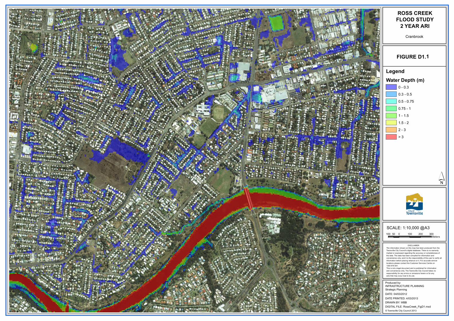
ROSS CREEKFLOOD STUDY
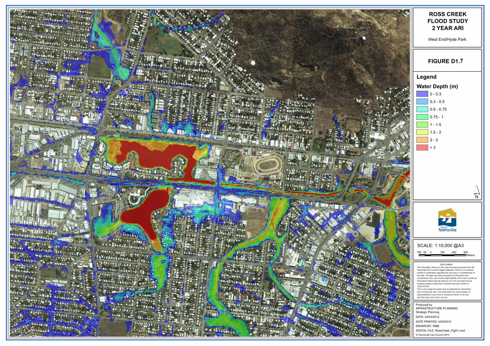
2 YEAR ARI
´
100 0 100 200 30050Meters
Produced by:
DATE: 04/03/2012
INFRASTRUCTURE PLANNINGStrategic Planning
© Townsville City Council 2013DIGITAL FILE: RossCreek_FigD1.mxdDRAWN BY: WBBDATE PRINTED: 4/03/2013
SCALE: 1:10,000 @A3
Cranbrook
1FIGURE D1.
LegendWater Depth (m)
0 - 0.30.3 - 0.50.5 - 0.750.75 - 11 - 1.51.5 - 22 - 3> 3
DISCLAIMERThe information shown on this map has been produced from the Townsville City Council's digital database. There is no warrantyimplied or expressed regarding the accuracy or completeness of the data. The data has been compiled for information and convenience only, and it is the responsibility of the user to verify all information before placing reliance on it. For accurate service locations please contact the Customer Services Centre on1300 878 001.This is not a legal document and is published for informationand convenience only. The Townsville City Council takes noresponsibility for any errors or omissions herein or for anyacts that may occur due to its use.
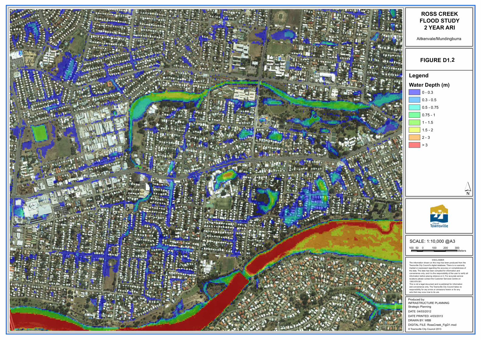
ROSS CREEKFLOOD STUDY
2 YEAR ARI
´
100 0 100 200 30050Meters
Produced by:
DATE: 04/03/2012
INFRASTRUCTURE PLANNINGStrategic Planning
© Townsville City Council 2013DIGITAL FILE: RossCreek_FigD1.mxdDRAWN BY: WBBDATE PRINTED: 4/03/2013
SCALE: 1:10,000 @A3
Aitkenvale/Mundingburra
2FIGURE D1.
LegendWater Depth (m)
0 - 0.30.3 - 0.50.5 - 0.750.75 - 11 - 1.51.5 - 22 - 3> 3
DISCLAIMERThe information shown on this map has been produced from the Townsville City Council's digital database. There is no warrantyimplied or expressed regarding the accuracy or completeness of the data. The data has been compiled for information and convenience only, and it is the responsibility of the user to verify all information before placing reliance on it. For accurate service locations please contact the Customer Services Centre on1300 878 001.This is not a legal document and is published for informationand convenience only. The Townsville City Council takes noresponsibility for any errors or omissions herein or for anyacts that may occur due to its use.
ROSS CREEKFLOOD STUDY
2 YEAR ARI
´
100 0 100 200 30050Meters
Produced by:
DATE: 04/03/2012
INFRASTRUCTURE PLANNINGStrategic Planning
© Townsville City Council 2013DIGITAL FILE: RossCreek_FigD1.mxdDRAWN BY: WBBDATE PRINTED: 4/03/2013
SCALE: 1:10,000 @A3
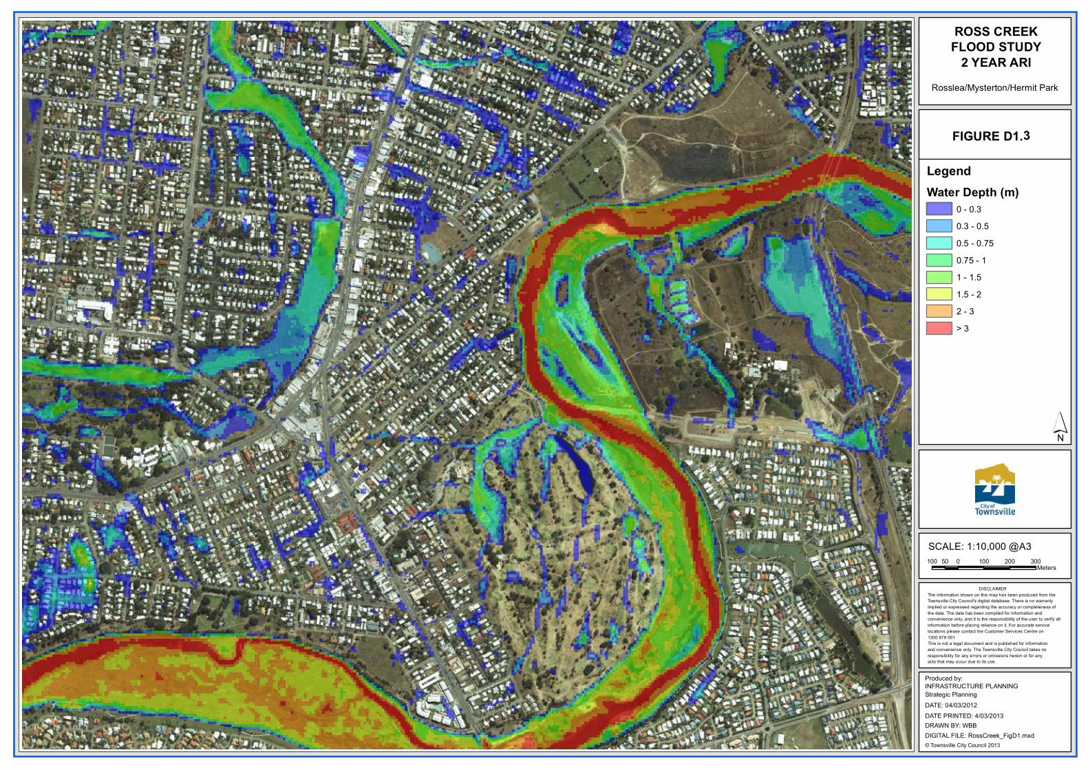
Rosslea/Mysterton/Hermit Park
3FIGURE D1.
LegendWater Depth (m)
0 - 0.30.3 - 0.50.5 - 0.750.75 - 11 - 1.51.5 - 22 - 3> 3
DISCLAIMERThe information shown on this map has been produced from the Townsville City Council's digital database. There is no warrantyimplied or expressed regarding the accuracy or completeness of the data. The data has been compiled for information and convenience only, and it is the responsibility of the user to verify all information before placing reliance on it. For accurate service locations please contact the Customer Services Centre on1300 878 001.This is not a legal document and is published for informationand convenience only. The Townsville City Council takes noresponsibility for any errors or omissions herein or for anyacts that may occur due to its use.
ROSS CREEKFLOOD STUDY
2 YEAR ARI
´
100 0 100 200 30050Meters
Produced by:
DATE: 04/03/2012
INFRASTRUCTURE PLANNINGStrategic Planning
© Townsville City Council 2013DIGITAL FILE: RossCreek_FigD1.mxdDRAWN BY: WBBDATE PRINTED: 4/03/2013
SCALE: 1:10,000 @A3
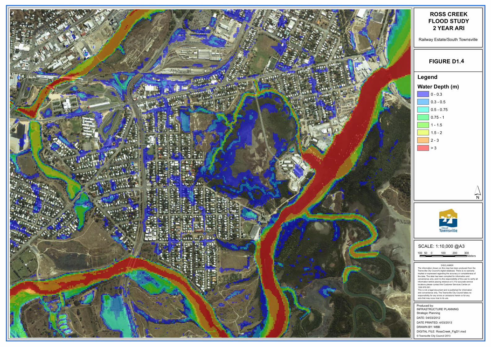
Railway Estate/South Townsville
4FIGURE D1.
LegendWater Depth (m)
0 - 0.30.3 - 0.50.5 - 0.750.75 - 11 - 1.51.5 - 22 - 3> 3
DISCLAIMERThe information shown on this map has been produced from the Townsville City Council's digital database. There is no warrantyimplied or expressed regarding the accuracy or completeness of the data. The data has been compiled for information and convenience only, and it is the responsibility of the user to verify all information before placing reliance on it. For accurate service locations please contact the Customer Services Centre on1300 878 001.This is not a legal document and is published for informationand convenience only. The Townsville City Council takes noresponsibility for any errors or omissions herein or for anyacts that may occur due to its use.
ROSS CREEKFLOOD STUDY
2 YEAR ARI
´
100 0 100 200 30050Meters
Produced by:
DATE: 04/03/2012
INFRASTRUCTURE PLANNINGStrategic Planning
© Townsville City Council 2013DIGITAL FILE: RossCreek_FigD1.mxdDRAWN BY: WBBDATE PRINTED: 4/03/2013
SCALE: 1:10,000 @A3
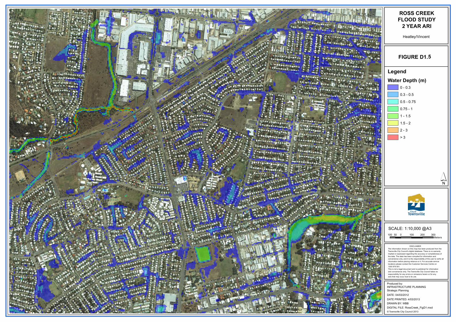
Heatley/Vincent
5FIGURE D1.
LegendWater Depth (m)
0 - 0.30.3 - 0.50.5 - 0.750.75 - 11 - 1.51.5 - 22 - 3> 3
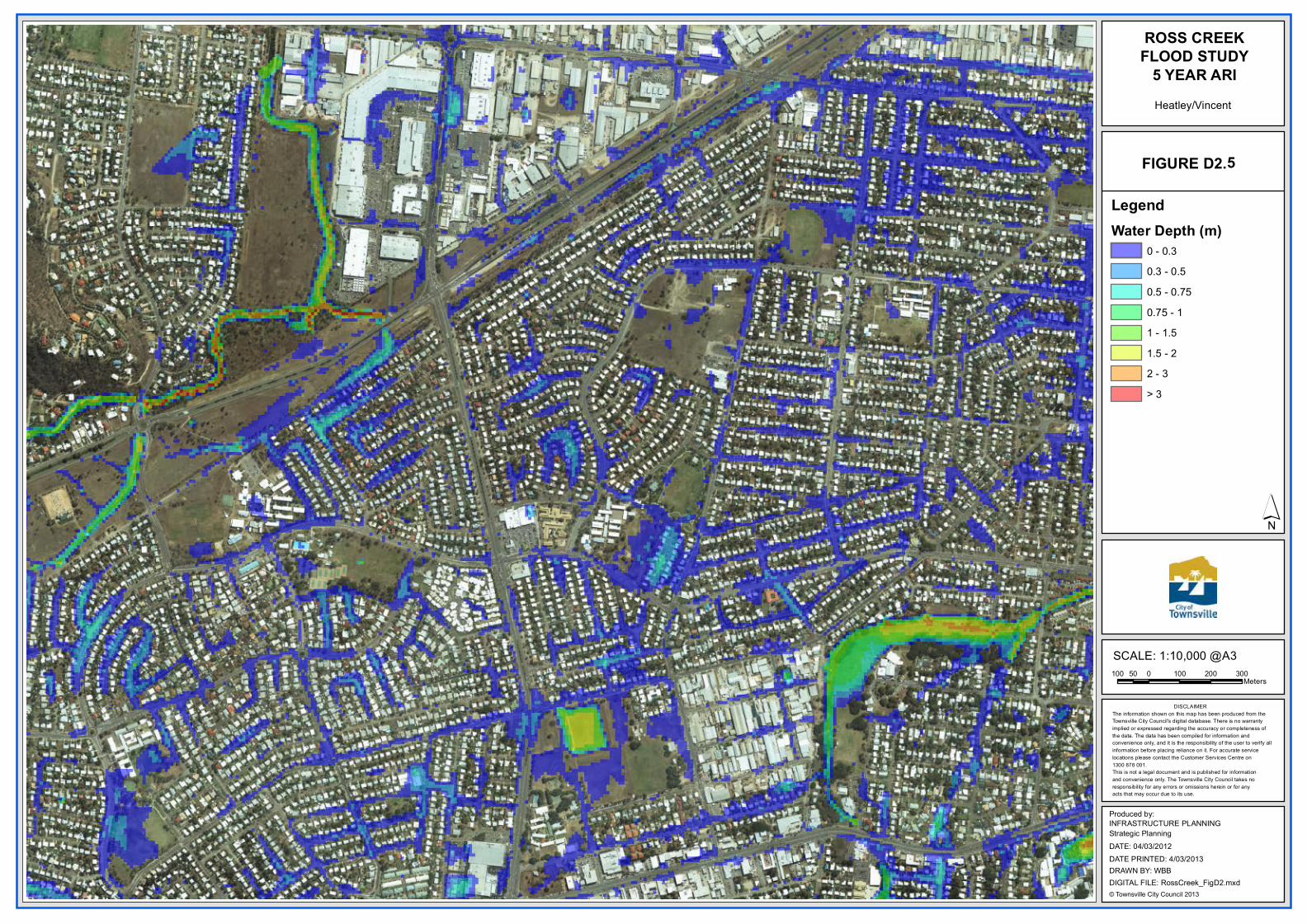
DISCLAIMERThe information shown on this map has been produced from the Townsville City Council's digital database. There is no warrantyimplied or expressed regarding the accuracy or completeness of the data. The data has been compiled for information and convenience only, and it is the responsibility of the user to verify all information before placing reliance on it. For accurate service locations please contact the Customer Services Centre on1300 878 001.This is not a legal document and is published for informationand convenience only. The Townsville City Council takes noresponsibility for any errors or omissions herein or for anyacts that may occur due to its use.
ROSS CREEKFLOOD STUDY
2 YEAR ARI
´
100 0 100 200 30050Meters
Produced by:
DATE: 04/03/2012
INFRASTRUCTURE PLANNINGStrategic Planning
© Townsville City Council 2013DIGITAL FILE: RossCreek_FigD1.mxdDRAWN BY: WBBDATE PRINTED: 4/03/2013
SCALE: 1:10,000 @A3
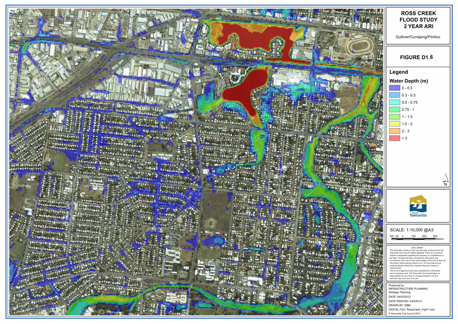
Gulliver/Currajong/Pimlico
6FIGURE D1.
LegendWater Depth (m)
0 - 0.30.3 - 0.50.5 - 0.750.75 - 11 - 1.51.5 - 22 - 3> 3
DISCLAIMERThe information shown on this map has been produced from the Townsville City Council's digital database. There is no warrantyimplied or expressed regarding the accuracy or completeness of the data. The data has been compiled for information and convenience only, and it is the responsibility of the user to verify all information before placing reliance on it. For accurate service locations please contact the Customer Services Centre on1300 878 001.This is not a legal document and is published for informationand convenience only. The Townsville City Council takes noresponsibility for any errors or omissions herein or for anyacts that may occur due to its use.
ROSS CREEKFLOOD STUDY
2 YEAR ARI
´
100 0 100 200 30050Meters
Produced by:
DATE: 04/03/2012
INFRASTRUCTURE PLANNINGStrategic Planning
© Townsville City Council 2013DIGITAL FILE: RossCreek_FigD1.mxdDRAWN BY: WBBDATE PRINTED: 4/03/2013
SCALE: 1:10,000 @A3
West End/Hyde Park
7FIGURE D1.
LegendWater Depth (m)
0 - 0.30.3 - 0.50.5 - 0.750.75 - 11 - 1.51.5 - 22 - 3> 3

DISCLAIMERThe information shown on this map has been produced from the Townsville City Council's digital database. There is no warrantyimplied or expressed regarding the accuracy or completeness of the data. The data has been compiled for information and convenience only, and it is the responsibility of the user to verify all information before placing reliance on it. For accurate service locations please contact the Customer Services Centre on1300 878 001.This is not a legal document and is published for informationand convenience only. The Townsville City Council takes noresponsibility for any errors or omissions herein or for anyacts that may occur due to its use.
ROSS CREEKFLOOD STUDY
2 YEAR ARI
´
100 0 100 200 30050Meters
Produced by:
DATE: 04/03/2012
INFRASTRUCTURE PLANNINGStrategic Planning
© Townsville City Council 2013DIGITAL FILE: RossCreek_FigD1.mxdDRAWN BY: WBBDATE PRINTED: 4/03/2013
SCALE: 1:10,000 @A3
City/South Townsville
8FIGURE D1.
LegendWater Depth (m)
0 - 0.30.3 - 0.50.5 - 0.750.75 - 11 - 1.51.5 - 22 - 3> 3
DISCLAIMERThe information shown on this map has been produced from the Townsville City Council's digital database. There is no warrantyimplied or expressed regarding the accuracy or completeness of the data. The data has been compiled for information and convenience only, and it is the responsibility of the user to verify all information before placing reliance on it. For accurate service locations please contact the Customer Services Centre on1300 878 001.This is not a legal document and is published for informationand convenience only. The Townsville City Council takes noresponsibility for any errors or omissions herein or for anyacts that may occur due to its use.
ROSS CREEKFLOOD STUDY
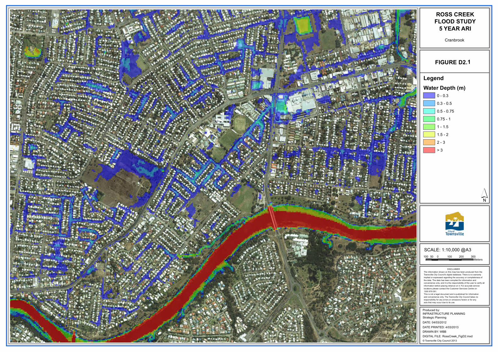
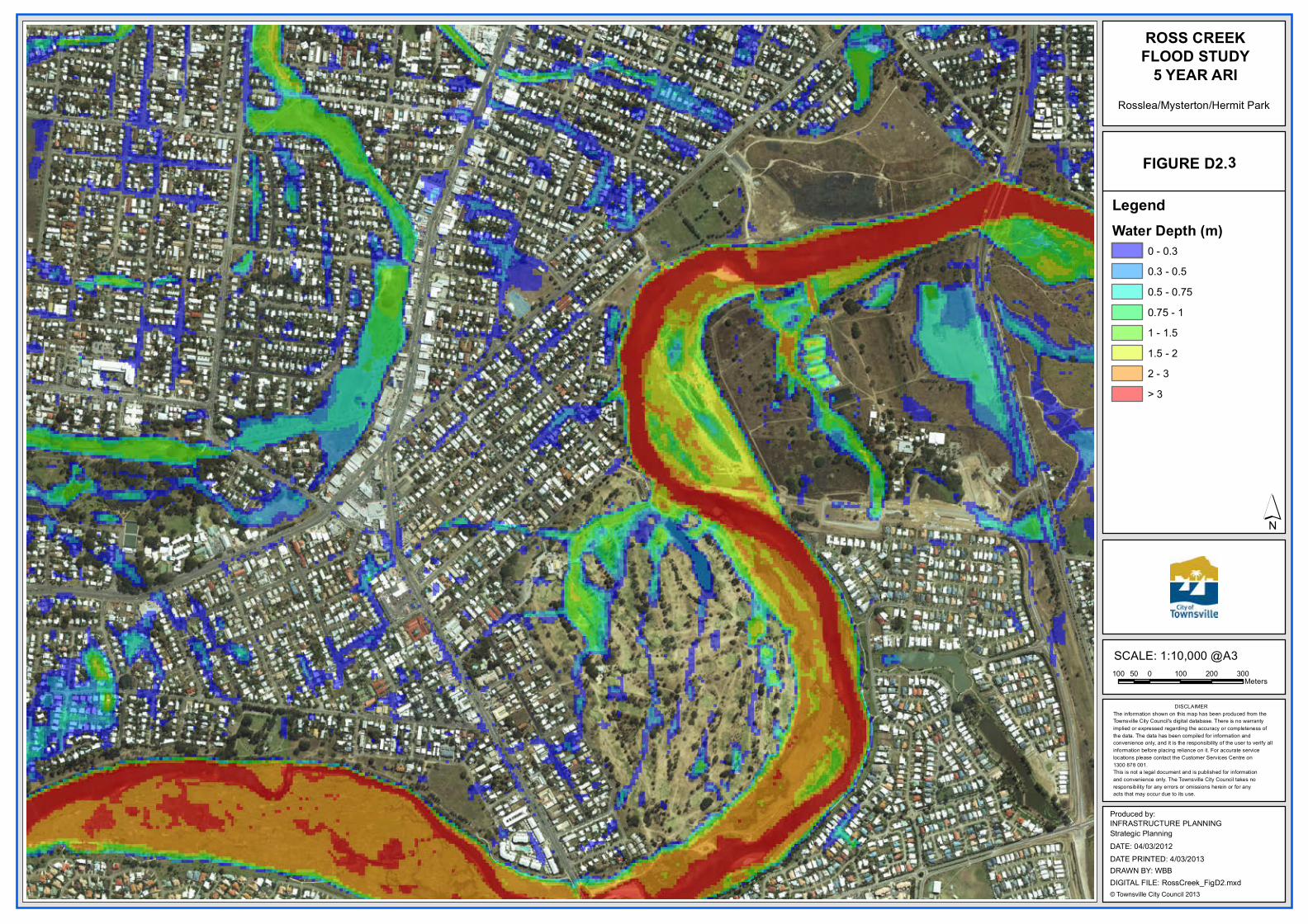
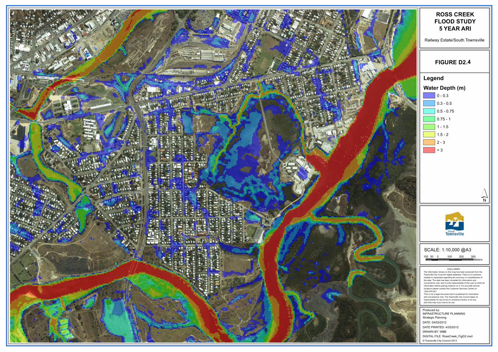
5 YEAR ARI
´
100 0 100 200 30050Meters
Produced by:
DATE: 04/03/2012
INFRASTRUCTURE PLANNINGStrategic Planning
© Townsville City Council 2013DIGITAL FILE: RossCreek_FigD2.mxdDRAWN BY: WBBDATE PRINTED: 4/03/2013
SCALE: 1:10,000 @A3
Cranbrook
1FIGURE D2.
LegendWater Depth (m)
0 - 0.30.3 - 0.50.5 - 0.750.75 - 11 - 1.51.5 - 22 - 3> 3

DISCLAIMERThe information shown on this map has been produced from the Townsville City Council's digital database. There is no warrantyimplied or expressed regarding the accuracy or completeness of the data. The data has been compiled for information and convenience only, and it is the responsibility of the user to verify all information before placing reliance on it. For accurate service locations please contact the Customer Services Centre on1300 878 001.This is not a legal document and is published for informationand convenience only. The Townsville City Council takes noresponsibility for any errors or omissions herein or for anyacts that may occur due to its use.
ROSS CREEKFLOOD STUDY
5 YEAR ARI
´
100 0 100 200 30050Meters
Produced by:
DATE: 04/03/2012
INFRASTRUCTURE PLANNINGStrategic Planning
© Townsville City Council 2013DIGITAL FILE: RossCreek_FigD2.mxdDRAWN BY: WBBDATE PRINTED: 4/03/2013
SCALE: 1:10,000 @A3
Aitkenvale/Mundingburra
2FIGURE D2.
LegendWater Depth (m)
0 - 0.30.3 - 0.50.5 - 0.750.75 - 11 - 1.51.5 - 22 - 3> 3
DISCLAIMERThe information shown on this map has been produced from the Townsville City Council's digital database. There is no warrantyimplied or expressed regarding the accuracy or completeness of the data. The data has been compiled for information and convenience only, and it is the responsibility of the user to verify all information before placing reliance on it. For accurate service locations please contact the Customer Services Centre on1300 878 001.This is not a legal document and is published for informationand convenience only. The Townsville City Council takes noresponsibility for any errors or omissions herein or for anyacts that may occur due to its use.
ROSS CREEKFLOOD STUDY
5 YEAR ARI
´
100 0 100 200 30050Meters
Produced by:
DATE: 04/03/2012
INFRASTRUCTURE PLANNINGStrategic Planning
© Townsville City Council 2013DIGITAL FILE: RossCreek_FigD2.mxdDRAWN BY: WBBDATE PRINTED: 4/03/2013
SCALE: 1:10,000 @A3
Rosslea/Mysterton/Hermit Park
3FIGURE D2.
LegendWater Depth (m)
0 - 0.30.3 - 0.50.5 - 0.750.75 - 11 - 1.51.5 - 22 - 3> 3
DISCLAIMERThe information shown on this map has been produced from the Townsville City Council's digital database. There is no warrantyimplied or expressed regarding the accuracy or completeness of the data. The data has been compiled for information and convenience only, and it is the responsibility of the user to verify all information before placing reliance on it. For accurate service locations please contact the Customer Services Centre on1300 878 001.This is not a legal document and is published for informationand convenience only. The Townsville City Council takes noresponsibility for any errors or omissions herein or for anyacts that may occur due to its use.
ROSS CREEKFLOOD STUDY
5 YEAR ARI
´
100 0 100 200 30050Meters
Produced by:
DATE: 04/03/2012
INFRASTRUCTURE PLANNINGStrategic Planning
© Townsville City Council 2013DIGITAL FILE: RossCreek_FigD2.mxdDRAWN BY: WBBDATE PRINTED: 4/03/2013
SCALE: 1:10,000 @A3
Railway Estate/South Townsville
4FIGURE D2.
LegendWater Depth (m)
0 - 0.30.3 - 0.50.5 - 0.750.75 - 11 - 1.51.5 - 22 - 3> 3
DISCLAIMERThe information shown on this map has been produced from the Townsville City Council's digital database. There is no warrantyimplied or expressed regarding the accuracy or completeness of the data. The data has been compiled for information and convenience only, and it is the responsibility of the user to verify all information before placing reliance on it. For accurate service locations please contact the Customer Services Centre on1300 878 001.This is not a legal document and is published for informationand convenience only. The Townsville City Council takes noresponsibility for any errors or omissions herein or for anyacts that may occur due to its use.
ROSS CREEKFLOOD STUDY
5 YEAR ARI
´
100 0 100 200 30050Meters
Produced by:
DATE: 04/03/2012
INFRASTRUCTURE PLANNINGStrategic Planning
© Townsville City Council 2013DIGITAL FILE: RossCreek_FigD2.mxdDRAWN BY: WBBDATE PRINTED: 4/03/2013
SCALE: 1:10,000 @A3
Heatley/Vincent
5FIGURE D2.
LegendWater Depth (m)
0 - 0.30.3 - 0.50.5 - 0.750.75 - 11 - 1.51.5 - 22 - 3> 3