Embed Size (px)
Citation preview

Flora and Fauna Assessment
Argoon (Lot 13, DP 878784), Seams Road,
Kundabung, NSW
Prepared for Gavan Landini
Argoon, Seams Rd, Kundabung, NSW
Job Reference 28 - November 2015

Flora and Fauna Assessment
Argoon
Job Reference: 28
November 2015 i
Document Control
Project Name Kundabung - Landini
Project Number 28
Client Gavan Landini
File Name 28 - Argoon Ecological Assessment R1 21-11-15.docx
Document Description Flora and Fauna Assessment
Prepared by Dr Anna McConville (PhD, B.Env.Sc.)
Ecologist / Director
Status FINAL
Version R1
Date 21 November 2015
This report should be cited as: Echo Ecology 2015. Flora and Fauna Assessment: Argoon, Kundabung, NSW. Prepared for Gavan Landini.
Disclaimer
This document may only be used for the purpose for which it was commissioned and in accordance with the contract between Echo Ecology Pty Ltd and Gavan Landini.
The scope of services was defined in consultation with Gavan Landini, by time and budgetary constraints imposed by the client, and the availability of reports and other
data on the subject area. Changes to available information, legislation and schedules are made on an ongoing basis and readers should obtain up to date information.
Echo Ecology Pty Ltd accepts no liability or responsibility whatsoever for or in respect of any use of or reliance upon this report and its supporting material by any third
party. Information provided is not intended to be a substitute for site specific assessment or legal advice in relation to any matter. Unauthorised use of this report in any
form is prohibited.

Flora and Fauna Assessment
Argoon
Job Reference: 28
November 2015 ii
Certification As the principal author, I, Anna McConville make the following certification:
• The results presented in the report are, in the opinion of the principal author and certifier, a true and accurate account of the species recorded, or considered likely to occur within the site;
• Commonwealth, state and local government policies and guidelines formed the basis of project surveying methodology, or where the survey work has been undertaken with specified departures from industry standard guidelines, details of which are discussed and justified in Section 2;
• All research workers have complied with relevant laws and codes relating to the conduct of flora and fauna research, including the Animal Research Act 1995, National Parks and Wildlife Act 1974 and the Australian Code of Practice for the Care and Use of Animals for Scientific Purposes.
Signature of Principal Author and Certifier:
Dr Anna McConville (PhD, B.Env.Sc.) Ecologist / Director

Flora and Fauna Assessment
Argoon
Job Reference: 28
November 2015 iii
Executive Summary Introduction Echo Ecology Pty Ltd (Echo Ecology) has been engaged by Gavan Landini to undertake a flora and fauna assessment for the proposed subdivision (via lot size amendment) of Argoon (Lot 13, DP 878784), Kundabung, NSW. The proposal is to subdivide the property into three rural blocks and create one new access road. The primary aim of this ecological assessment is to provide an overview of the ecological values within the study area and surrounds, identify ecological constraints in regard to the proposed subdivision, and assess the likely impacts of the proposal on threatened entities under relevant state and federal environmental legislation. The specific objectives of this assessment include the following:
• Undertake a background review of relevant literature and a review of relevant databases;
• Conduct a field survey to describe the ecological values of the study area; • Assess the potential for threatened species, populations and ecological
communities listed under TSC Act and / or EPBC Act to occur within the study area;
• Describe potential ecological impacts at the study area; • Assess the significance of the impacts of the proposal on threatened species,
populations and ecological communities listed under the TSC Act and the EPBC Act; and
Provide recommendations to avoid, mitigate and offset (where appropriate) impacts of the proposal. Methods We combined a literature review with a one-day field survey consisting of flora survey and habitat assessment to determine the ecological values of the study area. Results Vegetation Communities Following field surveys, five vegetation communities have been delineated as occurring within the study area; as listed below: 1. Dry Grassy Tallowwood - Grey Gum (FE 36); 2. Lowland Red Gums (FE 73); 3. Central Mid Elevation Sydney Blue Gum (FE 19); 4. Pasture Grassland and Cleared; and 5. Dam Fauna Habitat Fauna habitat within the study area consists predominantly of pasture grassland with a mix of native and exotic grass and herb species. Canopy trees with a pasture understorey also

Flora and Fauna Assessment
Argoon
Job Reference: 28
November 2015 iv
remain in patches and as scattered paddock trees. One small area along an ephemeral drainage line in the east of the study area contains some shrubs. The adjacent Pipers Creek is vegetated. Threatened Entities A total of one candidate EEC, 32 threatened fauna species and two threatened flora species were found to have at least a moderate chance of occurrence within the study area based on local records, habitat assessment and the results of our survey. Candidate EECs listed under TSC Act recorded within the study area were:
• Subtropical coastal floodplain forest of the NSW North Coast bioregion EEC; and Threatened flora species considered likely to occur (moderate or greater chance) within the study area are:
• Arthraxon hispidus (Hairy Jointgrass); and • Thesium australe (Austral Toadflax).
Threatened fauna species considered likely to occur (moderate or greater chance) or recorded (in bold) within the study area are:
• Mixophyes balbus (Stuttering Frog); • Mixophyes iteratus (Giant Barred Frog); • Litoria brevipalmata (Green-thighed Frog); • Lophoictinia isura (Square-tailed Kite); • Calyptorhynchus lathami (Glossy Black-Cockatoo); • Glossopsitta pusilla (Little Lorikeet); • Lathamus discolor (Swift Parrot); • Anthochaera phrygia (Regent Honeyeater); • Ninox strenua (Powerful Owl); • Tyto novaehollandiae (Masked Owl); • Tyto tenebricosa (Sooty Owl); • Chthonicola sagittata (Speckled Warbler); • Daphoenositta chrysoptera (Varied Sittella); • Coracina lineata (Barred Cuckoo-Shrike); • Carterornis leucotis (White-eared Monarch); • Melanodryas cucullata cucullata (Hooded Robin); • Petroica boodang (Scarlet Robin); • Petroica phoenicea (Flame Robin); • Stagonopleura guttata (Diamond Firetail); • Dasyurus maculatus (Spotted-tailed Quoll); • Phascogale tapoatafa (Brush-tailed Phascogale); • Phascolarctos cinereus (Koala); • Petaurus australis (Yellow-bellied Glider); • Petaurus norfolcensis (Squirrel Glider); • Saccolaimus flaviventris (Yellow-bellied Sheathtail-bat)

Flora and Fauna Assessment
Argoon
Job Reference: 28
November 2015 v
• Mormopterus norfolkensis (East Coast Freetail-bat); • Falsistrellus tasmaniensis (Eastern False Pipstrelle); • Miniopterus australis (Little Bentwing-bat); • Miniopterus schreibersii oceanensis (Eastern Bentwing-bat); • Myotis macropus (Southern Myotis); • Scoteanax rueppellii (Greater Broad-nosed Bat); • Pteropus poliocephalus (Grey-headed Flying-fox).
Kempsey Comprehensive Koala Plan of Management As the study area does not require rezoning (lot size amendment only) and no vegetation clearing is required for the proposal (the access road was cleared prior to the proposal as a RAMA under the NV Act), the development control provisions of the Kempsey CKPoM do not apply and detailed koala surveys are not required. Assessment of Significance Assessments of significance (7-part tests) were undertaken for one candidate EEC, 32 threatened fauna species and two threatened flora species that were found to have at least a moderate chance of occurrence within the study area. As the proposal is for subdivision only and will not remove any native vegetation, the potential impacts on threatened species, populations and communities listed under the TSC Act are considered to be quite low. Therefore, it is considered unlikely that the proposal will constitute a significant impact such that a Species Impact Statement is required. Recommendations To minimise potential impacts at this subdivision stage and for potential future development applications we provide the following impact management strategy recommendations. Subdivision and access road recommendations
• No vegetation clearing is to be undertaken within the study area for the subdivision or access road construction. If vegetation clearing is found to be required, a revised impact assessment may be required;
• Care should be taken during the construction of the proposed access road to avoid potential impacts on adjacent vegetation. Particularly, in the low-lying areas that contain candidate SCFF EEC.
• Appropriate erosion and sediment control measures should be implemented during the construction of the access road to minimise potential impacts on adjacent vegetation. Particularly, candidate SCFF EEC along the access road.
• Restrict any future building activity within riparian buffers and other low-lying floodplain areas (e.g. candidate SCFF EEC).
• Consider sustainable agricultural practices such as lower stocking ratios, replanting and the provision of recruitment opportunities for canopy trees (e.g. through temporary fencing) within low-lying floodplain areas to enhance SCFF EEC within the study area.

Flora and Fauna Assessment
Argoon
Job Reference: 28
November 2015 vi
• Encourage the use of native (locally endemic) plant species for any landscaping or wind break planting within the study area
• Undertake regular weed control activities Future building considerations While the current proposal is for subdivision only and a detailed flora and fauna survey and impact assessment is likely to be required to accompany any future Development Application, the following recommendations have been made to guide future development within the newly created lots:
• Restrict future building envelopes to outside of low-lying floodplain areas • Locate future building envelopes (and associated infrastructure) to avoid the
clearing of native vegetation. If native vegetation is required to be removed, then more detailed fauna surveys should be undertaken.
• Hollow-bearing and mature trees should be retained as a priority. If required, the loss of hollow-bearing trees should be offset with the installation of appropriate nest boxes and the protection of recruitment hollow-bearing trees (mature trees likely to develop hollows in the future) at a higher ratio than those removed.
• Encourage new property owners to minimise the potential for domestic dogs to free-range on properties unsupervised to minimise the risk of Koala mortality. E.g. provide a smaller fenced yard that contains no Koala feed trees for dogs to be contained;
• Encourage new property owners to keep domestic cats inside or caged at night to minimise potential impacts to native wildlife;
• Undertake full koala surveys as per the Kempsey CKPoM to accurately map and classify koala habitat within the study area;
• Retain Koala feed trees within the study area where possible and apply the offsetting principles of the Kempsey CKPoM where trees cannot be retained;
Conclusion The proposal is for subdivision into three rural lots, with no rezoning or vegetation clearing required. The proposed new lots appear to contain sufficient cleared areas to allow the future construction of new houses (one per lot) without further vegetation clearing. Providing the recommendations are adopted, we consider it unlikely that the subdivision proposal will significantly impact on any threatened species, populations or communities listed under TSC Act or EPBC Act.

Flora and Fauna Assessment
Argoon
Job Reference: 28
November 2015
Abbreviations and Definitions DCP Development Control Plan DOE Federal Department of the Environment EEC endangered ecological community EPBC Act Commonwealth Environment Protection and Biodiversity Conservation Act 1999 FWW Freshwater Wetlands EEC GIS geographic information system KTP key threatening process listed under NSW Threatened Species Conservation Act 1995 LEP local environment plan LLS local land services NPWS NSW National Parks and Wildlife Service NV Act NSW Native Vegetation Act 2003 OEH NSW Office of Environment and Heritage PFC percent foliage cover RFEF River-Flat Eucalypt Forest EEC ROTAP rare or threatened Australian plants, as listed by Briggs and Leigh (1996) SCFF Subtropical Coastal Floodplain Forest EEC SEPP NSW State Environmental Planning Policy sp. species (singular) spp. species (plural) subsp. subspecies SOFF Swamp Oak Floodplain Forest EEC

Flora and Fauna Assessment
Argoon
Job Reference: 28
November 2015
SSF Swamp Sclerophyll Forest EEC threatened a term used to describe a species, population or community listed under the NSW Threatened Species Conservation Act 1995 and / or Commonwealth Environment Protection Biodiversity Conservation Act 1999 TSC Act NSW Threatened Species Conservation Act 1995 VRZ Vegetated Riparian Zone WM Act NSW Water Management Act 2000
Flora and Fauna Assessment
Argoon
Job Reference: 28
November 2015
Definitions Direct impacts those that directly affect the habitat, individual plants and animals. Indirect impacts those that affect species, populations or ecological communities in a manner other than through direct loss or disturbance. Locality the area within 10 km of the study area (Figure 1-1) Study area is the subject site and any additional areas which were considered by the assessment (Figure 1-1)
Flora and Fauna Assessment
Argoon
Job Reference: 28
November 2015
Table of Contents
1.0 Introduction ................................................................................................ 1
1.1 Site Details .............................................................................................. 1
1.1.1 Soil Landscapes ...................................................................................... 3
1.1.2 Geology ................................................................................................... 3
1.2 Description of the Proposal ...................................................................... 6
1.3 Scope of the Study .................................................................................. 8
1.4 Legislative Context .................................................................................. 8
1.4.1 Commonwealth Legislation ...................................................................... 8
1.4.2 NSW Legislation ...................................................................................... 9
1.4.3 Local Environmental Planning Instruments .............................................12
1.5 Scientific Licensing and Ethics ................................................................12
2.0 Methods ................................................................................................... 13
2.1 Literature and Database Review .............................................................13
2.2 Field Survey ...........................................................................................13
2.2.1 Vegetation community mapping ..............................................................14
2.2.2 Endangered Ecological Community delineation ......................................14
2.2.3 Habitat Assessment ................................................................................15
2.3 Fauna Survey .........................................................................................15
2.3.1 Opportunistic Observations, Scats, Signs and Traces ............................15
2.4 Mapping..................................................................................................16
2.5 Limitations ..............................................................................................16
3.0 Results ..................................................................................................... 16
3.1 Habitat ....................................................................................................16
3.2 Flora .......................................................................................................20
3.2.1 Previous vegetation mapping ..................................................................20

Flora and Fauna Assessment
Argoon
Job Reference: 28
November 2015
3.2.2 Vegetation Communities .........................................................................20
3.2.3 Endangered Ecological Communities .....................................................27
3.2.4 Threatened Flora Species ......................................................................35
3.2.5 Regionally Significant Flora Species .......................................................36
3.3 Fauna .....................................................................................................36
3.4 Biodiversity Corridors ..............................................................................37
3.4.1 NPWS Key Habitats and Corridors .........................................................37
3.4.2 Local Corridors .......................................................................................37
3.5 Riparian Buffers ......................................................................................37
4.0 Impact Assessment ................................................................................. 40
4.1 Likelihood of Occurrence of Threatened Species, Populations and Ecological Communities .........................................................................40
4.2 Potential Impacts ....................................................................................41
4.2.1 Direct Impacts.........................................................................................41
4.2.2 Indirect Impacts ......................................................................................42
4.2.3 Cumulative Impacts ................................................................................43
4.3 Kempsey CKPoM ...................................................................................43
4.4 Assessment of Significance under TSC Act and EP&A Act (7-part tests) ......................................................................................................45
4.5 EPBC Act Considerations .......................................................................45
4.5.1 Environment of Commonwealth Land .....................................................46
4.5.2 Matters of NES .......................................................................................46
5.0 Recommendations ................................................................................... 47
5.1 Subdivision and access road recommendations .....................................47
5.2 Future building considerations ................................................................48
6.0 Conclusion ............................................................................................... 48
7.0 References .............................................................................................. 49

Flora and Fauna Assessment
Argoon
Job Reference: 28
November 2015
Appendix A Flora Species List
Appendix B Fauna Species List
Appendix C Likelihood of Occurrence of Threatened Species, Populations and Ecological Communities
Appendix D Key Threatening Processes
Appendix E Invasive Species
Appendix F Assessment of Significance (seven-part tests)
Appendix G EEC Characteristic Species
List of Tables
Table 1-1: Study area description .............................................................................. 1
Table 2-1: Braun-Blanquet cover abundance scale .................................................. 14
Table 3-1: Flowering phenology, nectar productivity and reliability of tree species recorded within the study area adapted from Eby and Law (2008) using lower north-east NSW data ................................................. 19
List of Figures
Figure 1-1: Study area location map .......................................................................... 2
Figure 1-2: Soil landscapes (Atkinson 1999) .............................................................. 4
Figure 1-3: Quaternary geology (Hashimoto and Troedson 2007).............................. 5
Figure 1-4: Proposed access road along existing fence line ....................................... 6
Figure 1-5: Proposal design ....................................................................................... 7
Figure 3-1: Vegetation communities recorded within the study area ........................ 21
Figure 3-2: Photograph of Dry Grassy Tallowwood - Grey Gum (north-west) ........... 22
Figure 3-3: Photograph of Dry Grassy Tallowwood - Grey Gum (south-east) ........... 22

Flora and Fauna Assessment
Argoon
Job Reference: 28
November 2015
Figure 3-4: Photograph of Dry Grassy Tallowwood - Grey Gum (north) ................... 23
Figure 3-5: Photograph of the scattered paddock trees that comprise the Lowland Red Gums (FE 73). The dense vegetation of Pipers Creek to the south of the study area is in the background. ................................ 24
Figure 3-6: Photograph of the disturbed Lowland Red Gums (FE 73) along the proposed access road. ................................................................. 24
Figure 3-7: Photograph of Central Mid Elevation Sydney Blue Gum (FE 19) along Pipers Creek adjacent to the study area ....................................... 25
Figure 3-8: Photograph of Pasture Grassland looking to the northern ridge of the study area..................................................................................... 26
Figure 3-9: Photograph of large dam in the south of the study area ......................... 27
Figure 3-10: Candidate Endangered Ecological Communities occurring within the study area and threatened fauna species ..................................... 34
Figure 3-11: Corridors .............................................................................................. 38
Figure 3-12: Riparian Buffers ................................................................................... 39

Flora and Fauna Assessment
Argoon
Job Reference: 28
November 2015 Page 1
1.0 INTRODUCTION
Echo Ecology Pty Ltd (Echo Ecology) has been engaged by Gavan Landini to undertake a flora and fauna assessment for the proposed subdivision of Argoon (Lot 13, DP 878784), Kundabung, NSW, hereafter referred to as the ‘study area’ (Figure 1-1). This report provides the findings of a literature review, database searches, and field survey and addresses relevant statutory considerations associated with the proposal.
1.1 Site Details
Relevant study area details are provided in Table 1-1. Table 1-1: Study area description
Item Description
Locality Seams Rd, Kundabung, NSW
Local Government Area Kempsey Shire
Address Lot 13, DP 878784
Area 78 hectares (approximately)
Boundaries The study area is bounded on all sides by rural properties, with Maria River State Forest occurring further to the north. Pipers Creek occurs along the southern boundary of the property.
Current Land-use The study area is currently used for rural grazing purposes.
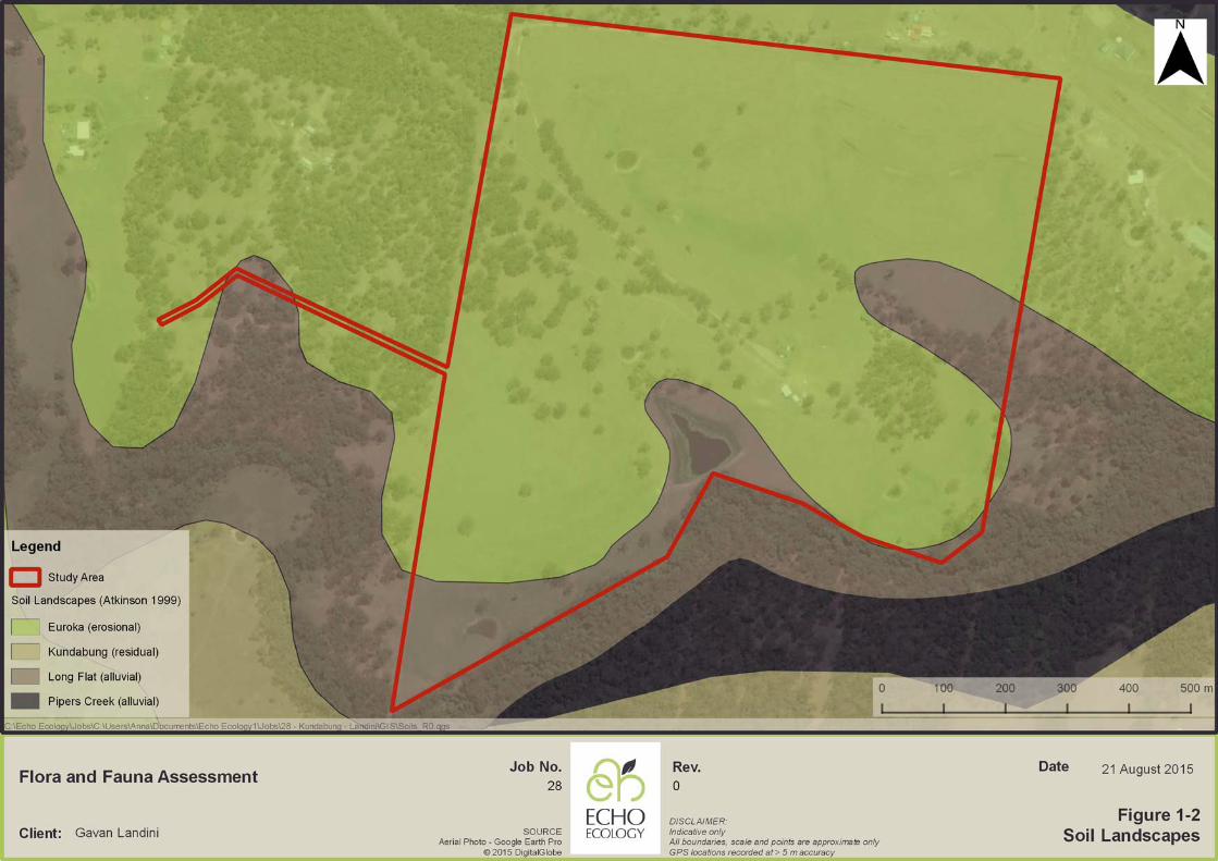
Soils and Geology The erosional Euroka soil landscape soil landscape (Atkinson 1999) underlain by bedrock (Hashimoto and Troedson 2007) is mapped as occurring across most of the study area. A small area of alluvial soils (Long Flat soil landscape) and geology (Quaternary valley fill) is mapped along Pipers Creek in the south and east of the study area (Atkinson 1999, Hashimoto and Troedson 2007).
Topography A low ridge runs in an east-west direction along the northern boundary of the study area, with gentle slopes falling to the creek in the south.
Vegetation The study area has been heavily cleared for agriculture in the past and consists mostly of pasture with a mix of native and exotic pasture species. Canopy trees are scattered throughout.

Date 02 Oct 2015
Gavan Landini
Flora and Fauna Assessment28
BACKGROUND SOURCEStamen © Toner contributors licensedunder CC-BY-SA
DISCLAIMER:Indicative only. All boundaries, scaleand points are approximate only
Figure 1-1Study Area Location
Rev.
0
Job No.
Client:
Flora and Fauna Assessment
Argoon
Job Reference: 28
November 2015 Page 3
1.1.1 Soil Landscapes
The erosional Euroka soil landscape soil landscape is mapped as occurring across most of the study area (Atkinson 1999), with a small area of alluvial soils (Long Flat soil landscape) mapped along Pipers Creek in the south of the study area (Atkinson 1999). Soil landscape mapping was undertaken at 1:100,000 scale and is shown in Figure 1-2.
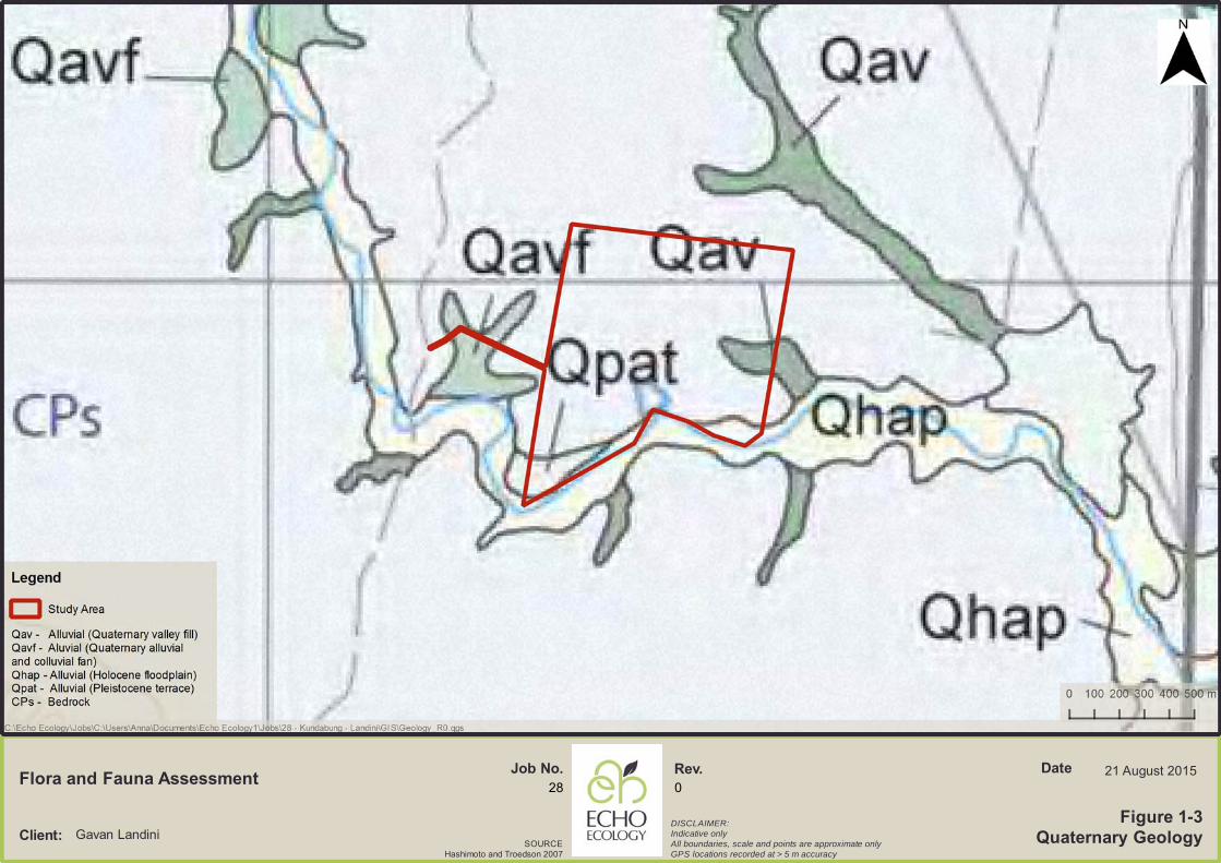
1.1.2 Geology
As shown in Figure 1-3, the study area is mapped at 1:25,000 scale as being underlain by mostly bedrock, being Carboniferous and Permian sedimentary geology (including coal measures) and minor volcanic rocks (Hashimoto and Troedson 2007). An alluvial geological system has been mapped in the south and east of the study area as Holocene Floodplain and Quaternary valley fill (silt, clay, fluvial sand and gravel) (Hashimoto and Troedson 2007).
SOURCEHashimoto and Troedson 2007
Rev.28
Figure 1-3Quaternary GeologyClient:
21 August 2015
Gavan Landini
Flora and Fauna Assessment
DISCLAIMER:Indicative onlyAll boundaries, scale and points are approximate onlyGPS locations recorded at > 5 m accuracy
Job No.0
Date

Flora and Fauna Assessment
Argoon
Job Reference: 28
November 2015 Page 6
1.2 Description of the Proposal
The proposal is to subdivide the property into three rural blocks and create one new access road (Figure 1-5). The existing access road to the north of the study area will continue to provide access. The new access road is located on an adjacent property and will link the study area with Old Coast Road to the west. Rezoning is not required. An existing residence occurs in the centre of the study area and there is the potential that two new dwellings will be built in the future on the newly created lots. While we have considered the future implications of additional residential dwellings as a result of the proposed subdivision, these will be subject to separate Development Applications if undertaken in the future. Parts of the new access road that occur along an existing fence line have been recently cleared as a Routine Agricultural Management Activity permissible under the Native Vegetation Act 2003 (NV Act) (Figure 1-4). It is understood that no further vegetation clearing is required for the subdivision and as the study area contains large areas of cleared land it is unlikely that future residential dwellings would require vegetation clearing. This report has been prepared on the premise that no further vegetation clearing will be required. The main impacts associated with the proposal are considered likely to be a result of indirect impacts associated with a slightly increased housing density.
Figure 1-4: Proposed access road along existing fence line


Flora and Fauna Assessment
Argoon
Job Reference: 28
November 2015 Page 8
1.3 Scope of the Study
The primary aim of this ecological assessment is to provide an overview of the ecological values within the study area and surrounds, identify ecological constraints in regard to the proposed subdivision, and assess the likely impacts of the proposal on threatened entities under relevant state and federal environmental legislation. The specific objectives of this assessment include the following:
• Undertake a background review of relevant literature and a review of relevant databases;
• Conduct a field survey to describe the ecological values of the study area; • Assess the potential for threatened species, populations and ecological
communities listed under TSC Act and / or EPBC Act to occur within the study area;
• Describe potential ecological impacts at the study area; • Assess the significance of the impacts of the proposal on threatened species,
populations and ecological communities listed under the TSC Act and the EPBC Act; and
• Provide recommendations to avoid, mitigate and offset (where appropriate) impacts of the proposal.
1.4 Legislative Context
1.4.1 Commonwealth Legislation
Environment Protection and Biodiversity Conservation Act 1999 The main Commonwealth environmental law is the Environment Protection and Biodiversity Conservation Act 1999 (EPBC Act). Under the EPBC Act any action that is likely to have a significant impact on a matter of national environmental significance or Commonwealth land it is required to be referred to the Federal Environment Minister and may be designated as a ‘controlled action’. Controlled actions require approval of the minister. Matters of national environmental significance under the EPBC Act include:
• World Heritage sites; • National Heritage places; • Nationally protected wetlands (Ramsar wetlands); • Nationally listed threatened species and ecological communities; • Listed migratory species; • Nuclear actions (including uranium mines); • Commonwealth marine areas; • Land owned by the Commonwealth; and • Activities by Commonwealth agencies.
Some exemptions apply to the requirement for approval under the EPBC Act, including:

Flora and Fauna Assessment
Argoon
Job Reference: 28
November 2015 Page 9
• Prior authorisation and continuing use exemptions; • Approved bilateral agreements between the Commonwealth and the States; • Ministerial declarations; • Regional forest agreements; and • Great Barrier Reef Marine Park Act 1975.
NSW bilateral agreement Controlled actions which take place in NSW and which are assessed in the manner specified by the bilateral agreement do not require assessment under the EPBC Act. In this report, consideration has been given to the potential impacts of the proposal on matters of national environmental significance and a recommendation has been made in relation to the requirement of a referral to the Federal Environment Minister.
1.4.2 NSW Legislation
Environmental Planning and Assessment Act 1979 The principal planning legislation in NSW is the Environmental Planning and Assessment Act 1979 (EP&A Act). It provides a framework for the overall environmental planning and assessment of development proposals and requires consideration be given to the potential impacts of development proposals on biodiversity. Clause 5A of the EP&A Act provides an outline of the ecological matters that must be taken into account in deciding whether there is likely to be a significant effect on threatened species, populations or ecological communities, or their habitats.
Threatened Species Conservation Act 1995 The NSW Threatened Species Conservation Act 1995 (TSC Act) aims to protect and encourage the recovery of threatened species, populations and communities listed under the Act. The TSC Act is integrated with the EP&A Act and requires consideration of whether a development (Part 4 of the EP&A Act) or an activity (Part 5 of the EP&A Act) is likely to significantly affect threatened species, populations and ecological communities or their habitat. The potential impact of proposals on threatened species, populations or communities listed under the TSC Act is assessed under Section 5A of the EP&A Act, the assessment of significance (also known as the ‘seven-part test’). If the impacts are found to be ‘significant’, a Species Impact Statement (SIS) and concurrence from the Director General of the Office of Environment and Heritage (OEH) is required.
Native Vegetation Act 2003 The Native Vegetation Act 2003 (NV Act) aims to conserve and manage native vegetation through regulation of native vegetation clearing in non-urban areas. The clearing of native vegetation (other than regrowth) in certain areas and for certain purposes requires consent under the NV Act, with Local Land Services (LLS) being the consent authority.

Flora and Fauna Assessment
Argoon
Job Reference: 28
November 2015 Page 10
Under section 6 the NV Act, ‘native vegetation’ is defined as: • trees (including any sapling or shrub, or any scrub); • understorey plants; • groundcover (being any type of herbaceous vegetation); and • plants occurring in a wetland.
Vegetation is indigenous if it is of a species of vegetation, or if it comprises species of vegetation, that existed in NSW before European settlement. For the purposes of the NV Act, native vegetation does not include any mangroves, seagrasses or any other type of marine vegetation to which section 205 of the Fisheries Management Act 1994 applies. The NV Act does not apply to the following land:
• the land described or referred to in Part 1 of Schedule 1 (National park estate and other conservation areas);
• the land described or referred to in Part 2 of Schedule 1 (State forestry land); • the land described or referred to in Part 3 of Schedule 1 (Urban areas); and • biodiversity certified land (within the meaning of Part 7AA of the TSC Act.
Clearing of native vegetation may be undertaken, if the following apply:
• a development consent has been granted in accordance with the NV Act; • a Property Vegetation Plan (PVP) has been prepared for the site; • the activity is classified as a Routine Agricultural Management Activity (RAMA)
pursuant to S11 of the NV Act; • the clearing is of regrowth vegetation, which is defined as native vegetation that
has regrown since the earlier of the following dates: o 1 January 1983 in the case of land in the Western Division and 1 January 1990
in the case of other land; or o the date specified in a PVP for the purposes of this definition (in exceptional
circumstances being a date based on existing rotational farming practices). It should be noted that regrowth vegetation does not include any native vegetation that has regrown following unlawful clearing of remnant native vegetation or following clearing of remnant native vegetation caused by bushfire, flood, drought or other natural cause.
State Environmental Planning Policy No. 14 - Coastal Wetlands The State Environmental Planning Policy No. 14 – Coastal Wetlands (SEPP 14) aims to ensure that coastal wetlands are preserved and protected. Under SEPP 14, a person must not clear land, construct a levee, drain land or fill land which is covered by SEPP 14 (or within 100 m) except with the consent of the local council and the concurrence (agreement) of the Director-General of Planning. A copy of all development applications for such activities must also be forwarded by the local council to the Director of National Parks and Wildlife within 7 days. No SEPP 14 wetlands were found to be present within or adjacent to the study area on review of the SEPP 14 spatial data layer.
Flora and Fauna Assessment
Argoon
Job Reference: 28
November 2015 Page 11
State Environmental Planning Policy No. 26 - Littoral Rainforest The State Environmental Planning Policy No. 26 – Littoral Rainforest (SEPP 26) provides a mechanism for the preservation of littoral rainforest in a natural state. Under SEPP 26, proposals require development consent from Council to use a littoral rainforest (or within 100m) for any purpose, except for:
• ordinary course of residential occupation of the land; • controlling native flora declared to be noxious under the Noxious Weeds Act
1993; and • removal of leaf litter, shed bark or cured grasses for the purpose of reducing the
risk of bushfire. Activities under SEPP 26 are deemed to be designated development, which means the development application must be accompanied by an environmental impact statement and be placed on public exhibition for public comment. The local council remains the consent authority for developments applying to SEPP 26 littoral rainforests and the concurrence (agreement) of the Director-General of the Department of Planning is also required. No littoral rainforests were found to be present within or adjacent to the study area during vegetation survey, nor on review of the SEPP 26 spatial data layer.
State Environmental Planning Policy No. 44 - Koala Habitat Protection The State Environmental Planning Policy No. 44 – Koala Habitat Protection (SEPP 44) applies to all LGAs listed on Schedule 2 of the policy, except land dedicated under the National Parks and Wildlife Act 1974 or the Forestry Act 1916. Potential Koala Habitat is defined as areas where koala feed tree species listed under Schedule 2 constitute at least 15% of the total number of trees in the upper or lower strata of the tree component. An area of land to which the policy applies must be at least one hectare in area (includes the total area of adjoining land in the same ownership). If potential koala habitat is present then it must be further assessed to determine whether it represents core koala habitat. Core Koala habitat is defined as ‘an area of land with a resident population of koalas, evidenced by attributes such as breeding females (that is, females with young) and recent sightings of and historical records of a population’. The policy requires the preparation of plans of management before development consent can be granted in relation to areas of core koala habitat, encourages the identification of areas of core koala habitat, and encourages the inclusion of areas of core koala habitat in environment protection zones. A Comprehensive Koala Plan of Management (CKPoM) has been prepared for eastern portion of Kempsey LGA (Kempsey Shire Council 2011) and this includes the study area. The Kempsey CKPoM replaces the requirement for preparation of individual plans of management in relation to development in areas of core koala habitat. Full discussion of the implications of the Kempsey CKPoM is provided within this report. Water Management Act 2000 Controlled activities carried out in, on or under waterfront land are regulated by the Water Management Act 2000 (WM Act). The NSW Office of Water administers the WM Act and is
Flora and Fauna Assessment
Argoon
Job Reference: 28
November 2015 Page 12
required to assess the impact of any proposed controlled activity to ensure that no more than minimal harm will be done to waterfront land as a consequence of carrying out the controlled activity. Waterfront land includes the bed and bank of any river, lake or estuary and all land within 40 metres of the highest bank of the river, lake or estuary. The guidelines for riparian corridors on waterfront land (Office of Water, 2012) recommend a Vegetated Riparian Zone (VRZ) width based on watercourse order as classified under the Strahler System of ordering watercourses and using current 1:25 000 topographic maps. The width of the VRZ should be measured from the top of the highest bank on both sides of the watercourse. The following VRZ widths are recommended on either side of the watercourse:
• 1st order watercourse - 10 m • 2nd order watercourse - 20 m • 3rd order watercourse - 30 m • 4th order and greater - 40 m
1.4.3 Local Environmental Planning Instruments
Kempsey Local Environmental Plan 2013 The Kempsey Local Environmental Plan (LEP) is the principle statutory planning document prepared by Council under the requirements of the Environmental Planning and Assessment Act 1979, to guide planning decisions for the local government area (LGA). The plan allows Council to manage the ways in which land may be used through zoning and development standards.
Kempsey Development Control Plan 2013 The Kempsey Development Control Plan (DCP 2013) provides guidelines for land use management in the Kempsey LGA. DCP 2013 supports the provisions of the LEP by expanding upon its aims, objectives and other provisions.
1.5 Scientific Licensing and Ethics
Research was conducted under the following licences:
• NSW National Parks and Wildlife Service Scientific Investigation Licence SL101055 (Valid 30 November 2015);
• Animal Research Authority (Trim File No: 1294891) issued by NSW Agriculture (Valid 8 October 2015); and
• Animal Care and Ethics Committee Certificate of Approval (Trim File No: 12/4801) issued by NSW Agriculture (Valid 8 October 2015).

Flora and Fauna Assessment
Argoon
Job Reference: 28
November 2015 Page 13
2.0 METHODS
2.1 Literature and Database Review
The literature review included the following information sources: • OEH Atlas of NSW Wildlife (http://www.bionet.nsw.gov.au) - 10 km radius search,
accessed 9 August 2015; • EPBC Act Protected Matters Search (http://www.environment.gov.au/epbc/) - 10 km
radius search, accessed 9 August 2015; • OEH Threatened Species Profile Database
(http://www.threatenedspecies.environment.nsw.gov.au/tsprofile); • PlantNET (Royal Botanic Gardens Sydney) database search
(http://plantnet.rbgsyd.nsw.gov.au/search/spatial.htm) for Rare or Threatened Australian Plants (ROTAP) species within the Kempsey LGA, accessed 20 August 2015;
• Existing vegetation mapping including: o GHD (2007). Report for Vegetation Mapping for Western Portion
Kempsey LGA. Kempsey Shire Council. • Kempsey Shire Council (2011). Comprehensive Koala Plan of Management for
Eastern Portion of Kempsey Shire LGA Volume 1 Working Provisions, Kempsey Shire Council.
• Biolink (2009). Comprehensive Koala Plan of Management for Eastern Portion of Kempsey Shire LGA Volume II - Resource Study.
The literature and database review was used to create a list of potentially occurring threatened flora, fauna and ecological communities (Appendix C).
2.2 Field Survey
As the study area is mostly cleared and the proposal is for subdivision into rural blocks requiring no vegetation clearing, full flora and fauna surveys following DEC (2004) were not undertaken. The field survey consisted of one day site assessment on 10 August 2015. We documented the vegetation communities present, searched for threatened flora species, recorded opportunistic fauna observations and conducted a habitat assessment. As comprehensive surveys were not undertaken we have relied heavily on habitat assessment and adopted a cautious approach when assessing the likelihood of occurrence of threatened species (Appendix C). An assessment of significance (seven-part test) under the EP&A Act and TSC Act has been prepared (Appendix F) for any threatened species with a moderate or greater chance of occurrence within the study area.

Flora and Fauna Assessment
Argoon
Job Reference: 28
November 2015 Page 14
2.2.1 Vegetation community mapping
Flora surveys consisted of random meanders through each of the major vegetation types present within the study area and recording flora species present. In addition, one quadrat (20 x 20 m) and two transects (100 m) were undertaken. Within each quadrat and transect, the plant species were recorded and details regarding stratum height, percent foliage cover (PFC) and abundance were collected. Species abundances were recorded utilising a modified Braun-Blanquet (1982) cover abundance six ranking scale (Table 2-2). Table 2-1: Braun-Blanquet cover abundance scale
Cover Code Projected Canopy Cover
1 < 5 % and < 5 individuals
2 < 5 % and > 5 individuals
3 6 - 20 %
4 21 - 50 %
5 51 - 75 %
6 76 - 100 %
Vegetation communities were identified following the Forest Ecosystems classification (Department of Environment and Conservation 2004) for consistency with the existing LGA mapping (GHD 2007).
2.2.2 Endangered Ecological Community delineation
Section 4(1) of the TSC Act defines an “ecological community” simply as an “assemblage of species occupying a particular area”. This definition identifies three requirements in order for there to be an ecological community under the TSC Act:
• The constituents of the community need to be ‘species’ • The species need to be brought together in such a way as to constitute an
‘assemblage’ of species; and • The assemblage of species needs to occupy a ‘particular area’.
As such, our assessment of whether vegetation within the study area could be classified as an EEC under the TSC Act included consideration of floristics, landform and topographical position (Preston and Adam 2004a, b). In order to determine whether the study area met the correct ‘particular area’ defined by the relevant final determinations we reviewed broad region descriptions, soil landscape and geology digital layers. We also considered any other description of the ‘particular area’ contained within the final determinations such as bioregion and LGA specifications.

Flora and Fauna Assessment
Argoon
Job Reference: 28
November 2015 Page 15
We used the data collected during our flora surveys to compare the ‘species assemblage’ of vegetation communities recorded within the study area to those listed in the final determinations for potentially occurring EECs.
2.2.3 Habitat Assessment
Habitat assessments were undertaken at each of the flora survey sites. The habitat assessment included recording the quality and presence of habitat for threatened fauna including:
• evidence of disturbance such as fire, weeds, feral animals, dumping, erosion and logging;
• presence of fallen timber and logs; • presence of stumps and stags; • presence of groundcover features such as rock, leaf litter, grasses, logs, boulder,
soil and lichen; • presence of dieback and / or insect attack; • mistletoe presence; • fallen and loose bark; • vegetation strata and composition; • nectar and seed producing trees and shrubs (particularly, winter flowering plants); • presence of other specific feed tree species (such as for cockatoos and
honeyeaters); and • presence of hollow-bearing trees.
2.3 Fauna Survey
The fauna survey was limited to opportunistic observations of fauna species and their scats, signs and traces.
2.3.1 Opportunistic Observations, Scats, Signs and Traces
Opportunistic observations were recorded during all aspects of field work. In particular, the following signs were taken note of:
• chewed Allocasuarina cones indicative of Calyptorhynchus lathami (Glossy Black-Cockatoo) foraging activity;
• flying-fox camps as evidenced by smell and noise; • koala scats and characteristic scratches on tree trunks; • other distinctive scats left by mammals. Any scats unable to be positively
identified or scats of predator species containing fur or bones were sent to an expert (Barbara Triggs) for identification and analysis;
• owl regurgitation pellets indicative of an owl roost; • raptor nests; • quoll latrine sites near fallen logs, rocks etc;

Flora and Fauna Assessment
Argoon
Job Reference: 28
November 2015 Page 16
• burrows and diggings; • searches of tree canopies for resting koalas (during the hollow-bearing tree
survey); • scratch marks made by various types of arboreal animals; and • feeding scars on eucalypts made by gliders.
2.4 Mapping
Maps for this report were prepared using QGIS, a geographic information system (version 2.6.1; QGIS Development Team 2015).
2.5 Limitations
As no vegetation is to be removed as a result of the proposal, the field survey consisted of a one day site visit. Our assessment relies on habitat assessment combined with searches for threatened flora species. Whilst we are unlikely to have sampled the entire range of species likely to use the study area, we have used habitat assessment, a conservative approach, to determining whether threatened species, populations and ecological communities listed under TSC Act and / or EPBC Act are likely to occur within the study area. We have prepared an assessment of significance (seven-part test) for each entity that we consider are more than moderately likely to occur to ensure that our study covers all relevant species, populations and communities. We have provided recommendations to minimise potential impacts associated with the proposal assuming that the relevant species, populations or communities occur. Locations of objects (trees, threatened species and survey sites on the ground were collected using a handheld GPS (Garmin GPSMap6S or Apple IPhone 6) and as such are not survey accurate. All standard handheld GPS may have errors of up to 30 m even if high accuracy settings are used (e.g. 5 m accuracy). This has been taken into account when preparing this report and mapping. However, it is important for readers to view mapping with these potential errors in mind.
3.0 RESULTS
3.1 Habitat
Fauna habitat within the study area consists predominantly of pasture grassland with a mix of native and exotic grass and herb species. Canopy trees with a pasture understorey also remain in patches and as scattered paddock trees. One small area along an ephemeral drainage line in the east of the study area contains some shrubs. The adjacent Pipers Creek is vegetated.
Flora and Fauna Assessment
Argoon
Job Reference: 28
November 2015 Page 17
Hollow-bearing trees Hollow-bearing trees are scattered throughout the site, containing mostly small- to medium-sized hollows. Disturbance and Weed Invasion The main disturbance experienced within the study area is historical land-clearing for grazing. Ongoing grazing has resulted in the removal of the shrub layer, creating a parkland vegetation structure with canopy trees occurring over a grazed pasture understorey. Pasture areas contained a number of exotic grass and herb species including Paspalum dilatatum (Paspalum) and Senecio madagascariensis (Fireweed). Bush rock No bush rock was observed within the study area. Ground cover, leaf litter and fallen timber Most of the study area contained very little leaf litter or fallen timber. Some recently felled trees were present along the western fence line. Continued grazing activities within the study area has reduced the groundcover to a cropped pasture, providing little shelter opportunities for small mammals or reptiles. Ecotonal (edge) areas Forest edges, boundaries of open and dense forest and regenerating vegetation all form edge habitats that are preferred by some species. Edges are used by many open habitat-adapted fauna species to hunt for insect or vertebrate prey common in forests, without entering the denser vegetation. Edge habitats were observed to occur along the property boundaries, where adjacent properties contained remnant forest vegetation. Shrubs and grasses Most of the study area has been heavily cleared for grazing or has a maintained understorey with only canopy trees remaining. These areas provide very little shelter for native fauna, but may still provide grassy foraging opportunities to mobile species such as Platycercus eximius (Common Eastern Rosella). Some shrubs are clustered along the north-eastern drainage line. Fruit Resources While the adjacent Pipers Creek contains a number of fruiting rainforest tree species that bear fleshy fruit that may be consumed by bird and mammal frugivores, few of these plants occurred within the study area. The study area contained only a few Allocasuarina sp. plants that may be used by Calyptorhynchus lathami (Glossy Black-cockatoo) for foraging. No evidence of chewed Allocasuarina sp. cones were observed within the study area.

Flora and Fauna Assessment
Argoon
Job Reference: 28
November 2015 Page 18
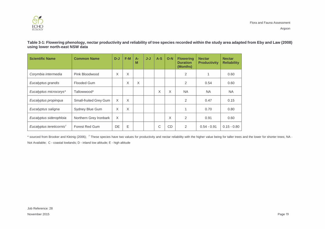
Nectar Resources We reviewed the Pteropus poliocephalus (Grey-headed Flying-fox) foraging habitat mapping layer (Eby and Law 2008) and found that remnant vegetation within the study area was ranked as mostly 2 (the second highest ranking), meaning that the forest type contained high reliability and productivity nectar resources. A small area was ranked as 1 (the highest ranking) for nectar reliability and productivity. This mapping not only classifies foraging habitat for Pteropus poliocephalus (Grey-headed Flying-fox), but for many other threatened fauna species that consume nectar such as Petaurus australis (Yellow-bellied Glider), Petaurus norfolkensis (Squirrel Glider), Glossopsitta pusilla (Little Lorikeet), Lathamus discolor (Swift Parrot) and Anthochaera phrygia (Regent Honeyeater). Within the study area, important nectar-producing trees are Corymbia intermedia (Pink Bloodwood), Eucalyptus siderophloia (Grey Ironbark), Eucalyptus saligna (Sydney Blue Gum) and tall Eucalyptus tereticornis (Forest Red Gum) (Eby and Law 2008). Mistletoe was present adjacent to the new access road at low density. The flowering phenology of tree species recorded within the study area is shown in Table 3-1.
Flora and Fauna Assessment
Argoon
Job Reference: 28
November 2015 Page 19
Table 3-1: Flowering phenology, nectar productivity and reliability of tree species recorded within the study area adapted from Eby and Law (2008) using lower north-east NSW data
Scientific Name Common Name D-J F-M A-M
J-J A-S O-N Flowering Duration (Months)
Nectar Productivity
Nectar Reliability
Corymbia intermedia
Pink Bloodwood X X 2 1 0.60
Eucalyptus grandis
Flooded Gum X X 2 0.54 0.60
Eucalyptus microcorys* Tallowwood* X X NA NA NA
Eucalyptus propinqua
Small-fruited Grey Gum X X 2 0.47 0.15
Eucalyptus saligna
Sydney Blue Gum X X 1 0.70 0.80
Eucalyptus siderophloia
Northern Grey Ironbark X X 2 0.91 0.60
Eucalyptus tereticornis†
Forest Red Gum DE E C CD 2 0.54 - 0.91 0.15 - 0.80
* sourced from Brooker and Kleinig (2006); † These species have two values for productivity and nectar reliability with the higher value being for taller trees and the lower for shorter trees; NA -
Not Available; C - coastal lowlands; D - inland low altitude; E - high altitude

Flora and Fauna Assessment
Argoon
Job Reference: 28
November 2015 Page 20
Riparian areas Two ephemeral drainage lines occur within the study area before entering Pipers Creek (Figure 3-1). Pipers Creek (a permanent drainage line) forms the southern boundary of the site and was not covered by our survey. Riparian areas within the study area have been historically cleared for grazing, with some regeneration occurring in parts. There are a number of functioning farm dams within the study area, the largest occurring along a drainage line in the south of the study area. These dams generally contained a number of aquatic and emergent plants. Disturbance levels varied across the study area, with stock grazing on the aquatic plants and increasing water turbidity in high use areas. The large dam in the south of the study area was in reasonable condition and is likely to provide habitat for a number of frog and waterbird species. Critical Habitat No critical habitat listed under the TSC Act occurs within 10 km of the study area.
3.2 Flora
3.2.1 Previous vegetation mapping
The following vegetation communities were mapped by GHD (2007) as occurring within the study area:
• Central Mid Elevation Sydney Blue Gum (FE 19); • River Oak (FE 120); • Dry Foothills Blackbutt - Turpentine (FE 32); and • Moist Foothills Spotted Gum (FE 89).
3.2.2 Vegetation Communities
A description of each community is provided below. Flora species recorded within the study area are listed in Appendix A. Following field surveys, five vegetation communities have been delineated as occurring within the study area (Figure 3-1), as listed below: 1. Dry Grassy Tallowwood - Grey Gum (FE 36); 2. Lowland Red Gums (FE 73); 3. Central Mid Elevation Sydney Blue Gum (FE 19); 4. Pasture Grassland and Cleared; and 5. Dam.


Flora and Fauna Assessment
Argoon
Job Reference: 28
November 2015 Page 22
1. Dry Grassy Tallowwood - Grey Gum (FE 36) This community occurs throughout the more elevated parts of the study area (Figure 3-1). It has been heavily cleared historically and remnants consist mostly canopy species with a grazed native and exotic pasture understorey (Figure 3-2; Figure 3-3; Figure 3-4).
Figure 3-2: Photograph of Dry Grassy Tallowwood - Grey Gum (north-west)
Figure 3-3: Photograph of Dry Grassy Tallowwood - Grey Gum (south-east)

Flora and Fauna Assessment
Argoon
Job Reference: 28
November 2015 Page 23
Figure 3-4: Photograph of Dry Grassy Tallowwood - Grey Gum (north)
Upper Stratum: 30 m with a PFC of 20% to 25%, the dominant species are variable across the site with Eucalyptus microcorys (Tallowwood), Eucalyptus propinqua (Small-fruited Grey Gum), Eucalyptus siderophloia (Grey Ironbark) and Eucalyptus carnea (Thick-leaved White Mahogany). Corymbia intermedia (Pink Bloodwood), Eucalyptus tereticornis (Forest Red Gum), Eucalyptus grandis (Flooded Gum) and Eucalyptus saligna (Sydney Blue Gum) also occur in this community as scattered individuals. Mid Stratum: The mid stratum is mostly absent due to historical clearing. Scattered occurrences of Allocasuarina littoralis (Black She oak), Breynia oblongifolia (Coffee Bush), Cassinia uncata (Bent Cassinia), and Acacia linifolia (Flax Wattle) were recorded. Along the ephemeral drainage line in the east of the study area and moist areas adjacent to the proposed access road Melaleuca stypheloides (Prickly-leaved Paperbark), Acacia floribunda (Sally Wattle), Callistemon salignus (Willow Bottlebrush) and Alphitonia excelsa (Red Ash) occurred in low numbers. Lower Stratum: to 0.5m with a PFC of 60 to 90% the dominant species were mostly representative of the pasture grassland.
2. Lowland Red Gums (FE 73) This vegetation community remains as only scattered canopy tree species in low-lying, more fertile areas of the study area (Figure 3-1). It also occurs adjacent to the access road in the west of the study area.

Flora and Fauna Assessment
Argoon
Job Reference: 28
November 2015 Page 24
Figure 3-5: Photograph of the scattered paddock trees that comprise the Lowland Red Gums (FE 73). The dense vegetation of Pipers Creek to the south of the study area is in the background.
Figure 3-6: Photograph of the disturbed Lowland Red Gums (FE 73) along the proposed access road.
Upper Stratum: scattered trees to 30 m, the dominant species being Eucalyptus tereticornis (Forest Red Gum), with Eucalyptus siderophloia (Grey Ironbark) also occurring. No mid stratum remains within this community and the understorey contains the pasture grassland species discussed in community 4 below.

Flora and Fauna Assessment
Argoon
Job Reference: 28
November 2015 Page 25
3. Central Mid Elevation Sydney Blue Gum (FE 19) This vegetation community occurs in the south-east corner of the study area and along Pipers Creek to the south and east of the study area (Figure 3-1). Within the study area, this community exists only as scattered canopy trees.
Figure 3-7: Photograph of Central Mid Elevation Sydney Blue Gum (FE 19) along Pipers Creek adjacent to the study area
Upper Stratum: 30 to 35 m existing as scattered canopy trees of both Eucalyptus saligna (Sydney Blue Gum) and Eucalyptus grandis (Flooded Gum). Within the study area the midstorey was absent and the understorey limited to the pasture grassland discussed below with scattered juvenile Commersonia fraseri (Brush Kurrajong) in some parts. This community was observed to occur along Pipers Creek outside of the study area, where additional canopy species such as Lophostemon confertus (Brushbox) was observed. Outside of the study area this community was observed to contain a moderately dense midstorey of rainforest plant species such as Alphitonia exelsca (Red Ash). Commersonia fraseri (Brush Kurrajong) was common along the external fence line, with a number of vines, such as Cissus antarctica (Native Grape) and Clematis glycinoides (Clematis) covering these small trees.
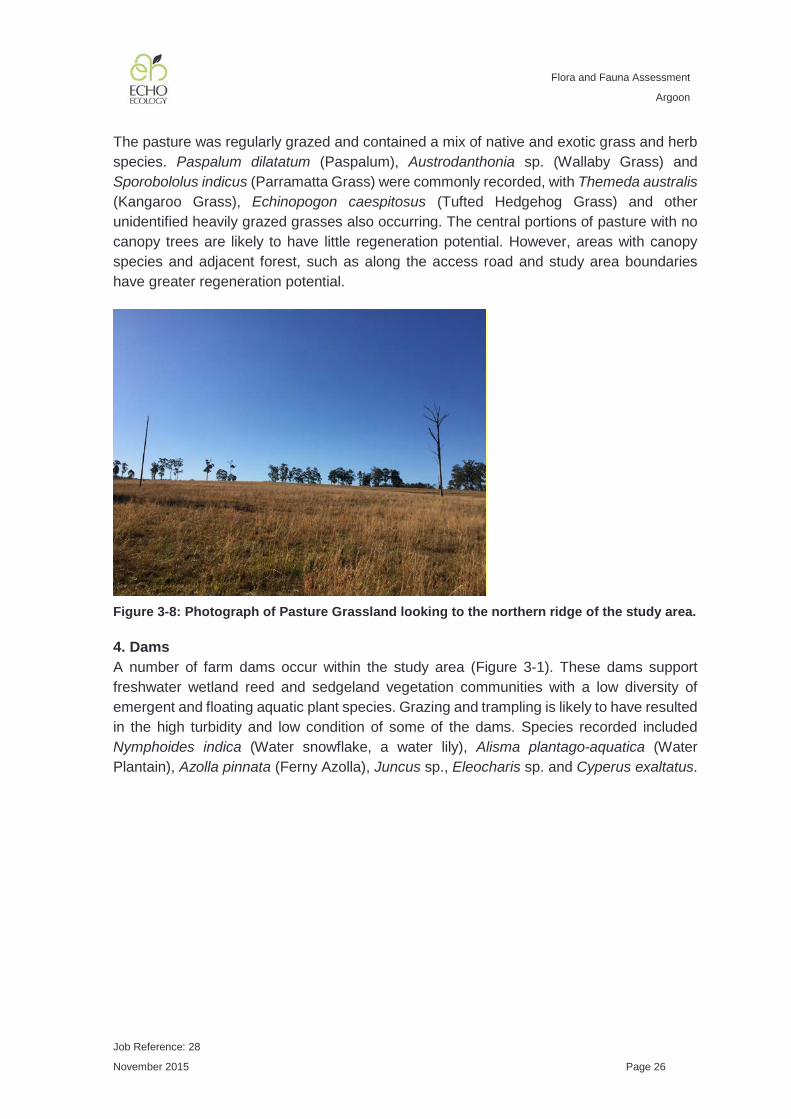
4. Pasture Grassland and Cleared This vegetation community comprises all remaining areas of native and exotic pasture grassland, cleared areas, roads and houses (Figure 3-1).
Flora and Fauna Assessment
Argoon
Job Reference: 28
November 2015 Page 26
The pasture was regularly grazed and contained a mix of native and exotic grass and herb species. Paspalum dilatatum (Paspalum), Austrodanthonia sp. (Wallaby Grass) and Sporobololus indicus (Parramatta Grass) were commonly recorded, with Themeda australis (Kangaroo Grass), Echinopogon caespitosus (Tufted Hedgehog Grass) and other unidentified heavily grazed grasses also occurring. The central portions of pasture with no canopy trees are likely to have little regeneration potential. However, areas with canopy species and adjacent forest, such as along the access road and study area boundaries have greater regeneration potential.
Figure 3-8: Photograph of Pasture Grassland looking to the northern ridge of the study area.
4. Dams A number of farm dams occur within the study area (Figure 3-1). These dams support freshwater wetland reed and sedgeland vegetation communities with a low diversity of emergent and floating aquatic plant species. Grazing and trampling is likely to have resulted in the high turbidity and low condition of some of the dams. Species recorded included Nymphoides indica (Water snowflake, a water lily), Alisma plantago-aquatica (Water Plantain), Azolla pinnata (Ferny Azolla), Juncus sp., Eleocharis sp. and Cyperus exaltatus.

Flora and Fauna Assessment
Argoon
Job Reference: 28
November 2015 Page 27
Figure 3-9: Photograph of large dam in the south of the study area
3.2.3 Endangered Ecological Communities
We have combined a review of digital datasets with floristic information collected during flora surveys to determine whether any EECs are likely to occur within the study area.
Coastal floodplain EECs Of most relevance to the study area is the potential occurrence of coastal floodplain EECs. Coastal floodplain EECs is a term commonly used to describe EECs in NSW listed under TSC Act that have an ‘association’ with coastal floodplains specified in their final determinations. Coastal floodplain EECs include:
• Swamp Oak Floodplain Forest of the New South Wales North Coast, Sydney Basin and South East Corner Bioregions (SOFF);
• Swamp Sclerophyll Forest on Coastal Floodplains of the New South Wales North Coast, Sydney Basin and South East Corner Bioregions (SSF);
• Freshwater Wetlands on Coastal Floodplains of the New South Wales North Coast, Sydney Basin and South East Corner Bioregions (FWW);
• Subtropical Coastal Floodplain Forest of the New South Wales North Coast Bioregion (SCFF); and
• River-Flat Eucalypt Forest on Coastal Floodplains of the New South Wales North Coast, Sydney Basin and South East Corner Bioregions (RFEF).
Collectively, these coastal floodplain EECs cover all remaining vegetation on coastal floodplains in NSW.

Flora and Fauna Assessment
Argoon
Job Reference: 28
November 2015 Page 28
Particular area In order to determine whether the vegetation communities within the study area could be classified as any of these coastal floodplain EECs, we first looked at whether the study area constituted the ‘particular area’ as defined by the final determination. Broadly, each final determination specifies the bioregions and LGAs in which the EEC is known to occur. Each of the coastal floodplain EECs are listed as occurring in the North Coast Bioregion and all are known to occur in the Kempsey LGA, except for RFEF. Therefore, the study area meets the broad definition of the ‘particular area’ of all of the coastal floodplain EECs, except for RFEF. The final determination for RFEF states “but may occur elsewhere in these bioregions”, which indicates a possibility of occurrence within the study area. However, there is evidence to suggest that the community does not occur further north than the Manning Valley. Firstly, Keith and Scott (2005; Table 2) in their classification of coastal floodplain EECs refer to RFEF as occurring south of the Hunter Valley. Secondly, the final determination for SCFF states that SCFF intergrades with RFEF south of the Manning Valley. Finally, the identification guidelines for RFEF (Department of Environment and Climate Change 2007a) refers to RFEF occurring south of Port Stephens. Therefore, as the study area occurs to the north of the Manning Valley, it is unlikely that the study area satisfies the broad ‘particular area’ for RFEF. At a fine scale, the final determinations for each of the coastal floodplain EECs state that the communities are associated with coastal floodplain features. The following definition of a coastal floodplain is common to each of the coastal floodplain EEC final determinations:
“Floodplains are level landform patterns on which there may be active erosion and aggradation by channelled and overbank stream flow with an average recurrence interval of 100 years or less (adapted from Speight 1990).”
Soil landscapes Alluvial soil types from 1:100,000 soil landscape mapping were used to identify coastal floodplains by Keith and Scott (2005) in their description of NSW coastal floodplain vegetation. The Keith and Scott (2005) vegetation classification and assessment forms the basis for the listing of the coastal floodplain EECs. As such, soil landscape mapping is often used to identify areas of floodplain that may potentially contain coastal floodplain EECs and has legal precedent (CBD Prestige Holdings Pty Ltd v Lake Macquarie City Council [2005] NSWLEC 367, Gales Holdings Pty Limited v Tweed Shire Council [2008] NSWLEC 209, and Motorplex (Australia) Pty Limited v Port Stephens Council [2007] NSWLEC 74). Some alluvial soils were mapped within low-lying areas of the study area in the soil landscape mapping of the Kempsey - Korogoro Point 1:100,000 map sheet (Atkinson 1999) (Figure 1-2).

Flora and Fauna Assessment
Argoon
Job Reference: 28
November 2015 Page 29
Quaternary geology Darkheart Eco-Consultancy (2014) has recently used alluvial geological formations found in 1:25,000 Quaternary geological mapping (Hashimoto and Troedson 2007) as a major component in defining coastal floodplain EECs for the nearby Port Macquarie - Hastings LGA. While using geological layers as a basis for defining floodplains for coastal floodplain EECs in NSW has not been tested legally as far as we are aware, it provides the benefit of being undertaken at a finer scale than the soil landscape mapping (Atkinson 1999). The Quaternary geological mapping layer (Figure 1-3) identifies most of the study area as being underlain by bedrock (Carboniferous and Permian sedimentary rocks and minor volcanic rocks) (Hashimoto and Troedson 2007). However, alluvial plain geological units are mapped in the south and east of the study area adjacent to Pipers Creek (Hashimoto and Troedson 2007). Summary The key findings of the fine-scale ‘particular area’ review for the presence of coastal floodplains are:
• Soil landscapes - alluvial soil landscapes were mapped by Atkinson (1999) in the south and east of the study area; and
• Quaternary geology - areas in the south and east of the study area were mapped as alluvial by the Quaternary geological mapping (Hashimoto and Troedson 2007).
As soil testing was beyond the scope of our study, we have adopted a cautious approach. We have classified all areas mapped as being underlain by alluvial soil landscapes or Quaternary alluvial geology as potential floodplain. These potential floodplain areas are likely to constitute the ‘particular area’ for coastal floodplain EECs. Floristics We secondly reviewed the flora species from vegetation communities that overlap with the potential floodplain areas to determine whether the vegetation in the study area contained an assemblage of species characteristic of any of the coastal floodplain EECs. Vegetation communities that overlap with the potential floodplain areas identified from the ‘particular area’ discussion above are Dry Grassy Tallowwood - Grey Gum (FE 36), Lowland Red Gums (FE 73) and Central Mid Elevation Sydney Blue Gum (FE 19). Swamp Oak Floodplain Forest This EEC is dominated by Casuarina glauca (Swamp Oak) and occurs in coastal floodplain areas with a saline or sub-saline groundwater. None of the vegetation communities recorded within the study area contained an abundance of Casuarina glauca (Swamp Oak) which indicates that this EEC does not occur within the study area.

Flora and Fauna Assessment
Argoon
Job Reference: 28
November 2015 Page 30
Swamp Sclerophyll Forest This EEC has an open to dense tree layer of eucalypts and paperbarks. The most widespread and abundant dominant trees include Eucalyptus robusta (Swamp Mahogany) and Melaleuca quinquenervia (Broad-leaved Paperbark). Other trees may be scattered throughout at low abundance or may be locally common at few sites, including Callistemon salignus (Weeping Bottlebrush), Casuarina glauca (Swamp Oak) and Eucalyptus resinifera subsp. hemilampra (Red Mahogany), Livistona australis (Cabbage Palm) and Lophostemon suaveolens (Swamp Turpentine). The absence of the characteristic and dominant or abundant tree species Eucalyptus robusta (Swamp Mahogany) and Melaleuca quinquenervia (Broad-leaved Paperbark) from the study area indicates that this EEC does not occur. Freshwater Wetlands This EEC is associated with ephemeral or semi-permanent standing water. The structure of the community may vary from sedgelands and reedlands to herbfields, and woody species of plants are generally scarce. There are some constructed farm dams containing reedlands within the study area. However, farm dams are specifically excluded from the EEC description and there were no other wetland areas with within areas identified as potential floodplain. Therefore, it is unlikely that this EEC occurs within the study area. Subtropical Coastal Floodplain Forest The final determination describes this EEC in the following manner
“has a tall open tree layer of eucalypts, which may exceed 40 m in height, but can be considerably shorter in regrowth stands or under conditions of lower site quality. While the composition of the tree stratum varies considerably, the most widespread and abundant dominant trees include Eucalyptus
tereticornis (Forest Red Gum), Eucalyptus siderophloia (Grey Ironbark), Corymbia intermedia (Pink Bloodwood) and, north of the Macleay floodplain, Lophostemon suaveolens (Swamp Turpentine). Other trees may be scattered throughout at low abundance or locally common at few sites, particularly where there is an influence from lithic substrates upslope. These include Eucalyptus moluccana (Grey Box), Eucalyptus propinqua (Small-fruited Grey Gum), Eucalyptus seeana (Narrow-leaved Red Gum), Angophora subvelutina (Broad-leaved Apple), Eucalyptus robusta (Swamp Mahogany), Eucalyptus
resinifera subsp. hemilampra (Red Mahogany), Eucalyptus acmenoides (White Mahogany), Angophora woodsiana, Angophora paludosa and rainforest trees such as Ficus spp. (figs) and Cupaniopsis spp (tuckeroos).
A layer of small trees may be present, including Allocasuarina torulosa (forest oak), Alphitonia excelsa (red ash), Glochidion ferdinandi (cheese tree), Callistemon spp. (bottlebrushes), Melaleuca spp. (paperbarks) and Casuarina glauca (swamp oak). Scattered shrubs include Breynia oblongifolia (coffee bush), Acacia concurrens (curracabah), Commersonia spp., and Hibiscus spp. Occasional vines include Eustrephus latifolius (wombat berry), Parsonsia straminea (common silkpod) and Geitonoplesium cymosum (scrambling lily). The groundcover is composed of abundant forbs,

Flora and Fauna Assessment
Argoon
Job Reference: 28
November 2015 Page 31
scramblers and grasses including Imperata cylindrica var. major (blady grass), Themeda australis (kangaroo grass), Vernonia cinerea, Dianella caerulea (blue flax lily), Pratia purpurascens (whiteroot), Cheilanthes sieberi subsp. sieberi, and Dichondra repens (kidney weed). The composition and structure of the understorey is influenced by grazing and fire history, changes to hydrology and soil salinity and other disturbance, and may have a substantial component of exotic grasses, vines and forbs.”
“The combination of features that distinguish Subtropical Coastal Floodplain Forest from other coastal floodplain EECs include: its dominance by a mixed eucalypt canopy, often with Lophostemon
suaveolens; the presence of rainforest elements as scattered trees or understorey plants; the relatively low abundance or sub-dominance of Casuarina and Melaleuca species; the relatively low abundance of Eucalyptus robusta; and the prominent groundcover of soft-leaved forbs and grasses.”
Of the four most widespread and abundant dominant tree species in SCFF (Corymbia intermedia, Eucalyptus siderophloia, Eucalyptus tereticornis and Lophostemon suaveolens) described by (Keith and Scott 2005), three were recorded within floodplain areas (those mapped as having alluvial soils and quaternary geology) being Eucalyptus tereticornis (Forest Red Gum), Corymbia intermedia (Pink Bloodwood) and Eucalyptus siderophloia (Grey Ironbark). Corymbia intermedia (Pink Bloodwood) occurred as a few small trees along the eastern drainage line. Eucalyptus siderophloia (Grey Ironbark) occurred commonly throughout the study area, including the floodplain areas. Eucalyptus tereticornis (Forest Red Gum) occurred as scattered trees throughout low-lying areas. Lophostemon suaveolens (Swamp Turpentine) was absent from the study area. Eucalyptus propinqua (Small-fruited Grey Gum) and other eucalypts may be locally common in SCFF where there is an influence from lithic substrates upslope (Keith and Scott 2005). Within the study area Eucalyptus propinqua (Small-fruited Grey Gum) occurred commonly. The Lowland Red Gums (FE 73) vegetation community within the study area is highly likely to have once contained species representative of SCFF. In particular, the occurrence of Eucalyptus tereticornis (Forest Red Gum) and Eucalyptus siderophloia (Grey Ironbark) are indicative of SCFF. However, within the study area, due to historical land-clearing and ongoing grazing, the community is represented by mostly canopy species and a few native grasses and herbs persisting in the pasture grassland. An area of Dry Grassy Tallowwood - Grey Gum (FE 36) overlaps with the alluvial soil landscape and quaternary geology mapping in the east of the study area. While the Dry Grassy Tallowwood - Grey Gum (FE 36) contains some of the species included in the SCFF final determination, it is more typical of upslope topography. One of the dominant eucalypts listed in the SCFF final determination, Eucalyptus siderophloia (Grey Ironbark) was recorded within this community. In addition, SCFF may contain Eucalyptus propinqua (Small-fruited Grey Gum), that was commonly recorded within the Dry Grassy Tallowwood - Grey Gum (FE 36), where there is influence from lithic substrates upslope. However, other
Flora and Fauna Assessment
Argoon
Job Reference: 28
November 2015 Page 32
commonly dominant eucalypts found in SCFF were absent from the Dry Grassy Tallowwood - Grey Gum (FE 36) within the study area. Since much of the shrub and groundcover layer was missing from the study area, further analysis based on these layers is unable to be undertaken. However, as some of the canopy species listed in the SCFF final determination were present within the Dry Grassy Tallowwood - Grey Gum (FE 36) community, we have adopted a cautious approach and mapped areas of this community that fall within the alluvial soil and quaternary geology as candidate SCFF. However, it appears that these areas are marginal. The Central Mid Elevation Sydney Blue Gum (FE 19) vegetation community overlaps with the occurrence of alluvial soils in the south-east of the study area. It also extends beyond the study area on alluvial soils along Pipers Creek. While we did not undertake detailed surveys outside of the study area, Eucalyptus saligna (Sydney Blue Gum) and Eucalyptus grandis (Flooded Gum) appeared to be dominant within this community along Pipers Creek, with Lophostemon confertus (Brushbox) also observed. These species are not listed in the SCFF final determination. Within the study area, this community is represented by only scattered Eucalyptus grandis (Flooded Gum) and Eucalyptus saligna (Sydney Blue Gum) trees and appears to be on the edge of this community. As the study area has a lack of shrub and groundcover species, detailed analysis cannot be undertaken. The Central Mid Elevation Sydney Blue Gum (FE 19) vegetation community may fit a little better within the RFEF EEC description. However, all indications are that RFEF doesn’t occur as far north as the study area. However, as the coastal floodplain EECs collectively occupy all areas of coastal floodplain, we must apply a cautious approach and consider the areas of Central Mid Elevation Sydney Blue Gum (FE 19) within the study area to be SCFF due to the northern location of the study area and the occurrence of alluvial soils and quaternary geology. A total of 23 (22.3 %) of the characteristic species listed as occurring in SCFF in the final determination were recorded from the Dry Grassy Tallowwood - Grey Gum (FE 36), two species from the Lowland Red Gums (FE 73) and one from the Central Mid Elevation Sydney Blue Gum (FE 19; Appendix G). However, vegetation surveys were not exhaustive and it is likely that additional species would be identified with further targeted surveys within the Lowland Red Gums (FE 73) and Central Mid Elevation Sydney Blue Gum (FE 19) vegetation communities. Coastal Floodplain EEC Summary The study area has been heavily cleared historically for grazing and much of the understorey is absent. Areas of potential floodplain exist in lower-lying areas adjacent to Pipers Creek and drainage lines, as indicated by alluvial soil landscape (Atkinson 1999) and quaternary geology mapping (Hashimoto and Troedson 2007). The floristic data collected shows some similarities with SCFF EEC. As there are similarities between the vegetation communities occurring on areas identified as potential floodplain, we have adopted a cautious approach and mapped these as candidate EECs (Figure 3-10).

Flora and Fauna Assessment
Argoon
Job Reference: 28
November 2015 Page 33
Further investigations such as soil testing and / or phytosociological analysis following the methods of Keith and Scott (2005) would be required to determine the presence or absence of EEC within the study area with greater confidence.


Flora and Fauna Assessment
Argoon
Job Reference: 28
November 2015 Page 35
Other EECs Other EECs occurring in the bioregion, but considered unlikely to occur within the study area include:
• Coastal Saltmarsh in the New South Wales North Coast, Sydney Basin and South East Corner Bioregions;
• Littoral Rainforest in the New South Wales North Coast, Sydney Basin and South East Corner Bioregions;
• Lowland Rainforest in the NSW North Coast and Sydney Basin Bioregions; and • Themeda grassland on seacliffs and coastal headlands in the NSW North Coast,
Sydney Basin and South East Corner Bioregions The study area is approximately 20 km from the ocean and as such is unlikely to contain coastal saltmarsh, littoral rainforest or Themeda grassland on seacliffs and coastal headlands EECs which are found immediately adjacent to the coast. This was verified by the floristic data collected during surveys. The lowland rainforest EEC is a vegetation community with a dense canopy through which little light passes and high diversity of trees which typically form three major strata, emergent, canopy and sub-canopy. None of the vegetation communities recorded within the study area had a closed canopy or are likely to have had a closed canopy in the past. While a few of the characteristic species described in the lowland rainforest EEC final determination were recorded in moist areas of the study area, the overstorey was dominated by sclerophyllous trees (Eucalyptus spp. and Lophostemon spp.) and lacked the dense canopy vegetation structure that characterises the lowland rainforest EEC.
3.2.4 Threatened Flora Species
Database searches indicated that nine threatened flora species occurred or had potential habitat within 10 km of the study area (see Appendix C for a full list). Based on the results of the flora survey and habitat assessment, we found that two threatened flora species have the potential to occur within the study area:
• Arthraxon hispidus (Hairy Jointgrass); and • Thesium australe (Austral Toadflax).
Thesium australe (Austral Toadflax) occurs in grassland and grassy woodland often in association with Themeda australis (Kangaroo Grass). It is a small straggling herb that is often hidden amongst grasses and herbs and is difficult to detect. There are no local records. We searched for this species during the course of our survey. However, we did not cover all potential grassland habitat within the study area. As there is potential habitat present within the study area and we did not undertake detailed searches, we have adopted a cautious approach and have classified it as moderately likely to occur. As we consider that these two species have a moderate or greater chance of occurrence within the study area, we have prepared an assessment of significance (7-part test) under the TSC Act and

Flora and Fauna Assessment
Argoon
Job Reference: 28
November 2015 Page 36
EP&A Act (Appendix F) to determine the significance of any potential impacts arising from the proposal.
3.2.5 Regionally Significant Flora Species
No ROTAP plants were recorded within the study area during surveys.
3.3 Fauna
The fauna survey was limited to opportunistic sightings, tracks and traces observed during the one-day site visit. Macropus giganteus (Eastern Grey Kangaroo) was recorded foraging in the pasture grassland and sheltering under canopy trees. Crinia signifera (Common Eastern Froglet) was heard calling from the large farm dam in the south of the study area. Bird species recorded from the open pasture were Dacelo novaeguineae (Laughing Kookaburra), Cracticus nigrogularis (Pied Butcherbird), Grallina cyanoleuca (Magpie-lark) Manorina melanocephala (Noisy Miner), Ardea ibis (Cattle Egret) and Platycercus eximius (Eastern Rosella). Nectarivorous bird species were recorded foraging in the canopy of scattered remnant trees and adjacent to the proposed new access road. Common nectarivorous birds recorded included: Acanthorhynchus tenuirostris (Eastern Spinebill), Myzomela sanguinolenta (Scarlet Honeyeater), Meliphaga lewinii (Lewin’s Honeyeater), Lichenostomus chrysops (Yellow-faced Honeyeater) and Philemon corniculatus (Noisy Friarbird). Other forest birds recorded include: Gerygone olivacea (White-throated Gerygone), Acanthiza pusilla (Brown Thornbill), Acanthiza nana (Yellow Thornbill), Pachycephala rufiventris (Rufous Whistler), Pardalotus punctatus (Spotted Pardalote), Eopsaltria australis (Eastern Yellow Robin), Psophodes olivaceus (Eastern Whipbird) and Rhipidura fuliginosa (Grey Fantail). Malurus cyaneus (Superb Blue Fairy-wren) was recorded from dense shrubs adjacent to the proposed access road in the west of the study area. The following water birds were recorded from farm dams within the study area Chenonetta jubata (Australian Wood Duck), Porphyrio porphyrio (Purple Swamphen), Ardea pacifica (White-necked Heron), Aythya australis (Hardhead), Tachybaptus novaehollandiae (Australasian Grebe), Threskiornis spinicollis (Straw-necked Ibis), and Vanellus miles (Masked Lapwing).

Flora and Fauna Assessment
Argoon
Job Reference: 28
November 2015 Page 37
Haliaeetus leucogaster (White-bellied Sea-Eagle) was recorded soaring high above the study area. Lophoictinia isura (Square-tailed Kite) which is listed as Vulnerable under TSC Act was recorded hunting adjacent to the large dam within the study area (Figure 3-10).
3.4 Biodiversity Corridors
3.4.1 NPWS Key Habitats and Corridors
No fauna key habitats are mapped within the study area (Figure 3-11) but large patches occur in Kumbantine National Park approximately 5 km to the west; Maria State Forest approximately 1.5 km to the north; and Ballengarra State Forest approximately 5 km to the south (Scotts 2003). The Pipers Creek subregional corridor mapped by Scotts (2003) runs through the eastern half of the study area and the Ballengarra-Mari regional corridor occurs in the south-eastern corner of the study area, linking Ballengarra State Forest in the south with Maria State Forest to the north (Figure 3-11). The Carrai Plateau - Macleay Lowlands corridor (Figure 3-11) is a dry habitat climate change corridor extending from the Carrai Plateau in the west to the floodplains south of Kempsey (Department of Environment and Climate Change 2007b). It is over 20 km in width when it passes through the entire study area.
3.4.2 Local Corridors
The study area is heavily cleared, but is surrounded by remnant native vegetation. Few opportunities for small terrestrial animals to move through the study area exist and these animals are likely to use adjacent bushland areas. More mobile fauna species such as birds and bats are likely to use the remnant trees within the study area for foraging and as movement corridors.
3.5 Riparian Buffers
The study area contains a number of watercourses defined by 1:25,000 topographic maps that the WM Act riparian buffers apply as constraints to future development. Indicative VRZs are shown in Figure 3-12 based on the topographic map drainage lines. These may vary with the actual centreline of watercourses and if development is required in close proximity to these areas, then accurate surveying may be required. Some encroachment on VRZs is permissible under the WM Act, providing that the average width of the VRZ can be achieved over the length of the watercourse.

SOURCEAerial Photo - Google Earth Pro
© 2015 DigitalGlobe
Figure 3-11CorridorsClient: Gavan Landini
DISCLAIMER:Indicative onlyAll boundaries, scale and points are approximate onlyGPS locations recorded at > 5 m accuracy

SOURCEAerial Photo - Google Earth Pro
© 2015 DigitalGlobe
Rev.28
Figure 3-12Riparian BuffersClient:
02 October 2015
Gavan Landini
Flora and Fauna Assessment
DISCLAIMER:Indicative onlyAll boundaries, scale and points are approximate onlyGPS locations recorded at > 5 m accuracy
Job No.0
Date

Flora and Fauna Assessment
Argoon
Job Reference: 28
November 2015 Page 40
4.0 IMPACT ASSESSMENT
4.1 Likelihood of Occurrence of Threatened Species, Populations and Ecological Communities
A total of one candidate EEC, 32 threatened fauna species and two threatened flora species were found to have at least a moderate chance of occurrence within the study area based on local records, habitat assessment and the results of our survey (see Appendix C for full assessment of likelihood of occurrence). Candidate EECs listed under TSC Act recorded within the study area were:
• Subtropical coastal floodplain forest of the NSW North Coast bioregion EEC; and Threatened flora species considered likely to occur (moderate or greater chance) within the study area are:
• Arthraxon hispidus (Hairy Jointgrass); and • Thesium australe (Austral Toadflax).
Threatened fauna species considered likely to occur (moderate or greater chance) or recorded (in bold) within the study area are:
• Mixophyes balbus (Stuttering Frog); • Mixophyes iteratus (Giant Barred Frog); • Litoria brevipalmata (Green-thighed Frog); • Lophoictinia isura (Square-tailed Kite); • Calyptorhynchus lathami (Glossy Black-Cockatoo); • Glossopsitta pusilla (Little Lorikeet); • Lathamus discolor (Swift Parrot); • Anthochaera phrygia (Regent Honeyeater); • Ninox strenua (Powerful Owl); • Tyto novaehollandiae (Masked Owl); • Tyto tenebricosa (Sooty Owl); • Chthonicola sagittata (Speckled Warbler); • Daphoenositta chrysoptera (Varied Sittella); • Coracina lineata (Barred Cuckoo-Shrike); • Carterornis leucotis (White-eared Monarch); • Melanodryas cucullata cucullata (Hooded Robin); • Petroica boodang (Scarlet Robin); • Petroica phoenicea (Flame Robin); • Stagonopleura guttata (Diamond Firetail); • Dasyurus maculatus (Spotted-tailed Quoll); • Phascogale tapoatafa (Brush-tailed Phascogale); • Phascolarctos cinereus (Koala); • Petaurus australis (Yellow-bellied Glider);

Flora and Fauna Assessment
Argoon
Job Reference: 28
November 2015 Page 41
• Petaurus norfolcensis (Squirrel Glider); • Saccolaimus flaviventris (Yellow-bellied Sheathtail-bat) • Mormopterus norfolkensis (East Coast Freetail-bat); • Falsistrellus tasmaniensis (Eastern False Pipistrelle); • Miniopterus australis (Little Bentwing-bat); • Miniopterus schreibersii oceanensis (Eastern Bentwing-bat); • Myotis macropus (Southern Myotis); • Scoteanax rueppellii (Greater Broad-nosed Bat); • Pteropus poliocephalus (Grey-headed Flying-fox).
The potential constraints arising from the known or potential occurrence of these species is discussed below.
4.2 Potential Impacts
4.2.1 Direct Impacts
Clearing or modification of native vegetation The clearing of native vegetation is listed as a KTP under the TSC Act and would represent a direct loss of habitat for a number of threatened fauna species (including koala) and also for the candidate EEC. The proposal is for subdivision into rural lots. No vegetation clearing will be required for the subdivision, outside of the clearing of vegetation along fence lines already undertaken as routine agricultural management actions permitted by the NV Act for rural zones. Grazing, which modifies native vegetation, already occurs within the study area. Grazing has the potential to impact on the threatened plants, ecological communities and terrestrial fauna species. However, no rezoning is being undertaken and the proposal will not increase the level of grazing within the study area more than may occur through any change in land ownership. Additionally, as the proposed new lot layout contains large areas of cleared land, it is unlikely that future development applications for single dwellings would require substantial vegetation clearing. To minimise potential ecological impacts it is recommended to focus any future building envelopes into areas that have already been cleared.
Loss of hollow-bearing trees Hollow-bearing trees are a key habitat resource for at least 40 threatened fauna species in NSW (Gibbons and Lindenmayer 2002). Hollows are used as diurnal or nocturnal shelter sites, for rearing young, foraging, thermoregulation and to facilitate ranging behaviour and dispersal (Gibbons and Lindenmayer 2002). The distribution and abundance of hollow-bearing trees in NSW has been reduced and fragmented by extensive clearing of native vegetation during the past two centuries, primarily for agriculture. Hollows may take a century or more to form and so are slow to be replaced. While the subdivision will not require the removal of any native vegetation including hollow-bearing trees, future development of the new lots may contribute to the loss of hollow-

Flora and Fauna Assessment
Argoon
Job Reference: 28
November 2015 Page 42
bearing trees and the removal of dead wood and dead trees KTPs listed under TSC Act, if ecologically sensitive placement of building envelopes is not undertaken. It is also possible that hollow-bearing trees may be removed in the future for safety and aesthetics. The further loss of hollow-bearing trees within the study area may also contribute to the operation of a number of other KTPs listed under TSC Act such as indirect impacts associated with Competition from feral honey bees Apis melifera.
4.2.2 Indirect Impacts
The potential increase in human activity within the study area may result in a number of indirect impacts resulting from increased human population both within and adjacent to the study area.
Habitat fragmentation, edge effects and connectivity Much of the remnant vegetation within the study area is already quite fragmented and subject to edge effects. As the study area contains large cleared areas, it is likely that future building envelopes will be able to be placed in an ecologically sensitive manner. There is also the opportunity to enhance habitat linkages through the study area via landscaping, bush regeneration and boundary plantings.
Feral animals and domestic pets Impacts to wildlife from domestic dog and cat attacks are likely to increase with an increase in the number of dwellings. Predation on wildlife by domestic animals is common wherever free-ranging dogs and cats occur. Rural residential properties are often a source of dog attacks as dogs free-range across large vegetated properties. Whereas domestic cats from any urban area can impact native wildlife as they are able to roam widely. Additionally, domestic pets may also contribute to feral populations of both dogs and cats which cause large impacts on wildlife. While these impacts are likely to be already occurring within the study area, an increase in housing will put further pressure on wildlife persisting in the local area. There are a number of KTPs listed under TSC Act that address impacts from feral animals. However, we consider it unlikely that an increase in human activity will increase the activity of these KTPs beyond what is currently occurring (see Appendix D for further details).
Weed invasion A number of weeds were recorded within the study area during surveys and others are likely to be present in the pasture areas that were not studied in detail. An increase in houses within the study area may result in additional weed invasion through inappropriate garden waste disposal into adjacent bushland areas and during construction. However, there are also opportunities for increased urbanisation to result in greater weed control due to the implementation of vegetation management plans for areas of conservation. The following six KTPs relating to exotic weed invasion are listed under TSC Act:
• The invasion and establishment of exotic vines and scramblers;

Flora and Fauna Assessment
Argoon
Job Reference: 28
November 2015 Page 43
• Invasion, establishment and spread of Lantana (Lantana camara); • Loss and degradation of native plant and animal habitat by invasion of escaped
garden plants, including aquatic plants; • Invasion of native plant communities by exotic perennial grasses; • Invasion of native plant communities by African Olive Olea europaea L. subsp.
Cuspidate; and • Invasion of native plant communities by Chrysanthemoides monilifera.
Water Quality and Alteration to hydrology Increased dwellings within the study area will result in slight changes to the hydrology of the study area by creating more impermeable surfaces for water to runoff. This may influence flow volumes, duration and groundwater recharge. Water quality may be negatively affected due to increased nutrient loads, erosion and sedimentation. However, these impacts are considered likely to be slight providing that appropriate controls are implemented as part of the future Development Application process.
Climate change It is likely that an increase in housing within the study area will contribute very slightly to climate change through in increase in greenhouse gas emissions during construction and operation. Anthropogenic climate change is listed as a KTP under TSC Act. However, there are opportunities for future residential development to incorporate sustainable design elements to reduce carbon footprints.
4.2.3 Cumulative Impacts
Any change in land-use within the study area is likely to contribute slightly to cumulative impacts at both a local and regional scale.
4.3 Kempsey CKPoM
The Kempsey CKPoM (Kempsey Shire Council 2011) was prepared in accordance with SEPP 44 (Koala Habitat Protection) and replaces the need for the preparation of individual Koala Plans of Management under SEPP 44 in areas of core Koala habitat. Koala Habitat Categories The Kempsey CKPoM classifies habitat into the following categories:
• Primary Habitat - Areas of forest and/or woodland wherein primary food tree species comprise the dominant or co-dominant (ie ≥ 50%) overstorey tree species. E.g. Swamp Mahogany Forest, Lowland Red gum Forest
• Secondary (Class A) Habitat - Primary food tree species present but not dominant or co-dominant and usually (but not always) growing in association with one or more secondary food tree species. E.g. Dry Blackbutt Forest.

Flora and Fauna Assessment
Argoon
Job Reference: 28
November 2015 Page 44
• Secondary (Class B) Habitat - Primary food tree species absent, habitat contains secondary and supplementary food tree species as components of overstorey. E.g. Scribbly Gum Forest.
• Other Habitat - Vegetation communities within which koala food trees are absent. E.g. Rainforest, Sedgeland, Headland Brush Box Forest.
• Unknown - Areas for which insufficient information regarding community composition was available, and which require further investigation to determine habitat category.
Preferred Koala Food Trees Preferred Koala Food Trees of the Kempsey CKPoM include the following primary and secondary food tree species (Kempsey Shire Council 2011). Primary koala food trees:
• Eucalyptus microcorys (Tallowwood); • Eucalyptus tereticornis (Forest Red Gum); • Eucalyptus robusta (Swamp Mahogany); and • Eucalyptus tereticornis x Eucalyptus robusta hybrid.
Secondary / supplementary food tree species:
• Eucalyptus propinqua (Grey Gum); • Eucalyptus globoidea (White Stringybark); and • Eucalyptus tindaliae (Stringybark).
The Study Area As the study area does not require rezoning and no vegetation clearing is required for the proposal (the access road was cleared prior to the proposal as a RAMA under the NV Act), the development control provisions of the CKPoM do not apply and detailed koala surveys are not required. The Kempsey CKPoM (Kempsey Shire Council 2011) maps most of the study area as Unknown (cleared or partly cleared) and remnant vegetation as Secondary (Class B) Koala Habitat. We found that the study area contained three Preferred Koala Food Tree species being Eucalyptus tereticornis (Forest Red Gum), Eucalyptus microcorys (Tallowwood) and Eucalyptus propinqua (Small-fruited Grey Gum). Eucalyptus microcorys (Tallowwood) and Eucalyptus propinqua (Small-fruited Grey Gum) were common in the west and eastern patches of remnant vegetation. Scattered Eucalyptus tereticornis (Forest Red Gum) occurred mostly in low-lying areas of the study area on alluvial soils. The Kempsey CKPoM resource study (Biolink 2009) found that koala use of Eucalyptus microcorys (Tallowwood) on erosional and residual soil landscapes was significantly lower than alluvial soil landscapes and strongly size class dependent (larger trees being used more frequently). In classifying vegetation communities as Koala habitat, Biolink (2009) treated Eucalyptus microcorys as a Primary Food Tree on alluvial, transferral and estuarine

Flora and Fauna Assessment
Argoon
Job Reference: 28
November 2015 Page 45
soil landscapes and as a Secondary Food Tree on erosional and residual soil landscapes. Biolink (2009) also found that Eucalyptus tereticornis (Forest Red Gum) was unlikely to be a Preferred Food Tree when growing on erosional and residual soil landscapes. As preferred koala food trees were generally dominant or co-dominant within the Lowland Red Gum and Dry Grassy Tallowwood-Grey Gum vegetation communities within the study area, we consider it unlikely that these areas are Secondary (Class B) Koala habitat as mapped by the CKPoM. Some areas of these vegetation communities on alluvial soils are likely to fall into the Primary Koala Habitat category. Where these vegetation communities occur on the erosional Euroka soil landscape, they are likely to be classified as Secondary (Class A) koala Habitat due to the lower ranking of Eucalyptus microcorys (Tallowwood) and Eucalyptus tereticornis (Forest Red Gum) as koala feed trees in erosional soil landscapes. The remainder of the study area should be classified as Other Habitat as it is predominantly cleared, with no Koala feed trees present. It is highly likely that koalas are active within the study area and any future Development Application for proposals within the newly created lots will require detailed koala surveys and habitat mapping in accordance with the Kempsey CKPoM. Future developments will be subject to the development control provisions of the Kempsey CKPoM which are likely to restrict development within or adjacent to remnant vegetation in the low-lying areas of alluvial soils and place other restrictions on koala food tree removal or require offsetting. However, it appears that the new lots of the proposed subdivision will contain sufficient cleared areas outside of the floodplain to permit a building envelope without further vegetation clearing.
4.4 Assessment of Significance under TSC Act and EP&A Act (7-part tests)
Assessments of significance were undertaken for one candidate EEC, 32 threatened fauna species and two threatened flora species that were found to have at least a moderate chance of occurrence within the study area. As the proposal is for subdivision only and will not remove any native vegetation, the potential impacts on threatened species, populations and communities listed under the TSC Act are considered to be quite low. Therefore, it is considered unlikely that the proposal will constitute a significant impact such that a Species Impact Statement is required. The full assessments of significance (7-part tests) can be found in Appendix F.
4.5 EPBC Act Considerations
Searches of the Department of the Environment On-line Database were used to gather baseline data on the site and general locality. This data, combined with other local

Flora and Fauna Assessment
Argoon
Job Reference: 28
November 2015 Page 46
knowledge and records, was utilised to assess whether the type of activity proposed on the study area will have, or is likely to have a significant impact upon a matter of National Environmental Significance (NES), or on the environment of Commonwealth land.
4.5.1 Environment of Commonwealth Land
The study area is not land owned by the Commonwealth and hence this portion of the EPBC Act is not applicable.
4.5.2 Matters of NES
World Heritage areas The study area is not a World Heritage area and is not in close proximity to any such area.
Wetlands of International Importance (RAMSAR) The study area is not within 10km of any RAMSAR Wetland area
Nationally listed threatened species and ecological communities: A total of nine threatened flora species, 15 threatened fauna species and two EECs listed under the EPBC Act have been recorded within the proximate region of the study area (see Appendix C for full list). No EECs listed under the EPBC Act were considered likely to occur within the study area (Appendix C). However, the following two threatened flora species and seven threatened fauna species listed under EPBC Act were found to be at least moderately likely to occur within the study area at some stage (Appendix C):
• Mixophyes balbus (Stuttering Frog) • Mixophyes iteratus (Giant Barred Frog) • Lathamus discolor (Swift Parrot) • Anthochaera phrygia (Regent Honeyeater) • Dasyurus maculatus (Spotted-tailed Quoll) • Phascolarctos cinereus (Koala) • Pteropus poliocephalus (Grey-headed Flying-fox)
Nationally listed migratory species The following migratory species listed under the EPBC Act may occur within the study area on an occasional basis: Migratory Terrestrial Species
• Haliaeetus leucogaster (White-bellied Sea-eagle) • Hirundapus caudacutus (White-throated Needletail) • Merops ornatus (Rainbow Bee-eater) • Monarcha melanopsis (Black-faced Monarch) • Monarcha trivirgatus (Spectacled Monarch) • Myiagra cyanoleuca (Satin Flycatcher) • Rhipidura rufifrons (Rufous Fantail)

Flora and Fauna Assessment
Argoon
Job Reference: 28
November 2015 Page 47
Migratory Wetland Species
• Ardea alba (Great Egret) • Ardea ibis (Cattle Egret) • Gallinago hardwickii (Latham’s Snipe) • Pandion cristatus (Eastern Osprey)
All nuclear actions No type of nuclear activity is proposed for the study area.
The environment of Commonwealth marine areas The proposed activity on the study area will not have a significantly adverse effect on any Commonwealth marine area.
5.0 RECOMMENDATIONS
This ecological impact assessment has been prepared on the assumption that no vegetation clearing will be undertaken. As the proposed subdivision is for three rural lots in a predominantly cleared study area, we have also assumed that any future building within the new will be able to be located in an ecologically sensitive manner within existing cleared areas. To minimise potential impacts at this subdivision stage and for potential future development applications we provide the following impact management strategy recommendations.
5.1 Subdivision and access road recommendations
• No vegetation clearing is to be undertaken within the study area for the subdivision or access road construction. If vegetation clearing is found to be required, a revised impact assessment may be required;
• Care should be taken during the construction of the proposed access road to avoid potential impacts on adjacent vegetation. Particularly, in the low-lying areas that contain candidate SCFF EEC.
• Appropriate erosion and sediment control measures should be implemented during the construction of the access road to minimise potential impacts on adjacent vegetation. Particularly, candidate SCFF EEC along the access road.
• Restrict any future building activity within riparian buffers and other low-lying floodplain areas (e.g. candidate SCFF EEC).
• Consider sustainable agricultural practices such as lower stocking ratios, replanting and the provision of recruitment opportunities for canopy trees (e.g. through temporary fencing) within low-lying floodplain areas to enhance SCFF EEC within the study area.

Flora and Fauna Assessment
Argoon
Job Reference: 28
November 2015 Page 48
• Encourage the use of native (locally endemic) plant species for any landscaping or wind break planting within the study area
• Undertake regular weed control activities
5.2 Future building considerations
While the current proposal is for subdivision only and a detailed flora and fauna survey and impact assessment is likely to be required to accompany any future Development Application, the following recommendations have been made to guide future development within the newly created lots:
• Restrict future building envelopes to outside of low-lying floodplain areas • Locate future building envelopes (and associated infrastructure) to avoid the
clearing of native vegetation. If native vegetation is required to be removed, then more detailed fauna surveys should be undertaken.
• Hollow-bearing and mature trees should be retained as a priority. If required, the loss of hollow-bearing trees should be offset with the installation of appropriate nest boxes and the protection of recruitment hollow-bearing trees (mature trees likely to develop hollows in the future) at a higher ratio than those removed.
• Encourage new property owners to minimise the potential for domestic dogs to free-range on properties unsupervised to minimise the risk of Koala mortality. E.g. provide a smaller fenced yard that contains no Koala feed trees for dogs to be contained;
• Encourage new property owners to keep domestic cats inside or caged at night to minimise potential impacts to native wildlife;
• Undertake full koala surveys as per the Kempsey CKPoM to accurately map and classify koala habitat within the study area;
• Retain Koala feed trees within the study area where possible and apply the offsetting principles of the Kempsey CKPoM where trees cannot be retained;
6.0 CONCLUSION
The study area contains large areas of cleared pasture, with some remnant native vegetation occurring, mostly in the form of canopy trees. A total of 32 threatened fauna species have the potential to occur within the study area and remnant vegetation within low-lying floodplain areas is likely to represent Subtropical Coastal Floodplain Forest EEC. Remnant vegetation within the study area is also likely to constitute Primary and Secondary (Class A) koala habitat. The proposal is for subdivision into three rural lots, with no rezoning or vegetation clearing required. The proposed new lots appear to contain sufficient cleared areas to allow the future construction of new houses (one per lot) without further vegetation clearing. Providing the recommendations outlined in Section 5 are adopted, we consider it unlikely that the subdivision proposal will significantly impact on any threatened species, populations or communities listed under TSC Act or EPBC Act.

Flora and Fauna Assessment
Argoon
Job Reference: 28
November 2015 Page 49
7.0 REFERENCES
Atkinson, G. 1999. Soil Landscapes of the Kempsey-Korogoro Point 1:100,000 Sheet map and report. NSW Department of Land and Water Conservation, Sydney.
Biolink. 2009. Comprehensive Koala Plan of Management for Eastern Portion of Kempsey Shire LGA Volume II - Resource Study.
Braun-Blanquet, J. 1982. Plant Sociology: The Study of Plant Communities. McGraw Hill Publishers, New York.
Briggs, J. D. and J. H. Leigh. 1996. Rare or threatened Australian plants. CSIRO Publishing. Brooker, M. I. H. and D. A. Kleinig. 2006. Field Guide to Eucalypts: Volume 1 South-eastern
Australia. Third edition. Bloomings Books Pty Ltd, Melbourne, Australia. Darkheart Eco-Consultancy. 2014. PMHC Vegetation Community Mapping: Coastal
Floodplain EEC Mapping Review. Port Macquarie - Hastings Council. DEC. 2004. Threatened Biodiversity Survey and Assessment: Guidelines for Developments
and Activities (working draft). NSW Department of Environment and Conservation, Husrtville, NSW.
DECC. 2007. Threatened species assessment guidelines: the assessment of significance.in Department of Environment and Climate Change, editor. Department of Environment and Climate Change,, Sydney South.
Department of Environment and Climate Change. 2007a. Identification Guidelines for Endangered Ecological Communities: River-flat Eucalypt Forest on Coastal Floodplain.in Department of Environment and Climate Change, editor. Department of Environment and Climate Change, Hurstville, NSW.
Department of Environment and Climate Change. 2007b. Landscape Selection Process: key altitudinal, latitudinal and coastal corridors for response to climate change. Northern Rivers Catchment Management Authority.
Department of Environment and Climate Change. 2008. Recovery plan for the koala (Phascolarctos cinereus). Department of Environment and Climate Change, Sydney South.
Department of Environment and Conservation. 2004. Field Key to Forest Ecosystems. Department of Environment and Conservation, Coffs Harbour, NSW.
Department of Environment and Conservation. 2006. Recovery Plan for the Large Forest Owls: Powerful Owl (Ninox strenua), Sooty Owl (Tyto tenebricosa) and Masked Owl (Tyto novaehollandiae). Department of Environment and Conservation, Sydney, NSW.
Department of Environment Climate Change and Water NSW. 2009. Draft National Recovery Plan for the Grey-headed Flying-fox Pteropus poliocephalus, prepared by Dr Peggy Eby. Department of Environment, Climate Change and Water NSW, Sydney, NSW.
Department of Natural Resources and Environment. 1999. Regent Honeyeater Recovery Plan 1999-2003. Parks, Flora and Fauna Division, East Melbourne.
Eby, P. and B. Law 2008. Ranking the feeding habitats of Grey-headed flying foxes for conservation management. Department of Environment and Climate Change (NSW) and Department of Environment Water Heritage and the Arts, Hurstville.
GHD. 2007. Report for Vegetation Mapping for Western Portion Kempsey LGA. Gibbons, P. and D. Lindenmayer. 2002. Tree Hollows and Wildlife Conservation in
Australia. CSIRO Publishing, Collingwood, VIC. Hashimoto, T. R. and A. L. Troedson. 2007. Port Macquarie 1:100 000 and 1:25 000,
Coastal Quaternary Geology Map Series. Geological Survey of NSW, Maitland.

Flora and Fauna Assessment
Argoon
Job Reference: 28
November 2015 Page 50
Keith, D. A. and J. Scott. 2005. Native vegetation of coastal floodplains - a diagnosis of the major plant communities in New South Wales. Pacific Conservation Biology 11:81-104.
Kempsey Shire Council. 2011. Comprehensive Koala Plan of Management for Eastern Portion of Kempsey Shire LGA Volume 1 Working Provisions. Kempsey Shire Council.
NSW National Parks and Wildlife Service. 2003. Recovery Plan for the Yellow-bellied Glider (Petaurus australis). NSW National Parks and Wildlife Service, Hurstville, NSW.
Preston, B. J. and P. Adam. 2004a. Describing and listing threatened ecological communities under the Threatened Species Conservation Act 1995 (NSW): Part 1 - the assemblage of species and the particular area. Environmental and Planning Law Journal 21:250-263.
Preston, B. J. and P. Adam. 2004b. Describing and listing threatened ecological communities under the Threatened Species Conservation Act 1995 (NSW): Part 2 - The role of supplementary descriptors and the listing process. Environmental and Planning Law Journal 21:372-390.
QGIS Development Team. 2015. QGIS Geographic Information System. Open Source Geospatial Foundation Project, http://qgis.osgeo.org.
Scotts, D. 2003. Key Habitats and Corridors for Forest Fauna: A Landscape Framework for Conservation in North-east New South Wales. NSW National Parks and Wildlife Service, Sydney, NSW.

Flora and Fauna Assessment
Argoon
Job Reference: 28
November 2015 Page A1
APPENDIX A FLORA SPECIES LIST
Family Scientific Name Common Name Q1
T1
T2
RM
MIMOSACEAE Acacia floribunda Sally Wattle x
MIMOSACEAE Acacia linifolia Flax Wattle 2 1
ALISMATACEAE Alisma plantago-aquatica Water Plantain x
CASUARINACEAE Allocasuarina littoralis Black She-oak 1
RHAMNACEAE Alphitonia excelsa Red Ash x
LORANTHACEAE Amyema congener Mistletoe x
POACEAE Austrodanthonia sp. Wallaby Grass 2 3 x
POACEAE Axonopus affinis* Narrow-leaved Carpet Grass 2
AZOLLACEAE Azolla pinnata Ferny Azolla x
ASTERACEAE Bidens pilosa* Cobbler's Pegs x
EUPHORBIACEAE Breynia oblongifolia Coffee Bush 1
MYRTACEAE Callistemon salignus Willow Bottlebrush 1
ASTERACEAE Cassinia uncata Bent Cassinia x
APIACEAE Centella asiatica Swamp Pennywort x
VITACEAE Cissus antarctica Native Grape x
PITTOSPORACEAE Citriobatus pauciflorus Orange Thorn 2
RANUNCULACEAE Clematis glycinoides Clematis x
STERCULIACEAE Commersonia fraseri Brush Kurrajong x
ASTERACEAE Coreopsis lanceolata* - x
MYRTACEAE Corymbia intermedia Pink Bloodwood 1

Flora and Fauna Assessment
Argoon
Job Reference: 28
November 2015 Page A2
Family Scientific Name Common Name Q1
T1
T2
RM
CYPERACEAE Cyperus exaltatus - x
CYPERACEAE Cyperus polystachyos - x
FABACEAE Desmodium rhytidophyllum - 1
CONVOLVULACEAE Dichondra repens Kidney Weed 2 x
POACEAE Echinopogon caespitosus Tufted Hedgehog Grass 2
POACEAE Entolasia stricta Wiry Panic x
MYRTACEAE Eucalyptus carnea Thick- leaved Mahogany 3
MYRTACEAE Eucalyptus grandis Flooded Gum 2
MYRTACEAE Eucalyptus microcorys Tallowwood 3
MYRTACEAE Eucalyptus propinqua Small-fruited Grey Gum 3 x
MYRTACEAE Eucalyptus saligna Sydney Blue Gum x
MYRTACEAE Eucalyptus siderophloia Northern Grey Ironbark 2 x
MYRTACEAE Eucalyptus tereticornis Forest Red Gum 1 x 1
PHILESIACEAE Eustrephus latifolius Wombat Berry 2
ASCLEPIADACEAE Gomphocarpus fruticosus* Narrow-leaved Cotton Bush x
GOODENIACEAE Goodenia sp. 2
ASTERACEAE Hypochaeris radicata* Flatweed 2 x 2 x
POACEAE Imperata cylindrica Blady Grass 2 3
VERBENACEAE Lantana camara* Lantana x
OLEACEAE Ligustrum sinense* Small-leaved Privet x
LINSAEACEAE Lindsaea microphylla Lacy Wedge-fern 1
XANTHORRHOEACEAE Lomandra filiformis Wattle Mat-rush 2
XANTHORRHOEACEAE Lomandra longifolia Spiky-headed Mat-rush 3
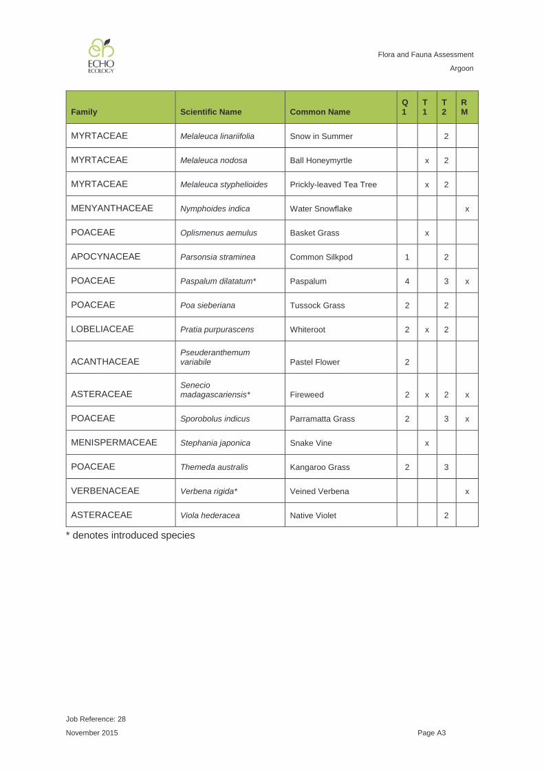
Flora and Fauna Assessment
Argoon
Job Reference: 28
November 2015 Page A3
Family Scientific Name Common Name Q1
T1
T2
RM
MYRTACEAE Melaleuca linariifolia Snow in Summer 2
MYRTACEAE Melaleuca nodosa Ball Honeymyrtle x 2
MYRTACEAE Melaleuca styphelioides Prickly-leaved Tea Tree x 2
MENYANTHACEAE Nymphoides indica Water Snowflake x
POACEAE Oplismenus aemulus Basket Grass x
APOCYNACEAE Parsonsia straminea Common Silkpod 1 2
POACEAE Paspalum dilatatum* Paspalum 4 3 x
POACEAE Poa sieberiana Tussock Grass 2 2
LOBELIACEAE Pratia purpurascens Whiteroot 2 x 2
ACANTHACEAE Pseuderanthemum variabile Pastel Flower 2
ASTERACEAE Senecio madagascariensis* Fireweed 2 x 2 x
POACEAE Sporobolus indicus Parramatta Grass 2 3 x
MENISPERMACEAE Stephania japonica Snake Vine x
POACEAE Themeda australis Kangaroo Grass 2 3
VERBENACEAE Verbena rigida* Veined Verbena x
ASTERACEAE Viola hederacea Native Violet 2
* denotes introduced species

Flora and Fauna Assessment
Argoon
Job Reference: 28
November 2015 Page B1
APPENDIX B FAUNA SPECIES LIST
Group Family Scientific Name Common Name TSC Act
EPBC Act
Amphibians MYOBATRACHIDAE Crinia signifera Common Eastern Froglet
- -
Birds ACCIPITRIDAE Lophoictinia isura Square-tailed Kite V -
Birds ACCIPITRIDAE Haliaeetus leucogaster
White-bellied Sea-Eagle - M
Birds ALCEDINIDAE Dacelo novaeguineae
Laughing Kookaburra - -
Birds ANATIDAE Chenonetta jubata Australian Wood Duck - -
Birds ANATIDAE Aythya australis Hardhead (White-eyed) Duck
- -
Birds ARDEIDAE Ardea ibis Cattle Egret - M
Birds ARDEIDAE Ardea pacifica White-necked (Pacific) Heron
- -
Birds ARTAMIDAE Cracticus nigrogularis
Pied Butcherbird - -
Birds CHARADRIIDAE Vanellus miles Masked Lapwing - -
Birds DICRURIDAE Grallina cyanoleuca Magpie-lark - -
Birds DICRURIDAE Rhipidura fuliginosa Grey Fantail - -
Birds MALURIDAE Malurus cyaneus Superb Blue Fairy-wren - -
Birds MELIPAGIDAE Acanthorhynchus tenuirostris
Eastern Spinebill - -
Birds MELIPAGIDAE Lichenostomus chrysops
Yellow-faced Honeyeater
- -
Birds MELIPAGIDAE Manorina melanocephala
Noisy Miner - -
Birds MELIPAGIDAE Meliphaga lewinii Lewin's Honeyeater - -
Birds MELIPAGIDAE Myzomela sanguinolenta
Scarlet Honeyeater - -

Flora and Fauna Assessment
Argoon
Job Reference: 28
November 2015 Page B2
Group Family Scientific Name Common Name TSC Act
EPBC Act
Birds MELIPAGIDAE Philemon corniculatus
Noisy Friarbird - -
Birds PACHYCEPHALIDAE Pachycephala rufiventris
Rufous Whistler - -
Birds PARDALOTIDAE Acanthiza nana Yellow Thornbill - -
Birds PARDALOTIDAE Acanthiza pusilla Brown Thornbill - -
Birds PARDALOTIDAE Gerygone olivacea White-throated Gerygone
- -
Birds PARDALOTIDAE Pardalotus punctatus
Spotted Pardalote - -
Birds PETROICIDAE Eopsaltria australis Eastern Yellow Robin - -
Birds PSITTACIDAE Platycercus eximius Eastern Rosella - -
Birds PSOPHODIDAE Psophodes olivaceus
Eastern Whipbird - -
Birds RALLIDAE Porphyrio porphyrio Purple Swamphen - -
Birds THRESKIORNITHIDAE
Threskiornis spinicollis
Straw-necked Ibis - -
Birds PODICIPEDIDAE Tachybaptus novaehollandiae
Australasian Grebe - -
Mammals MACROPODIDAE Macropus giganteus
Eastern Grey Kangaroo - -

Flora and Fauna Assessment
Argoon
Job Reference: 28
November 2015 Page C1
APPENDIX C LIKELIHOOD OF OCCURRENCE OF THREATENED SPECIES, POPULATIONS AND ECOLOGICAL COMMUNITIES
All threatened species, populations and ecological communities identified through database searches have been included in the following tables. A description of the habitat for each threatened species, population and ecological community is provided, along with a summary of local records. Additionally, an assessment of the likelihood of occurrence of each species, population and ecological community to occur within the study area has been made based on the results of field surveys, habitat assessment and the presence of local records. The following likelihood of occurrence rankings have been applied to each entity:
• Low: No suitable habitat is present and the species is unlikely to occur; • Low - Moderate: The study area either:
o Contains suitable habitat, but the species was not recorded during the survey (mainly non-cryptic plant species); or
o Contains marginal habitat and there are very few local records. • Moderate: the study area contains suitable habitat and the species cannot be
discounted from occurring at some stage; • Moderate - High: The study area is likely to be used by the species. However, it
was not recorded during the study; and • High: the species has been recorded within the study area.
For each threatened species, population or ecological community that is considered more than moderately likely to occur within the study area, a formal assessment of significance has been undertaken (see Appendix C) and a summary of potential impacts given in the table. The following abbreviations are used:
• E1: Endangered species; • E2: Endangered Population; • E3: Endangered ecological community; • CE: Critically endangered species; • K: Known occurrence; • PR: Predicted occurrence; and • V: Vulnerable.
Aquatic, marine and pelagic species have been excluded from this terrestrial flora and fauna assessment.

Flora and Fauna Assessment
Argoon
Job Reference: 28
November 2015 Page C2
Threatened Flora Species
Scientific Name
Common Name
TSC Act status
EPBC Act status
Habitat Description1 Records2 Likelihood of Occurrence Potential Impacts
Allocasuarina defungens
Dwarf Heath Casuarina
E1 E Straggly shrub to 2 m found in tall heath on sand and also extends onto exposed nearby coastal hills or headlands close to sand plains.
PR Low. No coastal heath or sandy soils.
Low. Unlikely to occur
Arthraxon hispidus
Hairy Jointgrass
V V Creeping grass with long white hairs around the edge of a leaf. Moisture and shade-loving grass, found in or on the edges of rainforest and in wet eucalypt forest, often near creeks or swamps.
1 Moderate. Suitable habitat present adjacent to Pipers Creek. However, not recorded during surveys and understorey subject to grazing.
Low. The proposal is for subdivision into rural lots only, grazing already occurs within the study area and no vegetation clearing outside of routine agricultural management actions permitted by the NV Act is required.
Cryptostylis hunteriana
Leafless Tongue-orchid
V V Known from a range of vegetation communities including swamp-heath and woodland. Appears to prefer open areas in the understorey and is often found in association with C. subulata and C. erecta.
PR Low - Moderate. Vegetation within the study area is heavily disturbed with little understorey and is subject to continued grazing. No local records.
Low. Unlikely to occur
Cynanchum elegans
White-flowered Wax Plant
E1 E A climber or twiner with a highly variable form that usually occurs on the edge of dry rainforest vegetation. Littoral rainforest, coastal Leptospermum laevigatum / Banksia integrifolia scrub, E. tereticornis open forest, spotted gum open forest and woodland and Melaleuca armillaris scrub.
PR Low - Moderate. Suitable habitat present along Pipers Creek. However, vegetation within the study area is heavily disturbed with little understorey and the species was not recorded during surveys.
Low. Unlikely to occur
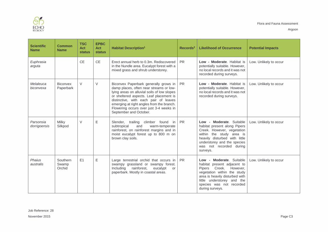
Flora and Fauna Assessment
Argoon
Job Reference: 28
November 2015 Page C3
Scientific Name
Common Name
TSC Act status
EPBC Act status
Habitat Description1 Records2 Likelihood of Occurrence Potential Impacts
Euphrasia arguta
CE CE Erect annual herb to 0.3m. Rediscovered in the Nundle area. Eucalypt forest with a mixed grass and shrub understorey.
PR Low - Moderate. Habitat is potentially suitable. However, no local records and it was not recorded during surveys.
Low. Unlikely to occur
Melaleuca biconvexa
Biconvex Paperbark
V V Biconvex Paperbark generally grows in damp places, often near streams or low-lying areas on alluvial soils of low slopes or sheltered aspects. Leaf placement is distinctive, with each pair of leaves emerging at right angles from the branch. Flowering occurs over just 3-4 weeks in September and October.
PR Low - Moderate. Habitat is potentially suitable. However, no local records and it was not recorded during surveys.
Low. Unlikely to occur
Parsonsia dorrigoensis
Milky Silkpod
V E Slender, trailing climber found in subtropical and warm-temperate rainforest, on rainforest margins and in moist eucalypt forest up to 800 m on brown clay soils.
PR Low - Moderate. Suitable habitat present along Pipers Creek. However, vegetation within the study area is heavily disturbed with little understorey and the species was not recorded during surveys.
Low. Unlikely to occur
Phaius australis
Southern Swamp Orchid
E1 E Large terrestrial orchid that occurs in swampy grassland or swampy forest. Including rainforest, eucalypt or paperbark. Mostly in coastal areas.
PR Low - Moderate. Suitable habitat present adjacent to Pipers Creek. However, vegetation within the study area is heavily disturbed with little understorey and the species was not recorded during surveys.
Low. Unlikely to occur

Flora and Fauna Assessment
Argoon
Job Reference: 28
November 2015 Page C4
Scientific Name
Common Name
TSC Act status
EPBC Act status
Habitat Description1 Records2 Likelihood of Occurrence Potential Impacts
Thesium australe
Austral Toadflax
V V A small straggling herb often hidden amongst grasses and herbs. Occurs in grassland on coastal headlands or grassland and grassy woodland away from the coast often in association with Themeda australis.
PR Moderate. Suitable habitat present as native grassland species persist and surveys could not cover all potential habitat. However, no local records exist.
Low. The proposal is for subdivision into rural lots only, grazing already occurs within the study area and no vegetation clearing outside of routine agricultural management actions permitted by the NV Act is required.
1 Unless otherwise cited, habitat description information was sourced from NSW OEH Threatened Species Profile Database (http://www.environment.nsw.gov.au/threatenedspecies) 2 Records obtained from OEH Atlas of NSW Wildlife and EPBC Protected Matters database searches

Flora and Fauna Assessment
Argoon
Job Reference: 28
November 2015 Page C5
Threatened Ecological Communities
Community Name TSC Act status
EPBC Act status
Habitat Description1 Records2 Likelihood of Occurrence Potential Impacts
Coastal Saltmarsh in the New South Wales North Coast, Sydney Basin and South East Corner Bioregions
E3 Occurs in the intertidal zone on the shores of estuaries and lagoons that are permanently or intermittently open to the sea. Characteristic plants include Baumea juncea, Juncus krausii, Sarcocornia quinqueflora, Sporobolous virginicus, Triglochin striata, Isolepsis nodosa, Samolus repens, Selliera radicans, Suaeda australis and Zoysia macrantha. Occasionally, mangroves are scattered throughout.
K Low. The study area does not contain intertidal zones.
Low. Unlikely to occur
Freshwater Wetlands on Coastal Floodplains of the New South Wales North Coast, Sydney Basin and South East Corner Bioregions
E3 Associated with coastal areas subject to periodic flooding and in which standing fresh water persists for at least part of the year in most years. Typically occurs on silts, muds or humic loams in low-lying parts of floodplains, alluvial flats, depressions, drainage lines, backswamps, lagoons and lakes but may also occur in backbarrier landforms where floodplains adjoin coastal sandplains. Generally occur below 20 m elevation on level areas. They are dominated by herbaceous plants and have very few woody species. The structure and composition of the community varies both spatially and temporally depending on the water regime.
K Low. Farm dams within the study area contain freshwater wetland vegetation communities. However, farm dams are specifically excluded from the EEC final determination.
Low. Unlikely to occur

Flora and Fauna Assessment
Argoon
Job Reference: 28
November 2015 Page C6
Community Name TSC Act status
EPBC Act status
Habitat Description1 Records2 Likelihood of Occurrence Potential Impacts
Littoral Rainforest in the New South Wales North Coast, Sydney Basin and South East Corner Bioregions
E3 CE Generally a closed forest, the structure and composition of which is strongly influenced by its proximity to the ocean (usually within 2 km). The plant species of this community are predominantly rainforest species. Scattered emergent individuals of sclerophyll species, such as Angophora costata, Banksia integrifolia, Eucalyptus botryoides and Eucalyptus tereticornis occur in many stands. Forms dense wind-pruned thickets when exposed to strong wind.
K Low. The vegetation types within the study area are not dense coastal rainforests consistent with this EEC description.
Low. Unlikely to occur
Lowland Rainforest in the NSW North Coast and Sydney Basin Bioregions
E3 CE Subtropical rainforest and some related, structurally complex forms of dry rainforest. Lowland Rainforest, in a relatively undisturbed state, has a closed canopy, characterised by a high diversity of trees whose leaves may be mesophyllous and encompass a wide variety of shapes and sizes. Typically, the trees form three major strata: emergents, canopy and sub-canopy which, combined with variations in crown shapes and sizes results in an irregular canopy appearance. The trees are taxonomically diverse at the genus and family levels, and some may have buttressed roots. A range of plant growth forms are present in Lowland Rainforest, including palms, vines and vascular epiphytes. In disturbed stands of this community the canopy cover may be broken, or the canopy may be smothered by exotic vines.
K Low. The vegetation types within the study area are not dense rainforests consistent with this EEC description.
Low. Unlikely to occur

Flora and Fauna Assessment
Argoon
Job Reference: 28
November 2015 Page C7
Community Name TSC Act status
EPBC Act status
Habitat Description1 Records2 Likelihood of Occurrence Potential Impacts
River-Flat Eucalypt Forest on Coastal Floodplains of the New South Wales North Coast, Sydney Basin and South East Corner Bioregions
E3 Found on coastal floodplains with a tall open tree layer including E. tereticornis, E. amplifolia, Angophora floribunda, A. subvelutina, E. baueriana, E. botryoides and E. elata. Associated with silts, clay-loams and sandy loams on periodically inundated alluvial flats, drainage lines and river terraces.
K Low. Occurs south of the Manning Valley.
Low. Unlikely to occur
Subtropical Coastal Floodplain Forest of the New South Wales North Coast Bioregion
E3 This subtropical forest occurs on the coastal floodplains of the north coast of NSW. It has a tall open tree layer of eucalypts, angophoras, melaleucas and bloodwoods, which may exceed 40 m in height, but can be considerably shorter in regrowth stands or under conditions of lower site quality. While the composition of the tree stratum varies considerably, the most widespread and abundant dominant trees include Eucalyptus tereticornis, E. siderophloia, Corymbia intermedia and, north of the Macleay floodplain, Lophostemon suaveolens.
K High. Remnants of this EEC are likely to occur adjacent to Pipers Creek in areas mapped as having alluvial soils.
Low. The proposal is for subdivision into rural lots only, grazing already occurs within the study area and no vegetation clearing outside of routine agricultural management actions permitted by the NV Act is required.
Swamp Oak Floodplain Forest of the New South Wales North Coast, Sydney Basin and South East Corner Bioregions
E3 Found on coastal floodplains of NSW and it has a dense to sparse tree layer in which Casuarina glauca is the dominant species. Associated with grey-black loams and sandy-loams where the groundwater is saline or sub-saline on waterlogged or periodically inundated flats, drainage lines, lake margins and estuarine fringes associated with coastal floodplains.
K Low. The vegetation types within the study area were not dominated by Casuarina glauca (Swamp Oak).
Low. Unlikely to occur

Flora and Fauna Assessment
Argoon
Job Reference: 28
November 2015 Page C8
Community Name TSC Act status
EPBC Act status
Habitat Description1 Records2 Likelihood of Occurrence Potential Impacts
Swamp Sclerophyll Forest on Coastal Floodplains of the New South Wales North Coast, Sydney Basin and South East Corner Bioregions
E3 This swamp community has an open to dense tree layer of eucalypts and paperbarks although some remnants now only have scattered trees as a result of partial clearing. The community also includes some areas of fernland and tall reedland or sedgeland, where trees are very sparse or absent. The most widespread and abundant dominant trees include Eucalyptus robusta, Melaleuca quinquenervia and, south from Sydney, Eucalyptus botryoides and Eucalyptus longifolia. Other trees may be scattered throughout at low abundance or may be locally common at few sites, including Callistemon salignus, Casuarina glauca and Eucalyptus resinifera subsp. hemilampra, Livistona australis and Lophostemon suaveolens.
K Low. The vegetation types within the study area were not dominated by paperbark
Low. Unlikely to occur
Themeda grassland on seacliffs and coastal headlands in the NSW North Coast, Sydney Basin and South East Corner Bioregions
E3 Themeda australis is the dominant species and in this community it may have a distinctive appearance, being prostrate and having glaucous leaves. Banksia integrifolia subsp. integrifolia, Westringia fruticosa and Acacia sophorae occurs as an emergent shrub or as a dense cover where they have recruited over grasslands. Smaller shrubs occur often as prostrate to dwarf forms, most frequently Pimelea linifolia, Hibbertia vestita, Pultenaea maritima and Westringia fruticosa.
K Low. The study area is not located on a sea cliff or headland near the coast.
Low. Unlikely to occur
1 Unless otherwise cited, habitat description information was sourced from NSW OEH Threatened Species Profile Database (http://www.environment.nsw.gov.au/threatenedspecies) 2 Records obtained from OEH Atlas of NSW Wildlife and EPBC Protected Matters database searches

Flora and Fauna Assessment
Argoon
Job Reference: 28
November 2015 Page C9
Threatened Fauna Species
Scientific Name Common Name
TSC Act status
EPBC Act status
Habitat Description1 Records2 Likelihood of Occurrence Potential Impacts
Amphibians
Mixophyes balbus
Stuttering Frog
E1 V Rainforest and wet, tall open forest in the eastern foothills and escarpment of the Great Dividing Range. Deep leaf litter and dense understorey vegetation on the forest floor outside of the breeding season and breeds in small flowing streams during summer.
PR Moderate. The adjacent Pipers Creek may offer marginal habitat for this species. While no local records occur it cannot be entirely discounted without further surveys.
Low. The proposal is for subdivision into rural lots only, grazing already occurs within the study area and no vegetation clearing outside of routine agricultural management actions permitted by the NV Act is required. The adjacent Pipers Creek is outside of the study area.
Mixophyes iteratus
Giant Barred Frog
E1 E Rainforests, moist eucalypt forest and nearby dry eucalypt forest generally at low elevation. May also occur in other riparian habitats such as drier forest, degraded remnants and occasionally around dams. Generally found within 20 m of the stream during the breeding season (late spring to summer) and may disperse away from the stream (50m or further) outside of the breeding season.
10 Moderate. The adjacent Pipers Creek may offer marginal habitat for this species. This species has been recorded from degraded agricultural land near Gloucester and as such it cannot be entirely discounted without further surveys.
Low. The proposal is for subdivision into rural lots only, grazing already occurs within the study area and no vegetation clearing outside of routine agricultural management actions permitted by the NV Act is required. The adjacent Pipers Creek is outside of the study area.

Flora and Fauna Assessment
Argoon
Job Reference: 28
November 2015 Page C10
Scientific Name Common Name
TSC Act status
EPBC Act status
Habitat Description1 Records2 Likelihood of Occurrence Potential Impacts
Litoria aurea Green and Golden Bell Frog
E1 V Inhabits marshes, dams and stream-sides, particularly those containing bullrushes (Typha spp.) or spikerushes (Eleocharis spp.). May inhabit highly disturbed areas.
PR Low - Moderate. This species was formerly widespread and common and may have once inhabited ponds within the study area. However, it has undergone a substantial range contraction and remains in industrial or coastal locations. Due to this range contraction and lack of local records we consider it is unlikely to occur within the study area.
Low. Unlikely to occur
Litoria brevipalmata
Green-thighed Frog
V Occur in a range of habitats from rainforest and moist eucalypt forest to dry eucalypt forest and heath. Typically in areas where surface water gathers after rain.
7 Moderate. Marginal potential habitat exists within low-lying areas of the study area if they contain small ephemeral pools after heavy rain.
Low. The proposal is for subdivision into rural lots only, grazing already occurs within the study area and no vegetation clearing outside of routine agricultural management actions permitted by the NV Act is required. The adjacent Pipers Creek is outside of the study area.

Flora and Fauna Assessment
Argoon
Job Reference: 28
November 2015 Page C11
Scientific Name Common Name
TSC Act status
EPBC Act status
Habitat Description1 Records2 Likelihood of Occurrence Potential Impacts
Birds
Ptilinopus magnificus
Wompoo Fruit-Dove
V In or near rainforest, low elevation moist eucalypt forest and brush box forests. Feeds on a range of tree and vine fruits and is locally nomadic.
1 Low - Moderate. While the adjacent Pipers Creek is likely to contain fruiting rainforest trees that the species may forage in, the study area contains very few fruiting trees. While the species may fly over the study area on occasion, it is likely to represent only poor quality habitat for the species.
Low. Unlikely to occur
Botaurus poiciloptilus
Australasian Bittern
E1 E Favours permanent freshwater wetlands with tall, dense vegetation, particularly cumbungi and spikerushes.
K Low. The farm dams present within the study area do not contain tall dense reedbeds required to support this species.
Low. Unlikely to occur
Lophoictinia isura Square-tailed Kite
V Timbered habitats including dry woodlands and open forests. Prefers timbered watercourses. Specialist hunter of passerines and insects.
1 High. Recorded hunting within the study area during surveys
Low. The proposal is for subdivision into rural lots only, grazing already occurs within the study area and no vegetation clearing outside of routine agricultural management actions permitted by the NV Act is required.
Rostratula australis
Australian Painted Snipe
E1 V Fringes of swamps, dams and nearby marshy areas where there is a cover of grass, lignum, low scrub or open timber.
PR Low. The farm dams present within the study area do not contain understorey cover to support this species.
Low. Unlikely to occur

Flora and Fauna Assessment
Argoon
Job Reference: 28
November 2015 Page C12
Scientific Name Common Name
TSC Act status
EPBC Act status
Habitat Description1 Records2 Likelihood of Occurrence Potential Impacts
Calyptorhynchus lathami
Glossy Black-Cockatoo
V Feeds almost exclusively on the seeds of Casuarina sp. and Allocasuarina sp.. Open forest and woodlands up to 1000 m with feed trees present. Nests in hollows in trunks, spouts and stumps of living or dead Eucalypts 5 - 28 m above the ground with a hollow entrance > 20 cm diameter and > 40 cm deep (Gibbons and Lindenmayer 2002).
28 Moderate. Potential foraging habitat present within the study area on the few Allocasuarina littoralis recorded. However, the study area is unlikely to offer nesting opportunities in the exposed small to medium-sized tree hollows observed.
Low. The proposal is for subdivision into rural lots only, grazing already occurs within the study area and no vegetation clearing outside of routine agricultural management actions permitted by the NV Act will be undertaken.
Glossopsitta pusilla
Little Lorikeet V Forages in flowering eucalypts and paperbarks. Riparian habitats are particularly used, due to higher productivity. Roosts in tree tops. Nests in tree hollows, most typically in the limb or trunk of smooth-barked eucalypts with small entrances (~3 cm), usually high above the ground (2 - 15 m). Nest sites are often used repeatedly for decades. Riparian trees are often chosen including Allocasuarina sp.
3 Moderate. Potential foraging (flowering eucalypts) and nesting habitat (small tree hollows) present within the study area.
Low. The proposal is for subdivision into rural lots only, grazing already occurs within the study area and no vegetation clearing outside of routine agricultural management actions permitted by the NV Act will be undertaken.

Flora and Fauna Assessment
Argoon
Job Reference: 28
November 2015 Page C13
Scientific Name Common Name
TSC Act status
EPBC Act status
Habitat Description1 Records2 Likelihood of Occurrence Potential Impacts
Lathamus discolor
Swift Parrot E1 E Migrates to south-eastern mainland Mar-Oct. Winter-flowering trees such as Eucalyptus robusta, Corymbia maculata, C. gummifera, E. sideroxylon and E. albens are important. Breeds in Tasmania
PR Moderate. Potential foraging habitat exists in winter-flowering eucalypts within the study area such as Eucalyptus tereticornis (Forest Red Gum).
Low. The proposal is for subdivision into rural lots only, grazing already occurs within the study area and no vegetation clearing outside of routine agricultural management actions permitted by the NV Act will be undertaken.
Ninox strenua Powerful Owl V A range of vegetation types, from open forest and woodland to wet forest and rainforest. Can occur in fragmented landscapes. It hunts medium-sized arboreal mammals such as greater glider, ringtail possum and sugar glider. Birds and flying-foxes may also be taken. Nests in large (> 30 cm diameter) vertical hollow (e.g. broken-off trunk) also horizontal or sloping spouts, often in living, but very old large Eucalypts (Gibbons and Lindenmayer 2002).
4 Moderate. Potential foraging habitat is present. No hollows of a sufficient size to provide nesting / breeding habitat were observed during the survey. However, the adjacent Pipers Creek may provide dense roosting habitat for the species and may contain large tree hollows for breeding.
Low. The proposal is for subdivision into large rural lots only, grazing already occurs within the study area and no vegetation clearing outside of routine agricultural management actions permitted by the NV Act will be undertaken. The adjacent Pipers Creek is outside of the study area. However, the proposal may have long-term indirect impacts associated with an increase in human activity. Particularly, hollow-bearing tree removal for safety and aesthetics.
Tyto longimembris
Eastern Grass Owl
V Tall grass in swampy areas, grassy plains, swamp heath and in cane grass or sedges on floodplains. Rest and nest on the ground in heavy vegetative growth, often accessed by tunnels through vegetation with a large landing pad.
1 Low. The study area does not contain swampy grassland or sedgeland with sufficient cover to support this species.
Low. Unlikely to occur

Flora and Fauna Assessment
Argoon
Job Reference: 28
November 2015 Page C14
Scientific Name Common Name
TSC Act status
EPBC Act status
Habitat Description1 Records2 Likelihood of Occurrence Potential Impacts
Tyto novaehollandiae
Masked Owl V Dry eucalypt forest and woodlands up to 1100m elevation. Often hunts along the edges of forests, including roadsides. Tree-dwelling and ground mammals, especially rats. Nests in large tree hollows (> 20 cm diameter), usually a trunk or vertical spout in large old living or dead trees (usually Eucalypts) (Gibbons and Lindenmayer 2002). Sometimes uses caves, ledges or sinkholes for nesting.
4 Moderate. Potential foraging habitat is present. No hollows of a sufficient size to provide nesting / breeding habitat were observed during the survey. Adjacent forested properties may provide roosting / nesting / breeding opportunities.
Low. The proposal is for subdivision into rural lots only, grazing already occurs within the study area and no vegetation clearing outside of routine agricultural management actions permitted by the NV Act will be undertaken. The adjacent Pipers Creek is outside of the study area. However, the proposal may have long-term indirect impacts associated with an increase in human activity. Particularly, hollow-bearing tree removal for safety and aesthetics.
Tyto tenebricosa Sooty Owl V Occurs in rainforest (dry, subtropical and warm temperate) as well as moist eucalypt forests. Roosts in the hollow of a tall forest tree or in heavy vegetation. Nests in very large tree-hollows (> 30 cm diameter) often in the trunk of living old Eucalypts (Gibbons and Lindenmayer 2002).
5 Moderate. Marginal foraging habitat is present adjacent to Pipers Creek. No hollows of a sufficient size to provide nesting / breeding habitat were observed during the survey. However, the adjacent Pipers Creek is likely to provide more suitable foraging habitat and may provide dense roosting habitat for the species and may contain large tree hollows for breeding.
Low. The proposal is for subdivision into rural lots only, grazing already occurs within the study area and no vegetation clearing outside of routine agricultural management actions permitted by the NV Act will be undertaken. The adjacent Pipers Creek is outside of the study area. However, the proposal may have long-term indirect impacts associated with an increase in human activity. Particularly, hollow-bearing tree removal for safety and aesthetics.

Flora and Fauna Assessment
Argoon
Job Reference: 28
November 2015 Page C15
Scientific Name Common Name
TSC Act status
EPBC Act status
Habitat Description1 Records2 Likelihood of Occurrence Potential Impacts
Atrichornis rufescens
Rufous Scrub-bird
V High altitude (> 600 m) rainforests (subtropical, warm temperate and cool temperate), moist and wet eucalypt forests. Occupy areas with a dense understorey and ground cover and a deep leaf litter cover.
K Low. The study area is not at high altitude.
Low. Unlikely to occur
Dasyornis brachypterus
Eastern Bristlebird
E E Dense, low vegetation including heath and open woodland with a heath or tussock grass understorey.
PR Low. The study area does not contain a heath understorey and there are no local records.
Low. Unlikely to occur
Climacteris picumnus victoriae
Brown Treecreeper (eastern subspecies)
V Eucalypt forests and woodlands of inland plains and slopes of the Great Dividing Range. Mainly inhabits woodlands dominated by rough-barked eucalypts, usually with a grassy or sparse shrub understorey. Fallen timber is an important habitat component for foraging. Nests in tree hollows.
1 Low - Moderate. The study area lacks the fallen timber habitat component preferred by this species.
Low. Unlikely to occur
Chthonicola sagittata
Speckled Warbler
V Inhabits a wide range of eucalypt-dominated communities with a grassy understorey. Often on rocky ridges or in gullies. Typical habitat includes scattered tussock grasses, a sparse shrub layer, eucalypt regrowth and an open canopy.
K Moderate. The study area contains suitable open eucalypts with a grassy understorey.
Low. The proposal is for subdivision into rural lots only, grazing already occurs within the study area and no vegetation clearing outside of routine agricultural management actions permitted by the NV Act will be undertaken.

Flora and Fauna Assessment
Argoon
Job Reference: 28
November 2015 Page C16
Scientific Name Common Name
TSC Act status
EPBC Act status
Habitat Description1 Records2 Likelihood of Occurrence Potential Impacts
Anthochaera phrygia
Regent Honeyeater
CE E Dry open forest and woodland. Particularly box-ironbark woodland and riparian forests of river she oak. Feeds on the nectar from a wide range of eucalypts and mistletoes. In coastal areas, winter flowering eucalypts are particularly important.
K Moderate. Potential foraging habitat exists in winter-flowering eucalypts within the study area such as Eucalyptus tereticornis (Forest Red Gum).
Low. The proposal is for subdivision into rural lots only, grazing already occurs within the study area and no vegetation clearing outside of routine agricultural management actions permitted by the NV Act will be undertaken.
Grantiella picta Painted Honeyeater
V V Inhabits boree, Brigalow and box-gum woodlands and box-ironbark forests. It specialises in foraging on the fruits of mistletoes, particularly Amyema sp..
1 Low - Moderate. Mistletoe was recorded at low density within the study area. However, the study area is not a box woodland and there are few local records.
Low. Unlikely to occur
Lichenostomus fasciogularis
Mangrove Honeyeater
V Coastal areas in mangrove woodlands and shrublands. But may also occur in adjacent forests, woodlands and shrublands.
K Low. The study area is not coastal and no mangroves are nearby.
Low. Unlikely to occur
Pomatostomus temporalis temporalis
Grey-crowned Babbler (eastern subspecies)
V Open box-gum woodlands on the slopes and box-cypress pine and open box woodlands on alluvial plains. Occurs in large family groups with many conspicuous nests.
K Low - Moderate. The study area contains marginal habitat for the species. However, this species was not recorded during surveys, despite being easily detected. Additionally, no characteristic nests were recorded during surveys.
Low. Unlikely to occur

Flora and Fauna Assessment
Argoon
Job Reference: 28
November 2015 Page C17
Scientific Name Common Name
TSC Act status
EPBC Act status
Habitat Description1 Records2 Likelihood of Occurrence Potential Impacts
Daphoenositta chrysoptera
Varied Sittella V Eucalypt forests and woodlands, particularly those with rough-barked species, mature smooth-barked gums with dead branches, mallee and Acacia woodland.
3 Moderate. The study area contains suitable open eucalypts with a grassy understorey.
Low. The proposal is for subdivision into rural lots only, grazing already occurs within the study area and no vegetation clearing outside of routine agricultural management actions permitted by the NV Act will be undertaken.
Coracina lineata Barred Cuckoo-shrike
V Rainforest, eucalypt forest and woodland, clearings in secondary growth, swamp woodlands and timber along watercourses.
4 Moderate. Potential foraging habitat occurs within the subject site.
Low. The proposal is for subdivision into rural lots only, grazing already occurs within the study area and no vegetation clearing outside of routine agricultural management actions permitted by the NV Act will be undertaken.
Pachycephala olivacea
Olive Whistler V Wet forests above 500 m elevation. During winter they may move to lower elevations.
K Low - Moderate. Marginal low elevation habitat only and few local records.
Low. The proposal is for subdivision into rural lots only, grazing already occurs within the study area and no vegetation clearing outside of routine agricultural management actions permitted by the NV Act will be undertaken.

Flora and Fauna Assessment
Argoon
Job Reference: 28
November 2015 Page C18
Scientific Name Common Name
TSC Act status
EPBC Act status
Habitat Description1 Records2 Likelihood of Occurrence Potential Impacts
Carterornis leucotis
White-eared Monarch
V Rainforest, especially drier types, such as littoral rainforest. But also wet and dry sclerophyll forest, swamp forest and regrowth. Appear to prefer Ecotone between rainforest and other open vegetation types, such as along road edges.
K Moderate. Marginal potential habitat occurs within the study area and its occurrence cannot be discounted.
Low. The proposal is for subdivision into rural lots only, grazing already occurs within the study area and no vegetation clearing outside of routine agricultural management actions permitted by the NV Act will be undertaken.
Melanodryas cucullata cucullata
Hooded Robin (south-eastern form)
V Lightly wooded country, usually open eucalypt woodland, acacia scrub and mallee, often in or near clearings or open areas. Requires structurally diverse habitats with mature, saplings, some small shrubs and moderately tall native grasses.
K Moderate. Marginal potential habitat occurs within the study area and its occurrence cannot be discounted.
Low. The proposal is for subdivision into rural lots only, grazing already occurs within the study area and no vegetation clearing outside of routine agricultural management actions permitted by the NV Act will be undertaken.
Petroica boodang Scarlet Robin V Dry eucalypt forests and woodland with open grassy understorey with few scattered shrubs. Occurs in both mature and regrowth forests and occasionally occurs in mallee, wet forests, wetlands and tea-tree swamps.
K Moderate. Marginal potential habitat occurs within the study area and its occurrence cannot be discounted.
Low. The proposal is for subdivision into rural lots only, grazing already occurs within the study area and no vegetation clearing outside of routine agricultural management actions permitted by the NV Act will be undertaken.

Flora and Fauna Assessment
Argoon
Job Reference: 28
November 2015 Page C19
Scientific Name Common Name
TSC Act status
EPBC Act status
Habitat Description1 Records2 Likelihood of Occurrence Potential Impacts
Petroica phoenicea
Flame Robin V Prefers clearings or areas with open understorey. Breeds in upland tall moist eucalypt forests and woodlands, often on ridges and slopes. In winter birds migrate to drier more open habitats in the lowlands (valleys and western slopes and plains).
K Moderate. Marginal potential habitat occurs within the study area and its occurrence cannot be discounted.
Low. The proposal is for subdivision into rural lots only, grazing already occurs within the study area and no vegetation clearing outside of routine agricultural management actions permitted by the NV Act will be undertaken.
Stagonopleura guttata
Diamond Firetail
V Grassy eucalypt woodlands including box-gum and E. pauciflora. Also occurs in open forest, mallee, native and derived grasslands. Often found in riparian areas and sometimes in lightly wooded farmland.
K Moderate. Potential habitat occurs within the study area and its occurrence cannot be discounted.
Low. The proposal is for subdivision into rural lots only, grazing already occurs within the study area and no vegetation clearing outside of routine agricultural management actions permitted by the NV Act will be undertaken.
Mammals
Dasyurus maculatus
Spotted-tailed Quoll
V E A variety of vegetation such as rainforest, open forest, woodland, coastal heath, inland riparian forest. Den sites may be located in hollow-bearing trees, fallen logs, small caves, rock crevices, boulder fields and rocky cliffs.
4 Moderate. Potential habitat exists within the study area as part of a larger home range that extends into the surrounding more forested lands.
Low. The proposal is for subdivision into rural lots only, grazing already occurs within the study area and no vegetation clearing outside of routine agricultural management actions permitted by the NV Act will be undertaken.
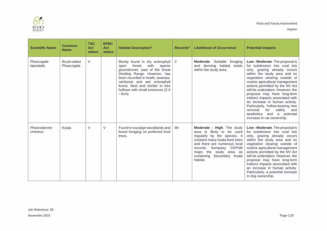
Flora and Fauna Assessment
Argoon
Job Reference: 28
November 2015 Page C20
Scientific Name Common Name
TSC Act status
EPBC Act status
Habitat Description1 Records2 Likelihood of Occurrence Potential Impacts
Phascogale tapoatafa
Brush-tailed Phascogale
V Mostly found in dry sclerophyll open forest with sparse groundcover, east of the Great Dividing Range. However, has been recorded in heath, swamps, rainforest and wet sclerophyll forest. Nest and shelter in tree hollows with small entrances (2.5 - 4cm)
2 Moderate. Suitable foraging and denning habitat exists within the study area.
Low - Moderate. The proposal is for subdivision into rural lots only, grazing already occurs within the study area and no vegetation clearing outside of routine agricultural management actions permitted by the NV Act will be undertaken. However, the proposal may have long-term indirect impacts associated with an increase in human activity. Particularly, hollow-bearing tree removal for safety and aesthetics and a potential increase in cat ownership.
Phascolarctos cinereus
Koala V V Found in eucalypt woodlands and forest foraging on preferred food trees.
90 Moderate - High. The study area is likely to be used regularly by the species. It contains many koala feed trees and there are numerous local records. Kempsey CKPoM maps the study area as containing Secondary Koala habitat
Low - Moderate. The proposal is for subdivision into rural lots only, grazing already occurs within the study area and no vegetation clearing outside of routine agricultural management actions permitted by the NV Act will be undertaken. However, the proposal may have long-term indirect impacts associated with an increase in human activity. Particularly, a potential increase in dog ownership.

Flora and Fauna Assessment
Argoon
Job Reference: 28
November 2015 Page C21
Scientific Name Common Name
TSC Act status
EPBC Act status
Habitat Description1 Records2 Likelihood of Occurrence Potential Impacts
Petaurus australis
Yellow-bellied Glider
V Tall mature eucalypt forest, generally in areas with high rainfall and nutrient rich soils. Feed primarily on nectar, sap, honeydew and manna with pollen and insects also taken. Often leave a distinctive V-shaped feeding scar on tree trunks. Den in tree hollows of large trees.
6 Moderate. Potential foraging habitat and denning habitat exists within the study area. However, no characteristic feeding incisions were recorded.
Low. The proposal is for subdivision into rural lots only, grazing already occurs within the study area and no vegetation clearing outside of routine agricultural management actions permitted by the NV Act will be undertaken. However, the proposal may have long-term indirect impacts associated with an increase in human activity. Particularly, hollow-bearing tree removal for safety and aesthetics.
Petaurus norfolcensis
Squirrel Glider
V Inhabits mature or old growth box, box-ironbark woodlands and river red gum forest west of the Great Dividing Range. Prefers mixed species stands with a shrub or Acacia midstorey. Uses tree hollows as dens sites.
PR Moderate. Suitable habitat present and potential denning habitat in tree hollows. However, few local records.
Low. The proposal is for subdivision into rural lots only, grazing already occurs within the study area and no vegetation clearing outside of routine agricultural management actions permitted by the NV Act will be undertaken. However, the proposal may have long-term indirect impacts associated with an increase in human activity. Particularly, hollow-bearing tree removal for safety and aesthetics.

Flora and Fauna Assessment
Argoon
Job Reference: 28
November 2015 Page C22
Scientific Name Common Name
TSC Act status
EPBC Act status
Habitat Description1 Records2 Likelihood of Occurrence Potential Impacts
Potorous tridactylus
Long-nosed Potoroo
V V Coastal heath and dry and wet sclerophyll forest. Dense understorey with occasional open areas is essential and may consist of grass-trees, sedges, ferns, heath or low shrubs. A sandy-loam soil is also a common feature. Small diggings similar to bandicoots.
PR Low. No dense understorey within the study area and no local records.
Low. Unlikely to occur
Pteropus poliocephalus
Grey-headed Flying-fox
V V Occurs in variety of habitats, generally within 200 km of the coast. Forage on nectar and pollen of flowering trees and shrubs and fruit of rainforest species. Also forage in gardens and fruit crops. Roosting camps are commonly found in gullies close to water in vegetation with a dense canopy.
16 Moderate - High. Highly mobile species that may forage within the subject site at some stage. Three camps within 5 km of the study area.
Low. The proposal is for subdivision into rural lots only, grazing already occurs within the study area and no vegetation clearing outside of routine agricultural management actions permitted by the NV Act will be undertaken.

Flora and Fauna Assessment
Argoon
Job Reference: 28
November 2015 Page C23
Scientific Name Common Name
TSC Act status
EPBC Act status
Habitat Description1 Records2 Likelihood of Occurrence Potential Impacts
Saccolaimus flaviventris
Yellow-bellied Sheathtail-bat
V Forages for insects high and fast above the forest canopy, but lower in more open areas. Roosts in tree hollows and have been known to use mammal burrows in treeless areas.
PR Moderate. Suitable foraging and roosting habitat (tree hollows) present within the study area.
Low - Moderate. The proposal is for subdivision into rural lots only, grazing already occurs within the study area and no vegetation clearing outside of routine agricultural management actions permitted by the NV Act will be undertaken. However, the proposal may have long-term indirect impacts associated with an increase in human activity. Particularly, hollow-bearing tree removal for safety and aesthetics and a potential increase in cat ownership.
Mormopterus norfolkensis
Eastern Freetail-bat
V Highly mobile species preferring productive floodplain habitats and avoiding urban areas.
PR Moderate. Suitable foraging and roosting habitat (tree hollows) present within the study area.
Low - Moderate. The proposal is for subdivision into rural lots only, grazing already occurs within the study area and no vegetation clearing outside of routine agricultural management actions permitted by the NV Act will be undertaken. However, the proposal may have long-term indirect impacts associated with an increase in human activity. Particularly, hollow-bearing tree removal for safety and aesthetics and a potential increase in cat ownership.

Flora and Fauna Assessment
Argoon
Job Reference: 28
November 2015 Page C24
Scientific Name Common Name
TSC Act status
EPBC Act status
Habitat Description1 Records2 Likelihood of Occurrence Potential Impacts
Chalinolobus dwyeri
Large-eared Pied Bat
V V Roosts in cave overhangs in the twilight zone, crevices in cliffs, old mine workings, fairy martin nests and rarely buildings. Recorded in well-timbered areas containing gullies.
PR Low - Moderate. Foraging habitat is present. However, there are local records and no nearby cave-overhang roosting habitat.
Low. Unlikely to occur
Falsistrellus tasmaniensis
Eastern False Pipistrelle
V Prefers moist habitats with trees taller than 20 m, usually at elevation. Roosts in tree hollows but has also been found under loose bark and in buildings.
PR Moderate. Marginal foraging and roosting habitat (tree hollows) present within the study area.
Low - Moderate. The proposal is for subdivision into rural lots only, grazing already occurs within the study area and no vegetation clearing outside of routine agricultural management actions permitted by the NV Act will be undertaken. However, the proposal may have long-term indirect impacts associated with an increase in human activity. Particularly, hollow-bearing tree removal for safety and aesthetics and a potential increase in cat ownership.

Flora and Fauna Assessment
Argoon
Job Reference: 28
November 2015 Page C25
Scientific Name Common Name
TSC Act status
EPBC Act status
Habitat Description1 Records2 Likelihood of Occurrence Potential Impacts
Kerivoula papuensis
Golden-tipped Bat
V Rainforest and adjacent wet and dry sclerophyll forest up to 1000 m elevation. Also recorded in tall open forest, Casuarina-dominated riparian forest and coastal paperbark forests. Roosts mainly in abandoned hanging yellow-throated scrubwren and brown gerygone nests. Also occasionally in tree hollows, dense foliage and epiphytes. Will fly up to 2 km from roosts to forage in rainforest and sclerophyll forest on mid- and upper-slopes.
PR Low - Moderate. While suitable dense habitat may exist along Pipers Creek, the study area has no shrub or small-tree layer that this species prefers.
Low. Unlikely to occur
Miniopterus australis
Little Bentwing-bat
V Moist eucalypt forest, rainforest, vine thicket, wet and dry sclerophyll forest, paperbark forest, dense coastal forests and banksia scrub. Generally found in well-timbered areas. Roosts in caves, tunnels, tree hollows, abandoned mines, stormwater drains, culverts, bridges and sometimes buildings during the day. Only five maternity colonies are known in Australia.
16 Moderate. Suitable foraging habitat present within the study area. However, no cave roosting habitat exists within the study area.
Low - Moderate. The proposal is for subdivision into rural lots only, grazing already occurs within the study area and no vegetation clearing outside of routine agricultural management actions permitted by the NV Act will be undertaken. However, the proposal may have long-term indirect impacts associated with an increase in human activity. Particularly, a potential increase in cat ownership.
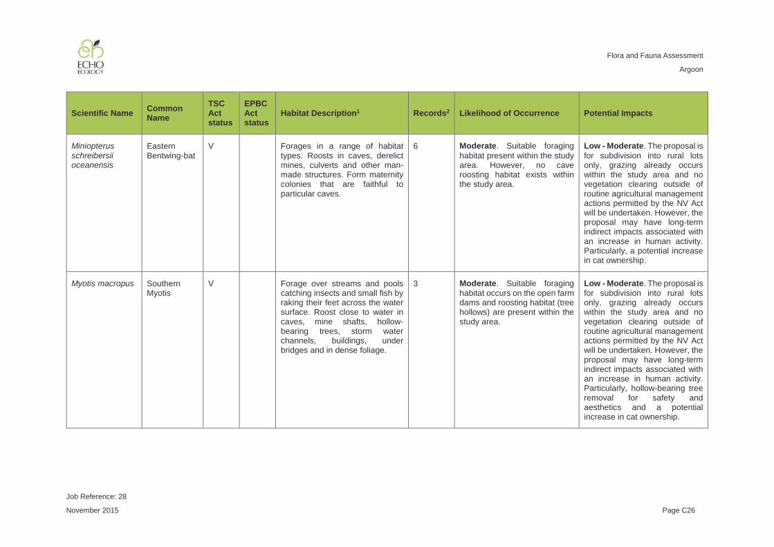
Flora and Fauna Assessment
Argoon
Job Reference: 28
November 2015 Page C26
Scientific Name Common Name
TSC Act status
EPBC Act status
Habitat Description1 Records2 Likelihood of Occurrence Potential Impacts
Miniopterus schreibersii oceanensis
Eastern Bentwing-bat
V Forages in a range of habitat types. Roosts in caves, derelict mines, culverts and other man-made structures. Form maternity colonies that are faithful to particular caves.
6 Moderate. Suitable foraging habitat present within the study area. However, no cave roosting habitat exists within the study area.
Low - Moderate. The proposal is for subdivision into rural lots only, grazing already occurs within the study area and no vegetation clearing outside of routine agricultural management actions permitted by the NV Act will be undertaken. However, the proposal may have long-term indirect impacts associated with an increase in human activity. Particularly, a potential increase in cat ownership.
Myotis macropus Southern Myotis
V Forage over streams and pools catching insects and small fish by raking their feet across the water surface. Roost close to water in caves, mine shafts, hollow-bearing trees, storm water channels, buildings, under bridges and in dense foliage.
3 Moderate. Suitable foraging habitat occurs on the open farm dams and roosting habitat (tree hollows) are present within the study area.
Low - Moderate. The proposal is for subdivision into rural lots only, grazing already occurs within the study area and no vegetation clearing outside of routine agricultural management actions permitted by the NV Act will be undertaken. However, the proposal may have long-term indirect impacts associated with an increase in human activity. Particularly, hollow-bearing tree removal for safety and aesthetics and a potential increase in cat ownership.

Flora and Fauna Assessment
Argoon
Job Reference: 28
November 2015 Page C27
Scientific Name Common Name
TSC Act status
EPBC Act status
Habitat Description1 Records2 Likelihood of Occurrence Potential Impacts
Scoteanax rueppellii
Greater Broad-nosed Bat
V Variety of habitats from woodland to moist and dry eucalypt forest and rainforest. Roosts in tree hollows, but has been found in buildings.
PR Moderate. Suitable foraging and roosting habitat (tree hollows) present within the study area.
Low - Moderate. The proposal is for subdivision into rural lots only, grazing already occurs within the study area and no vegetation clearing outside of routine agricultural management actions permitted by the NV Act will be undertaken. However, the proposal may have long-term indirect impacts associated with an increase in human activity. Particularly, hollow-bearing tree removal for safety and aesthetics and a potential increase in cat ownership.
Vespadelus troughtoni
Eastern Cave Bat
V Very little is known of this species. Cave-roosting found also in disused mine workings and abandoned buildings. Usually found foraging near cliffs or rocky overhangs.
PR Low - Moderate. Foraging habitat is present. However, there are local records and no nearby cave-overhang roosting habitat.
Low. Unlikely to occur

Flora and Fauna Assessment
Argoon
Job Reference: 28
November 2015 Page C28
Scientific Name Common Name
TSC Act status
EPBC Act status
Habitat Description1 Records2 Likelihood of Occurrence Potential Impacts
Pseudomys novaehollandiae
New Holland Mouse
V Known to inhabit open heathlands, woodlands and forests with a heathland understorey and vegetated sand dunes. It is a social animal, living predominantly in burrows shared with other individuals. Distribution is patchy in time and space, with peaks in abundance during early to mid-stages of vegetation succession typically induced by fire.
K Low. No shelter habitat (shrubby heath understorey) exists for this species within the study area.
Low. Unlikely to occur
1 Unless otherwise cited, habitat description information was sourced from NSW OEH Threatened Species Profile Database (http://www.environment.nsw.gov.au/threatenedspecies) 2 Records obtained from OEH Atlas of NSW Wildlife and EPBC Protected Matters database searches

Flora and Fauna Assessment
Argoon
Job Reference: 28
November 2015 Page D1
APPENDIX D KEY THREATENING PROCESSES
Table C1: Each key threatening process (KTP) listed under NSW Threatened Species Conservation Act 1995 (TSC Act) is assessed as to the likelihood that it operates within the study area. The potential contribution of the proposal to the operation of the KTP within the study area is also assessed.
Key Threatening Process Likelihood of Operation within Study Area
Potential Contribution of Proposal
Aggressive exclusion of birds from woodland and forest habitat by abundant Noisy Miners Manorina melanocephala
Moderate. Noisy Miners were common within the study area.
Low. The proposal is for subdivision only, with no alternation to land-use, only a slight increase in human activity.
Alteration of habitat following subsidence due to longwall mining
Low. No longwall mining has occurred within the study area.
Low. No longwall mining is proposed.
Alteration to the natural flow regimes of rivers and streams and their floodplains and wetlands
Moderate. A number of farm dams occur within the study area that are likely to alter the natural flow regimes. Additionally historical land-clearing is likely to have altered the hydrology.
Low. The proposal is for subdivision only, with no alternation to land-use, only a slight increase in human activity.
Anthropogenic Climate Change Low - Moderate. Historical land-clearing and residential development within the study area is likely to have contributed slightly to anthropogenic climate change.
Low. The proposal is for subdivision only, with no alternation to land-use or vegetation clearing, only a slight increase in human activity and therefore emissions.
Bush rock removal Low. The study area contains very little bush rock.
Low. The study area contains very little bush rock.
Clearing of native vegetation Moderate. Clearing has been historically undertaken within the study area for grazing.
Low. The proposal is for subdivision only, with no alternation to land-use or vegetation clearing, only a slight increase in human activity.
Competition and grazing by the feral European Rabbit, Oryctolagus cuniculus (L.)
Low - Moderate. Historical land-clearing for cattle grazing has created suitable conditions for this species to thrive. While European Hares were recorded within the study area during surveys, rabbits were not.
Low. The proposal is for subdivision only, with no alternation to land-use or vegetation clearing, only a slight increase in human activity.

Flora and Fauna Assessment
Argoon
Job Reference: 28
November 2015 Page D2
Key Threatening Process Likelihood of Operation within Study Area
Potential Contribution of Proposal
Competition and habitat degradation by Feral Goats, Capra hircus Linnaeus 1758
Low. No evidence of goats was recorded within the study area during surveys.
Low. The proposal is for subdivision only, with no alternation to land-use or vegetation clearing, only a slight increase in human activity.
Competition from feral honey bees, Apis mellifera L.
Moderate. The historical removal of hollow-bearing trees during vegetation clearing is likely to have increased the operation of this KTP.
Low. The proposal is for subdivision only, with no alternation to land-use or vegetation clearing, only a slight increase in human activity.
Forest eucalypt dieback associated with over-abundant psyllids and Bell Miners
Low. No Bell miners were recorded within the study area.
Low. The proposal is for subdivision only, with no alternation to land-use or vegetation clearing, only a slight increase in human activity.
Herbivory and environmental degradation caused by feral deer
Low. No evidence of deer was recorded within the study area during surveys.
Low. The proposal is for subdivision only, with no alternation to land-use or vegetation clearing, only a slight increase in human activity.
High frequency fire resulting in the disruption of life cycle processes in plants and animals and loss of vegetation structure and composition
Low - Moderate. The study area did not appear to be subject to high fire frequency due to the reduction of fuel via grazing.
Low. The proposal is for subdivision only, with no alternation to land-use or vegetation clearing, only a slight increase in human activity.
Importation of Red Imported Fire Ants Solenopsis invicta Buren 1972
Low. No importation of fire ants has occurred.
Low. The proposal is for subdivision only, with no alternation to land-use or vegetation clearing, only a slight increase in human activity.
Infection by Psittacine Circoviral (beak and feather) Disease affecting endangered psittacine species and populations
Low. Only domestic chicken and bird aviaries are likely to be present within the study area.
Low. The proposal is for subdivision only, with no alternation to land-use or vegetation clearing, only a slight increase in human activity.
Infection of frogs by amphibian chytrid causing the disease chytridiomycosis
Low - Moderate. Chytrid may already be present within the site. Transportation of Chytrid may already be occurring through use of farm machinery in damp areas.
Low. The proposal is for subdivision only, with no alternation to land-use or vegetation clearing, only a slight increase in human activity.

Flora and Fauna Assessment
Argoon
Job Reference: 28
November 2015 Page D3
Key Threatening Process Likelihood of Operation within Study Area
Potential Contribution of Proposal
Infection of native plants by Phytophthora cinnamomi
Low. There is no evidence of dieback within the study area.
Low. The proposal is for subdivision only, with no alternation to land-use or vegetation clearing, only a slight increase in human activity.
Introduction of the Large Earth Bumblebee Bombus terrestris (L.)
Low. No importation of bumblebees has occurred.
Low. The proposal does not involve bumblebee importation.
Invasion and establishment of exotic vines and scramblers
Low - Moderate. Few invasive exotic vines and scramblers were recorded within the study area during surveys.
Low. The proposal is for subdivision only, with no alternation to land-use or vegetation clearing, only a slight increase in human activity.
Invasion and establishment of Scotch Broom (Cytisus scoparius)
Low. Scotch Broom was not recorded within the study area during surveys.
Low. The proposal is for subdivision only, with no alternation to land-use or vegetation clearing, only a slight increase in human activity.
Invasion and establishment of the Cane Toad (Bufo marinus)
Low. It is unlikely that Bufo marinus (Cane Toad) is present within the study area.
Low. The proposal is for subdivision only, with no alternation to land-use or vegetation clearing, only a slight increase in human activity.
Invasion of native plant communities by African Olive Olea europaea L. subsp. cuspidata (Wall ex G. Don Cirferri)
Low. The species was not recorded within the study area during surveys.
Low. The proposal is for subdivision only, with no alternation to land-use or vegetation clearing, only a slight increase in human activity.
Invasion of native plant communities by Chrysanthemoides monilifera
Low. The species was not recorded within the study area during surveys.
Low. The proposal is for subdivision only, with no alternation to land-use or vegetation clearing, only a slight increase in human activity.
Invasion of native plant communities by exotic perennial grasses
Moderate. Exotic perennial grasses are present within the study area. However, the study area is regularly grazed which is likely to control these somewhat.
Low. The proposal is for subdivision only, with no alternation to land-use or vegetation clearing, only a slight increase in human activity.
Invasion of the Yellow Crazy Ant, Anoplolepis gracilipes (Fr. Smith) into NSW
Low. No importation of fire ants has occurred.
Low. The proposal does not involve the importation of fire ants.

Flora and Fauna Assessment
Argoon
Job Reference: 28
November 2015 Page D4
Key Threatening Process Likelihood of Operation within Study Area
Potential Contribution of Proposal
Invasion, establishment and spread of Lantana (Lantana camara L. sens. Lat)
Low - Moderate. Lantana was recorded within the study area at low density.
Low. The proposal is for subdivision only, with no alternation to land-use or vegetation clearing, only a slight increase in human activity.
Loss and degradation of native plant and animal habitat by invasion of escaped garden plants, including aquatic plants
Low - Moderate. Little evidence of escaped garden plants was observed within the study area.
Low. The proposal is for subdivision only, with no alternation to land-use or vegetation clearing, only a slight increase in human activity.
Loss of Hollow-bearing Trees Moderate. Historical land-clearing for grazing has resulted in the removal of many hollow-bearing trees. Loss continues as trees may be removed due to safety or aesthetics.
Low. The proposal is for subdivision only, with no alternation to land-use or vegetation clearing, only a slight increase in human activity.
Loss or degradation (or both) of sites used for hill-topping by butterflies
Low. The study area or region are not known to be important for threatened hill-topping butterflies.
Low. The proposal is for subdivision only, with no alternation to land-use or vegetation clearing, only a slight increase in human activity.
Predation and hybridisation by Feral Dogs, Canis lupus familiaris
Moderate. The study area may act as a source of feral dogs to surrounding areas.
Low. The proposal is for subdivision only, with no alternation to land-use or vegetation clearing, only a slight increase in human activity.
Predation by Gambusia holbrooki Girard, 1859 (Plague Minnow or Mosquito Fish)
Moderate. Gambusia were observed from farm dams within the study area.
Low. The proposal is for subdivision only, with no alternation to land-use or vegetation clearing, only a slight increase in human activity.
Predation by the European Red Fox Vulpes vulpes (Linnaeus, 1758)
Moderate. Foxes are likely to occur within the study area and are likely to benefit from the open pasture used by rabbits.
Low. The proposal is for subdivision only, with no alternation to land-use or vegetation clearing, only a slight increase in human activity.
Predation by the Feral Cat Felis catus (Linnaeus, 1758)
Moderate. Stray domestic cats from existing properties may already contribute to a feral cat population in the local area.
Low. The proposal is for subdivision only, with no alternation to land-use or vegetation clearing, only a slight increase in human activity.

Flora and Fauna Assessment
Argoon
Job Reference: 28
November 2015 Page D5
Key Threatening Process Likelihood of Operation within Study Area
Potential Contribution of Proposal
Predation, habitat degradation, competition and disease transmission by Feral Pigs, Sus scrofa Linnaeus 1758
Low. No evidence of pigs was recorded within the study area during surveys.
Low. The proposal is for subdivision only, with no alternation to land-use or vegetation clearing, only a slight increase in human activity.
Removal of dead wood and dead trees
Moderate. Very little fallen timber remained within the study area.
Low. The proposal is for subdivision only, with no alternation to land-use or vegetation clearing, only a slight increase in human activity.

Flora and Fauna Assessment
Argoon
Job Reference: 28
November 2015 Page F1
APPENDIX E INVASIVE SPECIES
Table E1: An assessment of the potential for the proposal to assist each invasive species listed under the Environment Protection and Biodiversity Conservation Act 1999, identified through the EPBC Act Protected Matters Search.
Scientific Name Common Name
Assessment
Hemidactylus frenatus Asian House Gecko
Low. The proposal is for subdivision only, with no alternation to land-use or vegetation clearing, only a slight increase in human activity. Therefore, the proposal is unlikely to further assist this invasive species.
Acridotheres tristis Indian Myna Low. The proposal is for subdivision only, with no alternation to land-use or vegetation clearing, only a slight increase in human activity. Therefore, the proposal is unlikely to further assist this invasive species.
Anas platyrhynchos Mallard Low. The proposal is for subdivision only, with no alternation to land-use or vegetation clearing, only a slight increase in human activity. Therefore, the proposal is unlikely to further assist this invasive species.
Carduelis carduelis European Goldfinch
Low. The proposal is for subdivision only, with no alternation to land-use or vegetation clearing, only a slight increase in human activity. Therefore, the proposal is unlikely to further assist this invasive species.
Columba livia Rock Pigeon Low. The proposal is for subdivision only, with no alternation to land-use or vegetation clearing, only a slight increase in human activity. Therefore, the proposal is unlikely to further assist this invasive species.
Lonchura punctulata Nutmeg Mannikin
Low. The proposal is for subdivision only, with no alternation to land-use or vegetation clearing, only a slight increase in human activity. Therefore, the proposal is unlikely to further assist this invasive species.
Passer domesticus House Sparrow
Low. The proposal is for subdivision only, with no alternation to land-use or vegetation clearing, only a slight increase in human activity. Therefore, the proposal is unlikely to further assist this invasive species.
Pycnonotus jocosus Red-whiskered Bulbul
Low. The proposal is for subdivision only, with no alternation to land-use or vegetation clearing, only a slight increase in human activity. Therefore, the proposal is unlikely to further assist this invasive species.
Streptopelia chinensis Spotted Turtle-Dove
Low. The proposal is for subdivision only, with no alternation to land-use or vegetation clearing, only a slight increase in human activity. Therefore, the proposal is unlikely to further assist this invasive species.

Flora and Fauna Assessment
Argoon
Job Reference: 28
November 2015 Page F2
Scientific Name Common Name
Assessment
Sturnus vulgaris Common Starling
Low. The proposal is for subdivision only, with no alternation to land-use or vegetation clearing, only a slight increase in human activity. Therefore, the proposal is unlikely to further assist this invasive species.
Turdus merula Common Blackbird
Low. The proposal is for subdivision only, with no alternation to land-use or vegetation clearing, only a slight increase in human activity. Therefore, the proposal is unlikely to further assist this invasive species.
Rhinella marina Cane Toad Low. The proposal is for subdivision only, with no alternation to land-use or vegetation clearing, only a slight increase in human activity. Therefore, the proposal is unlikely to further assist this invasive species.
Bos taurus Domestic Cattle
Low. The proposal is for subdivision only, with no alternation to land-use or vegetation clearing, only a slight increase in human activity. Therefore, the proposal is unlikely to further assist this invasive species.
Canis lupus familiaris Domestic Dog Low. The proposal is for subdivision only, with no alternation to land-use or vegetation clearing, only a slight increase in human activity. Therefore, the proposal is unlikely to further assist this invasive species.
Capra hircus Goat Low. The proposal is for subdivision only, with no alternation to land-use or vegetation clearing, only a slight increase in human activity. Therefore, the proposal is unlikely to further assist this invasive species.
Felis catus Cat Low. The proposal is for subdivision only, with no alternation to land-use or vegetation clearing, only a slight increase in human activity. Therefore, the proposal is unlikely to further assist this invasive species.
Feral deer Low. The proposal is for subdivision only, with no alternation to land-use or vegetation clearing, only a slight increase in human activity. Therefore, the proposal is unlikely to further assist this invasive species.
Lepus capensis Brown Hare Low. The proposal is for subdivision only, with no alternation to land-use or vegetation clearing, only a slight increase in human activity. Therefore, the proposal is unlikely to further assist this invasive species.
Mus musculus House Mouse Low. The proposal is for subdivision only, with no alternation to land-use or vegetation clearing, only a slight increase in human activity. Therefore, the proposal is unlikely to further assist this invasive species.
Oryctolagus cuniculus European Rabbit
Low. The proposal is for subdivision only, with no alternation to land-use or vegetation clearing, only a slight increase in human activity. Therefore, the proposal is unlikely to further assist this invasive species.

Flora and Fauna Assessment
Argoon
Job Reference: 28
November 2015 Page F3
Scientific Name Common Name
Assessment
Rattus norvegicus Brown Rat Low. The proposal is for subdivision only, with no alternation to land-use or vegetation clearing, only a slight increase in human activity. Therefore, the proposal is unlikely to further assist this invasive species.
Rattus rattus Black Rat Low. The proposal is for subdivision only, with no alternation to land-use or vegetation clearing, only a slight increase in human activity. Therefore, the proposal is unlikely to further assist this invasive species.
Sus scrofa Pig Low. The proposal is for subdivision only, with no alternation to land-use or vegetation clearing, only a slight increase in human activity. Therefore, the proposal is unlikely to further assist this invasive species.
Vulpes vulpes Red Fox Low. The proposal is for subdivision only, with no alternation to land-use or vegetation clearing, only a slight increase in human activity. Therefore, the proposal is unlikely to further assist this invasive species.
Alternanthera philoxeroides
Alligator Weed Low. The proposal is for subdivision only, with no alternation to land-use or vegetation clearing, only a slight increase in human activity. Therefore, the proposal is unlikely to further assist this invasive species.
Anredera cordifolia Madeira Vine Low. The proposal is for subdivision only, with no alternation to land-use or vegetation clearing, only a slight increase in human activity. Therefore, the proposal is unlikely to further assist this invasive species.
Asparagus aethiopicus Asparagus Fern
Low. The proposal is for subdivision only, with no alternation to land-use or vegetation clearing, only a slight increase in human activity.
Asparagus plumosus Climbing Asparagus-fern
Low. The proposal is for subdivision only, with no alternation to land-use or vegetation clearing, only a slight increase in human activity. Therefore, the proposal is unlikely to further assist this invasive species.
Cabomba caroliniana Cabomba Low. The proposal is for subdivision only, with no alternation to land-use or vegetation clearing, only a slight increase in human activity. Therefore, the proposal is unlikely to further assist this invasive species.
Chrysanthemoides monilifera
Bitou Bush, Boneseed
Low. The proposal is for subdivision only, with no alternation to land-use or vegetation clearing, only a slight increase in human activity. Therefore, the proposal is unlikely to further assist this invasive species.
Cytisus scoparius Scotch Broom Low. The proposal is for subdivision only, with no alternation to land-use or vegetation clearing, only a slight increase in human activity. Therefore, the proposal is unlikely to further assist this invasive species.

Flora and Fauna Assessment
Argoon
Job Reference: 28
November 2015 Page F4
Scientific Name Common Name
Assessment
Eichhornia crassipes Water Hyacinth
Low. The proposal is for subdivision only, with no alternation to land-use or vegetation clearing, only a slight increase in human activity. Therefore, the proposal is unlikely to further assist this invasive species.
Genista sp. X Genista monspessulana
Broom Low. The proposal is for subdivision only, with no alternation to land-use or vegetation clearing, only a slight increase in human activity. Therefore, the proposal is unlikely to further assist this invasive species.
Lantana camara Lantana Low. The proposal is for subdivision only, with no alternation to land-use or vegetation clearing, only a slight increase in human activity. Therefore, the proposal is unlikely to further assist this invasive species.
Lycium ferocissimum African Boxthorn
Low. The proposal is for subdivision only, with no alternation to land-use or vegetation clearing, only a slight increase in human activity. Therefore, the proposal is unlikely to further assist this invasive species.
Nassella neesiana Chilean Needle Grass
Low. The proposal is for subdivision only, with no alternation to land-use or vegetation clearing, only a slight increase in human activity. Therefore, the proposal is unlikely to further assist this invasive species.
Nassella trichotoma Serrated Tussock
Low. The proposal is for subdivision only, with no alternation to land-use or vegetation clearing, only a slight increase in human activity. Therefore, the proposal is unlikely to further assist this invasive species.
Opuntia spp. Prickly Pears Low. The proposal is for subdivision only, with no alternation to land-use or vegetation clearing, only a slight increase in human activity. Therefore, the proposal is unlikely to further assist this invasive species.
Pinus radiata Radiata Pine Low. The proposal is for subdivision only, with no alternation to land-use or vegetation clearing, only a slight increase in human activity. Therefore, the proposal is unlikely to further assist this invasive species.
Protasparagus plumosus
Climbing Asparagus-fern
Low. The proposal is for subdivision only, with no alternation to land-use or vegetation clearing, only a slight increase in human activity. Therefore, the proposal is unlikely to further assist this invasive species.
Rubus fruticosus aggregate
Blackberry Low. The proposal is for subdivision only, with no alternation to land-use or vegetation clearing, only a slight increase in human activity. Therefore, the proposal is unlikely to further assist this invasive species.
Sagittaria platyphylla Arrowhead Low. The proposal is for subdivision only, with no alternation to land-use or vegetation clearing, only a slight increase in human activity. Therefore, the proposal is unlikely to further assist this invasive species.

Flora and Fauna Assessment
Argoon
Job Reference: 28
November 2015 Page F5
Scientific Name Common Name
Assessment
Salix spp Willows Low. The proposal is for subdivision only, with no alternation to land-use or vegetation clearing, only a slight increase in human activity. Therefore, the proposal is unlikely to further assist this invasive species.
Salvinia molesta Salvinia Low. The proposal is for subdivision only, with no alternation to land-use or vegetation clearing, only a slight increase in human activity. Therefore, the proposal is unlikely to further assist this invasive species.
Senecio madagascariensis
Fireweed Low. The proposal is for subdivision only, with no alternation to land-use or vegetation clearing, only a slight increase in human activity. Therefore, the proposal is unlikely to further assist this invasive species.
Ulex europaeus Gorse Low. The proposal is for subdivision only, with no alternation to land-use or vegetation clearing, only a slight increase in human activity. Therefore, the proposal is unlikely to further assist this invasive species.

Flora and Fauna Assessment
Argoon
Job Reference: 28
November 2015 Page F6
APPENDIX F ASSESSMENT OF SIGNIFICANCE (SEVEN-PART TESTS)
An assessment of significance (seven-part test) under Section 5A of the Environmental Planning and Assessment Act 1979 has been prepared for each threatened species, population or ecological communities considered to have a moderate or greater chance of occurrence within the study area (see Appendix C) to determine the likely significance of the potential impacts of the proposal on each entity. We have prepared the assessment of significance with reference to the Environmental Impact Assessment Guidelines (DECC 2007), OEH Threatened Species Profiles and records from the NSW Atlas of Wildlife. We have considered relevant species, population and ecological community assessment guidelines when applying the following factors of assessment (seven-part test). The following species, populations and communities have been considered:
1. Subtropical coastal floodplain forest of the NSW North Coast bioregion (SCFF) EEC; 2. Threatened flora
a. Arthraxon hispidus (Hairy Jointgrass); b. Thesium australe (Austral Toadflax);
3. Ground-dwelling Frogs a. Mixophyes balbus (Stuttering Frog); b. Mixophyes iteratus (Giant Barred Frog);
4. Litoria brevipalmata (Green-thighed Frog); 5. Lophoictinia isura (Square-tailed Kite); 6. Calyptorhynchus lathami (Glossy Black-Cockatoo); 7. Diurnal Woodland and Forest Birds
a. Chthonicola sagittata (Speckled Warbler); b. Daphoenositta chrysoptera (Varied Sittella); c. Melanodryas cucullata cucullata (Hooded Robin); d. Petroica boodang (Scarlet Robin); e. Petroica phoenicea (Flame Robin); f. Stagonopleura guttata (Diamond Firetail); g. Coracina lineata (Barred Cuckoo-Shrike); h. Carterornis leucotis (White-eared Monarch);
8. Mobile nectarivorous fauna a. Lathamus discolor (Swift Parrot); b. Anthochaera phrygia (Regent Honeyeater); c. Glossopsitta pusilla (Little Lorikeet); d. Pteropus poliocephalus (Grey-headed Flying-fox).
9. Forest Owls a. Ninox strenua (Powerful Owl); b. Tyto novaehollandiae (Masked Owl);

Flora and Fauna Assessment
Argoon
Job Reference: 28
November 2015 Page F7
c. Tyto tenebricosa (Sooty Owl); 10. Dasyurus maculatus (Spotted-tailed Quoll); 11. Hollow-dependant Arboreal Mammals
a. Phascogale tapoatafa (Brush-tailed Phascogale); b. Petaurus australis (Yellow-bellied Glider); c. Petaurus norfolcensis (Squirrel Glider);
12. Phascolarctos cinereus (Koala); 13. Hollow-roosting bats
a. Saccolaimus flaviventris (Yellow-bellied Sheathtail-bat) b. Mormopterus norfolkensis (East Coast Freetail-bat); c. Myotis macropus (Southern Myotis); d. Falsistrellus tasmaniensis (Eastern False Pipstrelle); e. Scoteanax rueppellii (Greater Broad-nosed Bat);
14. Cave-roosting bats a. Miniopterus australis (Little Bentwing-bat); b. Miniopterus schreibersii oceanensis (Eastern Bentwing-bat);
Summary of habitat extent within the study area for each threatened entity Arthraxon hispidus (Hairy Jointgrass) Potential habitat for Arthraxon hispidus (Hairy Jointgrass) occurs within the study area adjacent to Pipers Creek. However, few local records occur and the species was not recorded during the survey. Thesium australe (Austral Toadflax) Potential habitat for Thesium australe (Austral Toadflax) occurs throughout most of the study area in grassland. However, few local records occur and the species was not recorded during the survey. Mixophyes balbus (Stuttering Frog) and Mixophyes iteratus (Giant Barred Frog) Potential foraging habitat for Mixophyes balbus (Stuttering Frog) and Mixophyes iteratus (Giant Barred Frog) occurs within the study area adjacent to Pipers Creek. These species are more commonly associated with high quality watercourses. However, Mixophyes iteratus (Giant Barred Frog) has been recently recorded from disturbed agricultural watercourses near Gloucester, so its occurrence in and adjacent to disturbed watercourses cannot be discounted. The study area does not contain potential breeding habitat for these species, but the adjacent Pipers Creek may offer potential breeding habitat. Litoria brevipalmata (Green-thighed Frog) Marginal potential foraging and breeding habitat for Litoria brevipalmata (Green-thighed Frog) occurs within the study area in low-lying areas that collect water after rain. However, these potential habitats are unlikely to be of high quality due to the ongoing disturbance due to grazing within the study area.

Flora and Fauna Assessment
Argoon
Job Reference: 28
November 2015 Page F8
Lophoictinia isura (Square-tailed Kite) Lophoictinia isura (Square-tailed Kite) was recorded hunting over the study area during surveys. Potential foraging habitat occurs where canopy tree species remain. No raptor nests were observed within the study area. But opportunities exist for nests in the scattered canopy trees. Calyptorhynchus lathami (Glossy Black-Cockatoo) Marginal potential foraging habitat for Calyptorhynchus lathami (Glossy Black-Cockatoo) occurs within the few Allocasuarina littoralis (Black She oak) recorded within the study area as part of a larger home-range. The study area is unlikely to offer nesting opportunities in the exposed small to medium-sized tree hollows observed. Diurnal Woodland and Forest Birds Potential habitat for woodland birds: Chthonicola sagittata (Speckled Warbler), Daphoenositta chrysoptera (Varied Sittella), Melanodryas cucullata cucullata (Hooded Robin) and Stagonopleura guttata (Diamond Firetail) occurs within areas of remnant canopy trees and for forest birds: Petroica boodang (Scarlet Robin), Petroica phoenicea (Flame Robin), Coracina lineata (Barred Cuckoo-Shrike) and Carterornis leucotis (White-eared Monarch) in vegetated areas along property boundaries adjacent to more intact vegetation as part of larger home ranges. Mobile nectarivorous fauna Potential habitat for mobile nectarivorous fauna species: Lathamus discolor (Swift Parrot), Anthochaera phrygia (Regent Honeyeater), Glossopsitta pusilla (Little Lorikeet) and Pteropus poliocephalus (Grey-headed Flying-fox) occurs within the remnant canopy trees within the study area as part of larger home ranges. In particular, the winter-flowering species such as Eucalyptus tereticornis (Forest Red Gum) are likely to offer important foraging resources for these species. Lathamus discolor (Swift Parrot) breeds in Tasmania, Anthochaera phrygia (Regent Honeyeater) is not known to breed nearby and no flying-fox camps were recorded within or in close proximity to the study area. However, potential nesting habitat for Glossopsitta pusilla (Little Lorikeet) occurs in hollow-bearing trees within the study area. Forest Owls Potential foraging habitat for Tyto tenebricosa (Sooty Owl) occurs adjacent to Pipers Creek; for Tyto novaehollandiae (Masked Owl) across the entire study area; and for Ninox strenua (Powerful Owl) in areas with remnant vegetation. The study area represents potential foraging habitat for these forest owls as part of larger home ranges. No hollow-bearing trees with large hollows suitable for nesting by these species were observed during surveys. Dense vegetation that may offer roosting opportunities for these owls is also absent from the study area. However, the adjacent Pipers Creek would provide dense roosting habitat for these species.

Flora and Fauna Assessment
Argoon
Job Reference: 28
November 2015 Page F9
Dasyurus maculatus (Spotted-tailed Quoll) Potential foraging habitat for Dasyurus maculatus (Spotted-tailed Quoll) occurs within the study area as part of a larger home range. The probability of occurrence of Dasyurus maculatus (Spotted-tailed Quoll) is increased by the presence of large forested blocks adjacent to the study area and the vegetated Pipers Creek which may be used for traversing the local area. However, foraging opportunities within the study area are limited due to the limited fauna habitats of potential prey species. Hollow-bearing trees within the study area may provide shelter habitat for this species. However, few opportunities for terrestrial denning occur within the study area as little fallen timber and no rock outcrops exist. However, the adjacent Pipers Creek provides riparian habitats that the species prefers to travel by. Hollow-dependant Arboreal Mammals Potential foraging and denning habitat occurs within the study area for the hollow-dependent arboreal mammals: Phascogale tapoatafa (Brush-tailed Phascogale), Petaurus australis (Yellow-bellied Glider) and Petaurus norfolcensis (Squirrel Glider). The study area is likely to form only part of a home range for any of the hollow-dependent arboreal mammals that are likely to occur. Phascolarctos cinereus (Koala) We have found that the Lowland Red Gum and Dry Grassy Tallowwood - Grey Gum vegetation communities are likely to constitute Primary Koala Habitat on alluvial soils and Secondary (Class A) Koala Habitat on the erosional soil landscapes following the Kempsey CKPoM (Kempsey Shire Council 2011) criteria. The study area contains both Preferred and Supplementary koala feed tree species, numerous local records occur and a local population is known from the Kundabung area. Hollow-roosting bats Potential foraging and roosting habitat for hollow-roosting microbats: Saccolaimus flaviventris (Yellow-bellied Sheathtail-bat); Mormopterus norfolkensis (East Coast Freetail-bat); Myotis macropus (Southern Myotis); Falsistrellus tasmaniensis (Eastern False Pipstrelle); and Scoteanax rueppellii (Greater Broad-nosed Bat) occurs throughout the study area as part of larger home ranges. The large farm dam may be used for foraging by Myotis macropus (large-footed Myotis) and all farm dams may be used for drinking by other threatened microbats. Cave-roosting bats Potential foraging habitat for cave-roosting microbats: Miniopterus australis (Little Bentwing-bat) and Miniopterus schreibersii oceanensis (Eastern Bentwing-bat) occurs within the study area as part of larger home ranges. No potential roosting habitat occurs within the study area. Farm dams within the study area may be used for drinking by threatened microbats
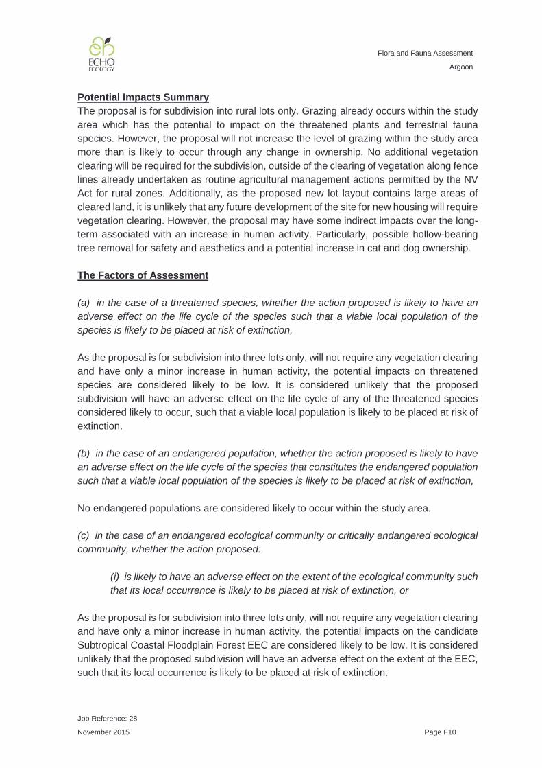
Flora and Fauna Assessment
Argoon
Job Reference: 28
November 2015 Page F10
Potential Impacts Summary The proposal is for subdivision into rural lots only. Grazing already occurs within the study area which has the potential to impact on the threatened plants and terrestrial fauna species. However, the proposal will not increase the level of grazing within the study area more than is likely to occur through any change in ownership. No additional vegetation clearing will be required for the subdivision, outside of the clearing of vegetation along fence lines already undertaken as routine agricultural management actions permitted by the NV Act for rural zones. Additionally, as the proposed new lot layout contains large areas of cleared land, it is unlikely that any future development of the site for new housing will require vegetation clearing. However, the proposal may have some indirect impacts over the long-term associated with an increase in human activity. Particularly, possible hollow-bearing tree removal for safety and aesthetics and a potential increase in cat and dog ownership. The Factors of Assessment (a) in the case of a threatened species, whether the action proposed is likely to have an adverse effect on the life cycle of the species such that a viable local population of the species is likely to be placed at risk of extinction, As the proposal is for subdivision into three lots only, will not require any vegetation clearing and have only a minor increase in human activity, the potential impacts on threatened species are considered likely to be low. It is considered unlikely that the proposed subdivision will have an adverse effect on the life cycle of any of the threatened species considered likely to occur, such that a viable local population is likely to be placed at risk of extinction. (b) in the case of an endangered population, whether the action proposed is likely to have an adverse effect on the life cycle of the species that constitutes the endangered population such that a viable local population of the species is likely to be placed at risk of extinction, No endangered populations are considered likely to occur within the study area. (c) in the case of an endangered ecological community or critically endangered ecological community, whether the action proposed:
(i) is likely to have an adverse effect on the extent of the ecological community such that its local occurrence is likely to be placed at risk of extinction, or
As the proposal is for subdivision into three lots only, will not require any vegetation clearing and have only a minor increase in human activity, the potential impacts on the candidate Subtropical Coastal Floodplain Forest EEC are considered likely to be low. It is considered unlikely that the proposed subdivision will have an adverse effect on the extent of the EEC, such that its local occurrence is likely to be placed at risk of extinction.

Flora and Fauna Assessment
Argoon
Job Reference: 28
November 2015 Page F11
(ii) is likely to substantially and adversely modify the composition of the ecological community such that its local occurrence is likely to be placed at risk of extinction,
As the proposal is for subdivision into three lots only, will not require any vegetation clearing and have only a minor increase in human activity, the potential impacts on the candidate Subtropical Coastal Floodplain Forest EEC are considered likely to be low. It is considered unlikely that the proposed subdivision will substantially and adversely modify the composition of the EEC such that its local occurrence is likely to be placed at risk of extinction. (d) in relation to the habitat of a threatened species, population or ecological community:
(i) the extent to which habitat is likely to be removed or modified as a result of the action proposed, and
The proposal is for subdivision into rural blocks and the landuse will not change. No vegetation clearing is required for the proposal (outside of actions permitted under NV Act for rural land). Potential indirect impacts associated with the slight increase in human activity are considered likely to be minor.
(ii) whether an area of habitat is likely to become fragmented or isolated from other areas of habitat as a result of the proposed action, and
The study area has been heavily cleared in the past, but is surrounded by blocks with remnant vegetation. No vegetation clearing is required for the proposal (outside of actions permitted under NV Act for rural land). As such, the proposal is unlikely to fragment or isolate areas of threatened species habitat..
(iii) the importance of the habitat to be removed, modified, fragmented or isolated to the long-term survival of the species, population or ecological community in the locality,
The study area has the potential to be used by threatened fauna species as part of larger home ranges. The study area represents marginal potential habitat for the two threatened flora species due to the continued grazing activities occurring within the study area. As such, the study area is likely to provide only part of the habitat required for the long-term survival of the threatened species and candidate EEC in the locality. (e) whether the action proposed is likely to have an adverse effect on critical habitat (either directly or indirectly), No declared critical habitat occurs within close proximity to the study area.

Flora and Fauna Assessment
Argoon
Job Reference: 28
November 2015 Page F12
(f) whether the action proposed is consistent with the objectives or actions of a recovery plan or threat abatement plan, SCFF - No recovery plan has been prepared for this EEC nor has a targeted strategy under the SOS program has been prepared for this EEC. No recovery plans exist for Arthraxon hispidus (Hairy Jointgrass) or Thesium australe (Austral Toadflax). These two threatened species are considered ‘keep watch’ species under the SOS program. Apart from continued grazing within the study area (which is likely to continue regardless of the proposal), the proposal is consistent with the conservation actions listed by SOS for these species. No recovery plans exist for Mixophyes balbus (Stuttering Frog) or Mixophyes iteratus (Giant Barred Frog). These two threatened species are considered ‘landscape’ species under the SOS program. The proposal is consistent with the conservation actions listed by SOS for these species. No recovery plan exists for Litoria brevipalmata (Green-thighed Frog) and it is listed as ‘Data-deficient’ species under the SOS program. The proposal is consistent with the conservation actions listed by SOS for this species. No recovery plan exists for Lophoictinia isura (Square-tailed Kite) and it is listed as a ‘landscape’ species under the SOS program. The proposal is consistent with the conservation actions listed by SOS for this species. No recovery plan exists for Calyptorhynchus lathami (Glossy Black-Cockatoo) and it is listed as a ‘landscape’ species under the SOS program. Apart from continued grazing within the study area (which is likely to continue regardless of the proposal), the proposal is consistent with the conservation actions listed by SOS for this species. No recovery plan exists for Chthonicola sagittata (Speckled Warbler), Melanodryas cucullata cucullata (Hooded Robin), Petroica boodang (Scarlet Robin), Petroica phoenicea (Flame Robin), Stagonopleura guttata (Diamond Firetail) and Coracina lineata (Barred Cuckoo-Shrike) and these species are listed as a ‘landscape’ species under the SOS program. Apart from continued grazing within the study area (which is likely to continue regardless of the proposal), the proposal is consistent with the conservation actions listed by SOS for this species. No recovery plan exists for Carterornis leucotis (White-eared Monarch) and it is listed as a ‘partnership’ species under the SOS program. The proposal is consistent with the conservation actions listed by SOS for this species.

Flora and Fauna Assessment
Argoon
Job Reference: 28
November 2015 Page F13
No recovery plan exists for Lathamus discolor (Swift Parrot) and it is listed as a ‘landscape’ species under the SOS program. The proposal is consistent with the conservation actions listed by SOS for this species. The proposal is consistent with the recovery actions listed in the Anthochaera phrygia (Regent Honeyeater) recovery plan (Department of Natural Resources and Environment 1999). This species is listed as a ‘site managed’ species under the SOS program, with sites in Bundarra - Barraba, Lower Hunter Valley and the Capertee Valley. None of these sites are in close proximity to the study area. No recovery plan exists for Glossopsitta pusilla (Little Lorikeet) and it is listed as a ‘landscape’ species under the SOS program. The proposal is consistent with the conservation actions listed by SOS for this species. The proposal is consistent with the recovery actions listed in the Draft recovery plan for Pteropus poliocephalus (Grey-headed Flying-fox) (Department of Environment Climate Change and Water NSW 2009) and it is listed as a ‘landscape’ species under the SOS program. The proposal is consistent with the recovery actions listed in the recovery plan for large forest owls: Ninox strenua (Powerful Owl), Tyto novaehollandiae (Masked Owl) and Tyto tenebricosa (Sooty Owl) (Department of Environment and Conservation 2006) which are listed as ‘landscape’ species under the SOS program. No recovery plan exists for Dasyurus maculatus (Spotted-tailed Quoll) and it is listed as a ‘landscape’ species under the SOS program. The proposal is consistent with the conservation actions listed by SOS for this species. No recovery plan exists for the hollow-dependent arboreal mammals: Phascogale tapoatafa (Brush-tailed Phascogale) and Petaurus norfolcensis (Squirrel Glider) and they are listed as ‘landscape’ species under the SOS program. The proposal is consistent with the conservation actions listed by SOS for these species. The proposal is consistent with the recovery actions listed in the recovery plan for Petaurus australis (Yellow-bellied Glider) (NSW National Parks and Wildlife Service 2003)and it is listed as a ‘landscape’ species under the SOS program. The proposal is consistent with the conservation actions listed by SOS for this species. The proposal is consistent with the recovery actions listed in the recovery plan for Phascolarctos cinereus (Koala) (Department of Environment and Climate Change 2008) and it is listed as a ‘landscape’ species under the SOS program. The proposal is consistent with the conservation actions listed by SOS for this species.

Flora and Fauna Assessment
Argoon
Job Reference: 28
November 2015 Page F14
No recovery plan exists for the hollow-roosting bats: Saccolaimus flaviventris (Yellow-bellied Sheathtail-bat), Mormopterus norfolkensis (East Coast Freetail-bat), Myotis macropus (Southern Myotis), Falsistrellus tasmaniensis (Eastern False Pipstrelle) and Scoteanax rueppellii (Greater Broad-nosed Bat) and they are listed as ‘landscape’ species under the SOS program. The proposal is consistent with the conservation actions listed by SOS for these species. No recovery plan exists for the cave-roosting bats: Miniopterus australis (Little Bentwing-bat) and Miniopterus schreibersii oceanensis (Eastern Bentwing-bat) and they are listed as ‘landscape’ species under the SOS program. The proposal is consistent with the conservation actions listed by SOS for these species. (g) whether the action proposed constitutes or is part of a key threatening process or is likely to result in the operation of, or increase the impact of, a key threatening process. As outlined in Appendix D - Key Threatening Processes above, the proposal is for subdivision only, with no alternation to land-use or vegetation clearing, only a slight increase in human activity and is unlikely to result in the operation of or increase the impact of a KTP listed under the TSC Act. CONCLUSION As the proposal is for subdivision only and will not remove any native vegetation, the potential impacts on threatened species, populations and communities listed under the TSC Act are considered to be quite low. Therefore, it is it is considered unlikely that the proposal will constitute a significant impact such that a Species Impact Statement is required.

Flora and Fauna Assessment
Argoon
Job Reference: 28
November 2015 Page G1
APPENDIX G EEC CHARACTERISTIC SPECIES
Table G-1: Characteristic flora species of Subtropical Coastal Floodplain Forest Endangered Ecological Community recorded within the study area
Scientific Name Dry Grassy Tallowwood - Grey Gum (FE 36)
Lowland Red Gums (FE 73)
Central Mid Elevation Sydney Blue Gum (FE 19)
Acacia concurrens
Acacia disparrima subsp. disparrima
Allocasuarina torulosa
Alphitonia excelsa X
Angophora paludosa
Angophora subvelutina
Angophora woodsiana
Aristida vagans
Brachychiton populneus subsp. populneus
Breynia oblongifolia X
Brunoniella australis
Callistemon salignus X
Callistemon viminalis
Callitris columellaris
Casuarina cunninghamiana subsp. cunninghamiana
Casuarina glauca
Centella asiatica X
Cheilanthes sieberi subsp. sieberi
Cissus hypoglauca
Commelina cyanea

Flora and Fauna Assessment
Argoon
Job Reference: 28
November 2015 Page G2
Scientific Name Dry Grassy Tallowwood - Grey Gum (FE 36)
Lowland Red Gums (FE 73)
Central Mid Elevation Sydney Blue Gum (FE 19)
Commersonia bartramia
Commersonia fraseri
Cordyline congesta
Corymbia intermedia X
Cupaniopsis anacardioides
Cupaniopsis parviflora
Cymbidium suave
Cymbopogon refractus
Cyperus enervis
Desmodium rhytidophyllum X
Desmodium varians
Dianella caerulea
Dianella longifolia
Dichelachne micrantha
Dichondra repens X
Digitaria parviflora
Drypetes australasica
Echinopogon caespitosus var. caespitosus
X
Elaeocarpus reticulatus
Entolasia marginata
Entolasia stricta X
Eragrostis leptostachya
Eucalyptus acmeniodes
Eucalyptus amplifolia
Eucalyptus moluccana
Eucalyptus propinqua X

Flora and Fauna Assessment
Argoon
Job Reference: 28
November 2015 Page G3
Scientific Name Dry Grassy Tallowwood - Grey Gum (FE 36)
Lowland Red Gums (FE 73)
Central Mid Elevation Sydney Blue Gum (FE 19)
Eucalyptus resinifera subsp. hemilampra
Eucalyptus robusta
Eucalyptus seeana
Eucalyptus siderophloia X X
Eucalyptus tereticornis X X
Eustrephus latifolius X
Ficus macrophylla subsp. macrophylla
Ficus obliqua
Ficus superba var. henneana
Gahnia aspera
Gahnia clarkei
Geitonoplesium cymosum
Glochidion ferdinandii
Glycine clandestina
Hardenbergia violacea
Hibbertia scandens
Hibiscus diversifolius
Hibiscus tiliaceus
Hovea acutifolia
Imperata cylindrica var. major X
Kennedia rubicunda
Lagenifera stipitata
Laxmannia gracilis
Lomandra filiformis X
Lomandra longifolia X

Flora and Fauna Assessment
Argoon
Job Reference: 28
November 2015 Page G4
Scientific Name Dry Grassy Tallowwood - Grey Gum (FE 36)
Lowland Red Gums (FE 73)
Central Mid Elevation Sydney Blue Gum (FE 19)
Lomandra multiflora subsp. multiflora
Lophostemon suaveolens
Maclura cochinchinensis
Mallotus philippensis
Melaleuca alternifolia
Melaleuca decora
Melaleuca nodosa X
Melaleuca quinquenervia
Melaleuca styphelioides X
Microlaena stipoides var. stipoides
Morinda jasminoides
Notelaea longifolia
Oplismenus aemulus X
Oplismenus imbecillis
Panicum simile
Parsonsia straminea X
Persoonia stradbrokensis
Phyllanthus virgatus
Pimelea linifolia
Pittosporum revolutum
Pratia purpurascens X
Pteridium esculentum
Sigesbeckia orientalis
Smilax australis
Smilax glyciphylla

Flora and Fauna Assessment
Argoon
Job Reference: 28
November 2015 Page G5
Scientific Name Dry Grassy Tallowwood - Grey Gum (FE 36)
Lowland Red Gums (FE 73)
Central Mid Elevation Sydney Blue Gum (FE 19)
Stephania japonica var. discolor X
Themeda australis
Tricoryne elatior X
Vernonia cinerea
Viola hederacea X
Wikstroemia indica