Embed Size (px)
Citation preview

FLORA AND FAUNA survey and assessment
Proposed road relocation, Mungo Brush Road Myall Lakes National Park, NSW May 2016

Cover photographs:
Left: Character of the woodland community present within the subject site. Right: Character of the heath community present within the subject site.
Report produced at the request of:
Royal HaskoningDHV
On behalf of
NSW Office of Environment and Heritage
by
Lesryk Environmental Pty Ltd PO Box 3001
Bundeena NSW 2230 Telephone: (02) 9523 2016
Mobile: 0408 25 8129 Email: [email protected]
www.lesryk.com.au
Document Control File Location: P:\Projects June 2015 onwards\Royal Haskoning DHV\Third draft\FF Mungo Brush Road Draft4 100516_Lesryk.doc
Version Authors Reviewer Approved For Issue Draft V1 Deryk Engel (Director), Stephen Bloomfield
(Senior ecologist), Paul Burcher (Botanist) and Kirsty Bloomfield (research assistant)
Deryk Engel, Stephen Bloomfield and Kirsty Bloomfield
Deryk Engel 16/03/16
Comments received from client 29/03/16 @ 12.09PM Draft V2 Deryk Engel, Stephen Bloomfield, Paul
Burcher and Kirsty Bloomfield Deryk Engel, Paul Burcher and Kirsty Bloomfield
Deryk Engel 05/04/16
Comments received from client 14/04/16 @ 02.59PM Comments received from Steve Lewer, OEH Regional Biodiversity Conservation Officer – Hunter /
Central Coast Region 22/04/16 @12.50PM
Draft V3 Deryk Engel, Stephen Bloomfield, Paul Burcher and Kirsty Bloomfield
Deryk Engel, Paul Burcher and Kirsty Bloomfield
Deryk Engel 03/05/16
Draft V4 Deryk Engel, Stephen Bloomfield, Paul Burcher and Kirsty Bloomfield
Deryk Engel and Paul Burcher
Deryk Engel 11/05/16
Disclaimer This document has been prepared in accordance with the brief provided by Royal HaskoningDHV (‘the client’). This investigation has relied upon information collected during the course of field investigations, and as available in current known literature and data sources. All findings, conclusions or recommendations contained within this document are based upon the abovementioned circumstances. The study has been prepared for use by the client, and no responsibility for its use by other parties is accepted by Lesryk Environmental Pty Ltd. Please note that, given the dynamic nature of the relevant pieces of environmental legislation considered in this report, the authors consider that this report only has a ‘shelf life’ of six months. If a development application, review of environmental factors or statement of environmental effect is not submitted to a determining authority for consideration within this time frame, it is recommended that this report be reviewed and revised where required in light of any relevant legislative listings or changes. This report is prepared in accordance with both the 6th Edition of the Commonwealth of Australia (2002) Style Manual.
Lesryk Environmental Pty Ltd 11/05/16 1
Executive summary A terrestrial flora and vertebrate fauna investigation has been conducted within, adjacent to and beyond the limits of a 3.2-kilometre-long section of Mungo Brush Road. This section of road is located within Myall Lakes National Park. Due to the westward wind assisted movement of the Dark Point dune sheet, sand is impacting upon the Mungo Brush Road; this being a key transport corridor connecting Hawks Nest and Bombah Point. The ecological survey has been undertaken as the New South Wales Office of Environment and Heritage is proposing to realign the section of road investigated. As part of the ecological investigation, to identify those species that have been previously recorded, or could potentially occur, within the section of Myall Lakes National Park surveyed, known databases and relevant ecological reports were consulted. By the completion of the field investigation, eight threatened and/or migratory species listed under the New South Wales Threatened Species Conservation Act 1995 and Commonwealth Environment Protection and Biodiversity Conservation Act 1999 were recorded within and/or in close proximity to the area investigated. As suitable habitat is present, and as they have been recorded in the study region, it was considered appropriate to adopt the precautionary principle in regards to the presence of a number of additional State and Commonwealth listed threatened species. No threatened flora species were recorded, though habitats for the State and Federally listed threatened flora species, Magenta Lilly Pilly, Trailing Woodruff, Biconvex Paperbark, Earp’s Gum and Leafless Tongue-orchid, and the State listed Noah's False Chickweed, were observed. By the completion of the flora component of the field survey, two endangered ecological communities listed on the New South Wales Threatened Species Conservation Act 1995 had been recorded in the study area. These were Swamp Sclerophyll Forest and Subtropical Coastal Floodplain Forest. The proposed road realignment would remove around 1.34 hectares of Swamp Sclerophyll Forest, representing around 0.34% of the remnant within which it is located. Approximately 0.05 hectares of Subtropical Coastal Floodplain Forest would be affected representing 2% of the remnant within which it is located. With reference to the relevant assessment criteria provided under the Commonwealth Environment Protection and Biodiversity Conservation Act 1999 and New South Wales Environmental Planning and Assessment Act 1979, it was concluded that the proposed road realignment would not have a significant effect on these species, ecological communities or their habitats. Therefore, there is no requirement to refer the proposal to the Federal Minister of Environment for further consideration and approval, or the need to prepare a Species Impact Statement. The study area is within the Myall Lakes Wetland of International Importance under the Ramsar Convention and thus is a Matters of National Environmental Significance under the Commonwealth Environment Protection and Biodiversity Conservation Act 1999. The proposed road realignment would result in the permanent loss of around 7.82 hectares of native vegetation representing less than 0.02% of the Myall Lakes Ramsar site. Of these 7.82 hectares, 1.73 hectares of wetland vegetation would be removed, which represents less than 0.03% of the wetland group within which the affected vegetation types are grouped. Given the small area affected, it is considered that the proposed road realignment would not have a significant impact on the ecological character of the wetland. Therefore, in relation to this Matters of National Environmental Significance, there is no requirement to refer the proposal to the Federal Minister of the Environment as a controlled action. The proposal is considered unlikely to have an adverse impact on any ecological communities, threatened species, or populations of State or Commonwealth conservation significance. The adoption of those mitigation measures provided would ensure that the work proposed is carried out in an ecologically sustainable manner.
Lesryk Environmental Pty Ltd 11/05/16 2
Contents
1. Introduction............................................................................................................................. 5
2. Legislative requirements ........................................................................................................ 8
3. Environmental setting ............................................................................................................. 8
4. Literature review and field guides ........................................................................................ 11
5. Results of the literature review ............................................................................................. 13
5.1. Vegetation mapping..................................................................................................... 13 5.2. Threatened species ..................................................................................................... 16
6. Field survey methods ........................................................................................................... 16
6.1. Botanical survey .......................................................................................................... 17 6.2. Infrared cameras ......................................................................................................... 18 6.3. Spotlighting .................................................................................................................. 18 6.4. Echolocation ................................................................................................................ 18 6.5. Call playbacks ............................................................................................................. 20 6.6. SongMeter ................................................................................................................... 20 6.7. Hair-tube trapping ........................................................................................................ 21 6.8. Scat searches .............................................................................................................. 22 6.9. Limitations ................................................................................................................... 22
7. Results ................................................................................................................................. 23
7.1. Plant communities and fauna habitats ........................................................................ 23 7.1.1. Wallum Banksia Heath ............................................................................................ 23 7.1.2. Old Man Banksia Woodland ................................................................................... 25 7.1.3. Swamp Mahogany – Broad-leaved Paperbark Open Forest .................................. 25 7.1.4. Forest Red Gum – Swamp Mahogany Open Forest .............................................. 26 7.1.5. Ball Honeymyrtle Heath .......................................................................................... 26
7.2. Fauna corridors and vegetation links .......................................................................... 27 7.3. Flora species recorded ................................................................................................ 29
7.3.1. Threatened species ................................................................................................. 29 7.3.2. Noxious weeds ........................................................................................................ 31
7.4. Fauna species recorded .............................................................................................. 31 7.4.1. Threatened species ................................................................................................. 32
7.4.1. (a) Long-nosed Potoroo - vulnerable species (TSC and EPBC Acts) ................. 33 7.4.1. (b) Little Bentwing Bat – vulnerable species (TSC Act) ....................................... 34 7.4.1. (c) Eastern Falsistrelle – vulnerable species (TSC Act) ...................................... 36 7.4.1. (d) Eastern Chestnut Mouse - vulnerable species (TSC Act) .............................. 37 7.4.1. (e) New Holland Mouse - vulnerable species (EPBC Act)................................... 37 7.4.1. (f) Eastern Osprey – vulnerable and migratory species (TSC and EPBC Acts) . 38 7.4.1. (g) Great Egret - migratory species (EPBC Act) .................................................. 38 7.4.1. (h) Rufous Fantail - migratory species (EPBC Act) ............................................. 39
8. Legislative considerations .................................................................................................... 39
8.1. Commonwealth - Environment Protection and Biodiversity Conservation Act 1999 .. 39 8.2. State - Environmental Planning and Assessment Act 1979 ........................................ 40
9. Conclusion............................................................................................................................ 41
10. Recommendations ............................................................................................................... 43
11. Bibliography ......................................................................................................................... 45

Lesryk Environmental Pty Ltd 11/05/16 3
Page List of Figures Figure 1. Area surveyed and locality 5 Figure 2-1. Proposed road realignment (southern portion) 6 Figure 2-2. Proposed road realignment (northern portion) 7 Figure 3. Myall Lakes Ramsar Site 10 Figure 4. Vegetation mapping of the study area 14 Figure 5. Vegetation mapping of the study area 15 Figure 6. Fauna survey locations 19 Figure 7. Vegetation communities recorded 24 Figure 8. Identified corridor linkages 28 Figure 9. Locations where threatened fauna species were recorded 35 List of Tables Table 1. Summary of legislative and policy requirements 9 Table 2. Weather details 16 List of Appendices Appendix 1. Photographic record of study area 50 Appendix 2. Threatened flora and fauna species previously recorded or having habitat in the study region and a consideration of their ‘likelihood of occurrence’ within the study area
53
Appendix 3. Flora species recorded 65 Appendix 4. Fauna species recorded or previously detected in the study region 69 Appendix 5. Microchiropteran call analysis 78 Appendix 6. Survey methods and locations 80 Appendix 7: Assessments of significance under the EPBC Act 81 Appendix 8: Assessments of significance under the EPA Act 101

Lesryk Environmental Pty Ltd 11/05/16 4
Glossary Terms used throughout this report are: °C Degrees Celsius ASL Above Sea Level DECC NSW Department of Environment and Climate Change (now known as
the NSW Office of Environment and Heritage) DE Commonwealth Department of the Environment ECD Ecological Character Description EEC Endangered ecological community EPBC Act Commonwealth Environment Protection and Biodiversity Conservation
Act 1999 EPA Act NSW Environmental Planning and Assessment Act 1979 GPS Global Positioning system KTPs Key Threatening Process LAC Limits of acceptable change LES Local Environment Study LGA Local Government Area m/m2/km/ha/mm Metres, metres squared, kilometres, hectares, millimetres MNES Matters of National Environmental Significance NSW New South Wales NW Act NSW Noxious Weeds Act 1993 PCT Plant Community Type PMST EPBC Act’s Protected Matters Search Tool OEH NSW Office of Environment and Heritage RoTAP Rare or Threatened Australian Plant RPS HSO Harper Somers O’Sullivan Pty Ltd SIS Species Impact Statement TSC Act NSW Threatened Species Conservation Act 1995 For the purpose of this investigation:
• Subject site is defined as ‘the area to be directly affected by the proposal’ (as per DECC 2007). The proposal is shown in the site plans (Figures 2-1 and 2-2).
• Study area is defined as ‘the subject site and any additional areas that are likely to be affected by the proposal, either directly or indirectly’ (DECC 2007).
• The study region is considered to ‘include the lands that surround the subject site for a distance of 10 km’ (DECC 2007).
• The proposal is considered to include ‘all activities likely to be undertaken within the area surveyed that permit the establishment of the proposed road realignment’ (DECC 2007).
• A local population of a threatened species comprises those individuals known or likely to occur in the study area, as well as any individuals occurring in adjoining areas (contiguous or otherwise) that are known or likely to utilise habitats in the study area (DECC 2007).
• An ‘important population’ is a population that is necessary for a species’ long-term survival and recovery. This may include populations identified as such in recovery plans, and/or that are:
o key source populations either for breeding or dispersal o populations that are necessary for maintaining genetic diversity, and/or o populations that are near the limit of the species range (DE 2013).
• Critical habitat is an area of land that is crucial to the survival of a particular endangered species, population and/or ecological community.
Lesryk Environmental Pty Ltd 11/05/16 5
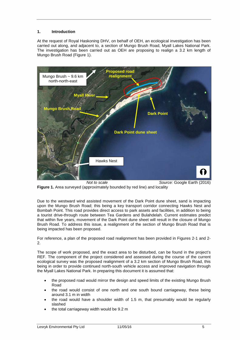
1. Introduction At the request of Royal Haskoning DHV, on behalf of OEH, an ecological investigation has been carried out along, and adjacent to, a section of Mungo Brush Road, Myall Lakes National Park. The investigation has been carried out as OEH are proposing to realign a 3.2 km length of Mungo Brush Road (Figure 1).
Not to scale Source: Google Earth (2016)
Figure 1. Area surveyed (approximately bounded by red line) and locality Due to the westward wind assisted movement of the Dark Point dune sheet, sand is impacting upon the Mungo Brush Road; this being a key transport corridor connecting Hawks Nest and Bombah Point. This road provides direct access to park assets and facilities, in addition to being a tourist drive-through route between Tea Gardens and Bulahdelah. Current estimates predict that within five years, movement of the Dark Point dune sheet will result in the closure of Mungo Brush Road. To address this issue, a realignment of the section of Mungo Brush Road that is being impacted has been proposed. For reference, a plan of the proposed road realignment has been provided in Figures 2-1 and 2-2. The scope of work proposed, and the exact area to be disturbed, can be found in the project’s REF. The component of the project considered and assessed during the course of the current ecological survey was the proposed realignment of a 3.2 km section of Mungo Brush Road, this being in order to provide continued north-south vehicle access and improved navigation through the Myall Lakes National Park. In preparing this document it is assumed that:
• the proposed road would mirror the design and speed limits of the existing Mungo Brush Road
• the road would consist of one north and one south bound carriageway, these being around 3.1 m in width
• the road would have a shoulder width of 1.5 m, that presumably would be regularly slashed
• the total carriageway width would be 9.2 m
Myall River
Dark Point
Dark Point dune sheet
Mungo Brush Road
Hawks Nest
Proposed road realignment
Mungo Brush ~ 9.6 km north-north-east
Lesryk Environmental Pty Ltd 11/05/16 6
Not to scale Source: Royal Haskoning DHV (undated)
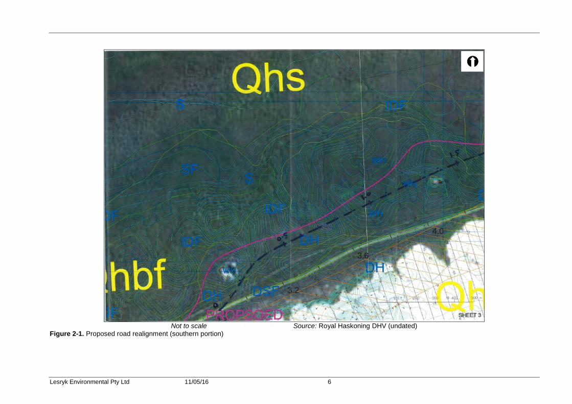
Figure 2-1. Proposed road realignment (southern portion)

Lesryk Environmental Pty Ltd 11/05/16 7
Not to scale Source: Royal Haskoning DHV (undated)
Figure 2-2. Proposed road realignment (northern portion)
Lesryk Environmental Pty Ltd 11/05/16 8
• there would be an additional cleared width of up to around 6.9 m on either side, with a total nominal cleared width of 23 m
• to ensure that the developed water table response is the same as the existing water table response, the design of the road would be constructed using porous materials (e.g. sand) and would include culverts or similar structures that avoid ‘damming’
• traffic volumes will not alter significantly from those currently experienced by Mungo Brush Road
• the existing network of tracks, including Robinson’s and Duck Hole Firetrails, will be used to access the work site
• the sighting of work compound sites and any stockpile areas will be determined in consultation with the project’s ecologist
• the section of Mungo Brush Road that will no longer be used will be closed to public access and decommissioned. The closed road corridor of Mungo Brush Road would be managed to encourage natural regeneration of native species, acknowledging that the road would eventually be buried by the mobile sand dune movement.
The area surveyed during the course of the current ecological investigation was a minimum of 30 m buffer around the centre line of the proposed road alignment with this distance increasing in areas that were easier to traverse (i.e. the woodland and open forest vegetation communities). With reference to those plans provided (i.e. Figures 2-1, 2-2), it is noted that the site’s development would require the clearing of around 7.82 ha of native vegetation. The loss of this vegetation would be ‘off-set’ by permitting the section of Mungo Brush Road that is to be realigned to revert to a natural state. The proposal will not directly or indirectly affect any of those portions of the National Park that occur to the north or south of the area investigated. The findings of the current investigation are based on a flora and fauna survey of both the subject site and study area, a literature review of previous studies carried out in both the study region and this portion of the Great Lakes Council LGA, the consultation of standard databases and the consideration of the objectives of the EPBC Act, the EPA Act, NPW Act and TSC Act, and any relevant SEPP’s. 2. Legislative requirements A number of State and Commonwealth Acts and policies are relevant to this study; these being listed in Table 1 below. 3. Environmental setting The subject site is located west and south of Dark Point within the Myall Lakes National Park. The subject site is broadly located between the township of Hawks Nest and Mungo Brush camp ground, on the NSW mid-north coast, within the Great Lakes Council LGA (Figure 1). Between Mungo Brush and Hawks Nest, Mungo Brush Road is around 27 km in length. The subject site is around 30 m wide by 3.2 km long.

Lesryk Environmental Pty Ltd 11/05/16 9
Table 1. Summary of legislative and policy requirements
Level Relevant Legislation / Policy Relevance to study area
Commonwealth Environment Protection and Biodiversity Conservation Act 1999
Under this Act an action will require approval from the Minister if the action has, will have, or is likely to have, a significant impact on a MNES. MNES include listed threatened species and ecological communities, migratory species and wetlands of international importance protected under international agreements. Where applicable, the assessment criteria relevant to this Act must be drawn upon to determine whether there would be a significant effect on these species and hence whether referral to the Federal Environment Minister is required. One Ramsar Wetland, two vulnerable fauna species and three migratory species were recorded. Assessments have been carried out; however, referral of the matter to the Federal Minister for the Environment is not considered necessary.
State
NSW Environmental Planning and Assessment Act 1979
Part 1, Section 5A of this Act requires that a determination be made as to whether a proposed action is likely to have a significant effect on species, populations and ecological communities listed on Schedules 1, 1A and 2 of the TSC Act. Where found, the assessment criteria relevant to this Act (these commonly referred to as the ‘seven-part test’) are to be drawn upon to determine whether there would be a significant effect on these species and hence whether a SIS is required. Threatened species were recorded. Assessments have been carried out; however, preparation of a SIS has not been triggered (Section 8.2).
NSW Threatened Species Conservation Act 1995/Amendment 2002
This Act makes further provision with respect to the conservation of threatened species, populations and ecological communities of animals and plants. Two endangered ecological communities and five vulnerable fauna species listed under this Act were recorded. Assessments have been carried out (Section 8.2).
NSW National Parks and Wildlife Act 1974
This Act defines those species listed as protected in NSW. No assessment is required under this Act, however, potential impacts of the proposed work on these species will be considered. Protected native species were recorded. Mitigation measures to ensure the local viability of these species have been provided.
NSW Noxious Weeds Act 1993
Part 3, Division 1, Section 13 of this Act requires land owners to control noxious weeds on their own land. One noxious weed was recorded and recommendations for the treatment of this provided.
Lesryk Environmental Pty Ltd 11/05/16 10
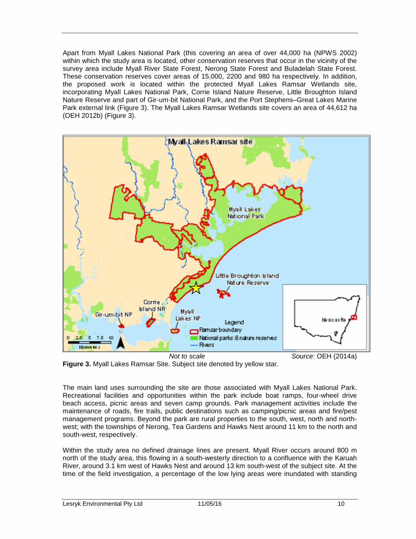
Apart from Myall Lakes National Park (this covering an area of over 44,000 ha (NPWS 2002) within which the study area is located, other conservation reserves that occur in the vicinity of the survey area include Myall River State Forest, Nerong State Forest and Buladelah State Forest. These conservation reserves cover areas of 15,000, 2200 and 980 ha respectively. In addition, the proposed work is located within the protected Myall Lakes Ramsar Wetlands site, incorporating Myall Lakes National Park, Corrie Island Nature Reserve, Little Broughton Island Nature Reserve and part of Gir-um-bit National Park, and the Port Stephens–Great Lakes Marine Park external link (Figure 3). The Myall Lakes Ramsar Wetlands site covers an area of 44,612 ha (OEH 2012b) (Figure 3).
Not to scale Source: OEH (2014a)
Figure 3. Myall Lakes Ramsar Site. Subject site denoted by yellow star. The main land uses surrounding the site are those associated with Myall Lakes National Park. Recreational facilities and opportunities within the park include boat ramps, four-wheel drive beach access, picnic areas and seven camp grounds. Park management activities include the maintenance of roads, fire trails, public destinations such as camping/picnic areas and fire/pest management programs. Beyond the park are rural properties to the south, west, north and north-west; with the townships of Nerong, Tea Gardens and Hawks Nest around 11 km to the north and south-west, respectively. Within the study area no defined drainage lines are present. Myall River occurs around 800 m north of the study area, this flowing in a south-westerly direction to a confluence with the Karuah River, around 3.1 km west of Hawks Nest and around 13 km south-west of the subject site. At the time of the field investigation, a percentage of the low lying areas were inundated with standing
Lesryk Environmental Pty Ltd 11/05/16 11
water. The permanency of this water is dependent on natural recharge rates. Low-lying areas were inundated with standing water due to a major storm and flooding event in January 2016. A series of unsealed vehicle tracks, including Robinson’s and Duck Hole Firetrails, are present near the subject site. These are fire trails which are maintained as part of the strategic fire management program for the park, and not open for vehicle access to the public. The northern end of the proposed realigned road also has a four-wheel drive track allowing access to the Sandy Point carpark which will continue to be maintained. Natural elevations within the subject site are between 5 m and 24 m ASL, the site being located within a landscape that is characterised by gentle to moderately undulating rises. According to monthly rainfall figures from Williamtown RAAF1, the mean annual rainfall in the region is 1128.8 mm with the greatest falls being experienced between February and June (Bureau of Meteorology 2016). Average temperatures range from a winter low of around 6.4 °C to a summer high of around 28.1 °C (Bureau of Meteorology 2016). With reference to the Newcastle 1:250 000 Geological Map, the study area has been mapped as derived from the Quaternary geology, this being comprised of gravel, sand, silt, clay, “Waterloo Rock” Marine and freshwater deposits (DI 1966). Mapping of soil landscapes of the Port Stephens 1:100 000 map sheet (Murphy 1995) indicates that the dunes that cover most of the study area are composed of the Hawks Nest Soil Landscape which was formed by Aeolian processes, while low-lying areas in the north of the study area are of the Tamboy Soil Landscape formed by estuarine processes. For reference, a photographic record of the subject site has been provided (Appendix 1). Through reference to the listings provided under both the EPBC and TSC Acts, it is noted that no gazetted areas of critical habitat for any flora or fauna species, populations or communities occur within, or in the vicinity of, the study area. 4. Literature review and field guides Prior to undertaking any fieldwork, to identify the diversity of vegetation communities and flora and fauna species known for, or potentially occurring in, the study area, previous ecological studies prepared in the surrounding region, and known databases, were consulted. The identification of known or potentially occurring native species within this portion of the Great Lakes Council LGA, particularly those listed under the Schedules to the EPBC and/or TSC Acts, thereby permits the tailoring of the field survey strategies to the detection of these plants, animals and ecological communities, or the identification of their necessary vegetation associations and habitat types. The undertaking of a literature search also ensures that the results from surveys conducted during different climatic, seasonal and date periods are considered and drawn upon as required. This approach therefore increases the probability of considering the presence of all known and likely native species, particularly any which are of regional, State and/or national conservation concern. This approach also avoids issues inherent with a one off ‘snap shot’ study.
1 This is the nearest operating weather station to Mungo Brush.

Lesryk Environmental Pty Ltd 11/05/16 12
The databases, studies and reports referred to include:
• The DE Protected Matters Search Tool (DE 2016a) • The OEH BioNet database [Atlas of NSW Wildlife] (OEH 2016a) • The OEH Threatened Species website (OEH 2016b) • Vegetation mapping of the Greater Hunter Region (OEH 2012a) • The ecological constrains report prepared in relation to the realignment of mungo Brush
Road (RPS HSO 2009). • The Myall Lakes National Park Plan of Management (NPWS 2002) • Descriptions of the ecological character of the Myall Lakes Ramsar Site (OEH 2012) • The Dune Management Options Study for the Dark Point Transgressive Dune Sheet (gba
Coastal 2010) • A flora assessment of the proposed road widening and upgrade of Nelson Bay Road at
Bob’s Farm and Fullerton Cove (Lesryk 2011, 2012) • A flora and fauna threatened species assessment conducted at Lot 101 DP608403, 413
Mungo Brush Road, Hawks Nest, NSW (EcoBiological 2006) • The North Hawks Nest Ecological Assessment (EcoPro 1996) • An ecological assessment conducted within a property that fronts Mungo Brush Road,
Hawks Nest, NSW (Wildthing Environmental Consultants 2012). Other reports and documents referred to are provided within the bibliography section of this report. When accessing the DE and OEH databases, the search area specified was a 10 km buffer around the study area. The data searches were carried out on 27 January 2016. All these databases and reports were reviewed and drawn upon where relevant. Whilst reviewing these documents, particular attention was paid to identifying records of species listed under the Schedules of the EPBC or TSC Acts, plants, animals and ecological communities that have been recorded in the surrounding region and which may occur within, or in the vicinity of, the study area. Field guides and standard texts used include:
• Harden (1992, 1993, 2000 and 2002), Brooker and Kleinig (2006) and Harden et al. (2006, 2007) (used for the identification of flora species)
• Cogger (2014) (reptiles and frogs) • Simpson and Day (2010) (birds) • Churchill (2008) (insectivorous bats) • Van Dyck and Strahan (2008) (mammals) • Triggs (1996) (scats and signs).
The naming of those species recorded or known for the region follows the nomenclature presented in these texts, or within the EPBC and TSC Acts. It is noted that the current accepted scientific names for some of the threatened animals previously recorded in this locality are not consistent with the names used/provided under either the EPBC or TSC Acts. In these instances, the nomenclature used within this report follows the current approved scientific conventions.
Lesryk Environmental Pty Ltd 11/05/16 13
The conservation significance of those ecological communities, plants and animals recorded is made with reference to:
• The RoTAP publication (Briggs and Leigh 1996) • The EPBC and TSC Acts • Mapping and description of the native vegetation of the Greater Hunter Area (OEH
2012a). • The NSW Master Plant Community Type Classification (OEH 2016c).
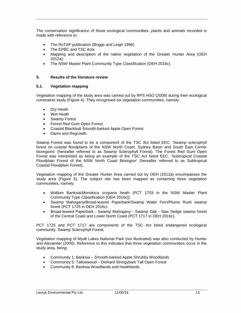
5. Results of the literature review 5.1. Vegetation mapping Vegetation mapping of the study area was carried out by RPS HSO (2009) during their ecological constraints study (Figure 4). They recognised six vegetation communities, namely:
• Dry Heath • Wet Heath • Swamp Forest • Forest Red Gum Open Forest • Coastal Blackbutt Smooth-barked Apple Open Forest • Dams and Regrowth.
Swamp Forest was found to be a component of the TSC Act listed EEC, ‘Swamp sclerophyll forest on coastal floodplains of the NSW North Coast, Sydney Basin and South East Corner bioregions’ (hereafter referred to as Swamp Sclerophyll Forest). The Forest Red Gum Open Forest was interpreted as being an example of the TSC Act listed EEC, ‘Subtropical Coastal Floodplain Forest of the NSW North Coast Bioregion’ (hereafter referred to as Subtropical Coastal Floodplain Forest). Vegetation mapping of the Greater Hunter Area carried out by OEH (2012a) encompasses the study area (Figure 5). The subject site has been mapped as containing three vegetation communities, namely:
• Wallum Banksia/Monotoca scoparia heath (PCT 1703 in the NSW Master Plant Community Type Classification [OEH 2016c]).
• Swamp Mahogany/Broad-leaved Paperbark/Swamp Water Fern/Plume Rush swamp forest (PCT 1725 in OEH 2016c)
• Broad-leaved Paperbark - Swamp Mahogany - Swamp Oak - Saw Sedge swamp forest of the Central Coast and Lower North Coast (PCT 1717 in OEH 2016c).
PCT 1725 and PCT 1717 are components of the TSC Act listed endangered ecological community, Swamp Sclerophyll Forest. Vegetation mapping of Myall Lakes National Park (not illustrated) was also conducted by Hunter and Alexander (2000). Reference to this indicates that three vegetation communities occur in the study area, being:
• Community 1: Banksia – Smooth-barked Apple Shrubby Woodlands • Community 5: Tallowwood – Diehard Stringybark Tall Open Forest • Community 8: Banksia Woodlands and Heathlands.
Lesryk Environmental Pty Ltd 11/05/16 14
Not to scale Source: RPS HSO (2009)
Figure 4. Vegetation mapping of the study area

Lesryk Environmental Pty Ltd 11/05/16 15
Not to scale Source: OEH (2012a)
Legend Figure 5. Vegetation mapping of the study area (outlined in red)
Wallum Banksia/Monotoca scoparia heath
Swamp Mahogany/Broad-leaved Paperbark/ Swamp Water Fern/ Plume Rush swamp forest
Broad-leaved Paperbark - Swamp Mahogany - Swamp Oak - Saw Sedge swamp forest of the Central Coast and Lower North Coast
Lesryk Environmental Pty Ltd 11/05/16 16
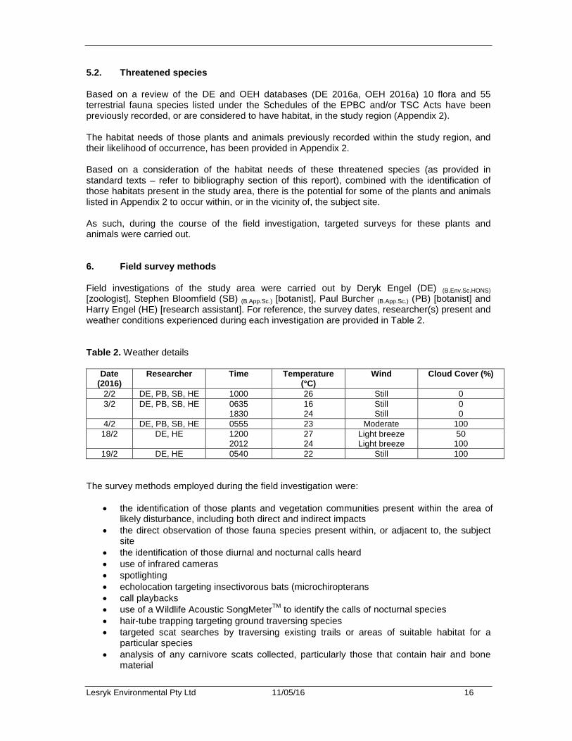
5.2. Threatened species Based on a review of the DE and OEH databases (DE 2016a, OEH 2016a) 10 flora and 55 terrestrial fauna species listed under the Schedules of the EPBC and/or TSC Acts have been previously recorded, or are considered to have habitat, in the study region (Appendix 2). The habitat needs of those plants and animals previously recorded within the study region, and their likelihood of occurrence, has been provided in Appendix 2. Based on a consideration of the habitat needs of these threatened species (as provided in standard texts – refer to bibliography section of this report), combined with the identification of those habitats present in the study area, there is the potential for some of the plants and animals listed in Appendix 2 to occur within, or in the vicinity of, the subject site. As such, during the course of the field investigation, targeted surveys for these plants and animals were carried out. 6. Field survey methods Field investigations of the study area were carried out by Deryk Engel (DE) (B.Env.Sc.HONS) [zoologist], Stephen Bloomfield (SB) (B.App.Sc.) [botanist], Paul Burcher (B.App.Sc.) (PB) [botanist] and Harry Engel (HE) [research assistant]. For reference, the survey dates, researcher(s) present and weather conditions experienced during each investigation are provided in Table 2. Table 2. Weather details
Date (2016)
Researcher Time Temperature (°C)
Wind Cloud Cover (%)
2/2 DE, PB, SB, HE 1000 26 Still 0 3/2 DE, PB, SB, HE 0635
1830 16 24
Still Still
0 0
4/2 DE, PB, SB, HE 0555 23 Moderate 100 18/2 DE, HE 1200
2012 27 24
Light breeze Light breeze
50 100
19/2 DE, HE 0540 22 Still 100 The survey methods employed during the field investigation were:
• the identification of those plants and vegetation communities present within the area of likely disturbance, including both direct and indirect impacts
• the direct observation of those fauna species present within, or adjacent to, the subject site
• the identification of those diurnal and nocturnal calls heard • use of infrared cameras • spotlighting • echolocation targeting insectivorous bats (microchiropterans • call playbacks • use of a Wildlife Acoustic SongMeterTM to identify the calls of nocturnal species • hair-tube trapping targeting ground traversing species • targeted scat searches by traversing existing trails or areas of suitable habitat for a
particular species • analysis of any carnivore scats collected, particularly those that contain hair and bone
material
Lesryk Environmental Pty Ltd 11/05/16 17
• the identification of indirect evidence including tracks, scats, scratchings and diggings • litter and ground debris searches for reptiles and amphibians.
Where required, a more detailed description on one or more of the survey methods employed is provided below. The purpose of the field investigation was to locate within the study area any plants, animals or vegetation communities that are of regional, State and/or national conservation significance, or any locations where these may potentially be present. When conducting the field investigation, the ‘Random Meander Method’ (as per Cropper 1993) was employed. This method is suitable for covering large areas and for locating any rare species, and their associated vegetation communities/habitat types. Whilst conducting the site investigation, efforts were made to document the diversity, structure and value of those communities and habitats present within, and adjacent to, the subject site. This involved assessing the structure of the vegetation communities and fauna habitats present, and determining their significance for native species, particularly any that are of State and/or national conservation concern. Whilst conducting the site assessments, efforts were made to identify features such as known vegetation associations, geological features, feed trees, mature trees with hollows, aquatic environments and other habitat features important to the life cycle needs of those threatened species previously recorded in the study region (as listed in Appendix 2). The survey methods employed and level of effort required were generally based on the descriptions provided in the following:
• DEC 2004 publication titled ‘Threatened biodiversity survey and assessment: Guidelines for developments and activities’
• DE survey guidelines for Australia’s threatened animals (DE various dates) It is noted that guidelines have yet to be produced for the use of infrared cameras and SongMeter’s. Therefore, information on the use of these was sourced from:
• the unit’s user manuals • the scientific literature (Claridge et al. 2010, Engel and Burcher 2010, Meek et al. 2012,
Meek and Fleming 2014). 6.1. Botanical survey The 'Random Meander Method' was employed during the botanical survey. The investigation involved conducting foot traverses through those vegetation communities that occur within the study area. During these traverses, notes were made on the structure and floristic composition of the native vegetation present. This method was employed until no new species were recorded. Numerous plant specimens were collected for later identification using standard texts. Based on the results of the literature review, and the habitat requirements of those flora species identified as potentially occurring (Appendix 2), targeted investigations were also carried out within those areas of suitable habitat observed.
Lesryk Environmental Pty Ltd 11/05/16 18
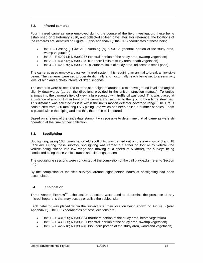
6.2. Infrared cameras Four infrared cameras were employed during the course of the field investigation, these being established on 2 February 2016, and collected sixteen days later. For reference, the locations of the cameras are identified on Figure 6 (also Appendix 6); the GPS coordinates of these being:
• Unit 1 – Easting (E) 431218; Northing (N) 6393756 (‘central’ portion of the study area, swamp vegetation)
• Unit 2 – E 429714; N 6393277 (‘central’ portion of the study area, swamp vegetation) • Unit 3 – E 431612; N 6393940 (Northern limits of study area, heath vegetation) • Unit 4 – E 429270; N 6393089. (Southern limits of study area, adjacent to small pond).
The cameras used employ a passive infrared system, this requiring an animal to break an invisible beam. The cameras were set to operate diurnally and nocturnally, each being set to a sensitivity level of high and a photo interval of 3/ten seconds. The cameras were all secured to trees at a height of around 0.5 m above ground level and angled slightly downwards (as per the directions provided in the unit’s instruction manual). To entice animals into the camera’s field of view, a lure scented with truffle oil was used. This was placed at a distance of around 1 m in front of the camera and secured to the ground by a large steel peg. This distance was selected as it is within the unit’s motion detector coverage range. The lure is constructed from 250 mm long PVC piping, into which has been drilled a number of holes. Foam is placed within the piping and into this, the truffle oil is poured. Based on a review of the unit’s date stamp, it was possible to determine that all cameras were still operating at the time of their collection. 6.3. Spotlighting Spotlighting, using 163 lumen hand-held spotlights, was carried out on the evenings of 3 and 18 February. During these surveys, spotlighting was carried out either on foot or by vehicle (the vehicle being placed into low range and moving at a speed of 5 km/hr), the surveys being conducted along those vehicle tracks and clearings present. The spotlighting sessions were conducted at the completion of the call playbacks (refer to Section 6.5). By the completion of the field surveys, around eight person hours of spotlighting had been accumulated. 6.4. Echolocation Three Anabat ExpressTM echolocation detectors were used to determine the presence of any microchiropterans that may occupy or utilise the subject site. Each detector was placed within the subject site; their location being shown on Figure 6 (also Appendix 6). The GPS coordinates of these locations are:
• Unit 1 – E 431500; N 6393884 (northern portion of the study area, heath vegetation) • Unit 2 – E 430986; N 6393601 (‘central’ portion of the study area, swamp vegetation) • Unit 3 – E 429718; N 6393243 (southern portion of the study area, woodland vegetation)
Lesryk Environmental Pty Ltd 11/05/16 19
Not to scale Source: Google Earth (2016)
Legend Red dot – Echolocation Green dot – Hair tube traps Blue dot – Infrared camera Purple dot – Call playback Yellow dot – Songmeter Figure 6. Fauna survey locations
Mungo Brush Road
Dark Point
Lesryk Environmental Pty Ltd 11/05/16 20
Being programmable and waterproof, the detectors were set to record microchiropteran calls between sunset (around 1957 hours at the time of the field investigation) and sunrise (around 0622) (i.e. ‘night only’ being the programmable option selected). The units were placed out on the site on 2 February 2016, and collected sixteen days later. Any calls recorded were analysed in house using Anabat 6.3 computer software. By the completion of the field investigation, around 175 hours of echolocation recording had been accumulated. 6.5. Call playbacks Nocturnal surveys were carried out within the subject site on the evenings of 3 and 18 February. Based on discussions held with NPWS representatives’ onsite (Brett Cann, NPWS, pers comm. 2/2/16), these indicating species which should be targeted, during each nocturnal session calls of the following species were broadcast:
• Koala (Phascolarctos cinereus) • Masked Owl (Tyto novaehollandiae).
The call playback sessions were carried out at four locations (Figure 6; Appendix 6), the GPS coordinates being:
• 1 – E 431074; N 6393660 (northern portion of the study area, Robinson’s Firetrail woodland vegetation)
• 2 – E 429360; N 6393046 (southern portion of the study area, Robinson’s Firetrail woodland vegetation)
• 3 – E 428879; N 6392772 (southern portion of the study area, Mungo Brush Road woodland vegetation)
• 4 – E 431335; N 6393581 (northern portion of the study area, Mungo Brush Road woodland vegetation)
Two call playbacks were conducted during each nocturnal session. In line with standard guidelines these were separated by a distance greater than 1 km (DEC 2004). The playback sessions involved broadcasting characteristic calls of each species being targeted through a loud hailer that was connected to an iPodTM. Prior to undertaking the call playbacks, a ten-minute listening period was carried out to determine if either of these species were present. The calls (which were taken from either Stewart 1999 or Buckingham and Jackson 1990) were then broadcast for five minutes per species. To detect any responses to the call playbacks, a ten-minute listening period was carried out at the completion of each playback session. The summer timing of the call playbacks was consistent with the recommended survey periods for those animals being targeted (DEC 2004, DE 2014). In total, an individual call playback session lasted for 30 minutes. 6.6. SongMeter To identify any of the vocal nocturnal species that occupy or may utilise the subject site, a Wildlife Acoustics SongMeterTM was employed (established at E 429367; N 6393066) (Figure 6; Appendix 6).

Lesryk Environmental Pty Ltd 11/05/16 21
In addition to the call playback method, the use of the SongMeter was carried out to target those threatened owls known to occur within the study region, as well as any other vocal fauna species. This device was set to record calls during three scheduled intervals, these being from:
• 1750 to 1950 • 0000 to 0100 • 0300 to 0400.
The SongMeterTM was placed out on the site on 3 February 2016, and collected fifteen days later. Calls were analysed in-house using Cornell Laboratory of Ornithology’s program ‘Raven Pro 1.4TM. 6.7. Hair-tube trapping Hair-tube trapping, using 20 FaunatechTM hair-tube traps, was carried out within the study area (Figure 6; Appendix 6). The hairtube traps were randomly placed throughout the subject site to ensure that each of the habitat types present were sampled. For reference, the GPS coordinates of the hair-tube trap are:
• E 431563; N 6393922 • E 431612; N 6393940 • E 431664; N 6393944 • E 431539; N 6393921 • E 431504; N 6393932 • E 431467; N 6393937 • E 429955; N 6393258 • E 429976; N 6393272 • E 429293; N 6393014 • E 429278; N 6393044 • E 429270; N 6393094 • E 429305; N 6393121 • E 429342; N 6393106 • E 429382; N 6393135 • E 430576; N 6393451 • E 430588; N 6393497 • E 430622; N 6393567 • E 431001; N 6393624 • E 430983; N 6393690 • E 430948; N 6393715.
Fifty percent of the hair-tube traps were baited with tuna, whilst the remainders were baited with the standard rolled oats, peanut butter and honey mixture. The traps were placed out sequentially (i.e. rolled oat mix, meat, rolled oat mix, meat etc.). The hair-tube traps were placed out on site on 3 February 2016, and collected fifteen days later. By the completion of the field surveys, 300 trapping nights had been accumulated. Any hairs collected from the hair-tube traps were sent to Ms Georgeanna Story of ‘ScatsAbout’ (Majors Creek, NSW) for analysis.

Lesryk Environmental Pty Ltd 11/05/16 22
6.8. Scat searches Scat searches were undertaken by traversing existing trails on foot, with any scats that contained hair or bone material being collected. These were sent to ScatsAbout for identification and analysis. For the purpose of this investigation, it is assumed that any species identified by this method were resident animals, as opposed to transient individuals that were traversing through the study area. Targeted searches (as per DE 2014) for scats characteristic of the Koala were undertaken in and adjacent to that section of the proposed road realignment that traverses the Swamp Mahogany – Broad-leaved Paperbark Open Forest and Forest Red Gum – Swamp Mahogany Open Forest vegetation communities. It is noted that Swamp Mahogany and Forest Red Gum are recognised as primary food tree species for the Koala in the North Coast Koala Management Area (DECC 2008). 6.9. Limitations No adverse weather conditions were encountered during the field investigation. Similarly, no seasonal constraints were encountered. During the field survey no significant limitations to the overall objectives of the site investigation were encountered. As it was tagged, identification of and access along the proposed alignment was possible, thereby ensuring that all habitat types present along and adjacent to this were sighted and sampled. Due to the existing network of firetrails, access to other portions of the study area was also possible. Though a range of fauna survey methods were employed it is acknowledged that no live trapping was carried out, as it was beyond the scope of the work required. Photographs of rodents were obtained, some of which could not be positively identified. If these rodents exhibited physiological features of a threatened species the precautionary approach was adopted. Not all animals and plants can be fully accounted for within any given subject site. The presence of threatened species is not static. It changes over time, often in response to longer term natural forces that can, at any time, be dramatically influenced by human-made disturbances. In order to overcome some of these limitations:
a) database searches were conducted for threatened species, populations and ecological communities known to occur within the region
b) the results of the previous investigations conducted in this locality were drawn upon. Where applicable, a ‘precautionary approach’ for species occurrence has been adopted. It is noted that this investigation was carried out during the peak survey period. The survey was carried out at a time when migratory birds were present in the region and a large number of plants were flowering. This report is based upon data acquired from previous and current surveys, however, it should be recognised that the data gathered is indicative of the environmental conditions of the site at the time the report was prepared. The above-mentioned constraints are not considered to compromise the scientific rigour of the field assessment.
Lesryk Environmental Pty Ltd 11/05/16 23
7. Results 7.1. Plant communities and fauna habitats Five vegetation communities were recorded within the study area, namely:
• Wallum Banksia Heath • Old Man Banksia Woodland • Swamp Mahogany – Broad-leaved Paperbark Open Forest • Forest Red Gum – Swamp Mahogany Open Forest • Ball Honeymyrtle Heath.
A brief description of each is provided below, with their distribution in the study area being illustrated on Figure 7. 7.1.1. Wallum Banksia Heath This is the most widespread community in the study area. It corresponds to the dry heath of RPS HSO (2009). It is dominated by a moderately dense to dense cover of Wallum Banksia (Banksia aemula) 2 m to 4 m in height with common co-dominants being Paperbark Tea-Tree (Leptospermum trinervium), Ball Honeymyrtle (Melaleuca nodosa), Black She-oak (Allocasuarina littoralis), Tree Broom-heath (Monotoca elliptica), Sweet-scented wattle (Acacia suaveolens) and Sydney Golden Wattle (A.longifolia). Lower shrubs to 1.5 m include Variable Bossiaea (Bossiaea heterophylla), Yellow Tea-tree (Leptospermum polygalifolium) and Drumsticks (Isopogon anemonifolius). The groundcover is generally sparse and is composed of a mixture of Bracken (Pteridium esculentum), graminoids and sub-shrubs. Common species are Flax-lily (Dianella caerulea var. product), the sedge Caustis recurvata, Rasp Wort (Gonocarpus teucrioides), Astroloma pinifolium, and Woolsia pungens. In some areas there are small emergent eucalypts such as Red Bloodwood (Corymbia gummifera) and Smooth-barked Apple (Angophora costata). No hollow-bearing plants were recorded within this vegetation type. No caves, sandstone outcropping, benches, ledges, crevices, weathered rock material or exposed rock slabs are present. Fallen branches are common, as are accumulations of ground debris and leaf litter. Conservation Significance This community corresponds to:
• Dry Heath of RPS HSO (2009) • Wallum Banksia-Monotoca scoparia heath on coastal sands of the Central Coast and
lower North Coast (OEH 2012a) • PCT 1703 of the same name in the NSW Master Plant Community Type Classification
(OEH 2016c). It is not part of any endangered ecological community listed on the TSC or EPBC Acts.

Lesryk Environmental Pty Ltd 11/05/16 24
Not to scale Source: Google Earth (2016)
Legend Figure 7. Vegetation communities recorded
Wallum Banksia Heath
Ball Honeymyrtle Heath Swamp Mahogany – Broad-leaved Paperbark Open Forest
Forest Red Gum – Swamp Mahogany Open Forest
Old Man Banksia Woodland
Lesryk Environmental Pty Ltd 11/05/16 25
7.1.2. Old Man Banksia Woodland This community occurs in the central part of the study area on old dunes. The canopy is dominated by Old Man Banksia (Banksia serrata) to 15 m tall with occasional and taller co-dominants being Red Bloodwood (Corymbia gummifera), Smooth-barked Apple (Angophora costata) and in ecotones with the Swamp Mahogany - Paperbark Forest, Forest Red Gum (Eucalyptus tereticornis) and Bangalay (E.botryoides). In the vicinity of Chainage 1600 there are also some Bastard Mahogany (E.robusta x tereticornis)2 present. Common shrub species are Sydney Golden Wattle, Blueberry Ash (Elaeocarpus reticulatis), Satinwood (Nematolepis squamea), Sweet-scented Wattle, Prickly Moses (Acacia ulicifolia), Tree Broom-heath and Giant Wedge-pea (Gompholobium latifolium). Occasionally, mesic species such as Red Ash (Alphitonia excelsa) and Corkwood (Endiandra sieberi) are present. Groundcover is generally dominated by Bladey Grass (Imperata cylindrica), Bracken and other species of the Wallum Banksia Heath. No hollow-bearing plants were recorded within this vegetation type. No caves, sandstone outcropping, benches, ledges, crevices, weathered rock material or exposed rock slabs are present. Fallen branches are common, as are accumulations of ground debris and leaf litter. Conservation Significance This community corresponds to:
• Coastal Blackbutt Smooth-barked Apple Open Forest of RPS HSO (2009) • Smooth-barked Apple - Blackbutt - Old Man Banksia woodland on coastal sands of the
Central and Lower North Coast of OEH (2012a) • PCT 1646 of the same name in the NSW Master Plant Community Type Classification
(OEH 2016c). It is not part of any endangered ecological community listed on the TSC or EPBC Acts. 7.1.3. Swamp Mahogany – Broad-leaved Paperbark Open Forest This community occurs on lower-lying, inundated peaty soil in the middle of the study area. The proposed alignment traverses around 400 m of this community. It is an open forest composed of varying densities of Swamp Mahogany (Eucalyptus robusta) and Broad-leaved Paperbark (Melaleuca quinquenervia) to 20 m tall with and Cabbage Tree Palm (Livistona australis) often present. Generally small trees and shrubs are absent apart from some Sieber’s Paperbark (Melaleuca sieberi) and Ball Honeymyrtle though there may be some Corkwood (Endiandra sieberi) and Cheese Tree (Glochidion ferdinandi) on slightly higher ground. The groundcover is characterised by dense growth of Saw Sedge (Gahnia clarkei) to 1.5 m tall and lower Tassel Cord Rush (Baloskion tetraphyllus subsp. meiostachyum), Swamp Water Fern (Blechnum indicum), Rainbow Fern (Calochlaena dubia) and Bracken Fern. Milk Vine (Marsdenia rostrata) and Pearl Vine (Stephania japonica) are common. No hollow-bearing plants were recorded within this vegetation type. No caves, sandstone outcropping, benches, ledges, crevices, weathered rock material or exposed rock slabs are present. Fallen branches are common, as are accumulations of ground debris and leaf litter.
2 Sometimes referred to as Eucalyptus patentinervis.

Lesryk Environmental Pty Ltd 11/05/16 26
Conservation Significance This community corresponds to:
• Swamp Forest of RPS HSO (2009) • Swamp Mahogany - Broad-leaved Paperbark - Swamp Water Fern - Plume Rush swamp
forest on coastal lowlands of the Central Coast and Lower North Coast of OEH (2012a) • PCT 1725 of the same name in the NSW Master Plant Community Type Classification
(OEH 2016c). It is part of the TSC Act listed endangered ecological community Swamp Sclerophyll Forest on Coastal Floodplains. 7.1.4. Forest Red Gum – Swamp Mahogany Open Forest This community occurs in a narrow band around the edge of the Swamp Mahogany - Broad-leaved Paperbark Open Forest on slightly higher ground that tends to be dry underfoot. It is probably not as extensive as indicated on Figure 7 as large parts of what is indicated are ecotones between this community and those downslope (Swamp Mahogany - Broad-leaved Paperbark Open Forest) and upslope of it (Old Man Banksia Woodland). The canopy is to 20 m and is composed of Forest Red Gum (Eucalyptus tereticornis) often with Swamp Mahogany and/or Old Man Banksia present. Unlike the Swamp Mahogany - Broad-leaved Paperbark Open Forest, smaller mesophyllic trees such as Blueberry Ash (Elaeocarpus reticulatis), Cheese Tree, Corkwood (Endiandra sieberi), Lilly Pilly (Acmena smithii) and lower shrubs such as Sydney Golden Wattle (Acacia longifolia), Coffee Bush (Breynia oblongifolia) and Mock Olive (Notelaea longifolia) are present. The groundcover is characterised by ferns, grasses and herbs such as Rainbow Fern (Calochlaena dubia), Bracken Fern, Weeping Meadow Grass (Microlaena stipoides), Basket Grass (Oplismenus imbecillus), Scurvy Weed (Commelina cyanea), Native Violet (Viola hederacea), Pennywort (Hydrocotyle peduncularis) and Pomax (Pomax umbellata). Several of those mature taller trees were noted to contain hollows (hollow diameter up to 150 mm). No caves, sandstone outcropping, benches, ledges, crevices, weathered rock material or exposed rock slabs are present. Fallen branches are common, as are accumulations of ground debris and leaf litter. Conservation Significance This community does not appear to have any matching community in the OEH (2012a) or the NSW Master Plant Community Type Classification (OEH 2016c). Although it has numerous species in common with the Swamp Sclerophyll Forest endangered ecological community and the Old Man Banksia Woodland, the presence of Forest Red Gum indicates this vegetation type is a component of the TSC Act listed endangered ecological community, Subtropical Coastal Floodplain Forest. 7.1.5. Ball Honeymyrtle Heath This community corresponds to the Wet Heath of RPS HSO (2009). It occurs along minor drainage lines and in low-lying areas amongst the Wallum Banksia Heath. It is composed of a dense cover of Ball Honeymyrtle (Melaleuca nodosa) along with Fern-leaf Banksia (Banksia oblongifolia), Prickly Tea-tree (Leptospermum juniperinum) 2 m to 4 m tall with lower Dagger Hakea (Hakea teretifolia) and Wallum Bottlebrush (Callistemon pachyphyllus) also common. The groundcover is characterised by moderately dense growth of Slender Twine-rush (Leptocarpus
Lesryk Environmental Pty Ltd 11/05/16 27
tenax) and Scale Rush (Lepyrodia scariosa), the sedge, Caustis recurvata, the herb, Goodenia hederacea and Coral Fern (Gleichenia dicarpa). No hollow-bearing plants were recorded within this vegetation type. No caves, sandstone outcropping, benches, ledges, crevices, weathered rock material or exposed rock slabs are present. Fallen branches are common, as are accumulations of ground debris and leaf litter. Conservation Significance This community corresponds to
• Fern-leaf Banksia - Prickly-leaved Paperbark-Tantoon - Leptocarpus tenax wet heath on coastal sands of the Central Coast and lower North Coast OEH (2012a)
• PCT 1704 of the same name in the NSW Master Plant Community Type Classification (OEH 2016c).
It is not part of any endangered ecological community listed on the TSC or EPBC Acts. 7.2. Fauna corridors and vegetation links With reference to the North Hawks Nest LES 2 Study Area Ecological Assessment (Eco Logical Australia Pty Ltd 2005), the study area is within a region where habitat connectivity has a high level of intactness and a low to high level of disturbance. The high level of intactness has resulted in strongly connected vegetation communities forming a robust fauna habitat corridor running north to south from the bushland around the township of Hawks Nest through to Myall River State Forest (Eco Logical Pty Ltd 2005) (Figure 8). The isthmus corridor provides a range of habitats and resources that support those threatened species that reside in the study area; with the lateral connectivity and integrity of vegetation communities along the north to south corridor also important to those threatened species likely, or that have the potential, to occur in the study area (Eco Logical Pty Ltd 2005). The Myall Lakes National Park is one of a series of conservation reserves and other protected areas that provide relatively continuous vegetated corridors. These corridors provide connectivity north and north-westwards through to Myall River State Forest, south-eastwards towards Tea Gardens and Hawks Nest, and north-eastwards through the Myall Lakes National Park. The connectivity of these corridors within the locality and wider region is important for the dispersal, movement, interbreeding and migratory needs of a number of native species. In relation to the corridor of which the study area forms a component, it is noted that the connectivity of this has been disturbed and fragmented due to the establishment of Mungo Brush Road itself (Figure 1, Figure 8). Some limitation exists to the east west movement of species, due to the existing north south aligned Mungo Brush Road. During the course of the field investigations a few road kills were observed, those that were noted being of ‘slow’ moving animals, species such as the reptiles, frogs and smaller birds [e.g. wrens]. Establishment of the new road is expected to result in an increase in road kills during the initial stages of its operation, though the native species that occupy the surrounding vegetation are expected to adapt to and be tolerant of the altered situation (essentially a mirroring of the existing situation). As such, these animals are expected to be able to adapt to the conditions presented by the proposed road.
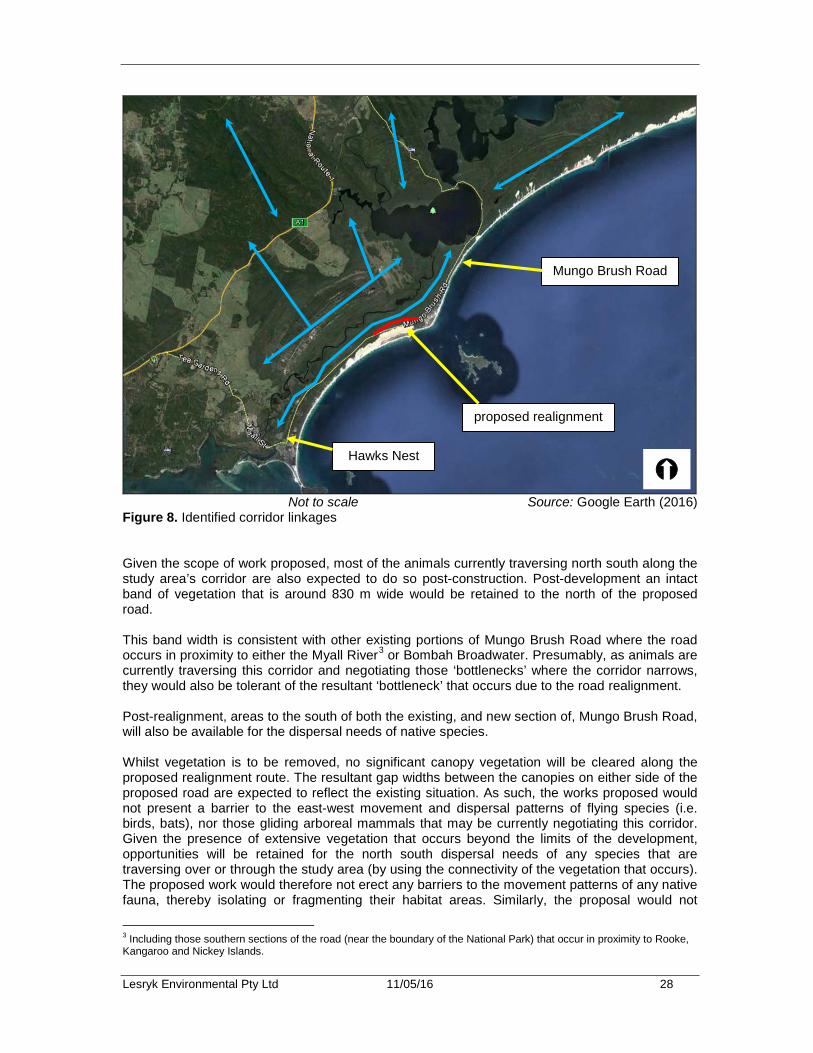
Lesryk Environmental Pty Ltd 11/05/16 28
Not to scale Source: Google Earth (2016)
Figure 8. Identified corridor linkages Given the scope of work proposed, most of the animals currently traversing north south along the study area’s corridor are also expected to do so post-construction. Post-development an intact band of vegetation that is around 830 m wide would be retained to the north of the proposed road. This band width is consistent with other existing portions of Mungo Brush Road where the road occurs in proximity to either the Myall River3 or Bombah Broadwater. Presumably, as animals are currently traversing this corridor and negotiating those ‘bottlenecks’ where the corridor narrows, they would also be tolerant of the resultant ‘bottleneck’ that occurs due to the road realignment. Post-realignment, areas to the south of both the existing, and new section of, Mungo Brush Road, will also be available for the dispersal needs of native species. Whilst vegetation is to be removed, no significant canopy vegetation will be cleared along the proposed realignment route. The resultant gap widths between the canopies on either side of the proposed road are expected to reflect the existing situation. As such, the works proposed would not present a barrier to the east-west movement and dispersal patterns of flying species (i.e. birds, bats), nor those gliding arboreal mammals that may be currently negotiating this corridor. Given the presence of extensive vegetation that occurs beyond the limits of the development, opportunities will be retained for the north south dispersal needs of any species that are traversing over or through the study area (by using the connectivity of the vegetation that occurs). The proposed work would therefore not erect any barriers to the movement patterns of any native fauna, thereby isolating or fragmenting their habitat areas. Similarly, the proposal would not
3 Including those southern sections of the road (near the boundary of the National Park) that occur in proximity to Rooke, Kangaroo and Nickey Islands.
Mungo Brush Road
Hawks Nest
proposed realignment

Lesryk Environmental Pty Ltd 11/05/16 29
isolate any interbreeding populations. 7.3. Flora species recorded By the completion of the flora survey, 87 native plants had been recorded (Appendix 3). It is noted that this is not intended to be a comprehensive list of all of the species present and only represents those plants that were recorded whilst:
• determining the vegetation community(ies) present • targeting the presence of threatened species, or their habitats.
Appendix 3 also includes some species recorded by RPS HAS (2015) and not observed during the current study. In regards to those species listed in Appendix 3, it is noted that none are:
• listed, or currently being considered for listing, on the Schedules to the EPBC or TSC Acts
• identified as a RoTAP. 7.3.1. Threatened species Whilst targeted searches for those threatened plants known to occur within the study region were carried out, none were recorded. Of the species listed in Appendix 2 the study area represents suitable habitat for four species, these being the:
• Magenta Lilly Pilly (Syzygium paniculatum) • Biconvex Paperbark (Melaleuca biconvexa) • Earp’s Gum (Eucalyptus parramattensis subsp. decadens) • Leafless Tongue-orchid (Cryptostylis hunteriana).
Each of these species is listed as vulnerable on the EPBC Act. Magenta Lilly Pilly is listed as endangered on the TSC Act while the other three species are listed as vulnerable. Magenta Lilly Pilly has been recorded in hind dunes near Hawks Nest and, at Seal Rocks, it has been found in “dense shrubland behind coastal sand dunes” and in littoral rainforest (OEH 2016a). Although littoral rainforest is regarded as its primary habitat (Floyd 1989, DE 2016c, Harden 2002, OEH 2016b), OEH (2016b) also includes Coastal Swamp Forest (Swamp Sclerophyll Forest) as a linked vegetation class in its profile of the species. Flora survey transects did not cover all the Coastal Swamp Forest in the study area. Weighing this against the fact that the study area’s Coastal Swamp Forest represents secondary habitat, it is considered that there is a low-moderate likelihood that the species occurs in the study area. Biconvex Paperbark has been recorded some 25 km north of the study area near Smiths Lake (OEH 2016a) in Swamp Sclerophyll Forest as indicated by (OEH 2012a) and in heathland near Salt Ash 35 km south-west (OEH 2016a). Previous surveys in Myall Lakes National Park (RPS 2015; Hunter 2015; Myerscough and Carolin 1986) have not detected the species. It is considered that there is a moderate likelihood the species occurs in the study area. Earp's Gum is endemic to the Hunter Region, with two distinct mega populations occurring at Cessnock-Kurri Kurri and on the Tomago Sandbeds with outliers either side of Port Stephens. It
Lesryk Environmental Pty Ltd 11/05/16 30
occurs in dry sclerophyll woodland on sandy soils, in low, often wet, sites (OEH 2016b). Nearby it has been recorded at two sites 7 km south-west of the study area (OEH 2016a) in what is mapped by OEH (2012a) as Wallum Banksia/Monotoca scoparia heath and Smooth-barked Apple/Blackbutt/Old Man Banksia woodland, vegetation types that occur in the study area. It is therefore considered that there is a moderate likelihood the species could occur in the study area. Leafless Tongue-orchid has a sporadic distribution along the coast in habitats including coastal heathlands and the margins of coastal swamps (OEH 2016b), both of which occur in the study area. The nearest records of the species are from Nelson Bay (18 km south) and Bulahdelah (20 km north-west) (OEH 2016a, DE 2016c). At Bulahdelah, its habitat included Swamp Mahogany vegetation associations (DE 2016c). In NSW, the species’ flowering season is between November to February (OEH 2016b), thus the current survey was carried out at a suitable time. However, not all parts of the species’ potential habitat in the study area were traversed nor does the species flower every year, therefore, it could be in the study area but not been detected. It is considered that there is a moderate likelihood the species occurs in the study area. In addition to these species, there is the possibility for two threatened flora species, that have been recorded outside the 10 km database search radius, to occur, these being:
• Trailing Woodruff (Asperula asthenes), which is listed as vulnerable on both the TSC and EPBC Acts
• Noah's False Chickweed (Lindernia alsinoides), which is listed as endangered on the TSC Act.
Trailing Woodruff has been recorded on the coast and hinterland from just north of Karuah (where there are numerous records of the species 19-21 km west of the site) to west of Macksville (OEH 2016a). It occurs in damp sites, often along river banks and Coastal Swamp Forest is one of the 16 vegetation classes with which it is associated. Noah's False Chickweed has been recorded sporadically north from near Bulahdelah (17 km north-west of the site) growing in swamp forests and wetlands along coastal and hinterland creeks (OEH 2016a, 2016b). Previous surveys in Myall Lakes National Park (RPS 2015; Hunter 2015; Myerscough and Carolin 1986) have not detected either of these species. However, both species are cryptic and suitable habitat for each is present. Therefore, it is considered that there is a moderate likelihood the species occurs in the study area. Seven-part tests have been conducted assessing the likely impacts the proposed road realignment would have on each of these species. RPS HSO (2009) mentioned Red Helmet-orchid (Corybas dowlingii) as a “species … known to the author as occurring within the locality” and that it could occur in the study area’s Wallum Banksia Heath. The nearest record of this species is Soldiers Point (OEH 2016a), some 20 km south-west of the area investigated. OEH (2016b) describes this species’ habitat as “sheltered areas such as gullies and southerly slopes in tall open forest on well-drained gravelly soil at elevations of 10-200 m” and that in the Hunter Central Rivers’ Catchment Management Authority area (which includes the study area) it is associated with Turpentine - Rough-barked Apple - Forest Oak moist shrubby tall open forest and Blackbutt - Narrow-leaved White Mahogany shrubby tall open forest, neither of which occur in the study area. It is considered unlikely that habitat for this species is represented in the study area. RPS HSO (2009) also considered that Chamaesyce psammogeton and Senecio spathulatus have habitat within the vegetation that would adjoin the sand dunes to the south of Mungo Brush Road. While this is correct, the proposed road realignment would not affect the southern sand dune habitats. Therefore, these species are not considered in the impact assessments.
Lesryk Environmental Pty Ltd 11/05/16 31
7.3.2. Noxious weeds Of those introduced species recorded, one is listed as a noxious weed in the Great Lakes LGA (as per the NW Act). This was Bitou Bush (Chrysanthemoides monilifera subsp monilifera), which occurs sporadically throughout the study area except for within very wet soils. Under the NW Act Bitou Bush’s is a locally controlled weed which has a control class of ‘4’ which requires that “the growth of the plant must be managed in a manner that continuously inhibits the ability of the plant to spread”. 7.4. Fauna species recorded As acknowledged in the limitations section of this report, some of the photographs obtained through use of the infrared cameras did not permit the positive identification of some species. Some of the photos obtained exhibited physiological features that suggested the presence of the Long-nosed Potoroo (Potorous tridactylus), New Holland Mouse (Pseudomys novaehollandiae) and Eastern Chestnut Mouse (Pseudomys gracilicaudatus). As these species have been recorded in the study region, given their conservation status, a precautionary approach has been adopted. Therefore, by the completion of the field investigation, 19 native mammals, 53 native birds, seven reptiles, five amphibians and one fish was recorded, or detected as occurring, within, or close to, the subject site (Appendix 4). In addition, a number of introduced species were also detected. In regards to the detection of those native species recorded:
• Brown Antechinus (Antechinus stuartii) hairs were obtained through use of hairtube traps. • The Northern Brown (Isoodon macrourus) and Long-nosed Bandicoot (Perameles
nasuta) were identified through use of the infrared cameras. In addition, the Northern Brown Bandicoot was also identified through use of both the hairtube traps and scat analysis.
• The Common Ringtail Possum (Pseudocheirus peregrinus) was spot lit. • The Long-nosed Potoroo, New Holland Mouse, Eastern Chestnut Mouse, Swamp
Wallaby (Wallabia bicolor), Swamp Rat (Rattus lutreolus) and Eastern Long-necked Turtle (Chelodina longicollis) were all identified through use of the infrared cameras. In addition, the Swamp Wallaby was identified through use of hairtube traps and scat analysis.
• The Dingo (Canis lupus dingo) was observed as well as identified through use of the infrared cameras.
• All microchiropterans were identified through the analysis of those echolocation calls obtained.
• All of the birds were observed adjacent to, or flying over, the subject site, or identified from their distinct calls.
• The Dark-flecked Garden Sun-skink (Lampropholis delicata), Jacky Lizard (Amphibolurus muricatus), Eastern Water Dragon (Intellagama lesueurii) and Lace Monitor (Varanus varanus) were either incidentally observed or recorded during the ground debris, bark and litter searches; whilst the Marsh Snake (Hemiaspis signata) was hand captured within the swamp habitat.
• A vehicle struck Death Adder (Acanthophis antarcticus) was collected from Mungo Brush Road in the vicinity of the Hawks Nest Golf Course.
• All amphibians were heard calling during the nocturnal investigation • The Eel (Anguilla sp.) was observed in one of the wetland ponds present south of Duck
Hole Firetrail.
Lesryk Environmental Pty Ltd 11/05/16 32
Fourteen carnivore scats were collected. Analysis of these indicated that Foxes (Vulpes vulpes) were preying on/had fed upon Northern Brown Bandicoots, Swamp Wallabies, Black Rats (Rattus rattus), skinks (unidentifiable), insects (beetles and grasshoppers), birds (unidentifiable) and crustacean (unidentifiable) whilst Dingos were feeding upon Swamp Wallabies, Rabbits (Oryctolagus cuniculus), birds and crustacean. Though considered, no scats characteristic of the Koala or any regurgitated owl pellets were collected. The non-threatened native species recorded during the field investigation are all protected, as defined by the NPW Act, but considered to be common to abundant throughout, and well conserved within, the surrounding conservation reserve. These species would not be solely reliant upon those habitats present within, or close to the proposed road alignment, such that the removal or disturbance of these would threaten the local occurrence of these animals. The species recorded are all expected to be present within the study area and surrounds post-work. 7.4.1. Threatened species Of those native species recorded, six are listed as vulnerable on the Schedules to the EPBC and/or TSC Acts, whilst three are listed as Migratory under the EPBC Act, these being:
• Long-nosed Potoroo (vulnerable under the TSC and EPBC Acts) • Little Bentwing Bat (Miniopterus australis) (vulnerable under the TSC Act) • Eastern Falsistrelle (Falsistrelle tasmaniensis) (vulnerable under the TSC Act) • Eastern Chestnut Mouse (vulnerable under the TSC Act) • New Holland Mouse (vulnerable under the EPBC Act) • Eastern Osprey (Pandion cristatus) (vulnerable under the TSC Act; migratory under the
EPBC Act) • Great Egret (Ardea alba) (migratory under the EPBC Act) • Rufous Fantail (Rhipidura rufifrons) (migratory under the EPBC Act).
For reference, a description of these species’ habitat requirements has been provided below. Of the 41 threatened species identified as potentially occurring (Appendix 2), six were recorded during the field investigation. Based on observations of those habitats present, and as they have been previously recorded in the study area in association with these habitats, it is considered necessary to adopt the precautionary principle and assume the presence of the:
• Spotted-tail Quoll (Dasyurus maculatus), which is listed as endangered under the EPBC Act and vulnerable under the TSC Act
• Koala – vulnerable, EPBC and TSC Acts and also listed as an Endangered Population in the Hawks Nest and Tea Garden area under the TSC Act
• Eastern Pygmy-possum (Cercartetus nanus) – vulnerable, TSC Act • Squirrel Glider (Petaurus norfolcensis) – vulnerable, TSC Act • Rufous Bettong (Aepyprymnus rufescens) – vulnerable, TSC Act • Grey-headed Flying-fox (Pteropus poliocephalus) – vulnerable, EPBC and TSC Acts • Glossy Black-cockatoo (Calyptorhynchus lathami) – vulnerable, TSC Act • Little Lorikeet (Glossopsitta pusilla) – vulnerable, TSC Act • Swift Parrot (Lathamus discolour) – endangered, EPBC and TSC Acts • Varied Sittella (Daphoenositta chrysoptera) – vulnerable, TSC Act • Wallum Froglet (Crinia tinnula) – vulnerable, TSC Act.
Assessments using the criteria provided under the EPBC Act (i.e. Significant Impact Guidelines) and Part 1, Section 5A of the EPA Act (i.e. The Assessment of Significance or, as it is commonly
Lesryk Environmental Pty Ltd 11/05/16 33
known as, the seven-part test) have been carried out on those threatened species recorded or potentially occurring within the study area (Appendix 7 and 8). It is noted that, whilst targeted:
• Neither the Koala nor Masked Owl responded during the call playback sessions. Neither of these species was heard calling during the spotlighting sessions and no calls for either species were recorded by the SongMeterTM. Use of the SongMeter indicated the presence of Australian Owlet-nightjar (Aegotheles cristatus). This species and the Tawny Frogmouth (Podargus strigoides), which was spotlit, were the only nocturnal birds detected.
• No Large-eared Pied Bat (Chalinolobus dwyeri) or East-coast Freetail Bat (Micronomus norfolkensis) individuals were recorded by the echolocation detectors.
• No medium sized native mammals were recorded by the infrared cameras or hair tube traps used.
In relation to the remaining threatened species listed in Appendix 2, though previously recorded within the locality, it is noted that the subject site does not contain suitable habitat for any of these animals. As such, no locally viable populations of these species would be present within, or in close proximity to, the subject site. Whilst one or more of these species may fly over the subject site on occasion, none are considered to be reliant on the vegetation and habitat to be removed. Therefore, as no locally viable populations of these animals would be present, it is not considered that the undertaking of the proposal would have an adverse impact on any of these species, their populations or habitats. It is noted that, of those species recorded, seven are listed as occurring within a Family (Families as in the Taxonomic classification system) of birds listed as migratory under the EPBC Act, these being:
• Pacific Black Duck (Anas superciliosa) • Grey Teal (Anas gracilis) • Eastern Osprey • Whistling Kite (Haliastur sphenurus) • Brahminy Kite (Haliastur indus) • Brown Goshawk (Accipiter fasciatus) • Masked Lapwing (Vanellus miles).
Although listed as occurring within a Family of migratory birds, none of these birds are considered to be migratory within Australia. As such, no further assessment (i.e. giving consideration to the Significant Impact Guidelines provided in association with the EPBC Act for a migratory species) is required for these species. 7.4.1. (a) Long-nosed Potoroo - vulnerable species (TSC and EPBC Acts) The Long-nosed Potoroo is found on the south-eastern coast of Australia, from Queensland to eastern Victoria and Tasmania, including some of the Bass Strait islands (OEH 2016b). It is historically thought that this species inhabited a range of habitats with a dense vegetation cover, such as rainforests or heathlands, now it is assumed that the dense cover provides diurnal sheltering sites and protection from predators while foraging occurs more often in adjacent, open areas (Van Dyck and Strahan 2008). Appears to be restricted to coastal heaths and forests east of the Great Dividing Range; in areas where the annual rainfall exceeds 760 mm (OEH 2016b). Within the dense vegetation cover, the Long-nosed Potoroo forms a shallow depression under grass tussocks, next to logs or in dense grassy patches in which to shelter (Strahan 2008).
Lesryk Environmental Pty Ltd 11/05/16 34
Feeding predominantly on fungi, they also eat roots, tubers, insects and their larvae and other soft-bodied animals in the soil (OEH 2016b). Often digs small holes in the ground in a similar way to bandicoots (OEH 2016b). Long-nosed Potoroos are not territorial but occupy stable, overlapping home ranges (Victoria Department of Environment and Primary Industries 2013 p1). In south-western Victoria, home ranges of Long-nosed Potoroos had values of 1 - 3 ha for females and 2 - 4 ha for males (Victoria Department of Environment and Primary Industries 2013, DE 2016c). Threats to this species include predation by a range of carnivore species, as well as the removal of suitable habitat by land clearing, forest fragmentation and extensive disturbance (OEH 2016b). This species dependence on fungi also appears to increase its vulnerability to such impacts as logging, habitat clearing and fire (OEH 2016b). The Long-nosed Potoroo was recorded through use of the unit 3 infrared camera (Figure 6, Figure 9). This camera was located within 200 m of the existing alignment of Mungo Brush Road. The occurrence of this species is not considered to be significantly affected by the disturbance and removal of a linear strip of native vegetation that totals 7.82 ha. Beyond the limits of the study area, and within the surrounding conservation reserve, suitable habitat is present, the occurrence of this providing long term resources for this species. In the locality, the scope of work proposed would not significantly affect any of this species’ habitat type, such that the presence of the Long-nosed Potoroo would be adversely affected. To further consider the impacts the proposal may have on this species, assessments drawing on the criteria provided under Part 1, Section 5A of the EPA Act, and in association with the EPBC Significant Impact Guidelines that are relevant to a vulnerable species, have been referred to (Appendix 7 and 8). 7.4.1. (b) Little Bentwing Bat – vulnerable species (TSC Act) The Little Bentwing Bat is distributed along the coasts and ranges of eastern Australia from central New South Wales, to Cape York, Queensland (Churchill 2008, Van Dyck and Strahan 2008). Within this area this species forms some of the largest aggregations of cave dwelling bats, with up to 200 000 individuals being recorded in one nursery site (Van Dyck and Strahan 2008). This species forages for insects within well-timbered habitats such as tropical rainforests, wet and dry sclerophyll forests and melaleuca swamps (Van Dyck and Strahan 2008). Roosting occurs predominantly within caves, though it will use abandoned mines, storm water drains and disused buildings when available (Churchill 2008, Van Dyck and Strahan 2008). Often found sharing roosts with the Eastern Bentwing Bat, this species faces similar threats through loss of suitable nursery and winter caves (Churchill 2008, Van Dyck and Strahan 2008). Females are known to move up to 200 km from their over-wintering roosts (Van Dyck and Strahan 2008). Indicative calls of the Little Bentwing Bat were recorded through use of those echolocation units that were placed within the central, and southern, portions of the study area (Figure 6; Figure 9). The earliest recorded call (of confidence) was at 2201 hours (around two hours after sunset); this obtained by unit 2. The detection of an individual at this time would indicate that this bat was traversing over the site as opposed to leaving a roosting site on sunset. Calls indicative of this species were recorded during several evenings, indicating that this species is a resident animal within this locality. However, it is noted that within, and in close proximity to, the study area, no caves or suitable cave substitutes for this species’ roosting requirements are present. As such, the proposed work is not expected to result in the removal of any roosting or breeding sites occupied by this species.
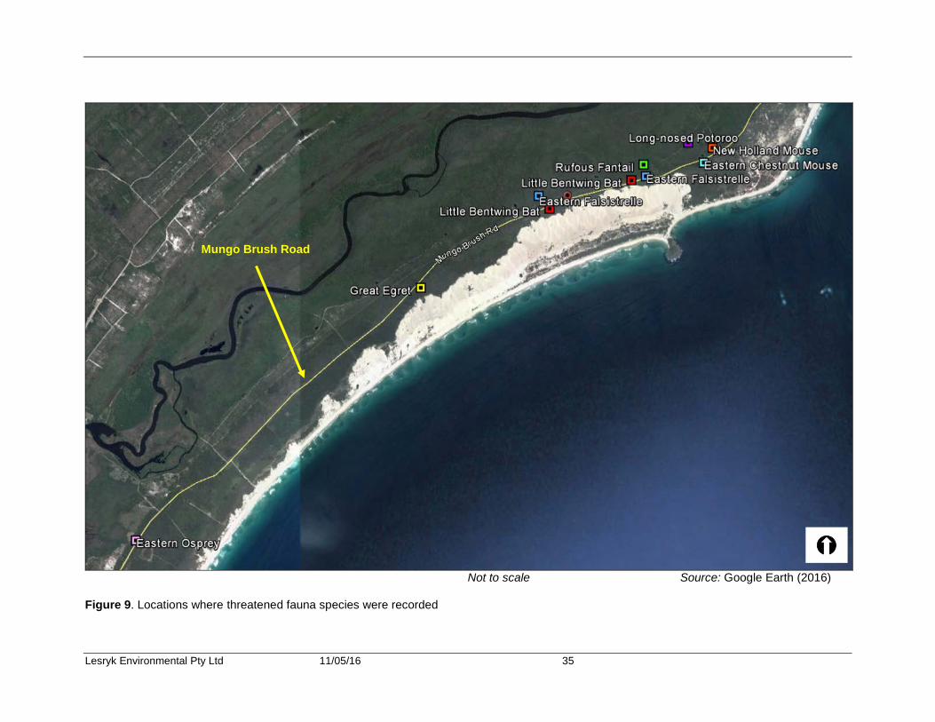
Lesryk Environmental Pty Ltd 11/05/16 35
Not to scale Source: Google Earth (2016)
Figure 9. Locations where threatened fauna species were recorded
Mungo Brush Road
Lesryk Environmental Pty Ltd 11/05/16 36
Foraging resources for this bat, in the form of insect attracting plants, are present within the subject site. In regards to the lifecycle requirements of this species, the proposed work would result in the removal of around 7.82 ha of native vegetation, this including insect attracting plants. As such, the proposal would result in the removal of a portion of this species’ foraging habitat. Whilst this is the case, given the amount of similar foraging resources available within Myall Lakes National Park, the impact on this bat and its local population is considered to be negligible. Nevertheless, an assessment drawing on the criteria provided under Part 1, Section 5A of the EPA Act has been carried out (Appendix 8). 7.4.1. (c) Eastern Falsistrelle – vulnerable species (TSC Act) The Eastern Falsistrelle is distributed southwards from south-eastern Queensland, along both the coast and Great Dividing Range through to western Victoria and Tasmania (Churchill 2008). Generally roosting in hollow trunks of eucalypt trees, this species has also been recorded within caves in the Jenolan area (NSW) and cave substitutes (e.g. buildings) (Churchill 2008, Van Dyck and Strahan 2008). On the mainland they are found in wet sclerophyll and coastal mallee; preferring tall and wet forests where trees are more than 20 m high and the understorey is dense (Churchill 2008). Known home ranges are in the order of 136 ha (Churchill 2008). Roosting sites appear to be altered on a daily basis, with distance of 750 m to 3.5 km between successive roosting areas being recorded (Churchill 2008). The Eastern Falsistrelle feeds on a variety of insects usually collected from around, or just below, the tree canopy (OEH 2016b). This species hibernates in winter (OEH 2016b). The main threat to the survival of this species is expected to be the loss of suitable roosting trees (OEH 2016b). Indicative calls of the Eastern Falsistrelle were recorded through use of those echolocation units that were placed within the central and southern portions of the study area (Figure 6; Figure 9). The earliest recorded call was at 2043 hours (this being probable4) (around 46 minutes after sunset); this obtained by unit 2. Given the climatic conditions experienced at the time of the field investigation, the detection of an individual at this time would indicate that this bat was traversing over the site as opposed to leaving a roosting site on sunset. Hollow-bearing trees were identified within, adjacent to, and beyond the limits of the subject site. Hollow-bearing trees were also observed at other locations within Myall Lakes National Park. Foraging resources, in the form of insect attracting plants, suitable for this bat are present within the subject site. The proposal is expected to result in the removal of 7.82 ha, this including possible roosting and foraging habitat. Whilst this is the case, given the amount of similar foraging resources available with the surrounding national park, this including hollow-bearing trees, sheltering and foraging opportunities would be retained within the study area and surrounding region. Whilst the proposed work is not considered to have an adverse impact on the viability of a local population of this species, to further consider the impacts of the proposal on the Eastern Falsistrelle, an assessment drawing on the criteria provided under Part 1, Section 5A of the EPA Act has been carried out (Appendix 8).
4 Some possibility of confusion of calls with those of other bat species.

Lesryk Environmental Pty Ltd 11/05/16 37
7.4.1. (d) Eastern Chestnut Mouse - vulnerable species (TSC Act) Throughout NSW the Eastern Chestnut Mouse mainly occurs along the eastern coast, north of the Hawkesbury River extending into Queensland; with isolated records in the Jervis Bay area (OEH 2016b). This species is mostly found in low numbers in heathland, and is most common in dense, wet heath and swamps (OEH 2016b). Optimal habitat appears to be in vigorously regenerating heathland burnt from 18 months to four years previously; as by the time the heath is mature, the larger Swamp Rat becomes dominant, and Eastern Chestnut numbers decline (OEH 2016b). The Eastern Chestnut Mouse feeds at night via runways through the grassy and sedge understorey (OEH 2016b). It has a broad diet of grass stems, invertebrates, fungi and seeds (OEH 2016b). Threats to the survival of this species include direct predation by cats and dogs, loss of habitat to agriculture and development, and long-term fire exclusion from its habitat heavily favouring the competing Swamp Rat (OEH 2016b). The ‘potential’ identification of this species was through use of the unit 3 infrared camera (Figure 6, Figure 9). This camera was located within a portion of the subject site that is regenerating post-fire. The occurrence of this species is not considered to be significantly affected by the disturbance and removal of around 7.82 ha of native vegetation. Beyond the limits of the study area, and within the surrounding national park, suitable habitat is present, the occurrence and regular management through the implementation of hazard reduction burns of this providing resource for this species. In the locality, the scope of work proposed would not affect any significant area of this species’ habitat type, such that the presence of the Eastern Chestnut Mouse would be adversely affected. To further consider the impacts the proposal may have on this species, assessments drawing on the criteria provided under Part 1, Section 5A of the EPA Act have been referred to (Appendix 8). 7.4.1. (e) New Holland Mouse - vulnerable species (EPBC Act) The New Holland Mouse has a fragmented distribution across Tasmania, Victoria, NSW and Queensland (DE 2016c). The species is now largely restricted to the coast of central and northern NSW, with one inland occurrence near Parkes (DE 2016c). The New Holland Mouse has been found from coastal areas and up to 100 km inland on sandstone country (DE 2016c). The species has been recorded from sea level up to around 900 m ASL (DE 2016c). Soil type may be an important indicator of suitability of habitat for the New Holland Mouse, with deeper top soils and softer substrates being preferred for digging burrows (DE 2016c). Across the species' range, the New Holland Mouse is known to inhabit the following habitat types:
• open heathland • open woodland with a heathland understorey • vegetated sand dunes.
Due to the largely granivorous diet of the species, sites where the New Holland Mouse are found are often high in floristic diversity, especially leguminous perennials (DE 2016c). The New Holland Mouse is listed as vulnerable under the EPBC Act as its geographic distribution is precarious for its survival and the estimated total number of mature individuals is limited and is likely to continue to decline (TSSC 2009). It is noted, however, that this species is not listed under the TSC Act. With reference to s266B of the EPBC Act, under approved conservation advice for the New Holland Mouse, the conservation status of this species is listed as secure under the TSC Act (DE 2010).
Lesryk Environmental Pty Ltd 11/05/16 38
The New Holland Mouse was recorded through use of the unit 3 infrared camera (Figure 6, Figure 9). The occurrence of this species is not considered to be significantly affected by the disturbance and removal of around 7.82 ha of native vegetation. Beyond the limits of the study area, and within the surrounding national park, suitable habitat is present, the occurrence of this providing resources for this species. In the locality, the scope of work proposed would not affect any of this species’ habitat type, such that the presence of the New Holland Mouse would be adversely affected. To further consider the impacts the proposal may have on this species, the assessment criteria provided in association with the EPBC Significant Impact Guidelines that are relevant to a vulnerable species have been referred to (Appendix 7). 7.4.1. (f) Eastern Osprey – vulnerable and migratory species (TSC and EPBC Acts) The Osprey is a large, water dependent, fish eating raptor (OEH 2016b). Eastern Ospreys are found right around the Australian coast line, except for Victoria and Tasmania (OEH 2016b). They are common around the northern coast, especially on rocky shorelines, islands and reefs (OEH 2016b). Eastern Ospreys occur in littoral and coastal habitats and terrestrial wetlands of tropical and temperate Australia and offshore islands (DE 2016c). They require extensive areas of open fresh, brackish or saline water for foraging (DE 2016c). They frequent a variety of wetland habitats including inshore waters, reefs, bays, coastal cliffs, beaches, estuaries, mangrove swamps, broad rivers, reservoirs and large lakes and waterholes (DE 2016c). They exhibit a preference for coastal cliffs and elevated islands in some parts of their range (DE 2016), but may also occur on low sandy, muddy or rocky shores and over coral cays (DE 2016c). This species normally builds a huge stick nest either in a large, dead tree, on a rocky outcrop or on the ground, though artificial structures have also been known to be utilised (Simpson and Day 2010). Nest sites may be used over many years by one or more pairs (DE 2016c). Within NSW the population of Osprey has increased over the last 20 years to 140 nesting pairs (Moffatt 2009). Despite this recovery the state population is still less than 300 birds and coastal development and global warming continue to threaten the coastal environment (Clancy 2009). The Eastern Osprey was observed roosting on powerlines immediately south of the southern limits of Myall Lake National Park at E 424064; N 6388499 (Figure 9). The Eastern Osprey was seen on the morning of 19 February 2016. It is noted that no nests typical of this species were observed within the area investigated. The scope of work proposed would not remove or disturb any significant resources relied upon by this species, nor would the work present any barriers to the movement patterns of this bird. As such, it is considered that the work would not have a significant effect on the Eastern Osprey. To further consider the impacts the proposal may have on this species, an assessment drawing on the criteria provided under Part 1, Section 5A of the EPA Act and in association with the EPBC Significant Impact Guidelines that are relevant to a migratory species have been referred to (Appendix 7 and 8). 7.4.1. (g) Great Egret - migratory species (EPBC Act) The Great Egret is a solitary and territorial waterbird that forages within waters up to 30 centimetres deep (Frith 2007). The Great Egret is found throughout Australia in association with lakes, swamps, rivers and dams (Frith 2007). Though listed under the international migratory bird agreement, the Great Egret is a sedentary bird that does not migrate northwards during the winter
Lesryk Environmental Pty Ltd 11/05/16 39
months. Breeding between the months of October and December and March to May, the Great Egret constructs a stick nest within trees at a height of up to 15 metres (Frith 2007). The Great Egret was observed within the Stewart and Lloyds campground, south of Mungo Brush Road (Figure 9). The habitat here would not be disturbed by the scope of work proposed. During the field surveys, no individuals were observed within the subject site. In the locality, the scope of work proposed would not affect any of this species’ habitat type, such that the presence of the Great Egret would be adversely affected. Adjacent to the area investigated, beyond the limits of and in the surrounding region, suitable habitat is present, the occurrence of this providing foraging and roosting opportunities for this migratory species. Whilst no impacts on the presence of this species are considered to arise, to further consider the impact of the proposal on this species an assessment using the EPBC Significant Impact Guidelines that are relevant to a migratory species has been carried out (Appendix 7). 7.4.1. (h) Rufous Fantail - migratory species (EPBC Act) The Rufous Fantail migrates south from north-eastern Queensland and New Guinea to breed within the southern states during the summer months (October to February) (Frith 2007). Generally, this species inhabits rainforests, moist sclerophyll forests and vegetated riparian corridors along the east coast and ranges (DE 2016c). This bird forages on a variety of insects that occur within the shrub layers of its preferred habitat type (Frith 2007). The Rufous Fantail was observed whilst traversing along the proposed road alignment (at E 431084; N 6393622) (Figure 9). Whilst no evidence was obtained during the field investigations, this species may be nesting within the native shrublands of the study area and surrounding region. Although this is the case, it is not considered that the potential breeding presence of this migratory bird would be a constraint to the realignment of Mungo Brush Road. In regards to the foraging requirements of this species, the proposed work would result in the removal of around 7.82 ha of native vegetation, this including insect attracting plants. Whilst this is the case, given the amount of foraging resources available within the adjacent national park; and that which would be retained within the subject site itself, it is considered that the proposed work would not have a significant effect on this species. Whilst no impacts on the presence of this species are expected to arise, to further consider the impact of the proposal on this species an assessment using the EPBC Significant Impact Guidelines that are relevant to a migratory species has been carried out (Appendix 7). 8. Legislative considerations 8.1. Commonwealth - Environment Protection and Biodiversity Conservation Act 1999 By the completion of the field investigations, the following MNES listed on this Act had been noted/recorded:
• the subject site occurs within the Myall Lakes Ramsar Wetland site • Long-nosed Potoroo, listed as vulnerable, was photographed • New Holland Mouse, listed as vulnerable (photographed) • Great Egret, listed as migratory (observed) • Eastern Osprey, listed as migratory (observed) • Rufous Fantail, listed as migratory (observed).
Lesryk Environmental Pty Ltd 11/05/16 40
Additionally, as they have been previously recorded in the region, and as suitable habitat was present, a precautionary approach has been adopted in regards to the occurrence of the following flora and fauna species:
• Magenta Lilly Pilly, listed as vulnerable • Biconvex Paperbark, listed as vulnerable • Earp’s Gum, listed as vulnerable • Leafless Tongue-orchid, listed as vulnerable • Spotted-tailed Quoll, listed as endangered • Koala, listed as vulnerable • Grey-headed Flying-fox, listed as vulnerable • Swift Parrot, listed as endangered.
Though not recorded within 10 km of the subject site, as suitable habitat is present, a precautionary approach was also adopted in regards to the presence of:
• Trailing Woodruff listed as vulnerable. Due to the similarity of their habitat requirements, Magenta Lilly Pilly, Biconvex Paperbark and Trailing Woodruff were assessed together. The migratory birds were also assessed together. With reference to the Significant Impact Guidelines prepared under the EPBC Act (DE 2013), assessments for Wetlands of international Importance, migratory, endangered and vulnerable species were undertaken to determine whether the action (i.e. the proposed realignment of Mungo Brush Road) has, will have, or is likely to have a significant impact on these MNES (Appendix 7). The assessments concluded that the proposed road realignment would not have a significant impact on a MNES. Referral of the matter to the Federal Minister for the Environment for further considersation or approval is not required. 8.2. State - Environmental Planning and Assessment Act 1979 Part 1, Section 5A of the EPA Act requires the consideration of the impacts of a proposed action on threatened species, populations and communities listed under the TSC Act. These criteria are designed to determine whether there is likely to be a significant effect on these threatened species and communities, or their habitats, and consequently whether a SIS is required. During the course of the field investigations, the following endangered ecological communities and threatened species were recorded within, or in close proximity to, the area investigated:
• Swamp Sclerophyll Forest • Subtropical Coastal Floodplain Forest • Long-nosed Potoroo • Little Bentwing Bat • Eastern Falsistrelle • Eastern Chestnut Mouse • Eastern Osprey.
Additionally, as they have been previously recorded in the region and as suitable habitat for their lifecycle requirements are present, a precautionary approach has been adopted in regards to the occurrence of the:
• Magenta Lilly Pilly • Biconvex Paperbark • Earp’s Gum
Lesryk Environmental Pty Ltd 11/05/16 41
• Leafless Tongue-orchid • Spotted-tailed Quoll • Koala • Eastern Pygmy-possum • Squirrel Glider • Rufous Bettong • Grey-headed Flying-fox • Glossy Black-cockatoo • Little Lorikeet • Swift Parrot • Varied Sittella • Wallum Froglet.
Though not recorded within 10 km’s of the subject site, as suitable habitat is present, a precautionary approach was also adopted in regards to the presence of:
• Trailing Woodruff • Noah’s False Chickweed.
In line with the seven-part test guidelines (DECC 2007), due to the similarity of their habitat requirements, Magenta Lilly Pilly and Biconvex Paperbark have been assessed together. Assessments drawing on the criteria provided under Part 1, Section 5A of the EPA Act were undertaken on the endangered ecological communities and threatened species recorded or considered likely to occur (Appendix 8). These assessments concluded that the proposed road realignment would not have a significant effect on an ecological community, threatened species, population, or their habitats. Consequently, the preparation of a SIS that further considers the impacts of the proposal on these State significant matters was not recommended. 9. Conclusion The study area is within the Myall Lakes Wetland of International Importance under the Ramsar Convention and thus is a MNES under the EPBC Act. The proposed road realignment would result in the permanent loss of around 7.82 ha of native vegetation representing less than 0.02% of the Myall Lakes Ramsar site. Of this 7.82 ha, 1.73 ha of wetland vegetation would be removed, which represents less than 0.03% of the 6000 ha of the wetland group within which the affected vegetation types are grouped. Given the small area affected, the small percentage that it represents of the Ramsar site (and the relevant wetland group affected), as well as proposed mitigation measures and ongoing management that will together minimise likely impacts, it is considered that the proposed road realignment would not have a significant impact on the ecological character of the wetland. Therefore, in relation to this MNES, there is no requirement to refer the proposal to the Federal Minister of the Environment as a controlled action. By the completion of the flora component of the field survey, two endangered ecological communities listed on the TSC Act had been recorded in the study area. These were Swamp Sclerophyll Forest and Subtropical Coastal Floodplain Forest. The proposed road realignment would remove around 1.34 hectares of Swamp Sclerophyll Forest, representing around 0.34% of the remnant within which it is located. Approximately 0.05 hectares of Subtropical Coastal Floodplain Forest would be affected representing 2% of the remnant within which it is located. It is considered unlikely that this would adversely affect the extent or composition of these communities such that their local occurrence would be placed at risk of extinction. Therefore, there is no requirement for the preparation of a SIS in relation to these endangered ecological communities.
Lesryk Environmental Pty Ltd 11/05/16 42
No threatened flora species were recorded nor were any detected in the study area by RPS HSO (2009). The study area is considered to support potential habitat for the State and federally listed threatened flora species, Magenta Lilly Pilly, Biconvex Paperbark, Trailing Woodruff, Earp’s Gum and Leafless Tongue-orchid and the State listed Noah's False Chickweed. It is considered unlikely that the proposed road realignment would have a significant effect on these species, or their habitats. Therefore, there is no requirement for the preparation of a SIS or a referral to the Federal Minister of Environment in relation to these species. By the completion of the fauna component of the field investigation, eight threatened and/or migratory species listed under the TSC and EPBC Acts were recorded within and/or in close proximity to the subject site, these being the:
• Long-nosed Potoroo • Little Bentwing Bat • Eastern Falsistrelle • Eastern Chestnut Mouse • New Holland Mouse • Great Egret • Eastern Osprey • Rufous Fantail.
In addition, it was considered necessary, based on habitat and previous records, to adopt the precautionary principle and assume the presence of the Spotted-tailed Quoll, Koala, Eastern Pygmy-possum, Squirrel Glider, Rufous Bettong, Grey-headed Flying-fox, Glossy Black-cockatoo, Little Lorikeet, Swift Parrot, Varied Sittella and Wallum Froglet. With reference to the assessment criteria provided under Part 1, Section 5A of the EPA Act, and the Significant Impact Guidelines prepared under the EPBC Act, the proposal is not considered to have a significant impact on any of these species, their habitat or life-cycle requirements. The proposal is not considered to have an adverse impact on any ecological communities, threatened species, or their populations, of State or national conservation significance. Referral of the matter to the Federal Minister for the Environment for further consideration or approval in relation to the proposal would not be necessary. Similarly, the preparation of a SIS is not required. Realignment of a 3.2 km section of Mungo Brush Road would not fragment or isolate any areas of habitat available to those species recorded or expected. The realigned section of road would not present a barrier to the dispersal patterns of those species likely to be traverse along the Mungo Brush isthmus. The proposal would reduce the existing width of the corridor in the vicinity of the realigned section of road. Whilst this is the case, the resultant band width of vegetation would be equivalent to similar ‘bottlenecks’ that are present at other locations along the isthmus. Native species are expected to be negotiating these ‘bottlenecks’ and would therefore be tolerant or, and adaptable to, the resultant conditions once a section of Mungo Brush Road is realigned. The adoption of those mitigation measures provided would ensure that the work proposed is carried out in an ecologically sustainable manner.
Lesryk Environmental Pty Ltd 11/05/16 43
10. Recommendations Based on the principles of Ecologically Sustainable Development, as identified in Schedule 2 of the Environmental Planning and Assessment Regulation, the following recommendations are provided:
• A biodiversity offset plan to mitigate for the loss of native vegetation/fauna habitat should be considered. The offset plan should be developed using the methods and principles of the Framework for Biodiversity Assessment (OEH 2014b) or the Biobanking Methodology (OEH 2014c)
• The design of the road culverts or similar structures should ensure that opportunities exist for the movement patterns of ground traversing species (i.e. the culvert should be wide enough that it acts as a fauna underpass).
• Prior to the commencement of the works, all hollow-bearing trees present within the
alignment of the new road, these mainly being within the Forest Red Gum – Swamp Mahogany Open Forest vegetation community, should be clearly identified on site.
• Standard procedures for NPWS clearing works, fauna handling and other ecological management strategies should be adhered to prior to, during and post construction.
• An ecologist should be on-site during the removal of the hollow-bearing trees. The ecologist should be present to:
o Provide direction on the appropriate removal of these plants o Assist with the relocation of any species that are present within the hollows.
• In the event that the removal of hollow-bearing trees occurs during the winter or spring
periods, hollows should be checked for over-wintering microchiropterans or any breeding/nesting animals.
• Any native species collected from the hollow-bearing trees to be removed should be
relocated locally.
• Any injured native species should be taken to a local veterinarian or wildlife carer for treatment.
• Any exotic species should be euthanised preferably by a local veterinarian.
• The areas of retained, adjacent vegetation should be maintained in their current
condition. No encroachment into these areas should occur.
• The location of vegetation beyond that required for construction of the road should be provided to the work contractor, these areas being identified on the construction plans and on site through the erection of temporary fencing and signage. These areas should be identified as ‘no-go’ zones. During induction, all construction staff should receive information on the conservation significance of the vegetation including the location of endangered ecological communities and its status as part of a Ramsar wetland.
• No new tracks are to be established within the study area.
• The bitumen pavement of the realigned section of Mungo Brush Road should be
removed.

Lesryk Environmental Pty Ltd 11/05/16 44
• The realigned section of Mungo Brush Road should be permitted to revert to a natural state.
• Prior to entering the construction zone, all vehicles and machinery should be washed to
prevent the importation of exotic weeds.
• All vehicles and machinery used during the course of the project should be serviced to prevent petrochemical leaks/spillages.
• During construction activities, construction vehicles should be restricted in their
movements to the delineated construction zone.
• Vehicles and machinery should not be stored or parked in those portions of the site that are to be retained. Similarly, no personnel or stockpiling of material is permitted within these areas.
• Construction huts, parking lots, stockpiles, access routes and the like should be located
in those portions of the site that have been previously cleared or degraded. The location of these should be determined in consultation with the project’s ecologist.
• Compound and stockpile sites should be fenced and bunded.
• Soil erosion and sediment controls should be implemented and maintained in accordance
with the requirements of the stormwater management manual Managing Urban Stormwater – Soils and Construction (Landcom 2004).
• Temporary soil and water management structures should not be removed until the road
construction has been completed.
• Temporary soil and water management structures should be monitored during the course of the construction activity, particularly after heavy rainfall periods. Any accumulations of sediment or fencing that requires maintenance/repair/replacement should be managed accordingly.
• In accordance with the regulations set out under the NW Act, the growth of Bitou Bush must be managed in a manner that reduces its numbers spread and incidence and continuously inhibits its reproduction and the plant must not be sold propagated or knowingly distributed.
• Monitoring of the new road alignment should be undertaken. During this time, and weed
outbreaks or infestations should be treated with a suitable herbicide or hand removed.
• Fox control programs should be undertaken along the new road alignment for a period of no less than six months after its establishment.5
• A component of the road monitoring is the incidents of any road kills. The diversity of
species recorded (if any) should result in the formulation of management strategies to minimise future strikes.
5 In relation to this point and the one above, it is understood that the road would be added to the NPWS Asset maintenance system, and included in regular pest and weed monitoring programs.

Lesryk Environmental Pty Ltd 11/05/16 45
11. Bibliography Briggs, J and Leigh, J 1996, Rare or Threatened Australian Plants, CSIRO Publishing, Collingwood, Victoria Brooker, MIH and Kleinig DA 2006, A field guide to Eucalypts. Volume 1: south-eastern Australia. Blooming Books, Melbourne Buckingham, R and Jackson, L (Eds) 1990, A field guide to Australian birdsongs, Cassette Numbers 5 and 6, Audio Cassette, Bird Observers Club Australia, Victoria Bureau of Meteorology 2016, Bureau of Meteorology Climate Averages, viewed February 2016, <http://www.bom.gov.au/climate/averages/tables/cw_061078.shtml> Churchill, S 2008, Australian bats, Reed - New Holland, Frenches Forest, NSW Claridge, AW, Paull, DJ and Barry, SC 2010, Detection of medium-sized ground-dwelling mammals using infrared digital cameras: an alternative way forward? Australian Mammology, 32(2), 165-171 Clancy, G 2009, Return of the Osprey, Wingspan, 19(2), pp 22-23 Cogger, H 2014, Reptiles and Amphibians of Australia, Reed Books, Chatswood, NSW Commonwealth of Australia 2002, Style Manual 6th Edition, John Wiley and Sons Australia Ltd, Richmond, Victoria Cropper, S 1993, Management of Endangered Plants, CSIRO, Melbourne, Victoria DEC 2004, Threatened Species Survey and Assessment: Guidelines for developments and activities (working draft), New South Wales Department of Environment and Conservation, Hurstville, NSW. Department of the Environment 2013, Matters of National Environmental Significance: Significant Impact Guidelines 1.1 Environment Protection and Biodiversity Conservation Act 1999, viewed February, 2016 <http://www.environment.gov.au/system/files/resources/42f84df4-720b-4dcf-b262-48679a3aba58/files/nes-guidelines_1.pdf> - 2014, EPBC Act Referral Guidelines for the vulnerable koala (combined populations of Queensland, New South Wales and the Australian Capital Territory), Commonwealth of Australia, 2014, viewed March 2016, <http://www.environment.gov.au/system/files/resources/dc2ae592-ff25-4e2c-ada3-843e4dea1dae/files/koala-referral-guidelines.pdf> - 2016a, Protected Matters Search Tool, viewed February 2016, <http://www.environment.gov.au/epbc/db/index.html> - 2016b, Myall Lakes, Ramsar wetlands, viewed February 2016, <https://www.environment.gov.au/cgi-bin/wetlands/ramsardetails.pl?refcode=52> - 2016c, Species profile and threats database, viewed February 2016, http://www.environment.gov.au/cgi-bin/sprat/public/sprat.pl - 2016d, Limits of Acceptable Change, viewed March 2016, http://www.environment.gov.au/system/files/resources/4b6b222f-bb51-4f1e-893a-c49ffc82f346/files/acceptable-change-factsheet.pdf
Lesryk Environmental Pty Ltd 11/05/16 46
- 2016e, Approved Conservation Advice for New Holland Mouse (Pseudomys novaehollandiae), viewed March 2016, http://www.environment.gov.au/biodiversity/threatened/species/pubs/96-conservation-advice.pdf - 2016f, Phascolarctos cinereus (combined populations of Qld, NSW and the ACT) - Koala (combined populations of Queensland, New South Wales and the Australian Capital Territory), SPRAT profile, viewed March 2016, <http://www.environment.gov.au/cgi-bin/sprat/public/publicspecies.pl?taxon_id=85104> Department of Environment and Climate Change 2007, Threatened species assessment guidelines: The assessment of significance, Department of Environment and Climate Change, Hurstville, NSW - 2008, Recovery Plan for the Koala (Phascolarctos cinereus), viewed March 2016, <http://www.environment.nsw.gov.au/resources/threatenedspecies/08450krp.pdf> Department of Environment, Climate Change and Water 2009, Draft National Recovery Plan for the Grey-headed Flying-fox (Pteropus poliocephalus), viewed March 2016, <http://www.environment.nsw.gov.au/resources/threatenedspecies/08214dnrpflyingfox.pdf> Department of Primary Industries 2016, Agriculture - Weeds declared in the Local Control Authority area of Illawarra District Weeds Authority, viewed February 2016, <http://weeds.dpi.nsw.gov.au/WeedDeclarations?RegionId=45> eBird 2016, Myall Lakes National Park--Dark Point, viewed February 2016, <http://ebird.org/ebird/hotspot/L2534789> - 2016b, Mungo Brush 10' Cell, viewed February 2016, <http://ebird.org/ebird/hotspot/L2534988> EcoBiological 2006, Flora and fauna threatened species assessment at Lot 101 DP608403, 413 Mungo Brush Road, Hawks Nest, NSW. Eco Logical Australia Pty Ltd 2005, North Hawks Nest Local Environment Study 2 Study Area Ecological Assessment, report prepared for Great Lakes Council by Eco Logical Australia Pty Ltd. EcoPro 1996, Norths Hawks Nest Ecological Assessment, report prepared for Great Lakes Council by EcoPro The Ecological Professionals, Hallidays Point, NSW. Engel, D and Burcher, P 2010, Infrared cameras, one alternative to trapping, Consulting Ecology, 25, 19-22 Fairfull, S and Witheridge, G 2003, Why do fish need to cross the road? Fish passage requirements for waterway crossings. NSW Department of Primary Industries. Floyd, AG 1989, Rainforest Trees of Mainland South-eastern Australia, Melbourne: Inkata Press. Frith, HJ (Ed) 2007, Complete book of Australian birds, Readers Digest, Surry Hills, NSW gba Coastal 2010, Dune Management Options Study for Transgressive Dune Sheet South of Dark Point – Great Lakes LGA, report prepared for The NSW National Parks and Wildlife Service Harden, G (Ed) 1992-2002, Flora of New South Wales Vols 1,2,3 and 4, NSW University Press, Kensington, NSW Harden, G, McDonald, B and Williams, J 2006, Rainforest Trees and shrubs: a field guide to their identification, Gwen Harden Publishing, Coffs Harbour, NSW
Lesryk Environmental Pty Ltd 11/05/16 47
Harden, G, McDonald, B and Williams, J 2007, Rainforest Climbing Plants: a field guide to their identification, Gwen Harden Publishing, Coffs Harbour, NSW Hunter JT and Alexander J 2000, Vegetation and Floristics of Myall Lakes National Park, an unpublished report submitted to NPWS. Keith, D 2004, Ocean Shores to Desert Dunes; the native vegetation of New South Wales and the ACT, NSW National Parks & Wildlife Service, Sydney, NSW, Landcom 2004, Blue book – Managing urban stormwater: soils and construction, volume 1, 4th edition, reprinted 2006, Sydney, viewed February 2016, <www.landcom.com.au/content/publication-and-programs/the-blue-book.aspx> Lesryk Environmental Pty Ltd 2011, Preliminary environmental investigation, Nelson Bay Road between Fullerton Cove Road and Cabbage Tree Road, Fullerton Cove, NSW, report prepared for Stuart. J. Hill Pty Ltd on behalf of The NSW Roads and Traffic Authority by Lesryk Environmental Pty Ltd, Bundeena, NSW Lesryk Environmental Pty Ltd 2012, Flora and fauna survey, Proposed road widening works, Nelson Bay Road, Bob’s Farm, NSW, report prepared for Stuart. J. Hill Pty Ltd on behalf of The NSW Roads and Traffic Authority by Lesryk Environmental Pty Ltd, Bundeena, NSW Meek, P, Ballard, G and Fleming, P 2012, An introduction to camera trapping for wildlife surveys in Australia, PestSmart Toolkit publication, Invasive Animals Cooperative Research Centre, Canberra, ACT Meek, P and Fleming, P 2014 (Eds), Camera trapping: Wildlife management and research CSIRO Publishing, Victoria, Australia Moffatt, B 2009, Ospreys and artificial nest structures, Wingspan, 19(2), pp. 24-27 Murphy, CL 1995, Soil Landscapes of the Port Stephens 1:100,000 Sheet Map, NSW Department of Land and Water Conservation, Sydney. Myerscough, PJ and Carolin, RC 1986, The vegetation of the Eurunderee sand mass, headlands and previous islands in the Myall Lakes area, New South Wales. Cunninghamia 1 (4). National Parks and Wildlife Service 2002, Myall Lakes National Park, Little Broughton Island and Stormpetrel Nature Reserves, Plan of Management, viewed February 2016, <http://www.environment.nsw.gov.au/resources/parks/pomFinalMyallLakes01.pdf> NSW Department of Industry, 1966, Newcastle1:250000 Geological map sheet SH56-02, viewed February 2016, <http://www.resourcesandenergy.nsw.gov.au/miners-and-explorers/geoscience-information/products-and-data/maps/geological-maps/1-250-000/newcastle-250k-geological-map> Office of Environment and Heritage 2011a, Introduction and establishment of Exotic Rust Fungi of the order Uredinales pathogenic on plants of the family Myrtaceae - Key Threatening Process Listing, viewed March 2016, <http://www.environment.nsw.gov.au/determinations/exoticrustPD.htm> - 2011b, Koala population, Hawks Nest and Tea Gardens - endangered population listing NSW Scientific Committee - final determination, viewed March 2016, <http://www.environment.nsw.gov.au/determinations/KoalaPopulationHawksNestAndTeaGardensEndPopListing.htm>
Lesryk Environmental Pty Ltd 11/05/16 48
- 2012a, Greater Hunter Native Vegetation Mapping v4.0. VIS ID 3855, NSW Office of Environment and Heritage, Sydney South, NSW. - 2012b, Myall Lakes Ramsar Site – Ecological Character Description, viewed March 2016, <http://www.environment.nsw.gov.au/resources/water/120423mlecd.pdf> - 2014a, Myall Lakes Ramsar Site, viewed March 2016, <http://www.environment.nsw.gov.au/wetlands/MyallLakesRamsar.htm> - 2014b, Framework for Biodiversity Assessment, NSW Biodiversity Offsets Policy for Major Projects, viewed March 2016, <http://www.environment.nsw.gov.au/resources/biodiversity/140675fba.pdf> - 2014c, Biobanking Assessment Methodology 2014, viewed March 2016, <http://www.environment.nsw.gov.au/resources/biobanking/140661BBAM.pdf> - 2016a, BioNet (Atlas of NSW Wildlife) Database, viewed February 2016, <http://www.bionet.nsw.gov.au/ > - 2016b, Threatened species, populations and ecological communities of NSW – profiles, viewed February 2016, <http://www.threatenedspecies.environment.nsw.gov.au/tsprofile/index.aspx> - 2016c, NSW Vegetation Information System: Classification, viewed March 2016, <http://www.environment.nsw.gov.au/NSWVCA20PRapp/default.aspx> - 2016d, Saving Our Species, viewed February 2016, <http://www.environment.nsw.gov.au/savingourspeciesapp/default.aspx> Phillips, S and Callaghan, J 2011, The Spot Assessment technique: a tool for determining localised levels of habitat use by Koalas; Phascolarctos cinereus. Australian Zoologist 35(3), p. 774-780. RPS Harper Somers O’Sullivan 2009, Ecological Constraints for Transgressive Dune Sheet at Dark Point, Mungo Brush Road, Hawks Nest NSW, report prepared for gba Coastal Pty Ltd. Saunders, DL and Tzaros, CL 2011, National Recovery Plan for the Swift Parrot (Lathamus discolor), Birds Australia, Melbourne. Simpson, K and Day, N 2010, Field guide to the birds of Australia, 7th Edition, Penguin Books Australia, Victoria Stewart, D 1999, Bird and Mammal Calls of NE-NSW Western Slopes and Plains, Nature Sound, Mullumbimby, NSW Strahan, R (Ed) 2008, The Mammals of Australia, 3rd Edition, Reed Books, Chatswood Triggs, B 1996, Tracks, scats and other traces: A field guide to Australian mammals, Oxford University Press, Melbourne, Victoria Threatened Species Scientific Committee (TSSC) 2010, Commonwealth Listing Advice on New Holland Mouse (Pseudomys novaehollandiae), viewed March 2016, <http://www.environment.gov.au/biodiversity/threatened/species/pubs/96-listing-advice.pdf> Van Dyck, S and Strahan, R (Eds) 2008, The mammals of Australia (3rd edition), Reed New Holland, Sydney, NSW

Lesryk Environmental Pty Ltd 11/05/16 49
Victoria Department of Environment and Primary Industries 2013, Action Statement No. 254 Long-nosed Potoroo Potorous tridactylus Flora and Fauna Guarantee Act 1988 Victoria Department of Environment and Primary Industries, Victoria Wildthing Environmental Consultants 2012, Seven Part Test on threatened flora and fauna for a proposed dwelling at Part Lot 102 DP608403, Mungo Brush Road, Hawks Nest, NSW, report prepared by Wildthing Environmental Consultants, Wallsend, NSW.

Lesryk Environmental Pty Ltd 11/05/16 50
Appendix 1. Photographic record of the study area
Plate 1. Character of the woodland community present within the subject site.
Plate 2. Character of the woodland community present within the subject site.

Lesryk Environmental Pty Ltd 11/05/16 51
Plate 3. Character of the swamp community present within the subject site.
Plate 4. Character of the heath community present within the subject site.
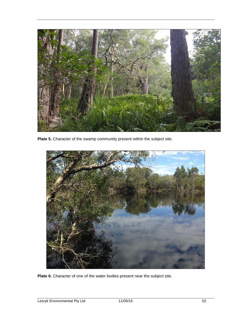
Lesryk Environmental Pty Ltd 11/05/16 52
Plate 5. Character of the swamp community present within the subject site.
Plate 6. Character of one of the water bodies present near the subject site.
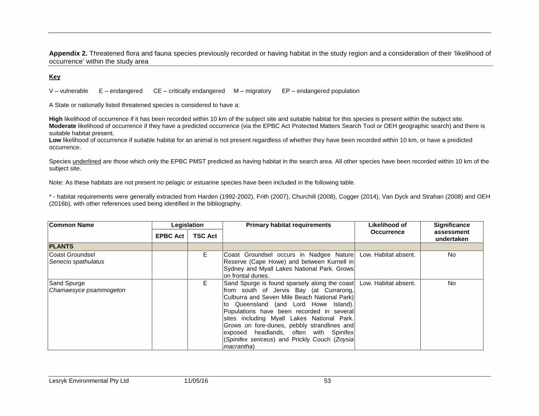
Lesryk Environmental Pty Ltd 11/05/16 53
Appendix 2. Threatened flora and fauna species previously recorded or having habitat in the study region and a consideration of their ‘likelihood of occurrence’ within the study area Key V – vulnerable E – endangered CE – critically endangered M – migratory EP – endangered population A State or nationally listed threatened species is considered to have a: High likelihood of occurrence if it has been recorded within 10 km of the subject site and suitable habitat for this species is present within the subject site. Moderate likelihood of occurrence if they have a predicted occurrence (via the EPBC Act Protected Matters Search Tool or OEH geographic search) and there is suitable habitat present. Low likelihood of occurrence if suitable habitat for an animal is not present regardless of whether they have been recorded within 10 km, or have a predicted occurrence. Species underlined are those which only the EPBC PMST predicted as having habitat in the search area. All other species have been recorded within 10 km of the subject site. Note: As these habitats are not present no pelagic or estuarine species have been included in the following table. * - habitat requirements were generally extracted from Harden (1992-2002), Frith (2007), Churchill (2008), Cogger (2014), Van Dyck and Strahan (2008) and OEH (2016b), with other references used being identified in the bibliography. Common Name Legislation Primary habitat requirements Likelihood of
Occurrence Significance assessment undertaken EPBC Act TSC Act
PLANTS Coast Groundsel Senecio spathulatus
E Coast Groundsel occurs in Nadgee Nature Reserve (Cape Howe) and between Kurnell in Sydney and Myall Lakes National Park. Grows on frontal dunes.
Low. Habitat absent. No
Sand Spurge Chamaesyce psammogeton
E Sand Spurge is found sparsely along the coast from south of Jervis Bay (at Currarong, Culburra and Seven Mile Beach National Park) to Queensland (and Lord Howe Island). Populations have been recorded in several sites including Myall Lakes National Park. Grows on fore-dunes, pebbly strandlines and exposed headlands, often with Spinifex (Spinifex sericeus) and Prickly Couch (Zoysia macrantha)
Low. Habitat absent. No
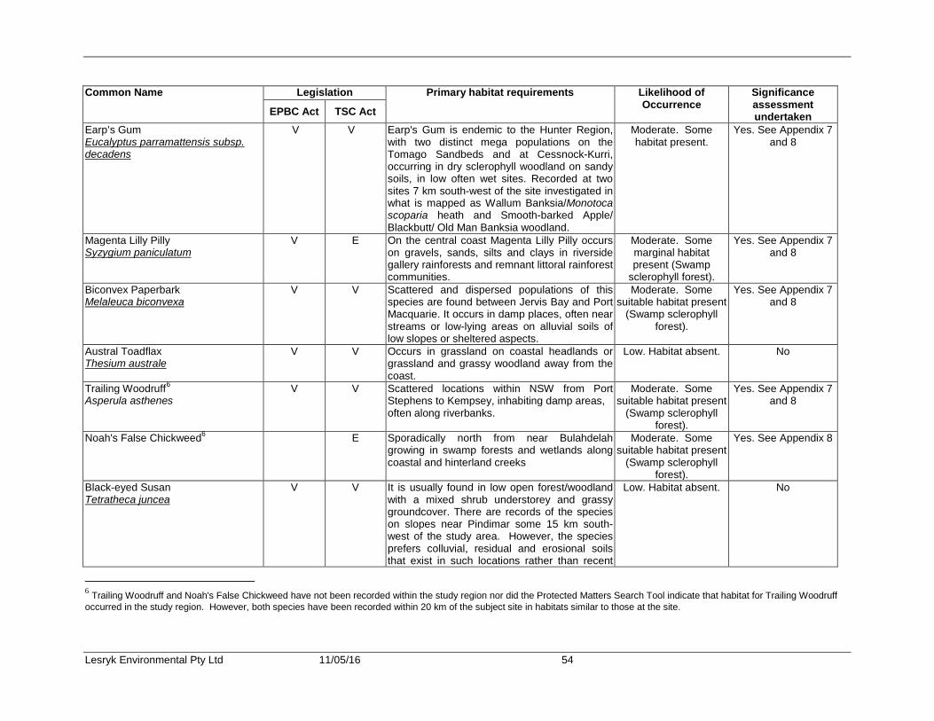
Lesryk Environmental Pty Ltd 11/05/16 54
Common Name Legislation Primary habitat requirements Likelihood of Occurrence
Significance assessment undertaken EPBC Act TSC Act
Earp’s Gum Eucalyptus parramattensis subsp. decadens
V V Earp's Gum is endemic to the Hunter Region, with two distinct mega populations on the Tomago Sandbeds and at Cessnock-Kurri, occurring in dry sclerophyll woodland on sandy soils, in low often wet sites. Recorded at two sites 7 km south-west of the site investigated in what is mapped as Wallum Banksia/Monotoca scoparia heath and Smooth-barked Apple/ Blackbutt/ Old Man Banksia woodland.
Moderate. Some habitat present.
Yes. See Appendix 7 and 8
Magenta Lilly Pilly Syzygium paniculatum
V E On the central coast Magenta Lilly Pilly occurs on gravels, sands, silts and clays in riverside gallery rainforests and remnant littoral rainforest communities.
Moderate. Some marginal habitat present (Swamp
sclerophyll forest).
Yes. See Appendix 7 and 8
Biconvex Paperbark Melaleuca biconvexa
V V Scattered and dispersed populations of this species are found between Jervis Bay and Port Macquarie. It occurs in damp places, often near streams or low-lying areas on alluvial soils of low slopes or sheltered aspects.
Moderate. Some suitable habitat present
(Swamp sclerophyll forest).
Yes. See Appendix 7 and 8
Austral Toadflax Thesium australe
V V Occurs in grassland on coastal headlands or grassland and grassy woodland away from the coast.
Low. Habitat absent. No
Trailing Woodruff6 Asperula asthenes
V V Scattered locations within NSW from Port Stephens to Kempsey, inhabiting damp areas, often along riverbanks.
Moderate. Some suitable habitat present
(Swamp sclerophyll forest).
Yes. See Appendix 7 and 8
Noah's False Chickweed6 E Sporadically north from near Bulahdelah growing in swamp forests and wetlands along coastal and hinterland creeks
Moderate. Some suitable habitat present
(Swamp sclerophyll forest).
Yes. See Appendix 8
Black-eyed Susan Tetratheca juncea
V V It is usually found in low open forest/woodland with a mixed shrub understorey and grassy groundcover. There are records of the species on slopes near Pindimar some 15 km south-west of the study area. However, the species prefers colluvial, residual and erosional soils that exist in such locations rather than recent
Low. Habitat absent. No
6 Trailing Woodruff and Noah's False Chickweed have not been recorded within the study region nor did the Protected Matters Search Tool indicate that habitat for Trailing Woodruff occurred in the study region. However, both species have been recorded within 20 km of the subject site in habitats similar to those at the site.
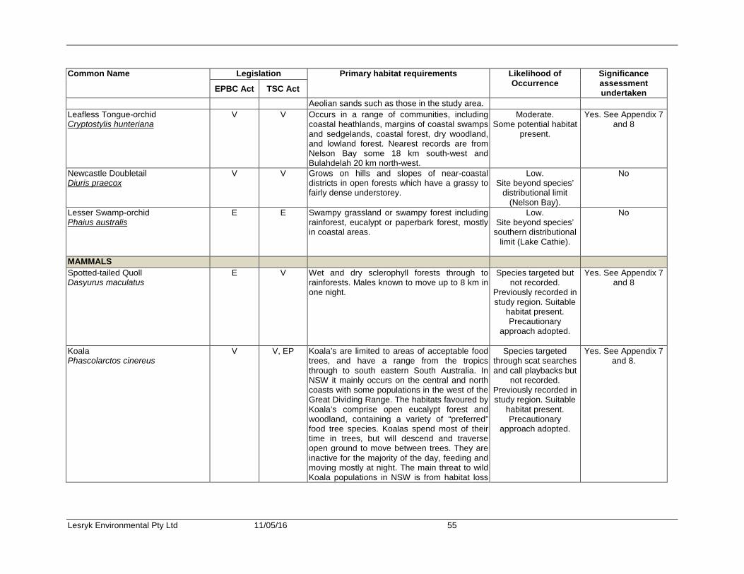
Lesryk Environmental Pty Ltd 11/05/16 55
Common Name Legislation Primary habitat requirements Likelihood of Occurrence
Significance assessment undertaken EPBC Act TSC Act
Aeolian sands such as those in the study area. Leafless Tongue-orchid Cryptostylis hunteriana
V V Occurs in a range of communities, including coastal heathlands, margins of coastal swamps and sedgelands, coastal forest, dry woodland, and lowland forest. Nearest records are from Nelson Bay some 18 km south-west and Bulahdelah 20 km north-west.
Moderate. Some potential habitat
present.
Yes. See Appendix 7 and 8
Newcastle Doubletail Diuris praecox
V V Grows on hills and slopes of near-coastal districts in open forests which have a grassy to fairly dense understorey.
Low. Site beyond species’
distributional limit (Nelson Bay).
No
Lesser Swamp-orchid Phaius australis
E E Swampy grassland or swampy forest including rainforest, eucalypt or paperbark forest, mostly in coastal areas.
Low. Site beyond species’
southern distributional limit (Lake Cathie).
No
MAMMALS Spotted-tailed Quoll Dasyurus maculatus
E V Wet and dry sclerophyll forests through to rainforests. Males known to move up to 8 km in one night.
Species targeted but not recorded.
Previously recorded in study region. Suitable
habitat present. Precautionary
approach adopted.
Yes. See Appendix 7 and 8
Koala Phascolarctos cinereus
V V, EP Koala’s are limited to areas of acceptable food trees, and have a range from the tropics through to south eastern South Australia. In NSW it mainly occurs on the central and north coasts with some populations in the west of the Great Dividing Range. The habitats favoured by Koala’s comprise open eucalypt forest and woodland, containing a variety of “preferred” food tree species. Koalas spend most of their time in trees, but will descend and traverse open ground to move between trees. They are inactive for the majority of the day, feeding and moving mostly at night. The main threat to wild Koala populations in NSW is from habitat loss
Species targeted through scat searches and call playbacks but
not recorded. Previously recorded in study region. Suitable
habitat present. Precautionary
approach adopted.
Yes. See Appendix 7 and 8.

Lesryk Environmental Pty Ltd 11/05/16 56
Common Name Legislation Primary habitat requirements Likelihood of Occurrence
Significance assessment undertaken EPBC Act TSC Act
and fragmentation. Home range varies in size with quality of habitat, ranging from less than 2 ha to several hundred ha in size. It is noted that the Koala population at Hawks Nest and Tea Garden is listed as endangered. This population is limited in the north to an east-west line 3 km north of the northern boundary of the Hawks Nest Golf Club. The study area is located around 6 km north of this limit. As such, the area investigated does not fall within the geographical distribution of this endangered population listing. No further legislative consideration has been given to the endangered Koala population at Hawks Nest and Tea Gardens.
Eastern Pygmy-possum Cercartetus nanus
V Occupies a wide range of habitats from rainforest through to woodlands and heath in which it is solitary. Feeds mostly on the pollen and nectar from banksias, eucalypts and understorey plants and will also eat insects, seeds and soft fruit when flowers unavailable. Nests and breeds in tree hollows. Home range size overlap and are between 0.35 and 0.68 ha. Within this home range several nesting sites will be use. Breeds throughout the year.
Species targeted but not recorded.
Previously recorded in study region. Suitable
habitat present. Precautionary
approach adopted.
Yes. See Appendix 8
Yellow-bellied Glider Petaurus australis
V Restricted to areas of tall, mature eucalypts. This species occupies tree hollows during the day and feeds at night predominantly on the sap that is collected from incisions that are gnawed into the trucks of specific species of eucalypts. The Yellow-bellied Glider occupies a home range area that is between 30 and 64 ha in size. This arboreal possum is a highly mobile species that is able to glide across open space areas that are in the order of 70 to 100 m.
Low. No suitable habitat present
No
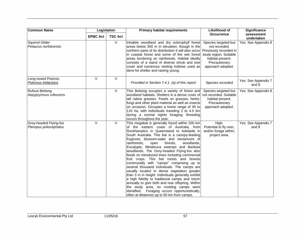
Lesryk Environmental Pty Ltd 11/05/16 57
Common Name Legislation Primary habitat requirements Likelihood of Occurrence
Significance assessment undertaken EPBC Act TSC Act
Squirrel Glider Petaurus norfolcensis
V Inhabits woodland and dry sclerophyll forest areas below 300 m in elevation, though in the northern parts of its distribution it will also occur in coastal forest and some of the wet forest areas bordering on rainforests. Habitat ideally consists of a stand of diverse shrub and tree cover and numerous nesting hollows used as dens for shelter and raising young.
Species targeted but not recorded.
Previously recorded in study region. Suitable
habitat present. Precautionary
approach adopted.
Yes. See Appendix 8
Long-nosed Potoroo Potorous tridactylus
V V Provided in Section 7.4.1. (a) of this report Species recorded Yes. See Appendix 7
and 8
Rufous Bettong Aepyprymnus rufescens
V This Bettong occupies a variety of forest and woodland habitats. Shelters in a dense cover of tall native grasses. Feeds on grasses, herbs, fungi and other plant material as well as insects on occasion. Occupies a home range of 45 to 110 ha, with individuals traveling 2 to 4.5 km during a normal nights foraging. Breeding occurs throughout the year.
Species targeted but not recorded. Suitable
habitat present. Precautionary
approach adopted.
Yes. See Appendix 8
Grey-headed Flying-fox Pteropus poliocephalus
V V This megabat is generally found within 200 km of the eastern coast of Australia, from Rockhampton in Queensland to Adelaide in South Australia. This bat is a canopy-feeding frugivore, blossom-eater and nectarivore of rainforests, open forests, woodlands, Eucalypts, Melaleuca swamps and Banksia woodlands. The Grey-headed Flying-fox also feeds on introduced trees including commercial fruit crops. This bat roosts and breeds communally with “camps” comprising up to several thousand individuals. The camps are usually located in dense vegetation greater than 3 m in height. Individuals generally exhibit a high fidelity to traditional camps and return annually to give birth and rear offspring. Within the study area, no roosting camps were identified. Foraging occurs opportunistically, often at distances up to 50 km from camps.
High. Potential to fly over, and/or forage within,
project area.
Yes. See Appendix 7 and 8
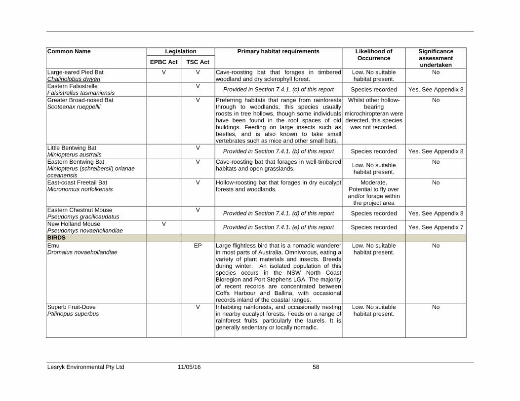
Lesryk Environmental Pty Ltd 11/05/16 58
Common Name Legislation Primary habitat requirements Likelihood of Occurrence
Significance assessment undertaken EPBC Act TSC Act
Large-eared Pied Bat Chalinolobus dwyeri
V V Cave-roosting bat that forages in timbered woodland and dry sclerophyll forest.
Low. No suitable habitat present.
No
Eastern Falsistrelle Falsistrellus tasmaniensis V Provided in Section 7.4.1. (c) of this report Species recorded Yes. See Appendix 8
Greater Broad-nosed Bat Scoteanax rueppellii
V Preferring habitats that range from rainforests through to woodlands, this species usually roosts in tree hollows, though some individuals have been found in the roof spaces of old buildings. Feeding on large insects such as beetles, and is also known to take small vertebrates such as mice and other small bats.
Whilst other hollow-bearing
microchiropteran were detected, this species
was not recorded.
No
Little Bentwing Bat Miniopterus australis
V Provided in Section 7.4.1. (b) of this report Species recorded Yes. See Appendix 8
Eastern Bentwing Bat Miniopterus (schreibersii) orianae oceanensis
V Cave-roosting bat that forages in well-timbered habitats and open grasslands. Low. No suitable
habitat present.
No
East-coast Freetail Bat Micronomus norfolkensis
V Hollow-roosting bat that forages in dry eucalypt forests and woodlands.
Moderate. Potential to fly over and/or forage within
the project area
No
Eastern Chestnut Mouse Pseudomys gracilicaudatus
V Provided in Section 7.4.1. (d) of this report Species recorded Yes. See Appendix 8
New Holland Mouse Pseudomys novaehollandiae
V Provided in Section 7.4.1. (e) of this report Species recorded Yes. See Appendix 7
BIRDS Emu Dromaius novaehollandiae
EP Large flightless bird that is a nomadic wanderer in most parts of Australia. Omnivorous, eating a variety of plant materials and insects. Breeds during winter. An isolated population of this species occurs in the NSW North Coast Bioregion and Port Stephens LGA. The majority of recent records are concentrated between Coffs Harbour and Ballina, with occasional records inland of the coastal ranges.
Low. No suitable habitat present.
No
Superb Fruit-Dove Ptilinopus superbus
V Inhabiting rainforests, and occasionally nesting in nearby eucalypt forests. Feeds on a range of rainforest fruits, particularly the laurels. It is generally sedentary or locally nomadic.
Low. No suitable habitat present.
No

Lesryk Environmental Pty Ltd 11/05/16 59
Common Name Legislation Primary habitat requirements Likelihood of Occurrence
Significance assessment undertaken EPBC Act TSC Act
Rose-crowned Fruit-Dove Ptilinopus regina
V This bird inhabits rainforests, especially those with vines and also nearby sclerophyll forests and costal scrub with abundant fruiting trees or shrubs. Feeds on fleshy fruits of rainforest trees, palms and vines, especially native figs. Will range locally over hundreds of kilometres when not breeding in search of food.
Low. No suitable habitat present.
No
Wompoo Fruit-Dove Ptilinopus magnificus
V Inhabiting only rainforests, this species is totally arboreal, never foraging on the ground.
Low. No suitable habitat present.
No
White-throated Needletail Hirundapus caudacutus
M Summer migrant that does not land in Australia. Takes insects on wing over a range of habitat types. Associated with the east coast highlands, coastal plains and the hinterlands of arid inland Australia.
Moderate. Potential to fly across
project area.
No
Fork-tailed Swift Apus pacificus
M Summer migrant that does not land in Australia. Takes insects on wing over a range of habitat types. Drinks from inland lakes, and rain water puddles.
Moderate. Potential to fly across
project area.
No
Black-necked Stork Ephippiorhynchus asiaticus
E Inhabits freshwater wetlands. Low. No suitable habitat present.
No
Cattle Egret Ardea ibis
M Wet pasture with tall grass, shallow open wetland and margins, mudflats.
Low. No suitable habitat present.
No
Great Egret Ardea alba
M Provided in Section 7.4.1. (f) of this report Species recorded Yes. See Appendix 7
Australasian Bittern Botaurus poiciloptilus
Shallow, vegetated freshwater or brackish swamps, usually dominated by tall, dense reed beds of Typha sp, Juncus sp and Phragmites sp.
Low. No suitable habitat present.
No
Eastern Osprey Pandion cristatus
M V Provided in Section 7.4.1. (e) of this report Species recorded Yes. See Appendix 7 and 8
White-bellied Sea-eagle Haliaeetus leucogaster
M Found throughout coastal Australia in association with large rivers, fresh and saline lakes, reservoirs, estuaries, coastal seas, islands.
Moderate. Potential to fly across project area. Targeted
but not recorded.
No

Lesryk Environmental Pty Ltd 11/05/16 60
Common Name Legislation Primary habitat requirements Likelihood of Occurrence
Significance assessment undertaken EPBC Act TSC Act
Little Eagle Hieraaetus morphnoides
V Found throughout mainland Australia except the most densely forested parts of the Diving Range escarpment. Occupies open eucalypt forest, woodland or open woodland; occasionally Sheoak or acacia, and riparian woodlands of interior NSW. Nests are made of large sticks, found in tall living trees within a remnant patch. Preys on birds, reptiles and occasionally large insects and carrion.
Moderate. Potential to fly across project area. Targeted
but not recorded.
No
Australian Painted Snipe Rostratula australis
M,E E This species prefers shallow freshwater swamps.
Low. No suitable habitat present.
No
Latham’s Snipe Gallinago hardwickii
M Wet, treeless, tussocky grasslands, short grasses and/or marshes along freshwater streams and channels, though it can also be found in any vegetation around freshwater wetlands, in sedges, grasses, lignum, reeds and rushes, saltmarshes, creek edges, crops and pastures.
Low. No suitable habitat present.
No
Glossy Black-Cockatoo Calyptorhynchus lathami
V Inhabits eucalypt woodland and feeds almost exclusively on Casuarina fruits.
Species targeted but not recorded.
Previously recorded in study region. Suitable
habitat present. Precautionary
approach adopted.
Yes. See Appendix 8
Little Lorikeet Glossopsitta pusilla
V Forages primarily in the open Eucalypt forest and woodland canopies, particularly along water courses; occasionally in Angophoras, Melaleucas and other tree species, also riparian habitats are used. They eat pollen, nectar, blossums, native and cultivated fruits and seeds.
Species targeted but not recorded.
Previously recorded in study region.
Potential to fly across project area.
Precautionary approach adopted
Yes. See Appendix 8
Swift Parrot Lathamus discolor
E E Eucalypt forests. Breeds in Tasmania and over winters on the mainland. When over-wintering on the mainland, this species is dependent on winter-flowering eucalypt species. As such,
Species targeted but not recorded.
Previously recorded in study region.
Yes. See Appendix 7 and 8
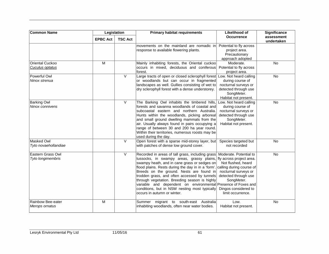
Lesryk Environmental Pty Ltd 11/05/16 61
Common Name Legislation Primary habitat requirements Likelihood of Occurrence
Significance assessment undertaken EPBC Act TSC Act
movements on the mainland are nomadic in response to available flowering plants.
Potential to fly across project area.
Precautionary approach adopted
Oriental Cuckoo Cuculus optatus
M Mainly inhabiting forests, the Oriental cuckoo occurs in mixed, deciduous and coniferous forest.
Moderate. Potential to fly across
project area.
No
Powerful Owl Ninox strenua
V Large tracts of open or closed sclerophyll forest or woodlands but can occur in fragmented landscapes as well. Gullies consisting of wet to dry sclerophyll forest with a dense understorey.
Low. Not heard calling during course of
nocturnal surveys or detected through use
SongMeter. Habitat not present.
No
Barking Owl Ninox connivens
V The Barking Owl inhabits the timbered hills, forests and savanna woodlands of coastal and subcoastal eastern and northern Australia. Hunts within the woodlands, picking arboreal and small ground dwelling mammals from the air. Usually always found in pairs occupying a range of between 30 and 200 ha year round. Within their territories, numerous roosts may be used during the day.
Low. Not heard calling during course of
nocturnal surveys or detected through use
SongMeter. Habitat not present.
No
Masked Owl Tyto novaehollandiae
V Open forest with a sparse mid-storey layer, but with patches of dense low ground cover.
Species targeted but not recorded
No
Eastern Grass Owl Tyto longimembris
V Recorded in areas of tall grass, including grass tussocks, in swampy areas, grassy plains, swampy heath, and in cane grass or sedges on flood plains. Rests during the day in in a ‘form’. Breeds on the ground. Nests are found in trodden grass, and often accessed by tunnels through vegetation. Breeding season is highly variable and dependent on environmental conditions, but in NSW nesting most typically occurs in autumn or winter.
Moderate. Potential to fly across project area.
Not flushed, heard calling during course of
nocturnal surveys or detected through use
SongMeter. Presence of Foxes and Dingos considered to
limit occurrence.
No
Rainbow Bee-eater Merops ornatus
M Summer migrant to south-east Australia inhabiting woodlands, often near water bodies.
Low. Habitat not present.
No

Lesryk Environmental Pty Ltd 11/05/16 62
Common Name Legislation Primary habitat requirements Likelihood of Occurrence
Significance assessment undertaken EPBC Act TSC Act
Eastern Bristlebird Dasyornis brachypterus brachypterus
E E Dense, low vegetation including heath and open woodland with a heath understorey.
Moderate. Species targeted but
not recorded.
No
Regent Honeyeater Anthochaera phrygia
M,E CE Temperate eucalypt woodlands and open forests containing key eucalypt species utilised during foraging periods such as Mugga Ironbark, Yellow Box, Blakely's Red Gum, White Box and Swamp Mahogany.
Low. Habitat not present.
No
Painted Honeyeater Grantiella picta
V V Inhabits eucalypt woodlands and scrub, usually heavily infested with mistletoe.
Low. Habitat not present.
No
White-fronted Chat Epthianura albifrons
V Found across the southern half of Australia. Lives mostly in temperate to arid climates, occupying foothills and lowlands up to 1000 m ASL. In the southern half of NSW, it occupies damp open habitats along the coast and near waterways. Regularly observed in the saltmarsh vegetation. Forages on bare or grassy ground in wetland areas. Feeds mainly on flies and beetles. Nests are open-cup, built in low vegetation but have been found up to 2.5 m above the ground.
Low. Habitat not present.
No
Varied Sittella Daphoenositta chrysoptera
V This bird occurs in sedentary groups that inhabit most of mainland Australia except the treeless deserts and open grasslands. In NSW its distribution is nearly continuous from the coast to the far west. The Varied Sittella inhabits eucalypt forests and woodlands, especially those containing rough-barked species and mature smooth-barked gums with dead branches, mallee and Acacia woodland. This bird feeds on arthropods gleaned from crevices in rough or decorticating bark, dead branches, standing dead trees and small branches and twigs in the tree canopy. The Varied Sittella builds a cup-shaped nest of plant fibres and cobwebs in an upright tree fork high in the living tree canopy, and often re-uses the same fork or tree in successive years.
Species targeted but not recorded.
Previously recorded in study region.
Potential to fly across project area.
Precautionary approach adopted
Yes. See Appendix 8

Lesryk Environmental Pty Ltd 11/05/16 63
Common Name Legislation Primary habitat requirements Likelihood of Occurrence
Significance assessment undertaken EPBC Act TSC Act
Rufous Fantail Rhipidura rufifrons
M Provided in Section 7.4.1. (g) of this report Species recorded Yes. See Appendix 7
Satin Flycatcher Myiagra cyanoleuca
M Eucalypt woodlands, forests and timbered watercourses.
Low. Habitat not present.
No
Black-faced Monarch Monarcha melanopsis
M Rainforest and wet eucalypt forest. Low. Habitat not present.
No
Spectacled Monarch Monacrha trivirgatus
M Rainforest, mangroves and moist gloomy gullies of dense eucalypt forest.
Low. Habitat not present.
No
Speckled Warbler Chthinicola sagittata
V Occupies eucalypt and cypress woodlands with an open grassy and shrubby understorey often associated with gullies and rocky ridges.
Low. Habitat not present.
No
REPTILE Stephens' Banded Snake Hoplocephalus stephensii
V This nocturnal, largely arboreal snake occupies wet sclerophyll, rainforest and, occasionally, eucalypt woodlands. Shelters during the day in tree hollows, under bark or in rock crevices. Hunts on frogs, lizards, birds and small mammals.
Low. Primary habitat not
present.
No
AMPHIBIANS Wallum Froglet Crinia tinnula
V This frog is found in a wide range of habitats, usually associated with acid paperbark swamps and sedge swamps of the coastal ‘wallum’ country. The species can breed throughout the year following rain, but is thought to peak during the colder months. Breeding mainly occurs in swamps with permanent water. Sheltering occurs under leaf litter vegetation, debris or in the burrows of other animals. Males call throughout the year, particularly after rain.
Species targeted but not recorded.
Previously recorded in study region.
Potential to fly across project area.
Precautionary approach adopted
Yes. See Appendix 8
Stuttering Frog Mixophyes balbus
V E Terrestrial inhabitant of rain, artic birch and wet sclerophyll forests. Usually found near permanently running water.
Low. Habitat not present.
No
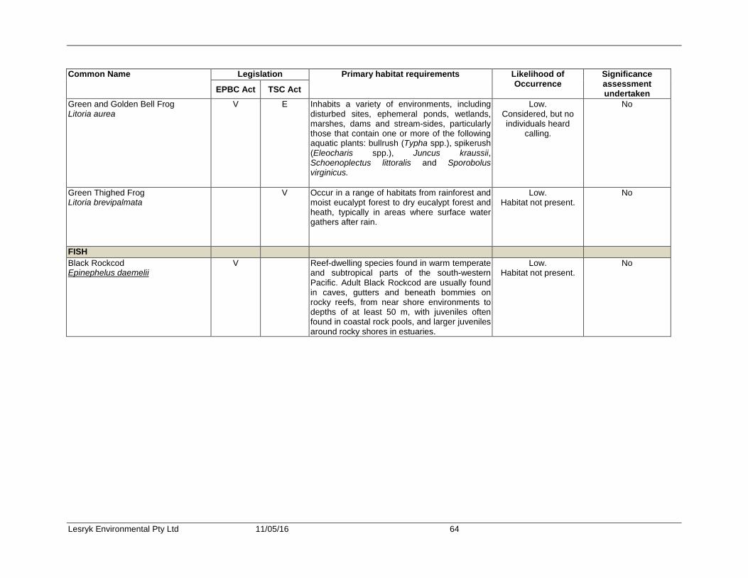
Lesryk Environmental Pty Ltd 11/05/16 64
Common Name Legislation Primary habitat requirements Likelihood of Occurrence
Significance assessment undertaken EPBC Act TSC Act
Green and Golden Bell Frog Litoria aurea
V E Inhabits a variety of environments, including disturbed sites, ephemeral ponds, wetlands, marshes, dams and stream-sides, particularly those that contain one or more of the following aquatic plants: bullrush (Typha spp.), spikerush (Eleocharis spp.), Juncus kraussii, Schoenoplectus littoralis and Sporobolus virginicus.
Low. Considered, but no individuals heard
calling.
No
Green Thighed Frog Litoria brevipalmata
V Occur in a range of habitats from rainforest and moist eucalypt forest to dry eucalypt forest and heath, typically in areas where surface water gathers after rain.
Low. Habitat not present.
No
FISH Black Rockcod Epinephelus daemelii
V Reef-dwelling species found in warm temperate and subtropical parts of the south-western Pacific. Adult Black Rockcod are usually found in caves, gutters and beneath bommies on rocky reefs, from near shore environments to depths of at least 50 m, with juveniles often found in coastal rock pools, and larger juveniles around rocky shores in estuaries.
Low. Habitat not present.
No

Lesryk Environmental Pty Ltd 11/05/16 65
Appendix 3. Flora species recorded Key * - indicates introduced species ? uncertain identification N- species listed as a noxious weed in the Great Lakes LGA on the NW Act. SCIENTIFIC NAME COMMON NAME LYCOPSIDA Clubmosses Selaginellaceae Selaginella uliginosa Swamp Selaginella FILICOPSIDA FERNS Blechnaceae Blechnum indicum Swamp Water Fern Dennstaedtiaceae Pteridium esculentum Bracken Dicksoniaceae Calochlaena dubia Rainbow Fern Polypodiaceae Platycerium bifurcatum Elkhorn Fern Pyrrosia rupestris Rock Felt Fern Schizaeaceae Schizaea dichotoma Branched Comb-fern Sinopteridaceae Cheilanthes sieberi Poison Rock Fern Sinopteridaceae Pellaea falcata Sickle Fern CONIFEROPSIDA CONIFERS Pinaceae Pinus elliotti* Slash Pine MAGNOLIOPSIDA FLOWERING PLANTS MAGNOLIIDAE DICOTYLEDONS Apiaceae Woolly Xanthosia Actinotus helianthi Flannel Flower ?Conium maculatum* Hemlock Hydrocotyle peduncularis Pennywort Trachymene incisa Xanthosia pilosa Apocynaceae Marsdenia rostrata Common Milk Vine Parsonsia straminea Common Silkpod Asteraceae Ageratina adenophora* Crofton Weed Bidens pilosa* Cobbler's Pegs Chrysanthemoides monilifera subsp. rotundata* Bitou Bush Conyza albida* Cudweed Euchiton japonicus Cudweed Hypochaeris radicata* Catsear Bignoniaceae Pandorea pandorana Wonga Wonga Vine Campanulaceae Wahlenbergia gracilis Australian Bluebell Casuarinaceae Allocasuarina littoralis Black She-Oak Chenopodiaceae Einadia nutans subsp. linifolia Climbing Saltbush Dilleniaceae Hibbertia fasciculata Hibbertia obtusifolia Grey Guinea Flower Hibbertia scandens Climbing Guinea-flower Elaeocarpaceae Elaeocarpus reticulatus Blueberry Ash

Lesryk Environmental Pty Ltd 11/05/16 66
SCIENTIFIC NAME COMMON NAME Ericaceae Aotus ericoides Astroloma pinifolium Pine Heath Epacris pulchella Wallum Heath Leucopogon ericoides Pink Beard-heath Leucopogon esquamatus Leucopogon parviflorus Lissanthe strigosa Peach Heath Monotoca elliptica Tree Broom-heath Monotoca scoparia Prickly Broom-heath Styphelia viridis Green Five-corners Woollsia pungens Euphorbiaceae Homalanthus populifolius Bleeding Heart Ricinicarpos pinifolius Wedding Bush Fabaceae Sub-family Faboideae Bossiaea heterophylla Variable Bossiaea Bossiaea rhombifolia Bossiaea scolopendria Desmodium brachypodum Large Tick-trefoil Daviesia ulicifolia Dillwynia retorta Eggs and Bacon Glycine clandestina Twining Glycine Gompholobium grandiflorum Golden Glory Pea Gompholobium latifolium Broad-leaf Wedge-pea Hardenbergia violacea False Sarsaparilla Phyllota phylicoides Phyllota Sub-family Mimosoideae Acacia implexa Hickory Wattle Acacia longifolia var. longifolia Sydney Golden Wattle Acacia suaveolens Sweet-scented Wattle Acacia ulicifolia Prickly Moses Goodeniaceae Goodenia hederacea Ivy Goodenia Haloragaceae Gonocarpus tetragynus Raspwort Gonocarpus teucroides Raspwort Lauraceae Cryptocarya microneura Murrogun Endiandra sieberi Corkwood Loranthaceae. Amyema congener Mistletoe Malvaceae Sida rhombifolia* Paddy's Lucerne Menispermiaceae Stephania japonica var. discolor Snake Vine Myrsinaceae Myrsine howittiana Brush Muttonwood Myrsine variabilis Muttonwood Myrtaceae Acmena smithii Lilly Pilly Angophora costata Smooth-barked Apple Callistemon citrinus Crimson Bottlebrush Callistemon pachyphyllus Wallum Bottlebrush Corymbia gummifera Red Bloodwood Eucalyptus botryoides Bangalay Eucalyptus pilularis Blackbutt Eucalyptus robusta Swamp Mahogany Eucalyptus tereticornis Forest Red Gum Eucalyptus robusta x tereticornis Bastard Mahogany Leptospermum juniperinum Prickly Tea-tree Leptospermum laevigatum Coast Tea-tree

Lesryk Environmental Pty Ltd 11/05/16 67
SCIENTIFIC NAME COMMON NAME Leptospermum parvifolium Small-leaved Tea-tree Leptospermum polygalifolium Yellow Tea-tree Leptospermum trinervium Paperbark Tea-tree Melaleuca nodosa Ball Honey-myrtle Melaleuca quinquenervia Broad-leaved Paperbark Melaleuca sieberi Rhodamnia rubescens Scrub Turpentine Syzygium oleosum Blue Lilly Pilly Oleaceae Notelaea longifolia Mock Olive Oxalidaceae Oxalis corniculata* Yellow Wood Sorrel Passifloraceae Passiflora edulis* Passionfruit Phyllanthaceae Breynia oblongifolia Coffee Bush Glochidion ferdinandii Cheese Tree Pimeleaceae Pimelea ligustrina Tall Rice Flower Pittosporaceae Billardiera scandens Hairy Appleberry Polygalaceae Comesperma sphaerocarpum Polygonaceae Persicaria praetermissa Knotweed Proteaceae Banksia aemula Wallum Banksia Banksia integrifolia Coast Banksia Banksia oblongifolia Fern-leaf Banksia Banksia serrata Old Man Banksia Hakea teretifolia Dagger Hakea Isopogon anemonifolius Drumsticks Persoonia lanceolata Lance-leaved Geebung Persoonia levis Broad-leaved Geebung Ranunculaceae Clematis aristata Old Man's Beard Rhamnaceae Alphitonia excelsa Red Ash Rubiaceae Pomax umbellata Pomax Richardia brasiliensis* White Eye Rutaceae Eriostemon australasius Pink Wax Flower Nematolepis squamea Satinwood Philotheca salsolifolia Zieria smithii Sandfly Zieria Santalaceae Exocarpos cupressiformis Cherry Ballart Sapindaceae Dodonaea triquetra Hop Bush Dodonaea viscosa subsp. angustifolia Sapotaceae Planchonella australis Black Apple Solanaceae Nicotiana suaveolens Native Tobacco Solanum nigrum* Black Nightshade Thymeliaceae Pimelea ligustrina Violaceae Viola hederacea Ivy-leaved Violet LILIIDAE MONOCOTYLEDONS Arecaceae Livistona australis Cabbage Tree Palm
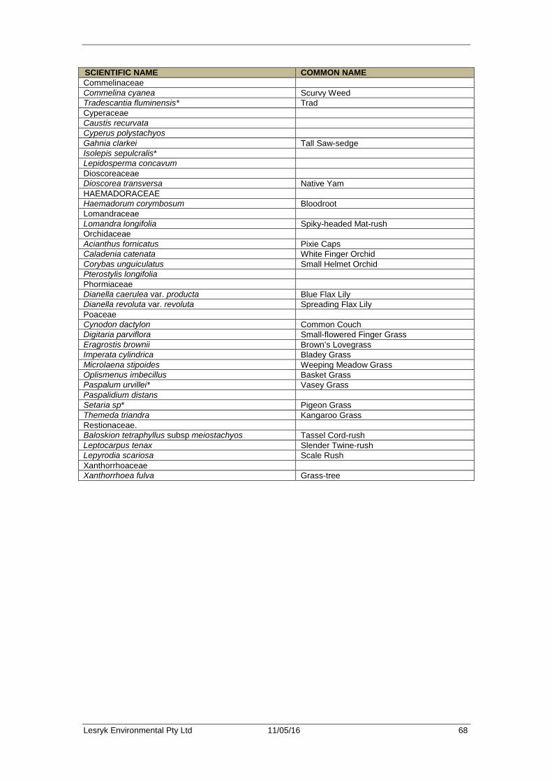
Lesryk Environmental Pty Ltd 11/05/16 68
SCIENTIFIC NAME COMMON NAME Commelinaceae Commelina cyanea Scurvy Weed Tradescantia fluminensis* Trad Cyperaceae Caustis recurvata Cyperus polystachyos Gahnia clarkei Tall Saw-sedge Isolepis sepulcralis* Lepidosperma concavum Dioscoreaceae Dioscorea transversa Native Yam HAEMADORACEAE Haemadorum corymbosum Bloodroot Lomandraceae Lomandra longifolia Spiky-headed Mat-rush Orchidaceae Acianthus fornicatus Pixie Caps Caladenia catenata White Finger Orchid Corybas unguiculatus Small Helmet Orchid Pterostylis longifolia Phormiaceae Dianella caerulea var. producta Blue Flax Lily Dianella revoluta var. revoluta Spreading Flax Lily Poaceae Cynodon dactylon Common Couch Digitaria parviflora Small-flowered Finger Grass Eragrostis brownii Brown’s Lovegrass Imperata cylindrica Bladey Grass Microlaena stipoides Weeping Meadow Grass Oplismenus imbecillus Basket Grass Paspalum urvillei* Vasey Grass Paspalidium distans Setaria sp* Pigeon Grass Themeda triandra Kangaroo Grass Restionaceae. Baloskion tetraphyllus subsp meiostachyos Tassel Cord-rush Leptocarpus tenax Slender Twine-rush Lepyrodia scariosa Scale Rush Xanthorrhoaceae Xanthorrhoea fulva Grass-tree
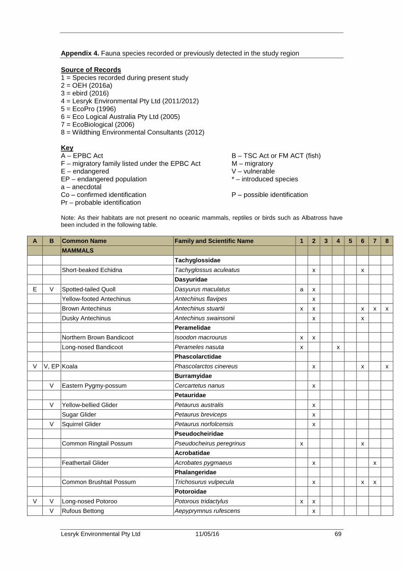
Lesryk Environmental Pty Ltd 11/05/16 69
Appendix 4. Fauna species recorded or previously detected in the study region Source of Records 1 = Species recorded during present study 2 = OEH (2016a) 3 = ebird (2016) 4 = Lesryk Environmental Pty Ltd (2011/2012) 5 = EcoPro (1996) 6 = Eco Logical Australia Pty Ltd (2005) 7 = EcoBiological (2006) 8 = Wildthing Environmental Consultants (2012) Key A – EPBC Act B – TSC Act or FM ACT (fish) F – migratory family listed under the EPBC Act M – migratory E – endangered V – vulnerable EP – endangered population * – introduced species a – anecdotal Co – confirmed identification P – possible identification Pr – probable identification Note: As their habitats are not present no oceanic mammals, reptiles or birds such as Albatross have been included in the following table.
A B Common Name Family and Scientific Name 1 2 3 4 5 6 7 8 MAMMALS Tachyglossidae Short-beaked Echidna Tachyglossus aculeatus x x Dasyuridae
E V Spotted-tailed Quoll Dasyurus maculatus a x Yellow-footed Antechinus Antechinus flavipes x Brown Antechinus Antechinus stuartii x x x x x Dusky Antechinus Antechinus swainsonii x x Peramelidae Northern Brown Bandicoot Isoodon macrourus x x Long-nosed Bandicoot Perameles nasuta x x Phascolarctidae
V V, EP Koala Phascolarctos cinereus x x x Burramyidae V Eastern Pygmy-possum Cercartetus nanus x Petauridae V Yellow-bellied Glider Petaurus australis x Sugar Glider Petaurus breviceps x V Squirrel Glider Petaurus norfolcensis x Pseudocheiridae Common Ringtail Possum Pseudocheirus peregrinus x x Acrobatidae Feathertail Glider Acrobates pygmaeus x x Phalangeridae Common Brushtail Possum Trichosurus vulpecula x x x Potoroidae
V V Long-nosed Potoroo Potorous tridactylus x x V Rufous Bettong Aepyprymnus rufescens x
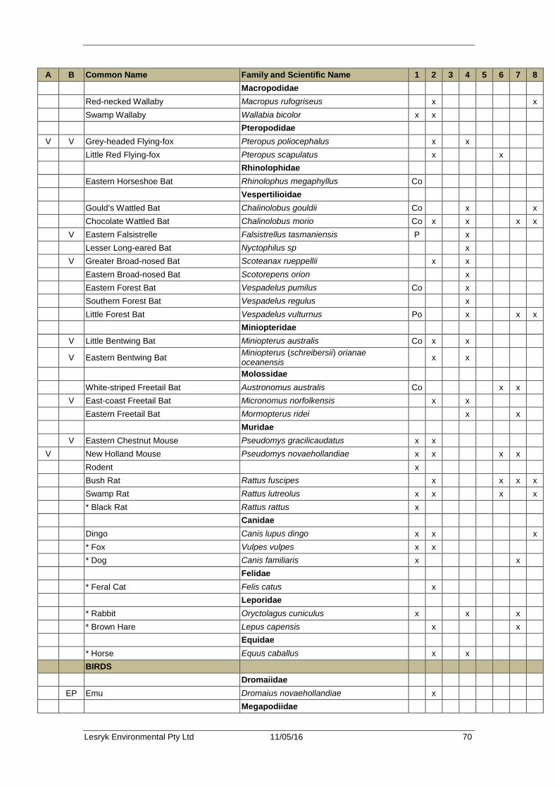
Lesryk Environmental Pty Ltd 11/05/16 70
A B Common Name Family and Scientific Name 1 2 3 4 5 6 7 8 Macropodidae Red-necked Wallaby Macropus rufogriseus x x Swamp Wallaby Wallabia bicolor x x Pteropodidae
V V Grey-headed Flying-fox Pteropus poliocephalus x x Little Red Flying-fox Pteropus scapulatus x x Rhinolophidae Eastern Horseshoe Bat Rhinolophus megaphyllus Co Vespertilioidae Gould’s Wattled Bat Chalinolobus gouldii Co x x Chocolate Wattled Bat Chalinolobus morio Co x x x x V Eastern Falsistrelle Falsistrellus tasmaniensis P x Lesser Long-eared Bat Nyctophilus sp x V Greater Broad-nosed Bat Scoteanax rueppellii x x Eastern Broad-nosed Bat Scotorepens orion x Eastern Forest Bat Vespadelus pumilus Co x Southern Forest Bat Vespadelus regulus x Little Forest Bat Vespadelus vulturnus Po x x x Miniopteridae V Little Bentwing Bat Miniopterus australis Co x x
V Eastern Bentwing Bat Miniopterus (schreibersii) orianae oceanensis x x
Molossidae White-striped Freetail Bat Austronomus australis Co x x V East-coast Freetail Bat Micronomus norfolkensis x x Eastern Freetail Bat Mormopterus ridei x x Muridae V Eastern Chestnut Mouse Pseudomys gracilicaudatus x x
V New Holland Mouse Pseudomys novaehollandiae x x x x Rodent x Bush Rat Rattus fuscipes x x x x Swamp Rat Rattus lutreolus x x x x * Black Rat Rattus rattus x Canidae Dingo Canis lupus dingo x x x * Fox Vulpes vulpes x x * Dog Canis familiaris x x Felidae * Feral Cat Felis catus x Leporidae * Rabbit Oryctolagus cuniculus x x x * Brown Hare Lepus capensis x x Equidae * Horse Equus caballus x x BIRDS Dromaiidae EP Emu Dromaius novaehollandiae x Megapodiidae

Lesryk Environmental Pty Ltd 11/05/16 71
A B Common Name Family and Scientific Name 1 2 3 4 5 6 7 8 Australian Brush Turkey Alectura lathami x x x Phasianidae Brown Quail Coturnix ypsilophora x x
F Anatidae Black Swan Cygnus atratus x x Radjah Shelduck Tadorna radjah x Pacific Black Duck Anas superciliosa x x x x x x * Mallard Anas platyrhynchos x Grey Teal Anas gracilis x x x Chestnut Teal Anas castanea x Hardhead Aythya australis x x Australian Wood Duck Chenonetta jubata x x Musk Duck Biziura lobata x Podicipedidae Great Crested Grebe Podiceps cristatus x Hoary-headed Grebe Poliocephalus poliocephalus x Columbidae V Superb Fruit-Dove Ptilinopus superbus x V Rose-crowned Fruit-Dove Ptilinopus regina x V Wompoo Fruit-Dove Ptilinopus magnificus x Topknot Pigeon Lopholaimus antarcticus x White-headed Pigeon Columba leucomela x x * Spotted Dove Streptopelia chinensis x Brown Cuckoo-Dove Macropygia amboinensis x x Bar-shouldered Dove Geopelia humeralis x x x x Common Bronzewing Phaps chalcoptera x x x Brush Bronzewing Phaps elegans x Crested Pigeon Ocyphaps lophotes x x Wonga Pigeon Leucosarcia picata x x x Podargidae Tawny Frogmouth Podargus strigoides x x x Eurostopodidae White-throated Nightjar Eurostopodus mystacalis x Aegothelidae Australian Owlet-nightjar Aegotheles cristatus x x Apodidae
M White-throated Needletail Hirundapus caudacutus x x x M Fork-tailed Swift Apus pacificus x Oceanitidae White-faced Storm-Petrel Pelagodroma marina x Procellariidae
EM V Gould’s Petrel Pterodroma leucoptera leucoptera x M V Flesh-footed Shearwater Ardenna carneipes x M Wedge-tailed Shearwater Puffinus pacificus x M Sooty Shearwater Ardenna grisea x M Short-tailed Shearwater Ardenna tenuiorstris x Sulidae Australasian Gannet Morus serrator x
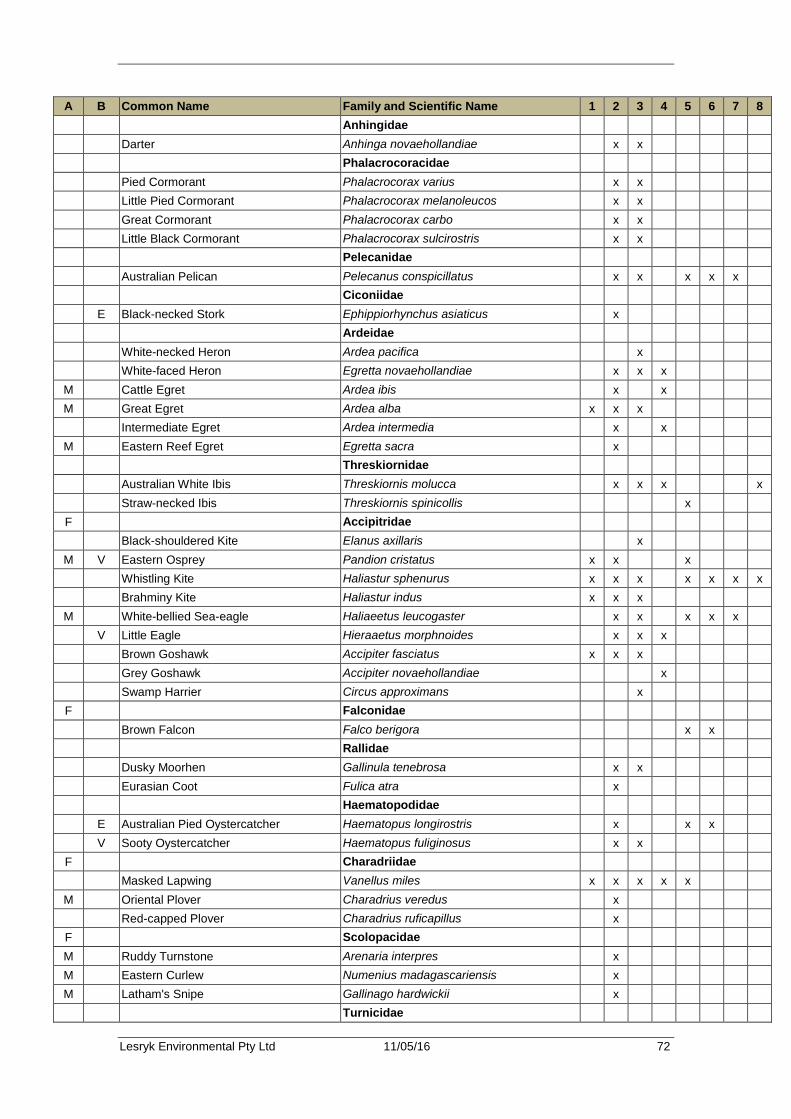
Lesryk Environmental Pty Ltd 11/05/16 72
A B Common Name Family and Scientific Name 1 2 3 4 5 6 7 8 Anhingidae Darter Anhinga novaehollandiae x x Phalacrocoracidae Pied Cormorant Phalacrocorax varius x x Little Pied Cormorant Phalacrocorax melanoleucos x x Great Cormorant Phalacrocorax carbo x x Little Black Cormorant Phalacrocorax sulcirostris x x Pelecanidae Australian Pelican Pelecanus conspicillatus x x x x x Ciconiidae E Black-necked Stork Ephippiorhynchus asiaticus x Ardeidae White-necked Heron Ardea pacifica x White-faced Heron Egretta novaehollandiae x x x
M Cattle Egret Ardea ibis x x M Great Egret Ardea alba x x x Intermediate Egret Ardea intermedia x x
M Eastern Reef Egret Egretta sacra x Threskiornidae Australian White Ibis Threskiornis molucca x x x x Straw-necked Ibis Threskiornis spinicollis x
F Accipitridae Black-shouldered Kite Elanus axillaris x
M V Eastern Osprey Pandion cristatus x x x Whistling Kite Haliastur sphenurus x x x x x x x Brahminy Kite Haliastur indus x x x
M White-bellied Sea-eagle Haliaeetus leucogaster x x x x x V Little Eagle Hieraaetus morphnoides x x x Brown Goshawk Accipiter fasciatus x x x Grey Goshawk Accipiter novaehollandiae x Swamp Harrier Circus approximans x
F Falconidae Brown Falcon Falco berigora x x Rallidae Dusky Moorhen Gallinula tenebrosa x x Eurasian Coot Fulica atra x Haematopodidae E Australian Pied Oystercatcher Haematopus longirostris x x x V Sooty Oystercatcher Haematopus fuliginosus x x
F Charadriidae Masked Lapwing Vanellus miles x x x x x
M Oriental Plover Charadrius veredus x Red-capped Plover Charadrius ruficapillus x
F Scolopacidae M Ruddy Turnstone Arenaria interpres x M Eastern Curlew Numenius madagascariensis x M Latham's Snipe Gallinago hardwickii x Turnicidae
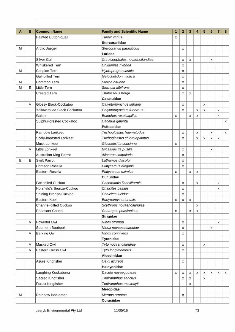
Lesryk Environmental Pty Ltd 11/05/16 73
A B Common Name Family and Scientific Name 1 2 3 4 5 6 7 8 Painted Button-quail Turnix varius x Stercorariidae
M Arctic Jaeger Stercorarius parasiticus x Laridae Silver Gull Chroicoephalus novaehollandiae x x x Whiskered Tern Chlidonias hybrida x
M Caspian Tern Hydroprogne caspia x Gull-billed Tern Gelochelidon nilotica x
M Common Tern Sterna hirundo x M E Little Tern Sternula albifrons x Crested Tern Thalasseus bergii x x Cacatuidae V Glossy Black-Cockatoo Calyptorhynchus lathami x x Yellow-tailed Black Cockatoo Calyptorhynchus funereus x x x x Galah Eolophus roseicapillus x x x x Sulphur-crested Cockatoo Cacatua galerita x Psittacidae Rainbow Lorikeet Trichoglossus haematodus x x x x Scaly-breasted Lorikeet Trichoglossus chlorolepidotus x x x x x Musk Lorikeet Glossopsitta concinna x V Little Lorikeet Glossopsitta pusilla x x Australian King Parrot Alisterus scapularis x
E E Swift Parrot Lathamus discolor x Crimson Rosella Platycercus elegans x Eastern Rosella Platycercus eximius x x x Cuculidae Fan-tailed Cuckoo Cacomantis flabelliformis x x x Horsfield's Bronze-Cuckoo Chalcites basalis x x Shining Bronze-Cuckoo Chalcites lucidus x Eastern Koel Eudynamys orientalis x x x Channel-billed Cuckoo Scythrops novaehollandiae x Pheasant Coucal Centropus phasianinus x x x Strigidae V Powerful Owl Ninox strenua x x Southern Boobook Ninox novaeseelandiae x x V Barking Owl Ninox connivens x Tytonidae V Masked Owl Tyto novaehollandiae x x V Eastern Grass Owl Tyto longimembris x Alcedinidae Azure Kingfisher Ceyx azureus x Halcyonidae Laughing Kookaburra Dacelo novaeguineae x x x x x x x x Sacred Kingfisher Todiramphus sanctus x x x Forest Kingfisher Todiramphus macleayii x Meropidae
M Rainbow Bee-eater Merops ornatus x Coraciidae
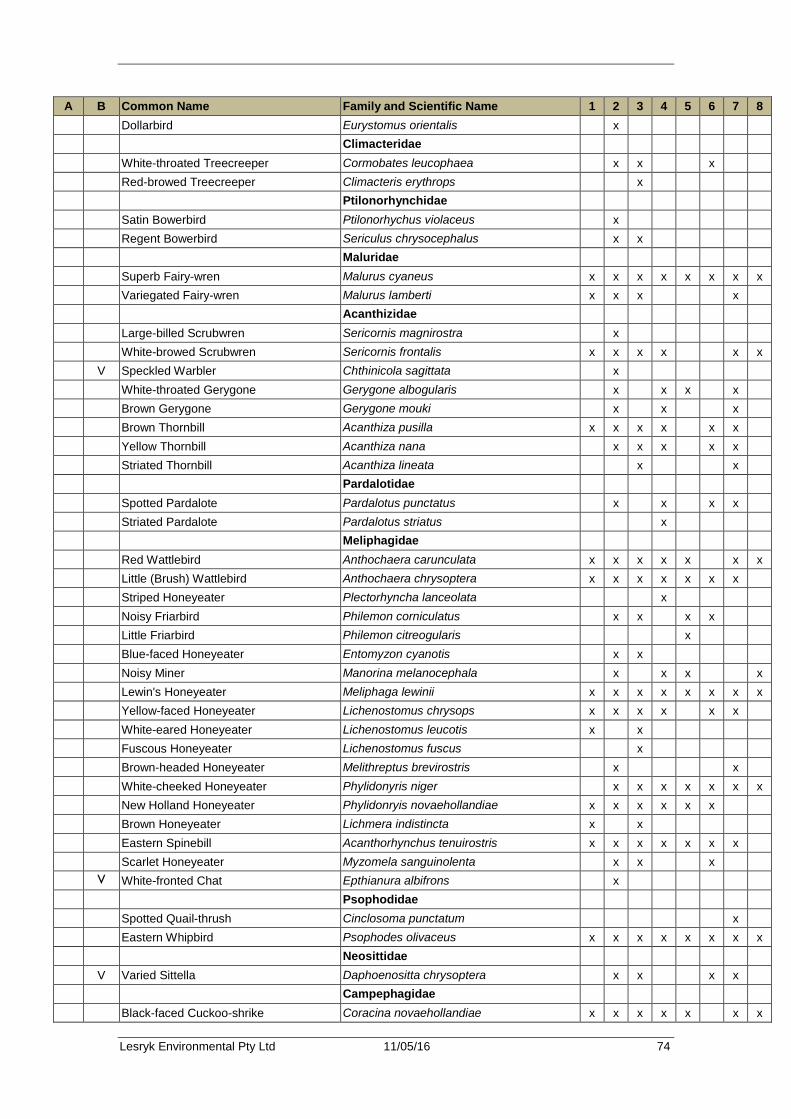
Lesryk Environmental Pty Ltd 11/05/16 74
A B Common Name Family and Scientific Name 1 2 3 4 5 6 7 8 Dollarbird Eurystomus orientalis x Climacteridae White-throated Treecreeper Cormobates leucophaea x x x Red-browed Treecreeper Climacteris erythrops x Ptilonorhynchidae Satin Bowerbird Ptilonorhychus violaceus x Regent Bowerbird Sericulus chrysocephalus x x Maluridae Superb Fairy-wren Malurus cyaneus x x x x x x x x Variegated Fairy-wren Malurus lamberti x x x x Acanthizidae Large-billed Scrubwren Sericornis magnirostra x White-browed Scrubwren Sericornis frontalis x x x x x x V Speckled Warbler Chthinicola sagittata x White-throated Gerygone Gerygone albogularis x x x x Brown Gerygone Gerygone mouki x x x Brown Thornbill Acanthiza pusilla x x x x x x Yellow Thornbill Acanthiza nana x x x x x Striated Thornbill Acanthiza lineata x x Pardalotidae Spotted Pardalote Pardalotus punctatus x x x x Striated Pardalote Pardalotus striatus x Meliphagidae Red Wattlebird Anthochaera carunculata x x x x x x x Little (Brush) Wattlebird Anthochaera chrysoptera x x x x x x x Striped Honeyeater Plectorhyncha lanceolata x Noisy Friarbird Philemon corniculatus x x x x Little Friarbird Philemon citreogularis x Blue-faced Honeyeater Entomyzon cyanotis x x Noisy Miner Manorina melanocephala x x x x Lewin's Honeyeater Meliphaga lewinii x x x x x x x x Yellow-faced Honeyeater Lichenostomus chrysops x x x x x x White-eared Honeyeater Lichenostomus leucotis x x Fuscous Honeyeater Lichenostomus fuscus x Brown-headed Honeyeater Melithreptus brevirostris x x White-cheeked Honeyeater Phylidonyris niger x x x x x x x New Holland Honeyeater Phylidonryis novaehollandiae x x x x x x Brown Honeyeater Lichmera indistincta x x Eastern Spinebill Acanthorhynchus tenuirostris x x x x x x x Scarlet Honeyeater Myzomela sanguinolenta x x x V White-fronted Chat Epthianura albifrons x Psophodidae Spotted Quail-thrush Cinclosoma punctatum x Eastern Whipbird Psophodes olivaceus x x x x x x x x Neosittidae V Varied Sittella Daphoenositta chrysoptera x x x x Campephagidae Black-faced Cuckoo-shrike Coracina novaehollandiae x x x x x x x
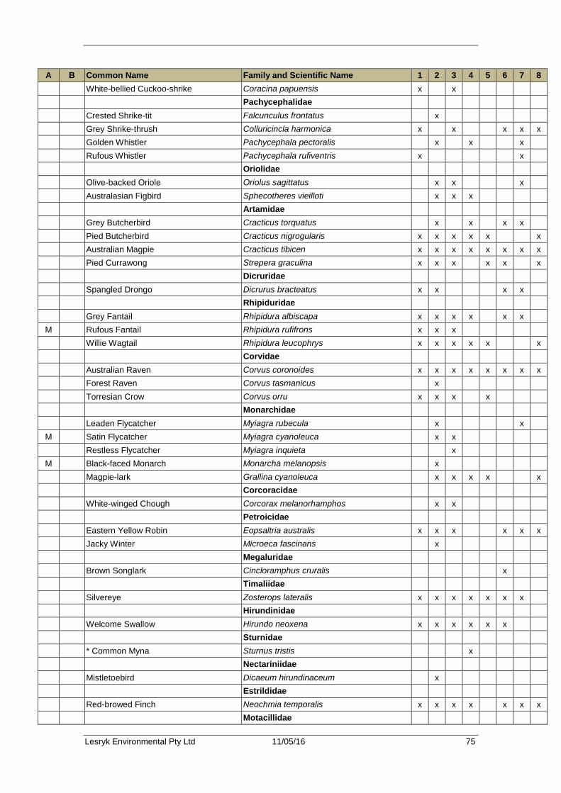
Lesryk Environmental Pty Ltd 11/05/16 75
A B Common Name Family and Scientific Name 1 2 3 4 5 6 7 8 White-bellied Cuckoo-shrike Coracina papuensis x x Pachycephalidae Crested Shrike-tit Falcunculus frontatus x Grey Shrike-thrush Colluricincla harmonica x x x x x Golden Whistler Pachycephala pectoralis x x x Rufous Whistler Pachycephala rufiventris x x Oriolidae Olive-backed Oriole Oriolus sagittatus x x x Australasian Figbird Sphecotheres vieilloti x x x Artamidae Grey Butcherbird Cracticus torquatus x x x x Pied Butcherbird Cracticus nigrogularis x x x x x x Australian Magpie Cracticus tibicen x x x x x x x x Pied Currawong Strepera graculina x x x x x x Dicruridae Spangled Drongo Dicrurus bracteatus x x x x Rhipiduridae Grey Fantail Rhipidura albiscapa x x x x x x
M Rufous Fantail Rhipidura rufifrons x x x Willie Wagtail Rhipidura leucophrys x x x x x x Corvidae Australian Raven Corvus coronoides x x x x x x x x Forest Raven Corvus tasmanicus x Torresian Crow Corvus orru x x x x Monarchidae Leaden Flycatcher Myiagra rubecula x x
M Satin Flycatcher Myiagra cyanoleuca x x Restless Flycatcher Myiagra inquieta x
M Black-faced Monarch Monarcha melanopsis x Magpie-lark Grallina cyanoleuca x x x x x Corcoracidae White-winged Chough Corcorax melanorhamphos x x Petroicidae Eastern Yellow Robin Eopsaltria australis x x x x x x Jacky Winter Microeca fascinans x Megaluridae Brown Songlark Cincloramphus cruralis x Timaliidae Silvereye Zosterops lateralis x x x x x x x Hirundinidae Welcome Swallow Hirundo neoxena x x x x x x Sturnidae * Common Myna Sturnus tristis x Nectariniidae Mistletoebird Dicaeum hirundinaceum x Estrildidae Red-browed Finch Neochmia temporalis x x x x x x x Motacillidae
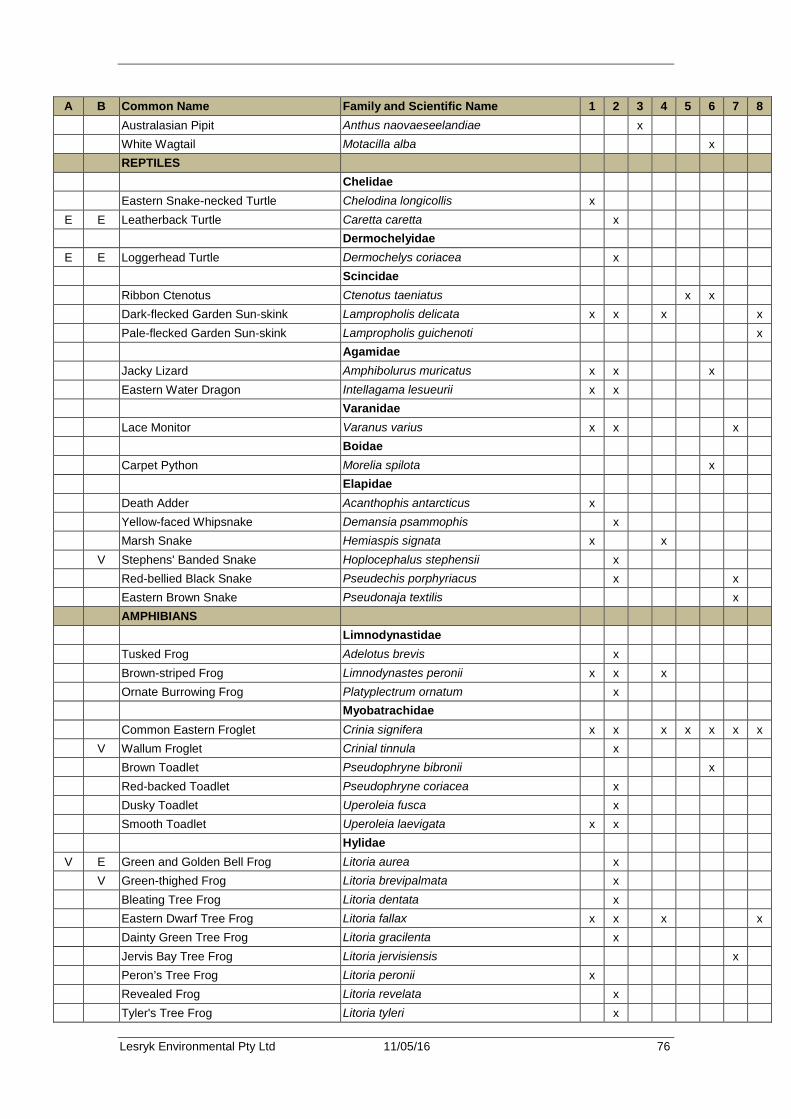
Lesryk Environmental Pty Ltd 11/05/16 76
A B Common Name Family and Scientific Name 1 2 3 4 5 6 7 8 Australasian Pipit Anthus naovaeseelandiae x White Wagtail Motacilla alba x REPTILES Chelidae Eastern Snake-necked Turtle Chelodina longicollis x
E E Leatherback Turtle Caretta caretta x Dermochelyidae
E E Loggerhead Turtle Dermochelys coriacea x Scincidae Ribbon Ctenotus Ctenotus taeniatus x x Dark-flecked Garden Sun-skink Lampropholis delicata x x x x Pale-flecked Garden Sun-skink Lampropholis guichenoti x Agamidae Jacky Lizard Amphibolurus muricatus x x x Eastern Water Dragon Intellagama lesueurii x x Varanidae Lace Monitor Varanus varius x x x Boidae Carpet Python Morelia spilota x Elapidae Death Adder Acanthophis antarcticus x Yellow-faced Whipsnake Demansia psammophis x Marsh Snake Hemiaspis signata x x V Stephens' Banded Snake Hoplocephalus stephensii x Red-bellied Black Snake Pseudechis porphyriacus x x Eastern Brown Snake Pseudonaja textilis x AMPHIBIANS Limnodynastidae Tusked Frog Adelotus brevis x Brown-striped Frog Limnodynastes peronii x x x Ornate Burrowing Frog Platyplectrum ornatum x Myobatrachidae Common Eastern Froglet Crinia signifera x x x x x x x V Wallum Froglet Crinial tinnula x Brown Toadlet Pseudophryne bibronii x Red-backed Toadlet Pseudophryne coriacea x Dusky Toadlet Uperoleia fusca x Smooth Toadlet Uperoleia laevigata x x Hylidae
V E Green and Golden Bell Frog Litoria aurea x V Green-thighed Frog Litoria brevipalmata x Bleating Tree Frog Litoria dentata x Eastern Dwarf Tree Frog Litoria fallax x x x x Dainty Green Tree Frog Litoria gracilenta x Jervis Bay Tree Frog Litoria jervisiensis x Peron’s Tree Frog Litoria peronii x Revealed Frog Litoria revelata x Tyler's Tree Frog Litoria tyleri x

Lesryk Environmental Pty Ltd 11/05/16 77
A B Common Name Family and Scientific Name 1 2 3 4 5 6 7 8 FISH Eel Anguilla sp. x * Mosquitofish Gambusia holbrooki x

Lesryk Environmental Pty Ltd 11/05/16 78
Appendix 5. Microchiropteran call analysis Date Surveyed: 2 – 8 February, 2016 Location: Mungo Brush, NSW Survey
Location Common Name Scientific Name Call
Confidence
Time of 1st pass
Unit 1 2 Feb
no calls 3 Feb
no calls 4 Feb
no calls Unit 2 2 Feb
Chocolate Wattled Bat Chalinolobus morio C 2019 # Little Bentwing Bat Miniopterus australis P 2020 Eastern Forest Bat Vespadelus pumilus Po 2016
3 Feb Eastern Horseshoe Bat Rhinolophus megaphyllus C 2136 Gould’s Wattled Bat Chalinolobus gouldii C 0528 Chocolate Wattled Bat Chalinolobus morio C 2020 # Little Bentwing Bat Miniopterus australis P 2018 Eastern Forest Bat Vespadelus pumilus C 2044 Little Forest Bat Vespadelus vulturnus Po 2016
4 Feb Chocolate Wattled Bat Chalinolobus morio C 2052 # Little Bentwing Bat Miniopterus australis P 2039 Eastern Forest Bat Vespadelus pumilus C 2040 Little Forest Bat Vespadelus vulturnus Po 2034
5 Feb Chocolate Wattled Bat Chalinolobus morio C 2008 # Eastern Falsistrelle Falsistrellus tasmaniensis P 2043 # Little Bentwing Bat Miniopterus australis P 2015 Eastern Forest Bat Vespadelus pumilus C 2012 Little Forest Bat Vespadelus vulturnus Po 2010
6 Feb Chocolate Wattled Bat Chalinolobus morio C 2011 # Little Bentwing Bat Miniopterus australis P 2053 Eastern Forest Bat Vespadelus pumilus C 2017 Little Forest Bat Vespadelus vulturnus Po 2012
7 Feb Gould’s Wattled Bat Chalinolobus gouldii P 0023 Chocolate Wattled Bat Chalinolobus morio C 2012 # Little Bentwing Bat Miniopterus australis P 2013 Eastern Forest Bat Vespadelus pumilus C 2136 Little Forest Bat Vespadelus vulturnus Po 2013
8 Feb Gould’s Wattled Bat Chalinolobus gouldii C 2206 Chocolate Wattled Bat Chalinolobus morio C 2012 # Little Bentwing Bat Miniopterus australis C 2201 Eastern Forest Bat Vespadelus pumilus C 2011 Little Forest Bat Vespadelus vulturnus Po 2037
Unit 3 2 Feb
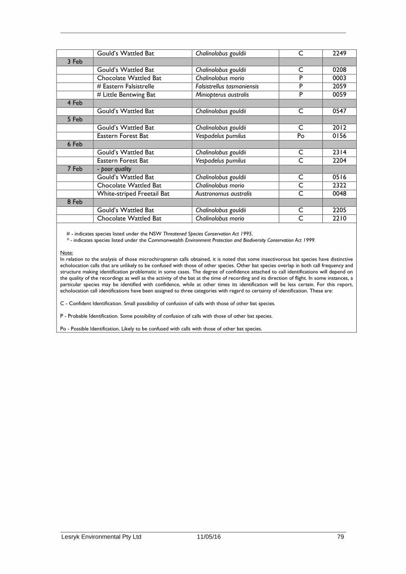
Lesryk Environmental Pty Ltd 11/05/16 79
Gould’s Wattled Bat Chalinolobus gouldii C 2249 3 Feb
Gould’s Wattled Bat Chalinolobus gouldii C 0208 Chocolate Wattled Bat Chalinolobus morio P 0003 # Eastern Falsistrelle Falsistrellus tasmaniensis P 2059 # Little Bentwing Bat Miniopterus australis P 0059
4 Feb Gould’s Wattled Bat Chalinolobus gouldii C 0547
5 Feb Gould’s Wattled Bat Chalinolobus gouldii C 2012 Eastern Forest Bat Vespadelus pumilus Po 0156
6 Feb Gould’s Wattled Bat Chalinolobus gouldii C 2314 Eastern Forest Bat Vespadelus pumilus C 2204
7 Feb - poor quality Gould’s Wattled Bat Chalinolobus gouldii C 0516 Chocolate Wattled Bat Chalinolobus morio C 2322 White-striped Freetail Bat Austronomus australis C 0048
8 Feb Gould’s Wattled Bat Chalinolobus gouldii C 2205 Chocolate Wattled Bat Chalinolobus morio C 2210
# - indicates species listed under the NSW Threatened Species Conservation Act 1995. * - indicates species listed under the Commonwealth Environment Protection and Biodiversity Conservation Act 1999.
Note: In relation to the analysis of those microchiropteran calls obtained, it is noted that some insectivorous bat species have distinctive echolocation calls that are unlikely to be confused with those of other species. Other bat species overlap in both call frequency and structure making identification problematic in some cases. The degree of confidence attached to call identifications will depend on the quality of the recordings as well as the activity of the bat at the time of recording and its direction of flight. In some instances, a particular species may be identified with confidence, while at other times its identification will be less certain. For this report, echolocation call identifications have been assigned to three categories with regard to certainty of identification. These are: C - Confident Identification. Small possibility of confusion of calls with those of other bat species. P - Probable Identification. Some possibility of confusion of calls with those of other bat species. Po - Possible Identification. Likely to be confused with calls with those of other bat species.

Lesryk Environmental Pty Ltd 11/05/16 80
Appendix 6. Survey methods and locations
Location Methods employed Easting Northing Northern end alignment Anabat 1 431500 6393884
Hair tube trap (HT M1) 431563 6393922 HT M2 431612 6393940 HT M3 431664 6393944 HT M4 431539 6393921 HT M5 431504 6393932 HT M6 431467 6393937
Infrared camera 3 431612 6393940 between northern end
and swamp Infrared camera 1 431218 6393756
Southern end alignment Anabat 3 429718 6393243 HT M7 429955 6393258 HT M8 429976 6393272 HT M9 429293 6393014 HT M10 429278 6393044 HT M11 429270 6393094 HT M12 429305 6393121 HT M13 429342 6393106 HT M14 429382 6393135
Infrared camera 2 429714 6393277 Infrared camera 4 429270 6393089
Songmeter 429367 6393066 Call playback 2 429360 6393046
Woodland HT M15 430576 6393451 HT M16 430588 6393497 HT M17 430622 6393567
Swamp HT M18 431001 6393624 HT M19 430983 6393690 HT M20 430948 6393715 Anabat 2 430986 6393601
Call playback 1 341074 6393660 Mungo Brush Road
(south) Call playback 3 428879 6392772
Mungo Brush Road (north)
Call playback 4 431335 6393581
Lesryk Environmental Pty Ltd 11/05/16 81
APPENDIX 7
ASSESSMENTS OF SIGNIFICANCE UNDER THE EPBC ACT
Lesryk Environmental Pty Ltd 11/05/16 82
Commonwealth - Environment Protection and Biodiversity Conservation Act 1999 By the completion of the field investigations, the following MNES had been noted/recorded: Wetland of international Importance
• the subject site occurs within the Myall Lakes Ramsar Wetland site Threatened species recorded
• Long-nosed Potoroo, listed as vulnerable, was photographed • New Holland Mouse, listed as vulnerable (photographed)
Migratory species recorded
• Great Egret (observed) • Eastern Osprey (observed) • Rufous Fantail (observed).
Additionally, as they have been previously recorded in, or beyond the study region, and as suitable habitat was present, a precautionary approach has been adopted in regards to the occurrence of the following flora and fauna species:
• Magenta Lilly Pilly, listed as vulnerable • Biconvex Paperbark, listed as vulnerable • Earp’s Gum, listed as vulnerable • Trailing Woodruff, listed as vulnerable • Leafless Tongue-orchid, listed as vulnerable • Spotted-tailed Quoll, listed as endangered • Koala, listed as vulnerable • Grey-headed Flying-fox, listed as vulnerable • Swift Parrot, listed as endangered.
The Significant Impact Guidelines prepared under the EPBC Act (DE 2013) are used to determine whether the action (i.e. the proposed realignment of Mungo Brush Road) has, will have, or is likely to have a significant impact on these MNES and, as such, whether the undertaking of the proposal would require referral of the matter to the Federal Minister for the Environment for further consideration or approval. Due to the similarity of their habitat requirements, Magenta Lilly Pilly and Biconvex Paperbark have been assessed together. The migratory birds have also been assessed together. (a) Myall Lakes Ramsar Wetland An action is likely to have a significant impact on the ecological character of a declared Ramsar wetland if there is a real chance of possibility that it will result in:
• areas of wetland being destroyed or substantially modified The ecological character of a Ramsar wetland is the combination of the ecosystem components, processes and benefits/services that characterise the wetland at a given point in time (DE 2016d). The Ecological Character Description (ECD) of the Myall Lakes Ramsar site is detailed in OEH (2012b) but can be summarised as comprising a mosaic of natural or near-natural wetlands; high quality, oligotrophic clear waters; a range of wetland vegetation types; significant biodiversity and habitats including migratory shorebirds; a diversity and abundance of wetland-dependent threatened species; special ecological features, namely gyttja beds; and recreational, scientific, educational and aesthetic amenity.
Lesryk Environmental Pty Ltd 11/05/16 83
Part of the purpose of the ECD document is to set limits of acceptable change. The purpose of these is to help site managers monitor the site, identify management actions and (of relevance to the proposal) determine limitations to activities to maintain the ecological character of the site. Limits of acceptable change have been formulated for water quality in the lakes but not for other critical components such as wetland vegetation due to a lack of baseline information. The duration of impacts on the wetland can be divided into those associated with the construction of the road (short-term) and those associated with the ongoing functioning of the road (medium to long-term). Construction impacts would include initial clearing of vegetation, soil disturbance, noise, vibration, and fumes (potentially affecting fauna), temporary changes to hydrology due to cut and fill activities. Demarcation of areas to be cleared would be used to ensure that clearing of vegetation does not extend beyond the minimum required for the road realignment and, with sediment and erosion controls, would minimise the possible impacts of soil movement. The months of January and February would represent the greatest risk of erosion and sedimentation impacts. These months occasionally experience more than 400mm of rainfall, with over 200mm in one day also occurring (Bureau of Meteorology 2016). Monitoring of erosion and sediment controls should be increased during heavy rain events. Maintenance of construction machinery would minimise the scale of possible impacts associated with noise, vibration, fumes and oil leaks. Site induction of construction workers would inform them of the significance of the Myall Lakes National Park Ramsar wetland and the importance of minimising impacts upon it. Direct medium to long-term impacts of the proposed road realignment are permanent loss of vegetation and potential modifications to hydrology. Indirect impacts include morbidity/mortality of fauna due to vehicle collision, repulsion of fauna from the road edge due to noise, possible introduction of pollutants (hydrocarbons, waste thrown from vehicles) traffic causing noise road-kill. The Myall Lakes Ramsar site of 44,612 ha covers the entire national park and therefore includes the study area, including vegetation communities such as heath and woodland that are not wetland communities. In total, the clearing would remove around 7.82 ha of vegetation, representing less than 0.02% of the Myall Lakes National Park Ramsar site. The Myall Lakes Ramsar site has 18 different wetland types as defined by the Ramsar Convention classification system. The wetland types listed in the ECD (Table 3 p 14) that would be affected by the proposed road are “Shrub dominated wetlands” and “Freshwater tree dominated wetlands.” No breakdown is provided in the ECD of the extent of these two wetland types in the Myall Lakes National Park Ramsar site. However, the two wetland types are part of the “Freshwater and fringing wetlands” group, of which it is estimated there are 6000 ha in the Myall Lakes Ramsar site (OEH 2012b). In terms of the vegetation community descriptions in this report (section 7.1.2), the Shrub dominated wetlands equate to the Ball Honeymyrtle Heath while the Freshwater tree dominated wetlands encompass the Swamp Mahogany - Broad-leaved Paperbark Open Forest and the Forest Red Gum – Swamp Mahogany Open Forest. The proposed road would affect around 1.39 ha of Freshwater tree dominated wetlands (comprising 1.34 ha of Swamp Mahogany - Broad-leaved Paperbark Open Forest and 0.05 ha of Forest Red Gum – Swamp Mahogany Open Forest) and 0.34 ha of Shrub dominated wetland. Together these wetland types total around 1.73 ha of Freshwater and fringing wetlands, which represents less than 0.03% of the 6000 ha this wetland group covers in the Ramsar site. Although the limits of acceptable change have not been set for the site’s wetland vegetation, it is considered that the level of clearing involved is not significant when viewed in the wider context of the extent of the vegetation types affected, and the small proportion (0.03%) of this that the proposed road realignment represents.
Lesryk Environmental Pty Ltd 11/05/16 84
• a substantial and measurable change in the hydrological regime of the wetland, for example, a substantial change to the volume, timing, duration and frequency of ground and surface water flows to and within the wetland
To elevate the road above the frequently inundated section of the alignment would require the deposition of fill to form an embankment. This has the potential to interrupt local hydrological patterns by causing a damming effect with pooling on the ‘upstream’ (southern) side of the road being a possible outcome. As the road base would be a porous material (sand) and that it would be constructed with culverts, the existing water table response would be maintained post-development.
• the habitat or lifecycle of native species, including invertebrate fauna and fish species, dependent upon the wetland being seriously affected
Though ground-traversing vehicle-struck fauna were observed during the course of the field investigations, it is considered that most of the native species present are tolerant of, and adaptable to, the existing patterns and volumes of traffic experienced along Mungo Brush Road. Flying, gliding and aquatic species would not be affected, particularly if culverts designed in accordance with NSW Department of primary Industries guidelines (Fairfull and Witheridge 2003) are included in the road design (thereby permitting the movement of fish and aquatic invertebrates). The scope of works proposed is not expected to increase traffic volumes. The realignment of Mungo Brush Road would remove 7.82 ha of native vegetation of which 1.73 ha is wetland vegetation, but this is not considered to seriously affect the habitat of lifecycle of any native species.
• a substantial and measurable change in the water quality of the wetland – for example, a substantial change in the level of salinity, pollutants, or nutrients in the wetland, or water temperature which may adversely impact on biodiversity, ecological integrity, social amenity or human health
Salinity and nutrient levels are unlikely to be affected by the proposed road realignment. Vehicles would be a vector of pollutants such as oil but as traffic volumes would not increase as a result of the road realignment, it is considered unlikely that there would be any substantial or measurable change in the water quality of the wetland. Furthermore, the slow flow rates in the wetland mean that any such pollutants are likely to be broken down in situ rather than being transported by overland flows to more sensitive areas such as wader habitats along the Myall River.
• an invasive species that is harmful to the ecological character of the wetland being established (or an existing invasive species being spread) in the wetland
A number of invasive species exist in the Myall Lakes Ramsar site as detailed in the Plan of Management for the Park (NPWS 2002) and some of these have been detected during the course of field investigations in the study area. Invasive plant species such as Slash Pine (Pinus elliotii) and the noxious weed Bitou Bush occur sporadically in the heath and woodland communities, while the European Red Fox was also detected in the study area. Vegetation clearing can promote the proliferation and spread of weeds, and roads are vectors for their movement and that of pest fauna species. However, given that it would not significantly add to the existing extent of roads, tracks and trails through the park and that active management of weed and pest species is conducted by NPWS, the proposed road realignment would not significantly increase the spread of invasive species that may be harmful to the wetland’s ecological character.
Lesryk Environmental Pty Ltd 11/05/16 85
Conclusion The proposed road realignment would result in the permanent loss of around 7.82 ha of native vegetation representing less than 0.02% of the Myall Lakes Ramsar site. Of this 7.82 ha, 1.73 ha of wetland vegetation would be removed, which represents less than 0.03% of the wetland group within which the affected vegetation types are grouped. It is likely to have some temporal effect on the hydrology of the wetland but this would be localised and readily mitigated by the inclusion of culverts in the road construction; nor is part of a pattern of cumulative impacts within the Ramsar wetland. All other developments within the wetland since the Ramsar listing have been small scale (e.g. modifications to camping areas) and have not changed the Ramsar site’s ecological character; nor does the plan of management for the park flag any large-scale developments that in concert with the proposed road realignment would change the Ramsar site’s ecological character. Furthermore, the ECD (OEH 2012b) states that the Myall Lakes Ramsar site also provides a broad range of opportunities for recreational, educational and scientific activities, and has a high social and cultural value. Myall National Park receives approximately 100,000 visitors per year and Mungo Brush Road is the main access route into the Park. The proposed road realignment would therefore facilitate the continuation of recreational, educational and scientific activities. The proposed road realignment is considered an isolated and relatively small-scale modification of the Ramsar site that would not have a significant impact on the ecological character of the Myall Lakes Ramsar Site. (b) Long-nosed Potoroo An action is likely to have a significant impact on a vulnerable species if there is a real chance or possibility that it will:
• lead to a long-term decrease in the size of an important population of a species The proposal would require the removal of 7.82 ha of native vegetation. Compared to the extent of similar resources being retained close to and beyond the limits of the subject site, the action is not considered to reduce the overall extent of habitat or foraging opportunities available to the Long-nosed Potoroo, nor adversely affect the life cycle of this species such that its local population would be placed at risk of extinction. The Long-nosed Potoroo was detected within 200 m of Mungo Brush Road. As such, the Long-nosed Potoroo is expected to be tolerant of the existing character and traffic volumes exhibited by this road. Therefore, the proposal would not lead to a long-term decrease in the size of an important population of this species.
• reduce the area of occupancy of an important population The proposal would not reduce the area of occupancy available to an important population of this species.
• fragment an existing important population into two or more populations Given the amount of vegetation to be removed it is highly unlikely that the proposal would result in the fragmentation of an important population of this species into two or more populations. Given its detection within 200 m of the existing alignment of Mungo Brush Road, and as suitable habitat is present either side of this for the Long-nosed Potoroo, it is expected that this animal is currently adaptable to, and negotiating the character of this urban infrastructure. The species is therefore expected to be tolerant of, and able to negotiate, the realigned section of this roadway.
Lesryk Environmental Pty Ltd 11/05/16 86
• adversely affect habitat critical to the survival of a species No habitat critical to the survival of this species was recorded within the study area.
• disrupt the breeding cycle of an important population Given the retention of suitable habitat adjacent to, and beyond the limits of, the area investigated, the proposed road is not considered to disrupt the breeding cycle of any potentially occurring important Long-nosed Potoroo populations.
• modify, destroy, remove or isolate or decrease the availability or quality of habitat to the extent that the species is likely to decline
The proposal is not considered to remove, modify, fragment or isolate a significant amount of Long-nosed Potoroo habitat such that the long-term survival of this species would be jeopardised. As similar habitat extends beyond the boundaries of the scope of work, it is not considered that the removal of around 7.82 ha of vegetation would have an impact on the Long-nosed Potoroo such that the species is likely to decline.
• result in invasive species that are harmful to a vulnerable species becoming established in the vulnerable species’ habitat7
The proposed work is not expected to exacerbate the current situation. A number of invasive species are already established within the Myall Lakes Ramsar site (NPWS 2002), some of which were detected during the course of the field investigations. It is noted that, near the site where the Long-nosed Potoroo was photographed, characteristic Fox scats were collected from Robinson’s Firetrail. As such, the Fox is already established with the habitat of this species. Vegetation clearing can promote the proliferation and spread of weeds, and roads are vectors for their movement and that of pest fauna species. However, given that it would not significantly add to the existing extent of roads, tracks and trails through the Park and that active management of weed and pest species is conducted by NPWS, the proposed road realignment would not result in the establishment of an invasive species that is harmful to the Long-nosed Potoroo.
• introduce disease that may cause the species to decline The proposal is unlikely to introduce diseases that may cause the Long-nosed Potoroo to decline.
• or interfere substantially with the recovery of the species A recovery plan has not yet been drafted for the Long-nosed Potoroo. The proposal is not considered to interfere substantially with the recovery of this species. Conclusion The proposal is not considered to have a significant impact on the Long-nosed Potoroo, its population or habitat. As such, it is not considered necessary that the matter be referred to the Federal Minister for the Environment for further consideration or approval.
7 Introducing an invasive species into the habitat may result in that species becoming established. An invasive species may harm listed threatened species or ecological communities by direct competition, modification of habitat, or predation.

Lesryk Environmental Pty Ltd 11/05/16 87
(c) New Holland Mouse An action is likely to have a significant impact on a vulnerable species if there is a real chance or possibility that it will:
• lead to a long-term decrease in the size of an important population of a species The proposal would require the removal of 7.82 ha of native vegetation. Compared to the extent of similar resources being retained adjacent to and beyond the limits of the subject site, the action is not considered to reduce the overall extent of habitat or foraging opportunities available to the New Holland Mouse, nor adversely affect the life cycle of this species such that its local population would be placed at risk of extinction. The New Holland Mouse was detected within 200 m of Mungo Brush Road. As such, this species is expected to be tolerant of the existing character and traffic volumes exhibited by this road. Therefore, the proposal would not lead to a long-term decrease in the size of an important population of this species.
• reduce the area of occupancy of an important population The proposal would not reduce the area of occupancy available to an important population of this species.
• fragment an existing important population into two or more populations Given the amount of vegetation to be removed it is highly unlikely that the proposal would result in the fragmentation of an important population of this species into two or more populations. Given its detection within 200 m of the existing alignment of Mungo Brush Road, and as suitable habitat is present either side of this for the New Holland Mouse, it is expected that this animal is currently adaptable to, and negotiating the character of this urban infrastructure. The species is therefore expected to be tolerant of, and able to negotiate, the realigned section of this roadway.
• adversely affect habitat critical to the survival of a species No habitat critical to the survival of this species was recorded within the study area.
• disrupt the breeding cycle of an important population Given the retention of suitable habitat within, and beyond the limits of, the area investigated, the proposed work is not considered to disrupt the breeding cycle of any potentially occurring important New Holland Mouse populations.
• modify, destroy, remove or isolate or decrease the availability or quality of habitat to the extent that the species is likely to decline
The proposal is not considered to remove, modify, fragment or isolate a significant amount of New Holland Mouse habitat such that the long-term survival of this species would be jeopardised. As similar habitat extends beyond the boundaries of the scope of work, this including the nearby conservation reserves, it is not considered that the removal of around 7.82 ha of vegetation would have an impact on the New Holland Mouse such that the species is likely to decline.
• result in invasive species that are harmful to a vulnerable species becoming established in the vulnerable species’ habitat
The proposed work is not expected to exacerbate the current situation. A number of invasive species are already established within the Myall Lakes Ramsar site (NPWS 2002), some of which were detected during the course of the field investigations. It is noted that, near the site where the New Holland Mouse was photographed, characteristic Fox scats were collected

Lesryk Environmental Pty Ltd 11/05/16 88
from Robinson’s Firetrail. As such, the Fox is already established with the habitat of this species. Vegetation clearing can promote the proliferation and spread of weeds, and roads are vectors for their movement and that of pest fauna species. However, given that it would not significantly add to the existing extent of roads, tracks and trails through the Park and that active management of weed and pest species is conducted by NPWS, the proposed road realignment would not result in the establishment of an invasive species that is harmful to the New Holland Mouse.
• introduce disease that may cause the species to decline The proposal is unlikely to introduce diseases that may cause the New Holland Mouse to decline.
• or interfere substantially with the recovery of the species No recovery plans that are applicable to the local New Holland Mouse population have been prepared. The proposal is not considered to interfere substantially with the recovery of the New Holland Mouse. Conclusion The proposal is not considered to have a significant impact on the New Holland Mouse, its population or habitat. As such, it is not considered necessary that the matter be referred to the Federal Minister for the Environment for further consideration or approval. (d) Migratory birds – Great Egret; Eastern Osprey; Rufous Fantail By the completion of the field investigation, three birds listed as migratory under the Act had been recorded, these being the:
• Great Egret • Eastern Osprey • Rufous Fantail.
Based on the observations made during the field investigation and the consultation of known literature sources, it is not considered that these species would significantly rely upon the subject site for any of their necessary life cycle requirements. No significant areas of these species’ habitat would be removed. Therefore, giving consideration to the Significant Impact Guidelines that are relevant to a migratory species: An action is likely to have a significant impact on a migratory species if there is a real chance or possibility that it will:
• substantially modify (including by fragmenting, altering fire regimes, altering nutrient cycles or altering hydrological cycles), destroy or isolate an area of important habitat for a migratory species
The subject site is not considered to constitute an important area of habitat for the Great Egret, Eastern Osprey or Rufous Fantail.
• result in an invasive species that is harmful to the migratory species becoming established in an area of important habitat for the migratory species
The proposed work is not expected to exacerbate the current situation. A number of invasive species are already established within the Myall Lakes Ramsar site (NPWS 2002), some of which were detected during the course of the field investigations.
Lesryk Environmental Pty Ltd 11/05/16 89
Introduced (invasive) species that have established within Myall Lake National Park, such as Fox, would be harmful to the presence of those migratory birds recorded. The proposed road realignment will not exacerbate or result in the establishment of any additional invasive species that are harmful to these birds or their habitat. The conducting of active management of weed and pest species by NPWS is expected to benefit those migratory birds recorded or expected.
• seriously disrupt the lifecycle (breeding, feeding, migration or resting behaviour) of an ecologically significant proportion of the population of a migratory species
The proposal would not seriously disrupt the lifecycle of an ecologically significant proportion of the Great Egret, Eastern Osprey or Rufous Fantail’s population. It is acknowledged that the proposal would result in the removal of around 7.82 ha of native vegetation. Whilst this is the case, given the amount of similar resources available within the surrounding national park, it is considered that the proposal would not have a significant effect on these species’. Conclusion As the proposed work is not considered to have a significant impact on the Great Egret, Eastern Osprey or Rufous Fantail, it is considered unnecessary that the matter be referred to the Federal Minister for the Environment for further consideration and approval. (e) Magenta Lilly Pilly, Biconvex Paperbark and Trailing Woodruff An action has, will have, or is likely to have a significant impact on a vulnerable species if there is a real chance or possibility that it will:
• lead to a long-term decrease in the size of an important population of a species, Magenta Lilly Pilly, Biconvex Paperbark nor Trailing Woodruff have not been confirmed as occurring along the proposed alignment of the road or in the wider study area. Therefore, an important population does not occur at the subject site.
• reduce the area of occupancy of an important population, An important population is not present in the study area.
• fragment an existing important population into two or more populations, An important population is not present in the study area.
• adversely affect habitat critical to the survival of a species, Given that the three species have not been detected in the study area, it is unlikely that the habitat at the site is critical to the survival of these plants.
• disrupt the breeding cycle of an important population, An important population is not present in the study area.
• modify, destroy, remove or isolate or decrease the availability or quality of habitat to the extent that the species is likely to decline,
The proposed action would result in the removal of approximately 1.34 ha of Swamp Mahogany – Broad-leaved Paperbark Forest and 0.05 ha of and Subtropical Coastal Floodplain Forest, which are potential habitat for these three species. Given that none of these plants occurs in, or close to, the study area, it is considered unlikely that that the realignment of a section of Mungo Brush Road would contribute to the decline of Magenta

Lesryk Environmental Pty Ltd 11/05/16 90
Lilly Pilly, Biconvex Paperbark or Trailing Woodruff.
• result in invasive species that are harmful to a vulnerable species becoming established in the vulnerable species’ habitat,
As a result of vegetation clearing, weed species may establish in areas of habitat adjacent to the road. However, as observed during the site investigation, elsewhere in the Park where the road has traversed potential habitat for these three plants, invasive plant species have not become established.
• introduce disease that may cause the species to decline, Magenta Lilly Pilly and Biconvex Paperbark are species susceptible to infection by Myrtle Rust (Puccinia psidii) (OEH 2011a). It is considered unlikely that the proposed road would introduce this disease into the species’ potential habitat. Profiles of Trailing Woodruff (OEH 2016b, DE 2016c) do not mention any diseases that affect this species.
• interfere substantially with the recovery of the species. The loss of a small area of potential habitat is unlikely to interfere with the recovery of these species. Conclusion The proposed action is unlikely to have a significant adverse impact on Magenta Lilly Pilly, Biconvex Paperbark or Trailing Woodruff. Therefore, it is considered that in relation to these species the matter would not require referral to the Federal Minister for the Environment as a controlled action. (f) Earp’s Gum An action has, will have, or is likely to have a significant impact on a vulnerable species if there is a real chance or possibility that it will:
• lead to a long-term decrease in the size of an important population of a species Earp’s Gum has not been confirmed as occurring along the proposed alignment of the road or in the wider study area. Therefore, an important population does not occur at the subject site.
• reduce the area of occupancy of an important population An important population is not present in the study area.
• fragment an existing important population into two or more populations An important population is not present in the study area.
• adversely affect habitat critical to the survival of a species Given that Earp’s Gum has not been detected in the study area, it is unlikely that the potential habitat at the site is critical to the survival of this species.
• disrupt the breeding cycle of an important population An important population is not present in the study area.

Lesryk Environmental Pty Ltd 11/05/16 91
• modify, destroy, remove or isolate or decrease the availability or quality of habitat to the extent that the species is likely to decline
The proposed action would result in the removal of around 6.09 ha of potential habitat (Wallum Banksia Heath and Old Man Banksia Woodland) for the species. Given that Earp’s Gum is not known from the study area, or in close proximity, it is considered unlikely that this would contribute to the decline of this species.
• result in invasive species that are harmful to a vulnerable species becoming established in the vulnerable species’ habitat
As a result of vegetation clearing, weed species may establish in areas of habitat adjacent to the road. However, those invasive plant species that could degrade habitat (e.g. Bitou Bush, Slash Pine) are only sporadic in areas of potential Earp’s Gum habitat and are being managed by NPWS.
• introduce disease that may cause the species to decline Earp’s Gum is not a species that has been confirmed as being susceptible to infection by Myrtle Rust; however, the closely related Forest Red Gum has (OEH 2011a). Therefore, it is likely the species is also susceptible. Whilst this is the case, it is considered unlikely that the proposed road would introduce this disease into the species’ potential habitat.
• interfere substantially with the recovery of the species The loss of a small area of potential habitat is unlikely to interfere with the recovery of this species. Conclusion The proposed action is unlikely to have a significant adverse impact on Earp’s Gum. Therefore, it is considered that, in relation to this species, the matter would not require referral to the Federal Minister for the Environment as a controlled action. (g) Leafless Tongue-orchid An action has, will have, or is likely to have a significant impact on a vulnerable species if there is a real chance or possibility that it will:
• lead to a long-term decrease in the size of an important population of a species The Leafless Tongue-orchid has not been confirmed as occurring along the proposed road alignment or in the wider study area. Therefore, an important population does not occur at the subject site.
• reduce the area of occupancy of an important population An important population is not present in the study area.
• fragment an existing important population into two or more populations An important population is not present in the study area.
• adversely affect habitat critical to the survival of a species Given that Leafless Tongue-orchid has not been detected in the study area, it is unlikely that the potential habitat at the site is critical to the survival of this species.

Lesryk Environmental Pty Ltd 11/05/16 92
• disrupt the breeding cycle of an important population An important population is not present in the study area.
• modify, destroy, remove or isolate or decrease the availability or quality of habitat to the extent that the species is likely to decline
The proposed action would result in the removal of around 6.09 ha of potential habitat (Wallum Banksia Heath and Old Man Banksia Woodland) for the species. Given that the species is not known to occur in the study area or in close proximity, it is considered unlikely that this would contribute to the decline of Leafless Tongue-orchid.
• result in invasive species that are harmful to a vulnerable species becoming established in the vulnerable species’ habitat
As a result of vegetation clearing, weed species may establish in areas of habitat adjacent to the road. However, those invasive plant species that could degrade habitat (e.g. Bitou Bush, Slash Pine) are only sporadic in areas of potential Leafless Tongue-orchid habitat and are being managed by NPWS.
• introduce disease that may cause the species to decline Profiles of the species (OEH 2016b, DE 2016c) do not mention any diseases as a threat to this species.
• interfere substantially with the recovery of the species The loss of a small area of potential habitat is unlikely to interfere with the recovery of this species. Conclusion The proposed action is unlikely to have a significant adverse impact on Leafless Tongue-orchid. Therefore, it is considered that in relation to this species the matter would not require referral to the Federal Minister for the Environment as a controlled action. (h) Spotted-tailed Quoll An action is likely to have a significant impact on a critically endangered or endangered species if there is a real chance or possibility that it will:
• lead to a long-term decrease in the size of a population Whilst not detected during the current investigation, this species has been previously recorded in the vicinity of the subject site. The proposal would require the removal of 7.82 ha of native vegetation. Compared to the extent of similar resources being retained close to and beyond the limits of the subject site, the action is not considered to reduce the overall extent of habitat or foraging opportunities available to the Spotted-tailed Quoll, nor adversely affect the life cycle of this species such that there would be a long-term decrease in the size of the local population. It is acknowledged that large areas of suitable habitat for the Spotted-tailed Quoll would remain unaffected within the surrounding Myall Lakes National Park; land specifically legislated and managed for conservation purposes under the NPW Act and the Myall Lakes National Park Plan of Management (NPWS 2002).
Lesryk Environmental Pty Ltd 11/05/16 93
• reduce the area of occupancy of the species The proposal would not reduce the area of occupancy available to a population of this species.
• fragment an existing population into two or more populations Given the amount of vegetation to be removed it is highly unlikely that the proposal would result in the fragmentation of a population of this species into two or more populations. Opportunities for the north south dispersal of this species along the Mungo Brush isthmus will be retained. Being previously recorded within this portion of Myall Lakes National Park, the Spotted-tailed Quoll is expected to be tolerant of, and adaptable to, the existing character of Mungo Brush Road.
• adversely affect habitat critical to the survival of a species No habitat critical to the survival of this species was recorded within the study area.
• disrupt the breeding cycle of a population Given the retention of suitable habitat within, and beyond the limits of, the area investigated, the proposed work is not considered to disrupt the breeding cycle of any potentially occurring Spotted-tailed Quoll populations.
• modify, destroy, remove, isolate or decrease the availability or quality of habitat to the extent that the species is likely to decline
The proposal is not considered to remove, modify, fragment or isolate a significant amount of Spotted-tailed Quoll habitat such that the long-term survival of this species would be jeopardised. As similar habitat extends beyond the boundaries of the scope of work, this including the nearby conservation reserves, it is not considered that the removal of around 7.82 ha of vegetation would have an impact on the Spotted-tailed Quoll such that the species is likely to decline.
• result in invasive species that are harmful to a critically endangered or endangered species becoming established in the endangered or critically endangered species’ habitat
The proposed work is not expected to exacerbate the current situation. A number of invasive species are already established within the Myall Lakes Ramsar site (NPWS 2002), some of which were detected during the course of the field investigations. It is noted that characteristic Fox scats were collected from Robinson’s Firetrail. As such, the Fox is already established with the habitat of this species. Vegetation clearing can promote the proliferation and spread of weeds, and roads are vectors for their movement and that of pest fauna species. However, given that it would not significantly add to the existing extent of roads, tracks and trails through the Park and that active management of weed and pest species is conducted by NPWS, the proposed road realignment would not result in the establishment of an invasive species that is harmful to the Spotted-tailed Quoll.
• introduce disease that may cause the species to decline The proposal is unlikely to introduce diseases that may cause the Spotted-tailed Quoll to decline.
Lesryk Environmental Pty Ltd 11/05/16 94
• interfere with the recovery of the species. A recovery plan has not yet been prepared for the Spotted-tailed Quoll. The proposal is not considered to interfere substantially with the recovery of this species. Conclusion As the proposed road realignment is not considered to have a significant impact on the Spotted-tailed Quoll, it is considered unnecessary that the matter be referred to the Federal Minister for the Environment for approval. (i) Koala An action is likely to have a significant impact on a vulnerable species if there is a real chance or possibility that it will:
• lead to a long-term decrease in the size of an important population8 of a species Should the population within Myall Lakes National Park and adjacent lands be part of an important population, it is considered unlikely that the proposed road realignment would lead to a long-term decrease in this population. Whilst a 7.82 ha linear band of vegetation would be affected, only 1.39 ha of this is comprised of Swamp Mahogany – Broad-leaved Paperbark Open Forest and Forest Red Gum – Swamp Mahogany Open Forest communities which are dominated by primary Koala feed trees (as defined by DECC 2008). The extent of these communities contiguous with the subject site is more than 400 ha. Therefore, though the potential area of occupancy would be reduced it would represent less than 1% of the habitat patch within which the subject site occurs. Furthermore, the population occupies other significantly-sized habitat patches to the north and south. Furthermore, the risk of morbidity/mortality associated with vehicle strikes, a primary threat to the species, is not likely to increase as a result of the proposed road realignment.
• reduce the area of occupancy of an important population The proposed road realignment would result in the removal of a linear band of vegetation that is around 7.82 ha in size, approximately 1.39 ha of which is comprised of suitable habitat for the species, namely Swamp Mahogany – Broad-leaved Paperbark Open Forest and Forest Red Gum – Swamp Mahogany Open Forest.
• fragment an existing important population into two or more populations Should an important population exist, given the minor clearing width proposed (i.e. 23 m) and the Koala’s ability to cross such gaps, the works are unlikely to fragment an existing population into two or more populations. It is noted that the author has observe Koalas traversing sealed rural roads that are lined by areas of suitable habitat (authors field notes).
• adversely affect habitat critical to the survival of a species With reference to the habitat assessment tool provided within the referral guidelines (i.e Table 4 pg 27 DE 2014), the Swamp Mahogany – Broad-leaved Paperbark Open Forest and Forest Red Gum – Swamp Mahogany Open Forest vegetation communities present within and beyond the study area (i.e. within Myall Lakes National Park) are considered critical habitat for the Koala based on:
8 The concept of ‘important populations’ has not been used in the koala referral guidelines (DE 2014).
Lesryk Environmental Pty Ltd 11/05/16 95
• Attribute: Koala occurrence: Evidence of one or more Koalas within 2 km of the edge of impact area within the last 5 years (score + 1)
• Attribute: Vegetation composition: Has forest or woodland with 2 or more known Koala food tree species (score + 2)
• Attribute: Habitat connectivity: Area is part of contiguous landscape ≥ 500 ha (score + 2)
• Attribute: Key existing threats: Little or no evidence of Koala mortality from vehicle strike or dog attack at present in areas that score 1 or 2 for Koala occurrence (score + 2)
• Attribute: Recovery value: Habitat is likely to be important for achieving the interim recovery objectives for the relevant context (score + 2)
“The Significant Impact Guidelines 1.1 state that actions are likely to have a significant impact on a vulnerable species if they adversely affect habitat critical to the survival of the species. Habitat destruction is recognised as the primary adverse effect on habitat critical to the survival of the Koala. Whether or not there are other impacts, the loss of habitat critical to the survival of the Koala can be sufficient to trigger a significant impact” (DE 2014 pg 29). With reference to Figure 2 of DE 2014 referral of the matter to the Federal Minister for the Environment is not recommended based on:
1) Consideration: Does your impact area contain habitat critical to the survival of the Koala?
a. Answer: Yes 2) Consideration: Do the area(s) proposed to be cleared contain known Koala food
trees? a. Answer: Yes
3) Consideration: Are you proposing to clear ≤ 2 ha of habitat containing known Koala food tress in an area with a habitat score of 5?
a. Answer: Yes. The proposal would only result in the clearing of 1.39 ha of the Swamp Mahogany – Broad-leaved Paperbark Open Forest and Forest Red Gum – Swamp Mahogany Open Forest vegetation communities.
• disrupt the breeding cycle of an important population
No Koalas were recorded or indicated as occurring within the study area. Should an important population exist, the undertaking of the proposal would not disturb the breeding cycle of this species.
• modify, destroy, remove or isolate or decrease the availability or quality of habitat to the extent that the species is likely to decline
The Koala is not considered to be reliant upon the 7.82 ha of native vegetation proposed to be removed such that the species would decline.
• result in invasive species that are harmful to a vulnerable species becoming established in the vulnerable species’ habitat
The proposal is not expected to exacerbate the current situation, thereby resulting in the establishment of any invasive species that may be harmful to the Koala or its habitat. Invasive species have not been identified as a threat to the Koala or its habitat (DE 2016, OEH 2016b)
• introduce disease that may cause the species to decline Two diseases have been identified as a threat to the Koala (DE 2016), these being Chlamydia and Myrtle Rust, the latter affecting trees upon which the species browses. It is considered unlikely that the proposed road would introduce either disease into the habitat available to the koala.

Lesryk Environmental Pty Ltd 11/05/16 96
The proposal is unlikely to introduce diseases that may cause the Koala to decline.
• or interfere substantially with the recovery of the species. Whilst a National Recovery Plan for the Koala has yet to be prepared, at a State scale OEH has prepared one (DECC 2008). The overall objectives of this plan are to:
• reverse the decline of the Koala in New South Wales • ensure adequate protection, management and restoration of Koala habitat • maintain healthy breeding populations of Koalas throughout their current range.
Criteria to indicate that the health and viability of Koala populations in NSW are improving will be:
• maintenance of existing populations (i.e. no local extinctions) • improvement of the extent and quality of habitat and protection of priority habitats and
sites • an increase in the numbers of breeding females, together with a corresponding
decrease in records of juvenile mortality • an increase in the general health of animals in the wild (e.g. less overt signs of
Chlamydia infection or other illness) • an expansion in distribution and the presence of koalas in all areas of primary Koala
habitat; and • an increase in community reports of Koala sightings.
Whilst the proposed works will result in the removal of a small portion of habitat containing known feed trees for the Koala, the proposal is not considered to substantially interfere with the recovery of this species at a State or national level. Conclusion As the proposed road realignment is not considered to have a significant impact on the Koala, it is considered unnecessary that the matter be referred to the Federal Minister for the Environment for approval. (j) Grey-headed Flying-fox An action is likely to have a significant impact on a vulnerable species if there is a real chance or possibility that it will:
• lead to a long-term decrease in the size of an important population of a species The proposal would require the removal of 7.82 ha of native vegetation. Compared to the extent of similar resources being retained within the remainder of the national park, the action is not considered to reduce the overall extent of foraging opportunities available to the Grey-headed Flying-fox, nor adversely affect the life cycle of this species such that its local population would be placed at risk of extinction. No roosting camps for this species were identified during the investigation. Therefore, the proposal would not lead to a long-term decrease in the size of an important population of this species.
• reduce the area of occupancy of an important population The proposal would not reduce the area of occupancy available to an important population of this species.

Lesryk Environmental Pty Ltd 11/05/16 97
• fragment an existing important population into two or more populations The Grey-headed Flying-fox’s ability to fly and negotiate open spaces and urban infrastructure would ensure that the proposal does not fragment an existing population into two or more populations.
• adversely affect habitat critical to the survival of a species; No habitat critical to the survival of this species was recorded within the study area.
• disrupt the breeding cycle of an important population No active or historic Flying-fox colonies were observed within the study area. The undertaking of the proposal would not disturb the breeding cycle of this species.
• modify, destroy, remove or isolate or decrease the availability or quality of habitat to the extent that the species is likely to decline;
This species is not considered to be reliant upon the resources offered by the subject site such that the vegetation removal and proposed road realignment would cause the Grey-headed Flying-fox to decline.
• result in invasive species that are harmful to a vulnerable species becoming established in the vulnerable species’ habitat
The existing diversity of introduced (invasive) species that have established within Myall Lake National Park is not harmful to the presence of this species. The proposed road realignment will not result in the establishment of any additional invasive species that are harmful to the presence of the Grey-headed Flying-fox or its habitat. It is considered unlikely that the proposed road would introduce or contribute to, beyond existing vectors, the spread of Myrtle Rust to the vegetation that is used as a foraging source by the Grey-headed Flying-fox. Within the study area, no active or historic Grey-headed Flying-fox colonies were noted. This megachiropteran has the ability to fly and traverse large distances, urban infrastructure and open space area (authors field notes).
• introduce disease that may cause the species to decline The proposal is unlikely to introduce diseases that may cause the Grey-headed Flying-fox to decline.
• or interfere substantially with the recovery of the species A National Recovery Plan (draft) for the Grey-headed Flying-fox has been prepared (DECCW 2009). The overall objectives of this plan are:
• to reduce the impact of threatening processes on Grey-headed Flying-foxes and arrest decline throughout the species’ range
• to conserve the functional roles of Grey-headed Flying-foxes in seed dispersal and pollination
• to improve the standard of information available to guide recovery of the Grey-headed Flying-fox, in order to increase community knowledge of the species and reduce the impact of negative public attitudes on the species.
The scope of proposed work would not affect any known roosting camps. The scope of work proposed would not be inconsistent with the objectives specified in this species’ recovery plan, specifically the following four specific objectives of the plan:
• Objective 1. To identify and protect foraging habitat critical to the survival of Grey-headed Flying-foxes throughout their range.
Lesryk Environmental Pty Ltd 11/05/16 98
No foraging habitat critical to the survival of the Grey-headed Flying-fox is present within the area proposed to be disturbed.
• Objective 2. To protect and increase the extent of key winter and spring foraging habitat of Grey-headed Flying-foxes.
Areas of winter and spring foraging habitat would remain unaffected within the surrounding Myall Lakes National Park, land specifically legislated and managed for conservation purposes under the NPW Act and the Myall Lakes National Park Plan of Management (NPWS 2002).
• Objective 3. To identify roosting habitat critical to the survival of Grey-headed Flying-foxes.
No Grey-headed Flying-fox roosting sites are present within, or in close proximity to, the area proposed to be disturbed.
• Objective 4. To protect and enhance roosting habitat critical to the survival of Grey-headed Flying-foxes.
No Grey-headed Flying-fox roosting sites are present within, or in close proximity to, the area proposed to be disturbed. Conclusion The proposal is not considered to have a significant impact on the Grey-headed Flying-fox, its population or habitat. As such, it is not considered necessary that the matter be referred to the Federal Minister for the Environment for further consideration or approval. (k) Swift Parrot An action is likely to have a significant impact on a critically endangered or endangered species if there is a real chance or possibility that it will:
• lead to a long-term decrease in the size of a population Whilst not detected during the current investigation, this species has been previously recorded in the locality. The proposed work would remove around 7.82 ha of native vegetation, this including areas of winter flowering species. Whilst this is the case, habitat and foraging resources for this species will be retained within the subject site and the surrounding locality, thereby providing resources for this species. The realignment of a 3.2 km section of Mungo Brush Road is not considered to disrupt the viability of any locally occurring Swift Parrot populations such that they are placed at risk of extinction.
• reduce the area of occupancy of the species The proposal would not reduce the area of occupancy available to a population of this species.
• fragment an existing population into two or more populations The Swift Parrot is adaptable to traversing open space areas such as Bass Strait. Given the amount of vegetation to be removed it is highly unlikely that the proposal would result in the fragmentation of a population of this species into two or more populations.
• adversely affect habitat critical to the survival of a species No habitat critical to the survival of this species was recorded within the study area.
Lesryk Environmental Pty Ltd 11/05/16 99
• disrupt the breeding cycle of a population Given the retention of suitable habitat within, and beyond the limits of, the area investigated, the proposed work is not considered to disrupt the breeding cycle of any potentially occurring Swift Parrot populations.
• modify, destroy, remove, isolate or decrease the availability or quality of habitat to the extent that the species is likely to decline
The proposal is not considered to remove, modify, fragment or isolate a significant amount of Swift Parrot habitat such that the long-term survival of this species would be jeopardised. Given the extent of similar resources beyond the boundaries of the scope of work, this including the nearby conservation reserves, it is not considered that the removal of around 7.82 ha of vegetation would have an impact on the Swift Parrot such that the species is likely to decline.
• result in invasive species that are harmful to a critically endangered or endangered species becoming established in the endangered or critically endangered species’ habitat
The proposed work is not expected to exacerbate the current situation. A number of invasive species are already established within the Myall Lakes Ramsar site (NPWS 2002), some of which were detected during the course of the field investigations. Introduced (invasive) species that have established within Myall Lake National Park, such as Fox, would be harmful to the presence of those threatened birds recorded. The proposed road realignment will not exacerbate or result in the establishment of any additional invasive species that are harmful to these birds or their habitat. The conducting of active management of weed and pest species by NPWS is expected to benefit those threatened birds recorded or expected.
• introduce disease that may cause the species to decline The proposal is unlikely to introduce diseases that may cause the Swift Parrot to decline.
• interfere with the recovery of the species. A national recovery plan has been prepared for the Swift Parrot (Saunders et al 2011). The overall objectives of this plan are to:
• to prevent further decline of the Swift Parrot population • to achieve a demonstrable sustained improvement in the quality and quantity of Swift
Parrot habitat to increase carrying capacity. The following actions are designed to achieve the overall objectives of this plan, these being: Recovery actions
• Action 1 - Identify the extent and quality of habitat. • Action 2 - Manage and protect Swift Parrot habitat at the landscape scale. • Action 3 - Monitor and manage the impact of collisions, competition and disease. • Action 4 - Monitor population and habitat.
Supporting actions
• Action 5 - Increase community involvement in, and awareness of, the recovery program.
• Action 6 - Coordinate, review and report on recovery process.

Lesryk Environmental Pty Ltd 11/05/16 100
It is noted that none of the recovery or supporting actions are relevant to the proposal. Whilst this is the case, it is acknowledged that the scope of work proposed would be consistent with the overall objectives specified in this species’ recovery plan. The proposal is not considered to interfere substantially with the recovery of this species. Conclusion As the proposed road realignment is not considered to have a significant impact on the Swift Parrot, it is considered unnecessary that the matter be referred to the Federal Minister for the Environment for further consideration or approval.

Lesryk Environmental Pty Ltd 11/05/16 101
APPENDIX 8
ASSESSMENTS OF SIGNIFICANCE UNDER THE EPA ACT
Lesryk Environmental Pty Ltd 11/05/16 102
State - Environmental Planning and Assessment Act 1979 Part 1, Section 5A of the EPA Act requires the consideration of the impacts of a proposed action on threatened species, populations and communities listed under the TSC Act. These criteria are designed to determine whether there is likely to be a significant effect on these threatened species and communities, or their habitats, and consequently whether a SIS is required. Endangered ecological communities
• Swamp Sclerophyll Forest • Subtropical Coastal Floodplain Forest
Threatened species recorded
• Long-nosed Potoroo • Little Bentwing Bat • Eastern Falsistrelle • Eastern Chestnut Mouse • Eastern Osprey.
Additionally, as they have been previously recorded in the region and as suitable habitat for their lifecycle requirements are present, a precautionary approach has been adopted in regards to the occurrence of the:
• Magenta Lilly Pilly • Biconvex Paperbark • Trailing Woodruff • Noah's False Chickweed • Earp’s Gum • Leafless Tongue-orchid • Spotted-tailed Quoll • Koala • Eastern Pygmy-possum • Squirrel Glider • Rufous Bettong • Grey-headed Flying-fox • Glossy Black-cockatoo • Little Lorikeet • Swift Parrot • Varied Sittella • Wallum Frog.
In line with the seven-part test guidelines (DECC 2007), due to the similarity of their habitat requirements, Magenta Lilly Pilly and Biconvex Paperbark have been assessed together. (a) Swamp Sclerophyll Forest – Seven-part test (a) in the case of a threatened species, whether the action proposed is likely to have an adverse effect on the life cycle of the species such that a viable local population of the species is likely to be placed at risk of extinction Swamp Sclerophyll Forest is an endangered ecological community, not a threatened species.
Lesryk Environmental Pty Ltd 11/05/16 103
(b) in the case of an endangered population, whether the action proposed is likely to have an adverse effect on the life cycle of the species that constitutes the endangered population such that a viable local population of the species is likely to be placed at risk of extinction Swamp Sclerophyll Forest is an endangered ecological community, not an endangered population. (c) in the case of an endangered ecological community or critically endangered ecological community, whether the action proposed:
(i) is likely to have an adverse effect on the extent of the ecological community such that its local occurrence is likely to be placed at risk of extinction, or
It is estimated that the total area of Swamp Sclerophyll Forest that would be removed by the proposal is around 1.34 ha based on a disturbance width of 23 m over a length of 580 m. The subject site’s Swamp Sclerophyll Forest is part of a larger remnant that extends to the east and west. By use of the Department of Lands' aerial photography imagery and associated online tools (http://imagery.maps.nsw.gov.au/), it was estimated that the overall size of the remnant of Swamp Sclerophyll Forest that occurs to the south of the river, between the Broadwater and Hawks Nest, is at least 400 ha, with a smaller area of the community occurring to the north of the Myall River. The area affected therefore constitutes less than 0.34% of the patch. Furthermore, the Swamp Sclerophyll Forest that would remain unaffected is within Myall Lakes National Park, land specifically legislated and managed for conservation purposes under the NPW Act and the Myall Lakes National Park Plan of Management (NPWS 2002). Therefore, giving consideration to the effective conservation of the remainder of the remnant, it is considered that the proposal would not place the local community at risk of extinction.
(ii) is likely to substantially and adversely modify the composition of the ecological community such that its local occurrence is likely to be placed at risk of extinction
An inspection of contiguous Swamp Sclerophyll Forest adjacent to Mungo Brush Road some 600 m north of the study area was conducted to determine likely effects the new route would have on the Swamp Sclerophyll Forest at the subject site. It found that there was no weed invasion of the Swamp Sclerophyll Forest adjacent to the road. Weeds, such as Vasey Grass (Paspalum urvillei) and Kurnell Curse (Hydrocotyle boniariensis) were confined to the well-drained soils on the shoulder of the road above the level at which inundation would commonly occur. It is unclear whether the effective “damming” that the road has caused here has changed the composition of the community since the road was constructed. In their study of the nearby Eurunderee sand mass Myerscough and Carolin (1986) found that Broad-leaved Paperbark was usually more abundant in sump sites where water stands. Water already appears to be sumping where the proposed road realignment traverses the Swamp Sclerophyll Forest with little evidence of flow observed during the field survey. Therefore, though imposition of a damming road may favour Broad-leaved Paperbark, there probably would be little change from the current composition of the community. Nevertheless, any such effect would not be to a degree that the adjacent remaining vegetation transforms into a vegetation type that is not commensurate with Swamp Sclerophyll Forest. Furthermore, the road base would be a porous material (sand) and culverts would be included in the road design in order to ensure that that the water table response post-development is the same as the existing water table response. Therefore, the local occurrence of the community is unlikely to be placed at risk of extinction.
Lesryk Environmental Pty Ltd 11/05/16 104
(d) in relation to the habitat of a threatened species, population or ecological community:
(i) the extent to which habitat is likely to be removed or modified as a result of the action proposed,
The proposal would result in the direct removal of around 0.58 ha of this community. Potential modifications to those parts of the community that would remain post-development are addressed above.
(ii) and whether an area of habitat is likely to become fragmented or isolated from other areas of habitat as a result of the proposed action
The proposed road work would fragment the stand of the community to some degree by increasing the distance between individual component plants. However, plants that occur on either side of the road would still exchange genetic material through vectors such as wind and fauna dispersal.
(iii) and the importance of the habitat to be removed, modified, fragmented or isolated to the long-term survival of the species, population or ecological community in the locality
It is considered that the habitat that would be removed or modified is not important to the long-term survival of the community in the locality as it does not constitute a significant proportion of the remnant. (e) whether the action proposed is likely to have an adverse effect on critical habitat (either directly or indirectly) Critical habitat of Swamp Sclerophyll Forest has not yet been defined. (f) whether the action proposed is consistent with the objectives or actions of a recovery plan or threat abatement plan No recovery plan has been prepared in relation to this endangered ecological community. Under the Saving our Species Program (OEH 2016d) (which has replaced recovery and threat abatement plans), OEH is currently developing a targeted approach for managing Ecological Communities. In the interim, numerous management actions have been identified for this community, none of which are relevant to the proposed action. (g) whether the action proposed constitutes or is part of a key threatening process or is likely to result in the operation of, or increase the impact of, a key threatening process Currently 35 KTPs for mainland NSW are listed under Schedule 3 of the TSC Act. Of these, ‘clearing of native vegetation’ is applicable to the proposed action. It could also result in the operation of two other KTPs, namely ‘Invasion of native plant communities by Bitou bush & boneseed’ and ‘Invasion, establishment and spread of Lantana camara.’ Expected impact on Swamp Sclerophyll Forest The proposal would result in the removal and modification of around 1.34 ha of Swamp Sclerophyll Forest, which represents about 0.34% of the local occurrence of the community. It is considered that this is a small proportion of the local occurrence of this community and that, as the remainder is conserved and managed within Myall Lakes National Park, the community’s local occurrence would not be placed at risk of extinction. Therefore, it is considered that there would not be a significant effect on Swamp Sclerophyll Forest, or its habitat and a SIS is not required.
Lesryk Environmental Pty Ltd 11/05/16 105
(b) Subtropical Coastal Floodplain Forest – Seven-part test (a) in the case of a threatened species, whether the action proposed is likely to have an adverse effect on the life cycle of the species such that a viable local population of the species is likely to be placed at risk of extinction Subtropical Coastal Floodplain Forest is an endangered ecological community, not a threatened species. (b) in the case of an endangered population, whether the action proposed is likely to have an adverse effect on the life cycle of the species that constitutes the endangered population such that a viable local population of the species is likely to be placed at risk of extinction Subtropical Coastal Floodplain Forest is an endangered ecological community, not an endangered population. (c) in the case of an endangered ecological community or critically endangered ecological community, whether the action proposed:
(i) is likely to have an adverse effect on the extent of the ecological community such that its local occurrence is likely to be placed at risk of extinction, or
It is estimated that the total area of Subtropical Coastal Floodplain Forest that would be removed by the proposal is around 0.05 ha based on a disturbance width of 23 m over a length of around 20 m on the eastern edge of the Swamp Sclerophyll Forest. The area of the community affected is part of a larger patch that occurs in a narrow band around the edge of the Swamp Sclerophyll Forest and on intermittent patches of slightly higher ground within that community. It is difficult to calculate the extent of the community as it intergrades with the Old Man Banksia Woodland. However, it is estimated that the local occurrence covers an area of at least 2.5 ha. Therefore, 2% of the local occurrence would be affected. The Subtropical Coastal Floodplain Forest that would remain unaffected is within Myall Lakes National Park, land specifically legislated and managed for conservation purposes under the NPW Act and the Myall Lakes National Park Plan of Management (NPWS 2002). Therefore, giving consideration to the effective conservation of the remainder of the remnant, it is considered that the proposal would not place the local community at risk of extinction.
(ii) is likely to substantially and adversely modify the composition of the ecological community such that its local occurrence is likely to be placed at risk of extinction
Construction of the road may have the potential to cause further pooling of water south of the alignment which would favour the spread of Swamp Sclerophyll Forest at the expense of the Subtropical Coastal Floodplain Forest. However, any such effect would be mitigated by the inclusion of culverts in the road design to maintain the existing water table response. (d) in relation to the habitat of a threatened species, population or ecological community:
(i) the extent to which habitat is likely to be removed or modified as a result of the action proposed
The proposal would result in the direct removal of around 0.05 ha of this community. Potential modifications to those parts of the community that would remain post-development are addressed above.
Lesryk Environmental Pty Ltd 11/05/16 106
(ii) and whether an area of habitat is likely to become fragmented or isolated from other areas of habitat as a result of the proposed action
The proposed road would fragment the stand of the community to some degree by increasing the distance between individual component plants. However, plants that occur on either side of the road would still exchange genetic material through vectors such as wind and fauna dispersal.
(iii) and the importance of the habitat to be removed, modified, fragmented or isolated to the long-term survival of the species, population or ecological community in the locality
It is considered that the habitat that would be removed or modified is not important to the long-term survival of the community in the locality as it does not constitute a significant proportion of the remnant. (e) whether the action proposed is likely to have an adverse effect on critical habitat (either directly or indirectly) Critical habitat of Subtropical Coastal Floodplain Forest has not yet been defined. (f) whether the action proposed is consistent with the objectives or actions of a recovery plan or threat abatement plan No recovery plan has been prepared in relation to this endangered ecological community. Under the Saving our Species Program (OEH 2016d) OEH is currently developing a targeted approach for managing Ecological Communities. In the interim, numerous management actions have been identified for this community, none of which are relevant to the proposed action. (g) whether the action proposed constitutes or is part of a key threatening process or is likely to result in the operation of, or increase the impact of, a key threatening process Currently 35 KTPs for mainland NSW are listed under Schedule 3 of the TSC Act. Of these, "clearing of native vegetation" is applicable to the proposed action. The proposed action could also result in the operation of two other KTPs, namely ‘Invasion of native plant communities by Bitou bush & boneseed’ and ‘Invasion, establishment and spread of Lantana camara.’ It is considered unlikely the proposed action would significantly increase the impact of these KTPs. Expected impact on Subtropical Coastal Floodplain Forest The proposal would result in the removal and modification of around 0.05 ha of Subtropical Coastal Floodplain Forest. It is considered that, as this would represent a small proportion (2%) of the local occurrence of the community and that the remainder is conserved and managed within Myall Lakes National Park, the community’s local occurrence would not be placed at risk of extinction. Therefore, it is considered that there would not be a significant effect on Subtropical Coastal Floodplain Forest, or its habitat. Therefore, a SIS is not required in relation to this endangered ecological community.

Lesryk Environmental Pty Ltd 11/05/16 107
(c) Long-nosed Potoroo – Seven-part test (a) in the case of a threatened species, whether the action proposed is likely to have an adverse effect on the life cycle of the species such that a viable local population of the species is likely to be placed at risk of extinction Indicative images of the Long-nosed Potoroo were recorded during the investigation through use of the infrared camera placed within the northern end of the proposed road realignment. To permit the scope of work, around 7.82 ha of native vegetation will require removal. Whilst this is the case, similar habitat will be retained within the surrounding national park, this providing for the foraging and breeding requirements of the Long-nosed Potoroo. The proposed work is not considered to affect the lifecycle of the Long-nosed Potoroo such that the viability of its population would be placed at risk of extinction. It is acknowledged that large areas of suitable habitat for the Long-nosed Potoroo would remain unaffected within the surrounding Myall Lakes National Park; land specifically legislated and managed for conservation purposes under the NPW Act and the Myall Lakes National Park Plan of Management (NPWS 2002). (b) in the case of an endangered population, whether the action proposed is likely to have an adverse effect on the life cycle of the species that constitutes the endangered population such that a viable local population of the species is likely to be placed at risk of extinction An ‘endangered population’ is defined as a ‘population specified in Part 2 of Schedule 1’ of the TSC Act. The Long-nosed Potoroo is only listed as an endangered population within the Cobaki Lakes and Tweed Heads West area near the NSW and QLD border, well beyond the limits of the proposed scope of works. (c) in the case of an endangered ecological community or critically endangered ecological community, whether the action proposed:
(i) is likely to have an adverse effect on the extent of the ecological community such that its local occurrence is likely to be placed at risk of extinction, or
(ii) is likely to substantially and adversely modify the composition of the ecological community such that its local occurrence is likely to be placed at risk of extinction
An endangered ecological community means an ecological community specified in Part 3 of Schedule 1 of the TSC Act. The Long-nosed potoroo is not listed as an endangered ecological community. (d) in relation to the habitat of a threatened species, population or ecological community:
(i) the extent to which habitat is likely to be removed or modified as a result of the action proposed
The proposal will require the removal of around 7.82 ha of native vegetation.
(ii) whether an area of habitat is likely to become fragmented or isolated from other areas of habitat as a result of the proposed action
Given its detection within 200 m of the existing alignment of Mungo Brush Road, and as suitable habitat is present either side of this for the Long-nosed Potoroo, it is expected that this animal is currently adaptable to, and negotiating, the character of this urban infrastructure. The species is therefore expected to be tolerant of, and able to negotiate, the realigned section of this roadway.
Lesryk Environmental Pty Ltd 11/05/16 108
The proposal would therefore not result in the fragmentation or isolation of any Long-nosed Potoroo habitat areas. Suitable habitat and vegetation linkages will be retained adjacent to and beyond the limits of the proposed road realignment.
(iii) the importance of the habitat to be removed, modified, fragmented or isolated to the long term survival of the species, population or ecological community in the locality
The vegetation present within the subject site is not considered to be important to the long-term survival of the Long-nosed Potoroo in this locality. Given the extent of suitable habitat being retained within the surrounding national park, the removal of around 7.82 ha of native vegetation is not considered to cause any further fragmentation of, or isolation to, any areas of habitat used by the Long-nosed Potoroo such that the long term survival of this species in the locality would be adversely affected. (e) whether the action proposed is likely to have an adverse effect on critical habitat (either directly or indirectly) No critical habitat would be adversely affected by the proposal. The subject site is not listed as critical habitat under Part 3 Division 1 of the TSC Act. (f) whether the action proposed is consistent with the objectives or actions of a recovery plan or threat abatement plan No recovery plans have been prepared for the Long-nosed Potoroo. A targeted strategy for managing this species has been developed under the Saving Our Species program, the Long-nosed Potoroo being assigned to the ‘site-managed species’ management stream (OEH 2016d). OEH has established five management sites where conservation activities need to take place to ensure the conservation of this species, none of which are in the Great Lakes LGA. Similarly, no actions to guide management in regards to this species have been identified. The retention of habitat within, and beyond the boundaries of, the subject site is considered to provide foraging resources for the Long-nosed Potoroo in this locality. (g) whether the action proposed constitutes or is part of a key threatening process or is likely to result in the operation of, or increase the impact of, a key threatening process Currently 35 KTPs for mainland NSW are listed under Schedule 3 of the TSC Act. Of these, the ‘clearing of native vegetation’ may be considered applicable to the presence of the Long-nosed Potoroo. Whilst this is the case, the removal of 7.82 ha of native vegetation, in comparison with the retention of similar resources within the study area and surrounding region, is not considered to significantly contribute to this KTP such that it would adversely affect the presence or long term survival of the Long-nosed Potoroo. Expected impact on the Long-nosed Potoroo The undertaking of the proposed action would not disturb, remove, modify or fragment any habitats critical to the life cycle requirements of the Long-nosed Potoroo. Given the likely scope of work proposed, it is considered that the realignment of a 3.2 km section of Mungo Brush Road would not have an impact on the Long-nosed Potoroo’s dispersal or movement corridors, nor would it adversely affect any significant areas of this species’ local or regional habitat. Therefore, the preparation of a SIS that further considers the impacts of the proposal on the Long-nosed Potoroo is not required.
Lesryk Environmental Pty Ltd 11/05/16 109
(d) Little Bentwing Bat – Seven-part test (a) in the case of a threatened species, whether the action proposed is likely to have an adverse effect on the life cycle of the species such that a viable local population of the species is likely to be placed at risk of extinction Indicative calls of the Little Bentwing Bat were recorded through use of those echolocation units placed within the central and southern portions of the study area. During the field investigation, no caves or suitable cave substitutes were observed within or in the vicinity of the subject site; as such, no roosting or breeding habitat suitable for the Little Bentwing Bat would be removed. The proposal will require the removal of around 7.82 ha of native vegetation, this including insect attracting plants. Whilst these plants would be cleared, similar resources would be retained within the surrounding national park, these ensuring that foraging opportunities are maintained for the Little Bentwing Bat. It is not considered that the proposal will have an adverse effect on the life cycle of the Little Bentwing Bat, such that the local population of this species would be placed at risk of extinction. It is acknowledged that large areas of suitable habitat for the Little Bentwing Bat would remain unaffected within the surrounding Myall Lakes National Park, land specifically legislated and managed for conservation purposes under the NPW Act and the Myall Lakes National Park Plan of Management (NPWS 2002). (b) in the case of an endangered population, whether the action proposed is likely to have an adverse effect on the life cycle of the species that constitutes the endangered population such that a viable local population of the species is likely to be placed at risk of extinction An ‘endangered population’ is defined as a ‘population specified in Part 2 of Schedule 1’ of the TSC Act. The Little Bentwing Bat is not an endangered population. (c) in the case of an endangered ecological community or critically endangered ecological community, whether the action proposed:
(i) is likely to have an adverse effect on the extent of the ecological community such that its local occurrence is likely to be placed at risk of extinction, or
(ii) is likely to substantially and adversely modify the composition of the ecological community such that its local occurrence is likely to be placed at risk of extinction
An endangered ecological community means an ecological community specified in Part 3 of Schedule 1 of the TSC Act. The Little Bentwing Bat is not listed as an endangered ecological community. (d) in relation to the habitat of a threatened species, population or ecological community:
(i) the extent to which habitat is likely to be removed or modified as a result of the action proposed
The proposal will require the removal of around 7.82 ha of native vegetation, this including insect attracting plants. The proposal would not remove any caves or suitable cave substitutes.
(ii) whether an area of habitat is likely to become fragmented or isolated from other areas of habitat as a result of the proposed action
To be detected within the study area, the Little Bentwing Bat would have had to negotiate features such as the Myall River, Mungo Brush Road, or similar open space area; as such,
Lesryk Environmental Pty Ltd 11/05/16 110
the Little Bentwing Bat is considered to be able to easily negotiate open areas. The loss of a 7.82 ha ‘linear band’ of vegetation from the subject site, combined with the retention of similar resources within the national park, is not considered to result in the disturbance to this species’ dispersal or movement patterns. The Little Bentwing Bat would be able to easily negotiate/traverse the site post-work. Therefore, no isolation or fragmentation of this species’ necessary habitats would arise.
(iii) the importance of the habitat to be removed, modified, fragmented or isolated to the long term survival of the species, population or ecological community in the locality
No caves or suitable cave substitutes would be removed. The removal of 7.82 ha of vegetation, this including insect attracting plants from the subject site, compared to the extent of similar resources being retained within the surrounding national park, is not considered to limit the overall extent of foraging resources available to the Little Bentwing Bat. The vegetation and habitats to be removed are therefore not considered important for the long-term survival of this species. (e) whether the action proposed is likely to have an adverse effect on critical habitat (either directly or indirectly) No critical habitat would be adversely affected by the proposal. The subject site is not listed as critical habitat under Part 3 Division 1 of the TSC Act. (f) whether the action proposed is consistent with the objectives or actions of a recovery plan or threat abatement plan No recovery plans have been prepared for any cave-dependant bat. A targeted strategy for managing this species has been developed under the Saving Our Species program, the Little Bentwing Bat being assigned to the ‘landscape species’ management stream (OEH 2016d). OEH has provided a number of actions to guide management in regards to this species, none of which are relevant to the current proposal. The retention of intact habitat within, and beyond the boundaries of, the subject site is considered to provide foraging opportunities for the Little Bentwing Bat in this locality. (g) whether the action proposed constitutes or is part of a key threatening process or is likely to result in the operation of, or increase the impact of, a key threatening process Currently 35 KTPs for mainland NSW are listed under Schedule 3 of the TSC Act. Of these, the ‘clearing of native vegetation’ may be considered applicable to the presence of the Little Bentwing Bat. Whilst this is the case, the removal of a number of insect attracting plants, in comparison with the retention of similar resources within the study area and surrounding region, is not considered to significantly contribute to this KTP such that it would adversely affect the presence or long term survival of the Little Bentwing Bat. Expected impact on the Little Bentwing Bat The undertaking of the proposed action would not disturb, remove, modify or fragment any habitats critical to the life cycle requirements of the Little Bentwing Bat. A small amount of insect-attracting plants would be removed. This, when compared to the extent of similar resources being retained both within the subject site itself and surrounding locality, not considered to present a significant impact. Given the likely scope of work proposed, the realignment of Mungo Brush Road would not have an impact on the Little Bentwing Bat’s dispersal or movement corridors, nor would it adversely affect any significant areas of this species’ local or regional habitat. Therefore, based on the results of the field investigation combined with the consultation of known literature sources, it is not considered that the proposal would have a significant impact on the Little Bentwing Bat or its habitat. Therefore,
Lesryk Environmental Pty Ltd 11/05/16 111
the preparation of a SIS that further considers the impacts of the proposal on the Little Bentwing Bat is not required. (e) Eastern Falsistrelle – Seven-part test (a) in the case of a threatened species, whether the action proposed is likely to have an adverse effect on the life cycle of the species such that a viable local population of the species is likely to be placed at risk of extinction The proposal would require the removal of some hollow-bearing trees that are present within the Forest Red Gum – Swamp Mahogany Open Forest. Whilst these trees would be cleared, similar stands of woodland that support hollow-bearing trees are present both within, and beyond the limits of, the study area. The proposed work would result in the removal of around 7.82 ha of native vegetation, this including insect attracting plants. Given the extent of similar foraging resources being retained within the study region, it is not considered that the proposal would have an adverse effect on the lifecycle of the Eastern Falsistrelle such that the local population of this species would be placed at risk of extinction. It is acknowledged that large areas of suitable habitat for the Eastern Falsistrelle would remain unaffected within the surrounding Myall Lakes National Park; land specifically legislated and managed for conservation purposes under the NPW Act and the Myall Lakes National Park Plan of Management (NPWS 2002). (b) in the case of an endangered population, whether the action proposed is likely to have an adverse effect on the life cycle of the species that constitutes the endangered population such that a viable local population of the species is likely to be placed at risk of extinction An ‘endangered population’ is defined as a ‘population specified in Part 2 of Schedule 1’ of the TSC Act. The Eastern Falsistrelle is not an endangered population. (c) in the case of an endangered ecological community or critically endangered ecological community, whether the action proposed:
(i) is likely to have an adverse effect on the extent of the ecological community such that its local occurrence is likely to be placed at risk of extinction, or
(ii) is likely to substantially and adversely modify the composition of the ecological community such that its local occurrence is likely to be placed at risk of extinction
An endangered ecological community means an ecological community specified in Part 3 of Schedule 1 of the TSC Act. The Eastern Falsistrelle is not listed as an endangered ecological community. (d) in relation to the habitat of a threatened species, population or ecological community:
(i) the extent to which habitat is likely to be removed or modified as a result of the action proposed
The proposal will require the removal of around 7.82 ha of native vegetation, this including insect attracting plants.
(ii) whether an area of habitat is likely to become fragmented or isolated from other areas of habitat as a result of the proposed action
The proposal is not expected to fragment or isolate any areas of habitat utilised by the Eastern Falsistrelle. Whilst the proposed work may increase the gap widths between habitats either side of the proposed road realignment, the Eastern Falsistrelle is known to easily
Lesryk Environmental Pty Ltd 11/05/16 112
negotiate open areas and has been recorded flying over/foraging through built up environments (author’s field notes, Churchill 2008). As such, the proposed work is not expected to result in the disturbance to this species’ dispersal or movement patterns. The Eastern Falsistrelle would be able to easily negotiate/traverse the subject site post-development. Therefore, no further isolation or fragmentation of this species’ necessary habitats would arise.
(iii) the importance of the habitat to be removed, modified, fragmented or isolated to the long term survival of the species, population or ecological community in the locality
The resources present within the subject site are not considered to be unique to this locality. Within the surrounding national park similar resources (i.e. hollow-bearing trees and insect attracting plants) are present. The importance of the subject site is therefore considered to be limited. The vegetation and habitats to be removed are therefore not considered important for the long-term survival of the Eastern Falsistrelle. (e) whether the action proposed is likely to have an adverse effect on critical habitat (either directly or indirectly) No critical habitat would be adversely affected by the proposal. The subject site is not listed as critical habitat under Part 3 Division 1 of the TSC Act. (f) whether the action proposed is consistent with the objectives or actions of a recovery plan or threat abatement plan A recovery plan has not been prepared for the Eastern Falsistrelle. A targeted strategy for managing this species has been developed under the Saving Our Species program, the Eastern Falsistrelle being assigned to the ‘landscape species’ management stream (OEH 2016d). OEH has provided a number of actions to guide management in regards to this species, two of which are relevant to the current proposal:
• Encourage landholders to retain and protect hollow-bearing trees in suitable habitat. Ensure long-term hollow availability by protecting recruit trees, that is, trees that will be able to provide hollows when current hollow-bearing trees have died and fallen.
• Ensure roosting bats are not present before removing or disturbing hollow-bearing trees in winter.
Hollow-bearing trees and insect attracting vegetation for this species will be retained within the subject site and the surrounding areas, thereby providing habitat resources for the Eastern Falsistrelle in this locality. (g) whether the action proposed constitutes or is part of a key threatening process or is likely to result in the operation of, or increase the impact of, a key threatening process Currently 35 KTPs for mainland NSW are listed under Schedule 3 of the TSC Act. Of these, the ‘clearing of native vegetation’ and ‘loss of hollow-bearing trees’ would be applicable to the proposal. Whilst this is the case, the removal of several hollow-bearing trees and 7.82 ha of insect attracting plants, in comparison with the extent of similar resources within the surrounding conservation reserve, is not considered to significantly contribute to these KTPs such that it would adversely affect the presence or long term survival of the Eastern Falsistrelle.
Lesryk Environmental Pty Ltd 11/05/16 113
Expected impact on the Eastern Falsistrelle The proposal would result in the removal of around 7.82 ha of native vegetation, this including several hollow-bearing trees. Given the extent of similar resources being retained within the subject site and the surrounding areas, the proposed work is not considered to present a significant impact on the Eastern Falsistelle Bat’s dispersal or movement corridors, nor would it adversely affect the lifecycle requirements of the Eastern Falsistrelle at either a local or regional level. It is not considered that the proposal would have a significant impact on the Eastern Falsistrelle or its habitat; as such, the preparation of a SIS that further considers the impacts of the proposal on the Eastern Falsistrelle is not required. (f) Eastern Chestnut Mouse – Seven-part test (a) in the case of a threatened species, whether the action proposed is likely to have an adverse effect on the life cycle of the species such that a viable local population of the species is likely to be placed at risk of extinction Probable images of this species were obtained through use of an infrared camera. The proposal would require the removal of 7.82 ha of native vegetation. Compared to the extent of similar resources being retained adjacent to and beyond the limits of the subject site, the action is not considered to reduce the overall extent of habitat or foraging opportunities available to the Eastern Chestnut Mouse, nor adversely affect the life cycle of this species such that its local population would be placed at risk of extinction. The Eastern Chestnut Mouse was detected within 200 m of Mungo Brush Road. As such, as suitable habitat occurs either side of this road, this species is expected to be tolerant of the existing character and traffic volumes exhibited by this road. Therefore, the proposal would not lead to a long-term decrease in the size of an important population of this species. It is acknowledged that large areas of suitable habitat for the Eastern Chestnut Mouse would remain unaffected within the surrounding Myall Lakes National Park; land specifically legislated and managed for conservation purposes under the NPW Act and the Myall Lakes National Park Plan of Management (NPWS 2002). (b) in the case of an endangered population, whether the action proposed is likely to have an adverse effect on the life cycle of the species that constitutes the endangered population such that a viable local population of the species is likely to be placed at risk of extinction An ‘endangered population’ is defined as a ‘population specified in Part 2 of Schedule 1’ of the TSC Act. The Eastern Chestnut Mouse is not an endangered population. (c) in the case of an endangered ecological community or critically endangered ecological community, whether the action proposed:
(i) is likely to have an adverse effect on the extent of the ecological community such that its local occurrence is likely to be placed at risk of extinction, or
(ii) is likely to substantially and adversely modify the composition of the ecological community such that its local occurrence is likely to be placed at risk of extinction
An endangered ecological community means an ecological community specified in Part 3 of Schedule 1 of the TSC Act. The Eastern Chestnut Mouse is not listed as an endangered ecological community.

Lesryk Environmental Pty Ltd 11/05/16 114
(d) in relation to the habitat of a threatened species, population or ecological community:
(i) the extent to which habitat is likely to be removed or modified as a result of the action proposed
The proposal will require the removal of around 7.82 ha of native vegetation.
(ii) whether an area of habitat is likely to become fragmented or isolated from other areas of habitat as a result of the proposed action
The loss of some native vegetation is not expected to result in the disturbance to this species’ dispersal or movement pattern. Suitable habitat for this species would be retained the study area. As such, the proposal would not cause any further fragmentation of, or isolation to, any areas of habitat used by the Eastern Chestnut Mouse.
(iii) the importance of the habitat to be removed, modified, fragmented or isolated to the long term survival of the species, population or ecological community in the locality
The vegetation currently present within the study area is not considered to be important to the long-term survival of the Eastern Chestnut Mouse in this locality. Given the extent of suitable habitat being retained within the surrounding region, the removal of around 7.82 ha of native vegetation is not considered to cause any further fragmentation of, or isolation to, any areas of habitat used by the Eastern Chestnut Mouse such that the long term survival of this species in the locality would be adversely affected. (e) whether the action proposed is likely to have an adverse effect on critical habitat (either directly or indirectly) No critical habitat would be adversely affected by the proposal. The subject site is not listed as critical habitat under Part 3 Division 1 of the TSC Act. (f) whether the action proposed is consistent with the objectives or actions of a recovery plan or threat abatement plan A recovery plan has not been prepared for the Eastern Chestnut Mouse. A targeted strategy for managing this species has been developed under the Saving Our Species program, the Eastern Chestnut Mouse being assigned to the ‘site-managed species’ management stream (OEH 2016d). OEH has established two management sites where conservation activities need to take place to ensure the conservation of this species, one of which is Myall Lakes National Park. The objective of this management site is to secure the species at the site and ensure the population's viability in the long term. OEH has identified one conservation management action that needs to be carried out on this site to ensure the population of threatened species is sustained, this being a ‘Species monitoring action’, of which ‘Track species abundance / condition over time’ is the objective (OEH 2016b). This action is not considered relevant to the current proposal. (g) whether the action proposed constitutes or is part of a key threatening process or is likely to result in the operation of, or increase the impact of, a key threatening process Currently 35 KTPs for mainland NSW are listed under Schedule 3 of the TSC Act. Of these, the ‘clearing of native vegetation’ would be considered applicable to the proposal. Whilst this is the case, the removal of around 7.82 ha of native vegetation, in comparison with the retention of similar resources adjacent to and beyond the limits of the subject site, is not considered to significantly contribute to this KTP such that it would adversely affect the presence or long term survival of the Eastern Chestnut Mouse.
Lesryk Environmental Pty Ltd 11/05/16 115
Expected impact on the Eastern Chestnut Mouse The undertaking of the proposed action would not disturb, remove, modify or fragment any habitats critical to the life cycle requirements of the Eastern Chestnut Mouse. Given the likely scope of work proposed, it is not considered that the realignment of a 3.2 km section of Mungo Brush Road would have an impact on the Eastern Chestnut Mouse’s dispersal or movement corridors, nor would it adversely affect any significant areas of this species’ local or regional habitat. Therefore, the preparation of a SIS that further considers the impacts of the proposal on the Eastern Chestnut Mouse is not required. (g) Eastern Osprey – Seven-part test (a) in the case of a threatened species, whether the action proposed is likely to have an adverse effect on the life cycle of the species such that a viable local population of the species is likely to be placed at risk of extinction During the field survey, an Eastern Osprey was observed roosting on powerlines immediately south of the southern limits of the national park. It is noted that no nests typical of this species were observed within the area investigated. It is also acknowledged, that whilst the proposal would remove a percentage of vegetation, no large trees suitable for the nesting requirements of this species would be cleared. Similarly, no major aquatic foraging sites (particularly oceans) would be directly or indirectly affected. The overall impact of the proposal is not considered to adversely affect the lifecycle requirements of this species, nor disrupt the viability of a local population of this species such that it would be placed at the risk to extinction. It is acknowledged that large areas of suitable habitat for the Eastern Osprey would remain unaffected within the surrounding Myall Lakes National Park; land specifically legislated and managed for conservation purposes under the NPW Act and the Myall Lakes National Park Plan of Management (NPWS 2002). (b) in the case of an endangered population, whether the action proposed is likely to have an adverse effect on the life cycle of the species that constitutes the endangered population such that a viable local population of the species is likely to be placed at risk of extinction An ‘endangered population’ is defined as a “population specified in Part 2 of Schedule 1” of the TSC Act. The Eastern Osprey is not an endangered population. (c) in the case of an endangered ecological community or critically endangered ecological community, whether the action proposed:
(i) is likely to have an adverse effect on the extent of the ecological community such that its local occurrence is likely to be placed at risk of extinction, or
(ii) is likely to substantially and adversely modify the composition of the ecological community such that its local occurrence is likely to be placed at risk of extinction
An Endangered Ecological Community means an ecological community specified in Part 3 of Schedule 1 of the TSC Act. The Eastern Osprey is not listed as an Endangered Ecological Community.
Lesryk Environmental Pty Ltd 11/05/16 116
(d) in relation to the habitat of a threatened species, population or ecological community:
(i) the extent to which habitat is likely to be removed or modified as a result of the action proposed
The proposal will require the removal of around 7.82 ha of native vegetation.
(ii) whether an area of habitat is likely to become fragmented or isolated from other areas of habitat as a result of the proposed action
The loss of some native vegetation is not expected to result in the disturbance to this species’ dispersal or movement pattern. The Eastern Osprey can traverse oceanic environments and large river systems. Suitable habitat for this species would be retained within and beyond the limits of Myall Lake National Park. As such, the proposal would not cause any further fragmentation of, or isolation to, any areas of habitat used by the Eastern Osprey.
(iii) the importance of the habitat to be removed, modified, fragmented or isolated to the long-term survival of the species, population or ecological community in the locality
The vegetation present within the study area is not considered to be important for the long-term survival of the Eastern Osprey. Given the extent of similar resources being retained within, and beyond the limits of, the study area, these providing breeding and sheltering opportunities for this species, the proposed road realignment is not considered to limit the extent of this species’ habitat resources in either the local or regional context. (e) whether the action proposed is likely to have an adverse effect on critical habitat (either directly or indirectly) No critical habitat would be adversely affected by the proposal. The subject site is not listed as critical habitat under Part 3, Division 1 of the TSC Act. (f) whether the action proposed is consistent with the objectives or actions of a recovery plan or threat abatement plan A recovery plan has not yet been prepared for the Eastern Osprey. A targeted strategy for managing this species has been developed under the Saving Our Species program, the Eastern Osprey being assigned to the ‘landscape species’ management stream (OEH 2016d). OEH has provided a number of actions to guide management in regards to this species, none of which are relevant to the current proposal. (g) whether the action proposed constitutes or is part of a key threatening process or is likely to result in the operation of, or increase the impact of, a key threatening process Currently 35 KTPs for mainland NSW are listed under Schedule 3 of the TSC Act. Of these, the ‘clearing of native vegetation’ and ‘removal of dead wood and dead trees’ would be considered applicable to the proposal. Whilst this is the case, the removal of around 7.82 ha of native vegetation, in comparison with the retention of similar resources within the surrounding national park, is not considered to significantly contribute to this KTP such that it would adversely affect the presence or long term survival of the Eastern Osprey.
Lesryk Environmental Pty Ltd 11/05/16 117
Expected impact on the Eastern Osprey The undertaking of the proposal would not disturb, remove, modify or fragment any habitats critical to the life cycle requirements of the Eastern Osprey. Given the extent of similar resources within the surrounding national park, the proposal is not considered to present a significant impact on the Eastern Osprey’s dispersal or movement corridors, nor would it adversely affect the lifecycle requirements of this species at either a local or regional level. It is not considered that the proposal would have a significant impact on the Eastern Osprey or its habitat; as such, the preparation of a SIS that further considers the impacts of the proposal on this species is not required. (h) Magenta Lilly Pilly, Biconvex Paperbark, Trailing Woodruff and Noah's False Chickweed– Seven-part test (a) in the case of a threatened species, whether the life cycle of the species is likely to be disrupted such that a viable local population of the species is likely to be placed at risk of extinction Although not detected during targeted field surveys conducted within the study area to date, the Swamp Sclerophyll Forest represents habitat for each of these species. The proposed action would result in the removal of approximately 1.34 ha of Swamp Mahogany – Broad-leaved Paperbark Forest and 0.05 ha of and Subtropical Coastal Floodplain Forest, which are potential habitat for these four species. Given that none of these plants have been confirmed from the alignment and that these habitat types extend well beyond the area affected by the proposal, it is considered unlikely that any local populations of these four plants would be placed at risk of extinction as a result of the road’s construction. (b) in the case of an endangered population, whether the action proposed is likely to have an adverse effect on the life cycle of the species that constitutes the endangered population, such that a viable local population of the species is likely to be placed at risk of extinction, An ‘endangered population’ is defined as a “population specified in Part 2 of Schedule 1” of the TSC Act. The populations of Biconvex Paperbark and Trailing Woodruff within the study area are not listed as an endangered population. As endangered species, Magenta Lilly Pilly and Noah's False Chickweed, are not eligible for endangered population listing. (c) in the case of an endangered ecological community or critically endangered ecological community, whether the action proposed:
(i) is likely to have an adverse effect on the extent of the ecological community such that its local occurrence is likely to be placed at risk of extinction, or
(ii) is likely to substantially and adversely modify the composition of the ecological community such that its local occurrence is likely to be placed at risk of extinction
Biconvex Paperbark, Magenta Lilly Pilly, Noah's False Chickweed and Trailing Woodruff are threatened species not endangered ecological communities. (d) in relation to the habitat of a threatened species, population or ecological community:
(i) the extent to which the habitat is likely to be removed or modified as a result of the action proposed, and
The proposal is expected to result in the removal of approximately 1.39 ha of suitable habitat from the subject site. Whilst this is the case, a large amount of habitat (>400 ha) is available to these species within the surrounding locality.
Lesryk Environmental Pty Ltd 11/05/16 118
(ii) whether an area of habitat is likely to become fragmented or isolated from other areas
of habitat as a result of the proposed action, and The proposal would fragment potential habitat for these species to a minor degree. Any plants that may occur on either side of the road would still exchange genetic material (principally pollen) through vectors such as birds, insects and flying-foxes.
(iii) the importance of the habitat to be removed, modified, fragmented or isolated to the long-term survival of the species, population or ecological community
The habitat that is expected to be removed and modified as a result of the proposal is not considered important to the long-term survival of these species in the locality. None of the species have been confirmed from the subject site, nor its vicinity, and the habitat within the subject site (Swamp Sclerophyll Forest) extends well beyond the boundaries of the proposal. (e) whether the action proposed is likely to have an adverse effect on critical habitat (either directly or indirectly) Under the TSC Act, only critically endangered and endangered species, populations or communities are eligible for critical habitat listing. Biconvex Paperbark and Trailing Woodruff are vulnerable species and are thus not eligible for critical habitat listing. Magenta Lilly Pilly and Noah's False Chickweed are listed as endangered. However, no critical habitat areas have been declared in relation to either of these plants. (f) whether the action proposed is consistent with the objectives or actions of a recovery plan or threat abatement plan Under the Saving our Species Program, all four species have been assigned to the Site-Managed species management stream (OEH 2016d). OEH has established three management sites for Magenta Lilly Pilly, Biconvex Paperbark and Noah's False Chickweed and five site for Trailing Woodruff, where conservation activities need to take place to ensure the conservation of these species. None of these occur in the vicinity of the subject site, the closest being:
• Seal Rocks which has been chosen as a management site for Magenta Lilly Pilly • Bulahdelah for Noah's False Chickweed • Coolongolook for Trailing Woodruff.
(g) whether the action proposed constitutes or is part of a key threatening process or is likely to result in the operation of, or increase the impact of, a key threatening process Currently 35 KTPs for mainland NSW are listed under Schedule 3 of the TSC Act. Of these, ‘clearing of native vegetation’ is applicable to the proposed action. It could also result in the operation of two other KTPs, namely ‘Invasion of native plant communities by Bitou bush & boneseed’ and ‘Invasion, establishment and spread of Lantana camara’. Whilst it is acknowledged that the proposal would result in the permanent loss and disturbance of suitable habitat for each of these species, it is considered that the clearance that would take place would not constitute a significant KTP such that these four species would be compromised.
Lesryk Environmental Pty Ltd 11/05/16 119
Expected impact on Magenta Lilly Pilly, Biconvex Paperbark, Trailing Woodruff and Noah's False Chickweed Whilst the proposed road is considered to result in the loss of approximately 1.39 ha of potential habitat for Magenta Lilly Pilly, Biconvex Paperbark, Trailing Woodruff and Noah's False Chickweed, the proposed action is unlikely to have a significant effect on these threatened species, or their habitats. A SIS that further considers the impact of the proposal on these threatened plants is therefore not required. (i) Earp’s Gum – Seven-part test (a) in the case of a threatened species, whether the life cycle of the species is likely to be disrupted such that a viable local population of the species is likely to be placed at risk of extinction Although not detected during targeted field surveys conducted within the study area to date, the Wallum Banksia Heath and the Old Man Banksia Woodland represent habitat for Earp’s Gum. The proposed road would remove around 6.09 ha of the species’ habitat. Given that the species has not been confirmed from the alignment and that this habitat type extends well beyond the area affected by the proposal, it is considered unlikely that any local population would be placed at risk of extinction as a result of the road’s construction. (b) in the case of an endangered population, whether the action proposed is likely to have an adverse effect on the life cycle of the species that constitutes the endangered population, such that a viable local population of the species is likely to be placed at risk of extinction, An ‘endangered population’ is defined as a “population specified in Part 2 of Schedule 1” of the TSC Act. The population of Earp’s Gum within the study area is not listed as an endangered population. (c) in the case of an endangered ecological community or critically endangered ecological community, whether the action proposed:
(i) is likely to have an adverse effect on the extent of the ecological community such that its local occurrence is likely to be placed at risk of extinction, or
(ii) is likely to substantially and adversely modify the composition of the ecological community such that its local occurrence is likely to be placed at risk of extinction
Earp’s Gum is a threatened species not endangered ecological communities. (d) in relation to the habitat of a threatened species, population or ecological community:
(i) the extent to which the habitat is likely to be removed or modified as a result of the action proposed
The proposal is expected to result in the removal of around 6 ha of suitable habitat for Earp’s Gum. Whilst this is the case, a large amount of habitat available to this species is present within the surrounding locality.
(ii) whether an area of habitat is likely to become fragmented or isolated from other areas of habitat as a result of the proposed action
The proposal would fragment potential habitat for the species to a minor degree. Any plants that may occur either side of the road would still exchange genetic material (principally pollen) through vectors such as birds, insects and flying-foxes.
Lesryk Environmental Pty Ltd 11/05/16 120
(iii) the importance of the habitat to be removed, modified, fragmented or isolated to the
long-term survival of the species, population or ecological community The habitat that is expected to be removed and modified as a result of the proposal is not considered important to the long-term survival of Earp’s Gum within the locality. The species has not been confirmed from the subject site or its vicinity and the habitat within the subject site extends well beyond the boundaries of the proposal area (e) whether the action proposed is likely to have an adverse effect on critical habitat (either directly or indirectly), Under the TSC Act, only critically endangered and endangered species, populations or communities are eligible for critical habitat listing. Earp’s Gum is a vulnerable species and is thus not eligible for critical habitat listing. (f) whether the action proposed is consistent with the objectives or actions of a recovery plan or threat abatement plan Under the Saving our Species Program, it is considered that Earp’s Gum is likely to be secure in NSW for the long term without targeted management, assuming adequate ongoing management of habitat within the public reserve system (OEH 2016d). A number of conservation actions have also been identified for this species, none of which are relevant to the proposal. (g) whether the action proposed constitutes or is part of a key threatening process or is likely to result in the operation of, or increase the impact of, a key threatening process Currently 35 KTPs for mainland NSW are listed under Schedule 3 of the TSC Act. Of these, ‘clearing of native vegetation’ is applicable to the proposed action. It could also result in the operation of two other KTPs, namely ‘Invasion of native plant communities by Bitou bush & boneseed’ and ‘Invasion, establishment and spread of Lantana camara’. Whilst it is acknowledged that the proposal would result in the permanent loss and disturbance of suitable habitat for Earp’s Gum, it is not considered that the clearance that would take place would constitute a significant KTP such that this species would be compromised. Expected impact on Earp’s Gum Whilst the proposal is considered to result in the loss of around 6.09 ha of potential habitat for Earp’s Gum habitat, the proposed action is unlikely to have a significant effect on this threatened species, or its habitat. A SIS that further considers the impact of the proposal on this threatened species is therefore not required. (j) Leafless Tongue-orchid – Seven-part test (a) in the case of a threatened species, whether the life cycle of the species is likely to be disrupted such that a viable local population of the species is likely to be placed at risk of extinction Although not detected in targeted field surveys of the study area to date, the Wallum Banksia Heath, Old Man Banksia Woodland and Forest Red Gum – Swamp Mahogany Forest represent potential habitat for Leafless Tongue-orchid.

Lesryk Environmental Pty Ltd 11/05/16 121
The proposed road would remove around 6.09 ha of the species’ habitat. Given that the species has not been confirmed from the alignment and that this habitat type extends well beyond the area affected, it is considered unlikely that any local population would be placed at risk of extinction as a result of the road’s construction. (b) in the case of an endangered population, whether the action proposed is likely to have an adverse effect on the life cycle of the species that constitutes the endangered population, such that a viable local population of the species is likely to be placed at risk of extinction, An ‘endangered population’ is defined as a “population specified in Part 2 of Schedule 1” of the TSC Act. The population of Leafless Tongue-orchid within the study area is not listed as an endangered population. (c) in the case of an endangered ecological community or critically endangered ecological community, whether the action proposed:
(i) is likely to have an adverse effect on the extent of the ecological community such that its local occurrence is likely to be placed at risk of extinction, or
(ii) is likely to substantially and adversely modify the composition of the ecological community such that its local occurrence is likely to be placed at risk of extinction
Leafless Tongue-orchid is a threatened species not endangered ecological communities. (d) in relation to the habitat of a threatened species, population or ecological community:
(i) the extent to which the habitat is likely to be removed or modified as a result of the action proposed
The proposal is expected to result in the removal of around 6.09 ha of suitable habitat for Leafless Tongue-orchid. Whilst this is the case, a large amount of habitat available to this species is present within the surrounding locality.
(ii) whether an area of habitat is likely to become fragmented or isolated from other areas of habitat as a result of the proposed action
The proposal would fragment potential habitat for the species to a minor degree. Any plants that may occur either side of the road would still exchange genetic material (principally pollen) through vectors such as birds, insects and flying-foxes.
(iii) the importance of the habitat to be removed, modified, fragmented or isolated to the long-term survival of the species, population or ecological community
The habitat that is expected to be removed and modified as a result of the proposal is not considered important to the long-term survival of Leafless Tongue-orchid within the locality. The species has not been confirmed from the subject site or its vicinity and the habitat within the subject site extends well beyond the boundaries of the proposal area. (e) whether the action proposed is likely to have an adverse effect on critical habitat (either directly or indirectly) Under the TSC Act, only critically endangered and endangered species, populations or communities are eligible for critical habitat listing. Leafless Tongue-orchid is a vulnerable species and is thus not eligible for critical habitat listing.
Lesryk Environmental Pty Ltd 11/05/16 122
(f) whether the action proposed is consistent with the objectives or actions of a recovery plan or threat abatement plan Under the Saving our Species Program, it is considered that Leafless Tongue-orchid is likely to be secure in NSW for the long term without targeted management, assuming adequate ongoing management of habitat within the public reserve system (OEH 2016d). A number of conservation actions have been identified for this species, none of which are relevant to the proposal. (g) whether the action proposed constitutes or is part of a key threatening process or is likely to result in the operation of, or increase the impact of, a key threatening process Currently 35 KTPs for mainland NSW are listed under Schedule 3 of the TSC Act. Of these, ‘clearing of native vegetation’ is applicable to the proposed action. The proposed action could also result in the operation of two other KTPs, namely ‘Invasion of native plant communities by Bitou bush & boneseed’ and ‘Invasion, establishment and spread of Lantana camara’. Whilst it is acknowledged that the proposal would result in the permanent loss and disturbance of suitable habitat for Leafless Tongue-orchid, it is not considered that the clearance that would take place would constitute a significant KTP such that this species would be compromised. Expected impact on the Leafless Tongue-orchid Whilst the proposal is considered to result in the loss of around 6.09 ha of potential habitat for Leafless Tongue-orchid habitat, the proposed action is unlikely to have a significant effect on this threatened species, or its habitat. A SIS is therefore not required in relation to this species. (k) Spotted-tailed Quoll – Seven-part test (a) in the case of a threatened species, whether the action proposed is likely to have an adverse effect on the life cycle of the species such that a viable local population of the species is likely to be placed at risk of extinction Whilst not detected during the current investigation, this species has been previously recorded in close proximity to the subject site and suitable habitat is present within the area surveyed. To permit the realignment of a section of Mungo Brush Road, around 7.82 ha of native vegetation will require removal. Whilst this is the case, similar resources will be retained within the subject site and the surrounding locality, thereby providing habitat and foraging opportunities for this species. Being previously recorded within this portion of Myall Lakes National Park, the Spotted-tailed Quoll is expected to be tolerant of, and adaptable to, the existing character of Mungo Brush Road. The proposal is essentially a mirroring of this. The realignment of a 3.2 km section of Mungo Brush Road is not considered to disrupt the viability of any locally occurring Spotted-tailed Quoll populations such that they are placed at risk of extinction. It is acknowledged that large areas of suitable habitat for the Little Lorikeet would remain unaffected within the surrounding Myall Lakes National Park; land specifically legislated and managed for conservation purposes under the NPW Act and the Myall Lakes National Park Plan of Management (NPWS 2002).

Lesryk Environmental Pty Ltd 11/05/16 123
(b) in the case of an endangered population, whether the action proposed is likely to have an adverse effect on the life cycle of the species that constitutes the endangered population such that a viable local population of the species is likely to be placed at risk of extinction An ‘endangered population’ is defined as a ‘population specified in Part 2 of Schedule 1’ of the TSC Act. The Spotted-tailed Quoll is not identified as an endangered population. (c) in the case of an endangered ecological community or critically endangered ecological community, whether the action proposed:
(i) is likely to have an adverse effect on the extent of the ecological community such that its local occurrence is likely to be placed at risk of extinction, or
(ii) is likely to substantially and adversely modify the composition of the ecological community such that its local occurrence is likely to be placed at risk of extinction
An endangered ecological community means an ecological community specified in Part 3 of Schedule 1 of the TSC Act. The Spotted-tailed Quoll is not listed as an endangered ecological community. (d) in relation to the habitat of a threatened species, population or ecological community:
(i) the extent to which habitat is likely to be removed or modified as a result of the action proposed
The proposal will require the removal of a linear strip of vegetation that totals around 7.82 ha in size.
(ii) whether an area of habitat is likely to become fragmented or isolated from other areas of habitat as a result of the proposed action
The loss of some native vegetation is not expected to result in the disturbance to this species’ dispersal or movement pattern. Suitable habitat for this species would be retained adjacent to and beyond the limits of the subject site. Being previously recorded within this portion of Myall Lakes National Park, the Spotted-tailed Quoll is expected to be tolerant of, and adaptable to, the existing character of Mungo Brush Road. As such, the proposal would not cause any further fragmentation of, or isolation to, any areas of habitat used by the Spotted-tailed Quoll. Opportunities for the north south dispersal of this species along the Mungo Brush isthmus will be retained.
(iii) the importance of the habitat to be removed, modified, fragmented or isolated to the long term survival of the species, population or ecological community in the locality
The vegetation present within the subject site is not considered to be important to the long-term survival of the Spotted-tailed Quoll in this locality. Given the extent of suitable habitat being retained within the surrounding national park, the removal of around 7.82 ha of native vegetation is not considered to cause any further fragmentation of, or isolation to, any areas of habitat used by the Spotted-tailed Quoll such that the long term survival of this species in the locality would be adversely affected. (e) whether the action proposed is likely to have an adverse effect on critical habitat (either directly or indirectly) No critical habitat would be adversely affected by the proposal. The subject site is not listed as critical habitat under Part 3 Division 1 of the TSC Act.
Lesryk Environmental Pty Ltd 11/05/16 124
(f) whether the action proposed is consistent with the objectives or actions of a recovery plan or threat abatement plan No recovery plans have been prepared for the Spotted-tailed Quoll. A targeted strategy for managing this species has been developed under the Saving Our Species program, the Spotted-tailed Quoll being assigned to the ‘Landscape species’ management stream (OEH 2016d). Whilst no management sites for this species have yet been identified, OEH has provided a number of actions to guide management in regards to this species, none of which are relevant to the current proposal. (g) whether the action proposed constitutes or is part of a key threatening process or is likely to result in the operation of, or increase the impact of, a key threatening process Currently 35 KTPs for mainland NSW are listed under Schedule 3 of the TSC Act. Of these, the ‘clearing of native vegetation’ would be applicable to the presence of the Spotted-tailed Quoll. Whilst this is the case, the removal of around 7.82 ha of native vegetation, in comparison with the retention of similar resources within the study area and surrounding region, is not considered to significantly contribute to this KTP such that it would adversely affect the presence or long term survival of the Spotted-tailed Quoll. Expected impact on the Spotted-tailed Quoll The undertaking of the proposed action would not disturb, remove, modify or fragment any habitats critical to the life cycle requirements of the Spotted-tailed Quoll. The removal of a linear strip of vegetation that totals around 7.82 ha, in comparison to the extent of similar resources being retained within the subject site and surrounding areas, is not considered to significantly impact this species. Given the likely scope of work proposed, it is considered that the realignment of a 3.2 km section of Mungo Brush Road would not have an impact on the Spotted-tailed Quoll’s dispersal or movement corridors, nor would it adversely affect any significant areas of this species’ local or regional habitat. Therefore, the preparation of a SIS that further considers the impacts of the proposal on the Spotted-tailed Quoll is not required. (l) Koala – Seven-part test (a) in the case of a threatened species, whether the life cycle of the species is likely to be disrupted such that a viable local population of the species is likely to be placed at risk of extinction Swamp Mahogany (Eucalyptus robusta) and Forest Red Gum (Eucalyptus tereticornis), which are both preferred feed trees of the Koala (DECC 2008), occur within the Swamp Mahogany – Broad-leaved Paperbark Open Forest and Forest Red Gum – Swamp Mahogany Open Forest vegetation communities (Section 7.1). The proposed road would result in the loss of a number of these feed trees that represent potential foraging habitat for the Koala. Though this foraging resource would be lost, similar and more extensive habitat would be retained immediately adjacent to, and beyond the scope of, works proposed (Figure 7). Swamp Mahogany – Broad-leaved Paperbark Open Forest extends largely to the north and west in Myall Lakes National Park, as well as to the south to the existing Mungo Brush Road. The loss of around 1.39 ha of potential Koala habitat, represented by the Swamp Mahogany – Broad-leaved Paperbark Open Forest and Forest Red Gum – Swamp Mahogany Open Forest vegetation communities, is unlikely to disrupt the life cycle of the local Koala population such that it would be placed at risk of extinction.
Lesryk Environmental Pty Ltd 11/05/16 125
(b) in the case of an endangered population, whether the action proposed is likely to have an adverse effect on the life cycle of the species that constitutes the endangered population such that a viable local population of the species is likely to be placed at risk of extinction An ‘endangered population’ is defined as a ‘population specified in Part 2 of Schedule 1’ of the TSC Act. The local population of the Koala not listed as an endangered population. (c) in the case of an endangered ecological community or critically endangered ecological community, whether the action proposed:
(i) is likely to have an adverse effect on the extent of the ecological community such that its local occurrence is likely to be placed at risk of extinction, or
(ii) is likely to substantially and adversely modify the composition of the ecological
community such that its local occurrence is likely to be placed at risk of extinction Not applicable to a vulnerable species. (d) in relation to the habitat of a threatened species, population or ecological community:
(i) the extent to which habitat is likely to be removed or modified as a result of the action proposed
Based on a worst case scenario, the proposed road is likely to require the removal of around 1.39 ha of potential Koala habitat.
(ii) whether an area of habitat is likely to become fragmented or isolated from other areas of habitat as a result of the proposed action
The proposed road would require the clearing of a linear strip of vegetation, around 23 m wide. As per the current situation where suitable feed trees occur either side of Mungo Brush Road, given this minor clearing width any Koalas present would be able to traverse this road. As such, the establishment of the road would not fragment or isolate any habitats available to the Koala. In the study locality, opportunities for the north south dispersal of this species along the Mungo Brush isthmus would be retained.
(iii) the importance of the habitat to be removed, modified, fragmented or isolated to the long-term survival of the species, population or ecological community in the locality
The resources present within the alignment of the proposed road are not considered to be unique to this locality. Within the surrounding Myall Lakes National Park similar woodland resources are present. Whilst a portion of the proposed road alignment is considered to be available for use to this species, given the vast amount of similar habitat available adjacent to the subject site, and in the surrounding region, the long-term survival of the species in the locality is ensured. (e) whether the action proposed is likely to have an adverse effect on critical habitat (either directly or indirectly) Critical habitat can only be declared for endangered species, populations or communities, or critically endangered species or ecological communities. The Koala is a vulnerable species and is therefore not eligible for critical habitat listing.
Lesryk Environmental Pty Ltd 11/05/16 126
(f) whether the action proposed is consistent with the objectives or actions of a recovery plan or threat abatement plan A recovery plan has been prepared for the Koala (DECC 2008). The overall objective of this recovery plan is to:
• reverse the decline of the Koala in NSW • ensure adequate protection, management and restoration of Koala habitat • to maintain healthy breeding populations of Koalas throughout their current range.
Criteria to indicate that the health and viability of Koala populations in NSW are improving will be:
• maintenance of existing populations (i.e. no local extinctions) • improvement of the extent and quality of habitat and protection of priority habitats and
sites • an increase in the numbers of breeding females, together with a corresponding
decrease in records of juvenile mortality • an increase in the general health of animals in the wild (e.g. less overt signs of
Chlamydia infection or other illness) • an expansion in distribution and the presence of koalas in all areas of primary Koala
habitat; and • an increase in community reports of Koala sightings.
Though the proposed road would result in the clearing of a linear strip of Koala habitat that totals 1.39 ha, it is considered that the overall objective of the project is not inconsistent with this species’ recovery plan. (g) whether the action proposed constitutes or is part of a key threatening process or is likely to result in the operation of, or increase the impact of, a key threatening process Currently 35 KTP for mainland NSW are listed under Schedule 3 of the TSC Act. Of these, the ‘clearing of native vegetation’ would be applicable to the proposal. Whilst the proposal would result in the removal of a linear strip of Koala habitat that totals around 1.39 ha, the impact of this on the local occurrence of the Koala is considered to be minimal. Adjacent to and beyond the scope of works proposed, similar woodland areas are present, the quality of which would not be affected. The presence of these adjacent areas would ensure that resources are retained, within the study area and surrounding region, for the foraging, sheltering and breeding needs of this species. Therefore, it is considered that the proposal is unlikely to increase the impact of the KTP such that the life cycle requirements of the Koala would be compromised. Expected impact on the Koala The undertaking of the proposal would not disturb, remove, modify or fragment any habitats critical to the life cycle requirements of the Koala. When compared to the extent of similar resources in the surrounding region, the linear band of vegetation that would be removed would not be considered significant for the local occurrence of this mammal. Therefore, it is considered that the proposed road would not have a significant impact on the Koala, or its habitat. Therefore, the preparation of a SIS that further considers the impacts of the proposal on the Koala is not required.
Lesryk Environmental Pty Ltd 11/05/16 127
(m) Eastern Pygmy-possum – Seven-part test (a) in the case of a threatened species, whether the action proposed is likely to have an adverse effect on the life cycle of the species such that a viable local population of the species is likely to be placed at risk of extinction Whilst not detected during the current investigation, this species has been previously recorded in the locality. The proposal would require the removal of 7.82 ha of native vegetation, this including a number of hollow-bearing trees. Compared to the extent of similar resources being retained adjacent to and beyond the limits of the subject site, the action is not considered to reduce the overall extent of habitat or foraging opportunities available to the Eastern Pygmy-possum, nor adversely affect the life cycle of this species such that its local population would be placed at risk of extinction. It is acknowledged that large areas of suitable habitat for the Eastern Pygmy-possum would remain unaffected within the surrounding Myall Lakes National Park; land specifically legislated and managed for conservation purposes under the NPW Act and the Myall Lakes National Park Plan of Management (NPWS 2002). (b) in the case of an endangered population, whether the action proposed is likely to have an adverse effect on the life cycle of the species that constitutes the endangered population such that a viable local population of the species is likely to be placed at risk of extinction An endangered population is defined under the TSC Act as ‘a population specified in Part 2 of Schedule 1’. The Eastern Pygmy-possum is not listed as an endangered population. (c) in the case of an endangered ecological community or critically endangered ecological community, whether the action proposed:
(i) is likely to have an adverse effect on the extent of the ecological community such that its local occurrence is likely to be placed at risk of extinction, or
(ii) is likely to substantially and adversely modify the composition of the ecological community such that its local occurrence is likely to be placed at risk of extinction
An endangered ecological community means an ecological community specified in Part 3 of Schedule 1 of the TSC Act. The Eastern Pygmy-possum is not listed as an endangered ecological community. (d) in relation to the habitat of a threatened species, population or ecological community:
(i) the extent to which habitat is likely to be removed or modified as a result of the action proposed
The proposal will require the removal of around 7.82 ha of native vegetation. Within the vegetation to be removed, several hollow-bearing trees occur.
(ii) whether an area of habitat is likely to become fragmented or isolated from other areas of habitat as a result of the proposed action
Opportunities for the north south dispersal of this species along the Mungo Brush isthmus would be retained. Being present in the vicinity of the subject site, this species is expected to be tolerant of, and adaptable to, the current character of Mungo Brush Road. The loss of some native vegetation is not expected to result in the disturbance to this species’ dispersal or movement patterns. Suitable habitat for this species would be retained in the

Lesryk Environmental Pty Ltd 11/05/16 128
study area and surrounding region. As such, the proposal would not cause any further fragmentation of, or isolation to, any areas of habitat used by the Eastern Pygmy-possum.
(iii) the importance of the habitat to be removed, modified, fragmented or isolated to the long-term survival of the species, population or ecological community in the locality
The vegetation present within the subject site is not considered to be important for the long-term survival of the Eastern Pygmy-possum. Given the extent of similar resources being retained within the surrounding national park, the proposed work and removal of around 7.82 ha of native vegetation is not considered to limit the extent of this species’ foraging resources in either the local or regional context. (e) whether the action proposed is likely to have an adverse effect on critical habitat (either directly or indirectly) No critical habitat would be adversely affected by the proposal. The subject site is not listed as critical habitat under Part 3 Division 1 of the TSC Act. (f) whether the action proposed is consistent with the objectives or actions of a recovery plan or threat abatement plan A recovery plan has not been prepared for the Eastern Pygmy-possum. A targeted strategy for managing this species has been developed under the Saving Our Species program, the Eastern Pygmy-possum being assigned to the ‘Landscape species’ management stream (OEH 2016d). Whilst no management sites for this species have yet been identified, OEH has provided a number of actions to guide management in regards to this species, none of which are relevant to the current proposal. (g) whether the action proposed constitutes or is part of a key threatening process or is likely to result in the operation of, or increase the impact of, a key threatening process Currently 35 KTPs for mainland NSW are listed under Schedule 3 of the TSC Act. Of these, the ‘clearing of native vegetation’ and ‘removal of dead wood and trees’ would be applicable to the presence of the Eastern Pygmy-possum. Whilst this is the case, the removal and/or disturbance of around 7.82 ha of native vegetation, in comparison with the retention of similar resources in the surrounding national park, is not considered to significantly contribute to this KTP such that it would adversely affect the presence or long term survival of the Eastern Pygmy-possum. Expected impact on the Eastern Pygmy-possum The undertaking of the proposed action would not disturb, remove, modify or fragment any habitats critical to the life cycle requirements of the Eastern Pygmy-possum. The removal of around 7.82 ha of native vegetation, in comparison to the extent of similar resources being retained within the subject site and surrounding areas, is not considered to significantly impact this species. Given the likely scope of work proposed, it is not considered that the realignment of a 3.2 km section of Mungo Brush Road would have an impact on the Eastern Pygmy-possum’s dispersal or movement corridors, nor would it adversely affect any significant areas of this species’ local or regional habitat. Therefore, the preparation of a SIS that further considers the impacts of the proposal on the Eastern Pygmy-possum is not required.
Lesryk Environmental Pty Ltd 11/05/16 129
(n) Squirrel Glider – Seven-part test (a) in the case of a threatened species, whether the action proposed is likely to have an adverse effect on the life cycle of the species such that a viable local population of the species is likely to be placed at risk of extinction Whilst not detected during the current investigation, this species has been previously recorded in the locality. To permit the proposed work, around 7.82 ha of native vegetation will require removal, this including hollow-bearing trees. Whilst this is the case, similar resources will be retained within the subject site and the surrounding locality, thereby providing habitat and foraging resources for this species. The realignment of a 3.2 km section of Mungo Brush Road is not considered to disrupt the viability of any locally occurring Squirrel Glider populations such that they are placed at risk of extinction. It is acknowledged that large areas of suitable habitat for the Squirrel Glider would remain unaffected within the surrounding Myall Lakes National Park; land specifically legislated and managed for conservation purposes under the NPW Act and the Myall Lakes National Park Plan of Management (NPWS 2002). (b) in the case of an endangered population, whether the action proposed is likely to have an adverse effect on the life cycle of the species that constitutes the endangered population such that a viable local population of the species is likely to be placed at risk of extinction An ‘endangered population’ is defined as a ‘population specified in Part 2 of Schedule 1’ of the TSC Act. The Squirrel Glider is listed as an endangered population within the Wagga Wagga LGA and the Pittwater LGA on the Barrenjoey Peninsula, north of Bushrangers Hill; however, it is not listed within the vicinity of the study area. (c) in the case of an endangered ecological community or critically endangered ecological community, whether the action proposed:
(i) is likely to have an adverse effect on the extent of the ecological community such that its local occurrence is likely to be placed at risk of extinction, or
(ii) is likely to substantially and adversely modify the composition of the ecological community such that its local occurrence is likely to be placed at risk of extinction
An endangered ecological community means an ecological community specified in Part 3 of Schedule 1 of the TSC Act. The Squirrel Glider is not listed as an endangered ecological community. (d) in relation to the habitat of a threatened species, population or ecological community:
(i) the extent to which habitat is likely to be removed or modified as a result of the action proposed
The proposal will require the removal of around 7.82 ha of native vegetation, this including hollow-bearing trees.
(ii) whether an area of habitat is likely to become fragmented or isolated from other areas of habitat as a result of the proposed action
The loss of some native vegetation is not expected to result in the disturbance to this species’ dispersal or movement pattern. The Squirrel Glider is known to easily negotiate (glide across) open space areas such as those that the proposed road realignment would create (authors notes). Being present in the vicinity of the subject site, this species is expected to be tolerant of, and adaptable to, traversing the existing character of Mungo Brush Road where suitable
Lesryk Environmental Pty Ltd 11/05/16 130
tree heights exist (i.e. woodland sections). It is acknowledged that suitable habitat for this species would be retained within the subject site and surrounding area. As such, the proposed work would not cause any further fragmentation of, or isolation to, any areas of habitat used by the Squirrel Glider. Beyond the limits of the subject site, opportunities for the north south dispersal of this species along the Mungo Brush isthmus would be retained
(iii) the importance of the habitat to be removed, modified, fragmented or isolated to the long-term survival of the species, population or ecological community in the locality
The vegetation present within the subject site is not considered to be important to the long-term survival of the Squirrel Glider in this locality. Given the extent of suitable habitat being retained within the surrounding national park, the removal of around 7.82 ha of native vegetation is not considered to cause any further fragmentation of, or isolation to, any areas of habitat used by the Squirrel Glider such that the long term survival of this species in the locality would be adversely affected. (e) whether the action proposed is likely to have an adverse effect on critical habitat (either directly or indirectly) No critical habitat would be adversely affected by the proposal. The subject site is not listed as critical habitat under Part 3 Division 1 of the TSC Act. (f) whether the action proposed is consistent with the objectives or actions of a recovery plan or threat abatement plan No recovery plans have been prepared for the Squirrel Glider. A targeted strategy for managing this species has been developed under the Saving Our Species program, the Squirrel Glider being assigned to the ‘Landscape species’ management stream (OEH 2016d). Whilst no management sites for this species have yet been identified, OEH has provided a number of actions to guide management in regards to this species; of which, collectively, the general relevance to the proposal is the retention of hollow-bearing trees. Hollow-bearing trees will be retained within, and beyond the limits of, the works proposed. The presence of these resources within both the study area and surrounding bushland will provide resources for, and ensure the longevity of, the Squirrel Glider in this locality. (g) whether the action proposed constitutes or is part of a key threatening process or is likely to result in the operation of, or increase the impact of, a key threatening process Currently 35 KTPs for mainland NSW are listed under Schedule 3 of the TSC Act. Of these, the ‘clearing of native vegetation’ would be applicable to the presence of the Squirrel Glider. Whilst this is the case, the removal and/or disturbance of around 7.82 ha of native vegetation, in comparison with the retention of similar resources in the surrounding national park, is not considered to significantly contribute to this KTP such that it would adversely affect the presence or long term survival of the Squirrel Glider. Expected impact on the Squirrel Glider The undertaking of the proposed work would not disturb, remove, modify or fragment any habitats critical to the life cycle requirements of the Squirrel Glider. The removal of around 7.82 ha of native vegetation, this including hollow-bearing trees, in comparison to the extent of similar resources being retained within the subject site and surrounding areas, is not
Lesryk Environmental Pty Ltd 11/05/16 131
considered to significantly impact this species. Given the likely scope of work proposed, it is not considered that the realignment of a 3.2 km section of Mungo Brush Road would have an impact on the Squirrel Glider’s dispersal or movement corridors, nor would it adversely affect any significant areas of this species’ local or regional habitat. Therefore, the preparation of a SIS that further considers the impacts of the proposal on the Squirrel Glider is not required. (o) Rufous Bettong – Seven-part test (a) in the case of a threatened species, whether the action proposed is likely to have an adverse effect on the life cycle of the species such that a viable local population of the species is likely to be placed at risk of extinction Whilst not detected during the current investigation, this species has been previously recorded in the locality and suitable habitat is present within the area surveyed. To permit the proposed work, around 7.82 ha of native vegetation will require removal. Whilst this is the case, similar resources will be retained within the study area and surrounding locality, thereby providing habitat and foraging resources for this species. The realignment of a 3.2 km section of Mungo Brush Road is not considered to disrupt the viability of the locally occurring Rufous Bettong population such that it would be placed at risk of extinction. It is acknowledged that large areas of suitable habitat for the Rufous Bettong would remain unaffected within the surrounding Myall Lakes National Park; land specifically legislated and managed for conservation purposes under the NPW Act and the Myall Lakes National Park Plan of Management (NPWS 2002). (b) in the case of an endangered population, whether the action proposed is likely to have an adverse effect on the life cycle of the species that constitutes the endangered population such that a viable local population of the species is likely to be placed at risk of extinction An endangered population is defined under the TSC Act as ‘a population specified in Part 2 of Schedule 1’. The Rufous Bettong is not listed as an endangered population. (c) in the case of an endangered ecological community or critically endangered ecological community, whether the action proposed:
(i) is likely to have an adverse effect on the extent of the ecological community such that its local occurrence is likely to be placed at risk of extinction, or
(ii) is likely to substantially and adversely modify the composition of the ecological community such that its local occurrence is likely to be placed at risk of extinction
An endangered ecological community means an ecological community specified in Part 3 of Schedule 1 of the TSC Act. The Rufous Bettong is not listed as an endangered ecological community. (d) in relation to the habitat of a threatened species, population or ecological community:
(i) the extent to which habitat is likely to be removed or modified as a result of the action proposed
The proposal will require the removal of around 7.82 ha of native vegetation, this including areas of dense ground cover vegetation.
Lesryk Environmental Pty Ltd 11/05/16 132
(ii) whether an area of habitat is likely to become fragmented or isolated from other areas of habitat as a result of the proposed action
The proposal would require the clearing of a linear strip of vegetation, this being around 23 m wide by 3.2 km long. Post-development, the proposal is expected to reflect the current situation. If present, the Rufous Bettong is expected to be tolerant of, and adaptable to, the existing character of Mungo Brush Road. As such, the realignment of a 3.2 km section of this road would not fragment or isolate any habitats available to the Rufous Bettong. Opportunities for the north south dispersal of this species along the Mungo Brush isthmus will be retained.
(iii) the importance of the habitat to be removed, modified, fragmented or isolated to the long-term survival of the species, population or ecological community in the locality
The vegetation present within the subject site is not considered to be important to the long-term survival of the Rufous Bettong in this locality. Given the extent of suitable habitat being retained within the surrounding national park, the removal of around 7.82 ha of native vegetation is not considered to cause any further fragmentation of, or isolation to, any areas of habitat used by the Rufous Bettong such that the long term survival of this species in the locality would be adversely affected. (e) whether the action proposed is likely to have an adverse effect on critical habitat (either directly or indirectly) No critical habitat would be adversely affected by the proposal. The subject site is not listed as critical habitat under Part 3 Division 1 of the TSC Act. (f) whether the action proposed is consistent with the objectives or actions of a recovery plan or threat abatement plan No recovery plans have been prepared for the Rufous Bettong. A targeted strategy for managing this species has been developed under the Saving Our Species program, the Rufous Bettong being assigned to the ‘Site-managed species’ management stream (OEH 2016d). No key management sites for this species have yet been identified. OEH has identified a number of priority actions to help recover the Rufous Bettong, those relevant to the current proposal being fox and weed control, connectivity of habitat, protection of sheltering and foraging habitat and undertake ecological burns that provide a mosaic of vegetation habitats. These actions are currently being implemented within the section of Myall Lakes National Park. Implementation of these actions will provide resources for, and ensure the longevity of, the Rufous Bettong in this locality. (g) whether the action proposed constitutes or is part of a key threatening process or is likely to result in the operation of, or increase the impact of, a key threatening process Currently 35 KTPs for mainland NSW are listed under Schedule 3 of the TSC Act. Of these, the ‘clearing of native vegetation’ would be applicable to the presence of the Rufous Bettong. Whilst this is the case, the removal and/or disturbance of around 7.82 ha of native vegetation, in comparison with the retention of similar resources in the surrounding national park, is not considered to significantly contribute to this KTP such that it would adversely affect the presence or long term survival of the Rufous Bettong.

Lesryk Environmental Pty Ltd 11/05/16 133
Expected impact on the Rufous Bettong The undertaking of the proposed work would not disturb, remove, modify or fragment any habitats critical to the life cycle requirements of the Rufous Bettong. The removal of around 7.82 ha of native vegetation, this including areas of dense ground cover plants, in comparison to the extent of similar resources being retained within the subject site and surrounding areas, is not considered to significantly impact this species. Given the likely scope of work proposed, it is not considered that the realignment of a 3.2 km section of Mungo Brush Road would have an impact on the Rufous Bettong’s dispersal or movement corridors, nor would it adversely affect any significant areas of this species’ local or regional habitat. Therefore, the preparation of a SIS that further considers the impacts of the proposal on the Rufous Bettong is not required. (p) Grey-headed Flying-fox – Seven-part test (a) in the case of a threatened species, whether the life cycle of the species is likely to be disrupted such that a viable local population of the species is likely to be placed at risk of extinction Whilst not detected during the current investigation, this species has been recorded in the locality in the past and has the potential to fly over and forage within the study area. The proposal would require the removal of 7.82 ha of native vegetation. Compared to the extent of similar resources being retained within the adjacent and surrounding national park, the action is not considered to reduce the overall extent of foraging opportunities available to the Grey-headed Flying-fox, nor adversely affect the life cycle of this species such that its local population would be placed at risk of extinction. It is acknowledged that large areas of suitable habitat for the Grey-headed Flying-fox would remain unaffected within the surrounding Myall Lakes National Park; land specifically legislated and managed for conservation purposes under the NPW Act and the Myall Lakes National Park Plan of Management (NPWS 2002). (b) in the case of an endangered population, whether the action proposed is likely to have an adverse effect on the life cycle of the species that constitutes the endangered population such that a viable local population of the species is likely to be placed at risk of extinction An endangered population is defined under the TSC Act as ‘a population specified in Part 2 of Schedule 1’. The Grey-headed Flying-fox is not listed as an endangered population. (c) in the case of an endangered ecological community or critically endangered ecological community, whether the action proposed:
(i) is likely to have an adverse effect on the extent of the ecological community such that its local occurrence is likely to be placed at risk of extinction, or
(ii) is likely to substantially and adversely modify the composition of the ecological community such that its local occurrence is likely to be placed at risk of extinction
Not applicable to a threatened species. (d) in relation to the habitat of a threatened species, population or ecological community:
(i) the extent to which habitat is likely to be removed or modified as a result of the action proposed
The proposal will require the removal of around 7.82 ha of native vegetation.
Lesryk Environmental Pty Ltd 11/05/16 134
(ii) whether an area of habitat is likely to become fragmented or isolated from other areas of habitat as a result of the proposed action
The Grey-headed Flying-fox’s ability to fly and negotiate open spaces and urban infrastructure would ensure that the proposal does not fragment an existing population into two or more populations.
(iii) the importance of the habitat to be removed, modified, fragmented or isolated to the long-term survival of the species, population or ecological community in the locality
The vegetation present within the subject site is not considered to be important for the long-term survival of the Grey-headed Flying-fox. Given the extent of similar resources being retained within the surrounding national park, the proposed work and removal of around 7.82 ha of native vegetation is not considered to limit the extent of this species’ foraging resources in either the local or regional context. (e) whether the action proposed is likely to have an adverse effect on critical habitat (either directly or indirectly) No critical habitat would be adversely affected by the proposal. The subject site is not listed as critical habitat under Part 3 Division 1 of the TSC Act. (f) whether the action proposed is consistent with the objectives or actions of a recovery plan or threat abatement plan A National Recovery Plan (draft) for the Grey-headed Flying-fox has been prepared (DECCW 2009). The overall objectives of this plan are:
• to reduce the impact of threatening processes on Grey-headed Flying-foxes and arrest decline throughout the species’ range
• to conserve the functional roles of Grey-headed Flying-foxes in seed dispersal and pollination
• to improve the standard of information available to guide recovery of the Grey-headed Flying-fox, in order to increase community knowledge of the species and reduce the impact of negative public attitudes on the species.
The scope of proposed work would not affect any known roosting camps. The scope of work proposed would not be inconsistent with the objectives specified in this species’ recovery plan, specifically the following four specific objectives of the plan:
• Objective 1. To identify and protect foraging habitat critical to the survival of Grey-headed Flying-foxes throughout their range.
No foraging habitat critical to the survival of the Grey-headed Flying-fox is present within the proposed road alignment.
• Objective 2. To protect and increase the extent of key winter and spring foraging habitat of Grey-headed Flying-foxes.
Areas of winter and spring foraging habitat would remain unaffected within the surrounding Myall Lakes National Park, land specifically legislated and managed for conservation purposes under the NPW Act and the Myall Lakes National Park Plan of Management (NPWS 2002).
• Objective 3. To identify roosting habitat critical to the survival of Grey-headed Flying-foxes.
Lesryk Environmental Pty Ltd 11/05/16 135
No Grey-headed Flying-fox roosting sites are present within, or in close proximity to, the proposed road alignment.
• Objective 4. To protect and enhance roosting habitat critical to the survival of Grey-headed Flying-foxes.
No Grey-headed Flying-fox roosting sites are present within, or in close proximity to, the proposed road alignment. (g) whether the action proposed constitutes or is part of a key threatening process or is likely to result in the operation of, or increase the impact of, a key threatening process Currently 35 KTPs for mainland NSW are listed under Schedule 3 of the TSC Act. Of these, the ‘clearing of native vegetation’ would be applicable to the presence of the Grey-headed Flying-fox. Whilst this is the case, the removal and/or disturbance of around 7.82 ha of native vegetation, in comparison with the retention of similar resources in the surrounding national park, is not considered to significantly contribute to this KTP such that it would adversely affect the presence or long term survival of the Grey-headed Flying-fox. Expected impact on the Grey-headed Flying-fox The proposal would result in the removal and/or disturbance of around 7.82 ha of native vegetation. Given the retention of similar resources within the surrounding national park, the loss of this would not significantly reduce the extent of foraging opportunities available to the Grey-headed Flying-fox. No known roosting/breeding camps are present within, or near, the subject site. The undertaking of the proposal is not considered to have a significant impact on the local status of the Grey-headed Flying-fox, therefore the preparation of a SIS in not considered necessary. (q) Glossy Black-cockatoo – Seven-part test (a) in the case of a threatened species, whether the action proposed is likely to have an adverse effect on the life cycle of the species such that a viable local population of the species is likely to be placed at risk of extinction Whilst not detected during the current investigation, this species has been previously recorded in the locality and has the potential to forage within or in the vicinity of the study area. It is acknowledged that, whilst the proposal would remove around 7.82 ha of native vegetation, this including hollow-bearing trees, habitat and foraging resources for this species will be retained within both the subject site and surrounding locality, thereby providing resources for this species. The realignment of a 3.2 km section of Mungo Brush Road is not considered to disrupt the viability of any locally occurring Glossy Black-Cockatoo populations such that they are placed at risk of extinction. It is acknowledged that large areas of suitable habitat for the Glossy Black-cockatoo would remain unaffected within the surrounding Myall Lakes National Park; land specifically legislated and managed for conservation purposes under the NPW Act and the Myall Lakes National Park Plan of Management (NPWS 2002). (b) in the case of an endangered population, whether the action proposed is likely to have an adverse effect on the life cycle of the species that constitutes the endangered population such that a viable local population of the species is likely to be placed at risk of extinction An endangered population is defined under the TSC Act as ‘a population specified in Part 2 of Schedule 1’. The Glossy Black-cockatoo is listed as an endangered population within the Riverina region; however, it is not listed within the vicinity of the study area.
Lesryk Environmental Pty Ltd 11/05/16 136
(c) in the case of an endangered ecological community or critically endangered ecological community, whether the action proposed:
(i) is likely to have an adverse effect on the extent of the ecological community such that its local occurrence is likely to be placed at risk of extinction, or
(ii) is likely to substantially and adversely modify the composition of the ecological community such that its local occurrence is likely to be placed at risk of extinction
An endangered ecological community means an ecological community specified in Part 3 of Schedule 1 of the TSC Act. The Glossy Black-cockatoo is not listed as an endangered ecological community. (d) in relation to the habitat of a threatened species, population or ecological community:
(i) the extent to which habitat is likely to be removed or modified as a result of the action proposed
The proposal will require the removal of around 7.82 ha of native vegetation, this including some hollow-bearing trees.
(ii) whether an area of habitat is likely to become fragmented or isolated from other areas of habitat as a result of the proposed action
The loss of some native vegetation is not expected to result in the disturbance to this species’ dispersal or movement pattern. Suitable habitat for this species would be retained the study area. As such, the proposal would not cause any further fragmentation of, or isolation to, any areas of habitat used by the Glossy Black-cockatoo. Being previously recorded in the vicinity of the subject site, this species is expected to be tolerant of, and adaptable to, flying over the existing character of Mungo Brush Road.
(iii) the importance of the habitat to be removed, modified, fragmented or isolated to the long-term survival of the species, population or ecological community in the locality
The vegetation present within the subject site is not considered to be important for the long-term survival of the Glossy Black-cockatoo. Given the extent of similar resources being retained within the surrounding national park, the proposed work and removal of around 7.82 ha of native vegetation is not considered to limit the extent of this species’ foraging resources in either the local or regional context. (e) whether the action proposed is likely to have an adverse effect on critical habitat (either directly or indirectly) No critical habitat would be adversely affected by the proposal. The subject site is not listed as critical habitat under Part 3 Division 1 of the TSC Act. (f) whether the action proposed is consistent with the objectives or actions of a recovery plan or threat abatement plan A recovery plan has not been prepared for the Glossy Black-cockatoo in this region. A targeted strategy for managing this species has been developed under the Saving Our Species program, the Glossy Black-cockatoo being assigned to the ‘Landscape species’ management stream (OEH 2016d). Whilst no management sites for this species have yet been identified, OEH has provided a number of actions to guide management in regards to
Lesryk Environmental Pty Ltd 11/05/16 137
this species; of which, collectively, the general relevance to the proposal is the retention of hollow-bearing trees. Hollow-bearing trees will be retained within, and beyond the limits of, the works proposed. The presence of these resources within both the study area and surrounding bushland will provide resources for, and ensure the longevity of, the Glossy Black-cockatoo in this locality. (g) whether the action proposed constitutes or is part of a key threatening process or is likely to result in the operation of, or increase the impact of, a key threatening process Currently 35 KTPs for mainland NSW are listed under Schedule 3 of the TSC Act. Of these, the ‘clearing of native vegetation’ would be applicable to the presence of the Glossy Black-cockatoo. Whilst this is the case, the removal and/or disturbance of around 7.82 ha of native vegetation, in comparison with the retention of similar resources in the surrounding national park, is not considered to significantly contribute to this KTP such that it would adversely affect the presence or long term survival of the Glossy Black-cockatoo. Expected impact on the Glossy Black-Cockatoo The undertaking of the proposed work would not disturb, remove, modify or fragment any habitats critical to the life cycle requirements of the Glossy Black-cockatoo. The removal of around 7.82 ha of native vegetation, this including hollow-bearing trees, in comparison to the extent of similar resources being retained within the subject site and surrounding areas, is not considered to significantly impact this species. Given the likely scope of work proposed, it is not considered that the realignment of a 3.2 km section of Mungo Brush Road would have an impact on the Glossy Black-cockatoo’s dispersal or movement corridors, nor would it adversely affect any significant areas of this species’ local or regional habitat. Therefore, the preparation of a SIS that further considers the impacts of the proposal on the Glossy Black-cockatoo is not required. (r) Little Lorikeet – Seven-part test (a) in the case of a threatened species, whether the action proposed is likely to have an adverse effect on the life cycle of the species such that a viable local population of the species is likely to be placed at risk of extinction Whilst not detected during the current investigation, this species has been previously recorded in the locality and has the potential to forage within, and fly over, the study area. It is acknowledged that, whilst the proposal would remove around 7.82 ha of native vegetation, this including hollow-bearing trees, habitat and foraging resources for this species will be retained within the subject site and the surrounding locality, thereby providing resources for this species. The realignment of a 3.2 km section of Mungo Brush Road is not considered to disrupt the viability of any locally occurring Little Lorikeet populations such that they are placed at risk of extinction. It is acknowledged that large areas of suitable habitat for the Little Lorikeet would remain unaffected within the surrounding Myall Lakes National Park; land specifically legislated and managed for conservation purposes under the NPW Act and the Myall Lakes National Park Plan of Management (NPWS 2002). (b) in the case of an endangered population, whether the action proposed is likely to have an adverse effect on the life cycle of the species that constitutes the endangered population such that a viable local population of the species is likely to be placed at risk of extinction An ‘endangered population’ is defined as a ‘population specified in Part 2 of Schedule 1’ of the TSC Act. The Little Lorikeet is not identified as an endangered population.
Lesryk Environmental Pty Ltd 11/05/16 138
(c) in the case of an endangered ecological community or critically endangered ecological community, whether the action proposed:
(i) is likely to have an adverse effect on the extent of the ecological community such that its local occurrence is likely to be placed at risk of extinction, or (ii) is likely to substantially and adversely modify the composition of the ecological community such that its local occurrence is likely to be placed at risk of extinction
An endangered ecological community means an ecological community specified in Part 3 of Schedule 1 of the TSC Act. The Little Lorikeet is not listed as an endangered ecological community. (d) in relation to the habitat of a threatened species, population or ecological community:
(i) the extent to which habitat is likely to be removed or modified as a result of the action proposed
The proposed work will require the removal of around 7.82 ha of native vegetation, this including some hollow-bearing trees.
(ii) whether an area of habitat is likely to become fragmented or isolated from other areas of habitat as a result of the proposed action
The loss of some native vegetation is not expected to result in the disturbance to this species’ dispersal or movement patterns. Suitable habitat for this species would be retained within the study area. As such, the proposal would not cause any further fragmentation of, or isolation to, any areas of habitat used by the Little Lorikeet. Being previously recorded in the vicinity of the subject site, this species is expected to be tolerant of, and adaptable to, flying over the existing character of Mungo Brush Road.
(iii) the importance of the habitat to be removed, modified, fragmented or isolated to the long term survival of the species, population or ecological community in the locality
The proposed work is not considered to remove, modify, fragment or isolate a significant amount of vegetation such that the long-term survival of the Little Lorikeet would be jeopardised. Given the extent of similar resources being retained within the surrounding national park, the proposed work and removal of around 7.82 ha of native vegetation is not considered to limit the extent of this species’ foraging resources in either the local or regional context. (e) whether the action proposed is likely to have an adverse effect on critical habitat (either directly or indirectly) No critical habitat would be adversely affected by the proposal. The subject site is not listed as critical habitat under Part 3 Division 1 of the TSC Act. (f) whether the action proposed is consistent with the objectives or actions of a recovery plan or threat abatement plan A recovery plan has not yet been prepared for the Little Lorikeet. A targeted strategy for managing this species has been developed under the Saving Our Species program, the Little Lorikeet being assigned to the ‘Landscape species’ management stream (OEH 2016d). Whilst no management sites for this species have yet been identified, OEH has provided a number of actions to guide management in regards to this species; of which, collectively, the general relevance to the proposal is the retention of hollow-bearing trees.
Lesryk Environmental Pty Ltd 11/05/16 139
Hollow-bearing trees will be retained within, and beyond the limits of, the works proposed. The presence of these resources within both the study area and surrounding bushland will provide resources for, and ensure the longevity of, the Little Lorikeet in this locality. (g) whether the action proposed constitutes or is part of a key threatening process or is likely to result in the operation of, or increase the impact of, a key threatening process Currently 35 KTPs for mainland NSW are listed under Schedule 3 of the TSC Act. Of these, the ‘clearing of native vegetation’ would be applicable to the presence of the Little Lorikeet. Whilst this is the case, the removal and/or disturbance of around 7.82 ha of native vegetation, in comparison with the retention of similar resources in the surrounding national park, is not considered to significantly contribute to this KTP such that it would adversely affect the presence or long term survival of the Little Lorikeet. Expected impact on the Little Lorikeet The undertaking of the proposed work would not disturb, remove, modify or fragment any habitats critical to the life cycle requirements of the Little Lorikeet. The removal of around 7.82 ha of native vegetation, this including hollow-bearing trees, in comparison to the extent of similar resources being retained within the subject site and surrounding areas, is not considered to significantly impact this species. Given the likely scope of work proposed, it is not considered that the realignment of a 3.2 km section of Mungo Brush Road would have an impact on the Little Lorikeet’s dispersal or movement corridors, nor would it adversely affect any significant areas of this species’ local or regional habitat. Therefore, the preparation of a SIS that further considers the impacts of the proposal on the Little Lorikeet is not required. (s) Swift Parrot – Seven-part test (a) in the case of a threatened species, whether the action proposed is likely to have an adverse effect on the life cycle of the species such that a viable local population of the species is likely to be placed at risk of extinction Whilst not detected during the current investigation, this species has been previously recorded in the locality. The proposed work would remove around 7.82 ha of native vegetation, this including hollow-bearing trees. Whilst this is the case, habitat and foraging resources for this species will be retained within the subject site and the surrounding locality, thereby providing resources for this species. The realignment of a 3.2 km section of Mungo Brush Road is not considered to disrupt the viability of any locally occurring Swift Parrot populations such that they are placed at risk of extinction. It is acknowledged that large areas of suitable habitat for the Swift Parrot would remain unaffected within the surrounding Myall Lakes National Park; land specifically legislated and managed for conservation purposes under the NPW Act and the Myall Lakes National Park Plan of Management (NPWS 2002). (b) in the case of an endangered population, whether the action proposed is likely to have an adverse effect on the life cycle of the species that constitutes the endangered population such that a viable local population of the species is likely to be placed at risk of extinction An ‘endangered population’ is defined as a ‘population specified in Part 2 of Schedule 1’ of the TSC Act. The Swift Parrot is not identified as an endangered population.
Lesryk Environmental Pty Ltd 11/05/16 140
(c) in the case of an endangered ecological community or critically endangered ecological community, whether the action proposed:
(i) is likely to have an adverse effect on the extent of the ecological community such that its local occurrence is likely to be placed at risk of extinction, or (ii) is likely to substantially and adversely modify the composition of the ecological community such that its local occurrence is likely to be placed at risk of extinction
An endangered ecological community means an ecological community specified in Part 3 of Schedule 1 of the TSC Act. The Swift Parrot is not listed as an endangered ecological community. (d) in relation to the habitat of a threatened species, population or ecological community:
(i) the extent to which habitat is likely to be removed or modified as a result of the action proposed
The proposed work will require the removal of around 7.82 ha of native vegetation, this including some hollow-bearing trees.
(ii) whether an area of habitat is likely to become fragmented or isolated from other areas of habitat as a result of the proposed action
The loss of some native vegetation is not expected to result in the disturbance to this species’ dispersal or movement pattern. Suitable habitat for this species would be retained the study area. As such, the proposal would not cause any further fragmentation of, or isolation to, any areas of habitat used by the Swift Parrot. Being previously recorded in the vicinity of the subject site, this species is expected to be tolerant of, and adaptable to, flying over the existing character of Mungo Brush Road.
(iii) the importance of the habitat to be removed, modified, fragmented or isolated to the long term survival of the species, population or ecological community in the locality
The proposed work is not considered to remove, modify, fragment or isolate a significant amount of vegetation such that the long-term survival of the Swift Parrot would be jeopardised. Given the extent of similar resources being retained within the surrounding national park, the proposed work and removal of around 7.82 ha of native vegetation is not considered to limit the extent of this species’ foraging resources in either the local or regional context. (e) whether the action proposed is likely to have an adverse effect on critical habitat (either directly or indirectly) No critical habitat would be adversely affected by the proposal. The subject site is not listed as critical habitat under Part 3 Division 1 of the TSC Act. (f) whether the action proposed is consistent with the objectives or actions of a recovery plan or threat abatement plan A national recovery plan has been prepared for the Swift Parrot (Saunders et al 2011). The overall objectives of this plan are to:
• to prevent further decline of the Swift Parrot population • to achieve a demonstrable sustained improvement in the quality and quantity of Swift
Parrot habitat to increase carrying capacity.
Lesryk Environmental Pty Ltd 11/05/16 141
The following actions are designed to achieve the overall objectives of this plan, these being: Recovery actions
• Action 1 - Identify the extent and quality of habitat. • Action 2 - Manage and protect Swift Parrot habitat at the landscape scale. • Action 3 - Monitor and manage the impact of collisions, competition and disease. • Action 4 - Monitor population and habitat.
Supporting actions
• Action 5 - Increase community involvement in, and awareness of, the recovery program.
• Action 6 - Coordinate, review and report on recovery process. It is noted that none of the recovery or supporting actions are relevant to the proposal. Whilst this is the case, it is acknowledged that the scope of work proposed would be consistent with the overall objectives specified in this species’ recovery plan. Additionally, a targeted strategy for managing this species has been developed under the Saving Our Species program, the Swift Parrot being assigned to the ‘Landscape species’ management stream (OEH 2016d). Whilst no management sites for this species have yet been identified, OEH has provided a number of actions to guide management in regards to this species, none of which are relevant to the current proposal. Hollow-bearing trees will be retained within, and beyond the limits of, the works proposed. The presence of these resources within both the study area and surrounding bushland will provide resources for, and ensure the longevity of, the Swift Parrot in this locality. (g) whether the action proposed constitutes or is part of a key threatening process or is likely to result in the operation of, or increase the impact of, a key threatening process Currently 35 KTPs for mainland NSW are listed under Schedule 3 of the TSC Act. Of these, the ‘clearing of native vegetation’ would be applicable to the presence of the Swift Parrot. Whilst this is the case, the removal and/or disturbance of around 7.82 ha of native vegetation, in comparison with the retention of similar resources in the surrounding national park, is not considered to significantly contribute to this KTP such that it would adversely affect the presence or long term survival of the Swift Parrot. Expected impact on the Swift Parrot The undertaking of the proposed work would not disturb, remove, modify or fragment any habitats critical to the life cycle requirements of the Swift Parrot. The removal of around 7.82 ha of native vegetation, this including hollow-bearing trees, in comparison to the extent of similar resources being retained within the subject site and surrounding areas, is not considered to significantly impact this species. Given the likely scope of work proposed, it is not considered that the realignment of a 3.2 km section of Mungo Brush Road would have an impact on the Little Lorikeet’s dispersal or movement corridors, nor would it adversely affect any significant areas of this species’ local or regional habitat. Therefore, the preparation of a SIS that further considers the impacts of the proposal on the Swift Parrot is not required.
Lesryk Environmental Pty Ltd 11/05/16 142
(t) Varied Sittella – Seven-part test (a) in the case of a threatened species, whether the action proposed is likely to have an adverse effect on the life cycle of the species such that a viable local population of the species is likely to be placed at risk of extinction, Whilst not detected during the current investigation, this species has been previously recorded in the locality. The proposed work would remove around 7.82 ha of native vegetation, this including insect attracting plants. Whilst this is the case, habitat and foraging resources for this species will be retained within the subject site and the surrounding locality, thereby providing resources for this species. The realignment of a 3.2 km section of Mungo Brush Road is not considered to disrupt the viability of any locally occurring Swift Parrot populations such that they are placed at risk of extinction. It is acknowledged that large areas of suitable habitat for the Swift Parrot would remain unaffected within the surrounding Myall Lakes National Park; land specifically legislated and managed for conservation purposes under the NPW Act and the Myall Lakes National Park Plan of Management (NPWS 2002). (b) in the case of an endangered population, whether the action proposed is likely to have an adverse effect on the life cycle of the species that constitutes the endangered population such that a viable local population of the species is likely to be placed at risk of extinction, An ‘endangered population’ is defined as a ‘population specified in Part 2 of Schedule 1’ of the TSC Act. The Varied Sittella is not identified as an endangered population. (c) in the case of an endangered ecological community or critically endangered ecological community, whether the action proposed:
(i) is likely to have an adverse effect on the extent of the ecological community such that its local occurrence is likely to be placed at risk of extinction, or
(ii) is likely to substantially and adversely modify the composition of the ecological community such that its local occurrence is likely to be placed at risk of extinction
An endangered ecological community means an ecological community specified in Part 3 of Schedule 1 of the TSC Act. The Varied Sittella is not listed as an endangered ecological community. (d) in relation to the habitat of a threatened species, population or ecological community:
(i) the extent to which habitat is likely to be removed or modified as a result of the action proposed
The proposed work will require the removal of around 7.82 ha of native vegetation, this including insect attracting plants.
(ii) whether an area of habitat is likely to become fragmented or isolated from other areas of habitat as a result of the proposed action
The loss of some native vegetation is not expected to result in the disturbance to this species’ dispersal or movement pattern. Suitable habitat for this species would be retained within the study area. As such, the proposal would not cause any further fragmentation of, or isolation to, any areas of habitat used by the Varied Sittella. Being previously recorded in the vicinity of the subject site, this species is expected to be tolerant of, and adaptable to, flying over the existing character of Mungo Brush Road.

Lesryk Environmental Pty Ltd 11/05/16 143
(iii) the importance of the habitat to be removed, modified, fragmented or isolated to the long term survival of the species, population or ecological community in the locality
The vegetation present within the subject site is not considered to be important to the long-term survival of the Varied Sittella in this locality. Given the extent of suitable habitat being retained within the surrounding national park, the removal of around 7.82 ha of native vegetation is not considered to cause any further fragmentation of, or isolation to, any areas of habitat used by the Varied Sittella such that the long term survival of this species in the locality would be adversely affected. (e) whether the action proposed is likely to have an adverse effect on critical habitat (either directly or indirectly), No critical habitat would be adversely affected by the proposal. The subject site is not listed as critical habitat under Part 3 Division 1 of the TSC Act. (f) whether the action proposed is consistent with the objectives or actions of a recovery plan or threat abatement plan, A recovery plan has not yet been prepared for the Varied Sittella. A targeted strategy for managing this species has been developed under the Saving Our Species program, the Varied Sittella being assigned to the ‘Landscape species’ management stream (OEH 2016d). Whilst no management sites for this species have yet been identified, OEH has provided a number of actions to guide management in regards to this species, one of which is relevant to the current proposal:
• Target removal of weeds significantly compromising habitat values (e.g. invasive perennial grasses) and restore native vegetation. Care should be taken to avoid widespread removal of beneficial exotic woody vegetation without replacement and avoid non-target impacts of herbicides.
(g) whether the action proposed constitutes or is part of a key threatening process or is likely to result in the operation of, or increase the impact of, a key threatening process Currently 35 KTPs for mainland NSW are listed under Schedule 3 of the TSC Act. Of these, the ‘clearing of native vegetation’ would be applicable to the presence of the Varied Sittella. Whilst this is the case, the removal and/or disturbance of around 7.82 ha of native vegetation, in comparison with the retention of similar resources in the surrounding national park, is not considered to significantly contribute to this KTP such that it would adversely affect the presence or long term survival of the Varied Sittella. Expected impact on the Varied Sittella The undertaking of the proposed work would not disturb, remove, modify or fragment any habitats critical to the life cycle requirements of the Varied Sittella. The removal of around 7.82 ha of native vegetation, in comparison to the extent of similar resources being retained within the subject site and surrounding areas, is not considered to significantly impact this species. Given the likely scope of work proposed, it is not considered that the realignment of a 3.2 km section of Mungo Brush Road would have an impact on the Varied Sittella’s dispersal or movement corridors, nor would it adversely affect any significant areas of this species’ local or regional habitat. Therefore, the preparation of a SIS that further considers the impacts of the proposal on the Varied Sittella is not required.
Lesryk Environmental Pty Ltd 11/05/16 144
(u) Wallum Froglet – Seven-part test (a) in the case of a threatened species, whether the action proposed is likely to have an adverse effect on the life cycle of the species such that a viable local population of the species is likely to be placed at risk of extinction Whilst not detected during the current investigation, this species has been previously recorded in the locality and suitable habitat occurs within, and beyond the limits of, the subject site. To permit the proposed work, around 7.82 ha of native vegetation will require removal, this including around 0.58 ha Swamp Sclerophyll Forest habitat. Whilst this is the case, similar resources will be retained within the subject site and the surrounding locality, thereby providing habitat for this species. In addition, culverts will be included in the road design thereby ensuring the flow and presence of free standing water/Wallum swamplands. The realignment of a 3.2 km section of Mungo Brush Road is not considered to disrupt the viability of any locally occurring Wallum Froglet populations such that they are placed at risk of extinction. (b) in the case of an endangered population, whether the action proposed is likely to have an adverse effect on the life cycle of the species that constitutes the endangered population such that a viable local population of the species is likely to be placed at risk of extinction An ‘endangered population’ is defined as a “population specified in Part 2 of Schedule 1” of the TSC Act. The Wallum Froglet is not listed as an endangered population. (c) in the case of an endangered ecological community or critically endangered ecological community, whether the action proposed:
(i) is likely to have an adverse effect on the extent of the ecological community such that its local occurrence is likely to be placed at risk of extinction, or
(ii) is likely to substantially and adversely modify the composition of the ecological community such that its local occurrence is likely to be placed at risk of extinction
An Endangered Ecological Community means an ecological community specified in Part 3 of Schedule 1 of the TSC Act. The Wallum Froglet is not listed as an endangered ecological community. (d) in relation to the habitat of a threatened species, population or ecological community:
(i) the extent to which habitat is likely to be removed or modified as a result of the action proposed
0.58 ha of habitat available for occupation and use by this species would be removed/affected due to the undertaking of the proposal.
(ii) whether an area of habitat is likely to become fragmented or isolated from other areas of habitat as a result of the proposed action
The loss of some native vegetation is not expected to result in the disturbance to this species’ dispersal or movement patterns. In contrast to the current situation, culverts will be included in the design of the realigned section of road. These culverts are expected to act as fauna underpasses, thereby permitting the movement of amphibian and other as aquatic species and minimising the incidents of vehicle strikes. Suitable habitat for this species would be retained the study area. As such, the proposal would not cause any further fragmentation of, or isolation to, any areas of habitat used by the Wallum Froglet.
Lesryk Environmental Pty Ltd 11/05/16 145
(iii) the importance of the habitat to be removed, modified, fragmented or isolated to the long-term survival of the species, population or ecological community in the locality
The habitats present within the subject site are not considered important for the long-term survival of the Wallum Froglet in this locality. Given the extent of suitable habitat being retained within the subject site and surrounding areas, the removal of a small percentage of this not considered to cause any further fragmentation of, or isolation to, any areas of habitat used by the Wallum Froglet such that the long term survival of this species in the locality would be adversely affected. (e) whether the action proposed is likely to have an adverse effect on critical habitat (either directly or indirectly) No critical habitat would be adversely affected by the proposal. The subject site is not listed as critical habitat under Part 3 Division 1 of the TSC Act. (f) whether the action proposed is consistent with the objectives or actions of a recovery plan or threat abatement plan No recovery plans have been prepared for the Wallum Froglet. Under the Saving Our Species program, the Wallum Froglet has being assigned to the ‘Keep-watch species’ management stream (OEH 2016d). As this species is ‘likely to be secured in NSW for the long term’, there is no targeted management identified, however, OEH has provided a number of state-wide conservation actions, none of which are relevant to the current proposal. (g) whether the action proposed constitutes or is part of a key threatening process or is likely to result in the operation of, or increase the impact of, a key threatening process Currently 35 KTPs for mainland NSW are listed under Schedule 3 of the TSC Act. Of these, the ‘clearing of native vegetation’ would be applicable to the presence of the Wallum Froglet. Whilst this is the case, the removal and/or disturbance of around 7.82 ha of native vegetation, in comparison with the retention of similar resources in the subject site and surrounding areas, is not considered to significantly contribute to this KTP such that it would adversely affect the presence or long term survival of the Wallum Froglet. Expected impact on the Wallum Froglet The undertaking of the proposed work would not disturb, remove, modify or fragment any habitats critical to the life cycle requirements of the Wallum Froglet. The proposed work would not remove any significant portions of this species’ sheltering, foraging, over-wintering or breeding sites. Given the likely scope of work proposed, it is not considered that the realignment of a 3.2 km section of Mungo Brush Road would have an impact on the Wallum Froglet’s dispersal or movement corridors, nor would it adversely affect any significant areas of this species’ local or regional habitat. Therefore, the preparation of a SIS that further considers the impacts of the proposal on the Wallum Froglet is not required.