Embed Size (px)
Citation preview
Florida Master Site File Forms
Prepared by:
ALPHA Plan, LLC
The Florida Master Site File is the State of Florida’s official inventory of historical and cultural resources. The University
of Miami’s Office of Civic and Community Engagement facilitated the preparation of Florida Master Site File forms for
three historic properties in the Overtown section of Miami.
Contact: [email protected]
Site #8 ___________________ Field Date ________________ Form Date ________________ Recorder # _______________
Page 1
Original Update
HISTORICAL STRUCTURE FORM FLORIDA MASTER SITE FILE
Version 4.0 1/07
Shaded Fields represent the minimum acceptable level of documentation. Consult the Guide to Historical Structure Forms for detailed instructions.
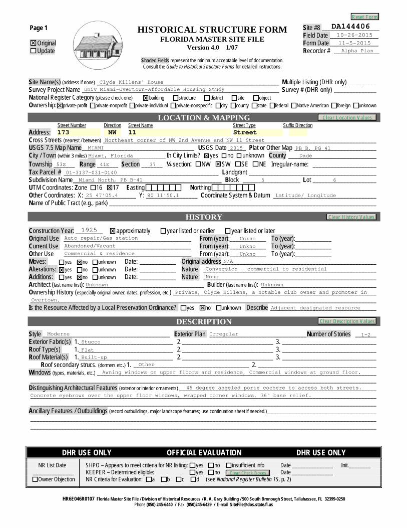
Site Name(s) (address if none) ____________________________________________________________ Multiple Listing (DHR only) _________ Survey Project Name _________________________________________________________________ Survey # (DHR only) ______________ National Register Category (please check one) building structure district site object Ownership: private-profit private-nonprofit private-individual private-nonspecific city county state federal Native American foreign unknown
LOCATION & MAPPING Street Number Direction Street Name Street Type Suffix Direction Address: Cross Streets (nearest / between) __________________________________________________________________________________________ USGS 7.5 Map Name _____________________________________ USGS Date ______ Plat or Other Map ___________________________ City / Town (within 3 miles) ________________________________ In City Limits? yes no unknown County _____________________________ Township _______ Range _______ Section _______ ¼ section: NW SW SE NE Irregular-name: _____________________ Tax Parcel # ___________________________________________________ Landgrant __________________________________________ Subdivision Name _________________________________________________ Block ___________________ Lot _____________________ UTM Coordinates: Zone 16 17 Easting Northing Other Coordinates: X: _________________ Y: _________________ Coordinate System & Datum __________________________________ Name of Public Tract (e.g., park) ________________________________________________________________________________________
HISTORY
Construction Year: _________ approximately year listed or earlier year listed or later Original Use __________________________________________ From (year):____________ To (year):____________ Current Use __________________________________________ From (year):____________ To (year):____________ Other Use __________________________________________ From (year):____________ To (year):____________ Moves: yes no unknown Date: ____________ Original address ___________________________________________________ Alterations: yes no unknown Date: ____________ Nature _________________________________________________________ Additions: yes no unknown Date: ____________ Nature _________________________________________________________ Architect (last name first): _______________________________________ Builder (last name first): ______________________________________ Ownership History (especially original owner, dates, profession, etc.) ___________________________________________________________________ __________________________________________________________________________________________________________________ Is the Resource Affected by a Local Preservation Ordinance? yes no unknown Describe ___________________________________
DESCRIPTION
Style __________________________________________ Exterior Plan ________________________________ Number of Stories _______ Exterior Fabric(s) 1. _______________________________ 2. ______________________________ 3. _______________________________ Roof Type(s) 1. _______________________________ 2. ______________________________ 3. _______________________________ Roof Material(s) 1. _______________________________ 2. ______________________________ 3. _______________________________ Roof secondary strucs. (dormers etc.) 1. ______________________________________ 2. _______________________________________ Windows (types, materials, etc.) ____________________________________________________________________________________________ __________________________________________________________________________________________________________________ Distinguishing Architectural Features (exterior or interior ornaments) _________________________________________________________________ __________________________________________________________________________________________________________________ __________________________________________________________________________________________________________________ Ancillary Features / Outbuildings (record outbuildings, major landscape features; use continuation sheet if needed.) ____________________________________ __________________________________________________________________________________________________________________ __________________________________________________________________________________________________________________
DHR USE ONLY OFFICIAL EVALUATION DHR USE ONLY
NR List Date SHPO – Appears to meet criteria for NR listing: yes no insufficient info Date _______________ Init.________ _______________ KEEPER – Determined eligible: yes no Date _______________ Owner Objection NR Criteria for Evaluation: a b c d (see National Register Bulletin 15, p. 2)
HR6E046R0107 Florida Master Site File / Division of Historical Resources / R. A. Gray Building / 500 South Bronough Street, Tallahassee, FL 32399-0250 Phone (850) 245-6440 / Fax (850)245-6439 / E-mail [email protected]
DA14440610-26-201511-5-2015Alpha Plan
Clyde Killens' HouseUniv Miami-Overtown-Affordable Housing Study
173 NW 11 StreetNortheast corner of NW 2nd Avenue and NW 11 Street
MIAMI 2015 PB B, PG 41Miami, Florida Dade
53S 41E 37
01-3137-031-0140Miami North, PB B-41 5 6
25 47'05.4 80 11'50.1 Latitude/ Longitude
1925Auto repair/Gas station UnknoAbandoned/Vacant UnknoCommercial & residence Unkno
N/A
Conversion - commercial to residential
None
Unknown Unknown
Private, Clyde Killens, a notable club owner and promoter in
Overtown.
Adjacent designated resource
Moderne Irregular 1-2Stucco
Flat
Built-upOther
Awning windows on upper floors and residence, Commercial windows at ground floor.
45 degree angeled porte cochere to access both streets.
Concrete eyebrows over the upper floor windows, wrapped corner windows, 36" base relief.
Reset Form
Clear History Values
Clear Description Values
Clear Location Values
Clear Check Boxes
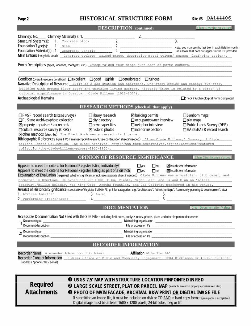
Page 2 HISTORICAL STRUCTURE FORM Site #8 ______________
DESCRIPTION (continued)
Chimney: No.____ Chimney Material(s): 1. ___________________________ 2. ____________________________ Structural System(s): 1. ____________________________ 2. ____________________________ 3. ____________________________ Foundation Type(s): 1. ____________________________ 2. ____________________________ Foundation Material(s): 1. ____________________________ 2. ____________________________ Main Entrance (stylistic details) ____________________________________________________________________________________________ __________________________________________________________________________________________________________________ Porch Descriptions (types, locations, roof types, etc.) _____________________________________________________________________________ __________________________________________________________________________________________________________________ __________________________________________________________________________________________________________________ Condition (overall resource condition): excellent good fair deteriorated ruinous Narrative Description of Resource _______________________________________________________________________________________ __________________________________________________________________________________________________________________ __________________________________________________________________________________________________________________ Archaeological Remains __________________________________________________________________ Check if Archaeological Form Completed
RESEARCH METHODS (check all that apply)
FMSF record search (sites/surveys) library research building permits Sanborn maps FL State Archives/photo collection city directory occupant/owner interview plat maps property appraiser / tax records newspaper files neighbor interview Public Lands Survey (DEP) cultural resource survey (CRAS) historic photos interior inspection HABS/HAER record search other methods (describe) _____________________________________________________________________________________________
Bibliographic References (give FMSF manuscript # if relevant, use continuation sheet if needed) ________________________________________________ __________________________________________________________________________________________________________________ __________________________________________________________________________________________________________________
OPINION OF RESOURCE SIGNIFICANCE Appears to meet the criteria for National Register listing individually? yes no insufficient information Appears to meet the criteria for National Register listing as part of a district? yes no insufficient information Explanation of Evaluation (required, whether significant or not; use separate sheet if needed) __________________________________________________ __________________________________________________________________________________________________________________ __________________________________________________________________________________________________________________ Area(s) of Historical Significance (see National Register Bulletin 15, p. 8 for categories: e.g. “architecture”, “ethnic heritage”, “community planning & development”, etc.) 1. ___________________________________ 3. ___________________________________ 5. ___________________________________ 2. ___________________________________ 4. ___________________________________ 6. ___________________________________
DOCUMENTATION Accessible Documentation Not Filed with the Site File - including field notes, analysis notes, photos, plans and other important documents Document type __________________________________________ Maintaining organization _________________________________________ Document description _______________________________________ File or accession #’s ___________________________________________ 1)
Document type __________________________________________ Maintaining organization _________________________________________ Document description _______________________________________ File or accession #’s ___________________________________________ 2)
RECORDER INFORMATION
Recorder Name _____________________________________________ Affiliation ______________________________________________ Recorder Contact Information __________________________________________________________________________________________ (address / phone / fax / e-mail)
USGS 7.5’ MAP WITH STRUCTURE LOCATION PINPOINTED IN RED LARGE SCALE STREET, PLAT OR PARCEL MAP PHOTO OF MAIN FACADE, ARCHIVAL B&W PRINT OR DIGITAL IMAGE FILE If submitting an image file, it must be included on disk or CD AND in hard copy format (plain paper is acceptable). Digital image must be at least 1600 x 1200 pixels, 24-bit color, jpeg or tiff.
Required Attachments
(available from most property appraiser web sites)
DA144406
Concrete block
Slab
Concrete, GenericNote: you may use the last box in each field to type in
an answer that does not appear in the list provided
Concrete eyebrow, raised stoop, decorative metal column/ screen (leaf/vine design).
Stoop raised four steps just east of porte cochere.
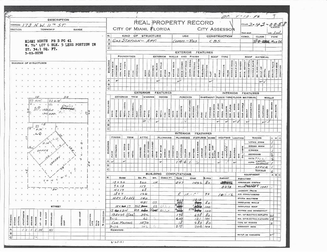
Built as a gas station and apartment. One-story office and canopy; two-story
building with ground floor store and upstairs living quarter. Historic Value is related to a person of
cultural significance in Overtown, Clyde Killens (1912-2007).
The Black Archives accessed via Internet
"I am Clyde Killens," Summary of Clyde
Killens Papers Collection, The Black Archives, http://www.theblackarchives.org/collections/featured-
collection/the-clyde-killens-papers-1930-1960/.
Clyde Killens was a musician, club owner, and
promoter in Overtown. He owned the Nut Club, Elks, Fiesta, Night Beat, and Island Club on "Little
Broadway."Billie Holiday, Nat King Cole, Aretha Franklin, and Cab Calloway performed in his venues.
African American
Performing arts/theater
Local
Alexander Adams obo Univ Miami
U Miami Office of Civic and Community Engagement, 1204 Dickinson Dr #37W,3052846636
Alpha Plan LLC
Clear Description Values
Clear Significance Values
Clear Documentation Values
2/17/2016 Property Search Application - Miami-Dade County
Property Information
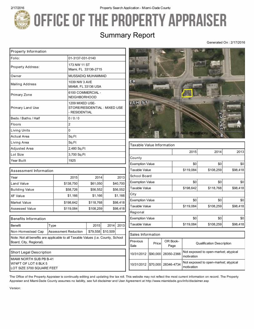
Folio: 01-3137-031-0140
Property Address: 173 NW 11 ST Miami, FL 33136-2715
Owner MUSSADIQ MUHAMMAD
Mailing Address 1039 NW 3 AVE MIAMI, FL 33136 USA
Primary Zone 6100 COMMERCIAL -NEIGHBORHOOD
Primary Land Use1209 MIXED USE-STORE/RESIDENTIAL : MIXED USE- RESIDENTIAL
Beds / Baths / Half 0 / 0 / 0
Floors 2
Living Units 0
Actual Area Sq.Ft
Living Area Sq.Ft
Adjusted Area 2,480 Sq.Ft
Lot Size 3,700 Sq.Ft
Year Built 1925
Assessment Information
Year 2015 2014 2013
Land Value $138,750 $61,050 $40,700
Building Value $58,726 $56,552 $56,552
XF Value $1,166 $1,166 $1,166
Market Value $198,642 $118,768 $98,418
Assessed Value $119,084 $108,259 $98,418
Benefits Information
Benefit Type 2015 2014 2013
Non-Homestead Cap Assessment Reduction $79,558 $10,509
Note: Not all benefits are applicable to all Taxable Values (i.e. County, SchoolBoard, City, Regional).
Short Legal Description
MIAMI NORTH SUB PB B-41W74FT OF LOT 6 BLK 5LOT SIZE 3700 SQUARE FEET
Taxable Value Information
2015 2014 2013
County
Exemption Value $0 $0 $0
Taxable Value $119,084 $108,259 $98,418
School Board
Exemption Value $0 $0 $0
Taxable Value $198,642 $118,768 $98,418
City
Exemption Value $0 $0 $0
Taxable Value $119,084 $108,259 $98,418
Regional
Exemption Value $0 $0 $0
Taxable Value $119,084 $108,259 $98,418
Sales Information
PreviousSale
Price OR Book-Page
Qualification Description
10/31/2012 $90,000 28350-2366 Not exposed to open-market; atypicalmotivation
10/31/2012 $70,000 28346-4734 Not exposed to open-market; atypicalmotivation
Summary ReportGenerated On : 2/17/2016
The Office of the Property Appraiser is continually editing and updating the tax roll. This website may not reflect the most current information on record. The PropertyAppraiser and Miami-Dade County assumes no liability, see full disclaimer and User Agreement at http://www.miamidade.gov/info/disclaimer.asp
Version:
2015 Aerial Photography 200ft
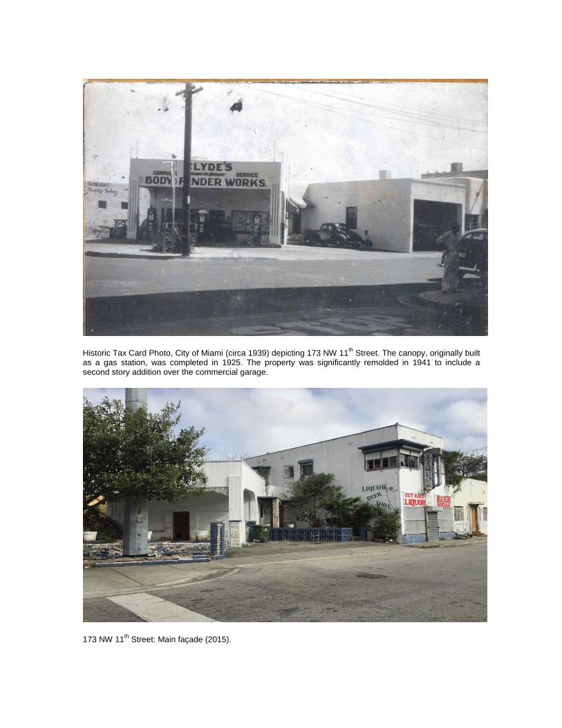
Historic Tax Card Photo, City of Miami (circa 1939) depicting 173 NW 11
th Street. The canopy, originally built
as a gas station, was completed in 1925. The property was significantly remolded in 1941 to include a second story addition over the commercial garage.
173 NW 11
th Street: Main façade (2015).
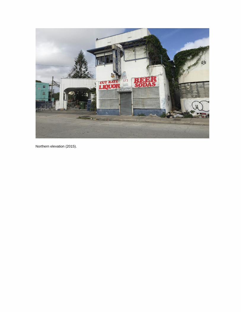
Northern elevation (2015).
Site #8 ___________________ Field Date ________________ Form Date ________________ Recorder # _______________
Page 1
Original Update
HISTORICAL STRUCTURE FORM FLORIDA MASTER SITE FILE
Version 4.0 1/07
Shaded Fields represent the minimum acceptable level of documentation. Consult the Guide to Historical Structure Forms for detailed instructions.
Site Name(s) (address if none) ____________________________________________________________ Multiple Listing (DHR only) _________ Survey Project Name _________________________________________________________________ Survey # (DHR only) ______________ National Register Category (please check one) building structure district site object Ownership: private-profit private-nonprofit private-individual private-nonspecific city county state federal Native American foreign unknown
LOCATION & MAPPING Street Number Direction Street Name Street Type Suffix Direction Address: Cross Streets (nearest / between) __________________________________________________________________________________________ USGS 7.5 Map Name _____________________________________ USGS Date ______ Plat or Other Map ___________________________ City / Town (within 3 miles) ________________________________ In City Limits? yes no unknown County _____________________________ Township _______ Range _______ Section _______ ¼ section: NW SW SE NE Irregular-name: _____________________ Tax Parcel # ___________________________________________________ Landgrant __________________________________________ Subdivision Name _________________________________________________ Block ___________________ Lot _____________________ UTM Coordinates: Zone 16 17 Easting Northing Other Coordinates: X: _________________ Y: _________________ Coordinate System & Datum __________________________________ Name of Public Tract (e.g., park) ________________________________________________________________________________________
HISTORY
Construction Year: _________ approximately year listed or earlier year listed or later Original Use __________________________________________ From (year):____________ To (year):____________ Current Use __________________________________________ From (year):____________ To (year):____________ Other Use __________________________________________ From (year):____________ To (year):____________ Moves: yes no unknown Date: ____________ Original address ___________________________________________________ Alterations: yes no unknown Date: ____________ Nature _________________________________________________________ Additions: yes no unknown Date: ____________ Nature _________________________________________________________ Architect (last name first): _______________________________________ Builder (last name first): ______________________________________ Ownership History (especially original owner, dates, profession, etc.) ___________________________________________________________________ __________________________________________________________________________________________________________________ Is the Resource Affected by a Local Preservation Ordinance? yes no unknown Describe ___________________________________
DESCRIPTION
Style __________________________________________ Exterior Plan ________________________________ Number of Stories _______ Exterior Fabric(s) 1. _______________________________ 2. ______________________________ 3. _______________________________ Roof Type(s) 1. _______________________________ 2. ______________________________ 3. _______________________________ Roof Material(s) 1. _______________________________ 2. ______________________________ 3. _______________________________ Roof secondary strucs. (dormers etc.) 1. ______________________________________ 2. _______________________________________ Windows (types, materials, etc.) ____________________________________________________________________________________________ __________________________________________________________________________________________________________________ Distinguishing Architectural Features (exterior or interior ornaments) _________________________________________________________________ __________________________________________________________________________________________________________________ __________________________________________________________________________________________________________________ Ancillary Features / Outbuildings (record outbuildings, major landscape features; use continuation sheet if needed.) ____________________________________ __________________________________________________________________________________________________________________ __________________________________________________________________________________________________________________
DHR USE ONLY OFFICIAL EVALUATION DHR USE ONLY
NR List Date SHPO – Appears to meet criteria for NR listing: yes no insufficient info Date _______________ Init.________ _______________ KEEPER – Determined eligible: yes no Date _______________ Owner Objection NR Criteria for Evaluation: a b c d (see National Register Bulletin 15, p. 2)
HR6E046R0107 Florida Master Site File / Division of Historical Resources / R. A. Gray Building / 500 South Bronough Street, Tallahassee, FL 32399-0250 Phone (850) 245-6440 / Fax (850)245-6439 / E-mail [email protected]
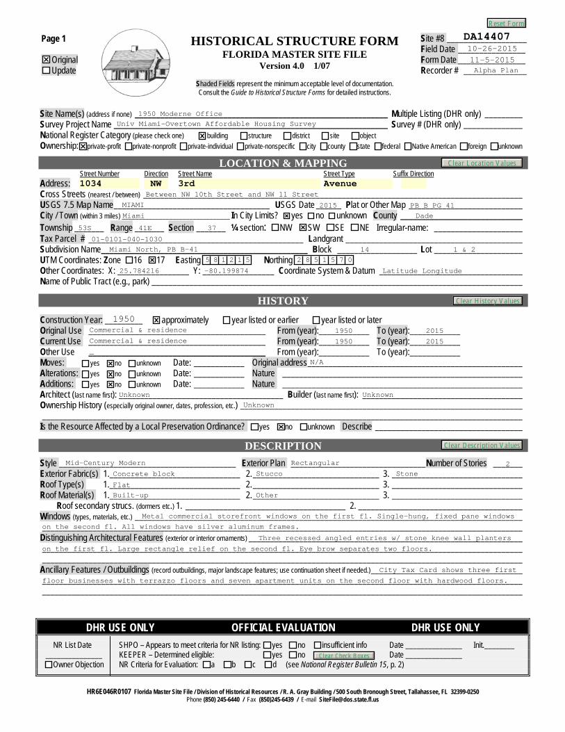
DA1440710-26-201511-5-2015Alpha Plan
1950 Moderne OfficeUniv Miami-Overtown Affordable Housing Survey
1034 NW 3rd AvenueBetween NW 10th Street and NW 11 Street
MIAMI 2015 PB B PG 41Miami Dade
53S 41E 37
01-0101-040-1030Miami North, PB B-41 14 1 & 2
5 8 1 2 1 5 2 8 5 1 5 7 0
25.784216 -80.199874 Latitude Longitude
1950Commercial & residence 1950 2015Commercial & residence 1950 2015_
N/A
Unknown UnknownUnknown
Mid-Century Modern Rectangular 2Concrete block Stucco Stone
Flat
Built-up Other
Metal commercial storefront windows on the first fl. Single-hung, fixed pane windows
on the second fl. All windows have silver aluminum frames.
Three recessed angled entries w/ stone knee wall planters
on the first fl. Large rectangle relief on the second fl. Eye brow separates two floors.
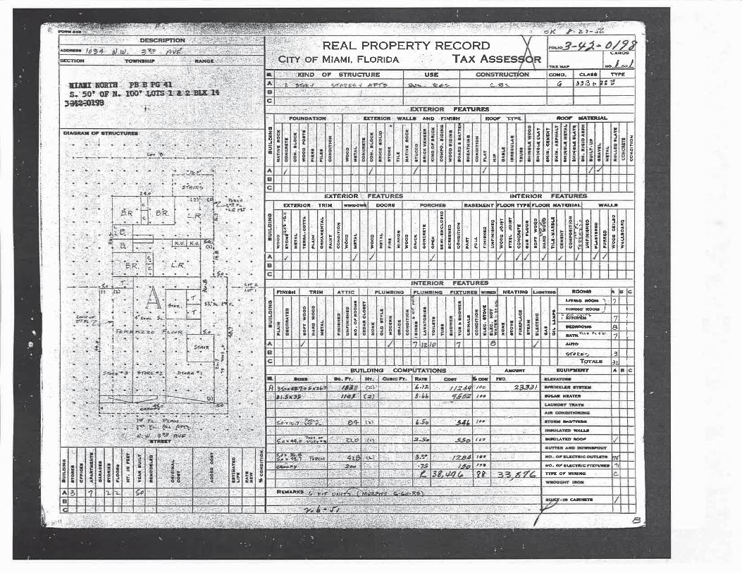
City Tax Card shows three first
floor businesses with terrazzo floors and seven apartment units on the second floor with hardwood floors.
Reset Form
Clear History Values
Clear Description Values
Clear Location Values
Clear Check Boxes
Page 2 HISTORICAL STRUCTURE FORM Site #8 ______________
DESCRIPTION (continued)
Chimney: No.____ Chimney Material(s): 1. ___________________________ 2. ____________________________ Structural System(s): 1. ____________________________ 2. ____________________________ 3. ____________________________ Foundation Type(s): 1. ____________________________ 2. ____________________________ Foundation Material(s): 1. ____________________________ 2. ____________________________ Main Entrance (stylistic details) ____________________________________________________________________________________________ __________________________________________________________________________________________________________________ Porch Descriptions (types, locations, roof types, etc.) _____________________________________________________________________________ __________________________________________________________________________________________________________________ __________________________________________________________________________________________________________________ Condition (overall resource condition): excellent good fair deteriorated ruinous Narrative Description of Resource _______________________________________________________________________________________ __________________________________________________________________________________________________________________ __________________________________________________________________________________________________________________ Archaeological Remains __________________________________________________________________ Check if Archaeological Form Completed
RESEARCH METHODS (check all that apply)
FMSF record search (sites/surveys) library research building permits Sanborn maps FL State Archives/photo collection city directory occupant/owner interview plat maps property appraiser / tax records newspaper files neighbor interview Public Lands Survey (DEP) cultural resource survey (CRAS) historic photos interior inspection HABS/HAER record search other methods (describe) _____________________________________________________________________________________________
Bibliographic References (give FMSF manuscript # if relevant, use continuation sheet if needed) ________________________________________________ __________________________________________________________________________________________________________________ __________________________________________________________________________________________________________________
OPINION OF RESOURCE SIGNIFICANCE Appears to meet the criteria for National Register listing individually? yes no insufficient information Appears to meet the criteria for National Register listing as part of a district? yes no insufficient information Explanation of Evaluation (required, whether significant or not; use separate sheet if needed) __________________________________________________ __________________________________________________________________________________________________________________ __________________________________________________________________________________________________________________ Area(s) of Historical Significance (see National Register Bulletin 15, p. 8 for categories: e.g. “architecture”, “ethnic heritage”, “community planning & development”, etc.) 1. ___________________________________ 3. ___________________________________ 5. ___________________________________ 2. ___________________________________ 4. ___________________________________ 6. ___________________________________
DOCUMENTATION Accessible Documentation Not Filed with the Site File - including field notes, analysis notes, photos, plans and other important documents Document type __________________________________________ Maintaining organization _________________________________________ Document description _______________________________________ File or accession #’s ___________________________________________ 1)
Document type __________________________________________ Maintaining organization _________________________________________ Document description _______________________________________ File or accession #’s ___________________________________________ 2)
RECORDER INFORMATION
Recorder Name _____________________________________________ Affiliation ______________________________________________ Recorder Contact Information __________________________________________________________________________________________ (address / phone / fax / e-mail)
USGS 7.5’ MAP WITH STRUCTURE LOCATION PINPOINTED IN RED LARGE SCALE STREET, PLAT OR PARCEL MAP PHOTO OF MAIN FACADE, ARCHIVAL B&W PRINT OR DIGITAL IMAGE FILE If submitting an image file, it must be included on disk or CD AND in hard copy format (plain paper is acceptable). Digital image must be at least 1600 x 1200 pixels, 24-bit color, jpeg or tiff.
Required Attachments
(available from most property appraiser web sites)
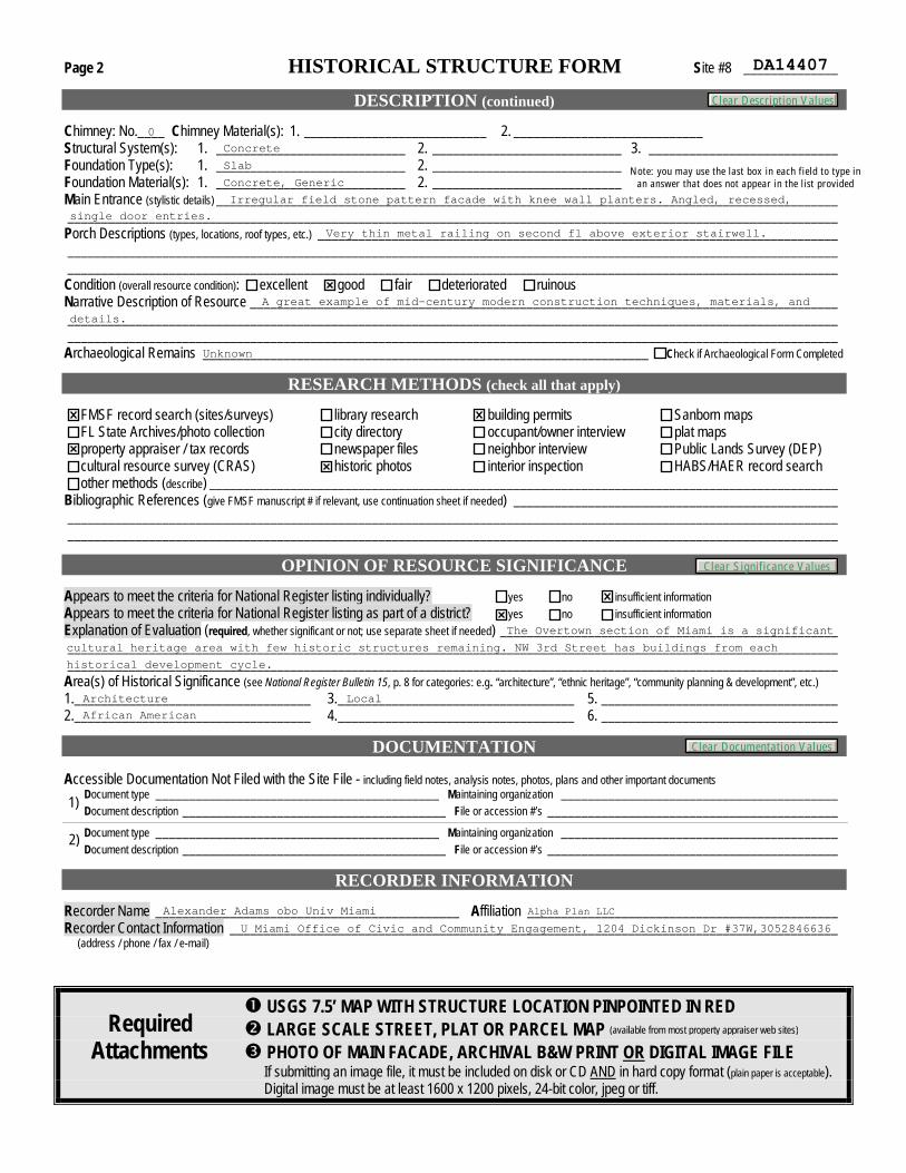
DA14407
0Concrete
Slab
Concrete, GenericNote: you may use the last box in each field to type in
an answer that does not appear in the list provided
Irregular field stone pattern facade with knee wall planters. Angled, recessed,
single door entries.
Very thin metal railing on second fl above exterior stairwell.
A great example of mid-century modern construction techniques, materials, and
details.
Unknown
The Overtown section of Miami is a significant
cultural heritage area with few historic structures remaining. NW 3rd Street has buildings from each
historical development cycle.
Architecture
African American
Local
Alexander Adams obo Univ Miami
U Miami Office of Civic and Community Engagement, 1204 Dickinson Dr #37W,3052846636
Alpha Plan LLC
Clear Description Values
Clear Significance Values
Clear Documentation Values

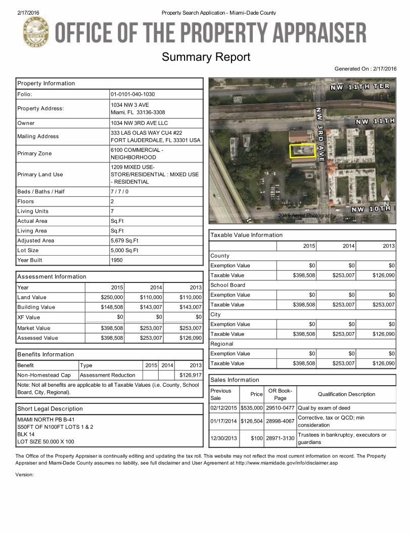
2/17/2016 Property Search Application - Miami-Dade County
Property Information
Folio: 01-0101-040-1030
Property Address: 1034 NW 3 AVE Miami, FL 33136-3308
Owner 1034 NW 3RD AVE LLC
Mailing Address 333 LAS OLAS WAY CU4 #22 FORT LAUDERDALE, FL 33301 USA
Primary Zone 6100 COMMERCIAL -NEIGHBORHOOD
Primary Land Use1209 MIXED USE-STORE/RESIDENTIAL : MIXED USE- RESIDENTIAL
Beds / Baths / Half 7 / 7 / 0
Floors 2
Living Units 7
Actual Area Sq.Ft
Living Area Sq.Ft
Adjusted Area 5,679 Sq.Ft
Lot Size 5,000 Sq.Ft
Year Built 1950
Assessment Information
Year 2015 2014 2013
Land Value $250,000 $110,000 $110,000
Building Value $148,508 $143,007 $143,007
XF Value $0 $0 $0
Market Value $398,508 $253,007 $253,007
Assessed Value $398,508 $253,007 $126,090
Benefits Information
Benefit Type 2015 2014 2013
Non-Homestead Cap Assessment Reduction $126,917
Note: Not all benefits are applicable to all Taxable Values (i.e. County, SchoolBoard, City, Regional).
Short Legal Description
MIAMI NORTH PB B-41S50FT OF N100FT LOTS 1 & 2BLK 14LOT SIZE 50.000 X 100
Taxable Value Information
2015 2014 2013
County
Exemption Value $0 $0 $0
Taxable Value $398,508 $253,007 $126,090
School Board
Exemption Value $0 $0 $0
Taxable Value $398,508 $253,007 $253,007
City
Exemption Value $0 $0 $0
Taxable Value $398,508 $253,007 $126,090
Regional
Exemption Value $0 $0 $0
Taxable Value $398,508 $253,007 $126,090
Sales Information
PreviousSale
Price OR Book-Page
Qualification Description
02/12/2015 $535,000 29510-0477 Qual by exam of deed
01/17/2014 $126,504 28998-4067 Corrective, tax or QCD; minconsideration
12/30/2013 $100 28971-3130 Trustees in bankruptcy, executors orguardians
Summary ReportGenerated On : 2/17/2016
The Office of the Property Appraiser is continually editing and updating the tax roll. This website may not reflect the most current information on record. The PropertyAppraiser and Miami-Dade County assumes no liability, see full disclaimer and User Agreement at http://www.miamidade.gov/info/disclaimer.asp
Version:
2015 Aerial Photography 200ft

Historic Tax Card Photo, City of Miami (circa 1950s) depicting 1034 NW 3
rd Avenue.
1034 NW 3
rd Avenue: Main façade (2015).
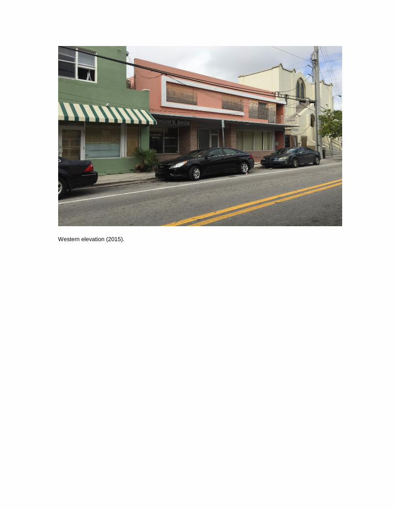
Western elevation (2015).
Site #8 ___________________ Field Date ________________ Form Date ________________ Recorder # _______________
Page 1
Original Update
HISTORICAL STRUCTURE FORM FLORIDA MASTER SITE FILE
Version 4.0 1/07
Shaded Fields represent the minimum acceptable level of documentation. Consult the Guide to Historical Structure Forms for detailed instructions.
Site Name(s) (address if none) ____________________________________________________________ Multiple Listing (DHR only) _________ Survey Project Name _________________________________________________________________ Survey # (DHR only) ______________ National Register Category (please check one) building structure district site object Ownership: private-profit private-nonprofit private-individual private-nonspecific city county state federal Native American foreign unknown
LOCATION & MAPPING Street Number Direction Street Name Street Type Suffix Direction Address: Cross Streets (nearest / between) __________________________________________________________________________________________ USGS 7.5 Map Name _____________________________________ USGS Date ______ Plat or Other Map ___________________________ City / Town (within 3 miles) ________________________________ In City Limits? yes no unknown County _____________________________ Township _______ Range _______ Section _______ ¼ section: NW SW SE NE Irregular-name: _____________________ Tax Parcel # ___________________________________________________ Landgrant __________________________________________ Subdivision Name _________________________________________________ Block ___________________ Lot _____________________ UTM Coordinates: Zone 16 17 Easting Northing Other Coordinates: X: _________________ Y: _________________ Coordinate System & Datum __________________________________ Name of Public Tract (e.g., park) ________________________________________________________________________________________
HISTORY
Construction Year: _________ approximately year listed or earlier year listed or later Original Use __________________________________________ From (year):____________ To (year):____________ Current Use __________________________________________ From (year):____________ To (year):____________ Other Use __________________________________________ From (year):____________ To (year):____________ Moves: yes no unknown Date: ____________ Original address ___________________________________________________ Alterations: yes no unknown Date: ____________ Nature _________________________________________________________ Additions: yes no unknown Date: ____________ Nature _________________________________________________________ Architect (last name first): _______________________________________ Builder (last name first): ______________________________________ Ownership History (especially original owner, dates, profession, etc.) ___________________________________________________________________ __________________________________________________________________________________________________________________ Is the Resource Affected by a Local Preservation Ordinance? yes no unknown Describe ___________________________________
DESCRIPTION
Style __________________________________________ Exterior Plan ________________________________ Number of Stories _______ Exterior Fabric(s) 1. _______________________________ 2. ______________________________ 3. _______________________________ Roof Type(s) 1. _______________________________ 2. ______________________________ 3. _______________________________ Roof Material(s) 1. _______________________________ 2. ______________________________ 3. _______________________________ Roof secondary strucs. (dormers etc.) 1. ______________________________________ 2. _______________________________________ Windows (types, materials, etc.) ____________________________________________________________________________________________ __________________________________________________________________________________________________________________ Distinguishing Architectural Features (exterior or interior ornaments) _________________________________________________________________ __________________________________________________________________________________________________________________ __________________________________________________________________________________________________________________ Ancillary Features / Outbuildings (record outbuildings, major landscape features; use continuation sheet if needed.) ____________________________________ __________________________________________________________________________________________________________________ __________________________________________________________________________________________________________________
DHR USE ONLY OFFICIAL EVALUATION DHR USE ONLY
NR List Date SHPO – Appears to meet criteria for NR listing: yes no insufficient info Date _______________ Init.________ _______________ KEEPER – Determined eligible: yes no Date _______________ Owner Objection NR Criteria for Evaluation: a b c d (see National Register Bulletin 15, p. 2)
HR6E046R0107 Florida Master Site File / Division of Historical Resources / R. A. Gray Building / 500 South Bronough Street, Tallahassee, FL 32399-0250 Phone (850) 245-6440 / Fax (850)245-6439 / E-mail [email protected]
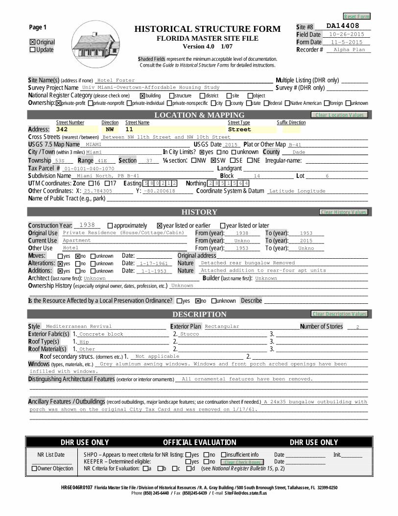
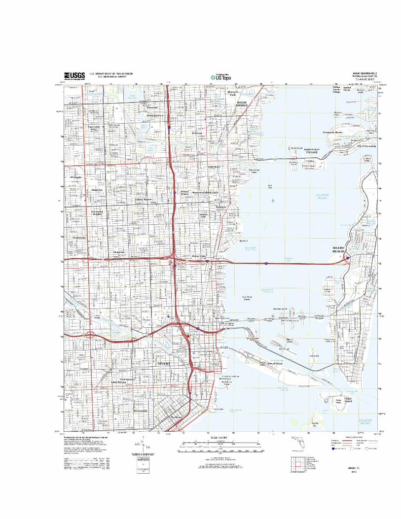
DA1440810-26-201511-5-2015Alpha Plan
Hotel FosterUniv Miami-Overtown-Affordable Housing Study
342 NW 11 StreetBetween NW 11th Street and NW 10th Street
MIAMI 2015 B-41Miami Dade
53S 41E 37
01-0101-040-1070Miami North, PB B-41 14 6
5 8 0 2 1 2 2 8 5 1 5 6 4
25.784305 -80.200618 Latitude Longitude
1938Private Residence (House/Cottage/Cabin) 1938 1953Apartment Unkno 2015Hotel 1953 Unkno
1-17-1961 Detached rear bungalow Removed
1-1-1953 Attached addition to rear-four apt units
Unknown UnknownUnknown
Mediterranean Revival Rectangular 2Concrete block Stucco
Hip
OtherNot applicable
Grey aluminum awning windows. Windows and front porch arched openings have been
infilled with windows.
All ornamental features have been removed.
A 24x35 bungalow outbuilding with
porch was shown on the original City Tax Card and was removed on 1/17/61.
Reset Form
Clear History Values
Clear Description Values
Clear Location Values
Clear Check Boxes
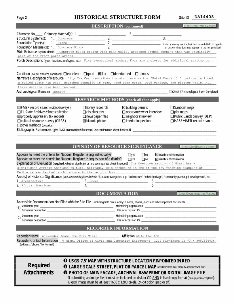
Page 2 HISTORICAL STRUCTURE FORM Site #8 ______________
DESCRIPTION (continued)
Chimney: No.____ Chimney Material(s): 1. ___________________________ 2. ____________________________ Structural System(s): 1. ____________________________ 2. ____________________________ 3. ____________________________ Foundation Type(s): 1. ____________________________ 2. ____________________________ Foundation Material(s): 1. ____________________________ 2. ____________________________ Main Entrance (stylistic details) ____________________________________________________________________________________________ __________________________________________________________________________________________________________________ Porch Descriptions (types, locations, roof types, etc.) _____________________________________________________________________________ __________________________________________________________________________________________________________________ __________________________________________________________________________________________________________________ Condition (overall resource condition): excellent good fair deteriorated ruinous Narrative Description of Resource _______________________________________________________________________________________ __________________________________________________________________________________________________________________ __________________________________________________________________________________________________________________ Archaeological Remains __________________________________________________________________ Check if Archaeological Form Completed
RESEARCH METHODS (check all that apply)
FMSF record search (sites/surveys) library research building permits Sanborn maps FL State Archives/photo collection city directory occupant/owner interview plat maps property appraiser / tax records newspaper files neighbor interview Public Lands Survey (DEP) cultural resource survey (CRAS) historic photos interior inspection HABS/HAER record search other methods (describe) _____________________________________________________________________________________________
Bibliographic References (give FMSF manuscript # if relevant, use continuation sheet if needed) ________________________________________________ __________________________________________________________________________________________________________________ __________________________________________________________________________________________________________________
OPINION OF RESOURCE SIGNIFICANCE Appears to meet the criteria for National Register listing individually? yes no insufficient information Appears to meet the criteria for National Register listing as part of a district? yes no insufficient information Explanation of Evaluation (required, whether significant or not; use separate sheet if needed) __________________________________________________ __________________________________________________________________________________________________________________ __________________________________________________________________________________________________________________ Area(s) of Historical Significance (see National Register Bulletin 15, p. 8 for categories: e.g. “architecture”, “ethnic heritage”, “community planning & development”, etc.) 1. ___________________________________ 3. ___________________________________ 5. ___________________________________ 2. ___________________________________ 4. ___________________________________ 6. ___________________________________
DOCUMENTATION Accessible Documentation Not Filed with the Site File - including field notes, analysis notes, photos, plans and other important documents Document type __________________________________________ Maintaining organization _________________________________________ Document description _______________________________________ File or accession #’s ___________________________________________ 1)
Document type __________________________________________ Maintaining organization _________________________________________ Document description _______________________________________ File or accession #’s ___________________________________________ 2)
RECORDER INFORMATION
Recorder Name _____________________________________________ Affiliation ______________________________________________ Recorder Contact Information __________________________________________________________________________________________ (address / phone / fax / e-mail)
USGS 7.5’ MAP WITH STRUCTURE LOCATION PINPOINTED IN RED LARGE SCALE STREET, PLAT OR PARCEL MAP PHOTO OF MAIN FACADE, ARCHIVAL B&W PRINT OR DIGITAL IMAGE FILE If submitting an image file, it must be included on disk or CD AND in hard copy format (plain paper is acceptable). Digital image must be at least 1600 x 1200 pixels, 24-bit color, jpeg or tiff.
Required Attachments
(available from most property appraiser web sites)
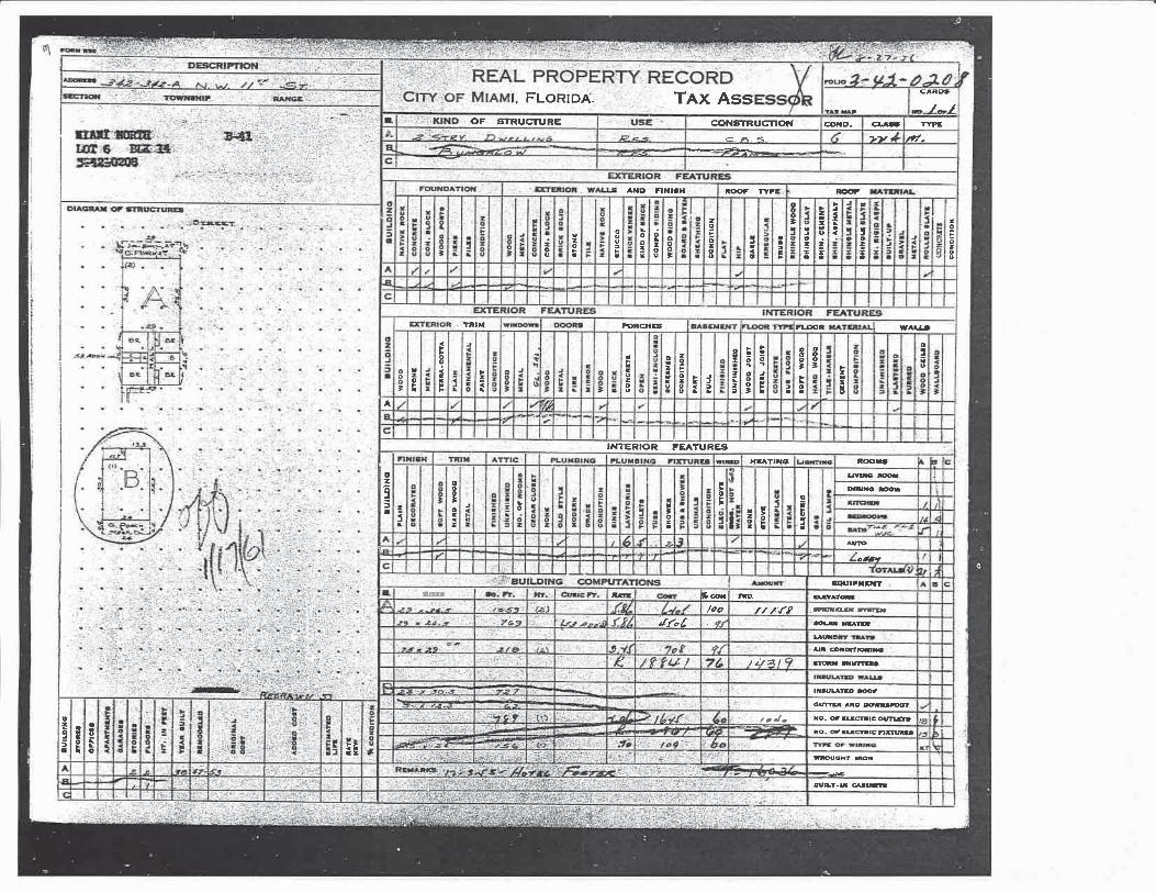
DA14408
Concrete
Piers
Concrete BlockNote: you may use the last box in each field to type in
an answer that does not appear in the list provided
Concrete block stairs with side walls. Recessed arched opening that was originally
part of the front porch arches.
Five symmetrical arches. Four are enclosed for additional apartments.
City Tax Card describes the structure as the "Hotel Foster." Structure included
a rolled slate hip roof, detached bungalow in rear, wood open porch, wood windows, and plaster walls. All
these details have been removed.
Unknown
The Overtown section of Miami has a
significant African American cultural heritage. This structure is one of the few renaming examples of
Mediterranean Revival architecture in the neighborhood.
Architecture
African American
Local
Alexander Adams obo Univ Miami
U Miami Office of Civic and Community Engagement, 1204 Dickinson Dr #37W,3052846636
Alpha Plan LLC
Clear Description Values
Clear Significance Values
Clear Documentation Values
2/17/2016 Property Search Application - Miami-Dade County
Property Information
Folio: 01-0101-040-1070
Property Address: 342 NW 11 ST Miami, FL 33136-2510
Owner 342BH LLC
Mailing Address PO BOX 403783 MIAMI BEACH, FL 33140 USA
Primary Zone 6106 RESIDENTIAL-LIBERAL RETAI
Primary Land Use 0303 MULTIFAMILY 10 UNITS PLUS: MULTIFAMILY 3 OR MORE UNITS
Beds / Baths / Half 24 / 4 / 0
Floors 2
Living Units 24
Actual Area Sq.Ft
Living Area Sq.Ft
Adjusted Area 3,571 Sq.Ft
Lot Size 7,500 Sq.Ft
Year Built 1938
Assessment Information
Year 2015 2014 2013
Land Value $375,000 $135,000 $90,000
Building Value $100,000 $225,000 $235,000
XF Value $0 $0 $0
Market Value $475,000 $360,000 $325,000
Assessed Value $393,250 $357,500 $325,000
Benefits Information
Benefit Type 2015 2014 2013
Non-Homestead Cap Assessment Reduction $81,750 $2,500
Note: Not all benefits are applicable to all Taxable Values (i.e. County, SchoolBoard, City, Regional).
Short Legal Description
MIAMI NORTH PB B-41LOT 6 BLK 14LOT SIZE 50.000 X 150OR 17561-2370 0397 4COC 23539-1837 06 2005 4
Taxable Value Information
2015 2014 2013
County
Exemption Value $0 $0 $0
Taxable Value $393,250 $357,500 $325,000
School Board
Exemption Value $0 $0 $0
Taxable Value $475,000 $360,000 $325,000
City
Exemption Value $0 $0 $0
Taxable Value $393,250 $357,500 $325,000
Regional
Exemption Value $0 $0 $0
Taxable Value $393,250 $357,500 $325,000
Sales Information
PreviousSale Price
ORBook-Page
Qualification Description
06/28/2012 $150,000 28172-1220
Financial inst or "In Lieu of Forclosure"stated
10/17/2011 $56,700 27883-4421
Financial inst or "In Lieu of Forclosure"stated
06/01/2005 $0 23539-1837
Sales which are disqualified as a result ofexamination of the deed
01/01/1994 $0 16227-0021
Sales which are disqualified as a result ofexamination of the deed
Summary ReportGenerated On : 2/17/2016
The Office of the Property Appraiser is continually editing and updating the tax roll. This website may not reflect the most current information on record. The PropertyAppraiser and Miami-Dade County assumes no liability, see full disclaimer and User Agreement at http://www.miamidade.gov/info/disclaimer.asp
Version:
2015 Aerial Photography 200ft
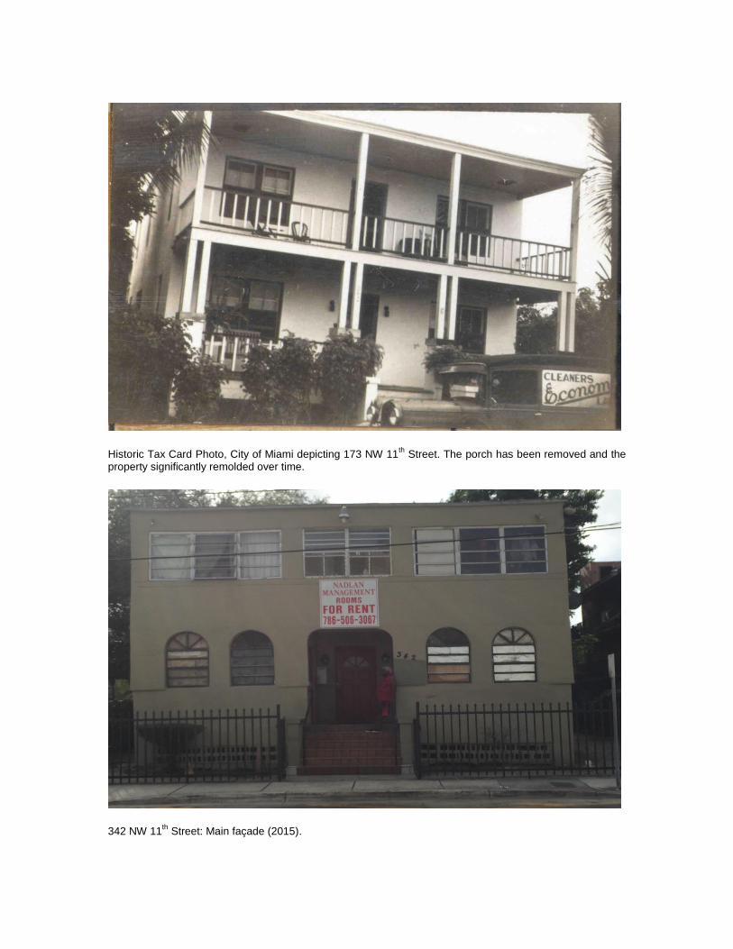
Historic Tax Card Photo, City of Miami depicting 173 NW 11
th Street. The porch has been removed and the
property significantly remolded over time.
342 NW 11
th Street: Main façade (2015).

Historic Tax Card Photo, City of Miami depicting the detached bungalow. This structure was demolished in 1961.
Southern elevation (2015).