Embed Size (px)
Citation preview
Florida
A Water Resources Manual from Florida’s Water Management Districts

Credits
AuthorElizabeth D. Purdum
Institute of Science and Public AffairsFlorida State University
CartographerPeter A. Krafft
Institute of Science and Public AffairsFlorida State University
Graphic Layout and DesignJim Anderson, Florida State University
Pati Twardosky, Southwest Florida Water Management District
Project ManagerBeth Bartos, Southwest Florida Water Management District
Project CoordinatorsSally McPherson, South Florida Water Management District
Georgann Penson, Northwest Florida Water Management DistrictEileen Tramontana, St. Johns River Water Management District
For more information or to request additional copies,contact the following water management districts:
Northwest Florida Water Management District850-539-5999 www.state.fl.us/nwfwmd
St. Johns River Water Management District800-451-7106 www.sjrwmd.com
South Florida Water Management District800-432-2045 www.sfwmd.gov
Southwest Florida Water Management District800-423-1476 www.WaterMatters.org
Suwannee River Water Management District800-226-1066 www.mysuwanneeriver.com

The water management districts do not discriminate upon the basis of any individual’s disability status.Anyone requiring reasonable accommodation under the ADA should contact the Communications andCommunity Affairs Department of the Southwest Florida Water Management District at (352) 796-7211or 1-800-423-1476 (Florida only), extension 4757; TDD only 1-800-231-6103 (Florida only).
April 2002
1
Contents
CHAPTER 1
THE HUMAN FRAMEWORK
The First Floridians 2Drainage, Flood Control and Navigation 6Modern Water Management 10
1970s 101980s 131990s 13
Conclusion 14The Human Framework Time Line 18
……………………………………
……………
……………………………
…………………………………………………
…………………………………………………
…………………………………………………
………………………………………………
……………………
CHAPTER 2
WATER: IT’S MAGIC 34Water’s Structure 35
Water’s Amazing Properties………………………… 35Global Water Cycle 36Water Cycle in Florida 37Weather and Climate 40
Floods and Droughts ……………………………… 41Storms ………………………………………………… 43
The Global Picture 46
El Niño and La Niña ………………………………… 46
Global Warming 48Conclusion 48
…………………………………………
………………………………………
…………………………………
……………………………………
………………………………………
…………………………………………………………………………………………
CHAPTER 3
FLORIDA’S WATER RESOURCES 49Watersheds ……………………………………………… 50Ground Water …………………………………………… 53
Aquifers ……………………………………………… 53Sinkholes ……………………………………………… 55Springs ………………………………………………… 57
Surface Water …………………………………………… 57Rivers ………………………………………………… 57Lakes ………………………………………………… 59Wetlands ……………………………………………… 59Estuaries ……………………………………………… 62
Conclusion ……………………………………………… 62 iiiii
CHAPTER 4
WATER AND LIFE: NATURAL SYSTEMS . . . . . . 63Ancient Origins 63Ecosystems 65
Soils … 66Ecosystem Processes: Water and Fire 68
Natural Communities 68Conclusion 73
……………………………………………
…………………………………………………
…………………………………………………
………………
……………………………………
…………………………………………………
CHAPTER 5
WATER SUPPLY AND WATER QUALITY. . . . . . . 74Water Use 76
Definitions …… 76Types of Uses ……………… 76Worldwide Water Use and Trends 78Florida Water Use and Trends … 79
Water Reuse 80Water Quality 81
Causes and Sources of Water Pollution 82Florida Water Quality and Trends … 83
Conclusion 85
…………………………………………………
………………………………………
…………………………
……………………
……………………
… ……………………………………………
………………………………………………
……………
………………
…………………………………………………
CHAPTER 6
FORWARD TO THE PAST . . . . . . . . . . . . . . . . . . . 86Restoration 87
Kissimmee-Okeechobee-Everglades Restoration… 87Tampa Bay …… 91Upper St. Johns River Basin ………… 93Longleaf Pine Restoration …………………………… 94Suwannee River Basin 95
Conclusion 95
………………………………………………
………………………………………
………………
………………………………
…………………………………………………
LINKS TO PROJECT WET ACTIVITIES. . . . . . . . . 96GLOSSARY 99REFERENCES 103
107
. . . . . . . . . . . . . . . . . . . . . . . . . . . . . . . .
. . . . . . . . . . . . . . . . . . . . . . . . . . . . .
INDEX . . . . . . . . . . . . . . . . . . . . . . . . . . . . . . . . . . . . .
iiiiiiiiii
Chapter 1
The Human Framework
We see things not as they are, but as we are.
— Henry Major Tomlinson, Out of Soundings, 1931
KEY IDEASKEY IDEASKEY IDEASKEY IDEASKEY IDEAS
• Water has played a critical role in thesettlement of Florida since the firsthumans arrived around 14,000 yearsago.
• Water resources exist within legal,social, economic and political contexts.
• Early in Florida’s development as a state,the main themes of water managementwere drainage, flood control andnavigation.
• Today, Floridians are actively seekingways to preserve, protect and restorewater resources.
• Modern water management in Florida isgoverned by the Water Resources Act of1972, one of the most innovative laws ofits kind in the nation.
VOCABULARYVOCABULARYVOCABULARYVOCABULARYVOCABULARY
Drainage
Ecosystem restoration
Flood control
Hammocks
Land acquisition
Limestone
Minimum flows and levels
Navigation
Prior appropriation
Reasonable and beneficial use
Riparian
Savanna
Water allocation
Water supply
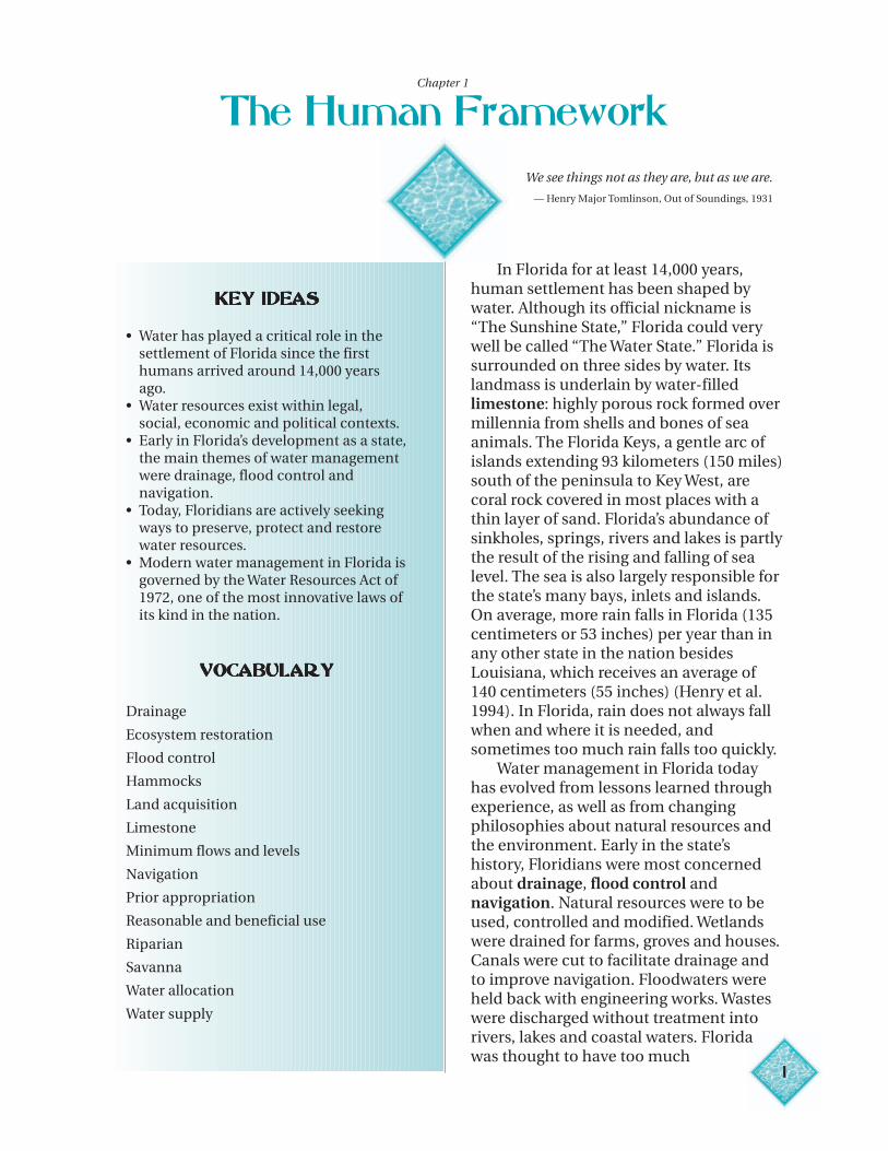
In Florida for at least 14,000 years,human settlement has been shaped bywater. Although its official nickname is“The Sunshine State,” Florida could verywell be called “The Water State.” Florida issurrounded on three sides by water. Itslandmass is underlain by water-filledlimestone: highly porous rock formed overmillennia from shells and bones of seaanimals. The Florida Keys, a gentle arc ofislands extending 93 kilometers (150 miles)south of the peninsula to Key West, arecoral rock covered in most places with athin layer of sand. Florida’s abundance ofsinkholes, springs, rivers and lakes is partlythe result of the rising and falling of sealevel. The sea is also largely responsible forthe state’s many bays, inlets and islands.On average, more rain falls in Florida (135centimeters or 53 inches) per year than inany other state in the nation besidesLouisiana, which receives an average of140 centimeters (55 inches) (Henry et al.1994). In Florida, rain does not always fallwhen and where it is needed, andsometimes too much rain falls too quickly.
Water management in Florida todayhas evolved from lessons learned throughexperience, as well as from changingphilosophies about natural resources andthe environment. Early in the state’shistory, Floridians were most concernedabout drainage, flood control andnavigation. Natural resources were to beused, controlled and modified. Wetlandswere drained for farms, groves and houses.Canals were cut to facilitate drainage andto improve navigation. Floodwaters wereheld back with engineering works. Wasteswere discharged without treatment intorivers, lakes and coastal waters. Floridawas thought to have too much
1
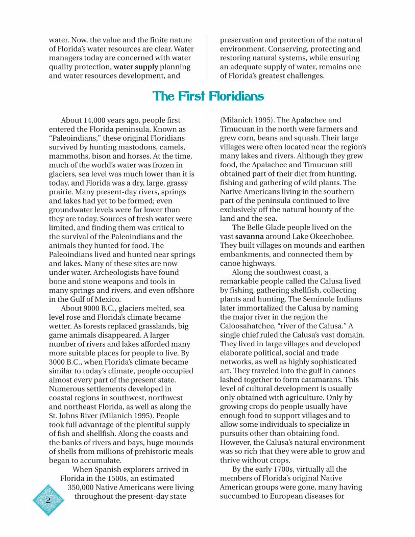
water. Now, the value and the finite natureof Florida’s water resources are clear. Watermanagers today are concerned with waterquality protection, water supply planningand water resources development, and
preservation and protection of the naturalenvironment. Conserving, protecting andrestoring natural systems, while ensuringan adequate supply of water, remains oneof Florida’s greatest challenges.
The First FloridiansThe First FloridiansThe First FloridiansThe First FloridiansThe First Floridians
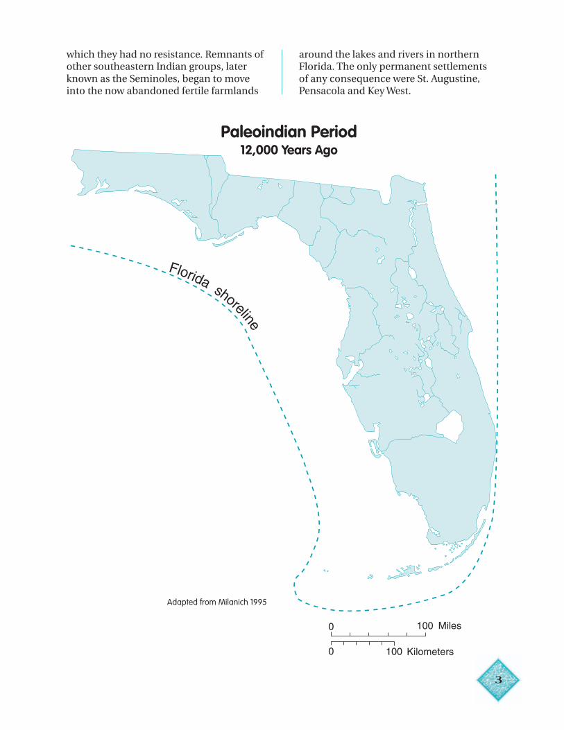
About 14,000 years ago, people firstentered the Florida peninsula. Known as“Paleoindians,” these original Floridianssurvived by hunting mastodons, camels,mammoths, bison and horses. At the time,much of the world’s water was frozen inglaciers, sea level was much lower than it istoday, and Florida was a dry, large, grassyprairie. Many present-day rivers, springsand lakes had yet to be formed; evengroundwater levels were far lower thanthey are today. Sources of fresh water werelimited, and finding them was critical tothe survival of the Paleoindians and theanimals they hunted for food. ThePaleoindians lived and hunted near springsand lakes. Many of these sites are nowunder water. Archeologists have foundbone and stone weapons and tools inmany springs and rivers, and even offshorein the Gulf of Mexico.
About 9000 B.C., glaciers melted, sealevel rose and Florida’s climate becamewetter. As forests replaced grasslands, biggame animals disappeared. A largernumber of rivers and lakes afforded manymore suitable places for people to live. By3000 B.C., when Florida’s climate becamesimilar to today’s climate, people occupiedalmost every part of the present state.Numerous settlements developed incoastal regions in southwest, northwestand northeast Florida, as well as along theSt. Johns River (Milanich 1995). Peopletook full advantage of the plentiful supplyof fish and shellfish. Along the coasts andthe banks of rivers and bays, huge moundsof shells from millions of prehistoric mealsbegan to accumulate.
When Spanish explorers arrived inFlorida in the 1500s, an estimated
350,000 Native Americans were livingthroughout the present-day state
2
(Milanich 1995). The Apalachee andTimucuan in the north were farmers andgrew corn, beans and squash. Their largevillages were often located near the region’smany lakes and rivers. Although they grewfood, the Apalachee and Timucuan stillobtained part of their diet from hunting,fishing and gathering of wild plants. TheNative Americans living in the southernpart of the peninsula continued to liveexclusively off the natural bounty of theland and the sea.
The Belle Glade people lived on thevast savanna around Lake Okeechobee.They built villages on mounds and earthenembankments, and connected them bycanoe highways.
Along the southwest coast, aremarkable people called the Calusa livedby fishing, gathering shellfish, collectingplants and hunting. The Seminole Indianslater immortalized the Calusa by namingthe major river in the region theCaloosahatchee, “river of the Calusa.” Asingle chief ruled the Calusa’s vast domain.They lived in large villages and developedelaborate political, social and tradenetworks, as well as highly sophisticatedart. They traveled into the gulf in canoeslashed together to form catamarans. Thislevel of cultural development is usuallyonly obtained with agriculture. Only bygrowing crops do people usually haveenough food to support villages and toallow some individuals to specialize inpursuits other than obtaining food.However, the Calusa’s natural environmentwas so rich that they were able to grow andthrive without crops.
By the early 1700s, virtually all themembers of Florida’s original NativeAmerican groups were gone, many havingsuccumbed to European diseases for
3
Florida shoreline
0 100 Miles
0 100 Kilometers
which they had no resistance. Remnants ofother southeastern Indian groups, laterknown as the Seminoles, began to moveinto the now abandoned fertile farmlands
around the lakes and rivers in northernFlorida. The only permanent settlementsof any consequence were St. Augustine,Pensacola and Key West.
Paleoindian Period12,000 Years Ago
Adapted from Milanich 1995
4
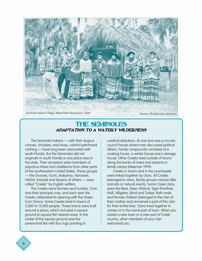
Seminole Indian Village, Royal Palm Hammock, 1920s Source: Florida State Archives
THE SEMINOLESTHE SEMINOLESTHE SEMINOLESTHE SEMINOLESTHE SEMINOLESADAPTATION TO A WATERY WILDERNESSADAPTATION TO A WATERY WILDERNESSADAPTATION TO A WATERY WILDERNESSADAPTATION TO A WATERY WILDERNESSADAPTATION TO A WATERY WILDERNESS
The Seminole Indians — with their dugoutcanoes, chickees, and loose, colorful patchworkclothing — have long been associated withsouth Florida. But the Seminoles did notoriginate in south Florida or any place else inthe state. Their ancestors were members ofpopulous tribes and chiefdoms from other partsof the southeastern United States. These groups— the Oconee, Yuchi, Alabama, Yamasee,Hitchiti, Koasati and dozens of others — werecalled “Creeks” by English settlers.
The Creeks were farmers and hunters. Cornwas their principal crop, and each year theCreeks celebrated its ripening with the GreenCorn Dance. Some Creeks lived in towns of5,000 to 15,000 people. These towns were builtaround a plaza, which included a squareground (a square flat cleared area). In thecenter of the square ground was theceremonial fire with four logs pointing in
cardinal directions. At one end was a circularcouncil house where men discussed politicalaffairs. Family compounds consisted of acooking house, a winter house and a storagehouse. Other Creeks lived outside of townsalong the banks of rivers and streams infamily camps (Weisman 1999).
Creeks in towns and in the countrysidewere linked together by clans. All Creeksbelonged to clans, family groups named afteranimals or natural events. Some Creek clanswere the Bear, Deer, Wildcat, Tiger (Panther),Wolf, Alligator, Wind and Turkey. Both maleand female children belonged to the clan oftheir mother and remained a part of this clanfor their entire lives. Clans lived together incamps or in the same part of town. When youvisited a new town or a new part of Creekcountry, other members of your clanwelcomed you.
5
By the 18th century, Creek clothing was ablend of European and traditional Indianstyles. The men wore cloth turbans, belts,beads, and leggings and jackets of deerskin.Women wore long dresses of manufacturedcloth.
The Creeks traveled long distances on theSoutheast’s numerous rivers and streams indugout canoes. They were skilled hunters,and the men spent much of their time huntingdeer and other animals. Creeks traded thepelts of the animals they hunted for Europeantraders’ guns and other manufactured items.
By the early 1700s, small bands of Creeksbegan migrating into northern Florida, at firstto hunt and later to farm lands once occupiedby the Timucuan and Apalachee Indians.These groups were now gone, their membershaving died in conflicts with Europeans orfrom European diseases for which they hadno resistance.
The name “Seminole” was first recorded infield notes accompanying a 1765 map ofFlorida. Most scholars believe it was derivedfrom the Spanish “cimarrone,” meaning “wild”or “runaway.” By 1800, many of the Seminoleswere prospering, raising cattle and growingcrops. Some lived in two-story houses andowned slaves. These newcomers to Floridahad built towns from the Apalachicola River tothe St. Johns River and from south Georgia tothe Caloosahatchee River.
As the American colonists settled moreand more of the South, more Indians fled toFlorida. Soon, however, Florida lands alsobecame desirable to the colonists. The Treatyof Payne’s Landing, signed in 1832, requiredthe Indians to give up their Florida lands andmove to Indian Territory in the West. TheSeminoles refused and a 7-year war ensued,fought between the Seminoles and the UnitedStates in the swamps and hammocks ofcentral Florida. At the end of the war, severalhundred Seminoles were forcibly shipped toIndian Territory, while others escaped into thewatery wilderness of Big Cypress Swamp andthe Everglades.
It was on the hammocks, small tree
islands in the midst of marsh andswampland, that the Seminoles made theirhome. Never a maritime or aquatic culture,like the Calusa Indians who had lived beforethem in southern Florida, the Seminolesadapted their traditional ways of making aliving — farming, raising livestock andhunting — to their new wetter and warmerhome.
They settled in clan camps rather than intowns. Although no longer united aroundtowns, clan camps came together each yearfor the traditional Green Corn Dance. Theycleared trees from the center of thehammocks and grew corn, squash, melonsand peas on the rich soil. They ran their cattleon lands that were dry enough. Their relianceon wild plants and animals increased. Theyate the new shoots of cabbage palm andprepared flour (known as coontie) from theroot of the tropical tuber zamia. Theycontinued to hunt deer and hunted the then-abundant manatee, which they called “giantbeaver.”
They abandoned their traditional four-walled board cabin for chickees, distinctiveopen-air structures built of cypress poles withpalmetto-thatched roofs. The localenvironment provided all the materials theyneeded for construction. They traveledbetween settlements in dugout canoes, andthey exchanged their deerskin garments forfewer, more loosely fitting cotton clothes.
After the Civil War, the Seminoles, like theirCreek ancestors, began to hunt commercially.They provided traders with skins of otters,deer, raccoons and alligators, as well as withfeathers from the thousands of tropical birdsfound in the Everglades (Kersey 1975). Womenin cities in America and Europe fueled themarket for plumes with their insatiable desirefor exotic feathers used to decorate their hats.
By early in the twentieth century, theSeminoles’ world changed again. Plumehunting was outlawed in an effort to save theremaining birds. Illegal trade continued andended only when women’s fashions changed(Weisman 1999). The physical environment
6
was also rapidly changing. Roads were beingbuilt, land was being drained for agriculture,and new communities were springing upovernight. In order to survive, the Seminoleshad to adapt. This time they adapted byresponding to the growing tourist market(West 1998). They entertained tourists withalligator wrestling and later with airboat rides.Women used hand-cranked sewingmachines to more quickly sew the colorfulcotton patchwork for which the Seminoles arefamous. Seminole dolls and patchworkclothing became popular tourist items.
By the 1960s the Seminoles had separatedinto two political groups: the Seminole Tribe ofFlorida and the Miccosukee Tribe. A group ofabout 100 individuals continued to live in theEverglades and chose not to enroll in eithertribe.
Today, tourism is still an importantaspect of the Seminole culture andeconomy. Both the Seminole Tribe and theMiccosukee Tribe operate high-stakes bingopalaces. On its Big Cypress reservation, theSeminole Tribe attracts tourists with itsAh-Tha-Thi-Ki (“to learn”) Museum, BigCypress Hunting Adventures, and BillieSwamp Safari. The Seminoles also run multi-million dollar cattle and citrus operationsand maintain a fleet of aircraft. But they stillpass their legends on from generation togeneration and they still belong to clans(Bear, Panther, Wind, Otter, Snake, Bird, Deerand Big Town). They continue to gather eachspring in a secret location far from the hustleand bustle of the modern world to reaffirmtheir identity and survival through the GreenCorn Dance.
Drainage, Flood Control and NavigationDrainage, Flood Control and NavigationDrainage, Flood Control and NavigationDrainage, Flood Control and NavigationDrainage, Flood Control and Navigation
When Florida became a state in 1845,most of its 70,000 inhabitants lived in thenorth. The state had few assets other thanland, much of which was unsuitable fordevelopment without drainage and floodcontrol. Water remained the main avenueof travel, and Floridians clamored forcanals and river improvements. As earlyas 1824, the legislative council of theterritory had proposed a ship canalacross north Florida to spare ships thelong and dangerous journey around thepeninsula.At statehood, Congress granted the state500,000 acres (202,400 hectares) offederal land outright for “internalimprovements.” Five years later, the statereceived an additional 20 million acres (8million hectares) through an act thattransferred all “land unfit for cultivationdue to its swampy and overflowedcondition.” In 1881, the state sold 4
million acres (1.6 million hectares) at25 cents per acre to Philadelphia
businessman Hamilton Disston.
The following year, Disston began to digcanals in the upper Kissimmee River basinand the Caloosahatchee-LakeOkeechobee region. These waterwayswere to drain the land in the interior ofthe state and to provide corridors totransport crops and commercial products.
As the 1800s drew to a close, Floridaremained largely dependent on watertransport. Phosphate had been discoveredin the Peace River valley, and boatsequipped with steam dredges were usedto mine the sand bars. Steamboats carriedpassengers and freight to coastal portsand to hundreds of riverside docks.Florida’s leading product, lumber, wastransported by water to markets in Europeand the northeastern United States.Construction of railroads in the late 1800sopened virgin forests to the growinglumber and naval stores (turpentine androsin) industries. Before railroads, watertransportation limited lumbering to thebanks along major rivers and streams.During times when rivers were low, logs
7
could not be transported to markets andwater-powered saw mills had to be shutdown.
Meanwhile, Florida’s mineral springs,spas, rest homes and warm climate beganto attract northern visitors seeking relieffrom rheumatism and from asthma andother lung ailments. Steamboat tours alongthe major rivers of north and central Floridabecame very popular, especially withhunters. In fact, by the late 1800s, gameanimals along the middle St. Johns Riverhad become scarce.
As the twentieth century dawned, southFlorida was still largely in its natural state.
Steamboat routes
Steamship routesE
scambia
Yellow
St.
Chocta
what
chee
Apa
lach
icola
Ochlockone
e
Suwan
nee
Suwannee
Santa Fe
Johns
St. Johns
Ock
l aw
aha
Withlacoochee
Florida Bay
Tampa Bay
LakeOkeechobee
Hillsborough
Manatee
Caloosahatchee
Peac
e
Lake George
Charlotte Harbor
IndianR
iver
Kissimm
ee
In 1904, Napoleon Bonaparte Broward waselected governor by promising to drain theEverglades. Established in 1913, theEverglades District became the first ofseveral districts that carried out drainageprojects in south Florida.
Drainage projects around LakeOkeechobee encouraged settlement anddevelopment of agriculture, but the regionwas still vulnerable to the catastrophiceffects of extremely strong hurricanes thatswept across south Florida in the 1920s.During the 1926 hurricane, the dike alongthe southern perimeter of the lake broke,killing more than 400 people in the Moore
Navigation1880–1900
Source: Fernald and Purdum 1996
8
Major canal existing at given date
New canal since last date
Major levee
1920
1930 1950
1960 1970
Growth ofWater Control System
South Florida
Source: Fernald and Purdum 1996
9
Haven area. During the 1928 hurricane,wind-blown water overflowed the lake,drowning more than 2,000 people. As aconsequence, the Okeechobee FloodControl District was established in 1929.The U.S. Army Corps of Engineers began amajor program of flood control in Florida,including construction of the 53-kilometer-long (85-mile-long) Herbert Hoover Dikeflanking Lake Okeechobee.
In 1947, two more hurricanes andfloods hit south Florida. Again, the existingnetwork of canals and levees failed toprotect farms and newly populous coastalcommunities. In response, Congresspassed the Flood Control Act of 1948,calling for a huge multistage flood controlproject designed and constructed by theU.S. Army Corps of Engineers. The Centraland Southern Florida Flood ControlDistrict was created by the FloridaLegislature in 1949 to operate andmaintain the massive project.
Streams and lakes were also modifiedin other parts of Florida. In the late 1800sand early 1900s, land was drained in theOcklawaha and Peace river basins forfarms, and canals were dug to createnavigation routes for shipping vegetables,citrus, timber and other products. Coastalnavigation waterways were also underconstruction, and the IntracoastalWaterway from Jacksonville to Miami wascompleted in 1912. The waterway provideda safer means of travel along the oftenhazardous east coast, and it linked riverchannels and the Okeechobee Waterway toFlorida’s deep-water coastal ports.
Construction of major water controlworks continued into the 1960s. In 1961,Congress authorized the Four River Basins,Florida Project for flood control in theTampa Bay area. Construction of theKissimmee Canal began in 1962. Work onthe Cross Florida Barge Canal, first begunin 1935, resumed in the 1960s with theinstallation of major locks and dams on theWithlacoochee and Ocklawaha rivers.Opposition to this canal grew steadilyduring the late 1960s until President Nixonhalted construction in 1971. Controversy
about the Rodman Dam and Reservoirportion of the Cross Florida Barge Canalproject persists to this day. Variousenvironmental groups have called forremoval of the dam and the restoration ofthe Ocklawaha River. Portions of theKissimmee River, channelized barely 30years ago, are now being restored.
19721972197219721972
YEAR OF THE ENVIRONMENTYEAR OF THE ENVIRONMENTYEAR OF THE ENVIRONMENTYEAR OF THE ENVIRONMENTYEAR OF THE ENVIRONMENT
• Florida Water Resources Act createsregional water management districts andestablishes a permit system for allocatingwater use.
• Land Conservation Act authorizes the saleof state bonds to purchaseenvironmentally endangered lands.
• Environmental Land and WaterManagement Act creates Development ofRegional Impact and Area of Critical StateConcern programs.
• The Comprehensive Planning Act requiresdevelopment of a state comprehensiveplan.
• First public hearing on the restoration ofthe Kissimmee River.
• Federal Clean Water Act sets “swimmableand fishable” as goal for all U.S. waters.
• Florida citizens approve a constitutionalamendment authorizing $240 million instate bonds for the Department of NaturalResources to purchase environmentallyendangered lands.
10
Northwest FloridaWMD Suwannee
River WMD
St. Johns River WMD
SouthwestFlorida WMD
South Florida WMD
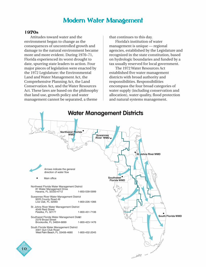
Arrows indicate the general direction of water flow
Northwest Florida Water Management District81 Water Management DriveHavana, FL 32333-4712 1-850-539-5999
Suwannee River Water Management District9225 County Road 49Live Oak, FL 32060 1-800-226-1066
St. Johns River Water Management District4049 Reid StreetPalatka, FL 32177 1-800-451-7106
Southwest Florida Water Management District2379 Broad StreetBrooksville, FL 34604-6899 1-800-423-1476
South Florida Water Management District3301 Gun Club RoadWest Palm Beach, FL 33406-4680 1-800-432-2045
Main office
Water Management Districts
Modern Water ManagementModern Water ManagementModern Water ManagementModern Water ManagementModern Water Management
19719719719719700000SSSSS
Attitudes toward water and theenvironment began to change as theconsequences of uncontrolled growth anddamage to the natural environment becamemore and more evident. During 1970–71,Florida experienced its worst drought todate, spurring state leaders to action. Fourmajor pieces of legislation were enacted bythe 1972 Legislature: the EnvironmentalLand and Water Management Act, theComprehensive Planning Act, the LandConservation Act, and the Water ResourcesAct. These laws are based on the philosophythat land use, growth policy and watermanagement cannot be separated, a theme
that continues to this day.Florida’s institution of water
management is unique — regionalagencies, established by the Legislature andrecognized in the state constitution, basedon hydrologic boundaries and funded by atax usually reserved for local government.
The 1972 Water Resources Actestablished five water managementdistricts with broad authority andresponsibilities. Responsibilitiesencompass the four broad categories ofwater supply (including conservation andallocation), water quality, flood protectionand natural systems management.
11
rights would be upheld in court. This system unimportant water uses may be continued,
Centimeters
Inches
Deficiency or Surplus
-100 0 100 200
0 40 80-40 Source: Fernald and Purdum 1998
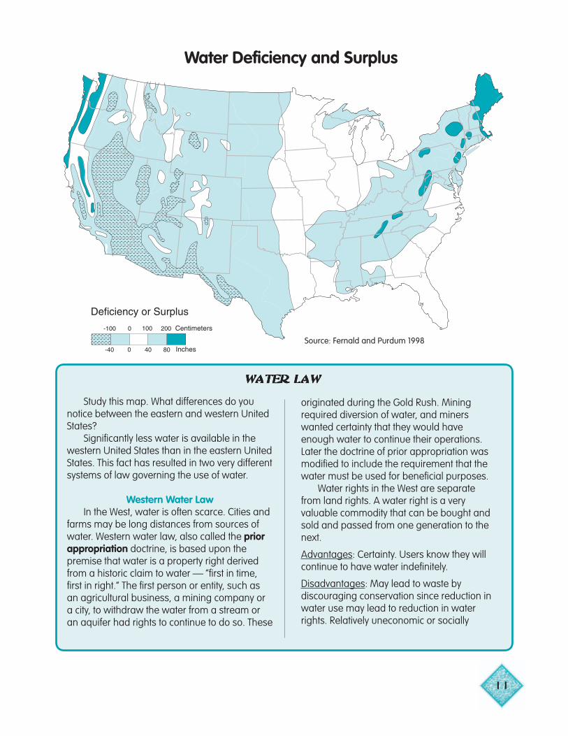
Water Deficiency and Surplus
WATER LAWWATER LAWWATER LAWWATER LAWWATER LAW
Study this map. What differences do younotice between the eastern and western UnitedStates?
Significantly less water is available in thewestern United States than in the eastern UnitedStates. This fact has resulted in two very differentsystems of law governing the use of water.
Western Water LawIn the West, water is often scarce. Cities and
farms may be long distances from sources ofwater. Western water law, also called the priorappropriation doctrine, is based upon thepremise that water is a property right derivedfrom a historic claim to water — ”first in time,first in right.” The first person or entity, such asan agricultural business, a mining company ora city, to withdraw the water from a stream oran aquifer had rights to continue to do so. These
originated during the Gold Rush. Miningrequired diversion of water, and minerswanted certainty that they would haveenough water to continue their operations.Later the doctrine of prior appropriation wasmodified to include the requirement that thewater must be used for beneficial purposes.
Water rights in the West are separatefrom land rights. A water right is a veryvaluable commodity that can be bought andsold and passed from one generation to thenext.
Advantages: Certainty. Users know they willcontinue to have water indefinitely.
Disadvantages: May lead to waste bydiscouraging conservation since reduction inwater use may lead to reduction in waterrights. Relatively uneconomic or socially
12
protect natural resources and (5) provide for
although some people think that free marketforces will transfer water rights to the mosteconomical uses. Water needs of naturalsystems may not be met because all of thewater in a stream may have been appropriatedfor human uses.
Eastern Water LawWater is considerably more abundant in the
eastern United States than it is in the westernUnited States. Eastern water law, also called theriparian system, is based on the premise thatthe riparian, the landowner along the shore,had the right to use the water for boating,fishing, swimming or viewing. Riparians alsohave a right to take as much water as theywant to use on their land as long as they do notinterfere with the reasonable use of water byother riparians. Landowners have a similarright to withdraw ground water for use onoverlying land.
Advantages: Generally more protective of thewater resources than Western law.
Disadvantages: Restricted commercial andother uses of water on nonriparian lands.Ongoing riparians constantly had to adjust tonew riparians. Courts had to resolve disputeson a case-by-case basis.
Florida Water LawFlorida water law, found in Chapter 373 of
the Florida Statutes (available on the Web atwww.leg.state.fl.us), is considered by many tocombine the best aspects of Western (priorappropriation) and Eastern (riparian) law. InFlorida, water is a resource of the state. It is notowned by anyone.
Consumptive use permits: Water is allocated bya permit system administered by the five watermanagement districts. The allocation system isdesigned to (1) prevent waste, (2) providecertainty to existing users, (3) provide equalrights irrespective of economic power, (4)
Minimum flows and levels: Florida water lawrequires the water management districts toestablish minimum flows for all rivers, streamsand canals. This means the districts mustidentify an amount of water flow below whichfurther withdrawals would cause significantharm to the water resource or to the ecology ofthe area. The law also requires the watermanagement districts to establish minimumlevels for ground water and surface waters(rivers, streams, canals, lakes and wetlands)below which further withdrawals would causeharm to the water resource. Surface watersless than 25 acres (10 hectares) generally areexempt from this requirement.
Determining minimum flows and levelsrequires complex scientific and technicalanalyses. The water management districts are
future users by requiring water managers toaddress comprehensive planning andresource development. Permits to use waterare issued by the water management districtsand may be issued for up to 50 years. Thequantity of water available for use under apermit may be reduced during droughts.
To obtain a permit, the applicant mustestablish three things: the use is reasonableand beneficial, the use will not interfere withany presently existing legal use of the water, andthe use is consistent with the public interest. Ifthere is not enough water for all proposed uses,the water management districts are to makedecisions based on which use best serves thepublic interest. If all the competing applicantsequally serve the public interest, preference isgiven to the existing permit holder.
Unlike the Western system of priorappropriation, Florida law discourages thelong-distance transfer of water acrosshydrologic boundaries. A transfer must notdiminish the availability of water for presentand future needs of the sending area, and thereceiving area must have exhausted allreasonable local sources and options. Inaddition, the transfer of water across countyboundaries is discouraged.
now making progress in establishing minimumflows and levels, which will play a much greaterrole in water resources planning and permittingin the future.
Advantages: Consumptive use permits helpensure that the use of water in Florida isreasonable and beneficial. Some degree ofcertainty is given by permits that give the rightto withdraw a certain amount of water for a
given time period. The minimum flow provisionand the restrictions on the long-distancetransport of water help protect the waterresources and the environment.
Disadvantages: Terms such as “public interest,”“reasonable and beneficial” and “significantharm” are open to interpretation and mayresult in conflicts that have to be resolvedthrough the courts.
The districts are drawn on watershedboundaries. These are natural drainagebasins, not political boundaries. Watermanagement districts are overseen at thestate level by the Department ofEnvironmental Protection. They aregoverned by a board appointed by theGovernor and approved by the Senate.They are funded to do the job of watermanagement by a tax granted to them bythe people of Florida in 1976. However, thebudgets of the districts are closelymonitored by the Governor’s Office and bythe Legislature.
19819819819819800000SSSSS
In the late 1970s and early 1980s,protection of Florida’s ground water, theprimary source of drinking water in thestate, became a major issue. The 1983 TaskForce on Water Issues reported that thethreat of contamination of ground waterand related surface waters from hazardouswastes, sewage, industrial wastes andpesticides had become a major problem.The Legislature passed the Water QualityAssurance Act, granting the Department ofEnvironmental Regulation more authorityto protect ground water and to clean upcontaminated resources.
In 1985, the Florida Legislature passedthe Surface Water Improvement andManagement Act (SWIM), the firststatewide program for protecting orrestoring waters of regional or statewidesignificance. The initial legislation namedthe first six water bodies to be restored and
protected under SWIM: Lake Apopka,Tampa Bay, Lake Okeechobee, BiscayneBay, the Indian River Lagoon and lower St.Johns River.
19919919919919900000SSSSS
Throughout the 1990s, Floridacontinued to protect environmentallysensitive lands, critical water resources andvital habitats through land acquisitionefforts. With programs such asPreservation 2000 and Save Our Rivers,Florida has carried out the largest landacquisition effort in the nation. In the lastquarter of the twentieth century, Floridapurchased 2.1 million acres (850,000hectares) of conservation and resource-based recreation land. In combination withland protected by local and federalprograms or under private conservationmanagement, these purchases protect andpreserve 7.6 million acres (3.1 millionhectares) of land (about 22 percent of theland in Florida).
In the 1990s, major ecosystemrestoration projects and land acquisitionprograms were undertaken throughout thestate. The Everglades Forever Act, passed bythe Legislature in 1994, outlines acomprehensive program for restoring waterquality and improving the amount, timingand distribution of water flows for the entiresouth Florida ecosystem (Kissimmee River-Lake Okeechobee-Everglades-Florida Bay).In the St. Johns River Water ManagementDistrict, restoration projects began inthe Lower St. Johns River Basin,
13

1
WATER KNOWS NO POLITICAL BOUNDARIESWATER KNOWS NO POLITICAL BOUNDARIESWATER KNOWS NO POLITICAL BOUNDARIESWATER KNOWS NO POLITICAL BOUNDARIESWATER KNOWS NO POLITICAL BOUNDARIES
The Apalachicola-Chattahoochee-Flint RiverBasin (ACF) is located within three states —Georgia, Alabama and Florida. Theheadwaters are in Georgia above Lake Laniernear Atlanta. The basin terminates in northwestFlorida where the Apalachicola River flows intoApalachicola Bay on the Gulf of Mexico. In1990, Florida joined with Alabama in a federallawsuit over the Army Corps of Engineers’ andGeorgia’s plan to reallocate water in LakeLanier for the Atlanta urban area’s watersupply. In 1997, after years of negotiations, thethree states entered into the ACF River BasinCompact, ratified by the three state legislaturesand Congress. The Compact directed the threestates to develop a water allocation formula to
apportion the water in this river system.The Suwannee River Basin begins in
Georgia in the Okefenokee Swamp and endsin the Gulf of Mexico. Two of the Suwannee’smajor tributaries, the Withlacoochee (distinctfrom the southern Withlacoochee) and theAlapaha, also originate in Georgia. In the1990s, the Suwannee River WaterManagement District and the FloridaDepartment of Environmental Protection andtheir counterpart agencies in Georgia formedthe Suwannee Basin Interagency Alliance.This group is working to develop a basinwidemanagement planning and river protectionprogram that, for the first time, will addressthe entire watershed.
Lake Apopka, the Indian River Lagoon, andthe upper Ocklawaha River Basin. In theNorthwest Florida Water ManagementDistrict, restoration began in portions ofTates Hell Swamp, formerly ditched anddrained for pine plantations. In theSuwannee River Water ManagementDistrict, large parcels within the 100-yearfloodplain of the Suwannee River are beingacquired, protected, and restored wherenecessary. In the Southwest Florida WaterManagement District, over 30 ecosystemrestoration projects are under variousstages of development for the Tampa Bay
estuarine ecosystem.In 1999, the Florida Legislature passed
the Florida Forever Act, the successor toPreservation 2000. The act provides $300million per year for 10 years for landacquisition, water resources protection,ecosystem restoration, and urban parks andopen space. Half of the water managementdistricts’ allocation (35 percent) may be usedfor water resources development, includingrestoring aquifer recharge, capturing andstoring of excess flows of surface water,surface water reservoirs, and implementingaquifer storage and recovery.
ConclusionConclusionConclusionConclusionConclusion
The basic water managementframework established by the 1972 WaterResources Act has remained intact. TheDepartment of Environmental Protectionand the water management districts jointlyimplement a broad range of programsrelated to water supply, flood protection,water quality and natural systemsprotection.
Water supply and water allocation have emerged as paramount issues
for the next century. In some areas ofthe state, demands for water are
4
beginning to exceed the capacity of aquifersand surface waters to meet these demands.Competition for water is increasing. Theeffects of withdrawing more ground waterthan rainfall can replenish are evidenced bysaltwater intrusion, diminished spring flow,dried-out marshes and disappearing lakes.In some areas, new, easily developed, cleansources of water no longer exist. Alternativesources can be developed, but at highercosts than traditional sources. AlthoughFlorida is in many ways “The Water State,”its supplies are not boundless.
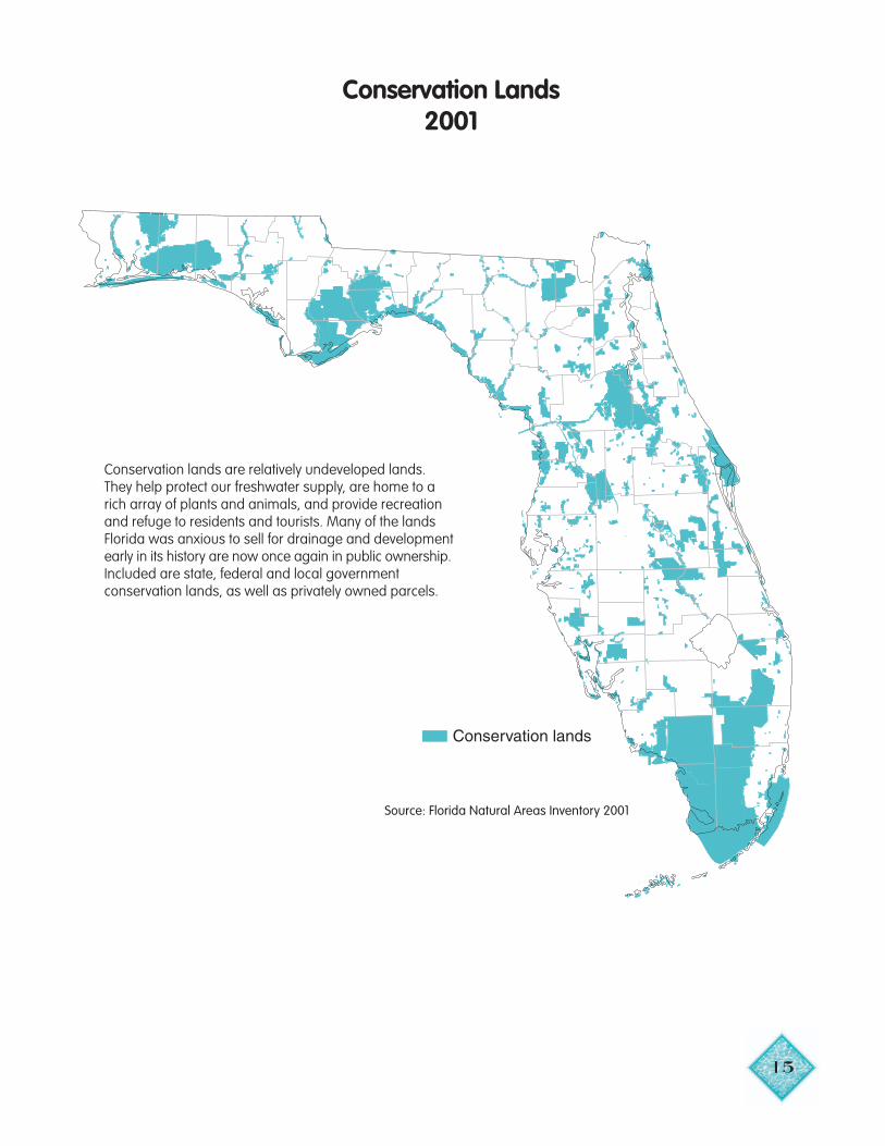
15
Conservation lands
Conservation Lands2001
Source: Florida Natural Areas Inventory 2001
Conservation lands are relatively undeveloped lands.They help protect our freshwater supply, are home to arich array of plants and animals, and provide recreationand refuge to residents and tourists. Many of the landsFlorida was anxious to sell for drainage and developmentearly in its history are now once again in public ownership.Included are state, federal and local governmentconservation lands, as well as privately owned parcels.
16
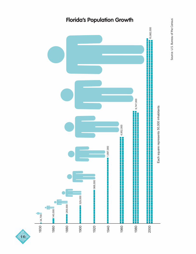
Florida’s Population Growth
34,7
0018
30
140,
000
1860
269,
000
1880
529,
000
1900
968,
000
1920
Eac
h sq
uare
rep
rese
nts
50,0
00 in
habi
tant
s
1,89
7,00
019
40
4,95
2,00
019
60
9,74
7,00
019
80
15,9
82,0
0020
00
Sour
ce: U
.S. B
urea
u of
the
Cens
us
17
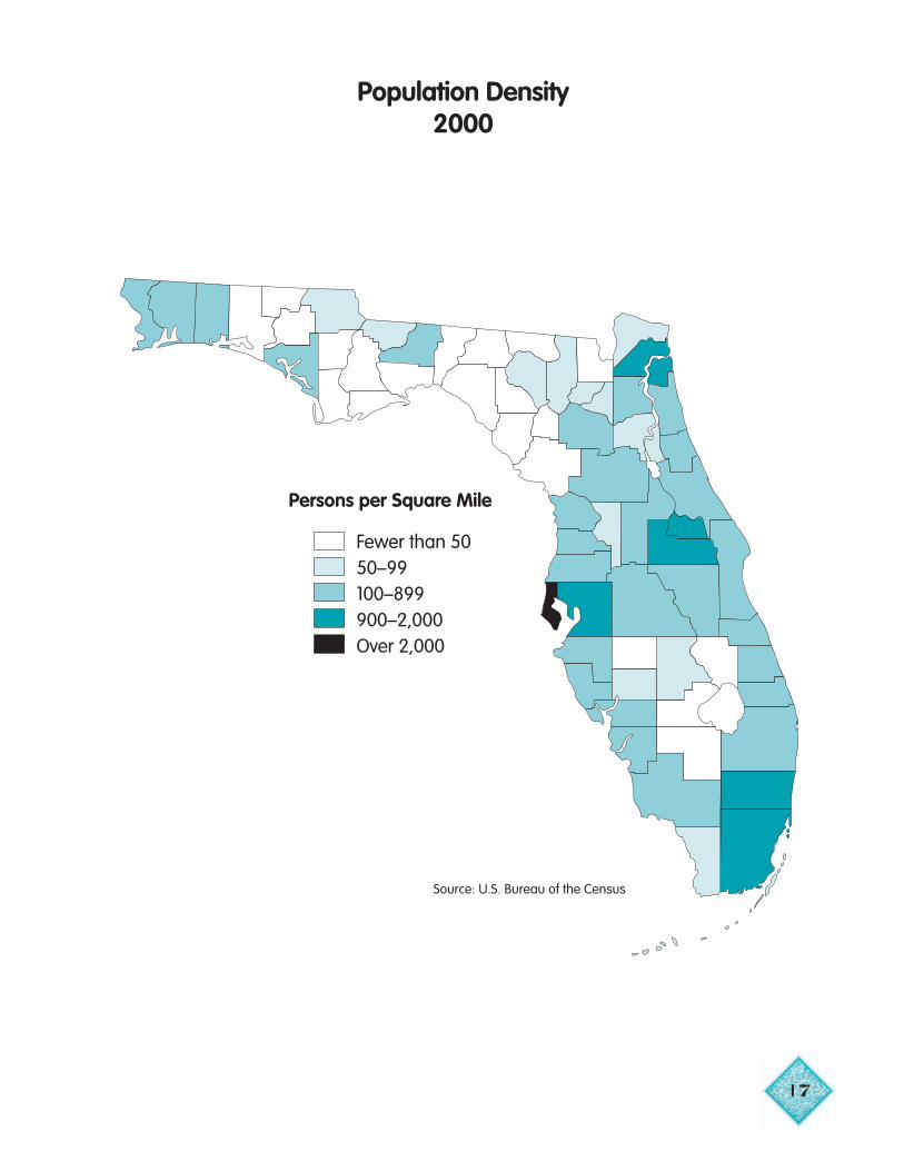
Persons per Square Mile
Fewer than 5050–99100–899900–2,000Over 2,000
Population Density2000
Source: U.S. Bureau of the Census

18
12,000 BC 1500 1770 1820 1830
The Human FrameworkTime Line
12,000 B.C.First Floridiansenter the Floridapeninsula.
1774The Suwannee River is“The cleanest and purestof any river. . . almost astransparent as the air webreathe.”— Naturalist William Bartram
1821Spain cedes East and WestFlorida to the United States
1500Beginning of Spanishexploration of Florida.
350,000 Native Americans livingthroughout the present-day state.
1827“In appearance it [northern Florida] isentirely unlike any part of the UnitedStates. The lakes abound in fish, trout,brim, perch and soft-shelled turtle; andin the winter with wild fowl.”— Judge Henry M. Brackenridge
Source: Florida State Archives
Timucuan Indians depositing grain in public granary
19
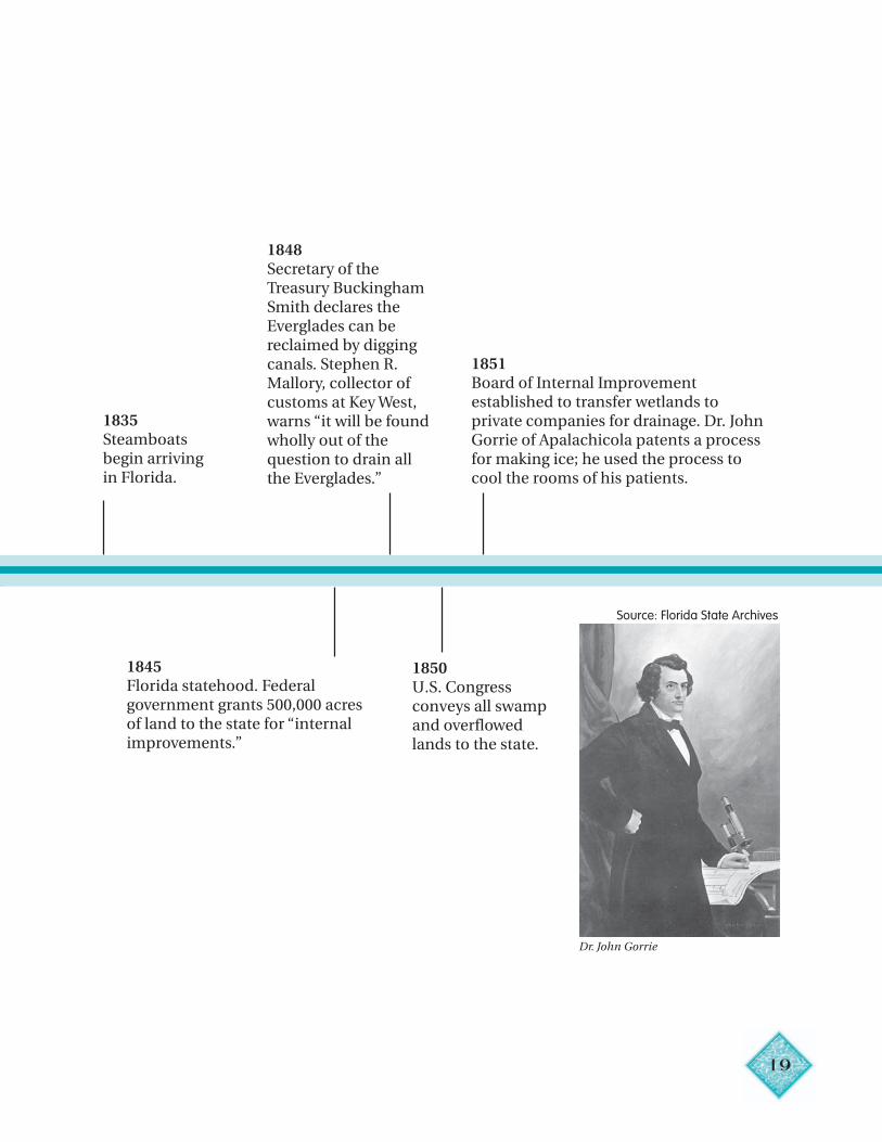
1840 1850 1860
d1835Steamboatsbegin arrivingin Florida.
Dr. John Gorrie
Source: Florida State Archives
1848Secretary of theTreasury BuckinghamSmith declares theEverglades can bereclaimed by diggingcanals. Stephen R.Mallory, collector ofcustoms at Key West,warns “it will be founwholly out of thequestion to drain allthe Everglades.”
1851Board of Internal Improvementestablished to transfer wetlands toprivate companies for drainage. Dr. JohnGorrie of Apalachicola patents a processfor making ice; he used the process tocool the rooms of his patients.
1845Florida statehood. Federalgovernment grants 500,000 acresof land to the state for “internalimprovements.”
1850U.S. Congressconveys all swampand overflowedlands to the state.
20
18701865 1875
1866Governor Davis Walkergrants William Gleasonover 6 million acresbased on his proposal todrain swamplands eastand south of theEverglades.
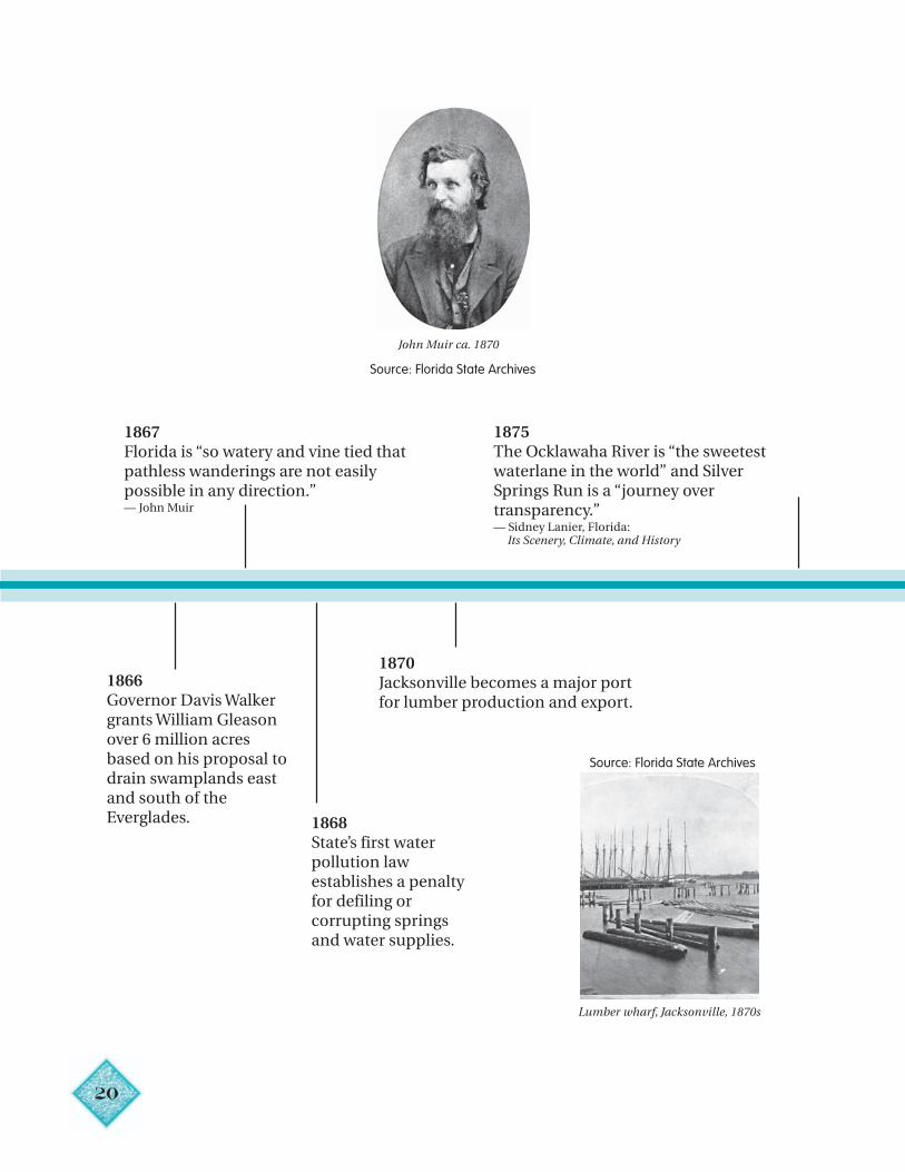
John Muir ca. 1870
Lumber wharf, Jacksonville, 1870s
Source: Florida State Archives
Source: Florida State Archives
1867Florida is “so watery and vine tied thatpathless wanderings are not easilypossible in any direction.”— John Muir
1868State’s first waterpollution lawestablishes a penaltyfor defiling orcorrupting springsand water supplies.
1870Jacksonville becomes a major portfor lumber production and export.
1875The Ocklawaha River is “the sweetestwaterlane in the world” and SilverSprings Run is a “journey overtransparency.”— Sidney Lanier, Florida: Its Scenery, Climate, and History
21
18801875 1885
1879Santa Fe CanalCompany constructstwo canals from Waldoto Melrose via Lake Altoand Lake Santa Fe.
1881State of Florida sells 4 million acresof land near Lake Okeechobee andin the Kissimmee River basin toHamilton Disston of Philadelphiafor 25 cents per acre.
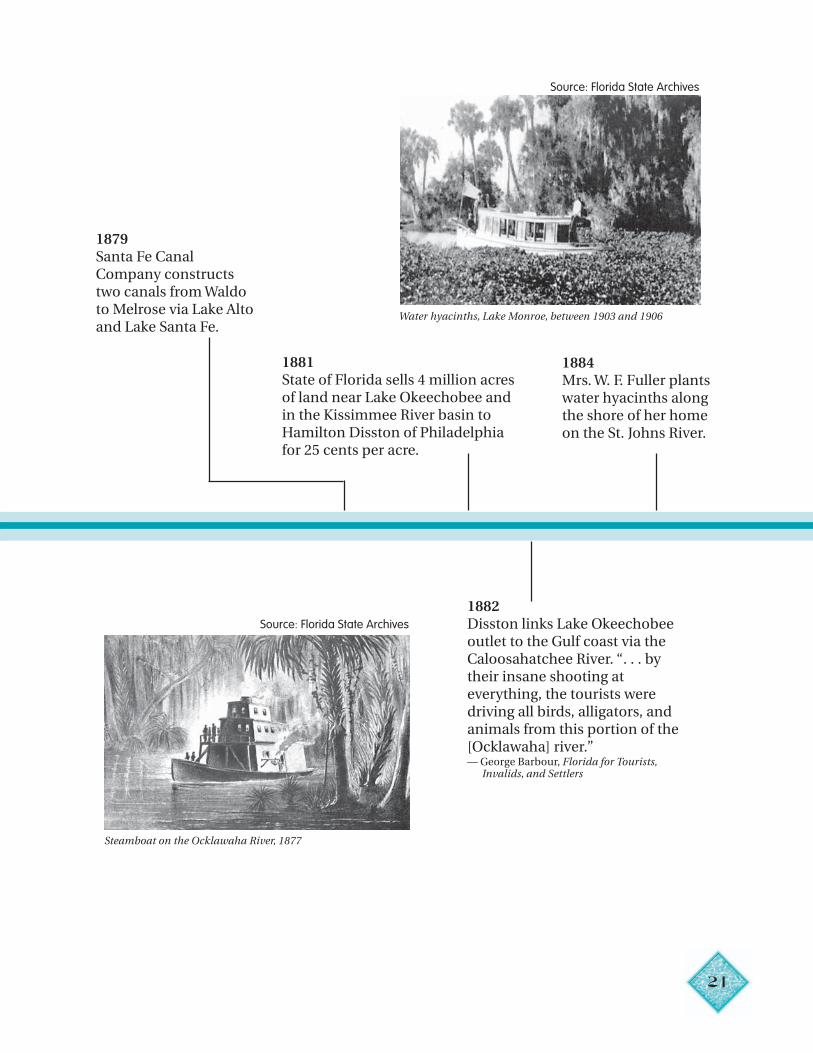
Water hyacinths, Lake Monroe, between 1903 and 1906
Steamboat on the Ocklawaha River, 1877
Source: Florida State Archives
Source: Florida State Archives
1882Disston links Lake Okeechobeeoutlet to the Gulf coast via theCaloosahatchee River. “. . . bytheir insane shooting ateverything, the tourists weredriving all birds, alligators, andanimals from this portion of the[Ocklawaha] river.”— George Barbour, Florida for Tourists, Invalids, and Settlers
1884Mrs. W. F. Fuller plantswater hyacinths alongthe shore of her homeon the St. Johns River.
22
18901885 1895
1886Freeze and hurricane destroy north-central Florida’s citrus industry.
1894–95Great Freeze ends commercialagriculture industry in north Florida.
1889Phosphate is discovered near Dunnellon.
Early phosphate mine
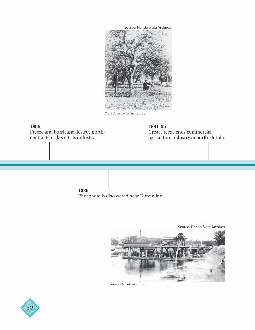
Frost damage to citrus crop
Source: Florida State Archives
Source: Florida State Archives
23
19001895 1905
1900“The existing practices of lumbermen incutting timber land so close . . . [left] noyoung trees unscathed to form newforests, and when the pine disappears, itis replaced by utterly worthless scrub.” — Pensacola Daily News, March 27
1900“[I]n our very midst, we have a tract of landone hundred and thirty miles long andseventy miles wide that is as much unknownto the white man as the heart of Africa.”— Hugh L. Willoughby, Across the Everglades
1904Napoleon Browardelected governor on apromise to drain theEverglades for gardensand farms.
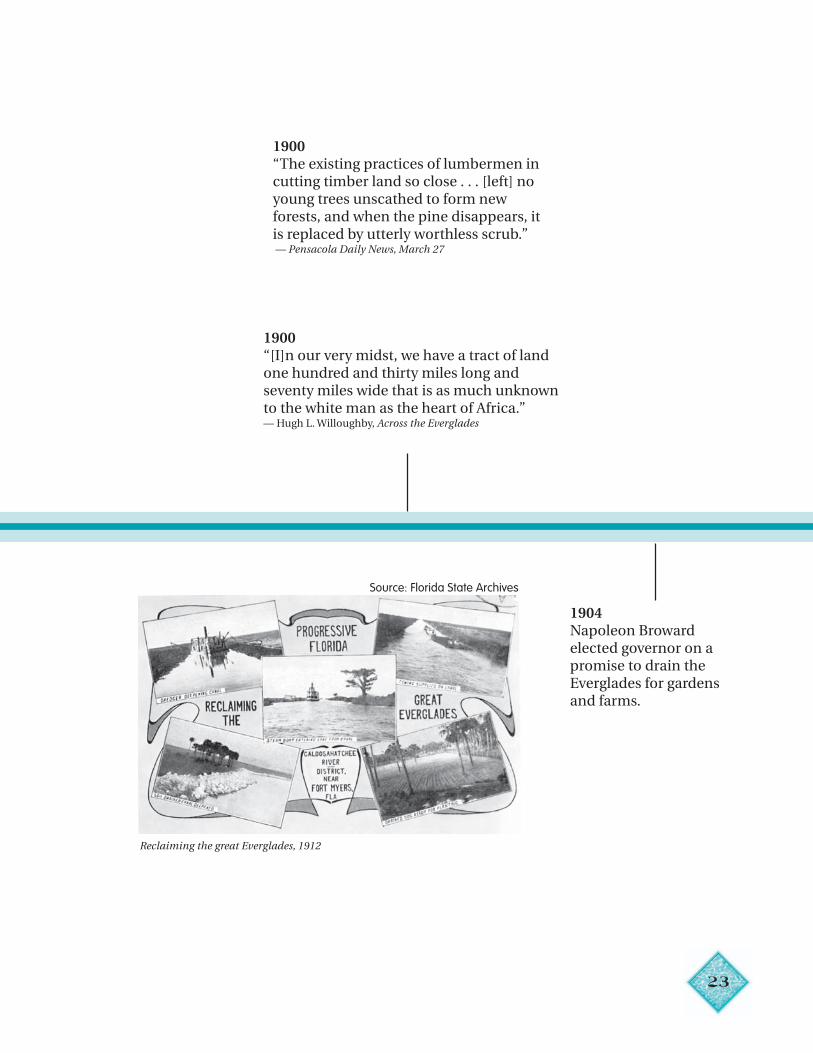
Reclaiming the great Everglades, 1912
Source: Florida State Archives
24
19101905 1915
1906John Gifford introducesmelaleuca as the idealplant for drying theEverglades.
1907Everglades Drainage District established.
1912The Flagler Railroad to Key West iscompleted.
Intracoastal Waterway fromJacksonville to Miami is completed.
1913“Drainage of the FloridaEverglades is entirelypracticable and can beaccomplished at a cost whichthe value of the reclaimedland will justify, the costbeing very small.”— Florida Everglades Engineering Commission
Former Governor Jennings and family with press tour ofEverglades Drainage Project, 1907
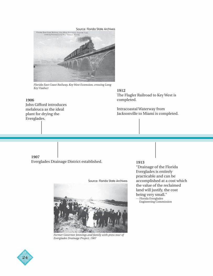
Florida East Coast Railway, Key West Extension, crossing LongKey Viaduct
Source: Florida State Archives
Source: Florida State Archives
25
1915 19251920
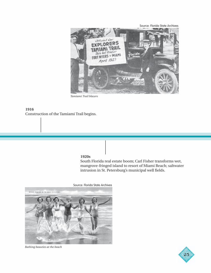
1916Construction of the Tamiami Trail begins.
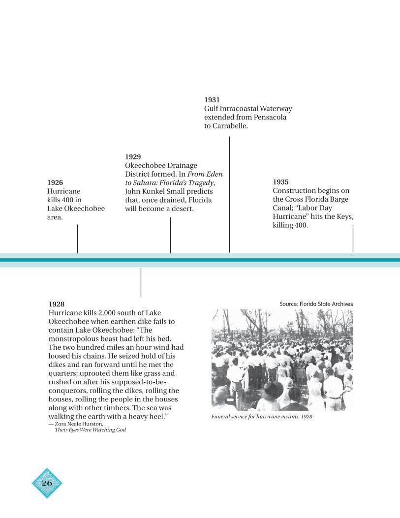
1920sSouth Florida real estate boom; Carl Fisher transforms wet,mangrove-fringed island to resort of Miami Beach; saltwaterintrusion in St. Petersburg’s municipal well fields.
Source: Florida State Archives
Tamiami Trail blazers
Bathing beauties at the beach
Source: Florida State Archives
26
1925 1930 1935
1926Hurricanekills 400 inLake Okeechobeearea.
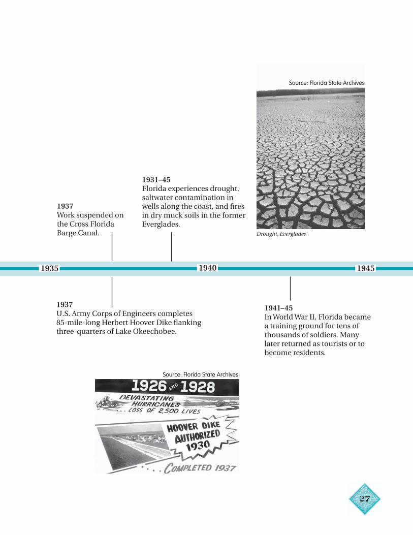
1928Hurricane kills 2,000 south of LakeOkeechobee when earthen dike fails tocontain Lake Okeechobee: “Themonstropolous beast had left his bed.The two hundred miles an hour wind hadloosed his chains. He seized hold of hisdikes and ran forward until he met thequarters; uprooted them like grass andrushed on after his supposed-to-be-conquerors, rolling the dikes, rolling thehouses, rolling the people in the housesalong with other timbers. The sea waswalking the earth with a heavy heel.”— Zora Neale Hurston, Their Eyes Were Watching God
1929Okeechobee DrainageDistrict formed. In From Edento Sahara: Florida’s Tragedy,John Kunkel Small predictsthat, once drained, Floridawill become a desert.
1931Gulf Intracoastal Waterwayextended from Pensacolato Carrabelle.
1935Construction begins onthe Cross Florida BargeCanal; “Labor DayHurricane” hits the Keys,killing 400.
Funeral service for hurricane victims, 1928
Source: Florida State Archives
27
1935 1940 1945
1931–45Florida experiences drought,saltwater contamination inwells along the coast, and firesin dry muck soils in the formerEverglades.
1937Work suspended onthe Cross FloridaBarge Canal.
1937U.S. Army Corps of Engineers completes85-mile-long Herbert Hoover Dike flankingthree-quarters of Lake Okeechobee.
1941–45In World War II, Florida becamea training ground for tens ofthousands of soldiers. Manylater returned as tourists or tobecome residents.
Drought, Everglades
Source: Florida State Archives
Source: Florida State Archives
28
1945 19551950
1947Two hurricanes flood Miami.First algal blooms reported inLake Apopka. Everglades NationalPark opens — “There are no otherEverglades in the world.”— Marjory Stoneman Douglas, The Everglades: River of Grass
1948Congress authorizes the Centraland Southern Florida FloodControl Project; U.S. ArmyCorps of Engineers proposesthree water conservation areas.
1949Florida Legislature creates the Central and SouthernFlorida Flood Control District to act as local sponsorfor the federally authorized project.
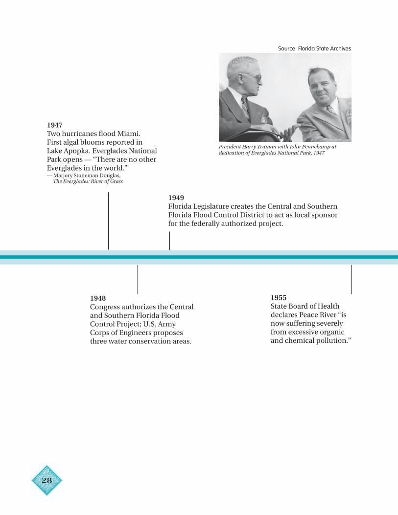
President Harry Truman with John Pennekamp atdedication of Everglades National Park, 1947
Source: Florida State Archives
1955State Board of Healthdeclares Peace River “isnow suffering severelyfrom excessive organicand chemical pollution.”
29
19651960 19651955
1957Jim Woodruff Lock and Damon the Apalachicola Riverbecomes fully operational.
1959Suwannee River Authorityand Peace River Valley WaterConservation and DrainageDistrict created.
1960Hurricane Donna floodsTampa Bay Area.
1961Congressauthorizes the FourRiver Basins,Florida Project forflood control inTampa area; theSouthwest FloridaWater ManagementDistrict is created;south Floridareceives only 30inches of rain.
1962Construction of theKissimmee Canal begins.
1964U.S. Army Corps of Engineers recommendsconstruction of a $12.5 million hurricanelevee across Hillsborough Bay at Tampa.“God was good to this country . . . But inHis wisdom the Creator left something formen to do for themselves.”— President Lyndon B. Johnson, Groundbreaking for the Florida Cross State Barge Canal
1965Congress enacts theFederal Water Quality Act.
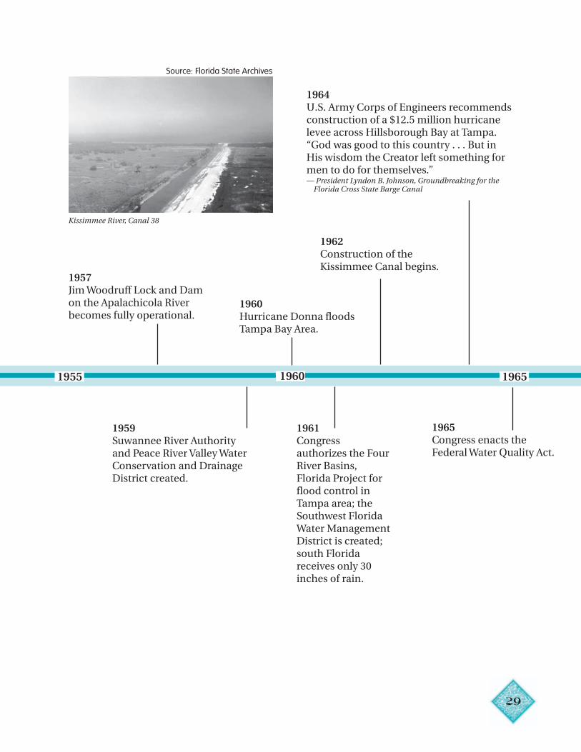
Kissimmee River, Canal 38
Source: Florida State Archives
30
197519701965
1966Central and Southern FloridaFlood Control District pumpsexcess water from farmlandsinto water conservation areas,drowning hundreds of deer.
1966–67Fifteen new sinkholesappear in central Florida,indicating a serious dropin the water table.
1969United States GeologicalSurvey map shows area insouthwestern Polk Countyas a “caution area” forfurther water withdrawals.
1970Four River Basins,Florida project ishalted for restudy;first Earth Day.
1971Congress orders U.S. Army Corps of Engineers todeliver more water to Everglades National Park;construction of the Florida Cross State Barge Canalhalted; canalization of the Kissimmee completed.
1970–71State experiencesworst drought todate.
1970sEscambia Bayexperiencesrepeated massivefish kills.
1972Year of the Environment(see page 9)
1973ecord flood occurs
n the upper reachesf the Suwanneeiver basin.
RioR
1974Big Cypress NationalPreserve, located inOchopee, Florida, next tothe Everglades NationalPark, was established.
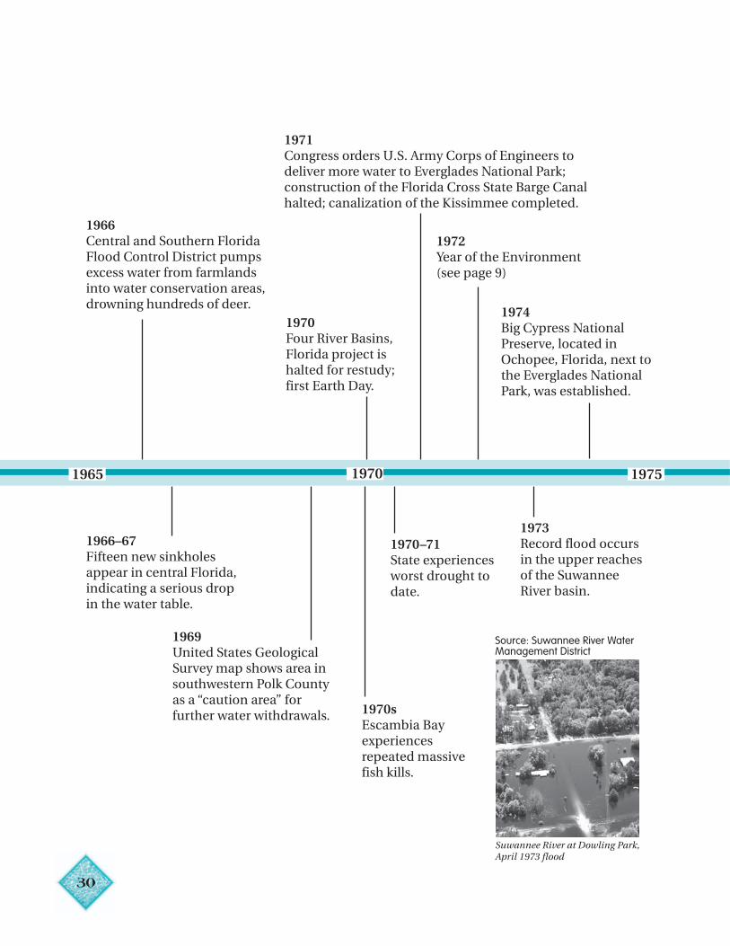
Suwannee River at Dowling Park,April 1973 flood
Source: Suwannee River WaterManagement District
31
1975 1980 1985
1976Summary Report on the Special Project toPrevent Eutrophication of LakeOkeechobee finds “water delivered to LakeOkeechobee from the Kissimmee River byCanal-38 contributes significantly to theeutrophication of the Lake.”
1977Upper St. JohnsRiver BasinRestorationProject begins. 1979
Conservation andRecreation Lands(CARL) Trust Fundestablished.
1980Florida Hazardous Waste ManagementAct enacted. Floridan aquifer levels inFt. Walton Beach area had declined asmuch as 100 feet below sea level.
1981Florida Legislature createsWater Management LandsTrust Fund, providesfunding for Save OurRivers land-buyingprogram.
1982–83Over 400 drinking water wells innortheastern Jackson Countyfound to be contaminated by thepesticide ethylene dibromide.
1983Florida Water QualityAssurance Act establishesstatewide groundwatermonitoring network;Governor Bob Grahamannounces the Save OurEverglades program.
1984The Warren S. HendersonWetlands Protection Act isenacted.
1985Elevated levels of nitrogendetected in the upper reachesof the Suwannee River.
32
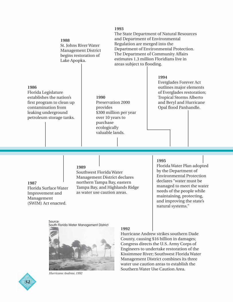
1985 1990 1995
1986Florida Legislatureestablishes the nation’sfirst program to clean upcontamination fromleaking undergroundpetroleum storage tanks.
1987Florida Surface WaterImprovement andManagement(SWIM) Act enacted.
1988St. Johns River WaterManagement Districtbegins restoration ofLake Apopka.
1989Southwest Florida WaterManagement District declaresnorthern Tampa Bay, easternTampa Bay, and Highlands Ridgeas water use caution areas.
1990Preservation 2000provides$300 million per yearover 10 years topurchaseecologicallyvaluable lands.
1992Hurricane Andrew strikes southern DadeCounty, causing $16 billion in damages;Congress directs the U.S. Army Corps ofEngineers to undertake restoration of theKissimmee River; Southwest Florida WaterManagement District combines its threewater use caution areas to establish theSouthern Water Use Caution Area.
1993The State Department of Natural Resourcesand Department of EnvironmentalRegulation are merged into theDepartment of Environmental Protection.The Department of Community Affairsestimates 1.3 million Floridians live inareas subject to flooding.
1994Everglades Forever Actoutlines major elementsof Everglades restoration;Tropical Storms Albertoand Beryl and HurricaneOpal flood Panhandle.
1995Florida Water Plan adoptedby the Department ofEnvironmental Protectiondeclares “water must bemanaged to meet the waterneeds of the people whilemaintaining, protecting,and improving the state’snatural systems.”
Hurricane Andrew, 1992
Source:South Florida Water Management District
33
2000 20051995
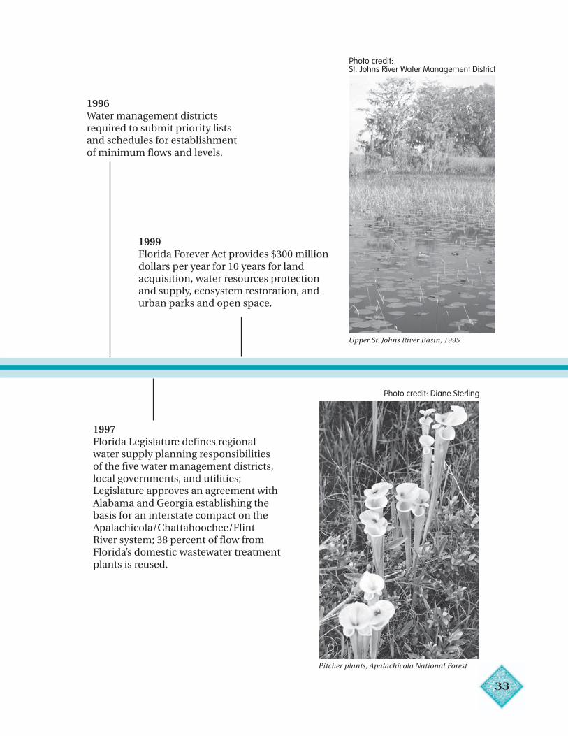
1996Water management districtsrequired to submit priority listsand schedules for establishmentof minimum flows and levels.
1997Florida Legislature defines regionalwater supply planning responsibilitiesof the five water management districts,local governments, and utilities;Legislature approves an agreement withAlabama and Georgia establishing thebasis for an interstate compact on theApalachicola/Chattahoochee/FlintRiver system; 38 percent of flow fromFlorida’s domestic wastewater treatmentplants is reused.
1999Florida Forever Act provides $300 milliondollars per year for 10 years for landacquisition, water resources protectionand supply, ecosystem restoration, andurban parks and open space.
Pitcher plants, Apalachicola National Forest
Upper St. Johns River Basin, 1995
Photo credit:St. Johns River Water Management District
Photo credit: Diane Sterling
34
Chapter 2
Water: It’s Magic
“If there is magic on this planet, it is in water.”— Loren Eisley, Naturalist and Philosopher
“One question I ask of you:Where flows the water?Deep in the ground in the gushing spring,A water of magic power — The water of life!Life! O give us this life!”
— Native Hawaiian poem
KEY IDEAS
• Water is critical for all life on Earth.• Water has many amazing chemical and
physical properties.• Most of the water on Earth is salt water.• Only 3 percent of the Earth’s water is fresh
water and less than 1 percent of the freshwater is available for use. Most fresh water isfrozen in glaciers and polar ice caps.
• Water is continuously circulating betweenthe sky, land and sea.
• No significant amount of water enters orleaves the global water cycle.
• Water does enter and leave Florida’s water cycle.• Rainfall in Florida varies with season and
location.• Florida is susceptible to extreme weather
events including tornadoes, hurricanes,floods, thunderstorms and droughts.
• Florida’s climate is influenced by globalpatterns.
VOCABULARY
Atom
Capillarity
Condensation
Drought
El Niño
Evaporation
Evapotranspiration
Flood
Gas
Global warming
Ground water
Humid subtropical
Hurricane
Hydrologic divide
La Niña
Liquid
Molecule
Precipitation
Saltwater intrusion
Solid
Solvent
Stormwater runoff
Surface tension
Surface water
Tornado
Transpiration
Tropical savanna
Water budget
Water cycle
The wonders and life-giving powers ofwater have awed and intrigued peoplethroughout the world. To many, watercame first in the unfolding of creation.Only after water did land appear, thenplants and animals, and then humans.The Winnebago Indians of Wisconsinspeak of the Earthmaker. Sitting alone inempty space, the Earthmaker began tocry, and as his tears fell, the waters of theEarth formed. For the Maori of NewZealand and the Crow Indians of theNorth American plains, in the beginningthere was no land on Earth, only water.The Book of Genesis describes Earthbefore creation as dark, with watercovering all the land. Scientists believelife on Earth began in water, where itremained for 3 billion years. About 450million years ago, plants began to growout of water, but only on wet ground(Hooper and Coady 1998). Today, watercovers 75 percent of the Earth.
Water is essential for all life processes.Plants and animals are between 50 and97 percent water. The human body is 70percent water. Protoplasm, the basicmaterial of all living cells, is a solution offats, carbohydrates, proteins, salts andother chemicals in water. Sap in plants andblood in animals are largely water.Humans can live almost 30 days withoutfood, but only about three to four dayswithout water.
Water’s cleansing, healing andrenewing powers are unmatched by anyother resource on Earth. Religions baptizetheir initiates in water, and the aged andinfirm continue to flock to springs thoughtto have special healing powers. Water is
fun as well as awe-inspiring and is thesingle most sought-after recreationalresource on Earth.
Water and the lack of water can alsobring death and destruction. People have
always feared the devastating effects offloods, droughts and storms. Moderntechnology has helped us predict theseevents and prepare for them, but theiroccurrence is still largely beyond our control.
Water’s Structure
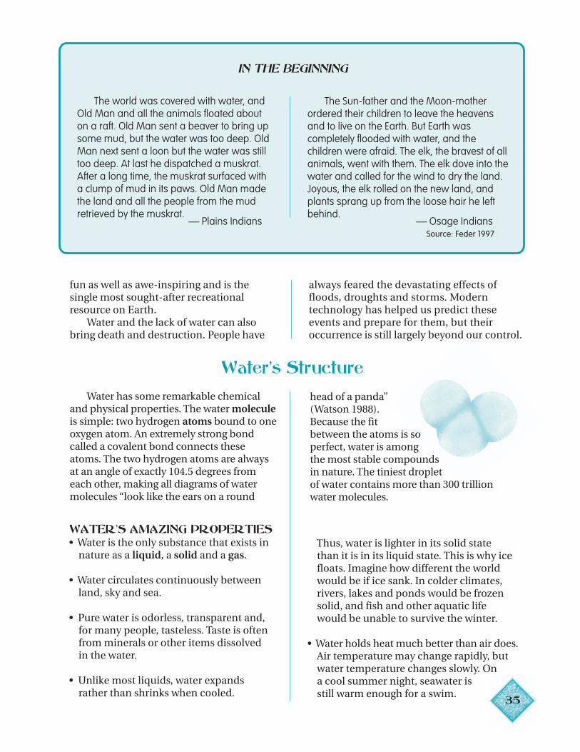
Water has some remarkable chemicaland physical properties. The water moleculeis simple: two hydrogen atoms bound to oneoxygen atom. An extremely strong bondcalled a covalent bond connects theseatoms. The two hydrogen atoms are alwaysat an angle of exactly 104.5 degrees fromeach other, making all diagrams of watermolecules “look like the ears on a round
head of a panda”(Watson 1988).Because the fitbetween the atoms is soperfect, water is amongthe most stable compoundsin nature. The tiniest dropletof water contains more than 300 trillionwater molecules.
WATER’S AMAZING PROPERTIES• Water is the only substance that exists in nature as a liquid, a solid and a gas.
• Water circulates continuously between land, sky and sea.
• Pure water is odorless, transparent and, for many people, tasteless. Taste is often from minerals or other items dissolved in the water.
• Unlike most liquids, water expands rather than shrinks when cooled.
Thus, water is lighter in its solid state than it is in its liquid state. This is why ice floats. Imagine how different the world would be if ice sank. In colder climates, rivers, lakes and ponds would be frozen solid, and fish and other aquatic life would be unable to survive the winter.
Water holds heat much better than air does. Air temperature may change rapidly, but water temperature changes slowly. On a cool summer night, seawater is still warm enough for a swim.
35
•
IN THE BEGINNING…
The world was covered with water, andOld Man and all the animals floated abouton a raft. Old Man sent a beaver to bring upsome mud, but the water was too deep. OldMan next sent a loon but the water was stilltoo deep. At last he dispatched a muskrat.After a long time, the muskrat surfaced witha clump of mud in its paws. Old Man madethe land and all the people from the mudretrieved by the muskrat.
— Plains Indians
The Sun-father and the Moon-motherordered their children to leave the heavensand to live on the Earth. But Earth wascompletely flooded with water, and thechildren were afraid. The elk, the bravest of allanimals, went with them. The elk dove into thewater and called for the wind to dry the land.Joyous, the elk rolled on the new land, andplants sprang up from the loose hair he leftbehind.
— Osage Indians Source: Feder 1997
36
• Water is the universal solvent. This meansthat more substances will dissolve inwater than in other liquids. This propertymakes water very useful for washingclothes, dishes and human skin. It alsomeans water becomes contaminated orpolluted very easily.
• Water shapes the surface of the Earth.In combination with gravity, wind andexpansion and contraction caused byfreezing and thawing, water can dissolverocks, wear down mountains and hills,and sculpt drainage basins.
• Water has surface tension. Surfacetension occurs when two substances thatdo not mix freely, such as air and water,come into contact. The water moleculesdraw closer together and cling or adhereto each other like little magnets, causing
the surface to shrink (Wick 1997).Because of surface tension, insects canskate across the surface of a pond, whichseems to have a skin. Surface tension alsoholds molecules together in drops.
• Water has capillarity. Capillaries are long,slender, tubelike structures. Water rises incapillaries because of the attraction ofwater molecules to each other and to themolecules on the side of the solidcapillary. For example, if you rest a strawin a glass of liquid, the liquid rises in thestraw above the level of liquid in the glass.This is because of capillarity, whichresults from the attraction of the watermolecules to each other and to themolecules in the straw. Because ofcapillarity, plants are able to draw waterfrom the ground up through their rootsand stems.
Global Water Cycle
Until the late 1980s, scientists assumedthe amount of water on Earth was fixedand finite. Now some scientists believe thatEarth’s water supply may be constantlygrowing as a result of huge “snowballs” thatenter the Earth’s gravitational field fromouter parts of the solar system. Thesesnowballs, about the size of small houses,are thought to melt and evaporate whenthey approach the Earth (Frank 1990, citedin Pielou 1998). In any event, this possibleaddition is relatively insignificant inrelation to the vast amount of waterconstantly on Earth.
Water on Earth today has been here formillions and perhaps billions of years.Scientists believe water originated early inthe Earth’s history from hydrogen andoxygen in the gas cloud from which ouruniverse formed.
In 1998 in Monahans, Texas, five boyswere playing basketball when they heardwhat sounded like a sonic boom. In anearby vacant lot, they saw a black rock
the size of a grapefruit. One of the boyspicked up the still-warm rock and
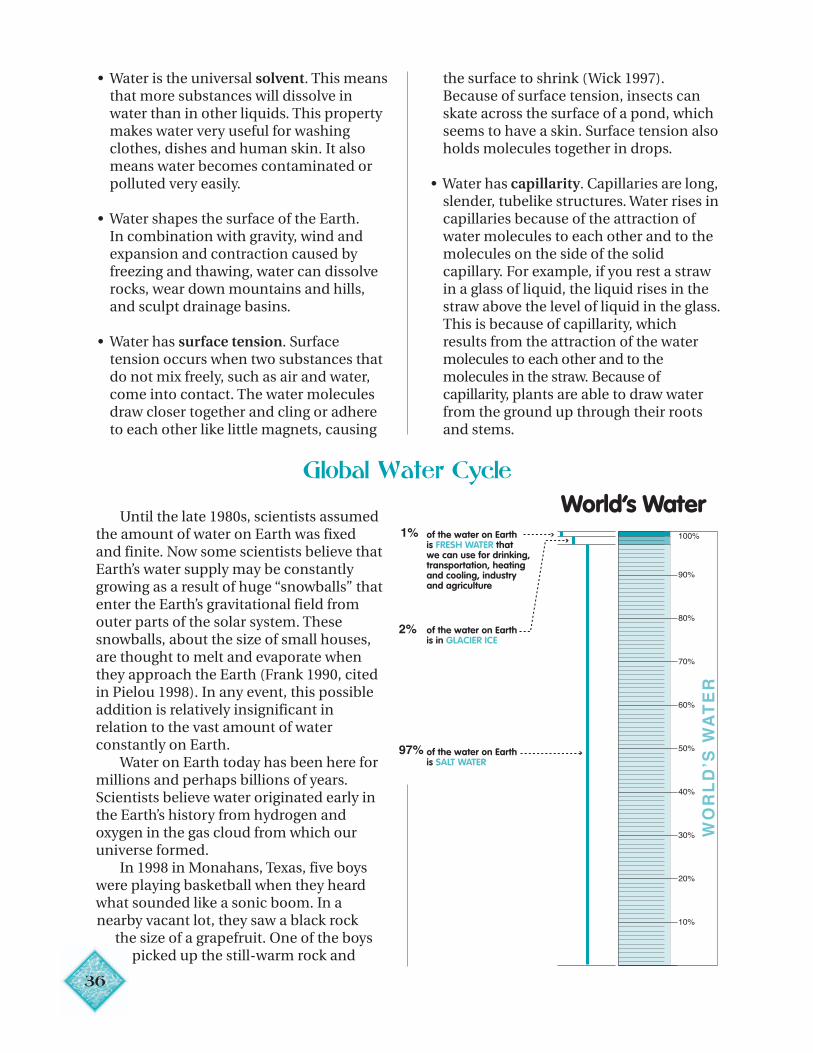
World’s Waterof the water on Earth is FRESH WATER thatwe can use for drinking, transportation, heating and cooling, industry and agriculture
of the water on Earth is in GLACIER ICE
of the water on Earth is SALT WATER
37
handed it to his father, who correctlyidentified it as a meteorite. Inside was aminute amount of liquid water, the firstever found in a meteorite. Scientistsbelieve this water dates from very early inthe solar system and may be 4.5 billionyears old. This finding supports the theorythat water is indeed very ancient. It alsosuggests that perhaps there were otherplaces in the solar system where life mayhave developed.
Nearly all of the water on Earth is saltwater. Less than 3 percent is fresh waterand most of this is locked up in glaciersand polar ice caps. Less than 1 percent ofthe world’s water is fresh water availablefor human and nature’s use.
The water on Earth is continuouslycirculating between the air or atmosphere,the land and the sea. The ways in whichwater moves around, above, on and withinthe Earth is the hydrologic or water cycle.
The sun is the energy source for thewater cycle, causing water to evaporatefrom lakes, rivers and oceans, as well asfrom land surfaces and vegetation. Whenwater evaporates, it changes to a gas(water vapor) and rises in the air. When thewater vapor rises and meets cold air, itcondenses, forming water droplets, orwhat we see as clouds or fog. This processis called condensation. Water dropletscombine into water drops and return tothe Earth as precipitation in the form ofrain, sleet, hail or snow.
Exactly how clouds produce rain haseluded meteorologists until recently. In1999, Dutch scientists using asupercomputer to model cloud behaviorannounced that rain is produced whenwhirling masses of water, a fewcentimeters in diameter, force waterdroplets outward by centrifugal force.These droplets then collide and grow. Tofall to the ground as precipitation, theyneed to reach a diameter greater than 20micrometers (Environmental NewsNetwork online, November 16, 1999).
Some rain is absorbed by vegetation orevaporates before it reaches the ground.Some evaporates after it reaches thesurface. Some soaks into the ground and istaken up by the roots of plants and thenreleased back into the air through theleaves of the plants in a process calledtranspiration. The combination ofevaporation and transpiration is referredto as evapotranspiration. Some rain soaksbeneath the water table into undergroundunits of water-bearing rock called aquifers.The remainder becomes surface orstormwater runoff that flows over theground to wetlands, lakes, ponds, riversand oceans.
A water molecule’s trip from theatmosphere and back may be very long orvery short. It may stay in the atmospherefor only a few days or it may remain deeplyburied in cavities in the earth or frozen inpolar ice caps for thousands of years.
Water Cycle in Florida
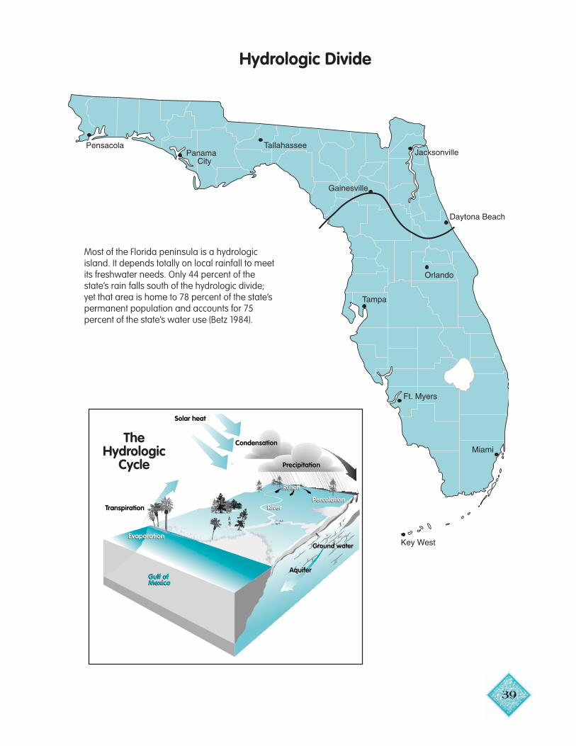
No significant amount of water entersor leaves the global water cycle. The watercycle in Florida, however, is an opensystem. Florida’s water cycle includes theflow of surface water and ground waterfrom Georgia and Alabama into northernand northwestern Florida, as well asoutflows to the Atlantic Ocean and theGulf of Mexico. Hydrologist Garald Parkerwas the first to discover that neithersurface water nor ground water crosses a
line snaking across the peninsula fromCedar Key on the Gulf to New SmyrnaBeach on the Atlantic (Betz 1984). This lineis known as the hydrologic divide. Southof the hydrologic divide, Florida is anisland as far as fresh water is concerned: ittotally depends on rainfall for its freshwater, including ground water stored inaquifers. North of the hydrologic divide,Florida receives water from outside thestate.
38
Florida's Water Cycle
Surface water and groundwater outflow to Gulf of Mexico and Atlantic Ocean
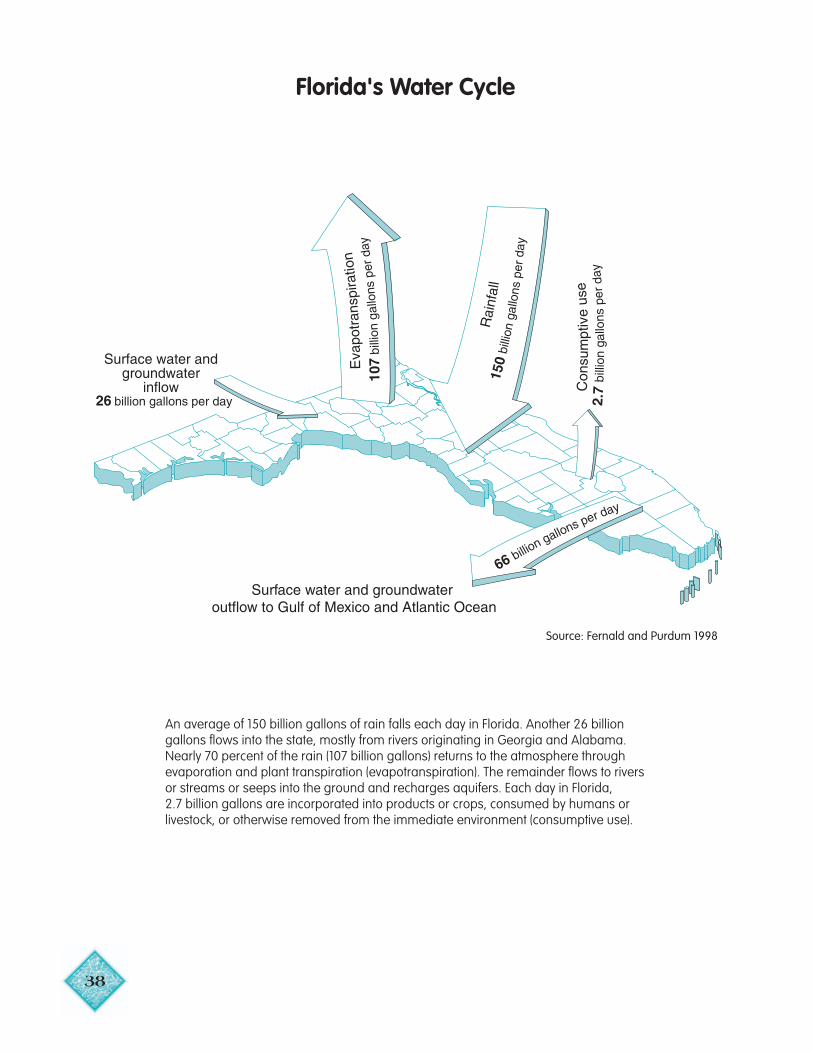
An average of 150 billion gallons of rain falls each day in Florida. Another 26 billiongallons flows into the state, mostly from rivers originating in Georgia and Alabama.Nearly 70 percent of the rain (107 billion gallons) returns to the atmosphere throughevaporation and plant transpiration (evapotranspiration). The remainder flows to riversor streams or seeps into the ground and recharges aquifers. Each day in Florida,2.7 billion gallons are incorporated into products or crops, consumed by humans orlivestock, or otherwise removed from the immediate environment (consumptive use).
Source: Fernald and Purdum 1998
39
Most of the Florida peninsula is a hydrologicisland. It depends totally on local rainfall to meetits freshwater needs. Only 44 percent of thestate’s rain falls south of the hydrologic divide;yet that area is home to 78 percent of the state’spermanent population and accounts for 75percent of the state’s water use (Betz 1984).
Hydrologic Divide
Precipitation
Ground waterGround water
Percolation
AquiferAquiferGulf ofMexicoGulf ofMexico
Condensation
Precipitation
Condensation
Solar heat
RiverTranspiration
Evaporation
Runoff
PercolationRiver
Evaporation
Runoff
TheHydrologic
Cycle
4
Weather and Climate
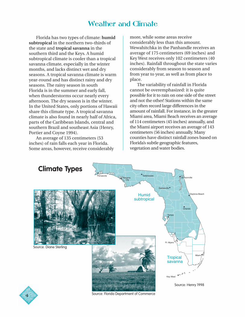
Florida has two types of climate: humidsubtropical in the northern two-thirds ofthe state and tropical savanna in thesouthern third and the Keys. A humidsubtropical climate is cooler than a tropicalsavanna climate, especially in the wintermonths, and lacks distinct wet and dryseasons. A tropical savanna climate is warmyear-round and has distinct rainy and dryseasons. The rainy season in southFlorida is in the summer and early fall,when thunderstorms occur nearly everyafternoon. The dry season is in the winter.In the United States, only portions of Hawaiishare this climate type. A tropical savannaclimate is also found in nearly half of Africa,parts of the Caribbean Islands, central andsouthern Brazil and southeast Asia (Henry,Portier and Coyne 1994).
An average of 135 centimeters (53inches) of rain falls each year in Florida.Some areas, however, receive considerably
more, while some areas receiveconsiderably less than this amount.Wewahitchka in the Panhandle receives anaverage of 175 centimeters (69 inches) andKey West receives only 102 centimeters (40inches). Rainfall throughout the state variesconsiderably from season to season andfrom year to year, as well as from place toplace.
The variability of rainfall in Floridacannot be overemphasized: it is quitepossible for it to rain on one side of the streetand not the other! Stations within the samecity often record large differences in theamount of rainfall. For instance, in the greaterMiami area, Miami Beach receives an averageof 114 centimeters (45 inches) annually, andthe Miami airport receives an average of 143centimeters (56 inches) annually. Manycounties have distinct rainfall zones based onFlorida’s subtle geographic features,vegetation and water bodies.
Climate Types
Source: Henry 1998
Source: Diane Sterling
Source: Florida Department of Commerce
Average Annual Rainfall
Inches Centimeters44 11248 12252 13256 14260 15264 163
1961–1990
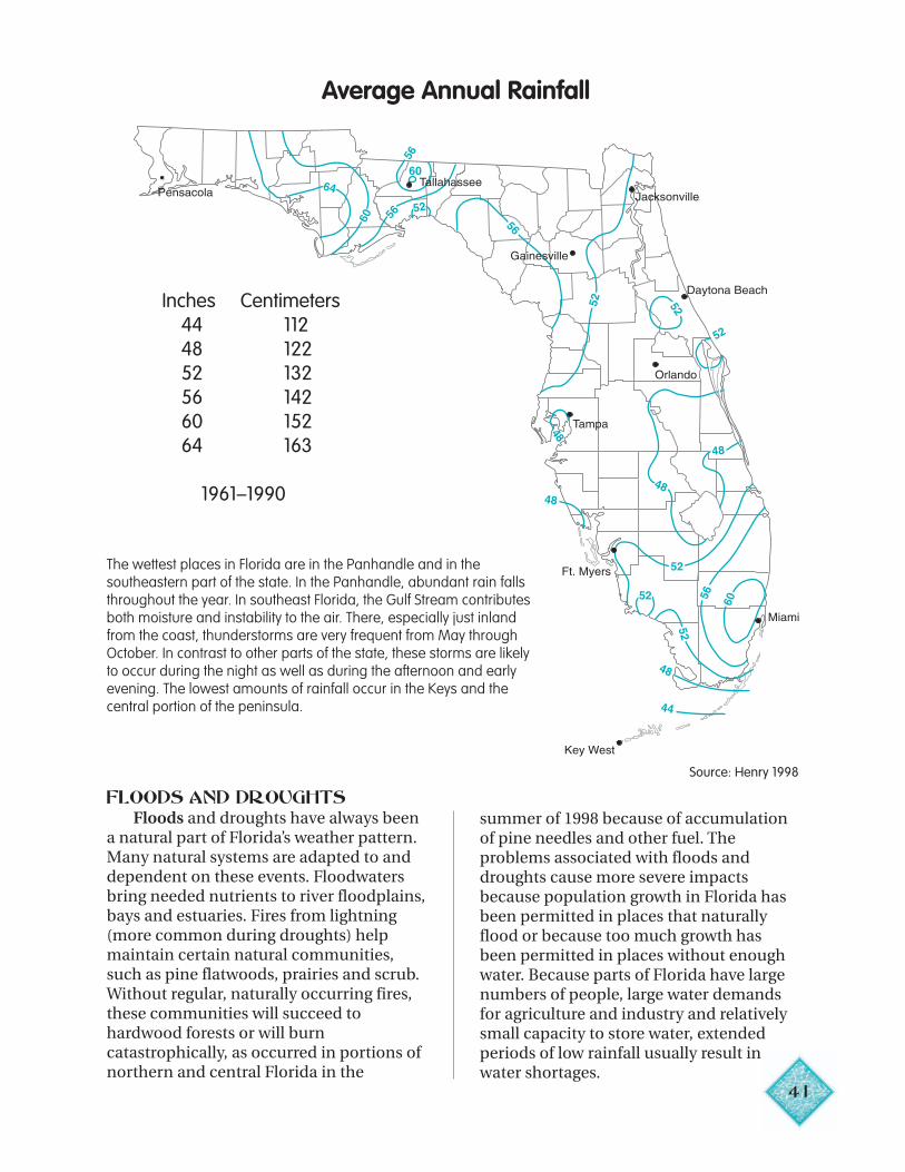
The wettest places in Florida are in the Panhandle and in thesoutheastern part of the state. In the Panhandle, abundant rain fallsthroughout the year. In southeast Florida, the Gulf Stream contributesboth moisture and instability to the air. There, especially just inlandfrom the coast, thunderstorms are very frequent from May throughOctober. In contrast to other parts of the state, these storms are likelyto occur during the night as well as during the afternoon and earlyevening. The lowest amounts of rainfall occur in the Keys and thecentral portion of the peninsula.
FLOODS AND DROUGHTSFloods and droughts have always been
a natural part of Florida’s weather pattern.Many natural systems are adapted to anddependent on these events. Floodwatersbring needed nutrients to river floodplains,bays and estuaries. Fires from lightning(more common during droughts) helpmaintain certain natural communities,such as pine flatwoods, prairies and scrub.Without regular, naturally occurring fires,these communities will succeed tohardwood forests or will burncatastrophically, as occurred in portions ofnorthern and central Florida in the
Source: Henry 1998
summer of 1998 because of accumulationof pine needles and other fuel. Theproblems associated with floods anddroughts cause more severe impactsbecause population growth in Florida hasbeen permitted in places that naturallyflood or because too much growth hasbeen permitted in places without enoughwater. Because parts of Florida have largenumbers of people, large water demandsfor agriculture and industry and relativelysmall capacity to store water, extendedperiods of low rainfall usually result inwater shortages.
41

Statewide Annual Rainfall= Average
Florida’s average rainfall varies greatly from year to year. However, averages in a state as large andas diverse as Florida may be misleading. In a year with “average” rainfall, one part of the state mayhave been very dry and another part may have been very wet!
In the Sunshine State, when it rains, itusually pours, and floods may result.Floods generally occur in winter and earlyspring in northern Florida from heavy rainaccompanying cold fronts. In summer andfall, all of Florida is susceptible to floodingfrom thunderstorms and hurricanes.Human activities can create environmentsprone to flooding. Practices that removesoil and vegetation can increase an area’svulnerability to flooding. In northernFlorida, flooding usually occurs alongrivers. In southern Florida, flooding mayoccur in any low-lying area. Dikes, canalsand other stormwater systems have beenbuilt in south and southwest Florida tohelp prevent flooding in developed areas.
Although Florida is one of the wetteststates in the nation, it is still sometimesaffected by droughts (extended periods oflow rainfall). Moderate droughts occurfrequently, and severe droughts occur insome part of the state about every sixyears. In the 1980s, a series of droughtsoccurred in the state. In 1988–89, rainfall inKey West was less than one-fifth thenormal amount and in southwest Florida,
groundwater levels were at a record low,causing many sinkholes to form. In
June and July of 1998, extremely dry42
conditions in northern and centralFlorida resulted in more than 2,300wildfires that consumed 200,000 hectares(500,000 acres), destroyed 368 houses andforced the evacuation of 130,000 people.
Rainfall deficits have continued since1998 until the present (May 2001)throughout the state. These deficits wouldstatistically be expected to occur onlyonce every 100 to 200 years. The flow ofthe Apalachicola River and the depth ofLake Okeechobee have dropped to all-time lows. The St. Johns River WaterManagement District has experiencedvast fluctuations in rainfall levels fromone end of the district to the other.Calendar year 2000 was the driest onrecord (since 1915) in the SouthwestFlorida Water Management District. Insome parts of the Southwest Florida WaterManagement District, drought conditionshave increased the potential for sinkholedevelopment, water quality problems anddrying up of private wells.
During droughts, when the level offresh water in the ground is lowered, saltwater may move into freshwater portionsof aquifers in a process known assaltwater intrusion. Because droughtsreduce recharge, they can have a major
Source: Henry 1998
impact on our underground water supply.Since salt water is heavier than fresh water,it occupies the lower portions of theaquifer. If the freshwater level is lowered bypumping and not replaced by recharge, saltwater can flow in or rise up andcontaminate underground freshwatersupplies.
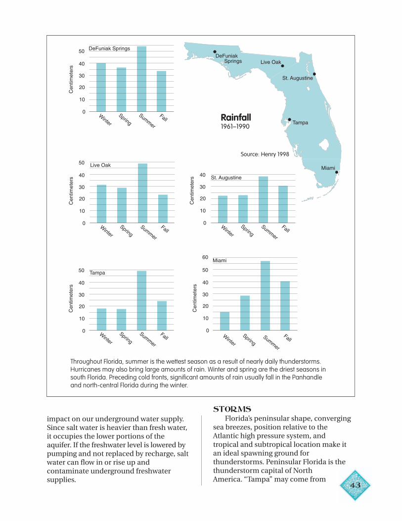
Throughout Florida, summer is the wettest season as a result of nearly daily thunderstorms.Hurricanes may also bring large amounts of rain. Winter and spring are the driest seasons insouth Florida. Preceding cold fronts, significant amounts of rain usually fall in the Panhandleand north-central Florida during the winter.
STORMSFlorida’s peninsular shape, converging
sea breezes, position relative to theAtlantic high pressure system, andtropical and subtropical location make itan ideal spawning ground forthunderstorms. Peninsular Florida is thethunderstorm capital of NorthAmerica. “Tampa” may come from
43
Rainfall1961–1990
Source: Henry 1998
Monthly Water Budgets
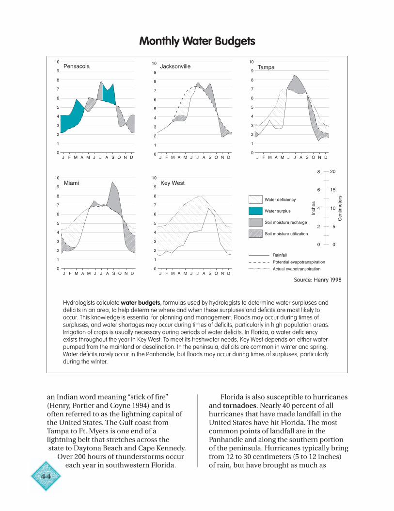
Hydrologists calculate water budgets, formulas used by hydrologists to determine water surpluses anddeficits in an area, to help determine where and when these surpluses and deficits are most likely tooccur. This knowledge is essential for planning and management. Floods may occur during times ofsurpluses, and water shortages may occur during times of deficits, particularly in high population areas.Irrigation of crops is usually necessary during periods of water deficits. In Florida, a water deficiencyexists throughout the year in Key West. To meet its freshwater needs, Key West depends on either waterpumped from the mainland or desalination. In the peninsula, deficits are common in winter and spring.Water deficits rarely occur in the Panhandle, but floods may occur during times of surpluses, particularlyduring the winter.
an Indian word meaning “stick of fire”(Henry, Portier and Coyne 1994) and isoften referred to as the lightning capital ofthe United States. The Gulf coast fromTampa to Ft. Myers is one end of alightning belt that stretches across thestate to Daytona Beach and Cape Kennedy.
Over 200 hours of thunderstorms occureach year in southwestern Florida.
44
Cen
timet
ers
Florida is also susceptible to hurricanesand tornadoes. Nearly 40 percent of allhurricanes that have made landfall in theUnited States have hit Florida. The mostcommon points of landfall are in thePanhandle and along the southern portionof the peninsula. Hurricanes typically bringfrom 12 to 30 centimeters (5 to 12 inches)of rain, but have brought as much as
Source: Henry 1998
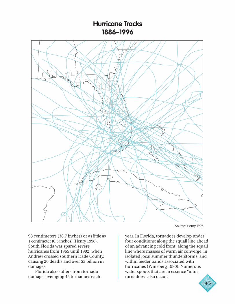
45
Hurricane Tracks1886–1996
Source: Henry 1998
98 centimeters (38.7 inches) or as little as1 centimeter (0.5 inches) (Henry 1998).South Florida was spared severehurricanes from 1965 until 1992, whenAndrew crossed southern Dade County,causing 26 deaths and over $3 billion indamages.
Florida also suffers from tornadodamage, averaging 45 tornadoes each
year. In Florida, tornadoes develop underfour conditions: along the squall line aheadof an advancing cold front, along the squallline where masses of warm air converge, inisolated local summer thunderstorms, andwithin feeder bands associated withhurricanes (Winsberg 1990). Numerouswater spouts that are in essence “mini-tornadoes” also occur.
4
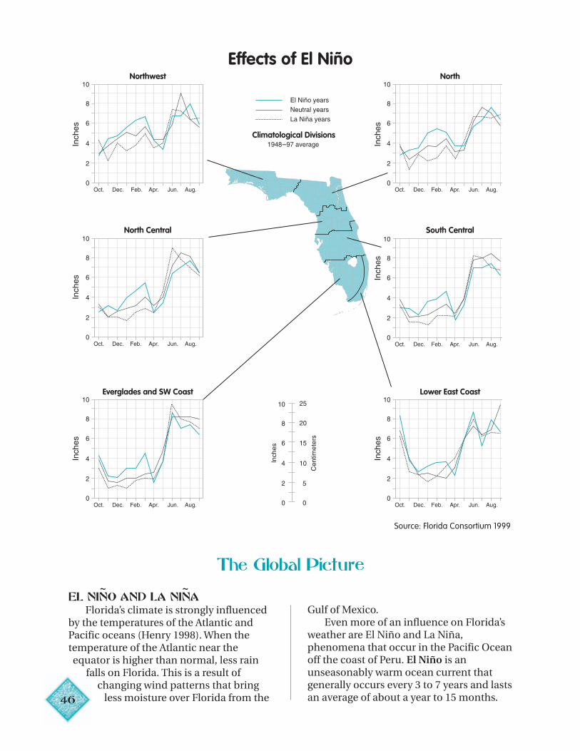
Climatological Divisions
Northwest North
North Central South Central
Everglades and SW Coast Lower East Coast
–
~ ~
The Global Picture
EL NIÑÑNO AND LA NINAFlorida’s climate is strongly influenced
by the temperatures of the Atlantic andPacific oceans (Henry 1998). When thetemperature of the Atlantic near theequator is higher than normal, less rain
falls on Florida. This is a result ofchanging wind patterns that bring
6 less moisture over Florida from the
Gulf of Mexico.Even more of an influence on Florida’s
weather are El Niño and La Niña,phenomena that occur in the Pacific Oceanoff the coast of Peru. El Niño is anunseasonably warm ocean current thatgenerally occurs every 3 to 7 years and lastsan average of about a year to 15 months.
Effects of El Niño
Source: Florida Consortium 1999
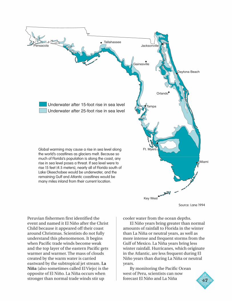
Underwater after 15-foot rise in sea level
Underwater after 25-foot rise in sea level
Global warming may cause a rise in sea level alongthe world’s coastlines as glaciers melt. Because somuch of Florida’s population is along the coast, anyrise in sea level poses a threat. If sea level were torise 15 feet (4.5 meters), nearly all of Florida south ofLake Okeechobee would be underwater, and theremaining Gulf and Atlantic coastlines would bemany miles inland from their current location.
Peruvian fishermen first identified theevent and named it El Niño after the ChristChild because it appeared off their coastaround Christmas. Scientists do not fullyunderstand this phenomenon. It beginswhen Pacific trade winds become weakand the top layer of the eastern Pacific getswarmer and warmer. The mass of cloudscreated by the warm water is carriedeastward by the subtropical jet stream. LaNiña (also sometimes called El Viejo) is theopposite of El Niño. La Niña occurs whenstronger than normal trade winds stir up
cooler water from the ocean depths.El Niño years bring greater than normal
amounts of rainfall to Florida in the winterthan La Niña or neutral years, as well asmore intense and frequent storms from theGulf of Mexico. La Niña years bring lesswinter rainfall. Hurricanes, which originatein the Atlantic, are less frequent during ElNiño years than during La Niña or neutralyears.
By monitoring the Pacific Oceanwest of Peru, scientists can nowforecast El Niño and La Niña 47
Source: Lane 1994
48
(Florida Consortium 1999). This knowledgeis critical to agriculture, forestry andemergency management. Wintervegetables and fruits are a big industry inFlorida. Growers now know whether theyare likely to face a wet or a dry growingseason. Strawberry growers, for example,have learned to plant drought-tolerantvarieties during La Niña years (FloridaConsortium 1999). Dry La Niña wintersmay mean greater risk of forest fires in thenormally dry spring. During El Niño years,although winters are wetter than normal,springs tend to be drier than normal inmany parts of the state. These conditionsmay result in fires in early summer, asoccurred in June 1998. Knowledge of LaNiña helps emergency managers plan inadvance for a hurricane season that willprobably be more active than normal.
GLOBAL WARMINGIn January 2001, over 700 scientists from
more than 100 countries met in Shanghai,China, to discuss world climate change.They reviewed the data and agreed that theaverage global surface temperature hasrisen by 0.6 degrees centigrade over thetwentieth century, and the sea level hasrisen between 0.1 and 0.2 meters. Theypredict temperatures will rise between 1.0and 3.5 degrees centigrade over the comingcentury, causing more frequent floods and
droughts, rising oceans and expansion oftemperate climates northward. The groupconcluded that most of the warmingobserved over the last 50 years isattributable to human activities,specifically burning of fossil fuels such ascoal and oil.
Although global warming is notaccepted by the entire scientificcommunity, some scientists predict thatglobal warming will impact several aspectsof Florida’s climate (Henry 1998). Whileglobal rainfall levels are expected toincrease, rainfall in Florida is expected todecrease as temperatures rise. According tosome researchers, reduced rainfall andfewer winter storms reaching Floridawould result from a predicted northwardshift of the jet stream. Another study,however, indicated that summer rainfallwould increase, particularly in thePanhandle. Droughts may also be moresevere if temperatures rise, because rainfallwould likely be more variable. Will thefrequency and intensity of hurricanesreaching Florida increase with globalwarming? Early studies indicated thatFlorida might experience more frequentand more intense hurricanes in a warmerworld, but more recent studies indicatethat the threat from hurricanes will notlikely increase significantly in the nearfuture (Henry 1998).
Conclusion
Water is basic to all life on Earth. “Livingthings depend on water but water does notdepend on living things. It has a life of itsown”(Pielou 1998:x). The hydrologic cyclecontinues regardless of the activities of themillions of life forms it nourishes. Rain fallsor fails to fall, rivers flow to the sea, snowfalls and lakes freeze, hurricanes form overthe warm seas, water seeps through the soilto replenish aquifers.
Today, humans have spread throughout
the globe and have the power to influencethe waters of the world on a scaleunprecedented in our history. Burning offossil fuels is contributing to globalwarming, which is predicted to bring morerain to some parts of the world and less toothers. In many places, aquifers, rivers andlakes are being depleted and polluted. Thewater now on Earth is essentially all thewater we will ever have. Yes, water is magic.It is up to us to respect and protect it.
Chapter 3
49
Florida’s Water Resources
“Florida is blessed with water. Water makesthe difference between desert and flourishinggreen plants, as much of the land around theearth at the same latitude is desert.”
— Peggy Lantz, The Florida Water Story
KEY IDEAS
• Most of Florida’s water is ground water.• No rocks. No water.• Ground water is replenished by rainfall.• Surface water in the form of rivers,
lakes, bays and wetlands is abundant.• Much of Florida has a karst terrain
with sinkholes, underground cavernsand an active interchange betweensurface water and ground water.
• Pollution on the land’s surface mayend up in drinking water.
• Wetlands perform many valuablefunctions and are protected by lawfrom development.
• Estuaries are nursery areas for manysport and commercial fish andshellfish.
VOCABULARY
Alluvial river
Aquaculture
Aquifer
Blackwater river
Brackish
Discharge
Drainage basin
Estuary
Fill
First-magnitudesprings
Karst
Recharge
Runoff
Sheetflow
Sinkhole
Spring
Spring-fed river
Streamflow
Tributary
Watershed
Wetland
Florida is, indeed, blessed with water.Yet you cannot see most of Florida’s freshwater: it seeps beneath the ground throughsand and gravel and flows through cracksand channels in underlying limestone. Theamount of ground water under Florida’sforests, pastures, cities, marshes, roads,schools and suburbs is mind-boggling:more than a quadrillion gallons. This isequivalent to about one-fifth of the waterin all five of the Great Lakes, 100 times asmuch water as in Lake Meade on theColorado River, and 30,000 times the dailyflow to the sea of Florida’s 13 major rivers(Conover 1973). In fact, Florida has moreavailable ground water in aquifers thanany other state.
Florida also has abundant surfacewater in springs, rivers, lakes, bays andwetlands. Of the 84 first-magnitudesprings (those that discharge water at arate of 100 cubic feet per second or more)in the United States, 33 are in Florida —more than in any other state. WithinFlorida’s boundaries are approximately16,000 kilometers (10,000 miles) of riversand streams and 7,800 lakes (Kautz et al.1998). Although more than half of Florida’soriginal wetlands have been drained ordeveloped (Noss and Peters 1995), the statestill has vast and diverse wetlands. TheFlorida Everglades and Big Cypress Swampcover much of southern Florida, and someFlorida wetland communities, such asmangrove swamps and hydric (wet)hammocks, rarely occur in other states.
In Florida, ground water and surfacewater are connected, often in complicatedand changing ways that are invisible at theland’s surface. Lakes may disappear intosinkholes, springs may bubble upthrough new breaks in underlying
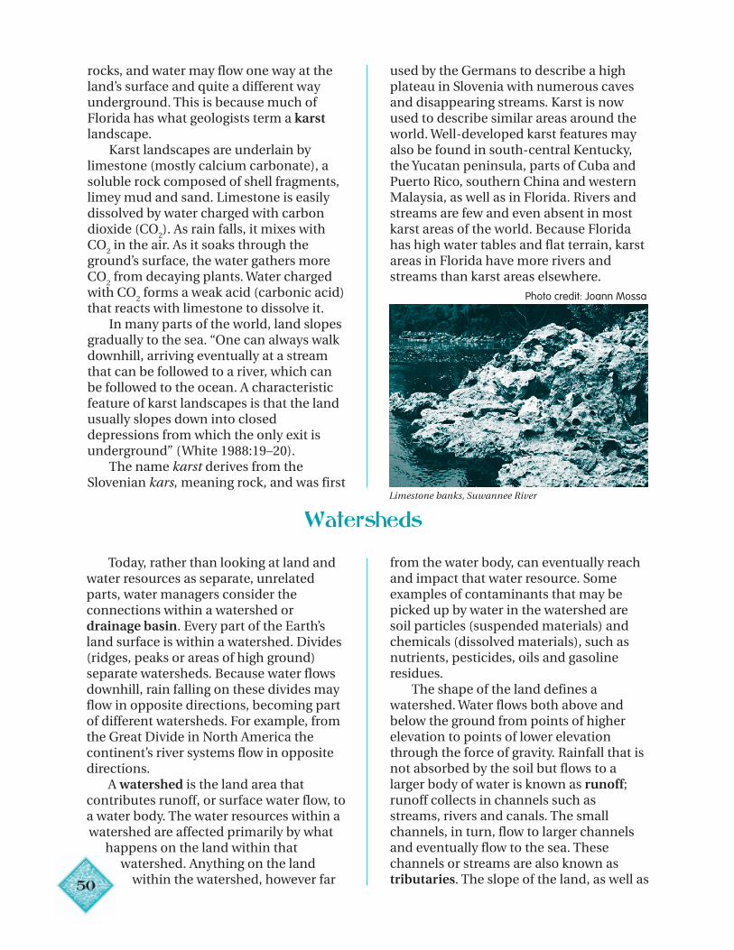
50
rocks, and water may flow one way at theland’s surface and quite a different wayunderground. This is because much ofFlorida has what geologists term a karstlandscape.
Karst landscapes are underlain bylimestone (mostly calcium carbonate), asoluble rock composed of shell fragments,limey mud and sand. Limestone is easilydissolved by water charged with carbondioxide (CO
2). As rain falls, it mixes with
CO2 in the air. As it soaks through the
ground’s surface, the water gathers moreCO
2 from decaying plants. Water charged
with CO2 forms a weak acid (carbonic acid)
that reacts with limestone to dissolve it.In many parts of the world, land slopes
gradually to the sea. “One can always walkdownhill, arriving eventually at a streamthat can be followed to a river, which canbe followed to the ocean. A characteristicfeature of karst landscapes is that the landusually slopes down into closeddepressions from which the only exit isunderground” (White 1988:19–20).
The name karst derives from theSlovenian kars, meaning rock, and was first
used by the Germans to describe a highplateau in Slovenia with numerous cavesand disappearing streams. Karst is nowused to describe similar areas around theworld. Well-developed karst features mayalso be found in south-central Kentucky,the Yucatan peninsula, parts of Cuba andPuerto Rico, southern China and westernMalaysia, as well as in Florida. Rivers andstreams are few and even absent in mostkarst areas of the world. Because Floridahas high water tables and flat terrain, karstareas in Florida have more rivers andstreams than karst areas elsewhere.
Limestone banks, Suwannee River
Watersheds
Today, rather than looking at land andwater resources as separate, unrelatedparts, water managers consider theconnections within a watershed ordrainage basin. Every part of the Earth’sland surface is within a watershed. Divides(ridges, peaks or areas of high ground)separate watersheds. Because water flowsdownhill, rain falling on these divides mayflow in opposite directions, becoming partof different watersheds. For example, fromthe Great Divide in North America thecontinent’s river systems flow in oppositedirections.
A watershed is the land area thatcontributes runoff, or surface water flow, toa water body. The water resources within awatershed are affected primarily by what
happens on the land within thatwatershed. Anything on the land
within the watershed, however far
from the water body, can eventually reachand impact that water resource. Someexamples of contaminants that may bepicked up by water in the watershed aresoil particles (suspended materials) andchemicals (dissolved materials), such asnutrients, pesticides, oils and gasolineresidues.
The shape of the land defines awatershed. Water flows both above andbelow the ground from points of higherelevation to points of lower elevationthrough the force of gravity. Rainfall that isnot absorbed by the soil but flows to alarger body of water is known as runoff;runoff collects in channels such asstreams, rivers and canals. The smallchannels, in turn, flow to larger channelsand eventually flow to the sea. Thesechannels or streams are also known astributaries. The slope of the land, as well as
Photo credit: Joann Mossa
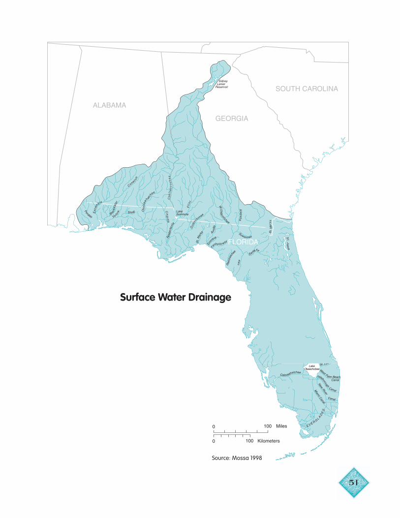
51
Surface Water Drainage
Source: Mossa 1998
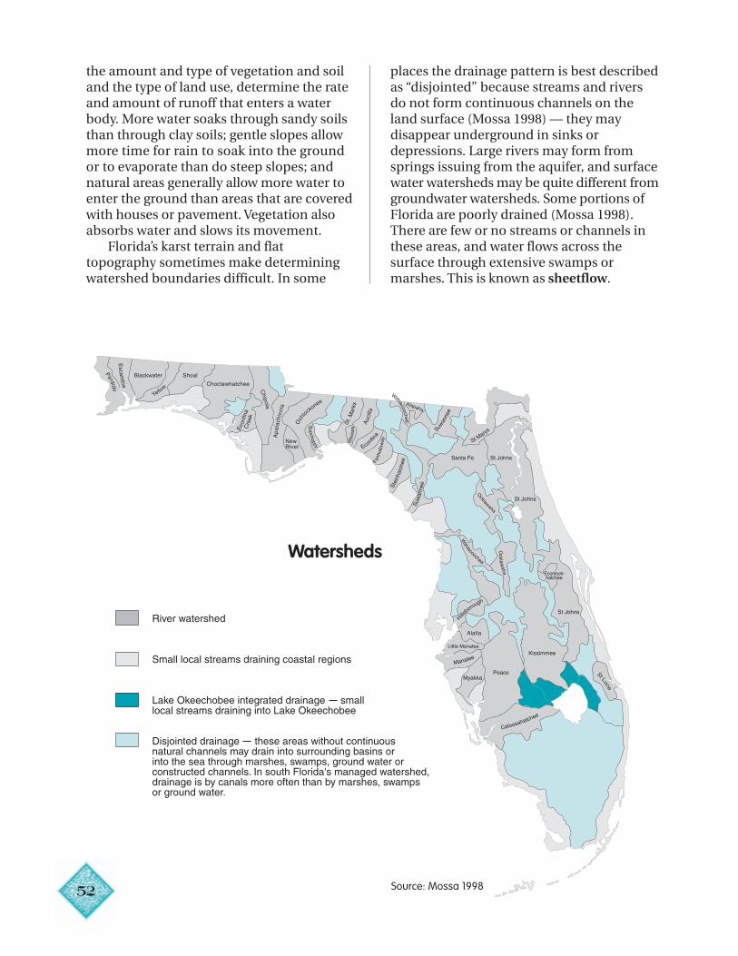
52
the amount and type of vegetation and soiland the type of land use, determine the rateand amount of runoff that enters a waterbody. More water soaks through sandy soilsthan through clay soils; gentle slopes allowmore time for rain to soak into the groundor to evaporate than do steep slopes; andnatural areas generally allow more water toenter the ground than areas that are coveredwith houses or pavement. Vegetation alsoabsorbs water and slows its movement.
Florida’s karst terrain and flattopography sometimes make determiningwatershed boundaries difficult. In some
places the drainage pattern is best describedas “disjointed” because streams and riversdo not form continuous channels on theland surface (Mossa 1998) — they maydisappear underground in sinks ordepressions. Large rivers may form fromsprings issuing from the aquifer, and surfacewater watersheds may be quite different fromgroundwater watersheds. Some portions ofFlorida are poorly drained (Mossa 1998).There are few or no streams or channels inthese areas, and water flows across thesurface through extensive swamps ormarshes. This is known as sheetflow.
Watersheds
River watershed
Small local streams draining coastal regions
Lake Okeechobee integrated drainage small local streams draining into Lake Okeechobee
Disjointed drainage these areas without continuousnatural channels may drain into surrounding basins or into the sea through marshes, swamps, ground water orconstructed channels. In south Florida's managed watershed,drainage is by canals more often than by marshes, swampsor ground water.
Source: Mossa 1998
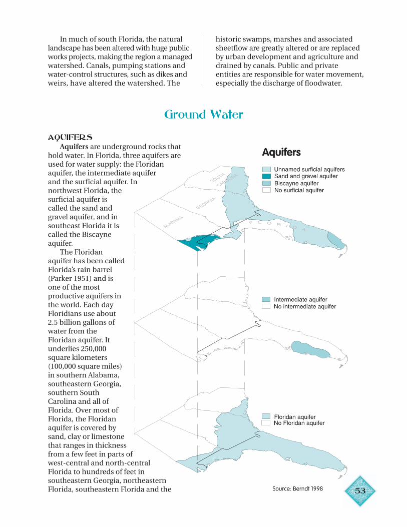
53
Aquifers
In much of south Florida, the naturallandscape has been altered with huge publicworks projects, making the region a managedwatershed. Canals, pumping stations andwater-control structures, such as dikes andweirs, have altered the watershed. The
historic swamps, marshes and associatedsheetflow are greatly altered or are replacedby urban development and agriculture anddrained by canals. Public and privateentities are responsible for water movement,especially the discharge of floodwater.
Ground Water
AQUIFERSAquifers are underground rocks that
hold water. In Florida, three aquifers areused for water supply: the Floridanaquifer, the intermediate aquiferand the surficial aquifer. Innorthwest Florida, thesurficial aquifer iscalled the sand andgravel aquifer, and insoutheast Florida it iscalled the Biscayneaquifer.
The Floridanaquifer has been calledFlorida’s rain barrel(Parker 1951) and isone of the mostproductive aquifers inthe world. Each dayFloridians use about2.5 billion gallons ofwater from theFloridan aquifer. Itunderlies 250,000square kilometers(100,000 square miles)in southern Alabama,southeastern Georgia,southern SouthCarolina and all ofFlorida. Over most ofFlorida, the Floridanaquifer is covered bysand, clay or limestonethat ranges in thicknessfrom a few feet in parts ofwest-central and north-centralFlorida to hundreds of feet insoutheastern Georgia, northeasternFlorida, southeastern Florida and the Source: Berndt 1998
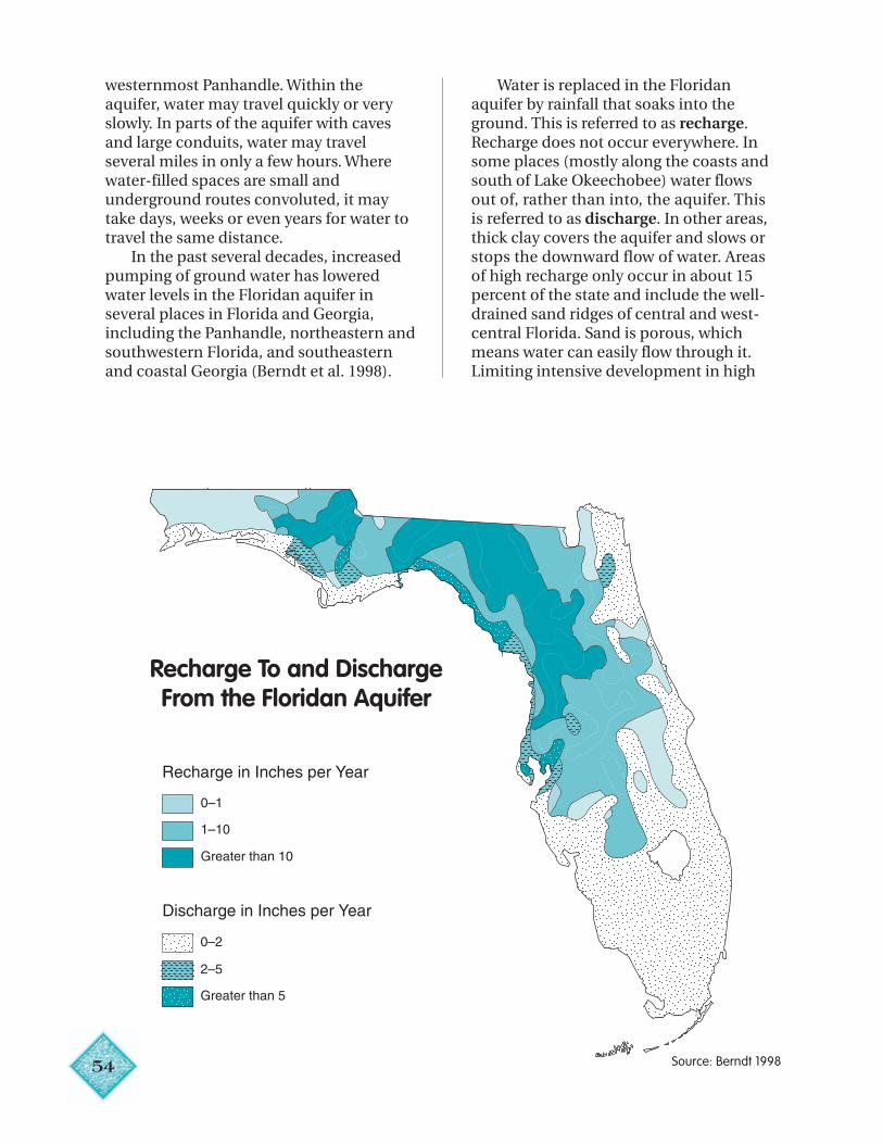
54
westernmost Panhandle. Within theaquifer, water may travel quickly or veryslowly. In parts of the aquifer with cavesand large conduits, water may travelseveral miles in only a few hours. Wherewater-filled spaces are small andunderground routes convoluted, it maytake days, weeks or even years for water totravel the same distance.
In the past several decades, increasedpumping of ground water has loweredwater levels in the Floridan aquifer inseveral places in Florida and Georgia,including the Panhandle, northeastern andsouthwestern Florida, and southeasternand coastal Georgia (Berndt et al. 1998).
Recharge To and DischargeFrom the Floridan Aquifer
Water is replaced in the Floridanaquifer by rainfall that soaks into theground. This is referred to as recharge.Recharge does not occur everywhere. Insome places (mostly along the coasts andsouth of Lake Okeechobee) water flowsout of, rather than into, the aquifer. Thisis referred to as discharge. In other areas,thick clay covers the aquifer and slows orstops the downward flow of water. Areasof high recharge only occur in about 15percent of the state and include the well-drained sand ridges of central and west-central Florida. Sand is porous, whichmeans water can easily flow through it.Limiting intensive development in high
Source: Berndt 1998
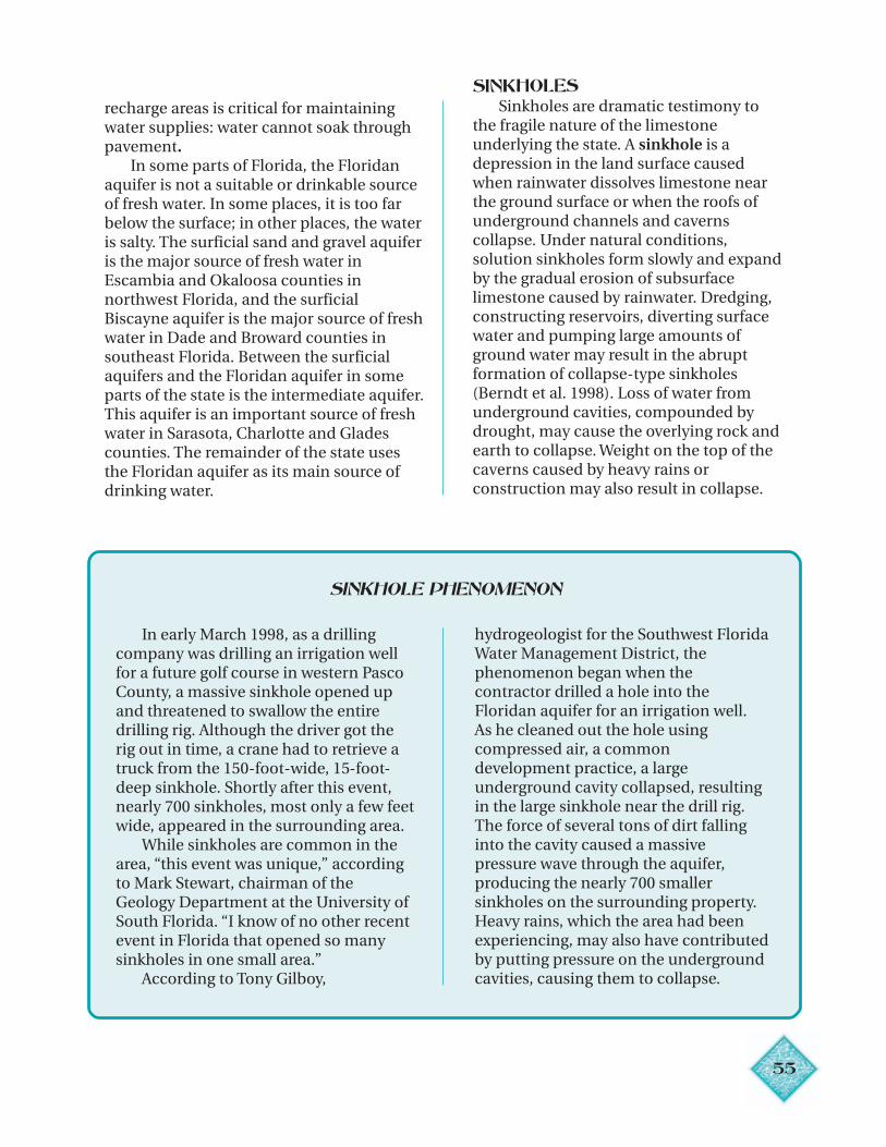
55
recharge areas is critical for maintainingwater supplies: water cannot soak throughpavement.
In some parts of Florida, the Floridanaquifer is not a suitable or drinkable sourceof fresh water. In some places, it is too farbelow the surface; in other places, the wateris salty. The surficial sand and gravel aquiferis the major source of fresh water inEscambia and Okaloosa counties innorthwest Florida, and the surficialBiscayne aquifer is the major source of freshwater in Dade and Broward counties insoutheast Florida. Between the surficialaquifers and the Floridan aquifer in someparts of the state is the intermediate aquifer.This aquifer is an important source of freshwater in Sarasota, Charlotte and Gladescounties. The remainder of the state usesthe Floridan aquifer as its main source ofdrinking water.
SINKHOLESSinkholes are dramatic testimony to
the fragile nature of the limestoneunderlying the state. A sinkhole is adepression in the land surface causedwhen rainwater dissolves limestone nearthe ground surface or when the roofs ofunderground channels and cavernscollapse. Under natural conditions,solution sinkholes form slowly and expandby the gradual erosion of subsurfacelimestone caused by rainwater. Dredging,constructing reservoirs, diverting surfacewater and pumping large amounts ofground water may result in the abruptformation of collapse-type sinkholes(Berndt et al. 1998). Loss of water fromunderground cavities, compounded bydrought, may cause the overlying rock andearth to collapse. Weight on the top of thecaverns caused by heavy rains orconstruction may also result in collapse.
SINKHOLE PHENOMENON
In early March 1998, as a drillingcompany was drilling an irrigation wellfor a future golf course in western PascoCounty, a massive sinkhole opened upand threatened to swallow the entiredrilling rig. Although the driver got therig out in time, a crane had to retrieve atruck from the 150-foot-wide, 15-foot-deep sinkhole. Shortly after this event,nearly 700 sinkholes, most only a few feetwide, appeared in the surrounding area.
While sinkholes are common in thearea, “this event was unique,” accordingto Mark Stewart, chairman of theGeology Department at the University ofSouth Florida. “I know of no other recentevent in Florida that opened so manysinkholes in one small area.”
According to Tony Gilboy,
hydrogeologist for the Southwest FloridaWater Management District, thephenomenon began when thecontractor drilled a hole into theFloridan aquifer for an irrigation well.As he cleaned out the hole usingcompressed air, a commondevelopment practice, a largeunderground cavity collapsed, resultingin the large sinkhole near the drill rig.The force of several tons of dirt fallinginto the cavity caused a massivepressure wave through the aquifer,producing the nearly 700 smallersinkholes on the surrounding property.Heavy rains, which the area had beenexperiencing, may also have contributedby putting pressure on the undergroundcavities, causing them to collapse.
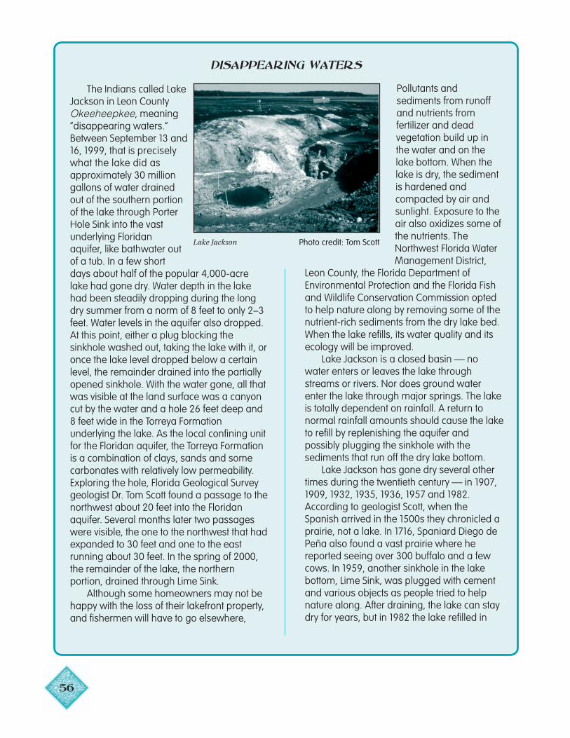
56
natural drainage can be healthy for a lake. only three months.
DISAPPEARING WATERS
The Indians called LakeJackson in Leon CountyOkeeheepkee, meaning“disappearing waters.”Between September 13 and16, 1999, that is preciselywhat the lake did asapproximately 30 milliongallons of water drainedout of the southern portionof the lake through PorterHole Sink into the vastunderlying Floridanaquifer, like bathwater outof a tub. In a few shortdays about half of the popular 4,000-acrelake had gone dry. Water depth in the lakehad been steadily dropping during the longdry summer from a norm of 8 feet to only 2–3feet. Water levels in the aquifer also dropped.At this point, either a plug blocking thesinkhole washed out, taking the lake with it, oronce the lake level dropped below a certainlevel, the remainder drained into the partiallyopened sinkhole. With the water gone, all thatwas visible at the land surface was a canyoncut by the water and a hole 26 feet deep and8 feet wide in the Torreya Formationunderlying the lake. As the local confining unitfor the Floridan aquifer, the Torreya Formationis a combination of clays, sands and somecarbonates with relatively low permeability.Exploring the hole, Florida Geological Surveygeologist Dr. Tom Scott found a passage to thenorthwest about 20 feet into the Floridanaquifer. Several months later two passageswere visible, the one to the northwest that hadexpanded to 30 feet and one to the eastrunning about 30 feet. In the spring of 2000,the remainder of the lake, the northernportion, drained through Lime Sink.
Although some homeowners may not behappy with the loss of their lakefront property,and fishermen will have to go elsewhere,
Pollutants andsediments from runoffand nutrients fromfertilizer and deadvegetation build up inthe water and on thelake bottom. When thelake is dry, the sedimentis hardened andcompacted by air andsunlight. Exposure to theair also oxidizes some ofthe nutrients. TheNorthwest Florida WaterManagement District,
Leon County, the Florida Department ofEnvironmental Protection and the Florida Fishand Wildlife Conservation Commission optedto help nature along by removing some of thenutrient-rich sediments from the dry lake bed.When the lake refills, its water quality and itsecology will be improved.
Lake Jackson is a closed basin — nowater enters or leaves the lake throughstreams or rivers. Nor does ground waterenter the lake through major springs. The lakeis totally dependent on rainfall. A return tonormal rainfall amounts should cause the laketo refill by replenishing the aquifer andpossibly plugging the sinkhole with thesediments that run off the dry lake bottom.
Lake Jackson has gone dry several othertimes during the twentieth century — in 1907,1909, 1932, 1935, 1936, 1957 and 1982.According to geologist Scott, when theSpanish arrived in the 1500s they chronicled aprairie, not a lake. In 1716, Spaniard Diego dePeña also found a vast prairie where hereported seeing over 300 buffalo and a fewcows. In 1959, another sinkhole in the lakebottom, Lime Sink, was plugged with cementand various objects as people tried to helpnature along. After draining, the lake can staydry for years, but in 1982 the lake refilled in
Lake Jackson Photo credit: Tom Scott
57
SPRINGSSprings are a “window” into the aquifer
from which they flow. Cool in the summerand warm in the winter, they are among themost sought-after of all the state’s naturaland scenic resources. Most of Florida’ssprings are found in the northern half ofthe state and flow from the Floridanaquifer. As rainwater enters and rechargesthe aquifer, pressure is exerted on the wateralready in the aquifer. This pressure causesthe water to move through cracks andtunnels in the aquifer. Sometimes thiswater flows out naturally to the landsurface at places called springs. When theopenings are large, spring flow maybecome the source of rivers. TheIchetucknee is an example of a river createdby a spring. Springs also make substantialcontributions to the flow of other rivers.Manatee, Fanning, Troy and Blue springscontribute nearly 368 million gallons eachday to the Suwannee River.
For thousands of years, NativeAmericans settled near springs and fishedin spring-fed streams. Spanish explorerPonce de Leon came to Florida seeking aFountain of Youth, as well as gold and othertreasures. Travelling in Florida in 1774,botanist William Bartram described waterissuing from one of the springs along theSt. Johns River as “perfectly diaphanous,”with fish appearing “as plain as lying on atable before your eyes, although many feetdeep in water” (Van Doren 1955:135).Today, springs are popular with both
tourists and residents. Many of Florida’slargest springs have been incorporated intostate parks, including Manatee, Homosassa,Silver, Wakulla and Ichetucknee. Wakulla andSilver springs have been popular locationsfor movies. Majorie Kinnan Rawlings’ TheYearling, as well as more than 100 episodesof the popular TV series Sea Hunt, werefilmed at Silver Springs. The Creature fromthe Black Lagoon and some of the Tarzanmovies were shot at Wakulla Springs.
Rain falling onto nearby recharge areasand entering the aquifer is the source ofmost of Florida’s ground water, includingwater that flows from springs. Contrary topopular belief, underground rivers do notcarry water into Florida from other states(Spechler and Schiffer 1995). Caverns in theaquifer are sometimes large andinterconnected and may transmit waterunderground for several miles, but there areno underground rivers. The 320 knownsprings in the state discharge nearly8 billion gallons of water each day, morethan all the fresh water used in the stateeach day (Spechler and Schiffer 1995).
Large withdrawals of water from wellsnear a spring can cause the flow of thespring to stop. Silt or sediments building upin the spring can also cause loss of flow. Theonly large spring in Florida known to haveceased flowing is Kissengen Spring, about4 miles southeast of Bartow (Berndt et al.1998). The spring stopped flowing in 1950(Rosenau et al. 1976).
Surface Water
RIVERSFlorida’s largest rivers are in the
northern part of the state. Portions of thewatersheds of many of these rivers are inGeorgia and Alabama. Even the largestrivers in Florida — the Apalachicola, theSuwannee and the St. Johns — have only afraction of the flow of the continent’s andthe world’s largest rivers.
In the Panhandle, rivers flow south tothe gulf; along the west coast, rivers flowwest to the gulf. In the central portion of
the peninsula, streamflow is south. In thelower southeastern portions of thepeninsula, rivers flow east to the Atlantic.In the northeastern and east-centralportions of the peninsula, the St. JohnsRiver flows north to the Atlantic and otherrivers flow east to the Atlantic. The onlymajor river that does not flow to the gulf orto the Atlantic is the Kissimmee River,which flows south and discharges toLake Okeechobee (Nordlie 1990).
5
Florida’s rivers may be classified aspredominantly alluvial, blackwater orspring-fed. Alluvial rivers, such as the greatMississippi, have large, well-defineddrainage basins, carry high sediment loads
and have large forested floodplains.These rivers typically flood each year
(usually in the winter in Florida),8
depositing a rich load of sediment. All ofFlorida’s alluvial rivers are in the Panhandle.The Apalachicola, Choctawhatchee,Escambia and Ochlockonee are examples.
Blackwater rivers have dark, stainedwaters from decomposing plant materials.Typically they drain pine flatwoods andcypress swamps. Many of Florida’s rivers are
WHAT IS STREAMFLOW?
Streamflow, also known as discharge, isthe volume of water passing a point in acertain amount of time. The slope of thewatershed surrounding the stream or river, thepermeability and water storage capacity of thesurrounding soils, and the rainfall pattern allaffect streamflow. Current or velocity measuresthe distance traveled by the water during acertain length of time. Velocity depends on thedepth of the stream or river, the slope andfriction due to the texture of the bottom and theshape of the river or stream channel. Velocity ishighest just under the water’s surface becausethe friction between water and air is slight.Faster currents are found at the outside of abend. The stream’s force erodes the outeredges. Slower water is found on the inside of aturn and is often where soils will be deposited,forming sandbars.
Bottom type is closely related to the velocityof streamflow. Fast water has more energyand scours or carries away all but the largestparticles of soil, sand or rock. So the bottoms offast-flowing rivers and streams are rock,rubble and gravel. These are generally foundin the upper stretches of a river system. Slowerwater allows fine particles (sand, silt and clay)to be deposited, resulting in sandy or muckybottoms.
In the United States, river discharge is mostcommonly measured in cubic feet per second.In her book Fresh Water , British Columbiannaturalist E. C. Pielou outlines a method formeasuring flow in a small stream. (Be sure toselect a stream that is safe to wade.)
Materials: rope marked at equal intervals,measuring stick, stop watch, oranges
1. Select a straight area in a stream and stretcha rope across it. The rope should have marks atequal intervals. Four or five intervals should besufficient. Secure the rope across the stream.One way to do so is to tie it around trees.
2. Wade in and measure the depth of the waterbelow each of the interval marks. Calculate thearea of the cross section by averaging thedepth and multiplying by the width of thestream. OR, measure depth in three placesacross the stream in a straight line, then dividethe total by four to get the average depth of thestream. The reason you take three depthmeasurements and divide by four is to take intoaccount the shallow areas of the stream.
3. Select a length of stream to measure thevelocity and mark each end with an object suchas a rock. A distance two or three times thewidth of the stream is usually enough.
4. Measure the velocity by putting a float in thestream and using a stopwatch to measure theamount of time it takes for the float to travel fromthe upstream marker to the downstream marker.An orange or an orange peel may be used as afloat. Repeat until you have recorded velocitiesbelow each marked interval on the rope.Average the velocities and multiply by 0.85 (thisnumber corrects for the fact that velocity has onlybeen measured at the surface).
5. Calculate streamflow by multiplying thecorrected average velocity by the area of thecross section.
Professional hydrologists use specialinstruments called current meters to measurestreamflow.
59
blackwater types, including New River innorthwest Florida, which drains Tates HellSwamp, and the Withlacoochee,Hillsborough and Peace rivers in centralFlorida, which begin in the Green Swamp(Clewell 1991).
Spring-fed rivers are most common inthe karst regions of north-central Floridawhere limestone is close to the groundsurface. Spring water is cool year-round,and clear. The Wakulla, Silver,Weekiwachee, Rainbow and Crystal riversare spring runs issuing from five ofFlorida’s 33 first-magnitude springs. TheChipola, St. Marks, Aucilla, Santa Fe,Ocklawaha and Homosassa are alsospring-fed rivers (Clewell 1991).
Many Florida rivers are a mixture ofthese types. For example, the Suwanneebegins as a blackwater river draining theOkefenokee Swamp. As it travels south, itbecomes a spring-fed river, as manysprings contribute to its flow. As itapproaches the gulf, it has a low-forestedfloodplain characteristic of alluvial rivers(Kautz et al. 1998).
LAKESFlorida has thousands of lakes, large
and small. By far the largest (1,890 squarekilometers or 730 square miles) is LakeOkeechobee, which extends into Glades,Hendry, Martin, Okeechobee and PalmBeach counties. Lake Okeechobee, thesecond largest lake wholly within theUnited States, has an average depth of 2.6meters (8.6 feet) (VanArman et al. 1998).Most of Florida’s other lakes are alsoshallow (between 2 and 9 meters, or 6.5and 29.5 feet, deep), although a fewsinkhole lakes are hundreds of feet deep(Heath and Conover 1981). Over one-thirdof the lakes in Florida are found in fourcentral Florida counties (Osceola, Orange,Lake and Polk).
Most of Florida’s lakes were formed inthe same manner as sinkholes. Groundwater dissolved limestone, formingunderground cavities; the roof of thesecavities collapsed, forming a depression,which then filled with ground water andrainwater. Other lakes were once
depressions in the sea bottom, and stillothers were carved out by rivers.
According to Thomas Scott, manytheories exist for the origin of LakeOkeechobee, including meteorite impact,compaction of underlying rock depositsand faulting along the northern part of anancient lagoon (pers. com). Dr. Scott, ageologist with the Florida GeologicalSurvey, thinks the lake developed from alarge lagoon that existed at the northernend of the Everglades.
In addition to natural lakes, Floridaabounds in constructed lakes and pondscreated by digging into the shallow watertable for fill (sand and rock), for irrigation,mining or aquaculture (commerciallygrowing fish or other water species). Lakesand ponds are also designed and created tomanage stormwater runoff from developedareas or to serve as reservoirs.
WETLANDSWetlands is a general term for portions
of land periodically covered by fresh wateror salt water. Over the past 400 yearsnumerous words have been used todescribe these areas including swamp,tidal swamp, coastal swamp, marsh, tidalmarsh, salt marsh, salt meadow, bog, fen,morass, overflowed land and quagmire(Moss 1980). Terminology has changed aspeople’s perceptions of the value of theselands have changed. The term wetlandsbegan to appear in the 1950s, along with aconcern for the preservation of these landsas wildlife habitat (Moss 1980). In 1953, theU.S. Fish and Wildlife Service definedwetlands as “lowlands covered withshallow and sometimes temporary orintermittent waters….and holding waterlong enough to grow moist-soil plants”(quoted in Moss 1980:200). The wetlandsdefinition found in Florida law today(Chapter 373.019, FS) is based onvegetation and soil, as well as on thehydrologic conditions. Topography is nolonger considered part of the definition.Some wetlands actually have higherelevation than surrounding land.
Wetlands are often classified asswamps or marshes, depending on
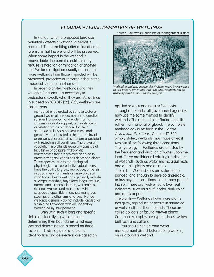
60
In Florida, when a proposed land usepotentially affects a wetland, a permit isrequired. The permitting criteria first attemptto ensure that the wetland will be preserved.When some impact to the wetland isunavoidable, the permit conditions mayrequire restoration or mitigation at anothersite. Wetland mitigation usually means thatmore wetlands than those impacted will bepreserved, protected or restored either at theimpacted site or at another site.
In order to protect wetlands and theirvaluable functions, it is necessary tounderstand exactly what they are. As definedin subsection 373.019 (22), F.S., wetlands arethose areas
inundated or saturated by surface water orground water at a frequency and a durationsufficient to support, and under normalcircumstances do support, a prevalence ofvegetation typically adapted for life insaturated soils. Soils present in wetlandsgenerally are classified as hydric or alluvial,or possess characteristics that are associatedwith reducing soil conditions. The prevalentvegetation in wetlands generally consists offacultative or obligate hydrophyticmacrophytes that are typically adapted toareas having soil conditions described above.These species, due to morphological,physiological, or reproductive adaptations,have the ability to grow, reproduce, or persistin aquatic environments or anaerobic soilconditions. Florida wetlands generally includeswamps, marshes, bayheads, bogs, cypressdomes and strands, sloughs, wet prairies,riverine swamps and marshes, hydricseepage slopes, tidal marshes, mangroveswamps and other similar areas. Floridawetlands generally do not include longleaf orslash pine flatwoods with an understorydominated by saw palmetto.
Even with such a long and specificdefinition, identifying wetlands anddetermining their boundaries is not easy.Wetland determination is based on threefactors — hydrology, soil and plants.Identification and delineation are based on
Wetland boundaries appear clearly demarcated by vegetation
FLORIDA’S LEGAL DEFINITION OF WETLANDS
in this picture. When this is not the case, scientists rely onhydrologic indicators and soil analysis.
applied science and require field tests.Throughout Florida, all government agenciesnow use the same method to identifywetlands. The methods are Florida-specificrather than national or global. The completemethodology is set forth in the FloridaAdministrative Code, Chapter 17-340.Simply stated, wetlands must have at leasttwo out of the following three conditions:The hydrology — Wetlands are affected bythe frequency and duration of water upon theland. There are thirteen hydrologic indicatorsof wetlands, such as water marks, algal matsand aquatic plants and animals.The soil — Wetland soils are saturated orponded long enough to develop anaerobic,or low oxygen, conditions in the upper part ofthe soil. There are twelve hydric (wet) soilindicators, such as a sulfur odor, dark colorand muck or peat.The plants — Wetlands have more plantsthat grow, reproduce or persist in saturatedor wet conditions than uplands. These arecalled obligate or facultative-wet plants.Common examples are cypress trees, willow,bull rush and cattails.
You should contact your watermanagement district before doing work in,on or around a wetland.
Source: Southwest Florida Water Management District
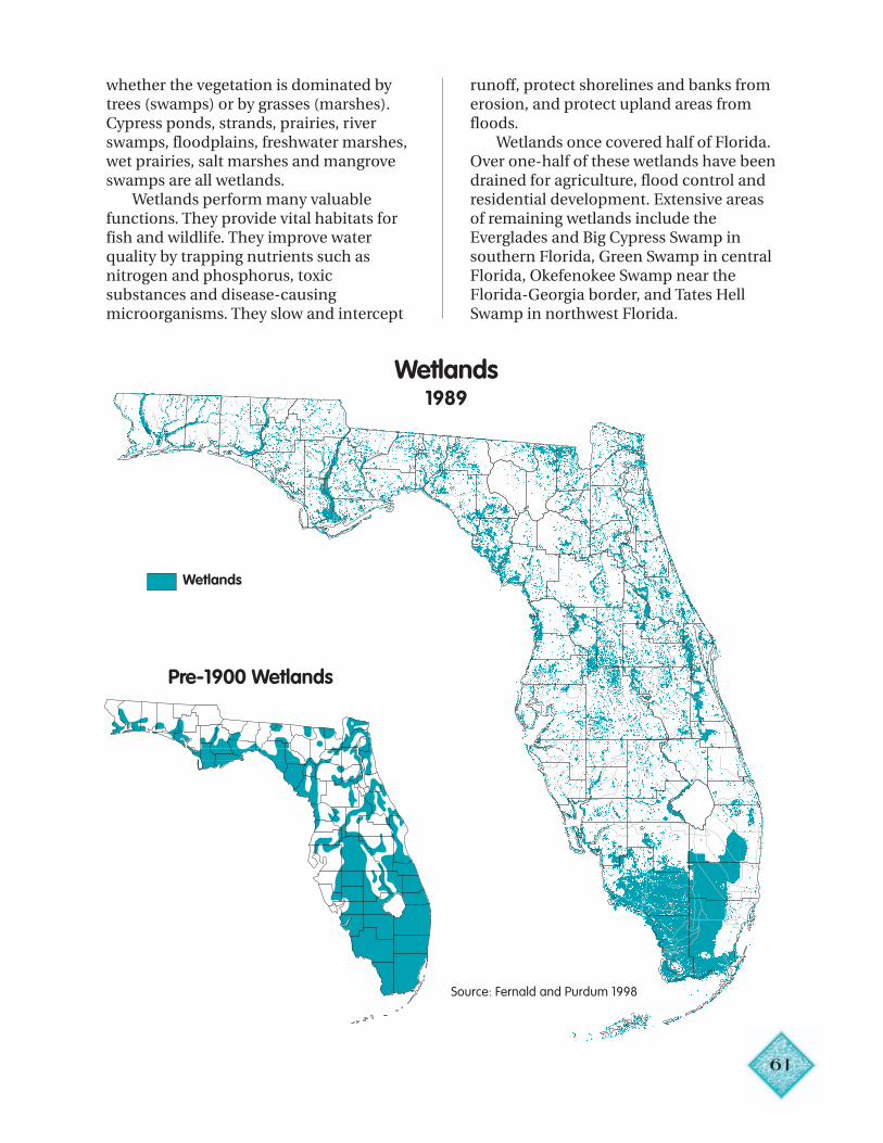
61
whether the vegetation is dominated bytrees (swamps) or by grasses (marshes).Cypress ponds, strands, prairies, riverswamps, floodplains, freshwater marshes,wet prairies, salt marshes and mangroveswamps are all wetlands.
Wetlands perform many valuablefunctions. They provide vital habitats forfish and wildlife. They improve waterquality by trapping nutrients such asnitrogen and phosphorus, toxicsubstances and disease-causingmicroorganisms. They slow and intercept
runoff, protect shorelines and banks fromerosion, and protect upland areas fromfloods.
Wetlands once covered half of Florida.Over one-half of these wetlands have beendrained for agriculture, flood control andresidential development. Extensive areasof remaining wetlands include theEverglades and Big Cypress Swamp insouthern Florida, Green Swamp in centralFlorida, Okefenokee Swamp near theFlorida-Georgia border, and Tates HellSwamp in northwest Florida.
Wetlands1989
Pre-1900 Wetlands
Source: Fernald and Purdum 1998
Wetlands
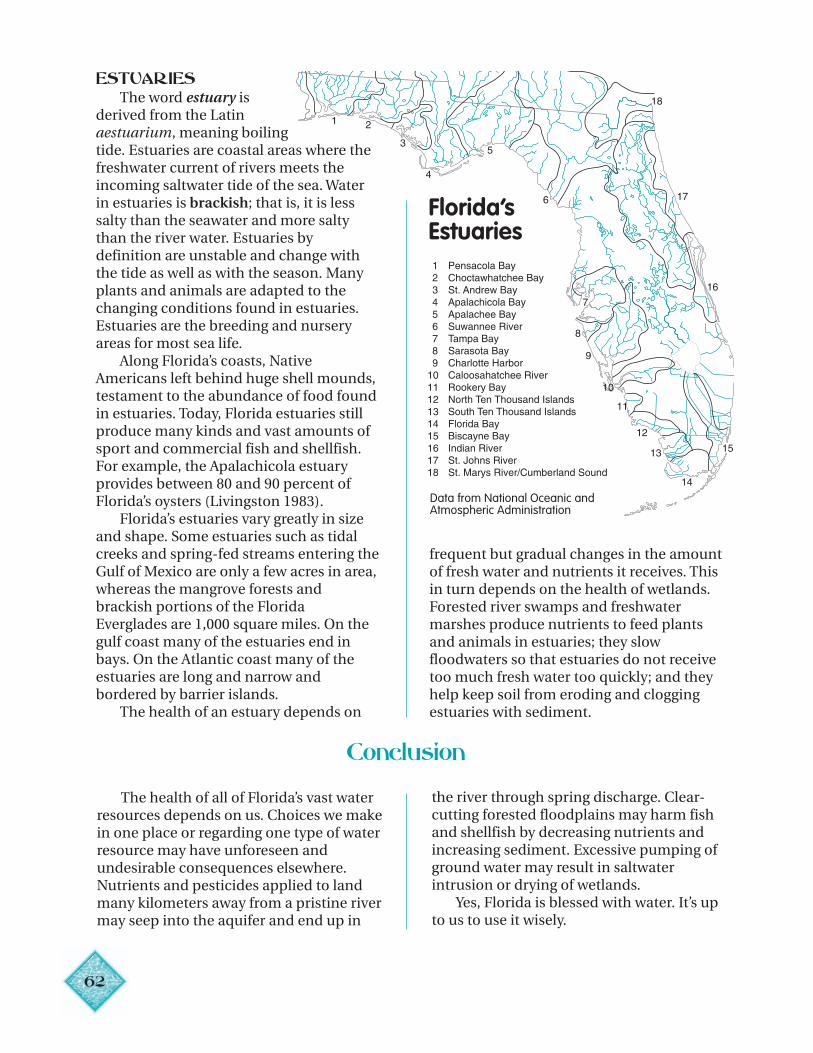
62
ESTUARIES
8
17
18
6
5
4
3
21
9
10
11
12
13 15
14
16
The word estuary isderived from the Latinaestuarium, meaning boilingtide. Estuaries are coastal areas where thefreshwater current of rivers meets theincoming saltwater tide of the sea. Waterin estuaries is brackish; that is, it is lesssalty than the seawater and more saltythan the river water. Estuaries bydefinition are unstable and change withthe tide as well as with the season. Manyplants and animals are adapted to thechanging conditions found in estuaries.Estuaries are the breeding and nurseryareas for most sea life.
Along Florida’s coasts, NativeAmericans left behind huge shell mounds,testament to the abundance of food foundin estuaries. Today, Florida estuaries stillproduce many kinds and vast amounts ofsport and commercial fish and shellfish.For example, the Apalachicola estuaryprovides between 80 and 90 percent ofFlorida’s oysters (Livingston 1983).
Florida’s estuaries vary greatly in sizeand shape. Some estuaries such as tidalcreeks and spring-fed streams entering theGulf of Mexico are only a few acres in area,whereas the mangrove forests andbrackish portions of the FloridaEverglades are 1,000 square miles. On thegulf coast many of the estuaries end inbays. On the Atlantic coast many of theestuaries are long and narrow andbordered by barrier islands.
The health of an estuary depends on
frequent but gradual changes in the amountof fresh water and nutrients it receives. Thisin turn depends on the health of wetlands.Forested river swamps and freshwatermarshes produce nutrients to feed plantsand animals in estuaries; they slowfloodwaters so that estuaries do not receivetoo much fresh water too quickly; and theyhelp keep soil from eroding and cloggingestuaries with sediment.
Florida’sEstuaries
7
Data from National Oceanic andAtmospheric Administration
Conclusion
The health of all of Florida’s vast waterresources depends on us. Choices we makein one place or regarding one type of waterresource may have unforeseen andundesirable consequences elsewhere.Nutrients and pesticides applied to landmany kilometers away from a pristine rivermay seep into the aquifer and end up in
the river through spring discharge. Clear-cutting forested floodplains may harm fishand shellfish by decreasing nutrients andincreasing sediment. Excessive pumping ofground water may result in saltwaterintrusion or drying of wetlands.
Yes, Florida is blessed with water. It’s upto us to use it wisely.
3
Chapter 4
Water and Life: Natural Systems
“Florida is a complex living creature, and subtlety is its most endearing quality.”— Clay Henderson, President, Florida Audubon Society
Water and its antithesis, fire, accountfor much of the subtlety we see in Florida’snatural communities. The Florida NaturalAreas Inventory, a project of The NatureConservancy and the Florida Departmentof Environmental Protection, recognizes81 distinct natural communities in Florida.No state east of the Mississippi can rivalFlorida in its abundance and diversity ofplants and animals. Florida also has moreendangered and threatened plants andanimals than any other state exceptCalifornia and Hawaii (U.S. Fish andWildlife Service 2000).
The state was colonized over manythousands of years by species fromcontinental areas to the north and tropicalCaribbean areas to the south. Some species,such as the American beech and the whiteoak, reach the southern limits of theirranges in the Florida Panhandle. Others,such as gumbo limbo and Bahamalysiloma, reach the northern limits of theirranges in southern Florida. Semi-isolationby ocean on three sides has contributed toa high percentage (8 percent) of endemicsin Florida (plant, fish, amphibian, reptile,bird and mammal species native tonowhere else in the world) (Governor’sOffice 1999).
Ancient Origins
During the Pleistocene Epoch (fromabout 1.8 million to 10,000 years ago),massive ice sheets formed over thenorthern latitudes in at least four separateevents, and sea levels around the world fellby as much as 400 feet. During the warmerinterglacial periods, sea levels rose ashigh as 150 feet above their currentlevel, leaving only the highest land 6
KEY IDEAS
• Water is the link connecting all of Florida’snatural communities.
• Water is the major defining feature ofFlorida’s natural communities.
• Hydrology and soils determine the kinds ofplants that grow.
• Plants in turn attract and support variouskinds of animals.
• Healthy uplands are critical formaintaining healthy aquatic ecosystems.
• Florida is a global hot spot of biodiversityand has many rare communities, as well asmore endangered plants and animals thanany other state except Hawaii andCalifornia.
• Human disruption of natural processesaffects natural communities.
VOCABULARY
Coral reefs
Dry prairies
Ecosystem
Endemic
Entisols
Hardwood hammock
Histosols
Hydrogenase
Hydrology
Hydroperiod
Insectivorous plants
Limnologist
Mangroves
Marsh
Microbes
Natural community
Pine flatwoods
Pleistocene
Prescribed burns
Scrub
Seagrass beds
Slough
Steepheads
Strand
Swamp
Symbiotic
Uplands
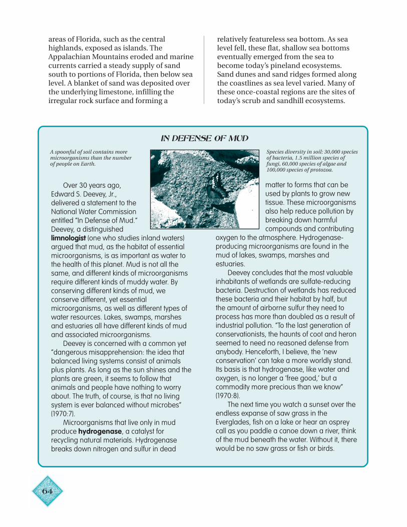
64
areas of Florida, such as the centralhighlands, exposed as islands. TheAppalachian Mountains eroded and marinecurrents carried a steady supply of sandsouth to portions of Florida, then below sealevel. A blanket of sand was deposited overthe underlying limestone, infilling theirregular rock surface and forming a
relatively featureless sea bottom. As sealevel fell, these flat, shallow sea bottomseventually emerged from the sea tobecome today’s pineland ecosystems.Sand dunes and sand ridges formed alongthe coastlines as sea level varied. Many ofthese once-coastal regions are the sites oftoday’s scrub and sandhill ecosystems.
IN DEFENSE OF MUD
A spoonful of soil contains moremicroorganisms than the numberof people on Earth.
Over 30 years ago,Edward S. Deevey, Jr.,delivered a statement to theNational Water Commissionentitled “In Defense of Mud.”Deevey, a distinguishedlimnologist (one who studies inland waters)argued that mud, as the habitat of essentialmicroorganisms, is as important as water tothe health of this planet. Mud is not all thesame, and different kinds of microorganismsrequire different kinds of muddy water. Byconserving different kinds of mud, weconserve different, yet essentialmicroorganisms, as well as different types ofwater resources. Lakes, swamps, marshesand estuaries all have different kinds of mudand associated microorganisms.
Deevey is concerned with a common yet“dangerous misapprehension: the idea thatbalanced living systems consist of animalsplus plants. As long as the sun shines and theplants are green, it seems to follow thatanimals and people have nothing to worryabout. The truth, of course, is that no livingsystem is ever balanced without microbes”(1970:7).
Microorganisms that live only in mudproduce hydrogenase, a catalyst forrecycling natural materials. Hydrogenasebreaks down nitrogen and sulfur in dead
matter to forms that can beused by plants to grow newtissue. These microorganismsalso help reduce pollution bybreaking down harmfulcompounds and contributing
oxygen to the atmosphere. Hydrogenase-producing microorganisms are found in themud of lakes, swamps, marshes andestuaries.
Deevey concludes that the most valuableinhabitants of wetlands are sulfate-reducingbacteria. Destruction of wetlands has reducedthese bacteria and their habitat by half, butthe amount of airborne sulfur they need toprocess has more than doubled as a result ofindustrial pollution. “To the last generation ofconservationists, the haunts of coot and heronseemed to need no reasoned defense fromanybody. Henceforth, I believe, the ‘newconservation’ can take a more worldly stand.Its basis is that hydrogenase, like water andoxygen, is no longer a ‘free good,’ but acommodity more precious than we know”(1970:8).
The next time you watch a sunset over theendless expanse of saw grass in theEverglades, fish on a lake or hear an ospreycall as you paddle a canoe down a river, thinkof the mud beneath the water. Without it, therewould be no saw grass or fish or birds.
Species diversity in soil: 30,000 speciesof bacteria, 1.5 million species offungi, 60,000 species of algae and100,000 species of protozoa.
65
Before the Pleistocene, naturallyacidic rain and ground water flowedthrough and dissolved the limestone rockof the Florida land form, forming a web ofunderground caverns and conduits.During low sea level periods inPleistocene times, these conduits often
collapsed, creating many of the sinkholes,springs and lakes that punctuate themodern Florida landscape. In the centralportion of the peninsula, dissolution andcollapse of the underlying limestonecreated lakes and large valleys, such asLake Apopka in the Central Valley.
Ecosystems
Water is the thread connecting allecosystems on Earth, as well as thesculptor of ancient and modern landforms. In Florida, water flows from uplandecosystems through rivers, swamps andfreshwater marshes, and eventually to saltmarshes, mangroves, seagrass beds andcoral reefs along the coast.
An ecosystem is a community ofmicrobes, plants and animals, includinghumans, interacting with one another andwith the physical environment where theylive. The term natural community isfrequently used interchangeably with theterm ecosystem, although ecosystems mayencompass more than one naturalcommunity. The physical environmentincludes soils, water and nutrients, as wellas human-made structures andalterations. In a healthy ecosystem, livingand nonliving components provide aframework through which solar energy istransferred and within which nutrientssuch as nitrogen and phosphoruscirculate. English botanist Sir ArthurTansley coined the word ecosystem in 1935from the Greek root oikos, meaning house.Ecosystems are place and life functioningtogether.
An ecosystem can be as small as acommunity of bacteria, insects andmicroscopic plants living in rainwatercollected in the crook of a tree, or largerthan the Kissimmee River-LakeOkeechobee-Everglades-Florida Bayecosystem. The Earth itself is one hugeecosystem. The size of an ecosystem, andoften its boundaries, are arbitrary anddepend on the needs and interests of the
investigator. Sometimes the observer canclearly see boundaries betweenecosystems. In other instances,ecosystems blend gradually one intoanother. In Florida, changes in moisture,soil fertility, fire frequency and humanalteration often occur over very shortdistances and result in clear and strikingchanges in the landscape: a scrubcommunity adjoins a cypress pond, atropical hammock stands out fromsurrounding pineland (Myers and Ewel1990).
Scientists do not agree on any oneway to classify ecosystems. Mostecosystem classifications are based onvegetation, the physical landscape andenvironmental factors. In Florida, one keydefining factor is water. Hydrology,combined with type of soil, determinesthe kinds of plants that grow. Plants inturn attract and support various kinds ofanimals. Although animals are criticalcomponents of ecosystems, manyanimals use more than one ecosystem,especially during different times of theirlife cycles. Thus it is far easier to defineecosystems by plant than by animal life.
In Florida, ecosystems may be dividedinto uplands (pinelands, scrub, dryprairies and hardwood hammocks),swamps (river swamps, cypress swamps),marshes (freshwater marshes, saltmarshes), lakes, rivers and coastalsystems (seagrass beds, mangroves andcoral reefs). Healthy uplands are criticalfor maintaining healthy aquaticecosystems. The type and condition ofuplands influence the amount and
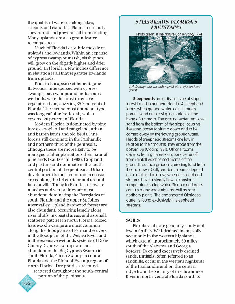
66
the quality of water reaching lakes,streams and estuaries. Plants in uplandsslow runoff and prevent soil from eroding.Many uplands are also groundwaterrecharge areas.
Much of Florida is a subtle mosaic ofuplands and lowlands. Within an expanseof cypress swamp or marsh, slash pineswill grow on the slightly higher and drierground. In Florida, a few inches differencein elevation is all that separates lowlandsfrom uplands.
Prior to European settlement, pineflatwoods, interspersed with cypressswamps, bay swamps and herbaceouswetlands, were the most extensivevegetation type, covering 35.3 percent ofFlorida. The second most abundant typewas longleaf pine/xeric oak, whichcovered 20 percent of Florida.
Modern Florida is dominated by pineforests, cropland and rangeland, urbanand barren lands and old fields. Pineforests still dominate in the Panhandleand northern third of the peninsula,although these are more likely to bemanaged timber plantations than naturalpinelands (Kautz et al. 1998). Croplandand pastureland dominate in the south-central portion of the peninsula. Urbandevelopment is most common in coastalareas, along the I-4 corridor and aroundJacksonville. Today in Florida, freshwatermarshes and wet prairies are mostabundant, dominating the Everglades ofsouth Florida and the upper St. JohnsRiver valley. Upland hardwood forests arealso abundant, occurring largely alongriver bluffs, in coastal areas, and as small,scattered patches in north Florida. Mixedhardwood swamps are most commonalong the floodplains of Panhandle rivers,in the floodplain of the Wekiva River, andin the extensive wetlands systems of DixieCounty. Cypress swamps are mostabundant in the Big Cypress Swamp insouth Florida, Green Swamp in centralFlorida and the Pinhook Swamp region ofnorth Florida. Dry prairies are found
scattered throughout the south-centralportion of the peninsula.
STEEPHEADS: FLORIDA’SMOUNTAINS
Steepheads are a distinct type of slopeforest found in northern Florida. A steepheadforms when ground water leaks throughporous sand onto a sloping surface at thehead of a stream. The ground water removessand from the bottom of the slope, causingthe sand above to slump down and to becarried away by the flowing ground water.Heads of steephead streams are low inrelation to their mouths: they erode from thebottom up (Means 1981). Other streamsdevelop from gully erosion. Surface runofffrom rainfall washes sediments off theground’s surface gradually, eroding land fromthe top down. Gully-eroded streams dependon rainfall for their flow, whereas steepheadstreams have a steady flow of constant-temperature spring water. Steephead forestscontain many endemics, as well as rarenorthern plants. The endangered Okaloosadarter is found exclusively in steepheadstreams.
Ashe’s magnolia, an endangered plant of steepheadforests
Photo credit: ©The Nature Conservancy 1994
SOILSFlorida’s soils are generally sandy and
low in fertility. Well-drained loamy soilsoccur only in the western highlands,which extend approximately 30 milessouth of the Alabama and Georgiaborders. Deep and excessively drainedsands, Entisols, often referred to assandhills, occur in the western highlandsof the Panhandle and on the centralridge from the vicinity of the SuwanneeRiver in north-central Florida south to
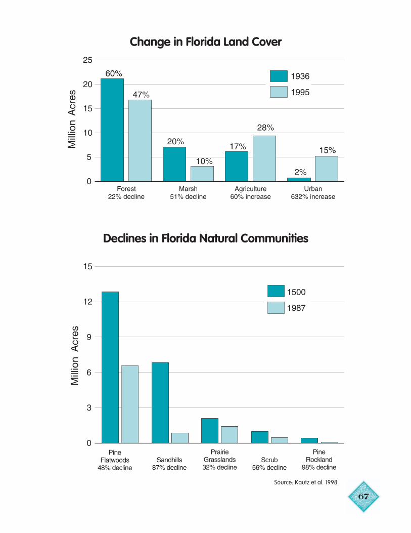
67
Change in Florida Land Cover
Declines in Florida Natural Communities
Source: Kautz et al. 1998
68
south-central Florida. These areas areimportant for groundwater recharge. Poorlydrained sandy soils are the most commonsoils in the state, occurring in pineflatwoods. Poorly drained organic soilsunderlain by limestone or marl (Histosols)occur on flat lands primarily in theEverglades and in the upper OcklawahaRiver.
ECOSYSTEM PROCESSWATER AND FIRE
Floods, fires from lightning and droughtsare common in Florida and often occur inquick succession. Plants, animals andnatural communities have evolved a varietyof adaptations to deal with these stressesand changes. Pond cypress, for example,survive better than bald cypress in nutrient-poor, still waters. Longleaf pine’s ability towithstand fire, even in its “grass” seedlingstage, is well known. Fire also producesminerals necessary for longleaf pinegermination (Abrahamson and Hartnett1990).
Hydroperiod, the duration ofstanding water, plays a strong role indetermining the location of the variouswetland communities. Forested wetlandsalong floodplains of major rivers are typicallyinundated for one to six months each year.In hammocks where limestone is near thesurface, the ground is frequently damp fromgroundwater seepage. Freshwater marshestypically have shallow standing water (lessthan 12 inches deep) from 7 to 12 monthseach year (Kautz et al. 1998).
In southern Florida, water levels variedgreatly between wet and dry seasons and
from year to year. Naturalist andadventurer A. W. Dimock describes a canoetrip he took in 1908: “We began the trip incanoes, but ended in an oxcart. We paddledand wallowed through two hundred milesof flower-clad lakes and boggy, moccasin-infested trails, zigzagging from border toborder of the Florida Everglades and werehauled for 5 days on pine-covered strandsof sand….Last year we crossed the ‘Gladesfrom west to east, in a power boat, over thedeepest water known for a decade. Thisyear, from Cape Sable to Lake Okeechobee,we could seldom find water to float acanoe” (Tebeau 1966:15).
Naturally occurring wildfires, as well aswater, have played a defining role inshaping Florida’s natural communities.Florida has one of the highest frequenciesof lightning strikes of any region in theUnited States and more thunderstorm daysthan anywhere in the country(Abrahamson and Hartnett 1990). As aresult of thousands of years of frequentlightning-set wildfires, many naturalcommunities in Florida have come todepend on fire. Pinelands, prairies, scrubsand marshes all require regularly occurringfire. Without fire, hardwoods will invade asite and, over time, a hardwood forest willreplace the original vegetation.
Today, roads, fire lanes and the need toprotect lives and property have limitednaturally occurring wildfires. Many fire-maintained communities are no longerable to sustain themselves without help.Forests must now be burned underprescribed conditions in order to reducefuel and to eliminate hardwoods.
Natural Communities
Pine flatwoods: The most common plantcommunity in Florida, pine flatwoods haveacidic sandy soil with some peat and often aclay layer one to three feet below thesurface. They are usually moist during therainy season and sometimes even flood. Fireis required to prevent their transformationto hardwood forests. Vegetation densityvaries from nearly closed to open and
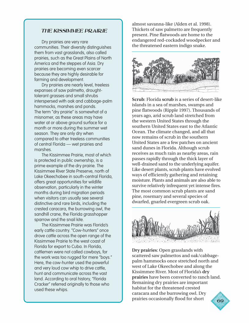
69
almost savanna-like (Alden et al. 1998).Thickets of saw palmetto are frequentlypresent. Pine flatwoods are home to theendangered red-cockaded woodpecker andthe threatened eastern indigo snake.
Scrub: Florida scrub is a series of desert-likeislands in a sea of marshes, swamps andpine flatwoods (Ripple 1997). Thousands ofyears ago, arid scrub land stretched fromthe western United States through thesouthern United States east to the AtlanticOcean. The climate changed, and all thatnow remains of scrub in the southernUnited States are a few patches on ancientsand dunes in Florida. Although scrubreceives as much rain as nearby areas, rainpasses rapidly through the thick layer ofwell-drained sand to the underlying aquifer.Like desert plants, scrub plants have evolvedways of efficiently gathering and retainingmoisture. Plants and animals are also able tosurvive relatively infrequent yet intense fires.The most common scrub plants are sandpine, rosemary and several species ofdwarfed, gnarled evergreen scrub oak.
Dry prairies: Open grasslands withscattered saw palmettos and oak/cabbage-palm hammocks once stretched north andwest of Lake Okeechobee and along theKissimmee River. Most of Florida’s dryprairies have been converted to ranch land.Remaining dry prairies are importanthabitat for the threatened crestedcaracara and the burrowing owl. Dryprairies occasionally flood for short
THE KISSIMMEE PRAIRIE
Dry prairies are very rarecommunities. Their diversity distinguishesthem from vast grasslands, also calledprairies, such as the Great Plains of NorthAmerica and the steppes of Asia. Dryprairies are becoming even scarcerbecause they are highly desirable forfarming and development.
Dry prairies are nearly level, treelessexpanses of saw palmetto, drought-tolerant grasses and small shrubsinterspersed with oak and cabbage-palmhammocks, marshes and ponds.The term “dry prairie” is somewhat of amisnomer, as these areas may havewater at or above ground surface for amonth or more during the summer wetseason. They are only dry whencompared to other treeless communitiesof central Florida — wet prairies andmarshes.
The Kissimmee Prairie, most of whichis protected in public ownership, is aprime example of the dry prairie. TheKissimmee River State Preserve, north ofLake Okeechobee in south-central Florida,offers great opportunities for wildlifeobservation, particularly in the wintermonths during bird migration periodswhen visitors can usually see severaldistinctive and rare birds, including thecrested caracara, the burrowing owl, thesandhill crane, the Florida grasshoppersparrow and the snail kite.
The Kissimmee Prairie was Florida’searly cattle country. “Cow-hunters” oncedrove cattle across the open range of theKissimmee Prairie to the west coast ofFlorida for export to Cuba. In Florida,cattlemen were not called cowboys, forthe work was too rugged for mere “boys.”Here, the cow-hunter used the powerfuland very loud cow whip to drive cattle,hunt and communicate across the vastland. According to oral history, “FloridaCracker” referred originally to those whoused these whips.
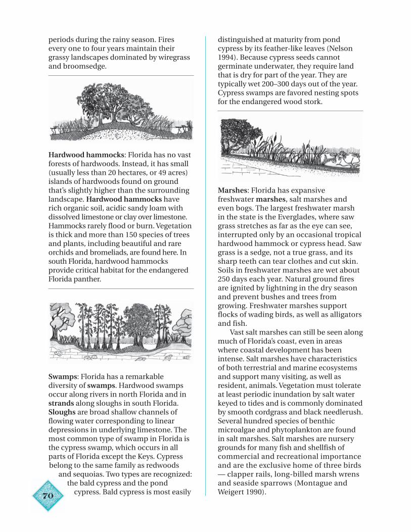
7
periods during the rainy season. Firesevery one to four years maintain theirgrassy landscapes dominated by wiregrassand broomsedge.
Hardwood hammocks: Florida has no vastforests of hardwoods. Instead, it has small(usually less than 20 hectares, or 49 acres)islands of hardwoods found on groundthat’s slightly higher than the surroundinglandscape. Hardwood hammocks haverich organic soil, acidic sandy loam withdissolved limestone or clay over limestone.Hammocks rarely flood or burn. Vegetationis thick and more than 150 species of treesand plants, including beautiful and rareorchids and bromeliads, are found here. Insouth Florida, hardwood hammocksprovide critical habitat for the endangeredFlorida panther.
Swamps: Florida has a remarkablediversity of swamps. Hardwood swampsoccur along rivers in north Florida and instrands along sloughs in south Florida.Sloughs are broad shallow channels offlowing water corresponding to lineardepressions in underlying limestone. Themost common type of swamp in Florida isthe cypress swamp, which occurs in allparts of Florida except the Keys. Cypressbelong to the same family as redwoods
and sequoias. Two types are recognized:the bald cypress and the pond
cypress. Bald cypress is most easily0
distinguished at maturity from pondcypress by its feather-like leaves (Nelson1994). Because cypress seeds cannotgerminate underwater, they require landthat is dry for part of the year. They aretypically wet 200–300 days out of the year.Cypress swamps are favored nesting spotsfor the endangered wood stork.
Marshes: Florida has expansivefreshwater marshes, salt marshes andeven bogs. The largest freshwater marshin the state is the Everglades, where sawgrass stretches as far as the eye can see,interrupted only by an occasional tropicalhardwood hammock or cypress head. Sawgrass is a sedge, not a true grass, and itssharp teeth can tear clothes and cut skin.Soils in freshwater marshes are wet about250 days each year. Natural ground firesare ignited by lightning in the dry seasonand prevent bushes and trees fromgrowing. Freshwater marshes supportflocks of wading birds, as well as alligatorsand fish.
Vast salt marshes can still be seen alongmuch of Florida’s coast, even in areaswhere coastal development has beenintense. Salt marshes have characteristicsof both terrestrial and marine ecosystemsand support many visiting, as well asresident, animals. Vegetation must tolerateat least periodic inundation by salt waterkeyed to tides and is commonly dominatedby smooth cordgrass and black needlerush.Several hundred species of benthicmicroalgae and phytoplankton are foundin salt marshes. Salt marshes are nurserygrounds for many fish and shellfish ofcommercial and recreational importanceand are the exclusive home of three birds— clapper rails, long-billed marsh wrensand seaside sparrows (Montague andWeigert 1990).
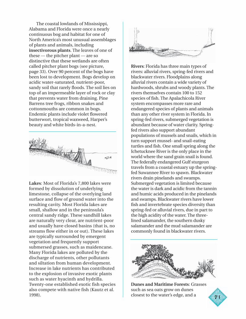
71
The coastal lowlands of Mississippi,Alabama and Florida were once a nearlycontinuous bog and habitat for one ofNorth America’s most unusual assemblagesof plants and animals, includinginsectivorous plants. The leaves of one ofthese — the pitcher plant — are sodistinctive that these wetlands are oftencalled pitcher plant bogs (see picture,page 33). Over 90 percent of the bogs havebeen lost to development. Bogs develop onacidic water-saturated, nutrient-poor,sandy soil that rarely floods. The soil lies ontop of an impermeable layer of rock or claythat prevents water from draining. PineBarrens tree frogs, ribbon snakes andcottonmouths are common in bogs.Endemic plants include violet floweredbutterwort, tropical waxweed, Harper’sbeauty and white birds-in-a-nest.
Lakes: Most of Florida’s 7,800 lakes wereformed by dissolution of underlyinglimestone, collapse of the overlying landsurface and flow of ground water into theresulting cavity. Most Florida lakes aresmall, shallow and in the peninsula’scentral sandy ridge. These sandhill lakesare naturally very clear, are nutrient-poorand usually have closed basins (that is, nostreams flow either in or out). These lakesare typically surrounded by emergentvegetation and frequently supportsubmersed grasses, such as maidencane.Many Florida lakes are polluted by thedischarge of nutrients, other pollutantsand siltation from human development.Increase in lake nutrients has contributedto the explosion of invasive exotic plantssuch as water hyacinth and hydrilla.Twenty-one established exotic fish speciesalso compete with native fish (Kautz et al.1998).
Rivers: Florida has three main types ofrivers: alluvial rivers, spring-fed rivers andblackwater rivers. Floodplains alongalluvial rivers contain a wide variety ofhardwoods, shrubs and woody plants. Therivers themselves contain 100 to 152species of fish. The Apalachicola Riversystem encompasses more rare andendangered species of plants and animalsthan any other river system in Florida. Inspring-fed rivers, submerged vegetation isabundant because of water clarity. Spring-fed rivers also support abundantpopulations of mussels and snails, which inturn support mussel- and snail-eatingturtles and fish. One small spring along theIchetucknee River is the only place in theworld where the sand grain snail is found.The federally endangered Gulf sturgeontravels from a coastal estuary up the spring-fed Suwannee River to spawn. Blackwaterrivers drain pinelands and swamps.Submerged vegetation is limited becausethe water is dark and acidic from the tanninand humic acids produced in the pinelandsand swamps. Blackwater rivers have lowerfish and invertebrate species diversity thanspring-fed or alluvial rivers, due in part tothe high acidity of the water. The three-lined salamander, the southern duskysalamander and the mud salamander arecommonly found in blackwater rivers.
Dunes and Maritime Forests: Grassessuch as sea oats grow on dunesclosest to the water’s edge, and a
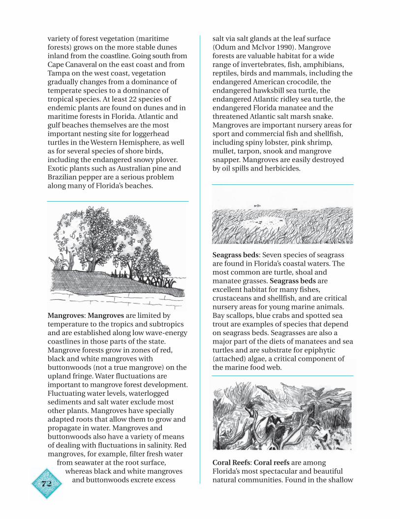
72
variety of forest vegetation (maritimeforests) grows on the more stable dunesinland from the coastline. Going south fromCape Canaveral on the east coast and fromTampa on the west coast, vegetationgradually changes from a dominance oftemperate species to a dominance oftropical species. At least 22 species ofendemic plants are found on dunes and inmaritime forests in Florida. Atlantic andgulf beaches themselves are the mostimportant nesting site for loggerheadturtles in the Western Hemisphere, as wellas for several species of shore birds,including the endangered snowy plover.Exotic plants such as Australian pine andBrazilian pepper are a serious problemalong many of Florida’s beaches.
Mangroves: Mangroves are limited bytemperature to the tropics and subtropicsand are established along low wave-energycoastlines in those parts of the state.Mangrove forests grow in zones of red,black and white mangroves withbuttonwoods (not a true mangrove) on theupland fringe. Water fluctuations areimportant to mangrove forest development.Fluctuating water levels, waterloggedsediments and salt water exclude mostother plants. Mangroves have speciallyadapted roots that allow them to grow andpropagate in water. Mangroves andbuttonwoods also have a variety of meansof dealing with fluctuations in salinity. Redmangroves, for example, filter fresh water
from seawater at the root surface,whereas black and white mangroves
and buttonwoods excrete excess
salt via salt glands at the leaf surface(Odum and McIvor 1990). Mangroveforests are valuable habitat for a widerange of invertebrates, fish, amphibians,reptiles, birds and mammals, including theendangered American crocodile, theendangered hawksbill sea turtle, theendangered Atlantic ridley sea turtle, theendangered Florida manatee and thethreatened Atlantic salt marsh snake.Mangroves are important nursery areas forsport and commercial fish and shellfish,including spiny lobster, pink shrimp,mullet, tarpon, snook and mangrovesnapper. Mangroves are easily destroyedby oil spills and herbicides.
Seagrass beds: Seven species of seagrassare found in Florida’s coastal waters. Themost common are turtle, shoal andmanatee grasses. Seagrass beds areexcellent habitat for many fishes,crustaceans and shellfish, and are criticalnursery areas for young marine animals.Bay scallops, blue crabs and spotted seatrout are examples of species that dependon seagrass beds. Seagrasses are also amajor part of the diets of manatees and seaturtles and are substrate for epiphytic(attached) algae, a critical component ofthe marine food web.
Coral Reefs: Coral reefs are amongFlorida’s most spectacular and beautifulnatural communities. Found in the shallow
73
waters off southeast Florida and the FloridaKeys, coral reefs require transparent, warmand relatively nutrient-poor waters. Onlythe surface layers of coral reefs are alive.The reef’s limestone base is composed ofskeletal deposits of dead corals and algae.Microscopic algae live symbiotically in theouter parts of the coral polyp. Over 100
species and subspecies of coral and algaeare found in Florida’s coral reefs, as well asnumerous other species of recreationaland commercial value, including spinylobster, grouper, snapper, parrot fish andbutterfly fish. Many reef species live innarrow niches and have specialized foodrequirements and complex life cycles.
Conclusion
People have been part of theecosystems of Florida for more than10,000 years. For most of this time, humanpopulation was relatively low and humanuse of natural resources did not cause anysignificant decrease in the ability of theenvironment to maintain clean air andwater, as well as productive, biologicallydiverse ecosystems. In the past 200 years,however, human uses have had enormous
impacts. Deforestation in the north,wetland drainage in the south, agriculturein the center and urbanization along thecoasts and the I-4 corridor have causedmassive losses of natural ecosystemdiversity and productivity. In Florida, themajor challenge of the next century will beto create an environmentally, as well aseconomically, sustainable way of living(Kautz et al. 1998).
74
Chapter 5
Water Supply and Water Quality“Not only is the level of the water in the global well getting low, the water is also polluted, sometimes to the point where it is no longer drinkable.”
— Julie Stauffer, The Water Crisis, 1998, p. xi
“Although water is part of a global system, how it is used and managed locally and regionally is what really counts. Unlike oil, wheat and most other important commodities, water is needed in quantities too large to make it practical to transport long distances.”
— Sandra Postel, Last Oasis, 1992, p. 23
KEY IDEAS
• Florida’s future depends on a continuedsupply of adequate amounts of clean freshwater for human consumption and fornatural systems.
• The amount of water changed by humanactivity is far greater than the amount ofwater directly used by humans.
• In some places in Florida, the demand forfresh water is greater than supply.
• Florida’s water management districts arecommitted to finding new ways to meet thedemand for water.
• Pollution is anything that causes animbalance in or harms the naturalenvironment.
• Scientists use a number of tests andmeasures to determine water quality.
• Pollution takes two main forms: point sourcepollution and non-point source pollution.
VOCABULARY
Aquifer storage andrecovery
Best managementpractices
Conductivity
Desalination
Detention pond
Dissolved oxygen
Drip irrigation
Environmental pollution
Filtration
Impervious surface
Irrigation
Non-point sourcepollution
Nutrients
pH
Point sourcepollution
Pollution
Public supply
Reclaimed water
Retention pond
Reuse
Turbidity
Wastewater
Water Use CautionAreas
Xeriscaping
Florida’s future depends on a continuedsupply of adequate clean fresh water. Waterquality and water quantity are bothimportant: it does little good to have vastamounts of polluted water. Plants, fish andother animals, as well as humans, all requireadequate amounts of clean water.
The quantity of water changed by humanactivity is far greater than the amount ofwater directly used by humans (Betz 1984).Each time humans withdraw ground water orsurface water for a particular purpose, wasteis generated. Household use generateswastewater from toilets, sinks, showers,bathtubs, dishwashers and washingmachines; phosphate mining generatesphosphate slime; manufacturing generateschemical waste; irrigation generates runoffcontaining nutrients from fertilizers, as wellas from pesticides and herbicides. Even raincontains impurities generated by burning offossil fuels, dust and ash. It’s not enough to becareful about the amount of water we use. Wemust also do our best to return it to theenvironment as pure as possible.
Some places in Florida, such as theFlorida Keys and St. Petersburg, never hadenough fresh water to support large-scaledevelopment. Each day, 16 million gallons ofwater flow from wells near Homestead, onthe mainland of Florida, to the Florida Keys.Water travels through a 130-mile-longpipeline supplying water all the way to KeyWest. St. Petersburg, “a peninsula on apeninsula” with the highest populationdensity in Florida (3,100 persons per squaremile), ran out of water in the 1920s and nowrelies on well fields in Hillsborough and Pascocounties. In other places, water use is rapidlysurpassing inexpensive water supply.
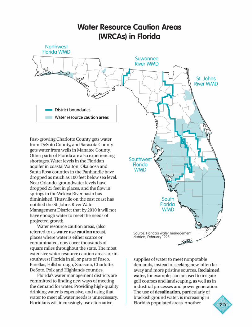
75
Water Resource Caution Areas(WRCAs) in Florida
Fast-growing Charlotte County gets waterfrom DeSoto County, and Sarasota Countygets water from wells in Manatee County.Other parts of Florida are also experiencingshortages. Water levels in the Floridanaquifer in coastal Walton, Okaloosa andSanta Rosa counties in the Panhandle havedropped as much as 100 feet below sea level.Near Orlando, groundwater levels havedropped 25 feet in places, and the flow insprings in the Wekiva River basin hasdiminished. Titusville on the east coast hasnotified the St. Johns River WaterManagement District that by 2010 it will nothave enough water to meet the needs ofprojected growth.
Water resource caution areas, (alsoreferred to as water use caution areas),places where water is either scarce orcontaminated, now cover thousands ofsquare miles throughout the state. The mostextensive water resource caution areas are insouthwest Florida in all or parts of Pasco,Pinellas, Hillsborough, Sarasota, Charlotte,DeSoto, Polk and Highlands counties.
Florida’s water management districts arecommitted to finding new ways of meetingthe demand for water. Providing high-qualitydrinking water is expensive, and using thatwater to meet all water needs is unnecessary.Floridians will increasingly use alternative
NorthwestFlorida WMD
SuwanneeRiver WMD
St. JohnsRiver WMD
SouthwestFloridaWMD
SouthFloridaWMD
District boundaries
Water resource caution areas
supplies of water to meet nonpotabledemands, instead of seeking new, often far-away and more pristine sources. Reclaimedwater, for example, can be used to irrigategolf courses and landscaping, as well as inindustrial processes and power generation.The use of desalination, particularly ofbrackish ground water, is increasing inFlorida’s populated areas. Another
Source: Florida’s water managementdistricts, February 1995
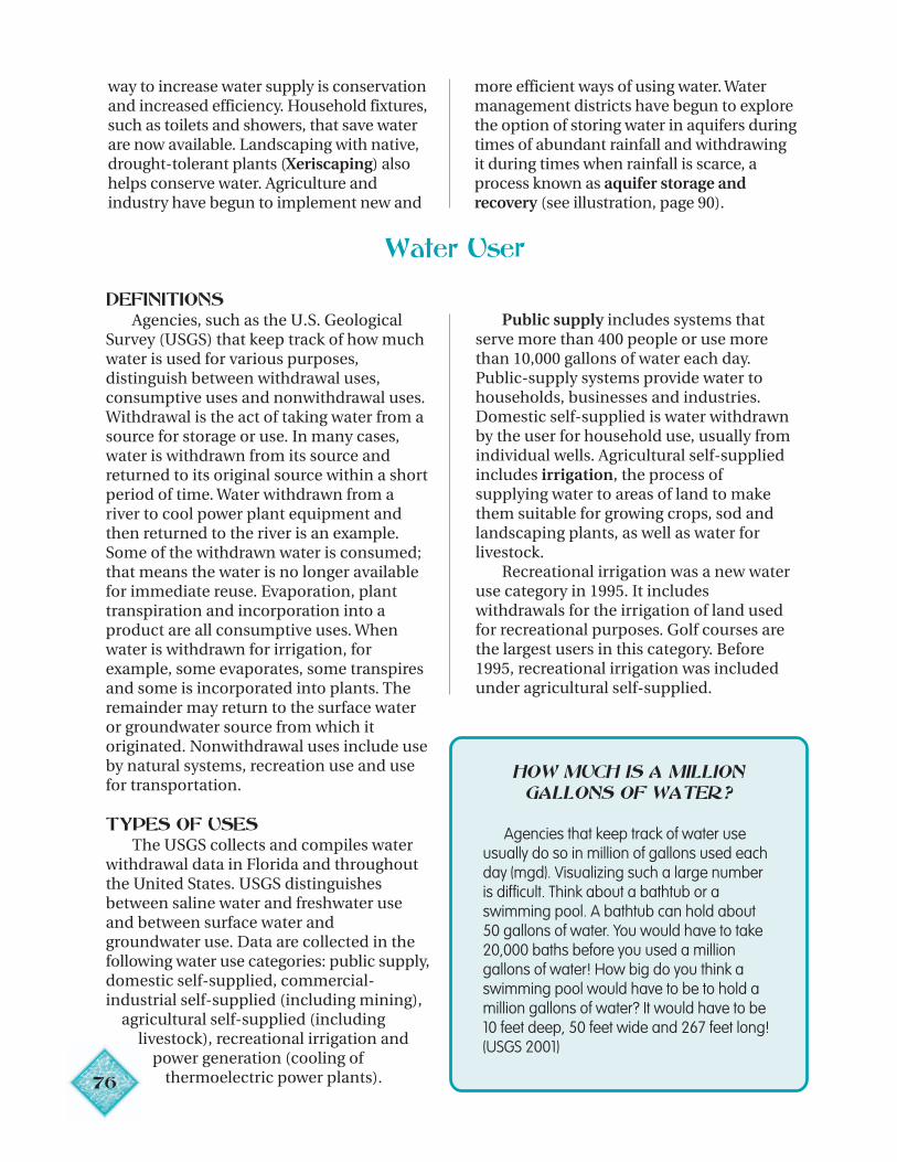
way to increase water supply is conservationand increased efficiency. Household fixtures,such as toilets and showers, that save waterare now available. Landscaping with native,drought-tolerant plants (Xeriscaping) alsohelps conserve water. Agriculture andindustry have begun to implement new and
more efficient ways of using water. Watermanagement districts have begun to explorethe option of storing water in aquifers duringtimes of abundant rainfall and withdrawingit during times when rainfall is scarce, aprocess known as aquifer storage andrecovery (see illustration, page 90).
Water User
DEFINITIONSAgencies, such as the U.S. Geological
Survey (USGS) that keep track of how muchwater is used for various purposes,distinguish between withdrawal uses,consumptive uses and nonwithdrawal uses.Withdrawal is the act of taking water from asource for storage or use. In many cases,water is withdrawn from its source andreturned to its original source within a shortperiod of time. Water withdrawn from ariver to cool power plant equipment andthen returned to the river is an example.Some of the withdrawn water is consumed;that means the water is no longer availablefor immediate reuse. Evaporation, planttranspiration and incorporation into aproduct are all consumptive uses. Whenwater is withdrawn for irrigation, forexample, some evaporates, some transpiresand some is incorporated into plants. Theremainder may return to the surface wateror groundwater source from which itoriginated. Nonwithdrawal uses include useby natural systems, recreation use and usefor transportation.
TYPES OF USESThe USGS collects and compiles water
withdrawal data in Florida and throughoutthe United States. USGS distinguishesbetween saline water and freshwater useand between surface water andgroundwater use. Data are collected in thefollowing water use categories: public supply,domestic self-supplied, commercial-industrial self-supplied (including mining), agricultural self-supplied (including
livestock), recreational irrigation and power generation (cooling of
thermoelectric power plants).76
Public supply includes systems thatserve more than 400 people or use morethan 10,000 gallons of water each day.Public-supply systems provide water tohouseholds, businesses and industries.Domestic self-supplied is water withdrawnby the user for household use, usually fromindividual wells. Agricultural self-suppliedincludes irrigation, the process ofsupplying water to areas of land to makethem suitable for growing crops, sod andlandscaping plants, as well as water forlivestock.
Recreational irrigation was a new wateruse category in 1995. It includeswithdrawals for the irrigation of land usedfor recreational purposes. Golf courses arethe largest users in this category. Before1995, recreational irrigation was includedunder agricultural self-supplied.
HOW MUCH IS A MILLIONGALLONS OF WATER?
Agencies that keep track of water useusually do so in million of gallons used eachday (mgd). Visualizing such a large numberis difficult. Think about a bathtub or aswimming pool. A bathtub can hold about50 gallons of water. You would have to take20,000 baths before you used a milliongallons of water! How big do you think aswimming pool would have to be to hold amillion gallons of water? It would have to be10 feet deep, 50 feet wide and 267 feet long!(USGS 2001)
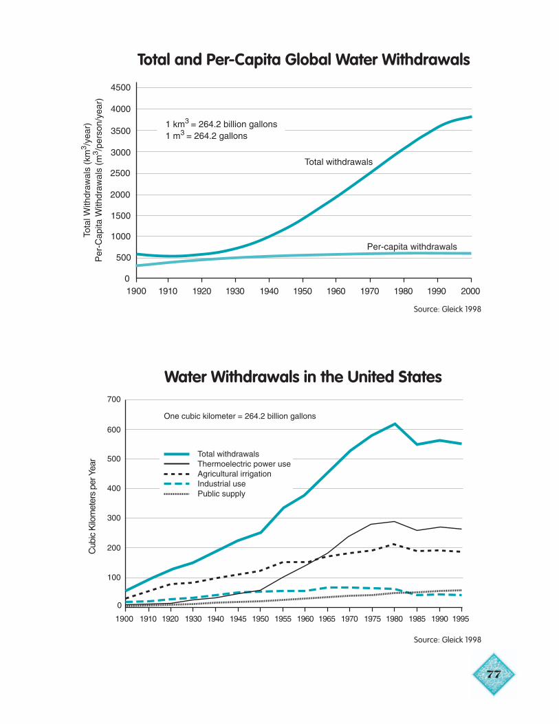
77
Source: Gleick 1998
Total and Per-Capita Global Water Withdrawals
Water Withdrawals in the United States
Source: Gleick 1998
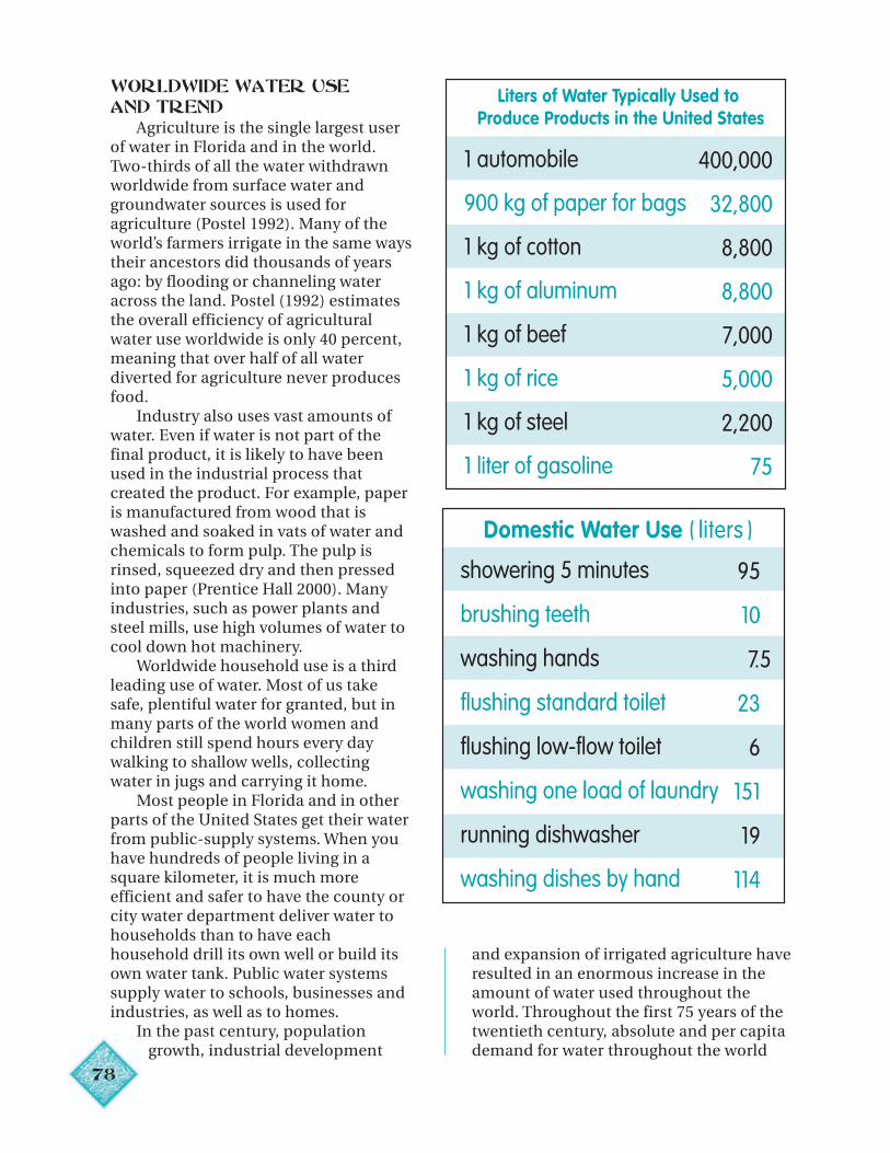
78
1 automobile 400,000
900 kg of paper for bags 32,800
1 kg of cotton 8,800
1 kg of aluminum 8,800
1 kg of beef 7,000
1 kg of rice 5,000
1 kg of steel 2,200
1 liter of gasoline 75
Liters of Water Typically Used to Produce Products in the United States
Domestic Water Use ( liters )
showering 5 minutes 95
brushing teeth 10
washing hands 7.5
flushing standard toilet 23
flushing low-flow toilet 6
washing one load of laundry 151
running dishwasher 19
washing dishes by hand 114
WORLDWIDE WATER USEAND TREND
Agriculture is the single largest userof water in Florida and in the world.Two-thirds of all the water withdrawnworldwide from surface water andgroundwater sources is used foragriculture (Postel 1992). Many of theworld’s farmers irrigate in the same waystheir ancestors did thousands of yearsago: by flooding or channeling wateracross the land. Postel (1992) estimatesthe overall efficiency of agriculturalwater use worldwide is only 40 percent,meaning that over half of all waterdiverted for agriculture never producesfood.
Industry also uses vast amounts ofwater. Even if water is not part of thefinal product, it is likely to have beenused in the industrial process thatcreated the product. For example, paperis manufactured from wood that iswashed and soaked in vats of water andchemicals to form pulp. The pulp isrinsed, squeezed dry and then pressedinto paper (Prentice Hall 2000). Manyindustries, such as power plants andsteel mills, use high volumes of water tocool down hot machinery.
Worldwide household use is a thirdleading use of water. Most of us takesafe, plentiful water for granted, but inmany parts of the world women andchildren still spend hours every daywalking to shallow wells, collectingwater in jugs and carrying it home.
Most people in Florida and in otherparts of the United States get their waterfrom public-supply systems. When youhave hundreds of people living in asquare kilometer, it is much moreefficient and safer to have the county orcity water department deliver water tohouseholds than to have eachhousehold drill its own well or build itsown water tank. Public water systemssupply water to schools, businesses andindustries, as well as to homes.
In the past century, populationgrowth, industrial development
and expansion of irrigated agriculture haveresulted in an enormous increase in theamount of water used throughout theworld. Throughout the first 75 years of thetwentieth century, absolute and per capitademand for water throughout the world
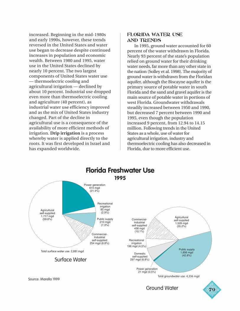
79
increased. Beginning in the mid-1980sand early 1990s, however, these trendsreversed in the United States and wateruse began to decrease despite continuedincreases in population and economicwealth. Between 1980 and 1995, wateruse in the United States declined bynearly 10 percent. The two largestcomponents of United States water use— thermoelectric cooling andagricultural irrigation — declined byabout 10 percent. Industrial use droppedeven more than thermoelectric coolingand agriculture (40 percent), asindustrial water use efficiency improvedand as the mix of United States industrychanged. Part of the decline inagricultural use is a consequence of theavailability of more efficient methods ofirrigation. Drip irrigation is a processwhereby water is applied directly to theroots. It was first developed in Israel andhas expanded worldwide.
FLORIDA WATER USE
AND TRENDSIn 1995, ground water accounted for 60
percent of the water withdrawn in Florida.Nearly 93 percent of the state’s populationrelied on ground water for their drinkingwater needs, far more than any other state inthe nation (Solley et al. 1998). The majority ofground water is withdrawn from the Floridanaquifer, although the Biscayne aquifer is theprimary source of potable water in southFlorida and the sand and gravel aquifer is themain source of potable water in portions ofwest Florida. Groundwater withdrawalssteadily increased between 1950 and 1990,but decreased 7 percent between 1990 and1995, even though the populationincreased 9 percent, from 12.94 to 14.15million. Following trends in the UnitedStates as a whole, use of water foragricultural irrigation, industry andthermoelectric cooling has also decreased inFlorida, due to more efficient use.
Florida Freshwater Use1995
Total surface water use: 2,881 mgd
Surface Water
Source: Marella 1999Total groundwater use: 4,336 mgd
Ground Water
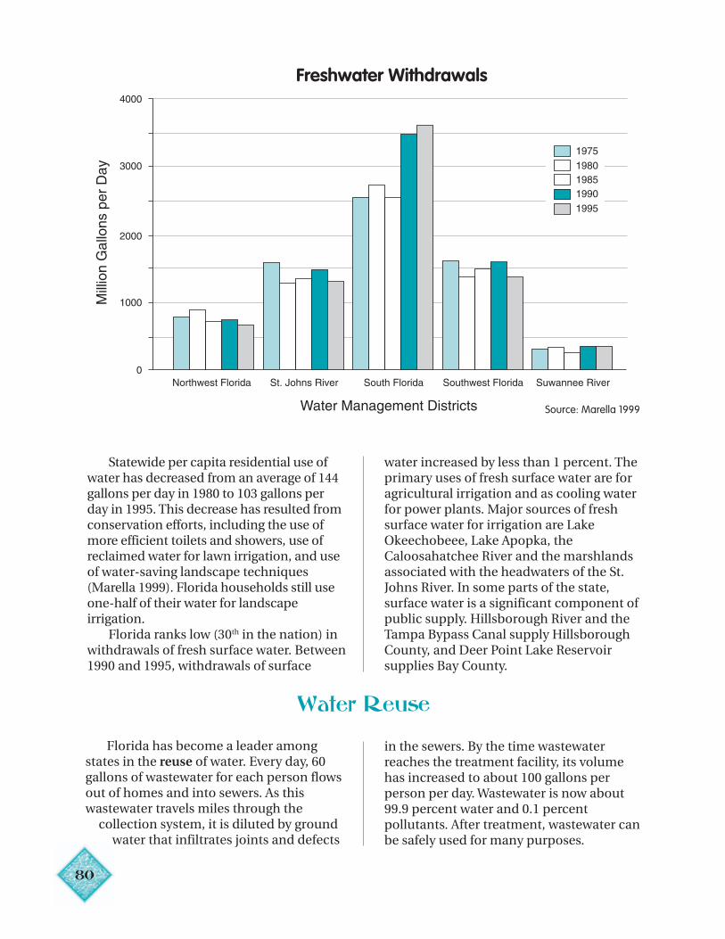
80
Statewide per capita residential use ofwater has decreased from an average of 144gallons per day in 1980 to 103 gallons perday in 1995. This decrease has resulted fromconservation efforts, including the use ofmore efficient toilets and showers, use ofreclaimed water for lawn irrigation, and useof water-saving landscape techniques(Marella 1999). Florida households still useone-half of their water for landscapeirrigation.
Florida ranks low (30th in the nation) inwithdrawals of fresh surface water. Between1990 and 1995, withdrawals of surface
Freshwater Withdrawals
water increased by less than 1 percent. Theprimary uses of fresh surface water are foragricultural irrigation and as cooling waterfor power plants. Major sources of freshsurface water for irrigation are LakeOkeechobeee, Lake Apopka, theCaloosahatchee River and the marshlandsassociated with the headwaters of the St.Johns River. In some parts of the state,surface water is a significant component ofpublic supply. Hillsborough River and theTampa Bypass Canal supply HillsboroughCounty, and Deer Point Lake Reservoirsupplies Bay County.
Water Reuse
Florida has become a leader amongstates in the reuse of water. Every day, 60gallons of wastewater for each person flowsout of homes and into sewers. As thiswastewater travels miles through the collection system, it is diluted by ground
water that infiltrates joints and defects
in the sewers. By the time wastewaterreaches the treatment facility, its volumehas increased to about 100 gallons perperson per day. Wastewater is now about99.9 percent water and 0.1 percentpollutants. After treatment, wastewater canbe safely used for many purposes.
Source: Marella 1999
State law requires reuse within waterresource caution areas. In 1999, the totalcapacity of all reuse systems in Florida wasabout 1.04 billion gallons per day, nearlyhalf of the total permitted capacity of alldomestic wastewater treatment facilities inthe state. A total of 523 million gallons perday of reclaimed water was reused in 1999.
Reclaimed water is being used forlandscape irrigation (including golf
courses, parks, highway medians,playgrounds and residential properties),agricultural irrigation (including irrigationof edible crops), aesthetic uses (decorativeponds, pools and fountains), groundwaterrecharge, industrial uses (for cooling,process or wash waters), wetlandscreation, restoration and enhancementand fire protection (use in hydrants andsprinklers).
Good quality water in adequateamounts is indispensable for the water wedrink, but it is also essential for many otheruses. We cannot safely swim or fish inpolluted waters nor can Florida’s naturalsystems survive without adequate water ofgood quality.
The recreational and ecological valuesof good quality water and other naturalresources are frequently acknowledged butare rarely considered in managementdecisions because we don’t buy and sellthem as we do other commodities. Anarticle published in 1997 (Costanza et al.)in the journal Nature summarizes andsynthesizes studies aimed at estimating thevalue of ecological functions and services.The authors conclude that the economicvalue of Earth’s natural systems averages$33 trillion per year, which is 1.2 times asmuch economic value created by humansand measured by the combined grossnational product of all the countries in theworld.
Scientists use a number of tests andmeasures to help them determine waterquality. These include turbidity, nutrientlevels, pH, dissolved oxygen, conductivityand temperature.
Turbidity is characterized by a cloudyor muddy appearance caused bysuspended solids that decrease the abilityof the sunlight to penetrate the water. Themost common suspended solids are soilparticles and algae. Water may sometimesbe naturally turbid because of highamounts of organic debris, erosion, or
Water Quality
waves or floods that suspend sediments.High turbidity reduces underwater
plant growth by limiting sunlightpenetration and photosynthesis. Adecrease in plant growth results in adecrease in the number of organisms thatdepend on plants for food and shelter. Soilparticles also affect the health of fish byclogging and irritating their gills. Turbidwaters may suffocate some aquatic plantsand animals and impair reproduction anddevelopment of eggs and larvae.
Nutrients in the proper amount arenecessary for healthy aquatic systems, butin excess, nutrients, primarily nitrogen andphosphorus, can be harmful. Nutrientscome from runoff containing fertilizer,waste from leaking septic tanks, decayinglawn debris and animal wastes. When toomany nutrients are present, certain plantsgrow explosively and crowd out otherplants, creating a monoculture. Increasesin nutrients may result in algal blooms inlakes and rivers. When algae multipliesrapidly, it uses up dissolved oxygen, leavingless available for other forms of aquaticlife. Excess nutrients also frequentlyincrease nonnative nuisance plants, suchas water hyacinth and hydrilla.
The measure of the amount ofhydrogen ions (H+) and hydroxide ions(OH-) in a solution is pH (potential ofhydrogen). The more acidic a solution, thegreater the amount of hydrogen ions. Themore basic or alkaline the solution, thegreater the amount of hydroxide ions.The pH scale ranges from 0 to 14
81
82
The lower the pH, the more acidic thesolution is; the higher the pH, the morebasic the solution is. A solution with a pHof 7 is neutral, neither basic nor acidic.Pure water has a pH of 7. Orange juice hasa pH of 4 and battery acid has a pH of 0.5.Milk of Magnesia has a pH of 10 and lyehas a pH of 14. Most aquatic organismsprefer water with a pH ranging from 6.5 to8.5. As acidity rises (pH falls), othercompounds in contact with the water orthe soil may release toxic elements (forexample, aluminum and mercury).Stormwater runoff containing leakagefrom faulty sewer lines or septic tanks,runoff from agricultural areas and acidrain can all decrease pH in lakes, rivers andestuaries, threatening aquatic organismsand releasing potentially harmfulelements.
Dissolved oxygen in water is essentialfor the survival of nearly all aquatic plantsand animals. Aquatic organisms, includingmost fish, generally thrive when dissolvedoxygen levels are 5 parts per million (ppm)or greater. Oxygen in the water comes fromthe air and as a byproduct ofphotosynthesis. The cooler the water, themore dissolved oxygen it will hold.However, at night when photosynthesisstops, animals continue to use oxygen andthe dissolved oxygen content of waterdrops.
Conductivity refers to how well thewater conducts or transmits an electricalcurrent. Pure distilled water does notconduct a current. As the concentration ofminerals and salts in the water increases,however, conductivity rises. Conductivityis therefore an indirect measure of themineral content of water. Sediments fromstormwater runoff and intrusion ofseawater increase the mineral content ofwater. Increases in conductivity mayindicate water quality problems fromincreased salinity or increased sediment.Both of these make water less useful tohumans and to natural systems.
Temperature affects the growth and life cycles of many aquatic organisms.
Nearly all organisms have a temperaturerange they prefer or even require.Sediments can absorb heat and increasewater temperature. Stormwater runofffrom heated impervious surfaces andpower plant outfalls also increases watertemperature. As water temperatureincreases, the life cycles of aquatic insectsmay accelerate. The growth of algaegenerally increases, whereas the growth ofother plants such as aquatic grasses maydecrease. Other aquatic organisms maybecome more sensitive and vulnerable todisease and their reproductive cycles maybe disrupted with increased temperatures.
CAUSES AND SOURCES OFWATER POLLUTION
Although pollution is often defined ascontamination by harmful chemicals orwaste materials, environmental pollutioncan be anything that harms or causes animbalance in plants and animals in theirnatural habitat — even though thesubstance may not be harmful to humans.For example, phosphorus and nitrogen arecommon elements of most fertilizers. Theyare not harmful to humans. However,nitrogen runoff can be a pollutant insaltwater bays and estuaries, such asTampa Bay and the Indian River Lagoon,and phosphorus runoff can be a pollutantin freshwater habitats such as theEverglades and Lake Apopka and otherfreshwater lakes because it causes animbalance in the natural system.
Pollution is usually caused by humanactivities. Pollutants aren’t alwaysdetectable by smell, sight or taste. Watermay look and smell clean and even tastefine, but it may still be contaminated andunsafe for drinking.
Despite successes in cleaning up somewater pollution, many modern pollutantsare very difficult to remove, and it isobviously better not to pollute in the firstplace. Heavy metals and syntheticchemicals pose particular hazards tohumans and other forms of life.
Heavy metals, such as lead and mercury,
83
can interfere with production ofhormones and with reproduction. Leadcan further result in physical and mentaldevelopmental problems in children.Other metals, such as copper and zinc, areless dangerous to humans but are toxic toaquatic life (Stauffer 1998).
More than 10 million chemicals aremanufactured today. Most are used inagriculture and industry. Some breakdown quickly, whereas others, like heavymetals, remain in the environment fordecades. Fewer than 2 percent of thesechemicals have been fully tested withregard to human health risks, and nohealth information is available for morethan 70 percent of them (Stauffer 1998).
Water may be polluted in two generalways: by point source pollution and bynon-point source pollution. With pointsource pollution, the cause of the problemcan be traced to a single source, forexample, a pipe discharging waste from afactory. Non-point source pollution ismore diffuse and originates from diversesources over a wider area.
In the past, pollution from industrialand domestic point sources was common.Stronger regulations, new technologiesand more advanced treatment of wasteshave reduced point source pollution.Today most water quality problems resultfrom non-point source pollution,including stormwater runoff, septic tanks,runoff from croplands, dairies, feedlotsand farms, and erosion from constructionsites and unpaved roads. Non-pointsource pollution carries pesticides andfertilizers from lawns and fields, oil andgreases from roads and parking lots,sediments from construction sites andclear-cutting of trees, and wastes fromimproperly functioning septic tanks.
In 1982, the state of Floridaimplemented a rule to reduce stormwaterrunoff. Since 1982, all new developmentshave been required to use bestmanagement practices (BMPs) tominimize runoff during construction and
to treat stormwater after construction.These BMPs include requiring swales,retention ponds, detention ponds anddetention ponds with filtration.
FLORIDA WATER QUALITYAND TREND
Because Florida is so populous andhas grown so rapidly, an important sourceof pollution, particularly of surface water,is urban storm water. Surface waterquality problems occur with the greatestfrequency in heavily populated areas —the southeast, in the central region nearOrlando, in the St. Johns River basinparticularly around Jacksonville, inPensacola Bay and its tributaries, in thePeace River basin and along the westcoast between Tampa and Naples. Waterbodies whose watersheds include largeurban areas and intensive industry andagriculture have the poorest water quality.
Developed areas have a much higherproportion of impervious surface thanrural areas. Impervious surfaces arecovered with buildings or asphalt,concrete and other materials that preventwater from seeping into the ground. As aconsequence, the volume of storm waterincreases, carrying pollutants with it.
The Florida Department ofEnvironmental Protection monitors waterquality in over 600 surface water bodiesthroughout the state. Between 1986 and1995, the water quality in 71 percent ofthese water bodies was unchanged, thewater quality of 20 percent improved, andthe water quality of 9 percent declined. Ingeneral, improvements were related tobetter control of point source pollution,particularly discharges from wastewatertreatment plants. Declines in waterquality generally resulted from increasesin stormwater runoff.
Florida’s ground water, as well as itssurface water, is vulnerable tocontamination. Large portions of the stateare covered with well-drained sandy soilsoverlying porous limestone. High
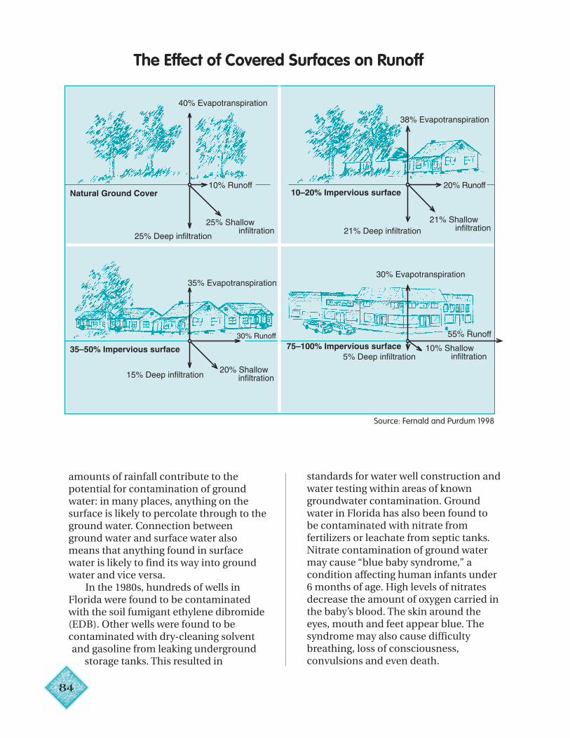
84
amounts of rainfall contribute to thepotential for contamination of groundwater: in many places, anything on thesurface is likely to percolate through to theground water. Connection betweenground water and surface water alsomeans that anything found in surfacewater is likely to find its way into groundwater and vice versa.
In the 1980s, hundreds of wells inFlorida were found to be contaminatedwith the soil fumigant ethylene dibromide(EDB). Other wells were found to becontaminated with dry-cleaning solventand gasoline from leaking underground
storage tanks. This resulted in
standards for water well construction andwater testing within areas of knowngroundwater contamination. Groundwater in Florida has also been found tobe contaminated with nitrate fromfertilizers or leachate from septic tanks.Nitrate contamination of ground watermay cause “blue baby syndrome,” acondition affecting human infants under6 months of age. High levels of nitratesdecrease the amount of oxygen carried inthe baby’s blood. The skin around theeyes, mouth and feet appear blue. Thesyndrome may also cause difficultybreathing, loss of consciousness,convulsions and even death.
The Effect of Covered Surfaces on Runoff
Source: Fernald and Purdum 1998

85
Conclusion
Although the analysis of water qualityand water pollution is complex, the needfor adequate amounts of clean water isclear. Some major water quality problemsof the past, particularly waterborneepidemics, are now well controlled. Wemust face new challenges resulting from afast-growing population, industry andintensive agriculture.
As water becomes scarcer, it willundoubtedly become more expensive,
Monitored Surface Water Quality Trends1986–1995
Source: Fernald and Purdum 1998
not just in Florida but throughout theworld.
“In most countries, water is priced atonly a fraction of its real cost. The workingassumption is that it’s an unlimited publicresource, and the result is that fewconsumers have any incentive to use itsparingly. Yet the time is coming whenwater must be treated as [a] valuable[resource], like oil, not free, like air”(Voyage Publishing 1996).
86
Chapter 6
Forward to the Past
KEY IDEAKEY IDEA S
• Many of Florida’s natural systems havebeen radically changed andfragmented by human development.
• Water no longer flows unimpeded fromuplands to coastal estuaries.
• Florida has responded to the loss,degradation and fragmentation of thenatural environment with one of themost aggressive and farsighted landacquisition programs in the nation.
• Land acquisition alone is not enough.These lands must be managed and inmany cases effectively restored.
• Throughout Florida, ecosystems arebeing restored.
• We cannot return to what used to be,but we can restore, protect and bettermanage what we have.
VOCABULARY
Degradation
Edge habitat
Finger-fill canals
Habitat fragmentation
Invasive exotics
Land restoration
Stormwater treatment areas
“The strength of the many is greater than thestrength of the individual organization.”
— Participant in Indiana Grand Kankalee Marsh Restoration Project (Yaffee et al. 1996)
“You can’t look at ecosystem management only in terms of what it can do for native plant and animal species. From the standpoint of sustainability, people have to be strongly involved.”
— Participant in Oak Mountain Partnership, Colorado (Yaffee et al. 1996)
Beginning in the 1800s, many ofFlorida’s natural systems were radicallychanged. Thousands of acres were drainedfor agriculture. Thousands more weredrained for houses for the steady stream ofnew residents. Rivers were straightenedand canals were dug for drainage and floodcontrol and to make travel easier for shipsand barges. Rivers were dammed forhydroelectric power and to create lakes forrecreation. Forests were cut and trees weretapped for turpentine and rosin. Innorthern Florida, centuries-old longleafpine trees were replaced with acre uponacre of fast-growing slash pine. Farthersouth, ancient cypress were logged and theland left bare.
Today, agricultural enterprises,businesses, houses, cities and roads cover43 percent of the Florida landscape.Forests and wetlands comprise the other57 percent. However, humans have lefttheir imprint on nearly all of thisremaining land. Most of the forests are nowstraight rows of young trees, the originaltrees having been logged. Also, manynatural areas have been affected byinvasive exotics (plants and animals fromelsewhere) that “crowd out” native species(Kautz et al. 1998).
A serious consequence of theconversion of the natural Floridalandscape to human uses has been thefragmentation of remaining naturalhabitats. Water no longer flows unimpededfrom uplands to coastal estuaries. Wide-ranging species such as the endangeredFlorida panther and the black bear facehazards as they cross barriers such as
87
roads and levees that isolate and fragmenttheir habitats. Habitat fragmentationincreases the amount of “edge” habitat.Although edges are desirable for somegame species, such as deer and rabbits, andfor some birds, such as song sparrows andcardinals, excessive amounts of edge areundesirable for interior forest dwellers.Edges of forests are also hotter and drierthan the forests themselves and may becomedominated by common weeds, whereasforest interiors are more diverse and supportmore rare species (Kautz et al. 1998).
Florida has responded to the loss,degradation and fragmentation of thenatural environment with one of the mostaggressive and farsighted land acquisitionprograms in the nation. As of March 2001,8.7 million acres, covering nearly a quarterof the state, were publicly managedconservation lands (Florida Natural Areas
Inventory, unpublished data). But publicacquisition is not enough: there must beland management and in many instances,land restoration. In the past century,conservation efforts focused onacquisition and preservation, basicallyputting a fence around what’s left,according to former U.S. Secretary of theInterior Bruce Babbitt. “We have finallycome to recognize that that’s not enough.We cannot meet our obligation to theprotection of creation by saying ‘fence offthe back 40,’ put somebody in a uniformfrom the National Park Service here andsay we’ve taken care of our obligation.”Today an “ecological revolution,” inBabbitt’s words, is occurring: it isecological, not political, boundaries thatare critical. You can’t preserve or manageor restore public lands in isolation fromthe landscapes of which they are a part.
Restoration
Many things can be taken apart, butsome, such as biological systems, are verydifficult to put back together again. On thesurface, a biological system may look likeit’s “fixed,” but it might not work. Someparts may be missing, some may beforgotten or some may not be put back inthe proper relationship to other parts.Complexity and diversity tend to behallmarks of unaltered systems, and thismakes restoration very difficult. Like abroken eggshell, a fragmented and alteredecosystem that is put back together maynever be as strong and resilient as theoriginal. In spite of these challenges,throughout Florida, ecosystems are being“put back together.”
KISSIMMEE-OKEECHOBEEEVERGLADES RESTORATION
The U.S. Army Corps of Engineers andthe South Florida Water ManagementDistrict are embarking on the mostambitious ecosystem restoration everundertaken in the United States. At anestimated cost of $7.8 billion, a 50-yearplan provides the road map for reviving
what was once an uninterruptedecosystem from the Kissimmee Rivervalley, through Lake Okeechobee, throughthe water conservation areas andEverglades National Park, to Florida Bayand the coral reefs. This plan is theculmination of eight years of scientificstudy and unprecedented cooperationamong local, state and federalgovernments, Indian nations,environmentalists, farmers and urbanwater utilities.
Many people think of the Everglades asEverglades National Park. They picture avast expanse of saw grass immortalized byMarjory Stoneman Douglas in her famousbook, The Everglades: River of Grass. Butthe Everglades ecosystem is much largerand more diverse. It begins near Orlando,north of the chain of lakes that feeds theKissimmee River and Lake Okeechobee,and it ends at Florida Bay and the coralreefs.
The natural landscape of theEverglades system was designed to holdwater. During wet periods, wateroverflowed the southern banks of
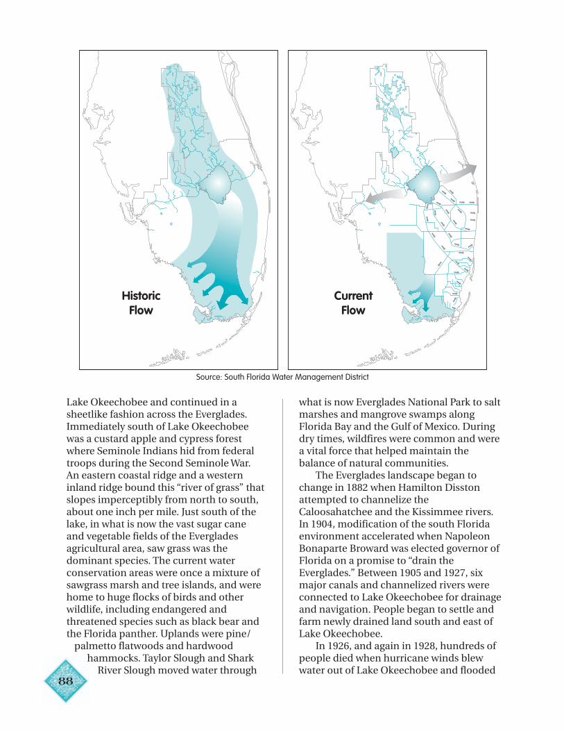
88
Lake Okeechobee and continued in asheetlike fashion across the Everglades.Immediately south of Lake Okeechobeewas a custard apple and cypress forestwhere Seminole Indians hid from federaltroops during the Second Seminole War.An eastern coastal ridge and a westerninland ridge bound this “river of grass” thatslopes imperceptibly from north to south,about one inch per mile. Just south of thelake, in what is now the vast sugar caneand vegetable fields of the Evergladesagricultural area, saw grass was thedominant species. The current waterconservation areas were once a mixture ofsawgrass marsh and tree islands, and werehome to huge flocks of birds and otherwildlife, including endangered andthreatened species such as black bear andthe Florida panther. Uplands were pine/
palmetto flatwoods and hardwoodhammocks. Taylor Slough and Shark
River Slough moved water through
what is now Everglades National Park to saltmarshes and mangrove swamps alongFlorida Bay and the Gulf of Mexico. Duringdry times, wildfires were common and werea vital force that helped maintain thebalance of natural communities.
The Everglades landscape began tochange in 1882 when Hamilton Disstonattempted to channelize theCaloosahatchee and the Kissimmee rivers.In 1904, modification of the south Floridaenvironment accelerated when NapoleonBonaparte Broward was elected governor ofFlorida on a promise to “drain theEverglades.” Between 1905 and 1927, sixmajor canals and channelized rivers wereconnected to Lake Okeechobee for drainageand navigation. People began to settle andfarm newly drained land south and east ofLake Okeechobee.
In 1926, and again in 1928, hundreds ofpeople died when hurricane winds blewwater out of Lake Okeechobee and flooded
Source: South Florida Water Management District
HistoricFlow
CurrentFlow
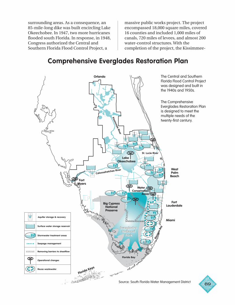
89
Bisc
ayne
Bay
Big CypressNationalPreserve
WestPalmBeach
FortMyers
FortLauderdale
Miami
Florida Keys
EvergladesNational
Park
Orlando
Kissimm
ee River
St. Lucie River
Florida Bay
Caloosahatchee River
Water Conservation
Areas
Aquifer storage & recovery
Surface water storage reservoir
Stormwater treatment areas
Seepage management
Removing barriers to sheetflow
Operational changes
Reuse wastewater
EvergladesNational
Park
Lake Okeechobee
surrounding areas. As a consequence, an85-mile-long dike was built encircling LakeOkeechobee. In 1947, two more hurricanesflooded south Florida. In response, in 1948,Congress authorized the Central andSouthern Florida Flood Control Project, a
massive public works project. The projectencompassed 18,000 square miles, covered16 counties and included 1,000 miles ofcanals, 720 miles of levees, and almost 200water-control structures. With thecompletion of the project, the Kissimmee-
Source: South Florida Water Management District
Comprehensive Everglades Restoration Plan
The Central and SouthernFlorida Flood Control Projectwas designed and built inthe 1940s and 1950s.
The ComprehensiveEverglades Restoration Planis designed to meet themultiple needs of thetwenty-first century.
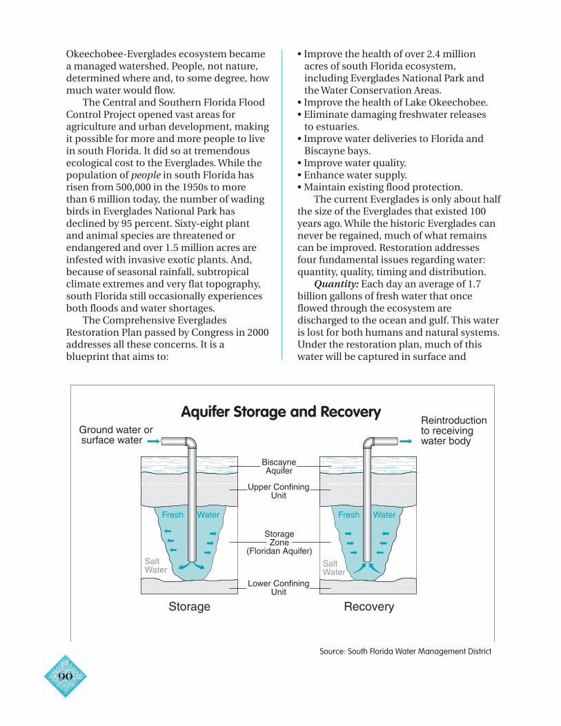
90
Aquifer Storage and RecoveryG
Okeechobee-Everglades ecosystem becamea managed watershed. People, not nature,determined where and, to some degree, howmuch water would flow.
The Central and Southern Florida FloodControl Project opened vast areas foragriculture and urban development, makingit possible for more and more people to livein south Florida. It did so at tremendousecological cost to the Everglades. While thepopulation of people in south Florida hasrisen from 500,000 in the 1950s to morethan 6 million today, the number of wadingbirds in Everglades National Park hasdeclined by 95 percent. Sixty-eight plantand animal species are threatened orendangered and over 1.5 million acres areinfested with invasive exotic plants. And,because of seasonal rainfall, subtropicalclimate extremes and very flat topography,south Florida still occasionally experiencesboth floods and water shortages.
The Comprehensive EvergladesRestoration Plan passed by Congress in 2000addresses all these concerns. It is ablueprint that aims to:
• Improve the health of over 2.4 million acres of south Florida ecosystem, including Everglades National Park and the Water Conservation Areas.• Improve the health of Lake Okeechobee.• Eliminate damaging freshwater releases to estuaries.• Improve water deliveries to Florida and Biscayne bays.• Improve water quality.• Enhance water supply.• Maintain existing flood protection.
The current Everglades is only about halfthe size of the Everglades that existed 100years ago. While the historic Everglades cannever be regained, much of what remainscan be improved. Restoration addressesfour fundamental issues regarding water:quantity, quality, timing and distribution.
Quantity: Each day an average of 1.7billion gallons of fresh water that onceflowed through the ecosystem aredischarged to the ocean and gulf. This wateris lost for both humans and natural systems.Under the restoration plan, much of thiswater will be captured in surface and
Source: South Florida Water Management District
91
underground storage areas until it is needed.More than 217,000 acres of new reservoirsand wetlands and 300 undergroundstorage and recovery wells are planned.Most of the water captured will be used forenvironmental restoration with somereserved for urban and agricultural uses.
Quality: Increased nutrients, especiallyphosphorus, cause negative changes to theplant communities of the Everglades.Florida’s 1994 Everglades Forever Actaddresses this water quality issue bymandating the construction of artificialwetlands, called stormwater treatmentareas, to reduce nutrients and improvewater quality before water enters theEverglades. The Comprehensive Planemploys storage and treatment areas thatfurther improve water quality in freshwaterreleases to the Everglades and LakeOkeechobee and that reduce undesirablefreshwater discharges to coastal waters.
Timing: Cycles of flood and droughtwere vital to the historic functioning of theEverglades ecosystem. Under therestoration plans, the timing of water heldand released into the ecosystem will moreclosely match natural patterns.
Distribution: To improve natural areaconnectors and to enhance overland flow,more than 240 miles of levees and canalswill be removed from the Everglades.Portions of the Tamiami Trail (U.S. Highway41) will be rebuilt with bridges and culverts,allowing a more natural flow of water acrossthe land into Everglades National Park. Inthe Big Cypress National Preserve, the leveethat separates the preserve from theEverglades will be removed, restoring more-natural overland water flow.
TAMPA BAYTampa Bay is Florida’s largest open-
water estuary, with a surface area of nearly400 square miles and a watershed of 2,200square miles. Tampa Bay borders portionsof Polk, Pasco, Hillsborough, Pinellas andManatee counties. Up to 70 percent ofsaltwater fish, crabs and shrimp spend partof their life cycles in estuaries where there isshelter, abundant food and protection fromlarge predators that swim in the open sea.
Tampa Bay is the year-round home to morethan 100 dolphins and a winter refuge forthe endangered Florida manatees thatcongregate around the warm-water outfallsof power plants. Economically, the bayyields $5 billion annually from trade,tourism and fishing. Along the bay arethree major seaports, and more than100,000 boats are registered to residents ofPinellas, Hillsborough and Manateecounties. Tampa Bay has been designatedan “estuary of national significance” by theNational Estuary Program.
Beginning in 1950, population in thebay area began to soar. Industrial andresidential development, finger-fill canals,farms and causeways altered nearly all ofthe bay’s original shoreline. In 1961,following devastating flooding fromHurricane Donna, the Florida Legislaturecreated the Southwest Florida WaterManagement District to work with the U.S.Army Corps of Engineers to provide floodcontrol around Tampa Bay. During theresulting Four River Basins, Florida Project,a regional flood detention area, a majorcanal and several shorter canals wereconstructed. These facilities were designedto store and (if needed) divert floodwatersaround Tampa, but they also altered thetiming and quantity of fresh water flowinginto the bay — factors that are important tothe bay’s productivity. Also impacting thebay was the discharge by Tampa of 70million gallons a day of partially treatedwastewater.
Algal blooms and fish kills werecommon in the bay. Water was so murkythat divers couldn’t see their own hands.Forty percent of the seagrass beds werelost, and bottom sediments were nearlydevoid of life. Populations of fish and birdsdeclined, along with their habitats.
The biggest culprit in the decline of thebay was nutrients, primarily nitrogen, fromwastewater discharges and stormwaterrunoff. In the late 1960s, in response tocitizen complaints, a federal investigationrecommended substantial reduction in theamount of nutrients entering the bay.The Florida Legislature responded byrequiring that wastewater be
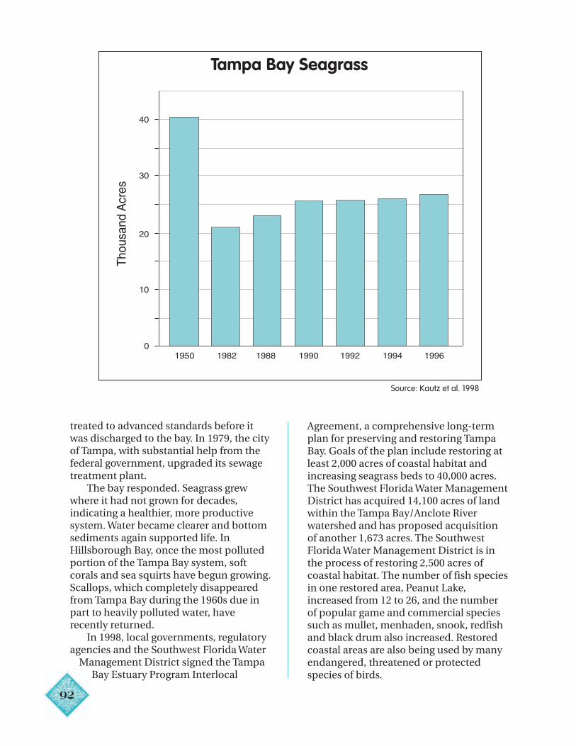
92
Tampa Bay Seagrass
treated to advanced standards before itwas discharged to the bay. In 1979, the cityof Tampa, with substantial help from thefederal government, upgraded its sewagetreatment plant.
The bay responded. Seagrass grewwhere it had not grown for decades,indicating a healthier, more productivesystem. Water became clearer and bottomsediments again supported life. InHillsborough Bay, once the most pollutedportion of the Tampa Bay system, softcorals and sea squirts have begun growing.Scallops, which completely disappearedfrom Tampa Bay during the 1960s due inpart to heavily polluted water, haverecently returned.
In 1998, local governments, regulatoryagencies and the Southwest Florida Water
Management District signed the TampaBay Estuary Program Interlocal
Agreement, a comprehensive long-termplan for preserving and restoring TampaBay. Goals of the plan include restoring atleast 2,000 acres of coastal habitat andincreasing seagrass beds to 40,000 acres.The Southwest Florida Water ManagementDistrict has acquired 14,100 acres of landwithin the Tampa Bay/Anclote Riverwatershed and has proposed acquisitionof another 1,673 acres. The SouthwestFlorida Water Management District is inthe process of restoring 2,500 acres ofcoastal habitat. The number of fish speciesin one restored area, Peanut Lake,increased from 12 to 26, and the numberof popular game and commercial speciessuch as mullet, menhaden, snook, redfishand black drum also increased. Restoredcoastal areas are also being used by manyendangered, threatened or protectedspecies of birds.
Source: Kautz et al. 1998
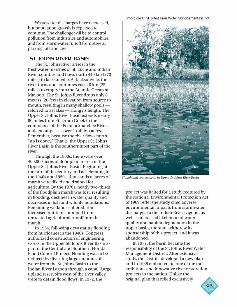
93
Wastewater discharges have decreased,but population growth is expected tocontinue. The challenge will be to controlpollution from industries and automobilesand from stormwater runoff from streets,parking lots and law
ST. JOHNS RIVER BASINThe St. Johns River arises in the
freshwater marshes of St. Lucie and IndianRiver counties and flows north 440 km (273miles) to Jacksonville. At Jacksonville, theriver turns and continues east 40 km (25miles) to empty into the Atlantic Ocean atMayport. The St. Johns River drops only 8meters (26 feet) in elevation from source tomouth, resulting in many shallow pools —referred to as lakes — along its length. TheUpper St. Johns River Basin extends nearly80 miles from Ft. Drum Creek to theconfluence of the Econlockhatchee River,and encompasses over 1 million acres.Remember, because the river flows north,“up is down.” That is, the Upper St. JohnsRiver Basin is the southernmost part of theriver.
Through the 1800s, there were over400,000 acres of floodplain marsh in theUpper St. Johns River Basin. Beginning atthe turn of the century and accelerating inthe 1940s and 1950s, thousands of acres ofmarsh were diked and drained foragriculture. By the 1970s, nearly two-thirdsof the floodplain marsh was lost, resultingin flooding, declines in water quality anddecreases in fish and wildlife populations.Remaining wetlands suffered fromincreased nutrients pumped fromuntreated agricultural runoff into themarsh.
In 1954, following devastating floodingfrom hurricanes in the 1940s, Congressauthorized construction of engineeringworks in the Upper St. Johns River Basin aspart of the Central and Southern FloridaFlood Control Project. Flooding was to bereduced by diverting large amounts ofwater from the St. Johns Basin to theIndian River Lagoon through a canal. Largeupland reservoirs west of the river valleywere to detain flood flows. In 1972, the
project was halted for a study required bythe National Environmental Protection Actof 1969. After the study cited adverseenvironmental impacts from stormwaterdischarges to the Indian River Lagoon, aswell as increased likelihood of waterquality and habitat degradation in theupper basin, the state withdrew itssponsorship of this project, and it wasabandoned.
In 1977, the basin became theresponsibility of the St. Johns River WaterManagement District. After extensivestudy, the District developed a new planand in 1988 embarked on one of the mostambitious and innovative river restorationprojects in the nation. Unlike theoriginal plan that relied exclusively
Slough and cypress head in Upper St. Johns River Basin
Photo credit: St. Johns River Water Management District
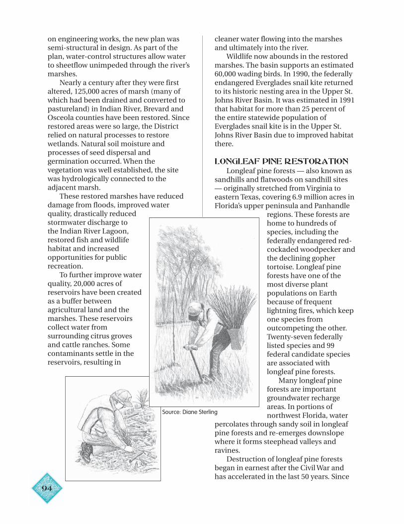
94
on engineering works, the new plan wassemi-structural in design. As part of theplan, water-control structures allow waterto sheetflow unimpeded through the river’smarshes.
Nearly a century after they were firstaltered, 125,000 acres of marsh (many ofwhich had been drained and converted topastureland) in Indian River, Brevard andOsceola counties have been restored. Sincerestored areas were so large, the Districtrelied on natural processes to restorewetlands. Natural soil moisture andprocesses of seed dispersal andgermination occurred. When thevegetation was well established, the sitewas hydrologically connected to theadjacent marsh.
These restored marshes have reduceddamage from floods, improved waterquality, drastically reducedstormwater discharge tothe Indian River Lagoon,restored fish and wildlifehabitat and increasedopportunities for publicrecreation.
To further improve waterquality, 20,000 acres ofreservoirs have been createdas a buffer betweenagricultural land and themarshes. These reservoirscollect water fromsurrounding citrus grovesand cattle ranches. Somecontaminants settle in thereservoirs, resulting in
cleaner water flowing into the marshesand ultimately into the river.
Wildlife now abounds in the restoredmarshes. The basin supports an estimated60,000 wading birds. In 1990, the federallyendangered Everglades snail kite returnedto its historic nesting area in the Upper St.Johns River Basin. It was estimated in 1991that habitat for more than 25 percent ofthe entire statewide population ofEverglades snail kite is in the Upper St.Johns River Basin due to improved habitatthere.
LONGLEAF PINE RESTORATIONLongleaf pine forests — also known as
sandhills and flatwoods on sandhill sites— originally stretched from Virginia toeastern Texas, covering 6.9 million acres inFlorida’s upper peninsula and Panhandle
regions. These forests arehome to hundreds ofspecies, including thefederally endangered red-cockaded woodpecker andthe declining gophertortoise. Longleaf pineforests have one of themost diverse plantpopulations on Earthbecause of frequentlightning fires, which keepone species fromoutcompeting the other.Twenty-seven federallylisted species and 99federal candidate speciesare associated withlongleaf pine forests. Many longleaf pineforests are importantgroundwater rechargeareas. In portions of
rling northwest Florida, waterpercolates through sandy soil in longleafpine forests and re-emerges downslopewhere it forms steephead valleys andravines.
Destruction of longleaf pine forestsbegan in earnest after the Civil War andhas accelerated in the last 50 years. Since
Source: Diane Ste
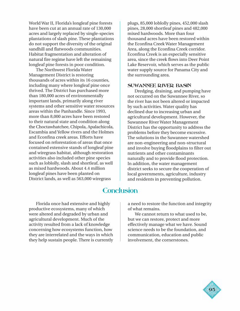
95
World War II, Florida’s longleaf pine forestshave been cut at an annual rate of 130,000acres and largely replaced by single-speciesplantations of slash pine. These plantationsdo not support the diversity of the originalsandhill and flatwoods communities.Habitat fragmentation and alteration ofnatural fire regime have left the remaininglongleaf pine forests in poor condition.
The Northwest Florida WaterManagement District is restoringthousands of acres within its 16 counties,including many where longleaf pine oncethrived. The District has purchased morethan 180,000 acres of environmentallyimportant lands, primarily along riversystems and other sensitive water resourcesareas within the Panhandle. Since 1993,more than 8,000 acres have been restoredto their natural state and condition alongthe Choctawhatchee, Chipola, Apalachicola,Escambia and Yellow rivers and the Holmesand Econfina creek areas. Efforts havefocused on reforestation of areas that oncecontained extensive stands of longleaf pineand wiregrass habitat, although restorationactivities also included other pine speciessuch as loblolly, slash and shortleaf, as wellas mixed hardwoods. About 4.4 millionlongleaf pines have been planted onDistrict lands, as well as 563,000 wiregrass
plugs, 85,000 loblolly pines, 452,000 slashpines, 28,000 shortleaf pines and 482,000mixed hardwoods. More than fourthousand acres have been restored withinthe Econfina Creek Water ManagementArea, along the Econfina Creek corridor.Econfina Creek is an especially sensitivearea, since the creek flows into Deer PointLake Reservoir, which serves as the publicwater supply source for Panama City andthe surrounding area.
SUWANNEE RIVER BASINDredging, draining, and pumping have
not occurred on the Suwannee River, sothe river has not been altered or impactedby such activities. Water quality hasdeclined due to increasing urban andagricultural development. However, theSuwannee River Water ManagementDistrict has the opportunity to address theproblems before they become excessive.The solutions in the Suwannee watershedare non-engineering and non-structuraland involve buying floodplains to filter outnutrients and other contaminantsnaturally and to provide flood protection.In addition, the water managementdistrict seeks to secure the cooperation oflocal governments, agriculture, industryand residents in preventing pollution.
Conclusion
Florida once had extensive and highlyproductive ecosystems, many of whichwere altered and degraded by urban andagricultural development. Much of theactivity resulted from a lack of knowledgeconcerning how ecosystems function, howthey are interrelated and the ways in whichthey help sustain people. There is currently
a need to restore the function and integrityof what remains.
We cannot return to what used to be,but we can restore, protect and moreeffectively manage what we have. Soundscience needs to be the foundation, andcommunication, education and publicinvolvement, the cornerstones.
96
Chapter
Links to Project WET Activities
Project WET (Water Education forTeachers) is a nonprofit water educationprogram for educators and young people,grades K–12. The Project WET Curriculumand Activity Guide was published in 1995by The Watercourse and the WesternRegional Environmental EducationCouncil and contains more than 90 watereducation activities. These guides aredistributed through water resourcesworkshops that also provide local-,regional-and state-specific information toparticipants. In Florida, Project WET issponsored by the St. Johns River,
Southwest Florida and South Floridawater management districts and theFlorida Department of EnvironmentalProtection.
The following activities from theProject WET Curriculum and ActivityGuide are especially appropriate for thecontent of each chapter. For SunshineState Standards correlations for theseactivities, please visit the SouthwestFlorida Water Management District’s Website’s Information and Education Sectionat WaterMatters.org, or call 1-800-423-1476, ext. 4757, to request a copy.
Chapter 1 — The Human FrameworkThe First Floridians
Water Celebration, page 446, grades 3–8Water Messages in Stone, page 455, grades 3–8
Drainage, Flood Control and NavigationDust Bowls and Failed Levees, page 303, grades 9–12
Modern Water ManagementHumpty Dumpty, page 316, grades 3–8Hot Water, page 389, grades 9–12Perspectives, page 397, grades 6–12
Water LawPass the Jug, page 393, grades 3–12, K–2 optionWater Bill of Rights, page 403, grades 3–12Common Water, page 232, grades 3–8, K–2 option
Chapter 2 — Water: It’s Magic!Introduction
Wish Book, page 460, grades 6–12Water Messages in Stone, page 454, grades 3–8Aqua Bodies, page 63, grades K–5Aqua Notes, page 66, grades K–5
97
Water’s StructureHangin’ Together, page 35, grades 3–12Adventures in Density, page 25, grades 3–12Molecules in Motion, page 47, grades K–8Water Match, page 50, grades K–5What’s the Solution? page 54, grades 3–8H
2Olympics, page 30, grades 3–8
Global Water CycleThirsty Plants, page 116, grades 6–8Imagine! page 157, grades 3–8The Incredible Journey, page 161, grades 3–8Just Passing Through, page 166, grades 3–8Old Water, page 171, grades 3–8Poetic Precipitation, page 182, grades 3–8, K–2 option
Floods and DroughtsAfterMath, page 289, grades 3–8Nature Rules! page 262, grades 6–12
StormsThe Thunderstorm, page 196, grades K–12Water Models, page 201, grades 3–8
Chapter 3 — Florida’s Water ResourcesWatersheds
Branching Out! page 129, grades 6–8Capture, Store, and Release, page 133, grades 4–5Rainy-Day Hike, page 186, grades 4–8Color Me a Watershed, page 223, grades 9–12
Ground WaterGet the Ground Water Picture, page 136, grades 6–12
Surface WaterStream Sense, page 191, grades K–5Back to the Future, page 293, grades 6–12
WetlandsLife in the Fast Lane, page 79, grades 3–8Wetland Soils in Living Color, page 212, grades 6–8Capture, Store, and Release, page 133, grades 4–5
EstuariesSalt Marsh Players, page 99, grades 4–5
Chapter 4 — Water and Life: Natural SystemsAncient Origins
Common Water, page 232, grades 6–8People of the Bog, page 89, grades 6–12Energetic Water, page 242, grades 4–8
EcosystemsThe Life Box, page 76, grades K–5Macroinvertebrate Mayhem, page 322, grades 4–8
98
SoilsWetland Soils in Living Color, page 212, grades 6–8
Ecosystem Processes: Water and FireA House of Seasons, page 155, grades K–3
Natural CommunitiesSalt Marsh Players, page 99, grades 4–5Water Address, page 122, grades 4–8
Chapter 5 — Water Supply and Water QualityWater Use
Common Water, page 232, grades 6–8A Drop in the Bucket, page 238, grades 6–8Irrigation Interpretation, page 254, grades 4–8The Long Haul, page 260, grades K–12Water Meter, page 271, grades 4–8Water Works, page 274, grades 4–8Every Drop Counts, page 307, grades 4–8Choices and Preferences, Water Index, page 367, grades 6–12Dilemma Derby, page 377, grades 6–12Easy Street, page 382, grades 6–8Water Concentration, page 407, grades 4–5Water Court, page 413, grades 9–12
Water ReuseSparkling Water, page 348, grades 6–12
Water QualityWater Actions, page 12, grades 6–12No Bellyachers, page 85, grades 4–8Poison Pump, page 93, grades 6–8Super Sleuths, page 107, grades 6–12Just Passing Through, page 166, grades 4–8Sum of the Parts, page 267, grades 4–8A-maze-ing Water, page 219, grades K–5Where Are the Frogs? page 279, grades 6–8The CEO, page 300, grades 9–12A Grave Mistake, page 311, grades 6–12The Pucker Effect, page 338, grades 6–12Reaching Your Limits, page 344, grades 4–8Sparkling Water, page 348, grades 6–12Super Bowl Surge, page 353, grades 4–12
Chapter 6 — Forward to the PastRestoration
Humpty Dumpty, page 316, grades 4–8Pass the Jug, page 392, grades 6–8Perspectives, page 397, grades 6–12
99
Glossary
Alluvial river — a type of river with a large,well-defined drainage basin that carries ahigh sediment load and has a large forestedfloodplain
Aquaculture — the cultivation of fish orshellfish
Aquifer — a layer of underground rock orsand that stores water
Aquifer storage and recovery — the processby which fresh surface water or groundwater is injected deep into an aquifer andfresh water pumped to the surface at somelater time from the same well
Atom — the smallest part of an elementthat exists in nature
Best management practices — methodsdesigned to minimize harm to theenvironment
Blackwater river — a type of river thatdrains pine flatwoods and cypress swampsand that has dark, stained waters fromdecomposing plant material
Brackish — fresh water that is mixed withsalt water
Capillarity — process by which water risesin tubes (capillaries) because of theattraction of water molecules to each otherand to the molecules on the sides of thetubes
Condensation — moisture produced whenwarm water vapor mixes with cooler air inthe atmosphere to form clouds or fog
Conductivity — measure of the ability of asubstance to conduct an electric charge;indicates presence of minerals or salts
Coral reefs — structure formed overthousands of years by the limestoneremains of millions of tiny animals (coral)
Degradation (habitat) — the result ofhuman disturbances and land-use changescommonly associated with urban andagricultural development, as well as withexotic plant invasion, to the extent thathabitat size and/or quality becomesnegatively impacted
Desalination — any of numerousprocesses that remove salt from seawateror brackish water
Detention pond — a pond constructed toslow stormwater runoff and to allow thesediment in the runoff to settle to thebottom
Discharge — flowing or issuing out
Dissolved oxygen — oxygen dissolved inwater — comes from the air and as a by-product of photosynthesis
Drainage — process of removing waterfrom the land
Drainage basin — land area thatcontributes runoff to a water body; alsoknown as a watershed
Drip irrigation — most efficient form ofirrigation whereby water is deliveredthrough pipes directly to the plants’ roots
Drought — a long period of time with littleor no rain
Dry prairies — expansive native grass andshrub lands occurring on very flat terrain
Ecosystem — a community of plants andanimals and their physical environment
Ecosystem restoration — Re-establishingand maintaining the health, sustainabilityand biological diversity of natural systems
Edge habitat — the area betweennatural community types
Chapter 6
100
El Niño — unseasonably warm oceancurrent that occurs in the Pacific Ocean offthe coast of Peru every 3 to 7 years
Endemic — an animal or plant restrictedin its distribution to one or a few places
Entisols — soils of slight and recentdevelopment, common along rivers andfloodplains
Environmental pollution — anything thatharms or causes an imbalance in plantsand animals in their natural habitat
Estuary — a place where fresh water andsalt water mix
Evaporation — process by which waterchanges from a liquid to a vapor (gas)
Evapotranspiration — the total loss ofwater to the atmosphere by evaporationfrom land and water surface and bytranspiration from plants
Fill — material taken from the land as aresult of drainage
Filtration — to hold and filter runoffthrough seepage
Finger-fill canals — canals created bydredging wetlands; resulting fill is used tobuild dry land, usually for houses
First-magnitude spring — one thatdischarges water at a rate of 100 cubic feetper second or more
Flood — the overflow of water onto an areathat is normally dry
Flood control — means used to controlfloods, may be structural (dams, dikes) ornonstructural (limiting development infloodplains)
Gas — a physical form of a substance as avapor; generally invisible
Global warming — warming of the Earth’ssurface thought to result from the burningof fossil fuels
Ground water — water under the groundin aquifers
Habitat fragmentation — isolated patchesof habitat remaining after land is cleared
Hammocks — small tree islands in themidst of marsh and swampland
Hardwood hammock — biologically diversecommunity growing on elevated coastalridges and islands of ground slightly higherthan surrounding wetlands
Histosols — soils that contain largeamounts of organic material derived fromdecayed organisms
Humid subtropical — climate of most ofFlorida except the southern tip of thepeninsula, characterized by coolertemperatures in the winter and lack ofdistinct wet and dry seasons
Hurricane — a storm with winds of 74 mphor greater
Hydrogenase — catalyst for recyclingnatural materials produced bymicroorganisms in mud
Hydrologic divide — area across whichwater does not flow
Hydrology — study of water’s properties,movement and distribution
Hydroperiod — amount of time water isstanding on the land’s surface
Impervious surface — material such asasphalt and concrete that does not allowwater to pass through it
Insectivorous plants — plants that digestinsects
Invasive exotics — nonnative species ofplants and animals that outcompete nativespecies
Irrigation — the application of water to anarea
Karst — type of terrain underlain bylimestone and characterized by caves,sinkholes and disappearing streams
La Niña — opposite of El Niño; occurs whenstronger than normal Pacific trade winds stirup cooler water from the ocean depths
101
Land acquisition — purchasing land, as forconservation
Land restoration — returning the land toits former integrity
Limestone — highly porous rock formedover millennia from shells and bones of seaanimals
Limnologist — one who studies inland water
Liquid — the physical form of a substancethat flows
Mangroves — trees that grow along Florida’ssouthern coasts; most plentiful in salt waterwhere few other trees are able to survive
Marsh — area of shallow water coveredwith grasses
Microbes — microscopic organisms suchas viruses and bacteria
Minimum flows and levels — the limit atwhich further water withdrawals wouldcause significant harm to the waterresource or ecology of the area
Molecule — group of atoms bondedtogether
Natural community — interdependentassociation of plants, animals andmicroorganisms
Navigation — traveling or transportinggoods by water
Non-point source pollution — pollutionthat does not come from a single point orlocation
Nutrients — substances that providesources of energy and growth for plantsand animals
pH — a measure of the amount ofhydrogen ions (H+) and hydroxide (OH-) ina solution
Pine flatwoods — characterized by low, flattopography; poorly drained and nutrient-poor, acidic, sandy soils; and an openwoodland vegetation with a pine overstory.
Pleistocene — geologic epoch beginningabout 2 million years ago and ending about10,000 years ago; also known as the Ice Ages
Point source pollution — contaminationthat can be traced to a single point orlocation
Pollution — contamination of water, soilor air by harmful chemicals or wastematerials
Precipitation — condensed water vaporthat falls to the Earth in the form of rain,snow, sleet or hail
Prescribed burns — controlled fires set byland managers to mimic natural processes
Prior appropriation — doctrine of wateruse common in the West whereby the firstwater user had continued rights towithdraw and use the water
Public supply — water delivered to homes,schools, businesses and other users by autility company
Reasonable and beneficial use — doctrineof water use set forth in Florida lawwhereby use of water must be bothreasonable and beneficial
Recharge — the process of water seepinginto the ground and refilling the aquifer
Reclaimed water — water collected andoften treated after use
Retention pond — constructed pondwhere storm water is held
Reuse — use of reclaimed water forvarious purposes, most commonly forlandscape irrigation
Riparian — along the shore of a river oranother water body
Runoff — rainfall that is not absorbed bythe soil but flows to a larger body of water
Saltwater intrusion — the phenomenonoccurring when salt water moves laterallyinland from the seacoast or vertically fromsaltwater zones in the aquifer, mixing withand replacing fresh water
Savanna — a flat grassland of tropical orsubtropical regions
102
Scrub — a type of natural community foundon extremely well-drained sands alongancient shorelines and islands; dominatedby sand pine or xeric oak
Seagrass beds — expanses of plants thatflower and produce fruits and seeds inseawater
Sheetflow — the movement of water, like asheet, across a surface — moving not inchannels, but as a whole mass
Sinkhole — depression in the land surfacecaused when rainwater dissolves limestonenear the ground surface or when the roofs ofunderground channels and caverns collapse
Slough — shallow channels of slow-movingwater
Solid — the physical form of a substancethat has three fixed dimensions
Solvent — a liquid that dissolves othersubstances
Spring — natural flow of water at the Earth’ssurface caused by pressure of ground water
Spring-fed river — a type of river with coolclear water issuing from springs
Steepheads — a unique natural communityfound in Florida and created when waterseeps from the aquifer eroding land fromthe ground up
Stormwater runoff — rainwater that runsoff land surfaces into the nearest body ofwater
Stormwater treatment areas — artificialwetlands used to reduce nutrients andimprove water quality
Strand — a linear swamp
Streamflow — the amount of water thatflows past a given point at a given time;usually measured in cubic feet per second
Surface tension — attraction of watermolecules at the surface of a liquid
Surface water — water found on the surfaceof the Earth (rivers, lakes, streams, ponds,wetlands, oceans and seas)
Swamp — wetland predominantly coveredwith trees
Symbiotic — characteristic of therelationship between two different kinds oforganisms that are interdependent; eachgains benefits from the other
Tornado — a violent rotating column of aircapable of mass destruction
Transpiration — the process by whichplants give off moisture through the surfaceof their leaves
Tributary — small stream or river that flowsinto a larger stream or river
Tropical savanna — type of climate found insouthern Florida, characterized by distinctwet and dry seasons
Turbidity — the degree of cloudiness ofwater caused by suspended solids
Uplands — higher parts of the landscape
Wastewater — water that has been used andis no longer clean
Water allocation — the distribution of wateramong various users
Water budget — formula used byhydrologists to help determine watersurpluses and deficits in an area
Water cycle — continuous cycling of waterbetween earth and sky
Water restoration — restoring water bodiesto a more natural state
Water supply — amount of water availablefor human and other uses
Water use caution area — an area that isexperiencing, or is anticipated to experiencewithin the next 20 years, critical waterresource problems
Watershed — land area that contributesrunoff to a water body; also known as adrainage basin
Wetland — area that supports plantsadapted to wet soil and often to changes inwater level
Xeriscaping — a type of landscapingdesigned to use water efficiently

103
Chapter 6
Reference
CHAPTER 1
Fernald, E. A., and E. D. Purdum, eds. Atlas of Florida. Gainesville: University Press ofFlorida, 1996.
Fernald, E. A., and E. D. Purdum. Water Resources Atlas of Florida. Tallahassee: Institute ofScience and Public Affairs, Florida State University, 1998.
Henry, J. A., K. M. Portier and J. Coyne. The Climate and Weather of Florida. Sarasota, Florida:Pineapple Press, 1994.
Kersey, H. Pelts, Plumes and Hides: White Traders among the Seminole Indians, 1870–1930.Gainesville: University of Florida Press, 1975.
Milanich, J. T. Florida Indians and the Invasion from Europe. Gainesville: University Press ofFlorida, 1995.
Weisman, B. R. Unconquered People: Florida Seminoles and Miccosukee Indians. Gainesville:University Press of Florida, 1999.
West, P. The Enduring Seminoles: From Alligator Wrestling to Ecotourism. Gainesville:University Press of Florida, 1998.
CHAPTER 2
Betz, J. V. “The Human Impact on Water.” In Edward A. Fernald and Donald J. Patton, eds.Water Resources Atlas of Florida. Tallahassee: Florida State University, 1984.
Feder, N. Two Hundred Years of North American Indian Art. New York: Praeger, 1997.
Fernald, E. A., and E. D. Purdum. Water Resources Atlas of Florida. Tallahassee: Institute ofScience and Public Affairs, Florida State University, 1998.
Florida Consortium (Florida State University, COAPS, University of Florida, IFAS andUniversity of Miami, RSMAS). “El Niño, La Niña and Florida’s Climate: Effects onAgriculture and Forestry.” 1999.
Henry, J. A. “Weather and Climate.” In Edward A. Fernald and Elizabeth D. Purdum, eds.Water Resources Atlas of Florida. Tallahassee: Institute of Science and Public Affairs,Florida State University, 1998.
104
Henry, J. A., K. M. Portier and J. Coyne. The Climate and Weather of Florida. Sarasota,Florida: Pineapple Press, 1994.
Hooper, M., and C. Coady. The Drop in My Drink: The Story of Water on Our Planet. New York:Vintage Children’s Books, 1998.
Lane, E. “Florida’s Geological History and Geological Resources.” Florida Geological SurveySpecial Publication No. 35. Tallahassee, Florida. 1994.
Pielou, E. C. Fresh Water. Chicago: University of Chicago Press, 1998.
Watson, Lyall. The Water Planet. New York: Crown Publishing, Inc., 1988.
Wick, W. A Drop of Water. New York: Scholastic Press, 1997.
Winsberg, Mart D. Florida’s Weather. Orlando: University of Florida Press, 1990.
CHAPTER 3
Berndt, M. P., E. T. Oaksford and G. L. Mahon. “Groundwater.” In E. A. Fernald and E. D.Purdum, eds. Water Resources Atlas of Florida. Tallahassee: Institute of Science and PublicAffairs, Florida State University, 1998.
Clewell, A. F. “Florida Rivers: The Physical Environment.” In Robert J. Livingston, ed. TheRivers of Florida. New York: Springer-Verlag, 1991.
Conover, C. S. Florida’s Water Resources. Gainesville: Institute of Food and AgriculturalSciences, University of Florida, 1973.
Fernald, E. A., and E. D. Purdum. Water Resources Atlas of Florida. Tallahassee: Institute ofScience and Public Affairs, Florida State University, 1998.
Heath, R. C., and C. S. Conover. “Hydrologic Almanac of Florida.” U.S. Geological SurveyOpen-File Report 81-1107. Tallahassee, Florida, 1981.
Kautz, R. S., K. Haddad, T. S. Hoehn, T. Rogers, E. Estevez, and T. Atkeson. “Natural Systems.”In E. A. Fernald and E. D. Purdum, eds. Water Resources Atlas of Florida. Tallahassee:Institute of Science and Public Affairs, Florida State University, 1998.
Lantz, P. The Florida Water Story. Sarasota, Florida: Pineapple Press, 1998.
Livingston, R. J. “Resource Atlas of the Apalachicola Estuary.” Florida Sea Grant College,Report Number 55. Gainesville, Florida, 1983.
Moss, D. “Historic Changes in Terminology for Wetlands.” Coastal Zone Management Journal.8(3):215:226, 1980.
Mossa, J. “Surface Water.” In Edward A. Fernald and Elizabeth D. Purdum, eds. Water ResourcesAtlas of Florida. Tallahassee: Institute of Science and Public Affairs, Florida StateUniversity, 1998.
Nordlie, F. G. “Rivers and Springs.” In R. L. Myers and J. J. Ewel, eds. Ecosystems of Florida.Orlando: University of Central Florida Press, 1990.
Noss, R. F., and R. L. Peters. “Endangered Ecosystems: A Status Report on America’sVanishing Habitat and Wildlife.” Washington, D. C.: Defenders of Wildlife, 1995.
Parker, G. G. “Geologic and Hydrologic Factors in the Perennial Yield of the Biscayne Aquifer.”American Water Works Association Journal 43:810–843, 1951.
Pielou, E. C. Fresh Water. Chicago: University of Chicago Press, 1998.
Rosenau, J. C., G. L. Faulkner, C. W. Hendry, Jr., and R. W. Hull. “Springs of Florida.” FloridaBureau of Geology Bulletin 31. Tallahassee, Florida, 1976.
Spechler, R. M., and D. M. Schiffer. “Springs of Florida.” U.S. Geological Survey Fact SheetFS-151-95. Tallahassee, Florida, 1995.
Van Doren, M., ed. Travels of William Bartram. New York: Dover, 1955.
VanArman, J., W. Park, P. Nicholas, P. Strayer, A. McLean, B. Rosen, and J. Gross. “South FloridaWater Management District.” In E. A. Fernald and E. D. Purdum, eds. Water Resources Atlasof Florida. Tallahassee: Institute of Science and Public Affairs, Florida State University, 1998.
White, W. B. Geomorphology and Hydrology of Karst Terrains. New York: Oxford UniversityPress, 1988.
CHAPTER 4
Abrahamson, W. G., and D. C. Hartnett. “Pine Flatwoods and Dry Prairies.” In R. L. Myers andJ. J. Ewel, eds. Ecosystems of Florida. Orlando: University of Central Florida Press, 1990.
Alden, P., R. Cech and G. Nelson. National Audubon Society Field Guide to Florida. New York:Knoft, 1998.
Deevey, Edward S., Jr. “In Defense of Mud.” Ecological Society of America 51(1970): 5–8.
Governor’s Office. Nature 2000 Task Force. “Preserving Florida’s Biodiversity.” Tallahassee,Florida, 1999.
Kautz, R. S., K. Haddad, T. S. Hoehn, T. Rogers, E. Estevez and T. Atkeson. “Natural Systems.” InE. A. Fernald and E. D. Purdum, eds. Water Resources Atlas of Florida. Tallahassee: Instituteof Science and Public Affairs, Florida State University, 1998.
Means, D. B. “Steepheads: Florida’s Little-Known Canyon Lands.” ENFO December:1–4, 1981.
Montague, C. L., and R. G. Weigert. “Salt Marshes.” In R. L. Myers and J. J. Ewel, eds. Ecosystemsof Florida. Orlando: University of Central Florida Press, 1990.
Myers, R. L., and J. J. Ewel, eds. Ecosystems of Florida. Orlando: University of Central FloridaPress, 1990.
Nelson, Gil. The Trees of Florida. Sarasota: Pineapple Press, 1994. 105
106
Odum, W. E., and C. C. McIvor “Mangroves.” In R. L. Myers and J. J. Ewel, eds. Ecosystems ofFlorida. Orlando: University of Cental Florida Press, 1990.
Ripple, J. Southwest Florida’s Wetland Wilderness. Gainesville: University Press of Florida, 1997.
Tebeau, C. W. A History of Florida. Coral Gables: University of Miami Press, 1966.
U.S. Fish and Wildlife Service. www.fws.gov (2000).
CHAPTER 5
Betz, J. V. “Water Use.” In Edward A. Fernald and Donald J. Patton, eds. Water Resources Atlasof Florida. Tallahassee: Florida State University, 1984.
Costanza, Robert, R. d’Arge, R. deGroot, S. Naeem, K. Limburg, J. Paruelo, R. V. O’Neill, R.Raskin, P. Sutton and M. Vander Belt. “The Value of the World’s Ecosystem Services andNatural Capital.” Nature Magazine May 15, 1997:253–260.
Fernald, E. A., and E. D. Purdum. Water Resources Atlas of Florida. Tallahassee: Institute ofScience and Public Affairs, Florida State University, 1998.
Gleick, Peter H. The World’s Water 1998–1999. Washington, D.C.: Island Press, 1998.
Marella, R. L. “Water Withdrawals, Use, Discharge, and Trends in Florida, 1995.” U.S.Geological Survey, 1999.
Postel, S. Last Oasis: Facing Water Scarcity. New York: Norton, 1992.
Prentice Hall Science Explorer. Earth’s Waters. Needham, Massachusetts: Prentice Hall, 2000.
Solley, W. B., R. R. Pierce and H. A. Perlman. “Estimated Use of Water in the U.S. in 1995.” U.S.Geological Survey, 1998.
Stauffer, J. The Water Crisis. London: Earthscan, 1998.
(USGS) U.S. Geological Survey Water Science for Schools. www.usgs.gov/education 2001.
Voyage Publishing. “As Global Demand for Water Grows, Observers Offer Differing Solutions.”Science and the Environment, 1996.
CHAPTER 6
Kautz, R. S., K. Haddad, T. S. Hoehn, T. Rogers, E. Estevez and T. Atkeson. “Natural Systems.”In E. A. Fernald and E. D. Purdum, eds. Water Resources Atlas of Florida. Tallahassee:Institute of Science and Public Affairs, Florida State University, 1998.
Yaffee, S. L., A. F. Phillips, I. C. Frentz, P. W. Hardy, S. M. Maleki and B. E. Thorpe. EcosystemManagement in the United States. Washington, D. C.: Island Press, 1996.

107
Index
ACF River Basin Compact — 14Alabama — 4, 14, 37, 38, 51, 53, 57, 66, 71Alapaha River — 14Alluvial rivers — 58, 59, 71, 99Apalachee Indians — 2, 5, 62Apalachicola-Chattahoochee-Flint River Basin (ACF) — 14, 33Apalachicola River — 5, 14, 29, 42, 57, 58, 71, 95Aquaculture — 59, 99Aquifer — 11, 14, 31, 37, 38, 39, 42, 43, 48, 49, 52, (fig.)53, 54, 55, 56, 57, 62, 69, 75, 76, 79, 90, 99Aquifer storage and recovery — 14, 76, (fig) 90, 99Archeologists — 2Atom — 35, 99Bays — 1, 2, 49, 62, 82, 92Best management practices — 83, 99Big Cypress — 5, 6, 30, 49, 61, 66, 91Biscayne Bay — 13, 62, 90Blackwater river — 58, 59, 71, 99Brackish — 62, 75, 99Broward, Napoleon Bonaparte — 7, 23, 88Caloosahatchee — 2, 5, 6, 21, 80, 88Calusa — 2, 5Canals — 1, 6, 9, 12, 19, 21, 42, 50, 53, 86, 88, 89, 91, 93Capillarity — 36, 99Central and Southern Florida Flood Control — 9, 28, 30, 89, 90, 93Climate — 2, 7, 34, 35, (fig.)40, 46, 48, 69, 90Comprehensive Everglades Restoration Plan — 90Comprehensive Planning Act — 9, 10Condensation — 37, 39, 99Conductivity — 81, 82, 99Congress — 6, 9, 14, 19, 28, 29, 30, 32, 89, 90, 93Conservation — 10, 13, (fig.)15, 28, 76, 80, 87Consumptive use — 76Consumptive use permits — 12, 13Coral reefs — 65, 72, 73, 87, 99Covalent bond — 35Creeks — 4, 5Cross Florida Barge Canal — 9, 26, 27, 30Deficiency — (fig.)11Degradation — 87, 99Department of Environmental Protection — 13, 14, 32, 56, 63, 83Department of Natural Resources — 9, 32
108
Desalination — 44, 75, 99Detention pond — 83, 99Discharge — (fig.)54, 58, 62, 71, 91, 94, 99Dissolved oxygen — 81, 82, 99Disston, Hamilton — 6, 21, 88Drainage — 1, 6, 7, 13, 15, 19, 24, 36, (fig.)51, 52, 56, 73, 86, 88, 99Drainage basin — 13, 36, 50, 58, 99Drip irrigation — 79, 99Drought — 10, 12, 27, 30, 34, 35, 41, 42, 48, 55, 68, 69, 76, 91, 99Dry prairies — 65, 66, 69, 99Dunes — 64, 69, 71, 72Eastern Water Law — 12Ecosystem — 13, 14, 63, 64, 65, 68, 70, 73, 86, 87, 90, 91, 95, 99Ecosystem restoration — 13, 14, 87, 99Edges — 87, 99El Niño — (fig.)46, 47, 48, 100Endemic — 63, 66, 71, 72, 100Entisols — 66, 100Environmental Land and Water Management Act — 9, 10Environmental pollution — 82, 100Escambia Bay — 30Estuaries — 41, 49, (fig.)62, 64, 66, 71, 82, 86, 90, 91,100Eutrophication — 31Evaporation — 37, 38, 39, 76, 100Evapotranspiration — 37, 38, 84, 100Everglades — 5, 6, 7, 13, 19, 20, 23, 24, 27, 28, 30, 31, 32, 49, 59, 61, 62, 64, 65, 66, 68, 70, 82, 87,
88, 90, 91, 94Everglades Forever Act — 13, 91Federal Clean Water Act — 9Fill — 59, 100Filtration — 83, 100Finger-fill canals — 91, 100Fires — 41, 42, 48, 63, 65, 68, 69, 70, 88, 94, 95First-magnitude springs — 49, 59, 100Flood — 9, 30, 32, 34, 35, 41, 42, 44, 48, 58, 61, 68, 69, 70, 71, 78, 81, 89, 90, 91, 93, 94, 100Flood control — 1, 6, 9, 61, 86, 91,100Flood Control Act of 1948 — 9Flood protection — 10, 14, 90, 95Floodplains — 14, 41, 58, 59, 61, 62, 66, 68, 71, 93, 95Floodwaters — 1, 41, 53, 62, 91Florida Bay — 13, 65, 87, 88Florida Forever Act — 14, 33Florida Water law — 12Florida Water Resources Act — 9Flow — (fig.)88Four River Basins, Florida Project — 9, 29, 30, 91Fresh water — 2, 15, 34, 36, 37, 39, 42, 43, 44, 49, 55, 57, 59, 62, 72, 74, 76, (fig.)79, (fig.)80, 82,
90, 91Freshwater marshes — 61, 62, 65, 66, 68, 70, 93
109
Gas — 35, 36, 37, 100Georgia — 37, 53, 54, 57, 61, 66Glaciers — 2, 34, 36, 37, 47Global warming — (fig.)47, 48, 100Gold Rush — 11Ground water — 2, 12, 13, 14, 31, 37, 38, 39, 49, 52, 53, 54, 55, 56, 57, 59, 60, 62, 65, 66, 68, 71, 74,
75, 76, 78, 79, 80, 81, 83, 84, 90, 94, 100Gulf — 2, 14, 21, 37, 38, 39, 44, 46, 47, 57, 59, 62, 72, 88, 90Habitat fragmentation - 87, 95, 100Hammocks — 5, 49, 65, 68, 69, 70, 88, 100Hardwood hammock — 65, 70, 88, 100Herbert Hoover Dike — 9, 27Histosols — 68, 100Humid subtropical — 40, 100Hurricane — 7, 9, 22, 26, 28, 29, 32, 34, 42, 43, 44, (fig.)45, 47, 48, 88, 89, 91, 93, 100Hydric hammocks — 49Hydrogenase — 64, 100Hydrologic cycle — (fig.)39Hydrologic divide — 37, (fig.)39, 100Hydrology — 60, 63, 65, 100Hydroperiod — 68, 100Impervious surface — 82, 83, 84, 100Indian River Lagoon — 13, 14, 82, 93, 94Insectivorous plants — 71, 100Intracoastal Waterway — 9, 24, 26Invasive exotics — 71, 86, 90, 100Irrigation — 44, 59, 74, 76, 79, 80, 81, 100Karst — 49, 50, 52, 59, 100Keys — 1, 40, 41, 70, 73Kissimmee Canal — 9, 29Kissimmee River — 6, 9, 13, 21, 30, 31, 32, 57, 65, 69, 87, 88, 90La Nina — 46, 47, 48, 100Lake Apopka — 13, 14, 28, 32, 65, 80, 82Lake Lanier — 14Lake Okeechobee — 2, 6, 7, 9, 13, 21, 26, 27, 31, 42, 47, 52, 54, 57, 59, 65, 68, 69, 80, 87, 88, 89, 90,
91Lakes — 1, 2, 3, 9, 12, 14, 35, 37, 48, 49, 56, 59, 64, 65, 66, 68, 71, 81, 82, 86, 93Land acquisition — 13, 14, 33, 86, 87, 92, 101Land Conservation Act — 9, 10Land restoration — 87, 101Legislature — 9, 10, 13, 14, 28, 31, 32, 33, 91Lightning — 41, 44, 68, 70, 94Limestone — 1, 49, 50, 53, 55, 59, 64, 65, 68, 70, 71, 73, 84, 101Limnologist — 64, 101Liquid — 35, 36, 37, 101Longleaf pine — 66, 68, 86, 94, 95Lower St. Johns River — 13Lumber — 6, 20, 23Mangrove — 62, 65, 72, 101Mangrove swamps — 49, 60, 61, 88
110
Maritime forests — 71, 72Marsh — 14, 49, 52, 53, 59, 60, 61, 62, 64, 65, 66, 67, 68, 69, 70, 88, 93, 94, 101Miccosukee Tribe — 6Microbes — 65, 101Minimum flows and levels — 12, 13, 33, 101Molecule — 35, 36, 37, 101Native Americans — 2, 18, 57, 62Natural community — 41, 63, 65, (fig.)67, 68, 73, 88, 101Natural systems — 2, 10, 12, 14, 32, 41, 74, 76, 81, 82, 86, 90Navigation — 1, (fig.)7, 9, 88, 101Non-point source pollution — 74, 83, 101Northwest Florida Water Management District — (fig.)10, 14, 56, 75, 80, 95Nutrients — 41, 50, 56, 61, 62, 65, 71, 74, 81, 91, 93, 95, 101Ocklawaha River —- 9, 20, 21, 59, 68Okeechobee Flood Control District — 9Okeechobee Waterway — 9Okefenokee Swamp — 14, 59, 61Paleoindians — 2, (fig.)3Peace River — 6, 9, 28, 29, 59, 83Percolation — (fig.)39pH — 81, 82, 101Phosphate — 6, 22, 74Pine flatwoods — 58, 68, 69, 88, 101Pleistocene — 63, 65, 101Point source pollution — 74, 83, 101Polar ice caps — 34, 37Pollution (polluted) — 20, 28, 36, 49, 56, 64, 71, 74, 80, 81, 82, 83, 85, 92, 93, 95, 101Population — (fig.)16, (fig.)17, 39, 41, 44, 47, 73, 74, 78, 79, 85, 90, 91, 93, 94Prairie — 2, 41, 56, 61, 65, 66, 68, 69Precipitation — 37, (fig.)39, 101Prescribed burns — 68, 101Preservation — 2, 59, 87Preservation 2000 — 13, 14, 32Prior appropriation — 11, 12, 101Public supply — 76, 78, 80, 101Rain (rainfall, rainwater, rainy) — 1, 14, 34, 37, 38, 40, (fig.)41, (fig.)42, (fig.)43, 44, 46, 47, 48,
49, 50, 52, 53, 54, 55, 57, 59, 65, 66, 68, 69, 70, 74, 76, 82, 84, 90Rainfall — see rainReasonable and beneficial use — 12, 13, 101Recharge — 14, 42, 43, (fig.)54, 55, 57, 66, 68, 81, 94, 101Reclaimed water — 75, 80, 81, 101Retention pond — 83, 101Reuse — 80, 81, 89, 101Riparian — 12, 101Rivers — 1, 2, 3, 4, 5, 6, 7, 9, 12, 35, 37, 38, 39, 42, 49, 50, 52, 56, 57, 58, 59, 62, 65, 68, 70, 71, 76,
81, 82, 86, 88, 93, 94, 95Rodman Dam and Reservoir — 9Runoff — (fig.)39, 50, 52, 56, 59, 61, 66, 74, 81, 82, 83, (fig.)84, 92, 93, 101Salt water — 27, 34, 37, 42, 43, 59, 62, 70, 72
111
Saltwater intrusion — 14, 25, 42, 62, 101Savanna — 2, 40, 69, 101Save Our Rivers — 13, 31Scrub — 41, 64, 65, (fig.)67, 68, 69, 102Sea — 1, 2, 34, 35, 37, 49, 50, 52, 59, 62, 91Sea level — 1, 2, 31, 48, 63, 64, 65, 75Seagrass beds — 65, 72, 91, (fig.)92, 102Seminole Indians — 2, 3, 4, 5, 6, 88Seminole Tribe of Florida — 6Sheetflow — 52, 53, 89, 94, 102Sinkholes — 1, 30, 42, 49, 55, 56, 59, 65, 102Slough — 70, 102Solid — 35, 81, 102Solvent — 36, 102South Florida Water Management District — (fig.)10, 75, 80, 87Southern Water Use Caution Area — 32Southwest Florida Water Management District — (fig.)10, 14, 29, 32, 42, 55, 75, 80, 91, 92Spanish — 2, 5, 18, 56, 57Spring-fed rivers — 58, 59, 71, 102Springs — 1, 2, 7, 20, 34, 49, 52, 56, 57, 59, 65, 75, 102Steepheads — 66, 102St. Johns River — 2, 5, 7, 21, 57, 62, 66, 80, 83, 93St. Johns River Water Management District — (fig.)10, 13, 32, 42, 75, 80, 93Stormwater runoff — 37, 59, 82, 83, 91, 102Stormwater treatment areas — 91, 102Strand — 61, 70, 102Streamflow — 58, 102Streams — 4, 5, 9, 11, 12, 38, 49, 50, 52, 56, 58, 66, 71Surface tension — 36, 102Surface water — 12, 13, 14, 37, 38, 49, 50, 52, 55, 60, 74, 76, 78, 79, 80, 83, 84, 85, 89, 90, 102Surface Water Improvement and Management Act — 13, 32Surplus — (fig.)11Suwannee Basin Interagency Alliance — 14Suwannee River — 14, 18, 29, 30, 31, 57, 59, 62, 66, 71, 95Suwannee River Basin — 14, 95Suwannee River Water Management District — (fig.)10, 14, 75, 80Swamp — 5, 19, 20, 52, 53, 59, 60, 61, 64, 65, 66, 69, 70, 71, 102Symbiotic — 102Tampa Bay — 9, 13, 14, 29, 32, 62, 82, 91, 92Tates Hell Swamp — 14, 59, 61Temperature — 35, 46, 48, 72, 81, 82Thunderstorms — 34, 40, 41, 42, 43, 44, 45, 68Time line — 18-33Timucuan — 2, 5, 18Tornado — 34,44, 45, 102Tourists — 6, 15, 21, 27, 57Transpiration — 37, 38, 39, 76, 102Treaty of Paynes Landing — 5Tributaries — 50, 102Tropical savanna — 40, 102
112
Turbidity — 81, 102Uplands — 65, 66, 72, 86, 88, 102Upper St. Johns River Basin — 31, 93, 94U.S. Army Corps of Engineers — 9, 87, 91U.S. Geological Survey — 76Wastes — 1, 82, 83Wastewater — 33, 74, 80, 81, 83, 89, 91, 93, 102Water allocation — 10, 14, 102Water budget — (fig.)44, 102Water control — (fig.)8, 9, 53, 94Water cycle — 34, 36, 37, (fig.)38, 102Water law — 11Water management — 1, 10, 13Water management districts — 9, (fig.)10, 12, 13, 14, 33, 74, 75, 76, 80Water quality — 2, 10, 13, 14, 42, 56, 61, 74, 81, 82, 83, (fig.)85, 90, 91, 93, 94, 95Water Quality Assurance Act — 13, 31Water Resources Act of 1972 — 1, 10, 14Water restoration — 102Water supply — 2, 10, 14, 33, 36, 43, 74, 76, 90, 102Water use — (fig.)78, (fig.)79Water use (resource) caution areas — 32, (fig.)75, 81, 102Water withdrawals — (fig.)77, (fig.)80Watershed — 13, 14, 50, (fig.)52, 57, 58, 83, 90, 91, 95, 102Western Water Law — 11, 12Wetlands — 1, 12, 19, 31, 37, 49, 59, 60, (fig.)61, 62, 64, 66, 68, 71, 81, 86, 91, 93, 102Withlacoochee River — 9, 14, 59World’s water — (fig.)36Xeriscape — 76, 80, 102

113
114
FloridaFlorida