Embed Size (px)
Citation preview
Sedimentary Geology 213 (2009) 121–135
Contents lists available at ScienceDirect
Sedimentary Geology
j ourna l homepage: www.e lsev ie r.com/ locate /sedgeo
Fluidization of buried mass-wasting deposits in lake sediments and its relevance forpaleoseismology: Results from a reflection seismic study of lakes Villarrica andCalafquén (South-Central Chile)
Jasper Moernaut a,⁎, Marc De Batist a, Katrien Heirman a, Maarten Van Daele a, Mario Pino b,Robert Brümmer b, Roberto Urrutia c
a Renard Centre of Marine Geology (RCMG), Ghent University, Krijgslaan 281 (S8), 9000 Ghent, Belgiumb Instituto de Geociencias, Universidad Austral de Chile, Casilla 567, Valdivia, Chilec Centro EULA, Universidad de Concepción, Casilla 160-C, Concepción, Chile
⁎ Corresponding author. Tel.: +32 9 2644637; fax: +32E-mail address: [email protected] (J. Moer
0037-0738/$ – see front matter © 2008 Elsevier B.V. Aldoi:10.1016/j.sedgeo.2008.12.002
a b s t r a c t
a r t i c l e i n f oArticle history:
A dense grid of very-high Received 5 May 2008Received in revised form 2 December 2008Accepted 12 December 2008Keywords:Fluidization structuresLake sedimentsReflection seismic profilingSouth-Central ChilePaleoseismology
resolution seismic profiles on Lake Villarrica provides a quasi-3D view onintercalated lenses of low-amplitude reflections, which are connected by acoustic wipe-out patches andfractures to an underlying voluminous mass-wasting deposit. The lenses are interpreted as being created byearthquake-triggered liquefaction in this buried mass-wasting deposit and subsequent sediment fluidizationand extrusion at the paleo-lake bottom. These sediment volcanoes are mapped in detail. They have a ratheruniform circular geometry and show a linear relationship between apparent width and maximum thicknesson a seismic section. The largest sediment volcanoes are up to 80 m wide and 1.9 m thick. Their slope anglesdesignate a syn- to post-depositional sagging of most sediment volcanoes. Sediment volcano detection andmapping from nearby Lake Calafquén further strengthen the revealed geometrical relationships. Locally,some of the sediment/fluid escape structures extend to a higher position in the stratigraphy, which points toa polyphase escape process associated with multiple multi-century spaced strong earthquakes. Thicknessand morphology of the source layer seem to exert a dominant control in the production of sediment/fluidextrusions. This study shows that reflection seismic profiling allowed recognizing 4 different seismic eventsin the studied stratigraphic interval, which are evidenced by mass-wasting deposits and/or fluidizationfeatures.
© 2008 Elsevier B.V. All rights reserved.
1. Introduction
Fluidization structures, such as sand blows, are a common effect ofsevere seismic shaking in continental settings and their use inpaleoseismological research is widely acknowledged (Audemard andDe Santis,1991;Obermeier,1996;Hibsch et al.,1997; Green et al., 2004;Obermeier et al., 2005; Mörner, 2005; Castilla and Audemard, 2007).The processes behind liquefaction/fluidization of soft sediments arestudiedwith laboratory experiments, bymeans of which various kindsof soft-sediment deformation structures have been produced (Nicholset al., 1994; Owen, 1996; Moretti et al., 1999 and references therein).Comprehensive mapping and measuring of fluidization structures inthe field allowed to define empirical relationships between quantita-tive earthquake parameters, such as magnitude and/or epicenterlocation, and sand-blow dimensions (Castilla and Audemard, 2007 andreferences therein). Unfortunately, erosional processes, strong lateralvariability of sediment layers, anthropogenic disturbance and limited
9 2644967.naut).
l rights reserved.
outcrop availability often hamper the possibilities of studying thespatial and geometrical aspects of this sediment extrusion process inmore detail. However, successful attempts have been made forvisualizing sand-blow craters, vents and source layers using ground-penetrating radar (GPR) techniques (Liu and Li, 2001; Al-Shukri et al.,2006; Maurya et al., 2006).
Lacustrine sedimentary sequences are generally uniform overlonger distances than those in continental settings. Fluidizationstructures in lacustrine deposits are, therefore, often used forpaleoseismic analyses (e.g. Beck et al., 1996; Rodríguez-Pascua et al.,2000; Singh and Jain, 2007; etc.). However, point observations (cores)or 2D logging of available lacustrine outcrops often still remaininsufficient to accurately study the geometry and spatial distributionof earthquake-induced sediment blows. Reflection seismic techniquesof appropriately high resolution can be applied in order to overcomethese typical limitations and to provide a (pseudo) 3D image of thefluidization features.
Even though most lacustrine paleoseismological studies usingreflection seismics focus mainly on the recognition of basin-wideslope-failure events (Schnellmann et al., 2002; Karlin et al., 2004;Strasser et al., 2006), some examples of liquefaction-related structures
122 J. Moernaut et al. / Sedimentary Geology 213 (2009) 121–135
have also been identified on high-resolution seismic records.Structures caused by vertical sediment mobilization with minimalhorizontal displacement have been interpreted in various lacustrinesedimentary records, and have in most cases been attributed to aseismic origin (Shilts and Clague, 1992; Shilts et al., 1992; Hofmannet al., 2006). Diapir-like structures, which were possibly earthquake-triggered, have also been observed on subbottom echosounderprofiles (Clague et al., 1989). In Lake Puyehue (South-Central Chile,40.7°S), Moernaut et al. (2007) interpreted vertical fluid-escapestructures, which were attributed to the dewatering of a buriedmass-wasting deposit. Temporal coincidence between the top of thesestructures and basin-wide mass-wasting deposits points towards acommon genesis, most likely a strong earthquake. It has not beenestablished yet whether such indications of fluid-escape events inlacustrine sedimentary records can effectively be used as trustworthypaleoseismological tools.
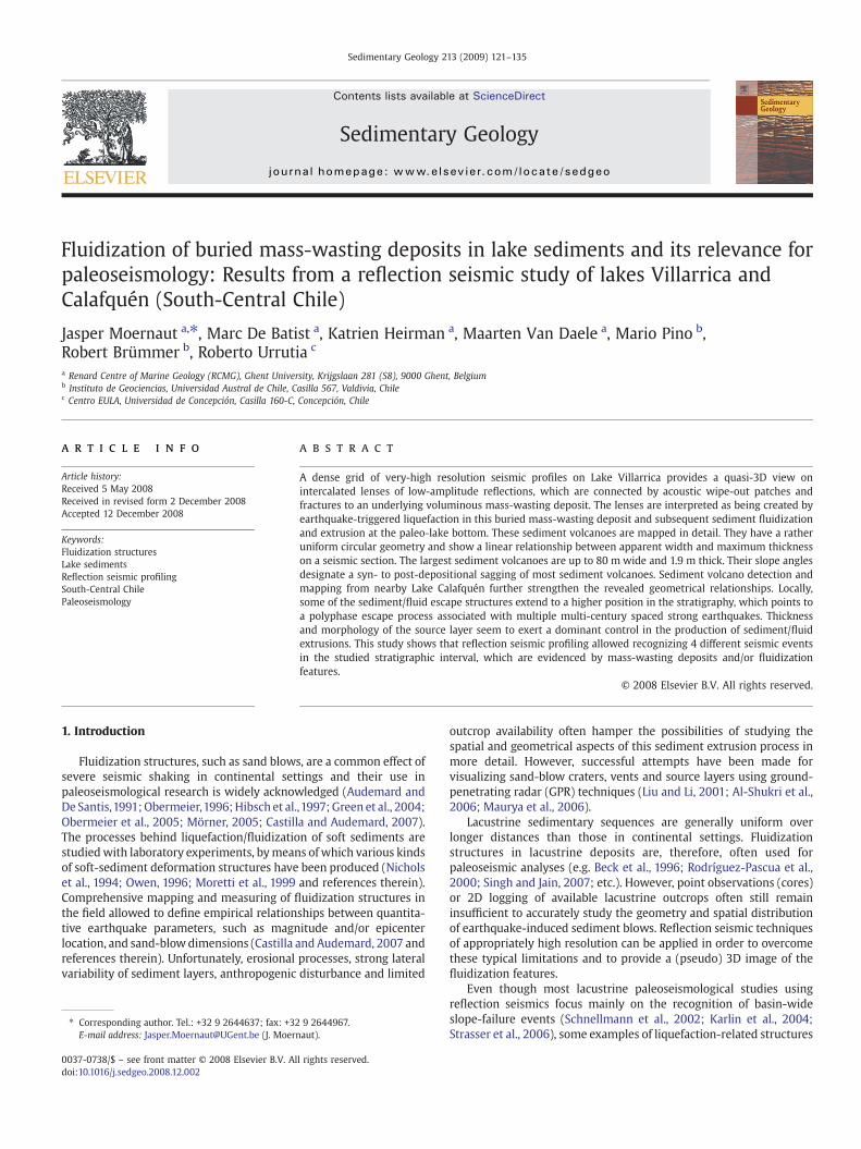
Fig. 1. Morphological setting of Lake Villarrica and Lake Calafquén. Lake surrounding topolocations (“Llanquihue” moraine belt) based on Laugenie (1982). Lahar pathways derived fr10 m. Deepest part: 167 m below lake level (based on SHOA, 1987). Lake Calafquén: Bathymedataset. Deepest part: 212 m below lake level. Inset figure: location of the study area in Sou
In the present study, we will illustrate the application of closely-spaced very-high-resolution reflection seismic profiles for the analysisof fluidization structures in the lacustrine infill of Lake Villarrica inSouth-Central Chile. We will further discuss and document the origin,geometry and spatial distribution of these structures as well as theirpaleoseismological implications, and we will compare them withsimilar structures in the subsurface of nearby Lake Calafquén.
2. Study area
Lake Villarrica and Lake Calafquén (resp. 39.25°S; 214 masl and39.55°S; 204 masl) are large glacigenic lakes (ca. 20×10/5 km)located at the foot of the Cordillera de los Andes. The lake basinsoriginated from glacial valley overdeepening and the formation oflarge frontal moraine ridges during the Late Quaternary glaciations(Laugenie, 1982). The landscape around the lakes is dominated by
graphy derived from SRTM data. Slope shader illumination from the North. Moraineom Laugenie (1982) and satellite pictures. Lake Villarrica: Bathymetric contours everytric contours every 20 m, derived from Volland et al. (2007) combined with our seismicth-Central Chile.
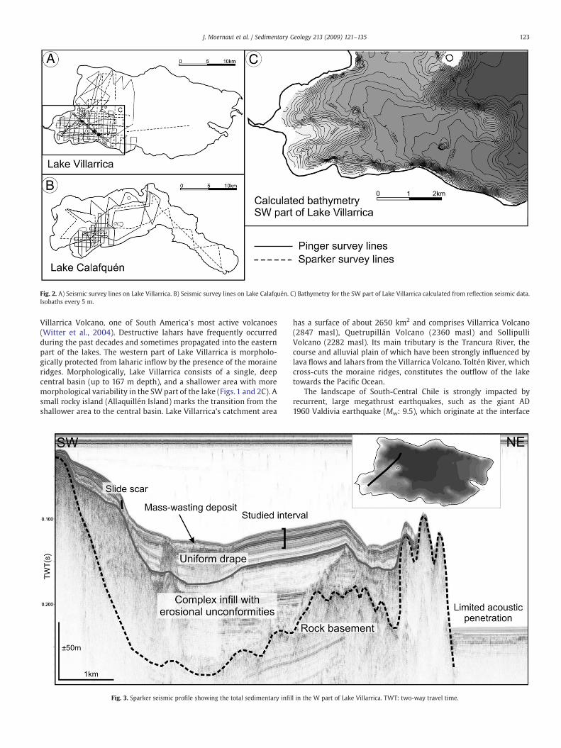
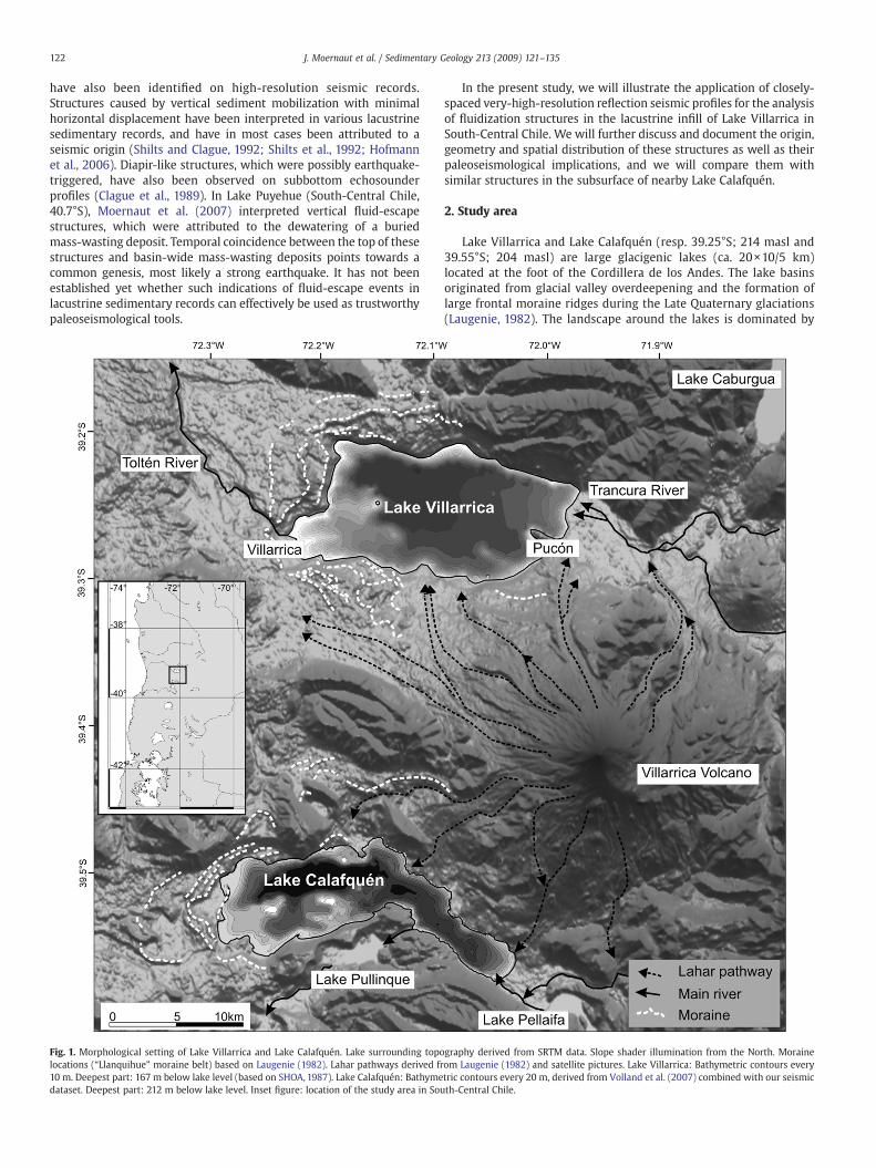
Fig. 2. A) Seismic survey lines on Lake Villarrica. B) Seismic survey lines on Lake Calafquén. C) Bathymetry for the SW part of Lake Villarrica calculated from reflection seismic data.Isobaths every 5 m.
123J. Moernaut et al. / Sedimentary Geology 213 (2009) 121–135
Villarrica Volcano, one of South America's most active volcanoes(Witter et al., 2004). Destructive lahars have frequently occurredduring the past decades and sometimes propagated into the easternpart of the lakes. The western part of Lake Villarrica is morpholo-gically protected from laharic inflow by the presence of the moraineridges. Morphologically, Lake Villarrica consists of a single, deepcentral basin (up to 167 m depth), and a shallower area with moremorphological variability in the SW part of the lake (Figs. 1 and 2C). Asmall rocky island (Allaquillén Island) marks the transition from theshallower area to the central basin. Lake Villarrica's catchment area
Fig. 3. Sparker seismic profile showing the total sedimentary infil
has a surface of about 2650 km2 and comprises Villarrica Volcano(2847 masl), Quetrupillán Volcano (2360 masl) and SollipulliVolcano (2282 masl). Its main tributary is the Trancura River, thecourse and alluvial plain of which have been strongly influenced bylava flows and lahars from the Villarrica Volcano. Toltén River, whichcross-cuts the moraine ridges, constitutes the outflow of the laketowards the Pacific Ocean.
The landscape of South-Central Chile is strongly impacted byrecurrent, large megathrust earthquakes, such as the giant AD1960 Valdivia earthquake (Mw: 9.5), which originate at the interface
l in the W part of Lake Villarrica. TWT: two-way travel time.
124 J. Moernaut et al. / Sedimentary Geology 213 (2009) 121–135
between the subducting Nazca Plate and the overlying SouthAmerican Plate. Seismic ground-shaking reached a Modified MercalliIntensity of VII to XI in the Chilean Lake District (Duke and Leeds,1963), triggered numerous landslides, both subaerially as suba-queously (Wright and Mella, 1963; Chapron et al., 2006; Moernautet al., 2007) and caused widespread infrastructural damage due toliquefaction of susceptible soils (Duke and Leeds, 1963). Historicalevidence and paleoseismological studies in South-Central Chilerevealed that several earthquakes with strength comparable to theone in AD 1960 occurred throughout the Holocene with a century tomulti-century recurrence interval (Lomnitz, 2004; Cisternas et al.,2005; Moernaut et al., 2007; Blumberg et al., 2008; Behrmann et al.,2008).
3. Methods
Reflection seismic surveys with a high-resolution CENTIPEDEsparker and very-high resolution GEOPULSE subbottom profiler
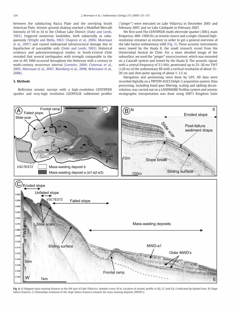
Fig. 4. A) Mapped mass-wasting features in the SW part of Lake Villarrica. Isobaths every 10failure features. C) Downslope evolution of the slope failure features towards the mass-was
(“pinger”) were executed on Lake Villarrica in December 2001 andFebruary 2007, and on Lake Calafquén in February 2007.
We first used The CENTIPEDE multi-electrode sparker (300 J, mainfrequency: 400–1500 Hz) as seismic source and a single-channel high-resolution streamer as receiver in order to get a general overview ofthe lake basins sedimentary infill (Fig. 3). These acoustic instrumentswere towed by the Huala II, the small research vessel from theUniversidad Austral de Chile. For a more detailed image of thesubsurface, we used the “pinger” source/receiver, which was mountedon a Cataraft system and towed by the Huala II. The acoustic signal,with a central frequency of 3.5 kHz, penetrated up to 25–30 ms TWT(±20 m) of the sedimentary fill with a vertical resolution of about 15–20 cm and shot-point spacing of about 1–1.5 m.
Navigation and positioning were done by GPS. All data wererecorded digitally on a TRITON-ELICS Delph-2 acquisition system. Dataprocessing, including band-pass filtering, scaling and spiking decon-volution, was carried out on a LANDMARK ProMax system and seismicstratigraphic interpretation was done using SMT's Kingdom Suite
m. Location of seismic profile in (B), (C) and Fig. 6 indicated by dashed lines. B) Slopeting deposits (MWD's).
125J. Moernaut et al. / Sedimentary Geology 213 (2009) 121–135
package. Water and subsurface depths were calculated using a meanacoustic velocity of 1500 m/s.
The reconnaissance survey in 2001 showed that the deep basin ofLake Villarrica has a very limited acoustic penetration, possibly due togas blanking and/or the episodic supply of coarsematerial transportedby lahars and/or underflows originating at the main tributaries. Thepenetration in the shallower, SW part of the lake is much better(Fig. 3). Seismic data from this area reveal the presence of voluminousmass-wasting deposits with indications of vertical subsurface fluidand sediment mobilization (Fig. 4). For these reasons, the 2007 surveyfocused essentially on this SW region (Fig. 2A). The spacing betweenpinger seismic profiles during the 2007 survey was ~500 m, in orderto map the mass-wasting features. In 3 small areas an even denserpinger grid spacing of ~50 m was achieved (grid 1–3; Fig. 9), in anattempt to accurately map the subsurface sediment mobilizationstructures. The totality of seismic data (2001 and 2007) also allowed
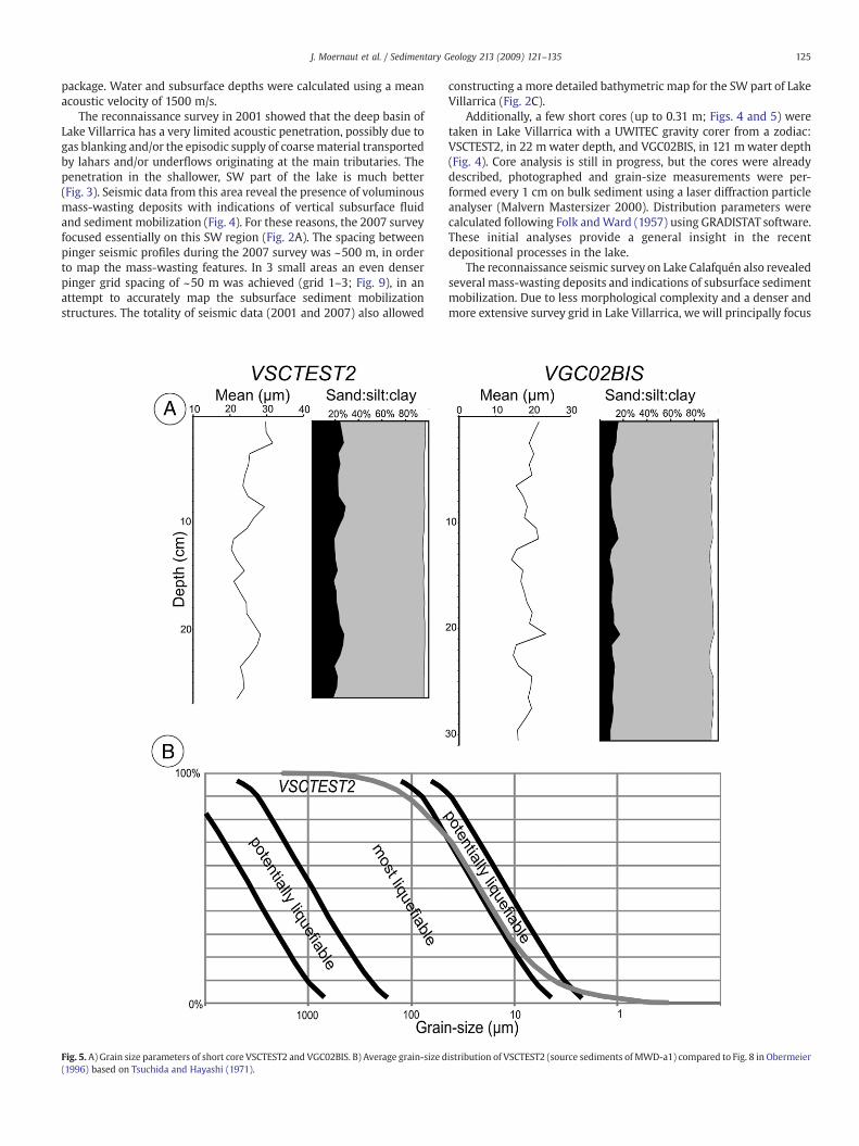
Fig. 5. A) Grain size parameters of short core VSCTEST2 and VGC02BIS. B) Average grain-size d(1996) based on Tsuchida and Hayashi (1971).
constructing a more detailed bathymetric map for the SW part of LakeVillarrica (Fig. 2C).
Additionally, a few short cores (up to 0.31 m; Figs. 4 and 5) weretaken in Lake Villarrica with a UWITEC gravity corer from a zodiac:VSCTEST2, in 22 mwater depth, and VGC02BIS, in 121 mwater depth(Fig. 4). Core analysis is still in progress, but the cores were alreadydescribed, photographed and grain-size measurements were per-formed every 1 cm on bulk sediment using a laser diffraction particleanalyser (Malvern Mastersizer 2000). Distribution parameters werecalculated following Folk andWard (1957) using GRADISTAT software.These initial analyses provide a general insight in the recentdepositional processes in the lake.
The reconnaissance seismic survey on Lake Calafquén also revealedseveral mass-wasting deposits and indications of subsurface sedimentmobilization. Due to less morphological complexity and a denser andmore extensive survey grid in Lake Villarrica, we will principally focus
istribution of VSCTEST2 (source sediments of MWD-a1) compared to Fig. 8 in Obermeier
126 J. Moernaut et al. / Sedimentary Geology 213 (2009) 121–135
our study on this lake, but we will use the data of Lake Calafquén forcomparison.
4. Results
4.1. General seismic stratigraphy, sediment characterization
The seismic sparker profiles image the entire lacustrine infill (100–150 m thick) in the SW part of Lake Villarrica, down to the rockbasement (Fig. 3). The uppermost seismic unit generally consists ofparallel and continuous reflectors with low-to-high reflection ampli-tudes, which are uniformly draped on top of i) an irregular basementmorphology and ii) a complex basin infill characterized by lateralseismic facies variability and major erosional unconformities. In thispaper, we will focus on the upper half of the uppermost seismic unitand, therefore, do not aim to establish a detailed seismic stratigraphyof the entire basin infill. Such a comprehensive study on the totalsedimentary infill should allow unraveling the evolution of thesedimentary environment in this glacigenic lake from the onset ofthe last deglaciation until the present (e.g. Charlet et al., 2008). Ingeneral, the lower seismic units are believed to have been rapidlydeposited in a sub- to pro-glacial environment, while the uppermostseismic unit has been deposited much more slowly (typicallysedimentation rate 0.5–1.5 mm/yr.; Bertrand et al., 2008b) in anopen, post-glacial lake. The timing of deglaciation of the southernChilean Lake District has been set around 17,500–17,150 cal a BP(McCulloch et al., 2000). However, the lacustrine record of LakePuyehue (40.7°S) indicates a significantly older timing of glacierretreat from the lake basin, i.e. around 24,750–28,000 cal a BP (Charletet al., 2008). This means that we cannot simply attribute an age to thelower limit of the uppermost seismic unit in Lake Villarrica, noraccurately estimate sedimentation rates from seismic stratigraphyalone.
Macroscopic observations and smear slide analysis on the shortcores show that the olive brown/gray sediments of VSCTEST2 andVGC02BIS are composed of biogenic particles (diatoms), organicmatter, amorphous clays, volcanic glasses and crystallized minerals. InVSCTEST2 (at 18–19 cm depth), a dark, fine sandy, tephra layer isdetected, within a fine matrix. Sediments in short core VGC02BIS aremacroscopically laminated while VSCTEST2 is homogeneous. Thegrain-size distribution of short core VSCTEST2 shows that it iscomposed of poorly sorted coarse silt with an average mean of25.0 µm. Average clay content (b2 µm) is 3.8% and average sandcontent (N63 µm) is 23.1%. VGC02BIS is also composed of poorly sortedsilts, but with a slightly lower mean of 18.3 µm. Average clay content(b2 µm) is 4.9% and average sand content (N63 µm) is 11.8%. The coresdisplay only limited variations in grain-size and lithogenic content(Fig. 5).
Due to the setting of Lake Villarrica in an area of active volcanism,intercalations of tephra deposits can be expected in the uppermostseismic unit (e.g. Lake Puyehue: Bertrand et al., 2008a,b), as shown bythe sandy tephra layer in core VSCTEST2. However, the seismic dataindicate that thick (N~0.5 m) sandy tephra layers are probably absentin the studied seismic-stratigraphic interval, because they would havetotally hampered seismic penetration of the 3.5 kHz seismic signal.
In analogy with studies on the seismic stratigraphy and sedimentcores of nearby Lake Puyehue (40.7°S; Charlet et al., 2008; Bertrandet al., 2008b), which exhibits a quite similar lake setting (i.e. Andespiedmont, nearby active volcano, frontal moraine belt in thewest), weinterpret the uppermost seismic unit as representing a post-glacialaccumulation of autochtonous lake sedimentation (suspension set-tling of mainly biogenic particles) when the glacier had alreadyretreated far into its catchment area. We will further use the term“background sedimentation” for both autochtonous lake sedimenta-tion and episodic, thin tephra layer deposition during the time intervalof the uppermost seismic unit.
4.2. Mass-wasting, sediment volcanoes and fluid escape
Seismic-stratigraphic analysis in Lake Villarrica reveals that lens-shaped sediment bodies with a characteristic transparent-to-chaoticseismic facies are present in the uppermost seismic unit (Figs. 3and 4). These lenses, which are up to 3 km long and 5 m thick, showupward-concave geometries and in downslope direction they wedgeout in between the continuous parallel-stratified reflectors of thisseismic unit. More upslope, abrupt and steep transitions occurbetween the transparent-to-chaotic facies of the lenses and thegenerally parallel-layered facies. These lenses bear all the typicalseismic characteristics of deposits resulting from the failure ofsubmerged lacustrine slopes, as described and sedimentologicallyground-truthed in several other studies (e.g. Schnellmann et al.,2005), and we therefore interpret them as lacustrine mass-wastingdeposits (MWD's).
Several of such mass-wasting deposits were identified in thewestern part of Lake Villarrica: i.e. MWD-a1, MWD-a2, MWD-a3 andMWD-b. Spatial mapping of MWD-a1 towards its upslope source areareveals that it resulted from the failure of an underwater slope (Fig. 4).This is evidenced by the identification of i) a 7-m-high scarp in theseismic stratigraphy and lake-floor morphology (i.e. the slide scar),locatedwhere the paleo-slope changes in slope angle from 0.2° to 2.3°,and of ii) a continuous high-amplitude reflector that correlates withthe base of the MWD (i.e. the basal sliding surface) (Fig. 4B). Bymapping the slide scar, we observed that it is located at water depthsthat range between 12 and 80 m, that it affects the lacustrinesediments of the uppermost seismic unit and that its most westwardpoint is located only 300 m east of Villarrica's marina. A step-up (indownslope direction) of the MWD's basal surface towards the paleo-lake bottom occurs at a water depth of 100 m (Fig. 4A/C). In map view,it shows a convex geometry and links up with the abovementionedslide scar. We therefore interpret this feature as a frontal rampstructure (e.g. Frey-Martinez et al., 2006).
The seismic data show that another voluminous mass-wastingdeposit, with associated slide scar and frontal ramp (MWD-a2) and asmall mass-wasting deposit (MWD-a3) are located at exactly the samestratigraphic level (L1) as MWD-a1. Together they constitute thesedimentary record of a mass-wasting event (MWE), which indicatesthat multiple slope failures (involving different segments of the lakeslopes) took place simultaneously. During this event, up to 9.9×10⁶m3
of entrained lacustrine sediments was deposited in these threeMWD's. Higher up in the stratigraphy, another mass-wasting deposit(MWD-b) with a volume of 1.0×10⁶ m3 occurs at stratigraphic level L3(Figs. 4A and 10B). Evidence for older MWD's is also found deeper inthe stratigraphy (e.g. Fig. 4C).
In conclusion, we interpret MWD-a1, MWD-a2 and MWD-b asfrontally emergent landslides (sensu Frey-Martinez et al., 2006), inwhich a sequence of sub-lacustrine slope sediments failed along abedding-parallel slip plane (up to 7° dip for MWD-a1), ramped out itsoriginal basal shear surface and flowed over the contemporaneouslake bottom following the steepest slope gradients on the paleo-lakefloor (0.5° dip for MWD-a1). Deposition (Mulder and Alexander, 2001)took place when the mass flow decelerated as it reached a lower slopegradient (0.2° for MWD-a1). Based on the grain-size data of theavailable short cores, we infer that –apart from occasional thin tephralayers– there are no major grain-size variations in the studiedseismic–stratigraphic interval. Considering the locations of the shortcores, we surmise that the composition and grain size of thesediments involved in the mass-flow deposit are probably comparableto those of short core VSCTEST2, although the failed sedimentarysequence is located at a deeper stratigraphic interval than the onesampled by the core. Therefore, we tentatively classify the MWD's assilty mud-flow deposits (Mulder and Alexander, 2001; Canals et al.,2004). However, since the exact transport mechanism of the massmovement is not known and downslope transformations could have
127J. Moernaut et al. / Sedimentary Geology 213 (2009) 121–135
taken place (Mulder and Alexander, 2001), we prefer to use the moregeneral term “mass-wasting deposit” in the present study.
In literature (e.g. Schnellmann et al., 2005), sediment cores in thedistal parts of lacustrine mass-wasting deposits typically show anamalgamation of both relatively small blocks of folded and remouldedstrata, and a more disintegrated mudclast conglomerate. These distalparts are commonly overlain by a turbidite, deposited from thesuspension cloud generated by mass-movement and/or associatedtsunami/seiche action.
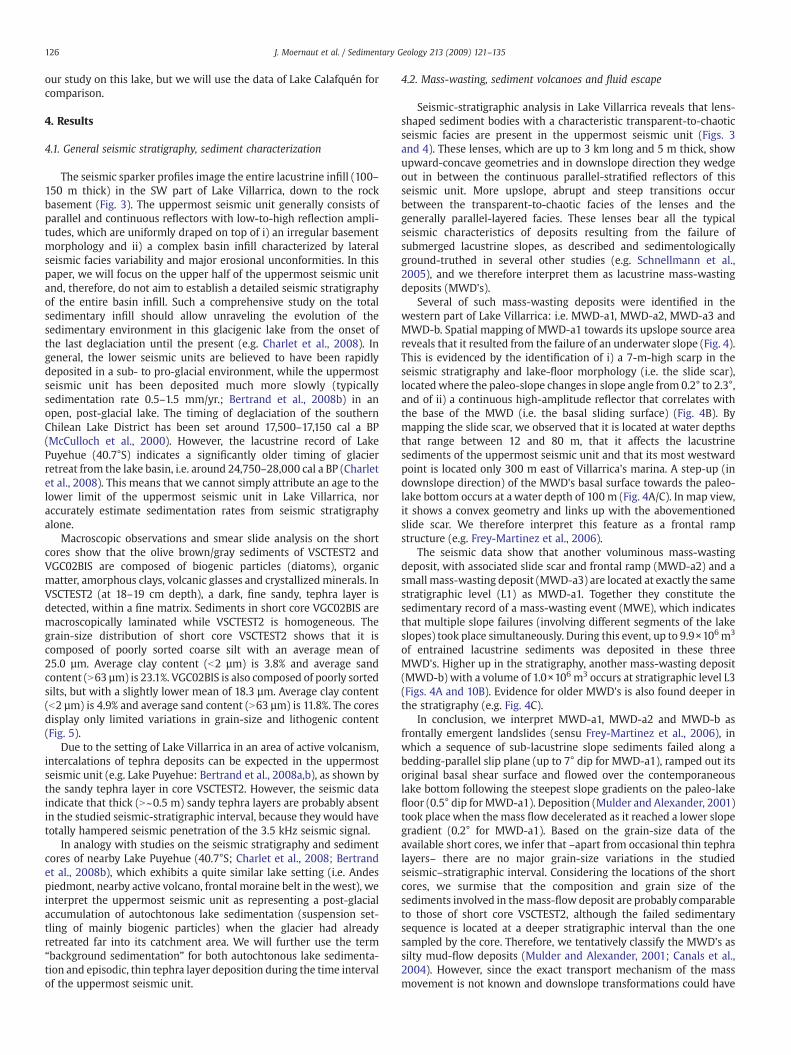
Remarkable is the occurrence of several decameter-scale lenses(Fig. 6) that appear to be emanating from the MWD's. These lenseshave a transparent to low-amplitude seismic facies and they occur atstratigraphic level L2. The lenses are connected to the underlyingMWD's trough transparent/low-amplitude patches in a 0.5-m-thickmedium- to high-amplitude layer with abundant low-offset sub-vertical faulting. The lenses are buried by a drape of continuous,parallel high-amplitude reflections, with locally reduced reflection
Fig. 6. Pinger profile showing mass-wasting deposit a1 (MWD-a1) with associated fluid/seescape features (wipe-out). L1 = stratigraphic level 1, etc.
amplitudes just above the lenses. The top of these amplitudewipe-outeffects is located at stratigraphic level L3.
We interpret these lenses as sediment volcanoes (or sedimentblows), which were induced by i) a sudden increase of pore-fluidpressure until liquefaction took place in the buried mass-wastingdeposit (i.e. the source layer), ii) subsequent hydraulic fracturation inthe overlying drape of background sedimentation with/without amass-wasting-associated turbidite at its base (i.e. the cap layer), iii)sediment fluidization and iv) extrusion at the contemporaneous lakebed (i.e. stratigraphic level L2). We will strengthen this interpretationin the next paragraphs through detailed mapping and measuring ofthese sediment volcanoes and the source layer. The acoustic wipe-outpatches are interpreted to represent traces of fluid migration withoutsediment expulsion (e.g. Chapron et al., 2004) through a hydraulicallyfractured drape of background sedimentation above the sedimentvolcanoes. This second phase of fluid expulsion also occurred as asingle event, i.e. at stratigraphic level L3.
diment escape features. Zooms: detailed visualization of sediment volcanoes and fluid
128 J. Moernaut et al. / Sedimentary Geology 213 (2009) 121–135
4.3. Geometry of sediment volcanoes
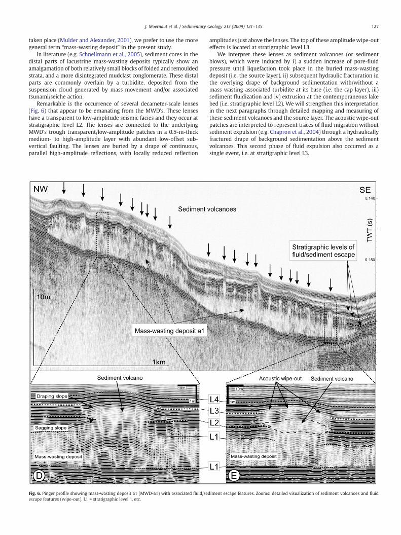
The maximum thickness and apparent width of all sedimentvolcanoes were measured on the seismic profiles (in 2D) (Fig. 8A).Most volcanoes have a width of 10–50 m and a thickness of 0.2–1.6 m,but volcanoes up to 80 m wide and 1.9 m thick were also identified.Volcanoes which are less than 0.2 m thick fall below the verticalresolution of the seismic images. Using densely spaced seismicprofiles (Fig. 9), we managed to map the full geometry of individualvolcanoes (in pseudo-3D). They form circular or slightly elongatedstructures. Fig. 8A shows that a clear linear relationship existsbetween the apparent width and maximum thickness of thevolcanoes on a 2D cross-section. This correlation is further strength-ened by integrating the maximum thickness and diameter measure-ments on the volcanoes mapped in pseudo-3D.
Similar measurements on sediment volcanoes observed on seismicprofiles from nearby Lake Calafquén (Figs. 1, 7 and 8C) also reveal aclear linear trend between apparent width and maximum thickness.Moreover, the trend lines of the Lake Villarrica and the Lake Calafquénsediment volcanoes have a very similar slope value (Villarrica: 0.0232versus Calafquén: 0.0233) and intersect near (0;0).
The slope values (Fig. 8C–D) of the sediment strata directly above(i.e. the draping sediments) and underneath (i.e. the breachedsediments) the outer edges of the sediment volcanoes were alsomeasured. We observe that the upper limit of a volcano with a flatbase has a ~3° slope at its outer edges. A negative linear relationship isrevealed between these slope values, but with noteworthy scatter,possibly due to the measurement accuracy. Measurements onsediment volcanoes in Lake Calafquén also indicate this negativelinear trend, but with a slightly steeper trend-line slope (Villarrica:−1.3824 versus Calafquén: −1.4658). We will discuss these linearrelationships below.
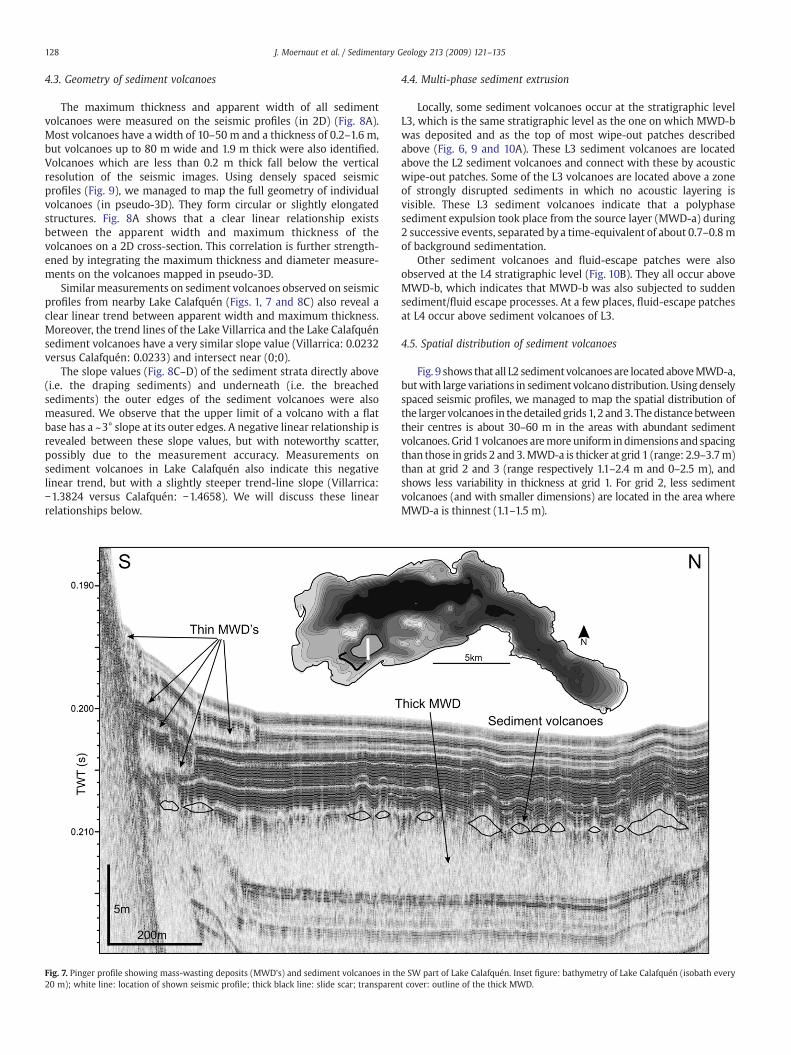
Fig. 7. Pinger profile showing mass-wasting deposits (MWD's) and sediment volcanoes in th20 m); white line: location of shown seismic profile; thick black line: slide scar; transparen
4.4. Multi-phase sediment extrusion
Locally, some sediment volcanoes occur at the stratigraphic levelL3, which is the same stratigraphic level as the one on which MWD-bwas deposited and as the top of most wipe-out patches describedabove (Fig. 6, 9 and 10A). These L3 sediment volcanoes are locatedabove the L2 sediment volcanoes and connect with these by acousticwipe-out patches. Some of the L3 volcanoes are located above a zoneof strongly disrupted sediments in which no acoustic layering isvisible. These L3 sediment volcanoes indicate that a polyphasesediment expulsion took place from the source layer (MWD-a) during2 successive events, separated by a time-equivalent of about 0.7–0.8mof background sedimentation.
Other sediment volcanoes and fluid-escape patches were alsoobserved at the L4 stratigraphic level (Fig. 10B). They all occur aboveMWD-b, which indicates that MWD-b was also subjected to suddensediment/fluid escape processes. At a few places, fluid-escape patchesat L4 occur above sediment volcanoes of L3.
4.5. Spatial distribution of sediment volcanoes
Fig. 9 shows that all L2 sedimentvolcanoes are located aboveMWD-a,butwith large variations in sediment volcanodistribution. Usingdenselyspaced seismic profiles, we managed to map the spatial distribution ofthe larger volcanoes in thedetailedgrids 1, 2 and3. Thedistancebetweentheir centres is about 30–60 m in the areas with abundant sedimentvolcanoes. Grid 1 volcanoes aremore uniform indimensions and spacingthan those in grids 2 and 3.MWD-a is thicker at grid 1 (range: 2.9–3.7m)than at grid 2 and 3 (range respectively 1.1–2.4 m and 0–2.5 m), andshows less variability in thickness at grid 1. For grid 2, less sedimentvolcanoes (and with smaller dimensions) are located in the area whereMWD-a is thinnest (1.1–1.5 m).
e SW part of Lake Calafquén. Inset figure: bathymetry of Lake Calafquén (isobath everyt cover: outline of the thick MWD.
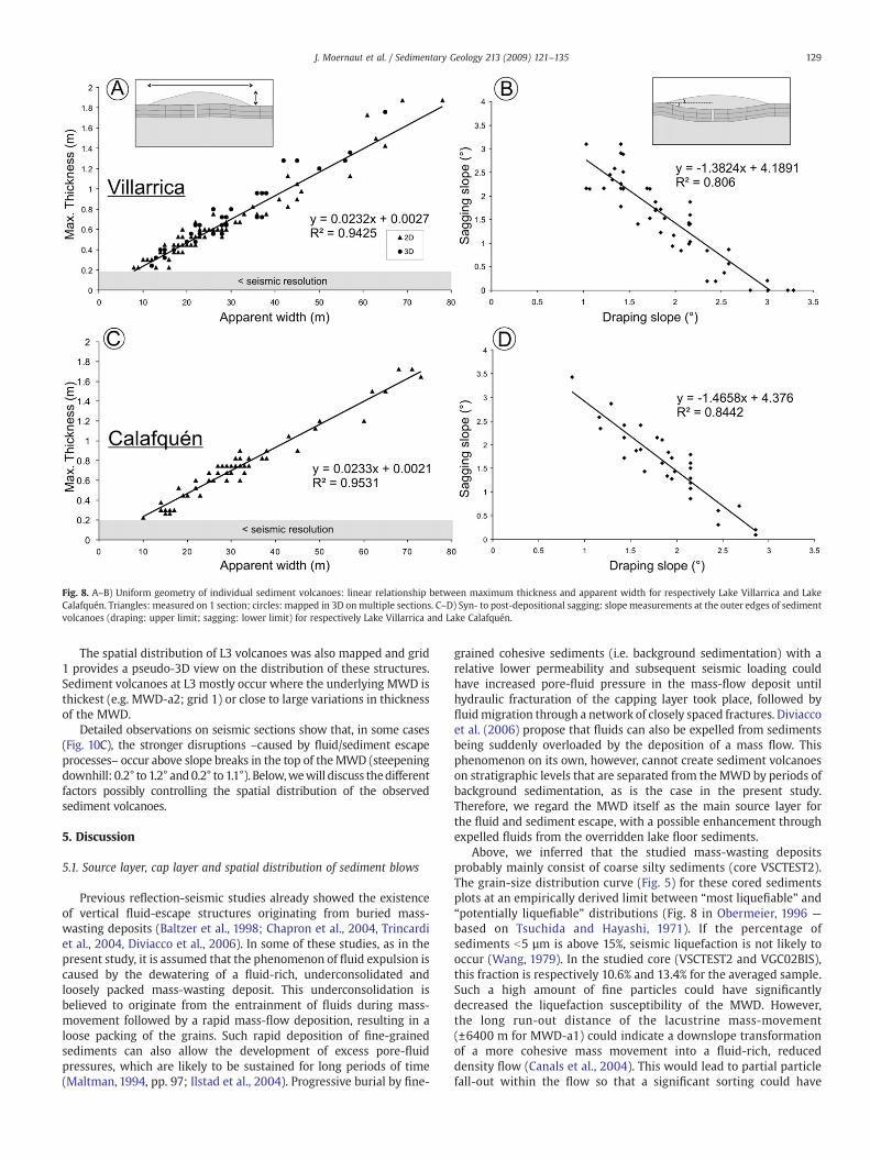
Fig. 8. A–B) Uniform geometry of individual sediment volcanoes: linear relationship between maximum thickness and apparent width for respectively Lake Villarrica and LakeCalafquén. Triangles: measured on 1 section; circles: mapped in 3D onmultiple sections. C–D) Syn- to post-depositional sagging: slope measurements at the outer edges of sedimentvolcanoes (draping: upper limit; sagging: lower limit) for respectively Lake Villarrica and Lake Calafquén.
129J. Moernaut et al. / Sedimentary Geology 213 (2009) 121–135
The spatial distribution of L3 volcanoes was also mapped and grid1 provides a pseudo-3D view on the distribution of these structures.Sediment volcanoes at L3 mostly occur where the underlying MWD isthickest (e.g. MWD-a2; grid 1) or close to large variations in thicknessof the MWD.
Detailed observations on seismic sections show that, in some cases(Fig. 10C), the stronger disruptions –caused by fluid/sediment escapeprocesses– occur above slope breaks in the top of theMWD (steepeningdownhill: 0.2° to 1.2° and0.2° to 1.1°). Below,wewill discuss thedifferentfactors possibly controlling the spatial distribution of the observedsediment volcanoes.
5. Discussion
5.1. Source layer, cap layer and spatial distribution of sediment blows
Previous reflection-seismic studies already showed the existenceof vertical fluid-escape structures originating from buried mass-wasting deposits (Baltzer et al., 1998; Chapron et al., 2004, Trincardiet al., 2004, Diviacco et al., 2006). In some of these studies, as in thepresent study, it is assumed that the phenomenon of fluid expulsion iscaused by the dewatering of a fluid-rich, underconsolidated andloosely packed mass-wasting deposit. This underconsolidation isbelieved to originate from the entrainment of fluids during mass-movement followed by a rapid mass-flow deposition, resulting in aloose packing of the grains. Such rapid deposition of fine-grainedsediments can also allow the development of excess pore-fluidpressures, which are likely to be sustained for long periods of time(Maltman, 1994, pp. 97; Ilstad et al., 2004). Progressive burial by fine-
grained cohesive sediments (i.e. background sedimentation) with arelative lower permeability and subsequent seismic loading couldhave increased pore-fluid pressure in the mass-flow deposit untilhydraulic fracturation of the capping layer took place, followed byfluidmigration through a network of closely spaced fractures. Diviaccoet al. (2006) propose that fluids can also be expelled from sedimentsbeing suddenly overloaded by the deposition of a mass flow. Thisphenomenon on its own, however, cannot create sediment volcanoeson stratigraphic levels that are separated from the MWD by periods ofbackground sedimentation, as is the case in the present study.Therefore, we regard the MWD itself as the main source layer forthe fluid and sediment escape, with a possible enhancement throughexpelled fluids from the overridden lake floor sediments.
Above, we inferred that the studied mass-wasting depositsprobably mainly consist of coarse silty sediments (core VSCTEST2).The grain-size distribution curve (Fig. 5) for these cored sedimentsplots at an empirically derived limit between “most liquefiable” and“potentially liquefiable” distributions (Fig. 8 in Obermeier, 1996 —
based on Tsuchida and Hayashi, 1971). If the percentage ofsediments b5 µm is above 15%, seismic liquefaction is not likely tooccur (Wang, 1979). In the studied core (VSCTEST2 and VGC02BIS),this fraction is respectively 10.6% and 13.4% for the averaged sample.Such a high amount of fine particles could have significantlydecreased the liquefaction susceptibility of the MWD. However,the long run-out distance of the lacustrine mass-movement(±6400 m for MWD-a1) could indicate a downslope transformationof a more cohesive mass movement into a fluid-rich, reduceddensity flow (Canals et al., 2004). This would lead to partial particlefall-out within the flow so that a significant sorting could have
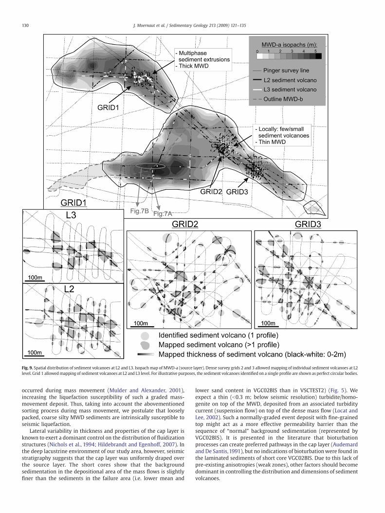
Fig. 9. Spatial distribution of sediment volcanoes at L2 and L3. Isopachmap of MWD-a (source layer). Dense survey grids 2 and 3 allowedmapping of individual sediment volcanoes at L2level. Grid 1 allowedmapping of sediment volcanoes at L2 and L3 level. For illustrative purposes, the sediment volcanoes identified on a single profile are shown as perfect circular bodies.
130 J. Moernaut et al. / Sedimentary Geology 213 (2009) 121–135
occurred during mass movement (Mulder and Alexander, 2001),increasing the liquefaction susceptibility of such a graded mass-movement deposit. Thus, taking into account the abovementionedsorting process during mass movement, we postulate that looselypacked, coarse silty MWD sediments are intrinsically susceptible toseismic liquefaction.
Lateral variability in thickness and properties of the cap layer isknown to exert a dominant control on the distribution of fluidizationstructures (Nichols et al., 1994; Hildebrandt and Egenhoff, 2007). Inthe deep lacustrine environment of our study area, however, seismicstratigraphy suggests that the cap layer was uniformly draped overthe source layer. The short cores show that the backgroundsedimentation in the depositional area of the mass flows is slightlyfiner than the sediments in the failure area (i.e. lower mean and
lower sand content in VGC02BIS than in VSCTEST2) (Fig. 5). Weexpect a thin (b0.3 m; below seismic resolution) turbidite/homo-genite on top of the MWD, deposited from an associated turbiditycurrent (suspension flow) on top of the dense mass flow (Locat andLee, 2002). Such a normally-graded event deposit with fine-grainedtop might act as a more effective permeability barrier than thesequence of “normal” background sedimentation (represented byVGC02BIS). It is presented in the literature that bioturbationprocesses can create preferred pathways in the cap layer (Audemardand De Santis, 1991), but no indications of bioturbationwere found inthe laminated sediments of short core VGC02BIS. Due to this lack ofpre-existing anisotropies (weak zones), other factors should becomedominant in controlling the distribution and dimensions of sedimentvolcanoes.
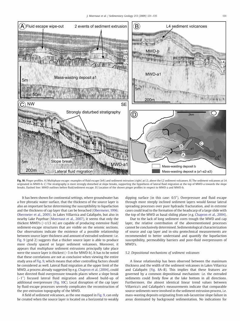
Fig. 10. Pinger profiles. A) Multiphase escape: examples of fluid escape (left) and sediment extrusion (right) at L3, above the L2 sediment volcanoes. B) The sediment volcanoes at L4originated in MWD-b. C) The stratigraphy is most strongly disturbed at slope breaks, supporting the hypothesis of lateral fluid migration at the top of MWD-a towards the slopebreaks. Dashed line: MWD outlines before fluid/sediment escape. D) Location of the shown pinger profiles in respect to MWD-a and MWD-b.
131J. Moernaut et al. / Sedimentary Geology 213 (2009) 121–135
It has been shown for continental settings, where groundwater hasa free phreatic water surface, that the thickness of the source layer isalso an important factor determining the susceptibility to liquefactionand the thickness of cap layer that can be breached (Obermeier, 1996;Obermeier et al., 2005). In Lakes Villarrica and Calafquén, but also innearby Lake Puyehue (Moernaut et al., 2007), it seems that only thethickest MWD's (N±1.5 m) are capable of producing extensive fluid/sediment-escape structures that are visible on the seismic sections.Our observations indicate the existence of a possible relationshipbetween source layer thickness and amount of extruded sediment: i.e.Fig. 9 (grid 2) suggests that a thicker source layer is able to producemore closely spaced or larger sediment volcanoes. Moreover, itappears that multiphase sediment extrusions principally take placewere the source layer is thickest (N3 m for MWD-b). It has to be notedthat these correlations are not as conclusive when viewing the entirestudy area of Fig. 9, which means that other controlling factors shouldbe considered as well. Lateral fluid migration at the upper limit of theMWD, a process already suggested by e.g. Chapron et al. (2004), couldhave directed fluid overpressure towards places where a slope break(~1°) focused lateral fluid migration and allowed build-up ofadditional overpressure (Fig. 10C). Local disruption of the cap layerby fluid-escape processes severely complicates the reconstruction ofthe pre-extrusion topography of the MWD.
A field of sediment volcanoes, as the onemapped in Fig. 9, can onlybe created when the source layer is located on a horizontal to weakly
dipping surface (in this case: 0.5°). Overpressure and fluid escapethrough more steeply inclined sediment layers would favour lateralspreading processes over pure hydraulic fracturation, and in extremecases could lead to the formation of the headscarp of a large slide withthe top of the MWD as basal sliding plane (e.g. Chapron et al., 2004).
Due to the lack of long sediment cores trough the MWD and caplayer, the relative contribution of the abovementioned processescannot be conclusively determined. Sedimentological characterizationof source and cap layer and in-situ geotechnical measurements arerecommended to better understand and quantify the liquefactionsusceptibility, permeability barriers and pore-fluid overpressures ofMWD's.
5.2. Depositional mechanisms of sediment volcanoes
A linear relationship has been observed between the maximumthickness and the width of the sediment volcanoes in Lakes Villarricaand Calafquén (Fig. 8A–B). This implies that these features aregoverned by a common depositional mechanism: i.e. the extrudedsediments could freely flow at the lake bottom in all directions.Furthermore, the almost identical linear trend values betweenVillarrica's and Calafquén's measurements indicate that comparablesource sediments were involved in the sediment extrusion process, i.e.mass-wasting deposits originating from sub-lacustrine slope failure inareas dominated by background sedimentation. No indications for
132 J. Moernaut et al. / Sedimentary Geology 213 (2009) 121–135
down-slope flow of the extruded sediments over the gently dipping(±0.5° in case of Lake Villarrica) paleo-lake bottom were found. Theuniform geometry of the sediment volcanoes eliminates the possibi-lity of sill-type emplacement of mobilized sediments (e.g. Obermeier,1996), which should result in much more geometrical variability.
The negative linear relationship between the slopes of theoverlying and underlying layers at the sediment volcano edges(Fig. 8C–D) can be interpreted as a result of sagging of the sedimentvolcanoes. Themore the cap layer collapses (increasing sagging slope),the less prominent the volcano can form a positive relief on the lakebottom (decreasing draping slope). Ourmeasurements indicate awiderange in the amount of sagging, from totally non-sagged structures toa sagging slope of 3°. However, the totally sagged end-member –witha horizontal upper surface– observed in the experiments of Nicholset al. (1994) was not detected in our data. We postulate that therevealed volcano sagging could be caused by the accumulatingextruded sediment load on the cap layer (Nichols et al., 1994) and/orby the created sediment deficit in the source layer near thefluidization conduits (Davies, 2003). Furthermore, the revealednegative trend provides information about the timing of sedimentvolcano sagging. If the sagging process occurred entirely after depo-sition, the slope of the trend line should be −1, i.e. passing troughpoints (3;0) (no collapse) and (0;3) (volcano build-up totally com-pensated by sagging). As most of the data points are located abovethis line, a significant amount of syn-depositional sagging must havetaken place during most sediment extrusions, instantly counter-acting the creation of positive relief on the contemporaneous lakefloor.
5.3. Earthquake triggering
Our data and seismic-stratigraphic analysis illustrate that a basin-wide event, involving multiple simultaneous underwater slope fail-ures, took place at the time of deposition of stratigraphic level L1. Theoccurrence of simultaneous slope failures in areas of undisturbedbackground sedimentation points towards a strong triggeringmechanism of regional importance. Taking into account South-CentralChile's record of historical and prehistorical giant earthquakes, it ismost likely that such mass-wasting events were triggered by strongseismic shaking, as was already proposed and discussed in detail forother lakes in the region (Chapron et al., 2006; Moernaut et al., 2007,Volland et al., 2007; Bertrand et al., 2008a). In these studies, otherpossible triggering mechanisms (e.g. rapid sedimentation, wave-action, lake-level fluctuations and sudden gas discharge) that couldcreate multiple coeval slope instabilities in the glacigenic lakes inSouth-Central Chile were carefully ruled out. Moreover, it wasdemonstrated that the recent most mass-wasting event in LakePuyehue (Moernaut et al., 2007), Lake Nahuel Huapi and ReloncaviFjord (Chapron et al., 2006) was induced by the well-known giant AD1960 earthquake.
Several arguments indicate that the fluid and sediment extrusionsdocumented in the present study were also triggered by earthquakeshaking:
- Most of the fluid escapes and sediment extrusions happenedduring distinct events (i.e. at stratigraphic levels L2, L3 and L4).This means that the upward-directed hydraulic forcewas suddenlyapplied and of short duration, and therefore that a strong andabrupt trigger was required.
- The escape structures are located at 100–120mwater depth, whicheliminates the possibility of wave-induced liquefaction (e.g. Sumeret al., 2006).
- The positive relief of the sediment volcanoes clearly differs fromthe concave crater-like depressions (pockmarks) commonly foundat oceanmargins and related to focused gas or liquid flow (Hovlandet al., 2002). This eliminates the possibility that the studied escape
structures in Lake Villarricawere created by episodes of sudden gasescape. Moreover, as the MWD's result from failed lacustrinesequences, there is no reason why they would have had a higherbiogenic gas content than sequences of background sediments.
- We found no indications for sudden gravity loading of the sourcelayer as potential trigger for liquefaction (e.g. Moretti et al., 2001).The source layer is draped by a laterally uniform sequence ofbackground sediments with/without turbidite at the base, inwhichwe do not expect strong lateral variations in density. However, therapid deposition of MWD-b (up to 3 m thick) could have locallyincreased pore-water pressures in MWD-a1, enhancing theliquefaction/fluidization processes. However, there are no clearindications in the spatial pattern and dimensions of sedimentvolcanoes to support this (Fig. 9). Moreover, MWD-b depositiondid not take place above MWD-a2, although most L3 (=level ofMWD-b) sediment volcanoes have been mapped above MWD-a2.
- The deposition of MWD-b, the formation of some of the sedimentvolcanoes and the fluid escape processes took place at the sametime, i.e. at stratigraphic level L3, which indicates a commontriggering mechanism, affecting these deposits at a basin-widescale.
Earlier paleoseismological studies already postulated that aModified Mercalli Intensity (MMI) of VII is the lower limit at whichliquefaction becomes a common phenomenon, both in continental(Obermeier, 1996) and in lacustrine (Monecke et al., 2004) settings.Reported damage and effects caused by the AD 1960 Valdiviaearthquake show that such megathrust earthquakes are capable ofgenerating MMI values greater than VII, even at more than 100 kmdistance from the rupture plane. Such earthquakes have a longduration of shaking, high values of ground acceleration, and moreenergy in the low-frequency spectrum. These are all factors thatfavour the creation of excess pore-water pressure in susceptiblesediments, which can lead to liquefaction (Leynaud et al., 2004;Biscontin and Pestana, 2006). Giant megathrust earthquakes, such ase.g. the 1964 Cascadia earthquake (Mw: 9.2), are known to haveliquefied beds that are as shallow as 0.5 m subsurface (~comparable tothis paper), and gave rise to abundant and large fluidization structures(Obermeier, 1996).
More local earthquakes, such as continental-crust earthquakes(Barrientos and Acevedo-Aranguiz, 1992) or intra-subducting slabearthquakes (Beck et al., 1998), should also not be excluded yet as apotential liquefaction trigger, although no such events have beenhistorically reported near Lake Villarrica. Dating and correlatinglacustrine paleoseismological records from a wide latitudinal rangeshould allow discerning between local or megathrust earthquakes asthe triggering mechanism of sub-lacustrine liquefaction and slopefailures.
5.4. Multi-phase fluid/sediment escape and paleoseismologicalimplications
Our seismic data indicate that two events of sediment extrusiontook place (i.e. at stratigraphic levels L2 and L3) with MWD-a assource layer, and that the L3 sediment extrusions were located abovethe buried sediment volcanoes of L2. In continental settings,paleoliquefaction studies and historical reports show that liquefac-tion has a strong tendency to reappear at the same location and canrepeatedly use the same conduit for fluid/sediment venting (Ober-meier, 1996). This process has been studied in detail in laboratorytests (e.g. Oda et al., 2001). We postulate that during a newearthquake, at the time of deposition of stratigraphic level L3,reliquefaction of the source layer took place and that previously-created fluid-escape fractures and sediment volcanoes acted aspreferential pathways for focused fluid flow. This explains why mostwipe-out patches at stratigraphic level L3 are located above buried
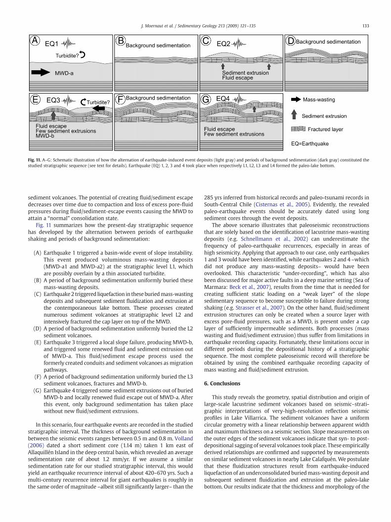
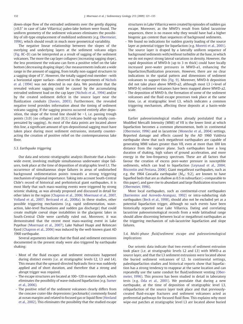
Fig. 11. A–G: Schematic illustration of how the alternation of earthquake-induced event deposits (light gray) and periods of background sedimentation (dark gray) constituted thestudied stratigraphic sequence (see text for details). Earthquake (EQ) 1, 2, 3 and 4 took place when respectively L1, L2, L3 and L4 formed the paleo-lake bottom.
133J. Moernaut et al. / Sedimentary Geology 213 (2009) 121–135
sediment volcanoes. The potential of creating fluid/sediment escapedecreases over time due to compaction and loss of excess pore-fluidpressures during fluid/sediment-escape events causing the MWD toattain a “normal” consolidation state.
Fig. 11 summarizes how the present-day stratigraphic sequencehas developed by the alternation between periods of earthquakeshaking and periods of background sedimentation:
(A) Earthquake 1 triggered a basin-wide event of slope instability.This event produced voluminous mass-wasting deposits(MWD-a1 and MWD-a2) at the stratigraphic level L1, whichare possibly overlain by a thin associated turbidite.
(B) A period of background sedimentation uniformly buried thesemass-wasting deposits.
(C) Earthquake2 triggered liquefaction in theseburiedmass-wastingdeposits and subsequent sediment fluidization and extrusion atthe contemporaneous lake bottom. These processes creatednumerous sediment volcanoes at stratigraphic level L2 andintensively fractured the cap layer on top of the MWD.
(D) A period of background sedimentation uniformly buried the L2sediment volcanoes.
(E) Earthquake 3 triggered a local slope failure, producing MWD-b,and triggered some renewed fluid and sediment extrusion outof MWD-a. This fluid/sediment escape process used theformerly created conduits and sediment volcanoes as migrationpathways.
(F) A period of background sedimentation uniformly buried the L3sediment volcanoes, fractures and MWD-b.
(G) Earthquake 4 triggered some sediment extrusions out of buriedMWD-b and locally renewed fluid escape out of MWD-a. Afterthis event, only background sedimentation has taken placewithout new fluid/sediment extrusions.
In this scenario, four earthquake events are recorded in the studiedstratigraphic interval. The thickness of background sedimentation inbetween the seismic events ranges between 0.5 m and 0.8 m. Volland(2006) dated a short sediment core (1.14 m) taken 1 km east ofAllaquillén Island in the deep central basin, which revealed an averagesedimentation rate of about 1.2 mm/yr. If we assume a similarsedimentation rate for our studied stratigraphic interval, this wouldyield an earthquake recurrence interval of about 420–670 yrs. Such amulti-century recurrence interval for giant earthquakes is roughly inthe same order of magnitude –albeit still significantly larger– than the
285 yrs inferred from historical records and paleo-tsunami records inSouth-Central Chile (Cisternas et al., 2005). Evidently, the revealedpaleo-earthquake events should be accurately dated using longsediment cores through the event deposits.
The above scenario illustrates that paleoseismic reconstructionsthat are solely based on the identification of lacustrine mass-wastingdeposits (e.g. Schnellmann et al., 2002) can underestimate thefrequency of paleo-earthquake recurrences, especially in areas ofhigh seismicity. Applying that approach to our case, only earthquakes1 and 3would have been identified, while earthquakes 2 and 4 –whichdid not produce any mass-wasting deposits– would have beenoverlooked. This characteristic “under-recording”, which has alsobeen discussed for major active faults in a deep marine setting (Sea ofMarmara: Beck et al., 2007), results from the time that is needed forcreating sufficient static loading on a “weak layer” of the slopesedimentary sequence to become susceptible to failure during strongshaking (e.g. Strasser et al., 2007). On the other hand, fluid/sedimentextrusion structures can only be created when a source layer withexcess pore-fluid pressures, such as a MWD, is present under a caplayer of sufficiently impermeable sediments. Both processes (masswasting and fluid/sediment extrusion) thus suffer from limitations inearthquake recording capacity. Fortunately, these limitations occur indifferent periods during the depositional history of a stratigraphicsequence. The most complete paleoseismic record will therefore beobtained by using the combined earthquake recording capacity ofmass wasting and fluid/sediment extrusion.
6. Conclusions
This study reveals the geometry, spatial distribution and origin oflarge-scale lacustrine sediment volcanoes based on seismic–strati-graphic interpretations of very-high-resolution reflection seismicprofiles in Lake Villarrica. The sediment volcanoes have a uniformcircular geometry with a linear relationship between apparent widthandmaximum thickness on a seismic section. Slope measurements onthe outer edges of the sediment volcanoes indicate that syn- to post-depositional sagging of several volcanoes took place. These empiricallyderived relationships are confirmed and supported by measurementson similar sediment volcanoes in nearby Lake Calafquén.We postulatethat these fluidization structures result from earthquake-inducedliquefaction of an underconsolidated buriedmass-wasting deposit andsubsequent sediment fluidization and extrusion at the paleo-lakebottom. Our results indicate that the thickness and morphology of the
134 J. Moernaut et al. / Sedimentary Geology 213 (2009) 121–135
source layer exert a dominant control on the dimensions and spatialdistribution of sediment volcanoes, and illustrate the ability of thesource layer to re-liquefy during multiple earthquake events.
Widespread fluid-escape features were also identified. Togetherwith the mass-wasting deposits and the sediment volcanoes, theyrepresent the sedimentary record of 4 paleoseismic events in thestudied stratigraphic interval. This study indicates that fluidizationstructures can be used as an additional paleoseismological tool. Theseprovide the possibility to extract paleoseismic information from thelacustrine sedimentary archive for periods following an earlier eventof earthquake-induced slope instability, when the generation of a newslope failure by seismic shaking is unlikely.
Sedimentological ground-truthing, in-situ geotechnical measure-ments and further detailed mapping –also in other types of lacustrineenvironments– is required in order to better understand the processesgoverning such large-scale lacustrine fluidization structures, and toeffectively link them to well-documented historical earthquakes toexamine if they can be used for (semi-) quantitative paleoseismolo-gical analysis.
Acknowledgments
We thank Alejandro Peña and Koen De Rycker for their logistic andtechnical support during the seismic surveys of 2001 and 2007. Wethank François Charlet and Emmanuel Chapron for their contributionduring the seismic survey in 2001. We thank Willem Vandoorne fordigitizing the bathymetric map of Lake Villarrica. This work wasfinancially supported by the Special Research Fund of the UniversiteitGent, through a 4-year research project and a project of bilateralscientific cooperation with Chile. Jasper Moernaut acknowledges thesupport of the Institute for the Promotion of Innovation throughScience and Technology in Flanders (IWT-Vlaanderen) and KatrienHeirman and Maarten Van Daele of the Fund for Scientific Research ofFlanders (FWO-Vlaanderen). The contributions of Mario Pino andRoberto Urrutia were respectively supported by the Chilean projectsFORECOS P04-065F from the Millennium Initiative (MIDEPLAN) andFONDECYT No. 1070508.
References
Al-Shukri, H.J., Mahdi, H.H., Tuttle, M., 2006. Three-dimensional imaging of earthquake-induced liquefaction features with ground penetrating radar near Marianna,Arkansas. Seismological Research Letters 77, 505–513.
Audemard, F.A., De Santis, F., 1991. Survey of liquefaction structures induced by recentmoderate earthquakes. Bulletin of the International Association of EngineeringGeology 44, 5–16.
Baltzer, A., Holmes, R., Evans, D., 1998. Debris flows on the Sula Sgeir Fan, NW ofScotland. In: Stoker, M.S., Evans, D., Cramp, A. (Eds.), Geological Processes onContinental Margins: Sedimentation, Mass-Wasting and Stability. GeologicalSociety of London Special Publication, vol. 129, pp. 105–115.
Barrientos, S.E., Acevedo-Aranguiz, P.S., 1992. Seismological aspects of the 1988–1989Lonquimay (Chile) volcanic eruption. Journal of Volcanology and GeothermalResearch 53, 73–87.
Beck, S., Barrientos, S., Kausel, E., Reyes, M., 1998. Source characteristics of historicearthquakes along the central Chile subduction zone. Journal of South AmericanEarth Sciences 11 (2), 115–129.
Beck, C., Manalt, F., Chapron, E., Van Rensbergen, P., De Batist, M., 1996. Enhancedseismicity in the early post-glacial period: evidence from the post-Würmsediments of Lake Annecy, northwestern Alps. Journal of Geodynamics 22, 155–171.
Beck, C., Mercier de Lépinay, B., Schneider, J.-L., Cremer, M., Çağatay, N., Wendenbaum,E., Boutareaud, S., Ménot-Combes, G., Schmidt, S., Weber, O., Eris, K., Armijo, R.,Meyer, B., Pondard, N., Labeyrie, L., Cortijo, E., Turon, J.-L., Malavielle, J., Dominguez,S., Gutscher, M.-A., 2007. Late Quaternary co-seismic sedimentation in the Sea ofMarmara's deep basins. In: Bourrouilh-Le Jan, F.G., Beck, C., Gorsline, D. (Eds.),Sedimentary Records of Catastrophic Events. Special Issue. Sedimentary Geology,199 (1/2), pp. 65–89.
Behrmann, J.H., Heberer, B., Roeser, G., Rahn, M., Kopf, A., 2008. Young sediments fromthe Southern Chile Trench: a record of active margin magmatism, tectonics, andpaleoseismicity. Abstract book of 4th Alexander von Humboldt InternationalConference, Santiago (Chile), p. 77.
Bertrand, S., Charlet, F., Chapron, E., Fagel, N., De Batist, M., 2008a. Reconstruction of theHolocene seismotectonic activity of the SouthernAndes fromseismites recorded in LagoIcalma, Chile, 39°S. Palaeogeography, Palaeoclimatology, Palaeoecology 259, 301–322.
Bertrand, S., Charlet, F., Charlier, B., Renson, V., Fagel, N., 2008b. Climate variability ofSouthern Chile since the Last Glacial Maximum: a continuous sedimentologicalrecord from Lago Puyehue (40°S). Journal of Paleolimnology 39, 179–195.
Biscontin, G., Pestana, J.M., 2006. Factors affecting seismic response of submarineslopes. Natural Hazards and Earth System Sciences 6, 97–107.
Blumberg, S., Lamy, F., Arz, H.W., Echtler, H.P., Wiedicke, M., Haug, G.H., Oncken, O.,2008. Turbiditic trench deposits at the South-Chilean active margin: a Pleistocene–Holocene record of climate and tectonics. Earth and Planetary Science Letters 268,526–539.
Canals, M., Lastras, G., Urgeles, R., Casamor, J.L., Mienert, J., Cattaneo, A., De Batist, M.,Haflidason, H., Imbo, Y., Laberg, J.S., Locat, J., Long, D., Longva, O., Masson, D.G.,Sultan, N., Trincardi, F., Bryn, P., 2004. Slope failure dynamics and impacts fromseafloor and shallow sub-seafloor geophysical data: case studies from the COSTAproject. Marine Geology 213, 9–72.
Castilla, R.A., Audemard, F., 2007. Sand blows as a potential tool for magnitudeestimation of pre-instrumental earthquakes. Journal of Seismology 11, 473–487.
Chapron, E., Ariztegui, D., Mulsow, S., Villarosa, G., Pino, M., Outes, V., Juvignié, E.,Crivelli, E., 2006. Impact of the 1960 major subduction earthquake in NorthernPatagonia (Chile, Argentina). Quaternary International 158, 58–71.
Chapron, E., Van Rensbergen, P., De Batist, M., Beck, C., Henriet, J.P., 2004. Fluid-escapefeatures as a precursor of a large sublacustrine sediment slide in Lake Le Bourget,NW Alps, France. Terra Nova 16, 305–311.
Charlet, F., De Batist, M., Chapron, E., Bertrand, S., Pino, M., Urrutia, R., 2008. Seismicstratigraphy of Lago Puyehue (Chilean Lake District): new views on its deglacial andHolocene evolution. Journal of Paleolimnology 39, 163–177.
Cisternas, M., Atwater, B.F., Torrejon, F., Sawai, Y., Machucha, G., Lagos, M., Eipert, A.,Youlton, C., Salgado, I., Kamataki, T., Shishikura, M., Rajendran, C.P., Malik, J.K., Rizal, Y.,Husni,M., 2005. Predecessors of thegiant 1960Chile earthquake.Nature 437, 404–407.
Clague, J.J., Shilts, W.W., Linden, R.H., 1989. Application of subbottom profiling toassessing seismic risk on Vancouver Island, British Columbia. Geological Survey ofCanada, Current research, part E. Paper, vol. 89-1E, pp. 237–242.
Davies, R.J., 2003. Kilometer-scale fluidization structures formed during early burial of adeep-water slope channel on the Niger Delta. Geology 31 (11), 949–952.
Diviacco, P., Rebesco, M., Camerlenghi, A., 2006. Late Pliocene mega debris flowdeposit and related fluid escapes identified on the Antarctic Peninsula continentalmargin by seismic reflection data analysis. Marine Geophysical Researches, 27 (2),109–128.
Duke, C.M., Leeds, D.J., 1963. Response of soils, foundations, and earth structures to theChilean earthquakes of 1960. Bulletin of the Seismological Society of America 53,309–357.
Folk, R.L., Ward, W.C., 1957. Brazos River bar: a study in the significance of grain sizeparameters. Journal of Sedimentary Petrology 27, 3–26.
Frey-Martinez, J., Cartwright, J., James, D., 2006. Frontally confined versus frontallyemergent submarine landslides: a 3D seismic characterization. Marine andPetroleum Geology 23, 585–604.
Green, R.A., Obermeier, S.F., Olson, S.M., 2004. Engineering geologic and geotechnicalanalysis of paleoseismic shaking using liquefaction effects: field examples.Engineering Geology 76, 263–293.
Hibsch, C., Alvarado, A., Yepes, H., Perez, V.H., Sébrier, M., 1997. Holocene liquefactionand soft-sediment deformation in Quito (Ecuador): a paleoseismic history recordedin lacustrine sediments. Journal of Geodynamics 24 (1), 259–280.
Hildebrandt, C., Egenhoff, S., 2007. Shallow-marine massive sandstone sheets asindicators of palaeoseismic liquefaction — an example from the Ordovician shelf ofCentral Bolivia. Sedimentary Geology 202, 581–595.
Hofmann, M.H., Hendrix, M.S., Moore, J.N., Sperazza, M., 2006. Late Pleistocene andHolocene depositional history of sediments in Flathead Lake,Montana: evidence fromhigh-resolution seismic reflection interpretation. Sedimentary Geology 184, 111–131.
Hovland, M., Gardner, J.V., Judd, A.G., 2002. The significance of pockmarks tounderstanding fluid flow processes and geohazards. Geofluids 2, 127–136.
Ilstad, T., Marr, J.G., Elverhøi, A., Harbitz, C.B., 2004. Laboratory studies of subaqueousdebris flows by measurements of pore-fluid pressure and total stress. MarineGeology 213, 403–414.
Karlin, R.E., Holmes, M., Abella, S.E.B., Sylwester, R., 2004. Holocene landslides and a3500-year record of Pacific Northwest earthquakes from sediments in LakeWashington. Geological Society of America Bulletin 116, 94–108.
Laugenie, C., 1982. La région des lacs, Chili méridional. PhD thesis. Université deBordeaux III, France, 822 p.
Leynaud, D., Mienert, J., Nadim, F., 2004. Slope stability assessment of the HellandHansen area offshore the mid-Norwegian margin. Marine Geology 213, 457–480.
Liu, L., Li, Y., 2001. Identification of liquefaction and deformation features using groundpenetrating radar in the New Madrid seismic zone, USA. Journal of AppliedGeophysics 47, 199–215.
Locat, J., Lee, H.J., 2002. Submarine landslides: advances and challenges. CanadianGeotechnical Journal 39, 193–212.
Lomnitz, C., 2004. Major earthquakes of Chile: a historical survey, 1535–1960.Seismological Research Letters 75, 368–378.
Maltman, A.J., 1994. The Geological Deformation of Sediments. Chapman & Hall,London.
Maurya, D.M., Goyal, B., Patidar, A.K., Mulchandani, N., Thakkar, M.G., Chamyal, L.S.,2006. Ground Penetrating Radar imaging of two large sand blow craters related tothe 2001 Bhuj earthquake, Kachchh, Western India. Journal of Applied Geophysics60, 142–152.
McCulloch, R.D., Bentley, M.J., Purves, R.S., Hulton, N.R.J., Sugden, D.E., Clapperton, C.M.,2000. Climatic inferences from glacial and palaeoecological evidence at the lastglacial termination, southern South America. Journal of Quaternary Science 15,409–417.
135J. Moernaut et al. / Sedimentary Geology 213 (2009) 121–135
Moernaut, J., De Batist, M., Charlet, F., Heirman, K., Chapron, E., Pino, M., Brümmer, R.,Urrutia, R., 2007. Giant earthquakes in South-Central Chile revealed by Holocenemass-wasting events in Lake Puyehue. Sedimentary Geology 195 (3–4), 239–256.
Monecke, K., Anselmetti, F.S., Becker, A., Sturm, M., Giardini, D., 2004. The record ofhistoric earthquakes in lake sediments of Central Switzerland. Tectonophysics 394,21–40.
Moretti, M., Alfaro, P., Caselles, O., Canas, J.A., 1999. Modelling seismites with a digitalshaking table. Tectonophysics 304, 369–383.
Moretti, M., Soria, J.M., Alfaro, P., Walsh, N., 2001. Asymmetrical soft-sedimentdeformation structures triggered by rapid sedimentation in turbiditic deposits(Late Miocene, Guadix Basin, Southern Spain). Facies 44, 283–294.
Mörner, N.-A., 2005. An interpretation and catalogue of paleoseismicity in Sweden.Tectonophysics 408, 265–307.
Mulder, T., Alexander, J., 2001. The physical character of subaqueous sedimentarydensity flows and their deposits. Sedimentology 48, 269–299.
Nichols, R.J., Sparks, R.S.J., Wilson, C.J.N., 1994. Experimental studies of the fluidizationof layered sediments and the formation of fluid escape structures. Sedimentology41, 233–253.
Obermeier, S.F., 1996. Use of liquefaction-induced features for paleoseismic analysis —an overview of how seismic liquefaction features can be distinguished from otherfeatures and how their regional distribution and properties of source sediment canbe used to infer the location and strength of Holocene paleo-earthquakes.Engineering Geology 44, 1–76.
Obermeier, S.F., Olson, S.C., Green, R.A., 2005. Field occurrences of liquefaction-inducedfeatures: a primer for engineering geologic analysis of paleoseismic shaking.Engineering Geology 76, 209–234.
Oda, M., Kawamoto, K., Suzuki, K., Fujimori, H., Sato, M., 2001. Microstructuralinterpretation on reliquefaction of saturated granular soils under cyclic loading.Journal of Geotechnical and Geoenvironmental Engineering 127 (5), 416–423.
Owen, G., 1996. Experimental soft-sediment deformation: structures formed by theliquefaction of unconsolidated sands and some ancient examples. Sedimentology43, 279–293.
Rodríguez-Pascua, M.A., Calvo, J.P., De Vicente, G., Gómez-Gras, D., 2000. Soft-sedimentdeformation structures interpreted as seismites in lacustrine sediments of thePrebetic Zone, SE Spain, and their potential use as indicators of earthquakemagnitudes during the Late Miocene. Sedimentary Geology 135, 117–135.
Schnellmann, M., Anselmetti, F.S., Giardini, D., McKenzie, J.A., Ward, S.N., 2002.Prehistoric earthquake history revealed by lacustrine slump deposits. Geology 30,1131–1134.
Schnellmann, M., Anselmetti, F.S., Giardini, D., McKenzie, J.A., 2005. Mass movement-induced fold-and-thrust belt structures in unconsolidated sediments in LakeLucerne (Switzerland). Sedimentology 1–19.
Servicio Hidrográfico y Oceanográfico de la Armada de Chile (SHOA), 1987. LagoVillarrica. 1pp.
Shilts, W.W., Clague, J.J., 1992. Documentation of earthquake-induced disturbance oflake sediments using subbottom acoustic profiling. Canadian Journal of EarthSciences 29, 1018–1042.
Shilts, W.W., Rappol, M., Blais, A., 1992. Evidence of late and postglacial seismic activityin the Témiscouata–Madawaska Valley, Quebec-New Brunswick, Canada. CanadianJournal of Earth Sciences 29, 1043–1069.
Singh, S., Jain, A.K., 2007. Liquefaction and fluidization of lacustrine deposits fromLahaul–Spiti and Ladakh Himalaya: geological evidences of paleoseismicity alongactive fault zone. Sedimentary Geology 196, 47–57.
Strasser, M., Anselmetti, F.S., Fäh, D., Giardini, D., Schnellmann, M., 2006. Magnitudesand source areas of large prehistoric northern Alpine earthquakes revealed by slopefailures in lakes. Geology 34, 1005–1008.
Strasser, M., Stegmann, S., Bussmann, F., Anselmetti, F.S., Rick, B., Kopf, A., 2007.Quantifying subaqueous slope stability during seismic shaking: Lake Lucerne asmodel for ocean margins. Marine Geology 240, 77–97.
Sumer, B.M., Hatipoglu, F., Fredsøe, J., Sumer, S.K., 2006. The sequence of sedimentbehaviour during wave-induced liquefaction. Sedimentology 53, 611–629.
Trincardi, F., Cattaneo, A., Corregiari, A., Ridente, D., 2004. Evidence of soft sedimentdeformation, fluid escape, sediment failure and regional weak layers within the lateQuaternary mud deposits of the Adriatic Sea. Marine Geology 213, 91–119.
Tsuchida, H., Hayashi, S., 1971. Estimation of liquefaction potential of sandy soils.Proceedings of the Third Joint Meeting, US–Japan Panel on Wind and SeismicEffects, UJNR, Tokyo, May 1971, pp. 91–109.
Volland, S., 2006. Sediment dynamics in Lago Calafquén and Lago Villarrica (NorthernPatagonia–Chile). Ph.D. Thesis, Technische Universität München, Germany.
Volland, S., Sturm, M., Lukas, S., Pino, M., Müller, J., 2007. Geomorphological andsedimentological evolution of a lake basin under strong volcano-tectonic influence:the seismic record of Lago Calafquén (south-central Chile). Quaternary Interna-tional 161, 32–45.
Wang, W.S., 1979. Some Findings in Soil Liquefaction. Water Conservancy andHydroelectric Power Scientific Research Institute, Beijing.
Witter, J.B., Kress, V.C., Delmelle, P., Stix, J., 2004. Volatile degassing, petrology, andmagma dynamics of the Villarrica Lava Lake, Southern Chile. Journal of Volcanologyand Geothermal Research 134, 303–337.
Wright, C., Mella, A., 1963. Modifications to the soils pattern of South-Central Chileresulting from seismic and associated phenomena during the period May to August1960. Bulletin of the Seismological Society of America 53, 1367–1402.