Embed Size (px)
Citation preview

FOCUSED FEASIBILITY STUDY REPORT
FOR
40TH AVENUE PROJECT AREA
IN THE ST. LOUIS RIVER AREA OF CONCERN
August 28, 2015
APPENDIX D. GEOTECHNICAL SAMPLING AND ANALYSIS

DEPARTMENT OF THE ARMY DETROIT DISTRICT, CORPS OF ENGINEERS
477 MICHIGAN AVENUE DETROIT MI 48226-2550
CELRE-EC-G 7 July 2015 MEMORANDUM FOR RECORD SUBJECT: Feasibility Stage Subgrade Settlement and Island Consolidation Potential, 40th Avenue Proposed Island Creation Sites. 1. This memorandum for record (MFR) provides a summary and feasibility stage discussion regarding the potential for subgrade settlement and dredge material island consolidation at the proposed 40th Avenue island creation sites in St. Louis Bay, Duluth – Superior Harbor. The focus of this MFR is the proposed island creation locations in the southern portion of the 40th Avenue AOC. 2. This MFR has been prepared in accordance with generally accepted geotechnical engineering practice for specific application to this project. The conclusions and recommendations contained in this report were based on the applicable standards of the profession at the time this report was prepared. No other warranty, express or implied is made. 3. The analyses and recommendations submitted herein are based, in part, upon the data obtained from the subsurface explorations. Based on the nature of soil borings, the potential extent of variations between the identified borings will not become evident until island creation activities begin. In the event that any changes in the nature, design, or location of the proposed islands are planned, the conclusions and recommendations contained in this report will not be considered valid unless the changes are reviewed and conclusions modified or verified in writing. Once the preferred alternative is selected, further analysis related to this subject will be required. 4. References: a. GEI, Inc. “Subsurface Investigation Report, FY14 St. Louis Area of Concern Geotechnical Investigation – 40th Avenue West”, 2014. b. GEI, Inc. “Organic Material Photo Log, FY14 St. Louis River Area of Concern Investigation – 40th Avenue West”, 2015.
c. Kazemian, S., et al. “A state of the art review of peat: Geotechnical engineering perspective”, International Journal of Physical Sciences, 6(8), 1974-1981, 2011.
d. Mesri, G. and Ajlouni, M. “Engineering Properties of Fibrous Peats”, Journal of Geotechnical and Geoenvironmental Engineering, 133(7), 850-866, 2007.
CELRE-EC-G
SUBJECT: Feasibility Stage Subgrade Settlement and Island Consolidation Potential, 40th Avenue Proposed Island Creation Sites.
2
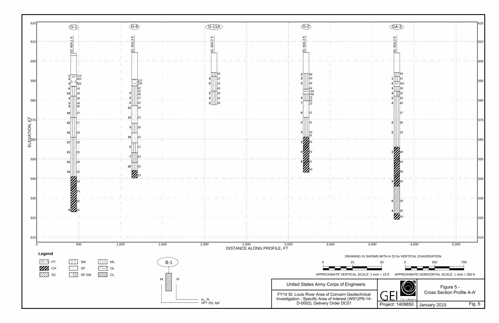
e. U.S. Army Corps of Engineers Engineer Manual (EM) 1110-1-1904, “Settlement Analysis”, (1990). 5. A map of the boring locations where GEI performed their 2014 investigation program is provided as an enclosure. The map also includes an overlay of the proposed island locations and the 1908 Sanborn Fire Insurance map showing the former location of docks and other structures which are no longer present on site. 6. The thickest proposed dredge material placement of 12 feet is located at the proposed island near Boring Location G-7.
7. Based on GEI’s 2014 investigation, the subgrade beneath the proposed island locations have strong local heterogeneities but broadly consist of 5 to 20 feet of very loose/very soft layers of silt, organic silt, silty sand, and peat deposits underlain by slightly more competent layers of sand, silt and silty clay (low and high plasticity).
8. Material identified as peat may represent pre-industrial deposits related to the formation of St. Louis Bay during the Glacial Epoch or (more likely) represent byproducts from post-1850 industrial activities taking place on the Bay (e.g. the extensive logging, milling and shipping operations that reached their peak around the turn of the 20th century). Much of the 40th Avenue South site is within the footprint of the former Alger Smith Lumber Docks & Yard (see enclosed map) and organic deposits encountered in this area may represent wastage, dumping and loss related to the timber and sawmill specific industrial activity at this site.
9. The total settlement of the proposed island creation site is a combination of the subgrade settlement beneath the proposed islands and the consolidation of the placed dredge material used to create the islands. Item 10 describes the subgrade settlement beneath the proposed islands and Item 11 describes consolidation within the placed dredge material.
10. For feasibility and planning purposes, our best feasibility stage estimate of subgrade settlement beneath the proposed islands is 10% to 25% the total proposed island fill height. For example, for an island dredge material fill thickness of 12 feet, this would represent an estimate 1 to 3 feet of subgrade consolidation. Most of the subgrade settlement will occur within the first few years following island creation. However, thick deposits of high plasticity clay were encountered at several of the boring locations which may indicate that subgrade consolidation will continue beyond 5+ years as these deposits consolidate relatively slowly. During the design process, this estimate will be further refined.

CELRE-EC-G
SUBJECT: Feasibility Stage Subgrade Settlement and Island Consolidation Potential, 40th Avenue Proposed Island Creation Sites.
3
11. The amount and time rate of consolidation that will occur within the dredged material following island creation placement is highly dependent on the type of material that will be placed at the sites. The relatively sandy material placed during the FY13 and FY14 seasons of the 21st Avenue Pilot Project consolidated almost immediately following placement with little evidence of continued consolidation. Finer grained material will have a longer period of consolidation however. 12. Based on the potential for subgrade settlement and consolidation, additional placements (beyond the initial island creation placement) of dredge material on the created islands to maintain target elevations may be required. 13. It is strongly recommended that extensive use of settlement plates, bathymetric surveys, land surveys and physical observation of the placed islands be conducted to monitor the overall performance of the created islands and refine design performance estimates with actual field results. 14. Point of Contact for this memorandum is the undersigned at 313-226-3529 or [email protected]. Encl Luke Vermeulen Project Area Map with Historical Overlay Geotechnical Engineer Geotech and Structures Branch
Digitally signed by VERMEULEN.LUKE.1270248051 DN: c=US, o=U.S. Government, ou=DoD, ou=PKI, ou=USA, cn=VERMEULEN.LUKE.1270248051 Date: 2015.07.07 14:14:44 -04'00'

AUAU
AU
AU
AUAU
AU AU
AU AU
AU
AU
GA-1
GA-2
GA-3
G-1
G-2
G-5
G-6 G-7
G-8 G-9
G-10
G-11
Source: Esri, DigitalGlobe, GeoEye, i-cubed, USDA, USGS, AEX,Getmapping, Aerogrid, IGN, IGP, swisstopo, and the GIS User Community
Historical South 40th AveLegendAU Geotechnical Boring
Locations
AUGeotechnical Boring &Env. SamplingLocations
40th Island CreationAreas
0 1,000 2,000500 Feet
´40th Avenue RAP, Duluth MN
Notes: NAD83 State Plane Minnesota North FIPS 2201 Coordinate System Historical Map: 1908 Duluth Sanborn Map AS OF Date: 7/7/2015

Subsurface Investigation Report FY14 St. Louis River Area of Concern Geotechnical Investigation - 40th Avenue West W912P6-14-D-0002, Delivery Order DC01 January 26, 2015
GEI Consultants, Inc.
Appendix A
Figures Figure 1 – Proposed Boring Locations Figure 2 – As Drilled Boring Locations Figure 3 – Boring Location Difference Figure 4 – Location of Cross-Section Profiles Figure 5 – Cross Section Profile A-A’ Figure 6 – Cross Section Profile B-B’ Figure 7 – Cross Section Profile C-C’

!A!A
!A !A
!A!A
!A
!A !A
!A!A
!A!A
!A!A!A
!A!A!A!A!A
!A!A!A!A
!A!A!A
!A
!A!A
!A!A!A!A!A!A
Sources: Esri, DeLorme, NAVTEQ, USGS, Intermap, iPC, NRCAN, Esri Japan, METI, Esri China (Hong Kong), Esri (Thailand), TomTom, 2013
2810000
2810000
2815000
2815000
2820000
2820000
2825000
2825000
2830000
2830000
2835000
2835000
2840000
2840000
2845000
2845000
2850000
2850000
2855000
2855000
2860000
2860000
2865000
2865000
2870000
2870000
2875000
2875000
2880000
2880000
3900
00
3900
00
3950
00
3950
00
4000
00
4000
00
4050
00
4050
00
4100
00
4100
00
4150
00
4150
00
4200
00
4200
00
4250
00
4250
00
United States Army Corps of Engineers SITE LOCATION AND SAMPLING SITES WITHIN THE AREA OF CONCERN
DATE: JANUARY 2015 FIGURE 1
20OC
T201
4
J:\20
14\14
0985
0_St
Louis
Rive
r\GIS\
MXDS
\1409
850_
OVER
ALL S
ITE D
IAGRA
M_MN
_rev1
.mxd
C
EF
®
LegendProject Sites and Proposed Boring Locations
!A 21st Avenue/Interstate Island
!A 40th Avenue West
!A Chambers Grove
!A Grassy Point
!A Knowlton Creek
0 10,000 20,0005,000Feet
1409850Projected CoordinateSystem: NAD_1983_StatePlane_Minnesota_North_FIPS_2201_Feet1 inch = 5,000 feet
!(!(!( !(
!(!(
!(
!(!(
!(!(
!(!(
!(!(!(!(!(!(!(!(
!(!(!(!(
!(!(!(
!(!(!(!(!(!(
!(!(!(
M I N N E S O TA
W I S C O N S I NSources: Esri, DeLorme, NAVTEQ, USGS,Intermap, iPC, NRCAN, Esri Japan, METI, EsriChina (Hong Kong), Esri (Thailand), TomTom,2013
FY14 St. Louis River Area of Concern Geotechnical Investigation - Specific Area of Interest
(W912P6-14-D-0002), Delivery Order DC01
(Proposed locations from August 21, 2014 scope of work)
Chambers Grove
Knowlton Creek
40th Avenue West
Grassy Point
21st Avenue/Interstate Island
Duluth
Superior
1 inch = 15,000 feet
St. Louis River Harbor

!R
!R
!R
!R
!R
!R
!R
!R
!R
!R
!R
!R
!R
!R
!R
!R
!R
!R
!R
!R
!R!R
!R
!R
!R
!R
!R
!R
!A
!A
!A
!A
!A
!A
!A
!A
!A
!A
!A!A
!A
!A
!A!AG-9
G-7G-6
G-5
G-4
G-3
G-2
G-1
G-11
G-10
GA-5
GA-4
GA-3
GA-2
GA-1
G-11A1017
1011
1009
1005
1001
1029(A-9)
1028(A-8)1026(A-7)
1025(A-6)
1016(A-5)
1012(A-4)
1004(A-3)1002(A-1)
1042(A-25)
1041(A-19)
1037(GA-5)
1035(GA-4)
1034(A-10)
1033(A-24)
1032(A-11) 1031(A-13)
1030(A-12)
1027(A-23)
1024(A-16)
1023(GA-3)
1022(A-14)
1021(A-15)
1010(A-21)
2860800
2860800
2862400
2862400
2864000
2864000
2865600
2865600
2867200
2867200
4144
00
4144
00
4160
00
4160
00
4176
00
4176
00
4192
00
4192
00
United States Army Corps of Engineers 40TH AVENUE WESTAS DRILLED BORING LOCATIONS
DATE: JANUARY 2015 FIGURE 2
06NO
V201
4
J:\20
14\14
0985
0_St
Louis
Rive
r\GIS\
MXDS
\1409
850_
40th
ave_
as dr
illed b
oring
s.mxd
C
EF
®
Legend!A As Drilled Boring Locations
!R Environmental Sample Locations
0 1,600 3,200800Feet
1409850Projected CoordinateSystem: NAD_1983_StatePlane_Minnesota_North_FIPS_2201_FeetBackground Image: http://gis.apfo.usda.gov/arcgis/services/NAIP/Minnesota_2013_1m_NC/ImageServer
S t . L o u i s R i v e r
1 inch = 800 feet
!A!A
!A
!A !A
!A!A
!A!A
!A!A!A!A!A!A!A
FY14 St. Louis River Area of Concern Geotechnical Investigation - Specific Area of Interest
(W912P6-14-D-0002), Delivery Order DC01
Notes:1. Location of water borings determined using a Trimble GEO 7X hand-held GPS receiver. Location of borings on land determined by Alta Land Survey. 2. Environmental boring data provided by Stantec
1 in = 10,000 feet
Boring Number Northing Easting
GA-1 413,422.0 2,863,727.0GA-2 413,741.0 2,863,178.0GA-3 415,845.0 2,864,010.0GA-4 419,442.5 2,864,828.1GA-5 419,133.6 2,866,307.8G-1 414,133.0 2,861,499.0G-2 414,822.0 2,863,952.0G-3 419,154.1 2,864,967.6G-4 419,573.3 2,865,360.1G-5 415,110.0 2,862,796.0G-6 414,159.0 2,862,225.0G-7 414,215.0 2,862,974.0G-8G-9 414,702.0 2,862,319.0G-10 415,099.0 2,862,180.0G-11 414,729.0 2,862,972.0
G-11A 414,719.0 2,862,962.0
Not Drilled

!R
!R
!R
!R
!R
!R
!R
!R
!R
!R
!R
!R
!R
!R
!R
!R
!R
!R
!R
!R
!R!R
!R
!R
!R
!R
!R
!R
#*
#*
#*
#*
#*
#*
#*
#*
#*
#*
#* #*
#* #*
#*
#*#*
!A
!A
!A
!A
!A
!A
!A
!A
!A
!A
!A!A
!A
!A
!A!AG-9G-8
G-7G-6
G-5
G-4
G-3
G-2
G-1
G-11
G-10
GA-5
GA-4
GA-3
GA-2
GA-1
G-11A
2856000
2856000
2856800
2856800
2857600
2857600
2858400
2858400
2859200
2859200
2860000
2860000
2860800
2860800
2861600
2861600
2862400
2862400
2863200
2863200
2864000
2864000
2864800
2864800
2865600
2865600
2866400
2866400
2867200
2867200
4136
00
4136
00
4144
00
4144
00
4152
00
4152
00
4160
00
4160
00
4168
00
4168
00
4176
00
4176
00
4184
00
4184
00
4192
00
4192
00
United States Army Corps of Engineers 40TH AVENUE WESTBORING LOCATION DIFFERENCE -
PROPOSED VS. AS DRILLED LOCATIONSDATE: JANUARY 2015 FIGURE 3
06NO
V201
4
J:\20
14\14
0985
0_St
Louis
Rive
r\GIS\
MXDS
\1409
850_
40th
ave_
borin
g diffe
rence
.mxd
C
EF
®
Legend!A As Drilled Boring Locations
#* Proposed Boring Locations
!R Environmental Sample Locations (Stantec)
0 1,600 3,200800Feet
1409850Projected CoordinateSystem: NAD_1983_StatePlane_Minnesota_North_FIPS_2201_FeetBackground Image: http://gis.apfo.usda.gov/arcgis/services/NAIP/Minnesota_2013_1m_NC/ImageServer
S t . L o u i s R i v e r
1 inch = 800 feet FY14 St. Louis River Area of Concern Geotechnical Investigation - Specific Area of Interest
(W912P6-14-D-0002), Delivery Order DC01
Notes:1. As outlined in the August 21, 2014 Scope of Work for FY14 St. Louis Area of Concern Geotechnical Investigation, Contract No. W912P6-14-D-00022. Location of water borings determined using a Trimble GEO 7X hand-held GPS receiver. Location of borings on land determined by Alta Land Survey
Northing Easting Northing Easting Northing Easting TotalGA-1 413,437.9 2,863,727.9 413,422.0 2,863,727.0 15.9 0.9 15.9GA-2 413,747.0 2,863,172.4 413,741.0 2,863,178.0 6.0 -5.6 8.2GA-3 415,858.1 2,864,005.7 415,845.0 2,864,010.0 13.1 -4.3 13.8GA-4 419,437.9 2,864,818.2 419,442.5 2,864,828.1 -4.6 -9.9 10.9GA-5 419,045.6 2,866,019.6 419,133.6 2,866,307.8 -88.0 -288.2 301.4G-1 414,128.9 2,861,509.2 414,133.0 2,861,499.0 -4.1 10.2 11.0G-2 414,826.8 2,863,964.1 414,822.0 2,863,952.0 4.8 12.1 13.0G-3 419,132.4 2,864,967.5 419,154.1 2,864,967.6 -21.7 -0.1 21.7G-4 419,576.8 2,865,352.9 419,573.3 2,865,360.1 3.5 -7.2 8.0G-5 415,083.8 2,862,807.8 415,110.0 2,862,796.0 -26.2 11.8 28.7G-6 414,184.5 2,862,207.1 414,159.0 2,862,225.0 25.5 -17.9 31.2G-7 414,198.4 2,862,971.0 414,215.0 2,862,974.0 -16.6 -3.0 16.9G-8 414,704.5 2,861,681.1 - - -G-9 414,701.0 2,862,316.5 414,702.0 2,862,319.0 -1.0 -2.5 2.7G-10 415,110.7 2,862,160.3 415,099.0 2,862,180.0 11.7 -19.7 22.9G-11 414,728.8 2,862,948.5 414,729.0 2,862,972.0 -0.2 -23.5 23.5
G-11A 414,728.8 2,862,948.5 414,719.0 2,862,962.0 9.8 -13.5 16.7
Not Drilled
Boring Number
Proposed Coordinates1 Drilled Coordinates2 Offset/Difference (ft)

!A
!A
!A
!A
!A
!A
!A
!A
!A
!A
!A!A
!A
!A
!A!AG-9
G-7G-6
G-5
G-4
G-3
G-2
G-1
G-11
G-10
GA-5
GA-4
GA-3
GA-2
GA-1
G-11A
2860800
2860800
2862400
2862400
2864000
2864000
2865600
2865600
2867200
2867200
4144
00
4144
00
4160
00
4160
00
4176
00
4176
00
4192
00
4192
00
United States Army Corps of Engineers 40TH AVENUE WESTLOCATION OF CROSS-SECTION PROFILE
DATE: JANUARY 2015 FIGURE 4
06NO
V201
4
J:\20
14\14
0985
0_St
Louis
Rive
r\GIS\
MXDS
\1409
850_
40th
ave_
cross
secti
on lo
catio
n.mxd
C
EF
®
Legend!A As Drilled Boring Locations
0 1,600 3,200800Feet
1409850Projected CoordinateSystem: NAD_1983_StatePlane_Minnesota_North_FIPS_2201_FeetBackground Image: http://gis.apfo.usda.gov/arcgis/services/NAIP/Minnesota_2013_1m_NC/ImageServer
S t . L o u i s R i v e r
1 inch = 800 feet
!A!A
!A
!A !A
!A!A
!A!A
!A!A!A!A!A!A!A
FY14 St. Louis River Area of Concern Geotechnical Investigation - Specific Area of Interest
(W912P6-14-D-0002), Delivery Order DC01
Notes:1. Location of water borings determined using a Trimble GEO 7X hand-held GPS receiver. Location of borings on land determined by Alta Land Survey. 2. Environmental boring data provided by Stantec
1 in = 10,000 feet
Boring Number Northing Easting
GA-1 413,422.0 2,863,727.0GA-2 413,741.0 2,863,178.0GA-3 415,845.0 2,864,010.0GA-4 419,442.5 2,864,828.1GA-5 419,133.6 2,866,307.8G-1 414,133.0 2,861,499.0G-2 414,822.0 2,863,952.0G-3 419,154.1 2,864,967.6G-4 419,573.3 2,865,360.1G-5 415,110.0 2,862,796.0G-6 414,159.0 2,862,225.0G-7 414,215.0 2,862,974.0G-8G-9 414,702.0 2,862,319.0G-10 415,099.0 2,862,180.0G-11 414,729.0 2,862,972.0
G-11A 414,719.0 2,862,962.0
Not Drilled
CC'
A'
B
A
B'
510
520
530
540
550
560
570
580
590
600
610
620
0 500 1,000 1,500 2,000 2,500 3,000 3,500 4,000 4,500 5,000
510
520
530
540
550
560
570
580
590
600
610
620
216410
426
24
29
28
3440
27
17
24
25
25
24
26
49
59
60
51
12
3
6
10
4
33
16
22
15
27
21
41
14
6
El.
604.
1 ft
45
22
23
50
34
32
39
4
5
2
2
2
El.
604.
2 ft
4849
46
44159268222823
21
31
3331
35
35
41
49
22
2
4
7
6
2
3
3
4
6
El.
604.
3 ft
111106
82332827
32
25
23
29
22
21
43
50
33
4
3
2
12
12
3
15
5
7
20
El.
604.
3 ft
44
41
361
28
32
39
40
37
36
33
48
64
58
39
29
36
54
1
2
3
4
2
2
2
2
3
3
6
4
El.
604.
2 ft
0 15 30
LegendDISTANCE ALONG PROFILE, FT
APPROXIMATE VERTICAL SCALE: 1 inch = 15 ft
January 2015
11
ELE
VA
TIO
N,
FT
PT SM ML
CH SP OL
SC SP-SM CL35
wn, %SPT (N), bpf
B-1 0 350 700
APPROXIMATE HORIZONTAL SCALE: 1 inch = 350 ft
DRAWING IS SHOWN WITH A 23.5x VERTICAL EXAGERATION
G-1 G-11A G-2G-6 GA-3
Fig. 5
United States Army Corps of Engineers
FY14 St. Louis River Area of Concern Geotechnical Investigation - Specific Area of Interest (W912P6-14-
D-0002), Delivery Order DC01 Project: 1409850
Figure 5 - Cross Section Profile A-A'

510
520
530
540
550
560
570
580
590
600
610
620
0 500 1,000 1,500 2,000 2,500 3,000
510
520
530
540
550
560
570
580
590
600
610
620
77312825
28
28
45
24
11
7
2
3
2
16
El.
604.
1 ft
14084
244
364
22
29
38
38
31
32
48
50
59
23
23
16
25
1
5
4
2
2
2
3
2
20
30
14
4
El.
604.
3 ft
31
21
24
32
34
30
41
2
4
2
3
2
3
2
El.
604.
1 ft
98
46
26
28
29
29
23
30
29
39
41
48
46
49
2
4
4
4
6
12
4
5
4
4
El.
604.
3 ft
85
78
549192030
33
36
36
34
35
38
47
51
54
65
57
49
56
2
2
7
5
2
2
4
2
3
4
5
4
4
El.
604.
1 ft
0 15 30
LegendDISTANCE ALONG PROFILE, FT
APPROXIMATE VERTICAL SCALE: 1 inch = 15 ft
January 2015 Fig. 6
11
ELE
VA
TIO
N,
FT
ML SM SP
OL PT CH
35
wn, %SPT (N), bpf
B-1 0 200 400
APPROXIMATE HORIZONTAL SCALE: 1 inch = 200 ft
DRAWING IS SHOWN WITH A 13.5x VERTICAL EXAGERATION
G-10 G-7G-9 GA-1GA-2
United States Army Corps of Engineers
Project: 1409850
Figure 6 - Cross Section Profile B-B'FY14 St. Louis River Area of Concern Geotechnical
Investigation - Specific Area of Interest (W912P6-14-D-0002), Delivery Order DC01

560
570
580
590
600
610
620
630
0 200 400 600 800 1,000 1,200 1,400 1,600 1,800 2,000 2,200560
570
580
590
600
610
620
630
144242
41
17
27
15
74
52
25
41307
58
32
13
12
6
16
3
12
9
El.
620.
7 ft
18
30
18
89
45369347
191
25
28
20
14
13
1
10
8
17
11
El.
608.
5 ft
7
13
37
322856
34
35
61
39
39
39
5
6
4
2
3
8
4
2
2
El.
604.
2 ft
0 10 20
LegendDISTANCE ALONG PROFILE, FT
APPROXIMATE VERTICAL SCALE: 1 inch = 10 ft
January 2015 Fig. 7
11
ELE
VA
TIO
N,
FT
FILL PT SM
SP CL ML
OL35
wn, %SPT (N), bpf
B-1 0 150 300
APPROXIMATE HORIZONTAL SCALE: 1 inch = 150 ft
DRAWING IS SHOWN WITH A 15x VERTICAL EXAGERATION
G-4
GA-4
GA-5
United States Army Corps of Engineers
Project: 1409850
Figure 7 - Cross Section Profile C-C'FY14 St. Louis River Area of Concern Geotechnical
Investigation - Specific Area of Interest (W912P6-14-D-0002), Delivery Order DC01
Subsurface Investigation Report FY14 St. Louis River Area of Concern Geotechnical Investigation - 40th Avenue West W912P6-14-D-0002, Delivery Order DC01 January 26, 2015
GEI Consultants, Inc.
Appendix D
Tables Table 1 – Boring Location, Elevation, and Depth Summary Table 2 – Summary of Laboratory Testing Results

Boring
Number Northing Easting
Date
Drilled
Total Depth Drilled
(feet)
Elevation
Top of
Water2Elevation
Barge Deck
Height of
Deck Above
Water (feet)
Depth of
Water
(feet)
Elevation Top
of Sediment
(feet)
Elevation
Top of
Ground3
40th Avenue WestGA‐1 413422 2863727 9/24/2014 69.5 from barge deck 603.0 604.3 1.3 18.2 584.8 NA
GA‐2 413741 2863178 9/22/2014 85.0 from barge deck 602.8 604.1 1.3 8.7 594.1 NA
GA‐3 415845 2864010 9/23/2014 85.0 from barge deck 602.9 604.2 1.3 8.7 594.2 NA
GA‐4 419442.5 2864828.1 9/30/2014 25.0 NA NA NA NA NA 608.47
GA‐5 419133.6 2866307.8 9/30/2014 30.0 NA NA NA NA NA 604.15
G‐1 414133 2861499 9/20/2014 81.0 from barge deck 602.8 604.1 1.3 9.7 593.1 NA
G‐2 414822 2863952 9/12/2014 61.0 from barge deck 603.0 604.3 1.3 9.2 593.8 NA
G‐3 419154.1 2864967.6 9/30/2014 30.0 NA NA NA NA NA 612.88
G‐4 419573.3 2865360.1 9/30/2014 31.5 NA NA NA NA NA 620.65
G‐5 415110 2862796 9/24/2014 62.0 from barge deck 603.0 604.3 1.3 8.2 594.8 NA
G‐6 414159 2862225 9/12/2014 64.0 from barge deck 603.0 604.3 1.3 12.2 590.8 NA
G‐7 414215 2862974 9/25/2014 80.5 from barge deck 603.0 604.3 1.3 9.2 593.8 NA
G‐8 Not Drilled
G‐9 414702 2862319 9/22/2014 26.5 from barge deck 602.8 604.1 1.3 8.7 594.1 NA
G‐10 415099 2862180 9/22/2014 26.5 from barge deck 602.8 604.1 1.3 8.7 594.1 NA
G‐11 414729 2862972 9/23/2014 26.5 from barge deck 602.9 604.2 1.3 9.0 593.9 NA
G‐11A 414719 2862962 9/11/2014 26.5 from barge deck 602.9 604.2 1.3 8.7 594.2 NA
3 = Elevation of ground surface in 1988 North American Vertical Datum 1988 (NAVD88). Surveyed by Alta Land Survey Company
Drilled Coordinates1
2 = Water Level of Lake Superior recorded at NOAA Station 9099064 Duluth, MN, and averaged between 8:00 am and 5:00 pm local time. Water level elevation in 1985 International Great Lakes
Datum (IGLD85)
TABLE 1St. Louis River Area of Concern Geotechnical Investigation ‐ FY14
Boring Location, Elevation and Depth Summary
1 = Projected Coordinate System NAD 1983 State Plane Minnesota North FIPS 2201. Location of water borings determined using a Trimble GEO 7X hand‐held GPS receiver. Location of borings on
land determined by Alta Land Survey Company.
Page 1 of 1

Test Description Test Method Number of Tests Remarks
Visual Classification ASTM D2488 175 All samples
Moisture Content ASTM D2216 175 Each cohesive or silt sample
Laboratory Hand Penetrometer 175 Each cohesive sample
Atterberg Limits ASTM D4318 17 One per stratum of cohesive material
Hydrometer (Combined) Analysis ASTM D422 17 One per Atterberg Limit (same sample)
Sieve Analysis ASTM D6913 17 One per stratum of non‐cohesive material
U‐U (Q) Test (incl. extrusion, unit weight
& moisture)
ASTM D2850 7 Selected undisturbed cohesive samples (3 point, 0.5x, 1x
and 2x effective overburden weight)
Direct Shear (incl. extrusion, unit weight,
& moisture)
ASTM D3080 5 Selected undisturbed cohesive samples (3 point, 0.5x,
1.5x and 2x effective overburden weight)
One Dimensional Consolidation (incl.
specific gravity)
ASTM D4546 5 Selected cohesive samples (goal‐ 1 per cohesive stratum)
Percent Organic (Loss on Ignition) ASTM D2974 5 Selected Peat layers (if encountered)
TABLE 2
Proposed Laboratory Testing Program
FY14 St. Louis River Area of Concern Geotechnical Investigation
40th Avenue
Page 1 of 1

Subsurface Investigation Report FY14 St. Louis River Area of Concern Geotechnical Investigation - 40th Avenue West W912P6-14-D-0002, Delivery Order DC01 January 26, 2015
GEI Consultants, Inc.
Appendix E
Boring Logs

WOH, WOH, 1N = 1WC = 215.9%
2, 1, 1 (3" Split spoon)N = 2WC = 410.4%
+602.8
+593.1
+591.6
1.3
11.0
12.5
111.012.5
212.514.0
Barge Deck
Water - St. Louis River
Peat - some organic silt - dark brown - veryloose - wet (Pt)
Peat - black - very loose - wet (Pt)
46.7
73.3
REMARKS(Drilling time, water loss, depthweathering, etc., if significant)
BOX ORSAMPLE
NO.LEGEND
CLASSIFICATION OF MATERIALS(Description)
ELEVATION DEPTH
a fc eb gd
%RECOV-
ERY
1. PROJECT
UNDISTURBED13. TOTAL NO. OFOVERBURDEN SAMPLESTAKEN
USACEINSTALLATION SHEET
18. TOTAL CORE RECOVERY FOR BORING
+604.1 0.0
12. MANUFACTURER'S DESIGNATION OF DRILL
OF
G-1
9/20/2014 9/20/2014
Detroit District 51
Strata Earth Services, LLC
B. McCarthy
11. DATUM FOR ELEVATION SHOWN (TBM or MSL)
DISTURBED
10. SIZE AND TYPE OF BIT
14. TOTAL NUMBER CORE BOXES
3. DRILLING AGENCY
5. NAME OF DRILLER
6. DIRECTION OF HOLE
%
2. LOCATION (Coordinates or Station)
VERTICAL INCLINED
19. SIGNATURE OF INSPECTOR
MN State Plane North NAD 83 N 414,133 E 2,861,499Diedrich-25
7. THICKNESS OF OVERBURDEN (FT.)
8. DEPTH DRILLED INTO ROCK (FT.)
9. TOTAL DEPTH OF HOLE (FT.)
DEG. FROM VERT.
4. HOLE NO. (As shown on drawing title andfile number)
+604.1
FY14 SLRAOC - 40th Avenue
IGLD85
16. DATE HOLE
81.0
DIVISION
---17. ELEVATION TOP OF HOLE
15. ELEVATION GROUND WATER
SHEETS
STARTED
DRILLING LOG
COMPLETED
Hole No. G-1
3 7/8" Roller Bit
Hole No. G-1
PROJECT HOLE NO.FY14 SLRAOC - 40th Avenue G-1PREVIOUS EDITIONS ARE OBSOLETE.1836
MAR 71ENG FORM
1
2
3
4
5
6
7
8
9
10
11
12
13
1 1, 2 (3" Split spoon)N = 3WC = 426.2%
3, 2, 4 (3" Split spoon)N = 6WC = 24.4%
6, 5, 5N = 10WC = 28.8%
2, 2, 2N = 4Qp = 0.25 tsfWC = 27.9%
3WC = 33.8%2, 1N = 3WC = 40.1%
10, 8, 8N = 16WC = 27.3%
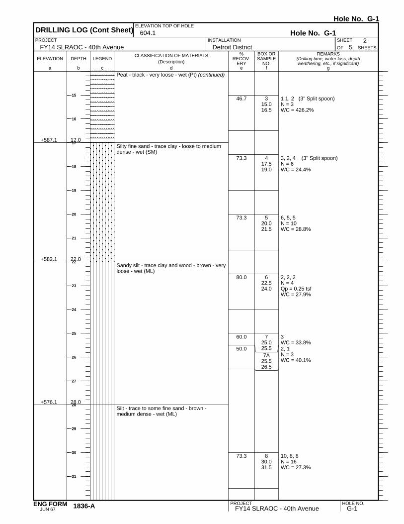
+587.1
+582.1
+576.1
17.0
22.0
28.0
315.016.5
417.519.0
520.021.5
622.524.0
725.025.57A
25.526.5
830.031.5
Peat - black - very loose - wet (Pt) (continued)
Silty fine sand - trace clay - loose to mediumdense - wet (SM)
Sandy silt - trace clay and wood - brown - veryloose - wet (ML)
Silt - trace to some fine sand - brown -medium dense - wet (ML)
46.7
73.3
73.3
80.0
60.0
50.0
73.3
REMARKS(Drilling time, water loss, depthweathering, etc., if significant)
BOX ORSAMPLE
NO.LEGEND
CLASSIFICATION OF MATERIALS(Description)
ELEVATION DEPTH
a fc eb gd
%RECOV-
ERY
SHEETS
PROJECT 2INSTALLATION
Detroit District
DRILLING LOG (Cont Sheet)ELEVATION TOP OF HOLE
604.1 Hole No. G-1
FY14 SLRAOC - 40th AvenueSHEET
OF 5
Hole No. G-1
PROJECT HOLE NO.FY14 SLRAOC - 40th Avenue G-11836-A
JUN 67ENG FORM
15
16
17
18
19
20
21
22
23
24
25
26
27
28
29
30
31
11, 12, 10N = 21WC = 17.0%
7, 7, 8N = 15WC = 23.9%
8, 12, 15N = 27WC = 25.1%
+571.1
+561.1
33.0
43.0
935.036.5
1040.041.5
1145.046.5
Silt - trace to some fine sand - brown -medium dense - wet (ML) (continued)
Silty fine sand - brown - medium dense - wet(SM)
Silt - trace to some clay and fine sand - brown- medium to dense - wet (ML)
66.7
73.3
80.0
REMARKS(Drilling time, water loss, depthweathering, etc., if significant)
BOX ORSAMPLE
NO.LEGEND
CLASSIFICATION OF MATERIALS(Description)
ELEVATION DEPTH
a fc eb gd
%RECOV-
ERY
SHEETS
PROJECT 3INSTALLATION
Detroit District
DRILLING LOG (Cont Sheet)ELEVATION TOP OF HOLE
604.1 Hole No. G-1
FY14 SLRAOC - 40th AvenueSHEET
OF 5
Hole No. G-1
PROJECT HOLE NO.FY14 SLRAOC - 40th Avenue G-11836-A
JUN 67ENG FORM
33
34
35
36
37
38
39
40
41
42
43
44
45
46
47
48
49
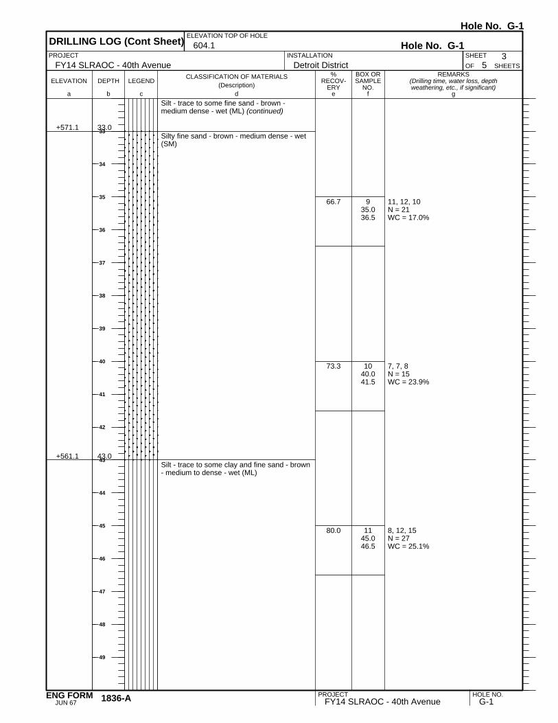
8, 10, 11N = 21WC = 25.0%
13, 19, 22N = 41WC = 24.0%
12, 7, 7N = 14WC = 26.3%
Torvane (Su) = 2.5 tsf to 4.5 tsfWC = 49.4%ST: 65'-67'
+541.1 63.0
1250.051.5
1355.056.5
1460.061.5
1565.067.0
Silt - trace to some clay and fine sand - brown- medium to dense - wet (ML) (continued)
Clay - some silt - trace fine to medium sand -brown - very stiff to hard (CH)
66.7
66.7
93.3
100.0
REMARKS(Drilling time, water loss, depthweathering, etc., if significant)
BOX ORSAMPLE
NO.LEGEND
CLASSIFICATION OF MATERIALS(Description)
ELEVATION DEPTH
a fc eb gd
%RECOV-
ERY
SHEETS
PROJECT 4INSTALLATION
Detroit District
DRILLING LOG (Cont Sheet)ELEVATION TOP OF HOLE
604.1 Hole No. G-1
FY14 SLRAOC - 40th AvenueSHEET
OF 5
Hole No. G-1
PROJECT HOLE NO.FY14 SLRAOC - 40th Avenue G-11836-A
JUN 67ENG FORM
51
52
53
54
55
56
57
58
59
60
61
62
63
64
65
66
67

Torvane (Su) = 3.5 tsf to 5.0 tsfWC = 59.0%ST: 70'-72'
Torvane (Su) = 3.0 tsf to 4.5 tsfWC = 60.3%ST: 75'-77'
3, 3, 3N = 6Qp = 1.0 tsfWC = 50.8%
+535.6
+523.1
68.5
81.0
1670.072.0
1775.077.0
1879.581.0
Clay - trace to some silt - trace fine sand -brown - hard to stiff (CH)
End of BoringBoring advanced to 79.5 feet with rock bit anddrilling fluidHW casing driven to 11.0 feet below riverbottomBoring backfilled with cement bentonite grout
100.0
75.0
100.0
REMARKS(Drilling time, water loss, depthweathering, etc., if significant)
BOX ORSAMPLE
NO.LEGEND
CLASSIFICATION OF MATERIALS(Description)
ELEVATION DEPTH
a fc eb gd
%RECOV-
ERY
SHEETS
PROJECT 5INSTALLATION
Detroit District
DRILLING LOG (Cont Sheet)ELEVATION TOP OF HOLE
604.1 Hole No. G-1
FY14 SLRAOC - 40th AvenueSHEET
OF 5
Hole No. G-1
PROJECT HOLE NO.FY14 SLRAOC - 40th Avenue G-11836-A
JUN 67ENG FORM
69
70
71
72
73
74
75
76
77
78
79
80
81
82
83
84
85

1, 1, 1N = 2WC = 48.0%
1, 1, 1N = 2WC = 48.7%
+603.0
+593.8
+592.3
1.3
10.5
12.0
110.512.0
212.514.0
Barge Deck
Water - St. Louis River
Silt - some organic silt - trace fine to coarsegravel - dark brown - very loose - wet (ML)
Silt - some clay - trace fine sand and rootfibers - brown - very loose - wet (ML)
53.3
73.3
REMARKS(Drilling time, water loss, depthweathering, etc., if significant)
BOX ORSAMPLE
NO.LEGEND
CLASSIFICATION OF MATERIALS(Description)
ELEVATION DEPTH
a fc eb gd
%RECOV-
ERY
1. PROJECT
UNDISTURBED13. TOTAL NO. OFOVERBURDEN SAMPLESTAKEN
USACEINSTALLATION SHEET
18. TOTAL CORE RECOVERY FOR BORING
+604.3 0.0
12. MANUFACTURER'S DESIGNATION OF DRILL
OF
G-2
9/12/2014 9/12/2014
Detroit District 41
Strata Earth Services, LLC
B. McCarthy
11. DATUM FOR ELEVATION SHOWN (TBM or MSL)
DISTURBED
10. SIZE AND TYPE OF BIT
14. TOTAL NUMBER CORE BOXES
3. DRILLING AGENCY
5. NAME OF DRILLER
6. DIRECTION OF HOLE
%
2. LOCATION (Coordinates or Station)
VERTICAL INCLINED
19. SIGNATURE OF INSPECTOR
MN State Plane North NAD 83 N 414,822 E 2,863,952Diedrich-25
7. THICKNESS OF OVERBURDEN (FT.)
8. DEPTH DRILLED INTO ROCK (FT.)
9. TOTAL DEPTH OF HOLE (FT.)
DEG. FROM VERT.
4. HOLE NO. (As shown on drawing title andfile number)
+604.3
FY14 SLRAOC - 40th Avenue
IGLD85
16. DATE HOLE
61.0
DIVISION
---17. ELEVATION TOP OF HOLE
15. ELEVATION GROUND WATER
SHEETS
STARTED
DRILLING LOG
COMPLETED
Hole No. G-2
3 7/8" Roller Bit
Hole No. G-2
PROJECT HOLE NO.FY14 SLRAOC - 40th Avenue G-2PREVIOUS EDITIONS ARE OBSOLETE.1836
MAR 71ENG FORM
1
2
3
4
5
6
7
8
9
10
11
12
13

WOH, 1, 1N = 2WC = 45.9%
WOH, 1N = 1/6"WC = 43.9%
1/6"WC = 159.3%
1, 4N = 4/6"WC = 267.5%
5/6"WC = 22.1%
2, 2, 2N = 4WC = 28.4%
4, 4, 3N = 7WC = 23.1%
4, 4, 2N = 6WC = 21.1%
+585.8
+583.3
+579.8
18.5
21.0
24.5
315.016.5
4A17.518.5
4B18.519.0
5A20.021.0
5B21.021.5
622.524.0
725.026.5
830.031.5
Silt - some clay - trace fine sand and rootfibers - brown - very loose - wet (ML)(continued)
Peat - trace organic silt - black - very loose toloose - wet (Pt)
Silt - trace fine sand - occasional fine sandseams and layers - brown - loose - wet (ML)
Fine to medium sand - trace silt - brown -loose - wet (SP)
93.3
90.0
100.0
60.0
100.0
60.0
46.7
60.0
REMARKS(Drilling time, water loss, depthweathering, etc., if significant)
BOX ORSAMPLE
NO.LEGEND
CLASSIFICATION OF MATERIALS(Description)
ELEVATION DEPTH
a fc eb gd
%RECOV-
ERY
SHEETS
PROJECT 2INSTALLATION
Detroit District
DRILLING LOG (Cont Sheet)ELEVATION TOP OF HOLE
604.3 Hole No. G-2
FY14 SLRAOC - 40th AvenueSHEET
OF 4
Hole No. G-2
PROJECT HOLE NO.FY14 SLRAOC - 40th Avenue G-21836-A
JUN 67ENG FORM
15
16
17
18
19
20
21
22
23
24
25
26
27
28
29
30
31

1, 1, 1N = 2WC = 30.5%
2, 1, 2N = 3WC = 33.2%
WC = 31.3%
2, 1, 2N = 3Qp = 0.25 tsfWC = 35.1%
+571.3
+561.3
33.0
43.0
935.036.5
10A40.041.2
10B41.242.5
1145.046.5
Fine to medium sand - trace silt - brown -loose - wet (SP) (continued)
Silt - trace clay and fine sand - brown - veryloose -wet (ML)
Silty clay - trace fine sand - brown - soft tohard (CH)
86.7
75.0
23.1
100.0
REMARKS(Drilling time, water loss, depthweathering, etc., if significant)
BOX ORSAMPLE
NO.LEGEND
CLASSIFICATION OF MATERIALS(Description)
ELEVATION DEPTH
a fc eb gd
%RECOV-
ERY
SHEETS
PROJECT 3INSTALLATION
Detroit District
DRILLING LOG (Cont Sheet)ELEVATION TOP OF HOLE
604.3 Hole No. G-2
FY14 SLRAOC - 40th AvenueSHEET
OF 4
Hole No. G-2
PROJECT HOLE NO.FY14 SLRAOC - 40th Avenue G-21836-A
JUN 67ENG FORM
33
34
35
36
37
38
39
40
41
42
43
44
45
46
47
48
49

2, 2, 2N = 4Qp = 0.75 tsfWC = 35.2%
2, 3, 3N = 6Qp = 0.75 tsfWC = 40.5%
Torvane (Su) = 2.5 tsf to 2.0 tsfWC = 48.8%ST: 59'-61'
+543.3 61.0
1250.051.5
1355.056.5
1459.061.0
Silty clay - trace fine sand - brown - soft tohard (CH) (continued)
End of BoringBoring advanced to 59.0 feet with rock bit anddrilling fluidHW casing driven to 9.5 feet below riverbottomBoring backfilled with cement bentonite grout
100.0
100.0
100.0
REMARKS(Drilling time, water loss, depthweathering, etc., if significant)
BOX ORSAMPLE
NO.LEGEND
CLASSIFICATION OF MATERIALS(Description)
ELEVATION DEPTH
a fc eb gd
%RECOV-
ERY
SHEETS
PROJECT 4INSTALLATION
Detroit District
DRILLING LOG (Cont Sheet)ELEVATION TOP OF HOLE
604.3 Hole No. G-2
FY14 SLRAOC - 40th AvenueSHEET
OF 4
Hole No. G-2
PROJECT HOLE NO.FY14 SLRAOC - 40th Avenue G-21836-A
JUN 67ENG FORM
51
52
53
54
55
56
57
58
59
60
61
62
63
64
65
66
67

1, 2, 3N = 5WC = 34.8%
3, 3, 3N = 6WC = 22.8%
3, 4N = 4/6"WC = 45.1%
3/6"Qp = 3.0 tsfWC = 19.8%
3, 5, 5N = 10Qp = 3.0 tsfWC = 22.4%
Torvane (Su) = 4.0 tsfWC = 34.5%ST: 10'-12'
4, 8, 8N = 16WC = 32%
+608.4
+606.9
+600.4
4.5
6.0
12.5
10.01.5
22.54.0
3A5.06.0
3B6.06.5
47.59.0
510.012.0
612.514.0
Fill: Silty fine sand - trace fine to coarsegravel - black - loose - moist (SM)
Peat - trace fine to medium sand - black -loose - moist (Pt)
Clay - some silt - trace to some fine tomedium sand - trace fine to coarse gravel -occasional organic silt pockets - brown - verystiff to hard (CH)
Silty fine sand - brown - medium dense - wet(SM)
53.3
73.3
100.0
100.0
40.0
100.0
66.7
REMARKS(Drilling time, water loss, depthweathering, etc., if significant)
BOX ORSAMPLE
NO.LEGEND
CLASSIFICATION OF MATERIALS(Description)
ELEVATION DEPTH
a fc eb gd
%RECOV-
ERY
1. PROJECT
UNDISTURBED13. TOTAL NO. OFOVERBURDEN SAMPLESTAKEN
USACEINSTALLATION SHEET
18. TOTAL CORE RECOVERY FOR BORING
+612.9 0.0
12. MANUFACTURER'S DESIGNATION OF DRILL
OF
G-3
9/30/2014 9/30/2014
Detroit District 21
Strata Earth Services, LLC
B. McCarthy
11. DATUM FOR ELEVATION SHOWN (TBM or MSL)
DISTURBED
10. SIZE AND TYPE OF BIT
14. TOTAL NUMBER CORE BOXES
3. DRILLING AGENCY
5. NAME OF DRILLER
6. DIRECTION OF HOLE
%
2. LOCATION (Coordinates or Station)
VERTICAL INCLINED
602.9
19. SIGNATURE OF INSPECTOR
MN State Plane North NAD 83 N 419,154 E 2,864,968Diedrich-25
7. THICKNESS OF OVERBURDEN (FT.)
8. DEPTH DRILLED INTO ROCK (FT.)
9. TOTAL DEPTH OF HOLE (FT.)
DEG. FROM VERT.
4. HOLE NO. (As shown on drawing title andfile number)
+612.9
FY14 SLRAOC - 40th Avenue
NAVD88
16. DATE HOLE
30.0
DIVISION
---17. ELEVATION TOP OF HOLE
15. ELEVATION GROUND WATER
SHEETS
STARTED
DRILLING LOG
COMPLETED
Hole No. G-3
3 7/8" Roller Bit
Hole No. G-3
PROJECT HOLE NO.FY14 SLRAOC - 40th Avenue G-3PREVIOUS EDITIONS ARE OBSOLETE.1836
MAR 71ENG FORM
1
2
3
4
5
6
7
8
9
10
11
12
13

2, 2, 4N = 6WC = 235.8%
4, 3N = 3/6"
3/6"WC = 45.6%
6, 6, 7N = 13WC = 57.2%
4, 6, 11N = 17WC = 59.0%
+598.4
+594.9
+591.9
+589.4
+582.9
14.5
18.0
21.0
23.5
30.0
715.016.5
8A20.021.0
8B21.021.5
925.026.5
1028.530.0
Fibrous peat - black - loose - wet (Pt)
Woody peat - brown - loose - wet (Pt)
Silt - some clay - trace fine sand - brown -loose -wet (ML)
Fine sand - trace to some silt - brown -medium dense - wet (SP-SM)
End of BoringBoring advanced to 7.5 feet with solid-stemaugerBoring advanced from 7.5 to 28.5 feet withrock bit and drilling fluidHW casing driven to 10.0 feetBoring backfilled with cement bentonite grout
60.0
50.0
60.0
66.7
66.7
REMARKS(Drilling time, water loss, depthweathering, etc., if significant)
BOX ORSAMPLE
NO.LEGEND
CLASSIFICATION OF MATERIALS(Description)
ELEVATION DEPTH
a fc eb gd
%RECOV-
ERY
SHEETS
PROJECT 2INSTALLATION
Detroit District
DRILLING LOG (Cont Sheet)ELEVATION TOP OF HOLE
612.9 Hole No. G-3
FY14 SLRAOC - 40th AvenueSHEET
OF 2
Hole No. G-3
PROJECT HOLE NO.FY14 SLRAOC - 40th Avenue G-31836-A
JUN 67ENG FORM
15
16
17
18
19
20
21
22
23
24
25
26
27
28
29
30
31
5WC = 13.5%4, 4N = 8WC = 42.4%
4, 14, 18N = 32WC = 41.7%
6, 6, 7N = 13WC = 41.1%
4, 6, 6N = 12WC = 16.6%
3, 3, 3N = 6WC = 26.6%
17, 10, 6N = 162WC = 15.3%
3, 2, 1N = 3WC = 73.8%
+620.2
+618.7
+616.2
+608.7
+606.2
0.5
2.0
4.5
12.0
14.5
1A0.00.51B0.51.5
22.54.0
35.06.5
47.59.0
510.011.5
612.514.0
715.016.5
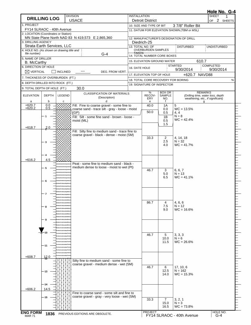
Fill: Fine to coarse gravel - some fine tocoarse sand - trace silt - gray - loose - moist(GP)Fill: Silt - some fine sand - brown - loose -moist (ML)
Fill: Silty fine to medium sand - trace fine tocoarse gravel - black - dense - moist (SM)
Peat - some fine to medium sand - black -medium dense to loose - moist to wet (Pt)
Silty fine to medium sand - some fine tocoarse gravel - medium dense - wet (SM)
Fine to coarse sand - some silt and fine tocoarse gravel - gray - very loose - wet (SM)
40.0
50.0
33.3
46.7
86.7
46.7
46.7
33.3
REMARKS(Drilling time, water loss, depthweathering, etc., if significant)
BOX ORSAMPLE
NO.LEGEND
CLASSIFICATION OF MATERIALS(Description)
ELEVATION DEPTH
a fc eb gd
%RECOV-
ERY
1. PROJECT
UNDISTURBED13. TOTAL NO. OFOVERBURDEN SAMPLESTAKEN
USACEINSTALLATION SHEET
18. TOTAL CORE RECOVERY FOR BORING
+620.7 0.0
12. MANUFACTURER'S DESIGNATION OF DRILL
OF
G-4
9/30/2014 9/30/2014
Detroit District 21
Strata Earth Services, LLC
B. McCarthy
11. DATUM FOR ELEVATION SHOWN (TBM or MSL)
DISTURBED
10. SIZE AND TYPE OF BIT
14. TOTAL NUMBER CORE BOXES
3. DRILLING AGENCY
5. NAME OF DRILLER
6. DIRECTION OF HOLE
%
2. LOCATION (Coordinates or Station)
VERTICAL INCLINED
610.7
19. SIGNATURE OF INSPECTOR
MN State Plane North NAD 83 N 419,573 E 2,865,360Diedrich-25
7. THICKNESS OF OVERBURDEN (FT.)
8. DEPTH DRILLED INTO ROCK (FT.)
9. TOTAL DEPTH OF HOLE (FT.)
DEG. FROM VERT.
4. HOLE NO. (As shown on drawing title andfile number)
+620.7
FY14 SLRAOC - 40th Avenue
NAVD88
16. DATE HOLE
30.0
DIVISION
---17. ELEVATION TOP OF HOLE
15. ELEVATION GROUND WATER
SHEETS
STARTED
DRILLING LOG
COMPLETED
Hole No. G-4
3 7/8" Roller Bit
Hole No. G-4
PROJECT HOLE NO.FY14 SLRAOC - 40th Avenue G-4PREVIOUS EDITIONS ARE OBSOLETE.1836
MAR 71ENG FORM
1
2
3
4
5
6
7
8
9
10
11
12
13
14
15

4, 6, 6N = 12WC = 51.6%
4, 4, 5N = 9WC = 25.0%
2, 3N = 3/6"Qp = 1.0 tsfWC = 41.4%4/6"WC = 306.9%
+602.7
+597.7
+592.7
+589.7
+589.2
18.0
23.0
28.0
31.0
31.5
820.021.5
925.026.5
10A30.031.0
10B31.031.5
Fine to coarse sand - some silt and fine tocoarse gravel - gray - very loose - wet (SM)(continued)
Silty fine sand - trace to some peat - brown -medium dense - wet (SM)
Fine sand - trace silt - brown - loose - wet(SP)
Silty clay - brown - stiff (CL)
Peat - black - loose - wet (Pt)
End of BoringBoring advanced to 7.5 feet with solid-stemaugerBoring advanced from 7.5 to 30.0 feet withrock bit and drilling fluidHW casing driven to 10.0 feetBoring backfilled with cement bentonite grout
66.7
66.7
100.0
100.0
REMARKS(Drilling time, water loss, depthweathering, etc., if significant)
BOX ORSAMPLE
NO.LEGEND
CLASSIFICATION OF MATERIALS(Description)
ELEVATION DEPTH
a fc eb gd
%RECOV-
ERY
SHEETS
PROJECT 2INSTALLATION
Detroit District
DRILLING LOG (Cont Sheet)ELEVATION TOP OF HOLE
620.7 Hole No. G-4
FY14 SLRAOC - 40th AvenueSHEET
OF 2
Hole No. G-4
PROJECT HOLE NO.FY14 SLRAOC - 40th Avenue G-41836-A
JUN 67ENG FORM
17
18
19
20
21
22
23
24
25
26
27
28
29
30
31
32
33
34
35
36
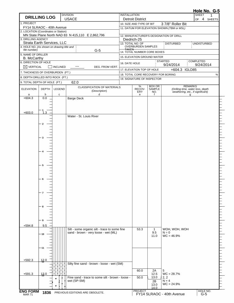
WOH, WOH, WOHN = 0WC = 46.9%
5WC = 28.7%2, 2N = 4WC = 24.9%
+603.0
+594.8
+592.3
+591.3
1.3
9.5
12.0
13.0
19.511.0
2A12.513.02B
13.014.0
Barge Deck
Water - St. Louis River
Silt - some organic silt - trace to some finesand - brown - very loose - wet (ML)
Silty fine sand - brown - loose - wet (SM)
Fine sand - trace to some silt - brown - loose -wet (SP-SM)
53.3
60.0
50.0
REMARKS(Drilling time, water loss, depthweathering, etc., if significant)
BOX ORSAMPLE
NO.LEGEND
CLASSIFICATION OF MATERIALS(Description)
ELEVATION DEPTH
a fc eb gd
%RECOV-
ERY
1. PROJECT
UNDISTURBED13. TOTAL NO. OFOVERBURDEN SAMPLESTAKEN
USACEINSTALLATION SHEET
18. TOTAL CORE RECOVERY FOR BORING
+604.3 0.0
12. MANUFACTURER'S DESIGNATION OF DRILL
OF
G-5
9/24/2014 9/24/2014
Detroit District 41
Strata Earth Services, LLC
B. McCarthy
11. DATUM FOR ELEVATION SHOWN (TBM or MSL)
DISTURBED
10. SIZE AND TYPE OF BIT
14. TOTAL NUMBER CORE BOXES
3. DRILLING AGENCY
5. NAME OF DRILLER
6. DIRECTION OF HOLE
%
2. LOCATION (Coordinates or Station)
VERTICAL INCLINED
19. SIGNATURE OF INSPECTOR
MN State Plane North NAD 83 N 415,110 E 2,862,796Diedrich-25
7. THICKNESS OF OVERBURDEN (FT.)
8. DEPTH DRILLED INTO ROCK (FT.)
9. TOTAL DEPTH OF HOLE (FT.)
DEG. FROM VERT.
4. HOLE NO. (As shown on drawing title andfile number)
+604.3
FY14 SLRAOC - 40th Avenue
IGLD85
16. DATE HOLE
62.0
DIVISION
---17. ELEVATION TOP OF HOLE
15. ELEVATION GROUND WATER
SHEETS
STARTED
DRILLING LOG
COMPLETED
Hole No. G-5
3 7/8" Roller Bit
Hole No. G-5
PROJECT HOLE NO.FY14 SLRAOC - 40th Avenue G-5PREVIOUS EDITIONS ARE OBSOLETE.1836
MAR 71ENG FORM
1
2
3
4
5
6
7
8
9
10
11
12
13

3, 3, 3N = 6WC = 26.8%
2, 1/12"N = 1WC = 36.3%
3, 2, 1N = 3WC = 41.6"
12, 1, 1N = 2WC = 19.8%
1, 1, 1N = 2WC = 37.3%
5, 8N = 8/6"Qp = 0.5 tsfWC = 55.5%9N = 9/6"WC = 24.9%
+587.3
+579.8
+576.3
+573.3
17.0
24.5
28.0
31.0
315.016.5
417.519.0
520.021.5
622.524.0
725.026.5
8A30.031.0
8B31.031.5
Fine sand - trace to some silt - brown - loose -wet (SP-SM) (continued)
Silt - some fine sand - brown - very loose - wet(ML)
Silt - some clay - trace fine sand - brown -very loose - wet (ML)
Silty clay - trace fine sand - brown - medium(CL)
Silty fine sand - medium dense - very loose -wet (SM)
66.7
60.0
73.3
86.7
86.7
60.0
100.0
REMARKS(Drilling time, water loss, depthweathering, etc., if significant)
BOX ORSAMPLE
NO.LEGEND
CLASSIFICATION OF MATERIALS(Description)
ELEVATION DEPTH
a fc eb gd
%RECOV-
ERY
SHEETS
PROJECT 2INSTALLATION
Detroit District
DRILLING LOG (Cont Sheet)ELEVATION TOP OF HOLE
604.3 Hole No. G-5
FY14 SLRAOC - 40th AvenueSHEET
OF 4
Hole No. G-5
PROJECT HOLE NO.FY14 SLRAOC - 40th Avenue G-51836-A
JUN 67ENG FORM
15
16
17
18
19
20
21
22
23
24
25
26
27
28
29
30
31

10, 11, 8N = 19WC = 26.1%
3, 2, 4N = 6WC = 25.6%
1, 1, 2N = 3WC = 26.2%
+556.3 48.0
935.036.5
1040.041.5
1145.046.5
Silty fine sand - medium dense - very loose -wet (SM) (continued)
Silt - some clay - trace to some fine to mediumsand - occasional silty sand seams and layers- brown (ML)
80.0
66.7
80.0
REMARKS(Drilling time, water loss, depthweathering, etc., if significant)
BOX ORSAMPLE
NO.LEGEND
CLASSIFICATION OF MATERIALS(Description)
ELEVATION DEPTH
a fc eb gd
%RECOV-
ERY
SHEETS
PROJECT 3INSTALLATION
Detroit District
DRILLING LOG (Cont Sheet)ELEVATION TOP OF HOLE
604.3 Hole No. G-5
FY14 SLRAOC - 40th AvenueSHEET
OF 4
Hole No. G-5
PROJECT HOLE NO.FY14 SLRAOC - 40th Avenue G-51836-A
JUN 67ENG FORM
33
34
35
36
37
38
39
40
41
42
43
44
45
46
47
48
49

ST: 50'-52'
9, 11, 10N = 21WC = 23.8%
Torvane (Su) = 4.0 tsf to 5.0 tsfWC = 62.2%
+549.3
+547.8
+542.3
55.0
56.5
62.0
1250.052.0
1355.056.5
1460.062.0
Silt - some clay - trace to some fine to mediumsand - occasional silty sand seams and layers- brown (ML) (continued)
Silty fine sand - brown - medium dense - wet(SM)
Clay - some silt - trace fine to medium sand -brown - hard (CH)
End of BoringBoring advanced to 60.0 feet with rock bit anddrilling fluidHW casing driven to 12.0 feet below watersurfaceBoring backfilled with cement bentonite grout
75.0
66.7
100.0
REMARKS(Drilling time, water loss, depthweathering, etc., if significant)
BOX ORSAMPLE
NO.LEGEND
CLASSIFICATION OF MATERIALS(Description)
ELEVATION DEPTH
a fc eb gd
%RECOV-
ERY
SHEETS
PROJECT 4INSTALLATION
Detroit District
DRILLING LOG (Cont Sheet)ELEVATION TOP OF HOLE
604.3 Hole No. G-5
FY14 SLRAOC - 40th AvenueSHEET
OF 4
Hole No. G-5
PROJECT HOLE NO.FY14 SLRAOC - 40th Avenue G-51836-A
JUN 67ENG FORM
51
52
53
54
55
56
57
58
59
60
61
62
63
64
65
66
67
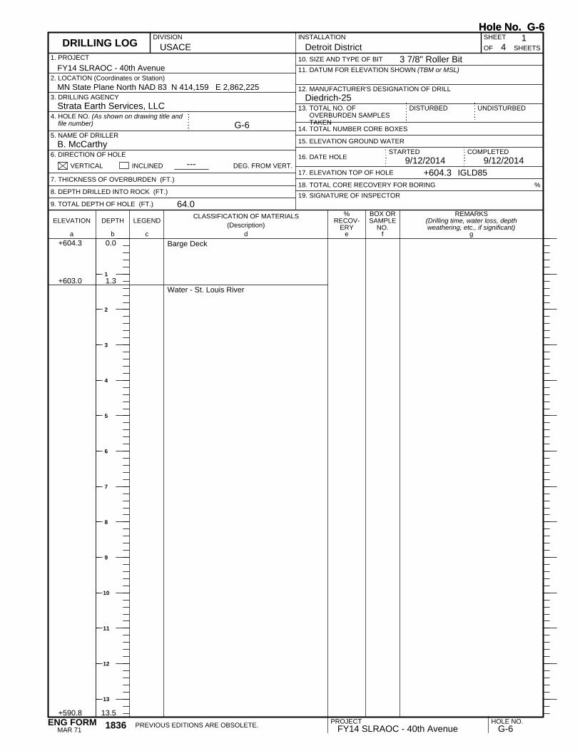
+603.0
+590.8
1.3
13.5
Barge Deck
Water - St. Louis River
REMARKS(Drilling time, water loss, depthweathering, etc., if significant)
BOX ORSAMPLE
NO.LEGEND
CLASSIFICATION OF MATERIALS(Description)
ELEVATION DEPTH
a fc eb gd
%RECOV-
ERY
1. PROJECT
UNDISTURBED13. TOTAL NO. OFOVERBURDEN SAMPLESTAKEN
USACEINSTALLATION SHEET
18. TOTAL CORE RECOVERY FOR BORING
+604.3 0.0
12. MANUFACTURER'S DESIGNATION OF DRILL
OF
G-6
9/12/2014 9/12/2014
Detroit District 41
Strata Earth Services, LLC
B. McCarthy
11. DATUM FOR ELEVATION SHOWN (TBM or MSL)
DISTURBED
10. SIZE AND TYPE OF BIT
14. TOTAL NUMBER CORE BOXES
3. DRILLING AGENCY
5. NAME OF DRILLER
6. DIRECTION OF HOLE
%
2. LOCATION (Coordinates or Station)
VERTICAL INCLINED
19. SIGNATURE OF INSPECTOR
MN State Plane North NAD 83 N 414,159 E 2,862,225Diedrich-25
7. THICKNESS OF OVERBURDEN (FT.)
8. DEPTH DRILLED INTO ROCK (FT.)
9. TOTAL DEPTH OF HOLE (FT.)
DEG. FROM VERT.
4. HOLE NO. (As shown on drawing title andfile number)
+604.3
FY14 SLRAOC - 40th Avenue
IGLD85
16. DATE HOLE
64.0
DIVISION
---17. ELEVATION TOP OF HOLE
15. ELEVATION GROUND WATER
SHEETS
STARTED
DRILLING LOG
COMPLETED
Hole No. G-6
3 7/8" Roller Bit
Hole No. G-6
PROJECT HOLE NO.FY14 SLRAOC - 40th Avenue G-6PREVIOUS EDITIONS ARE OBSOLETE.1836
MAR 71ENG FORM
1
2
3
4
5
6
7
8
9
10
11
12
13

WOH, WOH, WOHN = 0WC = 110.9%
WOH, WOH, WOHN = 0WC = 106.2%
WOH, WOH, WOHN = 0/6"WC = 82.1%
3/6"WC = 32.8%
6, 3, 1N = 4WC = 27.9%
1, 2, 1N = 3WC = 27.2%
WOH, 1, 1N = 2WC = 32.0%
7, 5, 7N = 12WC = 24.9%
+587.3
+584.8
+577.3
17.0
19.5
27.0
113.515.0
215.016.5
3A17.518.5
3B18.519.0
420.021.5
522.524.0
625.026.5
727.529.0
Organic silt - some inorganic silt - trace rootfibers - dark brown - very loose - wet (OL)
Silt - some fine sand - trace to some organicsilt - brown and dark brown - very loose - wet(ML)
Silt - trace to some clay - brown - loose to veryloose -wet (ML)
Fine sand - trace silt - brown - medium dense- wet (SP)
40.0
70.0
80.0
93.3
73.3
100.0
66.7
REMARKS(Drilling time, water loss, depthweathering, etc., if significant)
BOX ORSAMPLE
NO.LEGEND
CLASSIFICATION OF MATERIALS(Description)
ELEVATION DEPTH
a fc eb gd
%RECOV-
ERY
SHEETS
PROJECT 2INSTALLATION
Detroit District
DRILLING LOG (Cont Sheet)ELEVATION TOP OF HOLE
604.3 Hole No. G-6
FY14 SLRAOC - 40th AvenueSHEET
OF 4
Hole No. G-6
PROJECT HOLE NO.FY14 SLRAOC - 40th Avenue G-61836-A
JUN 67ENG FORM
14
15
16
17
18
19
20
21
22
23
24
25
26
27
28
29
30

6, 6, 6N = 12WC = 23.2%
4, 2, 1N = 3WC = 29.3%
6, 7, 8N = 15WC = 21.9%
5, 3, 2N = 5WC = 20.9%
+568.3
+563.3
+558.3
36.0
41.0
46.0
832.534.0
937.539.0
1042.544.0
1147.549.0
Fine sand - trace silt - brown - medium dense- wet (SP) (continued)
Silt - some fine sand - brown - very loose - wet(ML)
Fine sand - trace silt - brown - medium dense- wet (SP)
Silty fine to medium sand - trace fine tocoarse gravel - brown - loose - wet (SM)
53.3
66.7
60.0
86.7
REMARKS(Drilling time, water loss, depthweathering, etc., if significant)
BOX ORSAMPLE
NO.LEGEND
CLASSIFICATION OF MATERIALS(Description)
ELEVATION DEPTH
a fc eb gd
%RECOV-
ERY
SHEETS
PROJECT 3INSTALLATION
Detroit District
DRILLING LOG (Cont Sheet)ELEVATION TOP OF HOLE
604.3 Hole No. G-6
FY14 SLRAOC - 40th AvenueSHEET
OF 4
Hole No. G-6
PROJECT HOLE NO.FY14 SLRAOC - 40th Avenue G-61836-A
JUN 67ENG FORM
31
32
33
34
35
36
37
38
39
40
41
42
43
44
45
46
47
48

WC = 21.8%
8, 3, 4N = 7WC = 43.4%
9, 10, 10N = 20WC = 50.2%
Torvane (Su) = 1.75 tsf to 2.0 tsfWC = 32.9%ST: 62'-64'
+553.3
+548.3
+544.3
+540.3
51.0
56.0
60.0
64.0
1252.554.0
1357.559.0
1462.064.0
Silty fine to medium sand - trace fine tocoarse gravel - brown - loose - wet (SM)(continued)
Clayey fine to medium sand - some silt -brown - loose - wet (SC)
Silt - some clay - trace fine sand - brown -medium dense - wet (ML)
Clay - some silt - trace fine sand - brown -very stiff to hard (CH)
End of BoringBoring advanced to 62.0 feet with rock bit anddrilling fluidHW casing driven to 21.5 feet below riverbottomBoring backfilled with cement bentonite grout
40.0
40.0
30.0
REMARKS(Drilling time, water loss, depthweathering, etc., if significant)
BOX ORSAMPLE
NO.LEGEND
CLASSIFICATION OF MATERIALS(Description)
ELEVATION DEPTH
a fc eb gd
%RECOV-
ERY
SHEETS
PROJECT 4INSTALLATION
Detroit District
DRILLING LOG (Cont Sheet)ELEVATION TOP OF HOLE
604.3 Hole No. G-6
FY14 SLRAOC - 40th AvenueSHEET
OF 4
Hole No. G-6
PROJECT HOLE NO.FY14 SLRAOC - 40th Avenue G-61836-A
JUN 67ENG FORM
49
50
51
52
53
54
55
56
57
58
59
60
61
62
63
64
65

WOH, WOH, WOHN = 0WC = 140.4%
WOH, 1/12"N = 1WC = 83.6%
+603.0
+593.8
1.3
10.51
10.512.0
212.514.0
Barge Deck
Water - St. Louis River
Organic silt - some inorganic silt - trace finesand and wood pieces - dark brown - veryloose - wet (OL)
100.0
33.3
REMARKS(Drilling time, water loss, depthweathering, etc., if significant)
BOX ORSAMPLE
NO.LEGEND
CLASSIFICATION OF MATERIALS(Description)
ELEVATION DEPTH
a fc eb gd
%RECOV-
ERY
1. PROJECT
UNDISTURBED13. TOTAL NO. OFOVERBURDEN SAMPLESTAKEN
USACEINSTALLATION SHEET
18. TOTAL CORE RECOVERY FOR BORING
+604.3 0.0
12. MANUFACTURER'S DESIGNATION OF DRILL
OF
G-7
9/25/2014 9/25/2014
Detroit District 51
Strata Earth Services, LLC
B. McCarthy
11. DATUM FOR ELEVATION SHOWN (TBM or MSL)
DISTURBED
10. SIZE AND TYPE OF BIT
14. TOTAL NUMBER CORE BOXES
3. DRILLING AGENCY
5. NAME OF DRILLER
6. DIRECTION OF HOLE
%
2. LOCATION (Coordinates or Station)
VERTICAL INCLINED
19. SIGNATURE OF INSPECTOR
MN State Plane North NAD 83 N 414,215 E 2,862,974Diedrich-25
7. THICKNESS OF OVERBURDEN (FT.)
8. DEPTH DRILLED INTO ROCK (FT.)
9. TOTAL DEPTH OF HOLE (FT.)
DEG. FROM VERT.
4. HOLE NO. (As shown on drawing title andfile number)
+604.3
FY14 SLRAOC - 40th Avenue
IGLD85
16. DATE HOLE
80.5
DIVISION
---17. ELEVATION TOP OF HOLE
15. ELEVATION GROUND WATER
SHEETS
STARTED
DRILLING LOG
COMPLETED
Hole No. G-7
3 7/8" Roller Bit
Hole No. G-7
PROJECT HOLE NO.FY14 SLRAOC - 40th Avenue G-7PREVIOUS EDITIONS ARE OBSOLETE.1836
MAR 71ENG FORM
1
2
3
4
5
6
7
8
9
10
11
12
13

WOH, WOH, WOHN = 0WC = 244.2%
WOH, WOH, WOHN = 0WC = 363.6%
4, 2, 3N = 5WC = 21.9%
2, 2, 2N = 4WC = 29.1%
1, 1, 1N = 2WC = 38.4%
1, 1, 1N = 2WC = 37.6%
+587.3
+584.8
+579.8
17.0
19.5
24.5
315.016.5
417.519.0
520.021.5
622.524.0
725.026.5
830.031.5
Organic silt - some inorganic silt - trace finesand and wood pieces - dark brown - veryloose - wet (OL) (continued)
Peat - trace wood - black - very loose - wet -(Pt)
Silt - some fine sand - brown - loose - wet(ML)
Silt - some clay - trace to some fine to mediumsand - brown - very loose - wet (ML)
53.3
20.0
66.7
40.0
80.0
86.7
REMARKS(Drilling time, water loss, depthweathering, etc., if significant)
BOX ORSAMPLE
NO.LEGEND
CLASSIFICATION OF MATERIALS(Description)
ELEVATION DEPTH
a fc eb gd
%RECOV-
ERY
SHEETS
PROJECT 2INSTALLATION
Detroit District
DRILLING LOG (Cont Sheet)ELEVATION TOP OF HOLE
604.3 Hole No. G-7
FY14 SLRAOC - 40th AvenueSHEET
OF 5
Hole No. G-7
PROJECT HOLE NO.FY14 SLRAOC - 40th Avenue G-71836-A
JUN 67ENG FORM
15
16
17
18
19
20
21
22
23
24
25
26
27
28
29
30
31

WC = 30.6%ST: 35'-37'
1, 1, 1N = 2WC = 31.5%
1, 1, 2N = 3Qp = 0.25 tsfWC = 48.0%
+561.3 43.0
935.037.0
1040.041.5
1145.046.5
Silt - some clay - trace to some fine to mediumsand - brown - very loose - wet (ML)(continued)
Silty clay - trace fine sand - brown - very softto very stiff (CH)
100.0
100.0
100.0
REMARKS(Drilling time, water loss, depthweathering, etc., if significant)
BOX ORSAMPLE
NO.LEGEND
CLASSIFICATION OF MATERIALS(Description)
ELEVATION DEPTH
a fc eb gd
%RECOV-
ERY
SHEETS
PROJECT 3INSTALLATION
Detroit District
DRILLING LOG (Cont Sheet)ELEVATION TOP OF HOLE
604.3 Hole No. G-7
FY14 SLRAOC - 40th AvenueSHEET
OF 5
Hole No. G-7
PROJECT HOLE NO.FY14 SLRAOC - 40th Avenue G-71836-A
JUN 67ENG FORM
33
34
35
36
37
38
39
40
41
42
43
44
45
46
47
48
49

Torvane (Su) = 1.0 tsf to 1.75 tsfWC = 50.4%ST: 50'-52'
1, 1, 1N = 2Qp = 0.5 tsfWC = 59.1%
Torvane (Su) = <0.1 tsfST: 60'-61.5'
12, 10, 10N = 20WC = 22.7%
+543.3
+536.3
61.0
68.0
1250.052.0
1355.056.5
1460.062.0
1565.066.5
Silty clay - trace fine sand - brown - very softto very stiff (CH) (continued)
Fine to medium sand - trace silt and coarsesand - brown - medium dense - wet (SP)
100.0
100.0
75.0
60.0
REMARKS(Drilling time, water loss, depthweathering, etc., if significant)
BOX ORSAMPLE
NO.LEGEND
CLASSIFICATION OF MATERIALS(Description)
ELEVATION DEPTH
a fc eb gd
%RECOV-
ERY
SHEETS
PROJECT 4INSTALLATION
Detroit District
DRILLING LOG (Cont Sheet)ELEVATION TOP OF HOLE
604.3 Hole No. G-7
FY14 SLRAOC - 40th AvenueSHEET
OF 5
Hole No. G-7
PROJECT HOLE NO.FY14 SLRAOC - 40th Avenue G-71836-A
JUN 67ENG FORM
51
52
53
54
55
56
57
58
59
60
61
62
63
64
65
66
67
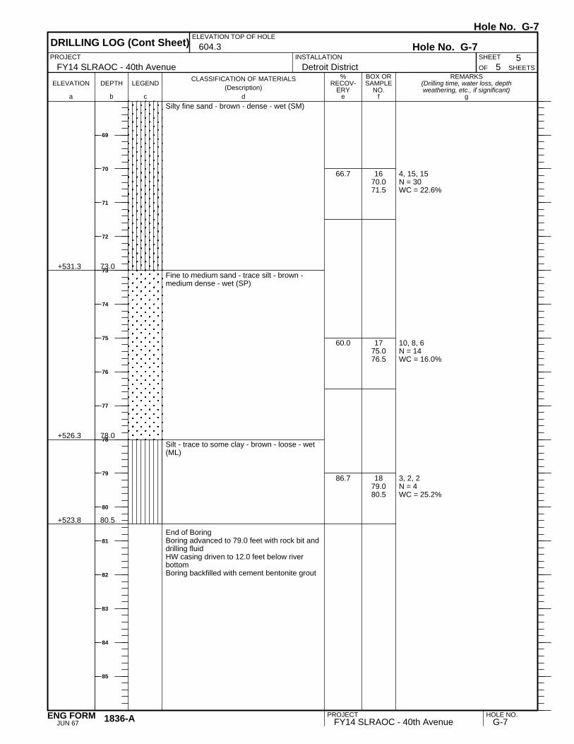
4, 15, 15N = 30WC = 22.6%
10, 8, 6N = 14WC = 16.0%
3, 2, 2N = 4WC = 25.2%
+531.3
+526.3
+523.8
73.0
78.0
80.5
1670.071.5
1775.076.5
1879.080.5
Silty fine sand - brown - dense - wet (SM)
Fine to medium sand - trace silt - brown -medium dense - wet (SP)
Silt - trace to some clay - brown - loose - wet(ML)
End of BoringBoring advanced to 79.0 feet with rock bit anddrilling fluidHW casing driven to 12.0 feet below riverbottomBoring backfilled with cement bentonite grout
66.7
60.0
86.7
REMARKS(Drilling time, water loss, depthweathering, etc., if significant)
BOX ORSAMPLE
NO.LEGEND
CLASSIFICATION OF MATERIALS(Description)
ELEVATION DEPTH
a fc eb gd
%RECOV-
ERY
SHEETS
PROJECT 5INSTALLATION
Detroit District
DRILLING LOG (Cont Sheet)ELEVATION TOP OF HOLE
604.3 Hole No. G-7
FY14 SLRAOC - 40th AvenueSHEET
OF 5
Hole No. G-7
PROJECT HOLE NO.FY14 SLRAOC - 40th Avenue G-71836-A
JUN 67ENG FORM
69
70
71
72
73
74
75
76
77
78
79
80
81
82
83
84
85

WOH, 1, 1N = 2WC = 31.4%
5, 3, 1N = 4WC = 21.0%
+602.8
+594.1
1.3
10.01
10.011.5
212.514.0
Barge Deck
Water - St. Louis River
Silty fine sand - trace fine gravel - brown -very loose to loose - wet (SM)
33.3
86.7
REMARKS(Drilling time, water loss, depthweathering, etc., if significant)
BOX ORSAMPLE
NO.LEGEND
CLASSIFICATION OF MATERIALS(Description)
ELEVATION DEPTH
a fc eb gd
%RECOV-
ERY
1. PROJECT
UNDISTURBED13. TOTAL NO. OFOVERBURDEN SAMPLESTAKEN
USACEINSTALLATION SHEET
18. TOTAL CORE RECOVERY FOR BORING
+604.1 0.0
12. MANUFACTURER'S DESIGNATION OF DRILL
OF
G-9
9/22/2014 9/22/2014
Detroit District 21
Strata Earth Services, LLC
B. McCarthy
11. DATUM FOR ELEVATION SHOWN (TBM or MSL)
DISTURBED
10. SIZE AND TYPE OF BIT
14. TOTAL NUMBER CORE BOXES
3. DRILLING AGENCY
5. NAME OF DRILLER
6. DIRECTION OF HOLE
%
2. LOCATION (Coordinates or Station)
VERTICAL INCLINED
19. SIGNATURE OF INSPECTOR
MN State Plane North NAD 83 N 414,702 E 2,862,319Diedrich-25
7. THICKNESS OF OVERBURDEN (FT.)
8. DEPTH DRILLED INTO ROCK (FT.)
9. TOTAL DEPTH OF HOLE (FT.)
DEG. FROM VERT.
4. HOLE NO. (As shown on drawing title andfile number)
+604.1
FY14 SLRAOC - 40th Avenue
IGLD85
16. DATE HOLE
26.5
DIVISION
---17. ELEVATION TOP OF HOLE
15. ELEVATION GROUND WATER
SHEETS
STARTED
DRILLING LOG
COMPLETED
Hole No. G-9
3 7/8" Roller Bit
Hole No. G-9
PROJECT HOLE NO.FY14 SLRAOC - 40th Avenue G-9PREVIOUS EDITIONS ARE OBSOLETE.1836
MAR 71ENG FORM
1
2
3
4
5
6
7
8
9
10
11
12
13

2, 1, 1N = 2WC = 24.0%
2, 2, 1N = 3WC = 32.4%
2, 1, 1N = 2WC = 33.8%
1, 1, 2N = 3WC = 30.3%
2, 1, 1N = 2WC = 40.5%
+589.6
+587.1
+584.6
+579.6
+577.6
14.5
17.0
19.5
24.5
26.5
315.016.5
417.519.0
520.021.5
622.524.0
725.026.5
Fine to medium sand - trace silt - brown - veryloose - wet (SP)
Silty fine sand - brown - very loose - wet (SM)
Silt - some fine sand - brown - very loose - wet(ML)
Silt - trace to some clay and fine sand - brown- very loose - wet (ML)
End of BoringBoring advanced to 25.0 feet with rock bit anddrilling fluidHW casing driven to 5.0 feet below riverbottomBoring backfilled with cement bentonite grout
53.3
66.7
46.7
86.7
80.0
REMARKS(Drilling time, water loss, depthweathering, etc., if significant)
BOX ORSAMPLE
NO.LEGEND
CLASSIFICATION OF MATERIALS(Description)
ELEVATION DEPTH
a fc eb gd
%RECOV-
ERY
SHEETS
PROJECT 2INSTALLATION
Detroit District
DRILLING LOG (Cont Sheet)ELEVATION TOP OF HOLE
604.1 Hole No. G-9
FY14 SLRAOC - 40th AvenueSHEET
OF 2
Hole No. G-9
PROJECT HOLE NO.FY14 SLRAOC - 40th Avenue G-91836-A
JUN 67ENG FORM
15
16
17
18
19
20
21
22
23
24
25
26
27
28
29
30
31

1, 1N = 1/6"WC = 77.4%
1/6"WC = 30.8%
5, 5, 6N = 11WC = 27.5%
+602.8
+594.1
+593.1
+592.1
1.3
10.0
11.0
12.0
1A10.011.0
1B11.011.5
212.514.0
Barge Deck
Water - St. Louis River
Silt - some organic silt - trace fine sand -brown - very loose - wet (ML)
Fine to medium sand - some silt - trace wood- brown - very loose to wet (SM)
Fine sand - trace silt - brown - medium denseto very loose - wet (SP)
70.0
100.0
60.0
REMARKS(Drilling time, water loss, depthweathering, etc., if significant)
BOX ORSAMPLE
NO.LEGEND
CLASSIFICATION OF MATERIALS(Description)
ELEVATION DEPTH
a fc eb gd
%RECOV-
ERY
1. PROJECT
UNDISTURBED13. TOTAL NO. OFOVERBURDEN SAMPLESTAKEN
USACEINSTALLATION SHEET
18. TOTAL CORE RECOVERY FOR BORING
+604.1 0.0
12. MANUFACTURER'S DESIGNATION OF DRILL
OF
G-10
9/22/2014 9/22/2014
Detroit District 21
Strata Earth Services, LLC
B. McCarthy
11. DATUM FOR ELEVATION SHOWN (TBM or MSL)
DISTURBED
10. SIZE AND TYPE OF BIT
14. TOTAL NUMBER CORE BOXES
3. DRILLING AGENCY
5. NAME OF DRILLER
6. DIRECTION OF HOLE
%
2. LOCATION (Coordinates or Station)
VERTICAL INCLINED
19. SIGNATURE OF INSPECTOR
MN State Plane North NAD 83 N 415,099 E 2,862,180Diedrich-25
7. THICKNESS OF OVERBURDEN (FT.)
8. DEPTH DRILLED INTO ROCK (FT.)
9. TOTAL DEPTH OF HOLE (FT.)
DEG. FROM VERT.
4. HOLE NO. (As shown on drawing title andfile number)
+604.1
FY14 SLRAOC - 40th Avenue
IGLD85
16. DATE HOLE
26.5
DIVISION
---17. ELEVATION TOP OF HOLE
15. ELEVATION GROUND WATER
SHEETS
STARTED
DRILLING LOG
COMPLETED
Hole No. G-10
3 7/8" Roller Bit
Hole No. G-10
PROJECT HOLE NO.FY14 SLRAOC - 40th Avenue G-10PREVIOUS EDITIONS ARE OBSOLETE.1836
MAR 71ENG FORM
1
2
3
4
5
6
7
8
9
10
11
12
13

3, 3, 4N = 7WC = 25.4%
1, 1, 1N = 2WC = 27.8%
1, 1, 2N = 3WC = 27.7%
1, 1, 1N = 2WC = 45.0%
4, 8, 8N = 16WC = 23.6%
+582.1
+579.6
+577.6
22.0
24.5
26.5
315.016.5
417.519.0
520.021.5
622.524.0
725.026.5
Fine sand - trace silt - brown - medium denseto very loose - wet (SP) (continued)
Silt - some fine sand - brown - very loose - wet(ML)
Fine sand - trace silt - brown - medium dense- wet (SP)
End of BoringBoring advanced to 25.0 feet with rock bit anddrilling fluidHW casing driven to 5.0 feetBoring backfilled with cement bentonite grout
46.7
46.7
40.0
66.7
53.3
REMARKS(Drilling time, water loss, depthweathering, etc., if significant)
BOX ORSAMPLE
NO.LEGEND
CLASSIFICATION OF MATERIALS(Description)
ELEVATION DEPTH
a fc eb gd
%RECOV-
ERY
SHEETS
PROJECT 2INSTALLATION
Detroit District
DRILLING LOG (Cont Sheet)ELEVATION TOP OF HOLE
604.1 Hole No. G-10
FY14 SLRAOC - 40th AvenueSHEET
OF 2
Hole No. G-10
PROJECT HOLE NO.FY14 SLRAOC - 40th Avenue G-101836-A
JUN 67ENG FORM
15
16
17
18
19
20
21
22
23
24
25
26
27
28
29
30
31
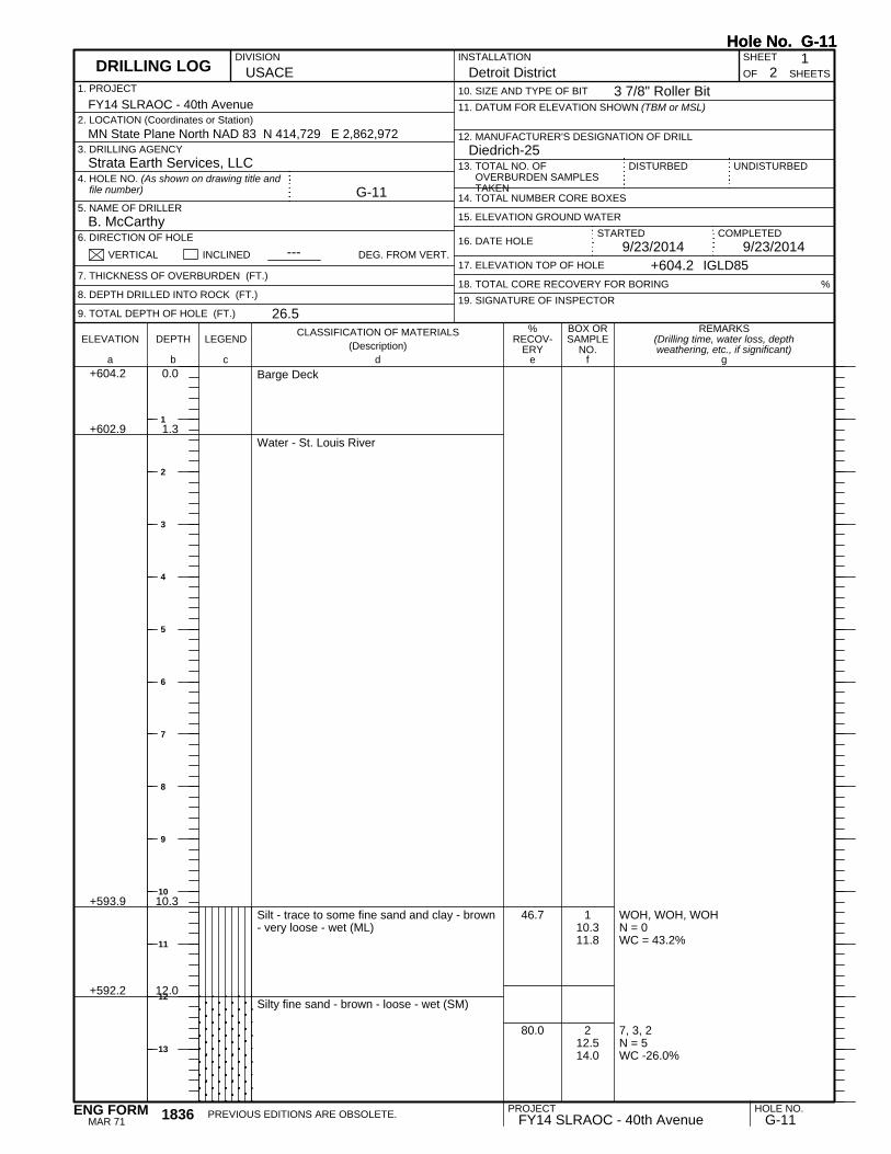
WOH, WOH, WOHN = 0WC = 43.2%
7, 3, 2N = 5WC -26.0%
+602.9
+593.9
+592.2
1.3
10.3
12.0
110.311.8
212.514.0
Barge Deck
Water - St. Louis River
Silt - trace to some fine sand and clay - brown- very loose - wet (ML)
Silty fine sand - brown - loose - wet (SM)
46.7
80.0
REMARKS(Drilling time, water loss, depthweathering, etc., if significant)
BOX ORSAMPLE
NO.LEGEND
CLASSIFICATION OF MATERIALS(Description)
ELEVATION DEPTH
a fc eb gd
%RECOV-
ERY
1. PROJECT
UNDISTURBED13. TOTAL NO. OFOVERBURDEN SAMPLESTAKEN
USACEINSTALLATION SHEET
18. TOTAL CORE RECOVERY FOR BORING
+604.2 0.0
12. MANUFACTURER'S DESIGNATION OF DRILL
OF
G-11
9/23/2014 9/23/2014
Detroit District 21
Strata Earth Services, LLC
B. McCarthy
11. DATUM FOR ELEVATION SHOWN (TBM or MSL)
DISTURBED
10. SIZE AND TYPE OF BIT
14. TOTAL NUMBER CORE BOXES
3. DRILLING AGENCY
5. NAME OF DRILLER
6. DIRECTION OF HOLE
%
2. LOCATION (Coordinates or Station)
VERTICAL INCLINED
19. SIGNATURE OF INSPECTOR
MN State Plane North NAD 83 N 414,729 E 2,862,972Diedrich-25
7. THICKNESS OF OVERBURDEN (FT.)
8. DEPTH DRILLED INTO ROCK (FT.)
9. TOTAL DEPTH OF HOLE (FT.)
DEG. FROM VERT.
4. HOLE NO. (As shown on drawing title andfile number)
+604.2
FY14 SLRAOC - 40th Avenue
IGLD85
16. DATE HOLE
26.5
DIVISION
---17. ELEVATION TOP OF HOLE
15. ELEVATION GROUND WATER
SHEETS
STARTED
DRILLING LOG
COMPLETED
Hole No. G-11
3 7/8" Roller Bit
Hole No. G-11
PROJECT HOLE NO.FY14 SLRAOC - 40th Avenue G-11PREVIOUS EDITIONS ARE OBSOLETE.1836
MAR 71ENG FORM
1
2
3
4
5
6
7
8
9
10
11
12
13

4, 3, 3N = 6WC = 18.6%
2WC = 99.4%2, 2N = 4WC = 36.7%
2, 1/12"N = 1WC = 40.3%
1, 1, 1N = 2WC = 36.6%
2, 1, 1N = 2WC = 36.7%
+589.7
+587.2
+586.2
+582.2
+577.7
14.5
17.0
18.0
22.0
26.5
315.016.5
4A17.518.04B
18.019.0
520.021.5
622.524.0
725.026.5
Silty fine sand - brown - loose - wet (SM)(continued)Fine to medium sand - trace silt - brown -loose - wet (SP)
Wood - some silt - brown and black - loose -wet (Pt)
Silt - trace to some fine sand - brown - veryloose - wet (ML)
Silt - trace to some clay and fine sand - brown- very loose - wet (ML)
End of BoringBoring advanced to 25.0 feet with rock bit anddrilling fluidHW casing driven to 10.0 feet below riverbottomBoring backfilled with cement bentonite grout
53.3
80.0
80.0
66.7
73.3
REMARKS(Drilling time, water loss, depthweathering, etc., if significant)
BOX ORSAMPLE
NO.LEGEND
CLASSIFICATION OF MATERIALS(Description)
ELEVATION DEPTH
a fc eb gd
%RECOV-
ERY
SHEETS
PROJECT 2INSTALLATION
Detroit District
DRILLING LOG (Cont Sheet)ELEVATION TOP OF HOLE
604.2 Hole No. G-11
FY14 SLRAOC - 40th AvenueSHEET
OF 2
Hole No. G-11
PROJECT HOLE NO.FY14 SLRAOC - 40th Avenue G-111836-A
JUN 67ENG FORM
15
16
17
18
19
20
21
22
23
24
25
26
27
28
29
30
31
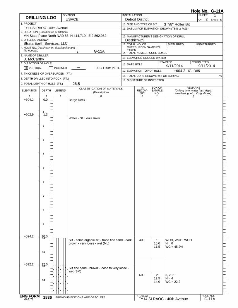
WOH, WOH, WOHN = 0WC = 45.2%
3, 2, 2N = 4WC = 22.2
+602.9
+594.2
+592.2
1.3
10.0
12.0
110.011.5
212.514.0
Barge Deck
Water - St. Louis River
Silt - some organic silt - trace fine sand - darkbrown - very loose - wet (ML)
Silt fine sand - brown - loose to very loose -wet (SM)
40.0
60.0
REMARKS(Drilling time, water loss, depthweathering, etc., if significant)
BOX ORSAMPLE
NO.LEGEND
CLASSIFICATION OF MATERIALS(Description)
ELEVATION DEPTH
a fc eb gd
%RECOV-
ERY
1. PROJECT
UNDISTURBED13. TOTAL NO. OFOVERBURDEN SAMPLESTAKEN
USACEINSTALLATION SHEET
18. TOTAL CORE RECOVERY FOR BORING
+604.2 0.0
12. MANUFACTURER'S DESIGNATION OF DRILL
OF
G-11A
9/11/2014 9/11/2014
Detroit District 21
Strata Earth Services, LLC
B. McCarthy
11. DATUM FOR ELEVATION SHOWN (TBM or MSL)
DISTURBED
10. SIZE AND TYPE OF BIT
14. TOTAL NUMBER CORE BOXES
3. DRILLING AGENCY
5. NAME OF DRILLER
6. DIRECTION OF HOLE
%
2. LOCATION (Coordinates or Station)
VERTICAL INCLINED
19. SIGNATURE OF INSPECTOR
MN State Plane North NAD 83 N 414,719 E 2,862,962Diedrich-25
7. THICKNESS OF OVERBURDEN (FT.)
8. DEPTH DRILLED INTO ROCK (FT.)
9. TOTAL DEPTH OF HOLE (FT.)
DEG. FROM VERT.
4. HOLE NO. (As shown on drawing title andfile number)
+604.2
FY14 SLRAOC - 40th Avenue
IGLD85
16. DATE HOLE
26.5
DIVISION
---17. ELEVATION TOP OF HOLE
15. ELEVATION GROUND WATER
SHEETS
STARTED
DRILLING LOG
COMPLETED
Hole No. G-11A
3 7/8" Roller Bit
Hole No. G-11A
PROJECT HOLE NO.FY14 SLRAOC - 40th Avenue G-11APREVIOUS EDITIONS ARE OBSOLETE.1836
MAR 71ENG FORM
1
2
3
4
5
6
7
8
9
10
11
12
13

3, 2, 3N = 5WC = 23.3%
2, 1, 1WC = 49.7%
WOH, 1, 1N = 2WC = 33.6%
1, 1, 1N = 2WC = 31.9%
1, 1, 1N = 2wc = 38.9%
+584.7
+577.7
19.5
26.5
315.016.5
417.519.0
520.021.5
622.524.0
725.026.5
Silt fine sand - brown - loose to very loose -wet (SM) (continued)
Silt - trace to some clay and fine sand - brown- very loose - wet (ML)
End of BoringBoring advanced to 25.0 feet with rock bit anddrilling fluidHW casing driven to 5.0 feet below riverbottomBoring backfilled with cement bentonite grout
66.7
73.3
66.7
86.7
80.0
REMARKS(Drilling time, water loss, depthweathering, etc., if significant)
BOX ORSAMPLE
NO.LEGEND
CLASSIFICATION OF MATERIALS(Description)
ELEVATION DEPTH
a fc eb gd
%RECOV-
ERY
SHEETS
PROJECT 2INSTALLATION
Detroit District
DRILLING LOG (Cont Sheet)ELEVATION TOP OF HOLE
604.2 Hole No. G-11A
FY14 SLRAOC - 40th AvenueSHEET
OF 2
Hole No. G-11A
PROJECT HOLE NO.FY14 SLRAOC - 40th Avenue G-11A1836-A
JUN 67ENG FORM
15
16
17
18
19
20
21
22
23
24
25
26
27
28
29
30
31

+603.0 1.3
Barge Deck
Water - St. Louis River
REMARKS(Drilling time, water loss, depthweathering, etc., if significant)
BOX ORSAMPLE
NO.LEGEND
CLASSIFICATION OF MATERIALS(Description)
ELEVATION DEPTH
a fc eb gd
%RECOV-
ERY
1. PROJECT
UNDISTURBED13. TOTAL NO. OFOVERBURDEN SAMPLESTAKEN
USACEINSTALLATION SHEET
18. TOTAL CORE RECOVERY FOR BORING
+604.3 0.0
12. MANUFACTURER'S DESIGNATION OF DRILL
OF
GA-1
9/24/2014 9/24/2014
Detroit District 51
Strata Earth Services, LLC
B. McCarthy
11. DATUM FOR ELEVATION SHOWN (TBM or MSL)
DISTURBED
10. SIZE AND TYPE OF BIT
14. TOTAL NUMBER CORE BOXES
3. DRILLING AGENCY
5. NAME OF DRILLER
6. DIRECTION OF HOLE
%
2. LOCATION (Coordinates or Station)
VERTICAL INCLINED
19. SIGNATURE OF INSPECTOR
MN State Plane North NAD 83 N 413,422 E 2,863,727Diedrich-25
7. THICKNESS OF OVERBURDEN (FT.)
8. DEPTH DRILLED INTO ROCK (FT.)
9. TOTAL DEPTH OF HOLE (FT.)
DEG. FROM VERT.
4. HOLE NO. (As shown on drawing title andfile number)
+604.3
FY14 SLRAOC - 40th Avenue
IGLD85
16. DATE HOLE
69.5
DIVISION
---17. ELEVATION TOP OF HOLE
15. ELEVATION GROUND WATER
SHEETS
STARTED
DRILLING LOG
COMPLETED
Hole No. GA-1
3 7/8" Roller Bit
Hole No. GA-1
PROJECT HOLE NO.FY14 SLRAOC - 40th Avenue GA-1PREVIOUS EDITIONS ARE OBSOLETE.1836
MAR 71ENG FORM
1
2
3
4
5
6
7
8
9
10
11
12
13

WOH, WOH, WOH, WOHN = 0WC = 98.4%
WOH, 1, 1N = 2WC = 45.9%
2, 2, 2N = 4WC = 25.8%
2, 2, 2N = 4WC = 27.6%
3, 2, 2N = 4WC = 29.3%
+584.8
+582.3
+579.8
19.5
22.0
24.5
119.521.5
222.524.0
325.026.5
427.529.0
530.031.5
Water - St. Louis River (continued)
Organic silt - some inorganic silt - trace tosome fine sand - brown - very loose - wet (OL)
Silty fine sand - brown and dark brown - veryloose - wet (SM)
Fine sand - trace silt - brown - loose - wet(SP)
40.0
53.3
46.7
53.3
40.0
REMARKS(Drilling time, water loss, depthweathering, etc., if significant)
BOX ORSAMPLE
NO.LEGEND
CLASSIFICATION OF MATERIALS(Description)
ELEVATION DEPTH
a fc eb gd
%RECOV-
ERY
SHEETS
PROJECT 2INSTALLATION
Detroit District
DRILLING LOG (Cont Sheet)ELEVATION TOP OF HOLE
604.3 Hole No. GA-1
FY14 SLRAOC - 40th AvenueSHEET
OF 5
Hole No. GA-1
PROJECT HOLE NO.FY14 SLRAOC - 40th Avenue GA-11836-A
JUN 67ENG FORM
15
16
17
18
19
20
21
22
23
24
25
26
27
28
29
30
31

5, 3, 3N = 6WC = 29.2%
2, 2, 10N = 12WC = 23.1%
2, 2, 2N = 4WC = 30.4%
2, 2, 3N = 5WC = 29.0%
+569.8
+566.3
+556.3
34.5
38.0
48.0
632.534.0
735.036.5
840.041.5
945.046.5
Fine sand - trace silt - brown - loose - wet(SP) (continued)
Fine to medium sand - trace silt and fine tocoarse gravel - brown - medium dense - wet(SP)
Silt - trace to some clay - trace fine sand -brown - loose - wet (ML)
Silty clay - trace to some fine sand - brown -stiff to hard (CH)
53.3
33.3
80.0
86.7
REMARKS(Drilling time, water loss, depthweathering, etc., if significant)
BOX ORSAMPLE
NO.LEGEND
CLASSIFICATION OF MATERIALS(Description)
ELEVATION DEPTH
a fc eb gd
%RECOV-
ERY
SHEETS
PROJECT 3INSTALLATION
Detroit District
DRILLING LOG (Cont Sheet)ELEVATION TOP OF HOLE
604.3 Hole No. GA-1
FY14 SLRAOC - 40th AvenueSHEET
OF 5
Hole No. GA-1
PROJECT HOLE NO.FY14 SLRAOC - 40th Avenue GA-11836-A
JUN 67ENG FORM
33
34
35
36
37
38
39
40
41
42
43
44
45
46
47
48
49

Torvane (Su) = 1.5 tsf to 2.25 tsfWC = 39.4%ST: 50'-52'
1, 2, 2N = 4Qp = 1.0 tsfWC = 41.0%
Torvane (Su) = 2.5 tsf to 3.0 tsfWC = 47.5%ST: 60'-62'
2, 2, 2N = 4Qp = 1.0 tsfWC = 45.6%
Torvane Su) = 4.0 tsf to 3.75 tsfWC = 48.7%
1050.052.0
1155.056.5
1260.062.0
1365.066.5
1467.5
Silty clay - trace to some fine sand - brown -stiff to hard (CH) (continued)
100.0
100.0
100.0
100.0
100.0
REMARKS(Drilling time, water loss, depthweathering, etc., if significant)
BOX ORSAMPLE
NO.LEGEND
CLASSIFICATION OF MATERIALS(Description)
ELEVATION DEPTH
a fc eb gd
%RECOV-
ERY
SHEETS
PROJECT 4INSTALLATION
Detroit District
DRILLING LOG (Cont Sheet)ELEVATION TOP OF HOLE
604.3 Hole No. GA-1
FY14 SLRAOC - 40th AvenueSHEET
OF 5
Hole No. GA-1
PROJECT HOLE NO.FY14 SLRAOC - 40th Avenue GA-11836-A
JUN 67ENG FORM
51
52
53
54
55
56
57
58
59
60
61
62
63
64
65
66
67

ST: 67.5'-69.5'
+534.8 69.5
69.5Silty clay - trace to some fine sand - brown -stiff to hard (CH) (continued)
End of BoringBoring advanced to 68.0 feet with rock bit anddrilling fluidHW casing driven to 12.0 feet below riverbottomBoring backfilled with cement bentonite grout
REMARKS(Drilling time, water loss, depthweathering, etc., if significant)
BOX ORSAMPLE
NO.LEGEND
CLASSIFICATION OF MATERIALS(Description)
ELEVATION DEPTH
a fc eb gd
%RECOV-
ERY
SHEETS
PROJECT 5INSTALLATION
Detroit District
DRILLING LOG (Cont Sheet)ELEVATION TOP OF HOLE
604.3 Hole No. GA-1
FY14 SLRAOC - 40th AvenueSHEET
OF 5
Hole No. GA-1
PROJECT HOLE NO.FY14 SLRAOC - 40th Avenue GA-11836-A
JUN 67ENG FORM
69
70
71
72
73
74
75
76
77
78
79
80
81
82
83
84
85

1, 1, 1 (3" split spoon)N = 2WC = 85.0%
WOH, 1, 1 (3" split spoon)N = 2WC = 77.8%
+602.8
+594.1
+592.1
1.3
10.0
12.0
110.011.5
212.514.0
Barge Deck
Water - St. Louis River
Organic silt - some inorganic silt - trace finesand - dark brown - very loose - wet (OL)
Silt - trace to some organic silt - trace finesand and wood - very loose - wet (ML)
66.7
73.3
REMARKS(Drilling time, water loss, depthweathering, etc., if significant)
BOX ORSAMPLE
NO.LEGEND
CLASSIFICATION OF MATERIALS(Description)
ELEVATION DEPTH
a fc eb gd
%RECOV-
ERY
1. PROJECT
UNDISTURBED13. TOTAL NO. OFOVERBURDEN SAMPLESTAKEN
USACEINSTALLATION SHEET
18. TOTAL CORE RECOVERY FOR BORING
+604.1 0.0
12. MANUFACTURER'S DESIGNATION OF DRILL
OF
GA-2
9/22/2014 9/22/2014
Detroit District 61
Strata Earth Services, LLC
B. McCarthy
11. DATUM FOR ELEVATION SHOWN (TBM or MSL)
DISTURBED
10. SIZE AND TYPE OF BIT
14. TOTAL NUMBER CORE BOXES
3. DRILLING AGENCY
5. NAME OF DRILLER
6. DIRECTION OF HOLE
%
2. LOCATION (Coordinates or Station)
VERTICAL INCLINED
19. SIGNATURE OF INSPECTOR
MN State Plane North NAD 83 N 413,741 E 2,863,178Diedrich-25
7. THICKNESS OF OVERBURDEN (FT.)
8. DEPTH DRILLED INTO ROCK (FT.)
9. TOTAL DEPTH OF HOLE (FT.)
DEG. FROM VERT.
4. HOLE NO. (As shown on drawing title andfile number)
+604.1
FY14 SLRAOC - 40th Avenue
IGLD85
16. DATE HOLE
85.0
DIVISION
---17. ELEVATION TOP OF HOLE
15. ELEVATION GROUND WATER
SHEETS
STARTED
DRILLING LOG
COMPLETED
Hole No. GA-2
3 7/8" Roller Bit
Hole No. GA-2
PROJECT HOLE NO.FY14 SLRAOC - 40th Avenue GA-2PREVIOUS EDITIONS ARE OBSOLETE.1836
MAR 71ENG FORM
1
2
3
4
5
6
7
8
9
10
11
12
13

1, 1 (3" split spoon)N = 1/6"WC = 548.5%
3 (3" split spoon)N = 3/6"WC = 19.0%
3, 4, 3 (3" split spoon)N = 7WC = 19.7%
6, 3, 2N = 5WC = 30.1%
2, 1, 1N = 2WC = 33.2%
2, 1, 1N = 2WC = 35.6%
1 2, 2N = 4WC = 35.7%
+590.1
+588.1
+584.1
+579.6
+576.1
14.0
16.0
20.0
24.5
28.0
3A15.016.0
3B16.016.5
417.519.0
520.021.5
622.524.0
725.026.5
830.031.5
Fibrous peat - black - loose - wet (Pt)
Silty fine sand - brown - loose - wet (SM)
Fine sand - trace silt - brown - very loose - wet(SP)
Silt - trace to some clay and fine sand - brown- very loose - wet (ML)
Silty fine sand - brown - loose - wet (SM)
50.0
100.0
86.7
53.3
53.3
80.0
73.3
REMARKS(Drilling time, water loss, depthweathering, etc., if significant)
BOX ORSAMPLE
NO.LEGEND
CLASSIFICATION OF MATERIALS(Description)
ELEVATION DEPTH
a fc eb gd
%RECOV-
ERY
SHEETS
PROJECT 2INSTALLATION
Detroit District
DRILLING LOG (Cont Sheet)ELEVATION TOP OF HOLE
604.1 Hole No. GA-2
FY14 SLRAOC - 40th AvenueSHEET
OF 6
Hole No. GA-2
PROJECT HOLE NO.FY14 SLRAOC - 40th Avenue GA-21836-A
JUN 67ENG FORM
14
15
16
17
18
19
20
21
22
23
24
25
26
27
28
29
30
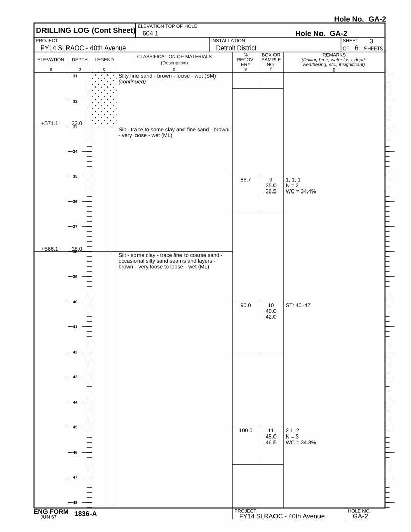
1, 1, 1N = 2WC = 34.4%
ST: 40'-42'
2 1, 2N = 3WC = 34.8%
+571.1
+566.1
33.0
38.0
935.036.5
1040.042.0
1145.046.5
Silty fine sand - brown - loose - wet (SM)(continued)
Silt - trace to some clay and fine sand - brown- very loose - wet (ML)
Silt - some clay - trace fine to coarse sand -occasional silty sand seams and layers -brown - very loose to loose - wet (ML)
86.7
90.0
100.0
REMARKS(Drilling time, water loss, depthweathering, etc., if significant)
BOX ORSAMPLE
NO.LEGEND
CLASSIFICATION OF MATERIALS(Description)
ELEVATION DEPTH
a fc eb gd
%RECOV-
ERY
SHEETS
PROJECT 3INSTALLATION
Detroit District
DRILLING LOG (Cont Sheet)ELEVATION TOP OF HOLE
604.1 Hole No. GA-2
FY14 SLRAOC - 40th AvenueSHEET
OF 6
Hole No. GA-2
PROJECT HOLE NO.FY14 SLRAOC - 40th Avenue GA-21836-A
JUN 67ENG FORM
31
32
33
34
35
36
37
38
39
40
41
42
43
44
45
46
47
48

1, 2, 2N = 4WC = 38.3%
Torvane (Su) = 3.0 tsf to 2.75 tsfWC = 46.5%ST: 55'-57'
Qp = 0.5 tsfTorvane (Su) = 2.75 tsf to 2.5 tsfWC = 50.9%ST: 60'-62'
2, 2, 3N = 5
+551.1 53.0
1250.051.5
1355.057.0
1460.062.0
1565.0
Silt - some clay - trace fine to coarse sand -occasional silty sand seams and layers -brown - very loose to loose - wet (ML)(continued)
Silty clay - trace fine sand - brown - hard tomedium (CH)
100.0
100.0
100.0
100.0
REMARKS(Drilling time, water loss, depthweathering, etc., if significant)
BOX ORSAMPLE
NO.LEGEND
CLASSIFICATION OF MATERIALS(Description)
ELEVATION DEPTH
a fc eb gd
%RECOV-
ERY
SHEETS
PROJECT 4INSTALLATION
Detroit District
DRILLING LOG (Cont Sheet)ELEVATION TOP OF HOLE
604.1 Hole No. GA-2
FY14 SLRAOC - 40th AvenueSHEET
OF 6
Hole No. GA-2
PROJECT HOLE NO.FY14 SLRAOC - 40th Avenue GA-21836-A
JUN 67ENG FORM
49
50
51
52
53
54
55
56
57
58
59
60
61
62
63
64
65
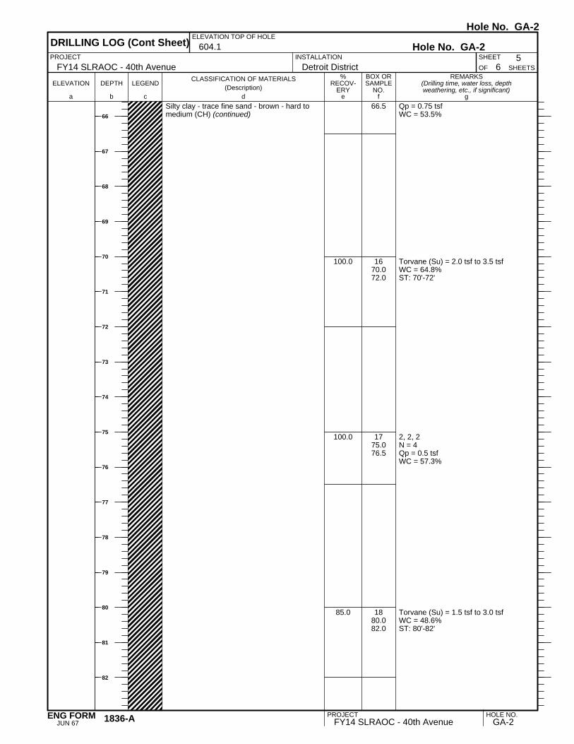
Qp = 0.75 tsfWC = 53.5%
Torvane (Su) = 2.0 tsf to 3.5 tsfWC = 64.8%ST: 70'-72'
2, 2, 2N = 4Qp = 0.5 tsfWC = 57.3%
Torvane (Su) = 1.5 tsf to 3.0 tsfWC = 48.6%ST: 80'-82'
66.5
1670.072.0
1775.076.5
1880.082.0
Silty clay - trace fine sand - brown - hard tomedium (CH) (continued)
100.0
100.0
85.0
REMARKS(Drilling time, water loss, depthweathering, etc., if significant)
BOX ORSAMPLE
NO.LEGEND
CLASSIFICATION OF MATERIALS(Description)
ELEVATION DEPTH
a fc eb gd
%RECOV-
ERY
SHEETS
PROJECT 5INSTALLATION
Detroit District
DRILLING LOG (Cont Sheet)ELEVATION TOP OF HOLE
604.1 Hole No. GA-2
FY14 SLRAOC - 40th AvenueSHEET
OF 6
Hole No. GA-2
PROJECT HOLE NO.FY14 SLRAOC - 40th Avenue GA-21836-A
JUN 67ENG FORM
66
67
68
69
70
71
72
73
74
75
76
77
78
79
80
81
82

2, 2, 2N = 4Qp = 0.5 tsfWC = 56.0%
+519.1 85.0
1983.585.0
Silty clay - trace fine sand - brown - hard tomedium (CH) (continued)
End of BoringBoring advanced to 83.5 feet with rock bit anddrilling fluidHW casing driven to 7.0 feet below riverbottomBoring backfilled with cement bentonite grout
100.0
REMARKS(Drilling time, water loss, depthweathering, etc., if significant)
BOX ORSAMPLE
NO.LEGEND
CLASSIFICATION OF MATERIALS(Description)
ELEVATION DEPTH
a fc eb gd
%RECOV-
ERY
SHEETS
PROJECT 6INSTALLATION
Detroit District
DRILLING LOG (Cont Sheet)ELEVATION TOP OF HOLE
604.1 Hole No. GA-2
FY14 SLRAOC - 40th AvenueSHEET
OF 6
Hole No. GA-2
PROJECT HOLE NO.FY14 SLRAOC - 40th Avenue GA-21836-A
JUN 67ENG FORM
83
84
85
86
87
88
89
90
91
92
93
94
95
96
97
98
99
100

WOH, WOH, WOHN = 0WC = 44.0%
WOH, 1/12"N = 1C = 41.0%
+602.9
+594.2
+592.2
1.3
10.0
12.0
110.011.5
212.514.0
Barge Deck
Water - St. Louis River
Silt - some organic silt - brown - very loose-wet (ML)
Silty fine sand - brown - very loose - wet (SM)
46.7
80.0
REMARKS(Drilling time, water loss, depthweathering, etc., if significant)
BOX ORSAMPLE
NO.LEGEND
CLASSIFICATION OF MATERIALS(Description)
ELEVATION DEPTH
a fc eb gd
%RECOV-
ERY
1. PROJECT
UNDISTURBED13. TOTAL NO. OFOVERBURDEN SAMPLESTAKEN
USACEINSTALLATION SHEET
18. TOTAL CORE RECOVERY FOR BORING
+604.2 0.0
12. MANUFACTURER'S DESIGNATION OF DRILL
OF
GA-3
9/23/2014 9/23/2014
Detroit District 61
Strata Earth Services, LLC
B. McCarthy
11. DATUM FOR ELEVATION SHOWN (TBM or MSL)
DISTURBED
10. SIZE AND TYPE OF BIT
14. TOTAL NUMBER CORE BOXES
3. DRILLING AGENCY
5. NAME OF DRILLER
6. DIRECTION OF HOLE
%
2. LOCATION (Coordinates or Station)
VERTICAL INCLINED
19. SIGNATURE OF INSPECTOR
MN State Plane North NAD 83 N 415,845 E 2,864,010Diedrich-25
7. THICKNESS OF OVERBURDEN (FT.)
8. DEPTH DRILLED INTO ROCK (FT.)
9. TOTAL DEPTH OF HOLE (FT.)
DEG. FROM VERT.
4. HOLE NO. (As shown on drawing title andfile number)
+604.2
FY14 SLRAOC - 40th Avenue
IGLD85
16. DATE HOLE
85.0
DIVISION
---17. ELEVATION TOP OF HOLE
15. ELEVATION GROUND WATER
SHEETS
STARTED
DRILLING LOG
COMPLETED
Hole No. GA-3
3 7/8" Roller Bit
Hole No. GA-3
PROJECT HOLE NO.FY14 SLRAOC - 40th Avenue GA-3PREVIOUS EDITIONS ARE OBSOLETE.1836
MAR 71ENG FORM
1
2
3
4
5
6
7
8
9
10
11
12
13

1, 1, 1N = 2WC = 360.9%
1, 1, 2N = 3WC = 28.3%
3, 2, 2N = 4WC = 32.4%
1, 1, 1N = 2WC = 38.9%
2, 1, 1N = 2WC = 40.1%
Torvane (Tv) = 0.75 tsf to 1.0 tsfWC = 37.2%ST: 30'-32'
+589.7
+587.2
+584.7
+582.2
+576.2
14.5
17.0
19.5
22.0
28.0
315.016.5
417.519.0
520.021.5
622.524.0
725.026.5
830.032.0
Silty fine sand - brown - very loose - wet (SM)(continued)
Fibrous peat - black - very loose - wet (Pt)
Silt - trace to some fine sand - brown - loose -wet (ML)
Fine sand - trace to some silt - brown - loose -wet (SP-SM)
Silt - trace to some fine sand - brown - veryloose - wet (ML)
Silt - trace to some clay and fine sand - brown- very loose - wet (ML)
53.3
53.3
60.0
100.0
80.0
35.0
REMARKS(Drilling time, water loss, depthweathering, etc., if significant)
BOX ORSAMPLE
NO.LEGEND
CLASSIFICATION OF MATERIALS(Description)
ELEVATION DEPTH
a fc eb gd
%RECOV-
ERY
SHEETS
PROJECT 2INSTALLATION
Detroit District
DRILLING LOG (Cont Sheet)ELEVATION TOP OF HOLE
604.2 Hole No. GA-3
FY14 SLRAOC - 40th AvenueSHEET
OF 6
Hole No. GA-3
PROJECT HOLE NO.FY14 SLRAOC - 40th Avenue GA-31836-A
JUN 67ENG FORM
14
15
16
17
18
19
20
21
22
23
24
25
26
27
28
29
30

1, 1, 1N = 2WC = 36.1%
1, 1, 1N = 2WC = 33.0%
Qp = 0.25 tsfST: 45'-47'
+556.2 48.0
935.036.5
1040.041.5
1145.047.0
Silt - trace to some clay and fine sand - brown- very loose - wet (ML) (continued)
86.7
100.0
20.0
REMARKS(Drilling time, water loss, depthweathering, etc., if significant)
BOX ORSAMPLE
NO.LEGEND
CLASSIFICATION OF MATERIALS(Description)
ELEVATION DEPTH
a fc eb gd
%RECOV-
ERY
SHEETS
PROJECT 3INSTALLATION
Detroit District
DRILLING LOG (Cont Sheet)ELEVATION TOP OF HOLE
604.2 Hole No. GA-3
FY14 SLRAOC - 40th AvenueSHEET
OF 6
Hole No. GA-3
PROJECT HOLE NO.FY14 SLRAOC - 40th Avenue GA-31836-A
JUN 67ENG FORM
31
32
33
34
35
36
37
38
39
40
41
42
43
44
45
46
47
48

1, 1, 2N = 3Qp = 0.25 tsfWC = 47.9%
Torvane (Tv) = 0.75 tsfWC = 64.2%ST: 55'-57'
Torvane (Tv) = 2.25 tsfWC = 58.0%ST: 60'-62'
2, 1, 2N = 3
1250.051.5
1355.057.0
1460.062.0
1565.0
Silty clay - trace fine sand - occasional siltseams and layers - brown - soft to hard (CH)(continued)
100.0
15.0
100.0
100.0
REMARKS(Drilling time, water loss, depthweathering, etc., if significant)
BOX ORSAMPLE
NO.LEGEND
CLASSIFICATION OF MATERIALS(Description)
ELEVATION DEPTH
a fc eb gd
%RECOV-
ERY
SHEETS
PROJECT 4INSTALLATION
Detroit District
DRILLING LOG (Cont Sheet)ELEVATION TOP OF HOLE
604.2 Hole No. GA-3
FY14 SLRAOC - 40th AvenueSHEET
OF 6
Hole No. GA-3
PROJECT HOLE NO.FY14 SLRAOC - 40th Avenue GA-31836-A
JUN 67ENG FORM
49
50
51
52
53
54
55
56
57
58
59
60
61
62
63
64
65

Qp = 0.75 tsfWC = 38.6%
Torvane (Tv) = 1.5 tsfWC = 33.9%ST: 70'-72'
2, 3, 3N = 6WC = 28.8%
2, 2, 2N = 4Qp = 0.5 tsfWC = 35.5%
+536.2
+522.2
68.0
82.0
66.5
1670.072.0
1775.076.5
1880.081.5
Silty clay - trace fine sand - occasional siltseams and layers - brown - soft to hard (CH)(continued)
Silty clay - some fine to medium sand - tracefine gravel - brown - very stiff to medium (CL)
Silty clay - trace fine sand - brown - stiff tovery stiff (CH)
100.0
86.7
100.0
REMARKS(Drilling time, water loss, depthweathering, etc., if significant)
BOX ORSAMPLE
NO.LEGEND
CLASSIFICATION OF MATERIALS(Description)
ELEVATION DEPTH
a fc eb gd
%RECOV-
ERY
SHEETS
PROJECT 5INSTALLATION
Detroit District
DRILLING LOG (Cont Sheet)ELEVATION TOP OF HOLE
604.2 Hole No. GA-3
FY14 SLRAOC - 40th AvenueSHEET
OF 6
Hole No. GA-3
PROJECT HOLE NO.FY14 SLRAOC - 40th Avenue GA-31836-A
JUN 67ENG FORM
66
67
68
69
70
71
72
73
74
75
76
77
78
79
80
81
82

Torvane (Tv) = 1.5 tsf to 2.5 tsfWC = 54.3%ST: 83'-85'
+519.2 85.0
1983.085.0
Silty clay - trace fine sand - brown - stiff tovery stiff (CH) (continued)
End of BoringBoring advanced to 83.0 feet with rock bit anddrilling fluidHW casing driven to 12.0 feet below riverbottomBoring backfilled with cement bentonite grout
100.0
REMARKS(Drilling time, water loss, depthweathering, etc., if significant)
BOX ORSAMPLE
NO.LEGEND
CLASSIFICATION OF MATERIALS(Description)
ELEVATION DEPTH
a fc eb gd
%RECOV-
ERY
SHEETS
PROJECT 6INSTALLATION
Detroit District
DRILLING LOG (Cont Sheet)ELEVATION TOP OF HOLE
604.2 Hole No. GA-3
FY14 SLRAOC - 40th AvenueSHEET
OF 6
Hole No. GA-3
PROJECT HOLE NO.FY14 SLRAOC - 40th Avenue GA-31836-A
JUN 67ENG FORM
83
84
85
86
87
88
89
90
91
92
93
94
95
96
97
98
99
100

3, 10, 10N = 20WC = 17.8%
4, 7, 7N = 14Qp = 2.0 tsfWC = 29.6%
3, 6, 7N = 13Qp = 2.5 tsfWC = 17.6%
1, 1/12"N = 1WC = 89.3%
2, 2N = 2/6"WC = 44.8%
3/6"WC = 369.0%
3, 5, 5N = 10WC = 347.3%
+606.5
+601.5
+599.0
+597.5
+596.5
2.0
7.0
9.5
11.0
12.0
10.01.5
22.54.0
35.06.5
47.59.0
5A10.011.0
5B11.011.5
612.514.0
Fill: Silty fine to medium sand - trace clay andfine to coarse gravel - brown - medium dense- moist (SM)
Fill: Silty clay - some fine sand - trace tosome fine to coarse gravel - brown - very stiff(CL)
Fill: Silty fine sand - gray - very loose - moistto wet (SM)
Fill: Silty fine sand - some wood - brown -loose - wet (SM)
Peat - black - loose - wet (Pt)
Wood peat - brown - medium dense to loose -wet (Pt)
100.0
60.0
60.0
100.0
50.0
100.0
33.3
REMARKS(Drilling time, water loss, depthweathering, etc., if significant)
BOX ORSAMPLE
NO.LEGEND
CLASSIFICATION OF MATERIALS(Description)
ELEVATION DEPTH
a fc eb gd
%RECOV-
ERY
1. PROJECT
UNDISTURBED13. TOTAL NO. OFOVERBURDEN SAMPLESTAKEN
USACEINSTALLATION SHEET
18. TOTAL CORE RECOVERY FOR BORING
+608.5 0.0
12. MANUFACTURER'S DESIGNATION OF DRILL
OF
GA-4
9/30/2014 9/30/2014
Detroit District 21
Strata Earth Services, LLC
B. McCarthy
11. DATUM FOR ELEVATION SHOWN (TBM or MSL)
DISTURBED
10. SIZE AND TYPE OF BIT
14. TOTAL NUMBER CORE BOXES
3. DRILLING AGENCY
5. NAME OF DRILLER
6. DIRECTION OF HOLE
%
2. LOCATION (Coordinates or Station)
VERTICAL INCLINED
601.0
19. SIGNATURE OF INSPECTOR
MN State Plane North NAD 83 N 419,443 E 2,864,828Diedrich-25
7. THICKNESS OF OVERBURDEN (FT.)
8. DEPTH DRILLED INTO ROCK (FT.)
9. TOTAL DEPTH OF HOLE (FT.)
DEG. FROM VERT.
4. HOLE NO. (As shown on drawing title andfile number)
+608.5
FY14 SLRAOC - 40th Avenue
NAVD88
16. DATE HOLE
25.0
DIVISION
---17. ELEVATION TOP OF HOLE
15. ELEVATION GROUND WATER
SHEETS
STARTED
DRILLING LOG
COMPLETED
Hole No. GA-4
3 7/8" Roller Bit
Hole No. GA-4
PROJECT HOLE NO.FY14 SLRAOC - 40th Avenue GA-4PREVIOUS EDITIONS ARE OBSOLETE.1836
MAR 71ENG FORM
1
2
3
4
5
6
7
8
9
10
11
12
13

6, 3, 5N = 8WC = 190.6%
8, 7, 10N = 17WC = 24.6%
7, 7, 4N = 11WC = 27.5%
+590.5
+586.0
+583.5
18.0
22.5
25.0
715.016.5
820.021.5
923.525.0
Wood peat - brown - medium dense to loose -wet (Pt) (continued)
Fine sand - trace silt - brown - medium dense- wet (SP)
Silt - trace to some fine sand - brown -medium dense - wet (ML)
End of BoringBoring advanced to 7.5 feet with solid-stemaugerBoring advanced from 7.5 to 23.5 feet withrock bit and drilling fluidHW casing driven to 10.0 feetBoring backfilled with cement bentonite grout
33.3
66.7
80.0
REMARKS(Drilling time, water loss, depthweathering, etc., if significant)
BOX ORSAMPLE
NO.LEGEND
CLASSIFICATION OF MATERIALS(Description)
ELEVATION DEPTH
a fc eb gd
%RECOV-
ERY
SHEETS
PROJECT 2INSTALLATION
Detroit District
DRILLING LOG (Cont Sheet)ELEVATION TOP OF HOLE
608.5 Hole No. GA-4
FY14 SLRAOC - 40th AvenueSHEET
OF 2
Hole No. GA-4
PROJECT HOLE NO.FY14 SLRAOC - 40th Avenue GA-41836-A
JUN 67ENG FORM
15
16
17
18
19
20
21
22
23
24
25
26
27
28
29
30
31
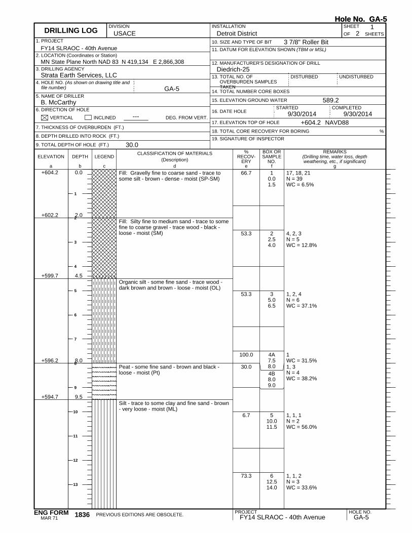
17, 18, 21N = 39WC = 6.5%
4, 2, 3N = 5WC = 12.8%
1, 2, 4N = 6WC = 37.1%
1WC = 31.5%1, 3N = 4WC = 38.2%
1, 1, 1N = 2WC = 56.0%
1, 1, 2N = 3WC = 33.6%
+602.2
+599.7
+596.2
+594.7
2.0
4.5
8.0
9.5
10.01.5
22.54.0
35.06.5
4A7.58.04B8.09.0
510.011.5
612.514.0
Fill: Gravelly fine to coarse sand - trace tosome silt - brown - dense - moist (SP-SM)
Fill: Silty fine to medium sand - trace to somefine to coarse gravel - trace wood - black -loose - moist (SM)
Organic silt - some fine sand - trace wood -dark brown and brown - loose - moist (OL)
Peat - some fine sand - brown and black -loose - moist (Pt)
Silt - trace to some clay and fine sand - brown- very loose - moist (ML)
66.7
53.3
53.3
100.0
30.0
6.7
73.3
REMARKS(Drilling time, water loss, depthweathering, etc., if significant)
BOX ORSAMPLE
NO.LEGEND
CLASSIFICATION OF MATERIALS(Description)
ELEVATION DEPTH
a fc eb gd
%RECOV-
ERY
1. PROJECT
UNDISTURBED13. TOTAL NO. OFOVERBURDEN SAMPLESTAKEN
USACEINSTALLATION SHEET
18. TOTAL CORE RECOVERY FOR BORING
+604.2 0.0
12. MANUFACTURER'S DESIGNATION OF DRILL
OF
GA-5
9/30/2014 9/30/2014
Detroit District 21
Strata Earth Services, LLC
B. McCarthy
11. DATUM FOR ELEVATION SHOWN (TBM or MSL)
DISTURBED
10. SIZE AND TYPE OF BIT
14. TOTAL NUMBER CORE BOXES
3. DRILLING AGENCY
5. NAME OF DRILLER
6. DIRECTION OF HOLE
%
2. LOCATION (Coordinates or Station)
VERTICAL INCLINED
589.2
19. SIGNATURE OF INSPECTOR
MN State Plane North NAD 83 N 419,134 E 2,866,308Diedrich-25
7. THICKNESS OF OVERBURDEN (FT.)
8. DEPTH DRILLED INTO ROCK (FT.)
9. TOTAL DEPTH OF HOLE (FT.)
DEG. FROM VERT.
4. HOLE NO. (As shown on drawing title andfile number)
+604.2
FY14 SLRAOC - 40th Avenue
NAVD88
16. DATE HOLE
30.0
DIVISION
---17. ELEVATION TOP OF HOLE
15. ELEVATION GROUND WATER
SHEETS
STARTED
DRILLING LOG
COMPLETED
Hole No. GA-5
3 7/8" Roller Bit
Hole No. GA-5
PROJECT HOLE NO.FY14 SLRAOC - 40th Avenue GA-5PREVIOUS EDITIONS ARE OBSOLETE.1836
MAR 71ENG FORM
1
2
3
4
5
6
7
8
9
10
11
12
13

1, 3, 5N = 8WC = 35.4%
2, 2, 2N = 4WC = 60.6%
1, 1, 1N = 2WC = 39.4%
1, 1, 1N = 2Qp = 0.25 tsfWC = 39.1%
+589.7
+586.2
+581.2
+576.7
+574.2
14.5
18.0
23.0
27.5
30.0
715.016.5
820.021.5
925.026.5
1028.530.0
Silt - trace to some fine sand - brown - loose -moist to wet (ML)
Silty fine sand - trace to some peat and wood- dark brown - loose - wet (SM)
Silt - trace to some clay and fine sand - black -very loose - wet (ML)
Silty clay - trace fine sand - brown - soft (CL)
End of BoringBoring advanced to 7.5 feet with solid-stemaugerBoring advanced from 7.5 to 28.5 feet withrock bit and drilling fluidHW casing driven to 10.0 feetBoring backfilled with cement bentonite grout
80.0
100.0
80.0
93.3
REMARKS(Drilling time, water loss, depthweathering, etc., if significant)
BOX ORSAMPLE
NO.LEGEND
CLASSIFICATION OF MATERIALS(Description)
ELEVATION DEPTH
a fc eb gd
%RECOV-
ERY
SHEETS
PROJECT 2INSTALLATION
Detroit District
DRILLING LOG (Cont Sheet)ELEVATION TOP OF HOLE
604.2 Hole No. GA-5
FY14 SLRAOC - 40th AvenueSHEET
OF 2
Hole No. GA-5
PROJECT HOLE NO.FY14 SLRAOC - 40th Avenue GA-51836-A
JUN 67ENG FORM
15
16
17
18
19
20
21
22
23
24
25
26
27
28
29
30
31