Embed Size (px)
Citation preview

Fog is a collection of water droplets or ice crystals suspended in the air at or near the Earth's surface.
While fog is a type of a cloud, the term "fog" is typically distinguished from the more generic term "cloud" in that fog is low-lying, and the moisture in the fog is often generated locally (such as from a nearby body of water, like a lake or the ocean, or from nearby moist ground or marshes).
FOG

• Fog is distinguished from mist only by its density, as expressed in the resulting decrease in visibility: Fog reduces visibility to less than 1 km (5/8 statute mile), whereas mist reduces visibility to no less than 1 km (5/8 statute mile)
• The foggiest place in the world is the Grand Banks off the island of Newfoundland, the meeting place of the cold Labrador Current from the north and the much warmer Gulf Stream from the south.


Fog can form in a number of ways, depending on how the cooling that caused the condensation occurred:
• RADIATION FOG is formed by the cooling of land after sunset by thermal radiation in calm conditions with clear sky. The cool ground produces condensation in the nearby air by heat conduction. In perfect calm the fog layer can be less than a meter deep but turbulence can promote a thicker layer. Radiation fogs occur at night, and usually do not last long after sunrise. Radiation fog is common in autumn and early winter.
TYPES
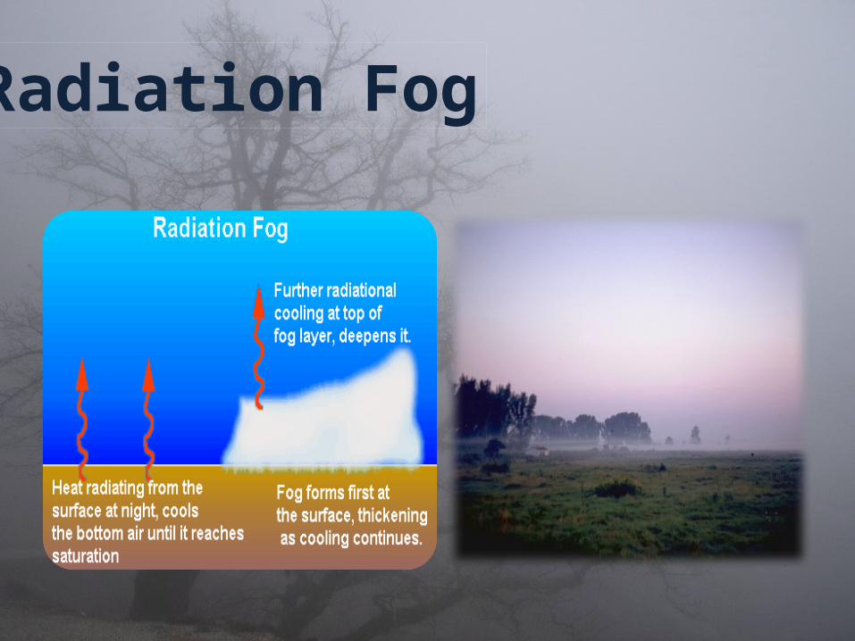
Radiation Fog

Advection Fog occurs when moist air passes over a cool surface by advection (wind) and is cooled. It is common as a warm front passes over an area with significant snowpack. It is most common at sea when tropical air encounters cooler waters, including areas of cold water upwelling, such as along the California coast.

• Evaporation or Mixing FogThis type of fog forms when sufficient water vapor is
added to the air by evaporation and the moist air mixes with cooler, relatively drier air. The two common types are steam fog and frontal fog.

• Steam FogSteam fog forms when cold air moves over warm
water. When the cool air mixes with the warm moist air over the water, the moist air cools until its humidity reaches 100% and fog forms. This type of fog takes on the appearance of wisps of smoke rising off the surface of the water.
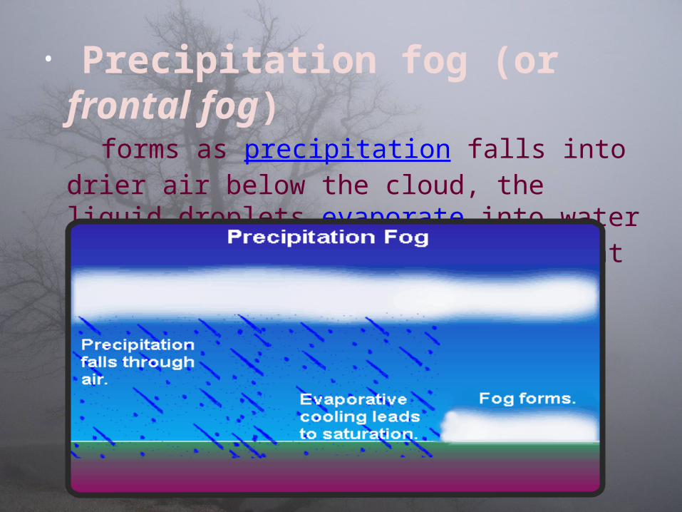
• Precipitation fog (or frontal fog)forms as precipitation falls into drier air below
the cloud, the liquid droplets evaporate into water vapor. The water vapor cools and at the dewpoint it condenses and fog forms.
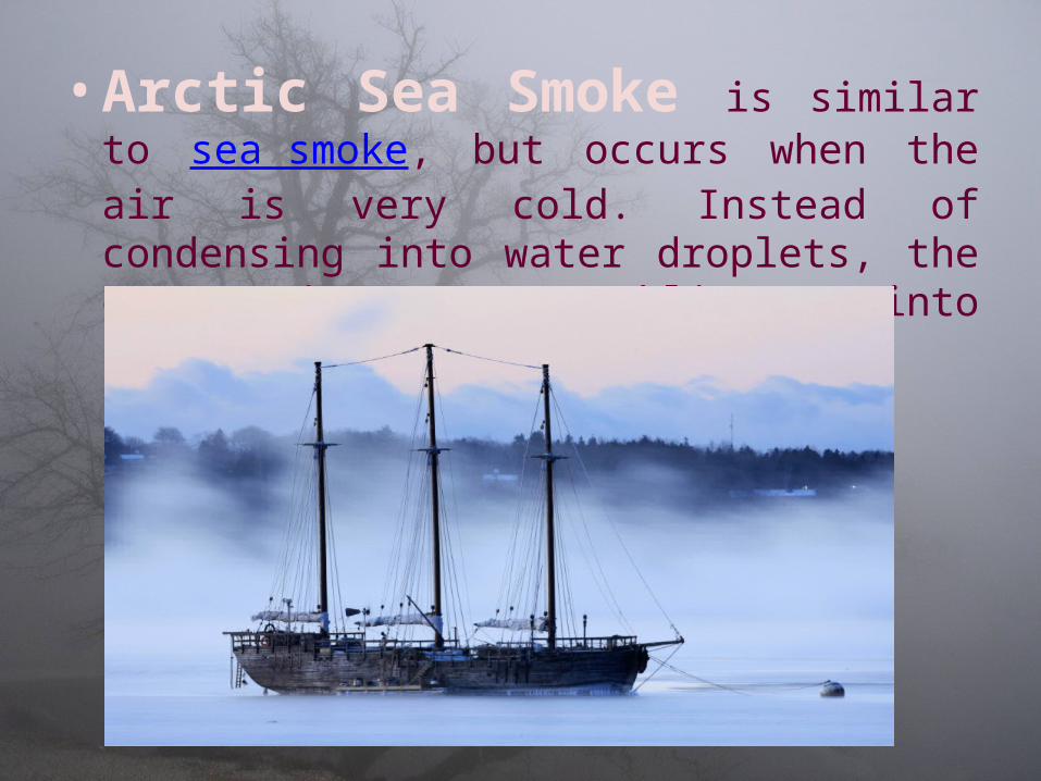
• Arctic Sea Smoke is similar to sea smoke, but occurs when the air is very cold. Instead of condensing into water droplets, the evaporating water sublimates into ice crystals.
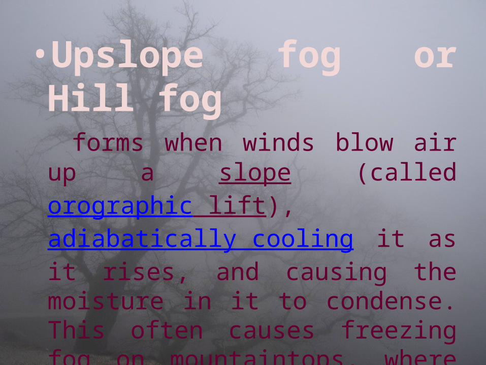
•Upslope fog or Hill fogforms when winds blow air up a
slope (called orographic lift), adiabatically cooling it as it rises, and causing the moisture in it to condense. This often causes freezing fog on mountaintops, where the cloud ceiling would not otherwise be low enough.

Upslope Fog
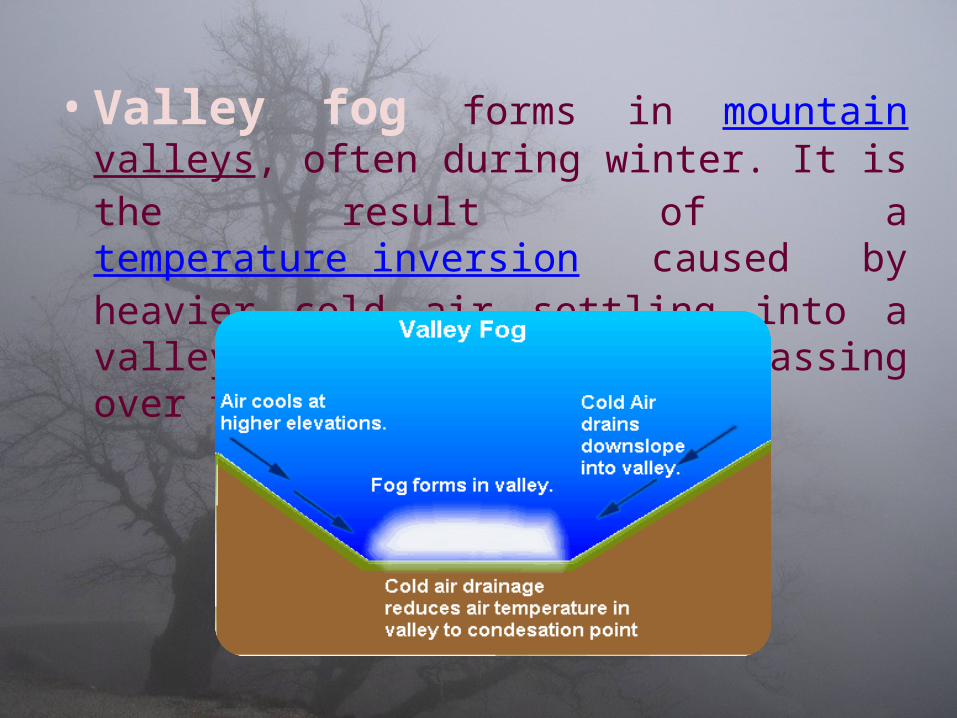
• Valley fog forms in mountain valleys, often during winter. It is the result of a temperature inversion caused by heavier cold air settling into a valley, with warmer air passing over the mountains above.

• Freezing fog occurs when liquid fog droplets freeze to surfaces, forming white soft or hard rime. This is very common on mountain tops which are exposed to low clouds. It is equivalent to freezing rain, and essentially the same as the ice that forms inside a freezer which is not of the "frostless" or "frost-free" type. The term "freezing fog" may also refer to fog where water vapor is super-cooled, filling the air with small ice crystals similar to very light snow. It seems to make the fog "tangible", as if one could "grab a handful".

• Frozen fog (also known as ice fog) is any kind of fog where the droplets have frozen into extremely tiny crystals of ice in midair. Generally this requires temperatures at or below −35 °C (−30 °F), making it common only in and near the Arctic and Antarctic regions.

• Garua fog is a type of fog which happens to occur by the coast of Chile and Peru. The normal fog produced by the sea travels inland, but suddenly meets an area of hot air. This causes the water particles of fog to shrink by evaporation, producing a transparent mist. A garûa is a fog that is so clear that it poses no problem to visibility but so wet that drivers have to use their windscreen wipers.
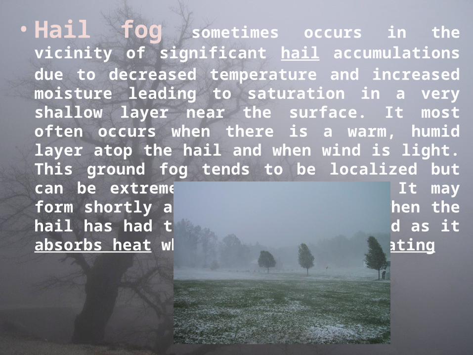
• Hail fog sometimes occurs in the vicinity of significant hail accumulations due to decreased temperature and increased moisture leading to saturation in a very shallow layer near the surface. It most often occurs when there is a warm, humid layer atop the hail and when wind is light. This ground fog tends to be localized but can be extremely dense and abrupt. It may form shortly after the hail falls; when the hail has had time to cool the air and as it absorbs heat when melting and evaporating

• Artificial fog is artificially generated fog that is usually created by vaporizing a water and glycol-based or glycerine-based fluid. The fluid is injected into a heated block, and evaporates quickly. The resulting pressure forces the vapor out of the exit. Upon coming into contact with cool outside air the vapor condenses and appears as fog.

• Redwood forests in California receive approximately 30 to 40 percent of their moisture from coastal fog. Change in climate patterns could result in relative drought in these areas.
Some coastal communities use fog nets to extract moisture from the atmosphere where groundwater pumping and rainwater collection are insufficient.
Biological and Human Uses

• is the force per unit area exerted against a surface by the weight of air above that surface in the Earth's atmosphere. In most circumstances atmospheric pressure is closely approximated by the hydrostatic pressure caused by the weight of air above the measurement point. Low pressure areas have less atmospheric mass above their location, whereas high pressure areas have more atmospheric mass above their location.
Atmospheric Pressure

• The standard atmosphere (symbol: atm) is a unit of pressure and is defined as being equal to 101,325 Pa
• In 1999, the International Union of Pure and Applied Chemistry (IUPAC) said that for the purposes of specifying the properties of substances, “the standard pressure” should be defined as precisely 100 kPa (≈750.01 torr) or 29.53 inHg rather than the 101.325 kPa value of “one standard atmosphere”
Standard Atmospheric Pressure

• Mean sea level pressure (MSLP) is the pressure at sea level or (when measured at a given elevation on land) the station pressure reduced to sea level assuming an isothermal layer at the station temperature.
• This is the pressure normally given in weather reports on radio, television, and newspapers or on the Internet.
Mean sea level Pressure

Altitude Atmospheric Pressure Variation

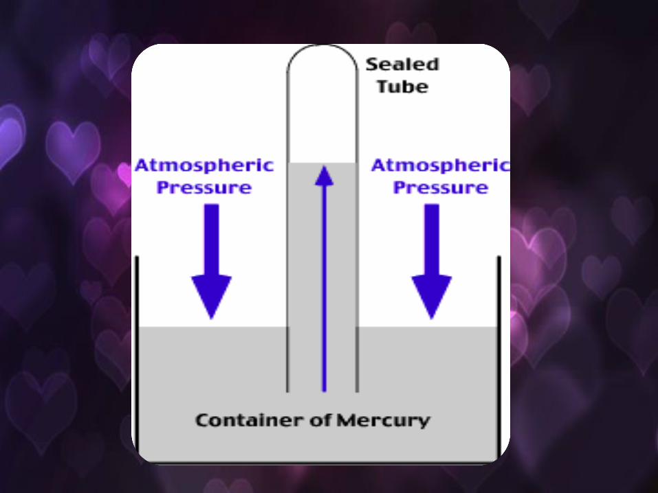
• Atmospheric pressure is often measured with a mercury barometer, and a height of approximately 760 millimetres (30 in) of mercury is often used to illustrate (and measure) atmospheric pressure. However, since mercury is not a substance that humans commonly come in contact with, water often provides a more intuitive way to visualize the pressure of one atmosphere.
• One atmosphere (100 kPa or 14.7 psi) is the amount of pressure that can lift water approximately 10.3 m (34 ft). Thus, a diver 10.3 m underwater experiences a pressure of about 2 atmospheres (1 atm of air plus 1 atm of water). This is also the maximum height to which a column of water can be drawn up by suction.
Atmospheric Pressure based on height of water

• Wind is the flow of gases on a large scale. On Earth, wind consists of the bulk movement of air. In outer space, solar wind is the movement of gases or charged particles from the sun through space, while planetary wind is the outgassing of light chemical elements from a planet's atmosphere into space. Winds are commonly classified by their spatial scale, their speed, the types of forces that cause them, the regions in which they occur, and their effect. The strongest observed winds on a planet in our solar system occur on Neptune and Saturn.
WIND
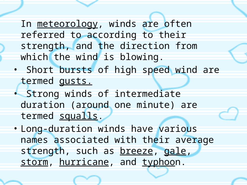
In meteorology, winds are often referred to according to their strength, and the direction from which the wind is blowing.
• Short bursts of high speed wind are termed gusts.
• Strong winds of intermediate duration (around one minute) are termed squalls.
• Long-duration winds have various names associated with their average strength, such as breeze, gale, storm, hurricane, and typhoon.
• Wind occurs on a range of scales, from thunderstorm flows lasting tens of minutes, to local breezes generated by heating of land surfaces and lasting a few hours, to global winds resulting from the difference in absorption of solar energy between the climate zones on Earth.

• the differential heating between the equator and the poles
• the rotation of the planet (Coriolis effect).
Two main causes of large scale atmospheric circulation
• Winds can shape landforms, via a variety of aeolian processes such as the formation of fertile soils, such as loess, and by erosion.
• Dust from large deserts can be moved great distances from its source region by the prevailing winds; winds that are accelerated by rough topography and associated with dust outbreaks have been assigned regional names in various parts of the world because of their significant effects on those regions.
• Wind affects the spread of wildfires.• Winds disperse seeds from various plants, enabling the
survival and dispersal of those plant species, as well as flying insect populations.
• When combined with cold temperatures, wind has a negative impact on livestock. Wind affects animals' food stores, as well as their hunting and defensive strategies.

• Historically, the Beaufort wind force scale provides an empirical description of wind speed based on observed sea conditions. Originally it was a 13-level scale, but during the 1940s, the scale was expanded to 17 levels. There are general terms that differentiate winds of different average speeds such as a breeze, a gale, a storm, tornado, or a hurricane.
Wind force scale

[hide]General wind classifications Tropical cyclone classifications (all winds are 10-minute averages)
Beaufort scale[17]10-minute
sustained winds (knots)
General term[20] N Indian OceanIMD
SW Indian OceanMF
Australian regionSouth Pacific
BoM, BMKG, FMS, MSNZ
NW PacificJMA
NW PacificJTWC
NE Pacific &N Atlantic
NHC & CPHC
0 <1 Calm
Low Pressure Area Tropical
disturbance Tropical lowTropical Depression
Tropical depression
Tropical depression
Tropical depression
1 1–3 Light air
2 4–6 Light breeze
3 7–10 Gentle breeze
4 11–16 Moderate breeze
5 17–21 Fresh breezeDepression
6 22–27 Strong breeze
728–29
Moderate gale Deep depression Tropical depression30–33
8 34–40 Fresh galeCyclonic storm Moderate
tropical stormTropical cyclone (1) Tropical storm
Tropical storm Tropical storm9 41–47 Strong gale
10 48–55 Whole gale Severe cyclonic storm
Severe tropical storm
Tropical cyclone (2)
Severe tropical storm11 56–63 Storm
12 64–72
Hurricane
Very severe cyclonic storm
Tropical cycloneSevere tropical cyclone (3)
Typhoon
Typhoon
Hurricane (1)
13 73–85 Hurricane (2)
14 86–89Severe tropical cyclone (4)
Major hurricane (3)15 90–99
Intense tropical cyclone16 100–106
Major hurricane (4)
17
107–114
Severe tropical cyclone (5)
115–119Very intense tropical cyclone Super typhoon
>120 Super cyclonic storm
Major hurricane (5)

• Fujita scale– The Enhanced Fujita Scale (EF Scale) rates the strength of tornadoes in
the United States based on the damage they cause. Below is that scale.
ScaleWind speed
Relative frequency Potential damageMph km/h
EF0 65–85 105–137 53.5%
Minor or no damage. Peels surface off some roofs; some damage to gutters or siding; branches broken off trees; shallow-rooted trees pushed over.
Confirmed tornadoes with no reported damage (i.e., those that remain in open fields) are always rated EF0.
EF1 86–110 138–178 31.6%Moderate damage. Roofs severely stripped; mobile homes overturned or badly damaged; loss of exterior doors; windows and other glass broken.
EF2 111–135 179–218 10.7%
Considerable damage. Roofs torn off well-constructed houses; foundations of frame homes shifted; mobile homes completely destroyed; large trees snapped or uprooted; light-object missiles generated; cars lifted off ground.
EF3 136–165 219–266 3.4%
Severe damage. Entire stories of well-constructed houses destroyed; severe damage to large buildings such as shopping malls; trains overturned; trees debarked; heavy cars lifted off the ground and thrown; structures with weak foundations are badly damaged.
EF4 166–200 267–322 0.7%Extreme damage. Well-constructed and whole frame houses completely leveled; cars and other large objects thrown and small missiles generated.
EF5 >200 >322 <0.1%
Total Destruction. Strong framed, well built houses leveled off foundations and swept away; steel-reinforced concrete structures are critically damaged; tall buildings collapse or have severe structural deformations.

• Transportation• Power source• Recreation • Erosion• Desert dust migration• Effects on plants and animals• Related damages
USAGE OF WIND
ROLES IN THE NATURAL WORLD

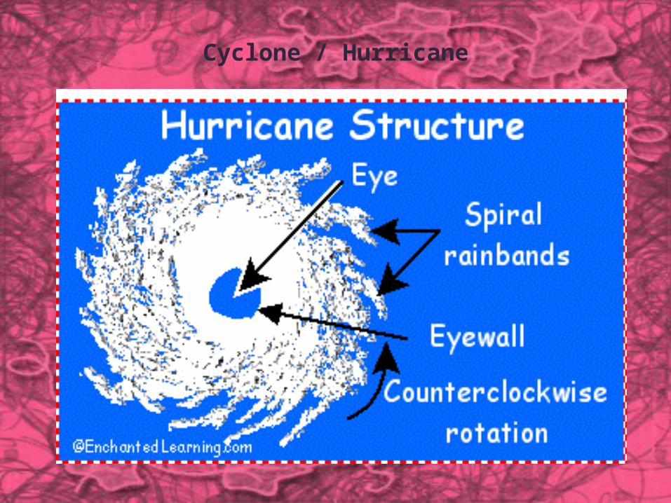
What is a Cyclone?
Cyclones are huge revolving storms caused by winds blowing around a central area of low atmospheric pressure. In the northern hemisphere, cyclones are called hurricanes or typhoons and their winds blow in an anti-clockwise circle. In the southern hemisphere, these tropical storms are known as cyclones, whose winds blow in a clockwise circle.
]
Cyclone / Hurricane

How do Cyclones occur?
Cyclones develop over warm seas near the Equator. Air heated by the sun rises very swiftly, which creates areas of very low pressure. As the warm air rises, it becomes loaded with moisture which condenses into massive thunderclouds. Cool air rushes in to fill the void that is left, but because of the constant turning of the Earth on its axis, the air is bent inwards and then spirals upwards with great force. The swirling winds rotate faster and faster, forming a huge circle which can be up to 2,000 km across. At the centre of the storm is a calm, cloudless area called the eye, where there is no rain, and the winds are fairly light. As the cyclone builds up it begins to move. It is sustained by a steady flow of warm, moist air. The strongest winds and heaviest rains are found in the towering clouds which merge into a wall about 20-30 km from the storm's centre. Winds around the eye can reach speeds of up to 200 km/h, and a fully developed cyclone pumps out about two million tonnes of air per second. This results in more rain being released in a day than falls in a year in a city like London.

When and where do Cyclones occur?
Cyclones begin in tropical regions, such as northern Australia, South-East Asia and many Pacific islands. They sometimes drift into the temperate coastal areas, threatening more heavily populated regions to the South. Northern Australia has about four or five tropical cyclones every year during the summertime wet season. For a cyclone to develop, the sea surface must have a temperature of at least 26ºC.

Why do Cyclones occur?
When warm air rises from the seas and condenses into clouds, massive amounts of heat are released. The result of this mixture of heat and moisture is often a collection of thunderstorms, from which a tropical storm can develop.
The trigger for most Atlantic hurricanes is an easterly wave, a band of low pressure moving westwards, which may have begun as an African thunderstorm. Vigorous thunderstorms and high winds combine to create a cluster of thunderstorms which can become the seedling for a tropical storm.
Typhoons in the Far East and Cyclones in the Indian Ocean often develop from a thunderstorm in the equatorial trough. During the hurricane season, the Coriolis effect of the Earth's rotation starts the winds in the thunderstorm spinning in a circular motion.

Six Types of Cyclones
There are six main types of cyclones:
• Polar cyclones• Polar lows
• Extratropical cyclones• Subtropical cyclones• Tropical cyclones• Mesocyclones

Polar cyclone
A polar, sub-polar, or Arctic cyclone (also known as a polar vortex) is a vast area of low pressure which strengthens in the winter and weakens in the summer. A polar cyclone is a low pressure weather system, usually spanning 1,000 kilometres (620 mi) to 2,000 kilometres (1,200 mi), in which the air circulates in a counterclockwise direction in the northern hemisphere, and a clockwise direction in the southern hemisphere. In the Northern Hemisphere, the polar cyclone has two centers on average. One center lies near Baffin Island and the other over northeast Siberia. In the southern hemisphere, it tends to be located near the edge of the Ross ice shelf near 160 west longitude. When the polar vortex is strong, westerly flow descends to the Earth's surface. When the polar cyclone is weak, significant cold outbreaks occur.
Polar Low Cyclone
A polar low is a small-scale, short-lived atmospheric low pressure system (depression) that is found over the ocean areas poleward of the main polar front in both the Northern and Southern Hemispheres. During winter, when cold-core lows with temperatures in the mid-levels of the troposphere reach −45 °C (−49 °F) move over open waters, deep convection forms which allows polar low development to become possible. The systems usually have a horizontal length scale of less than 1,000 kilometres (620 mi) and exist for no more than a couple of days. They are part of the larger class of mesoscale weather systems. Polar lows can be difficult to detect using conventional weather reports and are a hazard to high-latitude operations, such as shipping and gas and oil platforms. Polar lows have been referred to by many other terms, such as polar mesoscale vortex, Arctic hurricane, Arctic low, and cold air depression. Today the term is usually reserved for the more vigorous systems that have near-surface winds of at least 17 m/s.

Extratropical Cyclone
An extratropical cyclone is a synoptic scale low pressure weather system that has neither tropical nor polar characteristics, being connected with fronts and horizontal gradients in temperature and dew point otherwise known as "baroclinic zones".
The descriptor "extratropical" refers to the fact that this type of cyclone generally occurs outside of the tropics, in the middle latitudes of the planet. These systems may also be described as "mid-latitude cyclones" due to their area of formation, or "post-tropical cyclones" where extratropical transition has occurred, and are often described as "depressions" or "lows" by weather forecasters and the general public. These are the everyday phenomena which along with anti-cyclones, drive the weather over much of the Earth.
Although extratropical cyclones are almost always classified as baroclinic since they form along zones of temperature and dewpoint gradient within the westerlies, they can sometimes become barotropic late in their life cycle when the temperature distribution around the cyclone becomes fairly uniform with radius. An extratropical cyclone can transform into a subtropical storm, and from there into a tropical cyclone, if it dwells over warm waters and develops central convection, which warms its core.
Subtropical Cyclone
A subtropical cyclone is a weather system that has some characteristics of a tropical cyclone and some characteristics of an extratropical cyclone. They can form between the equator and the 50th parallel. As early as the 1950s, meteorologists were unclear whether they should be characterized as tropical cyclones or extratropical cyclones, and used terms such as quasi-tropical and semi-tropical to describe the cyclone hybrids. By 1972, the National Hurricane Center officially recognized this cyclone category. Subtropical cyclones began to receive names off the official tropical cyclone list in the Atlantic Basin in 2002. They have broad wind patterns with maximum sustained winds located farther from the center than typical tropical cyclones, and exist in areas of weak to moderate temperature gradient.Since they form from initially extratropical cyclones which have colder temperatures aloft than normally found in the tropics, the sea surface temperatures required for their formation are lower than the tropical cyclone threshold by three degrees Celsius, or five degrees Fahrenheit, lying around 23 degrees Celsius. This means that subtropical cyclones are more likely to form outside the traditional bounds of the hurricane season. Although subtropical storms rarely have hurricane-force winds, they may become tropical in nature as their cores warm.

Tropical Cyclone
A tropical cyclone is a storm system characterized by a low pressure center and numerous thunderstorms that produce strong winds and flooding rain. A tropical cyclone feeds on heat released when moist air rises, resulting in condensation of water vapour contained in the moist air. They are fueled by a different heat mechanism than other cyclonic windstorms such as nor'easters, European windstorms, and polar lows, leading to their classification as "warm core" storm systems.
The term "tropical" refers to both the geographic origin of these systems, which form almost exclusively in tropical regions of the globe, and their formation in Maritime Tropical air masses. The term "cyclone" refers to such storms' cyclonic nature, with counterclockwise rotation in the Northern Hemisphere and clockwise rotation in the Southern Hemisphere. Depending on their location and strength, tropical cyclones are referred to by other names, such as hurricane, typhoon, tropical storm, cyclonic storm, tropical depression, or simply as a cyclone. A tropical cyclone is generally referred to as a hurricane (from the name of the ancient Central American deity of wind, Huracan) in the Atlantic basin, and a cyclone in the Indian Ocean and parts of the Pacific.
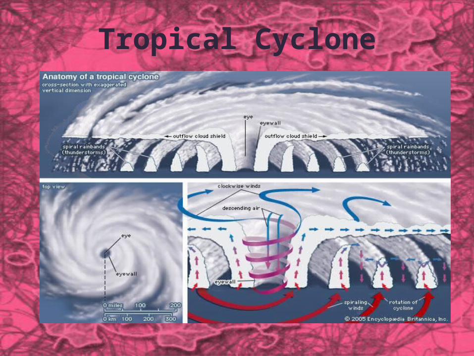
Tropical Cyclone
While tropical cyclones can produce extremely powerful winds and torrential rain, they are also able to produce high waves and damaging storm surge. They develop over large bodies of warm water, and lose their strength if they move over land. This is the reason coastal regions can receive significant damage from a tropical cyclone, while inland regions are relatively safe from receiving strong winds. Heavy rains, however, can produce significant flooding inland, and storm surges can produce extensive coastal flooding up to 40 kilometres (25 mi) from the coastline. Although their effects on human populations can be devastating, tropical cyclones can also relieve drought conditions. They also carry heat and energy away from the tropics and transport it toward temperate latitudes, which makes them an important part of the global atmospheric circulation mechanism. As a result, tropical cyclones help to maintain equilibrium in the Earth's troposphere.
Many tropical cyclones develop when the atmospheric conditions around a weak disturbance in the atmosphere are favorable. Others form when other types of cyclones acquire tropical characteristics. Tropical systems are then moved by steering winds in the troposphere; if the conditions remain favorable, the tropical disturbance intensifies, and can even develop an eye. On the other end of the spectrum, if the conditions around the system deteriorate or the tropical cyclone makes landfall, the system weakens and eventually dissipates. A tropical cyclone can become extratropical as it moves toward higher latitudes if its energy source changes from heat released by condensation to differences in temperature between air masses; From an operational standpoint, a tropical cyclone is usually not considered to become subtropical during its extratropical transition.
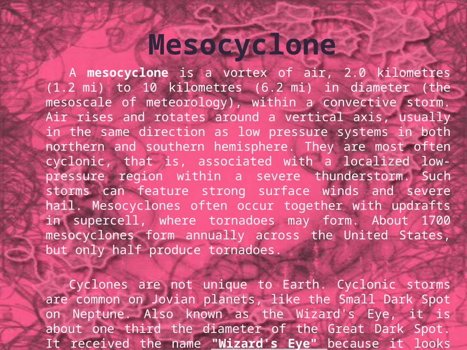
MesocycloneA mesocyclone is a vortex of air, 2.0 kilometres (1.2 mi) to 10
kilometres (6.2 mi) in diameter (the mesoscale of meteorology), within a convective storm. Air rises and rotates around a vertical axis, usually in the same direction as low pressure systems in both northern and southern hemisphere. They are most often cyclonic, that is, associated with a localized low-pressure region within a severe thunderstorm. Such storms can feature strong surface winds and severe hail. Mesocyclones often occur together with updrafts in supercell, where tornadoes may form. About 1700 mesocyclones form annually across the United States, but only half produce tornadoes.
Cyclones are not unique to Earth. Cyclonic storms are common on Jovian planets, like the Small Dark Spot on Neptune. Also known as the Wizard's Eye, it is about one third the diameter of the Great Dark Spot. It received the name "Wizard's Eye" because it looks like an eye. This appearance is caused by a white cloud in the middle of the Wizard's Eye. Mars has also exhibited cyclonic storms. Jovian storms like the Great Red Spot are usually mistakenly named as giant hurricanes or cyclonic storms. However, this is inaccurate, as the Great Red Spot is, in fact, the inverse phenomenon, an anticyclone.

Anticyclone
Anticyclone (that is, opposite to a cyclone) is a weather phenomenon defined by the National Weather Service's glossary as "[a] large-scale circulation of winds around a central region of high atmospheric pressure, clockwise in the Northern Hemisphere, counterclockwise in the Southern Hemisphere
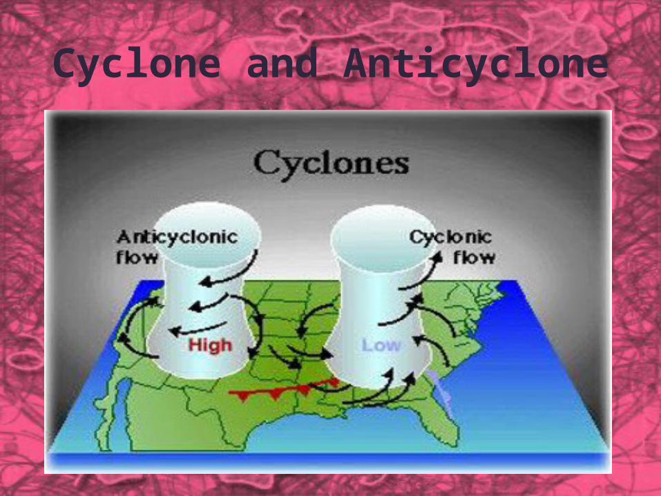
Cyclone and Anticyclone
Cyclone and Anticyclone
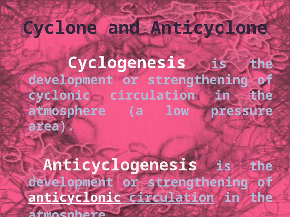
Cyclogenesis is the development or strengthening of cyclonic circulation in the atmosphere (a low pressure area).
Anticyclogenesis is the development or strengthening of anticyclonic circulation in the atmosphere.