Embed Size (px)
Citation preview
CYNGOR CEFN GWLAD CYMRU COUNTRYSIDE COUNCIL FOR WALES
CORE MANAGEMENT PLAN INCLUDING CONSERVATION OBJECTIVES
FOR
AFON EDEN – CORS GOCH TRAWSFYNYDD SAC
Version: March 2008 (Minor map edit, August 2012) Date: 25 February 2008 Approved by: N Thomas 31/3/08 A Welsh version of all or part of this document can be made available on request.

2
CONTENTS Preface: Purpose of this document 1. Vision for the Site 2. Site Description
2.1 Area and Designations Covered by this Plan 2.2 Outline Description 2.3 Outline of Past and Current Management 2.4 Management Units
3. The Special Features
3.1 Confirmation of Special Features 3.2 Special Features and Management Units
4. Conservation Objectives Background to Conservation Objectives Conservation Objectives for Features 4.1 Water courses (SSSI habitat supporting SAC features) 4.2 Floating water-plantain Luronium natans 4.3 Freshwater pearl mussel Margaritifera margaritifera. 4.4 Atlantic salmon Salmo salar 4.5 Otter Lutra lutra 4.6 Active raised bog.
5. Assessment of Conservation Status and Management Requirements:
Conservation Status and Management Requirements of Features 5.1 Water courses 5.2 Floating water-plantain Luronium natans 5.3 Freshwater pearl mussel Margaritifera margaritifera. 5.4 Atlantic salmon Salmo salar 5.5 Otter Lutra lutra 5.6 Active raised bog
6. Action Plan: Summary 7. Glossary 8. References and Annexes

3
PREFACE This document provides the main elements of CCW’s management plan for the sites named. It sets out what needs to be achieved on the sites, the results of monitoring and advice on the action required. This document is made available through CCW’s web site and may be revised in response to changing circumstances or new information. This is a technical document that supplements summary information on the web site. One of the key functions of this document is to provide CCW’s statement of the Conservation Objectives for the relevant Natura 2000 sites. This is required to implement the Conservation (Natural Habitats, &c.) Regulations 1994, as amended (Section 4). As a matter of Welsh Assembly Government Policy, the provisions of those regulations are also to be applied to Ramsar sites in Wales.

4
1. VISION FOR THE SITE
This is a descriptive overview of what needs to be achieved for conservation on the site. It brings together and summarises the Conservation Objectives (part 4) into a single, integrated statement about the site.
Our vision for the Afon Eden – Cors Goch Trawsfynydd SAC is to maintain, or where necessary restore, the raised bogs, their associated areas of blanket bog, and the river to good condition so that all of its typical and uncommon species (listed below) are able to sustain themselves in the long-term as part of a naturally functioning ecosystem. To conserve the physical river by maintaining or restoring the ecological connectivity of riparian habitats and by allowing the natural processes of erosion and deposition to operate without undue interference. The quality and quantity of water, including natural flow variability, and the quality of adjacent habitats, are maintained or restored to a level necessary to maintain in favourable condition for the foreseeable future all the freshwater species listed below; Floating water-plantain populations are able to maintain themselves on a long term basis throughout their current distribution in the river and each population is able to successfully complete sexual and /or vegetative reproduction. The river provides sufficient habitat to support existing populations within their current distribution and also allows for future expansion and dispersal. Atlantic salmon migrate into the catchment to spawn and go through their juvenile stages in the river and are present in numbers that reflect a healthy and sustainable population supported by well distributed good-quality habitat. These migratory fish are able to complete their migrations and life cycles largely unhindered by artificial barriers such as pollution, or depleted flows. The freshwater pearl mussel population is maintained throughout its distribution in the river corridor. Within the river there is a sufficient supply of clean water, host salmon and suitable habitat to support a long term, self-sustaining population. The otter population thrives on the abundance of prey species and the widespread availability of undisturbed resting and breeding sites that are found along the river and its main tributaries. The hydrology of the two raised bogs and their associated areas of blanket bog is intact and as a result there is active accumulation of Sphagnum moss peat. The bogs’ surface is a mosaic of hummocks and wetter hollows with little encroachment of scrub and where purple moor-grass occurs it is a typical and desirable species of localised dominance of a wetland or lagg/fen vegetation community. All factors affecting the achievement of favourable condition shall be under control. The presence of the Afon Eden – Cors Goch Traswfynydd SAC and its special wildlife enhances the economic and social value of the area, by providing a high quality environment for peaceful enjoyment by local people and visitors. The river catchment’s functions of controlling flooding and supplying clean water are recognised and promoted through appropriate land management.

5
2. SITE DESCRIPTION
2.1 Area and Designations Covered by this Plan
Grid references: SH702349 to SH735223 Unitary authority: GWYNEDD Area (hectares): 284.29 Designations covered: Afon Eden – Cors Goch Trawsfynydd SSSI. Afon Eden - Cors Coch, Trawsfynydd SAC. Meirionnydd oak woods and bat sites SAC.
Detailed maps of the designated sites are available through CCW’s web site: http://www.ccw.gov.uk/interactive-maps/protected-areas-map.aspx

6
2.2 Outline Description The Afon Eden/River Eden is a relatively unmodified river, mainly upland in character, of approximately 10km length. The watershed begins just south of Llyn Trawsfynydd, within an area of gently sloping and poorly drained land. The upper section of the catchment is slow-flowing with a number of deep pools along its length. In the lower two-thirds of the catchment the river flows more steeply into a narrow rocky gorge, with an adjacent area of forestry plantation, known as Coed y Brenin. The Afon Eden joins with the Afon Mawddach, just above the village of Ganllwyd, but the SAC boundary continues downstream to the tidal limit of the Mawddach at Llanelltyd. The Afon Eden is fed by a number of base-poor upland streams, which flow from the eastern flanks of the Rhinog mountains. The Ardudwy leat takes the most acidic waters from the eastern tributaries to Llyn Trawsfynydd. This water is used to maximise the water available for HEP generation by the Maentwrog Power Station. The area receives high average rainfall, which has contributed to the development of raised bogs, blanket bog, and transition mires and quaking bogs. Two areas of raised bog occur at the top end of the catchment, close to the watershed, where they were once part of a much larger extent of bog, much of which is now flooded by Llyn Trawsfynydd. Transition mires and quaking bogs occur in waterlogged situations where they receive nutrients from the surrounding catchment as well as from rainfall. They are located within the wetlands surrounding the areas of raised bog. The ecological structure and functions of the site are dependent on hydrological and geomorphological processes (often referred to as hydromorphological processes), the quality of riparian habitats and connectivity of habitats. Animals that are highly mobile such as migratory fish and otters, are also affected by factors operating outside the site. The river contains the last known population of freshwater pearl mussels surviving in Wales, they are almost entirely confined to one section of the river. Historically the mussels were more widespread in the catchment. The mussels rely on salmonid parr hosting, for a short period of time, the glochidial larvae of the mussels on their gills, so the success of migratory and spawning fish in the catchment is crucial to their long term survival. Atlantic salmon is also an important fish species that breeds in the Mawddach catchment. In the slow moving waters just upstream from Pont y Grible is a population of floating water plantain.
2.3 Outline of Past and Current Management Farming and forestry have been and continue to be the main activities in the catchment; the main landuse in the northern half of the catchment is predominantly rough grazing, with areas of semi-improved and improved grassland for sheep and cattle grazing and some forestry. The majority of the improved grassland, outside the SSSI/SAC, are located on the eastern slopes of the watershed. The Coed y Brenin forestry plantations dominate the southern portion of the catchment within a narrow rocky gorge. Peat cutting was practised widely on and adjacent to the two raised bogs.
2.4 Management Units
The plan area has been divided into management units to enable practical communication about features, objectives, and management. This will also allow us to differentiate between the different designations where necessary. In this plan the management units have been based on habitat and survey units within the Afon Eden – Cors Goch Trawsfynydd and Meirionnydd oak wood and bat sites SAC boundary that are underpinned by the Afon Eden – Cors Goch Trawsfynydd SSSI. The following table confirms the relationships between the management units and the designations covered:

7
Unit number
SAC SSSI CCW owned Other
Afon Eden – Cors Goch Trawsfynydd SSSI 1 a
a
2 X a 3 X a 4 a a 5a a
a
6 a
a
Aber Mawddach SSSI 5b a
a
3. THE SPECIAL FEATURES
3.1 Confirmation of Special Features
Designated feature Relationships, nomenclature etc Conservation Objective in part 4
Afon Eden – Cors Goch Trawsfynydd SAC features (& SSSI) Annex II species that are a primary reason for selection of this site Floating water-plantain Luronium natans (Code: 1831)
SSSI feature 2
Freshwater pearl mussel Margaritifera margaritifera (Code: 1029)
SSSI feature 3
Annex I habitats present as a qualifying feature, but not a primary reason for selection of this site Active raised bog (Code: 7110) SSSI feature 6 Annex II species present as a qualifying feature, but not a primary reason for site selection Atlantic salmon Salmo salar (Code: 1106)
SSSI feature 4
Otter Lutra lutra (Code: 1355) SSSI feature 5 Meirionnydd oakwoods and bat sites(M.O.W) SAC features Annex I habitats that are a primary reason for selection of this site Old sessile oak woods with Ilex and Blechnum in the British Isles
SSSI feature See Meirionnydd Oak Woods plan for details.
Afon Eden – Cors Goch Trawsfynydd SSSI features
Running waters 1
Acid grassland TBC*
Neutral grassland TBC
Woodland TBC
Blanket bog Component part of SAC feature 6

8
Raised bog & damaged raised bog SAC feature 6
Fen lagg Component part of SAC feature 6
Fen meadow TBC
Habitat mixture (complementary) TBC
Floating water plantain Luronium natans
SAC feature 2
Bog rosemary Andromeda polifolia Component part of raised bog SAC feature.
6
Water sedge Carex aquatilis TBC
Freshwater pearl mussel Margaritifera margaritifera
SAC feature 3
Large heath butterfly Coenonympha tullia
TBC
Otter Lutra lutra SAC feature 5
Atlantic salmon Salmo salar SAC feature 4
Liverwort – 1 Nationally rare species Scapania palui
Component part of raised bog SAC feature.
Mosses – 2 Nationally scarce & 1 Regionally rare Sphagnum mosses; S. affine, S. austinii, S. fuscum.
Component part of raised bog SAC feature.
6
Lichens - Four Nationally rare species- Thirty Nationally scarce species- Eighteen EUOIEC scoring species. NIEC scoring species
Component part of woodland SAC feature.
See Meirionnydd Oak Woods plan for details.
*TBC – to be completed. 3.2 Special Features and Management Units This section sets out the relationship between the special features and each management unit. This is intended to provide a clear statement about what each unit should be managed for, taking into account the varied needs of the different special features. All special features are allocated to one of seven classes in each management unit. These classes are: Key Features KH - a ‘Key Habitat’ in the management unit, i.e. the habitat that is the main focus of management and monitoring effort, perhaps because of the dependence of a key species (see KS below). There will rarely be more than one Key Habitat in a unit. KS – a ‘Key Species’ in the management unit, often driving both the selection and management of a Key Habitat. Geo – an earth science feature that is the main focus of management and monitoring effort in a unit. Other Features Sym - habitats, species and earth science features that are of importance in a unit but are not the main focus of management or monitoring. These features will benefit from management for the key feature(s) identified in the unit. These may be classed as ‘Sym’ features because: a) they are present in the unit but are of less conservation importance than the key feature; and/or
b) they are present in the unit but in small areas/numbers, with the bulk of the feature in other units of the site; and/or

9
c) their requirements are broader than and compatible with the management needs of the key feature(s).
Nm - an infrequently used category where features are at risk of decline within a unit as a result of meeting the management needs of the key feature(s), i.e. under Negative Management. These cases will usually be compensated for by management elsewhere in the plan, and can be used where minor occurrences of a feature would otherwise lead to apparent conflict with another key feature in a unit. Mn - Management units with no special feature present but which are of importance for management of features elsewhere on a site e.g. livestock over-wintering area included within designation boundaries. x – Features not present in the management unit.

10
The table below sets out the relationship between the special features and management units identified in this plan:
Afon Eden – Cors Goch Trawsfynydd SSSI*
Management Unit
1 Cors Goch mires, source of Afon Eden to Afon Serw.
2 Cae Crwn grassland
3 Pont y Grible
grassland
4 Maesgwm
& Aber Eden
woodland unit
5a River
corridor from
Coed y Brenin to Llaneltyd
& inc Afon Wen.
5b Aber
Mawddach SSSI
6 Afon Wen
woodland unit
SAC a a a a a SSSI a a a a a a a NNR/CCW owned Afon Eden – Cors Goch Trawsfynydd SAC features
1. Active raised bog KH x x x x x x
2. Floating water-plantain
KS x x x a a x
3. Freshwater pearl mussel
KS x x x a a x
4. Atlantic salmon KS x x x KS KS x
5. Otter KS x a a KS KS a Meirionnydd oak woods and bat sites SAC features occurring in Afon Eden – Cors Goch Trawsfynydd SSSI Old sessile oak woods with Ilex and Blechnum in the British Isles
x x x a x x a
Afon Eden – Cors Goch Trawsfynydd SSSI features but not SAC
River KH x x x KH KH x
Woodland x x x KH x x KH
Blanket bog KH x x x x x x
Raised bog & damaged raised bog
KH x x x x x x
Fen lagg KH x x x x x x
Fen meadow x x KH x x x x
* Unit 5b lies within the boundaries of Aber Mawddach SSSI.

11
Acid grassland x x KH x x x x
Neutral grassland x KH x x x x x

12
Afon Eden – Cors Goch Trawsfynydd SSSI*
Management Unit
Afon Eden – Cors Goch Trawsfynydd SSSI features but not SAC
1 Cors Goch mires, source of Afon Eden to Afon Serw.
2 Cae Crwn neutral grassland
3 Pont y
Grible Phase II grassland
site
4 Maesgwm
& Aber Eden woodland
unit
5a River
corridor from Coed y Brenin to Llaneltyd
& inc Afon Wen.
5b Aber
Mawddach SSSI
6 Afon Wen woodland
unit
Large heath Coenonympha tullia
KS x x x x
x x
Water sedge Carex aquatilis
KS x x x x
x x
Bog-rosemary Andromeda polifolia
KS x x x x
x x
Liverwort – 1 Nationally rare species Porella pinnata
KS
x x x x
x x
Mosses – 2 Nationally scarce & 1 Regionally rare Sphagnum mosses; S. affine, S. austinii, S. fuscum.
KS x x x x
x x
Lichens - Four Nationally rare species
x x x
KS x
x KS
Lichens - Thirty Nationally scarce species
x x x
KS x
x KS
Lichens - Eighteen EUOIEC scoring species
x x
x
KS x
x KS
Lichens NIEC scoring species x x
x KS x
x KS
Broadleaved woodland in units 4 and 6 are compartments within the Meirionnydd oak woods and bat sites SAC and are shaded in green for clarity.
Adult freshwater pearl mussel are only found in unit 1 but the larval part of their life cycle is dependent upon the presence of Atlantic salmon parr so they are directly dependent on the maintenance of a migration route for spawning for salmon in unit 5.
* Unit 5b lies within the boundaries of Aber Mawddach SSSI.

13
4. CONSERVATION OBJECTIVES
Background to Conservation Objectives:
a. Outline of the legal context and purpose of conservation objectives.
Conservation objectives are required by the 1992 ‘Habitats’ Directive (92/43/EEC). The aim of the Habitats Directives is the maintenance, or where appropriate the restoration of the ‘favourable conservation status’ of habitats and species features for which SACs and SPAs are designated (see Box 1). In the broadest terms, 'favourable conservation status' means a feature is in satisfactory condition and all the things needed to keep it that way are in place for the foreseeable future. CCW considers that the concept of favourable conservation status provides a practical and legally robust basis for conservation objectives for Natura 2000 and Ramsar sites.
Achieving these objectives requires appropriate management and the control of factors that may cause deterioration of habitats or significant disturbance to species. As well as the overall function of communication, Conservation objectives have a number of specific roles: • Conservation planning and management.
The conservation objectives guide management of sites, to maintain or restore the habitats and species in favourable condition.
Box 1 Favourable conservation status as defined in Articles 1(e) and 1(i) of the Habitats Directive “The conservation status of a natural habitat is the sum of the influences acting on it and its typical species that may affect its long-term natural distribution, structure and functions as well as the long term survival of its typical species. The conservation status of a natural habitat will be taken as favourable when:
• Its natural range and areas it covers within that range are stable or increasing, and • The specific structure and functions which are necessary for its long-term
maintenance exist and are likely to continue to exist for the foreseeable future, and • The conservation status of its typical species is favourable.
The conservation status of a species is the sum of the influences acting on the species that may affect the long-term distribution and abundance of its populations. The conservation status will be taken as ‘favourable’ when:
• population dynamics data on the species indicate that it is maintaining itself on a
long-term basis as a viable component of its natural habitats, and • the natural range of the species is neither being reduced nor is likely to be reduced
for the foreseeable future, and • There is, and will probably continue to be, a sufficiently large habitat to maintain
its populations on a long-term basis.”

14
• Assessing plans and projects. Article 6(3) of the ‘Habitats’ Directive requires appropriate assessment of proposed plans and projects against a site's conservation objectives. Subject to certain exceptions, plans or projects may not proceed unless it is established that they will not adversely affect the integrity of sites. This role for testing plans and projects also applies to the review of existing decisions and consents.
• Monitoring and reporting.
The conservation objectives provide the basis for assessing the condition of a feature and the status of factors that affect it. CCW uses ‘performance indicators’ within the conservation objectives, as the basis for monitoring and reporting. Performance indicators are selected to provide useful information about the condition of a feature and the factors that affect it.
The conservation objectives in this document reflect CCW’s current information and understanding of the site and its features and their importance in an international context. The conservation objectives are subject to review by CCW in light of new knowledge. b. Format of the conservation objectives There is one conservation objective for each feature listed in part 3. Each conservation objective is a composite statement representing a site-specific description of what is considered to be the favourable conservation status of the feature. These statements apply to a whole feature as it occurs within the whole plan area, although section 3.2 sets out their relevance to individual management units. Each conservation objective consists of the following two elements:
1. Vision for the feature 2. Performance indicators
As a result of the general practice developed and agreed within the UK Conservation Agencies, conservation objectives include performance indicators, the selection of which should be informed by JNCC guidance on Common Standards Monitoring1. There is a critical need for clarity over the role of performance indicators within the conservation objectives. A conservation objective, because it includes the vision for the feature, has meaning and substance independently of the performance indicators, and is more than the sum of the performance indicators. The performance indicators are simply what make the conservation objectives measurable, and are thus part of, not a substitute for, the conservation objectives. Any feature attribute identified in the performance indicators should be represented in the vision for the feature, but not all elements of the vision for the feature will necessarily have corresponding performance indicators. As well as describing the aspirations for the condition of the feature, the Vision section of each conservation objective contains a statement that the factors necessary to maintain those desired conditions are under control. Subject to technical, practical and resource constraints, factors which have an important influence on the condition of the feature are identified in the performance indicators.
1 Available through www.jncc.gov.uk and follow links to Protected Sites and Common Standards Monitoring.

15
4.1 Conservation Objective for SSSI Feature 1:Water Courses Vision for water courses The ecological status of the water course is a major determinant in the capacity for the habitats in the SAC to support each feature at near-natural population levels, as determined by natural ecological and hydromorphological processes and characteristics. Flow regime, water quality, quantity and physical habitat should be maintained or restored as far as possible to a near-natural state in order to support the coherence of the ecosystem structure and function. Favourable conservation status (FCS) is determined in part by the capacity of the water course to support the species for which it is considered special, so the relevant SAC features must be in FCS for the water course feature to be in FCS. FCS can be maintained or restored to favourable conservation status when all the following conditions for the water course are satisfied:
1. Water flows and water quantity shall be sufficient to support the SAC features. This shall
include: • during the migration periods of each migratory fish species that their passage
upstream to spawning sites is not hindered by abstraction discharges, engineering or gravel extraction activities or other impacts.
• Water quantity and flows at pearl mussel beds, fish spawning sites and nursery areas
will not be depleted by abstraction, discharges, engineering or gravel extraction activities or other impacts to the extent that these sites are damaged or destroyed.
2. Water quality shall be sufficient to support the SAC features. This shall include:-
• Levels of nutrients, in particular orthophosphate, will be agreed between EA and
CCW for the Water Framework Directive water body in the Afon Eden – Cors Goch Trawsfynydd SAC, and measures taken to maintain nutrients below these levels.
• Levels of suspended solids will be agreed between EA and CCW for the Water
Framework Directive water body in the Afon Eden – Cors Goch Trawsfynydd SAC. Measures including, but not limited to, the control of suspended sediment generated by agriculture, forestry and engineering works, will be taken to maintain suspended solids below these levels.
3. The physical habitat and substrate quantity shall be maintained. All known breeding,
spawning and nursery sites of species features should be maintained as suitable habitat except where natural processes cause them to change. Artificial factors impacting on the capability of each species feature to occupy the full extent of its natural range should be modified where necessary to allow passage, eg. leats, bridge sills etc.
Performance indicators for feature condition: Water courses. Attribute Attribute rationale and other comments Specified limits A1. Hydromorphology Flow regime, water quality,
Draft targets are set in relation to river/reach type(s)
Data for the Mawddach that may be possible to use for this
A2. Water quality Monitoring is responsibility of EA Wales.

16
A2.1 Biological quality
Set at the class required in the JNCC guidance for Atlantic salmon, the most sensitive feature
Water quality should not be injurious to any lifecycle stage of freshwater pearl mussel.
Biological GQA class A
(This is the class required in the JNCC guidance for freshwater pearl mussel).
A2.2 Chemical quality
It has been provisionally agreed with EA through the Stage 3 Review of Consents process that RE1 will be used throughout the SAC.
Water quality should not be injurious to any lifecycle stage of freshwater pearl mussel.
• Soluble reactive phosphorus. Elevated phosphorus levels can result in enhanced plant growth leading to large diurnal sags in dissolved oxygen levels. This can have an adverse impact on freshwater pearl mussel
• Nitrates.
See un-ionised ammonia limits cited in Site Issue Briefing for freshwater pearl mussel.
RE1 (This is the class required in the JNCC guidance for freshwater pearl mussel).
Routine analysis of water for presence of PCBs
Background limit for river type.
Background limit for river type
A2.3 Suspended solids
Attribute is significant for riparian SAC features i.e. negative impact if too high. Elevated levels of suspended solids can clog the respiratory structures of fish and adversely affect mussel filter-feeding feeding and juvenile development. In the absence of specific data the precautionary target of 10 mg L-1 (as used for salmon spawning areas) has been adopted for freshwater pearl mussel.
Levels of suspended solids will be agreed between EA and CCW for the Water Framework Directive.
Upper limit: Annual mean <10 mg L –1 Limits set by Fresh Water Fish Directive should be regarded as maximum level for river and stricter levels for sensitive sections where identified.
A3. Physical Habitat Predominantly unmodified planform and profile.
River habitat SSSI features should be in favourable condition
The characteristic channel morphology provides the diversity of water depths, current velocities and substrate types necessary to fulfil the habitat requirements of the features. The close proximity of different habitats facilitates movement of fish to new preferred habitats with age.
Morphological quality –absence of artificial factors
Physical modifications to open water courses that will have an adverse effect on the integrity of the SAC, including deepening and widening of drainage ditches within the catchment will not be consented.

17
Performance indicators for factors affecting the feature: Water courses Factor Factor rationale and other comments Operational Limits F1. Diffuse & point source pollution
In addition to individual domestic septic tanks in the catchment there are three sewerage treatment works (STW);
• Bronaber STW operated by Dŵr Cymru.
• Coed y Brenin visitor centre STW
at Maesgwm (SH715273) operated by Forestry Commission (FC).
• Coed y Brenin visitor centre STW
at Pont Dolgefeilau (SH721268) operated by FC.
Bronaber works is operating under discharge levels set in the 1950s which will be reviewed under RoC. Maesgwm centre is likely to be redeveloped and this could provide an opportunity to upgrade the facility. The new works (2005) at Pont Dolgefeilau has a relatively novel peat based filter which should conform to modern water quality discharge standards
F2. Agricultural operations
Different agricultural operations in the catchment present different risk factors for the feature; High risk operations leading to increased soil erosion, sediment supply and run-off rates include;
• Cleaning and creating new drainage ditches.
• Inappropriate high grazing levels. • Inappropriately sited
supplementary feeding points.
• Land cultivation e.g. ploughing. • Fertiliser and lime application. • Pesticide application including
sheep dipping and certain worming treatments.
Presumption against new drainage ditches. Light rotational cleaning of existing ditches only. Appropriate grazing Soil degradation occurs around stock feeding points and they should be located away from open watercourses. Presumption against any new land cultivation. No application within defined location specific buffer areas. Persistent, non-water soluble agri-veterinary treatments have the most impact.
F3. Forestry operations
Forestry operations in the catchment present different risk factors for the feature; The most high-risk operation is clear felling with timber transportation and conifer afforestation presenting a impact medium risk.
Assessment of plans and projects
F4. Trunk road management & other urban land use.
• Road drainage Increase in sediment and decrease in water quality to channel may be due to trunk road management between Coed y Brenin and Bronaber. Run-off from management of RTA by emergency services and fuel, milk or chemical spillages could affect water quality.
• Surface water abstraction for domestic/ industrial /agricultural
Review

18
use. Reduction of flows especially during the summer months.
• Tips/dumps The disused WWII army camp at Bronaber is the site of several licensed and unlicensed tips. There is the potential for materials and pollutants to enter a tributary of the Eden above the FWPM beds.
Review Review
F5. River engineering
• Ardudwy leat Cessation of the leat would increase the levels of acidic waters from the western tributaries entering the Eden. This leat abstracts water from the catchment and low flows affect water quality also overtopping of the leat during high flows leads to acidic waters entering the Eden. Annual cleaning of the weirs and screens leads to gravels being dumped in the tributaries in one large load. This creates an artificial “pulse” of sands, gravels and sediments entering the water body.
• Small-scale hydro-power schemes in the catchment would change channel morphology and flow regimes.
• Dredging would stir up river bed
sediments.
• In-channel works, including flood defence works, leading to increase in sediment load, chemical pollution.
Review Assessment of plans and projects Presumption against dredging Presumption against in –channel works.
F6. Recreation • Water base recreation can lead to disturbance and / or damage to channel banks and beds and cause an increase in sediment supply.
• Walking & cycling can lead to footpath erosion and cause an increase in sediment supply.
Assessment of plans and projects
F7. Mining There are three recorded mining sites in the upper sub-catchment of the Afon Eden but there are 70 known mine working within the Mawddach catchment. Mine discharges enter the Eden in the lower section of the catchment at the confluences with the Afon Mawddach & Afon Wen
Unknown levels: the release of toxic substances including acidic water could be a significant factor.
Review
F8. Deposition of atmospheric pollution
• Deposition of oxides of nitrogen & sulphur.
Acidification of river water. • Deposition of nitrogen &
ammonia.
U.K. monitoring programme

19
Eutrophication. F9. Climate change Change in rainfall patterns and
transpiration rates. Upward trend in average ambient water temperature.
• Warmer, drier summers Increased stream temperatures, reduced summer flows, increase in algal blooms and increase in potential for woodland / moorland fires.
• Increased frequency of high intensity rainfall.
More erosive runoff and thus increased sedimentation. More flashy flow regimes and flood souring of river bed.
U.K. monitoring programme

20
4.2 Conservation Objective for SAC Feature 2: Floating water-plantain Luronium natans (Code: 1831) Vision for feature 2 The vision for this feature is for it to be in favourable conservation status, where all of the following conditions are satisfied:
1. The L. natans populations will be viable throughout their current extent in the Afon Eden & will be able to maintain themselves on a long-term basis. There will be no contraction of the current L. natans distribution in the Afon Eden and each L. natans population must be able to disperse and complete sexual and/or vegetative reproduction successfully.
2. The river will have sufficient habitat to support existing L. natans populations within their current distribution and future expansion.
3. All factors affecting the achievement of these conditions are under control. Performance indicators for Feature 2 The performance indicators are part of the conservation objective, not a substitute for it. Assessment of plans and projects must be based on the entire conservation objective, not just the performance indicators. Performance indicators for SAC feature condition: L. natans Attribute Attribute rationale and other comments Specified limits A1. Species extent and abundance
Presence of Luronium natans recorded as plants that are attached to substrate. Detached fragments (unless obviously detached during monitoring) will not be counted.
Lower limit: Luronium natans will be present within each of Sections 1-3 along the Afon Eden (Annexe Map 3)
A2. Sufficient habitat.
Submerged populations of L. natans require substrates comprising of mud or stable fine gravel or silt in depths of clear water up to 3m..
Sufficient good quality habitat should exist to support the expansion of existing populations. Extent of good quality habitat should not be reduced.
Performance indicators for factors affecting the feature: L. natans Factor Factor rationale and other comments Operational Limits F1. Water quantity (flow) Refer to factors affecting water courses - feature 1. F2. Water quality L. natans is recorded elsewhere across
a spectrum of nutrient levels including fairly eutrophic canals, so it appears it is not highly sensitive to some enrichment. Water quality is set to protect the most sensitive feature.
Refer to factors affecting watercourses - feature 1.
F3. Dredging Dredging could directly damage L. natans beds.
No dredging likely to affect L.natans should occur at Pont y Grible or other sections of the Eden where suitable habitat is found.
F4. Gravel abstraction
Loss of source material for river gravel beds. Physical removal of potential habitat.
Presumption against gravel abstraction.
F5. Recreation Canoeing during periods of low flows & trampling of the riverbed could damage submerged populations.
No canoeing during periods of low flows and no up-stream access points in the vicinity of Pont y Grible.
F6. Competition from other aquatic plant species
L. natans cannot compete with other aquatic plant species including algae.
Review to assess if competition is an issue.

21
4.3 Conservation Objective for SAC Feature 3: Freshwater pearl mussel Margaritifera margaritifera (Code: 1029) Vision for feature 3 The vision for this feature is for it to be in favourable conservation status, where all of the following conditions are satisfied:
1. The freshwater pearl mussel population must be viable throughout its distribution in the river and maintaining itself on a long-term basis.
2. There will be no contraction of the number, age range, distribution or size of mussel beds found within the population.
3. Within the distribution of these beds there will be sufficient habitat to support a viable populations.
4. The transference of pearl mussel glochidia (larvae) is facilitated by an abundant and self-sustaining Atlantic salmon population.
5. All factors affecting the achievement of these conditions are under control. Performance indicators for Feature 3 The performance indicators are part of the conservation objective, not a substitute for it. Assessment of plans and projects must be based on the entire conservation objective, not just the performance indicators. Performance indicators for feature condition: Freshwater pearl mussel Attribute Attribute rationale and other
comments Specified limits
A1. Population distribution
Freshwater pearl mussel distribution is currently (as assessed in 2003) confined to the stretch of river between Pont y Grible and Bronaber, with the majority of animals found at Gelli Goch.
Lower limit: The distribution of mussels must not contract from its 2003 range.
A2. Population density and age structure
Freshwater pearl mussels have great longevity. Pearl mussel larvae spend a period of time attached to the gills of salmonid parr and so their breeding success depends in part on the presence of a healthy migratory Atlantic salmon population.
Upper limit: None set. Lower limit: Adult mussels are present for each delineated section of river (705 adults in total – 2003 survey results). Lower limit: Report of one juvenile mussel of <65mm length during a site visit Recovery target value: Transect A: 50. Transect B: 45. Transect C: 150. Transect D: 40. Transect E: 70. Transect F: 90. Transect G: 130. Transect H: 85. Transect I: 45. (See map 1) At least 20% of population ≤65mm and at least some mussels ≤ 30mm. See Map X.
Performance indicator for factors affecting the feature: Freshwater pearl mussel Factor Factor rationale and other comments Operational Limits F1. Water quantity (flow)
River flow affects a range of habitat factors of critical importance to pearl mussels, including current velocity,
Of the naturalised daily flow throughout the year the following should apply;

22
water depth, wetted area, substrate quality, dissolved oxygen levels and water temperature. The maintenance both of occasional flushing flows and base flows, based on natural hydrological processes, is vital. Refer to feature 1 factors affecting watercourses.
Upper limit: Flow should not be more than 110%. Lower limit: Flow should be at least 90%. Refer to feature 1 factors affecting watercourses.
F2. Water quality. Refer to factors affecting watercourses - feature 1. F3. Habitat extent including river morphology.
Maintain the characteristic physical features of the river channel, banks and riparian zone.
Lower limit: Map of current river morphology
F4. Habitat quality inc. river substrate
Clean coarse sands & gravels provide suitable habitat for pearl mussels. River banks should not be heavily shaded but some shading provides shade, keeping water temperatures optimal for the species and reducing growths of filamentous algae. Elevated levels of silt and fine sand can clog substrates used by juvenile mussels and can impair adult feeding/respiration. Riverside vegetation, especially mature willow trees, provide shading which helps keep the mussels cool during hot summers.
Lower limit: Recovery target value: <1% silt and fine sands in top 30 cm of substrates hosting juvenile and adult mussels. Monitoring targets: In the core transects, the following number of sample points will be classed as suitable habitat:
(A) 8/10, (B) 7/9, (C) 25/30, (D) 6/8, (E) 10/14, (F) 15/18, (G) 20/26, (H) 12/17, (I) 7/9, (J) 7/9, (K) 8/11
Limits: River bank shading should not exceed 60% adjacent to the mussel beds.
F5. Host fish population
Physical and chemical conditions need to be suitable for the well being of all life stages of salmonids, including free access up the river and conditions in the estuary and lower river where the juveniles of migratory salmonids are present. Release of parr & smolt by the EA from the smolt release pond at Bronaber means that fish of this age may migrate to sea before attached larval mussel has completed its glochidial stage.
An abundant supply of juvenile salmonids (0+ and 1+ year classes) is vital to the survival of the larval stage.
F6. Fisheries & species promotion - See factors affecting Atlantic salmon – feature 4.
F7. Operation of fish trap- See factors affecting Atlantic salmon – feature 4.
F8. Gravel abstraction- See factors affecting Atlantic salmon – feature 4.
F9. Invasive alien species- See factors affecting Atlantic salmon – feature 4.
F10. Coarse woody debris (CWD)- See factors affecting Atlantic salmon – feature 4.
F11. Illegal fish poaching- See factors affecting Atlantic salmon – feature 4.

23
F12. Illegal pearl fishing
The level, if any, of freshwater pearl mussel poaching is not known. Pearl fishers remove the pearl from the adult mussel inevitably killing it. The price of pearl mussels has declined during the last decade due to imports of cultivated ones from China & this may reduce the demand for wild ones.
Any evidence of pearl fishing must be pursued as a Wildlife crime. Under RL1, WCA5, H & S Annex Iia.
F13. Diffuse & point source pollution- Refer to factors affecting watercourses - feature 1. F14. Agricultural operations- Refer to factors affecting watercourses - feature 1. F15. Forestry operations- Refer to factors affecting watercourses - feature 1. F16. Trunk road management & other urban land use. - Refer to factors affecting watercourses - feature 1. F17. River engineering- Refer to factors affecting watercourses - feature 1. F18. Recreation- Refer to feature 1 factors affecting watercourses. F19. Mining Release of toxic substances can have a
direct & cumulative impact on both fish and invertebrates. See also factors affecting water courses – feature 1.
Refer to factors affecting watercourses - feature 1.
F20. Deposition atmospheric pollution
Refer to factors affecting watercourses - feature 1.
U.K. monitoring programme.
F21. Climate change Water temperature is the trigger for adult mussels to release their glochidial larvae. Data from the Mawddach pearl mussel hatchery project suggests that the larvae are being released earlier in the season and in some years this may not coincide with the presence of migratory salmonids. Also see factors affecting watercourses – feature 1.
U.K. monitoring programme.
4.4 Conservation Objective for Feature 4: Atlantic Salmon Salmo salar (Code: 1106) Vision for feature 4 The vision for this feature is for it to be in favourable conservation status, where all of the following conditions are satisfied:
1. The Atlantic salmon population must be viable throughout its distribution in the river and maintaining itself on a long-term basis.
2. There will be no contraction of the number or age range of the salmon population. 3. There will be sufficient habitat to support a viable population. 4. All factors affecting the achievement of these conditions are under control.
Performance indicators for Feature 4 The performance indicators are part of the conservation objective, not a substitute for it. Assessment of plans and projects must be based on the entire conservation objective, not just the performance indicators.

24
Performance indicators for SAC feature condition; Atlantic salmon Attribute Attribute rationale and other comments Specified limits A1 Population Distribution
EA have information which needs to be transferred to an annotated map.
Map current distribution and artificial barriers to movement/spawning.
A2. Population size & range; Adult run
CSM guidance states: Total run size at least matching an agreed reference level, including a seasonal pattern of migration characteristic of the river and maintenance of the multi-sea-winter component.
As there is no fish counter in the Eden so adult run size is calculated using rod catch data for the Mawddach catchment. Further details can be found in the EA Mawddach Salmon Action Plan 1999.
A2.1. Population size & range: Juvenile densities.
CSM guidance states: These should not differ significantly from those expected for the river type/reach under conditions of high physical and chemical quality. Expected densities for each sample site using HABSCORE. Assessed using electro fishing data

25
Performance indicator for factors affecting the SAC feature; Atlantic Salmon Factor Factor rationale and other comments Operational Limits F1. Water quantity (flow) – Refer to factors affecting watercourses - feature 1. F2. Water quality – Refer to factors affecting watercourses - feature 1. F3. Habitat extent including river morphology- Refer to factors affecting watercourses - feature 1. F4. Habitat quality inc. river substrate
Clean coarse sands & gravels provide suitable habitat for salmonid redds. Riverbanks should not be heavily shaded but some shading provides shade, keeping water temperatures optimal for the species and reducing growths of filamentous algae. Elevated levels of silt and fine sand can impair adult respiration
F5. Recreation • Water based recreation can lead to disturbance and / or damage to channel banks and beds and cause an increase in sediment supply. Canoeists may also trample and damage salmon spawning grounds. See Factors affecting watercourses – feature 1.
F6. Fisheries & species promotion
Net limitation orders are in place on the Mawddach. Rod licences are issued by the EA, Wales.
• Over-fishing during low flows Salmon become concentrated in pools during low flows and are vulnerable to over fishing.
• Over fishing of adult salmon at sea. This practise was recently out-lawed but it will continue to have an effect on salmon numbers in the short term future
• Stocking of non-native fish. Smolt releases from holding pond at Bronaber for sea trout & salmon. Competition with and predation of wild fish populations, introduction of disease, genetic alterations, impact on wider food chain.
• Alteration to the natural age structure through fishery release strategy
Shift in population structure from fry to parr stages. • Introduction of infectious diseases
Reduction in salmonids population. • Introduction of mink and displacement of
otter Predation on salmon stocks by both otter & mink. Mink are more generalist predators and tend to get pushed upstream by otters into the headwaters of a catchment where they impact upon the native aquatic fauna including salmonids.
Assessment of plans and projects. Insufficient data available on fish take. Insufficient data available on impact of release of hatchery bred fish on native population. Insufficient data on mink population in catchment.
F7. Operation of fish trap
Fish trap at Pont Dolgefeiliau is not currently in operation. If it were to be used it would create a barrier to fish migration
Assessment of plans and projects.
F8. Gravel abstraction Loss of salmon spawning grounds
Presumption against gravel abstraction

26
F9. Invasive alien species
Japanese knotweed is found growing next to the watercourses and is usually controlled via herbicides. Herbicided handled inappropriately may enter the water course and poison fish and invertebrates
Assessment of plans and projects.
F10. Coarse woody debris (CWD)
It is natural to find CWD in water courses and it assists with maintaining good water quality and can provide refuge areas for young fish
Presumption against CWD removal from the watercourse except on grounds of health and safety. Assessment of plans and projects
F11. Illegal fish poaching
Removal of salmonids Insufficient data
F12. Diffuse & point source pollution - Refer to factors affecting watercourses - feature 1. F13. Agricultural operations- Refer to factors affecting watercourses - feature 1. F14. Forestry operations- Refer to factors affecting watercourses - feature 1. F15. Trunk road management & other urban land use. - Refer to factors affecting watercourses - feature 1. F16. River engineering- Refer to factors affecting watercourses - feature 1. F17. Mining- Refer to factors affecting watercourses - feature 1. F18. Deposition atmospheric pollution- Refer to factors affecting watercourses - feature 1. F19. Climate change- Refer to factors affecting watercourses - feature 1.
F20. Marine by-catch A working group from the EA has identified that approximately 5% of the post-smolt and adult salmon are caught in pelagic trawl nets.
5% by-catch has been assessed as having no significant impact.

27
4.5 Conservation Objective for Feature 5: Otter Lutra lutra (Code: 1355) Vision for feature 5 The vision for this feature is for it be in favourable conservation status, where all of the following conditions are satisfied:
• The population of otters in the SAC is stable or increasing over the long term and reflects the natural carrying capacity of the habitat within the SAC, as determined by natural levels of prey abundance and associated territorial behaviour.
• The natural range of otters in the SAC is neither being reduced nor is likely to be reduced for
the foreseeable future. The natural range is taken to mean those reaches that are potentially suitable to form part of a breeding territory and/or provide routes between breeding territories. A number of potential and breeding sites have been identified (Lyles, 2006) in the upper reaches of the Afon Eden. The size of breeding territories may vary depending on prey abundance.
• The population size should not be limited by the availability of suitable undisturbed breeding sites. Where these are insufficient they should be created through habitat enhancement and where necessary the provision of artificial holts. No otter breeding site is subject to a level of disturbance that could have an adverse effect on breeding success. Where necessary, potentially harmful levels of disturbance are managed. Survey information shows that otters are widely distributed in the Mawddach catchment.
• The safe movement and dispersal of individuals around the SAC is facilitated by the provision, where necessary, of suitable riparian habitat, and underpasses, ledges, fencing etc at road bridges and other artificial barriers.
• All factors affecting the achievement of these conditions are under control.

28
Performance indicators for Feature 5 The performance indicators are part of the conservation objective, not a substitute for it. Assessment of plans and projects must be based on the entire conservation objective, not just the performance indicators. Performance indicators for feature condition: otter Attribute Attribute rationale and other comments Specified limits A1. Population distribution.
Although Performance Indicators are given it is difficult to assess the condition of the otter population distribution feature because of the relatively small size of the SAC areas compared to the typical home range size of otters. As otters are mobile animals occupying very large home ranges, the condition of the otter feature should be considered at the landscape level.
Upper limit: None set. Lower limit: Mawddach Sub-catchment: Afon Eden Otter signs found at 4 of the 6 OSW sites (66%)
A2. Breeding activity
Breeding Centres are used to provide an estimate of the number of females breeding in the system. They can only be a “best guess” but are based on our present knowledge of the size of otter home ranges, the juxtaposition of potential breeding sites, and records of breeding activity for the catchment.
Upper limit: None set. Lower limit: Breeding Centre: There should be no deterioration in, or loss of, bank side habitats within the assumed breeding centre.
A3. Actual & potential breeding sites.
Within the home range of a single female there may be two or more potential breeding sites. When this is the case, the female may use a different breeding site each year (Liles, 2003). Birth takes place in a Natal Den, either above ground in a small patch of cover (i.e.1m x 1m) such as scrub or a pile of timber, or below ground, for example in a tree root system or a pile of boulders. Females often use a different natal den site each year (Liles, 2003). Although targets are set for the number of Potential Breeding sites within the SAC areas and wider sub-catchments, the quality, habitat type, and location of sites is also important. Priority should be given to retaining existing sites. If the number or quality of sites does decline, alternative breeding sites can be created at nearby Habitat Improvement Sites.
Lower limit: None set.
Upper limit: Potential Breeding Sites: There should be no decline in the extent or quality of the 4 mapped potential breeding sites (Eden sub-catchment) on the Eden. Liles ( 2003) Bryn Re & Gallt Cefn Deuddwr

29
Performance indicator for factors affecting the feature: otter Factor Factor rationale and other comments Operational Limits F1. Water quality – see performance indicators for generic factors affecting feature 1 F2. Water quantity (flow) – see performance indicators for factors affecting feature 1
F3. Food availability & riparian habitat
The availability of food within the catchment is likely to be a major factor influencing both the distribution and breeding success of otters. Whilst the estuary is likely to support a range of fish species (particularly marine species), fish distribution on the rest of the system is patchy and, in places, very limited. The best parts of the Mawddach catchment for fish populations are the upper Eden (upriver from forestry areas) and the Wnion, where salmonid distribution and spawning is considered to be fair to good. Amphibians appear to be well distributed throughout the catchment. On the Eden, ditches and streams within the extensive areas of marshy grassland in the upper reaches are likely to support good populations of breeding amphibians.
Upper limit: None set. Lower limit: Fish & amphibian biomass should stay within expected fluctuations.
F4. Operation of fish trap- See factors affecting Atlantic salmon – feature 4. F5. Gravel abstraction See factors affecting Atlantic salmon – feature 4. F6. Invasive alien species See factors affecting Atlantic salmon – feature 4. F7. Coarse woody debris (CWD)
Where CWD has accumulated alongside the riverbank it can create suitable sites for laying up couches and natal dens. See factors affecting Atlantic salmon – feature 4.
See factors affecting Atlantic salmon – feature 4.
F11. Illegal fish poaching-See factors affecting Atlantic salmon – feature 4. F1. Diffuse & point source pollution -See factors affecting watercourses – feature 1. F2. Agricultural operations -See factors affecting watercourses – feature 1. F3. Forestry operations- See factors affecting watercourses – feature 1. F5. River engineering- See factors affecting watercourses – feature 1. F6. Recreation Breeding otters can be sensitive to disturbance by
humans and dogs so recreational areas should be sited at a distance from suitable breeding habitat and known breeding dens. See also factors affecting watercourses – feature 1.
See factors affecting watercourses – feature 1.
F7. Mining This factor can have an indirect impact on otter by affecting the food chain. See also factors affecting watercourses – feature 1.
See factors affecting watercourses – feature 1.
F8. Deposition atmospheric pollution
Eutrophication and acidification can have an indirect impact on otter by affecting the food chain. See also factors affecting water courses – feature 1.
See factors affecting watercourses – feature 1.
F10. Climate change
Change in rainfall patterns and increased flooding could affect the otter breeding cycle and success rates if natal dens are flooded and feeding patterns disrupted. See also factors affecting water courses – feature 1.
See factors affecting watercourses – feature 1.

30
4.6 Conservation Objective for SAC Feature 6: Active raised bog (Code: 7110) NVC communities: M2,,M17, M18, M25 The Cors Goch mires comprises a mosaic of ombrotrophic (rain-fed) bogs and minerotrophic (mire deriving nutrients from both rain, surface and ground water) mires. The raised bog vegetation comprises a mixture of M18 Erica tetralix-Sphagnum papillosum raised and blanket mire, M2 bog-pools and M17 Scirpus cespitosus – Eriophorum vaginatum blanket bog mire intersected with M6 Carex echinata – Sphagnum recurvum/auriculatum flushes. Areas of Molinia caerulea – Potentilla erecta mire (M25) fringe the core raised bog areas and are likely to represent a combination of cut-over raised bog and blanket bog. .The raised bog habitat supports bog-rosemary Andromeda polifolia, white-beak sedge Rhynchospora alba and Sphagnum mosses, including S. magellanicum.
Vision for feature 6
The vision for this feature is for it to be in a favourable conservation status, where all of the following conditions are satisfied for both raised bogs management units:
1. The location and distribution of the raised bogs and associated rands and fen laggs will
increase at the expense of less desirable vegetation communities (See Map 4). 2. The extent of the raised bogs and associated rands, fen lags and blanket bog (including those
areas that are considered unfavourable or currently degraded) will be at least 157 ha. This area estimate is based on the extent of the management units within which the peat ‘domes’ are situated. (See Map 4).
3. The raised bogs will exhibit a near-natural zonation from the purely ombrogenous (rain fed)
bog crowns, through sloping rand and wet lagg zones to adjacent blanket bog.
4. The abundance and distribution of uncommon plants is maintained or increased. (Refer to Table 1).
5. The typical species of the vegetation communities comprising the active raised bog SAC
feature are frequent. (Refer to Table 2). 6. The hydrological integrity of each bog will be restored and maintained and the development of
scrub and encroachment of Molinia caerulea will be managed. The structure of the bogs are maintained and restored to include bog pools, depressions, hummocks and hollows as a natural feature of the bog surface. Artificial drainage ditches or moor grips are not present as functioning drains.
7. Invasive non-native species such as conifers, rhododendron, Japanese knotweed, Himalayan
balsam and bridewort (Spirea) are not present within the SAC boundary.
8. Each active raised bog management unit is free from all trees.
9. All factors affecting the achievement of these conditions are under control.

31
Table 1: Uncommon plants of the raised bog feature Species Status Notes Andromeda polyfolia Regionally Rare M18 Sphagnum magellanicum Locally uncommon-indicator of
good quality raised bog M18, M17
Table 2. Typical species of the active raised bog feature NVC Vegetation community
Typical Species-constants and/or desirable*
Bog M17Trichophorum cespitosum-Eriophorum vaginatum blanket mire. Characteristically frequent Eriophorum vaginatum, Scirpus cespitosus and Molinia caerulea.
Calluna vulgaris Erica tetralix Eriophorum angustifolium Eriophorum vaginatum Molinea caerulea Narthecium ossifragum Potentilla erecta Scirpus cespitosus Sphagnum capillifolium Sphagnum papillosum
M18 Erica tetralix- Sphagnum papillosum raised and blanket mire Particularly good quality blanket bog tending towards raised bog dominated by Sphagna. Sphagnum papillosum frequent (V-IV). Sphagnum magellanicum present often just few clumps.
Calluna vulgaris Erica tetralix Eriophorum angustifolium Eriophorum vaginatum Sphagnum capillifolium Sphagnum papillosum Vaccinium oxycoccus* Sphagnum magellanicum*
Associated mire and lag fen M25 Molinia caerulea – Potentilla erecta mire
Molinea caerulea Potentilla erecta
M6 Carex echinata – Sphagnum recurvum/ auriculum mire
Carex echinata Sphagnum recurvum / auriculatum Polytrichum commune Agrostis canina Potentilla erecta Viola palustris

32
Performance indicators for Feature 6 The performance indicators are part of the conservation objective, not a substitute for it. Assessment of plans and projects must be based on the entire conservation objective, not just the performance indicators. Performance indicators for SAC feature condition; Active raised bog Attribute Attribute rationale and other comments Specified limits A1. Location and distribution of raised bog
The current location and distribution within the SAC must be maintained. See Map 4 showing location and distribution of northern and southern domes.
Lower limit: The current location and distribution within the SAC must be maintained. (see Map 4). Upper limit: None, naturally limited by geology, topography and rainfall
A2. Extent of raised bog
Two management units for each dome have been drawn up based upon SAC, habitat and land management boundaries. (Map 4).
Lower limit: The current extent within the SAC must be maintained. (see Map 4). Upper limit: None, naturally limited by geology, topography and rainfall
A3. Uncommon plant species
The abundance and distribution of uncommon plants is maintained or increased. (Refer to Table 1).
Map
A4. Typical species
The typical species of the vegetation communities comprising the active raised bog SAC feature are frequent. (Refer to Table 2).
As a guide to frequency refer to published NVC tables.
A5. Structure The structure of the raised bogs is maintained and restored to include bog pools, depressions, hummocks and hollows as a natural feature of the bog surface
Hummock/hollow microtopography will occupy the crown of both raised bogs.
A54. Hydrological integrity
Artificial drainage ditches or moor grips are not present as functioning drains. Ditches should be in filled or blocked to create pools.
Map current functioning drains and any other features contributing to the drying of the bogs and record bog surface topography-old peat cutting etc. Aspects of the hydrology may be indirectly assessed by interpreting the abundance of key peat forming Sphagnum mosses.
A65. Invasive non-natives species
Rhododendron and Japanese knotweed are examples of the type of plant species that can colonise wetter habitats. No invasive non-native species have been recorded at Cors Goch.
None within the SAC and preferably within a species-specific buffer around the SAC which may be the catchment.
A76. Tree cover Raised bogs in Wales has been naturally tree-less for a long time. Trees are present occasionally where this habitat is in mosaic on drier areas such as acid grassland or out crops of rock away from grazing stock… Invasive tree species such as birch & willow should not be allowed to mature.
When in favourable condition, raised bog and its associated rand, fen lagg and blanket bog is tree less

33
Performance indicators for factors affecting SAC feature condition; Active raised bog Factor rationale and other comments Operational Limits F1. Grazing & supplementary feeding Pony or cattle grazing between May and September/October at a rate of 0.3LSU/year on Molinia dominated bog and 0.05LSU on raised peat/non Molinia bog . Supplementary feeding means that stock congregate in one area to feed and dung leading to peat erosion and local nutrient enrichment which allows competitive ruderal weed plant species to establish to the detriment of bog species.
No winter grazing or supplementary feeding on the raised bog.
F2. Burning Raised bog should not be burnt, as burning damages important plant and animal species, especially bog mosses and invertebrates and interferes with the natural development of this vegetation. Past burning practice is likely to be at least partly responsible for the relative rarity of burning-sensitive species. Burning, in combination with intense grazing, is also responsible for damage to the raised bogs. Burns scorch and kill bog mosses such as Sphagnum magillanicum and S.papillosum and other lower plants, removing the heather/ericaeous layer, to reveal the blanket of Eriophorum vaginatum underneath. The cotton grass recovers well from fire, benefits from the ‘fertiliser’ input of ash, and has then a competitive advantage over other plants which can only recolonise slowly. Thus the NVC M18 bog community associated with intact mires in good condition is converted to the degraded NVC M20 and becomes unfavourable.
No burning
F3. Drainage The wetland habitats and features are profoundly influenced by alterations to the natural drainage regime of the site. Raised bog is a nutrient-poor, rain fed system, which arises in areas with a wet, cool climate and a suitable topography (completely flat broad valley floor) with little or no water flowing in from surrounding land. Artificial drains cause the bog to dry out and to deteriorate adjacent to the drains. The drains may bring nutrients to the system and the vegetation changes because the bog is no longer only receiving nutrients from the rain. Also, if the drying peat surface becomes exposed, it then oxidises which releases nutrients into the system, and dissolved carbon into water courses which ultimately feed into the Afon Eden. This results in similar changes to the sensitive vegetation as well as increased peat erosion. For these reasons, it is important that there should be no new drainage ditches dug in this habitat, and wherever possible old drainage ditches should be blocked or encouraged to infill. This habitat forms a natural sponge which, provided it is not ditched, helps to reduce floods lower down the river system in rainy times while providing plenty of water during summer droughts.
No new drainage ditches. We should also seek to infill/block existing ditches wherever possible.
F4. Ardudwy leat This leat transports water out of the Eden sub-catchment and into Llyn Trawsfynydd before it is used by Magnox Electric to run a hydropower scheme at Maentwrog. It is likely that it affects the water table level in the blanket bog that surrounds the southern raised dome but its impact is currently unknown. Research is required into the impact of leat on the local hydrology.
Operation of leat should not be changed without consulting CCW and conducting an appropriate assessment.
F5 Invasive non-natives species Invasive non-native species are aliens within the natural raised and blanket bog communities. Their invasive nature means they threaten the integrity of the habitat by competition, shading and often drying of the
None within the SAC and preferably within a species-specific buffer around the SAC which

34
blanket bog by transpiration. . may be the catchment. F6. Peat extraction In the past local people dug peat for fuel and the remains of old peat cuttings can still be seen today.
Peat cutting should not be allowed to resume.
F7 Dumped material There are dumps including an old municipal dump at SH702346 which has rubble and other material and has created a raised area that stands proud of the surrounding land. It is presumed that the rubble was dumped on top of part of the northern raised bog.
Map current hard standing/dumps within and adjacent to SAC. Consider restoration to regain bog area.
F7. Nitrogen deposition This air borne pollution leads to enrichment of vegetation and soils, and favours species such as Molinia at the expense of species associated with intact mires. Atmospheric N deposition at the site (estimated at 13.6 kg N/ha/yr – source www.apis.ac.uk) currently exceeds the estimated critical load for this habitat (5-10 kg N/ha/year). Reductions in atmospheric N deposition require policy implementation at a UK level, as well as local development control to place a limit on local point-source emissions. .
Upper limit: 10 kg N/ha/yr Lower limit: None set
F8.Climate change Peat bogs have an important mitigation role to play in managing the adverse impacts of climate change by acting as flood reservoirs and carbon sinks. Peat bogs are also highly sensitive to the predicted effects of climate change, namely increased winter rainfall and increasing incidence of summer droughts. Hydrological restoration is urgently needed to help ‘climate-proof’ the Cors Goch bogs.
U.K. monitoring of climate change.

35
5. ASSESSMENT OF CONSERVATION STATUS AND MANAGEMENT REQUIREMENTS This part of the document provides: • A summary of the assessment of the conservation status of each feature. • A summary of the management issues that need to be addressed to maintain or restore each feature. 5.1 Conservation Status and Management Requirements of Feature 1: Water courses Conservation Status of Feature 1 Status: Unfavourable Water quality is monitored by the Environment Agency, Wales and the Eden regularly fails on one or more aspect. The water flow in the Eden and its northern tributaries is artificial because the Ardudwy leat removes water from the catchment to feed the hydro-electric scheme at Maentwrog. There are gaps in our knowledge which would help identify the magnitude of factors impacting on this feature, the important gaps are:
• River flow data - there is currently no flow monitoring on the Eden so that calibration and validation of hydrological models is impossible, however, some data is available for the Mawddach which it may be possible to utilise. A gauging station should be installed as part of a strategy for assessing the impact of factors that affect the flow regime.
• The performance of the Ardudwy leat - this should be further assessed, particularly with regard to the smaller tributaries that flow into and sometimes out of the leat. The paper records held by BNFL should be examined and used to calibrate the hydrological model for the up stream sub-catchments which feed the leat (Afon Serw, Cwrt, Gam & Crawcwellts)
• Water quality monitoring – there is only one point on the Eden, but four in total within the Mawddach catchment . Spatial and temporal patterns in water quality should be ascertained particularly with respect to the determinants that affect freshwater pearl mussel.
Management Requirements of Feature 1 Favourable conservation status will be achieved by;
1. Reducing the levels of river bank erosion and increasing the density of bank side vegetation. 2. Removal of artificial features affecting the natural flow regime. 3. Reducing the level of nutrients, in particular orthophosphates, entering the open water courses
including reducing fertiliser application and adhering to the 10m “ no application zone” around ditches and streams in the catchment.
4. Run-off from municipal waste management in the catchment not being allowed to adversely impact on water quality.
5. Trunk road management between Coed y Brenin and Bronaber sympathetic to protecting water quality.
6. Existing drainage ditches being left unmaintained or lightly cleaned on rotation i.e. neither deepened or widened and leaving at least 50% vegetated. Not digging new drainage systems in the catchment and by leaving headwaters unmanaged.
7. Ensuring grazing levels in the catchment sympathetic to maintaining water quality. Restoring improved pastures to semi-improved or semi-improved to unimproved with corresponding reductions in livestock and reduction or cessation of fertiliser input.
8. Sympathetically siting agricultural activities in the catchment e.g. grazing sites for out-wintered stock, gates, supplementary feeding, stock crossing, gates and vehicle turning points which are situated away from open water courses.
9. All forestry related operations in the catchment adhering to the most recently published best practice guidelines at all times and implementing additional measures where necessary to protect water quality.

36
10. Sympathetically locating water borne recreational activities and operating them at a sensitive scale.
11. Retaining the presumption against dredging and gravel abstraction. 12. Leaving coarse woody debris (CWD) in-situ. 13. Reviewing consents for STW in the catchment. 14. Identifying and treating releases of toxic waters from old mine sites. 15. Adhering to DEFRA good practice guidelines for protecting water quality and controlling soil
erosion in the catchment. 16. Monitoring and controlling invasive alien plant species and adhering to EA good practice
guidelines for using herbicides near open water courses to protect water quality. 17. Ensuring sheep dip and other agri-veterinary products (e.g. Ivermectin) are used in accordance
with good practice guidelines. 5.2 Conservation Status and Management Requirements of Feature 2: Floating water-plantain Luronium natans (Code: 1831) Conservation Status of Feature 2 Status: Favourable Luronium natans has been recorded at only one location on the Afon Eden; along a stretch of river from Pont y Grible (SH708304) for a distance of approximately 650m upstream. To maintain the known extent, distribution and occurrence of Luronium in the river it is essential that Luronium continues to be found in all marked sections along this stretch of river.
• There should be surveillance of competition (not known to be a problem at present) from other aquatic plants including algal mats and invasive alien plants. Competition may result from a combination of other factors such as enrichment.
Management Requirements of Feature 2 In addition to meeting all the management requirements for the factors affecting the water quantity for the watercourse feature (listed above), favourable conservation status will be maintained by;
1. Retaining a presumption against dredging and gravel abstraction. 2. Trying to limit the number of canoes launching upstream of the Luronium beds and timing
paddling to coincide with high water flows. 5.3 Conservation Status and Management Requirements of Feature 3: Freshwater pearl mussel Margaritifera margaritifera (Code: 1029) Conservation Status of Feature 3 Status: Unfavourable The monitoring survey completed by Killeen in 2003 showed that the adult population of the river has declined since 1997 and that there was no evidence of any increase in recruitment. Also the density and ratio of juveniles to adults is far from favourable and the population is close to functional extinction.
• Monitoring and where necessary controlling the bank side vegetation growth and water course shading adjacent to mussel beds.
• Monitoring the success of captive breeding and release of glochidia infected salmonid project currently being conducted in partnership by EA and CCW.
37
Management Requirements of Feature 3 In addition to meeting all the management requirements for all the factors affecting the water course and Atlantic salmon features (listed respectively above and below), favourable conservation status will be achieved by the following measures;
1. Refer to actions listed for water courses : feature 1. 2. Trying to limit the number of boats launching upstream of the pearl mussel beds and
timing paddling to coincide with high water flows. 3. Increasing the capacity for juvenile salmonid host fish in the catchment. 4. Preventing / reducing potential for illegal pearl fishing by not publicising the location of
the pearl mussel beds.
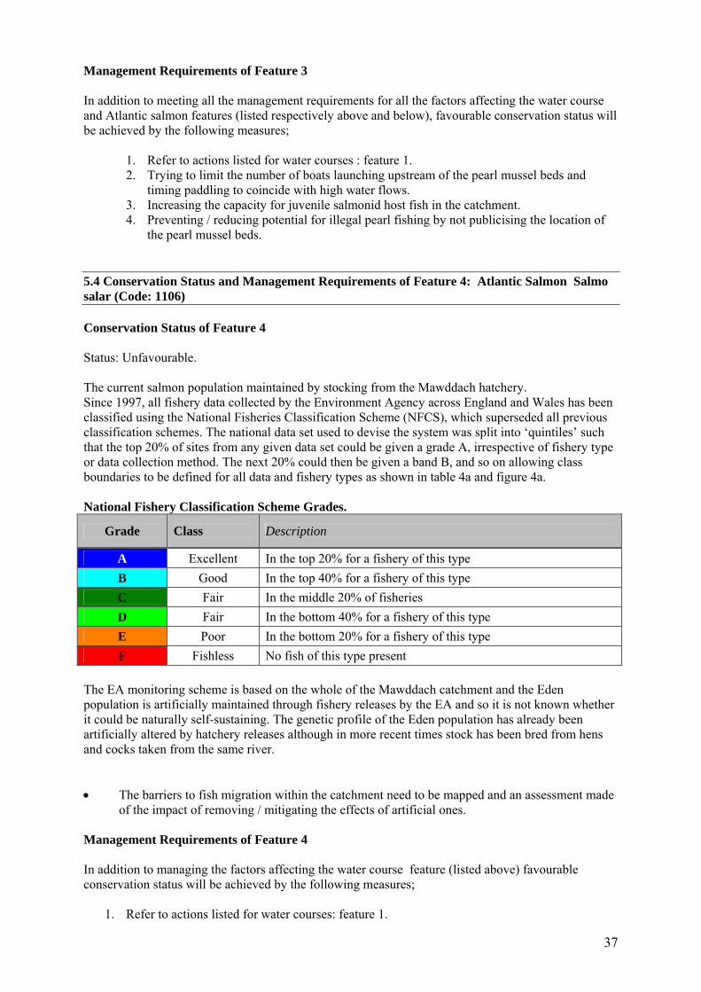
5.4 Conservation Status and Management Requirements of Feature 4: Atlantic Salmon Salmo salar (Code: 1106) Conservation Status of Feature 4 Status: Unfavourable. The current salmon population maintained by stocking from the Mawddach hatchery. Since 1997, all fishery data collected by the Environment Agency across England and Wales has been classified using the National Fisheries Classification Scheme (NFCS), which superseded all previous classification schemes. The national data set used to devise the system was split into ‘quintiles’ such that the top 20% of sites from any given data set could be given a grade A, irrespective of fishery type or data collection method. The next 20% could then be given a band B, and so on allowing class boundaries to be defined for all data and fishery types as shown in table 4a and figure 4a. National Fishery Classification Scheme Grades.
Grade Class Description
A Excellent In the top 20% for a fishery of this type B Good In the top 40% for a fishery of this type C Fair In the middle 20% of fisheries D Fair In the bottom 40% for a fishery of this type E Poor In the bottom 20% for a fishery of this type F Fishless No fish of this type present
The EA monitoring scheme is based on the whole of the Mawddach catchment and the Eden population is artificially maintained through fishery releases by the EA and so it is not known whether it could be naturally self-sustaining. The genetic profile of the Eden population has already been artificially altered by hatchery releases although in more recent times stock has been bred from hens and cocks taken from the same river. • The barriers to fish migration within the catchment need to be mapped and an assessment made
of the impact of removing / mitigating the effects of artificial ones. Management Requirements of Feature 4 In addition to managing the factors affecting the water course feature (listed above) favourable conservation status will be achieved by the following measures;
1. Refer to actions listed for water courses: feature 1.

38
2. Timing the launching of canoes to coincide with high flows. 3. Promoting awareness of the impact of over fishing pools during periods of low flows. 4. A presumption against stocking non-native fish and using live bait. 5. Checking hatchery reared salmonids for disease prior to release. 6. Removing the fish trap at Pont Dolgefeiliau. 7. Enforcement of fishery byelaws to reduce poaching. 8. Recreational fishing strategy that is sensitive to the requirement to restore a near to natural
salmonid population in the Mawddach catchment. 9. Reviewing the EA Salmon Action Plan for the Mawddach in light of new research on
conservation compliance limits. 5.5 Conservation Status and Management Requirements of Feature 5: Otter Lutra lutra (Code: 1355) Conservation Status of Feature 5 Status: Unfavourable Overall favourable conservation status depends on both distribution and number of actual / potential breeding sites being in favourable condition. Otter distribution – unfavourable. Actual / potential breeding sites – favourable. This assessment was made by consultant Geoff Liles in 2006 for the whole Mawddach catchment of which the Afon Eden is a sub-component. Management Requirements of Feature 5
1. Management should aim to manage the factors affecting the water courses and take additional action;
2. Refer to actions listed for water courses : feature 1. 3. Retain and develop habitat suitable for breeding sites. 4. Retain a healthy food chain and supply within the whole catchment and improve the
quality/quantity of the fish population. 5. Maintain existing good quality bankside vegetation for breeding otters including dense scrub,
bramble, blackthorn & gorse, reed beds, deciduous woodland with an understorey and wetlands within the boundary of the SAC.
6. Ensure infrastructure for recreational activities are sympathetically located and this activity takes place at an appropriate scale.
7. Reduce the mink population by implementing control measures.

39
5.6 Conservation Status and Management Requirements of Feature 6: Active raised bog (Code: 7110) Conservation Status of Feature 6 Status: Unfavourable. The active raised bog was assessed as “unfavourable” after a site monitoring survey in July 2003. The main cause for concern on the site was the very low cover of Sphagnum and high cover of bare peat on the raised mire domes at that time. The southern dome has been overgrazed in the past but is now considered under-grazed because of the abundance and dominance of purple moor grass in the lagg/fen, which is currently overgrown. The presence of the large drain on the margin of the northern dome is highly likely to be having a significant adverse impact as are the drains cut into the southern dome/bog. The two Cors Goch mire management units comprise 5 owner/occupiers each with different grazing patterns and stock (sheep and cattle). • A repeat vegetation and hydrological monitoring survey would be valuable to assist with
restoration advice measures to restore the hydrology of the raised bog habitat and to manage it sympathetically.
Management Requirements of Feature 6 The main factors affecting the raised bog on this site are drainage, grazing, past burning and peat cutting. Drainage In the past, the peatland at Cors Goch has been subjected to drainage works in an attempt to improve the land for agriculture. The current landowners maintain most of the larger drains. The main ditch system in the northern dome is currently maintained by Magnox Electric plc. as an overspill system for Llyn Trawsfynydd dam. The northern raised bog has a drain approximately 3m wide cutting through its western margin. The southern bog also has had several drains cut into it. A ditch up to a metre wide in places runs along the southern and western margins of the south dome and smaller mostly in-filled ditches also exist cutting across into the dome.
1. No new drainage ditches should be cut. Seek to infill or block existing ditches to create pools wherever possible.
Grazing Grazing can be very significant on this habitat particularly where it has been affected by artificial drainage, as is the case here. Artificially drained bog will tend to have a taller vegetation height and more woody ericaeous growth, such as tall heather and scrub on the dome, and very vigorous Molinia in the lagg/fen, as this species is favoured by a good through flow of drainage water. It is easy then for the bog to become under-grazed. Restoring a more stagnant, high water table will naturally help to lessen Molinia dominance, as will grazing and trampled by cattle or ponies. Grazing by sheep will lead to unwanted changes in species composition, through selective grazing out of species like the regionally rare bog rosemary and heather and in increased Molinia dominance. Some short vegetation and small patches of exposed peat through poaching can increase the biodiversity providing habitat for species such as mosses and sundews to colonise. Bare peat should not however be extensive or eroding. Patterns of grazing are also important. Summer cattle and/or horse grazing will have the most benefit to the SAC feature. Supplementary feeding means that stock congregate in one area to feed and dung leading to peat erosion and local nutrient enrichment which allows competitive ruderal weed plant species to establish to the detriment of bog species. Supplementary feeding tends to result in over grazing as more stock are held on the land for longer than it can naturally sustain. No supplementary feeding should be consented on the raised bog with the exception of mineral licks, which can help stock graze rank areas of vegetation.

40
To help attain favourable conservation status the grazing regimes would need to be adjusted;
2. Cattle/pony (not sheep) grazing regimes should be reinstated and bridges installed to facilitate stock movement. Stock may be encouraged to graze rank areas by mowing paths and by the placement of mineral licks. The erection of temporary/permanent fencing may also be appropriate.
Burning Burning causes a decrease in the cover of fire sensitive species such as the Sphagnum mosses and may lead to an increase in those species such as purple moor grass Molinia caerulea which regenerate rapidly after fire. It has been the practice of the landowners to manage the raised bogs by burning in the past and it is likely that this (together with drainage and grazing) has had an effect on the cover of Sphagnum, the occurrence of bare peat and the cover of ericaceous species. The southern dome is believed to be recovering from a large fire which occurred some time ago. In 2002, moss cover was considered to be more sparsely distributed than is typical of such habitat probably as a result of past burning, a low water table and competition from other plant species.
3. No burning should be consented.
Peat cutting Evidence of old peat cuttings are still visible on the surface of both domes. The cuttings to the east of the southern dome have developed into valuable habitat.
4. A presumption against peat cutting should be maintained. Ardudwy leat This leat transports water out of the Eden sub-catchment and into Llyn Trawsfynydd before it is used by Magnox Electric to run a hydropower scheme at Maentwrog. It is likely that it affects the water table level in the blanket bog that surrounds the southern raised dome but its impact is currently unknown.
• Research is required into the impact of leat on the local hydrology.
5. Operation of leat should not be changed without appropriate assessment. Old municipal dump at SH702346 Rubble and other material was dumped here sometime in the first half of the twentieth century and it has created a raised area that stands proud of the surrounding land. It is presumed that the rubble was dumped on top of the northern raised bog.
• Research is required to assess the potential for bog restoration and extension of area by removing the rubble.

41
6. ACTION PLAN: SUMMARY This section takes the management requirements outlined in Section 5 a stage further, assessing the specific management actions required on each management unit. This information is a summary of that held in CCW’s Actions Database for sites, and the database will be used by CCW and partner organisations to plan future work to meet the Wales Environment Strategy targets for sites. Unit Number
CCW Database Number
Unit Name Summary of Conservation Management Issues
Action needed?
1 000954 Cors Goch mires, source of Afon Eden to Afon Serw
Active raised bog: Drainage. Grazing. Burning. Peat cutting. Ardudwy leat. Old municipal dump. Floating water plantain: Water quantity. Dredging. Water based recreation. Freshwater pearl mussels: Water quantity & quality. Water based recreation. Population of host salmonids. Illegal pearl mussel poaching. Forestry. Atlantic salmon: Water quality & quantity. Water based recreation during low flows. Overfishing in low flows. Fish stocking. poaching. Artificial barriers to migration. Otter: Water quality. Breeding habitat. Food supply. Recreation. Mink predation.
Yes
5 002446 River corridor from Coed y Brenin to Llaneltyd, inc Afon Wen
Water course: Hydromorphology, flow regime & water quality (chemical & biological). Suspended solids. Physical habitat. Diffuse & point pollution. Agricultural & forestry operations. Trunk road management & other urban land use. River Engineering. Recreation. Mining. Deposition of atmospheric pollution. Climate change. Atlantic salmon: Water quality & quantity. Water based recreation during low flows. Over fishing in low flows. Fish stocking. poaching. Artificial barriers to migration. Otter: Water quality. Breeding habitat. Food supply. Recreation. Mink predation.
Yes
7. GLOSSARY This glossary defines the some of the terms used in this Core Management Plan. Some of the definitions are based on definitions contained in other documents, including legislation and other publications of CCW and the UK nature conservation agencies. None of these definitions is legally definitive. Action A recognisable and individually described act, undertaking or project of any kind,
specified in section 6 of a Core Management Plan or Management Plan, as being required for the conservation management of a site.
Attribute A quantifiable and monitorable characteristic of a feature that, in combination with
other such attributes, describes its condition.

42
Common Standards Monitoring A set of principles developed jointly by the UK conservation agencies to help ensure a consistent approach to monitoring and reporting on the features of sites designated for nature conservation, supported by guidance on identification of attributes and monitoring methodologies.
Condition A description of the state of a feature in terms of qualities or attributes that are
relevant in a nature conservation context. For example the condition of a habitat usually includes its extent and species composition and might also include aspects of its ecological functioning, spatial distribution and so on. The condition of a species population usually includes its total size and might also include its age structure, productivity, relationship to other populations and spatial distribution. Aspects of the habitat(s) on which a species population depends may also be considered as attributes of its condition.
Condition assessment The process of characterising the condition of a feature with
particular reference to whether the aspirations for its condition, as expressed in its conservation objective, are being met.
Condition categories The condition of feature can be categorised, following condition
assessment as one of the following2: Favourable: maintained; Favourable: recovered;
Favourable: un-classified Unfavourable: recovering; Unfavourable: no change; Unfavourable: declining; Unfavourable: un-classified Partially destroyed; Destroyed. Conservation management Acts or undertaking of all kinds, including but not necessarily limited
to actions, taken with the aim of achieving the conservation objectives of a site. Conservation management includes the taking of statutory and non-statutory measures, it can include the acts of any party and it may take place outside site boundaries as well as within sites. Conservation management may also be embedded within other frameworks for land/sea management carried out for purposes other than achieving the conservation objectives.
Conservation objective The expression of the desired conservation status of a feature,
expressed as a vision for the feature and a series of performance indicators. The conservation objective for a feature is thus a composite statement, and each feature has one conservation objective.
Conservation status A description of the state of a feature that comprises both its condition and
the state of the factors affecting or likely to affect it. Conservation status is thus a characterisation of both the current state of a feature and its future prospects.
Conservation status assessment The process of characterising the conservation status of a
feature with particular reference to whether the aspirations for it, as expressed in its conservation objective, are being
2 See JNCC guidance on Common Standards Monitoring http://www.jncc.gov.uk/page-2272

43
met. The results of conservation status assessment can be summarised either as ‘favourable’ (i.e. conservation objectives are met) or unfavourable (i.e. conservation objectives are not met). However the value of conservation status assessment in terms of supporting decisions about conservation management, lies mainly in the details of the assessment of feature condition, factors and trend information derived from comparisons between current and previous conservation status assessments and condition assessments.
Core Management Plan A CCW document containing the conservation objectives for a site
and a summary of other information contained in a full site Management Plan.
Factor Anything that has influenced, is influencing or may influence the condition of a
feature. Factors can be natural processes, human activities or effects arising from natural process or human activities, They can be positive or negative in terms of their influence on features, and they can arise within a site or from outside the site. Physical, socio-economic or legal constraints on conservation management can also be considered as factors.
Favourable condition See condition and condition assessment Favourable conservation status See conservation status and conservation status
assessment.3 Feature The species population, habitat type or other entity for which a site is designated.
The ecological or geological interest which justifies the designation of a site and which is the focus of conservation management.
Integrity See site integrity Key Feature The habitat or species population within a management unit that is the primary focus
of conservation management and monitoring in that unit. Management Plan The full expression of a designated site’s legal status, vision, features,
conservation objectives, performance indicators and management requirements. A complete management plan may not reside in a single document, but may be contained in a number of documents (including in particular the Core Management Plan) and sets of electronically stored information.
Management Unit An area within a site, defined according to one or more of a range of criteria,
such as topography, location of features, tenure, patterns of land/sea use. The key characteristic of management units is to reflect the spatial scale at which conservation management and monitoring can be most effectively organised. They are used as the primary basis for differentiating priorities for conservation management and monitoring in different parts of a site, and for facilitating communication with those responsible for management of different parts of a site.
Monitoring An intermittent (regular or irregular) series of observations in time, carried out to
show the extent of compliance with a formulated standard or degree of deviation from an expected norm. In Common Standards Monitoring, the formulated standard is the quantified expression of favourable condition based on attributes.
3 A full definition of favourable conservation status is given in Section 4.

44
Operational limits The levels or values within which a factor is considered to be acceptable in
terms of its influence on a feature. A factor may have both upper and lower operational limits, or only an upper limit or lower limit. For some factors an upper limit may be zero.
Performance indicators The attributes and their associated specified limits, together with
factors and their associated operational limits, which provide the standard against which information from monitoring and other sources is used to determine the degree to which the conservation objectives for a feature are being met. Performance indicators are part of, not the same as, conservation objectives. See also vision for the feature.
Plan or project Project: Any form of construction work, installation, development or other
intervention in the environment, the carrying out or continuance of which is subject to a decision by any public body or statutory undertaker. Plan: a document prepared or adopted by a public body or statutory undertaker, intended to influence decisions on the carrying out of projects. Decisions on plans and projects which affect Natura 2000 and Ramsar sites are subject to specific legal and policy procedures.
Site integrity The coherence of a site’s ecological structure and function, across its whole area, that
enables it to sustain the habitat, complex of habitats and/or the levels of populations of the species for which it is designated.
Site Management Statement (SMS) The document containing CCW’s views about the management
of a site issued as part of the legal notification of an SSSI under section 28(4) of the Wildlife and Countryside Act 1981, as substituted.
Special Feature See feature. Specified limit The levels or values for an attribute which define the degree to which the
attribute can fluctuate without creating cause for concern about the condition of the feature. The range within the limits corresponds to favourable, the range outside the limits corresponds to unfavourable. Attributes may have lower specified limits, upper specified limits, or both.
Unit See management unit. Vision for the feature The expression, within a conservation objective, of the aspirations
for the feature concerned. See also performance indicators. Vision Statement The statement conveying an impression of the whole site in the state that is
intended to be the product of its conservation management. A ‘pen portrait’ outlining the conditions that should prevail when all the conservation objectives are met. A description of the site as it would be when all the features are in favourable condition.
Abbreviations WCA5/8 - Wildlife and Countryside Act 1981, Schedule 5 or 8; RDB - Red Data Book, RDB1 - Endangered, RDB2 - Vulnerable, RDB3 - Rare, NT - Near Threatened; RL - Red List, RL1 - Endangered; AoS - Area of Search; SAC - Special Area of Conservation; H & S - Habitats and Species Directive; FWPM – freshwater pearl mussels; CWD – coarse woody
debris.

45
References Campbell, S. (Ed) (2000) Mining sites – GIS dataset. Countryside Council for Wales, Bangor. Environment Agency, Wales (1996) Salmon Action Plan. Report Environment Agency, Wales . Holman, I., Carter, J., Cobby, D., Palmer, R., Marechal, D. (2003) A risk assessment for the Afon Eden, Meirionnydd : final report. CCW Science Report (570) Countryside Council for Wales, Bangor. Killeen, I (2003) Monitoring of the freshwater pearl mussel on the Afon Eden candidate Special Area of Conservation. Unpublished CCW report. Dolgellau. Killeen, I. ; Oliver, G. ; Wood, D. ; National Museum of Wales (1997). The status of the freshwater pearl mussel Margaritifera margaritifera (L.1758) in north-west Wales. (CCW Science Report; 182). Bangor : Countryside Council for Wales (CCW). Killeen, I.J. (2004). Monitoring of the freshwater pearl mussel on the Afon Eden candidate special area of conservation. (CCW Environmental Monitoring Report; 10). Bangor : Countryside Council for Wales (CCW). Killeen, I.J. (2007). A survey of Welsh rivers supporting populations of the freshwater pearl mussel Margaritifera margaritifera (l.1758). (CCW Science Report; 770). Bangor : Countryside Council for Wales (CCW). Killeen, I.J. ; Oliver, P.G. ; National Museum of Wales (1998). The status and distribution of the freshwater pearl mussel (Margaritifera margaritifera (L.1758)) in Wales : report on the1997 survey. (CCW Science Report; 185). Bangor : Countryside Council for Wales (CCW). Lewis, H (2005) Afon Eden - Cors Goch Trawsfynydd (UK 0030075) Luronium natans (1831) SAC Monitoring Report November 2005. Unpublished CCW report. Liles, G. (2006) Current and potential distribution, condition and breeding success of the otter in the Afon Mawddach catchment area. CCW Environmental Monitoring Report (32). Countryside Council for Wales. Bangor. Available on request. Confidential Annex Scrivens, K. (2006) Pers comm. Heather Garrett.

46
ANNEXE 1 Map 3. Luronium natans monitoring sections on the Afon Eden