Embed Size (px)
Citation preview
1
Sustainable Forest Management Plan FOR
Green Ridge State Forest Sustainable Forests for People the Bay and Appalachia
F O R E S T S E RV I C E
Updated: 2019.02.28
GREEN RIDGE STATE FOREST 47,560 ACRES
2
TABLE OF CONTENTS
Preface 6Chapter 1 - Introduction 7
1.1 Background and History of the Forest 71.2 State Forest Planning & Sustainable Forest Management 81.3 Planning Process 91.4 Purpose and Goals of the Plan 101.5 Future Land Acquisition Goals for Green Ridge State Forest 12
Chapter 2 - Maryland’s Ridge and Valley Region: Resource Assessment 132.1 Maryland’s Ridge and Valley Region 132.2 General Geology and Soils 142.3 Water Resources 152.4 Wildlife Resources 272.5 Federal Endangered and Threatened Species of Special Concern 362.6 State Listed Species of Concern on Green Ridge State Forest 362.7 Trees and Shrubs of the Region 402.8 Plants of Special Concern 442.9 Plant Communities and Habitats of Special Concern 452.10 Game Species of Special Concern 482.11 The Forests of the Ridge and Valley 522.12 Forest Management in the Ridge and Valley 522.13 The Forest Products Industry 532.14 People and Forests of Allegany County 532.15 Landscape Considerations 552.16 Watersheds as a Landscape Issue 60
Chapter 3 - Resource Characterization 633.1 The Forests 633.2 Old Growth Forest 643.3 Forest Production 653.4 Non-native Invasive Species 65
3
3.5 Water Quality 653.6 Watersheds 663.7 Soils: Woodland Management Soils Groups 663.8 Compartments 67
Chapter 4 - Land Management Area Guidelines 704.1 Land Management Areas 704.2 General Forest 704.3 High Conservation Value Forests 704.4 Special Wildlife Habitat Areas 714.5 Recreation and Cultural Heritage Areas 724.6 Other Non-Forested Lands 72
Chapter 5 - Forest Management 735.1 Forest Management Areas and Mapping ??5.2 Priority Management – High Conservation Value Forest (HCVF) 745.3 Special Wildlife Habitat Areas 775.4 Cultural Heritage and Indigenous Peoples 775.5 Recreation Areas 785.6 Other Non-Forested Lands 785.7 General Forest Management Area – Area Management Forest Regulation 795.8 Forest Harvesting Equipment 855.9 Chemical Use 865.10 Forest Modeling 875.11 Inventory and Monitoring 885.12 Forest Certification 895.13 Forest Stewardship Council (FSC) – Guidelines & Principles 905.14 Practice Scheduling Annual Work Plans (AWP) 91
Chapter 6 - Water Quality Areas: Riparian Forest Buffers and Wetlands 926.1 Introduction 926.2 Riparian Forest Buffers: High Conservation Value Forest (HCVF) 926.3 Green Ridge State Forest Wetlands 946.4 Significant Vernal Pools 96
Chapter 7 - Ecologically Significant Areas & Other State Protected Lands 1027.1 Ecologically Significant Areas (ESA) Defined 102
4
7.2 Ecologically Significant Areas Descriptions 1037.3 Prescribed Burning within ESAs 1197.4 Use of Herbicides/Pesticides within ESAs 1197.5 Annual Work Plans 1197.6 Other State Protected Lands 1197.7 Wildlands 1197.8 Old Growth Ecosystem Management Areas 121
Chapter 8 - Wildlife Habitat: Protection and Management 1248.1 Introduction 1248.2 Rare, Threatened, and Endangered Species 1248.3 Special Wildlife Habitat Areas 1258.4 Other Wildlife Management Opportunities Within GRSF 1298.5 Upland Game Birds And Mammals 1328.6 Waterfowl 1348.7 Aquatic Furbearers 1348.8 Upland Fur Bearers 1358.9 Wildlife Management Objectives and Strategies for Game Species 1378.10 Forest Interior Dwelling Bird Species (FIDS) 1408.11 Bald Eagle 1408.12 Amphibians 140
Chapter 9 - Public Use & Education 1419.1 Background 1419.2 Current and Future Public Uses 141
Chapter 10 - Monitoring Plan 14710.1 Introduction 14710.2 Monitoring Plan 147
Chapter 11 - Annual Work Plan Process 15711.1 Annual Work Plan 15711.2 Annual Work Plan Time Table 15911.3 Contents of the Annual Work Plan 160
Chapter 12 - Operational Management 16212.1 Introduction 16212.2 Green Ridge State Forest Revenue 162
5
12.3 Operational Cost 16312.4 Summary 164
APPENDIX 165Appendix A - Citizens Advisory Committee 166Appendix B - Forest Stewardship Council 169Appendix C - Sustainable Forestry Initiative 171Appendix D - Woodland Management Soils Group 177Appendix E - Special Wildlife Habitat Areas Unit Plans 189Town Creek SWHA Management Final 233Appendix F - SFI Management Review & Continual Improvement 248Appendix G - Management Guidelines for the Conservation & Protection of Old-Growth Forests ??Appendix H - Modeling Long-term Sustainability 259Appendix I - Glossary 264Appendix J - Maps 267Appendix K - An Evergreen Forest Analysis of Garrett and Allegany Counties 273
6
Preface
The information contained within the Green Ridge State Forest Sustainable Management Plan was derived from a variety of sources. These include the 1993 Green Ridge State Forest Ten Year Resource Management Plan: Volumes I & II, and the 2010 Pocomoke State Forest Sustainable Management Plan. Data presented in tables and charts that are specific to Green Ridge State Forest were generated from field data collected by the Maryland Forest Service and the Maryland Wildlife & Heritage Service from 1992 through 2009. Other information contained within this document is referenced as to its source. The 47,560 acre Green Ridge State Forest is entirely contained within Allegany County.
7
Chapter 1 - Introduction
1.1 Background and History of the Forest
Green Ridge State Forest is located in eastern Allegany County. It is the only State Forest located in the Ridge and Valley physiographic province. Green Ridge receives the least amount of rainfall in Maryland, averaging 36 inches annually. Consisting of 47,560 acres, Green Ridge is the second largest State Forest in Maryland. It accounts for 29% of the State Forest system and approximately 12% of all DNR land in Maryland.
The general geographic boundaries of Green Ridge are Town Creek to the west and Sideling Hill Creek to the east. The northern boundary extends to the Mason-Dixon Line. The southeastern boundary parallels the Potomac River.
Elevations range from 500 feet above sea level on the Potomac River to 2,000 feet on Town Hill.
Two major highways, Interstate 68 and MD Route 51, traverse the forest in an east-west direction.
In the early 1800’s, Richard Caton and William Carroll in partnership, owned much of the land that is Green Ridge State Forest today. Richard Caton was the son-in-law to Charles Carroll of Carrollton, a signer of the Declaration of Independence. William Carroll was the grandson of Daniel Carroll of Rock Creek who was a framer of the United States Constitution. The land was originally patented from vacant lands during the 1820-1840 period for inclusion into various timber and mining interests, primarily the Town Hill, Mining, Manufacturing, and Timber Company. This business venture was financed by the estate of Charles Carroll of Carrollton. A crumbling stone structure known as the Carroll Chimney, part of a steam-powered sawmill built in 1836, is the only surviving structure from this period.
In the 1880-1912 era the last of the virgin forest was cut and a period of neglect resulted in numerous wildfires. During the early 1900’s, the Merten’s family of Cumberland had attempted to convert the forest to apple orchards. The Mertens promoted it as the “largest apple orchard in the Universe”. The orchard tract was subdivided into 10 acre parcels and sold to individuals as investment properties. Five acres in each parcel was cleared, burned, and planted into apple trees. The remaining five acres had the best trees cut and poorer trees were left standing. The orchard company went into bankruptcy in 1918 and the interests of the corporation were acquired by the State Department of Forestry in 1931. At this time the State Forest consisted of approximately 14,400 acres.
8
The first forest management activities at Green Ridge were performed by the Civilian Conservation Corps (CCC) in the 1930”s. Their main focus was fire control. Other work consisted of building a series of roads and trails, recreation enhancements, and management of the existing forest for its future timber and wildlife potential.
During World War II, the CCC camp at 15 Mile Creek housed German prisoners-of-war who were required to cut pulpwood in the forest. As the forest grew it became popular with outdoor enthusiasts, especially hunters. It also contributed more and more to the local wood products industry.
Today, Green Ridge is an approximately 90-year old, even-aged, mixed oak-hickory forest. The oaks consist of a variety of species characteristic of dry, upland areas and include black oak, white oak, red oak, scarlet oak, and chestnut oak. There are five native pines growing at Green Ridge. They are white pine, Virginia pine, pitch pine, table-mountain pine, and shortleaf pine. Flowering dogwood, redbud, and serviceberry are common understory trees.
1.2 State Forest Planning & Sustainable Forest ManagementThe resources and values provided from state forests reach people throughout the State and beyond. These resources and values range from economic to aesthetic and from scientific to inspirational. The Department of Natural Resources is mandated by law to consider a wide variety of issues and uses when pursuing a management strategy for these forests. The importance of considering these factors is acknowledged in the Annotated Code, which establishes the following policy pertaining to state forests and parks:
"Forests, streams, valleys, wetlands, parks, scenic, historic and recreation areas of the state are basic assets. Their proper use, development, and preservation are necessary to protect and promote the health, safety, economy and general welfare of the people of the state. It is the policy of the state to encourage the economic development and the use of its natural resources for the improvement of the local economy, preservation of natural beauty, and promotion of the recreational and leisure interest throughout the state." (Annotated Code of Maryland, Natural Resources Article §5-102)
The Department recognizes the many benefits provided by state forests and has established a corresponding management policy in regulation.
"The state forests are managed to promote the coordinated uses of their varied resources and values for the benefit of all people, for all time. Water, wildlife, wood, natural beauty and opportunities for natural environmental recreation, wildlands experience, research demonstration areas, and outdoor education are major forest benefits. "(Code of Maryland Regulations 08.07.01.01)
To ensure that benefits are realized by and resources are protected for future generations, a statewide system of renewable resource planning has developed. These plans are the foundation
9
for the many activities which can and should occur on state forest lands.
"The Department shall develop a system for long-range renewable forest resources planning. The public and private forest land resources of Maryland, including, but not limited to, wood fiber, forest recreation, wildlife, fish, forest watershed, and wilderness potential, shall be examined and inventoried periodically. As part of the forest planning process, the Department periodically shall develop, review and revise a resource plan that should help to provide for a sustained yield of forest resource benefits for the citizens of Maryland. The forest resource plan shall be made available for public and legislative review and comment. "(Annotated Code of Maryland, Natural Resources Article §5-2l4)
The Sustainable Forest Management Plan for Green Ridge State Forest has been prepared in consideration of these many uses and benefits. The concept of Sustainable Forest Management will be the guiding principle behind the management of Green Ridge State Forest. Sustainable Forestry is defined in COMAR Regulations 08.01.07.01
"Sustainable forestry" means the stewardship and use of forests and forest lands in a way, and at a rate, that: (a) Maintains their biodiversity, productivity, regeneration, capacity, vitality, and
potential to fulfill, now and in the future, relevant ecological, economic, and social functions at local and regional levels; and
(b) Does not cause damage to other ecosystems.
1.3 Planning ProcessThe new Sustainable Forest Management Plan for Green Ridge State Forest has been developed to replace the ten-year Resource Management that was developed back in 1993. The initial draft of the GRSF Sustainable Plan was crafted from sections of the former ten year plan and from information contained in the Pocomoke State Forest Sustainable Plan. The information utilized in the draft was prepared by an interdisciplinary planning team with assistance from the Green Ridge State Forest Citizens Advisory Committee. The current draft of the GRSF Sustainable Plan has been reviewed by representatives from the following:
Maryland Department of Natural Resources • Maryland Forest Service • Maryland Park Service• Maryland Wildlife & Heritage Service • Freshwater Fisheries Division• Land Acquisition & Planning
The GRSF Sustainable Plan is presented to the Green Ridge State Forest Citizens Advisory Committee for additional review & comments in October. The final step is that this plan will be posted to the DNR Webpage to go through 30 day public comment period. The original planning process for the ten year plan included extensive opportunity for public
10
participation, and relied on public feedback in the refinement of management goals and implementation strategies. The new sustainable plan will adhere to a similar procedure. One of the benefits of the new plan format is that it will be open for continual updates as additional resource information is developed. As updates are completed the revised plan will be reviewed by the Citizens Advisory Committee.
Forest resource inventory and assessment information for Green Ridge was first compiled in 1959 from established continuous forest inventory plots (CFI). Data was collected on these plots in 1976, 1989, and 2000. Stand level data collection began during the summer of 2010 and was completed in 2015.
1.4 Purpose and Goals of the PlanThe Sustainable Forest Management Plan for Green Ridge State Forest updates and expands the previous ten year resource management plan. This plan is intended to provide guidance and direction for forest staff to base daily decisions on the management of the forest. The plan also provides direction to the Forest Manager in the preparation of Annual Work Plans and to DNR staff in the preparation of related resource protection guidelines for sensitive habitats.
Included within the appendices, are forest modeling projections of growth rates and sustainable harvest levels, as well as several detailed sections outlining planning and management tools which support the proposed management direction and strategies.
The primary goal of the Green Ridge State Forest Sustainable Management Plan is to demonstrate that an environmentally sound, sustainably managed forest can contribute to local and regional economies while at the same time protecting significant or unique natural communities and elements of biological diversity.
ThiswillbepursuedsubjecttothefollowingresourcegoalsfortheForest:
A) Manage the wetlands, waterways and floodplains of the forest to protect valuable water resources.
• So the quality of the water flowing through the forest will not be impaired due to any actions on the land, and in many cases will be improved. Where feasible, wetlands and riparian areas will be the site of watershed improvement practices specifically aimed at improving the quality of water entering headwater streams and ultimately the Potomac River and Chesapeake Bay.
B) Provide sustainable levels of diverse recreational fishery opportunities through management strategies which emphasize protection and enhancement of aquatic resources and forested riparian buffers.
• Monitor proposed projects within Green Ridge State Forest that may potentially
11
result in blockages to fish passage and recommend design changes that will allow continued fish passage during all stream flow conditions. Continue to identify existing blockages to fish passage and make recommendations for providing access to upstream habitat.
C) Protect and enhance biological diversity native to Green Ridge State Forest and perpetuate indigenous natural communities and habitats of species which are rare, threatened, endangered, or in need of conservation.
• Insure that management policies and actions are consistent with state and federal requirements for protecting and managing rare, threatened and endangered species of plants and animals. The Department will identify locations of rare, threatened and endangered species habitat and forest conditions associated with the habitat requirements of these species. Management actions will consider opportunities to enhance existing habitats and provide for corridors. Abundance and distribution goals for common species will be periodically updated through DNR based resource assessments. Habitat goals for common species will be reflected in forest management activities.
D) Through Sustainable Forestry practices, maintain and improve the timber resource, while at the same time protecting other resource values consistent with responsible forest management.
• Forest harvest levels will comply with targets established by a long-term sustainable harvest plan. To the extent possible, harvest and thinning activity levels will produce reasonably uniform flows of products and contractor activities year-to-year. Short-term deviations due to natural disturbances, operational logistics, or unusual events are anticipated, but exceptions for an extended period will require re-evaluation of the sustainable harvest level. Spatial and timing constraints will prevent thinning or harvesting operations from concentrating impacts in any watershed or visual scene in violation of water quality goals, habitat diversity and connectivity goals, or the green-up requirements imposed by the Sustainable Forestry Initiative® (SFI®) Standard (See Appendix C). The plan will be re-evaluated periodically and updated according to changes in circumstances.
• The Department makes use of the best available data to determine what activity levels are consistent with the sustainability of the forest ecosystems so that harvests will not decrease the ability of the forests to continue an average level of yield. Ecosystem sustainability means, in addition to the factors listed in goals A, C &D, no net loss in soil fertility and no loss of non-target species due to on-site forestry practices. Past and present data are limited, so future harvests will be based on adaptive response to appropriate monitoring, forecasting, and revision.
E) Provide opportunities for the enjoyment of the natural resources on the Forest by making
12
appropriate areas available for resource-based, low impact recreational activities and environmental education programs that are consistent with the resource values of the Forest.
Forest recreational and educational opportunities will be provided as appropriate, and are consistent with the above goals. Recreational and education program opportunities available on the forest will be integrated with those available within Rocky Gap State Park and the Billmeyer Wildlife Management Area. The Department will determine the appropriate levels of recreational activities on the Forest as part of its ongoing evaluation and monitoring process.
1.5 Future Land Acquisition Goals for Green Ridge State ForestThe original Green Ridge State Forest properties are located in Allegany County lying between Sidling Hill Creek and Town Creek and extending from Pennsylvania to West Virginia. The addition of new parcels to Green Ridge State Forest could help alleviate a number of management issues as described below and also build upon a network of well managed forest lands that would in perpetuity contribute to the goals for protecting and restoring the Potomac River and the Chesapeake Bay. All potential acquisitions are based on a Stewardship review that scores each property on their ecological, cultural and recreational values.
Guidelines to be considered when pursuing new properties not currently in state ownership for addition to Green Ridge State Forest:
1) The property is an in-holding within a Green Ridge Forest Compartment and/or the parcel connects additional Green Ridge Forest properties thereby creating a larger contiguous management unit.
2) The property contains significant natural resources as identified in this plan that would help contribute toward their management and protection. Examples of such resources would be Ecologically Significant Areas (ESAs) as identified in Chapter 7, Wildlife Habitat resources described in Chapter 8, Water Quality Areas (Riparian areas and wetlands) as indicated in Chapter 6 and economically important forest resources as described in Chapter 5.
3) The property improves on or provides additional access to a Green Ridge Forest parcel, thereby improving on the implementation of management activities and or providing additional public access.
Properties that meet one or all of these criteria will go through an internal DNR review process and if they are determined to be good candidates to be added to the Forest they will be prioritized for acquisition. Currently there are a number of potential private acquisitions being considered for addition to Green Ridge State Forest that would greatly enhance management opportunities on the forest.
13
Chapter 2 - Maryland’s Ridge and Valley Region: Resource Assessment
2.1 Maryland’s Ridge and Valley Region
The Ridge and Valley Region of Maryland, as described in this assessment, consists primarily of Allegany County. The region is located between the Allegany Plateau Region to the West and the Piedmont Region to the East. Allegany County is bounded by the state of Pennsylvania to the North and West Virginia to the South. Elevations run from 420 feet above sea level to a maximum of 2,895 feet above sea level.
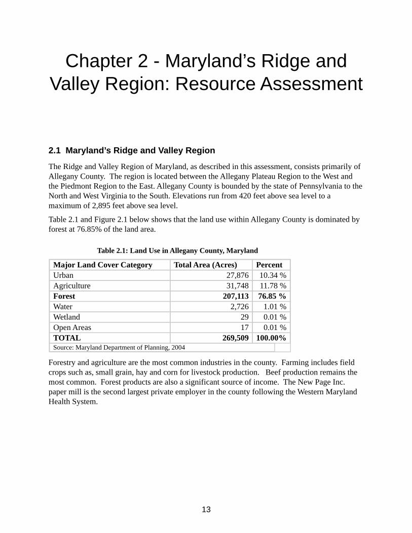
Table 2.1 and Figure 2.1 below shows that the land use within Allegany County is dominated by forest at 76.85% of the land area.
Table 2.1: Land Use in Allegany County, Maryland
Major Land Cover Category Total Area (Acres) PercentUrban 27,876 10.34 %Agriculture 31,748 11.78 %Forest 207,113 76.85 %Water 2,726 1.01 %Wetland 29 0.01 %Open Areas 17 0.01 %TOTAL 269,509 100.00%Source: Maryland Department of Planning, 2004
Forestry and agriculture are the most common industries in the county. Farming includes field crops such as, small grain, hay and corn for livestock production. Beef production remains the most common. Forest products are also a significant source of income. The New Page Inc. paper mill is the second largest private employer in the county following the Western Maryland Health System.
14
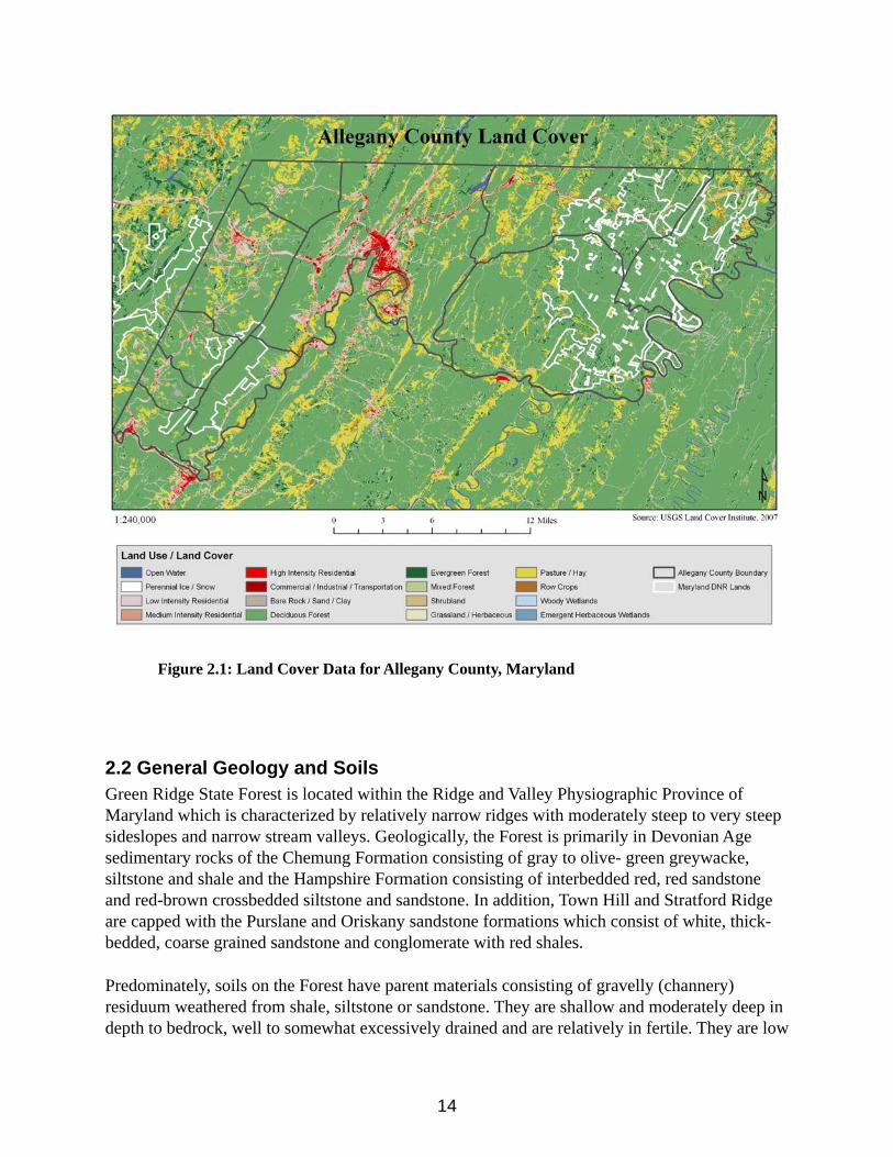
Figure 2.1: Land Cover Data for Allegany County, Maryland
2.2 General Geology and SoilsGreen Ridge State Forest is located within the Ridge and Valley Physiographic Province of Maryland which is characterized by relatively narrow ridges with moderately steep to very steep sideslopes and narrow stream valleys. Geologically, the Forest is primarily in Devonian Age sedimentary rocks of the Chemung Formation consisting of gray to olive- green greywacke, siltstone and shale and the Hampshire Formation consisting of interbedded red, red sandstone and red-brown crossbedded siltstone and sandstone. In addition, Town Hill and Stratford Ridge are capped with the Purslane and Oriskany sandstone formations which consist of white, thick- bedded, coarse grained sandstone and conglomerate with red shales.
Predominately, soils on the Forest have parent materials consisting of gravelly (channery) residuum weathered from shale, siltstone or sandstone. They are shallow and moderately deep in depth to bedrock, well to somewhat excessively drained and are relatively in fertile. They are low
15
in plant nutrients and are extremely acid to strongly acid throughout. Due to their high rock fragment content (channery or gravelly in surface layers to extremely channery or gravelly in substratum layers) and limited rooting zone depth they are droughty with low to very low available water holding capacity. Consequently, forest productivity is relatively low with site indices of 50 – 65 for chestnut oak and white oak. Many areas are very stony to extremely stony on the surface and rock outcrops are prevalent on steeply sloping areas.
The area from Green Ridge to Town Creek is dominated by yellowish brown grayish brown shale and siltstone soils consisting of the shallow Weikert series on moderately steep to very steep sideslopes and the moderately deep Berks series on gently sloping to strongly sloping ridgetops. The area east of Green Ridge, corresponding to the geologic Hampshire Formation consists of red ( maroon) shale, siltstone and sandstone soils of the shallow Klinesville series on moderately steep to very steep sideslopes, the moderately deep Calvin series on gently sloping to strongly sloping ridgetops and the moderately deep Lehew series on strongly sloping to steep sideslopes and benches. The top and adjoining sideslopes of Town Hill and Stratford Ridge are dominated by yellowish brown sandstone derived soils of the moderately deep Dekalb series and the deep Hazleton series. These soils are commonly very stony with rock- outcrops.
Small streams and creeks dissect the Forest with relatively narrow floodplains. These areas are represented by the occasionally to frequently flooded Craigsville series which are very gravelly throughout, deep and well drained with inclusions of moderately well drained soils and poorly drained hydric soils. While of limited extent on the Forest, the floodplain soils along the Potomac River and along the lower reaches of Town Creek, Fifteen Mile Creek and Sidling Hill Creek are the most productive. These areas are represented by mostly loamy soils consisting of the well drained Combs series, moderately well drained Lindside series and the poorly drained and hydric Holly series.
2.3 Water Resources
The rural nature and the high proportion of forest land in eastern Allegany County has helped to sustain the excellent quality of surface water runoff. The geology and topography of the area provide a relatively continuous base flow of clean, cool ground water to streams.
Allegany County has been subdivided into ground-water provinces on the basis of differences in physiography and geology. Green Ridge State Forest encompasses almost the entire Sideling Hill-Town Creek water province.
The Hydrologic Cycle
Nature replenishes surface and ground water supplies through a mechanism known as the hydrologic cycle. This process consists of the endless recirculation of water from the atmosphere to the earth and back to the atmosphere. Precipitation falls on the land and drains into rivers, lakes and oceans by way of stream runoff and ground water flow. Some precipitation falls directly onto the bodies of water.
In the area of Green Ridge State Forest, most storms approach from the west. As they ascend the
16
Allegheny Mountains from the Ohio Valley the temperature of the air mass drops and precipitation increases. Because of this, only 36 inches a year of precipitation falls in the eastern part of Allegany County (the ridge and valley province). This is the lowest amount of precipitation in Maryland.
Water is cycled back to the atmosphere by evaporation from land and water surfaces and transpiration from vegetation. Of the precipitation that falls each year, an average of 64% is evaporated or transpired back to the atmosphere from the land, through the land and vegetation. The remainder is either absorbed through the land surface to become ground water or runs off directly into streams.
The rate at which water moves through this cycle is affected by a variety of natural conditions and land uses. Man's activities affect the natural pathways of the hydrologic cycle, particularly surface and ground water flow. Because Green Ridge State Forest is relatively undisturbed, runoff and base flow characteristics of the forest are basically dictated by the geology of the area.
The Geologic Column
Most of the water province is underlain by a wide, shallow synclinorium, called the Potomac synclinorium. Sideling Hill and Town Hill are erosional remnants of synclines, capped by erosion-resistant sandstones of the Pocono formation. Stratford Ridge, capped by the erosion-resistant Oriskany sandstone, is a small anticline. The shales of the Romney, Jennings, and Hampshire Formations locally are folded into small anticlines and synclines. In the eastern part of the water province between Sideling Hill and Town Hill is a low anticlinal structure called the Orleans anticline.
Description of Formations and Groundwater Used
Oriskany Sandstone
The outcrop area of the Oriskany sandstone of early Devonian age is restricted to Stratford Ridge in the south-central part of the province and to a small outcrop about 1 mile southeast of Oldtown on the Potomac River. The lower part of the formation is a highly calcareous, cherty siltstone, and the upper part is a calcareous, coarse-grained, locally conglomeratic sandstone. Only the upper part is exposed at the surface. The thickness of the sandstone at Stratford Ridge is not known, but the thickness of the formation in the central part of Allegany County ranges from 300 to 350 feet.
Romney Shale
The Romney shale is of middle Devonian age and lies on the flanks of the Stratford Ridge anticline and extends from the Potomac River to a point 10.5 miles northeast. The Romney is an olive-gray and black shale, interbedded with argillaceous limestone in the lower part, black shale in the middle part, and silty mudstone and siltstone in the upper part. The thickness of the formation in Allegany County ranges from 350 to 1,660 feet.
Ground water is obtained from the Romney shale quantities generally sufficient for domestic and farm use. Wells yielding as much as 15 gallons per minute (gpm) are exceptional. The greatest concentration of drilled wells is in the Oldtown area.
17
Jennings Formation
The Jennings Formation of late Devonian age is the most widespread of the shale formations. The Jennings formation is a dark-gray to black, platy shale in the lower part; a platy, siliceous shale with interbedded siltstone and conglomeratic sandstone in the upper part. The uppermost conglomeratic sandstone forms Green Ridge and Polish and Ragged Mountains. The thickness of the unit in Allegany County ranges from 3,000 to 4,800 feet.
Ground water is obtained from drilled wells, dug wells, and small springs. Well yields range from 0.2 to 36 gpm; many wells are in the range of 5 to 10 gpm. Some of the more productive drilled wells are in draws or valleys near major streams. One of the best wells in this formation is situated on top of Green Ridge where it penetrates conglomeratic sandstone. Fractures in the sandstone may account for the relatively large (25 gpm) yield of this well.
Hampshire Formation
The Hampshire Formation of late Devonian age flanks the west side of Sideling Hill and the east and west sides of Town Hill in mile-wide bands of relatively uniform width. The Hampshire Formation is an interbedded red shale, red mudstone, and red to brown cross-bedded siltstone and sandstone. The thickness of the formation ranges from 1,630 to 2,400 feet. The formation is part of a syncline underlying Sideling Hill and Town Hill.
The area of exposure of the formation is rugged, dissected by small streams, and is sparsely inhabited. Well data are sparse. Water is obtained generally in sufficient quantities for limited domestic and farm use from both dug and drilled wells and from small springs.
Mississippian System
Pocono Formation
Exposures of the Pocono Formation are restricted to the crest of Sideling Hill and Town Hill in belts that average about 0.5 mile wide. The Sideling Hill exposure is continuous for the length of the mountain, but the Town Hill exposure is incised by Fifteen Mile Creek. These exposures are buff shales containing thin coal beds at the base, and crossbedded arkosic sandstone and conglomerate, overlain by thickbedded coarse, white sandstone and conglomerate. The thickness of the formation in this province is about 550 feet. The tops of the mountains are remnants of synclines.
Ground water from the Pocono Formation is obtained from drilled wells but the yields are not known. The fractured and creviced appearance of the sandstone in exposures suggests that the formation is moderately permeable.
Springs
The springs in all of the geologic units are of the contact or fracture type, and are in many places a combination of bom types. The estimated range of flow of several springs in the water province is from 2 to 50 gpm.
Black Sulfur Spring on the northwestern side of Green Ridge is so-called because the ground water contains iron and hydrogen sulfide from which a black precipitate of ferrous sulfide forms. White Sulfur Spring, also on the northwestern side of Green Ridge and only about a mile from Black Sulfur Spring, is so-called because the ground water contains hydrogen sulfide which
18
forms a white precipitate of sulfate minerals on the rocks near the spring.
2.2.1 Groundwater
Groundwater in the Sideling Hill-Town Creek province comes chiefly from the a really extensive shales underlying most of the province. The quantities available are small but in most places they are sufficient for farm and domestic use. The more productive wells are located in draws or in valleys near major streams.
The quality of the ground water is suitable for most domestic and farm purposes. The water from the shales is generally slightly irony, hard, and alkaline. Sulfate commonly occurs in higher than average concentration, probably derived from local deposits of gypsum. Water high in sulfate may be associated with hydrogen sulfide gas, which commonly occurs in noticeable concentrations in groundwaters from black shales or other sales formed from organic muds.
Surface Water
Allegany County, including Green Ridge State Forest, lies entirely within the Ridge and Valley physiographic province. The streams draining Allegany county are characterized by their steep slopes and flashy nature. The streams in this province flow in a generally southerly direction parallel to the ridges occasionally turning sharply and cutting through a ridge and then resuming their parallel course. The principal streams at Green Ridge are Town, 15 Mile and Sideling Hill Creeks.
Allegany County is completely within the Potomac River basin. The principal developments of surface-water resources are in the Cumberland area which is the center of industry in the county. Irrigation is insignificant.
Water Appropriation
State water appropriation and use permits are required for all water withdrawals in Maryland except for: farming use less than 10,000 gallons per day, individual domestic use and withdrawals for fire extinguishment purposes. There are no major appropriators in this water province.
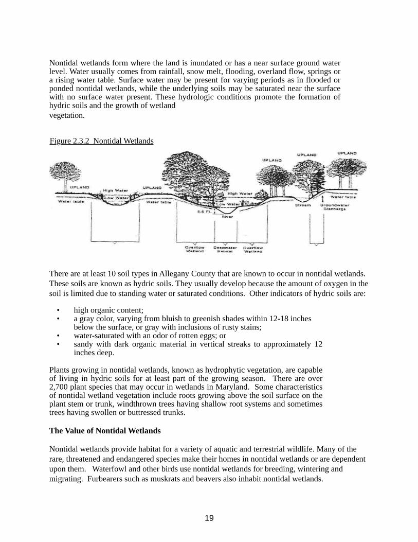
2.3.2 Nontidal Wetlands Assessment
Nontidal wetlands are freshwater areas that are covered by water or have saturated soils for at least brief periods during the growing season. The term "nontidal wetlands" encompasses a variety of environments such as marshes and swamps, bottomland hardwood forests, wet meadows, springs and seeps, inland bogs and the shallow areas of lakes and ponds. Figure A-l below shows nontidal wetland areas found along rivers, lakes, and streams, as shallow depressions surrounded by upland, and on slopes associated with ground water seepage areas and springs.
Some nontidal wetlands, such as freshwater marshes and shrub swamps, are very obvious. However, many nontidal wetlands, such as bottomland forests or wet meadows, are not as easily recognized because they are dry for some time during the summer. Three characteristics are used to identify nontidal wetlands: hydrology, soils and vegetation.
19
Nontidal wetlands form where the land is inundated or has a near surface ground water level. Water usually comes from rainfall, snow melt, flooding, overland flow, springs or a rising water table. Surface water may be present for varying periods as in flooded or ponded nontidal wetlands, while the underlying soils may be saturated near the surface with no surface water present. These hydrologic conditions promote the formation of hydric soils and the growth of wetlandvegetation.
Figure 2.3.2 Nontidal Wetlands
There are at least 10 soil types in Allegany County that are known to occur in nontidal wetlands. These soils are known as hydric soils. They usually develop because the amount of oxygen in the soil is limited due to standing water or saturated conditions. Other indicators of hydric soils are:
• high organic content;• a gray color, varying from bluish to greenish shades within 12-18 inches
below the surface, or gray with inclusions of rusty stains;• water-saturated with an odor of rotten eggs; or• sandy with dark organic material in vertical streaks to approximately 12
inches deep.
Plants growing in nontidal wetlands, known as hydrophytic vegetation, are capable of living in hydric soils for at least part of the growing season. There are over 2,700 plant species that may occur in wetlands in Maryland. Some characteristics of nontidal wetland vegetation include roots growing above the soil surface on the plant stem or trunk, windthrown trees having shallow root systems and sometimes trees having swollen or buttressed trunks.
The Value of Nontidal Wetlands
Nontidal wetlands provide habitat for a variety of aquatic and terrestrial wildlife. Many of the rare, threatened and endangered species make their homes in nontidal wetlands or are dependent upon them. Waterfowl and other birds use nontidal wetlands for breeding, wintering and migrating. Furbearers such as muskrats and beavers also inhabit nontidal wetlands.
20
The aquatic food chain is dependent upon nontidal wetlands to provide nourishment for the fish, shellfish and smaller organisms that spend periods of their lives in the wetland habitat. Organic material, or food, is produced in the water by the breakdown of wetland plants. When critical reproductive areas are filled for development or choked by pollution and excessive nutrients, the populations of these species decline.
Sedimentation decreases the penetration of sunlight needed by submerged aquatic plants and severely impacts reproduction and survival of aquatic life. Nontidal wetlands help to protect streams and other bodies ofwater by filtering sediment and intercepting and retaining excess nutrients such as phosphorus and nitrogen and other pollutants from upland runoff.
A reduction in the potential damage from fast moving storm or flood water is another benefit of nontidal wetlands. Large volumes of water are temporarily stored in nontidal wetland areas and released gradually which reduces erosion and property damage. Wetland plants are also effective in lessening bank erosion because their extensive and complex root systems hold soil in place and reduce sedimentation.
The scenic beauty and aquatic qualities of these special areas provide many opportunities for recreation and education. Nontidal wetlands have a natural beauty which has inspired painters and writers for centuries. They are now joined by enthusiasts with cameras, video and sound recorders. There is also endless opportunity for recreation such as fishing and hunting as well as hiking, bird watching, canoeing and other activities. The financial benefit of these wetland-dependent activities to the economy is significant.
Nontidal Wetland Classifications
Nontidal wetlands are classified according to the dominant type of vegetation. Nontidal wetland types on Green Ridge State Forest are forested, scrub-shrub, emergent and aquatic bed.
Forested wetlands include swamps dominated by trees over 20 feet in height and many wooded floodplains. They are the most common type of nontidal wetlands. Common vegetation includes red maple and ash. Forested wetlands fill the habitat requirements for many species of wildlife. Along streams they help prevent nutrients and sediment from entering the water temperatures critical to trout. Woody debris from adjacent trees also improve trout habitat.
Scrub-shrub wetlands include true shrub swamps or wetlands dominated by trees over 20 feet in height. True shrub wetlands are relatively uncommon. Some bogs are classified as scrub-shrub wetlands. Plants include alder and buttonbush. They provide excellent cover and browse for wildlife. Many shrub wetlands become forested wetlands over time.
Emergent wetlands are marsh areas characterized by herbaceous vegetation. Common emergent vegetation includes cattails, sedges and rushes. Statewide, between the 1950's and 1970's the percentage of emergent wetlands decreased more than any other wetland type.
Aquatic bed wetlands are found in some ponds and areas that are nearly always covered with water. They are the least common type of vegetated nontidal wetland. Species may include herbaceous plants such as spatterdock or pickerelweed. These wetlands are an important water
21
source for plants and wildlife during drought. Waterfowl often use aquatic bed wetlands.
Wetlands of Special State Concern
There are four Wetlands of Special State Concern that exist, totally or partially, within the boundaries of Green Ridge State Forest. These wetlands exhibit uncommon features such as rare, threatened or endangered species or unique biological communities. The singular nature of these areas makes the evaluation of management practices in their vicinity of particular importance.
The Wetlands of Special State Concern on Green Ridge State Forest are:
Artemas Quadrangle Fifteen Mile Creek Macrosite Long Pond
Bellegrove Quadrangle Sideling Hill Creek Macrosite
Paw Paw Quadrangle
Potomac Bends Wildland
Regulation
There are approximately 275,000 acres of vegetated nontidal wetlands in Maryland, comprising 4.3 percent of the state's land mass. This figure does not include nontidal wetlands that are currently farmed. These vital resources are declining at a rate of about 1,600 acres per year. There are approximately 360 acres of nontidal wetlands in Allegany County, according to data compiled in 1988 by the Water Resources Administration.
The 1989 Maryland General Assembly passed legislation that directed the Department of Natural Resources to establish a statewide program for the conservation, enhancement, regulation, creation and monitoring of nontidal wetlands. The goal is no net loss of nontidal wetland acreage and function. The Water Resources Administration, Nontidal Wetlands Division, has written regulations and set up a permit program in order to meet this goal. Since January 1,1991, all activities in non-tidal wetlands require a nontidal wetlands permit or a "letter of exemption", unless exempted by regulation.
Activities that require permits include excavation, filling, changing drainage patterns, disturbing the water level or water table, grading and removing vegetation in a nontidal wetland or within a 25-foot buffer. The buffer has been expanded to 100 feet for Nontidal Wetlands of Special State Concern. All these areas have been designated by regulation and are mapped on the nontidal wetlands guidance maps.
Forestry activities do not require a nontidal wetlands permit from the Department of Natural Resources if the land use remains as forestry. Forestry activities are the planting, cultivation, thinning, harvesting or any other activity undertaken to use the forest resources or to improve their quality or productivity. When an erosion and sediment control plan is. required for forestry activities, nontidal wetlands regulations stipulate the incorporation of best management practices to protect non-tidal wetlands. These plans are reviewed and approved by local Soil Conservation
22
Districts. For activities within a State Forest, these plans must be approved by the Maryland Department of the Environment.
Other activities that are exempt from permit requirements are agricultural activities, mowing existing rights-of-way, soil investigations, perc tests for sewage disposal fields, survey markers or survey monuments and maintenance of various serviceable structures or fills.
To achieve the goal of no net loss, after December 31,1990, any loss of nontidal wetlands regulated under state law must be offset by mitigation. Mitigation is the creation, restoration or enhancement of nontidal wetlands that were, or will be, lost due to regulated or agricultural activities. Creation is establishing a nontidal wetland on an upland site. Restoration is establishing nontidal wetlands on former nontidal wetlands sites. Enhancement is providing additional protection to, or improving the functions of, a nontidal wetland.
Nontidal wetland losses must be replaced by creating non-tidal wetlands at the following ratios:
1:1 for emergent or farmed non-tidal wetlands2:1 for scrub-shrub and forested non-tidal wetlands or emergent non-tidal wetlands of special state concern, and 3:1 for scrub-shrub and forested non-tidal wetlands of special state concern.
Nontidal wetlands as delineated on the resource assessment maps for Green Ridge State Forest include all areas identified by the National Wetlands Inventory. It also includes all perennial and intermittent stream channels as delineated on the USGS 7.5 minute quadrangle sheets that were not included in the National Wetlands Inventory. Included are Nontidal Wetlands of Special State Concern statewide significance. However, not all wetlands existing on the forest have been mapped. Some wetlands such as vernal pools which are essential to the life cycles of some species will only be located by visits to the site, often in response to proposed human activity.
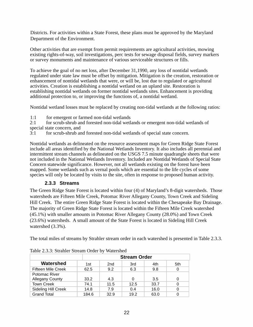
2.3.3 StreamsThe Green Ridge State Forest is located within four (4) of Maryland’s 8-digit watersheds. Those watersheds are Fifteen Mile Creek, Potomac River Allegany County, Town Creek and Sideling Hill Creek. The entire Green Ridge State Forest is located within the Chesapeake Bay Drainage. The majority of Green Ridge State Forest is located within the Fifteen Mile Creek watershed (45.1%) with smaller amounts in Potomac River Allegany County (28.0%) and Town Creek (23.6%) watersheds. A small amount of the State Forest is located in Sideling Hill Creek watershed (3.3%).
The total miles of streams by Strahler stream order in each watershed is presented in Table 2.3.3.
Table 2.3.3: Strahler Stream Order by WatershedStream Order
Watershed 1st 2nd 3rd 4th 5thFifteen Mile Creek 62.5 9.2 6.3 9.8 0Potomac River Allegany County 33.2 4.3 0 3.5 0Town Creek 74.1 11.5 12.5 33.7 0Sideling Hill Creek 14.8 7.9 0.4 16.0 0Grand Total 184.6 32.9 19.2 63.0 0
23
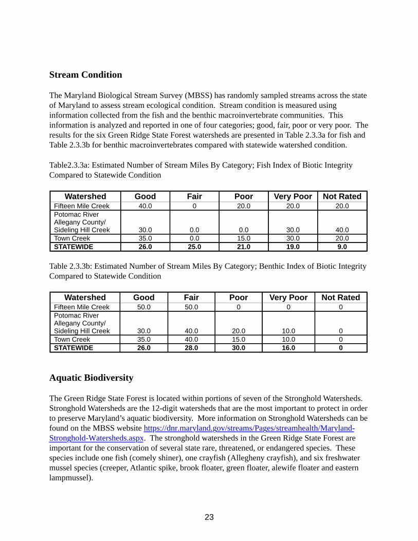
Stream Condition
The Maryland Biological Stream Survey (MBSS) has randomly sampled streams across the state of Maryland to assess stream ecological condition. Stream condition is measured using information collected from the fish and the benthic macroinvertebrate communities. This information is analyzed and reported in one of four categories; good, fair, poor or very poor. The results for the six Green Ridge State Forest watersheds are presented in Table 2.3.3a for fish and Table 2.3.3b for benthic macroinvertebrates compared with statewide watershed condition.
Table2.3.3a: Estimated Number of Stream Miles By Category; Fish Index of Biotic Integrity Compared to Statewide Condition
Watershed Good Fair Poor Very Poor Not RatedFifteen Mile Creek 40.0 0 20.0 20.0 20.0Potomac River Allegany County/Sideling Hill Creek 30.0 0.0 0.0 30.0 40.0Town Creek 35.0 0.0 15.0 30.0 20.0STATEWIDE 26.0 25.0 21.0 19.0 9.0
Table 2.3.3b: Estimated Number of Stream Miles By Category; Benthic Index of Biotic Integrity Compared to Statewide Condition
Watershed Good Fair Poor Very Poor Not RatedFifteen Mile Creek 50.0 50.0 0 0 0Potomac River Allegany County/Sideling Hill Creek 30.0 40.0 20.0 10.0 0Town Creek 35.0 40.0 15.0 10.0 0STATEWIDE 26.0 28.0 30.0 16.0 0
Aquatic Biodiversity
The Green Ridge State Forest is located within portions of seven of the Stronghold Watersheds. Stronghold Watersheds are the 12-digit watersheds that are the most important to protect in order to preserve Maryland’s aquatic biodiversity. More information on Stronghold Watersheds can be found on the MBSS website https://dnr.maryland.gov/streams/Pages/streamhealth/Maryland-Stronghold-Watersheds.aspx. The stronghold watersheds in the Green Ridge State Forest are important for the conservation of several state rare, threatened, or endangered species. These species include one fish (comely shiner), one crayfish (Allegheny crayfish), and six freshwater mussel species (creeper, Atlantic spike, brook floater, green floater, alewife floater and eastern lampmussel).
24
The MBSS has collected information on non-native aquatic species. Eleven non-native fishes have been found on or in close proximity to the Green Ridge State Forest. The eleven non-native species are common carp, brown trout, rainbow trout, largemouth bass, smallmouth bass, black crappie, rock bass, green sunfish, longear sunfish, bluegill and rainbow darter.
The MBSS has a long-term monitoring network called the Sentinel Site Network. This is a network of twenty-seven sites used to monitor the natural variability of streams and to investigate the possible effects to streams due to global climate change. These sites are the highest-quality sites identified by the MBSS with the least amount of anthropogenic influence in the upstream catchment. One of the twenty-seven Sentinel Sites is located in the Green Ridge State Forest.
2.3.4 Fishery Assessment of Green Ridge State Forest (GRSF)Sideling Hill Creek, Fifteen Mile Creek, and Town Creeks, as well as portions of the Upper Potomac River and their respective tributaries are home to the majority of the fisheries resources within the boundaries of GRSF. In addition to these lotic systems, there are also two managed ponds within the state forest that add to the recreational fishing opportunities available. The list of all fish species documented within the GRSF are presented in Table 1. A list of fish species collected in the Potomac River bordering GRSF is presented in Table 2.
The types of fisheries within GRSF can be divided into one, or a combination of the following three general categories;1) Stocked trout waters, which provide a seasonal recreation opportunity.2) Warmwater game and panfish fisheries, which provide a year-round recreational opportunity.3) Non-game fisheries, not targeted by anglers, but integral to a healthy trophic web as well as being indicators of overall stream health.
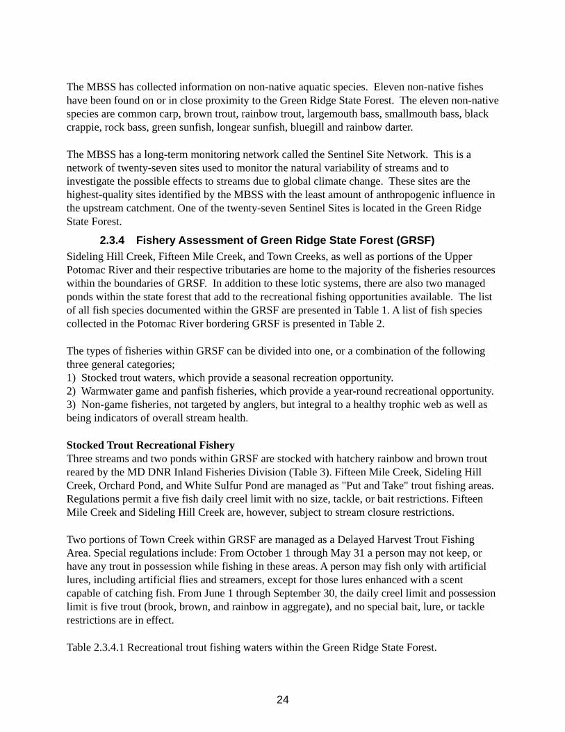
Stocked Trout Recreational FisheryThree streams and two ponds within GRSF are stocked with hatchery rainbow and brown trout reared by the MD DNR Inland Fisheries Division (Table 3). Fifteen Mile Creek, Sideling Hill Creek, Orchard Pond, and White Sulfur Pond are managed as "Put and Take" trout fishing areas. Regulations permit a five fish daily creel limit with no size, tackle, or bait restrictions. Fifteen Mile Creek and Sideling Hill Creek are, however, subject to stream closure restrictions.
Two portions of Town Creek within GRSF are managed as a Delayed Harvest Trout Fishing Area. Special regulations include: From October 1 through May 31 a person may not keep, or have any trout in possession while fishing in these areas. A person may fish only with artificial lures, including artificial flies and streamers, except for those lures enhanced with a scent capable of catching fish. From June 1 through September 30, the daily creel limit and possession limit is five trout (brook, brown, and rainbow in aggregate), and no special bait, lure, or tackle restrictions are in effect.
Table 2.3.4.1 Recreational trout fishing waters within the Green Ridge State Forest.
25
Waterbody Management Length/Area No. of trout stocked
Sideling Hill Creek Put and Take 13.4 miles 5,295Fifteen Mile Creek Put and Take 12.4 miles 5,295Town Creek Delayed Harvest 2.8 miles 4,000White Sulfur Pond Put and Take 1 acre 955Orchard Pond Put and Take 2 acres 955
Warmwater Recreational FisherySmallmouth bass and largemouth bass, as well as various catfish and panfish species make up the warmwater fishery found in GRSF. Smallmouth bass are often the most sought after by anglers, but most warmwater species in GRSF are targeted by anglers. A list of the warmwater gamefish found in GRSF is presented in Tables 1 and 2.
The bass fishery is managed under the statewide general bass regulations, with a 5 fish daily limit and a closed season from March 1 until June 15. Likewise, panfish (including bluegill, redbreast sunfish, pumpkinseed, and rock bass) are managed under the statewide regulations, with a 15 fish daily limit and no closed season. All catfish species are managed under the statewide regulations, with no size restrictions or closed season. Yellow and brown bullheads, flathead catfish and blue catfish have no daily limit; however, channel catfish are managed under a five fish daily limit.
Non-GamefishThe waters within and adjoining GRSF are home to a large diversity of non-game fishes, including members of the minnow, sculpin, perch and sucker families. These fishes are not typically sought by anglers, but are integral to the health of the fisheries through their role as forage fishes for the more popular gamefishes. A list of the non-game fishes found in GRSF is found in Tables 1 and 2.
Fish Index of Biotic Integrity (FIBI)The biomass, species composition, and diversity of fishes within a watershed are often indicative of the overall “heath” of that watershed. Understanding that allows fisheries biologists to evaluate a given stream using a set of metrics to develop an index of biotic integrity (IBI) score. This score is on a 0-5 scale, with 0 being poor and 5 being excellent. The following metrics are included in the calculation of the FIBI scores for warmwater highland streams, such as the ones found in GRSF:
• Abundance per square meter of fishes• Number of benthic species, adjusted• Percent of fishes considered ‘tolerant’• Percent of species considered ‘generalists, omnivores, or insectivores’• Percent insectivores• Percent abundance of dominant species
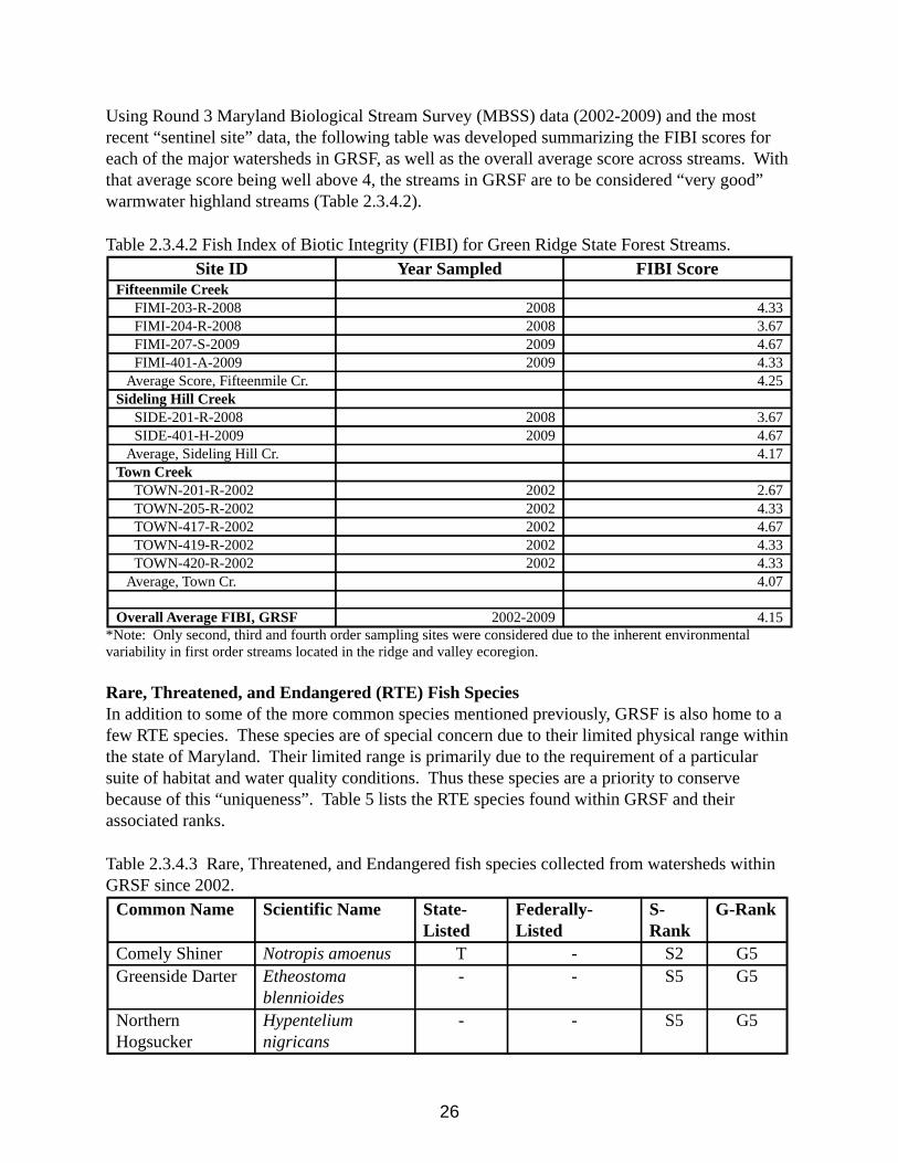
26
Using Round 3 Maryland Biological Stream Survey (MBSS) data (2002-2009) and the most recent “sentinel site” data, the following table was developed summarizing the FIBI scores for each of the major watersheds in GRSF, as well as the overall average score across streams. With that average score being well above 4, the streams in GRSF are to be considered “very good” warmwater highland streams (Table 2.3.4.2).
Table 2.3.4.2 Fish Index of Biotic Integrity (FIBI) for Green Ridge State Forest Streams. Site ID Year Sampled FIBI Score
Fifteenmile Creek FIMI-203-R-2008 2008 4.33 FIMI-204-R-2008 2008 3.67 FIMI-207-S-2009 2009 4.67 FIMI-401-A-2009 2009 4.33 Average Score, Fifteenmile Cr. 4.25Sideling Hill Creek SIDE-201-R-2008 2008 3.67 SIDE-401-H-2009 2009 4.67 Average, Sideling Hill Cr. 4.17Town Creek TOWN-201-R-2002 2002 2.67 TOWN-205-R-2002 2002 4.33 TOWN-417-R-2002 2002 4.67 TOWN-419-R-2002 2002 4.33 TOWN-420-R-2002 2002 4.33 Average, Town Cr. 4.07
Overall Average FIBI, GRSF 2002-2009 4.15*Note: Only second, third and fourth order sampling sites were considered due to the inherent environmental variability in first order streams located in the ridge and valley ecoregion.
Rare, Threatened, and Endangered (RTE) Fish SpeciesIn addition to some of the more common species mentioned previously, GRSF is also home to a few RTE species. These species are of special concern due to their limited physical range within the state of Maryland. Their limited range is primarily due to the requirement of a particular suite of habitat and water quality conditions. Thus these species are a priority to conserve because of this “uniqueness”. Table 5 lists the RTE species found within GRSF and their associated ranks.
Table 2.3.4.3 Rare, Threatened, and Endangered fish species collected from watersheds within GRSF since 2002.
Common Name Scientific Name State-Listed
Federally-Listed
S-Rank
G-Rank
Comely Shiner Notropis amoenus T - S2 G5Greenside Darter Etheostoma
blennioides- - S5 G5
Northern Hogsucker
Hypentelium nigricans
- - S5 G5
27
Management RecommendationsAs is evident by the above average FIBI scores and rich species diversity, the watersheds
within GRSF exhibit good water quality and suitable habitat for a host of fish species, both game and non-game alike. In order to support this high quality fishery, steps must be taken to maintain good water quality and suitable available habitat. Best management practices (BMPs), as well as additional measures should be employed by land managers in order to reduce sediment loading and thermal influences on the streams. These measures should include, but not be limited to the following:
• Protection and maintenance of all riparian buffers with vegetative cover.• Rigorous sediment controls during all road construction, logging operations, and other
construction projects within the state forest.• Minimizing in-stream ORV traffic.• Informing the public on the importance of healthy ecosystems and how they can help to
maintain GRSF as a popular public use area.
2.4 Wildlife ResourcesGreen Ridge State Forest wildlife habitats occur within a landscape that has been heavily disturbed in the past by agricultural and infrastructure development. The Green Ridge State Forest lands, themselves, are fragmented to a lesser degree through decades of public ownership and forest and wildlife conservation management. Management opportunities for wildlife on Green Ridge State Forest include habitat improvement for both game and non-game species and provision of habitat conditions that are critical to rare or declining species. Some critical habitat conditions will require adjustment of spatial and temporal provision of early succession habitats. Other critical habitat conditions will require adjustment of rotation length to provide for forests that are allowed to grow beyond economic maturity.
Some species of wildlife present on Green Ridge State Forest are forest obligates. Viability of forest obligate populations depends solely on the characteristics of these forestlands. Populations of other species of wildlife found on Green Ridge State Forest are more affected by the characteristics of adjacent wetland, managed openings, or shale barren habitats. Green Ridge State Forest lands will strive to achieve a nature-like balance of habitat types to maintain species viability, diversity and enhancement. The following table lists the species and relative abundance of Wildlife on Green Ridge State Forest.
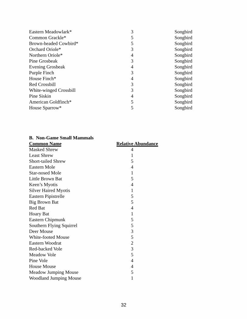
TABLE 2.4Relative Abundance of Wildlife on Green Ridge State Forest
A. Non-Game BirdsCommon Name Relative AbundanceCommon Loon 3 WaterbirdPied-billed Grebe 3 MarshbirdHorned Grebe 3 Waterbird
28
Double-crested Cormorant 3 WaterbirdAmerican Bittern 2 MarshbirdGreat Blue Heron 3 MarshbirdGreen-backed Heron* 3 MarshbirdGreat Egret 3 MarshbirdLittle Blue Heron 3 MarshbirdCattle Egret 3 MarshbirdBlack-crowned Night Heron 3 MarshbirdGlosy Ibis 3 MarshbirdTurkey Vulture* 3 MarshbirdNorthern Harrier 2 RaptorSharp-shinned Hawk* 2 RaptorCooper’s Hawk* 3 RaptorNorthern Goshawk 2 RaptorRed-shouldered Hawk * 4 RaptorBroad-winged Hawk* 4 RaptorRed-tailed Hawk* 4 RaptorAmerican Kestrel* 4 RaptorMerlin 3 RaptorPeregrine Falcon 2 RaptorOsprey 3 RaptorBald Eagle 2 RaptorGolden Eagle 3 RaptorCommon Moorhen 2 MarshbirdAmerican Coot 3 MarshbirdBlack-bellied Plover 3 ShorebirdSemipalmated Sandpiper 3 ShorebirdKilldeer* 4 ShorebirdGreater Yellowlegs 3 ShorebirdLesser Yellowlegs 3 ShorebirdSolitary Sandpiper 3 ShorebirdSpotted Sandpiper* 3 ShorebirdWestern Sandpiper 3 ShorebirdLeast Sandpiper 3 ShorebirdPectoral Sandpiper 3 ShorebirdDunlin 3 ShorebirdLaughing Gull 3 ShorebirdBonaparte’s Gull 3 ShorebirdRing-billed Gull 3 ShorebirdHerring Gull 3 ShorebirdCaspian Tern 3 ShorebirdCommon Tern 3 ShorebirdForester’s Tern 3 ShorebirdLeast Tern 3 Shorebird
29
Black – billed Cuckoo* 4 SongbirdYellow-billed Cuckoo* 5 SongbirdEastern Screech Owl* 4 RaptorGreat Horned Owl* 4 RaptorBarred Owl* 4 RaptorLong-eared Owl 3 RaptorShort-eared Owl 2 RaptorNorthern Saw-whet Owl 2 RaptorBarn Owl 2 RaptorSnowy Owl 3 RaptorCommon Nighthawk* 3 SongbirdWhip-poor-will* 3 SongbirdChimney Swift * 4 SongbirdRuby-throated Hummingbird * 4 SongbirdBelted Kingfisher* 4 SongbirdRed-bellied Woodpecker* 5 SongbirdYellow-bellied Sapsucker 3 SongbirdRed-headed Woodpecker * 3 SongbirdDowny Woodpecker* 5 SongbirdHairy Woodpecker* 5 SongbirdNorthern Flicker* 5 SongbirdPileated Woodpecker* 5 SongbirdOlive-sided Flycatcher 3 SongbirdEastern Wood Peewee* 5 SongbirdYellow-bellied Flycatcher 3 SongbirdAcadian Flycatcher* 5 SongbirdAlder Flycatcher 3 SongbirdWillow Flycatcher* 3 SongbirdLeast Flycatcher* 3 SongbirdEastern Phoebe* 4 SongbirdGreat-crested Flycatcher* 5 SongbirdEastern Kingbird* 4 SongbirdHorned Lark* 3 SongbirdPurple Martin* 3 SongbirdTree Swallow* 4 SongbirdNorthern Rough-winged Swallow 3 SongbirdBank Swallow 3 SongbirdCliff Swallow* 3 SongbirdBarn Swallow* 4 SongbirdBlue Jay* 5 SongbirdFish Crow 3 SongbirdCommon Raven* 3 RaptorBlack-capped Chickadee* 5 SongbirdCarolina Chickadee* 3 Songbird
30
Tufted Titmouse* 5 SongbirdRed-breasted Nuthatch* 2 SongbirdWhite-breasted Nuthatch* 5 SongbirdBrown Creeper* 5 SongbirdCarolina Wren* 5 SongbirdHouse Wren* 5 SongbirdWinter Wren 3 SongbirdBewick’s Wren 2 SongbirdSedge Wren 3 SongbirdGolden-crowned Kinglet 3 SongbirdBlue-gray Gnatcatcher* 5 SongbirdEastern Bluebird* 4 SongbirdVeery* 4 SongbirdSwainson’s Thrush 3 SongbirdGray-cheeked Thrush 3 SongbirdHermit Thrush* 3 SongbirdWood Thrush* 5 SongbirdAmerican Robin* 4 SongbirdGray Catbird* 5 SongbirdNorthern Mockingbird* 4 SongbirdBrown Thrasher* 4 SongbirdCedar Waxwing* 4 SongbirdEuropean Starling* 5 SongbirdLoggerhead Shrike 2 RaptorWhite-eyed Vireo* 5 SongbirdSolitary Vireo* 4 SongbirdYellow-throated Vireo* 4 SongbirdWarbling Vireo* 3 SongbirdPhiladelphia Vireo 3 SongbirdRed-eyed Vireo* 5 SongbirdBlue-winged Warbler * 3 SongbirdGolden-winged Warbler* 4 SongbirdTennessee Warbler 3 SongbirdOrange-crowned Warbler 3 SongbirdNashville Warbler* 2 SongbirdNorthern Parula* 5 SongbirdYellow Warbler* 5 SongbirdChestnut-sided Warbler* 5 SongbirdMagnolia Warbler 4 SongbirdCape May Warbler 4 SongbirdYellow-rumped Warbler 5 SongbirdBlack-throated Blue Warbler 4 SongbirdBlack-throated Green Warbler* 3 SongbirdBlackburnian Warbler* 2 Songbird
31
Prairie Warbler* 4 SongbirdPine Warbler* 5 SongbirdPalm Warbler 4 SongbirdBay-breasted Warbler 3 SongbirdBlackpoll Warbler 4 SongbirdCerulean Warbler* 4 SongbirdBlack-and-White Warbler* 4 SongbirdAmerican Redstart* 5 SongbirdProthonotary Warbler* 4 SongbirdWorm-eating Warbler* 5 SongbirdOvenbird* 5 SongbirdNothern Waterthrush 3 SongbirdLouisiana Waterthrush* 4 SongbirdKentucky Warbler* 4 SongbirdConnecticut Warbler 3 SongbirdMourning Warbler 2 SongbirdCommon Yellowthroat* 5 SongbirdHooded Warbler* 5 SongbirdWilson’s Warbler 3 SongbirdCanada Warbler 4 SongbirdYellow-breasted Chat* 4 SongbirdScarlet Tanager* 5 SongbirdNorthern Cardinal* 5 SongbirdRose-breasted Grosbeak* 4 SongbirdBlue Grosbeak* 3 SongbirdIndigo Bunting* 5 SongbirdRufous-sided Towhee* 5 SongbirdAmerican Tree Sparrow 4 SongbirdChipping Sparrow* 5 SongbirdField Sparrow* 5 SongbirdVesper Sparrow* 3 SongbirdSavannah Sparrow* 3 SongbirdGrasshopper Sparrow* 3 SongbirdHenslow’s Sparrow* 2 SongbirdSong Sparrow* 5 SongbirdFox Sparrow 4 SongbirdLincoln’s Sparrow 3 SongbirdSwamp Sparrow 3 SongbirdWhite-crowned Sparrow 3 SongbirdWhite-throated Sparrow 5 SongbirdDark-eyed Junco 5 SongbirdBobolink 3 SongbirdRed-winged Blackbird* 5 SongbirdRusty Blackbird* 3 Songbird
32
Eastern Meadowlark* 3 SongbirdCommon Grackle* 5 SongbirdBrown-headed Cowbird* 5 SongbirdOrchard Oriole* 3 SongbirdNorthern Oriole* 4 SongbirdPine Grosbeak 3 SongbirdEvening Grosbeak 4 SongbirdPurple Finch 3 SongbirdHouse Finch* 4 SongbirdRed Crossbill 3 SongbirdWhite-winged Crossbill 3 SongbirdPine Siskin 4 SongbirdAmerican Goldfinch* 5 SongbirdHouse Sparrow* 5 Songbird
B. Non-Game Small MammalsCommon Name Relative AbundanceMasked Shrew 4Least Shrew 1Short-tailed Shrew 5Eastern Mole 4Star-nosed Mole 1Little Brown Bat 5Keen’s Myotis 4Silver Haired Myotis 1Eastern Pipistrelle 5Big Brown Bat 5Red Bat 4Hoary Bat 1Eastern Chipmunk 5Southern Flying Squirrel 5Deer Mouse 3White-footed Mouse 5Eastern Woodrat 2Red-backed Vole 3Meadow Vole 5Pine Vole 4House Mouse 4Meadow Jumping Mouse 5Woodland Jumping Mouse 1
33
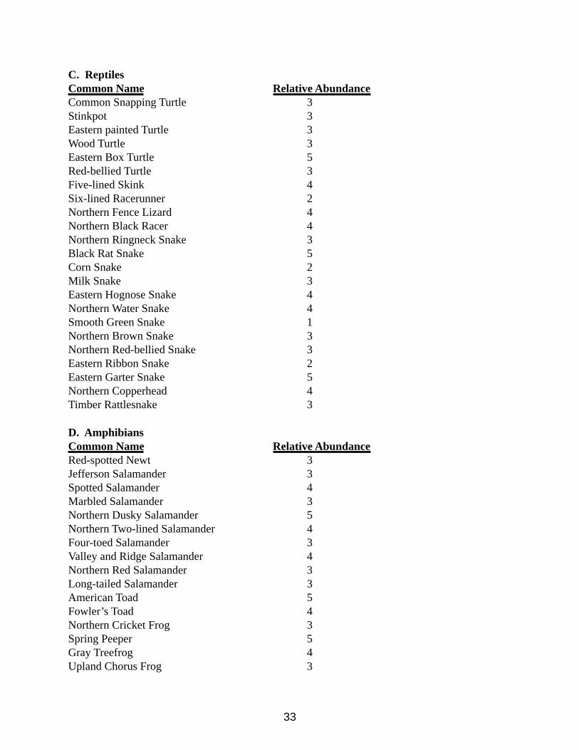
C. ReptilesCommon Name Relative AbundanceCommon Snapping Turtle 3Stinkpot 3Eastern painted Turtle 3Wood Turtle 3Eastern Box Turtle 5Red-bellied Turtle 3Five-lined Skink 4Six-lined Racerunner 2Northern Fence Lizard 4Northern Black Racer 4Northern Ringneck Snake 3Black Rat Snake 5Corn Snake 2Milk Snake 3Eastern Hognose Snake 4Northern Water Snake 4Smooth Green Snake 1Northern Brown Snake 3Northern Red-bellied Snake 3Eastern Ribbon Snake 2Eastern Garter Snake 5Northern Copperhead 4Timber Rattlesnake 3
D. AmphibiansCommon Name Relative AbundanceRed-spotted Newt 3Jefferson Salamander 3Spotted Salamander 4Marbled Salamander 3Northern Dusky Salamander 5Northern Two-lined Salamander 4Four-toed Salamander 3Valley and Ridge Salamander 4Northern Red Salamander 3Long-tailed Salamander 3American Toad 5Fowler’s Toad 4Northern Cricket Frog 3Spring Peeper 5Gray Treefrog 4Upland Chorus Frog 3
34
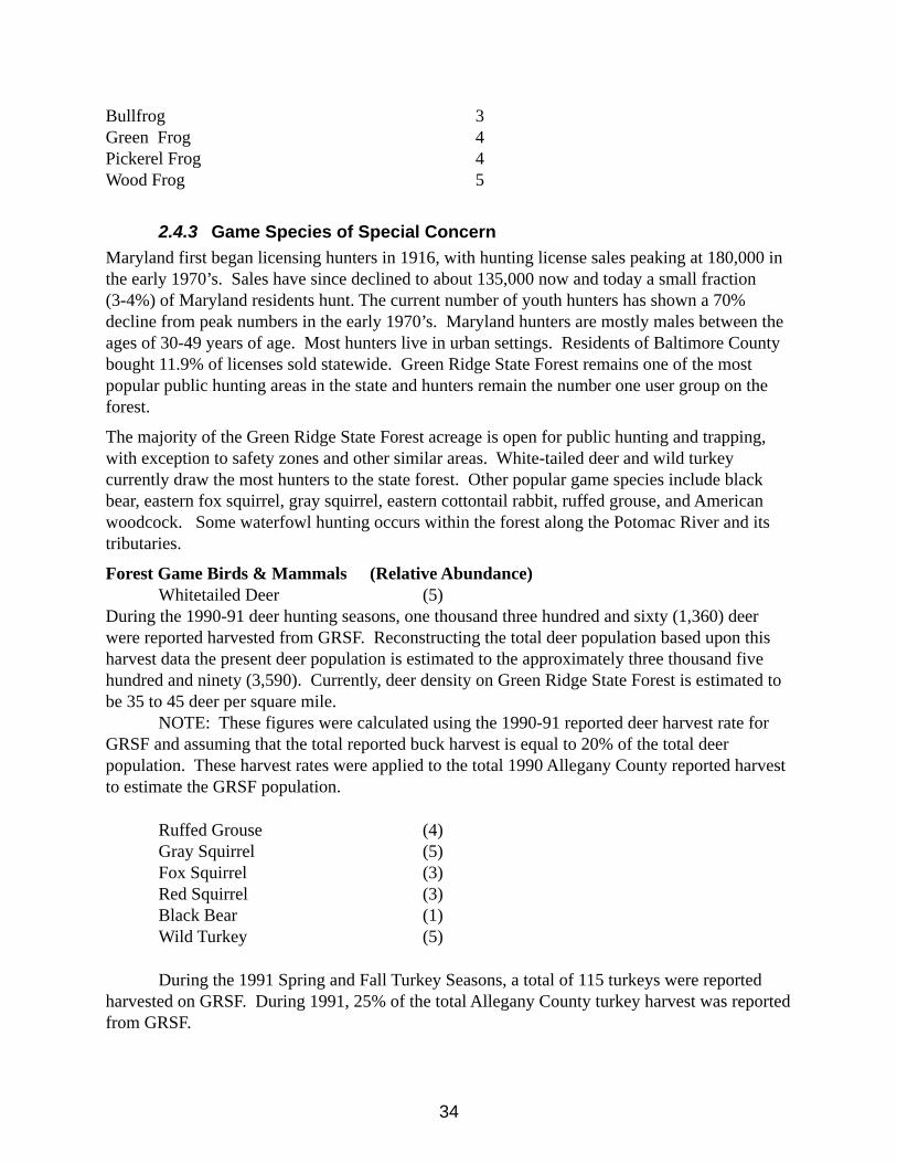
Bullfrog 3Green Frog 4Pickerel Frog 4Wood Frog 5
2.4.3 Game Species of Special Concern Maryland first began licensing hunters in 1916, with hunting license sales peaking at 180,000 in the early 1970’s. Sales have since declined to about 135,000 now and today a small fraction (3-4%) of Maryland residents hunt. The current number of youth hunters has shown a 70% decline from peak numbers in the early 1970’s. Maryland hunters are mostly males between the ages of 30-49 years of age. Most hunters live in urban settings. Residents of Baltimore County bought 11.9% of licenses sold statewide. Green Ridge State Forest remains one of the most popular public hunting areas in the state and hunters remain the number one user group on the forest.
The majority of the Green Ridge State Forest acreage is open for public hunting and trapping, with exception to safety zones and other similar areas. White-tailed deer and wild turkey currently draw the most hunters to the state forest. Other popular game species include black bear, eastern fox squirrel, gray squirrel, eastern cottontail rabbit, ruffed grouse, and American woodcock. Some waterfowl hunting occurs within the forest along the Potomac River and its tributaries.
Forest Game Birds & Mammals (Relative Abundance)Whitetailed Deer (5)
During the 1990-91 deer hunting seasons, one thousand three hundred and sixty (1,360) deer were reported harvested from GRSF. Reconstructing the total deer population based upon this harvest data the present deer population is estimated to the approximately three thousand five hundred and ninety (3,590). Currently, deer density on Green Ridge State Forest is estimated to be 35 to 45 deer per square mile.
NOTE: These figures were calculated using the 1990-91 reported deer harvest rate for GRSF and assuming that the total reported buck harvest is equal to 20% of the total deer population. These harvest rates were applied to the total 1990 Allegany County reported harvest to estimate the GRSF population.
Ruffed Grouse (4)Gray Squirrel (5)Fox Squirrel (3)Red Squirrel (3)Black Bear (1)Wild Turkey (5)
During the 1991 Spring and Fall Turkey Seasons, a total of 115 turkeys were reported harvested on GRSF. During 1991, 25% of the total Allegany County turkey harvest was reported from GRSF.
35
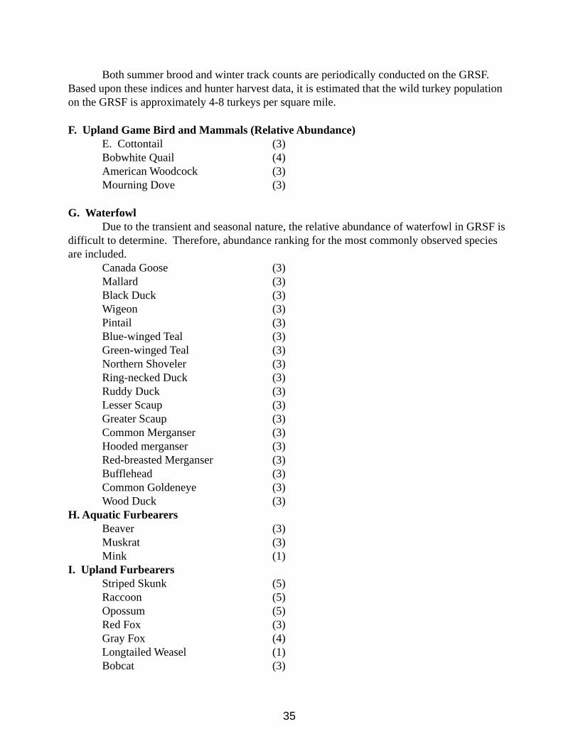
Both summer brood and winter track counts are periodically conducted on the GRSF. Based upon these indices and hunter harvest data, it is estimated that the wild turkey population on the GRSF is approximately 4-8 turkeys per square mile.
F. Upland Game Bird and Mammals (Relative Abundance)E. Cottontail (3)Bobwhite Quail (4)American Woodcock (3)Mourning Dove (3)
G. WaterfowlDue to the transient and seasonal nature, the relative abundance of waterfowl in GRSF is
difficult to determine. Therefore, abundance ranking for the most commonly observed species are included.
Canada Goose (3)Mallard (3)Black Duck (3)Wigeon (3)Pintail (3)Blue-winged Teal (3)Green-winged Teal (3)Northern Shoveler (3)Ring-necked Duck (3)Ruddy Duck (3)Lesser Scaup (3)Greater Scaup (3)Common Merganser (3)Hooded merganser (3)Red-breasted Merganser (3)Bufflehead (3)Common Goldeneye (3)Wood Duck (3)
H. Aquatic FurbearersBeaver (3)Muskrat (3)Mink (1)
I. Upland FurbearersStriped Skunk (5)Raccoon (5)Opossum (5)Red Fox (3)Gray Fox (4)Longtailed Weasel (1)Bobcat (3)
36
Coyote (?)
2.5 Federal Endangered and Threatened Species of Special Concern
-Harperella, Ptilimnium nodosum This is a semi-aquatic plant that occurs along and within two streams on the State Forest. A management plan exists for the plant, and annual monitoring has been conducted for the last 15 years. This plant receives special management consideration on Green Ridge State Forest. Harperella is listed as a Federally Endangered species.
-Indiana Bat, Myotis sodalisThere are several recent records for this bat from an abandoned tunnel on adjacent National Park property. The bats may forage or use other habitats on Green Ridge State Forest. The presence of White-nosed Syndrome, a deadly fungal disease of bats, in the region is a very serious threat to this species. The Indiana bat is listed as a Federally Endangered species.
2.6 State Listed Species of Concern on Green Ridge State Forest Species of special concern were identified by staff of the Wildlife and Heritage Service of the Maryland Department of Natural Resources and/or identified through reference to the Rare, Threatened, and Endangered Animals of Maryland and the Rare, Threatened and Endangered Plants of Maryland (2010). This list represents DNR’s current knowledge, and is constantly changing as new information is collected.
Those species of wildlife listed in this section of the GRSF wildlife assessment report are either officially listed on the State Threatened and Endangered Species list, are potential candidates for listing and usually require further investigation into their rarity and endangerment status, or are thought to be secure at present but are worthy of attention because of limited distributions, declining population or ecological vulnerability. It should be noted that other rare animals tracked by the Maryland Natural Heritage Program, but are not officially Stated listed, do occur on Green Ridge State Forests. Those species are not included here.
These native wildlife species of the GRSF are among the rarest and most in need of conservation and management.
The list of the GRSF threatened, and endangered wildlife species is arranged phylogenetically beginning with the most primitive group, planarians. Within each major group, species are listed alphabetically by scientific name. It should be noted that birds and some birds and some migratory insects are included on the basis of their breeding status alone.
MolluscsGreen Floater, Lasmigona subviridis
The freshwater mussel fauna of Maryland, as in other areas of eastern U.S. has been greatly depleted through the years. Sedimentation and other forms of pollution are the major factors
37
involved.
There are several very old records for the green floater from parts of the Potomac River and a few if its tributaries. Currently, it is only known to occur in Sideling Hill Creek and Licking Creek. This species is listed as Endangered in Maryland.
CrustaceansNone for GRSF.
Insects -Appalachian Tiger Beetle, Cicindela ancocisconensisThis rare tiger beetle occurs in specialized habitat along two streams within GRSF. Sandy soil coupled with natural scouring action of high stream flows are two components needed to sustain their habitat. This beetle is listed as Endangered in Maryland.
-Pepper-and-salt skipper, Amblvscirtes hegonIn Maryland, this small butterfly is known from the Ridge & Valley and the Appalachian Plateau physiographic provinces. At GRSF, it has been documented from the Fifteen Mile Creek area. The adults fly from late May through mid-June. This species is listed as In Need of Conservation in Maryland.
-Northern Metalmark Butterfly, Calephelis borealisIn Maryland, this butterfly is restricted to the Ridge and Valley physiographic province. It requires the combination of open, barren habitat and a good population of the larval food plant, round-leaved ragwort (Senecio obovatus). In the past, this species has been documented from several scattered places at Green Ridge State Forest. Currently, populations are being monitored by the DNR’s Natural Heritage Program. It is listed as a Threatened species in Maryland.
-Mottled Duskywing Skipper, Ervnnis martialisMost of the past records for this rare butterfly are from serpentine barrens in the eastern part of Maryland. However, it has been recently documented from Green Ridge State Forest near Sideling Hill Creek. The adults have two flight periods, one in early spring and one in early summer, and the larvae feed on New Jersey tea (Ceanothus americana). This species is listed as Endangered in Maryland.
-Northern Oak Hairstreak, Satyrium favonius ontarioThis small butterfly is known from only a few collections in Maryland. One of these sites is within Green Ridge State Forest. It is listed as an Endangered species in Maryland and has not been observed in recent years.
-Giant Swallowtail, Papilio cresphontesThis large butterfly is quite local in Maryland, occurring only where good populations of prickly ash (Zanthoxylum americanum) or water ash (Ptelea trifoliate) grow. These are the only plants
38
the larvae will feed on in this part of its range. There are a few scattered records from within GRSF, predominantly from areas near the Potomac River. It is listed as a species in need of Conservation in Maryland.
-Southern Grizzled Skipper, Pvrgus wvandotThis very rare butterfly has apparently experienced declining populations in the last several years. Despite intensive searching by different researchers, historic sites from GRSF have yielded no reports. One site (off of the State Forest) is still known to exist. This is a species known to be highly susceptible to the spraying treatments for gypsy moth control! It is listed as an Endangered species in Maryland.
-Edward’s Hairstreak, Satvrium edwardsiiThis is a butterfly of barren habitats and, in Maryland, is most frequently reported from serpentine barrens farther east. There is one record from GRSF. More potential habitat exists within GRSF, but, so far, extensive searching has yielded no new records. Edward’s hairstreak is listed as an Endangered species in Maryland.
-Olympia marble, Euchloe olvmpiaThis small, white butterfly begins flying very early in the spring, patrolling along dry, open shale barren habitat. With larvae hatching during May, this species is known to be very susceptible to the spray treatments used to control gypsy moths. However, the deletion of several areas from gypsy moth control has apparently helped this butterfly continue to thrive, albeit locally, at Green Ridge. Population monitoring this year revealed five historic sites still occupied. The Olympia is listed as In Need of Conservation in Maryland.
-Compton Tortoiseshell, Nymphalis vau-albumScattered individuals of this anglewing butterfly have been documented on Green Ridge State Forest. Since all records are from very early spring and represent over-wintering adults it is difficult to say if reproducing populations exist on the State Forest. This is because this species is highly migratory and new individuals for a given year are normally encountered from late June to early July. Compton’s tortoiseshell is listed as an Endangered species in Maryland.
AmphibiansNone for GRSF.
ReptilesNone for GRSF.
Birds None for GRSF.
Mammals-Alleghany Woodrat, Neotoma floridana
This historic range for the woodrat in Maryland extends from the Alleghany Plateau through the
39
Ridge and Valley region into the Piedmont section of the State.
Preferred habitat is restricted to certain large rock outcroppings or caves.
Recent evidence suggests that woodrat populations are declining throughout the northeastern United States. Maryland is no exception, as many areas that once harbored woodrats no longer support them. The Natural Heritage Program is currently conducting research on this animal in Maryland. Several study sites are on Green Ridge State Forest.
-Eastern Small-footed Bat, Myotis leibiiThis species has been recorded in several abandoned tunnels on adjacent National Park property. It may forage and use habitats on Green Ridge. It may also occur in some rock outcrops on GRSF. The presence of White-nosed Syndrome, a deadly fungal disease of bats, in the region is a very serious threat to this species. The small-footed bat is listed as Endangered in Maryland.
Maryland State-listed Plants documented on Green Ridge State ForestRunning Juneberry, Amelanchier humilis ThreatenedBearberry, Artostaphylos uva-ursi EndangeredBent Milkvetch, Astragalus distortus ThreatenedBroad-glumed Brome, Bromus latiglumis EndangeredPorter’s Reedgrass, Calamagrostis porteri EndangeredMaple-leaved Goosefoot, Chenopodium gigantospermum Endangered Standley’s Goosefoot, Chenopodium standleyanum EndangeredWild Bleeding –heart, Dicentra eximia ThreatenedLeatherwood, Dirca palustris ThreatenedBlunt-leaved Spurge, Euphorbia obtusata EndangeredWild Lupine, Lupinus perennis ThreatenedClimbing Milkvine, Matelea oblique EndangeredBroad-leaved Bunchflower, Melanthium latifolium EndangeredThree-flowered Melicgrass, Melica nitens ThreatenedWhite-fruited Mountainrice, Oryzopsis asperifolia ThreatenedYellow Nailwort, Paronychia virginica EndangeredAmerican Feverfew, Parthenium integrifolium EndangeredCanby’s Mountain Lover, Paxistima canbyi EndangeredBlack-fruited Mountianrice, Piptatherum racemosum ThreatenedRacemed Milkwort, Polygala polygama ThreatenedSeneca Snakeroot, Polygala senega ThreatenedAlleghany Plum, Prunus alleghaniensis ThreatenedHarperella, Ptilimnium nodosum EndangeredRustling Wild Petunia, Ruellia strepens EndangeredLeonard’s Skullcap, Scutellaria leonardii ThreatenedYellow Nodding Ladies’ Tresses, Spiranthes ochroleuca EndangeredSnowberry, Symphoricarpos albus ThreatenedMountain Pimpernel, Taenidia Montana Threatened
40
Kate’s Mountain Clover, Trifolium virginicum ThreatenedRusty Woodsia, Woodsia ilvensis ThreatenedNorthern Prickly-ash, Zanthoxylum americanum Endangered
Please note that other rare plants tracked by the Maryland Natural Heritage Program that are not officially State-listed occur on Green Ridge State Forest.
2.7 Trees and Shrubs of the RegionThe forests of the region are rich in species diversity. The following table lists the trees and shrubs species found within Green Ridge State Forest.
Table 2.7.1 Native Trees of Green RidgeAcer negundo BoxelderAcer pensylvanicum Striped MapleAcer rubrum Red MapleAcer saccharinum Silver MapleAcer saccharum Sugar MapleAmelanchier arborea ServiceberryBetula alleghaniensis Yellow BirchBetula lenta Black BirchBetual nigra River BirchCarpinus Caroliniana American HornbeamCarya cordiformis Bitternut HickoryCarya glabra Pignut HickoryCarya ovalis Red HickoryCarya ovata Shagbark HickoryCarya tomentosa Mockernut HickoryCastanea dentata American ChestnutCeltis occidentalis HackberryCercis Canadensis RedbudCornus alternifolia Alternate-leaf DogwoodCornus florida Flowering DogwoodCrataegus spp. HawthorneFagus gandifolia American BeechFraxinus americana White AshFraxinus nigra Black AshFraxinus pennsylvanica Green AshHamamelis virginiana Witch-hazelJuglans cinerea ButternutJuglans nigra Black WalnutJuniperus virginiana Eastern RedcedarLiriodendron tulipifera Yellow-poplarMagnolia acuminata Cucumber Tree
41
Malus coronaria Common CrabappleNyssa sylvatica BlackgumOstrya virginiana HophornbeamPinus echinata Shortleaf PinePinus pungens Table-mountain PinePinus rigida Pitch PinePinus strobus Eastern White PinePinus virginiana Virginia PinePlantanus occidentalis SycamorePopulus grandidentata Bigtooth AspenPopulus deltoides Eastern CottonwoodPrunus pensylvanica Fire CherryPrunus serotina Black CherryPrunus virginiana Common Choke CherryQuercus alba White OakQuercus bicolor Swamp White OakQuercus coccinea Scarlet OakQuercus ilicifolia Scrub OakQuercus prinus Chestnut OakQuercus palustris Pin OakQuercus rubra Northern Red OakQuercus stellata Post OakQuercus velutina Black OakRhus copallina Shining SumacRhus glabra Smooth SumacRhus typhina Staghorn SumacRobinia pseudo-acacia Black LocustSalix nigra Black WillowSassafras albidum SassafrasTilia americana American BasswoodTsuga Canadensis Eastern HemlockUlmus americana American ElmUlmus rubra Slippery Elm
Native Shrubs of Green RidgeAlnus rugosa Speckled AlderAlnus serrulata Smooth AlderAralia spinosa Hercules-clubAronia arbutifolia Red ChokeberryAronia melanocarpa Black ChokeberryCeanothus americanus New Jersey TeaCelastrus secanbens Climbing BittersweetCephalanthus Occidentalis Buttonbush Clematis virginiana Virgins Bower
42
Corrnus alternifolia Alternate-leaf DogwoodCornus amomum Silky CornelCornus stolonifera Red-osier DogwoodCorylus americana American HazelnutCrataegus uniflora One – flowered HawthornDiervilla lonicera Bush HoneysuckleEpigaea repens Trailing ArbutusEnonymus americanus Strawberry BushEuonymus atropurpureous WahooGaultheria procumbens TeaberryGaylussacia baccata Black HuckleberryGaylussacia dumosa Dwarf HuckleberryHydrangea arborescens Wild HydrangeaHypericum spathulatum Shrubby St. John’s WortIlex virticillata WinterberryKalmia latifolia Mountain-laurelLindera benzoin SpicebushLonicera dioica Smooth honeysuckleMenisperumn canadensis Moon SeedParthenocissus quinquefolia Virginia CeepersPhysocarpus opulifolius NinebarkPrunus allegheniensis Allegheny PlumPrunus americana Wild PlumRhododendron maximum Great RhododendronRhododendron nudiflorum Pink AzaleaRhododendron roseum Mountain AzaleaRhododendron aborescens White HoneysuckleRhus aromatica Fragrant Sumac Ribes rotundifolium Smooth GooseberryRosa carolina Wild RoseRubus canadensis Smooth BlackberryRubus occidentalis Black RaspberryRubus odoratus Purple Flowering RaspberryRubus setosus BristleberriesRubus Stirgosus Red RaspberryRubus alleghenienus Hybush BlackberryRubus flagellaris DewberrySalix sericea Silky WillowSambucus canadensis Black ElderberrySmilax galuca Glaucous GreenbrierSmilax hispada Hispid GreenbierSmilax rotundifolia Common GreenbierSpiraea alba Wild SpiraeaSpiraea betulifolia Birch-leaved Spiraea
43
Staphylea trifolia BladdernutSymphoricarpus albus SnowberryToxicodendron radicans Poison-IvyVaccinium agustifolium Low Sweet BlueberryVaccinium stamineum DeerberryVaccinium vacillans Late Low BlueberryVibernum acerifolium Maple-leaved VibernumVibernum cassinoides Wild RaisinVibernum prunifolium Black HawVibernum rafinesquianum Downy ArrowwoodVibernum reconitum Smooth ArrowwoodVitis aestivalis Summer GrapeVitis argentifolia Silverleaf GrapeVitis labrusca Northern Red Fox GrapeVitis riparia Riverbank GrapeVitis rotundifolia MascadineVitis rupestis Sand GrapeVitis vulpine Frost GrapeZanthoxylum americanum Prickly Ash
Many non-native species are present on Green Ridge State Forest. These species are present because they were either purposely or accidentally introduced to the area and the site conditions are suitable habitat for them. Some of these species can thrive in this region and create problems for natural vegetation communities. These species are known as invasive species. Invasive species management will be a priority for management as outlined in Chapter 5. The following table lists the non-native trees and shrubs found on Green Ridge State Forest. Table 2.7.2 Exotic Trees Species of Green RidgeAbies balsemea Balsam FirAcer japonicum Japanese MapleAcer plantanoides Norway MapleAilanthus altissima Tree- of –HeavenCatalpa speciesa northern catalpaCastanea mollissima Chinese ChestnutLarix dicidua European LarchMaclura pomifera Osage OrangeMalus pumila Common ApplePanlownia Tomentosa PaulowniaPicea abies Norway SprucePicea glauca White SprucePinus nigra Austrian PinePinus resinosa Red PinePinus sylvestris Scotch PinePinus taeda x rigida Lob-pitch Pine
44
Populus balsamifera Balsam PoplarPopulus deltoids Hybrid PoplarPumus armenica Domestic Sweet CherryPumus cerasus Domestic Sour CherryPyrus communis Common PearPseudotsuga taxifolia Douglas – FirSalix baylonica Weeping WillowSalix carolinia Carolina WillowSalix capren Goat WillowSalix fragalis English WillowSyringa vulgaris LilacTaxodium distichum bald cypress
Exotic Shrubs of Green RidgeBerberis vulgaris European BarberryBerberis thunbergii Japanese BarberryCytisus scoparius Scotch BroomElaeagnus angustifolia Russian OliveForsythia suspensa ForsythiaForsythia viridissima Weeping Golden-bellsHedera helix English IvyLigustrum vulgare PrivetLonicera japonica Japanese honeysuckleLonicera sempervirens Trumpet HoneysuckleLonicera tatarica Tartarian HoneysuckleMyrica pusilla Dwarf Wax-myrtlePolygonum cuspidatum Japanese KnotweedRosa multiflora Multiflora RoseSolanum dulcamara BittersweetSpiraea japonica Japanese Spiraea
2.8 Plants of Special Concern There one Federally Listed plant species (Ptilimnium nodosum) known to occur on Green Ridge State Forest. There are also a number of species of plants listed as Rare, Threatened, or Endangered by the State of Maryland. These species are listed in the following Table.
Table 2.8.1 Rare, Threatened or Endangered Plants found within Green Ridge State ForestScientific Name Common Name StatusAstragalus distortus Bent Milk-Vetch TBouteloua curtipendula Side-oats Grama grass RBromus latiglumis Broad-glumed brome grass ECampanula rotundifolia Harebell RCarex grayi Gray’s Sedge RDicentra eximia Wild Bleeding Heart T
45
Euphorbia obtusata Blunt-leaved spurge EJuglans cinerea Butternut RMatelea obliqua Angle pod EMelica nitens Three-flowered melicgrass TMinuartia michauxii Rock sandwort TParonychia virginica Yellow Nailwort EParthenium integrifolium American fever few EPolygala ploygama Racemed Milwort TPolygala senega Seneca Snakeroot TPrunus allegheniensis Allegheny Plum E*Ptilimnium nodosum Harperella ERuellia strepens Rustling Wild Petunia EScutellaria lenardii Shale Skullcap ESymphoricarpus albus Snowberry TTaenidia montana Mountain Pimpernel TTrifolium virginicum Kate’s Mountain Clover TTriosteum angustifolium Narrow-leaved horse-gentian EValerianella chenopodiifolia Goosefoot Corn-Salad EWoodsia ilvensis Rusty Woodsia Fern TZanthoxylum americanum Pickly Ash E*A federally endangered species. R=Rare T=Threatened E=Endangered
2.9 Plant Communities and Habitats of Special Concern
2.9.1 Shale BarrensThe shale barrens of Allegany County, Maryland represent unique, naturally open ecological communities, which developed long ago on certain moderately steep, southerly exposed hillsides. This type of open habitat only occurs in a relatively narrow band within the Ridge and Valley physiographic province of the mid-Appalachian Mountains from south-central Pennsylvania through Maryland and West Virginia to western Virginia. Because of this restricted distribution, ecologists recognize shale barrens as a very special habitat type.
Whether or not a shale barren forms depends entirely on the underlying geology of an area. The unusual character of particular shale types, primarily of Middle and Upper Devonian Age, determine if the area develops into an open habitat. Without these kinds of shale underlying the area, a forest would eventually grow on the site.
These shale types are very resistant to erosion, and when they do weather, they break up into small, hard pieces. Along with the geology, other important characteristics that are necessary for the formation of a shale barren community include a particular degree of slope (usually over 20 degrees), and a southerly exposure. Most of the barrens in Maryland face east-southeast to due south. This southerly exposure causes shale barrens to receive much sun. Therefore, they are very hot, dry habitats. A big part of this is the fact that the annual rainfall of the Ridge and Valley province is less than any other region in Maryland. A very hot, dry period from June to
46
September is quite normal for the heart of the Ridge and Valley. Natural shale barrens are considered climax communities, characterized by open, prairie-like situations dominated by herbaceous vegetation, intermixed with shrubs and stunted trees supported by little or no soil. Shale outcrops, either large or small, usually occur somewhere on the site. Apparently, the main ecological force allowing the habitat to stay open is drought stress on seedlings of trees and shrubs. However, there may be some chemical or mineral difference in the shale that helps determine where the open habitat forms. Occasional fires may also help keep the barrens open. Whatever the reason, the result is often the formation of very interesting herbaceous and shrub communities that are found nowhere else.
The term “barren” is descriptive of the overall openness of the habitat, but it may lead one to believe that little plant life is associated with them. This is often true on the very steep, acidic barrens. Quite often, however, the opposite is true. This is particularly evident on shales that appear to have a neutral or slightly basic chemistry. Here, the species diversity of the herbaceous layer is quite high and many unusual plants grow. Several of these plants are rarely found off the shale barren habitat and have very restricted ranges. The most notable of these occurring in Maryland is Kate's Mountain clover (Trifolium virginicum). It is listed as a Threatened species in Maryland. The microhabitat requirements for this plant seem to be quite stringent. For instance, there are many shale barrens that appear to offer suitable habitat, often within close proximity to established colonies, but the clover does not occur there. Furthermore, when this clover does occur on a site it is usually restricted to certain sections of a barren. Only rarely does Kate's Mountain clover establish itself more or less homogeneously throughout the barren's openings. This situation does occur on several prairie-like barrens in Maryland, and these sites may be considered very special. Also, it might be mentioned that a good "population" of this plant is very small by usual botanical standards. An occurrence of more than150 plants over a few acres is outstanding and rare. The largest occurrence discovered in Maryland numbers over 500 individuals. A majority of the sites harbor less than 50 individuals. Other unusual plants that are primarily restricted to the shale barren region include: Allegheny plum (Prunus alleghaniensis), shale ragwort (Senecio antennariifolius), shale evening-primrose (Oenothera argillicola), shale bindweed (Convolvulus purshianus), mountain nailwort (Paronychia montana), bent milkvetch (Astragalus distortus), prickly-pear cactus (Opuntia humifusa), side-oats grama grass (Bouteloua curtipendula), three-flowered melic grass (Melica nitens), and hairy-lip fern (Cheilanthes lanosa), to name a few. Many other interesting species of plants are found on most barrens.
Not only is the plant life of special interest on these natural, open habitats, the animal life is quite interesting as well. Even though the invertebrate fauna of shale barrens is largely uninvestigated, several species of uncommon or rare butterflies are known to occur in the shale barren region. These include the grizzled skipper (Pyrgus wyandot), Olympia marble-wing (Euchloe olympia), cobweb skipper (Hesperia metea), northern metalmark (Calephalis borealis), and the silvery blue (Glaucopsyche lygdamus). The shale barren openings provide a unique habitat for other wildlife, too. Wild turkey and ruffed grouse dusting sites are frequently observed on shale barrens and, no doubt, poults are brought here to hunt the large variety of insects available. A variety of reptiles may be observed, such as, five-lined skinks, eastern fence lizards, six-lined
47
racerunners, and several species of snakes. Shale barrens provide important egg-laying sites for the box turtle and the wood turtle.
The number one biggest threat to these unique communities is when disturbances such as agriculture, logging, or road building occur too close to the barren. These disturbances create a pathway for the invasion of non-native weeds, which often take over large sections of the habitat and crowd out native vegetation. Some of these weeds are quite troublesome, such as, Bromus sterilis (a grass), bush honeysuckle (several species of Lonicera), crown vetch (Coronilla varia), spotted knapweed (Centaurea maculosa), several species from the mustard family (Cruciferae), to name a few. A no disturbance buffer zone around a shale barren community of at least 500 ft. is needed to protect them from this threat, and 1,000 ft is preferred when possible. Frequent human visitation can also damage the habitat because the steepness of some sites causes the shaley substrate to be very unstable.
Allegany County is quite fortunate because there are a number of fine natural shale barrens within its border. Many of these are within the Green Ridge State Forest. The protection of these very special habitats would represent insightful conservation and cause negligible economic impact.
2.9.2 Rock Outcrops
Several of the ridge-tops in Green Ridge have significant rock outcrops, cliffs and large boulder fields. Those identified to date consist of sandstone. However, the chemistry of this sandstone is curious. This is because several rare plants that are normally found on limestone have been documented on these sites. These include running serviceberry (Amelanchier humilis), northern prickly-ash (Zanthoxylum americanum), and snowberry (Symphoricarpus albus).
Animals of special concern documented at these rocky sites include the Allegheny Woodrat (Neotoma magister), bobcat (Lynx rufus), and the timber rattlesnake (Crotalus horridus).
2.9.3 Vernal Pools
Vernal pools are typically flooded in winter to early spring or after a heavy rainfall, but are usually dry during summer. Many vernal pools are filled again in autumn. Substrate is typically dense leaf litter over hydric soils. Vernal pools typically occupy a confined basin (i.e., a standing waterbody without a flowing outlet), but may have an intermittent stream flowing out of it during high water. This community includes a diverse group of invertebrates and amphibians that depend upon temporary pools as breeding habitat. Since vernal pools cannot support fish populations, there is no threat of fish predation on amphibian eggs or invertebrate larvae. Characteristic animals of vernal pools include species of amphibians, reptiles, crustaceans, mollusks, annelids, and insects. Vernal pool species can be categorized as either obligate (species
48
that depend upon vernal pool habitat for their survival), or facultative (species that are often found in vernal pools, but are not dependent on them and can successfully reproduce elsewhere). Obligate vernal pool amphibians include spotted salamander (Ambystoma maculatum), Jefferson salamander (A .jeffersonianum), marbled salamander (A. opacum) and wood frog (Rana sylvatica). Fairy shrimp (Anostraca) are obligate vernal pool crustaceans, with Eubranchipus spp. being the most common. Facultative vernal pool amphibians include fourtoed salamander (Hemidactylium scutatum), red-spotted newt (Notophthalmus viridescens), spring peeper (Pseudacris crucifer), gray tree frog (Hyla versicolor), green frog (Rana clamitans), American toad (Bufo americanus), and Fowler’s toad (B. woodhousei fowleri). Facultative vernal pool reptiles include painted turtle (Chrysemys picta), and snapping turtle (Chelydra serpentina). Facultative vernal pool mollusks include freshwater fingernail clams (Sphaerium sp., Musculium sp., and Pisidium sp.) and aquatic amphibious snails (Physa sp., Lymnaea sp., and Helisoma sp.). Facultative vernal pool insects include predacious diving beetles (Dytiscidae), whirligig beetles (Gyrinidae), dobsonflies (Corydalidae), caddisflies (Trichoptera), dragonflies (Anisoptera), damselflies (Zygoptera), mosquitoes (Cuculidae), springtails (Collembula) and water striders (Gerris sp.). Leeches (Hirudinea) are a facultative vernal pool annelid. Plants are predominantly hydrophytic, typically with a combination of obligate and facultative wetland species. Floating and submergent plants may be common, but emergent plants should be sparse or lacking. In this region, fowl manna-grass (Glyceria septentrionalis) is one emergent plant that is often associated with vernal pools.
Naturally occurring vernal pools are quite rare in Green Ridge State Forest.
2.10 Game Species of Special Concern Allegany County’s rural landscape with 90+% forest cover and agriculture provides a habitat quality that supports abundant wildlife populations and species diversity. This mixture of largely hardwood forests dominated by oak species and some agriculture serves to provide a rich and abundant source of nutrition for many keystone wildlife species such as white-tailed deer, wild turkeys, and black bears. Allegany County supports a diverse wildlife community with species of reptiles, amphibians, birds, and mammals.
There are several threats and concerns that may influence wildlife populations and future habitats in Allegany County. One of the greatest threats to wildlife, not only in the county, but throughout the state is loss of habitat from increasing development. As the community and businesses develop, there may be increased demand for uses that are non-compatible with conserving wildlife habitat even on DNR lands.
Hunting is a primary recreational use of public lands in Allegany County. Pursuit of forest game species such as white-tailed deer (Odocoileus virginianus), gray squirrels (Sciurus carolinensis), ruffed grouse (Bonasa umbellus), and wild turkeys (Meleagris gallopavo) provide the majority of hunter days. Hunting for upland wildlife such as American woodcock (Philohela minor) and eastern cottontails (Sylvilagus floridanus) is also popular. Some opportunity for waterfowl hunting also exists. Mountain biking, and hiking are also popular recreational activities that may be considered wildlife enhanced activities.
49
It is anticipated that the demand for hunting forest game will continue and likely escalate as less private land is available to hunters. Along with this demand for hunting opportunity, it is expected that there will be increased interest in non-hunting use of public land for bird/wildlife watching.
White-tailed deer is the most popular species hunted in Allegany County and throughout the state. Along with the positive recreational benefits and population management that deer hunting provides, it also provides significant economic benefits to Maryland. A recent survey sponsored by the Association of Fish and Wildlife Agencies found that deer hunting in 2006 generated over $113 million in retail sales with a total multiplier effect of over $190 million contributed to Maryland’s economy. Deer hunting in Maryland supports nearly 2,300 jobs and generates $71 million in salaries, wages, and business owner’s income, $15 million in state and local tax revenue, and $16 million in federal tax revenue.
There are more than 40 species of game animals that occur in Allegany County. Hunting has been a most honored tradition that continues to provide recreation, food, and quality of life in Allegany County. The large amounts of public land in the county makes it a popular destination for non-resident hunters and those from more urban areas where there is little hunting opportunity. The most popular or keystone species of game animals continue to provide for most hunter recreation days in Allegany County.
White-tailed Deer – Harvest trends indicate that white tailed deer thrive in Allegany County (Figure 2). During the 2009-10 hunting season Allegany County had the 8th highest reported deer harvest in the state. This is significant considering that most counties have a much more liberal bag limit and therefore, higher harvest potential. The reported harvest during the 2009-10 hunting season was a total of 4508 deer.
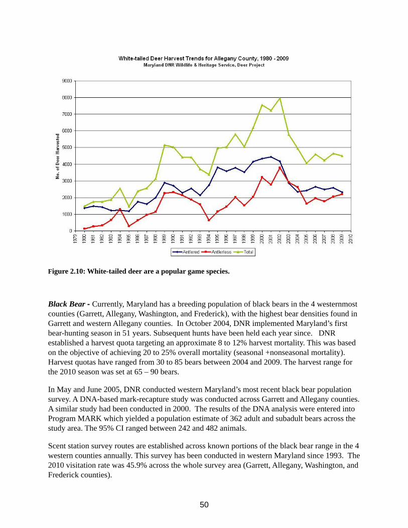
50
Figure 2.10: White-tailed deer are a popular game species.
Black Bear - Currently, Maryland has a breeding population of black bears in the 4 westernmost counties (Garrett, Allegany, Washington, and Frederick), with the highest bear densities found in Garrett and western Allegany counties. In October 2004, DNR implemented Maryland’s first bear-hunting season in 51 years. Subsequent hunts have been held each year since. DNR established a harvest quota targeting an approximate 8 to 12% harvest mortality. This was based on the objective of achieving 20 to 25% overall mortality (seasonal +nonseasonal mortality). Harvest quotas have ranged from 30 to 85 bears between 2004 and 2009. The harvest range for the 2010 season was set at 65 – 90 bears.
In May and June 2005, DNR conducted western Maryland’s most recent black bear population survey. A DNA-based mark-recapture study was conducted across Garrett and Allegany counties. A similar study had been conducted in 2000. The results of the DNA analysis were entered into Program MARK which yielded a population estimate of 362 adult and subadult bears across the study area. The 95% CI ranged between 242 and 482 animals.
Scent station survey routes are established across known portions of the black bear range in the 4 western counties annually. This survey has been conducted in western Maryland since 1993. The 2010 visitation rate was 45.9% across the whole survey area (Garrett, Allegany, Washington, and Frederick counties).
51
The visitation rate for Allegany County had an increase in 2010 by 9.4%. Allegany County’s visitation rates have remained noticeably higher since 2006 which may indicate an increasing density in the black bear population throughout the county. Allegany and Garrett counties together comprise Maryland’s black bear harvest zone. The combined visitation rate for these two counties demonstrated an increase of 4.7% in 2010.
Wild Turkey – Wild turkey populations have been strong in Allegany County since the rebound of suitable habitat conditions following the declines of the early 1900’s. Within the last few decades, turkey numbers have remained steady in Allegany County and Green Ridge State Forest. In Allegany County the turkey season is split with both a spring and fall season. It is estimated that over 10,000 hunters pursue turkeys during the spring season statewide. Allegany County ranked number two in harvested turkeys in 2010 with 327 birds reported (about 12% of the total statewide harvest). Brood habitat (typically herbaceous openings and edges) is reported by the Department to be the main limiting factor affecting populations.
Ruffed Grouse- Ruffed grouse inhabit the forested mountains of Garrett, Allegany, Washington, and Frederick Counties. They have been a traditional staple for Western Region upland game bird hunters for decades. Data suggests that ruffed grouse populations in Maryland have remained somewhat stable since the mid-70s. However, the number of Maryland grouse hunters continues to decrease. This parallels the decline in participation of other small-game hunting, such as quail, squirrel, and rabbit. The DNR’s Hunter Mail Survey for the 2006-2007 season reported an estimated 1,800 grouse hunters in Maryland. The typical grouse hunter spent average of 4 days afield and harvested about 1 grouse in the 2006-07 season. Although the number of grouse hunters has declined in recent years, success rates have remained stable or increased in the last few years. A grouse hunter survey was initiated in the 2008-09 hunting season. Cooperating hunters will record the number of grouse flushed and bagged per hour. This information should allow us to better estimate grouse population trends in the region.
American Woodcock – Spring "singing ground" surveys performed by the U.S. Fish and Wildlife Service suggest that eastern woodcock numbers have been declining by an average of 1.9 percent per year since these surveys were started in 1968. Most woodcock biologists suspect that alterations of habitat, losses to development and changes due to maturation of abandoned farmland are the cause of the population decline. Woodcock use Green Ridge State Forest as breeding and wintering habitat. Woodcock prefer moist soil areas with dense seedling/ sapling cover and rich humus layers because earthworms, their primary food, are most plentiful in these habitats. Such soils are primarily found within the stream valleys and flood plains within GRSF.
Furbearers – Resident furbearer populations are stable or growing within Allegany County. The diverse ecosystems support a rich and varied assemblage of furbearer species. They range from the solitary fisher of spruce and hemlock forests, to the more agricultural preferring red fox, to the wetland inhabiting beaver and river otter. Maryland's citizens enjoy a variety of ecological, recreational, economic, and cultural benefits from these valuable resources.
52
Allegany County’s 13 resident furbearer species yield many user days of recreation, while also providing the nucleus for many traditionally based rural activities. The fur harvest industry is a multibillion-dollar enterprise nationally and offers significant contributions to Maryland's economy.
2.11 The Forests of the Ridge and ValleyHistoric land cover shows the region dominated by hardwood forests mixed with pine softwoods. American Chestnut was a dominant species until lost due to the great chestnut blight. Mixed Oak-Hickory stands are the dominant forest type across the landscape of the Ridge and Valley Forests. Practically no virgin forests remain on the Ridge and Valley, and most forests have been cut over several times. Many areas (including many that are once again in forest) have been cleared for conversion to agriculture in the past.
2.12 Forest Management in the Ridge and ValleyMost of the forests on the ridge and valley are managed for multiple objectives, but chiefly for revenue from the sale of timber and for wildlife habitat to support wildlife-related recreation. The forests on the Ridge and Valley are well suited to meet these objectives because of their ability to provide valuable products and diverse habitats.
As described above, the forests on the ridge and valley tend to be dominated by oak hickory stands. Most of the forests are even-aged, having regenerated from the abandonment of agricultural land and/or extensive clear-cut timber harvests around 1900. The oak dominated forests is due to the loss of American chestnut, drier growing conditions and the frequency of fires in the past.
Of the many commercial products that a forest in the ridge and valley can generate, the most valuable is hardwood sawtimber. There is a strong market for this because of the many local sawmills engaged in the production of hardwood lumber and structural timbers. There is also a market for hardwood and pine pulpwood.
Most ridge and valley landowners that desire a commercial return from their forestland focus on hardwood saw timber because there is a stable market and it requires very little investment other than time. Hardwood stands in this region reach economic maturity at around 100 years. The pulpwood industry in the region provides a market for the non saw timber quality trees harvested during mid rotations and at final harvest.
Even aged silvicultural systems are best suited for sustainable management of these hardwood stands because the preferred species are shade intolerant. Natural regeneration under a clearcut or shelterwood system is successful for regeneration of stands similar to the previous stand.
The practice of partial harvest in economically mature second growth stands of the region has become prevalent on private forest land. This in part is due to the lack of knowledge of the ecology of these stands and the negative reputation that clear cutting has among many stakeholders of the region. Highgrading often results when a partial harvest is done in an economically mature stand. The term highgrading typically refers to the practice of harvesting
53
trees of the greatest value while leaving the trees of lesser value; “cut the best and leave the rest…” In even-aged stands this translates to harvesting the genetically superior specimens and the more desirable species while leaving the genetically inferior and less desirable species as residual growing stock. Furthermore, the residual shade will promote regeneration of the less favorable shade tolerant species while impeding regeneration of the more desired shade intolerant species. Diameter limit harvesting is a typical example of high grading in the region. Highgrading is not a sustainable practice and remains a resource management issue within the region.
In Maryland from 1976 to 1989 the number of private forest owners grew from 95,800 to 131,000, increasing by about 2.7% per year. That calculates out to about 2,600 more owners each year. In 1976, 55% of the owners held less than 10 acres of forest; by 1989 that proportion had grown to 65%. What can be inferred from these trends is that over 2/3 of the forestland owners in the area are now essentially large-lot homeowners who will seldom be able (or desire) to manage their forest for timber production. Some properties will be managed for wildlife and recreation value, but small, fragmented pieces are limited in their capacity to produce those values, as well.
Convincing private landowners to manage forests on a long-term, sustainable plan is affected by the rapid turnover of forest properties and the long rotation in the region.
To assist the landowner with the management of their forest, there are a variety of forestry services and sources of information available. The Maryland Department of Natural Resources, Forest Service, maintains foresters to service landowners in all counties. Many landowners rely on them for impartial advice concerning timber sales, the development of forest stewardship plans and the carrying out of forest management activities such as timber stand improvement. In addition, there are several private consulting foresters who assist landowners with all aspects of forest management. Most of the actual management activities, such as road building, site preparation, tree planting, and harvesting, are contracted out to separate businesses. However, some specific management practices have not been feasible because there has not been sufficient demand to support an operator. This is particularly the case on smaller parcels
In general, Ridge and Valley forest landowners do not seem driven to achieve long term forest management objectives, with many owners who are as likely to be interested in providing good habitat for game species as in generating future forest revenue.
2.13 The Forest Products Industry The forest products industry in Allegany County is dominated by hardwood sawmills and pulpwood markets. Most of the nearby sawmills are small family operated hardwood mills that produce grade hardwood lumber, railroad ties, and pallet grade lumber. New Page Inc. is currently the second largest private employer within Allegany County. New Page Inc. produces fine quality paper products such as magazine stock.
2.14 People and Forests of Allegany County
54
2.14.1 Historic and Cultural Resources Assessment
Very little is left of early pioneer settlement on the forest. Historically abandoned buildings that escaped arson were left to deteriorate through lack of concern. The foundations remain however and are considered as historic relics and therefore not destroyed or disturbed in management activities. Besides foundations, orchard reservoirs, rock fences, cemeteries, moon shine sites, springs and similar structures are left intact.
Buildings that become part of the forest through land purchase are razed if they are not habitable. Before razing, each building is studied for historical significance.
The Maryland Historical Trust surveyed the forest in 1978 and identified several structures as significant. They are primarily CCC structures and represent a style of construction associated with this time period (1930's). The stone rings on Polish Mountain and the stone chimney in Chimney Hollow were the two significant sites worthy of preservation. The origin of the stone rings is unknown and warrants study. The Stone Chimney is the remains of a large industrial sawmill complex built in the 1830's.
An archaeological inventory of the forest is lacking. Indian sites are common in the area. A large Indian village complex is known to exist near the Potomac River and Route 51. Similar areas are suspected inside the forest. As of this date no archeaological diggings or excavations have been done, nor are any planned for this planning period. Protection of sites is through regulation that prohibit any relic hunting or digging without Departmental permission.
2.14.2 Fire and Its role In Shaping the Forests of the Region The extent and frequency that Native Americans used fire to manage the forest prior to European Settlement is unclear, but it is clear that fire was used as a management tool to manipulate the environment. It is also unclear what the natural fire regime was during pre-settlement times.
Pre-European fire occurrence was probably highest near sites of major Indian settlements or seasonal fire activity. Open woods, when containing large stands of deciduous, nut-bearing trees, must have been the most desirable ecological zone to have near an Indian town. Aside from all the food and other things it has for people, this zone is extremely attractive for browsers like deer and elk (extinct in eastern Virginia and Maryland by about the eighteenth century).
It is known that today’s forests of the Ridge and Valley were influenced greatly by fire. Fire was used as a tool for clearing the land and a lot of wildlfire swept across the region after the widespread timber exploitation in the late 1800s and early 1900s. Oaks are adapted to fire because their natural history is that they focus growth in their roots systems during early development while most of its competitors focus their energy in vertical growth. These characteristics would facilitate the competing species winning the race of regenerating forests to close the canopy and hold a dominant position in the stand. However, these fast growing species are not as tolerant of fire because they do not have the established root systems to facilitate survival in the event of fire. These life history differences likely fostered the oak dominated forests of the region today because there was a lot of fire to reduce competing vegetation and release the oak forest.
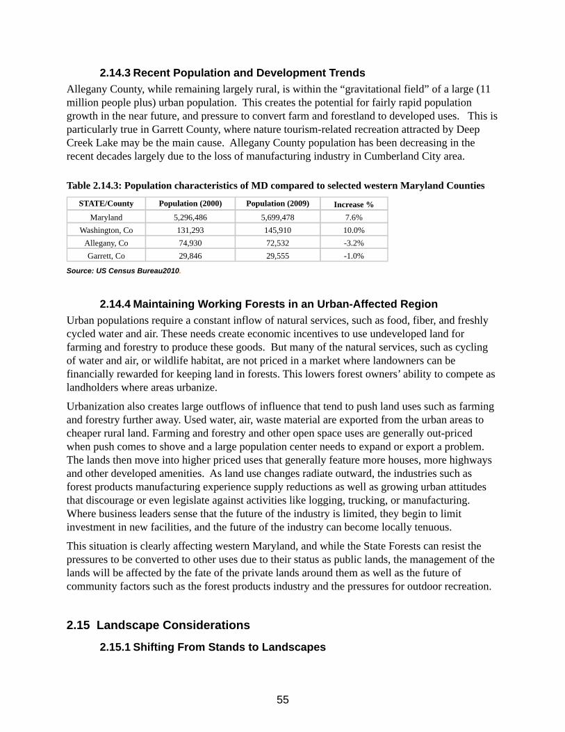
55
2.14.3 Recent Population and Development TrendsAllegany County, while remaining largely rural, is within the “gravitational field” of a large (11 million people plus) urban population. This creates the potential for fairly rapid population growth in the near future, and pressure to convert farm and forestland to developed uses. This is particularly true in Garrett County, where nature tourism-related recreation attracted by Deep Creek Lake may be the main cause. Allegany County population has been decreasing in the recent decades largely due to the loss of manufacturing industry in Cumberland City area.
Table 2.14.3: Population characteristics of MD compared to selected western Maryland Counties
STATE/County Population (2000) Population (2009) Increase %Maryland 5,296,486 5,699,478 7.6%
Washington, Co 131,293 145,910 10.0%Allegany, Co 74,930 72,532 -3.2%Garrett, Co 29,846 29,555 -1.0%
Source: US Census Bureau2010.
2.14.4 Maintaining Working Forests in an Urban-Affected RegionUrban populations require a constant inflow of natural services, such as food, fiber, and freshly cycled water and air. These needs create economic incentives to use undeveloped land for farming and forestry to produce these goods. But many of the natural services, such as cycling of water and air, or wildlife habitat, are not priced in a market where landowners can be financially rewarded for keeping land in forests. This lowers forest owners’ ability to compete as landholders where areas urbanize.
Urbanization also creates large outflows of influence that tend to push land uses such as farming and forestry further away. Used water, air, waste material are exported from the urban areas to cheaper rural land. Farming and forestry and other open space uses are generally out-priced when push comes to shove and a large population center needs to expand or export a problem. The lands then move into higher priced uses that generally feature more houses, more highways and other developed amenities. As land use changes radiate outward, the industries such as forest products manufacturing experience supply reductions as well as growing urban attitudes that discourage or even legislate against activities like logging, trucking, or manufacturing. Where business leaders sense that the future of the industry is limited, they begin to limit investment in new facilities, and the future of the industry can become locally tenuous.
This situation is clearly affecting western Maryland, and while the State Forests can resist the pressures to be converted to other uses due to their status as public lands, the management of the lands will be affected by the fate of the private lands around them as well as the future of community factors such as the forest products industry and the pressures for outdoor recreation.
2.15 Landscape Considerations
2.15.1 Shifting From Stands to Landscapes
56
In the past, management of forests was done primarily on a stand-basis, and most of the time, as stands within specific property holdings. From an ecological perspective, the stand was taken as a unit that could be accessed independent of others. Economic considerations, such as the desire to have consistent product to sell from year to year, and to minimize costs of treatments, linked the management of different stands, but otherwise it was assumed that a stand, by definition, was a management unit on which treatments could be scheduled independently of all others.
In recent years, however, there has been a strong movement toward management at a landscape level. Landscape level considerations means that the status of any specific stand, and what forestry treatments are applied to it, depend not only on its internal conditions (stand age and structure, site index, etc.) but on the condition of other stands and of other lands in a region. The landscape-level perspective leads to a view of stands within landscapes. The condition of other stands includes not only their stand age and structure, but also the frequency distribution of stands on the landscape of different kinds and stages. Landscape considerations also take into account land holdings by other landowners and government agencies. The management of a stand is perceived within a regional context.
All of the major goals of this project need to be examined from a landscape-level perspective, and decisions made in light of this perspective. Among the factors that are leading in the direction of management from a landscape level perspective are: the requirements of the Endangered Species Act; the Clean Water Act; the habitat needs of migratory species that make use of forest stands; the habitat needs of game species and other species of recreational value; the perception that recreational uses can benefit from a variety of stand types, not just from the existence of a certain kind of stand.
There are a number of examples that illustrate the landscape perspective. Recent approaches by Boise-Cascade illustrate landscape level forest management as a result of concerns with endangered species. Boise-Cascade has holdings in the southeast that are habitat of the Red-cockaded woodpecker. The company has taken the position that, while it can affect habitat for this species within its own holdings, it cannot be held responsible for the status of the species, specifically for the population abundance of the woodpecker. Instead, Boise-Cascade has initiated voluntary, cooperative agreements with other landholders and with government agencies so that planning for forest use is done on a regional basis. In this case, the decision about how a specific stand will be treated is influenced by more than the condition of that stand, and more than the holdings of Boise-Cascade. That treatment depends on the availability of habitat for the woodpecker in an entire region, and, by voluntary action, the corporation chooses to harvest stands under its own control to meet the regional needs of the endangered or threatened species, as well as to meet its corporate needs. Similarly, the desire to have clean water leads to a consideration of water quality within a region, as well as within a specific ownership. Water quality is affected by the condition of water in industrial areas, on lands that are in agriculture and residential, as well as on the forestland, making clean water a landscape
Thus a landscape-level perspective is intrinsic, if generally unspoken, in forest planning on the Ridge and Valley, and is likely to become increasingly important in the future. As the experiences and practices of Boise-Cascade illustrate this level of planning and management can be done on a voluntary, cooperative basis, and be driven by market forces. Landscape-level
57
planning means that a stand is seen within a regional context, but this does not require that planning be done from an external or regulatory perspective.
2.15.2 Climate Change and Maryland Forests
Research has speculated how forests and their management could be affected by a changing climate. While much of the research has been somewhat general, some researchers have focused their attention to areas including Maryland (McKenney-Easterling et al.: Climate change impacts on forests in the Mid-Atlantic Region, Climate Research Vol. 14: pages 195–206, 2000).
Species MigrationAccording to some of these studies, there are two major forest-related shifts that may result from the common climate-change scenarios. One, resulting warmer temperatures will likely cause a species distribution shift. Within this scenario some species may benefit while others will experience a range reduction. Certain forest-types such as oak-hickory, oak-pine and southern pine forest types, would probably benefit from dryer conditions while those requiring a more moist site will not.
“Large increases in some species of oak and pine, particularly those better adapted to warmer and dryer ecosystems. Consequently, those species preferring more moist conditions, such as elm-ash-cottonwood and maple-beech-birch forest types may be reduced from some landscapes, “results generally show warm-temperate mixed forest/evergreen forest moving northward, displacing temperate deciduous forest in the southern part of the MAR, and cool temperate mixed forest (such as maple-beech-birch) disappearing completely from the region.” (McKenney-Easterling et al.: Climate change impacts on forests in the Mid-Atlantic Region, page 204.)
Forest-Type ChangesThe forest-type distribution in Maryland varies greatly--from the coastal plain to the Allegheny Mountains, ecosystems are quiet different and so would the expected response to climate changes.
Eastern ShoreAs mentioned elsewhere in this document, the Shore silviculture and ecosystems are dominated by southern yellow pine and pine-hardwoods. It would be expected that this forest-type will largely be unaffected in most of these scenarios.
“The southern pine types remain fairly stable even though individual southern pine habitat increases to the north for many pines. The explanation for this pattern is that the oak species also generally increase so that the proportions stay similar, or even favor oak-pine over loblolly pine for a portion of the current southern pine habitat.” (L.R. Iverson et al. / Forest Ecology and Management 254 (2008) 390–406, pg 401)
Western Maryland
58
The oak-hickory forest type may actually benefit from a warmer climate. Oak regeneration has been less than desirable for several decades due to the reduced occurrence of fire on the landscape, due primarily from human intervention. One study suggests that some disturbances promoted by climate change may open the canopy to actually enhance the probability for oak regeneration. This may not only increase the chance of gaining a larger oak component but also the wildlife that benefit from that forest-type.
“Several of these species are currently important commercial species of oak (Quercus) or pine (Pinus). Increased habitat for oak could indicate an increased commercial and wildlife resource (especially in the northern part of the country), but oaks currently are undergoing a regeneration crisis in the absence of fire or other agents that can partially open the canopy (Loftis and McGee, 1993; Iverson et al., 2004b).” (L.R. Iverson et al. / Forest Ecology and Management 254 (2008), pages 403-404).
Disturbance IncreaseA secondary effect resulting from increased average temperatures is the increased incidence of insects, disease and fire. This will affect not only the composition of the forest but complicate their management. In the recent past, Maryland State Forests have been plagued by gypsy moth, southern pine bark beetle, hemlock wooly adelgid and recently emerald ash borer. A variety of other damage agents lay on our borders, namely sirex wood wasp, oak wilt and others.
Increased Severe WeatherThe second response identified is the result of more severe weather events and the forest management implications that would result from these events.
“Second, we used a survey to gather information on the types of extreme weather events that are currently problematic for forest land managers, and the types of impacts they cause to forests and forestry operations. Respondents indicated that high winds and precipitation-related events have been more problematic than extreme temperatures alone, based on experiences over the past decade. Types of major impacts include operational impacts (in particular, altered access to forest areas) as well as structural impacts (direct damage to trees) and biological impacts (mortality, and increased problems with insects, disease and fire). This information, in conjunction with our results from the tree species distribution modeling, was used to make inferences about the potential impacts of extreme events in the future. We note that climate change may lead to alterations in the frequency, severity and duration of extreme events such that the past is an imperfect predictor of the future.” (McKenney-Easterling et al.: Climate change impacts on forests in the Mid-Atlantic Region, page 205.)
Sea-level RiseThe National Wildlife Federation report (2008) entitled Sea-Level Rise and Coastal Habitats of the Chesapeake Bay: A Summary, states that the Maryland Shore could lose 16,000 acres of undeveloped dry land by 2100. This would dramatically effect forest management on the Pocomoke State Forest and Chesapeake Forest Lands, affectively reducing the area of
59
management acres and altering more.
Coastal habitats in the Chesapeake Bay region will be dramatically altered if sea levels rise globally about two feet by the end of the century, which is at the low end of what is predicted if global warming pollution remains unaddressed. Over 167,000 acres of undeveloped dry land and about 161,000 acres of brackish marsh would be lost, replaced in part by over 266,000 acres (415.6 square miles) of newly open water and 50,000 acres of saltmarsh. Ocean and estuarine beaches also fare poorly, declining by 58 percent and 69 percent, respectively, by 2100. In addition, more than half of the region’s important tidal swamp is at risk.
Over 167,000 acres of undeveloped dry land would be lost or replaced with wetlands. As dry land becomes saturated, the water table will increase, contributing to the expansion of open water inland. Furthermore, sea-level rise will make coastal and inland areas more susceptible to storm surges.
Agency ResponseThe State of Maryland has been addressing the threats of global warming and climate change through varies committee studies and reports.
In the Comprehensive Strategy for Reducing Maryland’s Vulnerability to Climate Change, Chapter 5, one of the key recommendations, in which DNR State Forests can have a role, was:
Retain and expand forests, wetlands, and beaches to protect us from coastal flooding. Identify high priority protection areas and strategically and cost-effectively direct protection and restoration actions. Develop and implement a package of appropriate regulations, financial incentives, and educational, outreach, and enforcement approaches to retain and expand forests and wetlands in areas suitable for long-term survival. Promote and support sustainable shoreline and buffer area management practices.
The Maryland DNR Forest Service response to these factors will be to maintain an adaptive management approach considering current research and regular forest (and other resource) inventories, monitoring and assessments and by proper staffing to maintain the ability to respond to these potentially destructive forces. (Western Maryland State Forests have begun a five-year forest inventory project beginning in 2011 and expected to be completed in 2016 which will provide baseline data to monitor forest changes and allow adaptive forest management approaches).
Additional information:
Sea-Level Rise and Coastal Habitats of the Chesapeake Bay: A Summary (National Wildlife Federation, 2008)http://www.nwf.org/~/media/PDFs/Global-Warming/Reports/NWF_ChesapeakeReportFINAL.ashx
60
Climate Change in Maryland: https://climatechange.maryland.gov/
Comprehensive Strategy for Reducing Maryland’s Vulnerability to Climate Change Phase I: Sea-level rise and coastal storms (2008)https://dnr.maryland.gov/ccs/.../Comprehensive_Strategy.pdf
2.16 Watersheds as a Landscape IssueRegional attention to water quality in the Chesapeake Bay and its tributaries has led to concern for some of the resource management activities in use. Declining water quality in the Bay has resulted in major interstate efforts, many of which have identified the treatment of the land within the watershed as the primary factor in reversing the decline and restoring the Bay's aquatic environments.
In its Clean Water Action Plan, the State of Maryland identified 138 "8-digit" watersheds, averaging about 75 square miles each, as the unit of analysis most suited to identification of watershed condition and treatment priorities. The "Unified Watershed Assessment Report" published by the State evaluated clean water and other natural resource goals on these watersheds. The clean water goals were based largely on the State's biennial water quality report, prepared in response to Section 305(b) of the Federal Clean Water Act. Waters that were reported to have violated water quality standards were assigned to "Category 1," as "in need of restoration." In addition, watersheds that were not in violation of water quality standards, but which were shown to need restoration in order to meet two or more natural resource goals, are also placed in Category 1.
Category 2 watersheds are those that meet current water quality and natural resource goals, but need preventative actions to sustain existing water quality. Category 3 is high quality pristine watersheds where protection was a high priority. In selecting water quality indicators that might be most affected by forest management within the watersheds, we chose sediment loading. See chapter 3 for additional characterization of Watersheds on Green Ridge State Forest.
2.16.1 Water Quality Issues
Green Ridge State Forest plays a pivotal role in water quality in the Upper Potomac River Watershed. Forestlands provide a steady source of clean water to streams and tributaries. Forests act as nutrient sinks across the landscape, absorbing more nutrients than they supply. Green Ridge State Forest currently contains approximately thirty miles of shoreline along the Potomac River and harbors thousands of miles of its perennial and intermittent tributaries. Riparian forest buffers are maintained along all of these tributaries within the state forest. Additionally, Green Ridge State Forest contains a large amount of land in western Maryland and therefore is critical to the viability of the timber industry and consequently, the forest cover in the region. Without the infrastructure of the timber industry, forestlands may be converted to other more polluting land uses. Finally, the location and landscape position of Green Ridge State Forest provides opportunities to capture additional nutrients and sediments traveling across the
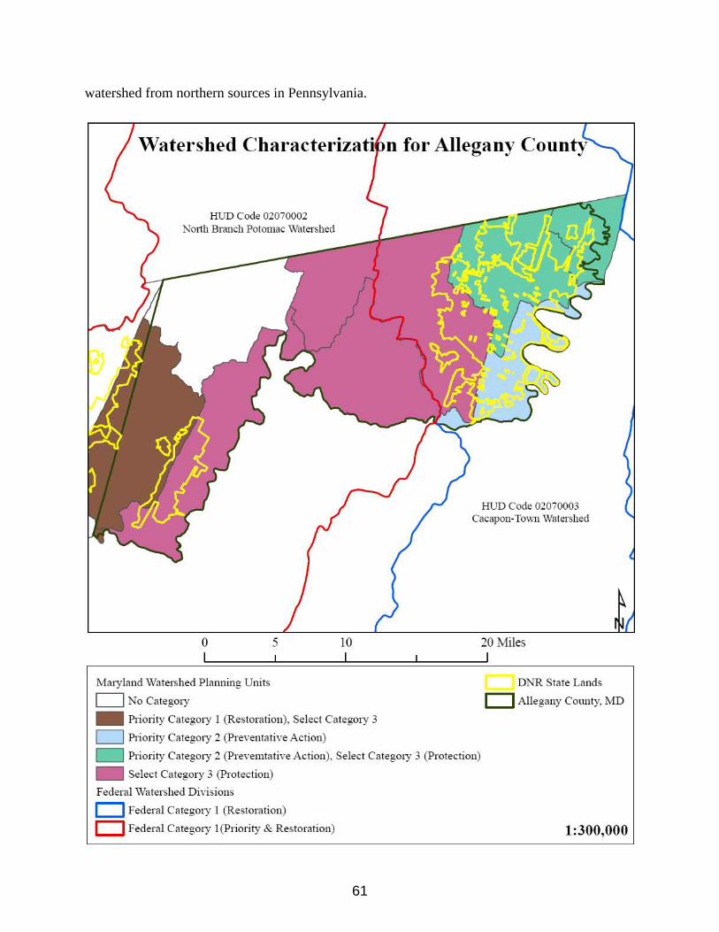
61
watershed from northern sources in Pennsylvania.

62
2.16.1.1 Potential Water Quality Impacts of Forestry Operations Timber operations have the potential to create unacceptable impacts on water quality. The steep topography of the region also increases risk of significant water quality impacts. However, with proper best management practices, these impacts are generally minimal and temporary. See Chapter 5, for additional information on mitigating impacts from forestry operations.

63
Chapter 3 - Resource Characterization
3.1 The ForestsGreen Ridge State Forest is primarily second growth, even-aged oak and pine forests characteristic of xeric upland areas, located in the Appalachian Ridge and Valley Physiographic Province. Green Ridge falls within the rain shadow of the Appalachians and receives the lowest annual rainfall in the state. Tree species include black, white, northern red, scarlet and chestnut oaks. The major pine species are white, Virginia, pitch, table-mountain, and shortleaf. Many other species of trees and shrubs also occur. See Chapter 2 for a more complete list of woody species occurring on Green Ridge State Forest.
The present second growth even-aged forest is the result of widespread timber cutting at the turn of the century and subsequesnt conversion of this land into what the developer, Frederick Mertens, promoted as the “largest apple orchard in the universe”. The resulting forest of primarily 110 year old even-aged stands is the direct result of these early development enterprises.
Following are forest resource characterizations including forest type, size class, and forest productivity for Green Ridge State Forest based on historic CFI data. The summaries in this plan will likely change as the result of the stand level data collection project that is being conducted at the time of writing this plan. This project will likely take five years to complete and this plan will be updated periodically as the new inventory data and analysis is completed.
Forest TypeThe predominant forest type is mixed oak. A type is an association of a forest population of similar species composition that is generally named for the predominant species or group of species within the population. Based on 1987 CFI data, the GRSF is comprised of the following forest types: Mixed Oak (58%), Hardwood/Hard Pine (12%), Hardwood-White Pine (6%), Cove Hardwoods (5%), Mixed Hard Pine (4%), Hemlock/Northern Hardwoods (<1%), Black Locust (<1%), Plantation (<1%), Plantation-Nat. Regen. (10%), and Non Forest (2%).
Forest Size ClassesFollowing is a summary of size class distribution by percent of total forest of Green Ridge State Forest based on the 1992 CFI data:
Size Class Total Forest
64
Seedling/Sapling 10%Poletimber 47%Sawtimber 48%Non-Forest/Other 5%
Forest ProductivityThe most popular measure of forest productivity is site index. Site index is a relationship between age and total height of a tree used as a measure of growing site quality. Following are the three site classes of productivity traditionally used on the western Maryland state forests:
Poor: Site index < 55 for mixed oaksMedium: Site Index 55 to 74 for mixed oaksGood: Site Index 75+ for mixed oaks
Following are the site classes by percent of the Green Ridge forest acreage based on the historic CFI Data:Site Class % GRSF acreagePoor 40%Medium 58%Good 2%
The stand level data collection project currently underway will strive to update these estimates on the forest, create data points for mapping site index on the forest, and split the medium site class into two separate site classes, low and moderate.
3.2 Old Growth ForestOld growth forests have generally been defined as forests in existence since pre-settlement times and lacking any significant Euro-American disturbance. The definition can differ according to climatic and eco-regional perspectives and the growth characteristics of specific native forest systems. In Maryland an old growth forest is defined as a minimum of 5 acres in size with a preponderance of old trees, of which the oldest trees exceeds at least half of the projected maximum attainable age for that species, and that exhibits most of the following characteristics:
1. Shade tolerant species are present in all age/size classes.2. There are randomly distributed canopy gaps.3. There is a high degree of structural diversity characterized by multiple growth layers (canopy, understory trees, shrub, herbaceous, ground layers) that reflect a broad spectrum of ages.4. There is an accumulation of dead wood of varying sizes and stages of decomposition, standing and down, accompanied by decadence in live dominant trees.5. Pit and mound topography can be observed, if the soil conditions permit it.
It is also important to recognize that old-growth forests are not static and may not be a permanent fixture on the landscape. The forests and trees within and around them change continuously. This
65
would be true even if human influence could be eliminated. All forests, including old-growth, succumb to natural, destructive disturbances and regenerate over time. A functional old-growth ecosystem includes the loss of old trees due to natural disturbances and the death of old trees. An old-growth system is not static, nor is it always dominated by old trees. Natural processes dictate the age composition at any time. The important factor in this process is that the trees have the opportunity to reach old age if natural disturbances do not intercede.
Green Ridge State Forest has several very small remnant areas of Old Growth Forest, 14 sites make up approximately 198 acres in total. There are nine additional sites that have been identified as “nearly old growth”. Furthermore there are 11 additional sites that have been identified as potential Old Growth. These sites have not been reviewed by the Old Growth Committee to date. The goal on GRSF is to expand Old Growth Forest by connecting a series of forest stands identified as old growth and/or “nearly old growth forest”. The larger areas identified in this exercise will be mapped as Old Growth Ecosystem Management Areas (OGEMA). This process is fully described in Appendix G “Management Guidelines for the Conservation and Protection of Old-Growth Forest”. Also see Chapter 5 for management guidelines for the identified “nearly old growth forest areas.
3.3 Forest ProductionGreen Ridge State Forest has been managed for industrial forest production for decades, and has been a major contributor to the region’s forest products industry. Multiple small sawmills and two pulpwood-chipping operations provide an outlet for timber from local forests. Green Ridge State Forest makes up about 22.5% of the productive forests in Allegany County.
Table 3.3: Green Ridge State Forest as a % of forest within Allegany County
*Total *Total GRSFGRSF as %
ofGRSF as %
ofCounty Area acres Forest acres acres Total Area Total Forest
Allegany 272,200 211,400 47,560 17.5 22.5%
*Source: USDA Forest Service-Forest Statistics for Maryland: 1986 and 1999
3.4 Non-native Invasive SpeciesMost of the Green Ridge State Forest acreage contains non-native invasive species. This is largely due to the extensive disturbance that occurred in the past. Some of these species were introduced accidentally as a result of import of goods while others have escaped cultivation. Furthermore, some species such as autumn olive and multi-flora rose were introduced and recommended as a conservation plant prior to knowledge of problems associated with non-native invasive species. See chapter 2 for a complete list of non-native plant species present on GRSF. Management of these species will be discussed in chapter 5.
3.5 Water Quality
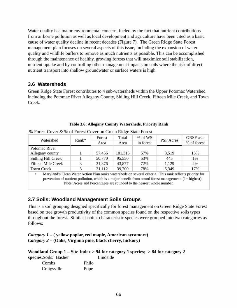
66
Water quality is a major environmental concern, fueled by the fact that nutrient contributions from airborne pollution as well as local development and agriculture have been cited as a basic cause of water quality decline in recent decades (Figure 7). The Green Ridge State Forest management plan focuses on several aspects of this issue, including the expansion of water quality and wildlife buffers to remove as much nutrients as possible. This can be accomplished through the maintenance of healthy, growing forests that will maximize soil stabilization, nutrient uptake and by controlling other management impacts on soils where the risk of direct nutrient transport into shallow groundwater or surface waters is high.
3.6 WatershedsGreen Ridge State Forest contributes to 4 sub-watersheds within the Upper Potomac Watershed including the Potomac River Allegany County, Sidling Hill Creek, Fifteen Mile Creek, and Town Creek.
Table 3.6: Allegany County Watersheds, Priority Rank
% Forest Cover & % of Forest Cover on Green Ridge State Forest
Watershed Rank* Forest Total % of WS PSF Acres GRSF as aArea Area in forest % of forest
Potomac River Allegany county 1 57,456 101,315 57% 8,519 15%Sidling Hill Creek 1 50,770 95,550 53% 445 1%Fifteen Mile Creek 3 31,376 43,877 72% 1,129 4%Town Creek 3 31,112 39,700 78% 5,349 17%
• Maryland’s Clean Water Action Plan ranks watersheds on several criteria. This rank reflects priority for prevention of nutrient pollution, which is a major benefit from sound forest management. (1= highest)
Note: Acres and Percentages are rounded to the nearest whole number.
3.7 Soils: Woodland Management Soils GroupsThis is a soil grouping designed specifically for forest management on Green Ridge State Forest based on tree growth productivity of the common species found on the respective soils types throughout the forest. Similar habitat characteristic species were grouped into two categories as follows:
Category 1 – ( yellow poplar, red maple, American sycamore)Category 2 – (Oaks, Virginia pine, black cherry, hickory) Woodland Group 1 – Site Index > 94 for category 1 species; > 84 for category 2 species.Soils: Basher Lindside
Combs PhiloCraigsville Pope
67
Woodland Group 2 – Site Index 85 – 94 for category 1 species; Site Index 75 – 84 for category 2 species.Soils: Allegheny Robertsville
Atkins TylerHolly Nelse
Woodland Group 3 – Site Index 75 – 84 for category 1 species; Site Index 65 – 74 for category 2 species.Soils: Blairton Ernest Macove
Buchanan Hazleton MonongahelaDownsville Hustotown Sideling
Woodland Group 4 – Site Index 65 – 74 for category 1 species; Site Index 55 – 64 for category 2 species.Soils: Berks Klinesville Weikert
Calvin LehewDekalb Udorthents
Woodland Group 5 – Site Index 55 – 64 for category 1 species; Site Index 45 – 54 for category 2 species.Soils: N/A
Woodland Group 6 – Site Index < 55 for category 1 species; Site Index < 45 for category 2 species.Soils: Rough
Other types without Management Groups – Other map units that are too small, are comprised of minor soil types, or are not suitable for forest management.Soils: Water
Additional information regarding the soils resource characterizations on Green Ridge State Forest can be found in section 2.2 and Appendix D of this plan.
3.8 CompartmentsTo facilitate management planning of the Green Ridge State Forest the forest has been grouped into Compartments. Compartments are maintained in mapping and record keeping because historic inventory data was collected and compiled under the compartment system. Table 3.8 reflects the identification of the 79 Compartments.
Table 3.8: Green Ridge State Forest - Compartments
Compartment # Total Acres1 527
2A 922B 302

68
3 4814 2525 5266 3027 519
8A 1,0798B 509 1,19110 1,08011 58612 66913 45814 78415 80616 79717 1,15618 88519 688
20A 45620B 76421 34722 67223 45724 29325 31626 82527 44528 46629 33230 54331 46932 45033 58434 48435 35936 17637 386
38A 45138B 1,33739 1,23440 57741 43742 25243 61744 36245 448
46A 82746B 34347A 29347B 27948 70949 761

69
50 1,08951 51952 91253 51254 63755 48756 72757 83458 90559 45160 57361 1,19462 52263 47164 67165 61666 75367 1,28568 50469 847
70A 85470B 9771 809
Total Acreage47,250
70
Chapter 4 - Land Management Area Guidelines
4.1 Land Management AreasDue to the diverse landscape of the Green Ridge State Forest, this plan will not make specific prescriptions for each stand. Rather, the planning team identified specific areas based on physical attributes that need to dominate future management decisions.
Figure 4.1 illustrates the sequence of identifying these areas for planning purposes. Beginning on top, the general forest management area is first constrained by identifying the ecologically significant areas where a particular site requires special management attention. This is followed by riparian forest buffers or wetland buffers. Next wildlife habitat areas may need to be established, where a special combination of management recommendations are required by a species or suite of species. Finally, attention must be paid to the visual impact of a practice, considering its location or neighbor concerns. Recommendations for each area have been developed and are listed in this plan and they serve to provide guidelines to field managers, who will need to address each situation on the basis of good inventory, analysis, and planning methods. Additionally these special sites fall into the High Conservation Forest (HCVF) designation, these are areas to be managed and protected because of identified unique conservation values, see chapter 5 for additional information.
4.2 General Forest One of the goals of this project is to maintain an economically sustainable forest and contribute to the local economy through providing forest-related employment and products. Most of this forest area is in even-aged second growth mixed oak and mixed hardwood stands . The general forest area will be managed under the principles of area regulation to achieve sustained yield. Primarily even-aged silvicultural systems and variable retention techniques will be utilized to achieve the resource goals of the general forest area. The management guidelines of the general forest areas are outlined in Chapter 5.
4.3 High Conservation Value ForestsFor the purpose of this Sustainable Forest Management Plan, any reference to High Conservation Value Forest (FSC® Principle 9) should also be interpreted to reference Forests with Exceptional Conservation Value (SFI® Objective 4).
71
Another primary objective of this project is to protect significant or unique natural communities and elements of biological diversity. High Conservation Value Forests (HCVF) were identified on the forest with this objective in mind. The designated HCVF for Green Ridge State Forest include Ecologically Significant Areas & other state protected lands, Old Growth Ecosystem Management Areas, and Forested Riparian Buffers.
4.3.1 Ecologically Significant Areas (ESA) & Other State Protected LandsSites containing rare plant and or animal communities have been identified and managed for their special qualities. The DNR Wildlife & Heritage Service is involved in assuring that special sites are properly inventoried, marked, and managed, and that adequate records are created and maintained for each site. Specific prescriptive management recommendations will be developed for each site by the Natural Heritage Program. A breakdown on the locations and description of the special sites that have been identified on the Green Ridge State Forest can be found in chapter 7. Other State Protected Lands: Most of these areas fall under one or more of the other HCVF layers. These land designations are State designated Heritage Areas, State Wildland Areas, and Wetlands of Special State Concern (WSSC) and Designated Old Growth areas. Many of these sites fall under some type of state protection through legislation.
4.3.2 Old Growth Ecosystem Management Areas (OGEMA)The Old Growth Ecosystem Management Areas include designated old growth, “nearly old growth” and area designated to manage towards Old Growth ecology and function. Specific prescriptive management recommendations within this layer will be under the objective of restoring and/or enhancing Old Growth forest structure and function.
4.3.3 Forested Riparian BuffersRiparian forest buffers and wetland buffers will be maintained according to the guidelines listed in Chapter 6. All management activities within these areas will be designed to protect or improve their ecological functions in protecting or enhancing water quality and/or vital wildlife habitats. The long-term goal is to achieve and maintain functional riparian forest buffers.
4.4 Special Wildlife Habitat AreasThe rich diversity of wildlife species located within Green Ridge State Forest, from endangered to recreational game species, requires the use of a wide array of adaptive management techniques. The objective is to utilize adaptive management to address the ecological needs of this diversity of wildlife species and habitat types.
Unit Habitat Management Plans have been developed and incorporated into this plan to focus on specific species or groups of species the planning team identifies as having a need for adaptive management. The areas managed under these plans are known as Special Wildlife Habitat Areas. The Kirk Orchard Early Succession Habitat Area and the Kasecamp Bottoms Woodcock Habitat Area Plans are examples of unit plans that have been developed and attached to this plan. Chapter 8 outlines the goals and guidelines for wildlife habitat areas. Additional Unit Habitat Management Plans will be developed and incorporated into this plan for the other Special Wildlife Habitat Areas as mapped in the coming years.
72
4.5 Recreation and Cultural Heritage AreasThese are areas that are managed to serve as scenic vistas, public camping areas, designated trails, and other high public use areas. Also included are historic structures or sites, and cemeteries. These sites will be maintained or enhanced. Additional recreation areas may be added as public demand increases. All recreation infrastructure proposals will be evaluated by the Inter-disciplinary Team and the Citizens Advisory Committee to determine if the use is suitable for the resource and sustainable. Chapter 9 outlines the goals and guidelines for these areas.
4.6 Other Non-Forested LandsThese lands, although not fully identified as a particular “area” in the management plan, are estimated to cover about 2% of Green Ridge State Forest. They consist primarily of roads, transmission lines, and abandoned infrastructure. Some of these areas may need to be maintained in non-forest vegetation either to allow management activities on the forest, to meet legal easement requirements, and/or to support wildlife habitat diversity. Control of invading brush, trees and invasive species will be an on-going maintenance issue for these areas. Roads that are not needed for fire or emergency access are considered for closure.
The Other Non-Forested Lands are combined with the Recreation and Cultural Heritage Areas for mapping and management planning purposes.
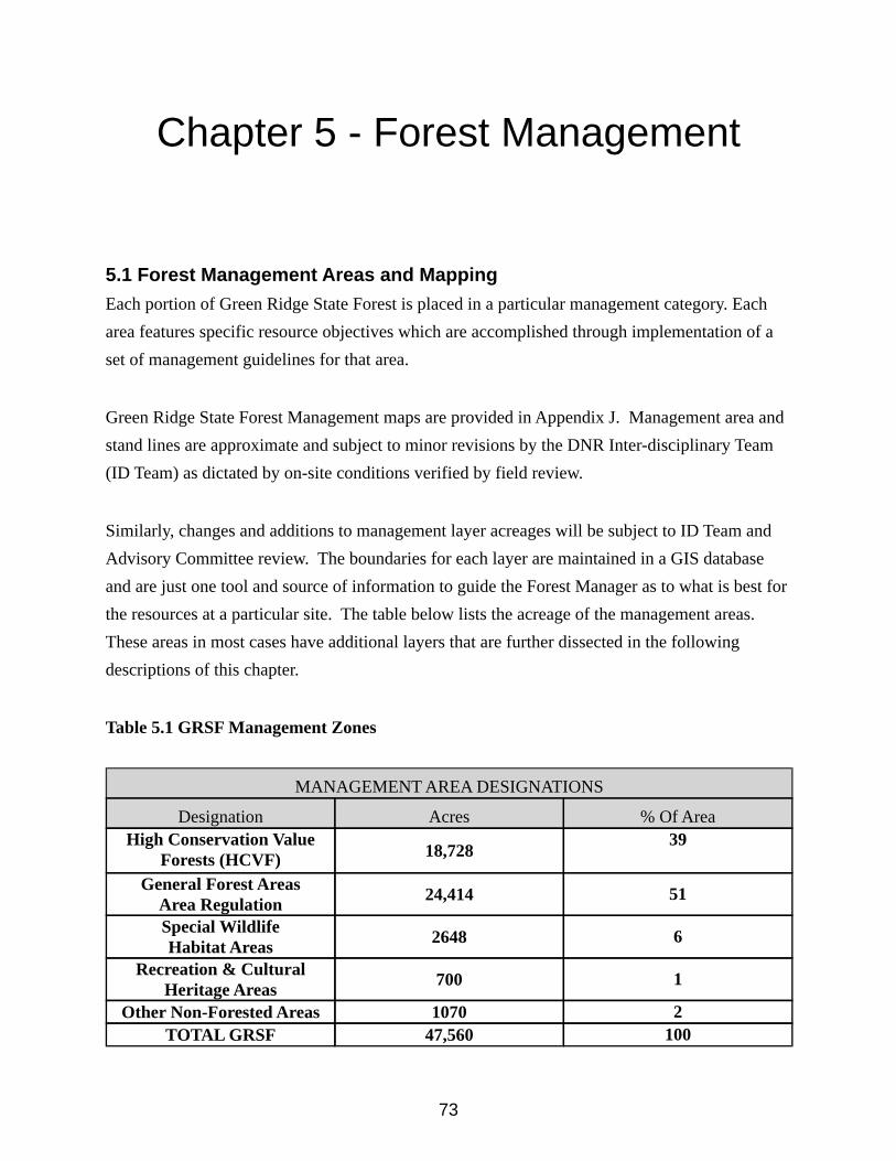
73
Chapter 5 - Forest Management
5.1 Forest Management Areas and MappingEach portion of Green Ridge State Forest is placed in a particular management category. Each area features specific resource objectives which are accomplished through implementation of a set of management guidelines for that area.
Green Ridge State Forest Management maps are provided in Appendix J. Management area and stand lines are approximate and subject to minor revisions by the DNR Inter-disciplinary Team (ID Team) as dictated by on-site conditions verified by field review.
Similarly, changes and additions to management layer acreages will be subject to ID Team and Advisory Committee review. The boundaries for each layer are maintained in a GIS database and are just one tool and source of information to guide the Forest Manager as to what is best for the resources at a particular site. The table below lists the acreage of the management areas. These areas in most cases have additional layers that are further dissected in the following descriptions of this chapter.
Table 5.1 GRSF Management Zones
MANAGEMENT AREA DESIGNATIONS
Designation Acres % Of AreaHigh Conservation Value
Forests (HCVF) 18,728 39
General Forest Areas Area Regulation 24,414 51
Special WildlifeHabitat Areas 2648 6
Recreation & Cultural Heritage Areas 700 1
Other Non-Forested Areas 1070 2TOTAL GRSF 47,560 100
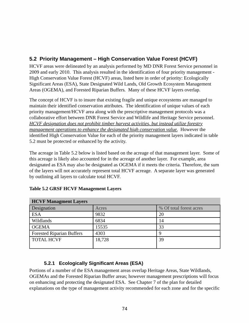
74
5.2 Priority Management – High Conservation Value Forest (HCVF)HCVF areas were delineated by an analysis performed by MD DNR Forest Service personnel in 2009 and early 2010. This analysis resulted in the identification of four priority management - High Conservation Value Forest (HCVF) areas, listed here in order of priority: Ecologically Significant Areas (ESA), State Designated Wild Lands, Old Growth Ecosystem Management Areas (OGEMA), and Forested Riparian Buffers. Many of these HCVF layers overlap.
The concept of HCVF is to insure that existing fragile and unique ecosystems are managed to maintain their identified conservation attributes. The identification of unique values of each priority management/HCVF area along with the prescriptive management protocols was a collaborative effort between DNR Forest Service and Wildlife and Heritage Service personnel. HCVF designation does not prohibit timber harvest activities, but instead utilize forestry management operations to enhance the designated high conservation value. However the identified High Conservation Value for each of the priority management layers indicated in table 5.2 must be protected or enhanced by the activity.
The acreage in Table 5.2 below is listed based on the acreage of that management layer. Some of this acreage is likely also accounted for in the acreage of another layer. For example, area designated as ESA may also be designated as OGEMA if it meets the criteria. Therefore, the sum of the layers will not accurately represent total HCVF acreage. A separate layer was generated by outlining all layers to calculate total HCVF.
Table 5.2 GRSF HCVF Management Layers
HCVF Managment LayersDesignation Acres % Of total forest acresESA 9832 20Wildlands 6834 14OGEMA 15535 33Forested Riparian Buffers 4303 9TOTAL HCVF 18,728 39
5.2.1 Ecologically Significant Areas (ESA)Portions of a number of the ESA management areas overlap Heritage Areas, State Wildlands, OGEMAs and the Forested Riparian Buffer areas; however management prescriptions will focus on enhancing and protecting the designated ESA. See Chapter 7 of the plan for detailed explanations on the type of management activity recommended for each zone and for the specific
75
definition and prescription for each ESA category. ESAs have been designated as High Conservation Value Forest (HCVF).
5.2.2 Other State Protected Lands including WildlandsMost of the land designations listed below fall under some type of state protection through legislation. Most of these areas are overlapped by the other HCVF layers, however some sections are not and as such are listed here as a separate layer. See Chapter 7 for a complete description. State Wildlands: are designated by the Legislature of Maryland as natural areas that are to be left undisturbed by human activity. Therefore, no intensive management is planned for these areas.
Wetlands of Special State Concern (WSSC): These wetlands contain prime examples of unique habitats. No management activities will take place within these areas. There are no WSSC areas present on GRSF.
Old Growth Forest: The few acres of old growth forest known to exist on Green Ridge State Forest will be protected as HCVF and no major activities are planned. The area will be monitored for invasive species, which will be suppressed if found. The management of these areas is further described in the Old Growth Ecosystem Management Areas section below.
5.2.3 Guidelines for Old Growth EcoSystem Management AreasCurrently, old growth forests in Maryland are located in patches that are limited in size, connectivity, and forest vegetation type. To achieve the desired vision of enhancing old growth ecosystem functionality, the current “patch” arrangement of old growth has been developed into a larger, connected “network” of old growth forest across the landscape. On Green Ridge State Forest there are several small patches of Old Growth Forest along with several identified patches of “nearly old growth forest”. In addition there are other isolated sections that have been included in OGEMA mapping that are areas that have been identified by field staff as potential Old Growth. Such identified areas will be inventoried and reviewed by the Old Growth Committee in the future but have already been included in mapping as OGEMA.
“Nearly old-growth forests” are those forests which are approaching old-growth forest status. They exhibit many of the characteristics of an old-growth forest but don’t quite meet all of the criteria of the definition outlined in Appendix H.
Each of the designated Old Growth and “nearly old growth” areas have had a 300 ft. buffer applied to them to protect the unit and to promote extension of old growth forest in the future. The conservation of functional old-growth forest ecosystems is the goal. Simply protecting patches of old-growth forest does not result in a functional old-growth ecosystem. A functional system provides a multitude of values and is the desired outcome of DNR for old-growth forests. While patches of old-growth forest contain essential elements of an old-growth system, DNR will manage old-growth ecosystems in units of approximately 1,000 acres or more whenever practical. Emphasis should be given to those old-growth forests that will most likely become functional old-growth ecosystems. Some old-growth stands will be too isolated to function as an
76
ecosystem and will be protected at the stand level.
The following guidelines are intended to protect old-growth forests while conserving and enhancing the functionality of the forested ecosystem within which the old-growth occurs:
• Designated old-growth forest will be excluded from timber harvest, including salvage, or other physical alterations.
• Designated old-growth forest will be excluded from protection from natural disturbance factors, such as native insect infestations or wild fire, unless such disturbance is introduced by an unnatural cause (e.g., exotic forest pests or invasive species) or will seriously jeopardize the continued existence of the old-growth ecosystem or significant resources adjacent to the old-growth forest.
• Control of the white-tailed deer population will be encouraged to maintain herd size at a level that does not adversely affect regeneration of trees in the understory.
• A no-cut buffer will be established to a width of at least 300 ft from the edge of the designated old growth. This buffer may be expanded based on specific site conditions or threats. The buffer will be excluded from timber harvest or other physical alterations. Any non-forested conditions within the buffer should be reforested, whenever feasible. Salvage harvesting should not occur within this buffer.
• Management zones will be established that includes the old-growth forest(s) and its primary buffer(s). This management zone will be approximately 1,000 acres in size or greater, whenever feasible. This management zone should incorporate as many designated old-growth and nearly old-growth sites as possible. Its shape should minimize edge to area ratio and be as contiguous as possible. Silvicultural treatments within this zone should be techniques that have as their primary objective the fostering of old-growth conditions, and would include practices such as uneven-aged management and limited even-aged management, extended rotations, techniques that more closely mimic the natural disturbances found in old-growth forests, structural complexity enhancement practices, or techniques that result in retention of at least 70% of the canopy trees. Standing snags and downed coarse woody debris will be retained. Any non-forested conditions within the secondary zone should be reforested, whenever feasible. Salvage harvesting is allowable with the retention of at least 33% of dead or dying snags (not damaged live trees) and coarse woody debris. At all times, the majority of the management zone shall be in the sawtimber size class, preferably a minimum of 75%. Areas within the management zone not designated old-growth or nearly old growth at the time of initial assessment/inventory will not necessarily be managed as if they are designated old-growth.
• Nearly old-growth forests within the management zone should be managed as if they were designated old growth. Timber harvest or other alterations will be excluded. Protection of natural disturbance factors, such as insect infestations or wild fire, will be excluded unless such disturbance is introduced by an unnatural cause or seriously jeopardize the continued existence of the old-growth ecosystem or significant resources adjacent to the old-growth forest. Salvage harvesting should not occur within this forest.
• Passive recreational and educational use of old-growth forests and their buffers will be
77
allowed, including hiking and hunting. No trails or roads will be built to access the old growth. Existing trails or roads will be managed to minimize impacts to the old-growth ecosystem or should be retired, whenever feasible. No campfires shall be allowed.
• An aggressive invasive species monitoring, prevention, and control program should be developed and implemented.
On Green Ridge State Forest Old Growth Ecosystem Management areas have been identified and were established in the OGEMA layer in October of 2010. This management area covers a total of 15,535 acres entirely within the boundaries of GRSF. Further field studies by the Forest Service and Wildlife & Heritage Service will be carried out to determine if additional old growth or nearly old growth stands exist within the forest. Once additional areas have been identified they will be inventoried, mapped and buffered per the requirements of the “Management Guidelines for the Conservation and Protection of Old-Growth Forests.” (See Appendix H) Once identified and mapped, these sites will become part of the OGEMA High Conservation Value Forest (HCVF) principle management layer.
5.2.4 Riparian Forest BuffersThe designated stream buffer areas were identified as areas 50 feet from the stream channel of “blue line” streams. Blue line streams are perennial and intermittent streams defined and mapped by the US Geological Survey. This area currently consists of approximately 4303 acres within the GRSF boundary. These forests will be managed to encourage a natural forest community with a combination of diverse herbaceous, mid-story, and over story plants to serve a vital role in watershed protection. The buffers also provide for critical habitats and other functions that enhance water quality. These riparian buffers have been designated as High Conservation Value Forest (HCVF). See Chapter 6 Water Quality Areas: High Conservation Value Forest for specific guidelines on the functions of the various water quality and habitat zones that comprise the stream buffer.
5.3 Special Wildlife Habitat AreasThe wildlife habitat areas will be managed under specific goals and recommendations of Unit Habitat Management Plans which are further described in chapter 8 and the individual habitat plans can be found in Appendix K. Additional Unit Habitat Management Plans may be developed and incorporated into this plan to focus on specific species or groups of species the planning team identifies as having a need for adaptive management. Acreages for the wildlife management areas, and the general forest will be adjusted within this plan as new areas are identified for specific wildlife habitat management.
5.4 Cultural Heritage and Indigenous PeoplesA number of special areas on Green Ridge State Forest have been identified, that require special consideration when developing management prescriptions. Old home sites, research areas and small cemeteries are common throughout the forest. Cultural Heritage Areas may also include historical, cultural or spiritually significant sites for indigenous peoples. Once a site has been identified and located in the field, its location and description are loaded into the forest GIS
78
database. Protection levels can then be assigned and incorporated into the future planning efforts of forest activities. Most Special Management Areas require some form of preservation or protection. Any proposed activity or management within the vicinity of these special areas will be identified and reviewed as part of the Annual Work Plans (AWP) process. Managers are expected to make diligent field inspections to identify additional sites that may currently be located within the other management layers and consider these areas as part of planning whatever work is planned.
Performance measures to judge the adequacy of those plans, and the subsequent management actions, should include:
a) Each identified special area is appropriately marked on the ground and documented in the data set.
b) Each plan is sufficient to protect the special values identified for each area.c) Field examination and monitoring reveals that the plan is being implemented properly
and that the special values are, in fact, protected or enhanced as the plan indicated.
The Department has a commitment to recognize and respect the rights of Indigenous Peoples. It is the mission of The Maryland Commission on Indian Affairs to “promote the awareness and understanding of historical and contemporary American Indian contributions in Maryland.” The role of the State Forest management in promoting this state mission is through the following practices:
a. understand and respect traditional forest-related knowledge;b. identify and protect spiritually, historically, or culturally important sites;c. address the use of non-timber forest products of value to American Indians on state
forests; andd. respond to American Indians’ inquiries and concerns received.
5.5 Recreation Areas
Designated recreation areas are areas managed to serve as scenic vistas, public camping areas, designated trails, and other high public use areas. All management activities within these areas should protect, maintain and/or enhance the areas for the purposes they were designated for. Additional recreation areas may be added as public demand increases. All recreation infrastructure proposals will be evaluated by the Inter-disciplinary Team and the Citizens Advisory Committee to determine if the use is suitable for the resource and sustainable. Chapter 9 includes the goals and guidelines for these areas.
5.6 Other Non-Forested LandsThese lands, although not fully identified as a particular “area” in the management plan, are estimated to cover about 2% of Green Ridge State Forest. They consist primarily of roads, transmission lines, and abandoned infrastructure. Some of these areas may need to be maintained in non-forest vegetation either to allow management activities on the forest, to meet legal
79
easement requirements, and/or to support wildlife habitat diversity. Control of invading brush, trees and invasive species will be an on-going maintenance issue for these areas. Roads that are not needed for fire or emergency access should be considered for closure.
5.7 General Forest Management Area – Area Management Forest Regulation
The general forest area will be managed for sustained yield under adapted principles of area regulation. The principle of area regulation is simple: harvest and regenerate the same number of acres each year or period of years. The number of acres to be harvested each period in order to achieve sustained yield is a function of the total acreage of the management zone and the rotation age. The rotation age is the number of years it takes the forest to develop from time of final harvest to reaching economic maturity. For example, the maximum sustained yield of a 20,000 acre forest with a rotation age of 100 years is to do a final regeneration harvest on 200 acres per year. Furthermore, the forest in this example would be considered fully regulated in one rotation. The previously managed general management zone within GRSF has been managed under this principle for the past forty years which implies that it would be fully regulated in approximately 60 years. The current General Forest Management Area within GRSF will continue to be managed under the principles of area regulation with some adjustment for specific and variable conservation measures such as un-cut buffers and other retention areas.
5.7.1 Managed Area versus Harvest Area Under the general principle of area regulation described above, sustained yield within the GRSF General Forest Management Area would be reached by implementing regeneration harvests on approximately 200 acres per year within this zone. An annual final harvest area of 200 acres would be sustainable within this management area if there were no other conservation factors to consider. However, there are many other conservation variables to be considered within this management area. Therefore the concept of “managed area” has been adopted to allow the forest managers to apply area regulation within the general forest area in a sustainable way, by accounting for both the regenerated acres as well as the retention acres. In other words, the forest manager will propose final harvest regeneration harvests within approximately 200 acres of managed area each year within the general forest area in order to achieve a perpetual and sustainable yield, and age class distribution while preserving and accounting for the other conservation attributes. The annual managed area proposals should also be on area proportional to areas within the Forest Productivity Site Classes described in Chapter 3.1. The area actually harvested will in most cases be less than the 200 acre managed area.
The managed areas for GRSF are identified and mapped by the forest management staff as part of the annual work plan development process. Generally these areas coincide with stand boundaries but may also be dictated by other features such as topography, drainages, roads, and access independent of the original stand lines. Once identified and mapped, a stand level inventory will be conducted to evaluate current regeneration conditions and to identify special features to consider for retention areas. Based on analysis of this inventory, retention areas will be mapped and regeneration harvest prescriptions are created for a proposal. These proposal
80
maps and recommendations will then be submitted with the Annual Work Plan under Silvicultural Projects and go through the review process further described in Chapter 11. Once final adjustments are made and approved the proposal areas are marked and processed as specified in the Western Maryland State Forests Policies and Procedures Handbook.
Forest Retention and Green Tree retention will vary greatly with each managed area and depend heavily on factors such as riparian areas, topography, wildlife habitat features, visual elements and Legacy Trees. In designing final harvest areas on Green Ridge State Forest, it is DNR Forest Service policy to retain an appropriate amount of green tree retention within the managed area. The stated goal is to retain an area of 5 percent or more of the harvested area on all regeneration harvests of 20 acres or greater. This retention area can be in addition to or be contained in riparian forest buffers.
5.7.2 Forest Buffers & Retention AreasExtended Stream BuffersIn addition to the watershed protection provided in the Forested Riparian Buffers Areas, extended buffers will be retained along all perennial and intermittent streams to provide additional watershed protection within the general forest area. These buffers will be identified and marked prior to harvest operations. The standard for these extended buffers is a minimum of fifty feet from the stream channel plus four additional feet of buffer for every one percent slope. For example, a stream channel adjacent to a 35% slope will have a forest buffer retention area width of at least one hundred ninety feet.
Steep SlopesIn general slopes greater than forty percent slope will be retained because it is difficult to harvest these areas with equipment typically deployed in forest harvest operations in this region without causing significant degradation to the site. Specialized harvesting systems may provide opportunity in the future to harvest timber on steeper ground in a sustainable fashion.
Other Forest or Tree Retention
Other elements to be considered and evaluated for retention include wildlife habitat features, visual quality, species diversity, legacy trees, and forest structure.
5.7.3 Regeneration Harvests/Silviculture Systems The primary goal of a final harvest within the general forest area is to facilitate natural regeneration of a new stand with species composition similar to the previous stand. The exception to this is in pioneer stands (such as Virginia pine and black locust), plantations, and stands with a high component of undesirable and/or non native species. In all cases after a final harvest practice, natural regeneration will be the preferred method to re-establish the forest. Determination of the even-aged silviculture system to be used will be based on Silvah Oak regeneration inventory and analysis completed 1-2 years prior to the harvest.
81
The Land Manager is responsible for developing a regeneration strategy outlining what practices will be used with each timber harvest plan, based on the specific conditions involved. Pre- and post- harvest data, as well as establishment surveys and BMP compliance (Best Management Practices) data will be collected and evaluated to measure the success of each regeneration project.
There may be situations where artificial regeneration using some form of site preparation would improve seedling growth and survival. Methods used may include prescribed fire, herbicides, fencing and or other low intensity mechanical prescriptions followed by a combination of natural regeneration and hand planting of seedlings.
Even-Aged Silviculture SystemsSilviculture proposals within the managed areas of the General Forest Zone will typically include adaptive prescriptions that combine clearcutting, shelterwood, or seed tree methods of regeneration with variable retention principles to achieve the diverse forestry management goals within these areas.
Silvicultural Systems are defined as a program for treatment of the stand during an entire rotation. The system is usually named after the regeneration method used.
5.7.3.1 Clearcutting System The clearcutting silvicultural system includes the removal of the mature community over a considerable area at one time to enhance the regeneration of a new even-aged community. This method allows the new seedlings to become established in fully exposed microenvironments. This system favors the regeneration of shade intolerant species and will be used within the General forest area of GRSF where indicators predict adequate stocking of oak and other desirable regeneration exist for establishment of a new stand. Individual clearcuts generally will not exceed 40 acres. Furthermore, all clearcuts 10 acres and greater will include retention of some residual dominant or codominant trees.
5.7.3.2 Shelterwood SystemThe Shelterwood system is an even-aged system where the reproduction method removes the mature community in two or more successive cuttings, temporarily leaving some of the mature trees to serve as a seed source and to protect the regeneration until it becomes established. This method may be used to regenerate stands in the general forest areas that the stocking of desirable regeneration is indicated to be inadequate for establishment. Some of the original stand will be retained until desired stocking of regeneration is established. Once the desired regeneration is established the remainder of the overstory will be removed to promote the productivity of the new developing stand.
5.7.3.3 Seed Tree SystemThe Seed tree system is an even-aged system where the reproduction method removes the mature community in two successive cuts, temporarily leaving only a few widely scattered desirable
82
mature trees to serve as a source of seed. In this method the residual trees serve only as a seed source. Most seed tree cuttings leave only 2-12 seed trees per acre and the seed trees are usually removed once adequate desired regeneration is established.
The seed tree system may be used on stands within the general forest area where regeneration indicators are borderline and/or to promote species diversity. Generally where the seed tree method is used on GRSF, the seed trees will be retained for at least half of the next rotation to provide other forest benefits such as vertical structure, aesthetics, and wildlife habitat.
5.7.3.4 Salvage Harvest & White Pine ReleaseSalvage Harvests will be used to respond to incidents of high mortality in mature stands and decline in pioneer stands such as Virginia pine and black locust. High mortality or decline within mature stands are indicators for the forest managers to focus regeneration and final harvest efforts in these areas within the general forest zone to salvage economic value of the timber while reestablishing a healthy productive growing stock.
Nearly pure Virginia pine stands on GRSF typically developed on recently (since 1935) abandoned fields and other openings. Virginia pine and associated species on these stands are short lived and shallow rooted. They tend to decline significantly by the time they reach seventy years. Typically these stands can be salvaged by removing the over story prior to complete failure and release a younger mixed oak or mixed hardwood cohort to occupy the site.
Salvaging these Virginia pine stands does create a decrease in the conifer component within the Green Ridge State Forest. However, if these stands are not salvaged, they fall out naturally without recruitment of Virginia pine resulting in similar decrease in conifer component. Furthermore, this scenario results in economic loss, damage to the residual younger hardwood growing stock and creates a fuel loading wildfire hazard.
White pine is another native conifer species present on the forest. It is an intermediately shade tolerant species and has a longer life span than Virginia pine. White pine primarily exists in mixed stands and does not typically contain a high component of the dominant overstory density. However, white pine’s intermediate shade tolerance has allowed it to establish recruitment in the understory of some mixed oak stands. GRSF Foresters have used the presence of white pine in the understory of mature mixed oak stands as an indicator to focus management activity for annual work plan harvest proposals. Final harvests in mature mixed oak stands with a high component of white pine will release the white pine component enhancing its growth and development and ultimately increase the conifer component on the forest.
Stand structure and habitat elements differ between Virginia pine and mixed white pine stands but white pine release promotes establishment of many forest structure and wildlife habitat benefits of conifer cover components on the forest.
5.7.3.5 Variable Retention System
83
Variable retention is a relatively new silvicultural system that retains forest structural elements for at least one rotation in order to preserve environmental values associated with structurally complex forests. The variable retention system generally retains at least 15% of the original stand. The variable retention system lends itself well to the “Managed Area” concept adopted as a model for forest regulation within the general forest area of GRSF.
Variable retention at GRSF will often combine the principles and science of the other even-aged silviculture systems above with accommodation for preserving other environmental elements and functions of the forest.
5.7.4 Intermediate Treatments Intermediate treatments of even-aged stands are any silviculture practice that improves stand variables between the stand establishment period and the final harvest. Generally this refers to practices such as cleanings, thinnings, and pruning.
5.7.4.1 Vegetation ControlChemical control of competing vegetation may be used to enhance survival and diameter growth of desired trees. Vegetation control can be done with chemical application with little to no adverse environmental impact if label directions and best management practices are followed. However, the Department will work to minimize the use of chemical control by exploring the use of lower application rates and prescribed burns.
5.7.4.2 re-commercial ThinningPre-commercial thinning in 10 to 40 year old naturally regenerated stands is a form of density control that is useful to concentrate growth on desired stems and to maintain an even distribution of trees across the site and is a practice usually accomplished by hand crews. As additional resources become available for forest management activity, pre-commercial thinning will play a more prevalent role in timber stand improvement.
5.7.4.5 Commercial ThinningCommercial thinning may be performed several times during the rotation of the stand, to extract value at an earlier date while concentrating growth on more desirable, larger diameter stems. Usually by the ages of 40 to 50 years, GRSF stands will yield adequate volume to facilitate a commercial thinning. These thinning operations will produce pulpwood-sized material. The residual stand density target will be at the B level as indicated by the stocking guide for mixed oaks. The B Level is the ultimate stocking for individual tree growth within the population. A second thinning may occur between the ages of 70 to 85 years, to again remove the smaller diameter trees but also produce merchantable sawtimber. Based on management prescriptions for a particular site, any thinning will produce higher quality merchantable sawtimber.
Other commercial thinning may be warranted to respond to mortality within the stands due to natural events such as ice storms and tornado damage or forest pest infestations. Furthermore, commercial thinning may be used to release conifers present in a stand in efforts to promote and increase the conifer composition of the forest. Thinning in these cases are similar to the objectives described above for salvage harvests and white pine release. The fundamental difference is that these practices occur prior to the end of the rotation and final harvest for the
84
stand.
5.7.4.4 Prescribed BurningThe Green Ridge forests were historically shaped by a regime of frequent, low-intensity wildfires. Prescribed fire can re-introduce ecological processes such as seed or seedling release and nutrient cycling that may not be possible in its absence, and can have beneficial effects on forest ecology and wildlife habitat through the re-distribution of nutrients and vegetation. However, prescribed fire is difficult to manage under current regulations and current resources on Green Ridge State Forest and will require careful planning. Land Managers will need to designate areas where significant re-introductions of prescribed fire can be tested and results measured. Implementing these projects can result in training for fire management staff including the use of specialized equipment. All prescribed burning applications will be implemented using smoke management practices. Prescribed burns will not take place if smoke conditions impact sensitive areas such as roads, airports, hospitals, homes, or schools. A prescribed fire should be kept at least 1000 feet from any occupied building, unless otherwise prescribed as necessary for reducing fuel loads. Special areas that might be destroyed or damaged, such as cemeteries, will be protected from burning activities. Fire line construction will follow State BMP’s.
5.7.5 Practice SchedulingField surveys, GIS-based forest and habitat maps and associated databases and forest models such as Remsoft Spatial Woodstock will be the working tools used for the long-range management of the forest and in scheduling harvests and thinning that are listed in the annual work plans (see chapter 10).
5.7.6 Non-Silvicultural Forest Management ActivitiesA variety of activities beyond silvicultural treatments are required to maintain the health and productive capacity of the forest. External property boundary lines will be marked and maintained either by painting and/or posting using approved procedures. This is required to protect the property from inadvertent trespass and to maintain evidence of ownership and management. All exterior boundaries will be maintained by painting on a six year rotation.
Existing roads will be maintained where necessary to provide access to tracts for fire management, management activities, and appropriate recreation. Additional roads may need to be constructed in support of silvicultural operations, but these will be limited and, often, closed after the operation is finished. Wildlife management activities will involve both the protection of existing habitat and the creation of new habitat for a variety of common and rare species (See Chapter 7 & 8).
5.7.6.1 RoadsRoads are important for management and public access. Existing roads and trails will be used and maintained in a manner that minimizes erosion and piled debris along road edges. They should also be maintained to blend with the natural topography and landscape and avoid blockage of drainage systems. While additional permanent roads are not needed on the Green Ridge State Forest, any road construction (even temporary access trails) will follow State BMP guidelines. Care will be taken in constructing logging entrances along public roads and in using public roads during harvesting operations. Damage to roadbeds, shoulders, ditches, culverts, and
85
buffer strips should be avoided and promptly repaired. Roads within Riparian Forest Buffers or Wildlife Areas should be closed and re-seeded where practical. Other roads should be reviewed from time to time, and those not needed for forest or game management purposes or access should be considered for closure.
5.7.6.2 Forest Health
One of the key aspects for maintaining forest health is to keep the forest actively growing and not let the forest stagnate. This can be accomplished by implementing a thinning program that releases selected trees for rapid and vigorous growth. This will improve forest health through reducing plant stress and competition for moisture, light and nutrients. By maintaining actively growing trees that are less likely to be impacted by forest insect or disease infestations. By reducing stand density through thinning and opening up the forest, wildfire intensity will also be reduced and resulting damage to trees will be lessened.
5.7.7 Financial ReturnsThe long-term goals for the general forest areas should provide sustainable economic performance as well as contribute to water quality protection and wildlife habitat enhancement. However, if future policy changes are made to the levels of environmental protection and additional acreage is moved from “General Forest Management” to other management prescriptions, significant impacts on financial returns could result.
Future financial projections will depend on the specific managed areas, their stand condition, amount of retention necessary for preservation of conservation assets and the markets. Yearly harvest acreages are determined through area regulation, retention within managed areas, forest modeling, ecological restoration projects, and wildlife habitat improvement projects. Deviations larger than 10 percent from these acreage targets should be explained in the Annual Work Plan. This should be accompanied by new model outputs indicating that the target is consistent with the goal of long-term sustainability.
Revenue generated from timber other than the general forest should be considered auxiliary funds and should not be considered in the analysis of sustainable long-term economic performance. This is because most forest management practices within HCVF, Wildlife Habitat Areas, and Recreation Areas are planned solely to maintain or enhance their respective conservation values and often are not planned to be perpetuated under a specified rotation. However, auxiliary funds generated within these areas should be considered support for additional restoration, maintenance, or enhancement within the respective land units.
5.8 Forest Harvesting Equipment
When planning a forest harvest, the forest manager should consider the soils, weather, seasonal restrictions, necessary harvesting equipment and other factors that may influence successfully harvesting the site.
86
In-woods equipment used on forest harvest operations may include: whole tree chippers, processors, feller-bunchers, grapple skidders, cable skidders, cut-off saws and forwarders.
Normally, bidding on forest harvest contracts are not restricted or limited by the equipment available to bidders. This is to maintain competitive fairness to all sized operations. However, forest harvest operations are closely monitored by the state forest staff to ensure compliance with the contract and use of Best Management Practices.
If necessary, the state forest manager can restrict the type of machinery required or allowed on the harvest site. The state forest manager has the authority to temporarily close a forest harvest operation if the conditions become too wet to prevent excessive rutting and damaging of forest soils. Seasonal restrictions may apply during late winter and early spring as the frozen soils begin to thaw. Certain sensitive areas may require specialized equipment such as dual-wheeled skidders, high floatation tires or other specialized equipment.
5.9 Chemical Use
No products on the FSC list of Highly Hazardous Pesticides will be used (see FSC-POL-30-001a EN FSC Pesticides policy 2017 or most recent equivalent) unless a derogation has been successfully awarded. The Pesticide Use Tracking Form will be used to document the identification of an area to be treated, the procedures that will be followed and who will be doing the application, including their qualifications.
The FSC Guide: To integrated pest, disease and weed management in FSC certified forests and plantations (FSC Technical Series, No. 2009-001) to be reviewed by the state forest manager and the Core Decision Key, the Pesticide Decision Key and Decision Recording Sheet attached to each pesticide use report with the Decision Recording Sheet having been completed by the state forest staff or contractor.
All pesticides used to control pests and competing vegetation are used only when and where non-chemical management practices are: a) not available; b) prohibitively expensive, taking into account overall environmental and social costs, risks and benefits; c) the only effective means for controlling invasive and exotic species; or d) result in less environmental damage than non-chemical alternatives. If chemicals are used, the forest manager will use the least environmentally damaging formulation and application method practical.
As opportunities are available, the state forest will employ and encourage the creation and maintenance of habitat that discourages pest outbreak; that encourages natural predators; will work with cooperating agencies to evaluation pest populations and control options; the diversification of species composition and structure; use of low impact mechanical methods; use of prescribed fire; and the use of longer rotations.
87
Chemicals and application methods are selected to minimize risk to non-target species and sites under the guidance of cooperating agencies such as Maryland Department of Agriculture and DNR Natural Heritage Program.
Whenever chemicals are used, the Pesticide Use Tracking Form will be used to prepare a written prescription to describe the site-specific hazards and environmental risks, and the precautions that workers will employ to avoid or minimize those hazards and risks, and includes a map of the treatment area.
Chemicals are applied only by appropriately trained and licensed workers according to State requirements.
When chemicals are used, the effects are monitored and the results are used to determine the measure of success and if treatment modifications can be employed, such as reduced application rates. Records are kept according to State requirements.
5.10 Forest Modeling
5.10.1 Modeling Long-term SustainabilityAchieving the goal of a sustainable and economically self-sufficient forest creates the need for forward projections that illustrate the probable effect of management activities on key forest qualities. This requires the identification of indicators that can be tracked over time to determine trends and relationships. Tracking requires that each indicator can be measured, monitored, or modeled in a consistent and feasible manner. A simple model of long-term sustainability of forest products on the general forest area within Green Ridge State Forest is established by the area regulation principle applied to the “managed areas” strategy of even-aged silviculture.
5.10.2 The Indicators
At this stage, the forest managers have identified the following indicators (others may be added as the ability to track them becomes available):
• The amount of acreage within the general forest area;
• Annual managed areas with final harvest proposals do not exceed 1% of general forest area acreage.
• The age and species composition of the harvest areas within the managed areas;
• The maintenance of a generally stable flow of economic opportunities (jobs, timber sales, etc.) from the forest; and,
• The generation & maintenance of stable economic flows back to the state and counties.
An additional indicator that will be added when the stand data collection project is completed is that annual managed area proposals within the general forest area will be proportional to the acreage of the four site classes of forest productivity ( see Chapter 3.1).
88
5.10.3 The Forest Planning ModelThe Maryland DNR Forest Service and Vision Forestry (the contract land manager) studied available forest modeling systems and ultimately chose the Remsoft Spatial Woodstock model for development of long-term projections on the Chesapeake Forest. For consistency, Remsoft will be employed for modeling on Green Ridge State Forest. Information on the model is available at www.remsoft.com.
Spatial Woodstock will need to be integrated with the Green Ridge State Forest Geographic Information System so that a single master database can be maintained to serve ongoing forest planning, management, and information needs.
Modeling Green Ridge State Forest requires that the forest be divided into discrete areas (called stands) that are sections of forest with characteristics that make them identifiable as a unit. These characteristics typically include similar soils, species composition, age, and stand structure. Priority Management Areas (Chapter 5) must also be identified.
To date, the stands have been delineated and mapped as well as the priority management areas. A stand level data collection project is currently underway to collect data for these stands that will be maintained in the GIS database and used for running the Remsoft Spatial Woodstock model.
5.11 Inventory and MonitoringA high quality inventory and monitoring program that is linked to a GIS-based data management system is the key to a successful adaptive management program. It is, however, one of the often-neglected or under-funded parts of a land management program. This plan’s successful implementation rests on the capacity of the Department to find the resources needed to support the necessary monitoring program across all the areas listed below (See Chapter 10 – Green Ridge State Forest Monitoring Plan). An inventory and monitoring program is also one of the important aspects of the Forest Certification program (See Forest Certification below).
The Land Manager is responsible for developing and maintaining an interactive data collection and management system to facilitate field management as well as document activities, results, yields, etc., to provide data input to the planning models. A statistically valid and multi-tiered sampling procedure has been developed to provide data on growth rates, yield response to management practices such as thinnings, and associated environmental impacts such as water quality or habitat changes.
Monitoring for forest sustainability will require attention to the parameters listed in Chapter 1. That will require monitoring of:
• Biodiversity– information is needed that ties species or suites of species to particular areas, soil types, or vegetative structural conditions so that trends can be predicted under various management options and population or species increases or declines can be detected.
89
• Water quality, particularly as it relates to nutrient and sediment loads that can be attributed to specific forest management practices.• Ecologically Significant Areas – an updated inventory of special areas, by type, location, and condition should be maintained to assure that none are being adversely affected by forest management activities.• Economic performance – Data for long-term trend analysis, as well as quarterly reporting, should be developed and maintained.
5.11.1 Water Quality Monitoring Due to the special attention on water quality in the Chesapeake Bay, and the need to document more clearly how commercial forest management affects water quality, Green Ridge State Forest can serve as a living laboratory for those interested in this particular field of study. Independent third-party partners such as Universities and non-profit organizations like the Chesapeake Bay Foundation are welcome to pursue a monitoring scheme, conduct research, and utilize the management actions on the land as an ongoing scientific experiment. Currently there is a volunteer based organization known as the Allegany Stream Keepers that routinely measure water quality parameters on local streams to monitor water quality over time. The West Virginia University is beginning a long-term watershed study to monitor two second order stream watersheds on Green Ridge State Forest to better understand water cycles in forested watersheds of the ridge and valley province and ultimately measure effects of silviculture practices on these watersheds.
5.11.2 Timber Harvests For Green Ridge State Forest, the forestry staff will ensure that for each harvest operation a pre-harvest plan is developed and a post harvest BMP inspection report is prepared and maintained on file. An important aspect to protect water quality on timber harvest sites is to insure a certified Master Logger carries out the harvest operation. Green Ridge State Forest was one of seven State Land sites included in a study of BMP implementation conducted in 2004 and 2005 as part of developing a Northeastern Area Regional BMP Assessment Protocol. The study revealed that statewide, sediment movement into water courses was avoided on 81% of the sites. The study was conducted by an independent contractor, Sustainable Solutions, LLC, and funded by the USDA Forest Service Northeastern Area State and Private Forestry.
5.12 Forest CertificationA primary objective of Green Ridge State Forest (and all Maryland State Forests) is to become a national model of certified sustainable forestry. The goal is to achieve dual certification under both the Sustainable Forestry Initiative (SFI) standard and the Forest Stewardship Council (FSC) standard. The initial certification evaluation for GRSF occurred in the Spring of 2011. Compliance with certification is monitored through annual audits. See Appendix: B & C for details on the two certification programs.
5.12.1 Certification Guidelines PremiseIt is the Department’s belief that an independent review and certification of all state forest management plans and practices has the potential to improve the management of the forest and
90
build public confidence in the quality of that management.
The initial thrust of the combined SFI/SFC certification process was begun on the Chesapeake Forest Lands which received dual certification in June 2004 and Pocomoke State Forest received this designation in the spring of 2009. As stated above, the initial certification evaluation for GRSF was completed in the Spring of 2011. As part of the process of maintaining dual certification, follow-up annual audits/inspections will continue, following the initial granting of certification. An annual Senior Management Review will also be conducted, as per SFI requirements (see “Appendix F – Policy for SFI Management Review and Continual Improvement”). The Maryland DNR Forest Service remains committed to resolve any audit issues that hinder it in obtaining and or maintaining SFI/FSC certification.
5.13 Forest Stewardship Council (FSC) – Guidelines & Principles
5.13.1 Invasive Plant Species ControlA detailed invasive plant species control plan will be developed in conjunction with the Wildlife and Heritage Service. In the meantime stands that are being proposed for management activities will be examined for invasive species and control action will be taken prior to any treatment. Priority will be given to invasives that actively inhibit ecosystem function and/or silvical response. Site locations will be mapped and incorporated into the GIS database. Treatment recommendations will be researched, assigned, and monitored for effectiveness.
Invasive species that occupy a large area may need to be addressed through the ID Team field review process. However, specific techniques and control measures will be timed to the biology of the individual invasive plant species in order to maximize control efficacy and minimize spread and propagule production.
5.13.2 High Conservation Value Forest (HCVF) Definition GuidelinesFour of the six types of High Conservation Value Forests as identified within FSC Principle 9 will constitute the definition for HCVF on Green Ridge State Forest. They are:
• (HCV1) Forest areas containing globally, regionally or nationally significant concentrations of biodiversity values (e.g. endangered species on GRSF are designated Ecologically Sensitive Areas).
• (HCV2) Forest areas containing globally, regionally, or nationally significant large landscape level forests (e.g. Wildlands, Old Growth Ecosystem Management Areas )
• (HCV3) Forest areas that are in or contain rare, threatened or endangered ecosystems. (old growth forest, Shale Barren ESAs)
• (HCV4) Forest areas that provide basic services of nature in critical situations (e.g. watershed protection, Riparian Forest Buffers, areas within 50 feet of blue line streams).
Refer to FSC Principle #9 (HCVF) in Appendix B.
91
5.13.3 Representative Samples of Existing Ecosystems Representative Sample Areas (RSAs) are established on the forest for the purpose of establishing and/or maintaining an ecological reference condition; or to create or maintain an under-represented ecological condition; or to serve as a set of protected areas or refugia for species, communities and community types not captured in the High Conservation Value Forests. RSAs have been designated on Green Ridge State Forest and are protected in their natural state. Most of the GRSF RSAs have been included in mapping as they are designated as HCVF. However, additional RSAs will be designated and mapped to address above criterion not already established within the High Conservation Value Forests.
Most RSAs will be fixed in location. However, others may move across the landscape as natural forest succession condition changes. Furthermore, some RSAs may be manipulated to maintain the desired condition.
5.14 Practice Scheduling – Annual Work Plans (AWP)Field surveys, GIS-based forest and habitat maps and associated databases and forest models such as Remsoft Spatial Woodstock will be the working tools used for the long-range management of the forest and in scheduling harvests and thinning that are listed in the annual work plans (See Chapter 10). Annual Work Plans (AWP) will list all management & restoration activities slated to occur on the Forest during each fiscal year. Annual Work Plans are posted on the DNR website for each state forest.
92
Chapter 6 - Water Quality Areas: Riparian Forest Buffers and Wetlands
6.1 IntroductionWater quality areas are dominated by land-water relationships. They include streamside forests, stream banks, flood plains, wetlands, and other areas that are the contact points between land and water. Their management is critical to not only preventing water pollution, but to cleaning up water through the filtering of sediments, uptake of nutrients, and stabilization of water temperature and flow conditions. In addition, these areas are some of the most biologically rich portions of the landscape, functioning as habitat for the widest variety of plants and animals, both aquatic and terrestrial. It is becoming generally recognized that riparian areas and wetlands are key to many biodiversity issues. It’s for these reasons that these areas have been designated as High Conservation Value Forest (HCVF). The identification and maintenance of High Conservation Value Forest fall under Principle 9 of the Forest Stewardship Council (FSC) guidelines see appendix “B & C” for information on this certification program.
There are approximately 4303 acres of riparian forests that extend throughout the Green Ridge State Forest as they are defined as areas within fifty feet of all USGS blue-lined streams.
By and large, the management of these areas relies primarily on natural processes, such as natural establishment and succession. Management activities within these areas will be designed to maintain or improve the ecological functioning of the forest, and stream systems. Any timber or fiber production from these lands will be ancillary to other management needs.
6.2 Riparian Forest Buffers: High Conservation Value Forest (HCVF)The primary goal of HCVF riparian forest buffers is to provide basic services of nature in critical situations such as maintaining and improving the quality of water flowing into the streams and rivers and eventually to the Chesapeake Bay from Green Ridge State Forest. Riparian forests also provide critical habitat that is an essential element of the associated aquatic ecosystem and the diversity of wildlife that utilizes riparian areas. Therefore, the management goals for riparian forest buffers are:
1) To remove sediments, nutrients, and other potential pollutants from surface and groundwater flows;
2) To maintain shade cover for streams and aquatic systems to regulate temperature and dissolved oxygen;
3) To provide a source of detritus and woody debris for aquatic systems;
93
4) To provide riparian habitat and travel corridors for wildlife; and,5) To maintain or establish native plant communities.6) To allow these areas to revert into Old Growth Forest.
In order to achieve these goals, the following management objectives will be used as criteria to more specifically evaluate and design potential management activities:
1) Minimize disturbance to soil structure or duff layer;2) Avoid exposed mineral soils;3) Prevent all rills, gullies, or ruts that may channel water flow and short circuit surface flow
paths;4) Protect mixed hardwood or mixed hardwood/conifer forest community;5) Maintain mature forest conditions adjacent to stream; and,6) Encourage the development of a diverse uneven age forest community in terms of
species, canopy levels, and diameter class.
6.2.1 Riparian Forest Buffer Delineation for High Conservation Value Forest Defined
Riparian forest buffer establishment and layout on Green Ridge State Forest extends 50 feet from the edge of all blue line streams as indicated on the USGS maps. These buffers will provide nutrient uptake for water quality; increased mature forest habitat for wildlife, and wildlife travel corridors. They will be managed for the creation and maintenance of mature natural forests. These areas have been identified as High Conservation Value Forest (HCVF) and will be managed to protect and maintain their important role in improving water quality as it affects the Potomac River Watershed and the Chesapeake Bay.
Riparian Forest Buffer Delineation for High Conservation Value Forest on Green Ridge State Forest was a GIS mapping exercise generating a layer including all GRSF lands within 50 feet of blue lined streams. In cases where the stream meanders off the property boundary of a Green Ridge State Forest, the best that can be done is to establish and manage the state owned riparian forest and attempt to encourage the adjacent landowners to take similar measures.
6.2.2 Stand CompositionRiparian forests will be managed to encourage a mixed hardwood or mixed hardwood/conifer community with a combination of diverse herbaceous, mid-story, and over story plants. Hardwood species will be encouraged to ensure maximum functions for denitrification, canopy diversity, woody debris, and nutrient uptake. Diversity in species and forest structure will be encouraged as a strategy to maintain forest function and resilience in the event of a major disturbance or new pest or pathogen; many pests or pathogens are limited to certain types of species or tree condition, and disturbances such as windstorms or fire can affect different species to varying extents.
6.2.3 Vegetation ManagementAny vegetation management must be designed to improve the ecological functioning of the riparian forest and stream system according to management goals and objectives. If a silvicultural treatment or management prescription is conducted, it should be limited to
94
addressing management concerns to improve or ensure the health of the riparian forest or adjacent stands. Such concerns include insects, disease, fire, wind throw, ice damage, threatened and endangered species, critical habitat, native plant communities, invasive/exotic species, hazard fuel reduction and prescribed burning. There will be no planned clear cuts conducted within a riparian forest area. Any management activities will use the least impacting equipment; following best management practices (BMPs) and comply with all state and local regulations.
6.2.4 RoadsRoads should avoid riparian forests to the maximum extent possible and any existing roads within riparian forests should be evaluated for closure. If road construction is necessary in a riparian forest, all related BMP's for road construction should be followed including:
1) Perpendicular alignment to riparian forest to minimize impact2) Utilizing temporary stream crossings when possible3) Adequate sizing of crossing to avoid affecting flow4) Discarding slash and debris from right-of-way clearing outside of stream area.
6.2.5 Herbicide UseAerial application of herbicides is not permitted within riparian forests. If aerial spraying is planned for stands adjacent to a riparian forest, the riparian forest must be clearly designated and GPS-established to protect the riparian forest from application or drift. Chemical applications within riparian forests will only be permitted for purposes of improving the ecological functioning of the riparian forest for its management goals and will be limited to spot applications and direct application to the target plant.
6.3 Green Ridge State Forest WetlandsEcologically, wetlands are defined as areas that are saturated or inundated enough to influence soil characteristics and to support a wetland plant community. Under this definition, there are few acres of wetlands on Green Ridge State Forest due to the topography, natural drainage patterns, and low precipitation. Therefore, most of the forested wetlands are contained within stream buffers.
However, some other small wetland areas may be present within the Green Ridge State Forest created by springs and or man-made impoundments. Wetland Management guidelines will include delineated wetlands, vernal pools and abandoned impoundments. Wetland management guidelines will include wetland buffers to protect the wetland and to provide upland habitat for amphibians. This buffer will need to be established in the field as the wetlands are identified and mapped. Many of these wetlands will also be designated as HCVF. All management proposal maps that include wetlands, pools, or impoundments will be considered by the ID Team during the annual review to discern specific protection for the water feature and surrounding habitat. All State and Federally designated wetlands and significant vernal pools will be managed under the following guidelines.
6.3.1 The Management Goals of wetland areas will be as follows:1) Provide high quality wetland systems including associated upland ecotones
95
2) Maintain or enhance any unique biological communities that may be present3) Maintain or restore hydrologic and water quality functions of wetlands, including flood
storage, groundwater recharge, denitrification, nutrient uptake, and sedimentation4) Maintain or establish a native wetland plant community
In order to achieve these goals, the following management objectives will be used as criteria to more specifically evaluate and design potential management activities:
1) Minimize disturbance to soil structure or removal of duff layer2) Encourage development or maintenance of a native wetland plant community
6.3.2 Vegetation ManagementWithin wetland areas, management activities should encourage the establishment of native wetland plant communities. Within the wetland buffer, management activities should encourage a healthy forest with a diversity of species, canopy levels, and diameter classes. Any vegetation management must be designed to improve the ecological functioning of the wetland system according to management goals and objectives. There should be no planned clear cuts conducted within a wetland area unless needed to re-establish or favor native wetland species. (An example of this would be the removal of over story canopy to improve American woodcock habitat) If a silvicultural treatment or management prescription is conducted, it should be limited to addressing management concerns that threaten the health of the wetland, the wetland buffer, or adjacent stands. Such concerns include insects, disease, fire, wind throw, ice damage, threatened and endangered species, critical habitat, native plant communities, invasive/exotic species, hazard fuel reduction and prescribed burning. Any management activities should use the least impacting equipment, follow best management practices (BMP’s) and comply with all state and local regulations.
6.3.3 Stand CompositionWithin wetland areas and wetland buffers, emphasis will be placed on maintaining and encouraging a diverse community of native wetland plants. Particular emphasis will be placed on maintaining any unique biological communities present at a site. In forested wetland areas and buffers, emphasis will be on maintaining or encouraging native species to maximize denitrification and to provide leaf litter and woody debris as food and cover for aquatic wildlife.
6.3.4 Herbicide UseAerial application of herbicides will not be done within wetlands. If aerial spraying is planned for stands adjacent to a designated wetland, the wetland must be clearly designated and GPS-established to protect the riparian forest from application or drift. Chemical applications within wetlands will only be permitted for purposes of improving the ecological functioning of the wetland to meet management goals and will be limited to spot applications and direct application to the target plant of products approved for aquatic application to the target plant.
6.3.5 RoadsRoads should avoid wetland areas and wetland buffers to the maximum extent possible, and any existing roads within wetland areas should be evaluated for closure. If road construction is necessary in a wetland area, all related BMP's for road construction must be followed including:
96
1) Align to minimize impact;2) Discard slash and debris from right-of-way clearing outside of wetland areas; and, 3) Avoid impacts to wetland hydrology.
6.4 Significant Vernal Pools Vernal pools are defined by the MD Nontidal Wetland Protection Act (Annotated Code of Maryland §8-1201) and associated regulations (COMAR 26.23.01.01) as a nontidal wetland in a confined depression that has surface water for at least 2 consecutive months during the growing season and:
a) Is free of adult fish populations;b) Provides habitat for amphibians; andc) Lacks abundant herbaceous vegetation.
The Maryland Wildlife Diversity Conservation Plan (MD DNR 2005) defines vernal pools as small, nontidal palustrine forested wetlands with a well-defined, discrete basin and the lack of a permanent, above ground outlet. The basin overlies a clay hardpan or some other impermeable soil or rock layer that impedes drainage. As the water table rises in fall and winter, the basin fills, forming a shallow pool. By spring, the pool typically reaches maximum depth following snowmelt and the onset of spring rains. By mid-late summer, the pool usually dries up completely, although some surface water may persist in relatively deep basins, especially in years with above average precipitation. This periodic, seasonal drying prevents fish populations from becoming established, an important biotic feature of vernal pools. Many species of plants and animals have evolved to use these temporary, fish-free wetlands. Some are obligate vernal pools species, so called because they require a vernal pool to complete all or part of their life cycle. While we typically associate vernal pools with forested habitats, they can also occur in other landscape settings, both vegetated and unvegetated (Calhoun and deMaynadier 2004), such as meadows, pastures, clearcuts, and agricultural fields.
Vernal pool basin substrate typically consists of dense mats of submerged leaf litter and scattered, coarse woody debris. During dry periods the presence of a vernal pool is often denoted by blackened leaf litter, a sign of seasonally anaerobic conditions, and stained tree trunks. Herbaceous vegetation is usually absent to sparse in and around the basin, although small sphagnum patches may occur along the basin edge. A dense shrub layer may occur along the shoreline or in small patches within the basin (MD DNR 2005).
A statewide vernal pool mapping exercise was conducted in GIS during preparation of the Maryland Wildlife Diversity Conservation Plan (MD DNR 2005). All palustrine wetlands (emergent, scrub-shrub, and forested) with NWI water regime modifiers of temporarily flooded, seasonally flooded, seasonally flooded/saturated, saturated, and semi-permanently flooded (beaver) were included (Cowardin et al. 1979). A concerted effort is still needed to ground-truth the existing map and to survey for significant vernal pools that have been missed. Presence of obligate and certain facultative vernal pool species could also be used to help identify these
97
wetlands. Calhoun and deMaynadier (2004) used the following NWI wetland classification codes to initially screen for potential vernal pools: PUB/POW (open water), PSS (scrub shrub), PFO (forested wetland), and PEM (emergent wetland), though the latter were less likely to be vernal pools due abundant herbaceous vegetation. A GIS vernal pool mapping exercise should be conducted that is a combination of methods used by the 2005 DNR effort and those of Calhoun and deMaynadier (2004).
Many states have developed vernal pool certification programs with criteria for determining “in the field” whether a wetland is truly a vernal pool. Based on these and other sources, it is recommended that the following criteria be adopted for use in determining a significant vernal pool on Green Ridge State Forest. The first 3 criteria must be met, # 4 must be met if there are no obligate species present, and either criteria 5 or 6:
1) A depression confined to a relatively small area with no permanent above ground outlet (look for blackened leaves and staining on trees);
2) Presence of surface water for ≥ 2 months during the growing season (pond depth is usually at its maximum just prior to tree leaf out);
3) Lack of herbaceous vegetation or it is limited to the basin edges, typically sparse (<50% cover), with or without sphagnum moss;
4) Lack of established and reproducing fish population(s);5) Evidence of breeding obligate or indicator vernal pool species (require a vernal pool to
complete all or part of their life cycle). On the lower Delmarva Peninsula these include 5 amphibians and a crustacean group, the fairy shrimp (at least 4 species in the Order Anostraca; Brown and Jung 2005). Amphibians include marbled salamander (Ambystoma opacum), spotted salamander (A. maculatum), eastern tiger salamander (A. t. tigrinum. state endangered), wood frog (Lithobates sylvaticus), and eastern spadefoot (Scaphiopus holbrookii). Eggs, egg masses, larvae, transforming individuals, juveniles, and adults all would serve as positive evidence of a significant vernal pool.
6) The presence of rare or state-listed facultative vernal pool species. Facultative species are vertebrate and invertebrate species that frequently use vernal pools for all or a portion of their life cycle, but are able to successfully complete their life cycle in other types of wetlands. They serve as indirect indicators of vernal pool habitat. On the lower Delmarva Peninsula facultative species include 16 amphibians, 1 reptile, and 17 invertebrates (Brown and Jung 2005), However only 3 of these, all amphibians, are rare or state-listed: barking treefrog (Hyla gratiosa; state endangered), eastern narrow-mouthed toad (Gastrophryne carolinensis; state endangered), and carpenter frog (L. virgatipes; watchlist). Eggs, egg masses, larvae, transforming individuals, juveniles, and adults all would serve as positive evidence of a significant vernal pool.
Identifying and mapping all significant vernal pools on Green ridge State Forest is a daunting task that will require both a concerted well-funded effort for GIS mapping and ground-truthing, plus opportunistic data collection by DNR Forestry staff, consultants, and other DNR staff and partners. Brown and Jung (2005) as well as the Vernal Pool Association’s website (www.vernalpool.org) should be used as primary references. A data sheet has been developed for these opportunistic surveys (see Appendix) based on the MD Vernal Pool Task Force draft 2008
98
datasheets.
6.4.1 Vernal Pool Conservation and Management Prescriptions Due to their complex bi-phasic life history, vernal pool breeding amphibians are biologically linked to both their aquatic breeding habitat and terrestrial habitat in which they forage, aestivate, and hibernate. Their population dynamics also are dependent on landscape connectivity as they operate as metapopulations. Major threats include anthropogenic destruction and alteration of their aquatic and terrestrial habitats. Management strategies require conservation of a diversity of wetland habitats that vary in hydroperiod and their surrounding terrestrial habitats (Semlitsch 2003). Semlitsch (1998) concluded that a buffer zone encompassing 95% of pond-breeding salamander populations would need to extend 534 feet from the wetland edge.
Semlitsch and Bodie (2003) observed that the 50-100 foot buffers used to protect wetlands in most states were inadequate for amphibians and reptiles. They summarized results of 40 papers describing biologically relevant core habitats surrounding wetland breeding sites and recommended that 3 conservation zones be established around amphibian breeding ponds. Zone 1 was the wetland and an Aquatic Buffer that extended 100-200 feet from the wetland edge. Zone 2 was the Core Habitat which extended 465-950 feet from the wetland edge. Zone 3 was a Terrestrial Buffer for Core Habitat and extended 165 feet from Zone 2. At a minimum these 3 zones comprise 630 feet and >1100 feet at the maximum. However, Semlitsch and Bodie (2003) did not make recommendations on what activities could occur in these areas only that managers needed to be aware that these were biologically relevant buffers.
Calhoun and deMaynadier (2004) also recommended 3 conservation zones. Zone 1 was the Vernal Pool Depression in which no disturbance should be allowed. Zone 2 was the Vernal Pool Protection Zone, a 100 foot buffer around the vernal pool in which limited timber harvesting could be allowed but only if >75% canopy cover was maintained, harvest occurred only when the ground was frozen or dry, heavy machinery use was minimized, and abundant coarse woody debris was retained. Zone 3, or the Amphibian Life Zone was a 400 foot wide buffer from Zone 2 (extends to 500 feet from vernal pool) in which partial timber harvest could occur, but only if >50% of the canopy was maintained, no openings >1 acre were made, harvest occurred only when the ground was frozen or dry, and abundant coarse woody debris was retained.
Semlitsch et al. (2009) concluded that removal of only a portion of the canopy (≤50%) minimized negative impacts to amphibians associated with select harvests and clearcuts. They noted trade-offs between either harvest method and that clearcuts should be small (<5 acres) and only used when remaining habitat was high-quality for amphibians.
Based on these papers and mindful of the need to balance conservation with sustainable forestry, the following conservation and management prescriptions are recommended for mapped significant vernal pools on Pocomoke State Forest and Chesapeake Forest:
Zone 1: includes the significant vernal pool and extends into terrestrial habitat to 100 feet from the high-water mark. This will be called the Amphibian Protection Zone (Fig. 2).
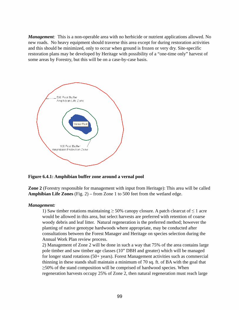
99
Management: This is a non-operable area with no herbicide or nutrient applications allowed. No new roads. No heavy equipment should traverse this area except for during restoration activities and this should be minimized, only to occur when ground is frozen or very dry. Site-specific restoration plans may be developed by Heritage with possibility of a “one-time only” harvest of some areas by Forestry, but this will be on a case-by-case basis.
Figure 6.4.1: Amphibian buffer zone around a vernal pool
Zone 2 (Forestry responsible for management with input from Heritage): This area will be called Amphibian Life Zones (Fig. 2) – from Zone 1 to 500 feet from the wetland edge.
Management:1) Saw timber rotations maintaining ! 50% canopy closure. A patch clearcut of " 1 acre would be allowed in this area, but select harvests are preferred with retention of coarse woody debris and leaf litter. Natural regeneration is the preferred method; however the planting of native genotype hardwoods where appropriate, may be conducted after consultations between the Forest Manager and Heritage on species selection during the Annual Work Plan review process. 2) Management of Zone 2 will be done in such a way that 75% of the area contains large pole timber and saw timber age classes (10” DBH and greater) which will be managed for longer stand rotations (50+ years). Forest Management activities such as commercial thinning in these stands shall maintain a minimum of 70 sq. ft. of BA with the goal that !50% of the stand composition will be comprised of hardwood species. When regeneration harvests occupy 25% of Zone 2, then natural regeneration must reach large
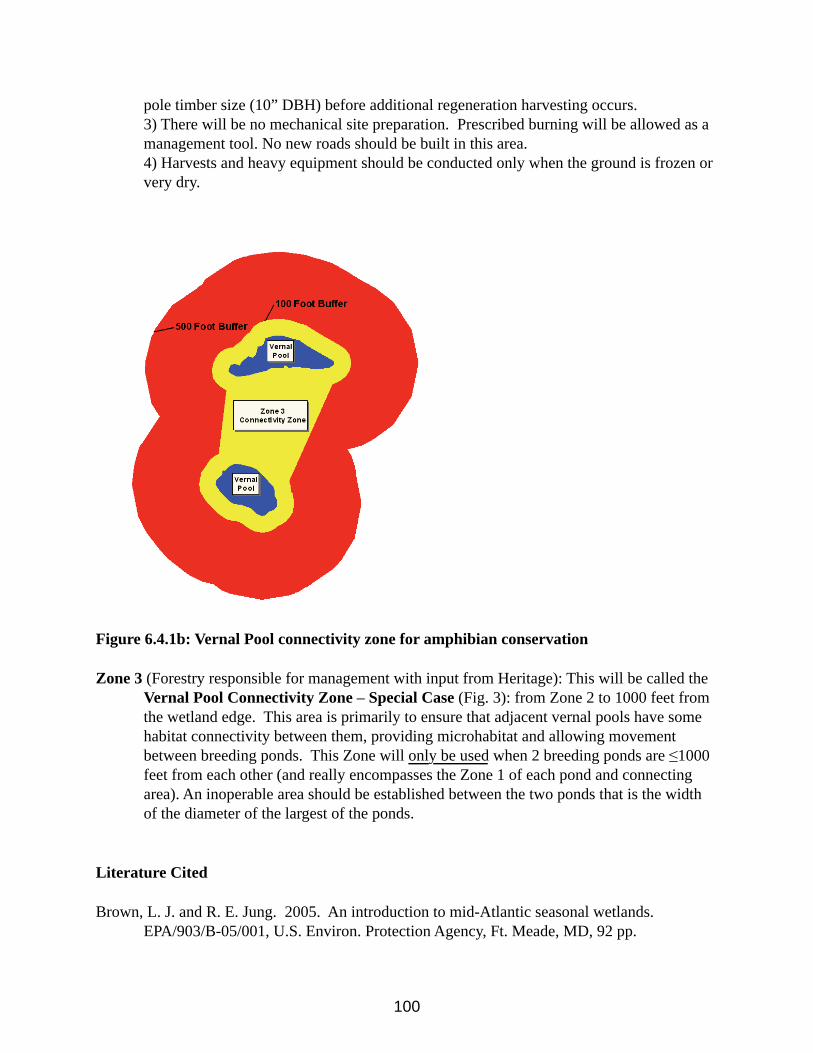
100
pole timber size (10” DBH) before additional regeneration harvesting occurs.3) There will be no mechanical site preparation. Prescribed burning will be allowed as a management tool. No new roads should be built in this area. 4) Harvests and heavy equipment should be conducted only when the ground is frozen or very dry.
Figure 6.4.1b: Vernal Pool connectivity zone for amphibian conservation
Zone 3 (Forestry responsible for management with input from Heritage): This will be called theVernal Pool Connectivity Zone – Special Case (Fig. 3): from Zone 2 to 1000 feet from the wetland edge. This area is primarily to ensure that adjacent vernal pools have some habitat connectivity between them, providing microhabitat and allowing movement between breeding ponds. This Zone will only be used when 2 breeding ponds are "1000 feet from each other (and really encompasses the Zone 1 of each pond and connecting area). An inoperable area should be established between the two ponds that is the width of the diameter of the largest of the ponds.
Literature Cited
Brown, L. J. and R. E. Jung. 2005. An introduction to mid-Atlantic seasonal wetlands.EPA/903/B-05/001, U.S. Environ. Protection Agency, Ft. Meade, MD, 92 pp.
101
Calhoun, A. J. K. and P. deMaynadier. 2004. Forestry habitat management guidelines for vernalpool wildlife. MCA Technical Paper No. 6, Metropolitan Conservation Alliance, WildlifeConservation Society, Bronx, New York. 32 pp.
Cowardin, L.M., V. Carter, F. C. Golet, and E.T. LaRoe. 1979. Classification of wetlands anddeepwater habitats in the United States. FWS/OBS 79/31, Fish Wildl. Serv., USDI, Washington, D.C., 103 pp.
Maryland Department of Natural Resources. 2005. Maryland wildlife diversity conservationplan. DNR Publ. No. 03-5312006-135, Annapolis, MD. 365 pp.
Semlitsch, R. D. 1998. Biological delineation of terrestrial buffer zones for pond-breedingsalamanders. Conservation Biology 12:1113-1119.
Semlitsch, R. D. 2003. Conservation of pond-breeding amphibians. Pages 8-23 in Semlitsch, R.D. (ed.) Amphibian conservation. Smithsonian Books, Washington, D.C. 324 pp.
Semlitsch, R. D. and J. R. Bodie. 2003. Biological criteria for buffer zones around wetlandsand riparian habitats for amphibians and reptiles. Conservation Biology 17:1219-1228.
Semlitsch, R. D., B. D. Todd, S. M. Blomquist, A. J. K. Calhoun, J. W. Gibbons, J. P. Gibbs, G.J. Graeter, E. B. Harper, D. J. Hocking, M. L. Hunter, Jr., D. A. Patrick, T. A. G. Rittenhouse, and B. B. Rothermel. 2009. Effects of timber harvest on amphibian populations: understanding mechanisms from forest experiments. BioScience 59:853-862.
Smith, S. and W. Knapp. 2006. Chesapeake Forest ecologically significant area (ESA)classification for sustainable forest management: management zone delineations and prescriptions. Unpubl. DNR Report, Wye Mills, MD, 10 pp.
102
Chapter 7 - Ecologically Significant Areas & Other State Protected Lands
7.1 Ecologically Significant Areas (ESA) DefinedThis plan uses the term “Ecologically Significant Area” to identify unique sites that have special ecological significance. These areas have been specifically delineated and must be given careful management consideration. ESA’s are areas that harbor or could potentially harbor rare, threatened or endangered (RTE) species and/or unique natural community types.
On Green Ridge State Forest these areas are also designated as High Conservation Value Forest (HCVF). Rare threatened or endangered species and or unique natural community types fall under two categories of our HCVF definition, they are: (HCV1) Forest areas containing globally, regionally or nationally significant concentrations of biodiversity values (e.g. endangered species) and (HCV3) Forest areas that are in or contain rare, threatened or endangered ecosystems.
In addition to the main criteria (RTE species and unique natural communities) used for establishing ESAs, other criteria were also used to assist in determination of ESA boundaries. These included: topography and geomorphology (based on U.S. Geological Survey topographical quads and geology maps); hydrology (based on National Wetland Inventory and State wetland maps); soil types (based on U.S. Department of Agriculture soil surveys); existing Natural Heritage Areas (NHAs) as designated by state law; surrounding land uses (houses, farms, etc.); and wildlife travel corridor linkages. HCVF includes areas identified as old-growth and nearly old-growth forests according to criteria developed by the DNR Old-Growth Forest Committee.
Following a thorough analysis, ESA boundaries were delineated using ArcView, a geographic information system (GIS) software program. Digital geo-referenced layers for most of the above criteria were used. The ESA boundaries are part of the Green Ridge State Forest database used for planning and review purposes. In addition to the GIS exercise, a wide range of species experts also evaluated the alignment of the established ESA network to ensure that the ecological criteria were accurately applied.
ESAs presently comprise approximately 9832 acres or about 20% of the entire forest. Some ESA boundaries will expand over time or entirely new ESAs will be delineated, both based on the discovery of new rare resources. Conversely, some ESAs may be removed based on new knowledge or changed legal status of a particular species. ESA boundaries in many cases overlap Wildlands, Forested Riparian Buffers and Old Growth Areas. Timber management is still
103
possible in most ESAs, but only in the context of managing for sensitive resources. Implementation of this management regime will help achieve the definition of a sustainable forest, providing balanced ecological and economic benefits.
7.2 Ecologically Significant Areas Descriptions
Polish MountainDescription: This ESA has several attributes. The first is the presence of critical habitat
for a State Threatened plant. The habitat is in excellent condition and the population is thriving. Additionally, the very small section of floodplain which is State-owned harbors trees that are old enough to offer a fine example of what much of the Town Creek floodplain forest might have looked like in the distant past. This condition had extended onto the privately owned floodplain to the north. However, a number of years ago this private section was subjected to a timber harvest. This significantly changed the area’s character and the disturbance allowed the spread of several invasive plants. This ESA also contains some fine examples of near old growth forest, mainly a mix of white pine and various oaks. The other natural communities here are in excellent condition and there is a reasonable chance to discover other rare species within this ESA. The private property to the west supports a population of a rare moth. The landowners are aware of this and wish to protect this resource. The landowners have enrolled the property in a Forest Stewardship Plan. A true ecological boundary for this site would extend to the west and to the north if the State owned the land.
Prescription: Management needs include monitoring the population of the State Threatened plant to assess any habitat changes. This effort should occur at least once every five years. In addition, an immediate assessment of the invasive plant situation on the Town Creek floodplain is in order. The upland forest communities just need time to age into old growth. If the private properties to the north or to the west were offered for sale, they would represent excellent additions to the State Forest.
Williams RoadDescription: The main feature of this ESA is the presence of several shale barren
communities. Despite their roadside situation, these communities are in good condition and support several uncommon and rare plants, one of which is State Threatened. Two rare butterfly species have been documented here, as well. One of these is listed as State Endangered and is considered one of the rarest butterflies in the region. In fact, despite recent searches, it has not been documented in Maryland for several years now. The other is a State Threatened species and has recently been re-verified from this site.
Prescription: The shale communities need occasional monitoring for the presence and spread of invasive plants. Both butterflies should be searched for at least every two years. If the State Endangered one is rediscovered, there may need to be discussions on how to keep the host plant in high numbers, i.e., through prescribed burning or some other disturbance. This area should never be sprayed for the control of gypsy moth infestations.
104
Boyer KnobDescription: The main feature of this ESA is the presence of old growth and near old
growth forest communities. The area also supports a population of a State Threatened plant. Private property to the west also contains some pockets of old growth forest. The landowners are aware of this and wish to protect this resource. They are enrolled in a Forest Stewardship Plan. A true ecological boundary for this site would extend to the west if the State owned the land.
Prescription: Periodic monitoring to assess the Threatened plant’s status and for the presence of invasive plants is highly recommended.
Sugar Hollow/Turkey CampDescription: This diverse area has a number of outstanding attributes. This relatively
recent addition to the State Forest was purchased with Heritage Conservation Fund money. The presence of several exemplary shale barren communities and the associated rare flora and fauna is perhaps the main attribute. At least seven plant species listed as State Threatened or Endangered have been documented from this ESA. One of these is the only known occurrence for the species in Maryland. A number of other rare and uncommon plants occur here, as well. In addition to the plants, three State-listed butterfly species occur within this area. There is a high likelihood of other rare Lepidoptera being documented here in the future. This area also supports a high diversity of amphibian and reptile life. A true ecological boundary for this ESA would be extended in a number of directions if the State owned this land.
Prescription: There are several management issues on this ESA. One is the presence of several infestations of various invasive plants. Efforts are currently underway trying to control tree-of-heaven, bush honeysuckle, and Japanese stilt grass. An old homestead at the mouth of one of the hollows is currently a reservoir for several invasive plants. One of the main shale barren communities is currently under a restoration effort. Hindering this effort is the presence of private land on part of the barren. This inhibits the use of prescribed burning as part of the restoration effort. The properties bordering the ESA in this area are of prime importance for future acquisition. Other properties adjacent to the ESA would also be important future acquisitions. There are several human built structures on this property. Other than the disturbed land around the aforementioned homestead, these structures do not take away from the ecological value of this ESA. In fact, several reptiles rather like them. This ESA should never be sprayed for gypsy moth control.
Bells HillDescription: There are two main features to this ESA. One is the presence of a shale
barren community, which supports two State Threatened plants and a number of uncommon plants. The other is the presence of old growth and near old growth forest communities. In addition, the shale barren has the potential to harbor some uncommon or rare butterflies.
Prescription: This shale barren community is not as exemplary as others given ESA status are. This is because of its close proximity to an old farm, which harbors many non-native invasive plants. Some of these plants have encroached upon the barren habitat. Furthermore, the
105
barren community is not as open as others are in the region. In the past, a prescribed burn was proposed for this barren to set back succession, and to study the fire’s affect on the invasive weeds. For various reasons, the work proposed was never initiated. It may be useful to re-visit this proposal in the future. In any event, updating the status of the invasive plant issue is highly recommended. It is very important that this ESA not be sprayed during any gypsy moth suppression program.
North Bells HillDescription: This small ESA represents critical habitat for a cliff dwelling State
Threatened plant. About half of the ESA would extend onto private land to the east. These landowners have been contacted and wish to conserve rare species on their property. They are enrolled in a Forest Stewardship Plan.
Prescription: Even though the adjacent landowners have been very cooperative in conserving resources they share with the State Forest, their property would be a prime acquisition if they ever wished to sell.
Hanging PrairieDescription: This property, also known as the Lehman tract, is a relatively new addition
to the Green Ridge State Forest. It was purchased with Heritage Conservation Fund money, a dedicated fund no longer in existence. There are a number of outstanding features associated with this ESA. One of these features is the presence of several high quality shale barren communities supporting numerous uncommon and rare plants. Several of these are State-listed as Threatened species. One barren, the namesake of the ESA, supports the largest population known in the region for a State Threatened shale barren endemic plant. These barrens also support several uncommon and rare butterflies, two of which are State-listed. Other attributes of this ESA include a thriving population of a regionally sensitive reptile species, breeding populations for several amphibians species (two of which are uncommon), and the presence of a good quality vernal pool community. This natural community type is infrequent in the Ridge & Valley. A true ecological boundary would extend to the south if the State owned this land.
Prescription: The southwest portion of this ESA lies within the floodplain of Town Creek. Much of it is an old farm with long neglected fields and other altered habitats. It has not been in production for a very long time. The current fields and thickets in this section contain some non-native plants, such as multi-flora rose. However, this reverting habitat is beneficial for a number of species, including one of the uncommon amphibians and the sensitive reptile. The benefits of trying to control the non-native plants here do not seem worth the cost and effort, since important non-game resources seem to be thriving in spite of these weeds. However, other areas on the ESA, such as the forest around the shale barren habitats, should be monitored for invasive weed expansion. For instance, field reconnaissance last year revealed some tree-of-heaven seedlings on one of the primary shale habitats. Fortunately, this fieldwork was part of a restoration effort of this barren by the Natural Heritage Program. An effort is underway to address this problem. There would be a benefit to one of the uncommon amphibians in keeping some of the old field habitat in this early stage of succession. In the wettest sections of these old
106
fields (the critical habitat for the amphibian), succession is happening at a relatively slow rate. None-the-less, succession is occurring.
It is recommended that the Natural Heritage Program work with the Forest Manager (and possibly others) to analyze this situation and formulate a plan on how to address this. There are several human created structures on this ESA. Some are very old remains associated with the farm that may have some historical value. Another is an old run down cabin now serving as wasp and rodent habitat. Still another is a relatively new unfinished cabin that may or may not have some value. These structures do not have any impact on the ecological values discussed above. This area must be excluded from any gypsy moth spray program.
Maple Run NorthDescription: This ESA forms the core area of the Maple Run Wildland. It lies entirely
within this wildland. The main feature is a series of very high quality shale barren communities that support numerous rare and uncommon plants and Lepidoptera. A number of these are State-listed as Threatened or Endangered. The shale communities within this ESA are as pristine as any discovered on Green Ridge. The series of barrens (along with some that occur south of Jacobs Rd.) allow for meta-population dynamics of the rare plants and butterflies that is often hard to protect. In addition to these attributes, there is also critical habitat for a sensitive reptile species within this ESA.
Prescription: The shale barrens closest to Jacobs Rd. will need continual monitoring for the presence of nonnative invasive plants. Those that do the monitoring should be very careful about spreading the invasive plant seeds. Infestations of several invasive plants occur along and within the vicinity of Jacobs Rd. Monitoring the rate of succession on these naturally open communities is highly recommended. Prescribed burning or other delicate restoration techniques may be warranted in the future. However, the pros and cons of any restoration effort should be carefully considered because excessive trampling, even by researchers, may do more harm than good. It is extremely important that the entire wildland be off limits to any gypsy moth spray program. Furthermore, there should be no encouragement of public visitation to this ESA.
Maple Run SouthDescription: The main features of this ESA include the presence of a high quality vernal
pool community and shale barrens. At least seven amphibian species have been documented using this pool as a breeding site. Additionally, there is a shale barren within this ESA that supports a small population of a State Threatened plant and a State Threatened butterfly. A true ecological boundary for this ESA would extend to the south if the State owned this land.
Prescription: There are a number of high quality shale barren communities southeast of here on the Green Ridge North ESA, and to the northwest on the Hanging Prairie ESA. The geology and topography indicate that several exist on the private land to the south, as well. Even the powerline that runs through here has prairie-like habitats established on sections of it. This entire region, in conjunction with the Maple Run Wildland to the north, is a Lepidoptera hot spot, and it represents an extremely important rare butterfly conservation area. It is imperative that
107
this entire area be excluded from any gypsy moth spray program.
Green Ridge NorthDescription: The main features of this ESA are the presence of several pockets of old
growth forest and a series of very high quality shale barren communities. There are some stands of near old growth, as well, and a few of these connect the stands of old growth. The old forest is mainly dominated by white oak with some chestnut oak dominated stands. The shale barren communities are nicely embedded within interior forest and this is the primary reason that these barrens are of such high ecological quality. Like the other high quality shale communities, those on this ESA support a unique assemblage of flora and fauna, several of which are State-listed as Threatened. All of the forest within this ESA is of high ecological quality with few invasive plant problems. A true ecological boundary for this site would extend to the south if the State owned this land.
Prescription: At this time, there appears to be little need for active management. Shale barren communities of such high quality are precious resources. Therefore, it is important to prevent any further fragmentation of the surrounding forest by discouraging any trail or road establishment. This will help to keep invasive plants at bay, and discourage over visitation. Occasional monitoring of the invasive plant situation is certainly warranted. This ESA is part of a larger area that should be excluded from any gypsy moth spray program. A narrow band of forest west of Green Ridge Rd. where the old growth occurs may be an exception to this.
Green Ridge SouthDescription: The main attribute of this ESA is the occurrence of a variety of shale barren
communities that represent critical habitat for three State Threatened plants and two animals officially State listed as In Need of Conservation. A number of other uncommon plants associated with shale barrens also occur here. There is excellent potential to document other uncommon or rare species within this site. The interesting diversity of this area results from the different chemistry of the barrens. Portions of the barren support plants that indicate a near basic soil chemistry, while other sections appear to be quite acidic. Significant portions of the barrens in the north section occur on private land and a true ecological boundary would certainly include this area. Also, a portion of the floodplain of Town Creek adjacent to the shale slope, which is owned by the same landowner, represents an excellent example of a floodplain forest. In 1993, the owners of this property entered into a voluntary registry program with the State of Maryland. This non-binding agreement basically states that the landowners agree to protect the unique resources on their property. Additionally, a narrow strip of private land divides the ESA on the shale slope. This, too, would be included in an ecological boundary.
Prescription: This site should be visited periodically to assess any invasive plant issues, determine if succession is occurring, and to monitor the rare species present here. In the long term, a prescribed fire is recommended for the northwest section of this ESA. The property adjacent to and dividing this ESA is an obvious acquisition priority should they ever come up for sale.
108
Big RunDescription: A primary feature of this ESA is the large variety of exemplary forest
communities represented, one of which provides habitat for a State Endangered plant. Several of the forest communities support a high diversity of herbaceous plant life, including several uncommon species. The interesting topography with a variety of different slope aspects coupled with an underlying rock strata that drives the formation of rich soil is the basis for this diversity.
Prescription: There is a long established hiking trail that traverses along Big Run. Over the years, use of this trail has facilitated the introduction of various non-native invasive plants. The rich soil of the area provides the type of situation conducive to the establishment of these plants. The last monitoring of the area noted that most invasives were growing on and adjacent to the trail. However, pockets of garlic mustard were noted quite distant from the trail. Monitoring the invasive plant situation is very important. Action may be needed to control some of these invasive plants. An evaluation of the trail’s impact should be made, as well.
Town Hill SouthDescription: The main features of this ESA are large rock outcrops of the Pocono
Sandstone (note that the name of this sandstone varies between states). There are cliffs, huge boulders and other rocky situations. The unique chemistry of this sandstone supports many plants usually associated with limestone or other basic rocks, rather than typical sandstone. The area provides critical habitat for one State Endangered plant and three State Threatened plants. Several other uncommon plants occur here, as well. The area also provides habitat for one State Endangered mammal, two rare butterflies, and one sensitive reptile species. Other uncommon or rare species are expected to be documented here with further inventory. There are also several ‘pockets’ of old growth or near old growth forest within this ESA.
Prescription: One serious management problem with this ESA was the presence of an over-used off-road vehicle (ORV) trail traversing the ridge of Town Hill. This trail was here prior to ESA designation and its use sky rocketed over the last 15 years. The ORV trail was recognized as a serious ecological problem within this ESA and was closed in early 2011. Restoration efforts are planned to mitigate erosion issues associated with this trail Another serious management issue is the presence of a severe infestation of garlic mustard. This infestation is due to the rich soil surrounding the rock outcrop and originated years ago from the ATV trail. The fortunate thing about this situation is that the garlic mustard does not take over the more xeric, open habitats, and this is where the rare plants occur. Essentially the infestation is in the surrounding shaded habitats. The garlic mustard occurrence is so severe that control methods would seem very daunting.
Paw Paw BendsDescription: This ESA lies totally with the designated Paw Paw Bends Wildland.
Significant ecological features include steep, often dramatic shale cliffs and barrens with a variety of exposures from due south to almost due north. This variety of exposures allows for a
109
large diversity of plant communities and associations. A large number of uncommon and rare flora have been documented from this area. This includes at least four plants listed as State Threatened or Endangered, one of which only occurs in one other location in the State. One ‘pocket’ of old growth forest has been formally documented, but others most likely exist. In any event, as long as it remains a Wildland the entire area is destined to become old growth. Several species of uncommon to rare Lepidoptera have also been documented from this large area. An abandoned railroad tunnel traversing under this area is being used by a State Endangered bat. There is great opportunity for other unique flora and fauna being discovered here.
Prescription: One important activity for this area is to monitor the status of the Threatened and Endangered plants. One of these has been monitored every few years for the past 15 years or so. Another has not been re-visited since its discovery over 25 years ago. The issue of the use of the tunnel by bats vs. the desire for a rail trail to go through the tunnel remains to be resolved. This area should be excluded from any gypsy moth spray program.
Outdoor Club Slopes/Kasecamp SlopesDescription: A large portion of this ESA lies within a designated Wildland. The
Kasecamp Slopes portion is outside the Wildland boundary. The variety of shale slopes and barrens provides habitat for a large number of uncommon, rare, and State listed plants and animals. Five State Threatened or Endangered plants are found within this ESA. One State Endangered animal and two listed as In Need of Conservation also occur within the area. Populations for two sensitive reptile species are found here, as well. Another reptile, whose primary range in Maryland is on the Coastal Plain, also occurs here. As with the Paw Paw Bends ESA, a variety of slope aspects contributes to the high diversity of plant life. The plant associations on the main shale slope of Outdoor Club are unlike any other documented on GRSF, so far. Two areas of old growth forest have been identified on this ESA, to date. The rugged nature of much of the site makes it likely that other rare flora and fauna could be discovered here. All of the forests within this area will eventually evolve into old growth.
Prescription: There is reason to be concerned about the advancement of various invasive plants, most importantly garlic mustard and tree-of-heaven. An old foot trail that traverses the steep hillside of Outdoor Club has garlic mustard and other non-native plants growing along it. Sections of mesic woods within the area have serious garlic mustard invasions. A colony of tree-of-heaven is established at an old quarry/dump site near the south end of the main shale slope of Outdoor Club. This poses a threat to the plant communities on this slope because many plants that occur there indicate a soil chemistry preferred by three-of-heaven. Because of Kasecamp Rd. traversing along the base of Kasecamp Slopes there are invasive plants along the road and invading the mesic places within the area. This situation needs evaluated. Occasional prescribed fires would certainly not hurt the ecology of these shale communities. This area should be excluded from any gypsy moth spray program.
Bonds LandingDescription: This wetland is designated for its unique association of breeding
amphibians that use the area. One interesting feature is the occurrence of a robust breeding
110
population of cricket frogs (Acris crepitans), a frog more commonly encountered on Maryland’s Coastal Plain. The breeding populations here represent the most western occurrences in the State. This site, along with the adjacent Federally owned C&O Canal west to Stickpile Tunnel and east around Kasecamp Neck may be considered a very important reptile and amphibian conservation area. The diversity of species within this area is extraordinary.
Prescription: While this site has always been a wetland, it holds more water longer into the season than it did naturally because of a dirt road built along its east end. Ironically, any attempt to improve drainage may be detrimental to what this site has become. Any future road improvements should be carefully evaluated and include a Natural Heritage biologist in the discussion.
Carroll Road SlopesDescription: This ESA lies within a designated Wildland. As with Outdoor Club Slopes,
the primary feature is a variety of shale habitats that support a large variety of plant life, many of which are uncommon, rare, or State listed. However, there are subtle differences in the shale chemistry that equate to some different plant associations than those that occur on Outdoor Club or Paw Paw Bends. Taken altogether these different ESAs represent a tremendous reservoir of botanical biological diversity. Four State Threatened plants are known to occur within this ESA. Two of these are different from the ones documented on Outdoor Club. Two animals listed as In Need of Conservation have been documented here. Two sensitive reptile species occur here, as well. One species of reptile whose range in Maryland is primarily on the Coastal Plain also occurs within this ESA. Additionally, a relatively large area of old growth forest has been identified. The rugged nature of much of this area makes it likely that other rare flora and fauna could be discovered here. All of the forest communities on this ESA will eventually evolve into old growth.
Prescription: An old road running along the top of the main shale slope has allowed the invasion of the troublesome weedy grass (Bromus sterilis c.f.). There is also a vista established along the crest of this slope and activities associated with keeping the vista open may have contributed to the original introduction of the Bromus. Crown vetch and other non-native plants can be observed around the vista. During a recent monitoring effort it was noted that this grass had not taken over large areas, but was established in small groups here and there. Trying to eradicate the Bromus is problematic because disturbance caused during the eradication effort simply provides more micro-habitat for the grass to take hold. A designated camp site at the south end of this road was recently eliminated because campers were traversing on a section of barren harboring a rare plant and their disturbance was helping establish the Bromus. At this time, it is not apparent that any of the invasive plants are impacting populations of rare native vegetation, with the exception of the immediate area around the now closed campsite. However, this situation needs periodic monitoring. There is a narrow strip of private land that divides this ESA. Certainly it represents an important future acquisition. Prescribed fires may be beneficial for the shale communities. This area should be excluded from any gypsy moth spray program.
Oldtown Road Pool
111
Description: Naturally occurring vernal pools are infrequent on GRSF. This particular pool is a relatively small one, but three vernal pool obligate amphibians use the site for breeding habitat. One of these is uncommon in Maryland. A diverse invertebrate community is supported by the pool, as well. The organic sediment core of the pool also serves as a reservoir for discovering past plant associations.
Prescription: This management plan contains information regarding the conservation of vernal pools supporting amphibian populations.
Yonkers BottomDescription: This ESA features an exemplary example of a shale barren community. It
provides critical habitat for two State Endangered plants and two State Threatened plants. Numerous uncommon plants associated with shale barren communities also occur here. There is the potential for uncommon and rare Lepidoptera to be documented from this site. The occurrence of a reptile on the barrens that is normally found on Maryland’s Coastal Plain is an added interesting feature.
Prescription: A number of invasive plants have become established on the adjacent floodplain on Fifteenmile Creek and ascend up slope near the base of the actual open barren habitat. This is a similar situation encountered at many shale barren sites. While it is troubling to observe these weedy invasions on the more mesic portions of these sites, the rare plants associated with the open habitat do not seem threatened at this time. However, this is a situation that should be kept abreast of since there are invasives that may show up at any time such as tree-of-heaven that could threatened the integrity of these shale communities. Periodic monitoring is highly recommended. Evaluation of the current situation by an invasive plant specialist is recommended. Because of long-term fire suppression monitoring ecological succession is also recommended. Prescribed burning should likely be a future consideration. This area should be excluded from any gypsy moth spray program.
Hoop Pole HollowDescription: This ESA was established for two important reasons. First, it is a very
important forested tributary to Sideling Hill Creek, with over 90% of it State owned. The ESA boundary would be extended to roads on all sides if it were all under State ownership. Some very important natural resources that depend on water quality are downstream of this tributary, including two occurrences of a Federally Endangered plant and two State listed freshwater mussels. These populations have national significance. Second, there are several ecologically significant shale barren communities that have subtle differences from other shale habitats found in the region.
Prescription: It is important that all land within this tributary remain undisturbed. Portions in the upper reaches were timbered over 25 years ago prior to knowing the importance of the resources in Sideling Hill Creek. There is an old road at the mouth of the hollow that leads to a campsite perhaps 100 meters in. The use of this campsite should be monitored and evaluated. If erosion is evident, or if invasive plants are moving in because of the road, it may need to be gated to discourage over-use.
112
Spring Lick/MudlickDescription: These two scenic tributaries of Fifteenmile Creek have several ecologically
significant attributes. There is an excellent shale barren community that provides critical habitat for a State Threatened plant. A number of other uncommon shale barren plants thrive here, as well. There are two naturally open habitats that do not fit into the traditional shale barren type because of the different character of the substrate. Whether these plant communities represent something unique remains to be evaluated, but they certainly add to the diversity of natural open habitats on GRSF. Another feature of this ESA is the presence of a State sensitive reptile species. Finally, this ESA helps protect the water quality of Fifteenmile Creek. To that end, if the State owned the land to the east and north, this ESA boundary would be extended.
Prescription: There are several invasive plants near the mouth of both of these hollows and along Mountain Rd. The current invasive plant situation needs evaluated to see how far up the stream valleys they may have spread. Land to the east and north are obvious acquisition priorities if they ever come up for sale.
Fifteenmile Creek SouthDescription: This is a large, complex ESA with a number of important ecological
attributes. The land surrounds a section of Fifteenmile Creek. One feature is the presence of a number of high quality shale barren communities formed over two distinct shale types. These shale habitats support a large number of uncommon and rare flora, including four State Endangered plants and three State Threatened plants. A diverse array of Lepidoptera and Odonata occur within the area including two species that are State listed as In Need of Conservation. There are a number of exemplary forest community types including one documented area of old growth and other sites of near old growth. Community types from floodplain forest to pine dominated ridge-tops are represented. This ESA also provides increased protection for a small, but thriving population of a Federally Endangered plant that occurs in Fifteenmile Creek. This section of stream supports several ‘sub-populations’ of a State sensitive reptile with two research areas established for it. Another State sensitive reptile has been documented on the surrounding shale slopes. This area is truly a biological diversity hotspot.
Prescription: Various sections of Fifteenmile Creek’s floodplain and bordering roadsides of this ESA have been invaded by several non-native plants including garlic mustard and the very troubling Japanese stilt-grass. Any old roads that traverse into this ESA should be shut down and put to rest. This includes a road off of Dug Hill Rd. that is used for access into old “wildlife openings”. This road goes through wet areas and has provided a conduit for invasive plants all the way to Fifteenmile Creek. Maintaining these wildlife openings is hardly defensible given the management problems the road has caused. Furthermore, there are a number of natural prairie-like openings in this ESA. Controlling the invasive plant problem may be an insurmountable task. However, many of the fine attributes of this large area will still exist in spite of this problem. A long period of minimal anthropogenic disturbances allowing some ecological healing will help. There are significant areas of private land within and on the edges of this ESA that cause what amounts to an incomplete boundary. These lands are obvious future
113
acquisition priorities. The Federally Endangered plant should be monitored every two years. This area should be excluded from any gypsy moth spray program.
Deep RunDescription: This ESA lies entirely within the Deep Run Wildland. A primary feature of
this ESA and the Wildland is the presence of a large variety of forest community types from mesic bottomland to dry ridge-top. Some of these are quite different from the usual matrix forest encountered on GRSF. One area of old growth has been identified and other ‘pockets’ of near old growth exist. As a Wildland, the entire area is destined to evolve into old growth which will serve to enhance the ecological significance of the forest communities. The entire GRSF has been identified as an Important Bird Area (IBA). This and other Wildlands in conjunction with Old Growth Management Areas will only enhance the forest interior dwelling bird habitat into the future. Deep Run also provides habitat for one State Endangered plant (its only location is in Allegany Co.), and a State Threatened plant.
Prescription: There are several important management issues associated with this area. First and foremost was the questionable compatibility of a heavily used ORV trail crossing the heads of many tributaries flowing into this Wildland. This management issue was mitigated by the 2011 closure of the GRSF ORV trail. Restoration efforts are planned for the near future to minimize erosion and sedimentation issues associated with this trail. Once restored, the trail should remain closed to ATV traffic. Another issue involves a hiking trail that traverses along Deep Run. Monitoring the use of this trail is quite important to the long-term future of the Endangered plant. It is especially important to keep bicycles and horses off of the trail. Another concern is the route of the Great Eastern Trail which was reviewed by the Interdisciplinary Team a few years ago. Coming from the south, it is to continue on to the Deep Run Trail to a certain point and then turn uphill towards Green Ridge Rd. Given the expected increase in hiking volume on this section of the Deep Run Trail it was discussed that it be closed at the point where the Great Eastern Trail veers uphill to discourage over use further into Deep Run. This issue needs further discussion. There at least two narrow strips of private land that extend into this ESA. These are obvious future acquisition priorities.
Piclic RunDescription: This ESA is an interesting mix of natural and human created habitats. The
basis for this area’s unique attributes stem from the shale substrate that is present through-out. Shale barrens in Allegany County may form over several different shale types. Although not intensely studied yet, it is evident from plant associations that these different shale types exhibit different chemical compositions. The shale at Piclic (and nearby areas) supports some flora that is usually associated with limestone or rocks of a near neutral pH. Most of the shale barrens that support rare plants show this characteristic. There is a small shale barren within this ESA that supports two State Threatened plants and a number of other uncommon and rare ones. There is an old road (Piclic Rd.) that cuts through the shale which caused the proliferation of a native plant that serves as the host plant for a very rare butterfly. This butterfly is listed as State Endangered and has not been relocated here in several years. The area also supports two other
114
Lepidoptera listed as In Need of Conservation. Along Fifteenmile Creek Rd. a unique habitat has formed on the roadside which amounts to a NE facing barren. A State listed Threatened plant with relatively strict habitat requirements has become established here.
Prescription: This area’s notoriety among amateur butterfly enthusiasts has caused problems for the rare Lepidoptera found here. This site became the “place to go” to observe the State Endangered butterfly documented here. There is a long history of visitation since the species was discovered some time ago, and the site is easily accessible. There is no doubt that this species has been over-collected since an infamous butterfly poacher was caught here years ago. The other rare species that occur here would be on a collector’s list, as well. In general, more attention should be paid to butterfly collectors on all of GRSF. Continued monitoring of this site is needed to perhaps relocate the species, and to be there at the proper time to encounter collectors. It is important that DNR has input on any projects that involve road maintenance or widening of Fifteenmile Creek Rd. in this area.
Wallizer RoadDescription: This ESA provides critical habitat for one State Endangered plant and a
State Threatened plant. Both of these plants are shrubs, one of which is normally considered more at home on limestone. In this case they grow on a shale substrate. The site is interesting because it is more or less a shrub community, with other more common species present. There is the potential to document a particular rare butterfly here since one of the shrubs is a host plant for the species. Two attempts have been unsuccessful, so far.
Prescription: This site needs monitored to keep abreast of succession. Some type of intervention may be necessary in the future to maintain the habitat needed by these shrubs. A prescribed burn may be necessary.
White Sulphur RunDescription: This ESA provides habitat for two State Threatened plants and a rare
aquatic snail. For one of the plants, this is the only site known off of the Alleghany Plateau in Maryland. The aquatic snail is a subterranean species and is only found at the head of springs. It was documented at White Sulphur Spring.
Prescription: Monitor the invasive plant situation. One of the rare plants is vulnerable to competition from invasives.
Black Sulphur RunDescription: This ESA represents a small shale barren that supports two State
Threatened plants. Regardless of its size, it is a fine example of the community type. Other uncommon shale barren plants occur here, as well.
Prescription: This site should be monitored for ecological succession and invasive plants.
115
Alternate 40 SlopeDescription: This ESA represents critical habitat for a State Threatened shrub. It
represents one of the best populations of this plant known in Maryland.Prescription: This site needs monitored for ecological succession. A prescribed burn
may be necessary for the continued health of the population.
Little Pine LickDescription: This ESA represents an exemplary stream bottom forest community and
provides critical habitat for a State Threatened shrub. A salamander more commonly found on the Appalachian Plateau has also been documented from here.
Prescription: It is very important to monitor the invasive plant situation. As might be expected, several troublesome invasives are present where the stream nears Frank Davis Rd.
Fifteenmile Creek NorthDescription: A number of different features define this ESA, varying from an excellent
example of a floodplain forest community to several excellent shale barren communities. Additionally, two vernal pools have been identified within the site. Similar to other barrens that have formed over the type of shale found here, these habitats resemble little prairie openings. This situation provides outstanding habitat for two State Threatened plants and both are found on all of the barrens within this ESA. The Lepidoptera diversity is high including three State listed species. Fifteenmile Creek Rd. divides this ESA. Originally, the site was divided into three separate ESAs. However, because of their close proximity to one another they were combined into one. The boundary for the northeastern portion of this ESA would be enlarged if the State owned the land.
Prescription: The floodplain forest community’s integrity has been compromised by the spread of Japanese stilt grass over the last 15 years. This grass was not discovered in this region until the early to mid 1990s. This plant is often spread along roads and trails, but natural disturbances like seasonal flooding have led to its spread on floodplains. At this time, it seems an insurmountable task to control this weed. The barrens should be monitored for succession and invasive plants. One of the best prairie-like shale barrens in the region occurs at the south end of Divide Ridge. A good portion of this barren is on private land. Housing development has been taking place along a road running down Divide Ridge getting ever closer to this barren. Private land in this area is a prime acquisition priority. Short of acquisition, contacting the adjacent landowner is recommended to inform them of the ecological treasure they have on their property.
Cumberland Road PoolDescription: Vernal pools are infrequent on GRSF. This ESA represents an excellent
example of this community type. At least six species of amphibians have been documented using the pool for a breeding site including four vernal pool obligates. One of these is an uncommon species in Maryland. A diverse aquatic invertebrate community is supported by this
116
pool, as well. The organic sediment core of the pool also serves as a reservoir for discovering past plant associations. The pool is close to Fifteenmile Creek Rd. which somewhat compromises its ecological integrity.
Prescription: This management plan contains information regarding the conservation of vernal pools harboring amphibian populations. The close proximity of the road represents a ‘wildcard’ in the conservation of this pool. Any proposed maintenance, widening, or change of drainage patterns for Fifteenmile Creek Rd. in this area should have direct DNR involvement.
Line RunDescription: This small ESA represents a shale barren community providing habitat for
a State Threatened plant.Prescription: Monitor for succession and invasive plants.
Fossil RunDescription: The main feature of this ESA is a series of very high quality shale barren
communities. Like some of the barren communities within the Maple Run North ESA, their location within interior forest is the primary reason that these communities are of such high ecological quality. Like the other high quality shale communities, those on this ESA support a unique assemblage of flora and fauna, several of which are State-listed as Threatened. A true ecological boundary for this site would, at least, extend to the south if the State owned this land.
Prescription: Shale barren communities of such high quality are precious resources. Therefore, it is important to prevent any further fragmentation of the surrounding forest by discouraging any trail or road establishment. This will help to keep invasive plants at bay, and discourage over visitation. It may be wise to join this ESA with the Green Ridge North ESA to help accomplish this objective for the long term. This ESA is part of a larger area that should be excluded from any gypsy moth spray program.
Maniford SlopesDescription: This area represents critical habitat for two State Threatened plants, two
State rare plants, and several uncommon plants. Furthermore, the north facing shale slopes represent significant examples of this natural community type. Further study within this ESA may reveal other unusual flora and fauna. Further field reconnaissance may be needed to adjust the boundary to include a unique hemlock community to the northeast. This hemlock site was reported to the old growth committee as a potential old growth site. The committee never made a field review of the area, because the age of the hemlock did not meet the old growth criteria. None-the-less, the researcher who discovered the area (Harry Kahler) thought the site was unique, and it may qualify for a HVCF.
Prescription: No glaring management needs are apparent at this time. However, it would be prudent to evaluate the current invasive plant situation. Further inventory of the area is highly recommended.

117
Pack Horse RidgeDescription: This ESA represents critical habitat for one State Threatened plant, two
State rare plants and several uncommon plants. The boundaries of this ESA represent those between public and private land rather than an ecological boundary. A true ecological boundary would extend several different directions.
Prescription: The boundary issues are important considerations for future acquisition, and if adjacent landowners enter into a Forest Stewardship Plan. Further inventory of this ESA is highly recommended. The invasive plant situation needs evaluated.
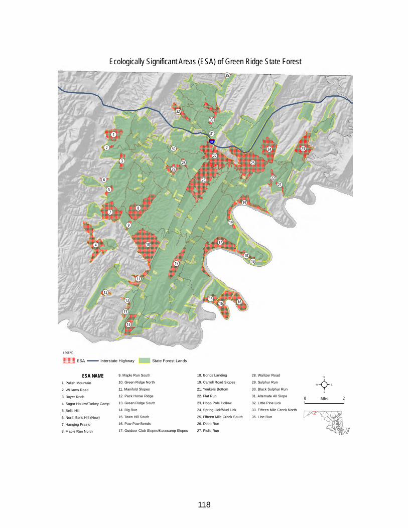
118
!(25
!(26
!(10
!(27
!(8
!(4 !(17
!(7
!(24 !(23
!(16
!(1
!(15
!(16
!(19
!(14
!(33
!(11
!(32
!(29
!(19
!(16
!(3
!(18
!(22
!(5
!(13
!(12
!(21
!(13
!(2
!(9
!(28
!(35
!(30
!(31
!(6
!(18
§̈¦68
²0 2Miles
LEGEND
ESA Interstate Highway State Forest Lands
ESA NAME1. Polish Mountain
2. Williams Road
3. Boyer Knob
4. Sugar Hollow/Turkey Camp
5. Bells Hill
6. North Bells Hill (New)
7. Hanging Prairie
8. Maple Run North
9. Maple Run South
10. Green Ridge North
11. Manifold Slopes
12. Pack Horse Ridge
13. Green Ridge South
14. Big Run
15. Town Hill South
16. Paw Paw Bends
17. Outdoor Club Slopes/Kasecamp Slopes
18. Bonds Landing
19. Carroll Road Slopes
21. Yonkers Bottom
22. Flat Run
23. Hoop Pole Hollow
24. Spring Lick/Mud Lick
25. Fifteen Mile Creek South
26. Deep Run
27. Piclic Run
28. Wallizer Road
29. Sulphur Run
30. Black Sulphur Run
31. Alternate 40 Slope
32. Little Pine Lick
33. Fifteen Mile Creek North
35. Line Run
Ecologically Significant Areas (ESA) of Green Ridge State Forest
119
7.3 Prescribed Burning within ESAsPrescribed burning may be used on ESAs to maintain or enhance the ESA. Some mechanical fire line construction may be necessary within ESAs in order to conduct prescribed burns within fire safety guidelines and according to state burning regulations. All fire lines that are proposed by Forestry within an ESA will be reviewed by Heritage for recommendation as to type and location of fire lines. Forestry and Heritage will coordinate on all prescribed burning on an ESA.
7.4 Use of Herbicides/Pesticides within ESAsChemicals may be used in ESAs to control invasive species only after consultation between the Forest Manager and Heritage. This also includes control of invasive animal species, particularly potentially damaging insects, such as the Hemlock wooly adelgid. The expected damage from the pest outbreak to the ESA and surrounding habitat should be greater than the potential negative effects on rare species populations if the area is treated. In the latter case, consultations would also include the MDA Forest Pest Specialist. Furthermore, chemicals may be used to maintain or enhance the elements that define the ESA. For example, chemical application to control invading native trees on shale barrens may be permitted to maintain Kate’s mountain clover populations and habitat.
7.5 Annual Work PlansConcerns for ESAs will also be addressed during Annual Work Plan (AWP) reviews by the full ID Team. This will often be done at the time another silviculture operation (thinning or harvest) is planned. During the AWP reviews, all actions necessary to protect, restore or enhance affected ESA’s will be considered.
7.6 Other State Protected LandsMost of the land designations listed below fall under some type of state protection through legislation. Most of these areas are overlapped by the ESA layer, however some sections are not and as such are listed here as a separate layer. There are four areas described here: Natural Areas (Heritage Areas); State Designated Wildlands; and Old Growth. The borders of these layers may overlap one another.
7.7 Wildlands
7.7.1 The Maryland Wildlands Preservation SystemThe Maryland Wildlands Preservation System is Maryland's counterpart to the federal Wilderness Preservation System, and consists of all those properties owned and managed by the Maryland Department of Natural Resources which were designated as State Wildlands by the Maryland General Assembly.
Statutory Definition"Wildlands are limited areas of land or water which have retained their wilderness character,

120
although not necessarily completely natural and undisturbed, or have rare or vanishing species of plant or animal life or similar features of interest worthy of preservation for use of present and future residents of the State. This may include unique ecological, geological, scenic, and contemplative recreational areas on State lands " (Natural Resources Article, §5-1201).
Background and HistoryThe Maryland Wildlands Act established the State Wildlands Preservation System in 1971. The first official Wildland in Maryland, the Big Savage Mountain Wildland in Savage River State Forest, was officially designated by an act of the General Assembly in 1973. As of 2009, twenty-nine separate Wildlands have been designated on over 43,773 acres of State Park, State Wildlife Management Areas and State Forest.
Wildlands at Green RidgeThere are presently three designated Wildlands within Green Ridge State Forest: the 2760 acre Maple Run Wildland, the 1260 acre Deep Run Wildland, the 2034 acre Potomac Bends Wildland. The Wildland boundaries overlap most of the above described Heritage Areas.
The Maple Run Wildland, which extends from Mertens Avenue to Jacobs Road along the west side of Green Ridge Road is a 2760 acre roadless area of Green Ridge State Forest. that contains a number of shale barren communities and mixed upland hardwood forest.
The Deep Run Wildland is roughly located along the east side of Green Ridge Road and west side of East Valley Road. It extends south from Fifteen Mile Creek Road to approximately the intersection with Mertens Avenue West.
The Potomac Bends Wildland is actually three separate parcels made up largely of remote steep slope sections of woodland bordering the C&O Canal National Park and the Potomac River.
Maryland laws and regulations regarding these wildlands are recorded in the Annotated Code of Maryland and Code of Maryland Regulations (COMAR 5-1203 through 5-1302).
7.7.2 Old Growth ForestsOld Growth Forest: The few acres of old growth forest known to exist on Green Ridge State Forest will be protected as HCVF and no major activities are planned. There are currently 14 sites designated as Old Growth on Green Ridge State Forest. When these sites have the required 300 foot buffer applied to them, they total 614.3 acres. These areas will be monitored for invasive species, which will be suppressed if found. The management of these areas is further described in the Old Growth Ecosystem Management Areas section below. There are also 9 areas known as “almost old growth” that total 370.7 acres when the 300 foot buffer is applied. These are areas that were inventoried and tested against the criteria for Maryland Old Growth but did not quite make the grade for all critereia as interpreted by the Old Growth Committee. However, Official almost old growth sites will be managed under the same guidelines of the Old Growth Forests. There are also 11 additional sites that have been identified, mapped, and a 300

121
foot buffer applied to them. These areas are known as potential Old Growth meaning that they potentially meet the criteria of Old Growth or Almost Old Growth but have not been evaluated by the Old Growth Committee yet. There is currently 11 potential Old Growth Sites that total 381 acres when the 300 foot buffer is applied. All of the above mentioned sites have been mapped with a 300 foot buffer and are included within the Old Growth Ecosystem Management Areas.
7.8 Old Growth Ecosystem Management AreasMost of the land designated as Old Growth Ecosystem Management Area (OGEMA) is also within other designations such as Forested riparian buffers, ESAs or other state protected lands and are already identified as HCVF. However, OGEMAs include some additional acreage that have been identified for linking some of the above mentioned sections of land to create forest areas containing globally, regionally, or nationally significant large landscape level forests (HCVF2).
The OGEMA layer was developed with the above in mind as well as the following guidelines for conservation of Old-Growth. Forest Service collaborated with the Old-Growth Committee and the GRSF Inter-disciplinary team to consider all of these elements to develop a logical and functional OGEMA layer.
7.8.1 Guidelines for Conservation of Old-Growth The conservation of functional old-growth forest ecosystems is the goal. Simply protecting patches of old-growth forest does not result in a functional old-growth ecosystem. A functional system provides a multitude of values and is the desired outcome of DNR for old-growth forests. While patches of old-growth forest contain essential elements of an old-growth system, DNR will manage old-growth ecosystems in units of approximately 1,000 acres or more whenever practical. Emphasis should be given to those old-growth forests that will most likely become functional old-growth ecosystems. Some old-growth stands will be too isolated to function as an ecosystem and will be protected at the stand level.
The following guidelines are intended to protect old-growth forests while conserving and enhancing the functionality of the forested ecosystem within which the old-growth occurs:
• Designated old-growth forest will be excluded from timber harvest, including salvage, or other physical alterations.
• Designated old-growth forest will be excluded from protection from natural disturbance factors, such as native insect infestations or wild fire, unless such disturbance is introduced by an unnatural cause (e.g., exotic forest pests or invasive species) or will seriously jeopardize the continued existence of the old-growth ecosystem or significant resources adjacent to the old-growth forest.
• Control of the white-tailed deer population will be encouraged to maintain herd size at a level that does not adversely affect regeneration of trees in the understory.
• A no-cut buffer will be established to a width of at least 300 ft from the edge of the
122
designated old growth. This buffer may be expanded based on specific site conditions or threats. The buffer will be excluded from timber harvest or other physical alterations. Any nonforested conditions within the buffer should be reforested, whenever feasible. Salvage harvesting should not occur within this buffer.
• A management zone will be established that includes the old-growth forest(s) and its primary buffer(s). This management zone will be approximately 1,000 acres in size or greater, whenever feasible. This management zone should incorporate as many designated old-growth and nearly old-growth sites as possible. Its shape should minimize edge to area ratio and be as contiguous as possible. Silvicultural treatments within this zone should be techniques that have as their primary objective the fostering of old-growth conditions, and would include practices such as uneven-aged management and limited even-aged management, extended rotations, techniques that more closely mimic the natural disturbances found in old-growth forests, structural complexity enhancement practices, or techniques that result in retention of at least 70% of the canopy trees. Standing snags and downed coarse woody debris will be retained. Any non-forested conditions within the secondary zone should be reforested, whenever feasible. Salvage harvesting is allowable with the retention of at least 33% of dead or dying snags (not damaged live trees) and coarse woody debris. At all times, the majority of the management zone shall be in the sawtimber size class, preferably a minimum of 75%. Areas within the management zone not designated old-growth or nearly old growth at the time of initial assessment/inventory will not necessarily be managed as if they are designated old-growth.
• Nearly old-growth forests within the management zone should be managed as if they were designated old growth. Timber harvest or other alterations will be excluded. Protection of natural disturbance factors, such as insect infestations or wild fire, will be excluded unless such disturbance is introduced by an unnatural cause or seriously jeopardize the continued existence of the old-growth ecosystem or significant resources adjacent to the old-growth forest. Salvage harvesting should not occur within this forest.
• Passive recreational and educational use of old-growth forests and their buffers will be allowed, including hiking and hunting. No trails or roads will be built to access the old growth. Existing trails or roads will be managed to minimize impacts to the old-growth ecosystem or should be retired, whenever feasible. No campfires shall be allowed.
• An aggressive invasive species monitoring, prevention, and control program should be developed and implemented.
• Private land holdings within these buffers and management zones should be conserved in accordance with these guidelines through incentives, easements, or acquisitions.
Note: Extended rotation management may result in the harvesting of some trees older than half their maximum age.
For patches of old-growth that are too isolated to become functional old-growth ecosystems, the following guidelines shall apply:
123
7.8.2 Old Growth Ecosystem Management Area (OGEMA) ManagementThe goal of OGEMA management is not only the establishment of land to create forest areas containing globally, regionally, or nationally significant large landscape level forests, but enhancement of old growth ecology elements within the area where appropriate. All management activities within OGEMAs shall be compatible with all HCVF values and resource guidelines within the proposed unit. The OGEMA boundaries were created with the knowledge that the OGEMA would link special areas such as Old Growth, Forested Riparian Buffers, and ESAs, into a landscape level mosaic while specific management within the special areas would enhance both the special area and the old growth ecology elements within the OGEMA. Some ESAs and other HCVF units were not included in the OGEMA because the principle management objectives for the units are not parallel with Old Growth Ecosystem Management objectives.
7.8.2.1 Prescribed Burning within OGEMAs: Prescribed burning may be used on ESAs to maintain or enhance the ESA. Some mechanical fire line construction may be necessary within ESAs in order to conduct prescribed burns within fire safety guidelines and according to state burning regulations. All fire lines that are proposed by Forestry within an ESA will be reviewed by Heritage for recommendation as to type and location of fire lines. Forestry and Heritage will coordinate on all prescribed burning on an ESA.
7.8.2.2 Use of Herbicides/Pesticides within OGEMAs: Chemicals may be used in OGEMAs to control invasive species only after consultation between the Forest Manager and Heritage. This also includes control of invasive animal species, particularly potentially damaging insects, such as the Hemlock wooly adelgid. The expected damage from the pest outbreak to the OGEMA and surrounding habitat should be greater than the potential negative effects on rare species populations if the area is treated. In the latter case, consultations would also include the MDA Forest Pest Specialist.
7.8.2.3 Annual Work PlansConcerns for OGEMAs will also be addressed during Annual Work Plan (AWP) reviews by the full ID Team. During the AWP reviews, all actions necessary to protect, restore or enhance affected OGEMAs and other associated management layers will be considered.
124
Chapter 8 - Wildlife Habitat: Protection and Management
8.1 IntroductionThe rich diversity of wildlife species located within the Green Ridge State Forest requires the use of a wide array of adaptive management techniques. The objective is to utilize adaptive management to address the ecological needs of this diversity of wildlife species and habitat types, including different successional stages of forest, (e.g., distribution, size, composition, and juxtaposition of forest patches), riparian buffers, corridors, and interior forest habitat. This approach requires management prescriptions that are anchored in the ecological principle that all of the habitats function in relationship to each other. This is not a definitive prescription, rather an adaptive attempt to best serve the species located on these lands. Using this approach, this part of the plan is broken into three sections: Rare, Threatened and Endangered Species; Wildlife Habitat Areas; and other Wildlife Management Opportunities. Furthermore, the land management area layers introduced in Chapter 4 and described throughout this plan are conducive to this adaptive landscape approach to wildlife habitat protection and management within the Green Ridge State Forest.
8.2 Rare, Threatened, and Endangered Species
8.2.1 Indiana Bat HeritageThe Indiana bat is an average sized bat, with a body length of less than 4 inches and a wingspan of 9-11 inches. It is dull brown with a pink or brown nose. The Indiana bat is also called the Social myotis. These creatures like to live in colonies. In summer, the males form small groups while females gather together into maternal colonies, usually roosting under loose bark or in hollow trees, usually near forested streams. In the winter, Indiana bats will come together to hibernate in limestone caves or mines, called hibernacula (singular: hibernaculum).
Bats are not “rodents with wings”. They are members of the Order Chiroptera, meaning “hand wing”. Their wings actually stretch from their bodies to between what would be their fingers. Also unlike many rodent groups (Order Rodentia), bats can be highly beneficial to humanity. As with the other nine species of bats in Maryland, Indiana bats are insect eaters. One estimate states that a single bat can eat up to 1000 mosquitoes in one hour. Indiana bats will forage for insects at night near the tops of trees and near running water.
The Indiana bat is State- and Federally-listed Endangered and is globally imperiled. It is found only in the Eastern United States (east of Oklahoma). The major cause of the decline is human
125
interference and damage, both to hibernation caves as habitat, and to bat food sources. Interference could come from cavers, biologists, or vandals. These bats have limited fat reserves during hibernation; any disturbance causes them to burn off the reserves, leaving them unprotected against the winter. Indiana bats choose very specific portions of caves; this specificity means they have few options if a cave is disturbed or poorly gated, blocking bat entry. The bats’ food source (insects) becomes contaminated with the increased use of pesticides.
Another cause of decline is the loss of quality habitat, exemplified by forested streams and dead or dying trees which provide loose bark and cavities. Stream channelization, impoundments, and excessive clear cutting destroy summer roosting sites.
In recent years, Western Maryland has hosted several hibernacula; and in 2005, 2 female Indiana bats were tracked from Pennsylvania into Central Maryland during the summer breeding season. Some bats may attempt to roost in human dwellings, i.e. attics and barns. One conservation measure MD Natural Heritage Program recommends is the installation of bat boxes. This will provide roosting opportunities to make up for lost habitat, without having to share your attic.
8.2.2 HarperellaSideling Hill Creek is home to a number of rare species and habitats, including the State and Federally Endangered plant, Harperella (Harperella nodosum). In Maryland, this delicate plant grows in streamside cobble and rock crevices here and on Fifteen Mile Creek. Found at 13 sites scattered from Maryland to Georgia, Harperella is adapted to the annual rise and fall of river waters. Harperella seeds germinate, or broken pieces of the plant take root, during low summer flows. High winter and spring waters cover young plants, protecting them from cold and ice, and uprooting competitors. The Nature Conservancy and Natural Heritage Program of Maryland and the Western Pennsylvania Conservancy have been working with private landowners to protect Harperella and other natural features of Sideling Hill Creek.
8.3 Special Wildlife Habitat AreasWildlife Habitat Management is an important objective on all areas of the GRSF as specified throughout this Long Term Sustainable Management Plan. However, Special Wildlife Habitat Areas are areas that have been identified for specific species or groups of species the planning team identifies as having a need for adaptive management. The special wildlife habitat areas will be managed under specific goals and recommendations of Unit Habitat Management Plans as they are developed. These management plans will be submitted as part of this document and can be found in Appendix E. Additional Wildlife Habitat Areas may be identified and plans developed to focus on specific species or groups of species the planning team identifies as having a need for adaptive management. Acreages for the wildlife management areas, and the general forest will be adjusted within this plan as new areas are identified for specific wildlife habitat management.
Forest management including commercial harvest is permitted within these areas provided that the management activity will maintain or enhance the habitat objectives as specified for the respective area.
126
Revenue generated from timber within wildlife habitat areas should be considered auxiliary revenue and should not be considered in the analysis of sustainable long-term economic performance for Green Ridge State Forest. It should rather, be reallocated to the facility to fund additional wildlife habitat restoration, maintenance, or enhancement within the special wildlife habitat areas.
8.3.1 Kirk Orchard Unit Plan - Early Succession Wildlife Habitat Focus AreaIntroduction:The Kirk Orchard area is approximately 515 acres of Green Ridge State Forest (GRSF) located along Dailey Road from Kirk Road south to near the intersection with Gorman Road. The eastern boundary of this unit is Purslane Run (Twigg Hollow) and the western boundary is Big Run. There are three private parcels that border this area. Private property accounts for less than 10% of the boundary. The remainder of the boundary is within the GRSF property. Furthermore, the entire unit is within a GRSF Special Management Zone. More information on this Special Management Zone is discussed below.
This parcel has been managed as a remnant orchard and an early succession wildlife habitat management unit for the past 30+ years. In recent years, little management has been done with the exception of maintenance efforts due to staff and equipment limitations within the Wildlife and Heritage Service. It is the intention of the Maryland DNR-Forest Service in partnership with the Wildlife & Heritage Service to actively manage this unit as an early succession wildlife management unit of the state forest. The primary management objective for this unit is to enhance and maintain the area for early succession wildlife species and upland hunting opportunities. The secondary objective is to maintain cultural heritage and aesthetics in the unit. This plan includes recommendations for management practices to fulfill the objectives for this management unit.
Early Succession Wildlife HabitatEarly succession wildlife habitat is generally characterized by fallow fields, managed grasslands, shrublands and young forests. In recent years these cover types have diminished greatly within the Maryland landscape, largely due to development and in some cases being allowed to revert to forest. Within GRSF, this habitat type has decreased greatly due to natural forest succession. Regeneration timber harvests do temporarily revert areas to this habitat type and provide habitat diversity within the forest. Because this is only temporary and the habitat type is becoming so rare, active management to restore, enhance, and maintain some of these habitat areas is a valid goal of the MD DNR.
Early-succession dependent wildlife species have been dramatically declining over the past 50 years primarily because of the lack of habitat. According to the Breeding Bird Survey (BBS), twelve of the sixteen shrublands bird species in eastern North America have declining populations. Some of these species include golden-winged warbler, song sparrow, whip-poor-will, eastern meadowlark, bobolink, and eastern bluebird. Many game species dependent on
127
early succession habitat have also declined, including American woodcock, ruffed grouse, northern bobwhite, ring-necked pheasant, and eastern cottontail. Several reptiles, including black racers and eastern box turtles rely on early succession areas for various stages of their life cycle.
The primary objective of this Wildlife Management unit is to enhance and maintain early succession wildlife habitat. Secondary objectives include providing quality upland game public hunting opportunities and maintaining cultural heritage values such as remnant representation of the orchard management that occurred on the forest in the past.
8.3.2 Kasecamp Bottoms Unit Plan - Early Succession Wildlife Habitat Focus AreaIntroduction:The Kasecamp Bottom area is approximately 380 acres of Green Ridge State Forest (GRSF) located between Kasecamp Road and the Potomac River. There is one private inholding adjacent to this unit and the C&O Canal National Park right of way bisects the parcel. Much of this unit is abandoned agricultural fields and marginal pasture. In recent years, the area has received little management with the exception of rotational mowing. It is the intention of the Maryland DNR-Forest Service in partnership with the Wildlife & Heritage Service, and other agency and private organization partners to actively manage this unit as an early succession wildlife management unit of GRSF. The primary management objective for this unit is to enhance and maintain the area for early succession wildlife and migratory bird species with a focus on the enhancement of American woodcock habitat. This plan includes recommendations for management practices to fulfill the objectives for this management unit.
American WoodcockThe American woodcock is a migratory avian species primarily associated with forested wetland habitats. Populations have steadily decreased at a rate of 1-2% per year over the last 25 years. This decline is believed to be attributed to the loss of young forest and shrubland in the eastern United States due to human development and forest maturation. Here in the Ridge and Valley area, young riparian forests are relatively uncommon, largely due to the topography and low annual precipitation. The best suited areas here are riparian areas along the Potomac River and its major tributaries.
8.3.3 Anthony’s Ridge Special Wildlife Habitat AreaThe Anthonys Ridge Special Wildlife Habitat Area is approximately 910 acres of Green Ridge State Forest (GRSF) located along Malcolm Road. There is one private inholding contained within this unit. Most of this area is currently composed of oak –hickory woodland. However, there is approximately 65 acres that are composed of mixed young forests and open meadows that resulted from an abandoned farm and homestead. The elevation of this area ranges from 800 feet to 1200 feet. During the 1980’s the Forest Manager accomplished some fuelwood block harvests along the ridgeline on Anthonys Ridge. The objective of this practice was to enhance the habitat in the area for ruffed grouse while providing opportunity for local fuelwood cutters to
128
access products from the forest. This past management objective and practices along with the proximity to the existing abandoned agriculture acreage served significantly in MD Department of Natural Resources (DNR) decision to select this area as a special wildlife habitat area to be managed for ruffed grouse, golden-winged warbler and other early succession forest habitats. It is the intention of the Maryland DNR-Forest Service in partnership with the Wildlife & Heritage Service, and other agency and private organization partners to actively manage this unit as a special wildlife habitat management area of GRSF. The primary management objective for this unit is to enhance and maintain the area for ruffed grouse and golden-winged warbler in a program that sustains their habitat within the area overtime. The secondary objective is to develop an Appalachian region ruffed grouse and golden-winged warbler management demonstration area. This plan includes recommendations for management practices to fulfill the objectives for this management unit.
8.3.4 Town Creek Special Wildlife Habitat AreaThe Town Creek Special Wildlife Habitat Area is approximately 275 acres of Green Ridge State Forest (GRSF) located along Town Creek Road. This property is made up of three parcels that were recently acquired by the state. There are two private residence inholdings contained within this unit located along Town Creek Road. About 2/3 of this property was actively farmed until recently. The remainder of the property is made up largely of 40 to 60 year old mixed oak and mixed pine woodlands. The fact this property is made up of open fields and relatively young forest stands served significantly in MD Department of Natural Resources (DNR) decision to select this area as a special wildlife habitat area to be managed for early succession wildlife habitats. Furthermore, open meadows and shrubland habitats are a minority cover component within the GRSF landscape. It is the intention of the Maryland DNR-Forest Service in partnership with the Wildlife & Heritage Service, and other agency and private organization partners to actively manage this unit as a special wildlife habitat management area of GRSF. The primary management objective for this unit is to enhance and maintain the area for early succession wildlife habitat species and sustain these habitat types within the area overtime. The secondary objective is to establish and enhance riparian forest buffers within the management area to improve and protect water quality in Town Creek. This plan includes recommendations for management practices to fulfill the objectives for this management unit.
8.3.5 Other Habitat Unit Plans and Special Wildlife Habitat AreasUnit Management Plans are in the process of being developed for the other Special Wildlife Habitat Areas as mapped. These areas include the Anthony’s Ridge (910 acres), Yonker’s Bottom (136 acres), Town Creek (82 acres), and Bull Ring Ranch (623 acres) Special Wildlife Habitat Areas. These areas were traditionally managed in partnership with the MD Wildlife Division for specific wildlife habitat values. Unit plans will be developed in partnership between MD Forest Service and MD Wildlife Division under specific habitat objectives and prescriptions for achieving the objectives. These plans will be submitted for thorough review during the Annual Work Plan review process for the year that the plan is completed. Once the plan is reviewed and a final revision is approved, it
129
will be attached to this Long Term Management Plan. Management practices specified in the plan may be completed after final approval of the plan. Any project proposals for these areas that are not outlined in the unit plan must be submitted and reviewed through the annual work plan review process. Furthermore, any management work proposed in the special management areas prior to completion and final approval of the unit plan will be submitted and reviewed through the annual work plan review process.
8.4 Other Wildlife Management Opportunities Within GRSF
8.4.1 Forest GameForest game birds and mammals include the following species: ruffed grouse, wild turkey, black bear, whitetailed deer, fox squirrels, gray squirrels and red squirrels as well as 13 species of furbearers. Due to the fact that 99% of the Green Ridge State Forest is classified as forestland, these species are common residents of the forest ecosystem. The following is a brief status report for each individual species:
8.4.2 Whitetailed DeerDeer survive in most forest and non-forest conditions and types. The early stage of timber rotation and intermediate cuts produce abundant deer browse and herbage that are their principal spring and summer foods. Their home range seldom exceeds 300 acres where food, cover and water are interspersed (U.S. Dept. of Agriculture, 1974). During severe winter conditions, deer concentrate in "deer yards." These areas have been identified on the Green Ridge State Forest as "special habitats." Deer populations are stable, and within carrying capacity, on Green Ridge State Forest and adjacent private properties. The present effects of the gypsy moth may continue to increase deer habitat by producing cover and browse. However, the loss of oak sprouting and acorn mast may have negative effects on deer, and other species populations over the long term.
Green Ridge State Forest continues to be a favorite destination for deer hunters. In 2009-10 hunting season, 636 deer were reported harvested from Green Ridge State Forest. This is more than 10% of the total countywide reported harvest. The harvest numbers continue to remain steady over the last several years.
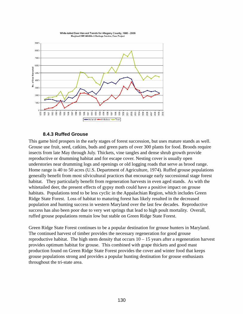
130
8.4.3 Ruffed GrouseThis game bird prospers in the early stages of forest succession, but uses mature stands as well. Grouse use fruit, seed, catkins, buds and green parts of over 300 plants for food. Broods require insects from late May through July. Thickets, vine tangles and dense shrub growth provide reproductive or drumming habitat and for escape cover. Nesting cover is usually open understories near drumming logs and openings or old logging roads that serve as brood range. Home range is 40 to 50 acres (U.S. Department of Agriculture, 1974). Ruffed grouse populations generally benefit from most silvicultural practices that encourage early successional stage forest habitat. They particularly benefit from regeneration harvests in even aged stands. As with the whitetailed deer, the present effects of gypsy moth could have a positive impact on grouse habitats. Populations tend to be less cyclic in the Appalachian Region, which includes Green Ridge State Forest. Loss of habitat to maturing forest has likely resulted in the decreased population and hunting success in western Maryland over the last few decades. Reproductive success has also been poor due to very wet springs that lead to high poult mortality. Overall, ruffed grouse populations remain low but stable on Green Ridge State Forest.
Green Ridge State Forest continues to be a popular destination for grouse hunters in Maryland. The continued harvest of timber provides the necessary regeneration for good grouse reproductive habitat. The high stem density that occurs 10 – 15 years after a regeneration harvest provides optimum habitat for grouse. This combined with grape thickets and good mast production found on Green Ridge State Forest provides the cover and winter food that keeps grouse populations strong and provides a popular hunting destination for grouse enthusiasts throughout the tri-state area.
131
8.4.4 Gray SquirrelThe gray squirrel inhabits hardwood and mixed coniferous-deciduous forests dominated by seed-producing trees. Its abundance is dictated by seed crop productivity rather than by a specific plant community. Habitats include tree species such as oak, hickory, beech, maple, poplar and walnut. The primary food source of the gray squirrel is nuts - acorns, hickory nuts, beechnuts, walnuts, and hazelnuts (Herritt, 1987). They require partial hardwood stands of trees old enough to produce mast and provide dens. Supportive foods are berries, soft mast, buds, seeds and fungi.Since the majority of Green Ridge State Forest is comprised of immature to mature hardwood forest, it presently provides excellent gray squirrel habitat. Green Ridge State Forest has among the highest populations and best hunting opportunities for gray squirrels in the state. Any severe hardwood mortality resulting from gypsy moth defoliation will have a negative effect on gray squirrel populations.
Conversion of the tree species complex on Green Ridge State Forest through harvest regeneration that favors other species over oak or loss of oak species through gypsy moth defoliation will result in poorer gray squirrel habitat over time. Gray squirrels are heavily influenced by the amount and diversity of acorns that are produced in the forest.
8.4.5 Fox SquirrelLike the gray squirrel, the fox squirrel resides in deciduous forests characterized by an abundance of seed-producing trees. The habitat preference of the fox squirrel and the gray squirrel is common in heavy forests with a well-developed understory, whereas the fox squirrel prefers open woods or forest edges with a poorly developed understory. Small woodlots with park-like conditions adjacent to cultivated fields or orchards are favored habitats for the fox squirrel (Nerritt, 1987). The fox squirrel is less common on the Green Ridge State Forest due to the lack of preferred habitats that exist there. Increased and timely intermediate tree harvests could improve and expand fox squirrel habitat.
8.4.6 Red SquirrelAlthough the red squirrel reaches maximum abundance in mature, closed-canopy, coniferous forests of Virginia pine, white pine and hemlock, it can also be found in mixed forests and pure deciduous woodlots. In mixed forests such as exist on Green Ridge State Forest, both the red and gray squirrel may co-exist, but in this situation, the red squirrel tends to be restricted to coniferous growth, while gray squirrels select deciduous areas in the same forest (Merritt, 1987). Due to the scattered stands of hemlock and pine plantations that exist on the Green Ridge State Forest, the red squirrel is probably locally common within these conifer stands.
8.4.7 Black BearCurrently, Maryland has a resident, breeding black bear population in Garrett, Allegany, Washington, and Frederick counties. Bears are considered common throughout all of Allegany County and utilize all areas of Green Ridge State Forest. The prevailing characteristic of black bear habitat is forest cover interspersed with small clearings and early stages of forest
132
succession. (U.S. Department of Interior, 1987). Mixed stands of conifers and hardwoods supporting a dense, brushy understory in close proximity to wetlands represent optimal black bear habitat. The extent of forestland and variety of age classes, such as that found in Green Ridge State Forest provides excellent black bear habitat. A major management consideration is that black bears have large home ranges as compared to many wildlife species that spend their entire lives within the boundaries of the forest. The annual home range size of female black bears is approximately 13 square miles and the annual home range size of male black bears may range to more than 50 square miles. Black bears are habitat generalists and will generally benefit from most common silvicultural practices.
8.4.8 Wild TurkeyGood turkey habitat contains mature stands of mixed hardwoods, groups of conifers, relatively open understories, scattered clearings, well-distributed water and reasonable freedom from disturbance. Home range is about one square mile. Turkey diets consist primarily of grass and weed seeds in the fall, mast and forage in winter and spring, and forage and insects in the summer. Acorns, dogwood berries, clover and pine seed are the foremost foods. Openings are essential to brood range (U.S. Department of Agriculture, 1974).Green Ridge State Forest offers good wild turkey habitat. Probably the greatest limiting factor is that 1% of the forest is classified as openland. Few areas of Green Ridge State Forest are maintained in permanent wildlife openings. Additional acres of utility rights-of-way provide marginal turkey brood habitat. Of course some of this lack of openland area is compensated for by nearby openings on private lands. A cursory GIS exercise shows that there is at least some limited potential for brood habitat within the annual range of turkeys throughout the forest. The large wildland areas are most lacking in available brood habitat. Converting reclaimed log landings to permanent herbaceous cover would improve brood habitat for turkeys in many areas of the State Forest.
If large scale hardwood mortality occurs due to gypsy moth defoliation, this will have a negative effect on the wild turkey population; as would any habitat change that would reduce mast production. The long-term decline in oak species regeneration following harvest or gypsy moth defoliation will have a negative effect of turkey populations. Any management toward maintaining healthy oak stands will benefit wild turkeys.
8.5 Upland Game Birds And MammalsFor the purpose of the Green Ridge State Forest planning effort, the following wildlife species will be classified as upland game: eastern cottontail, American woodcock, mourning dove.
8.5.1 Eastern cottontailThe eastern cottontail resides in various habitats. Although no single plant community is preferred, optimal habitats include brushy areas with profuse herbaceous vegetation such as cut-over forests, thickets and agricultural areas. They are less numerous in dense forests with poorly- developed ground covers of herbaceous plants and in very open grassland (Merritt, 1987).The eastern cottontail is not a common wildlife species to be found throughout Green Ridge
133
State Forest because most of the forest is immature to mature forestland. It is probably locally common adjacent to the open -land habitats that exist on the forest or in recently cut-over areas. Areas with severe gypsy moth mortality may provide a short term increase in eastern cottontail populations. The eastern cottontail was a more sought after game species a few decades ago when habitats were more suitable and populations were higher. There are a few sites on Green Ridge State Forest where there is more intensive management for this popular game species. Most notable are the Kirk Orchard, Kasecamp Bottomlands, and the Bull Ring Ranch described previously. Operational plans and specific work plans with more specific habitat alterations are developed and being implemented for these areas to target early successional habitats for species such as eastern cottontails.
8.5.2 American WoodcockThe American woodcock is a migratory game bird wintering in the warmer southeastern Atlantic and Gulf Coast states and breeds primarily in the northern midwest and northeastern states (Sanderson, 1987). The breeding range overlaps much of the winter range with Maryland near the southern limit of the breeding range. During the breeding season, woodcock are fairly common in the Allegheny Mountain regions of Maryland to including Green Ridge State Forest State Forest.
Woodcock habitat in Maryland is generally associated with the early stages of forest succession, thickets or open stages of shrubs and small trees adjacent to damp or wet areas. Woodcock prefer areas with little or no vegetation covering the ground (Sanderson, 1977).
Although woodcock continue to exist statewide, total population numbers, as counted by the United States Fish and Wildlife Service, have shown a decline in breeding density since the early 1970s (Bortner, 1990).
Habitat does exist for American woodcock in Green Ridge State Forest, but it is only a small percentage of the total forest, because most of the forest is at the immature to mature age class. Any silvicultural efforts creating early successional stage habitats near wetlands or moist soil and flood plain areas would be of benefit to woodcock populations. Moist soils are quite limited in the Ridge and Valley province and Green Ridge State Forest. The few bottomland floodplains that occur in this region are therefore extremely valuable when properly managed for American woodcock.
As part of the Appalachian Mountain Woodcock Initiative, there will be a concentrated effort to improve habitat for the American woodcock in Green Ridge State Forest. Specific plans will be determined following a GIS exercise to determine best potential areas for implementing habitat alterations to benefit American woodcock. The strategy will be to incorporate Best Management Practices as outlined by AMWI. Currently Kirk Orchard is being used as a habitat demonstration area within Green Ridge State Forest.
8.5.3 Mourning Dove
134
The mourning dove is a migratory game bird common throughout Maryland's agricultural areas.Mourning doves are found primarily in agricultural areas. They use hedgerows, wood margins, woodlots and residential areas as nesting and rearing sites. Food for adult doves consists of seeds of most weeds and waste grains from corn and wheat fields. Young and adult doves eat a few insects during the summer.
Due to its habitat requirement, the mourning dove is not abundant on most of Green Ridge State Forest. Best populations may exist adjacent to openland habitats or near private agricultural lands adjacent to the forest.
8.6 WaterfowlAquatic habitats located within and near Green Ridge State Forest, support several species of waterfowl. Open water areas include the Potomac River and a few other small ponds and streams. Waterfowl use of these habitats includes nesting, foraging and resting areas.
Wood ducks and mallards are the most common resident species. Wood ducks nest in tree cavities and man-made structures along wooded shorelines and upland areas. Young birds feed exclusively on animal matter, such as aquatic and terrestrial insects. As the birds mature, their diet shifts to vegetable matter, primarily acorn, and other forms of hard and soft mast. Mallards nest in marshy areas and along protected shorelines using cattails, grassy areas and fallen logs for cover. Mallards are highly adaptive feeders that use numerous native and agricultural foods. Native plant materials include wild millets, grasses, smartweeds and rushes. Agricultural foods consist of numerous types of waste grain including corn, wheat, barley and oats.
A resident Canada goose population exists on the Potomac River. Current breeding activity appears to be isolated from most of the state forest, but periodic use of the area is expected.
Current management of waterfowl in the Green Ridge State Forest is limited to erection and maintenance of wood duck nesting boxes. Management commensurate with watershed protection should adequately address this group's needs.
8.7 Aquatic FurbearersAquatic furbearers on the state forest include beaver, mink, muskrat and, potentially, river otter. This group, though taxonomically diverse, are commonly dependent upon aquatic habitats. Historical management strategies have centered around habitat protection and regulated trapping for recreational and economic opportunity.
8.7.1 BeaverThe beaver is America's largest rodent. It is known for its valuable fur. Unregulated trapping during the nineteenth century significantly reduced beaver populations. Aided by modern wildlife management and its own prolific breeding habits, the beaver has successfully repopulated much of its former range.Beavers are found throughout Western Maryland and occur on Green Ridge State Forest. They
135
are dependent upon plentiful, constant sources of water with nearby woody vegetation. They quickly modify their environment using rocks, sticks and mud to build dams and protective lodges. Entirely vegetarian, they prefer soft plant foods including grasses, ferns, stems and leaves of aquatic and terrestrial plants. They also eat the bark, twigs and buds of aspen, maple, willow, birch, alder and cherry trees.
Currently, beavers are considered common on Green Ridge State Forest. Regulated trapping and mandatory tagging provide useful data on beaver harvests and subsequent populations.
8.7.2 MuskratMuskrats live on or near still or slow moving water of ponds, marshes, streams, rivers and to a lesser extent, the faster mountain streams. They build lodges of vegetation or burrow into stream banks and dams. Both lodges and burrows have underwater entrances. Muskrats feed primarily on the roots and stems of aquatic plants, such as cattails and bulrushes, as well as a Small amount of animal protein, such as crayfish, fish and mussels. Highly reproductive, mature females may produce two to four litters per year. Muskrat habitat in the forest appears to be sub-optimal and subsequent population levels range from low to moderate.
8.7.3 MinkThe mink is a semi-aquatic member of the weasel family. They live at the edge of lakes, streams and rivers in forested areas. Opportunists, they hunt along the streambanks of rivers and dive to locate aquatic animals. Prey includes muskrats, mice, rabbits, shrews, fish, frogs, crayfish, insects, snakes, waterfowl and other birds. Due to the shy, secretive nature of minks, little is known about mink populations at Green Ridge State Forest. Studies indicate an individual mink requires approximately three miles of stream on the riverbank.
8.7.4 River Otter
The presence of river otters in Garrett and Allegany counties is the result of a reintroduction program that took place throughout the 1990s. River otters are now considered common throughout Allegany County and Green Ridge State Forest. River otters are semi-aquatic and utilize most healthy wetland systems, ranging from trout streams to beaver ponds to marshes. River otter feed predominantly on fish, but will also consume crustaceans, mollusks, amphibians, reptiles and other small animals when locally abundant.
8.8 Upland Fur BearersUpland furbearers on the state forest include raccoon, opossum, striped skunk, red fox, gray fox, coyote, fisher, long-tailed weasel, and bobcat. This group, though taxonomically diverse, are commonly dependent upon upland and forested habitats. Historical management strategies have centered around habitat protection and regulated trapping for recreational and economic opportunity.
136
8.8.1 Striped Skunk, Raccoon and OpossumDue to the generalized habitat requirements, omnivorous and opportunistic food habits and adaptability to human encroachment, these species are generally abundant throughout Green Ridge State Forest. In spring and summer months, all three species prefer to reside near streams, spring seeps, ponds and edges to seek aquatic prey, but will frequent other areas. Den trees and snags or rock outcroppings are utilized by raccoons.
8.8.2 Red FoxThe red fox is associated with brushy early successional areas such as old fields, pasture borders and rolling farmland, usually close to water. Some of these habitat types occur on or near Green Ridge State Forest and a red foxes are found on the forest. Due to the limited acreage of preferred habitat the red fox is present, but not abundant.
8.8.3 Gray FoxThe gray fox is closely affiliated with hardwood forest typified by rock terrain and abundant, brushy cover. Its feeding habits are similar to the red fox with rabbits, mice, rats and other wild mammals contributing up to 75% of its diet. Other food items vary according to seasonal availability. As most of Green Ridge State Forest provides this type of habitat, it can probably be assumed that the gray fox is generally common and well distributed throughout the forest.
8.8.4 FisherThe fisher is associated with large tracts of mixed hardwood and coniferous forest, usually in isolated mountain regions. It dens in hollow trees or logs, in abandoned animal dens or under large boulders. Fisher populations have been growing throughout the county as well as Green Ridge State Forest. Fishers were relocated in both neighboring West Virginia and Pennsylvania and have expanded throughout Garrett and Allegany County from these relocations. The fisher population has grown and the bag limit was raised to 2 per season. Maintaining a variety of habitat types within a forest ecosystem will ensure quality habitat for fishers.
8.8.5 Long-tailed WeaselThe long-tailed weasel lives in a diversity of habitats ranging from mature forests to marshes and farmlands. It is highly carnivorous and shows a preference for Small animals, which make up 95% of its diet. Although population status has not been determined, wildlife biologists believe it to be common and well-distributed throughout Green Ridge State Forest.
8.8.6 BobcatOptimal bobcat habitat is woodland interrupted by brushy thickets, old fields and rocky outcrops. Isolation from human activity and availability of prey and den sites are key factors determining habitat selection. A bobcat population study conducted in 1986-87 by the DNR indicated that this feline will use all habitat types in Green Ridge State Forest. Sightings have been documented throughout the forest.
137
Feldhamer et al. (1984) stated that although there is no question that the density of bobcats in Maryland is significantly reduced from colonial days, there probably are more individuals in Maryland than commonly believed. The Wildlife and Heritage Service is currently participating in a research project with Frostburg State University to better understand the population and range of bobcats in Maryland.
8.8.7 CoyoteCoyotes are associated with forested and upland or agricultural habitats where they can find abundant prey. Coyotes are known to be one of the most adaptable species and can use almost any habitat type and live in close proximity to human activity and development. Optimum habitat occurs wherever prey species are most abundant. This may include brushy forested areas and the edge habitats where agriculture and forest come together. Although the coyote has no closed season for hunting, populations are high and likely growing throughout western Maryland and on Green Ridge State Forest.
8.9 Wildlife Management Objectives and Strategies for Game Species
The DNR commonly considers and manages wildlife in broad categories based on the habitats that they prefer. Game species as mentioned include forest game such as white-tailed deer, black bears, gray and fox squirrels, ruffed grouse and wild turkeys and upland species such as eastern cottontail, American woodcock and morning dove, as well as wetland species such as aquatic furbearers and waterfowl. Habitats for these groups of species can be managed to provide all the requirements of the group. Though some species have very specific habitat requirements, many of the species will use similar habitat components that are beneficial for the group. The objectives and strategies listed will provide both the specific and general habitat requirements of the species within the groups.
Forest Game Species
Objective: Create and maintain 20% of manageable area in early successional forest habitat.
Strategies:• Regularly use silvicultural forest management practices, either commercial
or non-commercial, to maintain early succession forest habitat.• Target regeneration of aspen stands and maintain them in the sapling stage
by cutting and regenerating pole size trees to promote root sprouts.• Focus early succession habitat maintenance along edges of fields,
permanent wildlife openings, powerline rights-of-way, and road edges.
Objective: Maintain a structurally diverse forest that provides habitat for a variety of wildlife species.
138
Strategies:• Use Best Management Practices to maintain forest cover and protect
soils from erosion on steeper slopes.
• Use BMP’s and appropriate silviculture techniques to maintain various age classes.of forest habitat from seedling-sapling to older forest.
Objective: To manage older forest habitat for long term wildlife food production and promote acorns and other hard mast production.
Strategies:
• Complete comprehensive and detailed forest inventory and maintain a significant oak component throughout the forest.
• Conduct timber harvest and site preparation to focus on improving the oak component and ensuring oak regeneration in future stands.
• Conduct crop tree management to improve oak survival and improve hard and soft mast production throughout. This will also improve understory regeneration, cover, and vertical structure beneficial for a variety of forest wildlife species.
Objective: Maintain and protect the spring seeps, drainages and water quality for invertebrates as well as to provide winter habitat for turkeys and other species that will benefit from the springs in the area.
Strategies:
• Delineate and maintain adequate buffers along all springs and drainages to protect their ecological integrity.
• Utilize Best Management Practices for forest harvest operations.• Seek opportunities to acquire property, easements, or work with
landowners and municipalities to prevent watershed degradation.• Monitor water quality conditions, invertebrate populations, and threats and
adjust plans as necessary.
Upland Habitat
Objective: Create and maintain upland and early successional habitat.
Strategies:• Maintain the open herbaceous cover and crops beneficial to wildlife. A
variety of crops should be used to benefit different species of wildlife at
139
different times of the year. Perennial grass and clover plantings should be a priority to provide soil stabilization, forage, and game bird brood habitats. Plantings should include annual grains that will remain available in winter and stand up under snow.
• Throughout spring and summer, mow and maintain strips of herbaceous cover at less than a 6-8 inch height. Mowing will begin prior to nesting season and be maintained throughout summer to provide breeding habitat for Eastern cottontails.
• Maintain warm season grasses for Eastern cottontail nesting and escape cover and wildlife habitat demonstration.
• Continually monitor and maintain early succession edge habitat around field edges.
• Maintain and expand aspen and hawthorn thickets by releasing and regenerating as necessary.
• Regularly use forest management practices, either commercial or non-commercial, to maintain early succession forest habitat at field edges.
• Complete routine annual assessments of plantings and available cover crops and adjust annual work plans accordingly.
• Monitor and coordinate habitat programs with the Appalachian Mountain Woodcock Initiative.
• Consider management actions to enhance habitat for nesting Golden-winged Warbler.
Objective: Maintain upland field edge habitat and orchards.
Strategies:• Release and prune apple trees to encourage fruit production.• Maintain “soft” field edges by cutting back field edges 50-75 feet. • Continue to rotationally plant and mow herbaceous openings.• Evaluate plantings and edge effects and adjust plans as necessary.• Consider management actions to enhance habitat for nesting Golden-
winged Warbler.
Recreation Objective
Objective: Provide quality access for wildlife dependant recreation, particularly deer firearm season.
Strategies:• Conduct regular maintenance to roadways, parking areas, and signboards.• Seek critical maintenance funding when available.• Coordinate with Engineering and Construction for road maintenance
140
specifications.• Limit motorized access to the period of highest user demand.
8.10 Forest Interior Dwelling Bird Species (FIDS)
Information is provided as needed in cooperation with DNR Wildlife & Heritage Program
8.11 Bald Eagle
There have been several eagle nests located in or near Green Ridge State Forest along the Potomac River. These will change over time as the birds move or populations continue to expand. Guidelines established by the Department will be followed around all eagle nest trees. These guidelines currently require:
a. Establishment of a protection area of a 1/4-mile radius around the nest tree. Within this area, there are three zones of protection: Zone 1 extends from the nest tree to a radius of 330 feet; Zone 2 extends from 330 feet to 660 feet in radius; and Zone 3 extends from 660 feet to 1320 feet (1/4 mile). The management guidelines are:
b. No land use changes, including development or timber harvesting, in Zone 1;
c. No construction activities such as clearing, grading, building, etc., within Zones 1 or 2, and ideally should occur no closer than 750 feet from the nest;
d. Selective timber harvesting may be done in Zone 2, but clear cutting should be avoided; and,
e. No construction or timber harvesting activities should occur within the 1/4-mile protection zone during the eagle-nesting season, which is from December 15 through June 15.
8.12 AmphibiansLocations and special management prescriptions for some amphibian habitats are included within the Ecologically Significant Areas land classification (Chapter 7). Other amphibian habitat will be protected through expanded riparian forest buffer areas. Forest managers with assistance from a Heritage Biologist will need to identify any important amphibian habitat and adjust forest harvest operations to protect these habitats. Seasonal wetlands and vernal pools are nearly impossible to adequately survey and map from GIS data. Therefore, these critical habitats will need to be identified, GPS-located and protected during field examinations.
141
Chapter 9 - Public Use & Education
9.1 BackgroundGreen Ridge State Forest is an integral component of a larger greenway system that connects other public and private forest in Maryland, Pennsylvania, and West Virginia. Green Ridge shares boundaries with three MD DNR Wildlife Management Areas, the C&O Canal National Park, and Pennsylvania’s Buchannon State Forest. These sites in addition to their natural, cultural and historic values provide a variety of recreational opportunities. Decisions affecting public uses (recreational opportunities) on Green Ridge State Forest are integrated into management decisions that are consistent with the following resource goal as stated in chapter 1: “Provide opportunities for the enjoyment of the natural resources on the Forest by making appropriate areas available for resource-based, low impact recreational activities and environmental education programs that are consistent with the resource values of the Forest.”
Green Ridge State Forest traditionally receives more visitors than any of the other state forests in Maryland. Furthermore, the GRSF headquarters/visitors center is likely one of the most visited by the public, DNR offices. It has been estimated in recent years that approximately 100,000 visitors per year visit the GRSF headquarters complex. This is most likely due to GRSF’s proximity to the urban centers of the Washington DC and Baltimore City areas and the more developed recreation program that is in place on this forest.
9.2 Current and Future Public UsesThe demand both nationwide and locally indicate that outdoor recreational activities such as hiking, horseback riding, wildlife viewing, hunting, fishing, canoeing and kayaking continue to be popular. The public’s pursuit of these activities continues to play a major role in Maryland’s economic growth and tourism industry. Therefore, all future public use proposals will be evaluated based on the resource goal stated above to determine their compatibility with:
• The implementation of sustainable forest management;• The conservation of wildlife;• The conservation of plant and animal habitats and other sensitive areas;• The maintenance of water quality;• And the protection of cultural resources.
The primary types of public use to be encouraged on the Green Ridge State Forest include activities such as hunting, trapping, fishing, camping, hiking, biking, geocaching, birding, horseback riding, nature/wildlife observation, environmental education, and access for canoeing and kayaking. In select cases, minimal development may be undertaken to provide and maintain motorized trails, mountain bike trails, hiking trails, disabled hunter access, camp sites, scenic
142
vistas, and environmental education infrastructure.
9.2.1 HuntingWildlife populations must be managed to ensure a healthy forest. Therefore, public hunting opportunities are provided to manage healthy populations of game species and ensure the protection of the forest and other habitats. This plan attempts to identify the proper combination of hunting as well as other appropriate recreational use. The forest is open to public hunting, trapping and fishing in season.
Green Ridge State Forest is one of the most popular public hunting areas in Maryland. Hunters remain the most prevalent recreational user group on the forest. This is considered a symbiotic relationship between the forest resource and public use because many hunters rely on GRSF as a place to enjoy their sport while the Department relies on hunting as a tool for maintaining some wildlife populations at an ecologically sustainable level.
Hunting with rifles, handguns, shotguns, bows and muzzleloaders are permitted in all designated areas in accordance with state and federal laws. Possession or use of weapons is prohibited in State Forests outside of regular open hunting season. Target shooting is prohibited except at the public shooting range by permit. All game birds and game mammals may be hunted. Game shooting stands are limited to those of a temporary nature, which must be removed or dismantled at the end of each day. The hunting season in State Forests conforms to standard hunting seasons adopted by state and federal regulations
9.2.2 CampingPrimitive camping, group camping and back country camping is available at Green Ridge State Forest by permit. There are 100 designated campsites available year round with a permit fee of $10/night. Permits are also available for back country camping at same rate. Over flow campsites are made available in the event the designated campsites are all under permit. At this time, overflow camping is seldom needed except for during the weekend following Thanksgiving.
There are seven group campsites available by reservation to groups of 20 or more people. Permits for these sites also require that the party provide a portable sanitation system during occupancy of the site. The group campsite permits require a $5 reservation fee and $20/night camping fee.
Registration for all camping is done at the GRSF headquarters and visitor center. Self Registration is available when the office is closed. Current camping activity at GRSF is approximately 6500 registered campsite occupancy days per year.
9.2.3 Hiking, Biking, and Horseback Riding Although hunting is the most popular activity, there is an extensive forest road system on the Green Ridge State Forest that offers ample opportunities for hiking, biking, horseback riding and nature observation. These activities will be encouraged on all tracts provided there are no other user conflicts.
143
9.2.3.1 Green Ridge State Forest Hiking Trail System:The Green Ridge State Forest hiking trail system was designated as a National Recreation Trail in the National Trails System by the U.S. Department Of The Interior on June 3, 2005. The hiking trail system totals approximately 40 miles of trail. This trail system connects with Pennsylvania’s Mid State Trail and the National Park Service’s C&O Canal Tow Path Trail. Recently, sections of the existing trails and unimproved roads were connected to become part of the Maryland section of the Great Eastern Trail (GET). The GET remains in the infancy stages but is projected to someday rival the Appalachian Trail. Trail Grants will be utilized to improve the existing network of trails throughout the Green Ridge State Forest trail system. All new trail system proposals as well as maintenance work will be submitted and reviewed through the Annual Work Plan process.
9.2.3.2 Green Ridge State Forest Mountain Bike Trail:The Green Ridge Mountain Bike Trail is a 12-mile circuit trail designed with mountain bikers in mind, but is also open to hiking. Intermediate and advanced mountain bike riders are challenged by a variety of terrain, including steep inclines and fast descents. This trail is mostly single track and considered a rating of difficult.
Biking is also permitted on all forest roads and on the NPS’ C&O Canal Towpath. The combination of these biking opportunities offers varying levels of biking experiences on the forest from easy street and trail riding to difficult mountain biking experiences.
9.2.3.3 Horse Back Riding at Green Ridge State Forest:Horse back riding is permitted on the open public roads within the forest and there are three primitive campsites available that accommodate space for camping with horses. However, there are currently no designated horse trails on the forest and horses are not permitted on the designated hiking or mountain bike trails. Horses are not allowed on these trails because they were not designed to withstand horse traffic and horses are associated with depositing non native and invasive species seed where they travel.
Many of the public forest roads are unimproved and receive minimal vehicle traffic, making them accommodating to horse back riders. This system meets the current demand for horseback riding on the forest. Future proposals for alternative horse back riding trails will be submitted and reviewed through the Annual Work Plan process. The potential for invasive species introduction, organic accumulation from horse feces, soil degradation, and other environmental factors would be closely evaluated in consideration of any horse back trail proposals on the forest.
9.2.3.4 Green Ridge State Forest Off Road Vehicle (ORV) Trail:The 16.5 mile circuit ORV Trail and other Maryland ORV Trails were established in 1976 under MD Annotated Code 5-209 and DNR Regulation 08.01.03. The GRSF ORV Trail operated for approximately thirty five years. However, ATV use of this trail increased out of control in recent years to a point that it was no longer sustainable. In 2008, the Department assembled a committee to Assess the Department’s ORV Trails and
144
ATV use on DNR Lands. In August of 2010, the Department drafted an Off- Road Vehicle Trail Assessment and Report. In this report it was recommended that the Green Ridge ORV trail be closed. In early 2011, the Department finalized the decision to close the GRSF ORV Trail.
9.2.4 Water Access for Canoeing, Kayaking and FishingThe Potomac River and its tributaries offer opportunities for canoeing, kayaking and fishing. Green Ridge includes approximately 30 miles of Potomac River Shore Line. The Bonds Landing area offers a public boat launch and camping. There are several other public boat ramps located nearby. A popular two-day float trip is to launch at the C&O Canal Boat Ramp near Paw Paw Tunnel and float to Bond’s Landing where camping and vehicle access is available. Then float on down river to Little Orleans on day two. This is a total of 21 mile float trip that meanders around the remote, wild and scenic Potomac Bends Wildlands. There are also several local outfitters that offer canoe rentals and shuttle service for this popular adventure.
Anglers can enjoy year round fishing on GRSF section of the Potomac River including smallmouth bass, walleye, sunfish, catfish, and occasionally muskellunge. Angling opportunities also exist within the streams that meander through the forest and two managed ponds. Fifteen Mile Creek, Sidling Hill Creek, Orchard Pond and White Sulphur Pond are managed as Put and Take Trout Fishing Areas open to all anglers possessing a Maryland Fishing License and trout stamp. Anglers under 16 do not need a license to enjoy the fishing experience. The Green Ridge sections of Town Creek are managed as a Special delayed harvest trout fishing area. Artificial lures must be used for fishing during the season while there is a zero creel limit. Delayed harvest implies that catch and release fishing is permitted only until a specified date that fish may be caught using all types of legal tackle including live bait and two fish per day may be harvested. Delayed harvest trout fishing areas are managed to maximize trout fishing opportunities for license holders in waters that can not support natural trout populations because of summer habitat conditions. Improvement of these areas or development of additional water access opportunities will be submitted and reviewed during the Annual Work Plan process.
9.2.5 Education and Public Outreach The Department’s goal for Green Ridge State Forest is that it will be a national model of sustainable forest management, in addition to increasing the public’s awareness concerning the importance of sustainable forest management and its connection to the health of the Chesapeake Bay. The Forest is seen as a “living laboratory” or “outdoor classroom” where resource professionals and the public can learn. Therefore, education and the development of forest management demonstration areas will be very important. This goal will be achieved by:
• The continuation and constant update of the Green Ridge State Forest website;• The development of brochures and other written material about the Forest;• And, the provision of tours and other public forums for educating the public about the
Forest.
Green Ridge State Forest WebsiteThe website (https://dnr.maryland.gov/forests/Pages/publiclands/western_greenridgeforest.aspx) has been and will continue to be an valuable mechanism for
145
communicating with the public. It has been used to share general information and annual work plan (AWP) projects.
9.2.5.1 Educational MaterialThe Department should consider the placement of interpretive markers or informational kiosks at the public use areas experiencing the highest visitation. These kiosks would include a map and information on the Forest and sustainable forest management. One example of this approach is found at the Green Ridge State Forest Headquarters and Visitor Center. The Department annually updates its educational trail guide by developing information emphasizing sustainable forest management. The Department should also consider the development of a CD-ROM that contains information about the forest, its resources and the connection to the Bay. This could be a cooperative effort between the Forest Service, the Wildlife and Heritage Service and the Park Service.
9.2.5.2 Tours and ForumsThe Department will continue to sponsor forest management field days that educate the public in the values of sustainable forest management and working landscapes. These field days could be targeted to the public that are using the Forest as a way for them to be educated and understand the Department’s approach to forest management and the relationship of their use to this management. Examples of what has been done in the past at GRSF to educate the public about sustainable forest management and reconnect people to the forest include hosting nature and recreation based festivals, Forest Management themed van tours of the forest, development of a self guided driving tour, conduct service learning projects with the local schools, provide forestry experience opportunities for local colleges and Universities, and staff participation at community events such as fairs and festivals.
The Department will continue to sponsor cooperative research projects as part of the implementation of the Monitoring Plan (see Chapter 10). Some of the existing partnerships include the Appalachian Laboratory, Frostburg State University, West Virginia University, Allegany College of Maryland, Garrett College, The Nature Conservancy, The Wildlife Institute, and local community service organizations.
Department Staff should remain engaged with partnership organizations such as the Allegany Forestry Board, Volunteer Team Incorporated, Appalachian Forest Heritage Area, Maryland Forest Association, and other local Natural Resources, Cultural Heritage, and Recreation advocacy organizations to collaborate on projects and share information. In addition, the Department should involve the Maryland Conservation Corps, local school groups, scouting organizations and local environmental groups in the implementation of projects identified in the Annual Work Plan.
The Department should continue to support special events on the forest that are sustainable and compatible uses within the forest to foster the public’s connection to the land and public support for the forest management program. Such events may include trail runs, adventure races, search and rescue conferences and similar events.
146
The Department should utilize forest recreation medium as tools to facilitate interpretation of sustainable forestry management and other natural and cultural heritage themes within the forest to educate and connect the public to the forest. One example of this model being implemented at Green Ridge State Forest is the Geocaching program that has been initiated within the forest. Geocaching is a GPS based activity that is quickly becoming popular across the nation. In brief, geocaching is similar to a scavenger hunt where people navigate by GPS to locate a “Cache” that has been placed at given coordinates. Typically, these caches allow the finder to trade a trinket and log their discovery in a log book. During the fall of 2010, GRSF placed a series of geocaches throughout the forest at significant sites such as Champion Big Trees, and significant cultural heritage sites. Inside of these caches are interpretive materials that provide educational information about the significant feature at the site. GRSF plans to expand this program to include caches that will navigate participants to forest management demonstration sites and include interpretive information about the sustainable management practices.
9.2.6 ImplementationAs with the other management activities, recreational and educational activities will be included as proposals within the Annual Work Plan (AWP). These activities will be reviewed by the Green Ridge State Forest interdisciplinary team and once reviewed and approved will be implemented as part of the AWP process. Public use activities will also be monitored to ensure there is not conflict with the other management goals or degradation of the sensitive resources found on the forest. Limits of Acceptable Change procedures and protocols will be used to monitor these public use activities (see Monitoring Plan – Chapter 10).
Land Use Agreements and/or Memorandum of Understanding documents may need to be negotiated and processed for organizations cooperating with the Department on projects and/or events on the State Forest.
147
Chapter 10 - Monitoring Plan
10.1 IntroductionThe primary goal of the Green Ridge State Forest Project is to provide sustainable natural resources, from water, fisheries and wildlife habitat to timber, education and recreation contributing to the local environment and economy. The Green Ridge State Forest is being managed for sustainable forestry using similar strategies and combined efforts. Concepts of sustainability are based on the international standards of sustainable forestry represented by the Montreal Process Criteria and Indicators. MD DNR participates in the National Roundtable for Sustainable Forests to further improve coordination and use of sustainable forestry practices http://www.sustainableforests.net/ . Critical sustainability standards for this Forest includes no soil deterioration or nutrient loss, no decline in water quality from activities, no loss or decline of species, the protection of special areas, an acceptable flow of jobs and revenue, and stakeholder satisfaction with results.
Monitoring is crucial to the ability of the Green Ridge State Forest to supply its intended sustained yield of a variety of forest resource benefits. At a minimum, the monitoring activities must meet current requirements for certification and reporting. Monitoring is necessary to document sustainable practices, provide information to adapt management, and carry out elements required for certification as a sustainable forest by the Sustainable Forestry Initiative (SFI) and Forest Stewardship Council (FSC). The FSC specifically identifies monitoring and assessment as one of its ten Principles, and monitoring data are needed to meet a number of SFI Core Indicators. Evaluation of the range of elements being sustained relies on an interdisciplinary plan that monitors a wide range of aquatic and terrestrial features. A monitoring project on this scale provides opportunities for scientific study, collaboration, and external funding. It also provides challenges, such as the need for an efficient, coordinating structure for the monitoring program and how to overcome limits to the involvement of current staff in the project. This critical component of the Green Ridge State Forest Plan will not be successful unless support continues to be adequate, whether financed by Forest income or other sources.
On Green Ridge State Forest the process has just begun to implement the detailed layers of monitoring described within this chapter.
10.2 Monitoring Plan The monitoring plan supports the needs of the Green Ridge State Forest Project using a multi-tiered approach:
• Tier I: a landscape-scale inventory

148
• Tier II: a stand/complex-level inventory, and • Tier III: project-specific assessment and research.
In order to more efficiently use resources, data collection will be coordinated as much as possible among the different units’ staff and with similarly managed land holdings like GRSF. The exact number of points to be sampled will depend on the number of points falling within multiple strata, and potentially on the cost/effort for sampling. Power analysis and community dynamics models will be used to help determine the appropriate number of samples to allow trends in population changes to be detected. At the beginning of each section, the SFI Objectives and FSC Principles that are addressed by these elements of the monitoring plan are listed.
Data obtained from the monitoring will be used to update the Green Ridge State Forest Geographic Information System, and spatially integrated with the base ownership layer. DNR units and personnel have been assigned to manage the layers of information based on data source and unit expertise, including Forest Service, Wildlife & Heritage Service, Land Acquisition & Planning, Ecosystem Restoration Services, and Information Technology. New data are added to the GIS system through the data manager assigned for the respective layers.
10.2.1 Tier I: Landscape-scale, Long-term Monitoring
10.2.1.1 ObjectivesThe focus of Tier I monitoring is overall biodiversity and ecosystem health. It provides the basic inventory data for forest management, sensitive resources, and water quality over terrestrial and hydrogeomorphic regions. Tier I monitoring provides the information base for Sustainable Forestry Initiative certification Objectives 1, 3, 4, 5, and 6, and for Forest Stewardship Council certification Principles 5, 6, 7, 8, 9, 10 (Objectives and Principles listed in Appendices B & C).
Information to be collected at this scale includes:1) Forest overstory condition, including stand inventory, tree growth rates, and regeneration
status, yielding information needed to determine sustainable levels of harvesting;2) Forest understory condition, including height of canopy layers, species, diversity, and
presence of invasive species;3) Wildlife and habitat information, including habitat features like snags, woody debris,
percent canopy cover, and vertical diversity; and4) Water quality surveys of nutrient status, macroinvertebrate and stream salamander
populations, and aquatic habitat condition that supplement the Maryland Biological Stream Survey data, supplying water quality status and aquatic invertebrate, fish, and stream salamander species presence and diversity.
The inventory sampling approach assures representation of sensitive resource areas like forest interior habitat, wetlands including vernal pools, rare natural communities, ecologically significant areas, old growth forest, and riparian areas. Special area boundaries including sensitive species protection and restoration areas and cultural resources such as ruins, graveyards, research plots, or wells have been added to the GIS system as encountered or sought
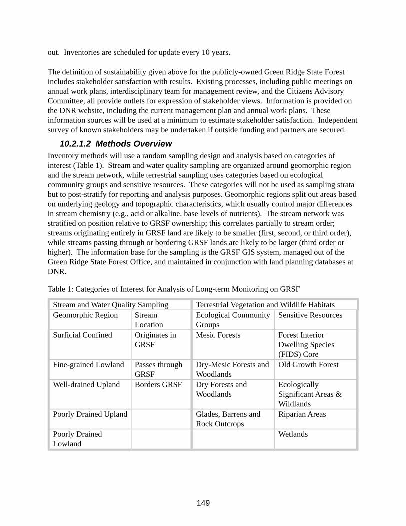
149
out. Inventories are scheduled for update every 10 years.
The definition of sustainability given above for the publicly-owned Green Ridge State Forest includes stakeholder satisfaction with results. Existing processes, including public meetings on annual work plans, interdisciplinary team for management review, and the Citizens Advisory Committee, all provide outlets for expression of stakeholder views. Information is provided on the DNR website, including the current management plan and annual work plans. These information sources will be used at a minimum to estimate stakeholder satisfaction. Independent survey of known stakeholders may be undertaken if outside funding and partners are secured.
10.2.1.2 Methods OverviewInventory methods will use a random sampling design and analysis based on categories of interest (Table 1). Stream and water quality sampling are organized around geomorphic region and the stream network, while terrestrial sampling uses categories based on ecological community groups and sensitive resources. These categories will not be used as sampling strata but to post-stratify for reporting and analysis purposes. Geomorphic regions split out areas based on underlying geology and topographic characteristics, which usually control major differences in stream chemistry (e.g., acid or alkaline, base levels of nutrients). The stream network was stratified on position relative to GRSF ownership; this correlates partially to stream order; streams originating entirely in GRSF land are likely to be smaller (first, second, or third order), while streams passing through or bordering GRSF lands are likely to be larger (third order or higher). The information base for the sampling is the GRSF GIS system, managed out of the Green Ridge State Forest Office, and maintained in conjunction with land planning databases at DNR.
Table 1: Categories of Interest for Analysis of Long-term Monitoring on GRSF
Stream and Water Quality Sampling Terrestrial Vegetation and Wildlife HabitatsGeomorphic Region Stream
LocationEcological Community Groups
Sensitive Resources
Surficial Confined Originates in GRSF
Mesic Forests Forest Interior Dwelling Species (FIDS) Core
Fine-grained Lowland Passes through GRSF
Dry-Mesic Forests and Woodlands
Old Growth Forest
Well-drained Upland Borders GRSF Dry Forests and Woodlands
Ecologically Significant Areas & Wildlands
Poorly Drained Upland Glades, Barrens and Rock Outcrops
Riparian Areas
Poorly Drained Lowland
Wetlands
150
10.2.1.3 Sampling Methods SummaryForest Stand Inventory Plots: For terrestrial samples, data collection points will be randomly selected from the entire Green Ridge State Forest area using a sampling frame and space-filling curves to define thousands of potential sample points (Lister and Scott 2008). This method is similar to Generalized Random Tessellation Stratified Design, but offers some advantages. The number of permanent sample points will be determined through power analysis and consideration of available resources. All permanent sample points are expected to be sampled at least once every 5-10 years depending on monitoring needs and goals for particular resources. It may be necessary to collect data on a subset of plots each year depending on resource availability. In order to ensure that there will be adequate samples to examine trends in the data, a minimum of 20 plots will be included for the less common strata, or these needs will be addressed in the next section.
10.2.1.4 Terrestrial Vegetation and Species SamplingForest Stand Inventory: Vegetation structure and composition is quantified using methods similar to those of the Continuous Forest Inventory (CFI), based on USDA Forest Service Forest Inventory and Analysis Program (FIA) inventory sampling and analysis methods. All trees five inches or greater in diameter at breast height (DBH) will be measured in 1/10 acre (37.2 foot radius) plots. Other information recorded at each plot will include: species, DBH, merchantable height, tree class, percent cull, damage, crown ratio, and crown class. Stand characteristics will be determined using size class, site index, land use, forest type, disturbance factor, distance to road, and physical limitations.
Supplemental Habitat Data Collection: In addition to data collected for Forest Stand Inventory above, percent ground cover, canopy cover, vertical layer presence and height, tree regeneration, coarse woody debris, depth of organic layer, forest health indicators, leaf litter depth and type, and data for invasive species will be collected at each plot location. Data for vertical stratification will be collected by recording the heights of all vertical layers present using a laser. The percent cover and species of all invasive species will be estimated in the entire 1/10 acre plot using the following categories: single stem or few plants, occasional but < 1, 1-5, 6-20, 21-40, 41-60, 61-80, and 81-100%. Canopy cover, litter depth, percent ground cover, and regeneration data will be collected from a 1/100 acre subplot (11.7 foot radius) that was established 20 feet from plot center along a heading of 270 degrees. Canopy cover will be estimated by using a concave densiometer to record leaf coverage in the four cardinal directions from the center of the subplot. Depth and type of litter (pine, hardwood, mixed pine/hardwood) will be measured to the nearest 0.25 inches at 1 foot from the center of the subplot in the four cardinal directions. Percent ground cover for bare ground, leaf litter, moss/lichen, and herbaceous vegetation will be estimated for the plot using cover categories of occasional but < 1, 1-5, 6-20, 21-40, 41-60, 61-80, and 81-100%. Data on regeneration will be collected in the subplot by tallying all tree seedlings and saplings < 5 inches in diameter by species and by height category (< 1.5 feet or > 1.5 feet). Standing and downed coarse woody debris (> 3 inches in diameter) will be measured and assigned a decay class in a transect 100 feet long by 10 feet wide. This transect will extend 50 feet on either side of the plot center along a random direction, with the 10-foot width of the transect on the right side of plot center when facing the random direction. Only the portion of
151
debris within the transect will be measured by recording diameter to the nearest inch and length to the nearest foot or nearest inch. For snags, diameter at breast height will be measured to the nearest inch and height will be estimated in feet. Decay classes to be used are: I (new log), II (slight bark slippage and sound wood), III (some bark slippage but with sound wood), IV (all bark slipped or removed and outer wood decaying), and V (all bark removed and decay extending to the core).
Wildlife and Botany Surveys: Herpetological, ornithological, and botanical surveys will also be completed in conjunction with the forest survey and survey of riparian areas. Multivariate analyses are used to determine relationships between stand types, age classes, and stand history and observed population characteristics. Vegetation information from the detailed wildlife habitat subset of plots may be analyzed using detrended correspondence analysis techniques to identify community types and other associations. Ornithological data collection will be carried out at all points that are located in interior forest. Plots that are located in sensitive resource areas will be selected for additional data collection on reptiles, amphibians, and plants using multiple visits from spring to late summer to adequately sample seasonally available populations. Forest Interior Dwelling bird species (FIDS) will be monitored by using standard point count methodology. Standard methods for reptiles and amphibians include constrained time searches, pitfall traps, and call counts, tailored to the species’ habits. For herbaceous flora, each plot will be visited four times to avoid sampling error derived from seasonality: (1) early spring, (2) late spring/early summer, (3) mid-summer and (4) late summer/early fall. For herbaceous plots, both species diversity and physical structure of the stand vegetation will be recorded using a combination of species presence, percent cover and position in the forest strata using a six strata model (Table 2).
Table 2. Summary of data collected for each of six forest strata.Strata Data CollectedT1 (emergent, high canopy) Species presenceT2 (canopy) Species presenceT3 (subcanopy) Species presenceS1 (tall shrub >2.0 meters) Relative cover S2 (shrub <2.0 meters) Relative cover H (herbaceous plants) Species presence
Stream and Water Quality Sampling: For aquatic samples, points will be chosen using stratified random sampling from mapped (“blue-line”) stream sections that are 150 m in length. Streams must traverse a minimum of 1000 feet on a GRSF parcel. These stream sampling points will be re-randomized for each sampling event (at least every 5 years) in order to more accurately capture the general condition of the aquatic resources. Water quality monitoring will use procedures outlined in Boward and Friedman (2000). All analyses will be conducted in accordance with US EPA protocols. Aquatic benthic macroinvertebrates, fish, mussels, and stream salamanders will be collected using methods developed for streams that are compatible
152
with and comparable to Maryland Biological Stream Survey (MBSS) sampling protocols (Kayzak, 2001). Summary measures will include the Benthic Macroinvertebrate Index of Biotic Integrity, Fish Index of Biotic Integrity, Habitat score, and percent of suitable habitat.
10.2.2 Tier II: Stand/Complex-level Medium-term Monitoring
10.2.2.1 ObjectivesThis level of monitoring is used to give more specific information on:1) Occurrence and management needs for rare, threatened, or endangered species, natural
communities, or High Conservation Value Forests,2) Areas where invasive species threaten populations of rare species, 3) Stands or complexes where more information is needed to support high production of
wood fiber or other marketable product, or 4) Other species or areas of interest that occurs across several stands.
Emphasis will be placed on High Value Conservation Forests and sites that need to be protected, enhanced, or restored to maintain healthy native communities. Factors assessed at this scale include water quality, sensitive resources, and targeted wildlife including species presence, richness, and diversity. In areas identified for high production of wood fiber, other marketable forest products, or restoration, more frequent and more intensive forest stand data may be needed to inform management options. These monitoring activities may need to occur more frequently and in more focused areas compared to Tier I monitoring. Tier II monitoring supplies information needed to carry out or document SFI Objectives 1, 3, 4, 6, and 8, and FSC Principles 5, 6, 7, 8, 9, 10.
Forest communities of interest on Green Ridge State Forest include High Conservation Value Forests (old growth and nearly old growth forests, including Old Growth Ecological Management Areas; Ecologically Significant Areas and Wildlands; riparian areas) and special wildlife habitat areas. Natural communities of interest at Green Ridge State Forest include eastern white pine-hardwood, basic oak-hickory, acidic cove and rich cove, montane pine-oak woodland, shale barrens, northern hardwood, forested seeps, and seepage swamps.
Sample points for sensitive resources will be selected using random sampling or, when necessary, stratified random sampling. Cluster sampling may be used for rare plants. For forest stand condition, systematic grid sampling will be used for greatest efficiency, avoiding lining up the grid with obvious landscape patterns (streams or ridges) to preclude bias in sampling. Data collection will occur more frequently than in Tier I monitoring, with the timing dependent on the organisms/habitat features to be monitored. This monitoring may be ongoing or of limited duration.
Standard methods available in federal or state manuals or published peer-reviewed research will be used to collect data for:
153
• Water quality indicators such as stream nutrient export, wetland condition, fish and aquatic macroinvertebrate assemblages;
• Forest stand condition indicators such as vegetation structure and composition, invasive species, natural plant communities, insect and disease impacts, fuel loading, and stand density;
• Rare, threatened, and endangered species presence, diversity, and abundance; and • Presence of invasive species that threaten the survival of rare, threatened, or
endangered species;• Natural community diversity metrics;• Other indicators of ecosystem recovery and function.
Impacts from trails including both hiking and All-Terrain Vehicle (ATV) routes, can be monitored in specific areas of concern using standard limits of acceptable change (LAC) procedures (Stankey et al., 1985; McCool and Cole, 1998) and procedures developed specifically to assess trail impacts (Marion and Leung, 2001). Methods to monitor populations of rare, threatened, and endangered species in Ecologically Significant Areas and other areas of interest will depend on the organisms of interest. Protocols will generally follow standardized methods presented in Tier I. Power analyses will be used to help determine the appropriate number of samples to allow a trend to be detected. Unique natural communities will be monitored using standard plot methods for community classification. Forest stand information may include data for stand-level growth and yield modeling, soil sampling, and overstory and understory composition.
10.2.2.2 Invasive SpeciesInformation on general occurrence of invasive plants will be captured in the Tier I inventory, and updated on the same cycle as that inventory. More intensive monitoring and control will be targeted to those areas where they might compromise the health and survival of rare, threatened, or endangered species or natural communities. Invasive species control plans will be developed in conjunction with rare species protection and restoration plans. Control plans will include actions to prevent or minimize re-infestation of problem species, such as when management operations are in adjacent areas. Control options will be tailored to the situation and species, and may include physical, chemical, or biological controls. The spread of invasive plant species will also be minimized as much as possible through Best Management Practices for timber harvest and other management activities. Problematic invasive species are sometimes identified in routine field operations, outside of rare species habitat. In these cases, staff will determine the potential to interfere with the survival, health, or regeneration of native forest stands. Where the invasive species is a significant detriment, a management strategy for control will be developed and included in the annual work plan review. Chemical control is anticipated in many settings because of the general effectiveness and cost-efficiency, although any effective option including physical or biological control will be considered. Species that have potential to interfere greatly with forest health and regeneration include multi-flora rose, mile-a-minute, tree of heaven, Japanese barberry, and Japanese wisteria.
154
10.2.3 Tier III: Management Activity-based Short-term Monitoring
10.2.3.1 ObjectivesMonitoring at the Tier III level measures responses to management activities at a finer scale, including silvicultural treatments, restoration projects, and public uses that may affect a portion of a stand or the whole stand. This level of monitoring includes updates of stand-level information to reflect recent management actions and some focused scientific studies, with monitoring occurring on both control and experimental areas before and after the manipulation. Measurement and monitoring of soil quality, water quality, and species presence, richness, and diversity allow us to monitor these indicators of sustainability from the Sustainable Forest Management Plan for the Green Ridge State Forest Project over the long term. Tier III monitoring is needed to document compliance with SFI Objectives 1, 2, 3, 4, and 6 and FSC Principles 5, 6, 7, 8, 9, and 10 (Appendix B & C).
10.2.3.2 Methods OverviewSample plots are chosen randomly or systematically within appropriate control (reference) and experimental areas (areas to be manipulated). Where possible, at least 3 replicates are sampled for each type, with more than one sample taken in each plot. Potential experimental area treatments include prescribed burns, herbicide applications, harvest systems and practices, watershed restoration and improvement projects, and ESA restoration activities. Measurements of stand health, biodiversity, productivity, soil fertility, water quality, and species-specific responses are most appropriate for this level of monitoring.
10.2.4 Procedures by Forest Management Actions Harvesting (For SFI Objectives 2, 3, 4, 5, 6):
All thinning and regeneration harvest operations are checked for compliance with Best Management Practices (BMP). Harvest Site Review checklist items include, Haul Roads\skid trails & Landings, Merchandizing & Selection, Streamside Management Zones (SMZ) & Stream Crossings, Safety BMPs, and Aesthetics.
The harvest area selection process occurs through Interdisciplinary Team review, based on an Annual Work Plan recommended activity list generated by the forest manager. Stands are selected based on age, stocking levels and species composition. Consideration is given to size of the area to be harvested and its proximity to stands less than seven years of age. Current stand data inventory is collected and analyzed. Silvicultural prescription is prepared based on the analysis of this data including species composition, relative stand density and the current regeneration condition. Proposed Silviculture prescriptions may be modified based on the following:
• Presence of rare species or habitats. • Aesthetics and Recreation features.• Cultural sites (e.g., graveyards, ruins);• Soil and water conservation indicators.
155
Post harvest monitoring of all stands is conducted 3-5 years after harvest to examine treatments success toward meeting objective of prescriptions. Typically this inventory focuses on species composition and density of natural regeneration and screens area for presence of invasive species.
10.2.4.1 Site PreparationNatural regeneration is considered as the first option, so advanced regeneration is evaluated (plot counts to estimate seedlings/acre, with attention to distribution over harvest area). Site preparation methods considered by the Interdisciplinary Team for the Annual Work Plan review include but are not limited to prescribed burning, herbicide application, and mechanical treatment.
10.2.4.2 Prescribed BurningPrescribed burning is recommended for site preparation or after thinning to control understory vegetation and encourage regeneration of native fire-adapted plants. Procedures for establishing the prescription for a burn include evaluating the site for fuel load, ability to carry a burn, locations of fire breaks, and potential hazards of smoke to surrounding locations (e.g., well-traveled roads, confined livestock, neighbors). MD DNR fire personnel evaluate all sites after burning to determine if the burn met the stated objectives. MD DNR Natural Heritage staff specialists evaluate selected sites with high potential for rare species for presence and abundance of target species following burn treatment. Regeneration monitoring will be used to evaluate the level of success of this practice and identify factors to improve regeneration.
10.2.4.3 Herbicide ApplicationThe use of herbicides on Green Ridge State Forest is closely monitored under state and federal regulations. There are instances where their use is an appropriate management tool to effectively manage invasive species or shape native vegetation communities to its desired condition for forest products and/or habitat with minimal impact to soils. Herbicides are applied according to label restrictions, with spray buffers around flowing streams or open water.
10.2.4.4 Mechanical TreatmentMechanical site preparation usually involves heavy equipment such as a bulldozer, which may be augmented by lighter equipment such as chain saws or brush saws. A drum chopper may be used to condense slash and allow the site to be burned and planted. If slash is too dense to permit regeneration or planting, root raking and piling is considered. Root raking may also be used in restoration efforts to remove invasive species from unique habitats. Riparian buffers are flagged in the field to assure that machinery does not affect water bodies and no delivery routes for sediment are established during the operation. Excessive rutting and soil compaction are avoided as required in Maryland Forest Harvesting BMPs, and are monitored through the use of the Harvest Site Review form.
10.2.4.5 Intermediate OperationsCommercial and pre-commercial thinning is planned for the Green Ridge State Forest. The same
156
procedures as outlined for harvesting are followed, regarding site review, modification of operation for rare or sensitive species, and BMP compliance. Fertilization is not typically practiced, but soil tests for nitrogen, phosphorus, and pH before and after application will be used if application is needed.
10.2.4.6 Special Area Projects for Water Quality, Wildlife, and Natural Communities
Some additional restoration projects may be undertaken for water quality and wildlife objectives. Habitat Improvement Projects are chosen in areas with great potential to support rare species or natural community types. MD Natural Heritage Program is developing management plans for selected areas, and restoration projects are being implemented as part of the annual work plan. Projects include clearing trees in areas where rare species depend on more open conditions, disturbance to mimic natural process, prescribed burning and restoring hydrology where past drainage has reduced extent of wetland habitat. Presence and extent of rare species or appropriate indicators will be recorded before and after projects. Portions of Green Ridge State Forest lands are being surveyed annually for bird presence through statewide and regional count programs. These bird counts are added to other regional and national data. Detailed studies of birds, including presence in forests of different ages, have been carried out in the past. Data from these studies will be used to evaluate future projects of value. Surveys of Golden-winged Warbler and collection of vegetation data are planned for future field seasons.
All Green Ridge Staff record wild turkey and ruffed grouse observations on the forest during the months of June through September. This information is recorded on a monthly data sheet and also includes vehicle odometer readings. These data have been collected annually since 2009 and maintained in a database. Woodcock singing ground surveys are conducted in the Kirk Orchard and Kasecamp Special Wildlife Habitat Areas to monitor woodcock densities and evaluate response to habitat practices.
10.2.4.7 Public Use and Recreational ActivityHunting is permitted on Green Ridge State Forest. For lands open to public hunting, monitoring consists of periodic roadside vehicle counts during hunting season. The annual harvest report includes estimates for harvest by species: white-tailed deer, turkey, grouse, squirrel and rabbit. Public use data will be collected via checklist surveys, permit applications, and other quantitative methods comparable to those used by the USDA Forest Service, US Fish and Wildlife National Refuge System, and Maryland DNR Wildlife and Heritage Service.
Other recreational activities (such as trail use for horseback riding, bird watching, or hiking) are monitored through use agreements outlining terms and conditions of use for organized for-profit groups. Ongoing survey efforts such as the national surveys for fishing and hunting and county recreational surveys will be used as additional information sources and for context to allow comparisons of patterns of use on Green Ridge State Forest. Other methods such as online user forms and honor system trail registry boxes will be used as time, resources, and departmental approval permit.

157
Chapter 11 - Annual Work Plan Process
11.1 Annual Work PlanThe Annual Work Plan (AWP) will be the controlling document to assure that the Land Manager is effectively carrying out the sustainable management plan for the land, and that the Department is fully informed and supportive of the management actions planned and taken. The Green Ridge State Forest Manager is responsible for preparation of the Annual Work Plan.
Figure 11.1: Annual Work Plan Development Process
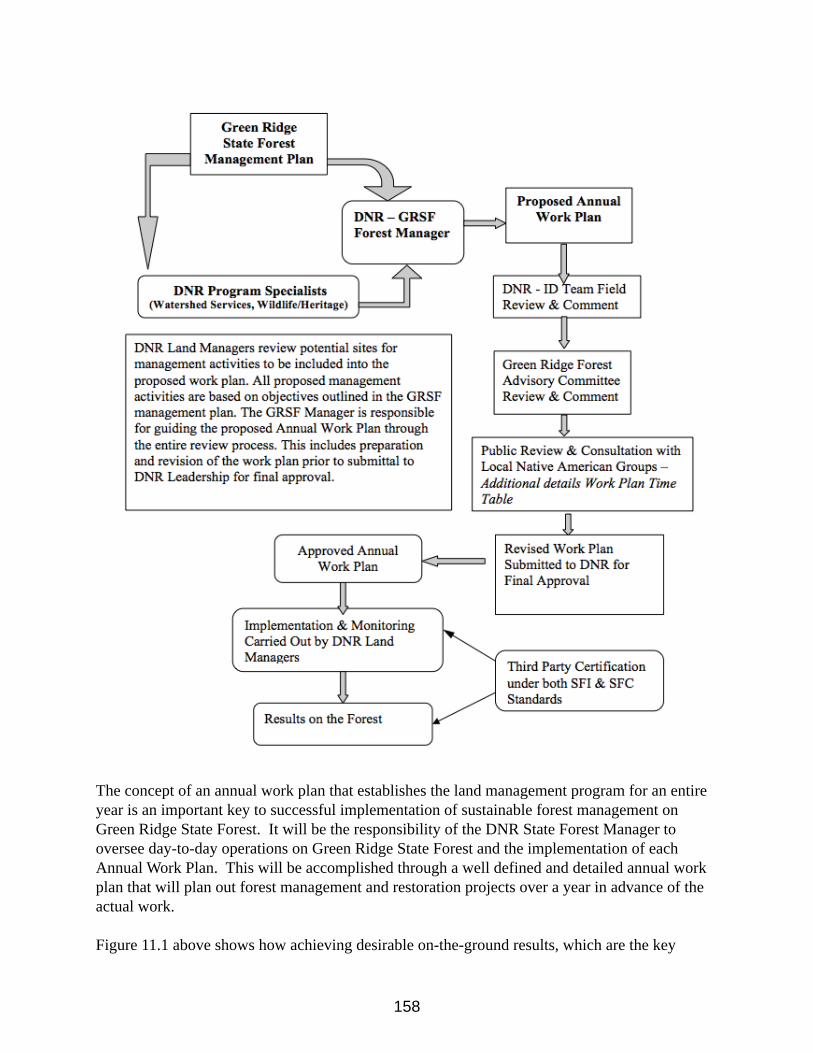
158
The concept of an annual work plan that establishes the land management program for an entire year is an important key to successful implementation of sustainable forest management on Green Ridge State Forest. It will be the responsibility of the DNR State Forest Manager to oversee day-to-day operations on Green Ridge State Forest and the implementation of each Annual Work Plan. This will be accomplished through a well defined and detailed annual work plan that will plan out forest management and restoration projects over a year in advance of the actual work.
Figure 11.1 above shows how achieving desirable on-the-ground results, which are the key
159
outcomes of the annual work plans, requires the cooperation of a variety of players. Several parties are involved in the process all with key roles, but the persons central to all implementation, monitoring and reporting are the Forest Managers. In this process, the lines of responsibility essential for success are clearly defined. The Forest Manager is responsible for implementing the Annual Work Plan in a manner that is both environmentally and fiscally responsible.
Once implementation is underway, the ongoing process of carrying out forest management activities will result in changes in on-the-land conditions, as well as new information gathered. The on-ground results will be verified by a third party certification process, which will be conducted every 3-5 years. Certification is done to compare the achieved results with the planned outcomes of the management prescriptions contained in this plan and the Annual Work Plans.
The independent 3rd party auditors will report their findings to the Land Managers. Where field or operational deficiencies are noted, it will be the responsibility of the Land Managers to correct them. Any deficiencies identified in the management plan or its goals, will be addressed by Maryland DNR. The audit report, and any subsequent actions taken, will be available to the public.
Implementing the Green Ridge State Forest plan involves adaptive management, where research and monitoring are given a high priority, and new information is constantly gathered to feed back into the basic data management system and all future plans. The Land Managers are responsible for reporting key findings as well as maintaining a constantly-updated data management system that is always available for making forecasts, guiding management decisions, and providing a current information base that can support plan reviews or amendments in the future.
11.2 Annual Work Plan Time TableAnnual Work plan development along with the necessary environmental and regulatory reviews will strive to follow the following process/time lines:
1. The DNR Land Managers begin fieldwork to review sites to be included in the next annual work plan from November through March.
2. The DNR Land Manager drafts a proposed work plan and sends it for ID Team review by July 1.
3. The DNR – ID Team reviews the proposed plan, a field review of proposed activities in the work plan is scheduled and comments returned to the DNR Land Manager at least two weeks before the scheduled ID Team field review.
4. The DNR Forest Manager presents the proposed work plan to the Green Ridge State Forest Citizens Advisory Committee for comment and review by December 1.
5. This above process includes consultation/review with local Native American Groups and the Maryland Commission on Indian Affairs concerning potential sites of special cultural, ecological, economic, or religious significance.
6. The DNR Forest Manager reacts to needed changes and submits a revised plan
160
to DNR Headquarters by January 1. 7. The final step is the AWP will be posted on the DNR webpage for a 30-day
public comment period, to be completed no later than March 1. 8. The DNR Headquarters obtains final official approval of the Annual Work
Plan, as revised, by June 1. 9. The Land Managers begin implementing the approved Work Plan July 1. 10. Independent Third-Party Auditing for forest certification begins after the year
ends and is repeated every 3-5 years, depending on certification requirements.
11.3 Contents of the Annual Work PlanForest OverviewIncludes an over site of the forest; history, size, location, special features, etc.
AWP SummaryIncludes number of sales, total harvest acres, acres by harvest method, estimated harvest volume and other important features for the work to be performed during the next year.
Maintenance ProjectsIncludes boundary maintenance, road maintenance, building maintenance and other such projects.
Recreation ProjectsIncludes projects such as campsite improvements, hunting programs, special recreational activities, ATV and hiking trail maintenance, trail grants, signage, and other projects specific to benefiting recreational users of the forest.
Special ProjectsIncludes activities to gain or maintain third party forest certification, GIS databases, and other such activities.
Silvicultural ProjectsIncludes forest harvesting, prescribed fire programs, fertilization, reforestation, and other such projects. This section must include the following:
Final Silvicultural Activities:1. Site Map2. Silvicultural Prescription3. Stand Data
Review Process:1. Review Summary2. Interdisciplinary Team Comments (collective)3. Advisory Committee Comments4. Public Comments
161
Watershed Improvement ProjectsIncludes special projects to enhance water quality, wetland restoration, and other such activities.
Ecosystem Restoration ProjectsIncludes projects to manage exotic invasive species, efforts to restore shale barrens or other natural habitats, and other such activities aimed at improving ecosytems.
Monitoring ProjectsIncludes CFI forest inventories, and other inventory projects being conducted on the forest, watershed monitoring, and other such projects.
BudgetThe Annual Work Plan will contain a proposed budget for the year, including revenue and cost estimates for all proposed activities. The Land Managers will be responsible for overseeing all activities to insure the desired environmental and silvicultural result, while maintaining cost effectiveness and targeted economic returns.
162
Chapter 12 - Operational Management
12.1 IntroductionThis section of the plan is designed to cover the annual cost and revenues associated with the operational management of Green Ridge State Forest. It is the Department’s intent that most of the revenues generated from the GRSF will be used to pay for the management and operation of the Forest. As stated in Chapter 1 of this plan, “The primary goal of the Green Ridge State Forest Sustainable Management Plan is to demonstrate that an environmentally sound, sustainably managed forest can contribute to local and regional economies while at the same time protecting significant or unique natural communities and elements of biological diversity.”
The numbers expressed in this section are only estimates and averages of annual expenses and revenues. These numbers will fluctuate each year based on management prescriptions, economic conditions and public use of the forest.
The following information is a breakdown on Revenues and Operational costs associated with the Green Ridge State Forest. These figures are only estimates that are based on projected revenues and operational expenses. Yearly changes in the timber markets and weather conditions can severely affect revenues. Also weather can greatly affect recreation revenue. Operational expenses will vary from year to year mainly based on costs associated with proposed projects. For many special projects other sources of revenues such as matching grants will be sought to help offset the cost to the Department.
12.2 Green Ridge State Forest Revenue Estimated: $225,000 to $300,000Revenues that are generated from the Green Ridge State Forest are deposited into the Department’s Forest or Park Reserve Fund. In order to cover expenses out of this Fund, a Green Ridge Forest Budget must be developed a year in advance as part of the larger DNR budget. It then goes through the legislative approval/review process along with all other state operating budgets. Once adopted, the budget goes into effect the first day of the fiscal year (July 1).
Forest Product Sale Revenue: Estimated: $150,000 to $175,000This revenue is generated from the sale of forest products, which are identified in the Annual Work Plan. Traditional forest products include pulpwood and sawtimber from intermediate and regeneration harvests. This revenue is tied to forest harvest activities identified in the annual work plan and will vary each year. With the current age class distribution of the forest most
163
revenue will be from regeneration final harvest operations.
Recreation Revenue: Estimated: $75,000 to 125,000 This revenue is generated from the sale of camping permits, fuel wood permits, and shooting range permits.
12.2.1 Other Revenue/Funding Sources Annual Amounts vary, Estimated:$250,000Other budgetary funding that is utilized on an annual basis in the management of Green Ridge State Forest comes from a variety of sources including the Forest or Park Reserve Fund, General Funds and/or the Off-road Vehicle Fund.
GrantsAnnual Amounts vary, Estimated: $30,000Other funding comes in the form of grants through state and federal sources and are primarily utilized in recreation, habitat and watershed restoration projects. These funds are project specific. Some funding will be obtained through partnerships and grants, such as National Recreation Trail Grants funds. Expenses include the installation recreation improvements, removing invasive species and re-establishing native plant communities and habitat
12.3 Operational Cost Estimated total Annual Expenses: $550,000Operational expenses are those costs paid directly out of the GRSF operational budget by the State Forest Manager and vary based on approval of operational budgets. The Forest Manager prepares a proposed operational budget for the forest based on instructions provided approximately one year in advance of the fiscal year. The FY-2012 budget proposal was prepared in August of 2010.
12.3.1 Staffing Cost Classified Salaries, Wages and Benefits, Estimated: $250,000This cost is associated with Departmental State Personnel classified salaries. This staff is responsible for developing and implementing annual work plans, managing the daily activities on the forest, including resource management, recreation program management, maintenance, and administration. Contractual Staffing, Estimated: $130,000This cost is associated with contractual staffing associated with operations of the state forest. Contractual personnel are responsible for assisting classified personnel in conducting work outlined in the annual work plan, managing the daily activities on the forest, including boundary line work, maintenance of trails, forest roads, maintaining primitive campsites, a public shooting range, overlooks, wildlife habitat areas, and assist with implementing all maintenance, recreational, silviculture, and ecosystem restoration projects.
12.3.2 Land Operation Cost Estimated: $100,000
164
This includes expenses for office and field equipment, vehicles, gates, gravel, signs, boundary paint, roadwork contracts and construction, trash removal from illegal dumping, boundary line work & surveying, tree planting, site preparation, control of invasive species, pre-commercial thinning and other forest management practices. Some of these costs will vary greatly from year to year based on the activities identified in the Annual Work Plan.
12.3.3 Forest Certification, Inventory & Monitoring Program Estimated: $10,000This estimate reflects the annual cost of various on-going inventory and research projects on the forest. Expenses are directly tied to Forest Certification. The purpose of forest monitoring is to accurately evaluate forest health and the effects of specific management activities. Resource managers will use the information to make informed future management decisions (i.e. adaptive management). Cost would cover both forest resource and sensitive habitat inventories and monitoring the effects of various restoration projects.
Expenses for forest certification will vary from year to year and will be at their highest at the initial certification and then every five years when the re-certification is done. Routine audits are used to verify compliance with the various certification programs. The goal is to certify Green Ridge State Forest under both the Sustainable Forest Initiative (SFI) and the Forest Stewardship Council (SFC). Each certifying agency takes a slightly different look at what is needed for sustainable forest management. Expenses will include fees for audits and annual monitoring programs for compliance with the certification requirements.
Future plans include hiring additional staffing to cover wildlife management activities, restoration projects, recreation management, monitoring, and additional forestry related activities outlined in this Sustainable Resource Management Plan for Green Ridge State Forest.
12.3.4 County Payments Estimated: $60,000These are revenue payments to local county governments which will vary every year. Payments are made on an annual basis to Allegany County based on 25% of the gross revenue generated from GRSF. These payments come out of revenue generated from timber sales and recreation. These payments are used to help the counties offset the loss in property tax revenues which are not paid on state owned lands.
12.4 SummaryThis is the general breakdown on Revenues and Operational Cost associated with the Green Ridge State Forest. As described, these figures will vary from year to year. A more detailed picture on revenues and operational cost will be provided within each Annual Work Plan and an annual report prepared by the Land Manager. This generalization of the operating budget suggests the importance of maintaining income levels in order to achieve the goals set forth in the other portions of this plan (i.e. sustainability).
165
Appendix A - Citizens Advisory Committee 166Appendix B - Forest Stewardship Council 169Appendix C - Sustainable Forestry Initiative 171Appendix D - Woodland Management Soils Group 177Appendix E - Special Wildlife Habitat Areas Unit Plans 189Town Creek SWHA Management Final 233Appendix F - SFI Management Review & Continual Improvement 248Appendix G - Management Guidelines for the Conservation & Protection of Old-Growth Forests ??Appendix H - Modeling Long-term Sustainability 259Appendix I - Glossary 264Appendix J - Maps 267Appendix K - An Evergreen Forest Analysis of Garrett and Allegany Counties 273

166
Appendix A - Citizens Advisory Committee
167
Appendix A
Green Ridge State Forest – Citizens Advisory Committee
The Citizens Advisory Committee (CAC) provides an opportunity for management plan review by local individuals with a working familiarity of the state forest, representing a wide array of natural resource based interests. Seven particular areas of interest will be represented by the board. These include fishing, hunting, ecology, conservation, business, recreation, timber, youth representation and wildlife, forestry and recreation professions.
The primary role of CAC Member is to review and comment on any/all resource issues and management proposals that affect the overall forest ecosystem and subsequently, its stakeholders as presented in the State Forest Annual Work Plan. Members ensure that all proposed management encompasses the needs of as many interest areas as possible and contains provisions to address the concerns of all user groups. As a follow-up to the Interdisciplinary Team Review, the CAC serves to eliminate possible omissions or oversights and to clarify misunderstandings that may arise during the management plan review process. Meetings will be held a minimum of once per fiscal year. Additional meetings will be scheduled if warranted.
Appointments to the committee will be made by the Maryland State Forester. Members of the existing committee as well as natural resources professionals have the opportunity to nominate new members for replacement as vacancies occur. Imposed term limits for formally appointed members will be three years. Individuals serving on the committee in an informal capacity will have term a limit of one year. At the end of each term, formally appointed members will notify, in writing, their intent to continue participating as a member of the board or to vacate their position. Informal appointees and anyone interested in serving on the CAC must forward their interest to the forest manager in order to receive an application. After review, a recommendation for membership approval/denial will be determined and individuals will be informed of the decision via formal letter.
Groups represented on the CAC include:
• Recreation (e.g. hiking, horseback riding, bird watching, etc.) • Sportsman (e.g. fishing, hunting) • Wildlife Interest (e.g. Audubon, National Wildlife Federation, TNC, Ducks Unlimited, etc.)• Conservation Interest (e.g. TNC, Trout Unlimited, National Turkey Federation, USFWS, etc.)• Forest Industry (e.g. mill representative or logger)• Socioeconomic Interest (e.g. local business or community/governmental representative)• Forest Conservation District Board Member (e.g. Representative from County Board in the area of State Forest)

168
169
Appendix B - Forest Stewardship Council
FSC – US Forest Management Standard (v1.0)(w/o FF Indicators and Guidance)
Recommended by FSC-US Board, May 25, 2010Approved by FSC-IC, July 8, 2010
Principle #1: Compliance with laws and FSC PrinciplesForest management shall respect all applicable laws of the country in which they occur, and international treaties and agreements to which the country is a signatory, and comply with all FSC Principles and Criteria.
Principle #2: Tenure and use rights and responsibilitiesLong-term tenure and use rights to the land and forest resources shall be clearly defined, documented and legally established.
Principle #3: Indigenous peoples' rightsThe legal and customary rights of indigenous peoples to own, use and manage their lands, territories, and resources shall be recognized and respected.
Principle #4: Community relations and worker's rightsForest management operations shall maintain or enhance the long-term social and economic well-being of forest workers and local communities.
Principle #5: Benefits from the forestForest management operations shall encourage the efficient use of the forest's multiple products and services to ensure economic viability and a wide range of environmental and social benefits.
Principle #6: Environmental impactForest management shall conserve biological diversity and its associated values, water resources, soils, and unique and fragile ecosystems and landscapes, and, by so doing, maintain the ecological functions and the integrity of the forest.
Principle #7: Management planA management plan -- appropriate to the scale and intensity of the operations -- shallbe written, implemented, and kept up to date. The long term objectives of management, and the means of achieving them, shall be clearly stated.

170
Principle #8: Monitoring and assessmentMonitoring shall be conducted -- appropriate to the scale and intensity of forest management -- to assess the condition of the forest, yields of forest products, chain of custody, management activities and their social and environmental impacts.
Principle #9: Maintenance of high conservation value forestsManagement activities in high conservation value forests shall maintain or enhance the attributes which define such forests. Decisions regarding high conservation value forests shall always be considered in the context of a precautionary approach.
Principle #10: PlantationsPlantations shall be planned and managed in accordance with Principles and Criteria1 - 9, and Principle 10 and its Criteria. While plantations can provide an array of social and economic benefits, and can contribute to satisfying the world's needs for forest products, they should complement the management of, reduce pressures on, and promote the restoration and conservation of natural forests.
For additional information go to the Forest Stewardship Council homepage at: http://www.fsc.org/en/

171
Appendix C - Sustainable Forestry Initiative
SFI 2015-2019 Forest Management Standard Principles
SFI Program Participants believe forest landowners have an important stewardship responsibility and a commitment to society, and they recognize the importance of maintaining viable commercial, family forest and conservation forestland bases. They support sustainable forestry practices on forestland they manage, and promote them on other lands. They support efforts to protect private property rights, and to help all private landowners manage their forestland sustainably. In keeping with this responsibility, SFI Program Participants shall have a written policy (or policies) to implement and achieve the following principles:
1. Sustainable Forestry To practice sustainable forestry to meet the needs of the present without compromising the ability of future generations to meet their own needs by practicing a land stewardship ethic that integrates reforestation and the managing, growing, nurturing and harvesting of trees for useful products and ecosystem services such as the conservation of soil, air and water quality, carbon, biological diversity, wildlife and aquatic habitats, recreation and aesthetics.
2. Forest Productivity and HealthTo provide for regeneration after harvest and maintain the productive capacity of the forestland base, and to protect and maintain long-term forest and soil productivity. In addition, to protect forests from economically or environmentally undesirable levels of wildfire, pests, diseases, invasive exotic plants and animals, and other damaging agents and thus maintain and improve long-term forest health and productivity.
3. Protection of Water Resources To protect water bodies and riparian areas, and to conform with forestry best management practices to protect water quality.
4. Protection of Biological Diversity To manage forests in ways that protect and promote biological diversity, including animal and plant species, wildlife habitats, and ecological or natural community types.
172
5. Aesthetics and Recreation To manage the visual impacts of forest operations, and to provide recreational opportunities for the public.
6. Protection of Special SitesTo manage lands that are ecologically, geologically or culturally important in a manner that takes into account their unique qualities.
7. Responsible Fiber Sourcing Practices in North AmericaTo use and promote among other forest landowners sustainable forestry practices that are both scientifically credible and economically, environmentally and socially responsible.
8. Legal ComplianceTo comply with applicable federal, provincial, state and local forestry and related environmental laws, statutes and regulations.
9. ResearchTo support advances in sustainable forest management through forestry research, science and technology.
10. Training and EducationTo improve the practice of sustainable forestry through training and education programs.
11. Community Involvement and Social ResponsibilityTo broaden the practice of sustainable forestry on all lands through community involvement, socially responsible practices, and through recognition and respect of Indigenous Peoples’ rights and traditionalforest-related knowledge.
12. TransparencyTo broaden the understanding of forest certification to the SFI 2015-2019 Forest Management Standard by documenting certification audits and making the findings publicly available.
13. Continual ImprovementTo continually improve the practice of forest management, and to monitor, measure and report performance in achieving the commitment to sustainable forestry.
SFI 2015-2019 Forest Management Standard objectives A Summary of the SFI 2015-2019 Forest Management Standard Objectives follows:
173
Objective 1. Forest Management Planning To ensure forest management plans include long-term sustainable harvest levels and measures to avoid forest conversion.
Objective 2. Forest Health and Productivity To ensure long-term forest productivity, carbon storage and conservation of forest resources through prompt reforestation, afforestation, minimized chemical use, soil conservation, and protecting forests from damaging agents.
Objective 3. Protection and Maintenance of Water Resources To protect the water quality of rivers, streams, lakes, wetlands and other water bodies through meeting or exceeding best management practices.
Objective 4. Conservation of Biological DiversityTo manage the quality and distribution of wildlife habitats and contribute to the conservation of biological diversity by developing and implementing stand- and landscape-level measures that promote a diversity of types of habitat and successional stages, and the conservation of forest plants and animals, including aquatic species, as well as threatened and endangered species, Forests with Exceptional Conservation Value, old-growth forests and ecologically important sites.
Objective 5. Management of Visual Quality and Recreational Benefits To manage the visual impact of forest operations and provide recreational opportunities for the public.
Objective 6. Protection of Special SitesTo manage lands that are geologically or culturally important in a manner that takes into account their unique qualities.
Objective 7. Efficient Use of Fiber ResourcesTo minimize waste and ensure the efficient use of fiber resources.
Objective 8. Recognize and Respect Indigenous Peoples’ RightsTo recognize and respect Indigenous Peoples’ rights and traditional knowledge.
Objective 9. Legal and Regulatory ComplianceTo comply with applicable federal, provincial, state, and local laws and regulations.
Objective 10. Forestry Research, Science and TechnologyTo invest in forestry research, science and technology, upon which sustainable forest management decisions are based and broaden the awareness of climate change impacts
174
on forests, wildlife and biological diversity.
Objective 11. Training and EducationTo improve the implementation of sustainable forestry practices through appropriate training and education programs.
Objective 12. Community Involvement and Landowner OutreachTo broaden the practice of sustainable forestry through public outreach, education, and involvement, and to support the efforts of SFI Implementation Committees.
Objective 13. Public Land Management ResponsibilitiesTo participate and implement sustainable forest management on public lands.
Objective 14. Communications and Public ReportingTo increase transparency and to annually report progress on conformance with the SFI Forest Management Standard.
Objective 15. Management Review and Continual ImprovementTo promote continual improvement in the practice of sustainable forestry by conducting a management review and monitoring performance.
For additional information on the Sustainable Forestry Initiative go to the homepage at:http://www.sfiprogram.org
175
SFI 2015-2019 Forest Management Standard Objectives
A Summary of the SFI 2015-2019 Forest Management Standard Objectives follows:
Objective 1. Forest Management Planning To ensure forest management plans include long-term sustainable harvest levels and measures to avoid forest conversion.
Objective 2. Forest Health and Productivity To ensure long-term forest productivity, carbon storage and conservation of forest resources through prompt reforestation, afforestation, minimized chemical use, soil conservation, and protecting forests from damaging agents.
Objective 3. Protection and Maintenance of Water Resources To protect the water quality of rivers, streams, lakes, wetlands and other water bodies through meeting or exceeding best management practices.
Objective 4. Conservation of Biological DiversityTo manage the quality and distribution of wildlife habitats and contribute to the conservation of biological diversity by developing and implementing stand- and landscape-level measures that promote a diversity of types of habitat and successional stages, and the conservation of forest plants and animals, including aquatic species, as well as threatened and endangered species, Forests with Exceptional Conservation Value, old-growth forests and ecologically important sites.
Objective 5. Management of Visual Quality and Recreational Benefits To manage the visual impact of forest operations and provide recreational opportunities for the public.
Objective 6. Protection of Special SitesTo manage lands that are geologically or culturally important in a manner that takes into account their unique qualities.
Objective 7. Efficient Use of Fiber ResourcesTo minimize waste and ensure the efficient use of fiber resources.
Objective 8. Recognize and Respect Indigenous Peoples’ RightsTo recognize and respect Indigenous Peoples’ rights and traditional knowledge.
Objective 9. Legal and Regulatory ComplianceTo comply with applicable federal, provincial, state, and local laws and regulations.
176
Objective 10. Forestry Research, Science and TechnologyTo invest in forestry research, science and technology, upon which sustainable forest management decisions are based and broaden the awareness of climate change impacts on forests, wildlife and biological diversity.
Objective 11. Training and EducationTo improve the implementation of sustainable forestry practices through appropriate training and education programs.
Objective 12. Community Involvement and Landowner OutreachTo broaden the practice of sustainable forestry through public outreach, education, and involvement, and to support the efforts of SFI Implementation Committees.
Objective 13. Public Land Management ResponsibilitiesTo participate and implement sustainable forest management on public lands.
Objective 14. Communications and Public ReportingTo increase transparency and to annually report progress on conformance with the SFI Forest Management Standard.
Objective 15. Management Review and Continual ImprovementTo promote continual improvement in the practice of sustainable forestry by conducting a management review and monitoring performance.
For additional information on the Sustainable Forestry Initiative go to the homepage at:http://www.sfiprogram.org
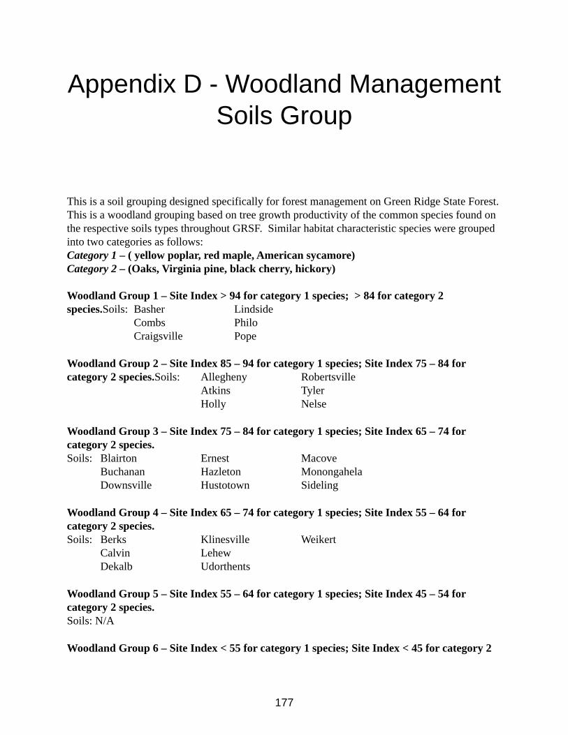
177
Appendix D - Woodland Management Soils Group
This is a soil grouping designed specifically for forest management on Green Ridge State Forest. This is a woodland grouping based on tree growth productivity of the common species found on the respective soils types throughout GRSF. Similar habitat characteristic species were grouped into two categories as follows:Category 1 – ( yellow poplar, red maple, American sycamore)Category 2 – (Oaks, Virginia pine, black cherry, hickory) Woodland Group 1 – Site Index > 94 for category 1 species; > 84 for category 2 species.Soils: Basher Lindside
Combs PhiloCraigsville Pope
Woodland Group 2 – Site Index 85 – 94 for category 1 species; Site Index 75 – 84 for category 2 species.Soils: Allegheny Robertsville
Atkins TylerHolly Nelse
Woodland Group 3 – Site Index 75 – 84 for category 1 species; Site Index 65 – 74 for category 2 species.Soils: Blairton Ernest Macove
Buchanan Hazleton MonongahelaDownsville Hustotown Sideling
Woodland Group 4 – Site Index 65 – 74 for category 1 species; Site Index 55 – 64 for category 2 species.Soils: Berks Klinesville Weikert
Calvin LehewDekalb Udorthents
Woodland Group 5 – Site Index 55 – 64 for category 1 species; Site Index 45 – 54 for category 2 species.Soils: N/A
Woodland Group 6 – Site Index < 55 for category 1 species; Site Index < 45 for category 2
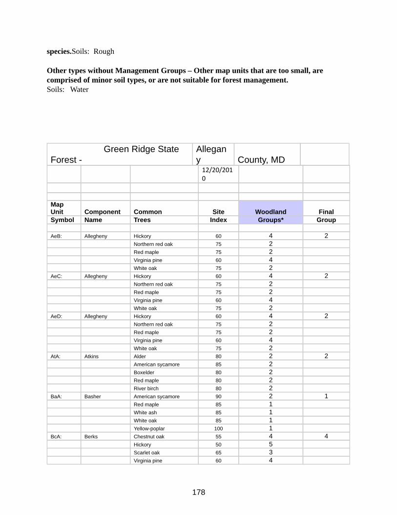
178
species.Soils: Rough
Other types without Management Groups – Other map units that are too small, are comprised of minor soil types, or are not suitable for forest management.Soils: Water
Green Ridge State Forest -
Allegany County, MD
12/20/2010
Map Unit Component Common Site Woodland Final Symbol Name Trees Index Groups* Group
AeB: Allegheny Hickory 60 4 2Northern red oak 75 2 Red maple 75 2 Virginia pine 60 4 White oak 75 2
AeC: Allegheny Hickory 60 4 2Northern red oak 75 2Red maple 75 2 Virginia pine 60 4 White oak 75 2
AeD: Allegheny Hickory 60 4 2Northern red oak 75 2 Red maple 75 2 Virginia pine 60 4 White oak 75 2
AtA: Atkins Alder 80 2 2American sycamore 85 2 Boxelder 80 2 Red maple 80 2 River birch 80 2
BaA: Basher American sycamore 90 2 1Red maple 85 1 White ash 85 1 White oak 85 1 Yellow-poplar 100 1
BcA: Berks Chestnut oak 55 4 4Hickory 50 5 Scarlet oak 65 3 Virginia pine 60 4
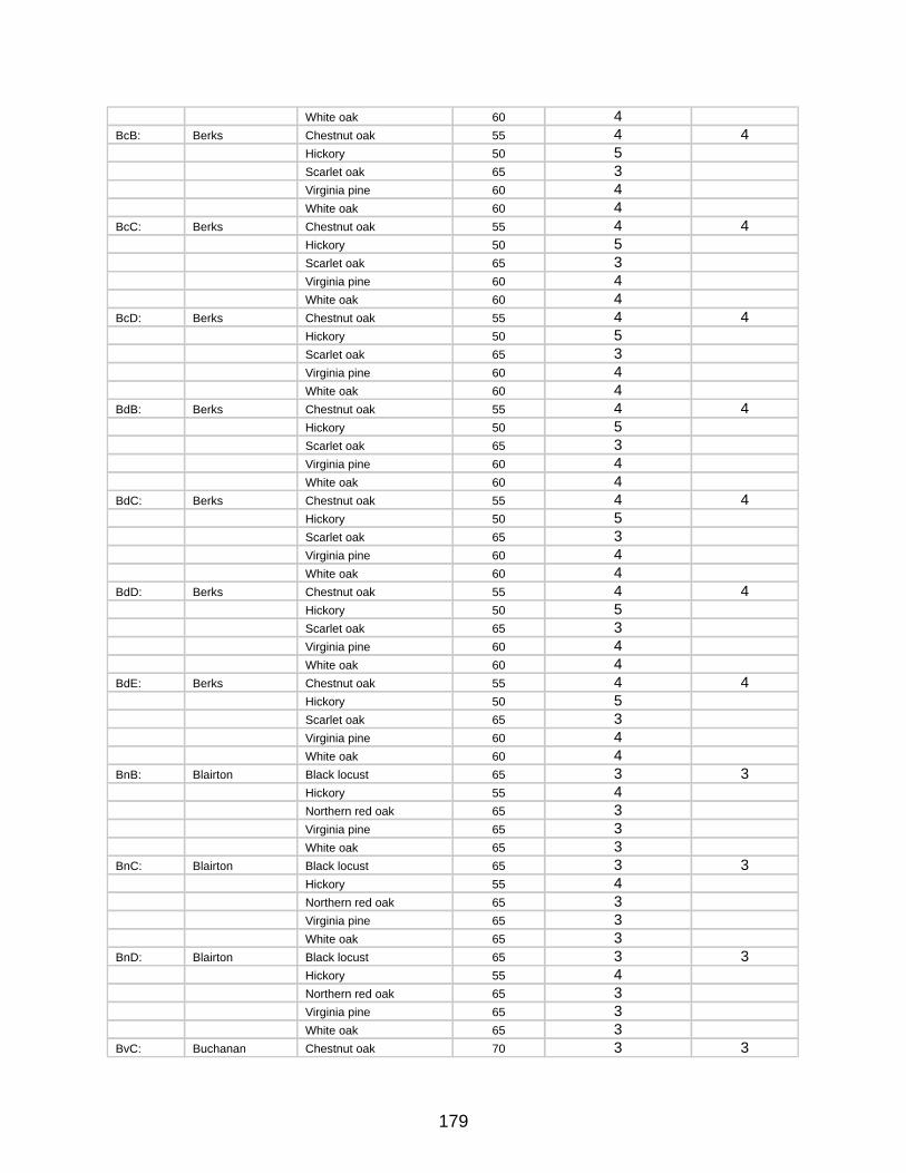
179
White oak 60 4 BcB: Berks Chestnut oak 55 4 4
Hickory 50 5 Scarlet oak 65 3 Virginia pine 60 4 White oak 60 4
BcC: Berks Chestnut oak 55 4 4Hickory 50 5 Scarlet oak 65 3 Virginia pine 60 4 White oak 60 4
BcD: Berks Chestnut oak 55 4 4Hickory 50 5 Scarlet oak 65 3 Virginia pine 60 4 White oak 60 4
BdB: Berks Chestnut oak 55 4 4Hickory 50 5 Scarlet oak 65 3 Virginia pine 60 4 White oak 60 4
BdC: Berks Chestnut oak 55 4 4Hickory 50 5 Scarlet oak 65 3 Virginia pine 60 4 White oak 60 4
BdD: Berks Chestnut oak 55 4 4Hickory 50 5 Scarlet oak 65 3 Virginia pine 60 4 White oak 60 4
BdE: Berks Chestnut oak 55 4 4Hickory 50 5 Scarlet oak 65 3 Virginia pine 60 4 White oak 60 4
BnB: Blairton Black locust 65 3 3Hickory 55 4 Northern red oak 65 3 Virginia pine 65 3 White oak 65 3
BnC: Blairton Black locust 65 3 3Hickory 55 4 Northern red oak 65 3 Virginia pine 65 3 White oak 65 3
BnD: Blairton Black locust 65 3 3Hickory 55 4 Northern red oak 65 3 Virginia pine 65 3 White oak 65 3
BvC: Buchanan Chestnut oak 70 3 3
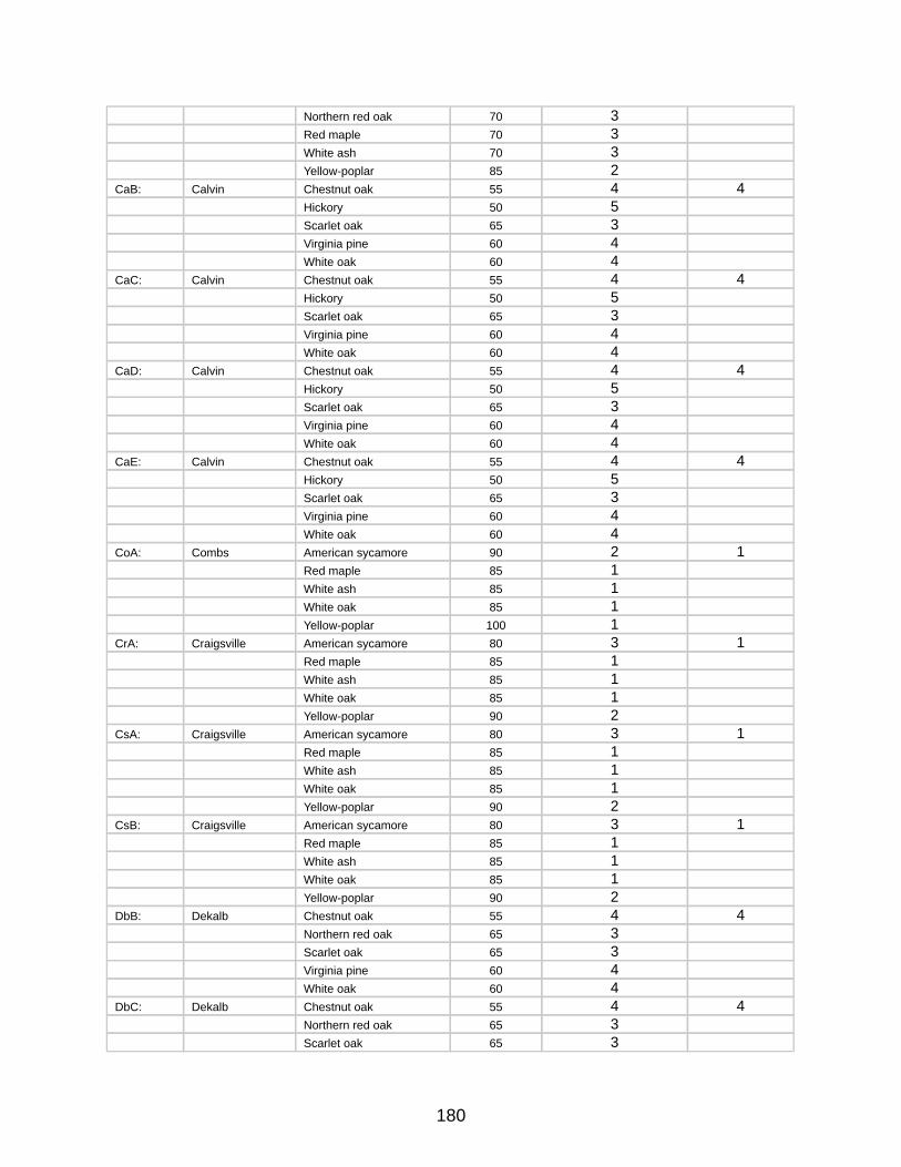
180
Northern red oak 70 3 Red maple 70 3 White ash 70 3 Yellow-poplar 85 2
CaB: Calvin Chestnut oak 55 4 4Hickory 50 5 Scarlet oak 65 3 Virginia pine 60 4 White oak 60 4
CaC: Calvin Chestnut oak 55 4 4Hickory 50 5 Scarlet oak 65 3 Virginia pine 60 4 White oak 60 4
CaD: Calvin Chestnut oak 55 4 4Hickory 50 5 Scarlet oak 65 3 Virginia pine 60 4 White oak 60 4
CaE: Calvin Chestnut oak 55 4 4Hickory 50 5 Scarlet oak 65 3 Virginia pine 60 4 White oak 60 4
CoA: Combs American sycamore 90 2 1Red maple 85 1 White ash 85 1 White oak 85 1 Yellow-poplar 100 1
CrA: Craigsville American sycamore 80 3 1Red maple 85 1 White ash 85 1 White oak 85 1 Yellow-poplar 90 2
CsA: Craigsville American sycamore 80 3 1Red maple 85 1 White ash 85 1 White oak 85 1 Yellow-poplar 90 2
CsB: Craigsville American sycamore 80 3 1Red maple 85 1 White ash 85 1 White oak 85 1 Yellow-poplar 90 2
DbB: Dekalb Chestnut oak 55 4 4Northern red oak 65 3 Scarlet oak 65 3 Virginia pine 60 4 White oak 60 4
DbC: Dekalb Chestnut oak 55 4 4Northern red oak 65 3 Scarlet oak 65 3
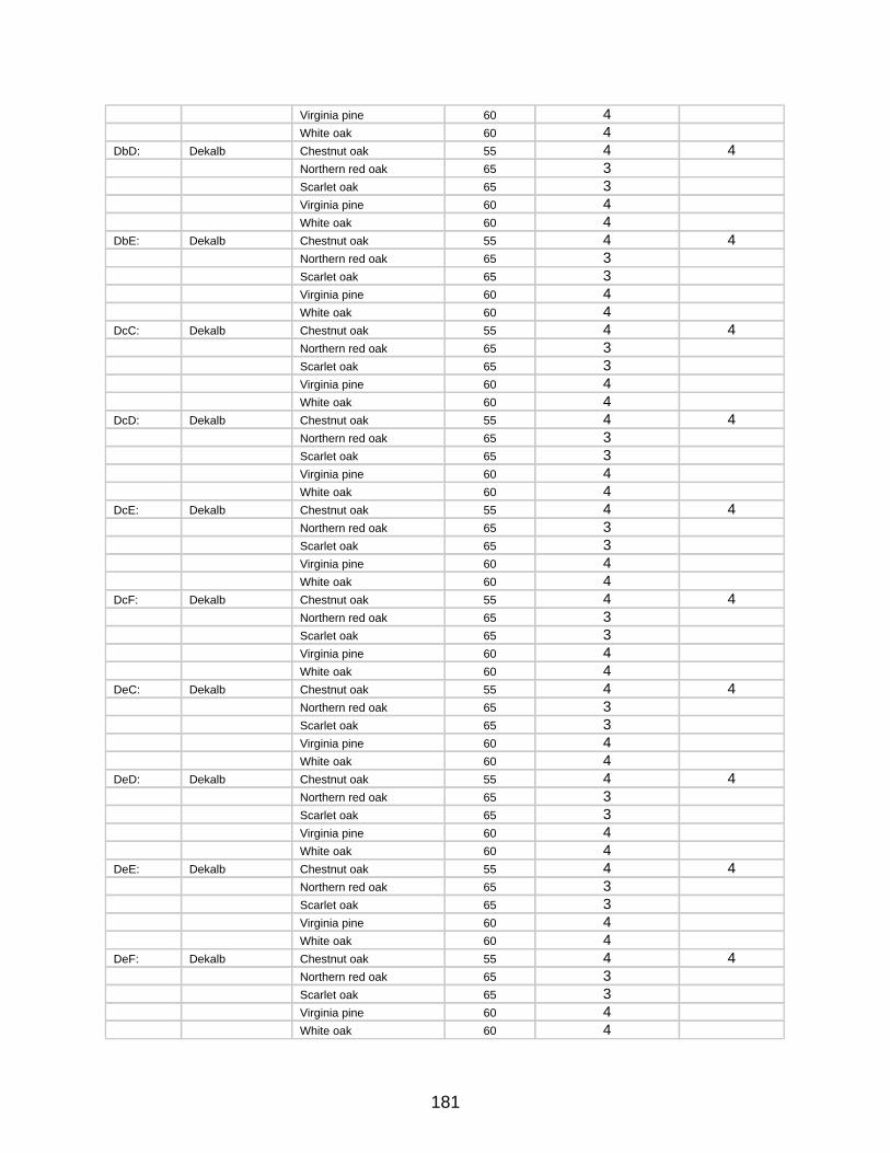
181
Virginia pine 60 4 White oak 60 4
DbD: Dekalb Chestnut oak 55 4 4Northern red oak 65 3 Scarlet oak 65 3 Virginia pine 60 4 White oak 60 4
DbE: Dekalb Chestnut oak 55 4 4Northern red oak 65 3 Scarlet oak 65 3 Virginia pine 60 4 White oak 60 4
DcC: Dekalb Chestnut oak 55 4 4Northern red oak 65 3 Scarlet oak 65 3 Virginia pine 60 4 White oak 60 4
DcD: Dekalb Chestnut oak 55 4 4Northern red oak 65 3 Scarlet oak 65 3 Virginia pine 60 4 White oak 60 4
DcE: Dekalb Chestnut oak 55 4 4Northern red oak 65 3 Scarlet oak 65 3 Virginia pine 60 4 White oak 60 4
DcF: Dekalb Chestnut oak 55 4 4Northern red oak 65 3 Scarlet oak 65 3 Virginia pine 60 4 White oak 60 4
DeC: Dekalb Chestnut oak 55 4 4Northern red oak 65 3 Scarlet oak 65 3 Virginia pine 60 4 White oak 60 4
DeD: Dekalb Chestnut oak 55 4 4Northern red oak 65 3 Scarlet oak 65 3 Virginia pine 60 4 White oak 60 4
DeE: Dekalb Chestnut oak 55 4 4Northern red oak 65 3 Scarlet oak 65 3 Virginia pine 60 4 White oak 60 4
DeF: Dekalb Chestnut oak 55 4 4Northern red oak 65 3 Scarlet oak 65 3 Virginia pine 60 4 White oak 60 4
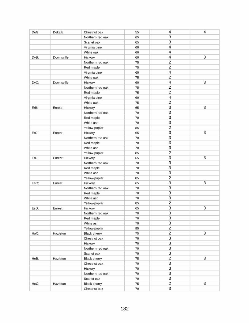
182
DeG: Dekalb Chestnut oak 55 4 4Northern red oak 65 3 Scarlet oak 65 3 Virginia pine 60 4 White oak 60 4
DvB: Downsville Hickory 60 4 3Northern red oak 75 2 Red maple 75 2 Virginia pine 60 4White oak 75 2
DvC: Downsville Hickory 60 4 3Northern red oak 75 2 Red maple 75 2 Virginia pine 60 4White oak 75 2
ErB: Ernest Hickory 65 3 3Northern red oak 70 3 Red maple 70 3 White ash 70 3Yellow-poplar 85 2
ErC: Ernest Hickory 65 3 3Northern red oak 70 3 Red maple 70 3 White ash 70 3Yellow-poplar 85 2
ErD: Ernest Hickory 65 3 3Northern red oak 70 3 Red maple 70 3 White ash 70 3Yellow-poplar 85 2
EsC: Ernest Hickory 65 3 3Northern red oak 70 3 Red maple 70 3 White ash 70 3Yellow-poplar 85 2
EsD: Ernest Hickory 65 3 3Northern red oak 70 3 Red maple 70 3 White ash 70 3Yellow-poplar 85 2
HaC: Hazleton Black cherry 75 2 3Chestnut oak 70 3 Hickory 70 3 Northern red oak 70 3 Scarlet oak 70 3
HeB: Hazleton Black cherry 75 2 3Chestnut oak 70 3 Hickory 70 3 Northern red oak 70 3 Scarlet oak 70 3
HeC: Hazleton Black cherry 75 2 3Chestnut oak 70 3
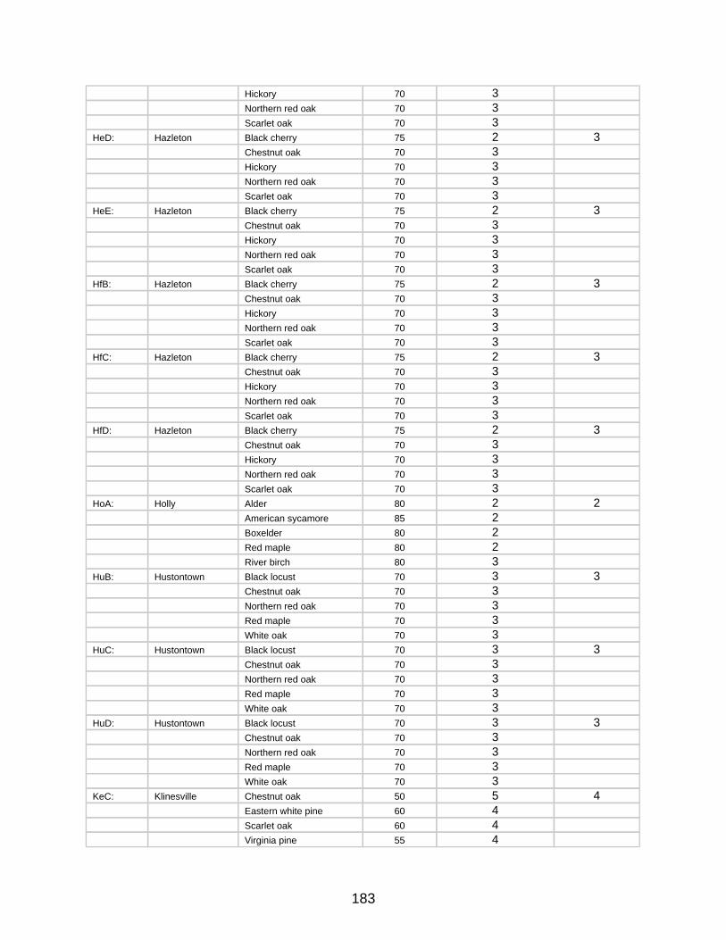
183
Hickory 70 3 Northern red oak 70 3 Scarlet oak 70 3
HeD: Hazleton Black cherry 75 2 3Chestnut oak 70 3 Hickory 70 3 Northern red oak 70 3 Scarlet oak 70 3
HeE: Hazleton Black cherry 75 2 3Chestnut oak 70 3 Hickory 70 3 Northern red oak 70 3 Scarlet oak 70 3
HfB: Hazleton Black cherry 75 2 3Chestnut oak 70 3 Hickory 70 3 Northern red oak 70 3 Scarlet oak 70 3
HfC: Hazleton Black cherry 75 2 3Chestnut oak 70 3 Hickory 70 3 Northern red oak 70 3 Scarlet oak 70 3
HfD: Hazleton Black cherry 75 2 3Chestnut oak 70 3 Hickory 70 3 Northern red oak 70 3 Scarlet oak 70 3
HoA: Holly Alder 80 2 2American sycamore 85 2 Boxelder 80 2 Red maple 80 2 River birch 80 3
HuB: Hustontown Black locust 70 3 3Chestnut oak 70 3 Northern red oak 70 3 Red maple 70 3 White oak 70 3
HuC: Hustontown Black locust 70 3 3Chestnut oak 70 3 Northern red oak 70 3 Red maple 70 3 White oak 70 3
HuD: Hustontown Black locust 70 3 3Chestnut oak 70 3 Northern red oak 70 3 Red maple 70 3 White oak 70 3
KeC: Klinesville Chestnut oak 50 5 4Eastern white pine 60 4 Scarlet oak 60 4 Virginia pine 55 4
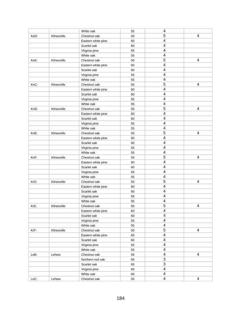
184
White oak 55 4 KeD: Klinesville Chestnut oak 50 5 4
Eastern white pine 60 4 Scarlet oak 60 4 Virginia pine 55 4 White oak 55 4
KeE: Klinesville Chestnut oak 50 5 4Eastern white pine 60 4 Scarlet oak 60 4 Virginia pine 55 4 White oak 55 4
KnC: Klinesville Chestnut oak 50 5 4Eastern white pine 60 4 Scarlet oak 60 4 Virginia pine 55 4 White oak 55 4
KnD: Klinesville Chestnut oak 50 5 4Eastern white pine 60 4 Scarlet oak 60 4 Virginia pine 55 4 White oak 55 4
KnE: Klinesville Chestnut oak 50 5 4Eastern white pine 60 4 Scarlet oak 60 4 Virginia pine 55 4 White oak 55 4
KnF: Klinesville Chestnut oak 50 5 4Eastern white pine 60 4 Scarlet oak 60 4 Virginia pine 55 4 White oak 55 4
KrD: Klinesville Chestnut oak 50 5 4Eastern white pine 60 4 Scarlet oak 60 4 Virginia pine 55 4 White oak 55 4
KrE: Klinesville Chestnut oak 50 5 4Eastern white pine 60 4 Scarlet oak 60 4 Virginia pine 55 4 White oak 55 4
KrF: Klinesville Chestnut oak 50 5 4Eastern white pine 60 4 Scarlet oak 60 4 Virginia pine 55 4 White oak 55 4
LeB: Lehew Chestnut oak 55 4 4Northern red oak 65 3 Scarlet oak 65 3 Virginia pine 60 4 White oak 60 4
LeC: Lehew Chestnut oak 55 4 4
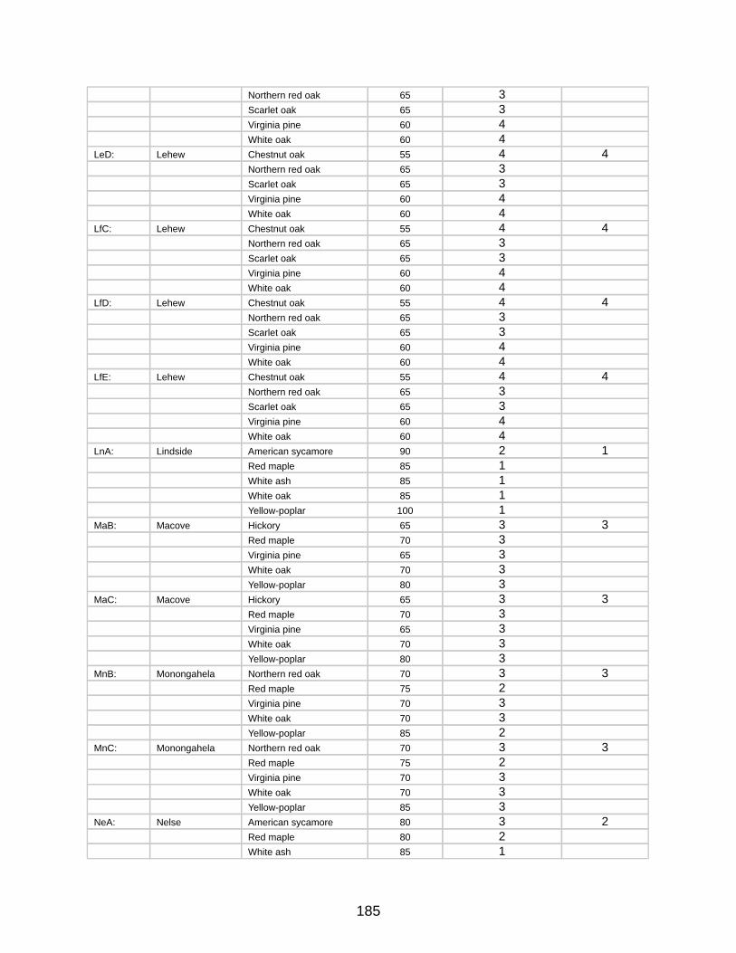
185
Northern red oak 65 3 Scarlet oak 65 3 Virginia pine 60 4 White oak 60 4
LeD: Lehew Chestnut oak 55 4 4Northern red oak 65 3 Scarlet oak 65 3 Virginia pine 60 4 White oak 60 4
LfC: Lehew Chestnut oak 55 4 4Northern red oak 65 3 Scarlet oak 65 3 Virginia pine 60 4 White oak 60 4
LfD: Lehew Chestnut oak 55 4 4Northern red oak 65 3 Scarlet oak 65 3 Virginia pine 60 4 White oak 60 4
LfE: Lehew Chestnut oak 55 4 4Northern red oak 65 3 Scarlet oak 65 3 Virginia pine 60 4 White oak 60 4
LnA: Lindside American sycamore 90 2 1Red maple 85 1 White ash 85 1 White oak 85 1Yellow-poplar 100 1
MaB: Macove Hickory 65 3 3Red maple 70 3 Virginia pine 65 3 White oak 70 3Yellow-poplar 80 3
MaC: Macove Hickory 65 3 3Red maple 70 3 Virginia pine 65 3 White oak 70 3Yellow-poplar 80 3
MnB: Monongahela Northern red oak 70 3 3Red maple 75 2Virginia pine 70 3White oak 70 3 Yellow-poplar 85 2
MnC: Monongahela Northern red oak 70 3 3Red maple 75 2 Virginia pine 70 3 White oak 70 3 Yellow-poplar 85 3
NeA: Nelse American sycamore 80 3 2Red maple 80 2 White ash 85 1
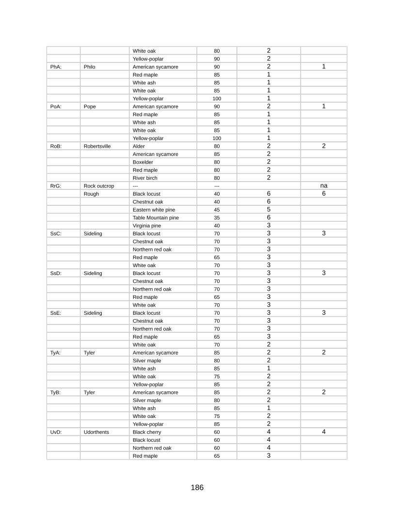
186
White oak 80 2Yellow-poplar 90 2
PhA: Philo American sycamore 90 2 1Red maple 85 1 White ash 85 1 White oak 85 1Yellow-poplar 100 1
PoA: Pope American sycamore 90 2 1Red maple 85 1 White ash 85 1 White oak 85 1Yellow-poplar 100 1
RoB: Robertsville Alder 80 2 2American sycamore 85 2 Boxelder 80 2 Red maple 80 2 River birch 80 2
RrG: Rock outcrop --- --- naRough Black locust 40 6 6
Chestnut oak 40 6Eastern white pine 45 5Table Mountain pine 35 6Virginia pine 40 3
SsC: Sideling Black locust 70 3 3Chestnut oak 70 3 Northern red oak 70 3 Red maple 65 3 White oak 70 3
SsD: Sideling Black locust 70 3 3Chestnut oak 70 3 Northern red oak 70 3 Red maple 65 3 White oak 70 3
SsE: Sideling Black locust 70 3 3Chestnut oak 70 3 Northern red oak 70 3 Red maple 65 3 White oak 70 2
TyA: Tyler American sycamore 85 2 2Silver maple 80 2White ash 85 1 White oak 75 2Yellow-poplar 85 2
TyB: Tyler American sycamore 85 2 2Silver maple 80 2White ash 85 1 White oak 75 2Yellow-poplar 85 2
UvD: Udorthents Black cherry 60 4 4Black locust 60 4 Northern red oak 60 4 Red maple 65 3
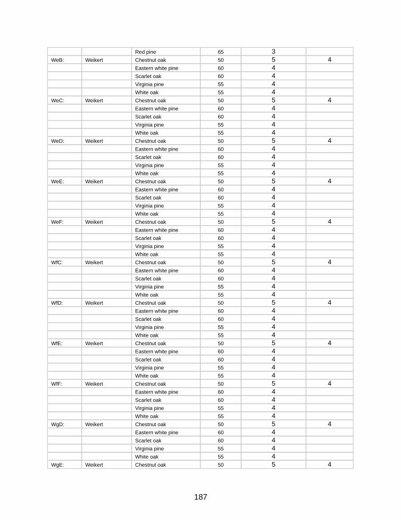
187
Red pine 65 3 WeB: Weikert Chestnut oak 50 5 4
Eastern white pine 60 4 Scarlet oak 60 4 Virginia pine 55 4 White oak 55 4
WeC: Weikert Chestnut oak 50 5 4Eastern white pine 60 4 Scarlet oak 60 4 Virginia pine 55 4 White oak 55 4
WeD: Weikert Chestnut oak 50 5 4Eastern white pine 60 4 Scarlet oak 60 4 Virginia pine 55 4 White oak 55 4
WeE: Weikert Chestnut oak 50 5 4Eastern white pine 60 4 Scarlet oak 60 4 Virginia pine 55 4 White oak 55 4
WeF: Weikert Chestnut oak 50 5 4Eastern white pine 60 4 Scarlet oak 60 4 Virginia pine 55 4 White oak 55 4
WfC: Weikert Chestnut oak 50 5 4Eastern white pine 60 4 Scarlet oak 60 4 Virginia pine 55 4 White oak 55 4
WfD: Weikert Chestnut oak 50 5 4Eastern white pine 60 4 Scarlet oak 60 4 Virginia pine 55 4 White oak 55 4
WfE: Weikert Chestnut oak 50 5 4Eastern white pine 60 4 Scarlet oak 60 4 Virginia pine 55 4 White oak 55 4
WfF: Weikert Chestnut oak 50 5 4Eastern white pine 60 4 Scarlet oak 60 4 Virginia pine 55 4 White oak 55 4
WgD: Weikert Chestnut oak 50 5 4Eastern white pine 60 4 Scarlet oak 60 4 Virginia pine 55 4 White oak 55 4
WgE: Weikert Chestnut oak 50 5 4
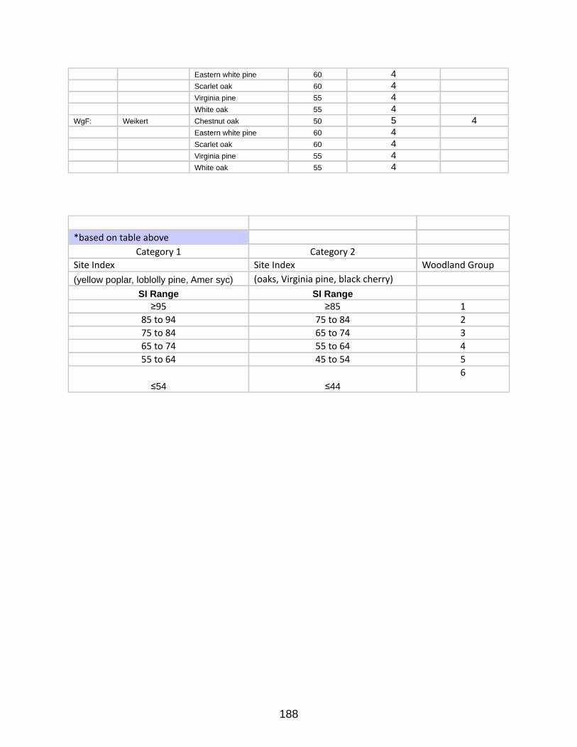
188
Eastern white pine 60 4 Scarlet oak 60 4 Virginia pine 55 4 White oak 55 4
WgF: Weikert Chestnut oak 50 5 4Eastern white pine 60 4 Scarlet oak 60 4 Virginia pine 55 4 White oak 55 4
*basedontableaboveCategory1 Category2
SiteIndex SiteIndex WoodlandGroup(yellow poplar, loblolly pine, Amer syc) (oaks,Virginiapine,blackcherry)
SI Range SI Range≥95 ≥85 1
85to94 75to84 275to84 65to74 365to74 55to64 455to64 45to54 5
≤54 ≤446

189
Appendix E - Special Wildlife Habitat Areas Unit Plans
190
Kirk Orchard Unit Plan
Early Successional Wildlife Habitat Focus Area
for
Green Ridge State Forest
LOCATION
Dailey Road GRSF
Phone: 301-478-3124
PROPERTY
505+/- Acres
PREPARED BY
Mark D. BealsAssistant Manager GRSF
ASSISTED BY
Jim MullanRegional Wildlife Manager
Rick LatshawHabitat Manager
Bill HarveyGame Bird Program Manager
Bob LongGame Bird Project Manager
Tom MathewsAppalachian Mountain Woodcock Initiative
30 April 2008
191
MANAGEMENT OBJECTIVES
Primary Objective: Enhance Early Successional Wildlife HabitatSecondary Objective: Maintain Cultural Heritage & Aesthetics
The Kirk Orchard area is approximately 505 acres of Green Ridge State Forest (GRSF) located along Dailey Road from Kirk Road south to near the intersection with Gorman Road. The eastern boundary of this unit is Purslane Run (Twigg Hollow) and the western boundary is Big Run. There are three private parcels that border this area. Private property accounts for less than 10% of the boundary. The remainder of the boundary is within the GRSF property. Furthermore, the entire unit is within a GRSF Special Management Zone. More information on this Special Management Zone is discussed below.
This parcel has been managed as a remnant orchard and an early successional wildlife habitat management unit for the past 30+ years. In recent years, little management has been done with the exception of maintenance efforts due to staff and equipment limitations within the Wildlife and Heritage Service. It is the intention of the Maryland DNR-Forest Service in partnership with the Wildlife & Heritage Service to actively manage this unit as an early successional wildlife management unit of the state forest. The primary management objective for this unit is to enhance and maintain the area for early successional wildlife species and upland hunting opportunities. The secondary objective is to maintain cultural heritage and aesthetics in the unit. This plan includes recommendations for management practices to fulfill the objectives for this management unit.
EARLY SUCCESSIONAL WILDLIFE HABITATEarly successional wildlife habitat is generally characterized by fallow fields, managed
grasslands, shrublands and young forests. In recent years these cover types have diminished greatly within the Maryland landscape, largely due to development and in some cases being allowed to revert to forest. Within GRSF, this habitat type has decreased greatly due to natural forest succession. Regeneration timber harvests do temporarily revert areas to this habitat type and provide habitat diversity within the forest. Because this is only temporary and the habitat type is becoming so rare, active management to restore, enhance, and maintain some of these habitat areas is a valid goal of the MD DNR.
Early-succession dependent wildlife species have been dramatically declining over the past 50 years primarily because of the lack of habitat. According to the Breeding Bird Survey (BBS), twelve of the sixteen shrublands bird species in eastern North America have declining populations. Some of these species include golden-winged warbler, song sparrow, whip-poor-will, eastern meadowlark, bobolink, and eastern bluebird. Many game species dependent on early succession habitat have also declined, including American woodcock, ruffed grouse, northern bobwhite, ring-necked pheasant, and eastern cottontail. Several reptiles, including black racers and eastern box turtles rely on early successional areas for various stages of their life cycle.
192
SPECIAL MANAGEMENT ZONESThe Kirk Orchard Early Successional Habitat Area is defined as a Special Management
Zone in accordance with the GRSF Resource Management Plan (RMP) dated October 25, 1993. This area falls under the special zone category of Wildlife Openings, Orchards and Yarding Areas. The goals and recommendations outlined in this management plan comply with the provisions defined by the RMP for such areas.
SOIL DESCRIPTIONS Following is a list and description of the soil types that are mapped on this property. The soil symbols listed are to be used with the attached soil map for orientation of where the soils occur. (Figure 2).
LhB2&LhC2 – Lehew channery loam 3-20% slopes, moderately eroded.This soil is moderately deep and well drained on uplands. It is moderately eroded and the hazard of further erosion is moderate. The permeability in this soil is moderate. Available water capacity is moderately low. Surface runoff is rapid. This soil is suitable to most crops typically grown in the county. This soil has fair productivity for trees with a site index of 55 to 65 for upland oaks and Virginia pine. White pine and Virginia Pine are recommended for planting.
LhE – Lehew channery loam 20-45% slopesIn most areas this strongly sloping to steep soil has lost part of the surface layer as the result of erosion. This soil is not safe for cultivation because of the extreme hazard of erosion. It is best suited as woodlands and upland brush to stabilize the soils. This soil has a poor productivity level for upland oaks and Virginia pine with a site index of 45 to 55. Recommended species for planting include white pine, Virginia pine and pitch pine.
CnC2&CnD2 – Calvin-Weikert shaly silt loam 10-30% slopesThese soils are moderately to strongly sloping. They are moderately deep and well drained to somewhat excessively drained. This soil type is eroded and the hazard of further erosion is severe. The permeability in this soil is moderate. Available water capacity is moderately low. Surface runoff is rapid. This soil is suitable to most crops typically grown in the county. This soil has fair productivity for trees with a site index of 55 to 65 for upland oaks and Virginia pine. White pine and Virginia Pine are recommended for planting.
AbB – Albright silt loam 0-8% slopes.This soil is nearly level to gently sloping. These soils tend to be wet and late to warm in the spring. Available water capacity is high but water moves slowly through the fragipan. Erosion is a slight to moderate hazard. Lime and nutrients need to be added according to sample for production of crops. Potential productivity for trees is good with a site index of 65 to 75 for oaks and 70 to 80 for yellow poplar. Recommended species for planting include yellow poplar, white pine, and Norway spruce.
193
COVER DESCRIPTIONSUnit SummaryUnit 1Acres 52Overstory white oak, chestnut oak, black oak, hickoryUnderstory flowering dogwoodSize Class Sawtimber Average Diameter 14 inches at DBHAge EvenBasal Area 90 square feet per acreStocking 72% fully stockedSoil Calvin-Weikert silt loam & Lehew channery loam.Growth potential Fair.
This unit is currently composed of mature mixed oak forest.
RecommendationsThe recommendation for this unit is to complete a variable retention harvest over the
entire stand. Mature forest adjacent to the springs and drains will be retained as riparian forest buffers and travel corridors. Furthermore, soft mast producing species such as apple, aspen, and persimmon will be identified prior to the harvest operation and retained as residuals in the stand. The remainder of the stand should be harvested commercially and result in a mosaic of small clearcuts. All roads and landings that result from this operation should be tilled, fertilized and planted with a desirable wildlife seed mix. Once established, these plantings should be maintained by rotational mowing and occasional fertilization.
Unit SummaryUnit 2Acres 50Overstory scarlet oak, chestnut, white oak, Virginia pine, hickoryUnderstory flowering dogwood, greenbrier, and red mapleSize Class Small SawtimberAverage Diameter 12 inches at DBHAge EvenBasal Area 85 square feet per acreStocking fully stockedSoil Lehew Channery loamGrowth Potential PoorThis 50+/-acre stand is currently dominated by mature mixed oak and Virginia pine.
Recommendations for Unit 2The recommendation for this unit is to implement a series of patch clearcuts over the next 20 years to remove most of the overstory and regenerate the stand. Some residuals should be left in the stand to retain some vertical structure. Unique legacy trees and soft mast producing species
194
should be targeted as residuals. Furthermore, grapevines should not be cut in this operation. All skid roads and landings created for these harvest operations should be seeded with specified herbaceous mix, limed, fertilized and mulched. Sections of mature forest will be retained within riparian areas and on steep slopes within this stand.
Maryland DNR currently has an agreement with Allegany College of Maryland’s (ACM) Forestry department that entails a partnership that will facilitate carrying out the prescription above. As part of the Forestry Summer Camp curriculum at ACM, they will harvest approximately 2 acres each year until all of the identified patches within this stand are harvested. This will take approximately 20 years to complete and will result is a mosaic of regeneration cohorts across the unit along with variable strips of mature forest.
Unit Summary Unit 3
This 36 +/- acre unit is located along the eastern boundary of the property. It consists primarily of an understocked sapling and small pole stand with a canopy that is closing and starting to choke out the understory brambles. Some work has been done at the north end of the unit to remove the overstory and create brush piles.Recommendations for Unit 3
The recommendation for this unit is to continue working south from the areas that have already been treated. Clearcutting approximately 1 chain wide patches perpendicular to the access road spaced approximately 250 feet apart. The trees cut in this operation should be trimmed, bucked and piled to create substantial brush piles to serve as quality cover for wildlife. This practice will create openings for regeneration and release the now suppressed shrub species in the understory. The brush piles will provide good winter and escape cover for ground dwelling wildlife species. This operation will be done manually and will be non-commercial because the slope is relatively steep and the trees are too small to be of any economic value. Leaving residual areas between the strips will facilitate distribution of the openings and brush piles over a larger area and ensure that there is material available for brush pile construction in the future.
Unit Summary Unit 4
This area is approximately 30 acres and currently consists of grasses and some shrubs. The area along the western border of this unit is mature forest. The soil type on this unit is Lehew channery silt loam. In recent years the area has been maintained by some late summer mowing of the roads and field openings. There are also a few small islands of mature Virginia pine. Recommendations for Unit 4
The recommendation for this unit is to continue to mow strips and road areas. Some of the field openings may be converted from fescue to more desirable wildlife mixes including grass and legumes. This recommendation is discussed in greater detail below in the “other recommendations” section of this management plan.
The western border of this unit is mature woodlands. There is a narrow band between
195
this unit border and the grasslands that is also mature forest. It is recommended that the overstory trees in this area be felled and used as brush pile material. This practice will “soften the edge” along this border and enhance the habitat value. It is also recommended to fell a portion of the trees in the islands and buck them up to be used for brush pile construction. This operation will likely not be merchantable so the work will be completed by DNR staff.
Unit Summary Unit 5 3 Sub units
This 20+- acre unit is primarily made up of old fields that have reverted back to Virginia pine forest. These stands are approximately 70 years old and have a full overstory canopy which no longer serves as early successional wildlife habitat. There is some hawthorn, crabapple, and flowering dogwood that remain suppressed in the understory of these units. However, the understory has become relatively sparse due to the canopy development. Recommendations for Unit 5
The recommendation for this unit is to convert it back to early successional wildlife habitat within the next few years. These Virginia pine units have reached merchantable size for pulpwood and should support a commercial operation if all three units are sold together. Understory species and unique crop trees should be marked for retention prior to harvest to promote these desirable species. The logging debris should be windrowed and/or piled to create immediate ground cover. All roads and landings that result from this operation should remain open to facilitate access and to provide brood habitat for wild turkey and ruffed grouse. Such roads should ultimately be cultivated, planted with desirable herbaceous mix and fertilized. Once the planting is established, it should be maintained by rotational mowing and occasional fertilization.
Unit Summary Unit 6
This 30+- acre unit is made up of 3 subunits. Each of these units has been harvested within the last 10 years and currently exhibit good levels of regeneration. The previous harvest primarily salvaged mature Virginia pine. White pines were deferred as residuals and the regeneration primarily consists of mixed hardwoods and white pine. The stand is also relatively dense with blackberry and green briar which provide excellent wildlife nesting cover and shelter.Recommendations for Unit 6
The recommendation for this unit is to allow it to grow naturally and reevaluate it in 10 – 15 years. At that time it may be necessary to do some enhancement work to maintain valuable early successional habitat value. For now it is recommended to let the stand grow naturally and maintain the roads and openings by removing deadfalls from the road and seasonal mowing. Some herbaceous cover plantings or supplements may be practical in these roads and landings.
Unit SummaryUnit 7
This 40+- acre stand is currently a mature mixed oak hardwood stand. It currently serves as a riparian forest buffer for Purslane Run and tributaries.Recommendations for Unit 7
196
The recommendation for this stand is to evaluate it for commercial harvests within the next five years. Furthermore, the areas along the drainages within the buffer zone are ideal to target for woodcock feeding habitat because of the deeper richer soils and associated earth worm production. It is recommended to create some small openings in the canopy to enhance horizontal canopy development within the shrub layer and ultimately provide a better habitat component for woodcock. These openings will be located on several flats along the tributaries and will be ¼ to ½ acre in size. These openings will be created by girdling the overstory trees within the patch unit. Furthermore, invasive plants such as multiflora rose should be identified and treated prior to creating the opening in the overstory. Overstory canopy trees shall be retained adjacent to the stream channel to provide shade for the stream. Unit SummaryUnit 8
This 240+- acre unit is the area that has been managed more intensely for the past 30 years to maintain a core area of early succession wildlife habitat. It is currently comprised of overgrown wind break and hedgerow conifer plantings, various fallow fields, overgrown fields, and a few warm season grass fields. Recommendations for Unit 8
The recommendation for this unit is to continue intensive management over the next five years to restore quality early successional habitat. This includes commercially harvesting overgrown conifer plantations where commercially suitable, elevating less mature conifers and using material for brush pile construction, reopening overgrown roads/grass strips, reclaiming grasslands, mowing, liming and fertilizing fallow fields, releasing and pruning fruit trees, and spring burns on all warm season grass fields. These recommendations are further described below. Where feasible, management activities will utilize best management practices identified for American woodcock as part of the Appalachian Mountain Woodcock Initiative.
Other Recommendations
Overgrown Conifer Plantations All of the conifer plantations in the orchard area have matured to the point that there is a
closed canopy and virtually no ground cover and or understory. They serve little benefit to early succession dependent wildlife. These trees are very limby and require a lot of trimming when harvesting for wood products and are therefore of little commercial value. However, commercial operators should be solicited to assist in the management of these stands. Though the trees are of low value, some operators may be willing to negotiate “in kind services” to harvest some of the trees for pulpwood. There may be some operators that are willing to harvest the trees, push wind rows into brush piles with skidders and/or bulldozers, and seed and mulch the disturbed areas for the pulpwood that they remove in the process. This would save a tremendous amount of manpower that could be used in other projects.
It may not be economically feasible to commercial operators to do in kind projects at this time in some of the conifer plantations because it is too much work with very little return. In such areas, it is recommended to elevate the trees and pile the debris. This practice is time consuming but yields a three tiered benefit. First, it creates material to be piled in the understory
197
to create groundcover brush piles. This practice will also promote a more suitable commercial harvest in the future because there will be clearer wood and less trimming required. Finally, this practice will allow tractor/mower access between the rows. These trees should ultimately be harvested within 5 to 10 years.
Overgrown Roads and Grasslands Many of the old roads or strips in this unit have become overgrown or receded due to lack
of mowing, deadfall obstruction, and/or natural succession. As feasible, these roads should be cleared and mowed to serve as feeding and travel corridors for ground dwelling birds and mammals. Grassed roadways in forest habitats provide excellent brooding areas for ruffed grouse and wild turkey.
Additional small grassland openings should be established to create more singing grounds for woodcock throughout the landscape of the orchard area. These openings should be at least ¼ acre in size and be maintained as grassland openings. This will enhance woodcock breeding opportunities and benefit many other wildlife species.
Grassland ReclamationThe orchard currently contains approximately 200 acres of grassland habitat in various
stages of succession. Some areas have been planted in more desirable grass-legume mixtures or warm season grasses, but the majority of the openings are comprised of fescue. Fescue is a dense growing, cool season grass that provides little wildlife benefit. When feasible, fescue stands should be converted to a more desirable grass/legume mixture and maintained by rotational mowing and occasional fertilization.
Orchard Tree Maintenance Over the past 30 years, WHS staff have actively located and pruned remnant apple trees
in an attempt to maintain this unique cultural and ecological component of the state forest. Additionally, staff has planted hundreds of new trees in an attempt to restore select areas of the remnant orchard. Increased efforts should be made to identify and maintain existing apple and other desirable fruit bearing trees in this unit. Other tree and shrub species that should be targeted for release and/or pruning include pear, plum, hawthorn spp., and persimmon. This work will restore vigor in these trees which will promote the cultural legacy of the orchard and enhance soft mass production for ecological benefit. Numerous wildlife species utilize apples and orchard habitats.
Tree PlantingOpportunities for tree planting in the orchard unit are extensive but should be carefully
planned not to interfere with the objectives of the specific sites. Conifer windrow plantings may be re-established as the over-mature ones are removed. Additional apple trees should be planted and fenced each spring to maintain the legacy and ecological benefit of soft mast production.
Prescribed FireFire will be used as a restoration and maintenance tool within the Orchard area. There
198
are currently 3 small warm season grass units within unit 8 that should be burned during the spring on a 2 to 3 year rotation to maintain the health and vitality of these stands. Furthermore, additional units will be identified and prepared to maintain with rotational prescribed fire. Experiments with prescribed fire will be carried out in an effort to evaluate enhancement of woodcock habitat. Herbicide Application
Herbicide application is a valuable tool in restoring and maintaining early successional habitat. Some areas within the orchard have reverted back to young forest stands due to years of lack of management. These stands have grown up to a point that they serve little benefit for habitat. However, they have not grown to the point that a traditional harvest would be commercially viable. Such areas that are comprised primarily of less desirable species for early successional habitat such as red maple, oak sp, black cherry, Virginia pine, etc will be targeted for restoration via aerial application of herbicides. Aerial application of herbicide will allow relatively large areas to be restored with less time and money than mechanical techniques.
Herbicide applications will also be used in the invasive plant suppression program described below and in converting grass stands made up primarily of fescue to more desirable herbaceous mixes.
All herbicide work will be administered by licensed pesticide applicators and product labels will be strictly adhered to.
Invasive PlantsThe Kirk Orchard does contain non-native and invasive plants. Efforts will be made to
suppress and where practical, eradicate invasive species. Autumn olive, multi-flora rose, Japanese barberry, Tartarian honeysuckle, and lilac are among the woody plant species that efforts will be made to suppress and prohibit spread and escape. The orchard area will continuously be monitored for these species and other invasive species such as mile-a-minute, Japanese knot weed and ailanthus. If these species are located, efforts will be made to eradicate them before they get a foot hold.
Ailanthus ControlAilanthus (tree-of-heaven) does currently exist in the orchard area. This tree has a similar
appearance to a young walnut or sumac. It is fast growing and is very prolific. Ailanthus is very resilient and hard to control because of its high growth rate, tendency for basal sprouting, and root suckering. Simply cutting the stems of these trees will not rectify the situation because that would stimulate basal sprouting and root suckering. Ailanthus will be monitored in this project area. Ailanthus trees will be treated using basal bark applications of Garlon 4 (20%) or cut treatment of Vanquish (50%) solution applied July through September for best results. Follow up foliar application should be applied the following year to kill smaller specimens and any remaining suckers.
Insects and Disease
The Kirk Orchard area will periodically be inspected for destructive insects and disease infestations. Numerous insects and disease attack all parts of a tree including the leaves, stems,
199
branches and roots. Forest pests include: borers, caterpillars, leaf miners, saw flies, mites, scales and aphids. Some common diseases include: anthracnose, galls, mildews, wilts, and root rot. The control of forest insects and disease should be accomplished through an integrated pest management approach using several prevention and suppression alternatives. Many insect and disease problems can be avoided through early detection.
Demonstration & EducationThe Kirk Orchard Early Successional Habitat Area is open to the public for hunting and
general outdoor recreation and enjoyment. A self guided trail will be established that will include wayside exhibits that discuss habitat practices that are apparent on the sites to educate visitors about the management of the area.
Natural resource organizations and institutions are encouraged to use the orchard as a demonstration area and natural laboratory. Such groups are encouraged to work to put practices in place to achieve the objectives of this plan. All of such activities must be approved and done under the supervision of the GRSF management staff.
PartnershipsThe Maryland Forest Service will continue to develop and maintain partnerships with
institutions and organizations to obtain funding and technical assistance in carrying out recommendations and prescriptions within this plan. Partnerships that currently exist in this endeavor include MD DNR Wildlife& Heritage Services, Garrett College, Allegany College of Maryland, Appalachian Mountain Woodcock Initiative, and American Chestnut Foundation.
Other organizations that the Forest Service will work to form partnerships with for this project include National Wild Turkey Federation, Quail Unlimited, Ruffed Grouse Society, Appalachian Forest Heritage Area, and The Nature Conservancy.
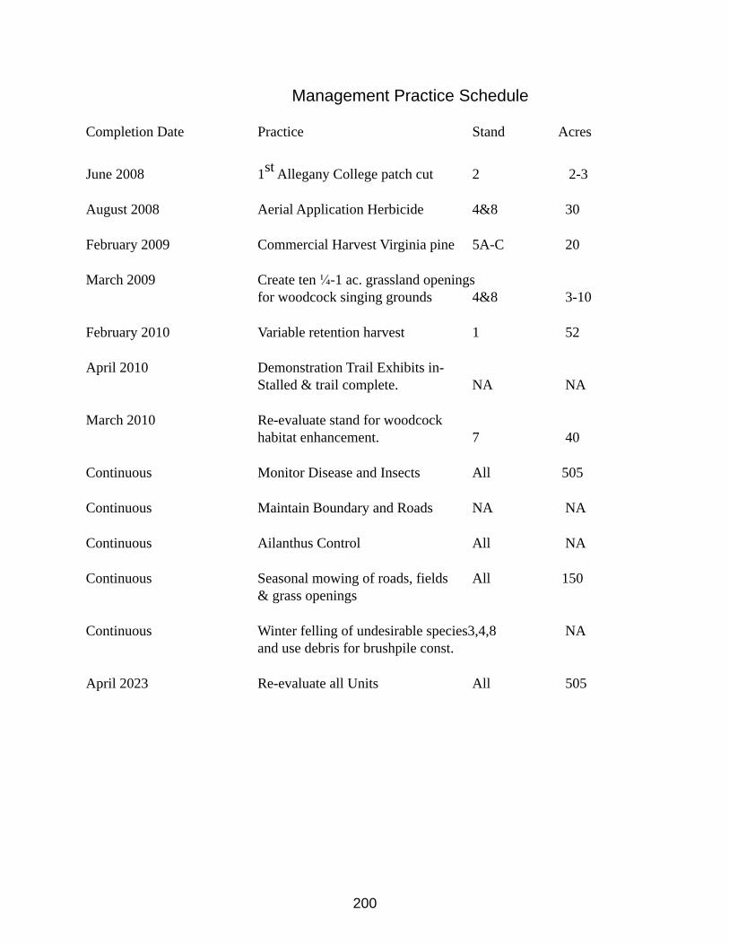
200
Management Practice Schedule
Completion Date Practice Stand Acres
June 2008 1st Allegany College patch cut 2 2-3
August 2008 Aerial Application Herbicide 4&8 30
February 2009 Commercial Harvest Virginia pine 5A-C 20
March 2009 Create ten ¼-1 ac. grassland openingsfor woodcock singing grounds 4&8 3-10
February 2010 Variable retention harvest 1 52
April 2010 Demonstration Trail Exhibits in-Stalled & trail complete. NA NA
March 2010 Re-evaluate stand for woodcock habitat enhancement. 7 40
Continuous Monitor Disease and Insects All 505
Continuous Maintain Boundary and Roads NA NA
Continuous Ailanthus Control All NA
Continuous Seasonal mowing of roads, fields All 150& grass openings
Continuous Winter felling of undesirable species3,4,8 NAand use debris for brushpile const.
April 2023 Re-evaluate all Units All 505
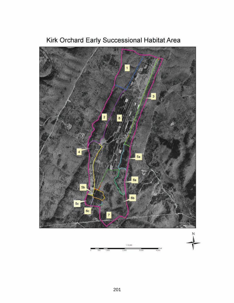
201
202
Kasecamp Bottoms Unit PlanEarly Successional Wildlife Habitat Focus Area
for
Green Ridge State Forest
LOCATION
Kasecamp Road GRSF
Phone: 301-478-3124
PROPERTY
381+/- Acres
PREPARED BY
Mark D. BealsForest Manager
ASSISTED BY
Rick LatshawHabitat Manager
Jim MullanRegional Wildlife Manager
Bill HarveyGame Bird Program Manager
Bob LongGame Bird Project Manager
Tom MathewsAppalachian Mountain Woodcock Initiative
9 July 2010Rev.2_2012
203
MANAGEMENT OBJECTIVES
Primary Objective: Enhance Early Succession Wildlife HabitatThe Kasecamp Bottom area is approximately 381 acres of Green Ridge State Forest
(GRSF) located between Kasecamp Road and the Potomac River. There is one private inholding adjacent to this unit and the C&O Canal National Park right of way bisects the parcel. Much of this unit is abandoned agricultural fields and marginal pasture. In recent years, the area has received little management with the exception of rotational mowing. It is the intention of the Maryland DNR-Forest Service in partnership with the Wildlife & Heritage Service, and other agency and private organization partners to actively manage this unit as an early successional wildlife management unit of GRSF. The primary management objective for this unit is to enhance and maintain the area for early succession wildlife habitat with a focus on American woodcock habitat. This plan includes recommendations for management practices to fulfill the objectives for this management unit.
EARLY SUCCESSIONAL WILDLIFE HABITAT
Early succession wildlife habitat is generally characterized by fallow fields, managed grasslands, shrublands and young forests. In recent years these cover types have diminished greatly within the Maryland landscape, largely due to development and in some cases being allowed to revert to forest. Within GRSF, this habitat type has decreased greatly due to natural forest succession. Regeneration timber harvests do temporarily revert areas to this habitat type and provide habitat diversity within the forest. However, this is only temporary and the habitat type is becoming so rare, active management to restore, enhance, and maintain some of these habitats is a valid goal of the MD DNR.
AMERICAN WOODCOCKThe American woodcock is a migratory avian species primarily associated with forested wetland habitats. Populations have steadily decreased at a rate of 1-2% per year over the last 25 years. This decline is believed to be attributed to the loss of young forest and shrubland in the eastern United States due to human development and forest maturation. Here in the Ridge and Valley section of Allegany County, young riparian forests are relatively uncommon, largely do to the topography and low annual precipitation. The best suited areas here are riparian areas along the Potomac River and its major tributaries.
American Woodcock Management Note for Units 1-4Units 1-4 are typical bottomland forest stands within the woodcock focus area. Conventional woodcock habitat recommendations would recommend managing these stands under even age regulation and likely include putting the approximately 100 acres into five acre stands to be harvested on a 40 year rotation. However, the recommendations below will demonstrate an alternative management scheme that will be monitored to measure the success of meeting similar habitat objectives while maintaining mature bottomland forest attributes. All silviculture
204
practices in these units shall be reviewed and approved by MD DNR Heritage Biologist prior to implementation to ensure other desired stand characteristics and micro-habitats are maintained.
SOIL DESCRIPTIONS
Following is a list and description of the soil types that are mapped on this property. The soil symbols listed are to be used with the attached soil map for orientation of where the soils occur. (Figure 2).
CoA – Combs fine sandy loam 0-3% slopes
This is a nearly level to slightly sloping well-drained bottomland soil with slight hazard of erosion. The parent material consists of Loamy alluvium derived from sedimentary rock. Depth to a root restrictive layer is greater than 60 inches. Available water capacity is high, surface runoff is low, and the area is occasionally flooded for brief periods of time. The area is considered prime farmland. This soil has excellent tree productivity with a site index of 90 for sycamore, 100 for yellow-poplar, and 85 for white oak. Black walnut, white pine, northern red oak, white oak, and yellow-poplar are recommended for planting.
ErD – Ernest silt loam 15-25% slopes
This is a moderately eroded soil, and is not well-suited for crops. The parent material consists of Loamy colluvium derived from sandstone and shale. Depth to a root restrictive layer, fragipan, is 20 to 36 inches. Surface runoff is moderate, and the soil is moderately-well drained. A seasonal zone of water saturation is at 21 inches during from December through May. Potential for tree productivity is good with site indexes of 65 for hickory, 85 for yellow-poplar, and 70 for northern red oak. Recommended trees for planting include black locust, black walnut, white pine, northern red oak, and sugar maple.
HoA – Holly silt loam 0-3% slopes
This is a nearly level to slightly sloping poorly drained soil, which frequently experiences flooding. The parent material consists of loamy alluvium derived from sedimentary rock. Depth to a root restrictive layer is greater than 60 inches. This area is not suitable for crops. Runoff is negligible, as this soil is occasionally to frequently flooded or ponded, and experiences a seasonal zone of water saturation at 0 inches from November through April. Tree productivity for the area is excellent with site indexes of 85 for sycamore and 80 for red maple, river birch, and alder. Recommended species for planting are sycamore, baldcypress, pin oak, red maple, and sugar maple.
LnA – Lindside silt loam 0-3% slopes

205
This is a moderately-well drained, nearly level to slightly sloping soil. The parent material consists of silty alluvium derived from limestone and shale. Depth to a root restrictive layer is greater than 60 inches. Runoff is low, and occasional flooding can occur with a seasonal zone of water saturation at 36 inches from November through May. This area is considered prime farmland. Tree productivity is excellent with site indexes of 100 for yellow-poplar, and 85 for red maple, white ash, and white oak. Recommended trees for planting are black oak, northern red oak, white oak, black walnut, white ash, and white pine.
MnC – Monongahela silt loam 8-15% slopes
This moderately sloping, moderately eroded soil is considered suitable for some crops. The parent material consists of Loamy old alluvium derived from sedimentary rock. Depth to a root restrictive layer, fragipan, is 18 to 30 inches. Surface runoff is moderate, with little chance of flooding. A seasonal zone of water saturation is at 21 inches from December through May. Tree productivity potential is good with site indexes of 85 for yellow-poplar, and 70 for northern red oak, white oak, and Virginia pine. Recommended species for planting include black locust, black walnut, white pine, northern red oak, and sugar maple.
WeE – Weikert channery silt loam 25-45% slopes
This strongly sloping soil is moderately eroded, and is not suited for crops. The parent material consists of gravelly residuum weathered from sandstone and shale. Depth to a root restrictive layer of bedrock is 10 to 20 inches. Surface runoff is low to moderate, with little chance of flooding. There is no zone of water saturation within a depth of 72 inches. Tree productivity is fair with site indexes of 55 for white oak, 60 for white pine, and 55 for Virginia pine. Hard and soft pines, including white pine, loblolly pine, shortleaf pine, and Virginia pine, are recommended for planting.
206
COVER DESCRIPTIONSUnit SummaryUnit 1Acres 16.5Overstory Virginia pine, yellow poplar, red maple black cherryUnderstory greenbrier, Japanese barberrySize Class small pole Average Diameter 3.9 inches @ DBHAge 30 yearsBasal Area 78.7 square feet per acreStocking 95% fully stockedSite Index 75 Northern red oakSoil Ernest silt loam & Monongahela silt loam.Growth potential Good.
This unit was regenerated by clear cut method in 1977. It is currently dominated by Virginia pine, and yellow poplar. This stand is currently 95% fully stocked with a mean dbh of 3.9” and basal area of 78.7 sq.ft.per acre. The unit has developed into a large sapling to small pole sized stand with little to no understory. This stand currently has little value as wildlife habitat.
RecommendationsThe recommendation for this unit is to thin within the next ten years. It may not be cost
neutral to harvest in this stand immediately because of the low diameters. However, a contractor may be attracted if the thinning is orchestrated in conjunction with harvest work in the adjacent stands. When this stand is thinned, it should be taken to the B level to encourage optimum individual tree growth. At this level the residual stand will have approximately 300 trees per acre and a basal area of 55 sq.ft. per acre. All persimmon in this stand should be retained to encourage species diversity, soft mast production and persimmon regeneration. Tops and other debris that results from this operation should be placed in piles to provide ground cover and protection for subsequent regeneration. Thinning to this level will allow enough sunlight to reinitiate an understory of shade tolerant and intermediate species such as sugar maple, black cherry, spice bush and paw paw, which will increase wildlife habitat values. Furthermore, the residual overstory stand will increase growth, crown development and ultimately, mast production. After this prescribed thinning, the stand should be reexamined in 20-30 years.
Unit SummaryUnit 2Acres 28Overstory black cherry, red maple, white ash, mixed oakUnderstory spice bush, paw paw, sassafrasSize Class Small SawtimberAverage Diameter 6.9 inches at DBHAge 60
207
Basal Area 82 square feet per acreStocking 85% fully stockedSite Index 77 for northern red oakSoil Monongahela silt loamGrowth Potential Good
This 28 acre stand is currently dominated by black cherry, red maple, white ash, and mixed oaks respectively. Other species present include Virginia pine, yellow poplar, sugar maple, slippery elm, and pignut hickory. The understory is dominated by spice bush, paw paw and sassafras. Other species prevalent include Japanese barberry, greenbriar, and ironwood. This stand appears to have been degraded at some time. Most likely this stand was used as wooded pasture during past ownership. Though it is apparent that the stand was degraded by pasturing, it is unique in species diversity. Another unique characteristic of the stand is the paw paw colonies that are apparent anywhere that there is a gap in the canopy.
Recommendations for Unit 2
The recommendation for this unit is to use a combination of single tree and group selection methods to stimulate regeneration and/or release understory vegetation. It is evident within this stand that where there has been windthrow, that paw paw has quickly responded to occupy the light gap. Paw paw is a unique species to the region and it tends to be a colonizer. The nature of these colonies offers a unique niche for American woodcock habitat because they have the multiple stem structure necessary for cover, a low canopy that keeps the ground level clear of dense vegetation where woodcock can forage for earthworms, and paw paw grows on soils indicative of good earthworm production.
After the initial entry for harvest into this stand, a cutting cycle of once every 10 – 20 years should keep adequate sunlight in the stand to sustain a dense understory and sub-canopy. This will result in the stand becoming an uneven aged stand. Using this prescription to obtain woodcock habitat objectives will also maintain mature woodland attributes desired within riparian forests. This scheme will also maintain vertical structure within the unit.
Unit SummaryUnit 3Acres 36Overstory yellow poplar, red maple, white ash, northern red oak, sycamore.Understory spice bush, paw paw, sassafrasSize Class SawtimberAverage Diameter 10.4 inches at DBHAge 84Basal Area 121 square feet per acreStocking 104% over stockedSite Index 100 for yellow poplar
208
Soil Lindside silt loam, Holly silt loamGrowth Potential excellent
This 36 acre unit is located along the C&O Canal. The dominant overstory species include yellow poplar, red maple, white ash, northern red oak and American sycamore. Other species present include silver maple, black maple, slippery elm, persimmon, black walnut, and honey locust. The new Allegany county champion silver maple was identified and measured in this stand. The dominant understory species include spicebush, boxelder, black haw, and paw paw. Non-native and invasive species are also prevalent within the understory including bush honeysuckle spp., Japanese barberry, and multiflora rose. This unit appears to have developed with unnatural species composition. This is most likely remnant of the major disturbances during the construction and operation of the C&O Canal and tow path.
Recommendations for Unit 3The recommendation for this unit is similar to unit 2 above. Special consideration for
equipment limitations will have to be considered in this unit and harvest operations will have to be limited to dry times. Furthermore, a no cut buffer shall be maintained adjacent to the C&O Canal. Especially large specimens of the various species within this unit should be preserved as legacy trees. Furthermore, consideration for non-native invasive species should be made to suppress and manage such species (see invasive species recommendations below). Enhancing young dense vertical stem regeneration within this unit will most certainly promote American woodcock abundance on this soil type.
Unit Summary Unit 4
This unit is approximately 34 acres and is currently part of a tract of land in process of having ownership transferred to the state of Maryland as a GRSF parcel. Therefore it is being included in this plan, however, complete inventory data has not been collected and therefore not summarized here. However, this unit is similar to units 2 and 3 with the exception that past disturbance does not appear to be as evident and the stand appears to be more remnant of a natural second growth bottomland forest. Several remarkable specimens of various species have recently been identified and measured including a black maple that is now published as the largest of its’ kind in Maryland’s Big Tree program. Other species identified and acknowledged by Allegany County’s big tree program include sassafras, white pine, short leaf pine, and pitch pine. There may be other County Big Tree species champions here as well.
Recommendations for Unit 4The recommendation for this unit is to allow it to continue to develop naturally for the
next 10-20 years at which time additional considerations may be made. A short interpretive loop trail is recommended to be developed to promote recreation and public access to the champion trees.
Unit SummaryUnit 5
209
This 5+- acre unit is primarily an old fallow field that is surrounded by woodlands. This unit is remnant of the previous landowners homestead site. Recommendations for Unit 5
The recommendation for this unit is to rotationally mow sections of it periodically to maintain it as an opening. This area probably serves several woodcock as a singing ground in the spring and may be marginally used as a roosting area.
Another recommendation is to selectively harvest many of the trees along the perimeter to release understory shrub species and to create a softer edge effect along the perimeter. The trees harvested in this operation should be bucked, pulled out of the field opening and used to construct brush piles along the edge.
Unit SummaryUnit 6
This 170.8 acre unit is located between the C&O Canal and the Potomac River and includes the Bond’s Landing Recreation Area. It is predominately made up of 75-85 year old bottomland hardwoods similar to unit 3 above. Bond’s Landing is a popular recreation area for camping, interpretive program gatherings and river access.
Recommendations for Unit 6The recommendation for this unit is to allow it to grow naturally and reevaluate it in 10 –
15 years. After evaluating treatment responses in unit 3, it may be recommended to do some single tree and/or group selection treatment to stimulate understory re-initiation to enhance woodcock feeding habitat . For now it is recommended to let the stand grow naturally and maintain the roads and recreation infrastructure. Unit SummaryUnit 7
This 18+- acre unit was an agricultural field within the past ten years. However, no cultivation has occurred in recent years and it is currently being overgrown by American sycamore and Japanese knotweed. Japanese knotweed is a non-native and invasive, shrub-like perennial herbaceous plant that has become very prevalent in the rich soils along the Potomac River. This plant is very vigorous and can occupy a site and out compete native vegetation quickly.
Recommendations for Unit 7The recommendation for this unit is to eliminate the Japanese knotweed. The following
Cut stem application is recommended: Cut the stem about 2 inches above ground level. Immediately apply a 25% solution of glyphosate (e.g., Roundup®, or use Rodeo® if applying in or near wetland areas) or triclopyr (e.g., Garlon) and water to the cross-section of the stem. This treatment remains effective at low temperatures as long as the ground is not frozen. A subsequent foliar application of glyphosate may be required to control new seedlings and resprouts. This practice must be done under the direct supervision of a Maryland certified pesticide applicator. The treated site and surrounding areas should be monitored for several seasons to ensure that the
210
knotweed has been controlled. Once control has been achieved, a cool season cover crop of clovers and native wildflower species should be seeded to reestablish the growing space.
Similar treatment should be done to the sycamore that has come up in the field. The cut stems of the sycamore and other undesirable trees should be pulled to the field edge and placed in brush piles to serve as wildlife cover habitat. The barren area that results from the knotweed eradication treatment will serve as woodcock summer roosting areas for some time until the new herbaceous plantings become established. Once herbaceous cover is established, approximately half of the field should be kept low through mowing periodic mowing to maintain summer roosting areas.
Unit Summary
Unit 8 This 29.6 acre unit is primarily made up of an old agricultural field that has recently been managed through periodic mowing. Recommendations for Unit 8
The recommendation for this unit is to establish a native shrub stand on approximately 15 acres along the river side of the unit to promote woodcock feeding ground habitat. This recommendation is described in specific detail in the attached 2011 Forest Brigade Planting Plan (Appendix A).
The remainder of the unit should be maintained as open areas for singing grounds and/or roosting areas. This can be achieved by keeping an approximately 200 feet strip adjacent to the shrub planting mowed throughout the growing season.
Unit Summary
Unit 9 This 43.75 acre unit is a relatively narrow strip located between the C&O Canal and the Potomac River and is made up primarily of a mosaic of abandoned agricultural fields and overgrown hedgerows. The hedgerows have grown into the pole size class and the stands shade has resulted in a sparse understory growth.level. Many of the open fields remain relatively clear of woody vegetation. However, the northern sections contain a relatively dense canopy of bush honeysuckle spp. and autumn olive which are non native and invasive.
Recommendations for Unit 9The recommendations for this unit include harvesting the overgrown trees in the hedge
rows and along the field borders and to contain and/or suppress the bush honeysuckle and autumn olive stands.
Harvesting the overgrown trees in the hedgerows and along the field borders will achieve a softer edge effect and stimulate regeneration of dense vertical woody stems which are optimal on this rich soil type for woodcock feeding and cover habitat. Native shrub and small tree species such as paw paw, persimmon, and hawthorn should be selected as residuals to remain in the stands to provide some vertical structure and serve as a soft mast source for other wildlife species and native seed stock. Furthermore, these species will provide a low canopy cover for foraging wildlife without growing into the taller overgrown pole stage. This practice may be
211
achieved cost neutral if combined with other mature timber harvest operations prescribed in this plan. Some merchantable pulpwood may be extracted in this operation if adjacent harvests are timed properly during dry periods and the use of low ground pressure equipment such as a pre-hauler is utilized.
Several ¼ to ½ acre patches of bush honeysuckle and autumn olive thickets should be cleared to create woodcock singing ground sites. Furthermore, the field edges and openings should be mowed periodically to maintain the singing grounds and to keep the invasive woody vegetation from escaping to adjacent stands.
Additional shrub plantings similar to that described for unit 8b and Appendix A of this plan may be applied within this unit to enhance additional woodcock feeding ground habitat.
Other Recommendations
Prescribed FireFire may be used as a restoration and maintenance tool within the management area as
the need for specific treatments arise Experiments with prescribed fire will be carried out in an effort to evaluate enhancement of woodcock habitat All prescribed fires will be managed and directed under the Maryland Forest Service fire policies. Herbicide Application
Herbicide application is a valuable tool in restoring and maintaining early successional habitat. Aerial application of herbicide may be prescribed on some stands in the future because it will allow relatively large areas to be maintained as early successional forest with less time and money than mechanical techniques. Herbicide applications will also be used in the invasive plant suppression prescriptions included within the plan and others as problems are discovered.
All herbicide work will be administered by licensed pesticide applicators and product labels will be strictly adhered to.
Invasive PlantsMuch of the Kasecamp Bottoms Management Area does contain non-native and invasive
plants. Efforts will be made to suppress and where practical, eradicate invasive species. However, a goal of 100% eradication of non-native and invasive species on this land unit would simply be an overwhelming proposition. Therefore a more realistic goal of suppression and containment of species such as autumn and Russian olive, multi-flora rose, Japanese barberry, and bush honeysuckle spp, is set to suppress and prohibit spread and escape. Furthermore, eradication is the goal for some species such as ailanthus, Japanese knot weed, and mile-a-minute. Invasive species monitoring will be conducted continuously on this management unit and IPM will be implemented as problems are identified.
Demonstration & EducationThe Kasecamp Bottoms Management Area is open to the public for hunting and general
outdoor recreation and enjoyment. Natural resource organizations and institutions are
212
encouraged to use this site as a demonstration area and natural laboratory. Such groups are encouraged to work to put practices in place to achieve the objectives of this plan. All of such activities must be approved and done under the supervision of the GRSF management staff.
Note: Hunter access on the River side of the C&O Canal is limited to crossing canal and tow path at location between unit 8&9 only. Guns must be unloaded while crossing hunter access point.
PartnershipsThe Maryland Forest Service will continue to develop and maintain partnerships with
institutions and organizations to obtain funding and technical assistance in carrying out recommendations and prescriptions within this plan. Partnerships that currently exist in this endeavor include MD DNR Wildlife& Heritage Services, Garrett College, and the Wildlife Institute, Appalachian Mountain Woodcock Initiative.
Other organizations that DNR will work to form partnerships with for this project include National Wild Turkey Federation, Quail Unlimited, Ruffed Grouse Society, Appalachian Forest Heritage Area, The Nature Conservancy, and the National Park Service.
American Woodcock Habitat Information used in this plan and additional information on Woodcock Habitat BMP’s for the Appalachian Mountain Region can be found at timberdoodle.org.
213
Kasecamp Bottoms Unit PlanEarly Successional Wildlife Habitat Focus Area
for
Green Ridge State Forest
LOCATION
Kasecamp Road GRSF
Phone: 301-478-3124
PROPERTY
381+/- Acres
PREPARED BY
Mark D. BealsForest Manager
ASSISTED BY
Rick LatshawHabitat Manager
Jim MullanRegional Wildlife Manager
Bill HarveyGame Bird Program Manager
Bob LongGame Bird Project Manager
Tom MathewsAppalachian Mountain Woodcock Initiative
9 July 2010
214
MANAGEMENT OBJECTIVES
Primary Objective: Enhance Early Succession Wildlife HabitatThe Kasecamp Bottom area is approximately 381 acres of Green Ridge State Forest
(GRSF) located between Kasecamp Road and the Potomac River. There is one private inholding adjacent to this unit and the C&O Canal National Park right of way bisects the parcel. Much of this unit is abandoned agricultural fields and marginal pasture. In recent years, the area has received little management with the exception of rotational mowing. It is the intention of the Maryland DNR-Forest Service in partnership with the Wildlife & Heritage Service, and other agency and private organization partners to actively manage this unit as an early successional wildlife management unit of GRSF. The primary management objective for this unit is to enhance and maintain the area for early succession wildlife habitat with a focus on American woodcock habitat. This plan includes recommendations for management practices to fulfill the objectives for this management unit.
EARLY SUCCESSIONAL WILDLIFE HABITAT
Early succession wildlife habitat is generally characterized by fallow fields, managed grasslands, shrublands and young forests. In recent years these cover types have diminished greatly within the Maryland landscape, largely due to development and in some cases being allowed to revert to forest. Within GRSF, this habitat type has decreased greatly due to natural forest succession. Regeneration timber harvests do temporarily revert areas to this habitat type and provide habitat diversity within the forest. However, this is only temporary and the habitat type is becoming so rare, active management to restore, enhance, and maintain some of these habitats is a valid goal of the MD DNR.
AMERICAN WOODCOCKThe American woodcock is a migratory avian species primarily associated with forested wetland habitats. Populations have steadily decreased at a rate of 1-2% per year over the last 25 years. This decline is believed to be attributed to the loss of young forest and shrubland in the eastern United States due to human development and forest maturation. Here in the Ridge and Valley section of Allegany County, young riparian forests are relatively uncommon, largely do to the topography and low annual precipitation. The best suited areas here are riparian areas along the Potomac River and its major tributaries.
American Woodcock Management Note for Units 1-4Units 1-4 are typical bottomland forest stands within the woodcock focus area. Conventional woodcock habitat recommendations would recommend managing these stands under even age regulation and likely include putting the approximately 100 acres into five acre stands to be harvested on a 40 year rotation. However, the recommendations below will demonstrate an alternative management scheme that will be monitored to measure the success of meeting similar habitat objectives while maintaining mature bottomland forest attributes. All silviculture
215
practices in these units shall be reviewed and approved by MD DNR Heritage Biologist prior to implementation to ensure other desired stand characteristics and micro-habitats are maintained.
SOIL DESCRIPTIONSFollowing is a list and description of the soil types that are mapped on this property. The
soil symbols listed are to be used with the attached soil map for orientation of where the soils occur. (Figure 2).
CoA – Combs fine sandy loam 0-3% slopes
This is a nearly level to slightly sloping well-drained bottomland soil with slight hazard of erosion. The parent material consists of Loamy alluvium derived from sedimentary rock. Depth to a root restrictive layer is greater than 60 inches. Available water capacity is high, surface runoff is low, and the area is occasionally flooded for brief periods of time. The area is considered prime farmland. This soil has excellent tree productivity with a site index of 90 for sycamore, 100 for yellow-poplar, and 85 for white oak. Black walnut, white pine, northern red oak, white oak, and yellow-poplar are recommended for planting.
ErD – Ernest silt loam 15-25% slopes
This is a moderately eroded soil, and is not well-suited for crops. The parent material consists of Loamy colluvium derived from sandstone and shale. Depth to a root restrictive layer, fragipan, is 20 to 36 inches. Surface runoff is moderate, and the soil is moderately-well drained. A seasonal zone of water saturation is at 21 inches during from December through May. Potential for tree productivity is good with site indexes of 65 for hickory, 85 for yellow-poplar, and 70 for northern red oak. Recommended trees for planting include black locust, black walnut, white pine, northern red oak, and sugar maple.
HoA – Holly silt loam 0-3% slopes
This is a nearly level to slightly sloping poorly drained soil, which frequently experiences flooding. The parent material consists of loamy alluvium derived from sedimentary rock. Depth to a root restrictive layer is greater than 60 inches. This area is not suitable for crops. Runoff is negligible, as this soil is occasionally to frequently flooded or ponded, and experiences a seasonal zone of water saturation at 0 inches from November through April. Tree productivity for the area is excellent with site indexes of 85 for sycamore and 80 for red maple, river birch, and alder. Recommended species for planting are sycamore, baldcypress, pin oak, red maple, and sugar maple.
LnA – Lindside silt loam 0-3% slopes
This is a moderately-well drained, nearly level to slightly sloping soil. The parent material consists of silty alluvium derived from limestone and shale. Depth to a root restrictive layer is greater than 60 inches. Runoff is low, and occasional flooding can occur with a seasonal zone of

216
water saturation at 36 inches from November through May. This area is considered prime farmland. Tree productivity is excellent with site indexes of 100 for yellow-poplar, and 85 for red maple, white ash, and white oak. Recommended trees for planting are black oak, northern red oak, white oak, black walnut, white ash, and white pine.
MnC – Monongahela silt loam 8-15% slopes
This moderately sloping, moderately eroded soil is considered suitable for some crops. The parent material consists of Loamy old alluvium derived from sedimentary rock. Depth to a root restrictive layer, fragipan, is 18 to 30 inches. Surface runoff is moderate, with little chance of flooding. A seasonal zone of water saturation is at 21 inches from December through May. Tree productivity potential is good with site indexes of 85 for yellow-poplar, and 70 for northern red oak, white oak, and Virginia pine. Recommended species for planting include black locust, black walnut, white pine, northern red oak, and sugar maple.
WeE – Weikert channery silt loam 25-45% slopes
This strongly sloping soil is moderately eroded, and is not suited for crops. The parent material consists of gravelly residuum weathered from sandstone and shale. Depth to a root restrictive layer of bedrock is 10 to 20 inches. Surface runoff is low to moderate, with little chance of flooding. There is no zone of water saturation within a depth of 72 inches. Tree productivity is fair with site indexes of 55 for white oak, 60 for white pine, and 55 for Virginia pine. Hard and soft pines, including white pine, loblolly pine, shortleaf pine, and Virginia pine, are recommended for planting.
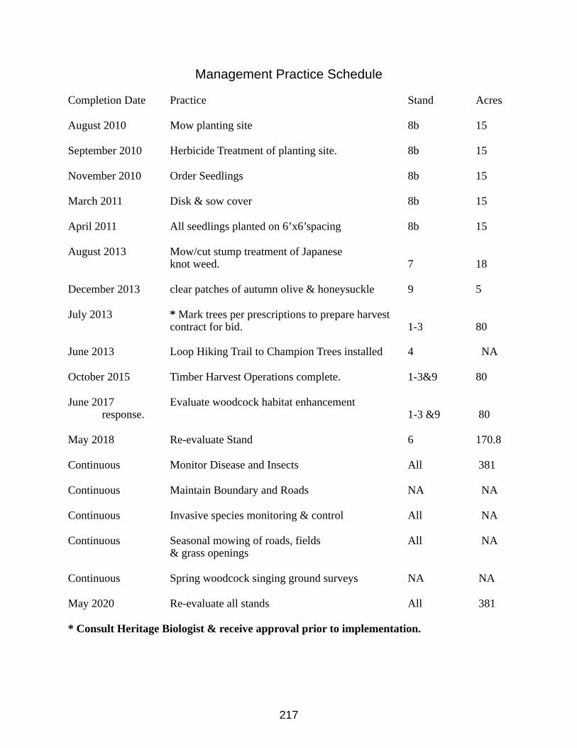
217
Management Practice Schedule
Completion Date Practice Stand Acres
August 2010 Mow planting site 8b 15
September 2010 Herbicide Treatment of planting site. 8b 15
November 2010 Order Seedlings 8b 15
March 2011 Disk & sow cover 8b 15
April 2011 All seedlings planted on 6’x6’spacing 8b 15
August 2013 Mow/cut stump treatment of Japanese knot weed. 7 18
December 2013 clear patches of autumn olive & honeysuckle 9 5
July 2013 * Mark trees per prescriptions to prepare harvestcontract for bid. 1-3 80
June 2013 Loop Hiking Trail to Champion Trees installed 4 NA
October 2015 Timber Harvest Operations complete. 1-3&9 80
June 2017 Evaluate woodcock habitat enhancement response. 1-3 &9 80
May 2018 Re-evaluate Stand 6 170.8
Continuous Monitor Disease and Insects All 381
Continuous Maintain Boundary and Roads NA NA
Continuous Invasive species monitoring & control All NA
Continuous Seasonal mowing of roads, fields All NA& grass openings
Continuous Spring woodcock singing ground surveys NA NA
May 2020 Re-evaluate all stands All 381
* Consult Heritage Biologist & receive approval prior to implementation.
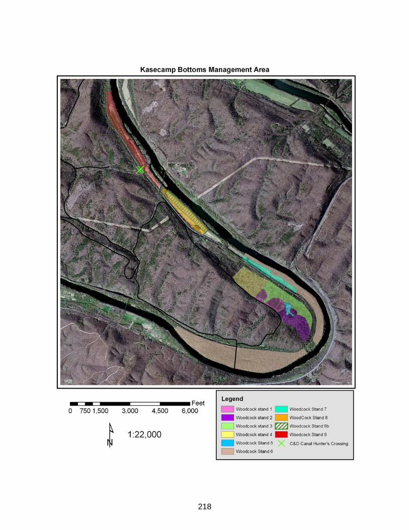
218
219
Anthonys Ridge Special Wildlife Habitat Area
Early Succession Wildlife Habitat Plan
for
Green Ridge State Forest
LOCATION
Malcolm Road GRSF
Phone: 301-478-3124
PROPERTY
910+/- Acres
PREPARED BY
Mark D. BealsForest Manager
ASSISTED BY
Rick LatshawHabitat Manager
Jim MullanRegional Wildlife Manager
Bill HarveyGame Bird Program Manager
Bob LongGame Bird Project Manager
28 February 2013
220
MANAGEMENT OBJECTIVES
Primary Objective: Enhance Early Succession Wildlife Habitat with a focus on ruffed grouse and golden-winged warbler habitat.
Secondary Objective: Develop Ruffed Grouse Demonstration Area.
The Anthonys Ridge Special Wildlife Habitat Area is approximately 910 acres of Green Ridge State Forest (GRSF) located along Malcolm Road. There is one private inholding contained within this unit. Most of this area is currently composed of oak –hickory woodland. However, there is approximately 65 acres that are composed of mixed young forests and open meadows that resulted from an abandoned farm and homestead. The elevation of this area ranges from 800 feet to 1200 feet. During the 1980’s the Forest Manager accomplished some fuelwood block harvests along the ridgeline on Anthonys Ridge. The objective of this practice was to enhance the habitat in the area for ruffed grouse while providing opportunity for local fuelwood cutters to access products from the forest. This past management objective and practices along with the proximity to the existing abandoned agriculture acreage served significantly in MD Department of Natural Resources (DNR) decision to select this area as a special wildlife habitat area to be managed for ruffed grouse, golden-winged warbler and other early succession forest habitats. It is the intention of the Maryland DNR-Forest Service in partnership with the Wildlife & Heritage Service, and other agency and private organization partners to actively manage this unit as a special wildlife habitat management area of GRSF. The primary management objective for this unit is to enhance and maintain the area for ruffed grouse and golden-winged warbler in a program that sustains their habitat within the area overtime. The secondary objective is to develop an Appalachian region ruffed grouse and golden-winged warbler management demonstration area. This plan includes recommendations for management practices to fulfill the objectives for this management unit.
EARLY SUCCESSION WILDLIFE HABITAT
Early succession wildlife habitat is generally characterized by fallow fields, managed grasslands, shrublands and young forests. In recent years these cover types have diminished greatly within the Maryland landscape, largely due to development and in some cases being allowed to revert to forest. Within GRSF, this habitat type has decreased greatly due to natural forest succession. Regeneration timber harvests do temporarily revert areas to this habitat type and provide habitat diversity within the forest. However, this is only temporary and the habitat type is becoming so rare, active management to restore, enhance, and maintain some of these habitats is a valid goal of the MD DNR.
Habitat enhancement practices will focus on ruffed grouse and GWWA within this management area. However, other species that will likely benefit from the management within this area include wild turkey, deer, black bear, cottontail rabbit, American woodcock and whip-poor-wills.
221
Ruffed GrouseThe ruffed grouse is considered the most widely distributed upland game bird in North America. However, according to Breeding Bird Surveys, ruffed grouse populations have been in decline throughout the Appalachian region over the past 35 years. Habitat loss and degradation are the principle causes of this decline. Maturing eastern deciduous forests, lack of management practices involving timber harvest, and fire suppression are major causes of habitat degradation. The quantity and quality of ruffed grouse habitat has declined in recent decades in the Appalachian region. The critical habitat requirements for ruffed grouse include nesting cover, brood cover, winter cover and winter/early spring nutrition. A primary objective of this plan is to enhance ruffed grouse habitat in a way that will sustain critical habitat requirements over time.
Golden-winged WarblerThe Golden-winged Warbler (GWWA) is a migratory songbird that spends its summers in the eastern and north-central portions of the United States and southern Ontario and winters in Central and northern South America. This species is considered one of the most critically threatened, non-federally listed vertebrates in eastern North America. GWWA population declines are largely due to competition and hybridization with Blue-winged Warbler and the loss of young forest habitats. A primary objective of this plan is to enhance and sustain GWWA breeding habitat within the management area in a perpetual fashion.
SOIL DESCRIPTIONSFollowing is a list and percent of coverage of the soil types that are mapped on this
management area: Weikert (44%), Klinesville (33%), Lehew (9%), Berks (5%), Calvin (3%), Ernest (2%), Blairton (1.5%), Craigsville (1.5%), and Rock outcrop-Rough complex (1%). Approximately 94% of the soils in this management area are in the “woodland management group 3” meaning that tree growth productivity is site index 55-64 for oaks Virginia pine, black cherry, and hickory. See appendix A for additional soil information.
222
COVER DESCRIPTIONSUnit SummaryUnit 1Acres 736Overstory Mixed oak, hickory, Virginia pine, red maple black
cherryUnderstory flowering dogwood, sassafras, hawthorn, greenbrier,
Japanese barberryAverage Diameter 5.8 inches @ DBHAge 100 yearsBasal Area 78 square feet per acreTPA 453Stocking 83% fullystockedSite Index 66Soil Weikert, KlinesvilleGrowth potential moderate
This unit is primarily made up of a 100 year old even-aged mixed oak stand. It is currently dominated by mixed oak, hickory, Virginia pine, red maple and black cherry respectively. Other species present include black gum, black locust, white pine, and pitch pine. Understory species include service berry, flowering dogwood, eastern redbud, blueberry spp., greenbrier, and multiflora rose.
RecommendationsThe recommendation for this unit is to further delineate the stand to separate area greater than 900 feet in elevation and/or less than fifty percent slope from the area less than 900 feet in elevation and/or greater than fifty percent slope. This will effectively separate the unit into two stands for management purposes (Unit 1a:aprox. 350 acres & Unit 1b: est. 386 acres respectively). The resulting unit 1a represents area that is operable for commercial timber harvest and is appropriate for GWWA management. Unit 1a should be managed under the principles of even aged silviculture on a 70 year rotation. Specific recommendations for this are described below. The recommendation for Unit 1b is to allow it to succeed naturally as mature forest and be reevaluated in 15-20 years. Some additional enhancement practices may be employed in the future as warranted and implementation resources are available. In the meantime, this area will serve a vital role as mature forest likely transitioning to uneven-aged, mature forest habitat while protecting sensitive soil resources on steep slopes. Furthermore, this will provide for increased diversity and complexity to the overall habitat values within this special wildlife habitat management area. Unit 1a should be further dissected into five to fifteen acre units to be regenerated over the next 70 years. This should result in an average opening size of 10 acres, which is considered optimum for both ruffed grouse and GWWA. Units 2,3, &5 (described below), will be treated similarly and should be included in the 70 year final harvest rotation to achieve perpetual maximum sustained yield of desired habitat for ruffed grouse and GWWA. This
223
recommendation is further described in the Silviculture section below.
Unit SummaryUnit 2Acres 33.7Overstory mixed oak, hickoryUnderstory blackberry, greenbriar, mixed hardwood regen.Age 4Basal Area 15 square feet per acre, residualStocking NA, regeneratingSite Index 64 for mixed oakSoil Weikert, KlinesvilleGrowth Potential Moderate
This 33.7 acre stand is made up of three blocks that were regenerated in 2007. The stand is currently dominated by blackberry, greenbriar, and mixed hardwood regeneration. There is 15 sq.ft./acre basal area of dominant and codominant trees that were left as residuals during the regeneration harvest. Most of the residuals are hickory or oak. Serviceberry and flowering dogwood were also retained where present. Several mature grapevines were released and retained during the regeneration harvest in this stand with soft mast production in mind.
Recommendations for Unit 2
The recommendation for this unit is to monitor the natural regeneration over the next 3-5 years to ensure desired species and stocking are achieved. Intermediate practices may be employed to facilitate desired composition and stocking. Once the desired stand is achieved, it is recommended to allow it to develop naturally for the next 20 to 30 years. This unit should be reevaluated around 2037 to consider commercial timber stand improvement to enhance forest health and ruffed grouse habitat value.
Unit Summary
Unit 3Acres 45Overstory NA, Regenerating standUnderstory blackberry, hardwood regen.Age 2Basal Area NAStocking NA, RegeneratingSite Index 64 for mixed oaksSoil Weikert KlinesvilleGrowth Potential moderate
224
This 45 acre unit is made up of two blocks north of Malcolm Road that were regenerated in 2010. It is very similar to unit 2 other than it was regenerated three years later. The stand is currently dominated by blackberry, greenbriar, and mixed hardwood regeneration. There is 15 sq.ft./acre basal area of dominant and codominant trees that were left as residuals during the regeneration harvest. Most of the residuals are hickory or oak. Serviceberry and flowering dogwood were also retained where present.
Recommendations for Unit 3The recommendation for this unit is similar to unit 2 above.
Unit Summary Unit 4Acres 25.9Overstory black cherry, red maple, mixed oak, black locust.Understory sassafras, flowering dogwood, greenbriar.Average Diameter 4.6 inches at DBHAge 30Basal Area 61 square feet per acreTPA 527Stocking 70% fully stockedSite Index 65 for mixed oaksSoil KlinesvilleGrowth Potential moderate
This 25.9 acre unit is located along the north side of Malcolm Road. This unit includes a narrow band of brush and other ornamental and orchard plantings along the roadside that are remnants of an old farmstead. However, most of the unit is dominated by black cherry, red maple, mixed oak, and black locust. Other species present include yellow poplar, American elm, black birch and ailanthus. The dominant understory species include sassafras, flowering dogwood, and greenbriar. Non-native and invasive species are also prevalent within the understory including bush honeysuckle spp., Japanese barberry, and multiflora rose. This unit appears to have developed with unnatural species composition. This is most likely remnant of the old farmstead and much of the unit was likely used as pasture some 30 years prior to now.
Recommendations for Unit 4The recommendation for this unit is to manage it intensely to maintain the soft edge
brush habitat between the road and the developing adjacent stand and to favor soft mast and grouse desired bud production. Furthermore, non-native and invasive species such as tree of heaven should be treated and/or removed from the unit. Practices to be completed in this unit include brush mowing, pruning, crop tree release, field border cut-backs, brush pile construction and herbicide treatment of ailanthus. Much of this work will be completed by forest staff and
225
partners including forestry and wildlife techniques training events as resources are available.
Unit Summary Unit 5Acres 31.3Overstory mixed oak, red maple, Virginia pine.Understory sassafras, flowering dogwood, multiflora rose, Japanese barberry.Average Diameter 6.7 inches at DBHAge 40Basal Area 94 square feet per acreTPA 388Stocking 93% fully stockedSite Index 68 for mixed oaksSoil KlinesvilleGrowth Potential Moderate
This 31.3 acre unit is currently dominated by mixed oaks, red maple and Virginia pine. Other species present include black locust, sassafras, table mountain pine, and ailanthus. The dominant understory species include sassafras, flowering dogwood, multiflora rose, and Japanese barberry. This stand is approximately 40 years old and likely regenerated naturally on abandoned pasture. This unit is over half the rotation age prescribed by this plan and currently has minimal wildlife habitat value because it has transitioned past the stage of desired early succession forest habitat components but also has not developed desired forest habitat components such as acorn production, canopy stratification, den trees, etc.
Recommendations for Unit 5The recommendation for this unit is to regenerate approximately 8-10 acres near the
center of the unit. 10 to 15 of the largest oaks per acre should be selected as residuals in this regeneration harvest to serve as singing perches and foraging sites for GWWA while providing future acorn production important for grouse and other wildlife. This will create an optimal sized opening for grouse and GWWA management in this region of the management area to provide prime habitat in 5 years and remain desirable for approximately 10-15 years. The remaining area within this unit should be thinned to a level that will maximize individual tree growth within the population. In this case, the residual stand density should be around 200 trees per acre and 60 sq.ft./acre of basal area. This could be accomplished through crop tree release or thinning from below. Either way, it is important that dominant trees of desired species be retained while suppressed trees and undesired species are targeted for removal.
This thinning will accelerate growth of the remaining population and promote mast production in the young stand. The increased light will regenerate understory growth more attractive to grouse and other wildlife species. Furthermore, woody debris left on the ground in result of the operation will provide additional cover structure within the developing stand. These thinned blocks should be regenerated in 30 – 35 years.
226
Unit SummaryUnit 6
This 38.8 acre unit is largely made up of recently abandoned agriculture fields and marginal pasture. Three native warm season grass (WSG) plantings were sowed in these fields in May of 2010 as part of a project to reclaim a largely tall fescue field to a more desirable mosaic of herbaceous vegetation. The open field areas outside of these WSG areas was also reclaimed and replanted with a cool season grass and clover mix to enhance forage diversity and facilitate management and maintenance of the field units. The steeper areas within the field units have had some rotational mowing where operable and some tree and shrub plantings. Furthermore, selective harvesting of trees along the edge of the field units was completed during the winter of 2009 to establish brush piles and creation of soft edge.
Recommendations for Unit 6The recommendation for this unit is to continue to manage intensely to maintain and
enhance early succession habitat. Specific recommendations for this unit include the following list:• Field border cutbacks to maintain soft edge and create brush piles for winter cover.• Selectively harvest trees within wooded section of this unit to release desirable mast producing species and create brush piles with resulting woody debris.• Plant shrubs and/or conifers on areas too steep to mow to establish diversity of cover types and thermal cover.• Rotationally mow cool season grass plantings to maintain existing vegetation and green strips to aid in maintenance of WSG stands.• Burn the WSG stands spring 2013 to reduce competing vegetation and enhance establishment of WSG. Once established, maintain by burning every 2-4 years.• Establish a conifer hedgerow along Malcolm road to create a visual screen and additional cover along the perimeter of the field units. • Encourage blackberry and other native brambles within this unit.
Silviculture Plan for Units 1a, 2, 3, &5
Under the objective of habitat management for ruffed grouse and GWWA, forest stand dynamics described above for units 1a, 2, 3 & 5 are suitable to consider as a whole to manage under an even-aged silviculture plan to provide sustainable habitat benefits for these species. This silviculture plan will strive to maximize habitat conditions for the focus species within this management area in a way that models long-term sustainability.
When the above units are combined, there is a combined total of approximately 460 acres of forest land that is both suitable for ruffed grouse and GWWA habitat management and operable under normal commercial harvesting operations within this area. It was stated earlier that these units would be managed under a rotation age of 70 years. This rotation age was selected in an effort to achieve a reasonable balance between maximum sustained habitat for target species within the area with sustained economic feasibility. In other words, this plan will provide both
227
biological, and economic long-term sustainability. Given the above area and rotation age, maximum sustained yield will be achieved by regenerating 6.6 acres per year within these units. This is the basis of the silviculture schedule in this plan. However, the optimal opening size recommended for managing these species is an average of 10 acres. Therefore, it is recommended that two, ten acre regeneration harvests be completed within this area every three years. This harvest schedule will allow for the creation of optimal sized forest openings that average 10 acres, decrease the frequency of entering the management unit with commercial logging equipment, and foster adequate sized timber sales to attract commercial contracts to perform the work. This schedule may be adjusted to mitigate abnormal conditions such as poor timber markets, environmental conditions, etc… so long as the openings created range from 5-15 acres and the overall rate of regeneration harvests do not exceed 6.6 acres per year over the course of 9 or 10 years. By the year 2077, all of this 460 acre management unit should have been regenerated resulting in 40 to 60 identifiable stands ranging in age from zero to seventy years. These regeneration harvests are predicted to yield optimal stand characteristics for GWWA and ruffed grouse from age 5 to 15 or 20 years post harvest. If this silviculture plan is followed closely over time, it will result in 65 to 100 acres within this management area will be within optimal stand conditions for the target species at all times.
The final harvest methods utilized to regenerate these stands may vary to increase diversity of cover types and so that the effectiveness of the practices for meeting the objectives may be evaluated. However the following guidelines should be followed to create optimal habitat conditions for GWWA and ruffed grouse within the young forest stands:
1. Retain 10-15 dominant or co-dominant trees per acre of desired species including oak spp., black cherry, American beech, and birch.
2. Retain native shrub species including service berry, red bud, flowering dogwood, and black-haw where practical.
3. Harvest units should be laid out with irregular shapes to maximize the proportional amount of edge.
4. Create feathered edges where practical retaining desirable mast producing trees.
Intermediate Harvest Operations
By the time the regenerated stands reach age of twenty years, the optimal stand level characteristics for GWWA and ruffed grouse will have diminished. However, additional management at this time would be very costly so it is recommended to allow the stands to continue to develop naturally until age 35 – 40 years. By this time the stand should develop to the point that thinning operations can be employed that are cost neutral. Thinning operations at this should be considered to increase the health and vitality of the stand and improve habitat quality.
Thinning operations employed in these stands should focus on reducing stand density to an optimal level for individual tree growth and release dominant and co-dominant trees of desired species. This practice will increase the health and vitality of the residual stand, increase production of hard and soft mast, and increase cover components within the stands for ruffed
228
grouse and other wildlife species. Crop Tree Release or thinning from below techniques are recommended for meeting these objectives.
Other Recommendations
Forest Roads and LandingsProperly managed forest roads and landings provide critical habitat for ruffed grouse in
this region by providing increased habitat dispersion, high quality forage, and attractive brood habitat. The forest roads in this management area are closed to all motorized traffic except for access to complete management practices. It is recommended that the main forest roads running north and south along Anthonys Ridge be maintained periodically through “daylighting” and restoration plantings of legumes, annual grains and native forbes to provide optimum habitat components and serve as travel corridors between the preferred habitat covers throughout the management area.
Daylighting is selectively removing trees at least thirty feet along the edge of the road on one or both sides of the road to allow sufficient sunlight for herbaceous cover to establish and grow.
Properly managed log landings serve a similar role of providing high quality forage and brood habitat for ruffed grouse. Additionally, landings may serve as suitable nesting sites for GWWA for a relatively long time because they tend to remain in herbaceous and or shrub cover for a long time after serving as a landing. Native forbs such as goldenrod should be encouraged on these sites because they are preferred by GWWA for nesting. Prescribed Fire
Fire may be used as a restoration and maintenance tool within the management area as the need for specific treatments arise. The native grass stands should be maintained with spring burns every 3-5 years. Experiments with prescribed fire will be carried out in an effort to evaluate enhancement of ruffed grouse and GWWA habitat. All prescribed fires will be managed and directed under the Maryland Forest Service fire policies. Herbicide Application
Herbicide application is a valuable tool in restoring and maintaining early succession habitat. Aerial application of herbicide may be prescribed on some stands in the future because it will allow relatively large areas to be maintained as early succession forest with less time and money than mechanical techniques. Herbicide applications will also be used in the invasive plant suppression prescriptions included within the plan and others as problems are discovered.
All herbicide work will be administered by licensed pesticide applicators and product labels will be strictly adhered to.
Invasive PlantsThe Anthony’s Ridge Management Area does contain non-native and invasive plants.
Efforts will be made to suppress and where practical, eradicate invasive species. However, a goal of 100% eradication of non-native and invasive species on this land unit would simply be an overwhelming proposition. Therefore a more realistic goal of suppression and containment of
229
species such as autumn and Russian olive, multi-flora rose, Japanese barberry, and bush honeysuckle spp, is set to suppress and prohibit spread and escape. Furthermore, eradication is the goal for some species such as ailanthus, Japanese knot weed, and mile-a-minute. Invasive species monitoring will be conducted continuously on this management unit and IPM will be implemented as problems are identified.
Demonstration & EducationThe Anthonys Ridge Special Wildlife Habitat Management Area is open to the public for
hunting and general outdoor recreation and enjoyment. A secondary objective of this plan is to demonstrate sustainable forest management for the enhancement of ruffed grouse and GWWA habitat. As resources are available, wayside exhibits and/or brochures will be developed to inform visitors of practices and management that has been applied to enhance habitat in this area for these species in a sustainable way. Natural resource organizations and institutions are encouraged to use this site as a demonstration area and natural laboratory. Such groups are encouraged to work to put practices in place to achieve the objectives of this plan. All of such activities must be approved and done under the supervision of the GRSF management staff. Allegany College of Maryland will work under a cooperative agreement with MD DNR-Forest Service to assist with timber harvest operations described in this plan in return for the practical experience for their Forestry students. Similar partnerships will be developed with others institutions.
PartnershipsThe Maryland Forest Service will continue to develop and maintain partnerships with
institutions and organizations to obtain funding and technical assistance in carrying out recommendations and prescriptions within this plan. Partnerships that currently exist in this endeavor include MD DNR Wildlife& Heritage Services, Garrett College, Allegany College of Maryland, and the Wildlife Institute, Appalachian Mountain Woodcock Initiative.
Other organizations that DNR will work to form partnerships with for this project include Appalachian Mountains Joint Venture, Ruffed Grouse Society, and National Wild Turkey Federation. Ruffed Grouse Habitat Information and GWWA information used in this plan and additional information on these habitat BMP’s for the Appalachian Mountain Region can be found at www.ruffedgrousesociety.organd www.pwrc.usgs.gov/pif/pubs/BMPs.htm
Management Practice Schedule
Completion Date Practice Stand Acres
May 2013 Prescribed fire in field units to promote Warm season grass establishment. 6 +-30
May 2013 Conifer/shrub plantings on field units too steep to mow. 6 5-10
230
June 2013 Begin Regeneration Harvest 5-15 acres. 1 15
December 2015 Complete Unit 5 Recommendations. 5 31.3
May 2020 Unit 4 Recommendations completed. 4 25.9
Continuous Monitor Habitat Response All 910
Continuous Monitor Disease and Insects All 910
Continuous Maintain Boundary and Roads NA NA
Continuous Invasive species monitoring & control All NA
Continuous Seasonal mowing of roads, fields All NA& grass openings
Continuous Ruffed Grouse & GWWA monitoring. NA NA
May 2032 Re-evaluate all stands All 910
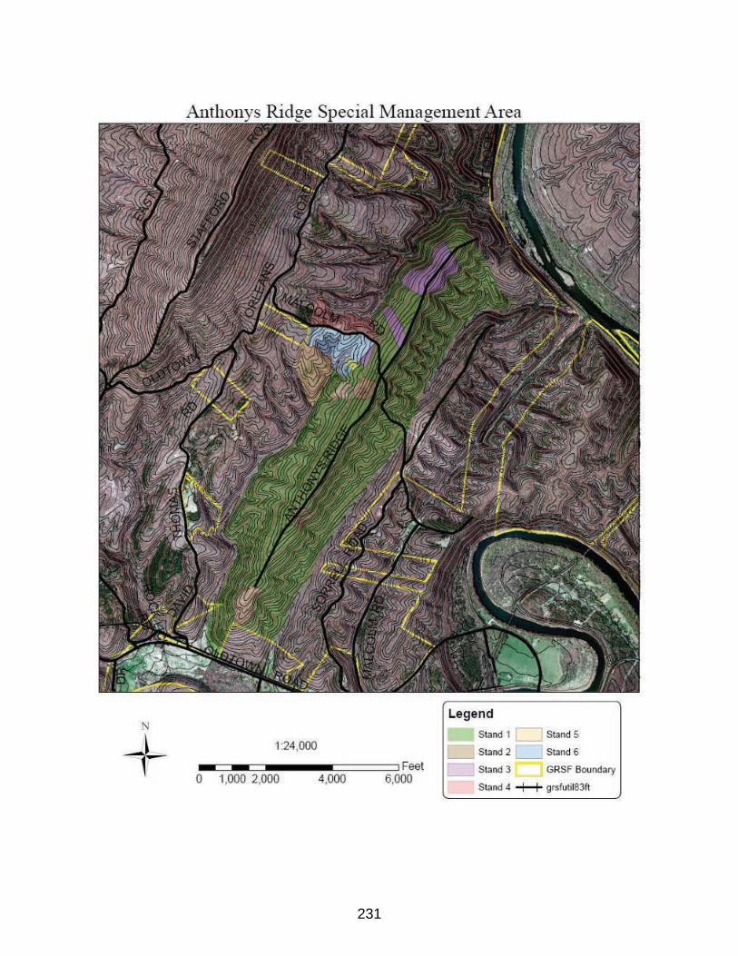
231
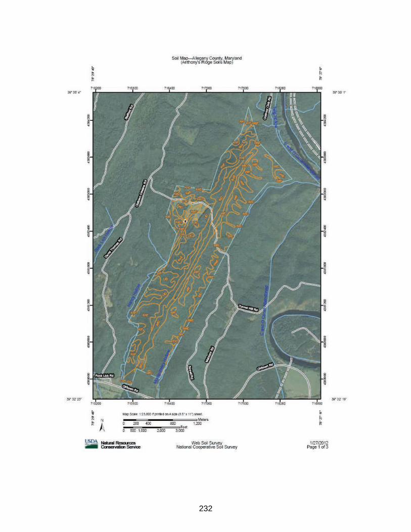
232
233
Town Creek Special Wildlife Habitat Area
Early Succession Wildlife Habitat Plan
for
Green Ridge State Forest
LOCATION
Town Creek Road GRSF
Phone: 301-478-3124
PROPERTY
275+/- Acres
PREPARED BY
Mark D. BealsForest Manager
ASSISTED BY
Rick LatshawHabitat Manager
Jim MullanRegional Wildlife Manager
Bill HarveyGame Bird Program Manager
Bob LongGame Bird Project Manager
234
31 March 2016
MANAGEMENT OBJECTIVES
Primary Objective: Enhance Early Succession Wildlife Habitat.Secondary Objective: Develop and enhance riparian forest buffers.
The Town Creek Special Wildlife Habitat Area is approximately 275 acres of Green Ridge State Forest (GRSF) located along Town Creek Road. This property is made up of three parcels that were recently acquired by the state. There are two private residence inholdings contained within this unit located along Town Creek Road. About 2/3 of this property was actively farmed until recently. The remainder of the property is made up largely of 40 to 60 year old mixed oak and mixed pine woodlands. The fact this property is made up of open fields and relatively young forest stands served significantly in MD Department of Natural Resources (DNR) decision to select this area as a special wildlife habitat area to be managed for early succession wildlife habitats. Furthermore, open meaodows and shrubland habitats are a minority cover component within the GRSF landscape. It is the intention of the Maryland DNR-Forest Service in partnership with the Wildlife & Heritage Service, and other agency and private organization partners to actively manage this unit as a special wildlife habitat management area of GRSF. The primary management objective for this unit is to enhance and maintain the area for early succession wildlife habitat species and sustain these habitat types within the area overtime. The secondary objective is to establish and enhance riparian forest buffers within the management area to improve and protect water quality in Town Creek. This plan includes recommendations for management practices to fulfill the objectives for this management unit.
EARLY SUCCESSION WILDLIFE HABITATEarly succession wildlife habitat is generally characterized by
fallow fields, managed grasslands, shrublands and young forests. In recent years these cover types have diminished greatly within the Maryland landscape, largely due to development and in some cases being allowed to revert to forest. Within GRSF, this habitat type has decreased greatly due to natural forest succession. Regeneration timber harvests do temporarily revert areas to this habitat type and provide habitat diversity within the forest. However, this is only temporary and the habitat type is becoming so rare, active
235
management to restore, enhance, and maintain some of these habitats is a valid goal of the MD DNR.
Habitat enhancement practices will focus on best management practices for American woodcock, ruffed grouse and eastern cottontail. However, many other native game and nongame species will benefit from the management within this area.
American WoodcockThe American woodcock is a migratory avian species primarily
associated with forested wetland habitats. Populations have steadily decreased at a rate of 1-2% per year over the last 25 years. This decline is believed to be attributed to the loss of young forest and shrubland in the eastern United States due to human development and forest maturation. Here in the Ridge and Valley section of Allegany County, young riparian forests are relatively uncommon, largely do to the topography and low annual precipitation. The best suited areas here are riparian areas along the Potomac River and its major tributaries.
Ruffed GrouseThe ruffed grouse is considered the most widely distributed
upland game bird in North America. However, according to Breeding Bird Surveys, ruffed grouse populations have been in decline throughout the Appalachian region over the past 35 years. Habitat loss and degradation are the principle causes of this decline. Maturing eastern deciduous forests, lack of management practices involving timber harvest, and fire suppression are major causes of habitat degradation. The quantity and quality of ruffed grouse habitat has declined in recent decades in the Appalachian region. The critical habitat requirements for ruffed grouse include nesting cover, brood cover, winter cover and winter/early spring nutrition. A primary objective of this plan is to enhance ruffed grouse habitat in a way that will sustain critical habitat requirements over time.
Eastern cottontailThe eastern cottontail has a wide distribution and is found
throughout most of the eastern United States. It is the most common rabbit species in Maryland. However, cottontail populations have declined over the past 50 years or so. The cause of this decline is largely the loss of early successional habitat (especially woody escape cover) due to conversion of farmlands to other uses, changes in farming practices, and maturing forests. This decline has likely been exacerbated by increases in the cottontail’s natural and non-natural predators. The most effective way to increase cottontails on an area is to increase the quantity and quality of their habitat. Probably the most
236
important factor is to provide plenty of quality escape cover in close proximity to feeding areas.
RIPARIAN FOREST BUFFERSRiparian forest buffers are forest adjacent to water; that serve a vital role in soil and water
conservation. Riparian forest buffers restore degraded waterways naturally. The establishment of and/or maintenance of riparian forest buffers is a way to protect and enhance streams, wetlands, floodplains, and riparian ecosystems. Whether it is located in an urban or agricultural setting the benefits are many and varies.
A complex forest ecosystem enhances and protects the natural ecology of stream systems. By stabilizing stream banks, filtering sediment and other suspended solids, absorbing excess nutrients, decreasing the spread and amount of run-off, transforming some toxic compounds to nontoxic useful compounds, forest improve the water quality of adjacent streams. Streamside forests directly affect aquatic life. Ground leaf litter and spongy forest soils allow precipitation to infiltrate slowly. Tree roots hold soil in place and absorb pollutants. Reduction of nutrients and sediment loads allow aquatic biota such as shellfish, finfish, and aquatic vegetation to thrive and reproduce. By helping to maintain base flow, providing food and habitat, providing shade to optimize light and temperature conditions, forest along streams provide habitat for trout and many other species of wildlife.
Forest areas along streams, rivers and other water bodies are classified as riparian forests. Riparian forests often differ from upland forest in their hydrology, plant community, soils, and topography. They also offer many benefits to the woodland ecosystem.
Studies have shown that riparian forests as narrow as 50` can serve as buffers to filter out, absorb, and utilize most of the sediment, nitrogen, and phosphorous carried in runoff from adjacent fields. These three elements are major contributors to the pollution of our streams, rivers, and ultimately Chesapeake Bay.
Tree roots also stabilize stream banks by holding soil in place and supply cover for fish and aquatic insects. Riparian forests also help slow down the velocity of floodwaters and allow sediment to settle.
SOIL DESCRIPTIONSFollowing is a list and percent of coverage of the soil types that
are mapped on this management area: Weikert (62.9%), Tyler (10.2%), Macove (6.8%), Ernest (6.5%), Philo (5.3%), Holly (3.1%), Craigsville (2.8%), Monongahela (2.2%).
237
COVER DESCRIPTIONSUnit SummaryUnit 1Acres 11Age 50 Overstory Mixed oak, hickory, white pine,Virginia pineUnderstory white pine, flowering dogwood, service berry,
ironwood.Average Diameter 6.4 inches @ DBHBasal Area 105 square feet per acreTPA 453Stocking 108% overstockedSite Index 62Soil WeikertGrowth potential low
This unit is primarily made up of a 50 year old even-aged mixed oak-hickory and pine stand. It is currently dominated by mixed oak, hickory, white pine and Virginia pine respectively. Other species present include sugar maple, black cherry and ailanthus. Understory species include white pine, service berry, flowering dogwood, and ironwood. This stand is currently overstocked which indicates that tree growth has stagnated due to competition.
RecommendationsThe recommendation for this stand is to reduce the stocking
significantly to enhance growth and vitality of the residual stand while promoting re-initiation of herbaceous and woody growth in the understory. 40-50 sq.ft. per acre of basal area of dominant and codominant trees should be selected as residuals as well as the native shrubs that exist. This will result in a two-aged stand but should also promote a dense understory for a longer period of time than a traditional light thinning and promote acorn production beneficial for ruffed grouse and other acorn dependent species.
Unit SummaryUnit 2Acres 18Age 67Overstory white pine, mixed oak, hickory, red maple hemlockUnderstory white pine, service berry
238
Average Diameter 6.2 inches @ DBHTPA 440Basal Area 123 square feet per acreStocking Fully StockedSite Index 56 for mixed oakSoil WeikertGrowth Potential low
This 18 acre stand is currently dominated by white pine, mixed oak, hickory, red maple and hemlock. This stand is not considered overstocked like the adjacent stand because it contains a high proportion of white pine. This stand is also located on steeper slopes.
Recommendations for Unit 2
The recommendation for this unit is to allow it to grow naturally for at least the next 10-15 years when it should be re-evaluated. This stand is currently serving well as valuable riparian forest on greater than 50% slope. Furthermore, the high component of conifers in this stand likely make this area serve as vital winter thermal cover for many wildlife species in the area.
Unit SummaryUnit 3Acres 14Age 67Overstory white pine, mixed oak, hickory, Virginia pineUnderstory white pine, serviceberryAverage Diameter 5.1 inches @ DBHTPA 478Basal Area 97 square feet per acreStocking fully stockedSite Index 58 for mixed oaksSoil WeikertGrowth Potential low
This unit is primarily made up of a 67 year old even-aged mixed oak-hickory and pine stand. It is currently dominated by mixed oak, hickory, white pine and Virginia pine respectively. Other species present include black gum, red maple, black locust and pitch pine. Understory species include service berry, and flowering dogwood. The upper slope section of this stand is predominantly mixed oak hickory while the lower and steeper sections tend to have the higher
239
component of pine. Recommendations for Unit 3
The recommendation for this unit is similar to unit 1 above. The upper slope section dominated by mixed oak hickory should be thinned to 40-50 sq.ft. of basal area of dominant and co-dominant trees while the steeper slopes adjacent to Bear Hill Road may be left natural to serve as an aesthetic buffer and wildlife travel corridor and thermal cover.
Unit Summary Unit 4Acres 66Age 70Overstory mixed oak, hickory, Virginia pine, white pine.Understory flowering dogwood, service berry, eastern redbudAverage Diameter 5.7 inches at DBHBasal Area 98 square feet per acreTPA 532Stocking 103% over stockedSite Index 60 for mixed oaksSoil WeikertGrowth Potential low
This 66 acre unit is currently dominated by mixed oaks, hickory and Virginia pine. Other species present include white pine, red maple, sugar maple and sasafras. The dominant understory species include flowering dogwood, and service berry. This stand is approximately 70 years old. Much of this unit is currently serving a vital role in soil and water conservation as riparian forest buffers for the many steep drainages found within the unit.
Recommendations for Unit 4
The recommendation for this unit is to allow most of it to continue to develop naturally as riparian forest buffer along the steep slopes and highly erodible soils. The ridge top sections of this unit should be evaluated closer in the coming years to determine areas that can be accessed with logging equipment for silviculture treatments that will regenerate vigorous young forest conditions within the management unit.
240
A primary skid road should be developed to facilitate the future management of this unit. Furthermore this skid road should be maintained This will result in dissecting the unit into multiple stands.
Unit Summary Unit 5Acres 3.5Age 40Overstory mixed oak, hickory, Virginia pine.Understory flowering dogwoodAverage Diameter 7.1 inches at DBHBasal Area 88 square feet per acreTPA 304Stocking 85% fully stockedSite Index 62 for mixed oaksSoil WeikertGrowth Potential low
This 3.5 acre unit is currently dominated by mixed oaks, hickory and Virginia pine. Other species present include black locust, bigtooth aspen, and black cherry. The dominant understory species include flowering dogwood and serviceberry. This stand is approximately 40 years old. This small stand is primarily a wooded area along a steep drain that was too steep for farming equipment. It is currently serving as a filter strip to the adjacent upland hayfields.
Recommendations for Unit 5The recommendation for this unit is to allow it to continue to
serve as a filter strip to the adjacent field units. Some single tree selection within this unit may be done to soften the edge with the field units and/or to promote vegetative growth in the understory. Such work will be done with hand crews as the area is too steep for most equipment. Single tree or group selection within this unit should include releasing crop trees with established gravevines and aspen regeneration. Brushpiles should be constructed with material generated in any of the above practices to create escape cover for early succession wildlife species..
This unit will likely expand in size as steep areas within Unit 8 below are converted over to shrub plantings and non-mowing areas. Unit Summary Unit 6Acres 3.0Age 20
241
Overstory Virginia pine, ailanthus, oakUnderstory autumn olive, bush honeysuckle.Average Diameter NABasal Area NATPA NAStocking NASite Index NASoil WeikertGrowth Potential low
This 3 acre unit is currently dominated by non native invasive species including autumn olive, bush honeysuckle, and ailanthus. Other invasive woody species present include multiflora rose and Japanese barberry. A few native trees including Virginia pine, scarlet oak and hickory do exist within this unit. This unit was likely cleared for agriculture when the adjacent field was cleared but later abandoned because it was too steep for equipment use. It was used as marginal pasture for some time but later allowed to develop naturally for the past 20 years or so.
Recommendations for Unit 6The recommendation for this unit is to contain and suppress the non-native invasive species through integrated pest management (IPM). This stand currently has value as a dense shrub cover habitat. However, suppressing the non-native species and converting the area over to native species over time is more desirable.Unit Summary Unit 7Acres 8.3Age 80Overstory sugar maple, American sycamore, white ash.Understory black haw.Average Diameter 16.5 inches at DBHBasal Area 97 square feet per acreTPA 80Stocking fully stockedSite Index 85 for mixed oaksSoil PhiloGrowth Potential high
This 8.3 acre unit is currently dominated by sugar maple, American sycamore, and white ash. Other species present include black walnut, shagbark hickory, swamp white oak and white oak. The dominant understory species include sugar maple and blackhaw. This stand is
242
currently serving as a mature riparian forest buffer along Town Creek.
Recommendations for Unit 7The recommendation for this unit is to allow it to continue developing naturally.
Unit SummaryUnit 8This 33 acre unit is largely made up of recently abandoned upland hay fields. It is on the Weikert soil type which has low site productivity.
Recommendations for Unit 8The recommendation for this unit is to continue to manage most of the area as grasslands and enhance early succession habitat. Specific recommendations for this unit include the following list:
Field border cutbacks along perimeter of the unit to soften the edge and create brush piles for winter cover.Plant shrubs and/or conifers on areas too steep to mow to establish diversity of cover types and thermal cover.Plant fruit trees along main service road following ridge top to increase soft mast production and add character and diversity to the landscape.Late summer/fall mowing to maintain desired herbaceous vegetation. Encourage blackberry and other native brambles within this unit.
Unit SummaryUnit 9This 18 acre unit is located on a steep slope along Lower Town Creek Road. It was likely abandoned as hayland and/or pasture within the last 15 – 20 years and allowed to develop naturally since that time. Currently the unit is a mixture of grass meadow and shrubs. The dominant shrub species include bush honeysuckle, autumn olive, and multi-flora rose.
Recommendations for Unit 9The recommendation for this unit is to continue to manage most of the area as grass and shrublands. However, this unit is currently dominated by non-native invasive shrub species. The recommendation is to aggressively manage this stand to suppress the non-native bush honeysuckle and autumn olive and promote the establishment of native shrubs. It is recommended to begin this effort by applying a prescribed fire to the entire unit. This unit should be burned during the
243
late winter or early spring in the earliest year possible. This treatment is not expected to eliminate the undesirable shrub population. The goal of this initial burn is to slow the spread and growth of the current population and allow the practitioners to monitor the response in order to further evaluate the best method of converting this stand over to a more desirable upland habitat cover. Follow up treatments will likely include additional prescribed fire, mechanical treatment, herbicide treatment, and native plantings.
Unit SummaryUnit 10This 58 acre unit is currently made up of recently abandoned hayfields located on highly productive bottomlands soils. These fields were likely once productive crop fields that were drained by constructed ditches to facilitate draining of saturated soils.
Recommendations for Unit 10The recommendation for this unit is to plant tree and shrubs on approximately ½ half of it to establish riparian forest buffer and woodcock habitat. Refer to the Planting Plan (Appendix A) for detailed information on the 26 acres of tree and shrub planting within this unit. This planting will create approximately 2.25 miles of linear riparian stream buffer to enhance water quality in Town Creek. Furthermore, it will create preferred woodcock habitat.
The remainder of this unit will remain in grasslands for now and maintained through seasonal mowing. Mowing within these field units should be limited toheight no less than eight inches if mowed during the growing season to avoid damage to any reptiles. If shorter mowing is desired it must be done November 15 through March 15 when reptiles are not present.
If additional resources are available in the future, some of these fields may be converted over to native warm season grass units and/or other forage crops such as grains, sunflowers or pumpkins.
Unit SummaryUnit 11This 32 acre unit was traditionally a bottomland agriculture field. However, much of the area was enrolled into the Conservation Reserve Enhancement Program by the previous landowner and approximately half of the unit was planted with trees. The center of the unit remains as a cool season grassland. The tree planting on this unit has been marginally successful as emerald ash borers have eliminated the high proportion of ash seedlings planted. Furthermore, rodent and deer damage has been prevalent.
Recommendations for Unit 11The recommendation for this unit is similar to Unit 9 above. Enhancement plantings of native trees and shrubs should be done in the riparian areas where tree mortality is high until young forest cover is achieved.
244
Other Recommendations
Forest Roads and LandingsOvergrown Roads and Grasslands Many of the old roads or strips in this unit have become
overgrown or receded due to lack of mowing, deadfall obstruction, and/or natural succession. As feasible, these roads should be cleared and mowed to serve as feeding and travel corridors for ground dwelling birds and mammals. Grassed roadways in forest habitats provide excellent brooding areas for ruffed grouse and wild turkey.
Additional small grassland openings should be established to create more singing grounds for woodcock throughout the landscape of the orchard area. These openings should be at least ¼ acre in size and be maintained as grassland openings. This will enhance woodcock breeding opportunities and benefit many other wildlife species.
Grassland ReclamationThis management area currently contains approximately 100
acres of grassland habitat in various stages of succession. Some areas have already been identified for planting of clover and/or trees and shrubs. Additional areas may be identified for replanting to more desirable grass-legume mixtures or native warm season grasses as resources and funding become available. Stands dominated by fescue should be a target for reclamation. Fescue is a dense growing, cool season grass that provides little wildlife benefit. When feasible, fescue stands should be converted to a more desirable grass/legume mixture and maintained by rotational mowing and occasional fertilization.
Tree PlantingAdditional opportunities for tree planting in this management
area are extensive but should be carefully planned not to interfere with the objectives of the specific sites. Conifer windrow plantings may be re-established as the over-mature ones are removed. Additional apple trees should be planted and fenced each spring to maintain the legacy and ecological benefit of soft mast production.
Prescribed Fire
Fire may be used as a restoration and maintenance tool within the management area as the need for specific treatments arise. Prescribed fire is recommended for stand 9 above to experiment and evaluate effectiveness of suppressing established non-native shrub
245
stand and enhancing habitat condition. Other prescribed fire applications within this management area may include maintenance of the grasslands, site preparation for future plantings, control regeneration of forest stands, establish and maintain native grasses, and control non-native invasive species. All prescribed fires will be managed and directed under the Maryland Forest Service fire policies. Herbicide Application
Herbicide application is a valuable tool in restoring and maintaining early succession habitat. Aerial application of herbicide may be prescribed on some stands in the future because it will allow relatively large areas to be maintained as early succession forest with less time and money than mechanical techniques. Herbicide applications will also be used in the invasive plant suppression prescriptions included within the plan and others as problems are discovered.
All herbicide work will be administered by licensed pesticide applicators and product labels will be strictly adhered to.
Invasive PlantsThe TCSWMA does contain non-native and invasive plants. Efforts will be made to suppress and where practical, eradicate invasive species. However, a goal of 100% eradication of non-native and invasive species on this land unit would simply be an overwhelming proposition. Therefore a more realistic goal of suppression and containment of species such as autumn and Russian olive, multi-flora rose, Japanese barberry, and bush honeysuckle spp, is set to suppress and prohibit spread and escape. Furthermore, eradication is the goal for some species such as ailanthus, Japanese knot weed, and mile-a-minute. Invasive species monitoring will be conducted continuously on this management unit and IPM will be implemented as problems are identified.Recreation, Education, and Partnerships
The Town Creek Special Wildlife Habitat Management Area is open to the public for hunting and general outdoor recreation and enjoyment. Natural resource organizations and institutions are encouraged to use this site as a demonstration area and natural laboratory. Such groups are encouraged to work to put practices in place to achieve the objectives of this plan. All of such activities must be approved and done under the supervision of the GRSF management staff.
Partnerships that currently exist and have been active in developing this plan include MD DNR Wildlife& Heritage Services and Garrett College. Garrett College has been an active partner in
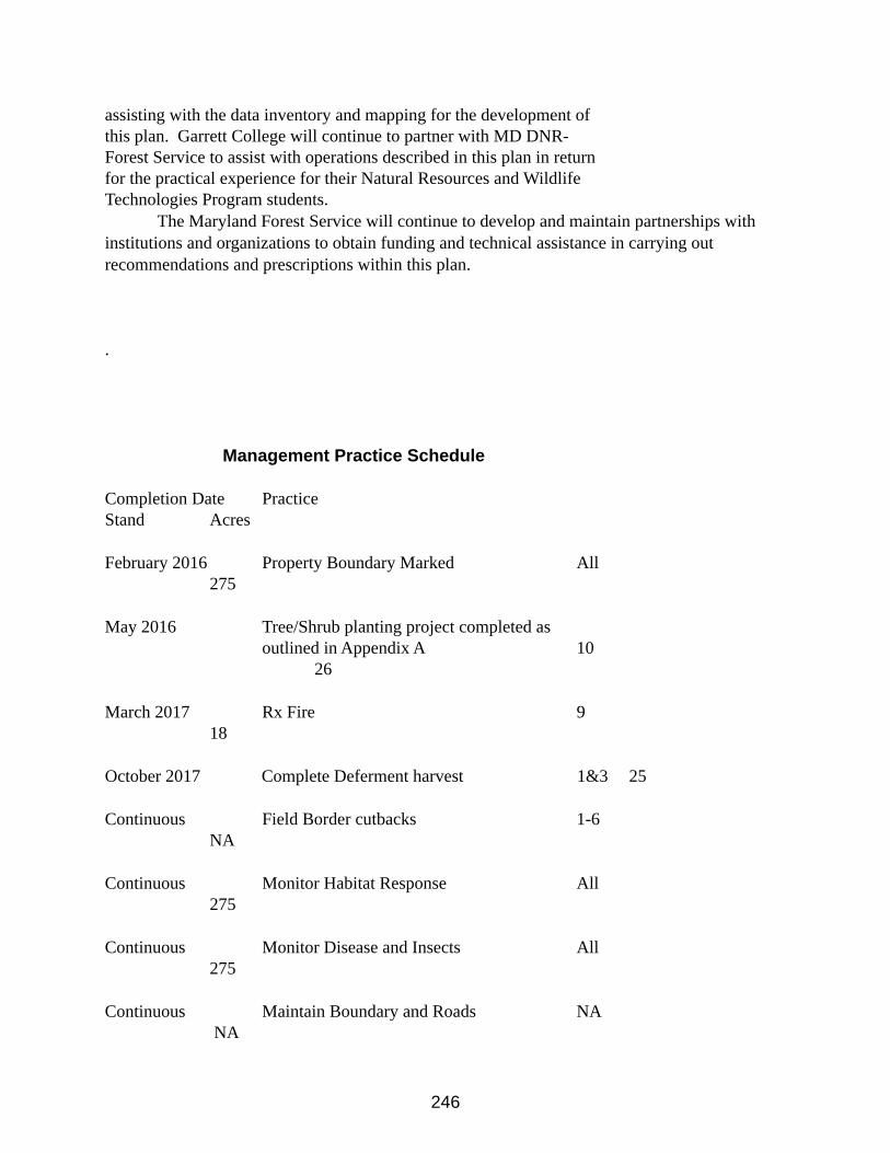
246
assisting with the data inventory and mapping for the development of this plan. Garrett College will continue to partner with MD DNR-Forest Service to assist with operations described in this plan in return for the practical experience for their Natural Resources and Wildlife Technologies Program students.
The Maryland Forest Service will continue to develop and maintain partnerships with institutions and organizations to obtain funding and technical assistance in carrying out recommendations and prescriptions within this plan.
.
Management Practice Schedule
Completion Date PracticeStand Acres
February 2016 Property Boundary Marked All275
May 2016 Tree/Shrub planting project completed as outlined in Appendix A 10
26
March 2017 Rx Fire 918
October 2017 Complete Deferment harvest 1&3 25
Continuous Field Border cutbacks 1-6NA
Continuous Monitor Habitat Response All275
Continuous Monitor Disease and Insects All275
Continuous Maintain Boundary and Roads NA NA
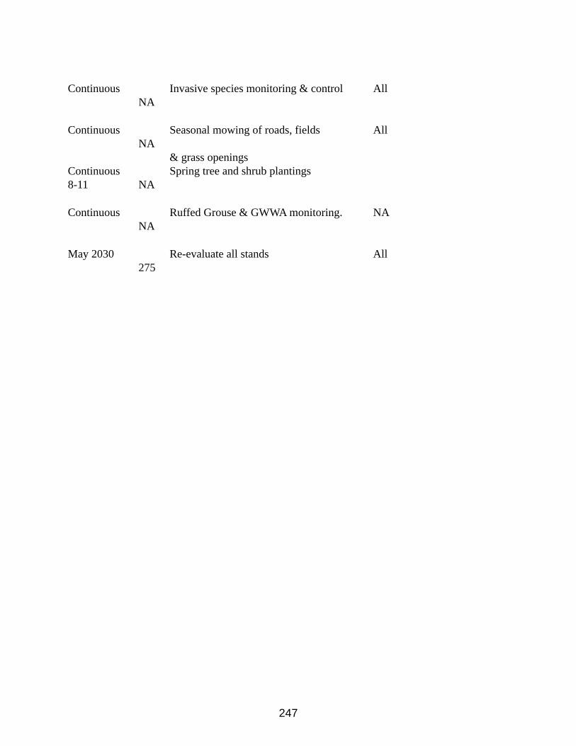
247
Continuous Invasive species monitoring & control All NA
Continuous Seasonal mowing of roads, fields All NA
& grass openingsContinuous Spring tree and shrub plantings8-11 NA
Continuous Ruffed Grouse & GWWA monitoring. NA NA
May 2030 Re-evaluate all stands All 275
248
Appendix F - SFI Management Review & Continual Improvement
Effective: July 19, 2005Operation Order 2005-601 Annapolis, Maryland
Policy for Management Review & Continual ImprovementObjectiveThis order establishes the Maryland Department of Natural Resources Forest Service policy for a management review system to examine findings and progress in implementing the Sustainable Forest Initiative (SFI) Standard on those lands subject to the Standard, to make appropriate improvements in programs, and to inform employees of changes.
OverviewThe Sustainable Forest Initiative Standard Objective 13 requires landowners with lands subject to the Standard to promote continual improvement in the practice of sustainable forestry and monitor, measure, and report performance in achieving the commitment to sustainable forestry.
Therefore:1. Biannual reports will be filed by the State Forest manager (with input by the management
contractor, if applicable) to the State Forester on progress of meeting SFI requirements, status of Corrective Action Requests (CAR), and suggested opportunities for continual improvement. The first report will be due within 60 days after the Sustainable Forest Initiative annual audit and the second report about six months after that.
2. A summary of the biannual reports will be posted on the DNR Forest Service website and optionally other appropriate public outlets.
3. A meeting will be held annually to report on the progress of meeting SFI requirements, CAR status, opportunities for continual improvement on meeting SFI requirements and for the adjustment and establishment of new SFI implementation goals. This will require attendance by the forest manager, management contractor (if applicable), State Forester and appropriate staff. This meeting should be in conjunction with the release of the second report and coordinated by State Forest manager, contractor (if applicable) and State Forester.
4. This policy shall be included as a requirement in the agreement with any forest management contractors with DNR Forest Service the requirement to fulfill the above written policy conditions.
249
Purpose/Vision StatementThe purpose of this document is to provide resource management guidelines for land unit managers to implement and advance the Department of Natural Resources’ (DNR) policy on “Conservation and Protection of Old-Growth Forests.” The policy objective is to enhance the functionality of old growth forest ecosystems on DNR lands by increasing old growth acreage and managing old growth ecosystems in a landscape context. Three fundamental questions must be answered to achieve this vision:
1. How much old growth forest is needed on the landscape to ensure the unique characteristics of these ecosystems are preserved?
2. How should old growth forest ecosystems be located and connected on the landscape?
3. Which forest species associations need to be included in Maryland’s old growth network to maintain the full range of the state’s forest habitats?
Answers to these broad questions will be achieved through a continuing process of scientific literature review, planning processes, and inventory and analysis. The guidance provided in this document is intended to ensure these questions are specifically addressed in the Department’s comprehensive land planning processes, and to guide DNR land managers in the application of appropriate scientific management practices to achieve the desired outcome.
Background and Summary of Current Old Growth Forests in MarylandIn August 1989, a DNR committee report entitled “Old Growth Forest Ecosystems” was drafted to provide land managers with a scientific list of old growth forest characteristics for use in identifying and managing potential old growth forests on DNR lands. In 2002, DNR up-dated the 1989 report with an extensive review of current scientific information on eastern old growth forests, and finalized the definition of old growth forests deemed most appropriate to Maryland. This was followed up by an extensive old growth inventory project from 2003-2006.
The DNR’s 2003-2006 inventory process identified 40 sites statewide as meeting the DNR’s old growth definition (see Appendix 1 for list of specific sites). In total, approximately 2,176 acres (930 hectares) were identified; more than 1,700 of the designated old growth acres (688 hectares) were found on State Forest lands. The largest identified old-growth tract is within the Big Savage and South Savage Wildlands of Savage River State Forest, an area totaling more than 770 acres (312 hectares).
Most (82%) of the identified old growth stands are co-dominated by mixed oak species (Table 21). Youghiogheny Grove (Swallow Falls State Park) and Rocky Gap (Rocky Gap State Park) are co-dominated by Eastern hemlock (Tsuga canadensis). Youghiogheny Grove and Keenan Ridge (Green Ridge State Forest), and Schoolhouse Woods (Wye Island Natural Resources Management Area) also are codominated by pines (Pinus sp.). (See Appendix 2 for a listing of the dominant cover species for each identified old growth area).
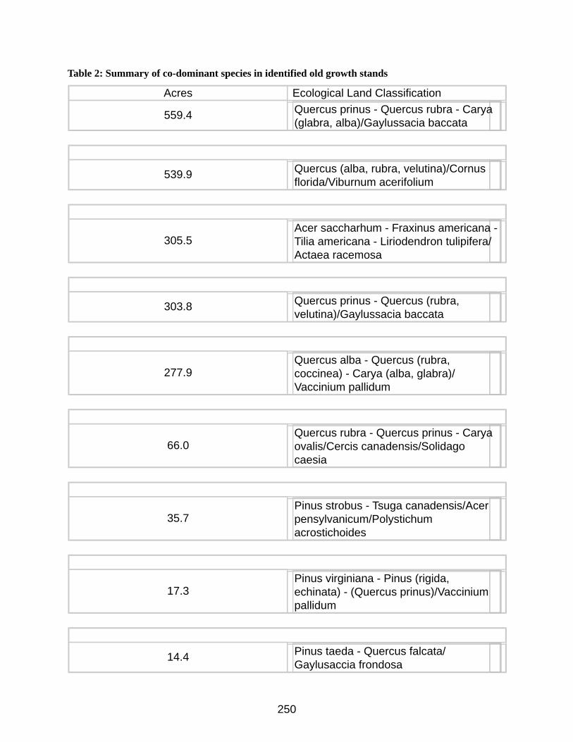
250
Table 2: Summary of co-dominant species in identified old growth stands
Acres Ecological Land Classification
559.4 Quercus prinus - Quercus rubra - Carya (glabra, alba)/Gaylussacia baccata
539.9 Quercus (alba, rubra, velutina)/Cornus florida/Viburnum acerifolium
305.5Acer saccharhum - Fraxinus americana - Tilia americana - Liriodendron tulipifera/Actaea racemosa
303.8 Quercus prinus - Quercus (rubra, velutina)/Gaylussacia baccata
277.9Quercus alba - Quercus (rubra, coccinea) - Carya (alba, glabra)/ Vaccinium pallidum
66.0Quercus rubra - Quercus prinus - Carya ovalis/Cercis canadensis/Solidago caesia
35.7Pinus strobus - Tsuga canadensis/Acer pensylvanicum/Polystichum acrostichoides
17.3Pinus virginiana - Pinus (rigida, echinata) - (Quercus prinus)/Vaccinium pallidum
14.4 Pinus taeda - Quercus falcata/Gaylusaccia frondosa
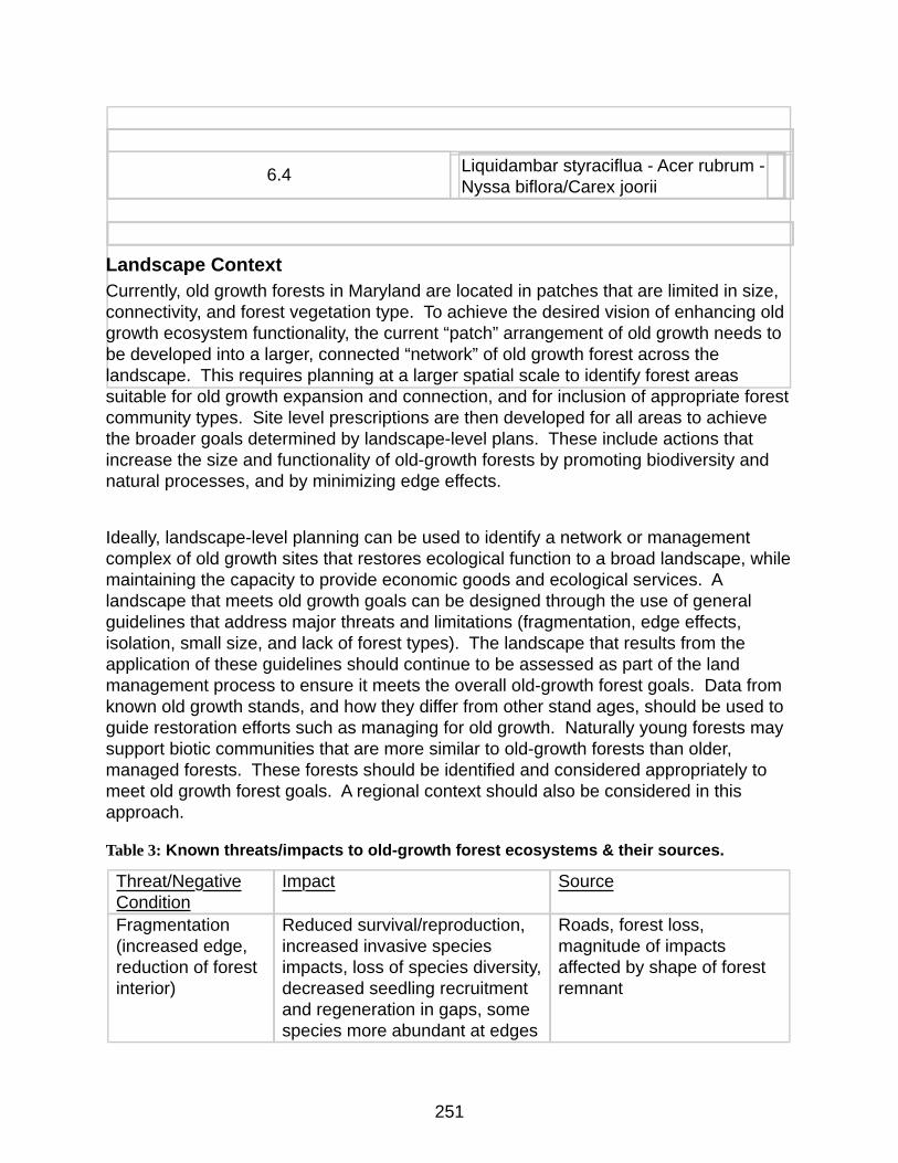
251
6.4 Liquidambar styraciflua - Acer rubrum - Nyssa biflora/Carex joorii
Landscape ContextCurrently, old growth forests in Maryland are located in patches that are limited in size, connectivity, and forest vegetation type. To achieve the desired vision of enhancing old growth ecosystem functionality, the current “patch” arrangement of old growth needs to be developed into a larger, connected “network” of old growth forest across the landscape. This requires planning at a larger spatial scale to identify forest areas suitable for old growth expansion and connection, and for inclusion of appropriate forest community types. Site level prescriptions are then developed for all areas to achieve the broader goals determined by landscape-level plans. These include actions that increase the size and functionality of old-growth forests by promoting biodiversity and natural processes, and by minimizing edge effects.
Ideally, landscape-level planning can be used to identify a network or management complex of old growth sites that restores ecological function to a broad landscape, while maintaining the capacity to provide economic goods and ecological services. A landscape that meets old growth goals can be designed through the use of general guidelines that address major threats and limitations (fragmentation, edge effects, isolation, small size, and lack of forest types). The landscape that results from the application of these guidelines should continue to be assessed as part of the land management process to ensure it meets the overall old-growth forest goals. Data from known old growth stands, and how they differ from other stand ages, should be used to guide restoration efforts such as managing for old growth. Naturally young forests may support biotic communities that are more similar to old-growth forests than older, managed forests. These forests should be identified and considered appropriately to meet old growth forest goals. A regional context should also be considered in this approach.
Table 3: Known threats/impacts to old-growth forest ecosystems & their sources.
Threat/Negative Condition
Impact Source
Fragmentation (increased edge, reduction of forest interior)
Reduced survival/reproduction, increased invasive species impacts, loss of species diversity, decreased seedling recruitment and regeneration in gaps, some species more abundant at edges
Roads, forest loss, magnitude of impacts affected by shape of forest remnant
252
Isolation/lack of connectivity
Alters species interactions, limits plant and animal dispersal, divides populations, alters post-disturbance recovery, reduces effective population size leading to loss of species and genetic diversity
Dispersal barriers such as roads and inhospitable or dangerous landscape to traverse, change in surrounding land use
Small size Reduces population size leading to loss of species and genetic diversity, increased vulnerability to invasive species impacts
Forest loss, land use changes
Limited forest types
Reduced species diversity, lack of reference sites
Forest loss, land use changes
Identifying Nearly Old-Growth Forests “Nearly old-growth forests” are those forests which are approaching old-growth forest status. They exhibit many of the characteristics of an old-growth forest but the oldest trees are slightly less than half their maximum age, thus they are almost old growth.
For the purposes of old-growth forest conservation, DNR defines “nearly old-growth forest” as a minimum of 5 acres in size with a preponderance of old trees and exhibits many of the following characteristics:
1. The oldest trees exceed at least 40% of the projected maximum attainable
age for that species (see Appendix 3).2. Shade tolerant species are present.3. There are randomly distributed canopy gaps.4. There is a high degree of structural diversity characterized by multiple
growth layers (canopy, understory trees, shrub, herbaceous, ground layers) that reflect a broad spectrum of ages.
5. There is an accumulation of dead wood of varying sizes and stages of decomposition, standing and down, accompanied by decadence in live dominant trees.
6. Pit and mound topography can be observed, if the soil conditions permit it.
The identification and conservation of these nearly old-growth forests are important for increasing the amount of old growth on DNR lands and to enhance the functionality of existing old growth in close proximity to these nearly old-growth forests. Appropriate conservation of nearly old-growth forests will be addressed in the sections on guidelines for conservation of old growth and guidelines for increasing old growth. Land managers, foresters, ecologists, biologists, and others on the DNR interdisciplinary teams should become familiar with nearly old-growth forests and delineate potential nearly old-growth forests for determination by the DNR’s Old Growth Committee.
253
Note: Forests managed for extended rotations are not by default to be considered nearly old-growth forests.
Guidelines for Conservation of Old-Growth The conservation of functional old-growth forest ecosystems is the goal. Simply protecting patches of old-growth forest does not result in a functional old-growth ecosystem. A functional system provides a multitude of values and is the desired outcome of DNR for old-growth forests. While patches of old-growth forest contain essential elements of an old-growth system, DNR will manage old-growth ecosystems in units of approximately 1,000 acres or more whenever practical. Emphasis should be given to those old-growth forests that will most likely become functional old-growth ecosystems. Some old-growth stands will be too isolated to function as an ecosystem and will be protected at the stand level.
The following guidelines are intended to protect old-growth forests while conserving and enhancing the functionality of the forested ecosystem within which the old-growth occurs:
• Designated old-growth forest will be excluded from timber harvest, including salvage, or other physical alterations.
• Designated old-growth forest will be excluded from protection from natural disturbance factors, such as native insect infestations or wild fire, unless such disturbance is introduced by an unnatural cause (e.g., exotic forest pests or invasive species) or will seriously jeopardize the continued existence of the old-growth ecosystem or significant resources adjacent to the old-growth forest.
• Control of the white-tailed deer population will be encouraged to maintain herd size at a level that does not adversely affect regeneration of trees in the understory.
• A no-cut buffer will be established to a width of at least 300 ft from the edge of the designated old growth. This buffer may be expanded based on specific site conditions or threats. The buffer will be excluded from timber harvest or other physical alterations. Any nonforested conditions within the buffer should be reforested, whenever feasible. Salvage harvesting should not occur within this buffer.
• A management zone will be established that includes the old-growth forest(s) and its primary buffer(s). This management zone will be approximately 1,000 acres in size or greater, whenever feasible. This management zone should incorporate as many designated old-growth and nearly old-growth sites as possible. Its shape should minimize edge to area ratio and be as contiguous as possible. Silvicultural treatments within this zone should be techniques that have as their primary objective the fostering of old-growth conditions, and would include practices such as uneven-aged management and limited even-aged management, extended rotations, techniques that more closely mimic the natural disturbances found in old-growth forests, structural complexity enhancement
254
practices, or techniques that result in retention of at least 70% of the canopy trees. Standing snags and downed coarse woody debris will be retained. Any non-forested conditions within the secondary zone should be reforested, whenever feasible. Salvage harvesting is allowable with the retention of at least 33% of dead or dying snags (not damaged live trees) and coarse woody debris. At all times, the majority of the management zone shall be in the sawtimber size class, preferably a minimum of 75%. Areas within the management zone not designated old-growth or nearly old growth at the time of initial assessment/inventory will not necessarily be managed as if they are designated old-growth.
• Nearly old-growth forests within the management zone should be managed as if they were designated old growth. Timber harvest or other alterations will be excluded. Protection of natural disturbance factors, such as insect infestations or wild fire, will be excluded unless such disturbance is introduced by an unnatural cause or seriously jeopardize the continued existence of the old-growth ecosystem or significant resources adjacent to the old-growth forest. Salvage harvesting should not occur within this forest.
• Passive recreational and educational use of old-growth forests and their buffers will be allowed, including hiking and hunting. No trails or roads will be built to access the old growth. Existing trails or roads will be managed to minimize impacts to the old-growth ecosystem or should be retired, whenever feasible. No campfires shall be allowed.
• An aggressive invasive species monitoring, prevention, and control program should be developed and implemented.
• Private land holdings within these buffers and management zones should be conserved in accordance with these guidelines through incentives, easements, or acquisitions.
Note: Extended rotation management may result in the harvesting of some trees older than half their maximum age.
For patches of old-growth that are too isolated to become functional old-growth ecosystems, the following guidelines shall apply:
• Designated old-growth forest will be excluded from timber harvest, including salvage, or other physical alterations.
• Designated old-growth forest will be excluded from protection from natural disturbance factors, such as native insect infestations or wild fire, unless such disturbance is introduced by an unnatural cause (e.g., exotic forest pests or invasive species) or will seriously jeopardize the continued existence of the old-growth ecosystem or significant resources adjacent to the old-growth forest.
• Control of the white-tailed deer population will be encouraged to maintain herd size at a level that does not adversely affect regeneration of trees in the understory.
• Old growth stands will be buffered by forest on all sides, when feasible.
255
• A no-cut buffer will be established to a width of at least 300 ft from the edge of the designated old growth. This buffer may be expanded based on specific site conditions or threats. The buffer will be excluded from timber harvest or other physical alterations. Any non-forested conditions within the buffer should be reforested, whenever feasible. Salvage harvesting should not occur within this buffer.
• Passive recreational and educational use of old-growth forests will be allowed, including hiking and hunting. No trails or roads will be built to access the old growth. Existing trails or roads will be managed to minimize impacts to the old-growth forest or should be retired, whenever feasible. No campfires shall be allowed.
• An aggressive invasive species monitoring, prevention, and control program should be developed and implemented.
Land managers are encouraged to consult with DNR’s Old Growth Committee or other old-growth forest experts when developing specific plans to conserve old-growth forests and functional old-growth ecosystems.
Guidelines for Increasing Old-Growth Increasing the amount of old-growth forest on DNR lands is desirable. State Forests, State Parks, Wildlife Management Areas, Natural Resources Management Areas, Natural Environmental Areas, and other designations should be assessed for the potential to increase old-growth forests and nearly old-growth forests. A functional system provides a multitude of values and is the desired outcome of DNR for old-growth forests. The following guidelines are intended to increase old-growth forest acreage on DNR land:
• Designated Wildlands, that are forested, will ultimately develop into old-growth forests over time.
• Certain Ecologically Significant Areas (ESA) will ultimately develop into old-growth forests over time.
• Nearly old-growth forests, as defined in Section 4, are those that can achieve old growth status in the quickest period of time. However, the locations and amount of nearly old-growth forests on DNR lands has not been determined. The following should be completed:
o An assessment of nearly old-growth forests should be completed. The locations of all such forests should be mapped.
o Until a complete assessment of nearly old-growth forests on DNR land units is completed, any forest that meet the criteria for nearly old-growth forest should be treated as old growth. During the annual work planning process, all forest stands considered for timber harvesting should be compared to the criteria for nearly old-growth forests and treated accordingly.
o Once a complete assessment of nearly old-growth forests is completed, those forests with the largest acreages and those located on the
256
landscape such that the functionality of old-growth ecosystems is enhanced should be conserved in a manner similar to designated old growth. Adequate buffers should be considered. Otherwise increased protection will not be required.
• Acquisition of privately-owned old-growth forests should be given extremely high priority, provided the tracts are not too isolated or small.
• Acquisition of privately-owned nearly old-growth forests adjacent to existing old growth should be pursued.
• Need to develop strategies for developing old-growth forests of under-represented forest types (e.g., loblolly pine-oak).
• If the old-growth acreage goal is not met through the inclusion of nearly old-growth forests and Wildlands, additional forest stands will be identified for management toward old-growth conditions. Once achieved these additional old-growth forest stands will be conserved as old-growth. Secondary management zones will be established and managed to mimic old-growth conditions using a variety of even-aged techniques, including extended rotations, and uneven-aged techniques to increase the functionality of the old-growth ecosystem.
Note: Extended rotation management may result in the harvesting of some trees older than half their maximum age.
Development of Specific (Land Unit) Management PlansLand Unit Plans will provide the site-specific Old-Growth management strategies for each respective Land Unit. The site-specific management strategies will be developed in the context of the broader management guidelines contained within this document as part of the Comprehensive Planning Process. Additionally, as part of the Comprehensive Planning Process, the Department will actively engage stakeholders and the public to comment and participate on the specific Old Growth recommendations for each respective Land Unit.
GlossaryBIOLOGICAL DIVERSITY - The variety of life forms in a given area. Diversity can be categorized in terms of the number of species, the variety in the area's plant and animal communities, the genetic variability of the animals, or a combination of these elements.
BUFFER STRIP - A narrow zone or strip of land, trees, or vegetation bordering an area. Common examples include visual buffers, which screen the view along roads, and streamside buffers, which are used to protect water quality. Buffers may also be used to prevent the spread of forest pests.
DOMINANT [CO-DOMINANT]: The overstory life form or species in a plant community which contributes the most cover or basal area to the community, compared to other life form or species.
ECOLOGICAL TYPE (Habitat Type): A category of land having a unique combination of potential natural community; soil, landscape features, climate, and differing from other ecological types in its ability to produce vegetation and respond to management. Classes of ecological types include all sites that have this
ECOSYSTEM/COVER TYPE: The native vegetation ecological community considered together with non-living factors of the environment as a unit and, the general cover type occupying the greatest percent of
257
the stand location. Based on tree or plant species forming a plurality of the stocking within the stand. May be observed in the field or computed from plot measurements.
INTERIOR FOREST: Habitat necessary for insulation from edge effects (e.g., noise, wind, sun, predation) which occurs within the interior of a patch.
LANDSCAPE LEVEL PLANNING: Planning of the distribution patterns of communities and ecosystems, the processes that affect those patterns, and changes in pattern and process over time.
LAND USE CLASS: The predominant purpose for which an area is employed. Classes include Agricultural Land, Forest land, Rangeland, Wetland, Urban/suburban, and Utility/Transportation Corridors (Roads, Railroads, Utility Corridors).
OLD GROWTH ECOSYSTEM FUNCTIONALITY: The ability of an ecosystem to produce the attributes and perform the continued operation of the plant and animal communities in an area together with the non-living physical environment that supports them. Functional Old Growth Ecosystems have physically defined boundaries, but they are also dynamic: their boundaries and constituents can change over time. They can import and export materials and energy and thus can interact with and influence other ecosystems. They can also vary widely in size.
Extended Rotation: Forest stands for which the harvest age is increased beyond the optimum economic harvest age [e.g., increasing the harvest age of an oak stand from 80-100 years (i.e., the "normal" economic harvest age for oak on most sites) to 150 or more years] to provide larger trees, wildlife habitat, and other non-timber values.
OLD GROWTH NETWORK / MANAGEMENT COMPLEX: interrelated areas of Old Growth that import and export materials and energy and interact with and influence each other as ecosystems.
SHADE-INTOLERANT TREES - Trees that cannot thrive in the shade of larger trees.
STAND AGE: The mean age of the dominant and co-dominant trees in the stand.
STAND CONDITION: A classification of forest stands based upon the age of maturity and structure of the overstory and understory.
• Old-Growth Stands: Ecosystems distinguished by old trees and related structural attributes. Old growth encompasses the later stages of stand development which typically differ from earlier stages in a variety of characteristics that may include tree size, accumulations of large dead woody material, number of canopy layers, species composition, and ecosystem function. The age at which old growth develops and the specific structural attributes that characterize old growth will vary widely according to forest type, climate, site conditions and disturbance regime. For example, old growth in fire-dependent forest types may not differ from younger forests in the number of canopy layers or accumulation of down woody material. However, old growth is typically distinguished from younger growth by several of the following structural attributes:
o Large trees for species and site.
o Wide variation in tree sizes and spacing.
o Accumulations of large-size dead standing and fallen trees that are high relative to earlier stages.
o Decadence in the form of broken or deformed tops or bole and root decay.
o Multiple canopy layers.
o Canopy gaps and understory patchiness.
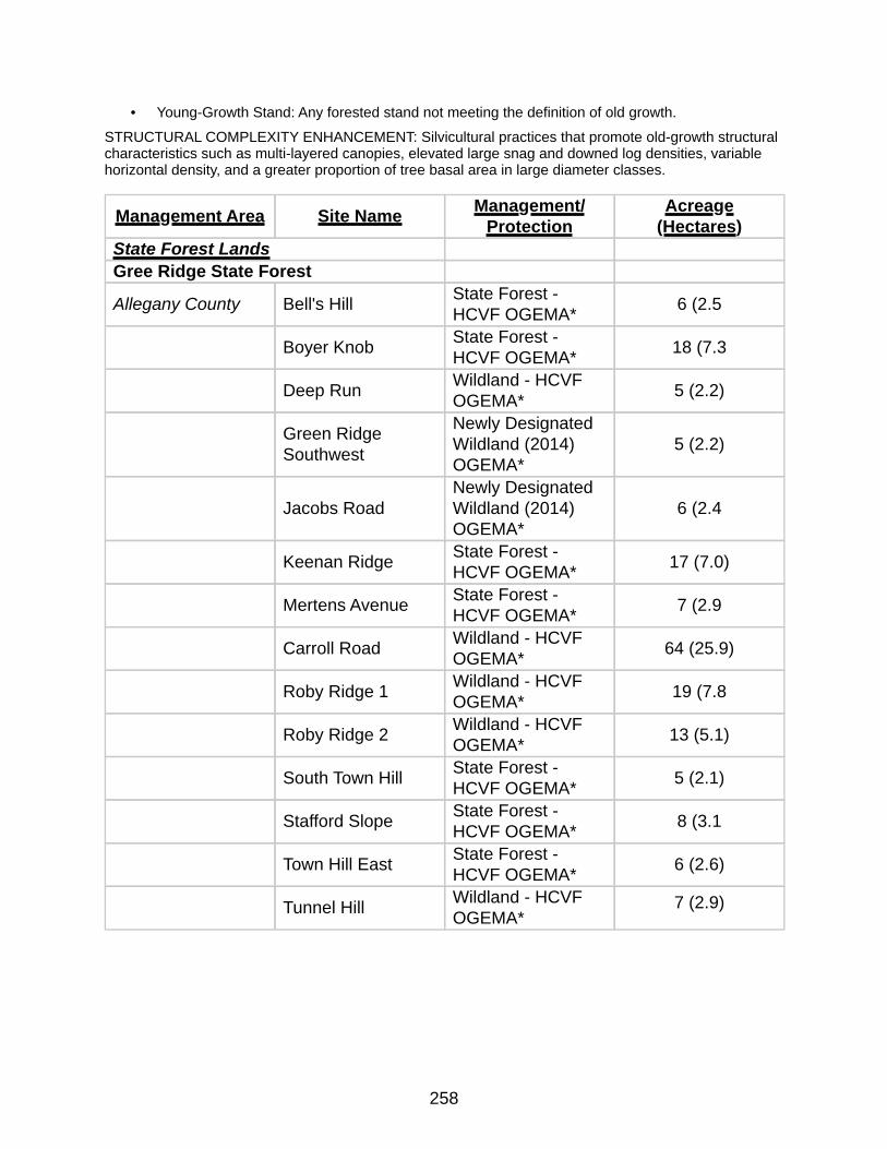
258
• Young-Growth Stand: Any forested stand not meeting the definition of old growth.
STRUCTURAL COMPLEXITY ENHANCEMENT: Silvicultural practices that promote old-growth structural characteristics such as multi-layered canopies, elevated large snag and downed log densities, variable horizontal density, and a greater proportion of tree basal area in large diameter classes.
Management Area Site Name Management/Protection
Acreage (Hectares)
State Forest LandsGree Ridge State Forest
Allegany County Bell's Hill State Forest - HCVF OGEMA* 6 (2.5
Boyer Knob State Forest - HCVF OGEMA* 18 (7.3
Deep Run Wildland - HCVF OGEMA* 5 (2.2)
Green Ridge Southwest
Newly Designated Wildland (2014) OGEMA*
5 (2.2)
Jacobs RoadNewly Designated Wildland (2014) OGEMA*
6 (2.4
Keenan Ridge State Forest - HCVF OGEMA* 17 (7.0)
Mertens Avenue State Forest - HCVF OGEMA* 7 (2.9
Carroll Road Wildland - HCVF OGEMA* 64 (25.9)
Roby Ridge 1 Wildland - HCVF OGEMA* 19 (7.8
Roby Ridge 2 Wildland - HCVF OGEMA* 13 (5.1)
South Town Hill State Forest - HCVF OGEMA* 5 (2.1)
Stafford Slope State Forest - HCVF OGEMA* 8 (3.1
Town Hill East State Forest - HCVF OGEMA* 6 (2.6)
Tunnel Hill Wildland - HCVF OGEMA*
7 (2.9)
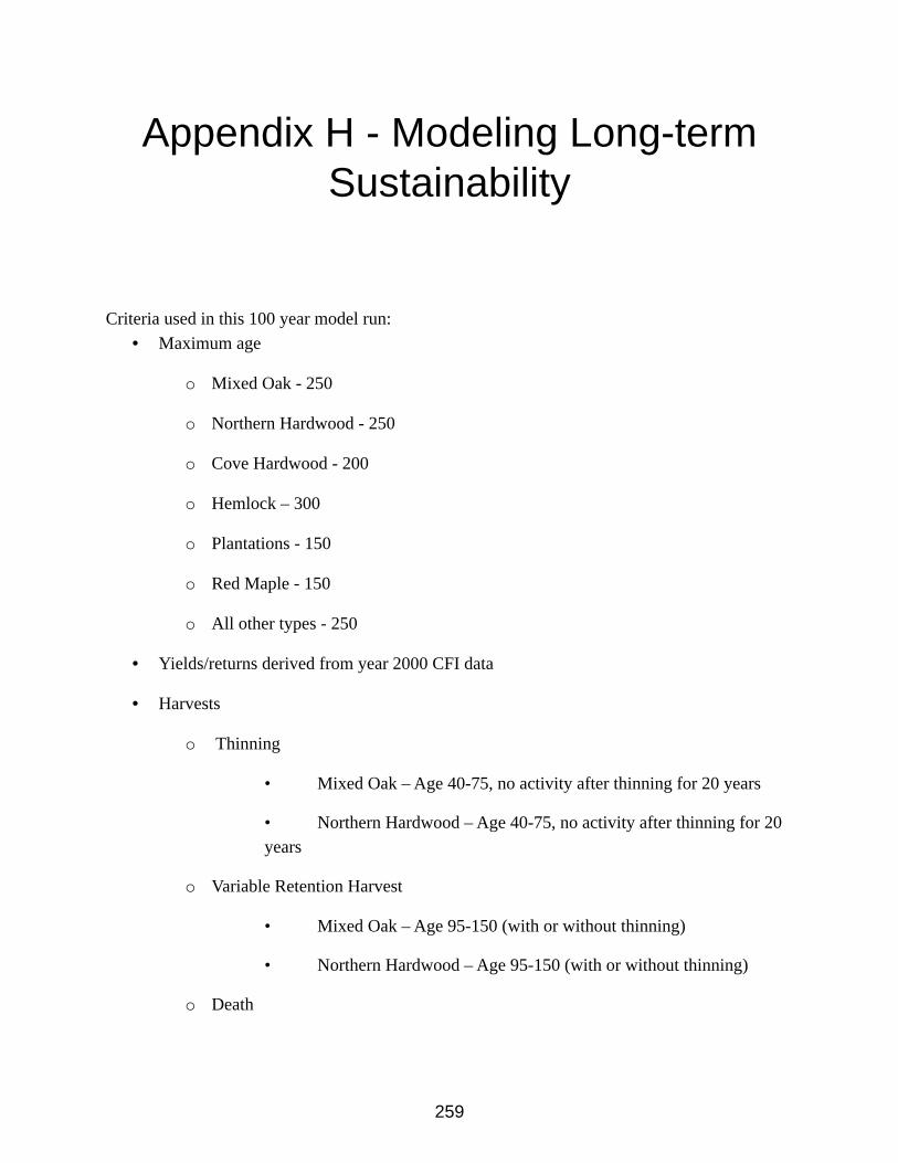
259
Appendix H - Modeling Long-term Sustainability
Criteria used in this 100 year model run:• Maximum age
o Mixed Oak - 250
o Northern Hardwood - 250
o Cove Hardwood - 200
o Hemlock – 300
o Plantations - 150
o Red Maple - 150
o All other types - 250
• Yields/returns derived from year 2000 CFI data
• Harvests
o Thinning
• Mixed Oak – Age 40-75, no activity after thinning for 20 years
• Northern Hardwood – Age 40-75, no activity after thinning for 20 years
o Variable Retention Harvest
• Mixed Oak – Age 95-150 (with or without thinning)
• Northern Hardwood – Age 95-150 (with or without thinning)
o Death

260
o All stands reset to age zero with the same cover type
• Model maximizes total dollar return over entire model run
• Constraints
o Total harvest area cannot exceed 500 acres per year
o Total Thin area cannot exceed 200 acres per year
o Total Variable Retention area cannot exceed 500 acres per year
o Even flow constraints
• Total volume harvested cannot change from the maximum by more
than 40%
• No restriction on total thin area change
• Total variable retention level cannot change more than 25% from
max
• Total standing inventory cannot change by more than 25% from
the max
The following forest modeling graphs are derived from the current database for Green Ridge State Forest as of March 2011. The forest modeling projections below are estimates on what can be expected to occur over a 100 year time frame.
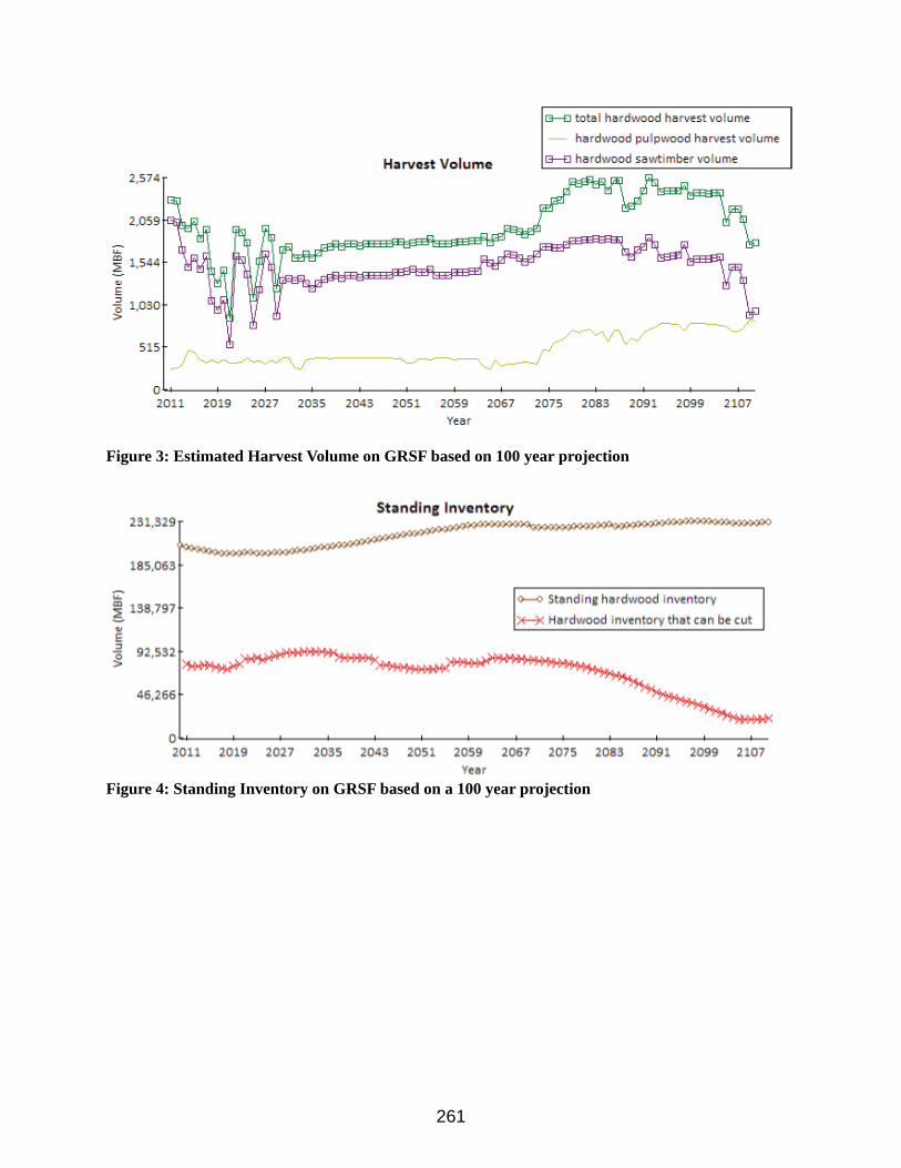
261
Figure 3: Estimated Harvest Volume on GRSF based on 100 year projection
Figure 4: Standing Inventory on GRSF based on a 100 year projection
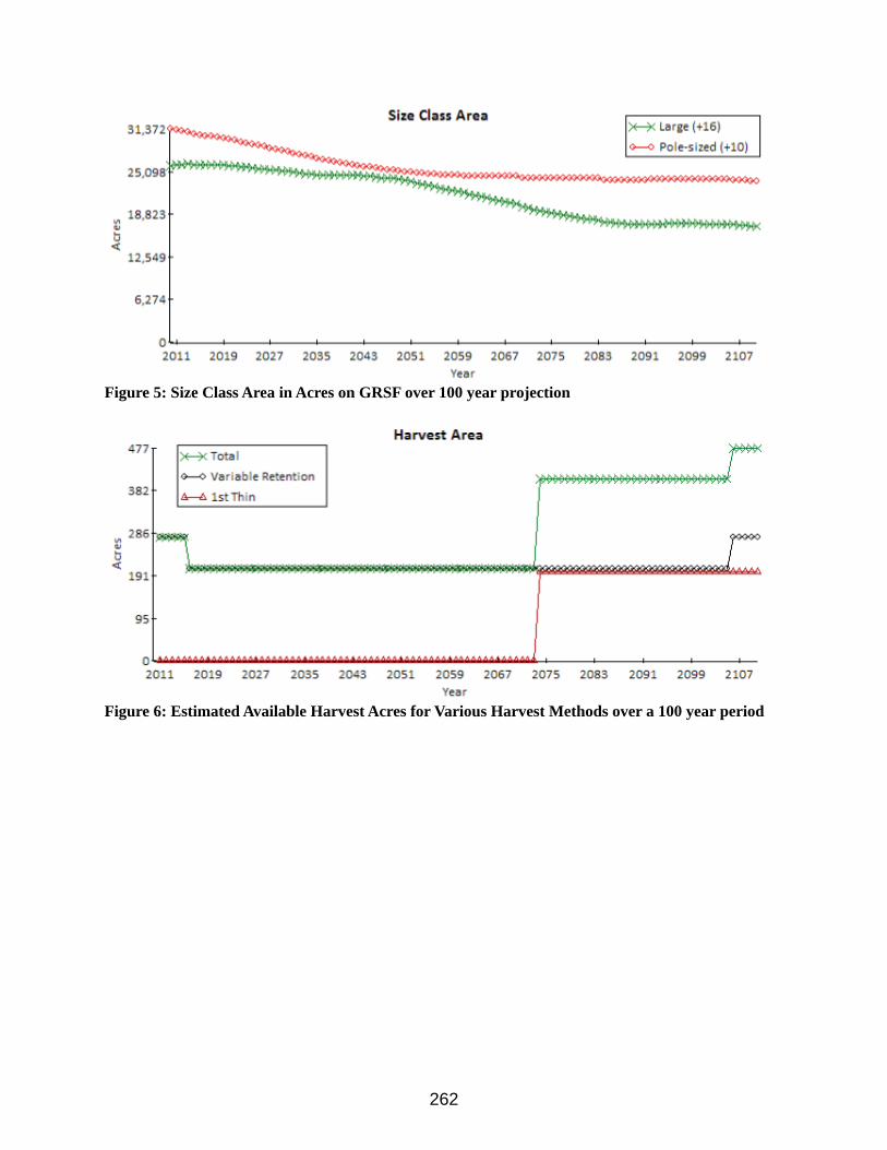
262
Figure 5: Size Class Area in Acres on GRSF over 100 year projection
Figure 6: Estimated Available Harvest Acres for Various Harvest Methods over a 100 year period
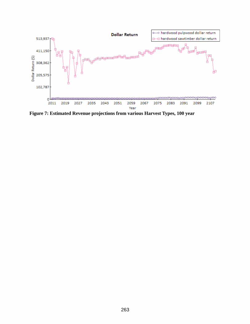
263
Figure 7: Estimated Revenue projections from various Harvest Types, 100 year
264
Appendix I - Glossary
BIOLOGICAL DIVERSITY - The variety of life forms in a given area. Diversity can be categorized in terms of the number of species, the variety in the area's plant and animal communities, the genetic variability of the animals, or a combination of these elements.
BUFFER STRIP - A narrow zone or strip of land, trees, or vegetation bordering an area. Common examples include visual buffers, which screen the view along roads, and streamside buffers, which are used to protect water quality. Buffers may also be used to prevent the spread of forest pests.
DOMINANT [CO-DOMINANT]: The overstory life form or species in a plant community which contributes the most cover or basal area to the community, compared to other life form or species.
ECOLOGICAL TYPE (Habitat Type): A category of land having a unique combination of potential natural community; soil, landscape features, climate, and differing from other ecological types in its ability to produce vegetation and respond to management. Classes of ecological types include all sites that have this
ECOSYSTEM/COVER TYPE: The native vegetation ecological community considered together with non-living factors of the environment as a unit and, the general cover type occupying the greatest percent of the stand location. Based on tree or plant species forming a plurality of the stocking within the stand. May be observed in the field or computed from plot measurements.
EXTENDED ROTATION: Forest stands for which the harvest age is increased beyond the optimum economic harvest age [e.g., increasing the harvest age of an oak stand from 80-100 years (i.e., the "normal" economic harvest age for oak on most sites) to 150 or more years] to provide larger trees, wildlife habitat, and other non-timber values.
INTERIOR FOREST: Habitat necessary for insulation from edge effects (e.g., noise, wind, sun, predation) which occurs within the interior of a patch.
LANDSCAPE LEVEL PLANNING: Planning of the distribution patterns of communities and ecosystems, the processes that affect those patterns, and changes in pattern and process over time.
LAND USE CLASS: The predominant purpose for which an area is employed. Classes include Agricultural Land, Forest land, Rangeland, Wetland, Urban/suburban, and Utility/Transportation Corridors (Roads, Railroads, and Utility Corridors).
265
OLD GROWTH ECOSYSTEM FUNCTIONALITY: The ability of an ecosystem to produce the attributes and perform the continued operation of the plant and animal communities in an area together with the non-living physical environment that supports them. Functional Old Growth Ecosystems have physically defined boundaries, but they are also dynamic: their boundaries and constituents can change over time. They can import and export materials and energy and thus can interact with and influence other ecosystems. They can also vary widely in size.
OLD GROWTH NETWORK / MANAGEMENT COMPLEX: interrelated areas of Old Growth that import and export materials and energy and interact with and influence each other as ecosystems.
OLD-GROWTH STANDS: Ecosystems distinguished by old trees and related structural attributes. Old growth encompasses the later stages of stand development which typically differ from earlier stages in a variety of characteristics that may include tree size, accumulations of large dead woody material, number of canopy layers, species composition, and ecosystem function. The age at which old growth develops and the specific structural attributes that characterize old growth will vary widely according to forest type, climate, site conditions and disturbance regime. For example, old growth in fire-dependent forest types may not differ from younger forests in the number of canopy layers or accumulation of down woody material. However, old growth is typically distinguished from younger growth by several of the following structural attributes:
• Large trees for species and site.
• Wide variation in tree sizes and spacing.
• Accumulations of large-size dead standing and fallen trees that are high relative to earlier stages.
• Decadence in the form of broken or deformed tops or bole and root decay.
• Multiple canopy layers.
• Canopy gaps and understory patchiness.
• Young-Growth Stand: Any forested stand not meeting the definition of old growth.
SHADE-INTOLERANT TREES - Trees that cannot thrive in the shade of larger trees.
STAND AGE: The mean age of the dominant and co-dominant trees in the stand.
STAND CONDITION: A classification of forest stands based upon the age of maturity and structure of the overstory and understory.
STRUCTURAL COMPLEXITY ENHANCEMENT: Silvicultural practices that promote old-growth structural characteristics such as multi-layered canopies, elevated large snag and downed log densities, variable horizontal density, and a greater proportion of tree basal area in large

266
diameter classes.
267
Appendix J - Maps
1. Land Management Areas Of Green Ridge State Forest2. High Conservation Value Forests of Green Ridge State Forest3. General Forest Areas of Green Ridge State Forest4. Special Wildlife Habitat Areas of Green Ridge State Forest5. Green Ridge State Forest Recreation and Other Non Forest Areas.

268
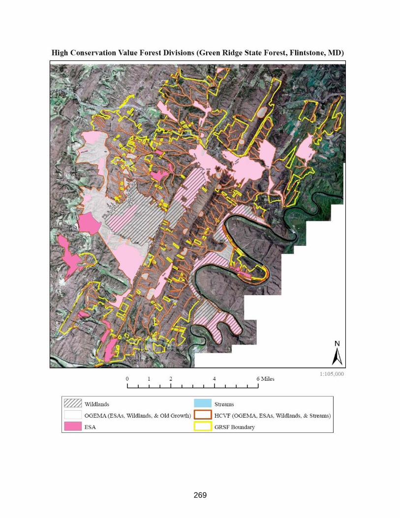
269
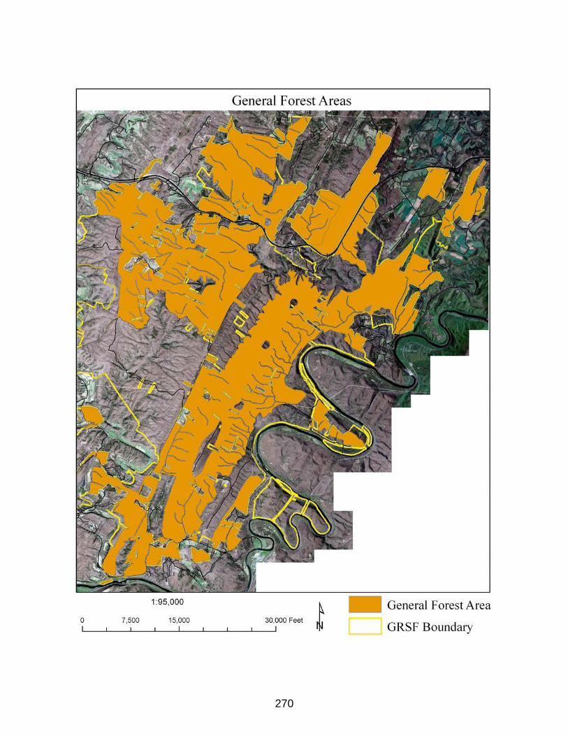
270
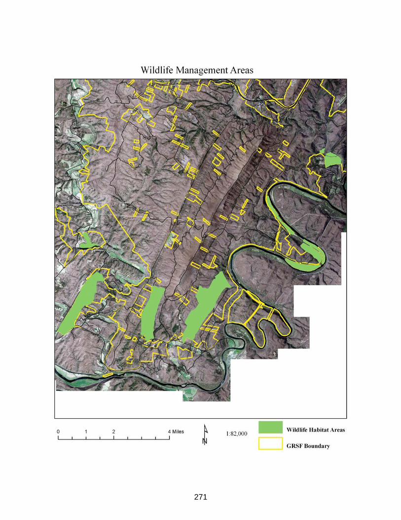
271
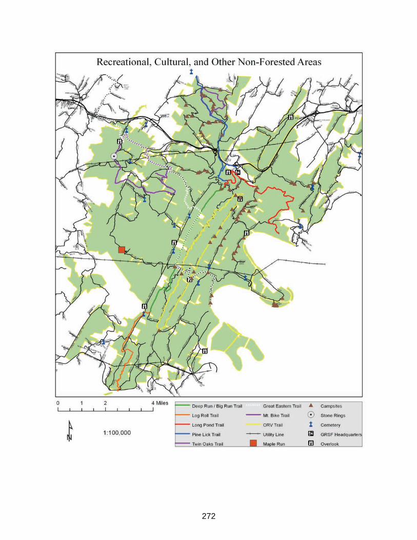
272
273
Appendix K - An Evergreen Forest Analysis of Garrett and Allegany
Counties
274
AN EVERGREEN FOREST ANALYSIS OF GARRETT AND ALLEGANY COUNTIES IN MARYLAND
BY
THE MARYLAND DNR FOREST SERVICEFOREST RESOURCE PLANNING SECTION
JANUARY 2018
ROBERT FELDT, FOREST PLANNERJACK PERDUE, PUBLIC LANDS SUPERVISOR
DONALD VANHASSENT, DIRECTOR/STATE FORESTER

275
276
INTRODUCTION
THE MARYLAND FOREST SERVICE, a unit of the Maryland Department of Natural Resources (DNR) manages over 200,000 acres of state forest land for multiple uses, which include camping, hunting, fishing, timber products, non-timber forest products, animal viewing, hiking, water quality, and more. Four of these forests are found in Garrett and Allegany Counties, in western Maryland, namely Green Ridge State Forest, Savage River State Forest, and the jointly managed Potomac and Garrett State Forests.
Beginning in 2004, State Forests in Maryland became dual certified as a Sustainable Forest under the Sustainable Forestry Initiative (SFI) and the Forest Stewardship Council (FSC), two globally recognized forest sustainability non-profit organizations. The certification process involved a very detailed review of the forests by a third party auditor. In 2015, the four western forests also received dual certification by the FSC and SFI. Annual audits by third-party auditors ensure that forest management activities are following the Sustainable Forest Management Plan for each forest, and that activities are guided by the indicators specified by the FSC and SFI. Occasionally, an audit will reveal a deficiency or “opportunity for improvement”, which can eventually be elevated to a Minor Corrective Action Request (CAR), or a more serious Major Corrective Action Request. These must be addressed in various periods of time (depending on the type of CAR), or the managing unit risks revocation of certification.
Recently, an observation by an auditor was made that management was not putting sufficient effort toward management of the western forest’s evergreen forest component. This resulted in the issuance of an Opportunity for Improvement, where improvements could be made, but not required. Generally, “evergreens” in western Maryland take the form of naturally occurring hemlock (Tsuga spp.), Eastern White pine (Pinus strobus), Table Mountain pine (Pinus pungens), Pitch pine (Pinus rigida) and others, but also planted stands of spruce—notably Norway spruce (Picea abies). These species comprise the majority of the evergreen component in western Maryland forests.
METHODOLOGY
Evaluation of the evergreen component was done using ESRI Corp. ArcGIS software. Recent upgrades to ESRI software has enabled image classification, feature creation, and raster analysis available in one software package; thus simplifying the project work-flow. These tools were utilized to find potential evergreen tree cover in western Maryland, and quantify it. Additionally, the “iterator” tool used in the Modelbuilder package provides a very simple and effective means of automating the classification/extraction process, and other processes.
Over the years, the state has purchased very high resolution, leaf-off color imagery for the years 2008 and 2013. The recent 2013 imagery also included the color near-infrared band (CIR), in addition to the red/green/blue bands common to regular color imagery. Near-infrared enhances the appearance of healthy, green vegetation, which appears as bright red on the CIR image. The combination of imagery collection during leaf-off, and the inclusion of the CIR band, makes this the perfect imagery for determining evergreen coverage.
The imagery is provided to the state at 6 inch resolution, where one image pixel represents a 6 x 6 inch area on the ground. The assessment of evergreen coverage did not require such high resolution, so the imagery was resampled to 3.2808 x 3.2808 feet per pixel (approximately 1 square meter)(figure 1). This made moving the numerous imagery files needed for the analysis more efficient, and made image processing/classification much faster.
The imagery was downloaded from the State’s iMap Maryland data portal. This had the added benefit of completing the resample and mosaic (whereby several smaller images are combined into one)
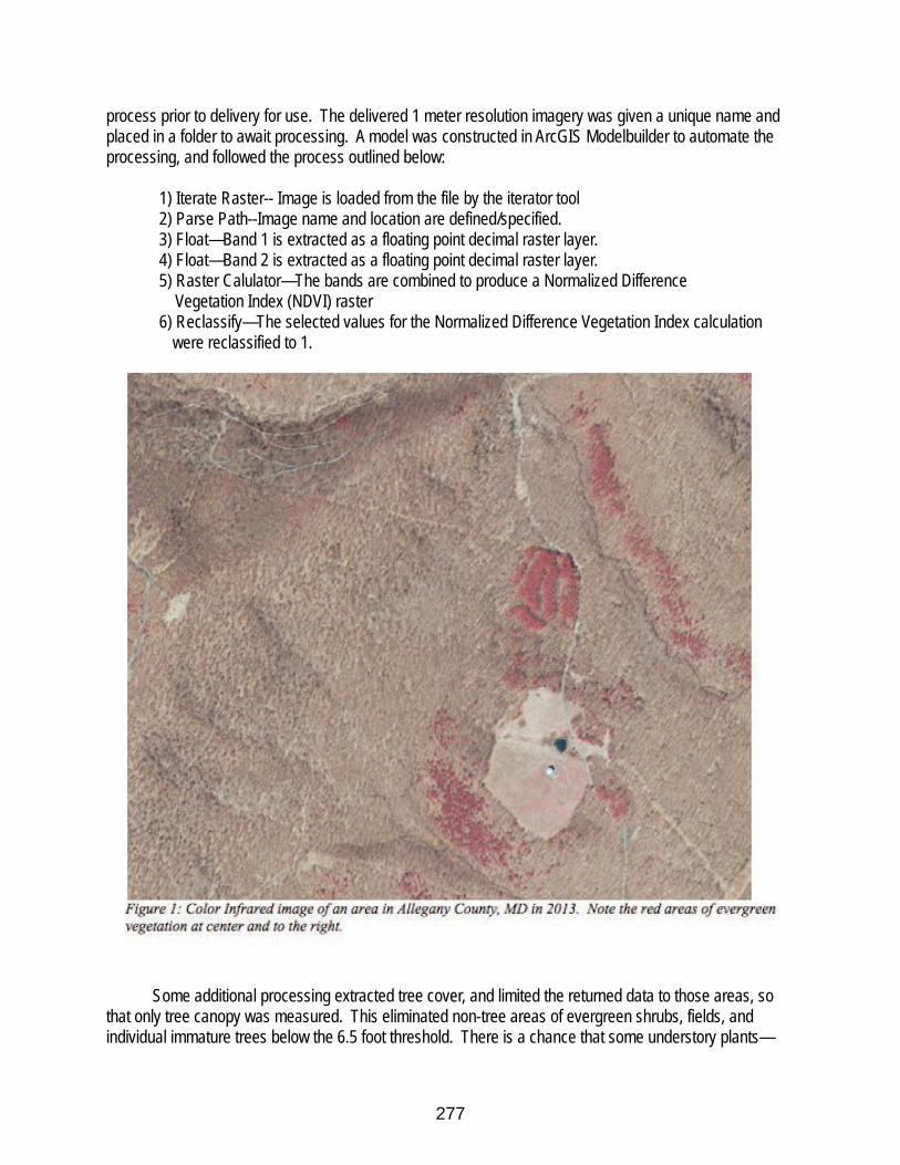
277
process prior to delivery for use. The delivered 1 meter resolution imagery was given a unique name and placed in a folder to await processing. A model was constructed in ArcGIS Modelbuilder to automate the processing, and followed the process outlined below:
1) Iterate Raster-- Image is loaded from the file by the iterator tool2) Parse Path--Image name and location are defined/specified.3) Float—Band 1 is extracted as a floating point decimal raster layer.4) Float—Band 2 is extracted as a floating point decimal raster layer.5) Raster Calulator—The bands are combined to produce a Normalized Difference Vegetation Index (NDVI) raster6) Reclassify—The selected values for the Normalized Difference Vegetation Index calculation
were reclassified to 1.
Some additional processing extracted tree cover, and limited the returned data to those areas, so that only tree canopy was measured. This eliminated non-tree areas of evergreen shrubs, fields, and individual immature trees below the 6.5 foot threshold. There is a chance that some understory plants—
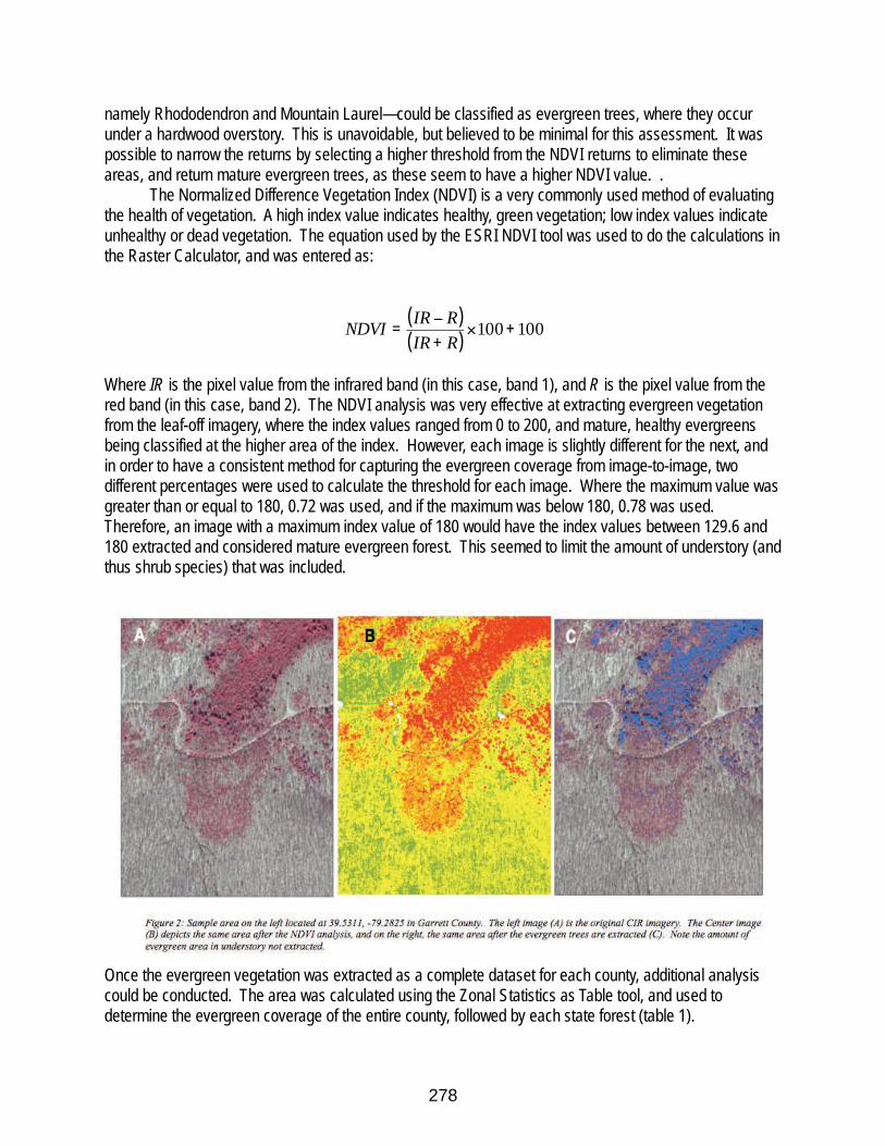
278
namely Rhododendron and Mountain Laurel—could be classified as evergreen trees, where they occur under a hardwood overstory. This is unavoidable, but believed to be minimal for this assessment. It was possible to narrow the returns by selecting a higher threshold from the NDVI returns to eliminate these areas, and return mature evergreen trees, as these seem to have a higher NDVI value. .
The Normalized Difference Vegetation Index (NDVI) is a very commonly used method of evaluating the health of vegetation. A high index value indicates healthy, green vegetation; low index values indicate unhealthy or dead vegetation. The equation used by the ESRI NDVI tool was used to do the calculations in the Raster Calculator, and was entered as:
( )( )
100100 +!+"
=RIRRIRNDVI
Where IR is the pixel value from the infrared band (in this case, band 1), and R is the pixel value from the red band (in this case, band 2). The NDVI analysis was very effective at extracting evergreen vegetation from the leaf-off imagery, where the index values ranged from 0 to 200, and mature, healthy evergreens being classified at the higher area of the index. However, each image is slightly different for the next, and in order to have a consistent method for capturing the evergreen coverage from image-to-image, two different percentages were used to calculate the threshold for each image. Where the maximum value was greater than or equal to 180, 0.72 was used, and if the maximum was below 180, 0.78 was used. Therefore, an image with a maximum index value of 180 would have the index values between 129.6 and 180 extracted and considered mature evergreen forest. This seemed to limit the amount of understory (and thus shrub species) that was included.
Once the evergreen vegetation was extracted as a complete dataset for each county, additional analysis could be conducted. The area was calculated using the Zonal Statistics as Table tool, and used to determine the evergreen coverage of the entire county, followed by each state forest (table 1).
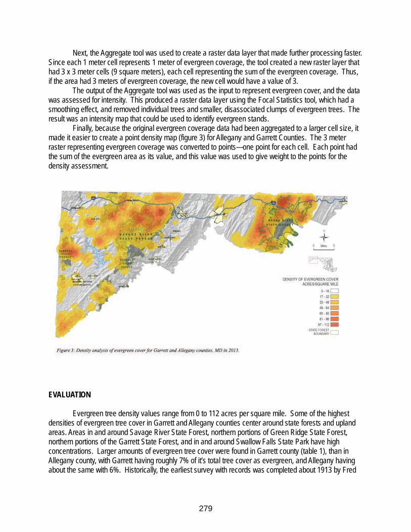
279
Next, the Aggregate tool was used to create a raster data layer that made further processing faster. Since each 1 meter cell represents 1 meter of evergreen coverage, the tool created a new raster layer that had 3 x 3 meter cells (9 square meters), each cell representing the sum of the evergreen coverage. Thus, if the area had 3 meters of evergreen coverage, the new cell would have a value of 3.
The output of the Aggregate tool was used as the input to represent evergreen cover, and the data was assessed for intensity. This produced a raster data layer using the Focal Statistics tool, which had a smoothing effect, and removed individual trees and smaller, disassociated clumps of evergreen trees. The result was an intensity map that could be used to identify evergreen stands.
Finally, because the original evergreen coverage data had been aggregated to a larger cell size, it made it easier to create a point density map (figure 3) for Allegany and Garrett Counties. The 3 meter raster representing evergreen coverage was converted to points—one point for each cell. Each point had the sum of the evergreen area as its value, and this value was used to give weight to the points for the density assessment.
EVALUATION
Evergreen tree density values range from 0 to 112 acres per square mile. Some of the highest densities of evergreen tree cover in Garrett and Allegany counties center around state forests and upland areas. Areas in and around Savage River State Forest, northern portions of Green Ridge State Forest, northern portions of the Garrett State Forest, and in and around Swallow Falls State Park have high concentrations. Larger amounts of evergreen tree cover were found in Garrett county (table 1), than in Allegany county, with Garrett having roughly 7% of it’s total tree cover as evergreen, and Allegany having about the same with 6%. Historically, the earliest survey with records was completed about 1913 by Fred
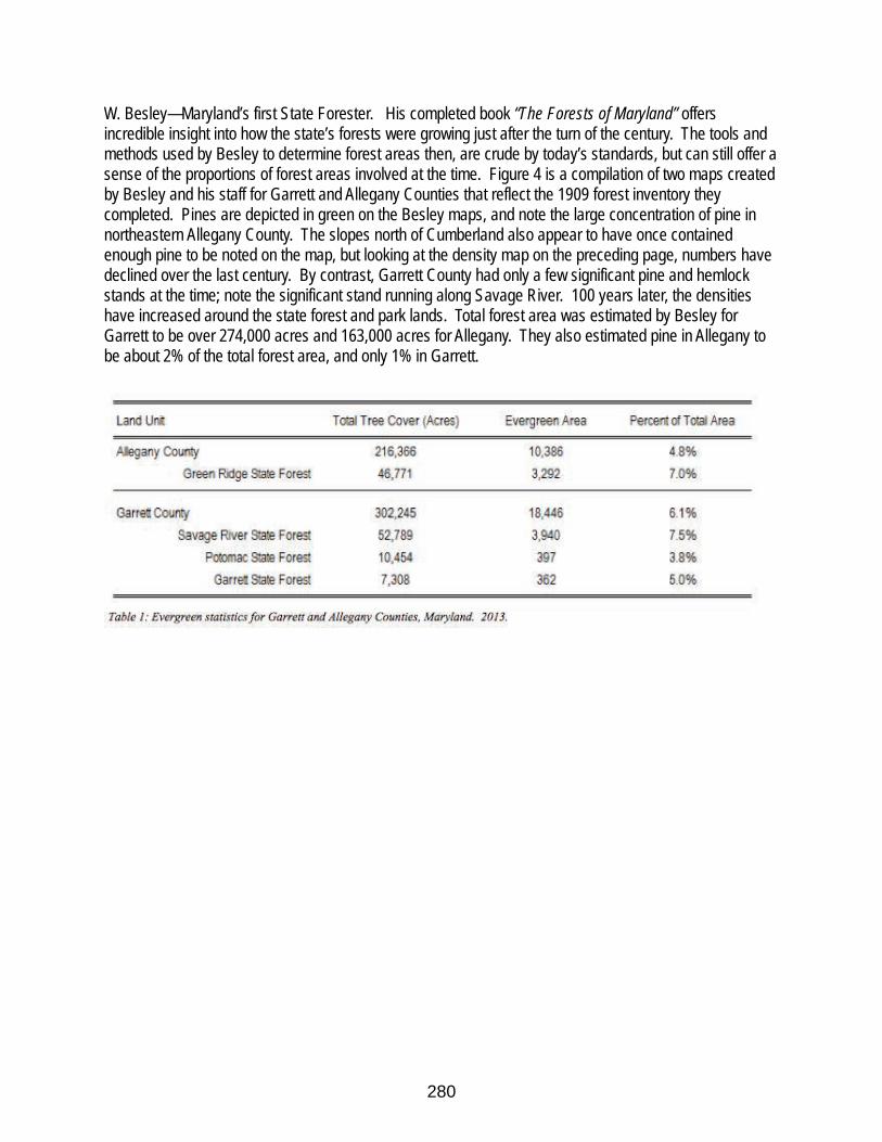
280
W. Besley—Maryland’s first State Forester. His completed book “The Forests of Maryland” offers incredible insight into how the state’s forests were growing just after the turn of the century. The tools and methods used by Besley to determine forest areas then, are crude by today’s standards, but can still offer a sense of the proportions of forest areas involved at the time. Figure 4 is a compilation of two maps created by Besley and his staff for Garrett and Allegany Counties that reflect the 1909 forest inventory they completed. Pines are depicted in green on the Besley maps, and note the large concentration of pine in northeastern Allegany County. The slopes north of Cumberland also appear to have once contained enough pine to be noted on the map, but looking at the density map on the preceding page, numbers have declined over the last century. By contrast, Garrett County had only a few significant pine and hemlock stands at the time; note the significant stand running along Savage River. 100 years later, the densities have increased around the state forest and park lands. Total forest area was estimated by Besley for Garrett to be over 274,000 acres and 163,000 acres for Allegany. They also estimated pine in Allegany to be about 2% of the total forest area, and only 1% in Garrett.
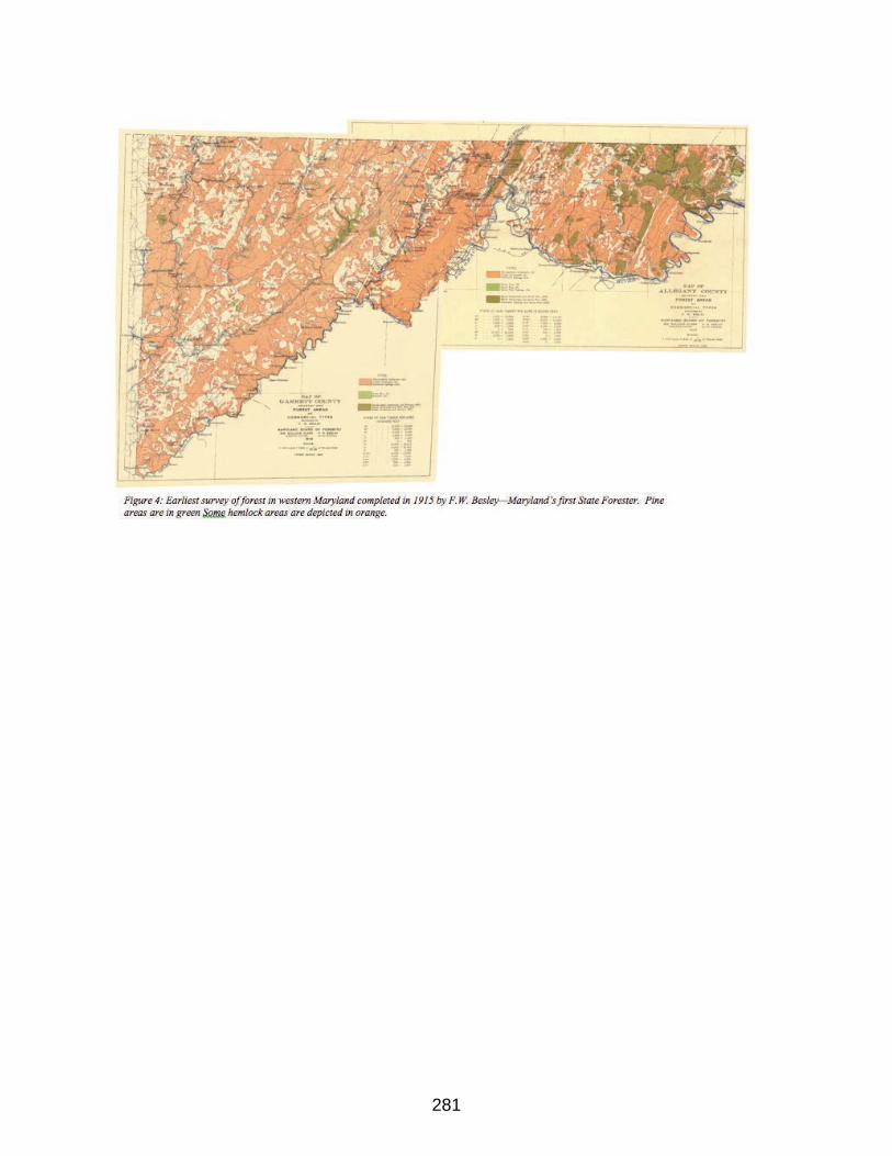
281
282
IntroductionBelow is a synopsis of the conifer forest of Allegany County based on two historical documents, Maryland Geological Survey, The Forests of Allegany County, George B. Sudworth (1900), and The Forests of Allegany County, Fred W. Besley (1912). These are textual pieces that were left for us to learn what that forest looked like then, and possibly how it was comprised leading up to that time.
From these observations of that forest at the turn of the twentieth century, we get a glimpse that the conifer component of that forest was small compared to the dominating hardwood forest, but did hold an important economic place which led to it being harvested to the point of even lesser distribution and place in the subsequent forests since then.
Maryland Geological SurveyThe Forests of Allegany CountyGeorge B. Sudworth1900
The following is a complete list of coniferous trees of Allegany county: 1. White Pine (Pinus strobus). 2. Pitch Pine (Pinus rigida). 3. Scrub Pine (Pinus virginiana). 4. Table-Mountain Pine (Pinus pungens). 5. Shortleaf Pine (Pinus echinata). 6. Hemlock (Tsuga canadensis). 7. Red Juniper (Juniperus virginiana).
The White Pine occurs almost entirely on northern and eastern slopes, ascending to the summits of the highest mountains (Mt. Savage, Warrior Ridge and Dans Mountain). It is especially conspicuous along the rocky north slopes of streams, often forming dense, narrow belts of pure growth down to the water's edge. Higher up on the slopes it is usually mingled with hardwoods. The White Pine forest is composed chiefly of young timber (25 to 75 years old), ranging from 6 to occasionally 15 inches in diameter, and under 60 feet in height. A much older, scattered growth of this pine is found among hardwoods. Under these conditions the trunks are 18 to 30 inches in diameter and 80 to 100 feet high. The White Pine of this county grows best in moist, well drained, clayey loam soils, such as produce the finest White Oak.
The next most conspicuous timber trees are, among conifers, the Pitch Pine, Shortleaf Pine, Table-mountain Pine and Scrub Pine. Of hardwoods, the principal remaining species are Sugar Maple, Red Maple, Shagbark Hickory, Tulip-tree, White Ash, White Basswood, Locust, Black Gum and American Elm. The pines commonly pass for one species. Together, they constitute an important element in the forest cover of very exposed, bare, rocky, southern slopes.
The Scrub Pine forms a dense cover in the poorest shale soils on the lower southern slopes of the high ridges, or more frequently on the south side of low hills throughout the middle and southern sections of the county. It is peculiarly adapted to exposed, sterile soils, often taking possession of abandoned, worn- out fields to the exclusion of all other species. In richer soils and less exposed localities it gives way to patches of hardwoods. Most of the Scrub Pine now standing is of small size, ranging from two to six inches, with occasional trees eight to fourteen inches in diameter.
283
The largest trees which grow on least exposed sites have straight clear trunks twenty to thirty feet long. The growth found on the most exposed, precipitous sites is usually low, crooked, and much branched.
At higher elevations, comprising the middle benches and summits of the mountains, Pitch and Table-mountain Pine occupy sterile, rocky situations on southern, southeastern and southwestern exposures. Scattered individuals also occur mingled with hardwoods on the low shale hilltops adjacent to the mountains. Where these pines form the principal growth, the two species are usually mingled in about equal numbers. Not infrequently, however, the Table-mountain Pine forms pure open stands of ten to fifty acres on narrow, rocky benches high up on the mountain sides. In exceptional instances also, stunted Shortleaf Pine is to be seen among these mountain groves, notably on Town Hill. Little merchantable timber is produced by the Pitch Pine and Table- mountain Pine, as their principal growth is low and much branched and the wood coarse-grained and knotty.
Most of the large White Pine is now gone. Defective old White Pines are frequently seen scattered over slopes now covered with young hardwood forests only an occasional sound White Pine is to be found.
Shortleaf Pine is similarly exhausted. Small groups and scattered single trees are to be found in patches of hardwoods on farms in the lower hill country, or forming thin belts skirting the lower slopes of the higher, wooded mountains. Only occasional trees are to be found. The majority are now too few or of too small size to furnish any considerable amount of timber.
The Forests of Allegany CountyFred W. Besley1912
In Allegany County, about two percent of the forested area at that time was in pine forests, with a small component of that in hemlock. Mixed hardwood and pine forests covered about twenty percent of the land. From the 1909, about six acres of pine had over 5 mbf/ac while there were 3,158 of less productive pine forest. The pine forest was comprised of white, pitch, table mountain and scrub pines (Virginia pine). Most of the pine forest was found in the eastern half of the county.
White pine is not abundant, being confined to a relatively few locations where it occurs in mixture with the hardwoods. It is seldom found except on northern and eastern slopes indicating its strong preference for moist, well-drained, fertile soils. The cut of white pine lumber, amounting to over three million feet in 1909, shows that it is still a tree of considerable importance.
Scrub pine, pitch pine, and table-mountain pine are abundant in certain sections, particularly in the eastern part of the county. These pines usually grow on the dry sterile soils of southern slopes, the scrub pine occupying the low hills and lower slopes, while the pitch and table-

284
mountain pine are more often found on or near the top of the ridges. Nearly four million feet of yellow pine lumber was cut in 1909, made up entirely of the three tree species named above, which indicates the relative commercial importance of these trees.