Embed Size (px)
Citation preview

1
For Immediate Release
22 April 2020
NQ Minerals Plc
(the "Company" or "NQ Minerals")
Nickel resource significantly expanded in Tasmania to support PFS
Highlights:
• Updated Mineral Resource Estimate has been issued by Snowden Mining Industry Consultants
Pty Ltd (“Snowden”) for the Barnes Hill Nickel Project to include lower grade Ni material. The
new expanded resource has increased substantially to 25Mt @ 0.6% Nickel (“Ni”) and 0.05%
Cobalt (“Co”) on a 0.25% Ni cut-off grade.
• Metallurgical testwork has supported an updated flowsheet that will serve as the base case in
the current Pre-Feasibility Study (“PFS”). A metallurgical simulation model of the mass and
energy balances of the central processing circuits has been completed to allow appropriate
sizing of plant equipment and to support subsequent design work.
• The updated flowsheet includes three stage leaching that utilises the full laterite profile. Low
grade material is also upgraded through screening to be used in the third neutralization stage.
• A residue filtration section has also been added that will allow for dry stacking of laterite waste
back into the original pit. This removes the need for a tailings dam at the nickel mine.
London listed NQ Minerals Plc (AQUIS: NQMI) (OTCQB: NQMLF), the base and precious metals
producer at the Hellyer Gold Mine (“Hellyer”) in Tasmania Australia, is pleased to announce progress
on the flowsheet being developed for the Barnes Hill nickel and cobalt project. NQ Minerals is funding
this development work through its investment in Tasmania Energy Metals Pty Ltd (“TEM”). Following
further metallurgical testwork and initial engineering works, an updated flowsheet has been
developed for the PFS. This updated flowsheet enables utilisation of lower grade feed for
neutralisation of the process solutions after Ni and Co extraction. Accordingly, an updated Mineral
Resource estimate for the Barnes Hill, Scotts Hill and Mount Vulcan deposits has been released
covering all types of potential feed material.
David Lenigas, Chairman of NQ Minerals, commented:
“The completion of this testwork and commencement of engineering sees the Barnes Hill project
starting to take on physical shape. The lower cut-off Mineral Resource estimates for Barnes Hill,
Scotts Hill and Mt Vulcan provides support for our long-term plans for the Beaconsfield region, and
this larger tonnage of 25 million tonnes, versus 14 million tonnes previously reported, could supply
a plant of the planned scale for well over 20 years. Our close proximity to the deep-water port at
Bell Bay in Tasmania also suggests opportunities to import and blend in high-grade ore to boost feed
grades and extend the life of the Barnes Hill mine even further.
2
We are actively examining the ability to achieve further enhance economics by planning this
downstream development to take advantage of our plans for the adjacent Beaconsfield Gold site.
We expect to make an announcement on the final plant location in the near term. We are already
speaking to off-takers and battery industry players and believe there is strong support for this
development.”
Testwork to Establish the PFS Flowsheet
Metallurgical testwork has supported an updated flowsheet that will serve as the basis for the current
PFS. A metallurgical simulation model, providing a detailed understanding of the mass and energy
balances across the central processing operations has now been completed. It was designed using the
well-respected METSIM software. The outputs of this model will allow appropriate sizing of plant
equipment and support subsequent design work. The METSIM model, alongside other cost inputs, will
also allow estimation of a new ore reserve (replacing the ore reserve issued by Snowden in 2010) for
the Barnes Hill North and South deposits. The ore reserve will include pit design and the delivery of a
mining schedule covering the initial years of planned operations.
The updated flowsheet includes three stage leaching that allows utilization of the full laterite profile
including limonite, transitional, saprolite and saprock material. Blends of higher grade material will
feed the initial two leaching stages. In addition, a screened fraction of low grade material is used in
the third neutralization stage.
This updated flowsheet is based on laboratory testwork completed over recent months. For the
testwork, TEM selected a purposive sample of intersections from the 2019 air-core drilling. The
samples were checked for representativeness against the Barnes Hill resource. Following this, 90
drilled intersections were sent to the Beijing General Research Institute of Mining & Metallurgy
(“BGRIMM”), a well-established Chinese laboratory with expertise in multi-stage leaching. These
samples totally 518.5kg. The testwork applied sequential sulphuric acid leaching with varied blends of
feed. In the first stage a blend of limonite/transitional/saprolite was processed with a high dosage of
acid at a leaching temperature of 95degC. This was followed by a further stage of leaching of
saprolite/saprock feed in an autoclave, where no additional acid was added but the temperature was
raised to 160degC. A screened large-sized fraction from the saprock domain was then used for a
neutralisation stage. This was ground and used in a tertiary leach to commence neutralisation, with
no additional acid added. Results supported the ability to achieve overall Nickel and Cobalt extraction
of over 90% across all three leaching stages with an acid consumption of 509kg/t feed. In accordance
with the current plant design, this acid will be entirely supplied by utilising waste streams from the
roasting of Hellyer’s gold and silver-bearing pyrite concentrate, which will separately produce
gold/silver doré bars and copper/zinc intermediates. Testwork also included beneficiation testwork,
including dry and wet screening, magnetic separation and gravity upgrading. As expected, wet
screening produced strong results, particularly for saprock material. This was then built into the
testwork, with a screened fraction of saprock providing a high-Mg neutralisation feed stock.
Further Development Progress
In addition to examining leaching, some initial filtration testwork has been performed. On the basis of
those first-pass results, which are consistent with experiences at other comparable nickel laterite

3
projects, an updated filtration section has also been added to the plant design that will allow for dry
stacking of laterite waste back into the original pit. This removes the need for a tailings dam at the
nickel mine.
The improved flowsheet further enhances the project’s green credentials, with ore-based
neutralisation reducing the CO2 footprint and dry stacking enabling the refilled mining pit to be
rehabilitated to close to its original form. The project already benefits from its Tasmania location
where it will be able to be supplied by 100% renewable hydroelectric and wind power. NQ Minerals
believes that these advantages make the Barnes Hill project environmentally attractive relative to peer
projects. This is expected to be increasingly important in the Electric Vehicle supply chain where
cradle-to-grave emissions assessment is becoming more prominent. NQ Minerals is in initial
discussions with battery industry players regarding the future development of the project.
Expanded Mineral Resource Estimate for Scotts Hill & Mt Vulcan
The Barnes Hill Project is composed of four resources, all located within 2km of each other. Mining
lease 1872P/M hosts the Barnes Hill North and South deposits, while Scotts Hill and Mt Vulcan
(“Scotts/Vulcan”) occur primarily within exploration license EL2/2017 which is adjacent to the liming
lease. All licenses are 100% owned by TEM.
On the basis of work done so far, an updated Mineral Resource Estimate has been issued by Snowden
Mining Industry Consultants Pty Ltd for the Barnes Hill Nickel Project to include the lower grade Ni
material. The expanded resource now totals 25Mt @ 0.6% Ni and 0.05% Co at a 0.25% Ni cut-off
(indicated and inferred) as shown in Table 1 below. This complements the 0.5% Ni cut-off Mineral
Resource estimate released on 25 November 2019. That previously announced resource (with a higher
Ni cut-off) will still provide the main supply into the first two stages of leaching. Snowden found the
revised lower cut-off grade to be reasonable assuming a standard open-pit mining approach with low-
to-moderate selectivity and that it is commensurate with the cut-off grade used at similar deposits
where beneficiation through screening is applicable.

4
Table 1: Barnes Hill Project Mineral Resource Estimates 2020
Scotts Hill & Mt Vulcan (“SV”) Mineral Resource Estimate at a 0.25% Ni cut-off
Domain Class Tonnes (kt) Ni % Co % MgO % Fe2O3 % SiO2 %
Transitional Inferred 2,311 0.53 0.09 3.5 44.3 28.4
Saprolite Inferred 3,222 0.74 0.05 12.0 29.6 39.0
Saprock Inferred 7,309 0.49 0.02 27.2 15.3 42.5
SV Total Inferred 12,842 0.56 0.04 19.1 24.1 39.1
Barnes Hill (“BH”) North & South Mineral Resource Estimate at a 0.25% Ni cut-off
Domain Class Tonnes (kt) Ni % Co % MgO % Fe2O3 % SiO2 %
Limonite Indicated 1,874 0.37 0.11 1.3 53.3 16.3
Limonite Inferred 242 0.40 0.07 1.9 45.5 26.2
Limonite Total Indicated &
Inferred 2,117 0.38 0.10 1.4 52.4 17.4
Transitional Indicated 444 0.53 0.08 3.4 39.8 29.2
Transitional Inferred 10 0.67 0.12 4.0 48.2 25.4
Transitional Total Indicated &
Inferred 454 0.54 0.08 3.4 40.0 29.1
Saprolite Indicated 4,663 0.77 0.05 11.5 27.1 39.0
Saprolite Inferred 817 0.61 0.05 12.7 24.8 43.3
Saprolite Total Indicated &
Inferred 5,480 0.75 0.05 11.7 26.8 39.6
Saprock Indicated 2,559 0.57 0.02 27.9 12.8 41.9
Saprock Inferred 1,315 0.47 0.02 25.0 14.7 42.9
Saprock Total Indicated &
Inferred 3,874 0.53 0.02 26.9 13.4 42.2
All Domains Indicated 9,540 0.63 0.06 13.5 29.0 34.9
All Domains Inferred 2,384 0.51 0.04 18.4 21.4 41.3
BH Total Indicated &
Inferred 11,925 0.60 0.05 14.5 27.5 36.1
Barnes Hill Project, BH & SV Total Mineral Resource Estimates at a 0.25% Ni cut-off
Domain Class Tonnes (kt) Ni % Co % MgO % Fe2O3 % SiO2 %
All Domains Project Total
Indicated & Inferred
24,767 0.58 0.05 16.89 25.74 37.66
Notes: 1) Please refer to the end of this section for the Competent Persons statements; 2) the Mineral
Resource is reported in accordance with the JORC Code (2012) with required tables included in the
appendix; 3) Some rounding related discrepancies may occur in the totals.
The Mineral Resources were estimated using block models, constructed using a parent cell size of
25 mE by 25 mN by 1 mRL for Barnes Hill and 50 mE by 50 mN by 1 mRL for Scotts-Vulcan, constrained
within the wireframed domains of the interpreted laterite layers. Grades were estimated using
ordinary block kriging for both the Barnes Hill deposit and Scotts-Vulcan. Search ellipses and
estimation parameters were based on the results of the variography, along with consideration of the

5
drill spacing and geometry of the mineralisation. Global average density values were applied to the
blocks according to the domain based on density measurements of diamond drill core.
The Barnes Hill and Scotts-Vulcan Mineral Resource estimates have been classified and reported in
accordance with the JORC Code (2012). Mineral Resources for the Barnes Hill deposit have been
classified as a combination of Indicated and Inferred Resources, while the Scotts-Vulcan resource has
been classified as an Inferred Resource. The classification was developed by Snowden based on an
assessment of the nature and quality of the drilling, sampling and assaying methods; drill spacing;
confidence in the geological interpretation; and results of the model validation. The Mineral Resource
is limited to the Limonite, Transitional, Saprolite and Saprock domains, with lower-Ni, higher-Fe
domains above the limonite excluded. At Barnes Hill, where drilling is approximately 50 mN by 50 mE
or better and the thickness is greater than 2 m, the resource has been classified as an Indicated
Resource. Areas that are not supported by a 50 mN by 50 mE drill spacing or are less than 1 m in
thickness have been assigned an Inferred classification. At Scotts-Vulcan, blocks within approximately
125 m of a drillhole have been classified as an Inferred Resource, with extrapolation beyond that
excluded.
About NQ Minerals NQ Minerals is an Australian-based mining company which commenced base metal and precious metal production in 2018 at its 100% owned flagship Hellyer Gold Mine in Tasmania. Hellyer has a published JORC compliant Mineral Resource estimated at 9.25 Mt which is host to Gold at 2.57 g/t Au for 764,300 oz Au, Silver at 92 g/t Ag for 27,360,300 oz Ag, Lead at 2.99% Pb for 276,600 tonnes and Zinc at 2.57% Zn for 217,400 tonnes. In addition to these resources, the Hellyer assets include a large mill facility and full supporting infrastructure, including a direct rail line to port. The Company regularly updates the market on Hellyer’s operational and financial performance and these updates can be views on NQ’s website at www.nqminerals.com.
-END-
Competent Person’s Statement – Mineral Resources
The information in this report that relates to the Barnes Hill, Scotts Hill and Mount Vulcan (“Scotts-
Vulcan”) Mineral Resource estimate is based on information compiled by Snowden and reviewed by
Elizabeth Haren, a Competent Person who is a Member and Chartered Professional of The
Australasian Institute of Mining and Metallurgy and a Member of the Australian Institute of
Geoscientists. Elizabeth Haren is employed as an associate consultant by Snowden Mining Industry
Consultants Pty Ltd and a consultant to Tasmania Energy Metals Pty Ltd. Payment for work
completed is not contingent on any particular outcome of the work. Elizabeth Haren has sufficient
experience that is relevant to the style of mineralisation and type of deposit under consideration
and to the activity being undertaken to qualify as a Competent Person as defined in the 2012 Edition
of the 'Australasian Code for Reporting of Exploration Results, Mineral Resources and Ore
Reserves'. Elizabeth Haren consents to the inclusion in the report of the matters based on her
information in the form and context in which it appears.

6
Competent Person’s Statement– General
The information in this report that relates to the Hellyer and Barnes Hill project is based on
information (third party consultants) compiled by Roger Jackson, an Executive Director of the
Company, who is a 20+ year Member of the Australasian Institute of Mining and Metallurgy
(MAusIMM) and a Member of Australian Institute of Company Directors. Mr. Jackson has sufficient
experience which is relevant to the style of mineralisation and type of deposits under consideration
and to the activity which he is undertaking to qualify as a Competent Person as defined in the 2012
Edition of the “Australasian Code for Reporting of Exploration results, Mineral Resources and Ore
Reserves”. Mr. Jackson consents to the inclusion of the data contained in relevant resource reports
used for this announcement as well as the matters, form and context in which the relevant data
appears.
For further information, please contact:
NQ Minerals plc
David Lenigas, Chairman
Colin Sutherland, Chief Financial Officer
Tel: +1 416 452 2166 (North America)
Media Enquiries:
Graham Herring
IFC Advisory
Tel: +44 (0) 7793 839 024 (United Kingdom)
Corporate Adviser:
First Sentinel Corporate Finance Limited
Brian Stockbridge/Liza Vasilyeva
Tel: +44 207 183 7407 (United Kingdom)

7
Appendix: JORC Code (2012) Tables for both Scotts Hill/Mt Vulcan and Barnes Hill
Part 1: Scotts Hill & Mt Vulcan Mineral Resource Estimate 2020
JORC Table 1 – Section 1: Sampling Techniques and Data
Criteria JORC Code explanation Commentary
Sampling techniques
• Nature and quality of sampling (e.g. cut channels, random chips, or specific specialised industry standard measurement tools appropriate to the minerals under investigation, such as downhole gamma sondes, or handheld XRF instruments, etc). These examples should not be taken as limiting the broad meaning of sampling.
• Include reference to measures taken to ensure sample representivity and the appropriate calibration of any measurement tools or systems used.
• Aspects of the determination of mineralisation that are Material to the Public Report.
• In cases where ‘industry standard’ work has been done this would be relatively simple (e.g. ‘reverse circulation drilling was used to obtain 1 m samples from which 3 kg was pulverised to produce a 30 g charge for fire assay’). In other cases, more explanation may be required, such as where there is coarse gold that has inherent sampling problems. Unusual commodities or mineralisation types (e.g. submarine nodules) may warrant disclosure of detailed information.
• The bulk of the data used for resource estimation is based on the logging and sampling of air-core drilling (approximately 94% of the data).
• Air-core drilling from 1997 was sampled at 1 m intervals using a PVC or aluminium scoop to obtain an average weight of 0.7 kg per sample. For the 2019 drilling, an average of 0.38kg was collected by spearing from each drilled metre.
• The sample was pulverised and split to 200 g from which a 20 g subsample was taken for x-ray fluorescence (XRF) and loss on ignition (LOI) analysis.
• Diamond drilling was sampled at 1 m intervals with occasional smaller length samples taken where appropriate due to mineralisation boundaries.
Drilling techniques
• Drill type (e.g. core, reverse circulation, open-hole hammer, rotary air blast, auger, Bangka, sonic, etc) and details (e.g. core diameter, triple or standard tube, depth of diamond tails, face-sampling bit or other type, whether core is oriented and if so, by what method, etc).
• A total of 67 drillholes totalling 816 m have been drilled at the Scotts-Vulcan deposit, comprising 62 air-core drillholes (50 mm diameter) and five PQ triple tube diamond drillholes.
Drill sample recovery
• Method of recording and assessing core and chip sample recoveries and results assessed.
• Measures taken to maximise sample recovery and ensure representative nature of the samples.
• Whether a relationship exists between sample recovery and grade and whether sample bias may have occurred due to preferential loss/gain of fine/coarse material.
• Diamond drillholes were completed using triple tube to enhance core recoveries. Core recovery was recorded throughout drillholes with core recovery typically exceeding 90%.
• Recovery of air-core drill samples was generally reasonable based on a visual assessment, with relatively few damp or wet samples. Samples with “poor” recovery were not assayed and recorded as “No Sample”.
• Recovered drill sample weights were recorded for a total of 90 samples from the 2019 Tasmania Energy Metals Pty Ltd (TEM) air-core drilling program. Analysis of the wet sample weights (including the weight of the speared laboratory fraction) indicates an average whole bag sample weight of approximately 6.1 kg was attained from each drilled metre, with a total of 3 samples (of 90), or 3.3% of the dataset, with sample weights below 1 kg on a wet basis.
8
Criteria JORC Code explanation Commentary
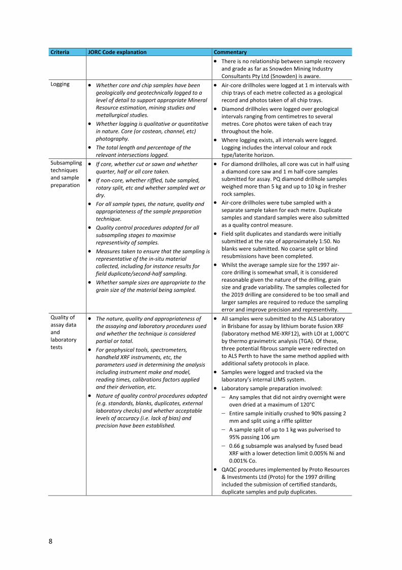
• There is no relationship between sample recovery and grade as far as Snowden Mining Industry Consultants Pty Ltd (Snowden) is aware.
Logging • Whether core and chip samples have been geologically and geotechnically logged to a level of detail to support appropriate Mineral Resource estimation, mining studies and metallurgical studies.
• Whether logging is qualitative or quantitative in nature. Core (or costean, channel, etc) photography.
• The total length and percentage of the relevant intersections logged.
• Air-core drillholes were logged at 1 m intervals with chip trays of each metre collected as a geological record and photos taken of all chip trays.
• Diamond drillholes were logged over geological intervals ranging from centimetres to several metres. Core photos were taken of each tray throughout the hole.
• Where logging exists, all intervals were logged. Logging includes the interval colour and rock type/laterite horizon.
Subsampling techniques and sample preparation
• If core, whether cut or sawn and whether quarter, half or all core taken.
• If non-core, whether riffled, tube sampled, rotary split, etc and whether sampled wet or dry.
• For all sample types, the nature, quality and appropriateness of the sample preparation technique.
• Quality control procedures adopted for all subsampling stages to maximise representivity of samples.
• Measures taken to ensure that the sampling is representative of the in-situ material collected, including for instance results for field duplicate/second-half sampling.
• Whether sample sizes are appropriate to the grain size of the material being sampled.
• For diamond drillholes, all core was cut in half using a diamond core saw and 1 m half-core samples submitted for assay. PQ diamond drillhole samples weighed more than 5 kg and up to 10 kg in fresher rock samples.
• Air-core drillholes were tube sampled with a separate sample taken for each metre. Duplicate samples and standard samples were also submitted as a quality control measure.
• Field split duplicates and standards were initially submitted at the rate of approximately 1:50. No blanks were submitted. No coarse split or blind resubmissions have been completed.
• Whilst the average sample size for the 1997 air-core drilling is somewhat small, it is considered reasonable given the nature of the drilling, grain size and grade variability. The samples collected for the 2019 drilling are considered to be too small and larger samples are required to reduce the sampling error and improve precision and representivity.
Quality of assay data and laboratory tests
• The nature, quality and appropriateness of the assaying and laboratory procedures used and whether the technique is considered partial or total.
• For geophysical tools, spectrometers, handheld XRF instruments, etc, the parameters used in determining the analysis including instrument make and model, reading times, calibrations factors applied and their derivation, etc.
• Nature of quality control procedures adopted (e.g. standards, blanks, duplicates, external laboratory checks) and whether acceptable levels of accuracy (i.e. lack of bias) and precision have been established.
• All samples were submitted to the ALS Laboratory in Brisbane for assay by lithium borate fusion XRF (laboratory method ME-XRF12), with LOI at 1,000°C by thermo gravimetric analysis (TGA). Of these, three potential fibrous sample were redirected on to ALS Perth to have the same method applied with additional safety protocols in place.
• Samples were logged and tracked via the laboratory’s internal LIMS system.
• Laboratory sample preparation involved:
− Any samples that did not airdry overnight were oven dried at a maximum of 120°C
− Entire sample initially crushed to 90% passing 2 mm and split using a riffle splitter
− A sample split of up to 1 kg was pulverised to 95% passing 106 µm
− 0.66 g subsample was analysed by fused bead XRF with a lower detection limit 0.005% Ni and 0.001% Co.
• QAQC procedures implemented by Proto Resources & Investments Ltd (Proto) for the 1997 drilling included the submission of certified standards, duplicate samples and pulp duplicates.

9
Criteria JORC Code explanation Commentary
• TEM inserted certified reference materials (CRMs) and field duplicates into the sample batches from the 2019 drilling. Of the 325 samples submitted for the 2019 drilling, 26 quality control samples were included, comprising 15 CRMs and 11 field duplicates, equating to an insertion rate of approximately 1:20 for the CRMs and 1:30 for the duplicates. Results of the CRMs shows that reasonable analytical accuracy has been achieved and field duplicates show a reasonable level of precision.
• Additionally, a batch of 36 sample pulps from the 2019 drilling was submitted to the SGS laboratory in Perth for check assaying. Three check assays from SGS show significantly different nickel results compared to the original sample and are suspected to have been incorrectly labelled.
• ALS and SGS included standards within sample batches as part of the internal laboratory QAQC.
Verification of sampling and assaying
• The verification of significant intersections by either independent or alternative company personnel.
• The use of twinned holes.
• Documentation of primary data, data entry procedures, data verification, data storage (physical and electronic) protocols.
• Discuss any adjustment to assay data.
• As part of the 2010 Barnes Hill resource estimate, Snowden verified laboratory assay certificates against the supplied database with no discrepancies identified.
• A total of five diamond drillholes twinned existing air-core drillholes to confirm grade and provided mineralised material for bulk density testwork.
• Geological logging was completed on paper, transferred to Microsoft Excel spreadsheets and geological logging codes validated.
• Due to the different generations of assays, where required, element assays were converted to oxides (e.g. % Fe to % Fe2O3). No other adjustments have been made to the assay data.
Location of data points
• Accuracy and quality of surveys used to locate drillholes (collar and downhole surveys), trenches, mine workings and other locations used in Mineral Resource estimation.
• Specification of the grid system used.
• Quality and adequacy of topographic control.
• The coordinate system used for the 2019 drilling is MGA Zone 55 projection based on the GDA94 datum. Historical data (i.e. 1997 drilling) was reportedly collected using the AGD66 datum; however, this was apparently later converted to GDA94 by Proto/Allegiance. Investigations by TEM revealed that there is significant uncertainty regarding the coordinate system that was used and the reliability of the transformed coordinates. Based on a historical map provided by TEM, Snowden and TEM were able to ascertain that the coordinates of the historical data recorded in the database were likely based on the AGD66 system. As such, a transformation was applied by Snowden using the world coordinate transform algorithm in Datamine Studio RM software from AGD66 to MGA94 Zone 55. The resulting, transformed coordinates were verified by TEM as being visually correct. The transform shifts the historical collar locations approximately 212.6 m horizontally to the northeast.
• The collars of the 2019 drilling at Scotts-Vulcan were surveyed by a contract surveyor using RTK global positioning system (GPS) with a horizontal accuracy of ±10 mm and a vertical accuracy of ±15 mm.

10
Criteria JORC Code explanation Commentary
• The survey method and accuracy of the 1997 drilling is unknown.
• The vertical (Z) coordinate for the 2019 drilling matched the topographic surface reasonably well; however, Snowden noted a significant difference between the historical collars and the topographic surface of up to 43 m (average 17 m difference). Given the close match of the 2019 drilling to topography, Snowden elected to project the historical collar points onto the topographic surface.
• A topographic surface was provided by TEM, based on a light detection and ranging (LiDAR)-derived 5 m digital elevation model of the northwest region of Tasmania completed by Geoscience Australia in 2013. The LiDAR has a reported 0.15 m vertical and horizontal accuracy.
Data spacing and distribution
• Data spacing for reporting of Exploration Results.
• Whether the data spacing and distribution is sufficient to establish the degree of geological and grade continuity appropriate for the Mineral Resource and Ore Reserve estimation procedure(s) and classifications applied.
• Whether sample compositing has been applied.
• Air-core drillhole spacing across the Scotts-Vulcan resource area is somewhat variable but is based on an approximate 100 mE x 100 mN grid.
• Five diamond drillholes were completed at various locations across the deposit to gain material for bulk density and to twin existing air core drillholes.
• Samples were composited to a 1 m interval for resource estimation.
Orientation of data in relation to geological structure
• Whether the orientation of sampling achieves unbiased sampling of possible structures and the extent to which this is known, considering the deposit type.
• If the relationship between the drilling orientation and the orientation of key mineralised structures is considered to have introduced a sampling bias, this should be assessed and reported if material.
• Drillholes were drilled vertically, perpendicular to the interpreted mineralisation orientation which is sub-horizontal.
Sample security
• The measures taken to ensure sample security.
• No specific measures have been taken to ensure sample security.
• Snowden does not believe that sample security poses a material risk to the integrity of the assay data used in the Mineral Resource estimate.
Audits or reviews
• The results of any audits or reviews of sampling techniques and data.
• No external review of sampling and drilling procedures has been completed as far as Snowden is aware.

11
JORC Table 1 – Section 2: Reporting of Exploration Results
Criteria JORC Code explanation Commentary
Mineral tenement and land tenure status
• Type, reference name/number, location and ownership including agreements or material issues with third parties such as joint ventures, partnerships, overriding royalties, native title interests, historical sites, wilderness or national park and environmental settings.
• The security of the tenure held at the time of reporting along with any known impediments to obtaining a licence to operate in the area.
• The Scotts-Vulcan deposit straddles granted Exploration Lease EL2/2017 and Mining Lease 1872P/M, although the majority of the resource occurs within EL2/2017.
• Tasmania Energy Metals Pty Ltd is the registered holder of 100% of Mining Lease 1872P/M and 100% of EL2/2017.
Exploration done by other parties
• Acknowledgment and appraisal of exploration by other parties.
• A number of phases of mapping, drilling and metallurgical testwork have been completed over the nickel/cobalt laterites in the Barnes Hill area, which includes Scotts-Vulcan, by various companies:
− 1955 to 1956, Ben Lomond Mining. Reconnaissance sampling completed to identify nickel-rich clays above serpentinites.
− 1958, Consolidated Zinc. Enterprise Exploration Company Pty Ltd completed an exploration report in 1958. Initial mapping identified garnierite bearing serpentine in a 4,000 ft x 2,500 ft area. Auger drilling completed on three lines south of Barnes Hill. Holes were 100 ft apart over a distance of 1,400 ft, 1,700 ft and 2,400 ft. Sample recovery was reportedly excellent and all holes except two ended at the bedrock contact. Average grades ranged from 0.4% Ni to 0.96% Ni and thicknesses varied from less than 5–9 ft. Other smaller areas were also identified and an additional six lines of auger drillholes were completed; however, the nickel laterite profile was thinner (4–6 ft) and of lower grade (0.2% Ni).
− 1965 to 1967, BHP. Regional and detailed mapping was completed. Airborne and ground magnetic surveys, along with geochemical sampling. One diamond core hole drilled at Scotts Hill to 673 ft to investigate magnetic anomaly – intersected magnetite (no sulphide mineralisation). A series of pits were completed on 17 separate lines within the “Chromite Gravels”. BHP concluded the laterites near Andersons Creek were of low grade and not worthy of development.

12
Criteria JORC Code explanation Commentary
− 1967 to 1968, King Island Scheelite. 17 diamond drillholes completed. Assay analyses were completed by Minex in Melbourne. Mineralogical study using x-ray diffraction (XRD) completed with nickel bearing phases identified. Identification of different domains laterally (Scotts Hill/Mount Vulcan/Barnes Hill) and throughout the profile (Laterite Zone/Transitional Serpentinite Zone/Bleached Serpentinite Zone/Fresh Zone). Beneficiation tests were also completed (H2SO4 leach tests, size analysis of ore, size analysis of residue of H2SO4 leach, caustic soda recovery, ammonia recovery, Nicaro process) with the Nicaro process achieving 67.7% Ni recovery.
− 1969, King Island Scheelite. Additional 20 diamond drillholes completed. Four ore locations delineated (Scotts Hill, Mount Vulcan, Barnes Hill and Barnes Hill South). Resource estimate of 6.0 Mt at 1.04% Ni and 0.06% Co at a 0.7% Ni cut-off. Analysis for Ni, Co, Cr, Al2O3, CaO, MgO, SiO2 and FeO was completed. Analyses were completed by the Launceston Laboratories of the Tasmanian Department of Mines.
− 1971 to 1972, Allstate Exploration. 15 core holes completed. Trenching also completed.
− 1969 to 1981, Northern Chromite. Chromium production on western flank of Barnes Hill. Drilling completed at Rifle Range.
− 1988, Placeco Australia. Rock chip samples taken from Barnes Hill, Dans Hill and Mount Vulcan areas.
− 1997 to 2000, Allegiance Mining. Completed 549 m of air-core drilling in 51 holes. Drilling contractor was Tas Diamond Driller Pty Ltd. All holes were vertical with 1 m samples. All samples were weighed. Nine holes at Scotts Hill, eight holes Mt Vulcan, 17 holes at Barnes Hill, and 17 holes at Barnes Hill South. Revere circulation (RC) drilling program of 65 holes totalling 492 m. Updated resource estimated in March 1998.
− 2001 to 2005, Jervois Mining. Air-core holes relogged to standardised format. Check assaying was completed on pulps from Allegiance air-core holes S001 to S051. Composite bulk samples for limonite, saprolite and weathered serpentinite lithologies for the Barnes Hill region and the Scotts Hill/Mount Vulcan regions were collected for metallurgical testing. Resource estimate re-done based on lithological domains.

13
Criteria JORC Code explanation Commentary
− 2007 to 2012, Proto. Completion of a high-level review of the Barnes Hill project and drillhole database by Snowden. Air-core drilling program (17 holes for 202 m) completed to validate historical drilling results and to provide samples for metallurgical testwork. Detailed flora and fauna assessment of the resource areas by North Barker Ecosystem Services. Cutting and assaying of some historical diamond core holes held at the MRT Rockstore in Mornington. Metallurgical testwork at HRL Testing in Brisbane. Regional soil sampling program consisting of 429 samples taken along 400 m spaced east-west lines. Aboriginal heritage and European heritage surveys completed. Column leach testwork on further air-core drilling samples from the Barnes Hill deposit. First phase of a resource drilling program at the Barnes Hill deposit which consisted of 75 air-core drillholes (BHA001–075) for 1,080 m was completed in 2008. Second phase of the resource drill-out at Barnes Hill was completed in late 2009 through to early 2010 and consisted of 549 air-core drillholes (BHA076–625) for 4,839 m and 16 diamond drillholes (BHD001–16) for 416 m. In 2010, Norivet Pty Ltd undertook bench scale testwork with samples submitted to the Southern Cross University Environmental Analysis Laboratory (EAL) for cross checking. In 2011, two pilot vat tests were undertaken by Australian Biorefining at Evans Head, New South Wales at a scale of over 1 tonne using samples composed from wide gauge drilling at two pit locations (North and South). Following this in 2012, number of bench scale tests then applied agitated tank leaching at 80degC and with an increased free acid concentration of 150g/L. Results established that 85% recovery of Ni and Co could be achieved with acid consumption of 580-700kg/t ore through an 8-10 hour residence time.
Geology • Deposit type, geological setting and style of mineralisation.
• The Barnes Hill deposits, including Scotts Hill and Mount Vulcan, are interpreted to have formed from the chemical weathering of a serpentinised ultramafic parent rock (Andersons Creek Complex). The ultramafic Andersons Creek Complex is a layered wedge of Cambrian ultramafic stratigraphy consisting mainly of serpentinite, pyroxenite and gabbro. The ultramafic complex around the Barnes Hill region has been altered almost completely to serpentinite prior to the chemical weathering process. The weathered serpentinites have subsequently been altered to clays which are overlain by a ferruginised laterite zone.
• The laterite profile identified at Scotts-Vulcan is similar to Barnes Hill and comprises:
− A surficial pisolitic soil horizon
− Fe-rich laterised hard-cap zone (in places)
− Laterite zone
− Limonite zone

14
Criteria JORC Code explanation Commentary
− Saprolite zone
− Saprock zone
− Bedrock/serpentinite.
• At Scotts-Vulcan, the upper ferruginous portion of the profile is not as well developed as at Barnes Hill and is less continuous.
• The Barnes Hill ultramafic rocks (Andersons Creek Complex) are bounded by quartzites to the east and claystones and slates to the west. Permian conglomerates overlie the ultramafic complex to the north and south. The quartzites are of Cambrian age and were intruded by the ultramafic rocks in the Cambrian. The ultramafics were subsequently altered to serpentinites. In turn the serpentinites were intruded by granitic rocks in the Devonian period. The belt of serpentine occupies a topographic low and is surrounded to the west and north by rugged hills.
• The weathering history at Barnes Hill has not been suitable for the co-precipitation of soluble silica and nickel. Consequently, the hydrous nickel silicate garnierite, which is typically present in other nickel laterite deposits, is not prevalent at Barnes Hill. Serpentine and chlorite are the main nickel bearing species.
Drillhole information
• A summary of all information material to the understanding of the exploration results including a tabulation of the following information for all Material drillholes:
− easting and northing of the drillhole collar
− elevation or RL (Reduced Level – elevation above sea level in metres) of the drillhole collar
− dip and azimuth of the hole
− downhole length and interception depth
− hole length.
• If the exclusion of this information is justified on the basis that the information is not Material and this exclusion does not detract from the understanding of the report, the Competent Person should clearly explain why this is the case.
• No exploration results being reported.
• A diagram showing the location of drillhole collars is included in the accompanying release.
Data aggregation methods
• In reporting Exploration Results, weighting averaging techniques, maximum and/or minimum grade truncations (e.g. cutting of high grades) and cut-off grades are usually Material and should be stated.
• Where aggregate intercepts incorporate short lengths of high grade results and longer lengths of low grade results, the procedure used for such aggregation should be stated and some typical examples of such aggregations should be shown in detail.
• The assumptions used for any reporting of metal equivalent values should be clearly stated.
• No exploration results being reported.

15
Criteria JORC Code explanation Commentary
Relationship between mineralisation widths and intercept lengths
• These relationships are particularly important in the reporting of Exploration Results.
• If the geometry of the mineralisation with respect to the drillhole angle is known, its nature should be reported.
• If it is not known and only the downhole lengths are reported, there should be a clear statement to this effect (e.g. ‘downhole length, true width not known’).
• No exploration results being reported.
• Drillholes were drilled vertically – perpendicular to the interpreted orebody orientation.
• The true width of mineralisation is not considered to be materially different from the drillhole intercepts for vertical drilling.
Diagrams • Appropriate maps and sections (with scales) and tabulations of intercepts should be included for any significant discovery being reported These should include, but not be limited to a plan view of drill hole collar locations and appropriate sectional views.
• No exploration results being reported.
Balanced reporting
• Where comprehensive reporting of all Exploration Results is not practicable, representative reporting of both low and high grades and/or widths should be practiced to avoid misleading reporting of Exploration Results.
• No exploration results being reported.
Other substantive exploration data
• Other exploration data, if meaningful and material, should be reported including (but not limited to): geological observations; geophysical survey results; geochemical survey results; bulk samples – size and method of treatment; metallurgical test results; bulk density, groundwater, geotechnical and rock characteristics; potential deleterious or contaminating substances.
• No exploration results being reported.
Further work • The nature and scale of planned further work (e.g. tests for lateral extensions or depth extensions or large-scale step-out drilling).
• Diagrams clearly highlighting the areas of possible extensions, including the main geological interpretations and future drilling areas, provided this information is not commercially sensitive.
• Further drilling is planned as part of ongoing feasibility programs. This will target areas where historical work, including sampling by BHP and drilling by King Island Scheelite, reported anomalous nickel values. In particular, exploration around and north of Simmonds Hill is proposed.
• Additional bulk density measurements using different methods are planned to validate existing bulk density measurements.

16
JORC Table 1 – Section 3: Estimation and Reporting of Mineral Resources
Criteria JORC Code explanation Commentary
Database integrity
• Measures taken to ensure that data has not been corrupted by, for example, transcription or keying errors, between its initial collection and its use for Mineral Resource estimation purposes.
• Data validation procedures used.
• Selected checks by Snowden of drillhole data against original assay certificates were completed with no errors identified.
• Geological logging completed on paper, transferred to Microsoft Excel spreadsheets and geological logging codes validated.
• Drillhole database backed up on a regular basis.
• Statistical checks completed to ensure all assays fall within acceptable limits.
• Checks on overlapping or duplicate intervals completed.
• Checks were completed on all samples which fell below analytical detection limits to ensure samples were assigned zero grades in resource estimation.
• Holes SD121, SD121A, SD122 and SD123 were excluded from the resource modelling as these holes have identical collar coordinates to other drillholes.
Site visits • Comment on any site visits undertaken by the Competent Person and the outcome of those visits.
• If no site visits have been undertaken indicate why this is the case.
• Due to the lack of outcropping geology and as no drilling is currently taking place, Snowden does not believe that a site visit is warranted at this stage; however, a site visit is anticipated when drilling recommences.
Geological interpretation
• Confidence in (or conversely, the uncertainty of) the geological interpretation of the mineral deposit.
• Nature of the data used and of any assumptions made.
• The effect, if any, of alternative interpretations on Mineral Resource estimation.
• The use of geology in guiding and controlling Mineral Resource estimation.
• The factors affecting continuity both of grade and geology.
• Snowden believes the local geology is well understood as a result of work undertaken by Proto and other companies working in the region. The Scotts-Vulcan nickel laterites have developed from the weathering of an ultramafic host rock sequence.
• The geological interpretation of the laterite horizons was developed based on the profile interpreted in 2010 for the nearby Barnes Hill deposit and used in the 2010 Barnes Hill resource model. At Scotts-Vulcan however, the upper ferruginous portion of the profile is not as well developed as at Barnes Hill and is less continuous, especially given the current drill spacing. Consequently, the pisolite, hard-cap, laterite and limonite zones were combined into a single “laterite” domain, which Snowden believes is reasonable given the somewhat gradational nature of the internal boundaries.
• Surfaces of the laterite horizons were interpreted based on a combination of geochemistry (mainly Ni, MgO and Fe2O3) and the geological logging. Each surface was treated as a hard boundary for resource modelling.
• Geological interpretation in this region has been limited to the extent of current drilling.
• Alternative interpretations of the mineralisation are unlikely to significantly change the overall volume of the mineralised zone in terms of the reported classified resources.

17
Criteria JORC Code explanation Commentary
Dimensions • The extent and variability of the Mineral Resource expressed as length (along strike or otherwise), plan width, and depth below surface to the upper and lower limits of the Mineral Resource.
• The deposit has an extent of approximately 1.6 km north-south x 0.9 km east-west.
• The main and thickest regions of the deposit are centred around Scotts Hill and Mount Vulcan and extend approximately 500 m north-south x 500 m east-west.
• Nickel mineralisation within the limonite zone is overlain in most part by ferruginised lateritic waste material which may be up to 15 m thick in places.
Estimation and modelling techniques
• The nature and appropriateness of the estimation technique(s) applied and key assumptions, including treatment of extreme grade values, domaining, interpolation parameters and maximum distance of extrapolation from data points. If a computer assisted estimation method was chosen include a description of computer software and parameters used.
• The availability of check estimates, previous estimates and/or mine production records and whether the Mineral Resource estimate takes appropriate account of such data.
• The assumptions made regarding recovery of by-products.
• Estimation of deleterious elements or other non-grade variables of economic significance (e.g. sulphur for acid mine drainage characterisation).
• In the case of block model interpolation, the block size in relation to the average sample spacing and the search employed.
• Any assumptions behind modelling of selective mining units.
• Any assumptions about correlation between variables.
• Description of how the geological interpretation was used to control the resource estimates.
• Discussion of basis for using or not using grade cutting or capping.
• The process of validation, the checking process used, the comparison of model data to drill hole data, and use of reconciliation data if available.
• Ordinary kriging estimation (parent cell estimation) technique for Ni, Co, MgO, MnO, Al2O3, Fe2O3 and SiO2.
• Sample selection honoured geological domains which were developed considering the vertical chemical and geological trends of the profile. Five domains developed: combined Limonite-Laterite Domain, Transitional Domain, Saprolite Domain, Saprock Domain and Bedrock Domain.
• Statistical analysis by domain completed. Top cuts were applied to Co (0.35% Co) and MgO (8% MgO) within the Limonite-Laterite Domain to control sporadic extreme values during estimation. No other top cuts were applied.
• Variography completed for Ni, Co, MgO, MnO, Al2O3, Fe2O3 and SiO2. Due to the low number of samples for individual domains, variograms were modelled within a combined Transitional-Saprolite-Saprock Domain and applied to all domains.
• Validation of block estimates included visual and statistical checks, both global and local. Checks were completed against original and de-clustered drillhole composites. The validations show that while smoothed, the block estimates reproduce the trends observed in the drillhole data.
Moisture • Whether the tonnages are estimated on a dry basis or with natural moisture, and the method of determination of the moisture content.
• All tonnages have been estimated as dry tonnages.

18
Criteria JORC Code explanation Commentary
Cut-off parameters
• The basis of the adopted cut-off grade(s) or quality parameters applied.
• Resources have been reported within domain boundaries above a 0.25% Ni cut-off. The cut-off grade of 0.25% Ni is based on beneficiation testwork that shows the ability to upgrade lower grade ore through screening methods and is commensurate with the cut-off grade used at similar deposits where such screening is applicable. The testwork shows that lower grade portion of the deposit can be upgraded and then serve as suitable feed for hydrometallurgical processing. Snowden believes that the cut-off grade is reasonable assuming a standard open-pit mining approach with low-to-moderate selectivity. The amenability to open-pit mining was separately established by a pit optimisation undertaken in 2010, albeit at a higher cut-off grade with a higher stripping ratio.
Mining factors or assumptions
• Assumptions made regarding possible mining methods, minimum mining dimensions and internal (or, if applicable, external) mining dilution. It is always necessary as part of the process of determining reasonable prospects for eventual economic extraction to consider potential mining methods, but the assumptions made regarding mining methods and parameters when estimating Mineral Resources may not always be rigorous. Where this is the case, this should be reported with an explanation of the basis of the mining assumptions made.
• It is assumed that the deposit will be mined using conventional drill and blast open cut mining methods with low-to-moderate selectivity.
Metallurgical factors or assumptions
• The basis for assumptions or predictions regarding metallurgical amenability. It is always necessary as part of the process of determining reasonable prospects for eventual economic extraction to consider potential metallurgical methods, but the assumptions regarding metallurgical treatment processes and parameters made when reporting Mineral Resources may not always be rigorous. Where this is the case, this should be reported with an explanation of the basis of the metallurgical assumptions made.
• During 2019 TEM performed initial testwork on samples from Scotts Hill and Mt Vulcan. The aim of the program was to confirm that Scotts-Vulcan ore would perform similarly to Barnes Hill ore which had been previously tested (as noted below), and also to test improved operating conditions. The testwork applied sequential leaching with varied blends of feed ore exposed to conditions suited for these particular combinations of limonitic and saprolitic ore. 60 tests were performed. Results supported the ability to achieve overall Ni and Cobalt extraction of 90% with an acid consumption of 509kg/t ore across the three leaching stages. Testwork also applied dry and wet screening to all the ore domains. Upgrading was shown to be effective, particularly for ore sampled from the saprolite and saprock domains with a significant increase in Ni through rejection of the coarser fractions.
• Metallurgical testwork has also been conducted on the Barnes Hill deposit, which is located approx. 3 km south of Scotts-Vulcan, since 1968, with the last testwork completed in 2012. The testwork was conducted on composite samples from diamond core along with bulk samples from trenches. Various acid leaching tests were performed, at both atmospheric temperatures and higher temperatures of up to 260°C, along with different acid concentrations and residence times. Nickel recoveries of greater than 80% were achieved, with cobalt recoveries above 80% also achieved.

19
Criteria JORC Code explanation Commentary
• Snowden believes that, given the similar geology of the Scotts-Vulcan deposit to Barnes Hill, it can be reasonably assumed that similar recoveries should be able to be achieved at both project sites.
Environmental factors or assumptions
• Assumptions made regarding possible waste and process residue disposal options. It is always necessary as part of the process of determining reasonable prospects for eventual economic extraction to consider the potential environmental impacts of the mining and processing operation. While at this stage the determination of potential environmental impacts, particularly for a greenfields project, may not always be well advanced, the status of early consideration of these potential environmental impacts should be reported. Where these aspects have not been considered this should be reported with an explanation of the environmental assumptions made.
• It is assumed that no environmental factors exist that could prohibit any potential mining development at the Scotts-Vulcan deposit.
Bulk density • Whether assumed or determined. If assumed, the basis for the assumptions. If determined, the method used, whether wet or dry, the frequency of the measurements, the nature, size and representativeness of the samples.
• The bulk density for bulk material must have been measured by methods that adequately account for void spaces (vughs, porosity, etc), moisture and differences between rock and alteration zones within the deposit.
• Discuss assumptions for bulk density estimates used in the evaluation process of the different materials.
• Bulk density was determined for a total of 244 density samples by the water immersion technique (Archimedes principle) on 20–30 cm samples of PQ diamond core from the nearby Barnes Hill deposit.
• Default density values were assigned to each domain based on the Barnes Hill measurements: Limonite-Laterite Domain (1.5 g/cm3), Transitional Domain (1.40 g/cm3), Saprolite Domain (1.3 g/cm3), Saprock Domain (2.2 g/cm3) and Bedrock Domain (2.4 g/cm3).
Classification • The basis for the classification of the Mineral Resources into varying confidence categories.
• Whether appropriate account has been taken of all relevant factors (i.e. relative confidence in tonnage/grade estimations, reliability of input data, confidence in continuity of geology and metal values, quality, quantity and distribution of the data).
• Whether the result appropriately reflects the Competent Person’s view of the deposit.
• Classification is based on a number of considerations:
− Nature and quality of the drilling and sampling methods.
− Drill spacing.
− Uncertainty in the collar coordinates of historical holes due to grid transformations. Resurveying of historical collars is required to verify the transformations applied.
− Confidence in the understanding of the underlying geological and grade continuity.
− Analysis of the QAQC data.
− Confidence in the estimate of the mineralised volume.
− The results of the model validation.
− Quantity of bulk density data.
• The resource classification scheme adopted by Snowden for the Scotts-Vulcan Mineral Resource estimate is outlined as follows:
− Where blocks are located within approximately 125 m of a drillhole, the Transitional (Domain 45), Saprolite (50) and Saprock (55) domains were classified as Inferred Resources.

20
Criteria JORC Code explanation Commentary
− Blocks within the Transitional (Domain 45), Saprolite (50) and Saprock (55) domains greater than approximately 125 m from a drillhole, remain unclassified and do not form part of the Mineral Resource.
− The Bedrock (60) and Laterite-Limonite (40) domains remain unclassified and do not form part of the Mineral Resource.
• Extrapolation horizontally beyond the drilling is limited to approximately 125 m.
• The Mineral Resource classification appropriately reflects the view of the Competent Person.
Audits or reviews
• The results of any audits or reviews of Mineral Resource estimates.
• Snowden is not aware of any independent reviews of the Mineral Resource estimate.
• Snowden’s internal review process ensures all work meets quality standards.
Discussion of relative accuracy/ confidence
• Where appropriate a statement of the relative accuracy and confidence level in the Mineral Resource estimate using an approach or procedure deemed appropriate by the Competent Person. For example, the application of statistical or geostatistical procedures to quantify the relative accuracy of the resource within stated confidence limits, or, if such an approach is not deemed appropriate, a qualitative discussion of the factors that could affect the relative accuracy and confidence of the estimate.
• The statement should specify whether it relates to global or local estimates, and, if local, state the relevant tonnages, which should be relevant to technical and economic evaluation. Documentation should include assumptions made and the procedures used.
• These statements of relative accuracy and confidence of the estimate should be compared with production data, where available.
• The Mineral Resource has been validated both globally and locally against the input composite data.
• Given the relatively sparse drilling within the Inferred Resource, estimates are considered to be globally accurate. Closer spaced drilling is required to improve the local confidence of the block estimates.
• There is no operating mine at the Barnes Hill project, including Scotts-Vulcan, and as such, no production data is available.

21
Part 2: Barnes Hill Mineral Resource Estimate 2020
JORC Table 1 – Section 1: Sampling Techniques and Data
Criteria JORC Code explanation Commentary
Sampling techniques
• Nature and quality of sampling (e.g. cut
channels, random chips, or specific specialised
industry standard measurement tools
appropriate to the minerals under
investigation, such as downhole gamma
sondes, or handheld XRF instruments, etc).
These examples should not be taken as
limiting the broad meaning of sampling.
• Include reference to measures taken to ensure
sample representivity and the appropriate
calibration of any measurement tools or
systems used.
• Aspects of the determination of mineralisation
that are Material to the Public Report.
• In cases where ‘industry standard’ work has
been done this would be relatively simple (e.g.
‘reverse circulation drilling was used to obtain
1 m samples from which 3 kg was pulverised
to produce a 30 g charge for fire assay’). In
other cases, more explanation may be
required, such as where there is coarse gold
that has inherent sampling problems. Unusual
commodities or mineralisation types (e.g.
submarine nodules) may warrant disclosure of
detailed information.
• The bulk of the data used for the Barnes Hill
resource estimate is based on the logging and
sampling of air core drilling (approximately 97% of
the data).
• Air core drilling was sampled at 1 m intervals using
a PVC or aluminium scoop to obtain an average
weight of 0.7 kg per sample. The sample was
pulverised and split to 200 g from which a 20 g sub-
sample was taken for XRF and LOI analysis.
• Diamond drilling was sampled at 1 m intervals with
occasional smaller length samples taken where
appropriate due to mineralisation boundaries.
Drilling techniques
• Drill type (e.g. core, reverse circulation, open-
hole hammer, rotary air blast, auger, Bangka,
sonic, etc) and details (e.g. core diameter,
triple or standard tube, depth of diamond
tails, face-sampling bit or other type, whether
core is oriented and if so, by what method,
etc).
• A total of 716 drill holes totalling 7,114 m have
been drilled at the Barnes Hill deposit, comprising
694 air core drill holes (50 mm diameter) and 23 PQ
triple tube diamond drill holes. All 716 drill holes
were used tor geological interpretation and
resource estimation.
Drill sample recovery
• Method of recording and assessing core and
chip sample recoveries and results assessed.
• Measures taken to maximise sample recovery
and ensure representative nature of the
samples.
• Whether a relationship exists between sample
recovery and grade and whether sample bias
may have occurred due to preferential
loss/gain of fine/coarse material.
• Diamond drill holes were completed using triple
tube to enhance core recoveries. Core recovery was
recorded throughout drill holes with core recovery
typically exceeding 90%.
• Recovery of air core drill samples was generally
reasonable based on a visual assessment, with
relatively few damp or wet samples. Samples with
“poor” recovery were not assayed and recorded as
"No Sample". A total of 28 samples did not have
enough sample for analysis.
• Sample weights were recorded for a total of 4,611
samples from the 2008-2010 air core drilling
programs. Analysis of the dry sample weights
indicates an average sample weight of
approximately 0.7 kg was attained, with a total of
699 samples, or 15.2% of the dataset, with sample
weights below 0.5 kg.

22
Criteria JORC Code explanation Commentary
Logging • Whether core and chip samples have been
geologically and geotechnically logged to a
level of detail to support appropriate Mineral
Resource estimation, mining studies and
metallurgical studies.
• Whether logging is qualitative or quantitative
in nature. Core (or costean, channel, etc)
photography.
• The total length and percentage of the
relevant intersections logged.
• Air core drill holes were logged at 1 m intervals with
chip trays of each metre collected as a geological
record and photos taken of all chip trays.
• Diamond drill holes were logged over geological
intervals ranging from centimetres to several
metres. Core photos were taken of each tray
throughout the hole.
• 4,627 data-lines of logging were produced for the
2010 MRE for all drill holes. Not all data has logging
records.
• Logging codes have not been standardised.
Subsampling techniques and sample preparation
• If core, whether cut or sawn and whether
quarter, half or all core taken.
• If non-core, whether riffled, tube sampled,
rotary split, etc and whether sampled wet or
dry.
• For all sample types, the nature, quality and
appropriateness of the sample preparation
technique.
• Quality control procedures adopted for all
subsampling stages to maximise
representivity of samples.
• Measures taken to ensure that the sampling is
representative of the in-situ material
collected, including for instance results for
field duplicate/second-half sampling.
• Whether sample sizes are appropriate to the
grain size of the material being sampled.
• For diamond drill holes all core was cut in half using
a diamond core saw and 1 m half core samples
submitted for assay. PQ diamond drill hole samples
weighed more than 5 kg and up to 10 kg in fresher
rock samples.
• Air core drill holes were tube sampled with a
separate sample taken for each metre. Duplicate
samples and standard samples were also submitted
as a quality control measure.
• Field split duplicates and standards were initially
submitted at the rate of approximately 1:50. No
blanks were submitted. No coarse split or blind
resubmissions have been completed.
• Whilst the average sample size for the air core
drilling is somewhat small, it is considered
reasonable given the nature of the drilling, grain
size and grade variability.
Quality of assay data and laboratory tests
• The nature, quality and appropriateness of the
assaying and laboratory procedures used and
whether the technique is considered partial or
total.
• For geophysical tools, spectrometers,
handheld XRF instruments, etc, the
parameters used in determining the analysis
including instrument make and model,
reading times, calibrations factors applied and
their derivation, etc.
• Nature of quality control procedures adopted
(e.g. standards, blanks, duplicates, external
laboratory checks) and whether acceptable
levels of accuracy (i.e. lack of bias) and
precision have been established.
• All samples were submitted to the ALS Laboratory
in Adelaide for assay by lithium borate fusion X-Ray
Fluorescence (XRF; lab method ME-XRF12), with LOI
at 1,000°C by thermogravimetric analysis (TGA).
• Samples were logged and tracked via the
laboratory’s internal LIMS system.
• Laboratory sample preparation involved:
− Any samples that didn’t air dry overnight were
oven dried at a maximum of 120°C
− Entire sample initially crushed to 90% passing 2
mm
− Sample split using a riffle splitter
− A sample split of up to 1 kg was pulverised to
95% passing 106 µm
− A 0.66 g sub-sample was analysed by fused bead
XRF with a lower detection limit of 0.005% Ni
and 0.001% Co.
• QAQC procedures implemented by Proto included
the submission of certified standards, duplicate
samples and pulp duplicates.
• ALS laboratory included internal standards within
sample batches and was also involved in round
robin testing with other laboratories.

23
Criteria JORC Code explanation Commentary
Verification of sampling and assaying
• The verification of significant intersections by
either independent or alternative company
personnel.
• The use of twinned holes.
• Documentation of primary data, data entry
procedures, data verification, data storage
(physical and electronic) protocols.
• Discuss any adjustment to assay data.
• Snowden verified laboratory assay certificates
against the supplied database with no
discrepancies identified.
• A total of 16 diamond drill holes (BHD001 –
BHD016) twinned existing air core drill holes to
confirm grade and provided mineralised material
for bulk density testwork.
• Geological logging was completed on paper,
transferred to Excel spreadsheets and geological
logging codes validated.
• No adjustments have been made to the assay data.
Location of data points
• Accuracy and quality of surveys used to locate
drill holes (collar and downhole surveys),
trenches, mine workings and other locations
used in Mineral Resource estimation.
• Specification of the grid system used.
• Quality and adequacy of topographic control.
• Drill hole collars were surveyed by handheld GPS.
Due to discrepancies between the drill hole collar
elevations and the topographic surface, the drill
hole collars were projected to the topographic
surface as it is considered to have greater accuracy.
• All drill holes were drilled vertically
• Topographic surface was determined by an
Airborne Laser Scanning (LiDAR) survey completed
by Photomapping Services of Melbourne, Victoria
LiDAR survey has a quoted accuracy of 0.15 m.
Supplied contours were on a 1 m elevation spacing.
Data spacing and distribution
• Data spacing for reporting of Exploration
Results.
• Whether the data spacing and distribution is
sufficient to establish the degree of geological
and grade continuity appropriate for the
Mineral Resource and Ore Reserve estimation
procedure(s) and classifications applied.
• Whether sample compositing has been
applied.
• Air core drill hole spacing across the Barnes Hill
resource area has been completed predominantly
on a 50 mN x 50 mE staggered grid pattern. A
50 mN by 50 mE drilling pattern has been shown to
give a robust grade estimate into 25 mN by 25 mE
by 1.0 m blocks and is considered adequate to
support a Measured Resource classification for
mineralised material greater than 2.0 m thick.
However, a 50 mN x 50 mE staggered drilling
pattern does not accurately define the true
variability of thickness and consequently tonnage
estimates are subject to additional uncertainty. An
Indicated classification has therefore been applied.
• Diamond drill holes were completed at various
locations across the deposit to gain material for
bulk density and to twin existing air core drill holes.
• In addition, two traverses consisting of 151 holes of
10 m closely spaced air core drill holes were
completed in the northern resource area to test
grade and width variability.
• Sampling was completed consistently to a 1 m
length. Compositing was not required to obtain an
equal sample support.
Orientation of data in relation to geological structure
• Whether the orientation of sampling achieves
unbiased sampling of possible structures and
the extent to which this is known, considering
the deposit type.
• If the relationship between the drilling
orientation and the orientation of key
mineralised structures is considered to have
introduced a sampling bias, this should be
assessed and reported if material.
• Drill holes were drilled vertically, perpendicular to
the interpreted ore body orientation.
• A tight spaced (10 m) drilling program was
completed along a north-south and an east-west
line, traversing the main portion of the deposit, to
assess thickness and grade variation on a local
scale.

24
Criteria JORC Code explanation Commentary
Sample security
• The measures taken to ensure sample
security.
• No specific measures have been taken to ensure
sample security.
• Snowden does not believe that sample security
poses a material risk to the integrity of the assay
data used in the Mineral Resource estimate.
Audits or reviews
• The results of any audits or reviews of
sampling techniques and data.
• No external review of sampling and drilling
procedures has been completed as far as Snowden
is aware.

25
JORC Table 1 – Section 2: Reporting of Exploration Results
Criteria JORC Code explanation Commentary
Mineral tenement and land tenure status
• Type, reference name/number, location and
ownership including agreements or material
issues with third parties such as joint
ventures, partnerships, overriding royalties,
native title interests, historical sites,
wilderness or national park and
environmental settings.
• The security of the tenure held at the time of
reporting along with any known impediments
to obtaining a licence to operate in the area.
• The Barnes Hill deposit occurs within Mining Lease
1872P/M.
• Tasmania Energy Metals Pty Ltd is the registered
holder of 100% of Mining Lease 1872P/M.
Exploration done by other parties
• Acknowledgment and appraisal of exploration
by other parties.
• A number of phases of mapping, drilling and
metallurgical testwork have been completed over
the nickel/cobalt laterites in the Barnes Hill area by
various companies:
− 1955 to 1956, Ben Lomond Mining.
Reconnaissance sampling completed to identify
Ni-rich clays above serpentinites.
− 1958, Consolidated Zinc. Enterprise Exploration
Company Pty Ltd completed an exploration
report in 1958. Initial mapping identified
garnierite bearing serpentine in a 4,000 ft by
2,500 ft area. Auger drilling completed on 3
lines south of Barnes Hill. Holes were 100 ft
apart over a distance of 1,400 ft, 1,700 ft and
2,400 ft. Sample recovery was reportedly
excellent and all holes except 2 ended at the
bedrock contact. Average grades ranged from
0.4% Ni to 0.96% Ni and thicknesses varied from
less than 5 ft to 9 ft. Other smaller areas were
also identified, and an additional 6 lines of auger
drill holes were completed, however the nickel
laterite profile was thinner (4 to 6 ft) and of
lower grade (0.2% Ni).
− 1965 to 1967, BHP. Regional and detailed
mapping was completed. Airborne and ground
magnetic surveys, along with geochemical
sampling. One diamond core hole drilled at
Scotts Hill to 673 ft to investigate magnetic
anomaly - intersected magnetite (no sulphide
mineralisation). A series of pits were completed
on 17 separate lines within the 'Chromite
Gravels'. BHP concluded the laterites near
Andersons Creek were of low grade and not
worthy of development.

26
Criteria JORC Code explanation Commentary
− 1967 to 1968, King Island Scheelite. 17 diamond
drill holes completed. Assay analyses were
completed by Minex in Melbourne.
Mineralogical study using XRD completed with
nickel bearing phases identified. Identification
of different domains laterally (Scotts Hill /
Mount Vulcan / Barnes Hill) and throughout the
profile (Laterite Zone / Transitional Serpentinite
Zone / Bleached Serpentinite Zone / Fresh
Zone). Beneficiation tests were also completed
(H2SO4 leach tests, size analysis of ore, size
analysis of residue of H2SO4 leach, caustic soda
recovery, ammonia recovery, Nicaro process)
with the Nicaro process achieving 67.7% Ni
recovery.
− 1969, King Island Scheelite. Additional 20
diamond drill holes completed. Four ore
locations delineated (Scotts Hill, Mount Vulcan,
Barnes Hill and Barnes Hill south). Resource
estimate of 6.0 Mt at 1.04% Ni and 0.06% Co at
a 0.7% Ni cut-off. Analysis for Ni, Co, Cr, Al2O3,
CaO, MgO, SiO2 and FeO was completed.
Analyses were completed by the Launceston
Laboratories of the Tasmanian Department of
Mines.
− 1971 to 1972, Allstate Exploration. 15 core
holes completed. Trenching also completed.
− 1969 to 1981, Northern Chromite. Chromium
production on western flank of Barnes Hill.
Drilling completed at Rifle Range.
− 1988, Placeco Australia. Rock chip samples
taken from Barnes Hill, Dans Hill and Mt Vulcan
areas.
− 1997 to 2000, Allegiance Mining. Completed
549 m of air core drilling in 51 holes. Drilling
contractor was Tas Diamond Driller Pty Ltd. All
holes were vertical with 1 m samples. All
samples were weighed. 9 holes at Scotts Hill, 8
holes Mt Vulcan, 17 holes at Barnes Hill, and 17
holes at Barnes Hill South. RC drilling program of
65 holes totalling 492 m. Updated resource
estimated in March 1998
− 2001 to 2005, Jervois Mining. Air core holes
relogged to standardised format. Check assaying
was completed on pulps from Allegiance air
core holes S001 to S051. Composite bulk
samples for limonite, saprolite and weathered
serpentinite lithologies for the Barnes Hill region
and the Scotts Hill / Mount Vulcan regions were
collected for metallurgical testing. Resource
estimate re-done based on lithological domains.

27
Criteria JORC Code explanation Commentary
− 2007 to 2012, Proto. Completion of a high-level
review of the Barnes Hill Project and drill hole
database by Snowden Mining Industry
Consultants. Air core drilling program (17 holes
for 202 m) completed to validate historic drilling
results and to provide samples for metallurgical
testwork. Detailed flora and fauna assessment
of the resource areas by North Barker
Ecosystem Services. Cutting and assaying of
some historic diamond core holes held at the
MRT Rockstore in Mornington. Metallurgical
testwork at HRL Testing in Brisbane. Regional
soil sampling program consisting of 429 samples
taken along 400 m spaced east-west lines.
Aboriginal heritage and European heritage
surveys completed. Column leach testwork on
further air core drilling samples from the Barnes
Hill deposit. First phase of a resource drilling
program at the Barnes Hill deposit which
consisted of 75 air core drill holes (BHA001 —
075) for 1,080 m was completed in 2008.
Second phase of the resource drill-out at Barnes
Hill was completed in late 2009 through to early
2010 and consisted of 549 air core drill holes
(BHA076 - 625) for 4,839 m and 16 diamond drill
holes (BHD001 - 16) for 416 m. In 2010, Norivet
Pty Ltd undertook bench scale testwork with
samples submitted to the Southern Cross
University Environmental Analysis Laboratory
(EAL) for cross checking. In 2011, two pilot vat
tests were undertaken by Australian Biorefining
at Evans Head, New South Wales at a scale of
over 1 tonne using samples composed from
wide gauge drilling at two pit locations (North
and South). Following this in 2012, number of
bench scale tests then applied agitated tank
leaching at 80degC and with an increased free
acid concentration of 150g/L. Results
established that 85% recovery of Ni and Co
could be achieved with acid consumption of
580-700kg/t ore through an 8-10 hour residence
time.
Geology • Deposit type, geological setting and style of
mineralisation.
• The Barnes Hill deposit is interpreted to have
formed from the chemical weathering of a
serpentinised ultramafic parent rock (the
Andersons Creek Complex). The Andersons
Creek Complex is a layered wedge of Cambrian
ultramafic stratigraphy consisting mainly of
serpentinite, pyroxenite and gabbro. The
ultramafic complex around the Barnes Hill region
has been altered almost completely to
serpentinite prior to the chemical weathering
process. The weathered serpentinites have
subsequently been altered to clays which are
overlain by a ferruginised laterite zone.

28
Criteria JORC Code explanation Commentary
• The laterite profile identified at Barnes Hill
comprises:
− A surficial pisolitic soil horizon
− Fe-rich laterised hardcap zone (in places)
− Laterite zone
− Limonite zone
− Saprolite zone
− Saprock zone
− Bedrock / serpentinite
• The Barnes Hill ultramafic rocks (Andersons
Creek Complex) are bounded by quartzites to the
east and claystones and slates to the west.
Permian conglomerates overlie the ultramafic
complex to the north and south. The quartzites
are of Cambrian age and were intruded by the
ultramafic rocks in the Cambrian. The ultramafics
were subsequently altered to serpentinites. In
turn the serpentinites were intruded by granitic
rocks in the Devonian period. The belt of
serpentine occupies a topographic low and is
surrounded to the west and north by rugged
hills.
• The weathering history at Barnes Hill has not
been suitable for the co-precipitation of soluble
silica and nickel. Consequently, the hydrous
nickel silicate garnierite, which is typically
present in other nickel laterite deposits, is not
prevalent at Barnes Hill. Serpentine and chlorite
are the main nickel bearing species.
Drill hole information
• A summary of all information material to the
understanding of the exploration results
including a tabulation of the following
information for all Material drill holes:
− easting and northing of the drill hole
collar
− elevation or RL (Reduced Level – elevation
above sea level in metres) of the drill hole
collar
− dip and azimuth of the hole
− downhole length and interception depth
− hole length.
• If the exclusion of this information is justified
on the basis that the information is not
Material and this exclusion does not detract
from the understanding of the report, the
Competent Person should clearly explain why
this is the case.
• No exploration results being reported.
• A diagram showing the location of drill hole collars
is available on request.
Data aggregation methods
• In reporting Exploration Results, weighting
averaging techniques, maximum and/or
minimum grade truncations (e.g. cutting of
high grades) and cut-off grades are usually
Material and should be stated.
• No exploration results being reported.

29
Criteria JORC Code explanation Commentary
• Where aggregate intercepts incorporate short
lengths of high grade results and longer
lengths of low grade results, the procedure
used for such aggregation should be stated
and some typical examples of such
aggregations should be shown in detail.
• The assumptions used for any reporting of
metal equivalent values should be clearly
stated.
Relationship between mineralisation widths and intercept lengths
• These relationships are particularly
important in the reporting of Exploration
Results.
• If the geometry of the mineralisation with
respect to the drill hole angle is known, its
nature should be reported.
• If it is not known and only the downhole
lengths are reported, there should be a clear
statement to this effect (e.g. ‘downhole
length, true width not known’).
• No exploration results being reported.
• Drill holes were drilled vertically - perpendicular to
the interpreted ore body orientation.
• The true width of mineralisation is not considered
to be materially different from the drill hole
intercepts for vertical drilling.
Diagrams • Appropriate maps and sections (with scales)
and tabulations of intercepts should be
included for any significant discovery being
reported These should include, but not be
limited to a plan view of drill hole collar
locations and appropriate sectional views.
• No exploration results being reported.
Balanced reporting
• Where comprehensive reporting of all
Exploration Results is not practicable,
representative reporting of both low and
high grades and/or widths should be
practiced to avoid misleading reporting of
Exploration Results.
• No exploration results being reported.
Other substantive exploration data
• Other exploration data, if meaningful and
material, should be reported including (but
not limited to): geological observations;
geophysical survey results; geochemical
survey results; bulk samples – size and
method of treatment; metallurgical test
results; bulk density, groundwater,
geotechnical and rock characteristics;
potential deleterious or contaminating
substances.
• No exploration results being reported.
Further work • The nature and scale of planned further work
(e.g. tests for lateral extensions or depth
extensions or large-scale step-out drilling).
• Diagrams clearly highlighting the areas of
possible extensions, including the main
geological interpretations and future drilling
areas, provided this information is not
commercially sensitive.
• Further drilling is planned as part of ongoing
feasibility programs. This will target areas were
historical work including sampling by BHP and
drilling by King Island Scheelite reported anomalous
nickel values. In particular, areas around and north
of Simmonds Hill will be explored.
• Additional bulk density measurement is planned.
This would use different methods to those used
previously and would seek to enhance the
reliability of existing bulk density measurements.

30
JORC Table 1 – Section 3: Estimation and Reporting of Mineral Resources
Criteria JORC Code explanation Commentary
Database integrity
• Measures taken to ensure that data has not
been corrupted by, for example, transcription
or keying errors, between its initial collection
and its use for Mineral Resource estimation
purposes.
• Data validation procedures used.
• Selected checks by Snowden of drill hole data
against original assay certificates were completed
with no errors identified.
• Geological logging completed on paper, transferred
to Excel spreadsheets and geological logging codes
validated.
• Statistical checks completed to ensure all assays fall
within acceptable limits.
• Checks on overlapping or duplicate Intervals
completed.
• Checks were completed on all samples which fell
below analytical detection limits to ensure samples
were assigned zero grades in resource estimation.
Site visits • Comment on any site visits undertaken by the
Competent Person and the outcome of those
visits.
• If no site visits have been undertaken indicate
why this is the case.
• Due to the lack of outcropping geology and as no
drilling is currently taking place, Snowden does not
believe that a site visit is warranted at this stage;
however, a site visit is anticipated when drilling
recommences.
Geological interpretation
• Confidence in (or conversely, the uncertainty
of) the geological interpretation of the mineral
deposit.
• Nature of the data used and of any
assumptions made.
• The effect, if any, of alternative interpretations
on Mineral Resource estimation.
• The use of geology in guiding and controlling
Mineral Resource estimation.
• The factors affecting continuity both of grade
and geology.
• Snowden believes that the local geology is well
understood as a result of work undertaken by Proto
and other companies working in the region.
• The Barnes Hill nickel laterite has developed from
the weathering of an ultramafic host rock sequence.
The boundaries of the deposit have been interpreted
from drilling which has intersected unmineralised
sandstone and siltstones to the east, west and south
of the deposit. The northern boundary to the
deposit has yet to be defined from drilling.
• Surfaces of the laterite horizons were interpreted
based on a combination of geochemistry (mainly
MgO, Fe2O3 and Ni) and the geological logging. Each
surface was treated as a hard boundary for resource
modelling.
• Alternative interpretations of the mineralisation are
unlikely to significantly change the overall volume of
the mineralised zone in terms of the reported
classified resources.
Dimensions • The extent and variability of the Mineral
Resource expressed as length (along strike or
otherwise), plan width, and depth below
surface to the upper and lower limits of the
Mineral Resource.
• The deposit has an extent of approximately 2 km
north-south by 1 km east-west.
• The main and thickest region of the deposit is
centred around Barnes Hill and is approximately 400
m north-south by 800 m east-west. This area is
characterised by a distinct limonite zone (average
thickness ~3.5 m) underlain by a saprolite zone (~4.0
m).
• The area to the south of Barnes Hill is thinner and
consists primarily of saprolite material ~2.0 m to 3.0
m).
• Ni mineralisation within the limonite zone is overlain
in most part by ferruginised lateritic waste material
(~2.0 m to 5.0 m).
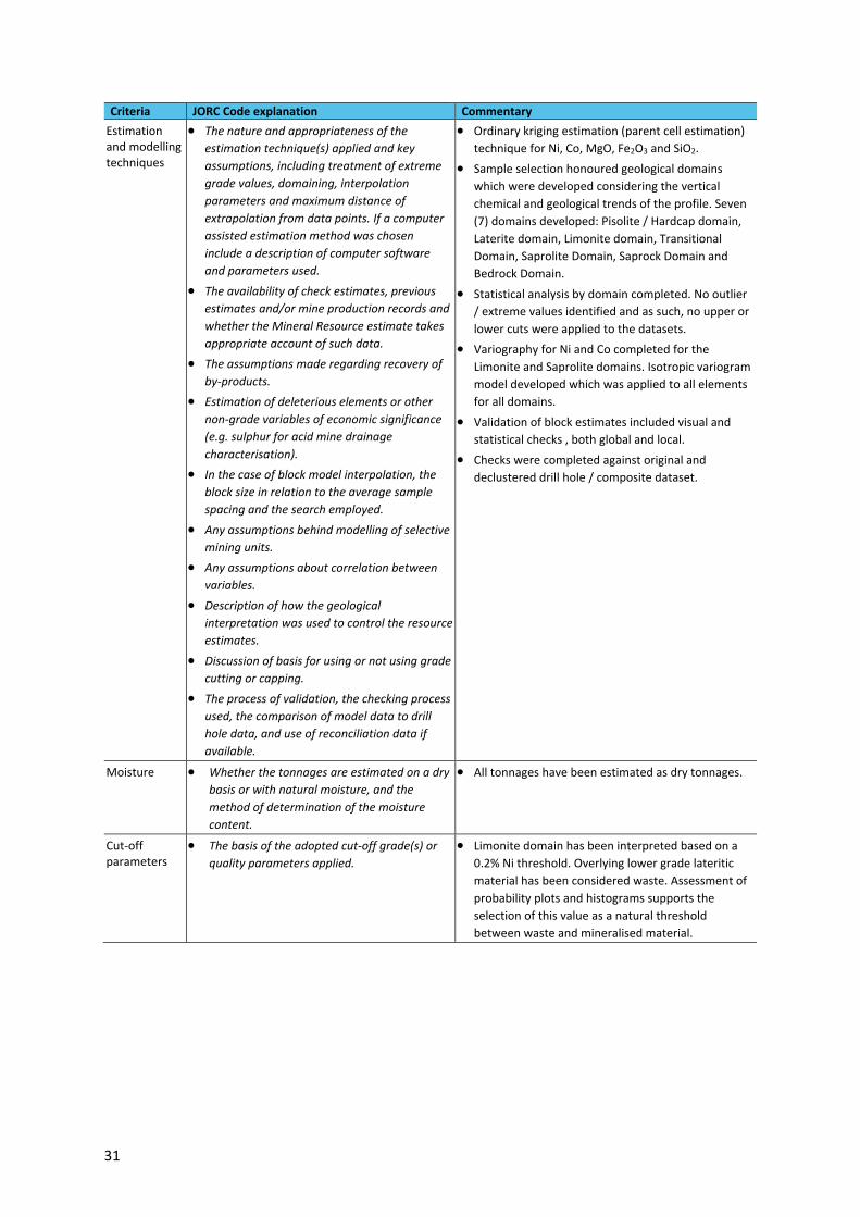
31
Criteria JORC Code explanation Commentary
Estimation and modelling techniques
• The nature and appropriateness of the
estimation technique(s) applied and key
assumptions, including treatment of extreme
grade values, domaining, interpolation
parameters and maximum distance of
extrapolation from data points. If a computer
assisted estimation method was chosen
include a description of computer software
and parameters used.
• The availability of check estimates, previous
estimates and/or mine production records and
whether the Mineral Resource estimate takes
appropriate account of such data.
• The assumptions made regarding recovery of
by-products.
• Estimation of deleterious elements or other
non-grade variables of economic significance
(e.g. sulphur for acid mine drainage
characterisation).
• In the case of block model interpolation, the
block size in relation to the average sample
spacing and the search employed.
• Any assumptions behind modelling of selective
mining units.
• Any assumptions about correlation between
variables.
• Description of how the geological
interpretation was used to control the resource
estimates.
• Discussion of basis for using or not using grade
cutting or capping.
• The process of validation, the checking process
used, the comparison of model data to drill
hole data, and use of reconciliation data if
available.
• Ordinary kriging estimation (parent cell estimation)
technique for Ni, Co, MgO, Fe2O3 and SiO2.
• Sample selection honoured geological domains
which were developed considering the vertical
chemical and geological trends of the profile. Seven
(7) domains developed: Pisolite / Hardcap domain,
Laterite domain, Limonite domain, Transitional
Domain, Saprolite Domain, Saprock Domain and
Bedrock Domain.
• Statistical analysis by domain completed. No outlier
/ extreme values identified and as such, no upper or
lower cuts were applied to the datasets.
• Variography for Ni and Co completed for the
Limonite and Saprolite domains. Isotropic variogram
model developed which was applied to all elements
for all domains.
• Validation of block estimates included visual and
statistical checks , both global and local.
• Checks were completed against original and
declustered drill hole / composite dataset.
Moisture • Whether the tonnages are estimated on a dry
basis or with natural moisture, and the
method of determination of the moisture
content.
• All tonnages have been estimated as dry tonnages.
Cut-off parameters
• The basis of the adopted cut-off grade(s) or
quality parameters applied.
• Limonite domain has been interpreted based on a
0.2% Ni threshold. Overlying lower grade lateritic
material has been considered waste. Assessment of
probability plots and histograms supports the
selection of this value as a natural threshold
between waste and mineralised material.
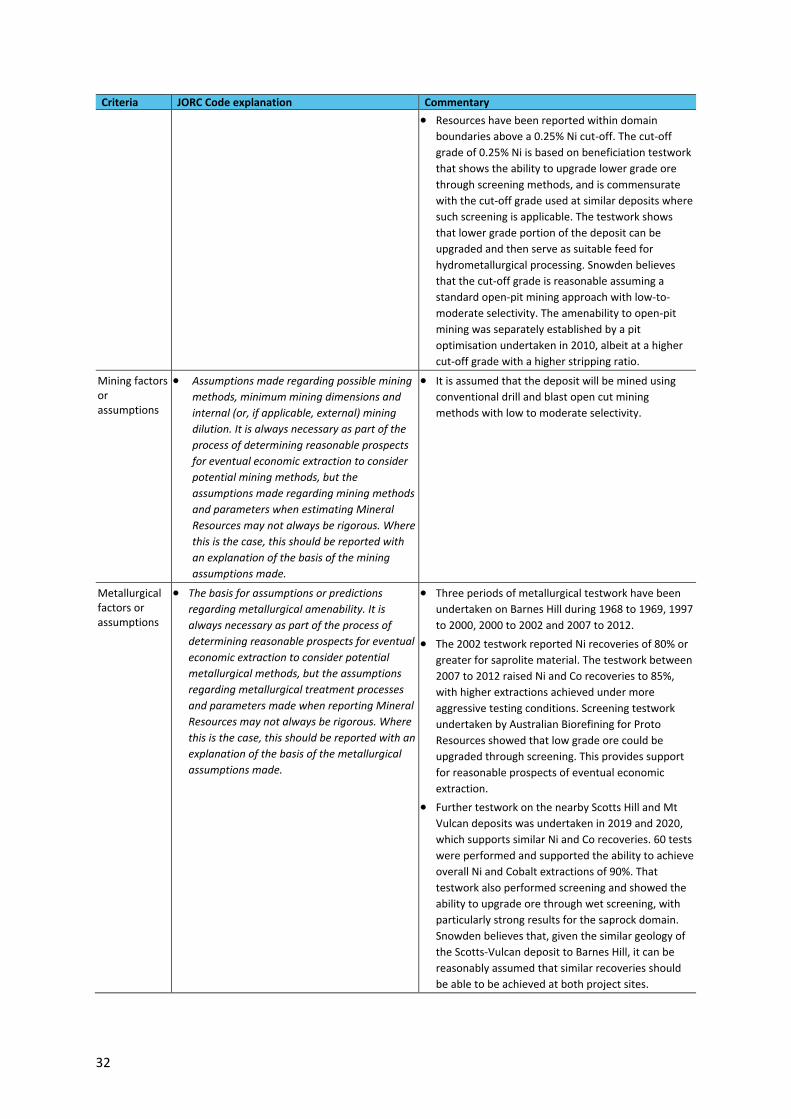
32
Criteria JORC Code explanation Commentary
• Resources have been reported within domain
boundaries above a 0.25% Ni cut-off. The cut-off
grade of 0.25% Ni is based on beneficiation testwork
that shows the ability to upgrade lower grade ore
through screening methods, and is commensurate
with the cut-off grade used at similar deposits where
such screening is applicable. The testwork shows
that lower grade portion of the deposit can be
upgraded and then serve as suitable feed for
hydrometallurgical processing. Snowden believes
that the cut-off grade is reasonable assuming a
standard open-pit mining approach with low-to-
moderate selectivity. The amenability to open-pit
mining was separately established by a pit
optimisation undertaken in 2010, albeit at a higher
cut-off grade with a higher stripping ratio.
Mining factors or assumptions
• Assumptions made regarding possible mining
methods, minimum mining dimensions and
internal (or, if applicable, external) mining
dilution. It is always necessary as part of the
process of determining reasonable prospects
for eventual economic extraction to consider
potential mining methods, but the
assumptions made regarding mining methods
and parameters when estimating Mineral
Resources may not always be rigorous. Where
this is the case, this should be reported with
an explanation of the basis of the mining
assumptions made.
• It is assumed that the deposit will be mined using
conventional drill and blast open cut mining
methods with low to moderate selectivity.
Metallurgical factors or assumptions
• The basis for assumptions or predictions
regarding metallurgical amenability. It is
always necessary as part of the process of
determining reasonable prospects for eventual
economic extraction to consider potential
metallurgical methods, but the assumptions
regarding metallurgical treatment processes
and parameters made when reporting Mineral
Resources may not always be rigorous. Where
this is the case, this should be reported with an
explanation of the basis of the metallurgical
assumptions made.
• Three periods of metallurgical testwork have been
undertaken on Barnes Hill during 1968 to 1969, 1997
to 2000, 2000 to 2002 and 2007 to 2012.
• The 2002 testwork reported Ni recoveries of 80% or
greater for saprolite material. The testwork between
2007 to 2012 raised Ni and Co recoveries to 85%,
with higher extractions achieved under more
aggressive testing conditions. Screening testwork
undertaken by Australian Biorefining for Proto
Resources showed that low grade ore could be
upgraded through screening. This provides support
for reasonable prospects of eventual economic
extraction.
• Further testwork on the nearby Scotts Hill and Mt
Vulcan deposits was undertaken in 2019 and 2020,
which supports similar Ni and Co recoveries. 60 tests
were performed and supported the ability to achieve
overall Ni and Cobalt extractions of 90%. That
testwork also performed screening and showed the
ability to upgrade ore through wet screening, with
particularly strong results for the saprock domain.
Snowden believes that, given the similar geology of
the Scotts-Vulcan deposit to Barnes Hill, it can be
reasonably assumed that similar recoveries should
be able to be achieved at both project sites.

33
Criteria JORC Code explanation Commentary
Environmental factors or assumptions
• Assumptions made regarding possible waste
and process residue disposal options. It is
always necessary as part of the process of
determining reasonable prospects for eventual
economic extraction to consider the potential
environmental impacts of the mining and
processing operation. While at this stage the
determination of potential environmental
impacts, particularly for a greenfields project,
may not always be well advanced, the status
of early consideration of these potential
environmental impacts should be reported.
Where these aspects have not been considered
this should be reported with an explanation of
the environmental assumptions made.
• It is assumed that no environmental factors exist
that could prohibit any potential mining
development at the Barnes Hill deposit.
Bulk density • Whether assumed or determined. If assumed,
the basis for the assumptions. If determined,
the method used, whether wet or dry, the
frequency of the measurements, the nature,
size and representativeness of the samples.
• The bulk density for bulk material must have
been measured by methods that adequately
account for void spaces (vughs, porosity, etc),
moisture and differences between rock and
alteration zones within the deposit.
• Discuss assumptions for bulk density estimates
used in the evaluation process of the different
materials.
• Bulk density was determined for a total of 244
density samples by the water immersion technique
(Archimedes principle) on 20 cm to 30 cm samples of
PQ diamond core.
• Default density values were assigned to each
domain: Pisolite / Hardcap Domain (1.75 g/cm3),
Laterite domain (1.70 g/cm3), Limonite domain (1.5
g/cm3), Transitional domain (1.40 g/cm3), Saprolite
domain (1.3 g/cm3), Saprock domain (2.2 g/cm3) and
Bedrock domain (2.4 g/cm3).
Classification • The basis for the classification of the Mineral
Resources into varying confidence categories.
• Whether appropriate account has been taken
of all relevant factors (i.e. relative confidence
in tonnage/grade estimations, reliability of
input data, confidence in continuity of geology
and metal values, quality, quantity and
distribution of the data).
• Whether the result appropriately reflects the
Competent Person’s view of the deposit.
• Classification was based on a number of
considerations:
− Reliability of the drilling, sampling and assaying.
− Geostatistical measures associated with estimated
block grades (e.g. regression slope, kriging
variance).
− Number of composites and number of drill hole
used in estimation.
− Domain thickness and variability.
− Results of a conditional simulation study of the
saprolite thickness.
− Amount and reliability of the density data.
• Mineral Resources have been classified as a
combination of Indicated and Inferred Resources
based on the following criteria:
− The Mineral Resource has been limited to the
Limonite, Transitional, Saprolite and Saprock
domains.
− Where drilling is 50 mN by 50 mE or better and the
thickness is greater than 2 m, the resource has
been classified as an Indicated Resource.
− Areas that are not supported by a 50 mN by 50 mE
drill spacing or are less than 1 m in thickness have
been assigned an Inferred classification.
• The Mineral Resource classification appropriately
reflects the view of the competent Person.
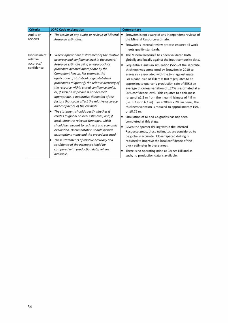
34
Criteria JORC Code explanation Commentary
Audits or reviews
• The results of any audits or reviews of Mineral
Resource estimates.
• Snowden is not aware of any independent reviews of
the Mineral Resource estimate.
• Snowden’s internal review process ensures all work
meets quality standards.
Discussion of relative accuracy/ confidence
• Where appropriate a statement of the relative
accuracy and confidence level in the Mineral
Resource estimate using an approach or
procedure deemed appropriate by the
Competent Person. For example, the
application of statistical or geostatistical
procedures to quantify the relative accuracy of
the resource within stated confidence limits,
or, if such an approach is not deemed
appropriate, a qualitative discussion of the
factors that could affect the relative accuracy
and confidence of the estimate.
• The statement should specify whether it
relates to global or local estimates, and, if
local, state the relevant tonnages, which
should be relevant to technical and economic
evaluation. Documentation should include
assumptions made and the procedures used.
• These statements of relative accuracy and
confidence of the estimate should be
compared with production data, where
available.
• The Mineral Resource has been validated both
globally and locally against the input composite data.
• Sequential Gaussian simulation (SGS) of the saprolite
thickness was completed by Snowden in 2010 to
assess risk associated with the tonnage estimate.
For a panel size of 100 m x 100 m (equates to an
approximate quarterly production rate of 55Kt) an
average thickness variation of ±24% is estimated at a
90% confidence level. This equates to a thickness
range of ±1.2 m from the mean thickness of 4.9 m
(i.e. 3.7 m to 6.1 m). For a 200 m x 200 m panel, the
thickness variation is reduced to approximately 15%,
or ±0.75 m.
• Simulation of Ni and Co grades has not been
completed at this stage.
• Given the sparser drilling within the Inferred
Resource areas, these estimates are considered to
be globally accurate. Closer spaced drilling is
required to improve the local confidence of the
block estimates in these areas.
• There is no operating mine at Barnes Hill and as
such, no production data is available.