Embed Size (px)
Citation preview

SDMS DocID 2049957
First Five-Year Review Reportfor
Site 4 - Old Landfill
Marine Corps Base (MCB)Quantico, Virginia
Engineering Field Activity ChesapeakeNaval Facilities Engineering Command
Contract Number N62467-94-D-0888Contract Task Order 0806
March 2003

Navy Five-Year Review Signature Cover
Key Review Information
Site Identification
Site Name: Marine Corps Base (MCB) Quantico (Site 4 - Old Landfill) EPA ID: VA1170024722
Region: 3 State: VA City/County: Quantico
Site Status
NPL Status: Final
Remediation Status {under construction, operating, complete): Complete (Interim Remedy for Site 4)
Multiple Operable Units (highlight): Y | Number of Sites/OUs: 1 /NA
Construction Completion Date: October 1997
Fund/PRP/Federal FacilityLead: Federal Facility
Lead Agency: Department of the NavyEngineering Field Activity Chesapeake
Has site been put into reuse? (highlight): Y
Review Status
Who conducted the review (EPA Region, State, Federal Agency): Engineering Field Activity Chesapeake
Author Name: Andrew Gutberlet Author Title: Remedial Project Manager
Author Affiliation: Department of the Navy, Engineering Field Activity Chesapeake
Review Period: September 2002
Highlight:
Date(s) of Site Inspection: September 2002
Policy Type (name):1. Pre-SARA
3. Removal Only4. Regional Discretion
Review Number (1, 2, etc)
1
Triggering Action Event: Initiation of the remedial action for Site 4 - Old Landfill
Trigger Action Date: May 1996
Due Date: May 2001
This five-year review only applies to the interim remedial action implemented at Site 4 - Old Landfill.
(•sues:
The only issue is the presence of the invasive species phragmites in the constructed wetland. Thepresence of this invasive species does not affect the potential for release of contaminants from the siteand does not affect the current or future protectiveness of the interim remedy.
Recommendations and Required Actions:
MCB Quantico has been advised of the above issue and plans to apply herbicide to eliminate/control theinvasive species, which is the recommendation.
Protectiveness Statement(s):
The interim remedial action for Site 4 is protective of human health and the environment. The interimremedy is functioning as intended.
This five-year review shows that the Navy is meeting the requirements of the ROD for the interimremedial action for Site 4.
Other Comments:
None.
Next Review:
The next five-year review of Site 4 will be completed in March 2008.
Signature of U.S. Departmerjtof the Navy and Date
3/31/01Date 7
U.S. Makjne'UorpsCommanding General, Marine Corps Base

TABLE OF CONTENTS
SECTION PAGE NO.
NAVY FIVE-YEAR REVIEW SIGNATURE COVER KEY i
ACRONYMS v
EXECUTIVE SUMMARY ES-1
1.0 INTRODUCTION 1
2.0 SITE CHRONOLOGY 2
3.0 BACKGROUND 23.1 Physical Characteristics 23.2 Land and Resource Use 23.3 History of Contamination 33.4 Initial Response 43.5 Basis for Taking Interim Remedial Action 4
4.0 INTERIM REMEDIAL ACTIONS 64.1 Interim Remedy Selection 64.2 Remedy Implementation 74.3 System Operation/Operation and Maintenance 8
5.0 PROGRESS SINCE THE LAST FIVE-YEAR REVIEW 9
6.0 FIVE-YEAR REVIEW PROCESS 96.1 Administrative Components : 96.2 Community Involvement 96.3 Document Review 106.4 Data Review 106.5 Site Inspection 126.6 Interviews 13
7.0 TECHNICAL ASSESSMENT 137.1 Question A: Is the remedy functioning as intended by the decision documents? 137.2 Question B: Are the exposure assumptions, toxicity data, clean-up levels, and
RAOs used at the time of the remedy selection still valid? 147.3 Question C: Has any other information come to light that calls into question the
protectiveness of the remedy? 157.4 Technical Assessment Summary 15
8.0 ISSUES 15
9.0 RECOMMENDATIONS AND FOLLOW-UP ACTIONS 15
100203/P iii CTO 0806

TABLE OF CONTENTS (Continued)
SECTION PAGE NO.
10.0 PROTECTIVENESS STATEMENT 16
11.0 NEXT REVIEW 16
APPENDICES
A SITE VISIT PHOTOGRAPHSB WETLAND INSPECTION MEMORANDUM
TABLES
NUMBER
1 Chronology of Site Events2 Review of Groundwater Data3 Review of Sediment Data4 Applicable or Relevant and Appropriate Requirements
FIGURES
NUMBER
1 Site Layout
100203/P iv CTO 0806
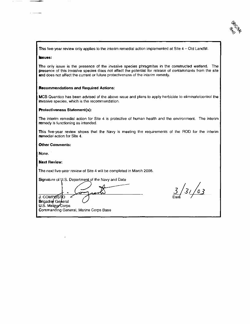
ACRONYMS
pg/L micrograms per liter
ARAR applicable or relevant and appropriate requirement
AWQC ambient water quality criteria
CAA Clean Air Act
CERCLA Comprehensive Environmental Response, Compensation, and Liability Act
CLEAN Comprehensive Long-Term Environmental Action Navy
CFR Code of Federal Regulations
COE Corps of Engineers
CWA Clean Water Act
CZMA Coastal Zone Management Act
DEQ Department of Environmental Quality
DRMO Defense Reutilization and Marketing Office
EE/CA Engineering Evaluation/Cost Analysis
EPA U.S. Environmental Protection Agency
ERA ecological risk assessment
FFS Focused Feasibility Study
IAS Initial Assessment Study
IRA interim remedial action
MCB Marine Corps Base
MCL maximum contaminant level
mg/kg milligram per kilogram
NCP National Oil and Hazardous Substances Pollution Contingency Plan
NOV Notice of Violation
NPL National Priorities List
NPDES National Pollutant Discharge Elimination System
O&M operation and maintenance
PAH polynuclear aromatic hydrocarbon
PCB polychlorinated biphenyl
RAO Remedial Action Objective
RCRA Resource Conservation and Recovery Act
RF&P Richmond, Fredricksburg, and Potomac
RD remedial design
Rl remedial investigation
ROD Record of Decision
RPM Remedial Project Manager
100203/P CTO 0806
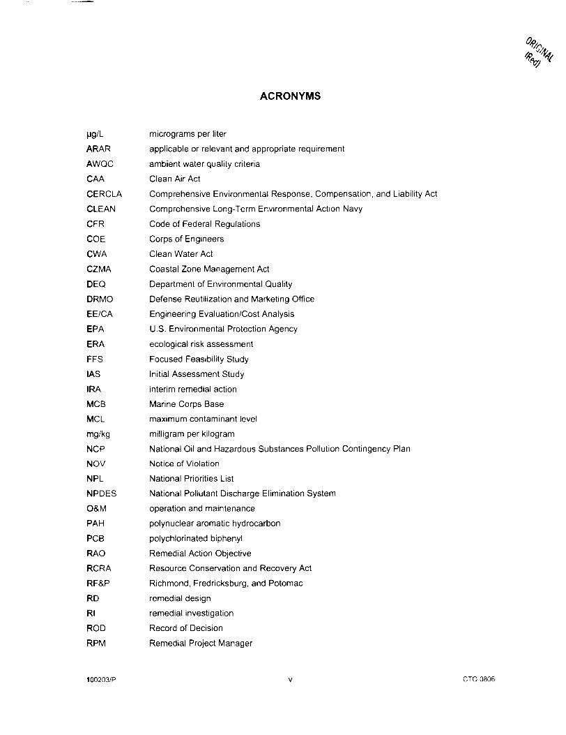
SVOC semivolatile organic compound
TBC to be considered
TSCA Toxic Substances Control Act
TtNUS Tetra Tech NUS, Inc.
USFWS U.S. Fish and Wildlife Service
VHWMR Virginia Hazardous Waste Management Regulations
VPDES Virginia Pollutant Discharge Elimination System
VMRC Virginia Marine Resources Commission
VOC volatile organic compound
100203/P Vi CTO 0806
EXECUTIVE SUMMARY
The interim remedial action (IRA) for Site 4 - Old Landfill at Marine Corps Base (MCB) Quantico, Virginia,
included the following:
• Excavation and off-site disposal of soil and drainage swale sediment contaminated with
polychlorinated biphenyls (PCBs) in excess of 10 milligrams per kilogram (mg/kg).
• Excavation and on-site disposal of landfill material and sediment from the Potomac River shoreline
adjacent to the site.
• Installation of a 23-acre permeable soil barrier layer over the landfill
• Shoreline stabilization.
• Wetland mitigation.
• Institutional controls.
The completion of construction activities for the interim remedy was achieved in October 1997. The
trigger for this five-year review was the actual start of construction in May 1996.
The assessment of this five-year review found that the interim remedy was constructed in accordance
with the requirements of the Record of Decision (ROD). The interim remedy is functioning as designed.
The immediate threats have been addressed, and the interim remedy is protective of human health and
the environment. Subsequent actions are being conducted to fully address the potential threats posed by
exposure to other media at the site (i.e., on-site groundwater, off-site surface water, and off-site
sediment).
100203/P ES-1 CTO0806
SITE 4-OLD LANDFILL
MARINE CORPS BASE QUANTICO, VIRGINIA
FIRST FIVE-YEAR REPORT
1.0 INTRODUCTION
The purpose of the five-year review report is to determine whether the interim remedy at the site is
protective of human health and the environment. The methods, findings, and conclusions of reviews are
documented in Five-Year Review reports. In addition, Five-Year Review reports identify issues found
during the review, if any, and identify recommendations to address them.
The Navy is preparing this Five-Year Review report pursuant to the Comprehensive Environmental
Response, Compensation, and Liability Act (CERCLA) §121 and the National Oil and Hazardous
Substances Pollution Contingency Plan (NCP). CERCLA §121 states:
If the President selects a remedial action that results in any hazardous substances, pollutants, or
contaminants remaining at the site, the President shall review such remedial action no less often
than each five years after initiation of such remedial action to assure that human health and the
environment are being protected by the remedial action being implemented. In addition, if upon
such review it is the judgment of the President that action is appropriate at such site in
accordance with section 104 or 106, the President shall take or require such action. The
President shall report to the Congress a list of facilities for which such review is required, the
results of all such reviews, and any actions taken as a result of such reviews.
The Navy interpreted this requirement further in the NCP: 40 Code of Federal Regulations (CFR)
§300.430(f)(4)(ii) states:
If a remedial action is selected that results in hazardous substances, pollutants, or contaminants
remaining at the site above levels that allow for unlimited use and unrestricted exposure, the lead
agency shall review such actions no less often that every five years after the initiation of the
selected remedial action.
The Engineering Field Activity Chesapeake, Naval Facilities Engineering Command conducted the five-
year review of the interim remedy implemented at Site 4 - Old Landfill at the MCB in Quantico, Virginia.
Tetra Tech NUS, Inc. (TtNUS) conducted an analysis of the available information in support of the five-
year review in September 2002 in response to Contract Task Order 0806 under the Comprehensive
Long-Term Environmental Action Navy (CLEAN) Contract Number N62467-94-D-0888. Representatives
100203/P 1 CTO 0806

of the Navy, MCB Quantico, U.S. Environmental Protection Agency (EPA) Region 3, and TtNUS
conducted a site inspection on September 12, 2002. This report documents the results of the review.
This is the first five-year review for Site 4 at MCB Quantico. The triggering action for this statutory review
is the initiation of the interim remedial action on May 19, 1996. The five-year review is required due to the
fact that hazardous substances, pollutants, or contaminants remain at the site above levels that allow for
unlimited use and unrestricted exposure.
2.0 SITE CHRONOLOGY
The site chronology lists all important site events and relevant dates and is shown in Table 1.
3.0 BACKGROUND
3.1 Physical Characteristics
Site 4 (Old Landfill) is a 24-acre landfill located on the banks of the Potomac River in the Mainside Area of
MCB Quantico (see Figure 1). Site 4 is bound to the north and west by industrialized portions of MCB
Quantico. The base sewage treatment plant borders the site to the north. The Richmond, Fredricksburg,
and Potomac (RF&P) railroad tracks, steam generation plant, barracks, and several offices are located
along the western site boundary. The southern edge of the site is surrounded partially by wetlands and
barracks used by airfield personnel. The site also contains a constructed wetland that was created in the
area of an unnamed tributary to replace wetlands that were destroyed during implementation of the IRA.
There are no residential properties or areas near the site. During the IRA, the site was significantly
regraded, and all existing structures were removed. Currently, the surface of Site 4 slopes gently from
the access road near the railroad tracks to the Potomac River. The shoreline has been covered with
riprap revetment to prevent further erosion. Chain-link fencing has been installed around the perimeter,
except along the river.
3.2 Land and Resource Use
Landfill operations at Site 4 began in the early 1920s near the RF&P railroad tracks and continued to
expand eastward until 1971. Operations at Site 4 have extended the original shoreline an additional 600
to 1,200 feet eastward to create a new Potomac River bank, consisting of artificial fill. The Defense
Reutilization and Marketing Office (DRMO) Scrapyard (known as Site L-03) and Building 669 (known as
Site B-08) were located within the landfill area. The scrap yard was constructed in the 1950s on the
northeastern portion of Site 4 and covered an area of approximately 2.5 acres. Building 669 was located
near the Potomac River and was used to store electrical transformers until 1979. The site has been
inactive since the IRA was completed in 1997.
100203/P 2 CTO 0806
The site is currently an open, grass-covered field. The site is currently fenced, except along the river, and
the landfill waste is contained beneath a soil barrier layer. The current land use for the surrounding area
is military. The future land use for the surrounding area is expected to be military.
The Potomac River is not used for domestic or agricultural uses within the vicinity of MCB Quantico;
however, it is used for recreational and commercial fishing near the base. The base has a fish advisory
posted for waters in the Quantico Embayment, which is adjacent to the site. The advisory warns against
ingesting fish and shellfish species that are caught in the Quantico Embayment.
Groundwater underlying the site is currently not used as a drinking water source. Groundwater is not
expected to be a future source of drinking water because potable water at the base is provided by three
surface reservoirs (Brackenridge Reservoir. Gray's Reservoir, and Lunga Reservoir).
The surficial aquifer beneath the site consists of river deposits (alluvium and river terrace deposits) that
overlay the Potomac Group. The river deposits consist of sand, silt, and organic clay, interlayered with
peat in the southwest portion of the site. In northern portion of the site, this material consisted of gravel,
sand, silt, and clay mixtures. A 4- to 12-foot thick clay layer was encountered at the top of the Potomac
Group, ranging from 40 to 61 feet below the ground surface. Cohesive, dense sand with silt, clay, and
gravel, also part of the Potomac Group was encountered at depths ranging from 50 to 66 feet below the
ground surface. The depth to groundwater generally varied from 3 to 20 feet below the ground surface
depending on the season and amount of precipitation. The dominant groundwater flow direction at the
site is east toward the Potomac River.
3.3 History of Contamination
Wastes reportedly disposed at Site 4 included municipal refuse, construction debris, paints and thinners,
transformers, dielectric fluids, batteries, and compressors. Wastes were burned prior to burial until the
mid-1960s. The estimated volume of fill material at Site 4 is 281,000 cubic yards. The fill material was
observed to be approximately 2 to 13 feet thick and generally thickens toward the south and east, toward
the Potomac River. Site 4 was used until 1971, when another municipal landfill was opened at the base.
Electrical transformers were stored in the eastern portion of the DRMO area and the transformer storage
area at Building 669. The transformers were reportedly opened to recover the copper wire and steel
casings. Consequently, transformer oil, possibly containing PCBs, was released onto the ground. No
information exists concerning quantities of contaminants spilled in the DRMO area in the past.
During the Initial Assessment Study (IAS) in 1984, Site 4 was recommended for further study because of
the potential impacts to groundwater and surface water. The 1988 Confirmation Study and preliminary
100203/P 3 CTO 0806

remedial investigation (Rl) indicated that past disposal operations at Site 4 and the DRMO area
contaminated soil, groundwater, and sediment. Soil contaminants included volatile organic compounds
(VOCs), semivolatile organic compounds (SVOCs), most of which are polynuclear aromatic hydrocarbons
(PAHs), pesticides, PCBs, and metals. Groundwater contaminants were mostly metals, with a few
detections of VOCs, SVOCs, and pesticides. Sediment contaminants were mostly PAHs, pesticides,
PCBs, and metals.
The Virginia DEQ issued Notice of Violation (NOV) No. 93-06-NRO-075 on June 24, 1993. The NOV
noted discharge of contaminants to state waters without authority of a National Pollutant Discharge
Elimination System (NPDES) permit, thereby violating water quality standards for surface water and
groundwater and causing environmental damage (i.e., PCBs were detected in fish tissue).
3.4 Initial Response
The initial responses discussed below were taken before the IRA was implemented.
A removal action was conducted from September 1990 through December 1990 to remove PCB-
contaminated soil from the DRMO Scrapyard and the adjoining Building 669 Transformer Storage Area.
Approximately 3,800 tons of contaminated soil, including soil from another site (Old Batch Plant Site)
unrelated to Site 4, were excavated and disposed off site.
In response to the 1993 NOV, the Navy initiated immediate measures to eliminate further contaminant
migration from Site 4. Activities included installation of silt fences to prevent migration of contaminated
sediment, a blacktop area was scarified by breaking up the asphalt to make the area more permeable
and to decrease runoff, collection of surface water samples to verify that PCBs were not migrating off site,
initiation of the Focused Feasibility Study (FFS), and initiation of an ecological risk assessment (ERA) by
the USF&WS.
MCB Quantico was proposed for the National Priorities List (NPL) on May 10, 1993, and finalized on the
NPL on May 31, 1994. In July 1995, the FFS and Proposed Plan identifying the Navy's preferred interim
remedy were presented to the public, starting the period for public comment.
3.5 Basis for Taking Interim Remedial Action
Based on information collected before implementation of the IRA, hazardous substances, pollutants, and
contaminants that have been released at concentrations higher than risk-based screening levels in each
site media include:
100203/P 4 CTO0806
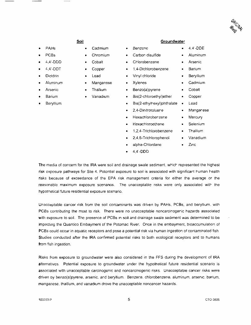
Soil
PAHs
PCBs
4,4'-DDD
4,4'-DDT
Dieldrin
Aluminum
Arsenic
Barium
Beryllium
Cadmium
Chromium
Cobalt
Copper
Lead
Manganese
Thallium
Vanadium
Groundwater
Benzene • 4,4'-DDE
Carbon disulfide • Aluminum
Chlorobenzene • Arsenic
1,4-Dichlorobenzene • Barium
Vinyl chloride • Beryllium
Xylenes • Cadmium
Benzo(a)pyrene • Cobalt
Bis(2-chloroethyl)ether • Copper
Bis(2-ethylhexyl)phthalate • Lead
2,4-Dinitrotoluene • Manganese
Hexachlorobenzene • Mercury
Hexachloroethane • Selenium
1,2,4-Trichlorobenzene • Thallium
2,4,6-Trichlorophenol • Vanadium
alpha-Chlordane • Zinc
4,4'-DDD
The media of concern for the IRA were soil and drainage swale sediment, which represented the highest
risk exposure pathways for Site 4. Potential exposure to soil is associated with significant human health
risks because of exceedance of the EPA risk management criteria for either the average or the
reasonable maximum exposure scenarios. The unacceptable risks were only associated with the
hypothetical future residential exposure scenario.
Unacceptable cancer risk from the soil contaminants was driven by PAHs, PCBs, and beryllium, with
PCBs contributing the most to risk. There were no unacceptable noncarcinogenic hazards associated
with exposure to soil. The presence of PCBs in soil and drainage swale sediment was determined to be
impacting the Quantico Embayment of the Potomac River. Once in the embayment, bioaccumulation of
PCBs could occur in aquatic receptors and pose a potential risk via human ingestion of contaminated fish.
Studies conducted after the IRA confirmed potential risks to both ecological receptors and to humans
from fish ingestion.
Risks from exposure to groundwater were also considered in the FFS during the development of IRA
alternatives. Potential exposure to groundwater under the hypothetical future residential scenario is
associated with unacceptable carcinogenic and noncarcinogenic risks. Unacceptable cancer risks were
driven by benzo(a)pyrene, arsenic, and beryllium. Benzene, Chlorobenzene, aluminum, arsenic, barium,
manganese, thallium, and vanadium drove the unacceptable noncancer hazards.
100203/P CTO 0806
The IRA was followed by additional Rl and FS activities for Site 4 and a Quantico Post-IRA Study to
further evaluate groundwater, surface water, and sediment contamination and potential impacts to the
Potomac River. These studies have yet to be completed and are currently being conducted.
Groundwater will be addressed in the final remedy for Site 4, and surface water and sediment will be
addressed as part of the Post-IRA study.
4.0 INTERIM REMEDIAL ACTIONS
4.1 Interim Remedy Selection
The ROD for the IRA for Site 4 was signed in September 1997. Remedial Action Objectives (RAOs) for
the IRA were developed as a result of data collected during the preliminary Rl and FFS to aid in the
development and screening of remedial alternatives to be considered for the ROD. The RAOs for soil
and on-site sediment include the following:
• Minimize direct contact, inhalation, and ingestion of contaminants posing a carcinogenic risk.
• Reduce migration of contaminants to groundwater.
• Restrict migration of contaminants to the adjacent embayment.
• Comply with applicable or relevant and appropriate requirements (ARARs) directly associated with
the action.
The major components of the IRA selected in the ROD include the following:
• Consolidation of existing berms, demolition and off-site disposal of scrap yard buildings, and
incorporation of scrap yard building foundations within the landfill.
• Excavation and off-site disposal of surface soil and drainage swale sediment contaminated with PCBs
in excess of 10 mg/kg.
• Excavation and on-site disposal of landfill material and sediment from the shoreline.
• Permeable soil barrier layer installation covering 23 acres, and incorporation of flood control
measures and shore protection.
100203/P 6 CTO 0806
• Shoreline stabilization
• Mitigation for wetlands destroyed or impacted by implementation of the IRA (1.8 acres impacted
versus 2.1 acres replaced), including monitoring of the replacement wetlands to ensure mitigation is
effective.
• Institutional controls, to include no breaching of the barrier layer, fencing around the entire site with
locked gates, and access restrictions from unauthorized personnel
• Operation and maintenance (O&M).
• Five-year reviews as required by CERCLA.
Final use restrictions for the landfill are to be addressed in the final remedy for Site 4. Until that time, the
Navy will employ the above institutional controls as protection. No invasive development is to be allowed.
O&M activities will include an annual inspection of the cover and includes, at a minimum, performance
standards to assure integrity of the barrier layer, erosion control, wetland monitoring, and inspection and
maintenance, as applicable.
4.2 Remedy Implementation
The Navy performed the remedial design (RD) and implemented the IRA. The RD was completed in July
1995. Site preparation activities for the IRA began in May 1996. The IRA was completed in October
1997. The major components of the IRA were as follows:
• Four on-site building were demolished and the landfill surface was cleared as initial steps for
preparing the site for subsequent actions.
• A total of 4,986 tons of soil and drainage swale sediment with PCB concentrations higher than
10 mg/kg was excavated and hauled off site for disposal. Erosion of the riverbank had resulted in
exposure of waste and debris along the shoreline from the shore to approximately 50 to 60 feet into
the river. Approximately 3,500 cubic yards of waste, debris, and sediment were excavated from the
river. The excavated material, which contained less than 10 mg/kg of PCBs, was placed on the
landfill and covered by the soil barrier layer.
• The landfill surface was regraded, and a layer of geotextile materials was placed at the site. The
barrier layer, which consists of 18 inches of common fill and 6 inches of topsoil. was placed above the
100203/P 7 CTO 0806
%,
geotextile layer. The area was seeded upon completion of the topsoil layer. The shoreline was
stabilized with riprap to minimize erosion.
• A wetland was created to replace wetlands that were destroyed or impacted by installation of the soil
barrier layer (wetland mitigation). A stream was graded and backfilled with planting soil, and the
planting of new replacement wetland species was accomplished.
• Approximately 3,000 feet of chain-link fence was installed around the landfill perimeter, except along
the river, to control site access. Warning signs were posted on the fence.
The remediation contractor issued the final IRA report in February 1998. The Navy. EPA. and Virginia
DEQ have determined that all IRA construction activities were performed according to specifications.
4.3 System Operation/Operation and Maintenance
The ROD for the IRA states that O&M will be performed in accordance with state solid waste
management regulations. The O&M is to include an annual inspection of the soil barrier layer, initiated
within one year of the completion of the IRA. The remaining portions of the state O&M requirements are
to be implemented as part of the final remedy for the site. O&M for the IRA is to include, at a minimum,
the following items: performance standards to assure integrity of the barrier layer, erosion control, wetland
monitoring, and inspection and maintenance as applicable.
MCB Quantico is conducting inspection and maintenance activities according to the maintenance manual
dated November 30. 1997. The primary inspection and maintenance activities associated with O&M
include the following:
• Site security, condition of gates, evidence of trespassing, evidence of vandalism, and condition of
warning signs.
• Condition of landfill cover, including erosion, ponded water, burrowing animal damage, and vegetative
cover.
• Condition of constructed wetland.
• Condition of monitoring wells.
• Mowing and maintenance, as needed.
100203/P 8 CT00806
The primary cleanup of Site 4 took place during the construction phase of the IRA (i.e.. removal of
contaminated soil and sediment and placement of soil barrier layer). Therefore, as indicated in the
planned elements above, the primary O&M activities have been geared towards inspections and
maintenance of the fence, landfill cover, and constructed wetland.
5.0 PROGRESS SINCE THE LAST FIVE-YEAR REVIEW
This was the first five-year review for the site.
6.0 FIVE-YEAR REVIEW PROCESS
6.1 Administrative Components
The EPA and Virginia DEQ were notified of the initiation of the five-year review on September 4, 2002.
The Site 4 five-year review team was led by Andrew Gutberlet, the Remedial Project Manager (RPM) for
the Navy. TtNUS assisted in the review under contract to the Navy. Matias Santiago, the MCB Quantico
RPM, assisted in the review as the representative of the base. Lisa Bradford, the EPA RPM, and Steve
Mihalko, the Virginia DEQ RPM, assisted in the review as the representatives of the support agencies.
Early in September 2002, the review team established the review schedule whose components included
the following:
• Community involvement
• Document review
• Data review
• Site inspection
• Five-Year Review report development and review
The schedule extended through the end of September 2002.
6.2 Community Involvement
A notice was sent to three local newspapers that a five-year review was to be conducted.
A notice was sent to local newspapers announcing the results of the five-year review and that the report
was available to the public at the Chinn Park Regional Library, John Porter Memorial Library, and Marine
100203/P 9 CTO 0806

Corps Research Center. This notice was published in the same local newspapers that announced that
the five-year review report was completed for Site 4.
6.3 Document Review
The five-year review consisted of a review of relevant documents including O&M records and monitoring
data. The documents reviewed include the following:
• RI/Risk Assessment Report, Old Landfill, November 1992
• FFS Report for Old Landfill, April 1995.
• ROD for Old Landfill - Site 4, Interim Remedial Action, September 1997.
• Maintenance Manual, Site 4 - Old Landfill, November 1997
• Final Report, IRA, Site 4 - Old Landfill, February 1998.
• Rl for Site 4 - Old Landfill, April 2000.
• Draft Final FS for Site 4 - Old Landfill, September 2001.
• Draft Survey Report, Quantico Watershed Study, Rapid Sediment Analysis Pilot Study, November.
2001.
• Site Inspection Checklists, Site 4 - Old Landfill, December 1997 to December 2001
6.4 Data Review
6.4.1 Groundwater Data
The data review conducted for the five-year review included a comparison of maximum detected
groundwater concentrations for samples collected before and after the IRA (see Table 2). The IRA did
not include a formal monitoring program to specifically evaluate remedy performance. However,
groundwater samples were collected after the IRA was implemented to support the ongoing Rl and FS
activities at Site 4. All available groundwater data were reviewed for this report. In general, most
chemicals were detected at their highest levels before the IRA was completed, when groundwater
samples were collected with bailers resulting in turbid samples. Also, some chemicals detected during
the preliminary Rl or the FFS were not detected after the completion of the IRA. Higher concentrations of
many chemicals (metals, PAHs, pesticides, etc.) in the pre-IRA groundwater samples are considered to
be attributable to particulate matter in turbid samples. Lower concentrations in the post-IRA groundwater
samples are attributable to the use of low-flow sampling techniques. Lower chemical concentrations in
the post-IRA groundwater samples also may be the direct result of the IRA (i.e.. contaminated soil
removal). Overall differences in chemical concentrations may also be attributable to the specific locations
sampled (i.e., not all wells were sampled during each sampling event). Some monitoring wells were
100203/P 10 CTO0806
destroyed during the IRA and were replaced by other wells. Also, some new (post-IRA) monitoring well
locations were added and only sampled after the IRA.
The following describes concentration trends for the groundwater chemicals identified in Section 3.5.
There was a slight increase in the maximum concentrations of benzene. 1,4-dichlorobenzene,
manganese, and mercury. There was a decrease to slight decrease in the maximum concentrations of
chlorobenzene, alpha-chlordane, 4,4'-DDD, 4,4'-DDE, aluminum, arsenic, barium, beryllium, copper, lead,
vanadium, and zinc. Additional information on the magnitude of the concentration trends is shown on
Table 2, which shows the maximum concentrations and frequency of detection from the pre-RI, FFS, and
post-IRA groundwater samples. The other groundwater chemicals listed in Section 3.5 have not been
detected since the IRA was completed.
Table 2 also presents a comparison of maximum detected concentrations in preliminary Rl, FFS, and
post-IRA groundwater samples to USEPA Federal Maximum Contaminant Levels (MCLs) (USEPA,
National Primary Drinking Water Standards, Office of Water, EPA 816-F-02-013, July 2002). VOCs were
most frequently detected during the Preliminary Rl. Although maximum detected concentrations of
chlorobenzene, methylene chloride, and vinyl chloride exceeded MCLs during the Preliminary Rl and/or
FFS. all VOCs detected after the IRA were present at concentrations below MCLs. Various SVOCs were
detected sporadically during the Preliminary Rl and FFS. Some concentrations of
bis(2-ethylhexyl)phthalate during all three phases of investigation exceeded the Federal MCL. However,
this chemical is likely attributable to laboratory blank contamination, not site-related disposal practices.
Additionally although, maximum concentrations of benzo(a)pyrene and hexachlorobenzene detected
during the Preliminary Rl and the FFS were in excess of MCLs, these chemicals were not detected during
the post-IRA sampling. No pesticides were detected at concentrations above MCLs. Aroclor 1242 and
1260 were detected during the Preliminary IRA at concentrations in excess of the MCL, but PCBs were
not detected during the FFS or after the IRA. Maximum concentrations of aluminum, arsenic, chromium,
iron, lead, mercury, and manganese were in excess of MCLs during all three investigations. Maximum
concentrations of antinomy, barium, beryllium, cadmium, copper, thallium, and zinc were in excess of
MCLs during the Preliminary Rl and FFS.
No distinguishable groundwater plumes were evident from the data collected prior to the IRA. Data
collected after the IRA supports this conclusion.
6.4.2 Sediment Data
The data review conducted for the five-year review included a comparison of the sediment sampling
results from the ERA and the sediment results from the Quantico Embayment Post-IRA Study (see
Table 3). The IRA did not include a formal monitoring program to specifically evaluate remedy
100203/P 1 1 CTO 0806
performance. However, the USF&WS collected sediment samples in 1993, 1995, and 1997 to support an
ERA for the Quantico Embayment. Additional sediment samples were collected from the embayment in
2001 as part of the ongoing Quantico Embayment Post-IRA Study. Table 3 only contains results for
chemicals that were reported in both the ERA and Quantico Embayment Post-IRA Study because the
analytical parameter lists for these studies were not exactly the same. Both studies included analysis for
PAHs, pesticides, PCBs, and metals, which are the primary contaminants of concern for Site 4. The
concentrations of all PAHs and PCBs were lower for the Quantico Embayment Post-IRA Study samples
than for the ERA samples. In general, the concentrations for the pesticide 4.4'-DDT and its breakdown
products were higher for the Quantico Embayment Post-IRA Study while the concentrations of other
pesticides (i.e., chlordane, dieldrin. and endrin) were higher for the ERA. With the exception of aluminum
and chromium, the concentrations of metals were similar for both studies (i.e., maximum concentrations
within 25 percent of each other). The maximum concentration of aluminum was approximately three
times higher and the maximum concentration of chromium was approximately two times higher for the
Quantico Embayment Post-IRA Study than for the ERA. The larger differences for aluminum and
chromium may be the result of natural variability in the sample matrix. In addition, aluminum is a major
soil-forming cation and is naturally abundant in soil and sediment matrices.
An evaluation of the past and present effects of Site 4 on the Quantico Embayment will be addressed
further in the Quantico Embayment Post-IRA Study and the Final FS for Site 4, which are both ongoing at
the time of this five-year review.
6.5 Site Inspection
An inspection of the site was conducted on September 12, 2002 by the Navy RPM, MCB Quantico RPM,
EPA RPM, and representatives of TtNUS, including a wetland specialist. The purpose of the inspection
was to assess the protectiveness of the remedy, including the presence of fencing to restrict access, the
integrity of the soil barrier layer and shoreline protection, and the condition of the constructed wetland.
Photographs taken during the site inspection are included in Appendix A.
No significant issues were identified at any time regarding the soil barrier layer, shoreline protection, or
the fence.
No significant issues were identified during the site visit regarding the constructed wetland. The
vegetation planted during the IRA is healthy and dense. Some trees have emerged naturally. The only
issue that was noted during the site visit was the presence of a few small clumps of phragmites, which is
an invasive species. MCB Quantico personnel were notified of this issue and will apply a herbicide to the
affected areas to eliminate/control the invasive species. The wetland inspection report is included in
Appendix B.
100203/P 12 CTO0806
The institutional controls that have been put in place by MCB Quantico include restrictions on breaching
of the barrier layer, access from unauthorized personnel, and any other activities or actions that might
interfere with the implemented interim remedy. No invasive development of the landfill is allowed. During
the site visit, no activities were observed that would have violated the institutional controls. The soil
barrier layer was undisturbed, and no uses of groundwater were observed. Final institutional controls and
use restrictions are to be addressed in the final remedy for Site 4.
6.6 Interviews
No interviews were conducted as part of this five-year review. The parties most familiar with the site are
the Navy, MCB Quantico, EPA, and Virginia DEQ RPMs and TtNUS personnel. These personnel meet
regularly to discuss issues with the CERCLA sites at MCB Quantico, including Site 4. Their knowledge
regarding Site 4 is reflected in this five-year review report.
7.0 TECHNICAL ASSESSMENT
7.1 Question A: Is the remedy functioning as intended by the decision documents?
The review of documents, ARARs, risk assumptions, and the results of the site inspection indicates that
the interim remedy is functioning as intended by the ROD. The removal of contaminated soil and
drainage swale sediment, the removal of waste material and sediment from the Quantico Embayment,
and the installation of the soil barrier layer have achieved the RAOs to minimize direct contact, inhalation,
and ingestion of soil and sediment contaminants, reduce migration of contaminants to groundwater. and
restrict migration of contaminants to the adjacent embayment. The effective implementation of
institutional controls has also helped to achieve the RAO to minimize direct contact, inhalation, and
ingestion of soil and sediment contaminants. Removal and off-site disposal of soil and drainage swale
sediment having PCB concentrations greater than 10 mg/kg has achieved the RAO to comply with
ARARs.
Inspection and maintenance of the site security controls and soil barrier layer have, on the whole, beentt
effective. Areas needing repair are noted on the site inspection checklist along with the status of the
repair. There are no indications of any difficulties with the interim remedy.
The maintenance and survival of the constructed wetland has been good. A few clumps of the invasive
species phragmites were observed in the wetland. However, this does not affect the potential for the
release of contaminants from the site and does not affect protectiveness of the interim remedy.
100203/P 13 CTO0806
There were no opportunities to improve the performance and/or reduce costs of monitoring, sampling,
and treatment systems because these activities are not part of the IRA.
The institutional controls that are in place include restrictions on breaching of the barrier layer, access
restrictions from unauthorized personnel, and any other activities or actions that might interfere with the
implemented interim remedy. No invasive development of the landfill is allowed. No activities were
observed that would have violated the institutional controls. The soil barrier layer is undisturbed. The
fence around the site is intact and in good repair.
7.2 Question B: Are the exposure assumptions, toxicity data, clean-up levels, and RAOs
used at the time of the remedy selection still valid?
There have been no changes in the physical conditions of the site that would affect the protectiveness of
the interim remedy.
7.2.1 Changes in Standards and To Be Considers (TBCs)
As the remedial work has been completed, all ARARs for PCB-contaminated soil, wetlands, and
floodplains cited in the ROD have been met. A list of ARARs from the ROD for the IRA is included in
Table 4. There have been no changes in these ARARs and no new standards or TBCs that would affect
the protectiveness of the remedy. Almost all the ARARs and TBCs related to requirements to be met
during design and construction of the IRA.
7.2.2 Changes in Exposure Pathways, Toxicity, and Other Contaminant Characteristics
The exposure assumptions used to develop the human health risk assessment for Site 4 included both
current exposures (adult trespasser and construction worker) and potential future exposures (hypothetical
adult and child residents). The risk assessment also included exposure of an adult recreational user that
ingests fish; however, this route of exposure is not applicable to the IRA. Changes in toxicity factors for
soil contaminants of concern and changes to the standardized risk assessment methodology were not
evaluated for this five-year review because the only contaminant-specific remediation goal in the ROD
was for PCBs. The remediation goal for PCBs (10 mg/kg) was not based on a concentration derived from
the risk assessment but was based on a concentration obtained from EPA Guidance on Remedial Actions
for Superfund Sites with PCB Contamination (OSWER Directive 9355.4-01, August 1990) that is still
applicable. The soil barrier layer effectively eliminates exposure to landfill material and soil beneath the
barrier for the evaluated potential receptors. Any changes in toxicity factors or risk assessment
methodology would not affect the protectiveness of the interim remedy.
100203/P 14 CTO0806
X" °- '/',
7.3 Question C: Has any other information come to light that calls into question the
protectiveness of the remedy?
There is no other information that calls into question the protectiveness of the interim remedy. No on-site
ecological target's were evaluated during the baseline risk assessment conducted, and none were
identified during the five-year review. Therefore, monitoring of on-site ecological targets is not necessary.
The site as a continuing source area (i.e., the potential for current migration of contaminants) is being
evaluated further in the ongoing FS for the final remedy for Site 4. Historical migration of contaminants is
being addressed in the ongoing Quantico Embayment Post-IRA Study. Additionally, no weather-related
events have affected the protectiveness of the interim remedy.
7.4 Technical Assessment Summary
According to the data reviewed and the site inspection, the interim remedy is functioning as intended by
the ROD. There have been no changes in the physical conditions of the site that would affect the
protectiveness of the interim remedy. All ARARs for soil contamination cited in the ROD have been met.
A review of changes in toxicity factors or risk assessment methodology was not conducted for this five-
year review. The soil barrier layer effectively eliminates exposure to landfill material and soil beneath the
barrier; therefore, any changes in toxicity or risk methodology are not relevant to the protectiveness of the
interim remedy. There is no other information that calls into question the protectiveness of the interim
remedy.
8.0 ISSUES
The only issue related to site operations, conditions, or activities is the presence of the invasive species
phragmites in the constructed wetland. The presence of this invasive species does not affect the
potential for release of contaminants from the site and does not affect current or future protectiveness of
the interim remedy.
9.0 RECOMMENDATIONS AND FOLLOW-UP ACTIONS
The only issue identified during this five-year review was the presence of an invasive species phragmites
in the constructed wetland. MCB Quantico has been advised of this issue and plans to apply herbicide to
eliminate/control the invasive species, which is the recommendation. The Navy and MCB Quantico will
be responsible for this action with oversight by EPA and Virginia DEQ. The milestone for this follow-up
action is March 2003. However, it should be noted that the presence of this invasive species does not
affect current or future protectiveness of the interim remedy.
100203/P 15 CTO 0806
10.0 PROTECTIVENESS STATEMENT
The IRA for Site 4 is protective of human health and the environment. The interim remedy is functioning
as intended. The exposure assumptions, toxicity data, clean-up levels, and RAOs used at the time of the
interim remedy selection are still valid. No other information has come to light that could call into question
the protectiveness of the interim remedy.
11.0 NEXT REVIEW
The next five-year review for Site 4 is required by March 2008, five years from the date of this review.
100203/P 16 CTO 0806
TABLE 1
CHRONOLOGY OF SITE EVENTSSITE 4 - OLD LANDFILL
MCB QUANTICO, VIRGINIA
Event
Landfill operations
Landfill surface used by DRMO for storage of waste fuels and solvents,electrical transformers, and out of service military vehicles.
Rupture of pipeline adjacent near the landfill spilled approximately 100,000gallons of diesel fuel onto the landfill.
Initial Assessment Study (equivalent to a preliminary assessment)
Confirmation Study (equivalent to a site inspection)
Removal action for soil contaminated with polychlorinated biphenyls (PCBs)from DRMO activities
Preliminary remedial investigation (Rl)
Virginia Department of Environmental Quality (DEQ) issues Notice of Violation(NOV) for discharging contaminants without a National Pollutant DischargeElimination System (NPDES) permit
U.S. Fish and Wildlife Service (USFWS) conducts ecological risk assessment
Final listing on EPA National Priority List
Engineering Evaluation/Cost Analysis (EE/CA) and Focused Feasibility Study(FFS) for interim remedial action (IRA)
FFS and Proposed Plan released to the public; start of public comment period
Remedial Design (RD) completed
IRA activities - sediment removed from drainage channel, sediment and wastematerial removed from Quantico Embayment, DRMO structures and surfacedebris removed, soil barrier layer installed over landfill, shoreline protectioninstalled
Record of Decision (ROD) for the IRA is signed
Rl to support final remedial action
Federal Facility Agreement signed
FS to support final remedial action
Sampling to support Rapid Sediment Analysis Pilot Study for QuanticoEmbayment
Draft Survey Report for Rapid Sediment Analysis Pilot Study
Draft Post-IRA Study Work Plan
Date
Early 1920s- 1971
1950s -1979
June 1980
1984
1988
1990
1991
June 1993
1993 to 1999
May 1994
1994 to 1995
July 1995
July 1995
May 1996 to October1997
September 1997
1997 to 1999February 1999
2000 to present
October 2001
November 2001
June 2002
TABLE 2
REVIEW OF GROUNDWATER DATASITE 4-OLD LANDFILL
MCB QUANTICO, VIRGINIAPAGE 1 OF 5
Chemical Preliminary Rl(1)
Frequencyof Detection
MaximumConcentration
FFS'2'
Frequencyof Detection
MaximumConcentration
Post-IRA(3)
Frequency ofDetection
MaximumConcentration
U.S. EPAFederalMCL<4'
Volatile Organics (ug/L)
1 ,2-Dichloroethene (total)
Acetone
Benzene
2-Butanone
Carbon disulfide
Chlorobenzene
Chloroform
Ethylbenzene
Methylene chloride
Toluene
Vinyl chloride
Xylenes (total)
5/39
12/39
1/39
0/39
12/39
12/39
0/39
5/39
5/39
4/39
5/39
6/39
6
180
2
64
160
—
210
9
14
16
1,400
2/20
1/5
1/20
0/20
6/20
7/20
0/20
3/20
0/11
2/20
2/20
4/20
3 (cis)
38
2
14
280
—
58 " "
2
4
580
0/25
3/6
4/25
5/8
0/25
4/25
3/25
0/25
0/25
4/25
0/25
0/25
—
150
2.3
42—
35
8—
—
2—
—
70(5)
—
5
—
100
80
700
5
1,000
2
10,000
Semivolatile Organics (uc
Acenaphthene
Anthracene
Benzo(a)anthracene
Benzo(a)pyrene
Benzo(b)fluoranthene
Benzo(g,h,i)perylene
Benzo(k)fluoranthene
Bis(2-chloroethyl)ether
Bis(2-ethylhexyl)phthalate
/L)5/38
5/38
4/38
2/38
2/38
1/38
2/38
0/38
3/38
150
23
21Q
9
5
7
12
2/20 ' 51
1/20 ! 4
0/19
1/20 ; 12
0/19
0/19
0/19
1/20 59
1/20 I 59
0/25
0/25
0/25
0/25
0/25
1/25
0/25
0/25
4/25
...
—
—
2.7
8.8
...
—
0.2
6

TABLE 2
REVIEW OF GROUNDWATER DATASITE 4-OLD LANDFILL
MCB QUANTICO, VIRGINIAPAGE 2 OF 5
Chemical
Butylbenzyl phthalate
4-Chloro-3-methylphenol
2-Chlorophenol
Chrysene
Dibenzofuran
• 1,4-Dichlorobenzene
Diethylphthalate
2,4-Dimethylphenol
2,4-Dinitrotoluene
Fluoranthene
Fluorene
Hexachlorobenzene
Hexachloroethane
lndeno(1 ,2,3-cd)pyrene
Isophorone
2-Methylnaphthalene
4-Methylphenol
N-Nitrosodiphenylamine
Phenanthrene
Phenol
Pyrene
1 ,2,4-Trichlorobenzene
2,4,6-Trichlorophenol
Preliminary RII1)
Frequencyof Detection
MaximumConcentration
0/38
0/38
0/38
4/38
5/38
19
46
0/38 _j
1/38 15
0/38
0/38
5/38
5/38
—
78
83
0/38
0/38
2/38
0/38
4/38
1/38
0/38
5/38
0/38
5/38
...
5
46
3
150
54
0/38
0/38
FFS(2)
Frequencyof Detection
1/20
1/20
2/20
MaximumConcentration
1.1
2
10
0/19
2/20
2/18
2/20
2/20
1/20
1/20
2/20
1/20
1/20
0/19
1/20
2/20
0/19
1/20
2/20
1/20
1/20
1/20
1/20
14
3
16
25
11
10
29
13
3—
5
16
2
36
14
55
22
Post-IRA(3)
Frequency ofDetection
0/25
0/25
0/25
1/25
0/25
2/25
0/25
0/25
0/25
1/25
0/25
0/25
0/25
0/25
0/25
' 0/25
3/25
1/25
0/25
2/25
1/25
0/25
0/25
MaximumConcentration
—
—2.2
—
4
—
—
—
2
——
—
—
—
—
25
1,100
—
420
14—
—
U.S. EPAFederalMCU41
—
—
——
—
75
—
—...
—
—
1.0
—...
——
—
—
—
70
—

TABLE 2
REVIEW OF GROUNDWATER DATASITE 4-OLD LANDFILL
MCB QUANTICO, VIRGINIAPAGE 3 OF 5
Chemical Preliminary Rl(1)
Frequencyof Detection
MaximumConcentration
FFS(2)
Frequency Maximumof Detection Concentration
Post-IRA(3)
Frequency ofDetection
MaximumConcentration
U.S. EPAFederalMCL<4'
Pesticides/PCBs (ug/L)
alpha-Chlordane
4,4'-DDD
4,4'-DDE
4,4'-DDT
Dieldrin
Endrin aldehyde
Endrin ketone
gamma-Chlordane
Methoxychlor
Aroclor 1242
Aroclor 1260
Inorganics (ug/L)
Aluminum
Antimony
Arsenic
Barium
Beryllium
Cadmium
Calcium
Chromium
Cobalt
Copper
0/43
25/43
20/43
0/43
0/43
0/43
0/43
0/43
0/43
1/43
9/43
40/40
36/40
36/40
40/40
22/40
17/40
40/40
35/40
39/40
40/40
...
26
3
...
——
——
—
4.8
19.8
219,000
299
207
9,220
93.9
38.2
381,000
450
245
1,810
1/20
4/20
3/20
0/20
0/20
0/20
0/20
0/20
0/20
0/20
0/20
11/20
0/19
11/20
20/20
4/20
1/20
20/20
3/20
6/20
7/20
0.09
4.2
0.22—
—
—
——
—
49,500—
80.2
2,220
15.3
4.6
293,000
98.9
42.2
142
1/25
2/25
1/25
1/25
1/25
3/25
1/25
1/25
1/25
0/25
0/25
9/25
0/25
14/25
25/25
1/25
0/25
25/25
4/25
5/25
5/25
0.039
1.2
0.03
I 0.47
0.26
0.048
0.1
0.048
0.082...
—
29,000—
31
1,560
3
—
199,000
194 1
37.9
60.9
2(6)
...
—
—
...
2(7)
2<7>
2
40
0.5
0.5
50<8>
6
10<3)
2,000
4
5—
100
1.300'10'
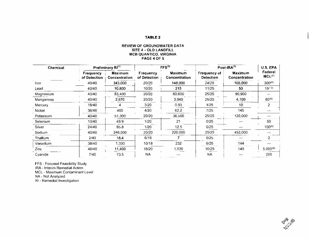
TABLE 2
REVIEW OF GROUNDWATER DATASITE 4 -OLD LANDFILL
MCB QUANTICO, VIRGINIAPAGE 4 OF 5
Chemical
Iron
Lead
Magnesium
Manganese
Mercury
Nickel
Potassium
Selenium
Silver
Sodium
Thallium
Vanadium
Zinc
Cyanide
Preliminary Rl(1)
Frequencyof Detection
40/40
40/40
40/40
40/40
18/40
36/40
MaximumConcentration
343,000
10,800
83,400
2,670
4
400
40/40 51,300
10/40 49.9
24/40 85.8
40/40 246,000
2/40
I 38/40
r 40/40
18.4
1,330
11,400
7/40 73.5
FFS'2'
Frequencyof Detection
20/20
10/20
MaximumConcentration
148,000
215
20/20 80,600
20/20 3,040
3/20 : 0.93
4/20
20/20
1/20
1/20
62.2
36,500
21
12.5
20/20 220,000
6/19 7
10/18 232
16/20 : 1,530
NA
Post-IRA(3)
Frequency ofDetection
24/25
11/25
25/25
25/25
1/25 ~~l
7/25
25/25
0/25
0/25
25/25
0/25
6/25
10/25
NA
MaximumConcentration
105,000
50
90,900
4,100
10
145
120,000—
—
453,000...
144
149
U.S. EPAFederalMCL<">
300<8>
15<10>
80<8>
2
——
50
100<8'—
2
5,000<8>
200
FFS - Focused Feasibility StudyIRA - Interim Remedial ActionMCL - Maximum Contaminant LevelNA - Not AnalyzedRl - Remedial Investigation

TABLE 2
REVIEW OF GROUNDWATER DATASITE 4-OLD LANDFILL
MCB QUANTICO, VIRGINIAPAGE 5 OF 5
Notes:
Highlighted cells indicate a groundwater concentration that exceeds the Federal MCL.A dash in the MCL column indicates that a numerical MCL does not exist for this analyte.Only unfiltered groundwater data are included in this table.Number of sample results excludes rejected data or non-qualified data. Duplicates are consolidated into one result.Frequency of detection refers to number of times a chemical was detected among all samples versus total number of samples.Number of samples may vary based on the number of usable results.
Footnotes:
1 Preliminary Rl (up to 1992)2 FFS Investigation (1994)3 Rl and FS (1997-1999)4 USEPA, National Primary Drinking Water Standards, Office of Water, EPA 816-F-02-013, July 2002.5 Values for cis-1,2-Dichloroethene is presented.6 Value for Technical Chlordane is presented.7 Value for Endrin is presented.8 Secondary MCL is presented.9 The new arsenic MCL of 10 ug/L becomes effective on January 23, 2006.10 The value presented is an action level.
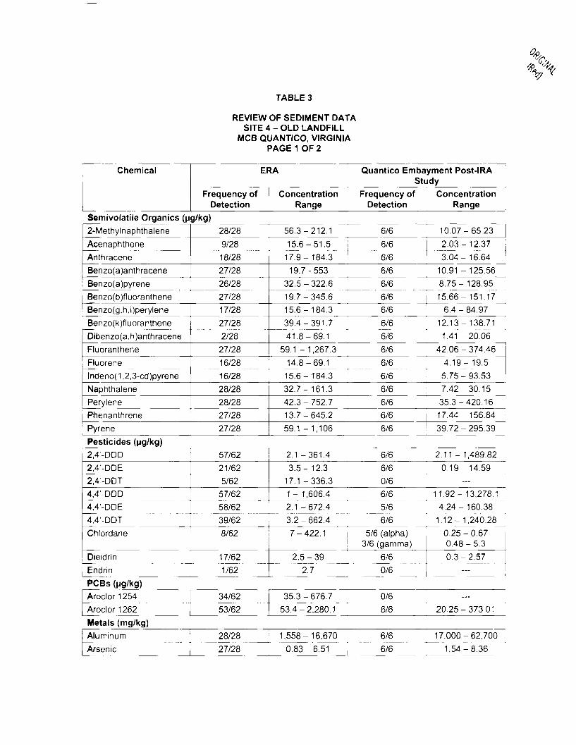
TABLE 3
REVIEW OF SEDIMENT DATASITE 4 -OLD LANDFILL
MCB QUANTICO, VIRGINIAPAGE 1 OF 2
Chemical ERA
Frequency of ConcentrationDetection Range
Quantico Embayment Post-IRAStudy
Frequency of ConcentrationDetection Range
Semivolatile Organics (ug/kg)
2-Methylnaphthalene
AcenaphtheneAnthracene
Benzo(a)anthracene
Benzo(a)pyreneBenzo(b)fluorantheneBenzo(g,h,i)perylene
Benzo(k)fluoranthene
Dibenzo(a,h)anthraceneFluoranthene
Fluorenelndeno(1 ,2,3-cd)pyreneNaphthalene
PerylenePhenanthrene
Pyrene
28/28
9/28
18/28
27/2826/28
27/2817/28
27/28
2/28
27/28
16/28
16/28
28/28
28/28
27/28
27/28
56.3-212.1
15.6-51.5
17.9-184.3
19.7-553
32.5-322.6
19.7-345.6
15.6-184.3
39.4-391.7
41.8-69.1
59.1 -1,267.3
14.8-69.1
15.6-184.3
32.7-161.3
42.3-752.7
13.7-645.2
59.1 -1,106
6/6
6/6
6/6
6/6
6/6
6/6
6/6
6/6
6/6
6/6
6/6
6/6
6/6
6/6
6/6
6/6
10.07-65.23
2.03-12.37
3.04- 16.64
10.91 - 125.56
8.75- 128.95
15.66- 151.17
6.4-84.97
12.13- 138.71
1.41 -20.06
42.06-374.46
4.19- 19.5
5.75-93.53
7.42-30.15
35.3-420.16
17.44- 156.84
39.72-295.39
Pesticides (ug/kg)2,4'-DDD2,4'-DDE2,4'-DDT4,4'-DDD4,4'-DDE
4,4'-DDTChlordane
Dieldrin
EndrinPCBs (ug/kg)
Aroclor 1254Aroclor 1262
Metals (mg/kg)Aluminum
Arsenic
57/6221/625/62
57/6258/6239/628/62
17/621/62
34/6253/62
28/28
27/28
2.1 -361.4
3.5- 12.317.1 -336.31 - 1,606.42.1 -672.43.2-662.4
7-422.1
2.5-392.7
35.3-676.7
53.4-2,280.1
1,558-16,670
0.83-6.51
6/6
6/6
0/6
6/6
5/6
6/6
5/6 (alpha)3/6 (gamma)
6/6
0/6
0/6
6/6
6/6
6/6
2.11 - 1,489.82
0.19- 14.59
—
11.92- 13,278.1
4.24-160.38
1.12- 1,240.28
0.25-0.670.48-5.3
0.3-2.57
—
—
20.25-373.01
17,000-62,700
1.54-8.36
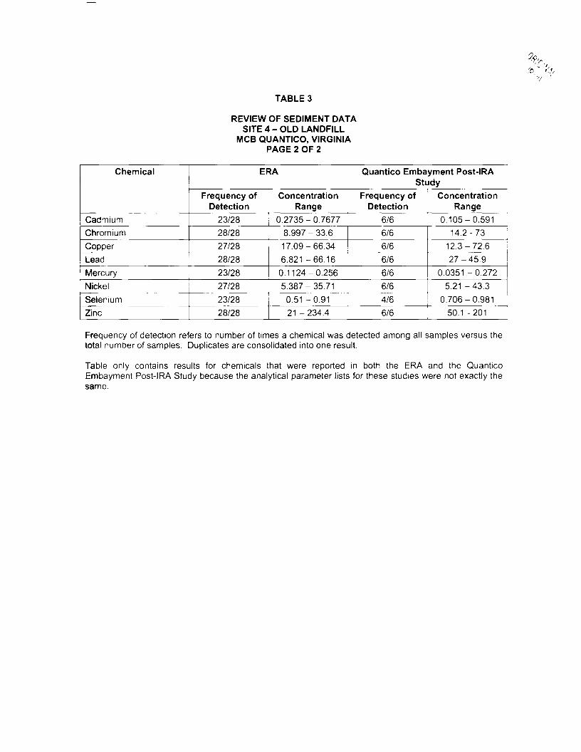
TABLE 3
REVIEW OF SEDIMENT DATASITE 4 - OLD LANDFILL
MCB QUANTICO, VIRGINIAPAGE 2 OF 2
Chemical
CadmiumChromium
Copper
ERA
Frequency of ConcentrationDetection Range
23/28 0.2735-0.767728/28
27/28Lead ! 28/28Mercury 23/28
NickelSelenium
Zinc
27/28
23/2828/28
8.997-33.617.09-66.34
6.821 -66.16
0.1124-0.2565.387-35.71
0.51 -0.9121 -234.4
Quantico Embayment Post-IRAStudy
Frequency of ConcentrationDetection Range
6/6
6/6
6/6
6/6
6/6
6/6
4/6
0.105-0.59114.2-73
12.3-72.6
27-45.90.0351 -0.272
5.21 -43.3
0.706-0.9816/6 50.1 -201
Frequency of detection refers to number of times a chemical was detected among all samples versus thetotal number of samples. Duplicates are consolidated into one result.
Table only contains results for chemicals that were reported in both the ERA and the QuanticoEmbayment Post-IRA Study because the analytical parameter lists for these studies were not exactly thesame.
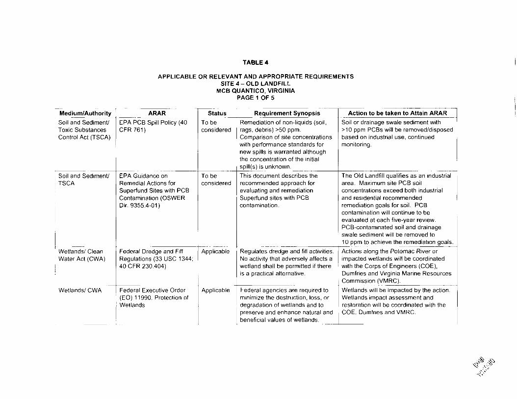
TABLE 4
APPLICABLE OR RELEVANT AND APPROPRIATE REQUIREMENTSSITE 4 -OLD LANDFILL
MCB QUANTICO, VIRGINIAPAGE 1 OF 5
Medium/Authority
Soil and Sediment/Toxic SubstancesControl Act (TSCA)
Soil and Sediment/TSCA
Wetlands/ CleanWater Act (CWA)
Wetlands/ CWA
ARAR
EPA PCB Spill Policy (40CFR761)
EPA Guidance onRemedial Actions forSuperfund Sites with PCBContamination (OSWERDir. 9355.4-01)
Federal Dredge and FillRegulations (33 USC 1344;40 CFR 230.404)
Federal Executive Order(EO) 11990, Protection ofWetlands
Status
To beconsidered
To beconsidered
Applicable
Applicable
Requirement Synopsis
Remediation of non-liquids (soil,rags, debris) >50 ppm.Comparison of site concentrationswith performance standards fornew spills is warranted althoughthe concentration of the initialspill(s) is unknown.
This document describes therecommended approach forevaluating and remediationSuperfund sites with PCBcontamination.
Regulates dredge and fill activities.No activity that adversely affects awetland shall be permitted if thereis a practical alternative.
Federal agencies are required tominimize the destruction, loss, ordegradation of wetlands and topreserve and enhance natural andbeneficial values of wetlands.
Action to be taken to Attain ARAR
Soil or drainage swale sediment with>10 ppm PCBs will be removed/disposedbased on industrial use, continuedmonitoring.
The Old Landfill qualifies as an industrialarea. Maximum site PCB soilconcentrations exceed both industrialand residential recommendedremediation goals for soil. PCBcontamination will continue to beevaluated at each five-year review.PCB-contaminated soil and drainageswale sediment will be removed to10 ppm to achieve the remediation goals.
Actions along the Potomac River orimpacted wetlands will be coordinatedwith the Corps of Engineers (COE),Dumfries and Virginia Marine ResourcesCommission (VMRC).
Wetlands will be impacted by the action.Wetlands impact assessment andrestoration will be coordinated with theCOE, Dumfries and VMRC.
TABLE 4
APPLICABLE OR RELEVANT AND APPROPRIATE REQUIREMENTSSITE 4 -OLD LANDFILL
MCB QUANTICO, VIRGINIAPAGE 2 OF 5
Medium/Authority
Shorelines/ CoastalZone ManagementAct (CZMA)
Floodplain/ CWA
Wetlands/ CWA
Wetlands/ CWA
Surface Water/CWA
Wetlands/ResourceConservation andRecovery Act(RCRA)
ARAR
16 USC 1451
Federal EO 11988,Consideration forFloodplains
Virginia Wetlands Act(Code of VA 62.1-13.1 etseqj
Virginia WetlandsRegulations Act (Code ofVA 62.1.13.1 etseq.; VRA450-01 -0051/4 VAC 20-390-10 etseq.)
Virginia Water ProtectionPermit Regulations (VR-680-15-02)
Virginia Water ManagementAct, Siting of HazardousWaste Facilities (Ch. 14VWMA Article 6, 10.1-1433)
Status
Applicable
Applicable
Applicable
Applicable
Applicable
Applicable
Requirement Synopsis
Protection of shorelines, wetlands,and runoff controls.
Federal agencies are required toreduce the risk of flood loss,minimize impact of floods, andrestore and preserve the naturaland beneficial value of floodplains.
Regulates activities in tidalwetlands.
Any activity to take place in, orimpact on, a tidal wetland mustmeet the provisions of the VirginiaWetlands Act and regulations asapplicable. Regulates activities intidal wetlands.
Applies to activities that affectdredge and fill of surface waters.Virginia's certification authorityunder CWA §401^
Protects wetland from facilitysiting.
Action to be taken to Attain ARAR
Alternative will impact shoreline,wetlands, and runoff controls. Alternativewill comply with substantive requirementsof CWA §404 and VPDES permit andlocal CZMA and erosion control boards.
Portions of the site are in the 100-yearfloodplain. Flood protection will includevegetative cover and riprap.
Coordinate compliance throughsubstantive regulations of CWA §404.
Any activity to place, or impact on, thetidal wetland of the Old Landfill mustmeet the provisions of the Act.Coordinate compliance throughsubstantive regulations of CWA §404.
Permit information will be coordinatedwith VMRC regarding wetlanddisturbances coordinated through VWPPat Virginia DEQ.
Alternative includes restoration.Restoration will be in accordance withthis standard.

TABLE 4
APPLICABLE OR RELEVANT AND APPROPRIATE REQUIREMENTSSITE 4-OLD LANDFILL
MCB QUANTICO, VIRGINIAPAGE 3 OF 5
Medium/Authority ARAR Status Requirement Synopsis Action to be taken to Attain ARAR
Surface Water/Chesapeake BayPreservation Act
Hazardous Waste/RCRA
Hazardous Waste/RCRA
Chesapeake BayPreservation AreaDesignation andManagement Regulations(Virginia) (Code of VACh.21,§10.1-2100; VR 173-02-01)
Applicable Limits land disturbing activitiesimpacting state surface waterquality. Chesapeake BayPreservation Act and Regulationsadministered by local C-BLAD.
Requires that certain locally designatedtidal and nontidal wetlands, as well asother sensitive land areas, be subject tolimitations regarding land-disturbingactivities, removal of vegetation, use ofimpervious cover, erosion and sedimentcontrol, stormwater management, andother aspects of land use that may haveeffects on water quality.
Virginia Hazardous WasteManagement Regulations(VHWMR)(VR 672-10-1/9VAC 20-60-10 etseq.);Federal Hazardous WasteRegulations (40 CFR 261-266,268,270-271)
Corrective Action for SolidWaste Management Unitsat Hazardous WasteManagement Facilities. 40CFR 264, 265, 270, 271
Solid Waste/ RCRA Virginia Solid WasteManagement Regulations(VR 672-20-10/9 VAC 20-80-10 et seq.)
Applicable
To beconsidered
Applicable
Controls generation, storage, anddisposal of solid and hazardouswaste. Regulations mirror thosedeveloped by EPA for hazardouswaste.
Corrective action procedures.
The disposal of any soil, debris,sludge, or any other solid wastefrom a site must be done incompliance with these regulations.
If the remedial response involvesstorage, treatment, or disposal ofVHWMR/RCRA hazardous waste,various VHWMR/RCRA requirementsmay need to be complied with asspecified in the VHWMR and/orapplicable 40 CFR parts. BecauseVirginia administers an authorized stateRCRA program, the VHWMR will serveas the governing ARAR in place of theRCRA regulations.
Will be used as guidance whendeveloping remedial strategies.
The disposal of any soil, debris, sludge,or any other solid waste from the OldLandfill site must be done in compliancewith the regulations.
TABLE 4
APPLICABLE OR RELEVANT AND APPROPRIATE REQUIREMENTSSITE 4-OLD LANDFILL
MCB QUANTICO, VIRGINIAPAGE 4 OF 5
Medium/Authority
Surface Water/CWA
Surface Water/CWA
Surface Water/CWA
Surface Water/CWA
Surface Water/CWA
ARAR
NPDES Regulations (40CFR 122)
Federal Ambient WaterQuality Criteria (AWQC) (40CFR 131)
Virginia Pollutant DischargeElimination System(VPDES) Regulations(VR680-14-01/9 VAC 25-30-10 etseq.)
Virginia Water QualityStandards (VR 680-21-00)
Virginia StormwaterManagement Act (Code ofVA Sections 10.1-603.1 etseq.); Virginia StormwaterManagement Regulations(VF 215-02-00/4 VAC 3-20-10 etseq.)
Status
Applicable
Applicable
Applicable
Applicable
Applicable
Requirement Synopsis
Controls discharges ofcontaminants to surface water.
AWQC may be considered foractions that involve discharges tostate surface waters.
Establishes the mechanism forpermitting of discharges to statewaters through VPDES.
Provides water quality standardsfor surface water.
All land-disturbing activities mustbe in compliance with localStormwater managementprograms, where they exist.
Action to be taken to Attain ARAR
Criteria will be followed in the design andoperation of any watertreatment/discharge system.
Comply with substantive requirements ofNPDES and storm water regulations asidentified by Virginia DEQ.
Comply with the substantiverequirements of VPDES and storm waterregulations as identified by Virginia DEQ.
Standards are used for basis to developand comply with the substantiverequirements of VPDES dischargepermits for PCB hot spots andexcavation activities and storm waterregulations as identified by Virginia DEQ.
Comply with substantive requirements asidentified by Virginia DEQ.
TABLE 4
APPLICABLE OR RELEVANT AND APPROPRIATE REQUIREMENTSSITE 4-OLD LANDFILL
MCB QUANTICO, VIRGINIAPAGE 5 OF 5
Medium/Authority
Air/ Clean Air Act(CM)
Air/ CAA
Surface Water/CWA
ARAR
National Ambient AirQuality Standards (40 CFR50)
Virginia Regulations for theControl and Abatement ofAir Pollution (VR 120-01-1through VR 120-08-065/9VAC 5-10-10 through 9VAC 5-80-350)
Virginia Erosion andSediment ControlRegulations (VR 625-02-00)
Status
Applicable
Applicable
Applicable
Requirement Synopsis
Controls emission of unacceptablelevels of airborne particulates tothe atmosphere. The primary andsecondary standards forparticulate matter, expressed asPM-10 are 150 (24-hour, annualarithmetic mean) and 50 (1-year,annual arithmetic mean),respectively.Established ambient air qualitygoals and regulates the dischargeof pollutants into the atmosphere.
Establishes minimum design andimplementation standards tocontrol erosion and sedimentationfrom construction sites.
Action to be taken to Attain ARAR
Alternative may result in emission ofunacceptable levels of airborneparticulates to the atmosphere. Sitewetting will be used to control particulatematter and fugitive dust in compliancewith Virginia DEQ air regulations.
Particulates may be released into theatmosphere during remediation. Sitewetting will be used to controlparticulates and fugitive dust incompliance with Virginia DEQ airregulations.
An erosion and sediment control plan willbe prepared and submitted for Virginiaand Navy before engaging in any landdisturbing activity.

%„V*
FORMERTRANSFORMER
STORAGEAREA(B-8)
FORMERDRAINAGECHANNEL
QUANTICOEMBAYMENT
Fit) Tetn Tech NUS, Inc
SI Tt LAYOUT
SITE 4 • OLD LANDFILL
MCCOC QUANTICO, VIRGINIA
MMwa_auMmcowB.<u_TMiMBirTE4-<vinc-nunouT XM kin

Xfa <
APPENDIX A
SITE VISIT PHOTOGRAPHS
MVC - 004S: Overview of the constructed wetland, looking roughly south from the northern(upgradient) end of the wetland.
MVC - 006S: View of upper (north) end of constructed wetland showing dense emergentvegetation and frequent black willow seedlings.

MVC - 007S: Overview of cap surface on the landfill.
MVC - 009S: Foreground shows a dense patch of groundsel tree within the constructed wetland.Background shows a dense thicket of black willow.
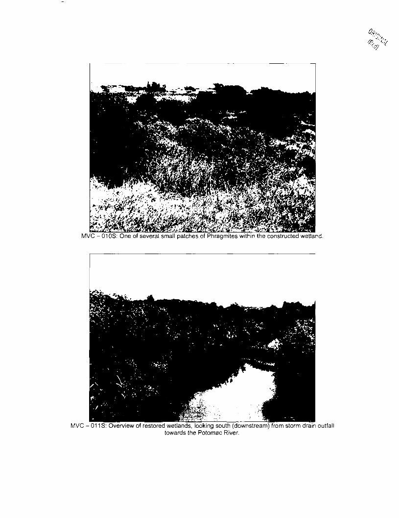
MVC - 01 OS: One of several small patches of Phragmites within the constructed wetland.
MVC - 011S: Overview of restored wetlands, looking south (downstream) from storm drain outfalltowards the Potomac River.
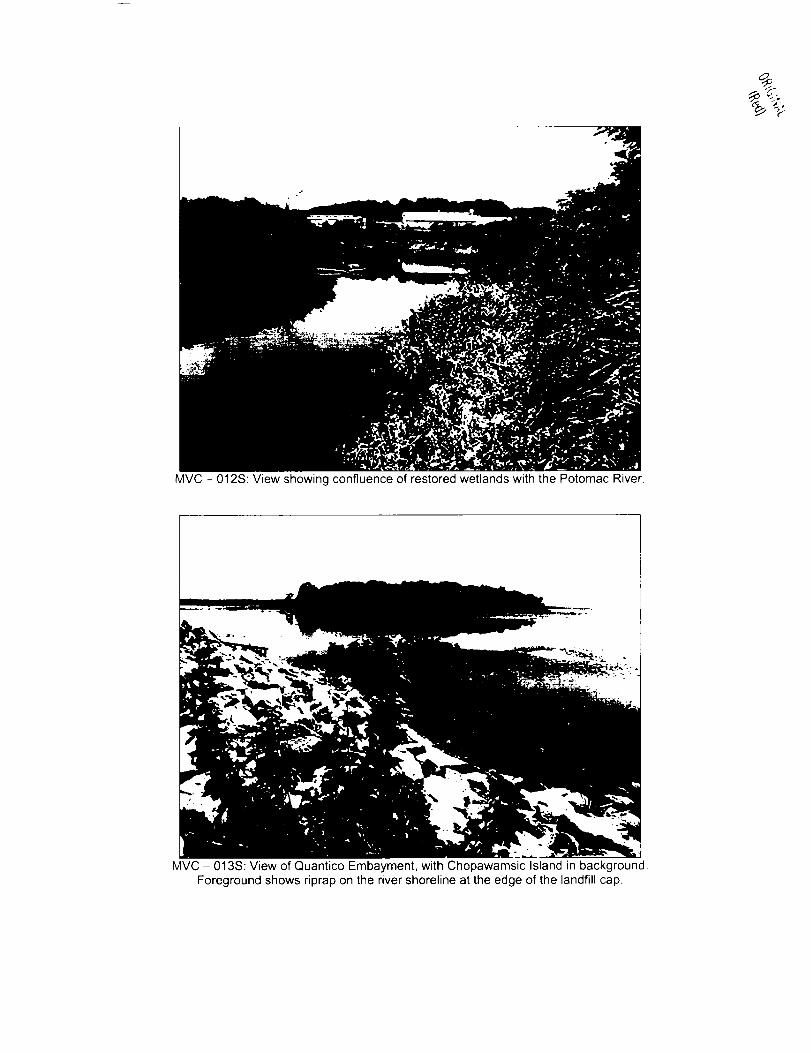
MVC - 012S: View showing confluence of restored wetlands with the Potomac River.
MVC - 013S: View of Quantico Embayment, with Chopawamsic Island in background.Foreground shows riprap on the river shoreline at the edge of the landfill cap.

MVC - 015S: Riprap on the Potomac River shoreline at the edge of the landfill cap.
MVC - 018S: Dense emergent vegetation in the restored wetland.
APPENDIX B
WETLAND INSPECTION MEMORANDUM
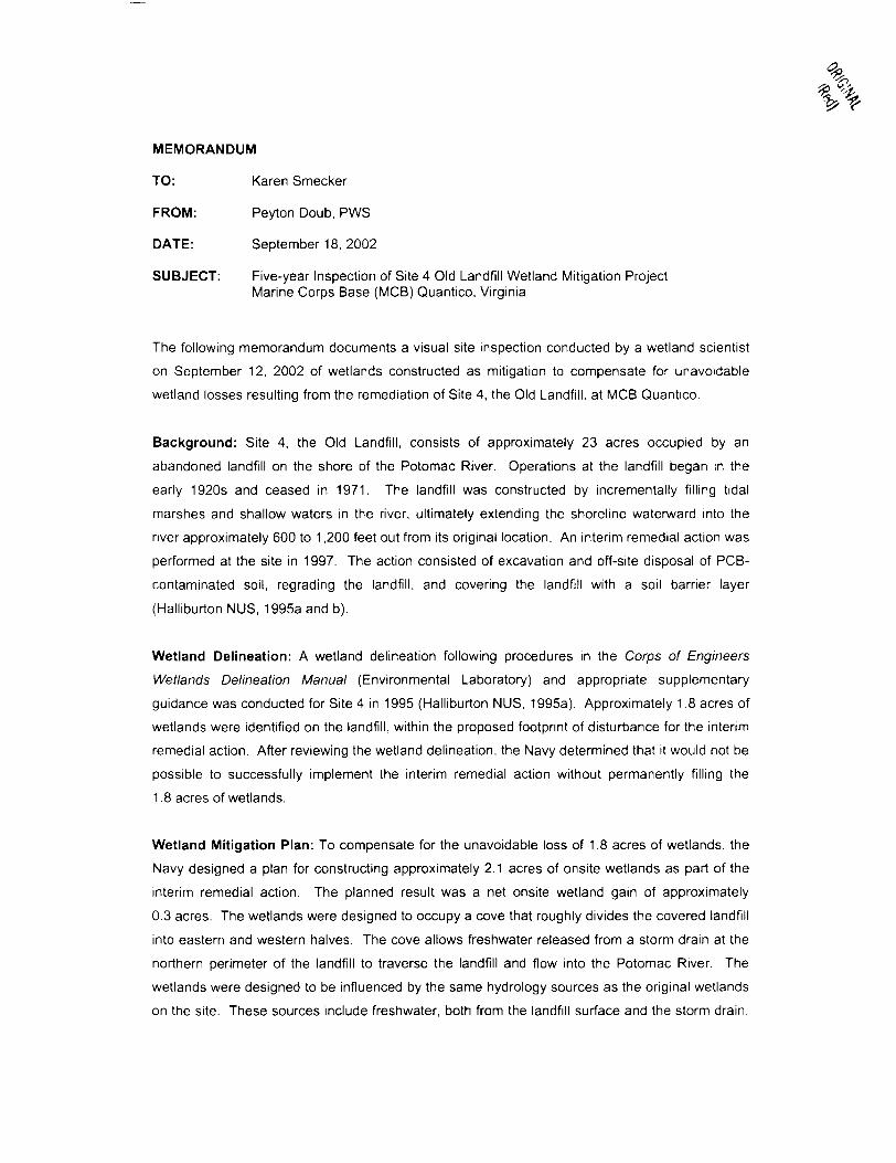
MEMORANDUM
TO: Karen Smecker
FROM: Peyton Doub, PWS
DATE: September 18, 2002
SUBJECT: Five-year Inspection of Site 4 Old Landfill Wetland Mitigation ProjectMarine Corps Base (MCB) Quantico, Virginia
The following memorandum documents a visual site inspection conducted by a wetland scientist
on September 12, 2002 of wetlands constructed as mitigation to compensate for unavoidable
wetland losses resulting from the remediation of Site 4, the Old Landfill, at MCB Quantico.
Background: Site 4, the Old Landfill, consists of approximately 23 acres occupied by an
abandoned landfill on the shore of the Potomac River. Operations at the landfill began in the
early 1920s and ceased in 1971. The landfill was constructed by incrementally filling tidal
marshes and shallow waters in the river, ultimately extending the shoreline waterward into the
river approximately 600 to 1,200 feet out from its original location. An interim remedial action was
performed at the site in 1997. The action consisted of excavation and off-site disposal of PCB-
contaminated soil, regrading the landfill, and covering the landfill with a soil barrier layer
(Halliburton NUS, 1995a and b).
Wetland Delineation: A wetland delineation following procedures in the Corps of Engineers
Wetlands Delineation Manual (Environmental Laboratory) and appropriate supplementary
guidance was conducted for Site 4 in 1995 (Halliburton NUS, 1995a). Approximately 1.8 acres of
wetlands were identified on the landfill, within the proposed footprint of disturbance for the interim
remedial action. After reviewing the wetland delineation, the Navy determined that it would not be
possible to successfully implement the interim remedial action without permanently filling the
1.8 acres of wetlands.
Wetland Mitigation Plan: To compensate for the unavoidable loss of 1.8 acres of wetlands, the
Navy designed a plan for constructing approximately 2.1 acres of onsite wetlands as part of the
interim remedial action. The planned result was a net onsite wetland gain of approximately
0.3 acres. The wetlands were designed to occupy a cove that roughly divides the covered landfill
into eastern and western halves. The cove allows freshwater released from a storm drain at the
northern perimeter of the landfill to traverse the landfill and flow into the Potomac River. The
wetlands were designed to be influenced by the same hydrology sources as the original wetlands
on the site. These sources include freshwater, both from the landfill surface and the storm drain.
MEMORANDUMFive-year Inspection of Wetland Mitigation ProjectSite 4 Old Landfill at MCB QuanticoSeptember 18, 2002Page 2 of 10
and the tides of the Potomac River (Halliburton NUS, 1995c). The Potomac River, although tidal
at MCB Quantico, is normally fresh or nearly fresh, with salinities normally less than 5 parts per
thousand during all seasons (White, 1989).
The design called for planting three zones of herbaceous vegetation keyed to elevation as
follows:
• Elevations Below 1 Foot: Saltmeadow Cordgrass (Spartina alterniflora)
• Elevations Between 1 and 2 Feet: Common Three-square (Scirpus americanus)
• Elevations Between 2 and 3 Feet: Soft-stem Bulrush (Scirpus validus)
These species were selected because they are regionally indigenous, establish and spread
rapidly, provide effective soil stabilization, and are of good value to wildlife. The design also
called for planting more widely spaced accents of other herbaceous species that typically occur in
similar landscape settings and are of good value to wildlife but which could not be counted on to
establish and spread rapidly. Accent species used in the design include deep-water duck potato
(Sagittaria rigida, for elevations below 1 foot), pickerelweed (Pontederia cordata, for elevations
between 1 and 2 feet), and marsh hibiscus (Hibiscus moscheutos, for elevations between 2 and
3 feet). The design also called for planting a fringe of woody vegetation around the edges of the
wetland, including black willow (Sa//'x nigra) and red maple (Acer rubrum) (both trees) and
elderberry (Sambucus canadensis) and groundsel tree (Baccharis halimifolia) (both shrubs)
(Halliburton NUS, 1995c).
The expectation was that water in the wetland would be fresh or nearly fresh (normally with a
salinity of less than 5 parts per thousand) but that at least some of the vegetation would have to
be able to withstand brief, episodic incursions of weakly brackish water (with salinities as high as
7 or 8 parts per thousand).
Installation of Wetland Mitigation Plan: OHM Remediation Services Corporation (OHM) and
their subcontractor, Coastal Environmental Services (Coastal), constructed the wetlands and
installed the plant material called for in the wetland mitigation plan in 1997. Coastal substituted
arrow arum (Peltandra virginica) for the deep-water duck potato. Coastal also shifted the planting
of the pickerelweed 25 feet downgradient (i.e. toward the lower elevations in the center of the
wetland) to provide that species with a deeper hydrological regime. Planting took place between

MEMORANDUMFive-year Inspection of Wetland Mitigation ProjectSite 4 Old Landfill at MCB QuanticoSeptember 18, 2002Page 3 of 10
April and June 1997. Planting was periodically delayed during this period by incidents of high
tidal flooding of the wetland (Coastal, 1997).
OHM and Coastal inspected the wetland mitigation area in November 1997 and presented their
observations in a written report. The report stated that a vigorous herbaceous stand comprised
predominantly of the planted soft-stem bulrush, common three-square, and saltmeadow
cordgrass had become established over much of the wetland. Several volunteer herbaceous
species had also reportedly begun to colonize the wetland. The volunteer species reportedly
included flat sedge (Cyperus sp.), soft rush (Juncus effusus), common cattail (Typha latifolia).
and smartweed (Polygonum persicaria) (Coastal, 1997).
Vegetative coverage was described as sparser in the upper (drier) fringe of the wetland. Possible
explanations provided in the report included flooding, herbivory, and low rainfall during the
summer of 1997. The report did not, however, recommend additional planting. It stated that tidal
wetland hydrology had been successfully established throughout the wetland and areas of sparse
vegetation in November 1997 would likely become colonized naturally by desirable wetland plant
species (Coastal, 1997).
A Site Inspection Checklist and Repair Report prepared by OHM in July 1998 stated that OHM
replanted vegetation in the wetland area (OHM, 1998). The reports did not provide information
on how much of the vegetation required replanting or what vegetation was used in the replanting.
It is assumed that OHM adhered to the original planting scheme when replacing vegetation.
Five-Year Inspection: September 12, 2002: Peyton Doub, PWS, CEP of Tetra Tech NUS. who
prepared the wetland mitigation plan design, visited the site on Thursday, September 12, 2002 to
evaluate the wetland five years following its installation. Also present were Andrew Gutberlet of
Engineering Field Activity Chesapeake, Lisa Bradford of the U.S. Environmental Protection
Agency, and Matias Santiago of the Natural Resources and Environmental Affairs (NREA) office
of MCB Quantico.
The entire wetland mitigation area, extending to the toe of the surrounding slope, consisted of
dense vegetated wetlands (Photo 1). A shallow stream of running water, fed by the storm outlet
at the northern head of the wetland (Photo 2), flowed down the center of the wetland to the
Potomac River. The stream was less than 10 feet wide, roughly 6-12 inches deep, and lacked
emergent vegetation (Photo 3). Lower-elevation lands adjoining the stream supported dense

MEMORANDUMFive-year Inspection of Wetland Mitigation ProjectSite 4 Old Landfill at MCB QuanticoSeptember 18, 2002Page 4 of 10
emergent vegetation and were saturated at the surface. Higher-elevation lands around the upper
edge of the wetland were not saturated on the surface, but the vegetation displayed watermarks
suggesting that this drier portion of the wetland had recently experienced as much as an inch of
inundation.
Vegetation within all parts of the wetland was dense and dominated throughout by herbaceous
plant species that typically grow in wetlands (i.e. hydrophytes). Most of the wetland supported
dense patches of the following species: jewelweed (Impatiens capensis), soft rush, soft-stem
bulrush, common three-square, common cattail, woolgrass (Scirpus cyperinus), and rice cutgrass
(Leers/a oryzoides). All of these dominant species are regionally indigenous hydrophytes (i.e.,
wetland-dwelling plants) with wetland indicator statuses of Facultative Wetland (FACW) or
Obligate Wetland (OBL) (Reed, 1988). The soft-stem bulrush and common three-square were
components of the original design; the remainder of the dominant species were not planted and
therefore could have only become established as natural volunteers.
Other plant species frequently observed in the wetland include marsh hibiscus, pickerelweed.
smartweed. coreopsis (Coreopsis sp.), and tall ironweed (Vernonia altissima). With the exception
of the coreopsis (which could not be identified to species), all of these scattered accent plants are
regionally indigenous hydrophytes with wetland indicator statuses of Facultative Wetland (FACW)
or Obligate Wetland (OBL) (Reed. 1988). The marsh hibiscus and pickerelweed were
components of the original design; the other species were not planted and therefore could have
only become established as natural volunteers.
A dense fringe of black willow saplings was observed at the outer edge of the wetlands, at the toe
of the surrounding slope (Photo 4). The original design called for planting a mixture of black
willow and red maple at the fringe of the wetland. At least some of the black willows appear to be
the planted specimens, while others are likely volunteers. No red maple was observed. Coastal
had reported that the planted red maple had not been growing well during the November 1997
inspection (Coastal, 1997). Considering that red maple has a broad tolerance of hydrological
settings, the most likely explanation for its failure at this site would be the Summer 1997 drought
at the time of planting. Several volunteer tree saplings of other species were observed at widely
scattered locations within the wetland, including sycamore (Platanus occidentalis), elm (Ulmus
americana), and eastern cottonwood (Populus delloides). All are regionally indigenous species
that are ecologically desirable for wildlife.

MEMORANDUMFive-year Inspection of Wetland Mitigation ProjectSite 4 Old Landfill at MCB QuanticoSeptember 18, 2002Page 5 of 10
Among the shrubs, dense patches of groundsel tree were observed, especially near the fringe of
the wetland where this species was planted (Photo 5). No elderberry (the other planted shrub
species) was observed. Reasons for the non-survival of elderberry in the wetland are not
apparent. However, silky dogwood (Cornus amomum), another regionally indigenous shrub
typical of wetlands with fresh or nearly fresh water, was observed to have volunteered at several
locations in the wetland.
The only invasive or exotic vegetation observed in the wetland were a few small clumps of
phragmites (Phragmites australis) (Photo 6). Phragmites does not appear to established
dominance over the wetland. However, the clumps could eventually spread, especially if the
other vegetation experiences new stresses in the future.
Conclusions: The following conclusions are drawn from observations made during the five-year
inspection of the wetlands on September 12, 2002:
1. The entire 2.1-acre constructed wetland (wetland mitigation area) called for in the wetland
mitigation plan for the Site 4 Interim Remedial Action has been successfully established as a
wetland.
2. The Site 4 Interim Remedial Action resulted in the loss of approximately 1.8 acres of
wetlands adjacent to the Potomac River but also resulted in the successful establishment of
2.1 acres of wetlands adjacent to the Potomac River, a net onsite wetland gain of
approximately 0.3 acres.
3. The planted vegetation appears to have successfully stabilized surface soils throughout the
constructed wetland in the early years, allowing a mixed community of regionally indigenous
wetland plants (hydrophytes) to become established throughout most of the wetland through
natural successional processes.
4. The mixture of regionally indigenous wetland herbs, shrubs, and tree saplings that have
become established in the constructed wetland appears to provide high-quality wildlife habitat
similar to that previously provided by the wetlands lost as a result of the Interim Remedial
Action.

MEMORANDUMFive-year Inspection of Wetland Mitigation ProjectSite 4 Old Landfill at MCB QuanticoSeptember 18, 2002Page 6 of 10
5. The fact that certain of the plant species planted in the constructed wetland at the time of its
initial establishment are no longer is not a matter of concern. Their absence is offset by the
presence of many other ecologically desirable volunteer species capable of occupying similar
ecological niches.
6. A few small clumps of an invasive plant species, Phragmites, have become established at
multiple widely scattered locations within the wetland. These clumps represent the only
exotic and/or invasive vegetation that has established in the wetland.
Recommendations: The following recommendations are offered for future management of the
wetland mitigation project:
1. Because ecologically desirable, regionally indigenous wetland vegetation has become
successfully established throughout nearly the entire wetland, no supplemental planting of
additional vegetation is recommended.
2. It is recommended that the Phragmites clumps be sprayed with a systemic herbicide,
appropriately labeled for use in aquatic habitats, to prevent their spread. Because of the
small size of the clumps and the vigor of surrounding vegetation, desirable herbaceous
vegetation is expected to rapidly fill in areas of sprayed Phragmites. Planting replacement
vegetation in the gaps is not recommended.
3. Other than the spot treatment of the Phragmites clumps with herbicide, no application of
pesticides or fertilizers appears to be necessary at this time.
4. Because physical stresses such as herbivory and drought do not appear to be adversely
affecting the vegetation in the wetland, no watering or other actions to counteract such
stresses are recommended at this time.
5. Because the wetland and its vegetation appear to be well established at this time, continued
monitoring of the wetland does not appear to be necessary. However, the wetland should be
managed in a manner commensurate with other naturally vegetated areas on MCB Quantico.

MEMORANDUMFive-year Inspection of Wetland Mitigation ProjectSite 4 Old Landfill at MCB QuanticoSeptember 18, 2002Page 7 of 10
REFERENCES
Coastal (Coastal Environmental Services, Inc.). 1997. As-Built Description of Wetland Planting,
Old Landfill as Marine Corps Combat Development Command (MCCDC), Quantico, Virginia.
Prepared for OHM Remediation Services Corp., Pittsburgh, Pennsylvania. Project No. 41-
133.01, December 17, 1997.
Halliburton NUS. 1995a. Wetland Delineation Report for Site 4 Old Landfill at Marine Corps
Combat Development Command (MCCDC), Quantico. Virginia. Prepared for Engineering Field
Activity Chesapeake, Naval Facilities Engineering Command, Washington, DC under Northern
Division Contract Number N62472-90-D-1298, Contract Task Order 198.
Halliburton NUS. 1995b. Erosion and Sediment Control Plan Report for Interim Remedial Action
at Site 4 - Old Landfill, Marine Corps Combat Development Command (MCCDC), Quantico,
Virginia. Prepared for Engineering Field Activity Chesapeake, Naval Facilities Engineering
Command, Washington, DC under Northern Division Contract Number N62472-90-D-1298,
Contract Task Order 198.
Halliburton NUS. 1995c. Wetland Mitigation Plan for Site 4 Old Landfill at Marine Corps Combat
Development Command (MCCDC), Quantico, Virginia. NAVFAC Drawing Number 3089092,
Sheet 16 of 17, Sheet Number C-14. Prepared for Engineering Field Activity Chesapeake, Naval
Facilities Engineering Command, Washington, DC under Northern Division Contract Number
N62472-90-D-1298, Contract Task Order 198.
OHM (OHM Remediation Services Corp.). 1998. Site Inspection Checklist and Repair Report,
July 1998.
Reed, P. B. 1988. National List of Plant Species that Occur in Wetlands. U.S. Fish and Wildlife
Service. U.S. Army Corps of Engineers, U.S. Environmental Protection Agency, and U.S. Soil
Conservation Service. Biological Report 88(24), September 1988.
White, C. P. 1989. Chesapeake Bay - A Field Guide. Tidewater Publishers, Centreville,
Maryland.

MEMORANDUMFive-year Inspection of Wetland Mitigation ProjectSite 4 Old Landfill at MCB QuanticoSeptember 18, 2002Page 8 of 10
Photo 1: Overview of the constructed wetland at Site 4 Old Landfill.
*}*& :!>&'K&JL--V&&,. :.
1f£"~; .i*^--ov>J?s: --1 :'•''iVvv *f-^' '4v &?%,"
^••JEfSs.3>'?V:.jLJW'
Photo 2: Storm drain outfall at upgradient point in the constructed Site 4 wetland.
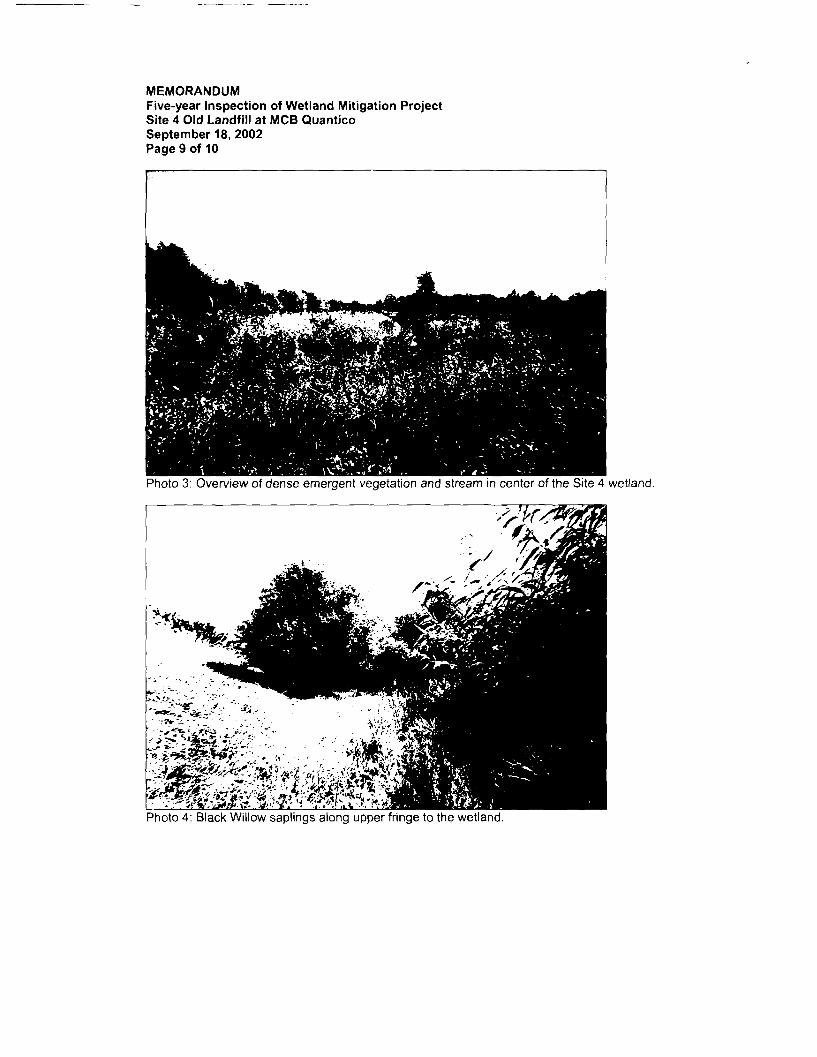
MEMORANDUMFive-year Inspection of Wetland Mitigation ProjectSite 4 Old Landfill at MCB QuanticoSeptember 18, 2002Page 9 of 10
Photo 3: Overview of dense emergent vegetation and stream in center of the Site 4 wetland.
Photo 4: Black Willow saplings along upper fringe to the wetland.
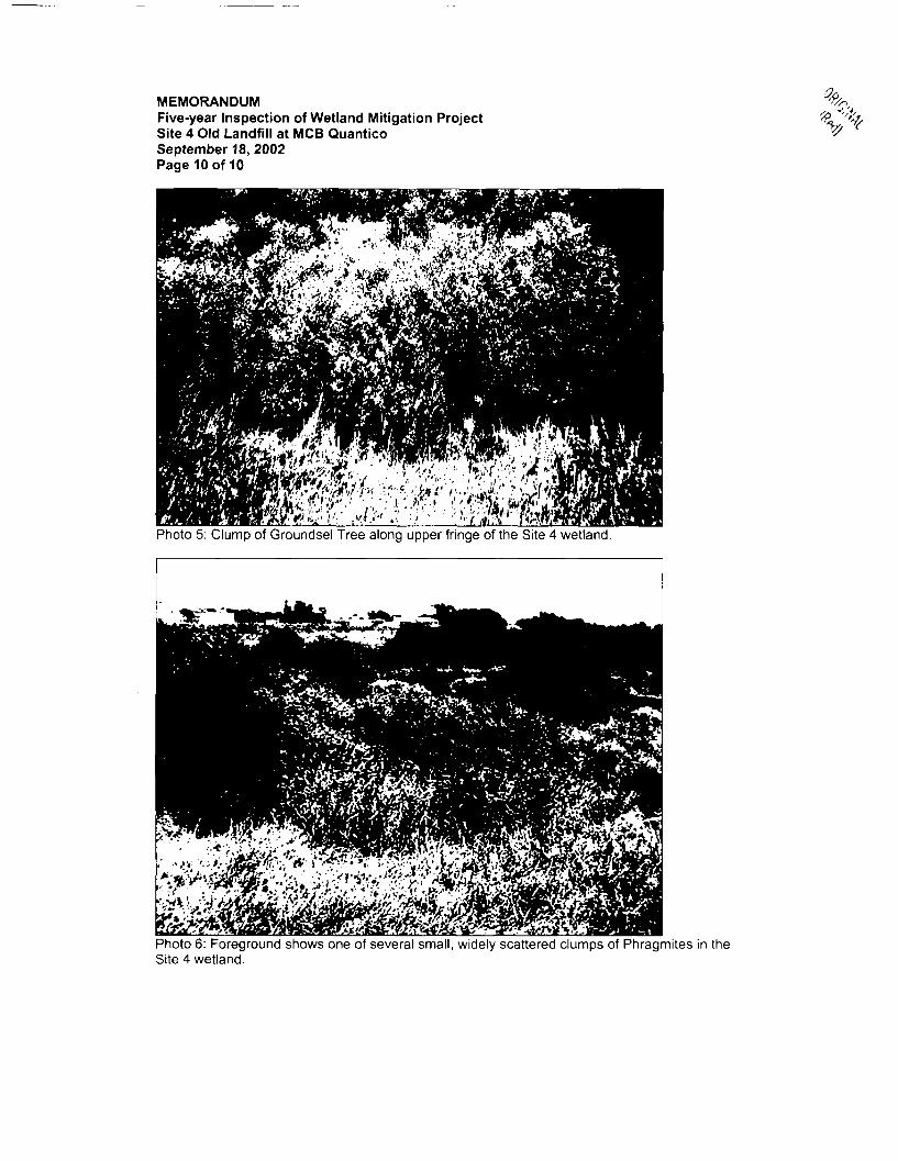
MEMORANDUMFive-year Inspection of Wetland Mitigation ProjectSite 4 Old Landfill at MCB QuanticoSeptember 18, 2002Page 10 of 10
%,
Photo 5: Clump of Groundsel Tree along upper fringe of the Site 4 wetland.
Photo 6: Foreground shows one of several small, widely scattered clumps of Phragmites in theSite 4 wetland.