Embed Size (px)
Citation preview

IN THE UNITED STATES BANKRUPTCY COURTFOR THE DISTRICT OF DELAWARE
)In re: ) Chapter 11
)EXTRACTION OIL & GAS, INC. et al.,1
Debtors.
)))))))))
Case No. 20-11548 (CSS)
Jointly Administered
Hearing Date: December 11, 2020 at 1:00 p.m. (ET)
Re: Docket Nos. 1063, 1180 & 1202
DEBTORS’ SUR-REPLY IN SUPPORTOF DEBTORS’ OBJECTION TO MOTION TO COMPEL ABANDONMENT
The above-captioned debtors and debtors in possession (collectively, the “Debtors”)
respectfully submit this sur-reply (the “Sur-Reply”) in response to the Movant’s reply [Docket
No. 1202] (the “Reply”) in further opposition to the Motion. The Debtors further submit the
Declaration of Chandler Newhall in Support of the Debtors’ Sur-Reply in Support of Debtors’
Objection to Motion to Compel Abandonment (the “Newhall Declaration”), attached hereto as
Exhibit 1, in support of this Sur-Reply.2
1 The Debtors in these chapter 11 cases, along with the last four digits of each Debtor’s federal tax identification number, are: Extraction Oil & Gas, Inc. (3923); 7N, LLC (4912); 8 North, LLC (0904); Axis Exploration, LLC (8170); Extraction Finance Corp. (7117); Mountaintop Minerals, LLC (7256); Northwest Corridor Holdings, LLC (9353); Table Mountain Resources, LLC (5070); XOG Services, LLC (6915); and XTR Midstream, LLC (5624). The location of the Debtors’ principal place of business is 370 17th Street, Suite 5300, Denver, Colorado 80202.
2 Capitalized terms used throughout but not defined shall have the meaning ascribed to them in the Debtors’ Objection to Motion to Compel Abandonment [Docket No. 1180] (the “Objection”).
Case 20-11548-CSS Doc 1288 Filed 12/09/20 Page 1 of 10

2
Relevant Background
1. As the Court is aware, on November 12, 2020, the Movant filed the Motion, seeking
to compel the Debtors to abandon their interests in the Wells. On November 25, 2020, the Debtors
filed their Objection and on November 30, 2020, the Movant filed the Reply. At a hearing held
on December 3, 2020, the Court set this matter for an evidentiary hearing and granted the Debtors
an opportunity to file this Sur-Reply.
2. By and through the Motion, the Movant seeks to compel the Debtors to abandon
the Wells located on the Movant’s property, alleging they are burdensome to the estate simply
because they are not currently producing hydrocarbons.
3. The Movant has failed to establish sufficient cause under 11 U.S.C. § 554(b) for
the Court to order the Debtors to abandon the Wells. As discussed in the Objection, the purpose
of 11 U.S.C. § 554(b), “is to prevent a trustee from unnecessarily selling property without value
to the estate merely in order to earn a commission.” See In re DiDario, 232 B.R. 311, 313 (Bankr.
D. N.J. 1999) (internal citations omitted). “Abandonment should only be compelled in order to
help the creditors by assuring some benefit in the administration of each asset.” In re K.C. Machine
& Tool Co., 816 F.2d 238, 246 (6th Cir. 1987).
4. This Motion is not driven by an intent to rid the estate of allegedly “burdensome”
property, but rather, is concerned with the marketability of Movant’s land. The Movant has entered
into a contract to sell the land where one of the Wells is situated, knowing that this sale and the
Movant’s financial gain is contingent upon the Well being plugged and abandoned at the Debtor’s
financial loss. See Reply at Exhibit 1, §§ 19-13. The Movant explicitly states that he is not under
contract to sell the land where two of the three Wells are located, but he “expects to begin
marketing the land soon.” Id. at § 14. The Movant entered into a contract for the sale of his land
knowing that his sale would be contingent upon the plugging and abandonment of the Bydalek
Case 20-11548-CSS Doc 1288 Filed 12/09/20 Page 2 of 10

3
2-11 Well. The Movant’s unilateral business decisions, and a future, hypothetical sale of his lands
should not distract from, and potentially derail, the Debtors’ restructuring. Plugging and
abandoning would require significant time and resources and jeopardize the Debtors’ go-forward
operations and future strategic developments.
5. Throughout the Motion and Reply, the Movant continually misstated both the
underlying facts of this matter, as well as the Colorado law at play. Ultimately, however,
discussions of the state law are not relevant to the question of whether the Wells constitute property
that is burdensome or of no benefit or of inconsequential value to the estate.
Argument
I. The Wells are not ‘uneconomic.’ Rather, the leased premises have historically produced hydrocarbons per the terms of each lease.
6. By the Reply, the Movant focuses on the alleged “uneconomic” nature of the Wells.
Reply at §§ 10-12. While the Movant concedes that the Wells were shut-in for safety reasons “for
some period of time,” they allege that shut-ins since May 2020 have not been due to safety reasons,
and that the Wells are “uneconomic and of inconsequential value and benefit” to the estate. See Id.
at §§ 8, 15.
7. First, the Movant mischaracterizes the nature of the applicable case law. As an
initial matter, Colorado law does not conceptualize uneconomic or economic gas and oil
production, but rather whether leased premises are producing hydrocarbons. It is well-settled
Colorado state law that so long as the lease premises were producing oil and gas in paying
quantities, production clauses are satisfied. Davis v. Cramer, 837 P.2d 218, 222 (Colo. App.
1992). Further, courts consistently look at production over a reasonable, extended period of time,
not short-term snapshots.
Case 20-11548-CSS Doc 1288 Filed 12/09/20 Page 3 of 10

4
8. Colorado courts have not established a specific time period to consider when
determining whether a leased premises is producing in paying quantities, but those jurisdictions
that have directly addressed the issue recognize that:
the proper accounting period is to be a reasonable time, depending upon the circumstances of each case, taking into consideration sufficient time to reflect the current production status of the lease and thus provide the information which a prudent operator would take into account in whether to continue or to abandon the operation.
Wrestler v. Colt, 7 Kan. App. 2d 553, 555–56, 644 P.2d 1342, 1345 (Kan. App. 1982) (quoting
Texaco Inc. v. Fox, 228 Kan. 589, Syl. P3, 618 P.2d 833 (1980)); see also Transp. Oil Co. v. Exeter
Oil Co., 84 Cal. App. 2d 616, 623–24, 191 P.2d 129, 134 (Cal. App. 1948) (“In the absence of
compelling reasons to the contrary, the profitability of a lease should, where possible, be
determined over a relatively long-term period, so that expenses subject to wide fluctuations may
be exposed to the leveling influences of time.”).
9. And while the Movant cites to Clifton v. Koontz, a Texas case from 1959, even the
Texas Supreme Court has held that “there can be no limit as to time” and recognized that
“[n]arrowing the question on paying production to any particular time period is necessarily
arbitrary.” See BP Am. Production Co. v. Laddex, Ltd., 513 S.W.3d 476, 485 (Tex. 2017) (citations
omitted). Moreover, jurisdictions, including Texas, routinely find that “[a] lessor seeking to
establish that an oil and gas lease terminated because of cessation of production of paying
quantities must meet a two-prong test, namely, that the lease failed to yield a profit over a
reasonable period of time, and that a reasonably prudent operator would not have continued to
operate the well in the manner in which it was being operated for the purpose of making a profit
and not merely for speculation.” Am. Jur. 2d Gas and Oil at § 214 (emphasis added) (citing
Cannon v. Sun-Key Oil Co., Inc., 117 S.W.3d 416 (Tex. App. Eastland 2003). Further, “[i]t is the
general rule that the temporary cessation of production will not automatically terminate an oil and
Case 20-11548-CSS Doc 1288 Filed 12/09/20 Page 4 of 10

5
gas lease. The equities dictate that, in the ordinary case, the operator be allowed a reasonable time
to bring the lease back into production.” See Sorum v. Schwartz, 344 N.W.2d 73, 76 (N.D. 1984).
10. Accordingly, the Movant’s focus on the uneconomic nature of the Wells since May
of 2020 is contrary to well-established law and improperly ignores the Debtors’ production history
over the course of the last five years since the Debtors operated the Wells, as well as the
reasonableness of its shut-ins (due to commodity-price driven economics, regulatory adherence,
and safety concerns). See Newhall Declaration at § 4.
11. Second, as the Court is aware, over the last ten months, the Debtors and the oil and
gas industry generally, experienced an unprecedented drop in global energy prices and market
uncertainty due to the combined effects of the COVID-19 pandemic and tensions between OPEC
and Russia. Given the historic events of this past year, it is difficult to imagine that a prudent or
reasonable operator would continue to produce hydrocarbons with a commodity price that was
negative in April of 2020, one month prior to Movant’s claim that production from the Wells was
uneconomic.
II. The Debtors have never represented to the Movant the Wells are not valuable assets.
12. By the Reply, the Movant alleges that “[b]y agreeing to plug and abandon the Wells
sometime in the future, Debtors have admitted the Wells are not valuable assets.” See Reply
at §§ 3-6. Further, the Movant alleges the Debtors have no intention to rework the Wells, which
could result in increased production. Id. at § 16.
13. The Debtors have never represented that the Wells are not valuable assets, and the
Debtors’ willingness to negotiate with the Movant over the last five years to reach a
mutually-beneficial commercial resolution does not imply that the Wells are of no value to the
estate. Moreover, any discussion regarding plugging the Wells was predicated on an
Case 20-11548-CSS Doc 1288 Filed 12/09/20 Page 5 of 10
6
understanding that the underlying leases would be extended and ratified in order to keep them
alive, any production stranded due to the plugging would be compensated for by Movant, and all
actual plugging costs would be paid for by Movant. Movant’s statement is deliberately out of
context and misleading. Moreover, the Debtors have never stated nor represented that they have
no intention to rework the Wells, and the Movant provides no evidence to support this contention.
The Debtors maintain that reworking the Wells is always an option if doing so is economic,
prudent, and reasonable. See Newhall Declaration at § 6.
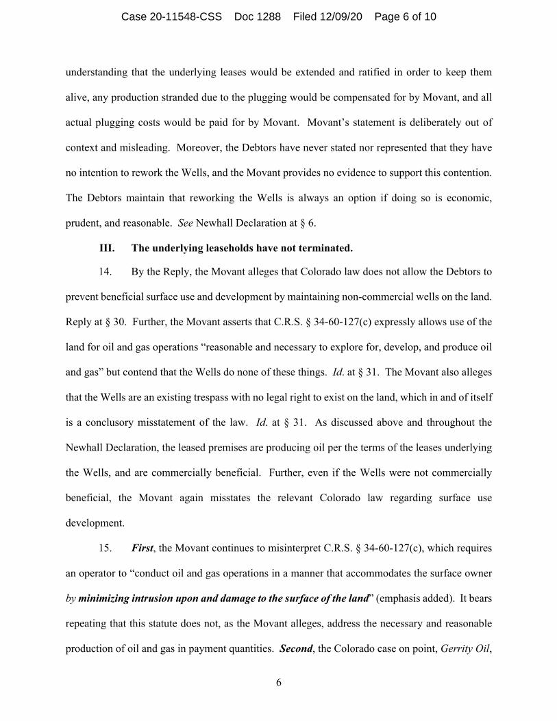
III. The underlying leaseholds have not terminated.
14. By the Reply, the Movant alleges that Colorado law does not allow the Debtors to
prevent beneficial surface use and development by maintaining non-commercial wells on the land.
Reply at § 30. Further, the Movant asserts that C.R.S. § 34-60-127(c) expressly allows use of the
land for oil and gas operations “reasonable and necessary to explore for, develop, and produce oil
and gas” but contend that the Wells do none of these things. Id. at § 31. The Movant also alleges
that the Wells are an existing trespass with no legal right to exist on the land, which in and of itself
is a conclusory misstatement of the law. Id. at § 31. As discussed above and throughout the
Newhall Declaration, the leased premises are producing oil per the terms of the leases underlying
the Wells, and are commercially beneficial. Further, even if the Wells were not commercially
beneficial, the Movant again misstates the relevant Colorado law regarding surface use
development.
15. First, the Movant continues to misinterpret C.R.S. § 34-60-127(c), which requires
an operator to “conduct oil and gas operations in a manner that accommodates the surface owner
by minimizing intrusion upon and damage to the surface of the land” (emphasis added). It bears
repeating that this statute does not, as the Movant alleges, address the necessary and reasonable
production of oil and gas in payment quantities. Second, the Colorado case on point, Gerrity Oil,
Case 20-11548-CSS Doc 1288 Filed 12/09/20 Page 6 of 10

7
holds that surface development has to be “not unreasonable” and aligned with industry standards.
See Gerrity Oil & Gas Corp. v. Magness, 946 P.2d 913, 927 (Colo. 1997) (“Because the scope of
a mineral rights holder’s implied easement is defined in terms of reasonableness and necessity, the
reasonableness of the holder’s conduct is not only relevant, but is essential to any resolution of a
trespass claim. Until it is found that the lessee’s conduct was not reasonable and necessary for
the exploration or extraction of the minerals, a cause of action for trespass must fail.”)
(emphasis added). The Movant has provided no evidence that the Debtors have acted in an
“unreasonable” manner not “aligned with industry standards.”
IV. The Movant’s pattern of behavior supports the Debtors’ position that the shut-in clauses are valid.
16. By the Reply, the Movant asserts that since the Wells are not satisfying production
per the terms of the underlying lease, the Bydalek Well is not saved by the lease’s shut-in clause
since it is not a gas well. The Movant incorrectly states that the underlying leasehold has no value,
since the leases have already terminated. This is factually, legally, and patently false.
17. The leasehold is maintained by a shut-in clause that permits the Debtors to maintain
the lease, even where production is temporarily halted. There are approximately 21 leases, with
approximately 29 lease owners, with respect to the Wells. However, Movant provided only one
vintage lease from the 1980s, which accounts for approximately 25% of the land in the leasehold
underlying the Wells, and is not representative of the universe of shut-in clauses contained in the
remaining 20 leases underlying the Wells. Further, pursuant to the terms of the lease cited by
Movant, attached hereto as Exhibit 2, if a shut-in period, when taking into account all wells
developing the lease, is greater than ninety (90) days, then a shut-in payment shall be due on or
before the next anniversary date of the lease. Lease at page 8. In other words, so long as there
is not a lapse in production of greater than ninety (90) days, when accounting for all the Wells that
Case 20-11548-CSS Doc 1288 Filed 12/09/20 Page 7 of 10

8
develop the lease, production, per the terms of the lease, is satisfied. Id. As discussed in the
Newhall Declaration, until recently (during the period from April 2020 through June 2020, when
all the Wells were shut in) there was no concurrent lapse in production greater than ninety (90)
days among all the Wells. See Newhall Declaration at § 4. Accordingly, the Debtors do not
dispute that they owe the Movant shut-in payments related to the recent shut-in status of the Wells;
that payment shall come due in April of 2021, per the terms of the lease cited by Movants.
V. The Movant’s New Arguments—Raised for the First Time in the Reply—Are Improper and Should be Stricken
18. By the Reply, the Movant now raises three new arguments and introduces new
sources of law attempting to support the propositions that: (i) the leases have terminated due to
the cessation of production; (ii) the Wells constitute a trespass on the Movant’s land; and (iii) the
shut-in savings clause is inapplicable. See Reply §§ 19-26.
19. Bankruptcy Rule 9013 provides that a motion shall “state with particularity the
grounds therefor.” This rule reflects the more general proposition that adversaries should have a
full and fair opportunity to review the bases for asserted relief, as opposed to being required to
engage in “trial by surprise”—which is certainly the case here. And, while the Debtors believe the
Movant’s new arguments fail on their merits, the Debtors submit they should be stricken under
Bankruptcy Rule 9013 given the lack of any adequate notice provided by the Movant.
VI. Were the Court to compel the Debtors to plug and abandon the Wells, the Debtors’ estate would be materially harmed.
20. Were the Court to grant the Motion, the Debtors estimate that in addition to the loss
of the land for long-term, strategic use, they would lose approximately $6 million dollars’ worth
of horizontal well development that the Debtors have pre-existing permits on. Such permits are
testament to the fact that Debtor is maintaining the leasehold via the Wells for the purpose of
making significant profit and not merely for speculative purposes. See Newhall Declaration at § 7.
Case 20-11548-CSS Doc 1288 Filed 12/09/20 Page 8 of 10

9
Further, while the Movant has estimated the cost to plug and abandon each Well at approximately
$100,000.00 per Well, the Debtors estimate such operations, based on prior operations in the
vicinity, would cost the estate upward of $900,000.00. Id. at § 8. Accordingly, given the value in
retaining the leaseholds, as well as the significant cost to plug and abandon the Well, the Wells are
not “burdensome” or of “inconsequential value” to the estate.
Conclusion
WHEREFORE, for the foregoing reasons and as set forth in the Objection, the Debtors
request that the Court enter an Order denying the Motion.
[Remainder of page intentionally left blank]
Case 20-11548-CSS Doc 1288 Filed 12/09/20 Page 9 of 10

Dated: December 9, 2020Wilmington, Delaware /s/ Richard W. Riley
WHITEFORD, TAYLOR & PRESTON LLC3
Marc R. Abrams (DE No. 955)Richard W. Riley (DE No. 4052)Stephen B. Gerald (DE No. 5857)The Renaissance Centre405 North King Street, Suite 500Wilmington, Delaware 19801Telephone: (302) 353-4144Facsimile: (302) 661-7950Email: [email protected]
[email protected]@wtplaw.com
- and -
KIRKLAND & ELLIS LLPKIRKLAND & ELLIS INTERNATIONAL LLPChristopher Marcus, P.C. (admitted pro hac vice)Allyson Smith Weinhouse (admitted pro hac vice)Ciara Foster (admitted pro hac vice)601 Lexington AvenueNew York, New York 10022Telephone: (212) 446-4800Facsimile: (212) 446-4900Email: [email protected]
[email protected]@kirkland.com
Co-Counsel for the Debtors and Debtors in Possession
3 Whiteford, Taylor & Preston LLC operates as Whiteford Taylor & Preston L.L.P. in jurisdictions outside of Delaware.
Case 20-11548-CSS Doc 1288 Filed 12/09/20 Page 10 of 10

Exhibit 1
Newhall Declaration
Case 20-11548-CSS Doc 1288-1 Filed 12/09/20 Page 1 of 22

KE 72883209
IN THE UNITED STATES BANKRUPTCY COURTFOR THE DISTRICT OF DELAWARE
)In re: ) Chapter 11
)EXTRACTION OIL & GAS, INC. et al.,1
Debtors.
))))))))
Case No. 20-11548 (CSS)
Jointly Administered
Hearing Date: December 11, 2020 at 1:00 p.m. (ET)
Re: Docket Nos. 1063, 1180 & 1202
)
DECLARATION OF CHANDLER NEWHALL IN SUPPORT OF DEBTORS’ SUR-REPLY IN SUPPORT
OF DEBTORS’ OBJECTION TO MOTION TO COMPEL ABANDONMENT
I, Chandler Newhall, hereby state and declare as follows:
1. I am a Senior Project Manager at Extraction Oil & Gas, Inc. (the “Debtors”). I have
worked for the Debtors since December of 2016, and I have worked in the oil and gas industry for
over 18 years. I am a member of the Society of Petroleum Engineers and I received a Bachelor
of Science in Petroleum Engineering from Montana Tech University.
2. I submit this declaration (this “Declaration”) in support of the Debtors’ Sur-Reply
in Support of Debtors’ Objection to Motion to Compel Abandonment (the “Sur-Reply”).2
3. Except as otherwise stated in this Declaration, I have personal knowledge of or
1 The Debtors in these chapter 11 cases, along with the last four digits of each Debtor’s federal tax identification number, are: Extraction Oil & Gas, Inc. (3923); 7N, LLC (4912); 8 North, LLC (0904); Axis Exploration, LLC (8170); Extraction Finance Corp. (7117); Mountaintop Minerals, LLC (7256); Northwest Corridor Holdings, LLC (9353); Table Mountain Resources, LLC (5070); XOG Services, LLC (6915); and XTR Midstream, LLC (5624). The location of the Debtors’ principal place of business is 370 17th Street, Suite 5300, Denver, Colorado 80202.
2 Capitalized terms used throughout but not defined shall have the meaning ascribed to them in the Debtors’ Objection to Motion to Compel [Docket No. 1180] (the “Objection”) or the Sur-Reply, filed contemporaneously herewith.
Case 20-11548-CSS Doc 1288-1 Filed 12/09/20 Page 2 of 22
2KE 72883209
have relied upon the knowledge of others employed by the Debtors, with respect to the matters set
forth herein. If called to testify, I could and would testify competently to the facts set forth herein.
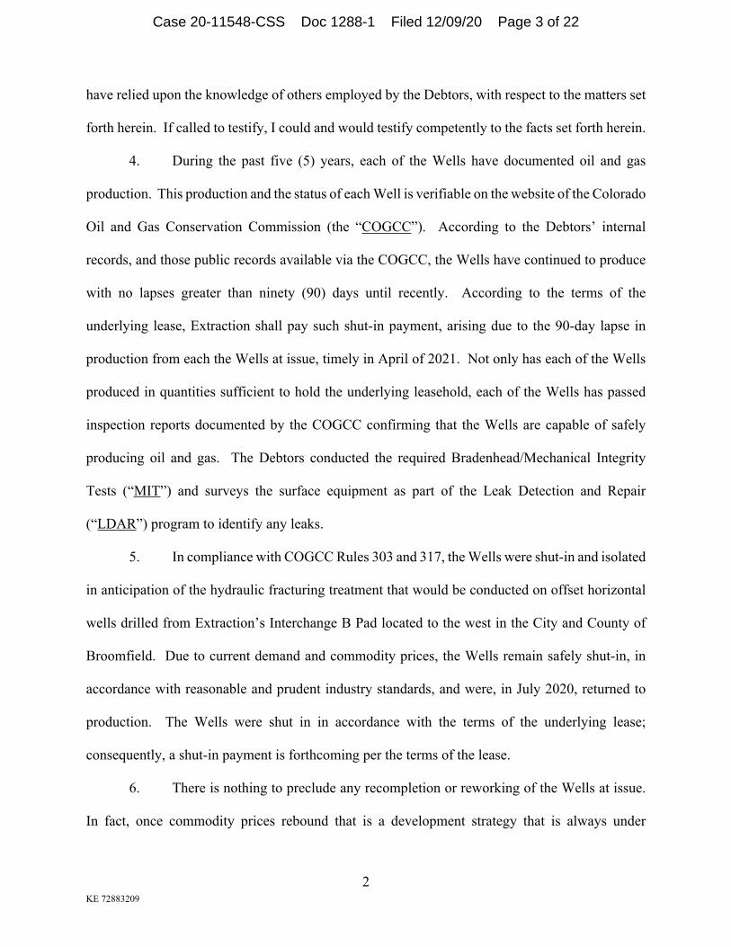
4. During the past five (5) years, each of the Wells have documented oil and gas
production. This production and the status of each Well is verifiable on the website of the Colorado
Oil and Gas Conservation Commission (the “COGCC”). According to the Debtors’ internal
records, and those public records available via the COGCC, the Wells have continued to produce
with no lapses greater than ninety (90) days until recently. According to the terms of the
underlying lease, Extraction shall pay such shut-in payment, arising due to the 90-day lapse in
production from each the Wells at issue, timely in April of 2021. Not only has each of the Wells
produced in quantities sufficient to hold the underlying leasehold, each of the Wells has passed
inspection reports documented by the COGCC confirming that the Wells are capable of safely
producing oil and gas. The Debtors conducted the required Bradenhead/Mechanical Integrity
Tests (“MIT”) and surveys the surface equipment as part of the Leak Detection and Repair
(“LDAR”) program to identify any leaks.
5. In compliance with COGCC Rules 303 and 317, the Wells were shut-in and isolated
in anticipation of the hydraulic fracturing treatment that would be conducted on offset horizontal
wells drilled from Extraction’s Interchange B Pad located to the west in the City and County of
Broomfield. Due to current demand and commodity prices, the Wells remain safely shut-in, in
accordance with reasonable and prudent industry standards, and were, in July 2020, returned to
production. The Wells were shut in in accordance with the terms of the underlying lease;
consequently, a shut-in payment is forthcoming per the terms of the lease.
6. There is nothing to preclude any recompletion or reworking of the Wells at issue.
In fact, once commodity prices rebound that is a development strategy that is always under
Case 20-11548-CSS Doc 1288-1 Filed 12/09/20 Page 3 of 22

3KE 72883209
consideration by prudent operators in better commodity-price environments. The Denver
Julesburg basin has a long history of documented rework/recomplete potential from legacy
producing wells, similar to the Wells at issue. If horizontal wells are not developed in the subject
spacing area, then the vertical legacy wells would be candidates for rework/recomplete potential
in existing producing intervals and non-completed formation intervals. In my experience,
reworks/recompletions can enhance the production rates, extend the life of the well, and provide
economic benefit to the operator, working interest partners, and royalty owners.
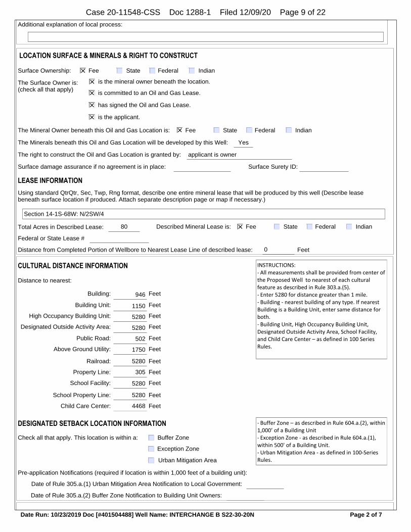
7. The Wells are currently retaining approximately 523-acres of leased minerals. The
Debtors have an approved horizontal permit and spacing order, from the COGCC, that will allow
it, in part, to develop the minerals and leases that the Wells hold, attached hereto as Schedule 1.
If the Wells were prematurely removed, those minerals and leases would be lost at a significant
financial impact to the Debtors, due to the reduced developable value of the assets. Additionally,
the Wells hold mineral interests in the existing approved Washington North DSU (COGCC Order
No. 407-1827, Docket No. 161000471, approved 10/24/2016) and Washington South DSU
(COGCC Order No. 407-1831, Docket No. 161000475, approved 10/24/2016), attached hereto as
Schedule 2 and Schedule 3, respectively, which the Debtors have planned for horizontal-well
development. Loss of these critical leases would negatively impact future horizontal-well
development at a significant cost to the Debtors, its working interest owners, and its royalty
owners. If the Wells are plugged, the estimated value loss attributable to the subsequent lost leases
will exceed $6 million, at a $50/bbl commodity price scheme.
8. Movants have noted an estimated plugging cost of $100,000 per Well. However,
Multiple other cost factors need to be accounted for to fully plug and abandon the Wells, including
the removal of production equipment, proper decommission of buried infrastructure, and site
Case 20-11548-CSS Doc 1288-1 Filed 12/09/20 Page 4 of 22

4KE 72883209
reclamation of a producing legacy vertical well, all of which must be done in compliance with
local laws, rules, and regulations. As such, based on its experience plugging similar wells in the
vicinity, the Debtors’ estimate the costs to conduct properly compliant well removals are closer to
$300,000.00 per Well.
[Remainder of page intentionally left blank]
Case 20-11548-CSS Doc 1288-1 Filed 12/09/20 Page 5 of 22

I declare under penalty of perjury that the foregoing statements are true and correct to the
best of my knowledge, information and belief.
Dated: December 9, 2020 Extraction Oil & Gas, Inc.
/s/ Chandler NewhallChandler NewhallSenior Project Manager
Case 20-11548-CSS Doc 1288-1 Filed 12/09/20 Page 6 of 22

Schedule 1
COGCC Permit
Case 20-11548-CSS Doc 1288-1 Filed 12/09/20 Page 7 of 22

COMMINGLE ZONESMULTIPLE ZONESSINGLE ZONEZONE TYPE
TYPE OF WELL OIL GAS COALBED OTHER:
State of ColoradoOil and Gas Conservation Commission
1120 Lincoln Street, Suite 801, Denver, Colorado 80203 Phone: (303) 894-2100 Fax: (303) 894-2109
APPLICATION FOR PERMIT TO:
FORM2
Rev 08/19
Document Number:
401504488
12/19/2018
Date Received:
Name of Operator: EXTRACTION OIL & GAS INC COGCC Operator Number: 10459
Address: 370 17TH STREET SUITE 5300
City: DENVER State: CO Zip: 80202
Contact Name: Bonnie Lamond Phone: (720)481-2379 Fax: ( )
Well Number: S22-30-20N Well Name: INTERCHANGE B
RECLAMATION FINANCIAL ASSURANCEPlugging and Abandonment Bond Surety ID: 20130028
68WRng:1STwp:23Sec:68WRng:1STwp:11Sec:
28FSL
FNL/FSL
460
If well is Directional Horizontal (highly deviated) submit deviated drilling plan.
Footage at Top of Prod Zone:
150 FNL
FNL/FSL
20 FWL
FEL/FWL Bottom Hole:
FWL
FEL/FWL
FeetFeet
-104.990845
WELL LOCATION INFORMATIONQtrQtr: NESW Sec: 10 Rng: 68W Twp: 1S Meridian: 6
Latitude: 39.978220 Longitude:
Footage at Surface: 2222 FSLFNL/FSL
1776 FWLFEL/FWL
Field Name: WATTENBERG Field Number: 90750
Ground Elevation: 5205 County: BROOMFIELD
GPS Data:
Date of Measurement: 09/28/2017 PDOP Reading: 1.4 Instrument Operator's Name: T. WINNICKI
LOCAL GOVERNMENT INFORMATION
Per § 34-60-106 (1)(f)(I)(A), the following questions pertain to the “local government with jurisdiction to approve the siting of the proposed oil and gas location.”
County: BROOMFIELD Municipality:
The local government with jurisdiction is: City and County
Does the local government with jurisdiction regulate the siting of Oil and Gas Locations, with respect to this COGCC application? If the local government has waived its right to precede the COGCC in siting determination, indicate by selecting “NO” here and selecting “Waived” below.
If yes, in checking this box, I hereby certify that an application has been filed with the local government with jurisdiction to approve the siting of the proposed oil and gas location.
NoYes
ApprovedThe disposition of the application filed with the local government is:
The local government siting permit type is: Operator Agreement
10/24/2017The local government siting permit was filed on:
Drill Deepen Re-enter Recomplete and Operate
Refiling
Sidetrack
Page 1 of 7Date Run: 10/23/2019 Doc [#401504488] Well Name: INTERCHANGE B S22-30-20N
Case 20-11548-CSS Doc 1288-1 Filed 12/09/20 Page 8 of 22
LOCATION SURFACE & MINERALS & RIGHT TO CONSTRUCT
Surface Ownership: Fee State Federal Indian
is the mineral owner beneath the location.
Fee State Federal Indian
is committed to an Oil and Gas Lease.
has signed the Oil and Gas Lease.
is the applicant.
The Mineral Owner beneath this Oil and Gas Location is:
The Minerals beneath this Oil and Gas Location will be developed by this Well: Yes
The right to construct the Oil and Gas Location is granted by:
Surface damage assurance if no agreement is in place:
applicant is owner
Surface Surety ID:
LEASE INFORMATIONUsing standard QtrQtr, Sec, Twp, Rng format, describe one entire mineral lease that will be produced by this well (Describe lease beneath surface location if produced. Attach separate description page or map if necessary.)
Section 14-1S-68W: N/2SW/4
Total Acres in Described Lease: 80 Described Mineral Lease is: Fee State Federal Indian
Federal or State Lease #
Distance from Completed Portion of Wellbore to Nearest Lease Line of described lease: 0 Feet
The Surface Owner is:(check all that apply)
Additional explanation of local process:
Distance to nearest:
Building: 946 Feet
Building Unit: 1150 Feet
High Occupancy Building Unit: 5280 Feet
Designated Outside Activity Area: 5280 Feet
Public Road: 502 Feet
Above Ground Utility: 1750 Feet
Railroad: 5280 Feet
Property Line: 305 Feet
INSTRUCTIONS:- All measurements shall be provided from center of the Proposed Well to nearest of each cultural feature as described in Rule 303.a.(5).- Enter 5280 for distance greater than 1 mile.- Building - nearest building of any type. If nearest Building is a Building Unit, enter same distance for both.- Building Unit, High Occupancy Building Unit, Designated Outside Activity Area, School Facility, and Child Care Center – as defined in 100 Series Rules.
CULTURAL DISTANCE INFORMATION
School Facility: 5280 Feet
School Property Line: 5280 Feet
Child Care Center: 4468 Feet
Buffer Zone
Exception Zone
Urban Mitigation Area
DESIGNATED SETBACK LOCATION INFORMATION
Check all that apply. This location is within a:
Pre-application Notifications (required if location is within 1,000 feet of a building unit):
Date of Rule 305.a.(1) Urban Mitigation Area Notification to Local Government:
Date of Rule 305.a.(2) Buffer Zone Notification to Building Unit Owners:
- Buffer Zone – as described in Rule 604.a.(2), within 1,000’ of a Building Unit- Exception Zone - as described in Rule 604.a.(1), within 500' of a Building Unit.- Urban Mitigation Area - as defined in 100-Series Rules.
Page 2 of 7Date Run: 10/23/2019 Doc [#401504488] Well Name: INTERCHANGE B S22-30-20N
Case 20-11548-CSS Doc 1288-1 Filed 12/09/20 Page 9 of 22

SPACING and UNIT INFORMATIONDistance from completed portion of proposed wellbore to nearest completed portion of offset wellbore permitted or completed in the
Distance from Completed Portion of Wellbore to Nearest Unit Boundary 460 Feet (Enter 5280 for distance greater than 1 mile.)
Federal or State Unit Name (if appl): Unit Number:
SPACING & FORMATIONS COMMENTS
PROPOSED SPACING UNIT:Section 2-1S-68W: SWSWSection 3-1S-68W: SESESection 10-1S-68W: E/2E/2Section 11-1S-68W: W/2W/2Section 14-1S-68W: W/2W/2Section 15-1S-68W: E/2E/2Section 22-1S-68W: E/2E/2Section 23-1S-68W: W/2W/2
OBJECTIVE FORMATIONSObjective Formation(s) Formation Code Spacing Order Number(s) Unit Acreage Assigned to Well Unit Configuration (N/2, SE/4, etc.)
NIOBRARA NBRR 1040 GWA
343 Feetsame formation:
If this Form 2 is associated with a Drilling and Spacing Unit application, provide docket number:
GROUNDWATER BASELINE SAMPLING AND MONITORING AND WATER WELL SAMPLINGWater well sampling required per Rule 318A
DRILLING WASTE MANAGEMENT PROGRAM
Drilling Fluids Disposal: OFFSITE
Cuttings Disposal: OFFSITE
Drilling Fluids Disposal Methods:
Cuttings Disposal Method:
Commercial Disposal
Commercial Disposal
Other Disposal Description:
Beneficial reuse or land application plan submitted?
Reuse Facility ID: or Document Number:
DRILLING PROGRAMProposed Total Measured Depth: 25133 Feet
Distance from the proposed wellbore to nearest existing or proposed wellbore belonging to another operator, including plugged wells:
Will a closed-loop drilling system be used? Yes
Is H2S gas reasonably expected to be encountered during drilling operations at concentrations greater than
Noor equal to 100 ppm?
Will salt sections be encountered during drilling? No
Will salt based (>15,000 ppm Cl) drilling fluids be used? No
Will oil based drilling fluids be used? Yes
BOP Equipment Type: Annular Preventor Double Ram Rotating Head None
(If Yes, attach an H2S Drilling Operations Plan)
Enter distance if less than or equal to 1,500 feet: 220 No well belonging to another operator within 1,500 feetFeet
Page 3 of 7Date Run: 10/23/2019 Doc [#401504488] Well Name: INTERCHANGE B S22-30-20N
Case 20-11548-CSS Doc 1288-1 Filed 12/09/20 Page 10 of 22

Distance from completed portion to nearest completed portion of wellbore permitted/completed in the same formation: 343' (Ref. well: INTERCHANGE A S22-30-19C, Extraction) Distance to nearest wellbore belonging to another operator: 220' (Ref. well: TYMKOVICH 1-10, Status: PA, OIL RESOURCES INC)
Extraction Oil & Gas Inc. is the surface owner and self-waives Rules 318A.a. & 318A.c.
All BMPs on the related Form 2A for the Interchange A&B pad are applicable to this well.
Comments
OPERATOR COMMENTS AND SUBMITTAL
This application is in a Comprehensive Drilling Plan
456747Location ID:
Is this application being submitted with an Oil and Gas Location Assessment application?
I hereby certify all statements made in this form are, to the best of my knowledge, true, correct, and complete.
Signed: Print Name: Bonnie Lamond
Title: Regulatory Analyst Date: 12/19/2018 Email: [email protected]
CDP #:
No
DESIGNATED SETBACK LOCATION EXCEPTIONSCheck all that apply:
Rule 604.a.(1)A. Exception Zone (within 500' of Building Unit)
Rule 604.b.(1)A. Exception Location (existing or approved Oil & Gas Location now within a Designated Setback as a result of
Rule 604.b.(1)B. Exception Location (existing or approved Oil & Gas Location is within a Designated Setback due to Building Unit construction after Location approval)
Rule 604.b.(2) Exception Location (SUA or site-specific development plan executed on or before August 1, 2013)
Rule 604.b.(3) Exception Location (Building Units constructed after August 1, 2013 within setback per an SUA or site-specific development plan)
GREATER WATTENBERG AREA LOCATION EXCEPTIONSCheck all that apply:
Rule 318A.a. Exception Location (GWA Windows).
Rule 318A.c. Exception Location (GWA Twinning).
RULE 502.b VARIANCE REQUESTRule 502.b. Variance Request from COGCC Rule or Spacing Order Number
Rule 604.a.)
OTHER LOCATION EXCEPTIONSCheck all that apply:
Rule 318.c. Exception Location from Rule or Spacing Order Number
Rule 603.a.(2) Exception Location (Property Line Setback).
ALL exceptions and variances require attached Request Letter(s). Refer to applicable rule for additional required attachments (e.g. waivers, certifications, SUAs).
Casing Type Size of Hole Size of Casing Wt/Ft Csg/Liner Top Setting Depth Sacks Cmt Cmt Btm Cmt Top
CONDUCTOR 24 16 42 0 80 100 80 0
SURF 12+1/4 9+5/8 36 0 1500 400 1500 0
1ST 8+1/2 5+1/2 20 0 25133 3444 25133
Conductor Casing is NOT planned
CASING PROGRAM
Page 4 of 7Date Run: 10/23/2019 Doc [#401504488] Well Name: INTERCHANGE B S22-30-20N
Case 20-11548-CSS Doc 1288-1 Filed 12/09/20 Page 11 of 22

Operator must have a valid water right or permit allowing for industrial use or purchased water from a seller that has a valid water right or permit allowing for industrial use, otherwise an application for a change in type of use is required under Colorado law. Operator must also use the water in the location set forth in the water right decree or well permit, otherwise an application for a change in place of use is required under Colorado law. Section 37-92-103(5), C.R.S. (2011).
API NUMBER
05 014 20851 00
Expiration Date: 10/22/2021
Based on the information provided herein, this Application for Permit-to-Drill complies with COGCC Rules, applicable orders, and SB 19-181 and is hereby approved.
COGCC Approved: Director of COGCC Date: 10/23/2019
Conditions Of ApprovalAll representations, stipulations and conditions of approval stated in the Form 2A for this location shall constitute representations, stipulations and conditions of approval for this Form 2 Permit-to-Drill and are enforceable to the same extent as all other representations, stipulations and conditions of approval stated in this Permit-to-Drill.
COA Type Description
Drilling/Completion Operations This Permit to Drill is approved subject to all the BMPs and COAs on the most recently approved Form 2A and any subsequently approved Form 4 for the Oil and Gas Location (Location ID #456747). The most recently approved Form 2A and any subsequent Form 4s containing applicable COAs for this location shall be posted onsite during construction, drilling, and completions operations.
Drilling/Completion Operations 1) Submit Form 42 electronically to COGCC 48 hours prior to MIRU (Spud Notice), for the first well/activity on the pad and provide 48 hour spud notice for all subsequent wells drilled on the pad.2) Comply with Rule 317.j and provide cement coverage from the end of production casing to a minimum of 200' above Niobrara and from 200’ below Sussex to 200’ above Sussex. Verify coverage with cement bond log.3) Oil-based drilling fluid is to be used only after all fresh water aquifers are covered.
Drilling/Completion Operations Per COGCC Order 1-232, Bradenhead tests shall be performed according to the following schedule and Form 17 submitted within 10 days of each test:1) Within 60 days of rig release, prior to stimulation. If any pressure greater than 200 psi, must contact COGCC engineer prior to stimulation.2) If a delayed completion, 6 months after rig release and prior to stimulation. If any pressure greater than 200 psi, must contact COGCC engineer prior to stimulation.3) A post-production test within 60 days after first sales, as reported on the Form 10, Certificate of Clearance.
Page 5 of 7Date Run: 10/23/2019 Doc [#401504488] Well Name: INTERCHANGE B S22-30-20N
Case 20-11548-CSS Doc 1288-1 Filed 12/09/20 Page 12 of 22

No BMP/COA Type Description
1 Drilling/Completion Operations
Alternative Logging Program: One of the first wells drilled on the pad will be logged with open-hole resistivity log and gamma-ray log from the kick-off point into the surface casing. All wells on the pad will have a cement bond log with gamma-ray run on production casing (or on intermediate casing if production liner is run) into the surface casing. The horizontal portion of every well will be logged with a measured-while-drilling gamma-ray log. The Form 5, Completion Report, for each well on the pad will list all logs run and have those logs attached. The Form 5 for a well without open-hole logs shall state “Alternative Logging Program - No open-hole logs were run” and shall clearly identify the type of log and the well (by API#) in which open-hole logs were run.
2 Drilling/Completion Operations
Operator acknowledges and will comply with COGCC policy for Bradenhead Monitoring during Hydraulic Fracturing treatments in the Greater Wattenberg Area dated May 29, 2012.
3 Drilling/Completion Operations
Anti-collision: Operator will perform an anti-collision evaluation of all active (producing, shut in, or temporarily abandoned) offset wellbores that have the potential of being within 150 feet of a proposed well prior to drilling operations for the proposed well. Notice shall be given to all offset operators prior to drilling.
Total: 3 comment(s)
Best Management Practices
User Group Comment Comment Date
OGLA Public Comments received for this Form 2 are summarized and addressed in COGCC Response to Public Comments (Doc# 2316417) saved in the file for Oil and Gas Location ID# 456747.
10/23/2019
Permit Final Review Completed. 10/23/2019
Permit The Objective Criteria Review Memo (Doc# 2158200) is attached to this Form 2 Application for Permit to Drill (APD). Following additional analysis arising out of the Objective Criteria, the Director determined that this application meets the standard for the protection of public health, safety, welfare, the environment and wildlife resources set by SB 19-181.
10/23/2019
OGLA COGCC staff reviewed and considered all public comments received for this Form 2. 10/23/2019
General Comments
Attachment Check ListAtt Doc Num Name
2158200 OBJECTIVE CRITERIA REVIEW MEMO
401504488 FORM 2 SUBMITTED
401518856 OffsetWellEvaluations Data
401522486 WELL LOCATION PLAT
401524954 DIRECTIONAL DATA
401524960 DEVIATED DRILLING PLAN
401525277 EXCEPTION LOC REQUEST
401881398 PROPOSED SPACING UNIT
402219688 OFFSET WELL EVALUATIONTotal Attach: 9 Files
Applicable Policies and Notices to Operators
Notice Concerning Operating Requirements for Wildlife Protection.http://cogcc.state.co.us/documents/reg/Policies/Wildlife_Notice.pdf
Policy for Bradenhead Monitoring During Hydraulic Fracturing Treatments in the Greater Wattenberg Area.http://cogcc.state.co.us/documents/reg/Policies/PolicyGwaBradenheadMonitoringFinal.pdf
Page 6 of 7Date Run: 10/23/2019 Doc [#401504488] Well Name: INTERCHANGE B S22-30-20N
Case 20-11548-CSS Doc 1288-1 Filed 12/09/20 Page 13 of 22

OGLA Status - IN PROCESS: With operator concurrence, corrected distance to nearest building unit from 1651' to 1150'.
07/11/2019
OGLA Status Pending - waiting for operator to confirm distance to nearest building unit; possible closer BU to the south at ~1150'.
07/10/2019
Permit IN PROCESS - no 318A objections received. 07/05/2019
Permit COGCC Staff has added the Local Government siting permit information and the School and Childcare Center distances provided by the operator.
06/19/2019
Permit Initial permitting review complete and task passed.The following changes were made with Operator concurrence:- corrected 317.p. logging BMP and TPZ footage corrected to "150 FNL".
05/21/2019
Permit Contacted Operator for the following corrections: - “Well Location” tab: TPZ footage listed as "150 FSL", but the PLAT says this should be "150 FNL".
05/02/2019
Permit ON HOLD - pending review of possible 318A objection(s). 02/07/2019
Engineer Offset Wells Evaluated. 01/25/2019
LGD As the Local Government Designee for the City and County of Broomfield (Broomfield), Broomfield would like to provide the COGCC with an update related to Extraction Oil and Gas, LLC (Extraction) Form 2A permits, by the Colorado Oil and Gas Conservation Commission (COGCC), including the following permit applications:
Doc NumberWell Name
401504488Interchange B S22-30-20N
401504441Interchange A S16-20-20N
401475500Livingston S20-25-2C
401475489Livingston S19-25-15N
By way of an update to the COGCC, on October 24, 2017, Extraction and Broomfield entered into an Amended and Restated Operator Agreement (Agreement).The COGCC spacing orders for these spacing units, dated as of October 31, 2017, indicate that any Permits for the wells within these spacing units must “comport with” the Agreement.We would request that all Best Management Practices required by the Operator Agreement be included as conditions on COGCC’s Form 2s and Form 2As for these permit applications.
We further request that COGCC include a note on all approved permits that Extraction mustobtain all necessary permits from Broomfield prior todrilling the permitted wells.
01/25/2019
Permit The Public Comment Period has been extended an additional 10 days at the request of the Broomfield County LGD; the comment period will end on January 27, 2019.
01/04/2019
Permit Passed completeness. 12/28/2018
Total: 15 comment(s)
Page 7 of 7Date Run: 10/23/2019 Doc [#401504488] Well Name: INTERCHANGE B S22-30-20N
Case 20-11548-CSS Doc 1288-1 Filed 12/09/20 Page 14 of 22

Schedule 2
COGCC Order No. 407-1827
Case 20-11548-CSS Doc 1288-1 Filed 12/09/20 Page 15 of 22

BEFORE THE OIL & GAS CONSERVATION COMMISSION
OF THE STATE OF COLORADO
IN THE MATTER OF THE PROMULGATION AND ) CAUSE NO. 407
ESTABLISHMENT OF FIELD RULES TO GOVERN )
OPERATIONS FOR THE CODELL AND NIOBRARA ) DOCKET NO. 161000471
FORMATIONS, WATTENBERG FIELD, ADAMS COUNTY, )
COLORADO. ) TYPE: SPACING
)) ORDER NO. 407-1827
REPORT OF THE COMMISSION
The Commission heard this matter on October 24, 2016, at the Northeastern Junior
College, Hayes Student Center Ballroom, 100 College Avenue, Sterling, Colorado, upon
application for an order to establish an approximate 640-acre drilling and spacing unit for the
W!4 of Sections 2 and 11, Township 1 South, Range 68 West, 6th P.M. and approve up to 10
horizontal wells within the unit, for the production of oil, gas and associated hydrocarbons from
the Codell and Niobrara Formations.
The Commission finds as follows:
Extraction Oil and Gas, LLC, Operator No. 10459 ("Extraction" or "Applicant") is
an interested party in the subject matter of the above referenced hearing.1.
Due notice of time, place and purpose of the hearing has been given in all2.
respects as required by law.
3. The Commission has jurisdiction over the subject matter embraced in said Notice
and the parties interested therein, and has authority to promulgate the hereinafter prescribed
order pursuant to the Oil and Gas Conservation Act.
4. On April 27, 1998, the Commission adopted Rule 31 8A, the Greater Wattenberg
Area Special Well Location, Spacing and Unit Designation Rule.
On September 9, 2016, Extraction, by its attorneys, filed a verified application
("Application") pursuant to §34-60-116, C.R.S., for an order to establish an approximate 640-
acre drilling and spacing unit for the below-described lands ("Application Lands") and approve
up to 10 horizontal wells within each unit, for the production of oil, gas and associated
hydrocarbons from the Codell and Niobrara Formations with the productive interval of each
wellbore located no closer than 150 feet from the productive interval of any other wellbore in the
drilling and spacing unit producing from the same formation, and permitted no closer than 100
feet from the drilling and spacing unit boundary and any drilling and spacing unit or Rule
318A.a.(4)D. horizontal wellbore spacing unit covering adjacent or cornering lands shall have
the corresponding right to locate the productive interval of a wellbore no closer than 100 feet
from the drilling and spacing unit boundary:
5.
Township 1 South. Range 68 West. 6th P.M.Section 2: W%
Section 11: W1/2
1(161000471/407-1827)
Case 20-11548-CSS Doc 1288-1 Filed 12/09/20 Page 16 of 22

On October 3, 2016, Extraction, by its attorneys, filed with the Commission a
written request to approve the Application based on the merits of the verified Application and the
supporting exhibits. Sworn testimony and exhibits were submitted in support of the Application.
Land testimony and exhibits submitted in support of the Application by Jason
Lowrey, Senior Landman for Extraction, showed that Extraction holds oil and gas leasehold
interests and has a right to drill in the Application Lands.
6.
7.
Geologic testimony and exhibits submitted in support of the Application by Matt
Volkmar, Petroleum Engineer for Extraction showed that the Niobrara and Codell Formations
are present throughout the Application Lands, are approximately 365 to 505 feet thick from the
top of the Niobrara through the base of the Codell.
8.
Engineering testimony and exhibits submitted in support of the Application by
Boyd McMaster, Petroleum Engineer for Extraction, showed that the drainage area for
analogous horizontal Codell and Niobrara Formation wells are estimated at 148-244 acres and
1.5-33.5 acres, respectively, and an approximate 640-acre drilling and spacing unit is therefore
not less than the maximum area that can be efficiently, economically and effectively drained by
10 horizontal wells producing oil, gas and associated hydrocarbons from the benches of the
Codell and Niobrara Formations.
9.
On October 14, 2016, Extraction, by its attorneys, filed with the Commission an
Amended Request for Recommendation of Approval of Application Without a Hearing to request
an enlargement of the Application's requested unit boundary setback from 100 feet to 460 feet
consistent with Rule 318A.a.(4)D.
10.
The above-referenced testimony and exhibits show that granting the Application
will allow more efficient reservoir drainage, will prevent waste, will assure a greater ultimate
recovery of hydrocarbons, and will not violate correlative rights.
11.
12. Extraction agreed to be bound by oral order of the Commission.
Based on the facts stated in the verified Application, having received no protests,
and based on the Hearing Officer review of the Application under Rule 511, the Commission
should enter an order to establish an approximate 640-acre drilling and spacing unit for the WA
of Sections 2 and 11, Township 1 South, Range 68 West, 6th P.M. and approve up to 10horizontal wells within the unit, for the production of oil, gas and associated hydrocarbons from
the Codell and Niobrara Formations.
13.
ORDER
IT IS HEREBY ORDERED:
One approximate 640-acre drilling and spacing unit for the below-described
lands, is hereby established, and a total of up to 10 horizontal wells within the unit are hereby
approved, for the production of oil, gas and associated hydrocarbons from the Codell and
Niobrara Formations:
1.
2(161000471/407-1827)
Case 20-11548-CSS Doc 1288-1 Filed 12/09/20 Page 17 of 22
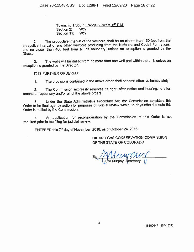
Township 1 South. Range 68 West. 6lh P.M.Section 2: WVS
Section 1 1 : W1/2
2. The productive interval of the wellbore shall be no closer than 150 feet from the
productive interval of any other wellbore producing from the Niobrara and Codell Formations,
and no closer than 460 feet from a unit boundary, unless an exception is granted by the
Director.
3. The wells will be drilled from no more than one well pad within the unit, unless an
exception is granted by the Director.
IT IS FURTHER ORDERED:
1 . The provisions contained in the above order shall become effective immediately.
2. The Commission expressly reserves its right, after notice and hearing, to alter,
amend or repeal any and/or all of the above orders.
3. Under the State Administrative Procedure Act, the Commission considers this
Order to be final agency action for purposes of judicial review within 35 days after the date this
Order is mailed by the Commission.
4. An application for reconsideration by the Commission of this Order is not
required prior to the filing for judicial review.
ENTERED this 7th day of November, 2016, as of October 24, 2016.
OIL AND GAS CONSERVATION COMMISSION
OF THE STATE OF COLORADO
ABy,
Jjilie Murphy, Secretary
3(161000471/407-1827)
Case 20-11548-CSS Doc 1288-1 Filed 12/09/20 Page 18 of 22

Schedule 3
COGCC Order No. 407-1831
Case 20-11548-CSS Doc 1288-1 Filed 12/09/20 Page 19 of 22

BEFORE THE OIL & GAS CONSERVATION COMMISSIONOF THE STATE OF COLORADO
IN THE MATTER OF THE PROMULGATION AND ) CAUSE NO. 407ESTABLISHMENT OF FIELD RULES TO GOVERN )OPERATIONS FOR THE CODELL AND NIOBRARA ) DOCKET NO. 161000475FORMATIONS, WATTENBERG FIELD, ADAMS COUNTY, )COLORADO. ) TYPE: SPACING
)) ORDER NO. 407-1831
REPORT OF THE COMMISSION
The Commission heard this matter on October 24, 2016, at the Northeastern JuniorCollege, Hayes Student Center Ballroom, 100 College Avenue, Sterling, Colorado, uponapplication for an order to establish an approximate 640-acre drilling and spacing unit for theW1/4 of Sections 14 and 23, Township 1 South, Range 68 West, 6th P.M. and approve up to 10horizontal wells within the unit, for the production of oil, gas and associated hydrocarbons fromthe Codell and Niobrara Formations.
The Commission finds as follows:
Extraction Oil and Gas, LLC, Operator No. 10459 ("Extraction" or "Applicant") isan interested party in the subject matter of the above referenced hearing.
1.
Due notice of time, place and purpose of the hearing has been given in ail2.respects as required by law.
3. The Commission has jurisdiction over the subject matter embraced in said Noticeand the parties interested therein, and has authority to promulgate the hereinafter prescribedorder pursuant to the Oil and Gas Conservation Act.
4. On April 27, 1998, the Commission adopted Rule 31 8A, the Greater WattenbergArea Special Well Location, Spacing and Unit Designation Rule.
On September 9, 2016, Extraction, by its attorneys, filed a verified application("Application") pursuant to §34-60-116, C.R.S., for an order to establish an approximate 640-acre drilling and spacing unit for the below-described lands ("Application Lands") and approveup to 10 horizontal wells within each unit, for the production of oil, gas and associatedhydrocarbons from the Codell and Niobrara Formations with the productive interval of eachwellbore located no closer than 150 feet from the productive interval of any other wellbore in thedrilling and spacing unit producing from the same formation, and permitted no closer than 100feet from the drilling and spacing unit boundary and any drilling and spacing unit or Rule318A.a.(4)D. horizontal wellbore spacing unit covering adjacent or cornering lands shall havethe corresponding right to locate the productive interval of a wellbore no closer than 100 feetfrom the drilling and spacing unit boundary:
5.
1
(161000475/407-1831)
Case 20-11548-CSS Doc 1288-1 Filed 12/09/20 Page 20 of 22
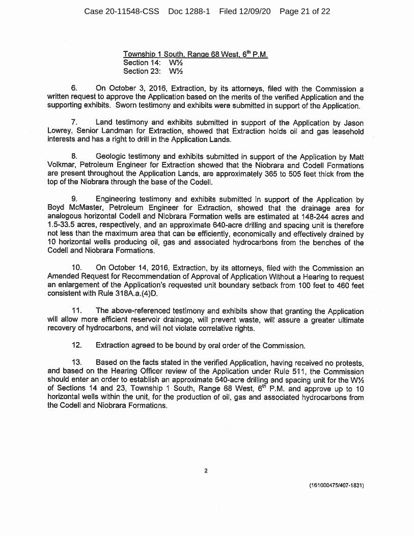
Township 1 South. Range 68 West. 6th P.M.Section 14: WASection 23: WA
On October 3, 2016, Extraction, by its attorneys, filed with the Commission awritten request to approve the Application based on the merits of the verified Application and thesupporting exhibits. Sworn testimony and exhibits were submitted in support of the Application.
Land testimony and exhibits submitted in support of the Application by JasonLowrey, Senior Landman for Extraction, showed that Extraction holds oil and gas leaseholdinterests and has a right to drill in the Application Lands.
6.
7.
Geologic testimony and exhibits submitted in support of the Application by MattVolkmar, Petroleum Engineer for Extraction showed that the Niobrara and Codell Formationsare present throughout the Application Lands, are approximately 365 to 505 feet thick from thetop of the Niobrara through the base of the Codell.
8.
Engineering testimony and exhibits submitted in support of the Application byBoyd McMaster, Petroleum Engineer for Extraction, showed that the drainage area foranalogous horizontal Codell and Niobrara Formation wells are estimated at 148-244 acres and1.5-33.5 acres, respectively, and an approximate 640-acre drilling and spacing unit is thereforenot less than the maximum area that can be efficiently, economically and effectively drained by10 horizontal wells producing oil, gas and associated hydrocarbons from the benches of theCodell and Niobrara Formations.
9.
10. On October 14, 2016, Extraction, by its attorneys, filed with the Commission anAmended Request for Recommendation of Approval of Application Without a Hearing to requestan enlargement of the Application's requested unit boundary setback from 100 feet to 460 feetconsistent with Rule 318A.a.(4)D.
11. The above-referenced testimony and exhibits show that granting the Applicationwill allow more efficient reservoir drainage, will prevent waste, will assure a greater ultimaterecovery of hydrocarbons, and will not violate correlative rights.
12. Extraction agreed to be bound by oral order of the Commission.
Based on the facts stated in the verified Application, having received no protests,and based on the Hearing Officer review of the Application under Rule 511, the Commissionshould enter an order to establish an approximate 640-acre drilling and spacing unit for the WAof Sections 14 and 23, Township 1 South, Range 68 West, 6th P.M. and approve up to 10horizontal wells within the unit, for the production of oil, gas and associated hydrocarbons fromthe Codell and Niobrara Formations.
13.
2
(161000475/407-1831)
Case 20-11548-CSS Doc 1288-1 Filed 12/09/20 Page 21 of 22

ORDER
IT IS HEREBY ORDERED:
One approximate 640-acre drilling and spacing unit for the below-describedlands, is hereby established, and a total of up to 10 horizontal wells within the unit are hereby
approved, for the production of oil, gas and associated hydrocarbons from the Codell and
Niobrara Formations:
1.
Township 1 South. Range 68 West. 6th P.M.Section 14: WVz
Section 23: W1/2
The productive interval of the wellbore shall be no closer than 150 feet from the
productive interval of any other wellbore producing from the Niobrara and Codell Formations,and no closer than 460 feet from a unit boundary, unless an exception is granted by the
Director.
2.
3. The wells will be drilled from no more than one well pad within the unit, unless an
exception is granted by the Director.
IT IS FURTHER ORDERED:
1. The provisions contained in the above order shall become effective immediately.
The Commission expressly reserves its right, after notice and hearing, to alter,
amend or repeal any and/or all of the above orders.
2.
Under the State Administrative Procedure Act the Commission considers this
Order to be final agency action for purposes of judicial review within 35 days after the date thisOrder is mailed by the Commission.
3.
An application for reconsideration by the Commission of this Order is notrequired prior to the filing for judicial review.
ENTERED this 7th day of November, 2016, as of October 24, 2016.
4.
OIL AND GAS CONSERVATION COMMISSION
OF THE STATE OF COLORADO
, /AMAArnMtrt(_jjjjlie Murphy, Secretary U
By
3
(161000475/407-1831)
Case 20-11548-CSS Doc 1288-1 Filed 12/09/20 Page 22 of 22

Exhibit 2
Lease
Case 20-11548-CSS Doc 1288-2 Filed 12/09/20 Page 1 of 9

, 642711 TATLOCK"S :, I >111ui1ri1n:l1PLORA'l'IOII IID.. B .. 2 7 I I
aaee ee .• tr&l De. · DENVER coLORACO ao202.
Boulder, Colorado 80:S0l !R I/~ ~ 1 / ~- ,
RATIFICATION OF OIL AND G4f~A&eooK3133 PACE206 AOA-M S COUNTY, COlQ,
lrft 11 a oo AM 'a& KNOW ALL MEN BY THESE PRESENTS:
THAT, WHEREAS, Heretofore under date of tJ,e 8th day of Apr i 1 , 19_§_§__, a certain oil and gas
lease was made, exec·1ted, and delivered by. Bull wash Associates, a 1 i:ni ted partner ship
as Lessor_, to, __ P_e_t_r_o...!:g::...u_l_f __ E_n_e_r_,g""y"--_C_o_m_.p'--a_n--=-y ____________________ _,
as Lessee, covering tl-.e following-described lands inc.-_A_d_a_m_s _________ Coi:.nty, State of __ C_o_l_o_r_a_d_o _ _, to-wit:
Township 1 South, Range 68 West of the 6th P.M.
Sec~ion 11: The Southwest one-quarter.
Sec"'.:ion 14: The North one-half of the North one-half of the Northwest
one-quarter.
Subject to letter agreement dated April 8, 1986, approved by Bullwash Associates on April ' 5-tt:_ , 1986.
said lease being reco:-ded in Book 2 6 3 9 at. Pag l of the records in the office of the Register of Deeds in and fer said County, reference to said lease and to the record thereof being hereby made for all purpose;.
NOW, THEREFORE, In consideration of the sum of One Dollar ($1.00) and other valuable consideration, the receipt' and sufficiency of which are hereby acknowledged, we, the undersigned, and each for himself md herself, as the case may be, do hereby ratify, adopt and corfirm the hereinabove-described oil and gas lease in all of its terms a,d provisions and do hereby lease, c.emise and. let said land and premises unto the said lessee hereinabove-named, his as.signs and sue ~essors in interest, as fully and completely as if we had originally been named as lessor in said lease and had executed, acknowledged ,md delivered the same; provided, however, that this instrument:shall cover and bind all interest of the undersigned which may have been acquired subsequent to the date of the aforesaid oil and gu lease and is intended further to cover and bind any interest which -;he undersigned may hereafter acquire by way of reversion or c,therwise.
It being prov:ded further that the undersigned shall not be entitled to receive any portion of the rentals payable under said lease but such renta!s shall be paid to the persor.s designated to receive such rentals in accordance with the terms and provisions of said oil and gas lease and their heirs, legal representatives, successors or assigns.
We hereby agree and declare that said oil and gas lease in all of its terms and provi,ions is binding on us and each of us.and is a valid and subsisting oil and gas }ease and that this instrument shall be binding upon the ;-espective heirs, executors, administ:-ators, successors or assign~ of the undersigned.
EXECUTED Tliis 8th day o ..... f ---=Ac::.p<"-=r-=i=l'------, 19_8_6_.
artne::-ship
STATE OF }
-------------- ss. ACKNOWLEDGMENT FOR INDIVIDUAL (Kans. Okla. and Colo.)
COUNTY OF Before me, the undersigned, a Notary Public, within and for said County and State, on thi"-----------
day o..._ _______________ _, 19 __ , personally- appeareu-_________________ _
an,~------------------------------------------------
to me personally kr.own to be the identical person-who executed the within and foregoing instrument and acknowledged to me
tha,.,_ ____ executed the same a-~-----ree and voluntary act and deed for the uses and purposes therein set forth. IN WITNESS WHEREOF, I have hereunto set my hand and official seal the d:ly and year last above written.
My Mmmission exi:ires, ________________ _ Notary Public
ACKNOWLEDGMENT FOR CORPORATION
Case 20-11548-CSS Doc 1288-2 Filed 12/09/20 Page 2 of 9

•
,· I
. -TOJJ M01TMi0Jcm3 lUI:lAM .e~A LG-x.tnoo ooea
!0t0B f)t•= .... I.oJ \ "lehluon
Case 20-11548-CSS Doc 1288-2 Filed 12/09/20 Page 3 of 9

FORM T3 - TATLOCK'S
DENVER. COLDRAC•D 80202
RA.TIFICATION OF OIL AND GAS LEASE
KNOW ALL MEN BY THESE PRESENTS:
THAT, WHEREAS, Heretofore under date of the 8th day of April , 19_§_§_, a certain oil and gas
lease was made, executed, an:i delivered by Bull wash Associates, a li:nited partnership
as Lessor __ , to __ P_e_t_-r_o....!g~u_l_f_E_n_e_r~g~y~_C_o_m...,!p'""a_n.=..y _____________________ _
as Lessee, covering the follov.ing-described lands in1..-....;A=-:d::.;a::cm=s=----------County, State of __ C_o_l_o.c.-r_a..;..d__;o _ __,to-wit:
Township 1 Soutr., Range 68 West of the 6th P .M.
Section 11: Section 14:
The Southwest one-quarter. The North one-half of the North one-half of the Northwest
one-quarter.
Subject to le-:ter agreement dated April 8, 1986, approved by Bullwash Associates on April • S-f:lc.. , 1986.
said lease being recorded in Book 2 6 3 9 at Pag 1 of the records in the office of the Register of Deeds in and fo!" said County, reference toe.aid lease and to the record thereof being hereby made for all purposes.
NOW, THEREFORE, In consideration of the sum of One Dollar ($1.00) and othe::- valuable consideration, the receipt• and sufficiency of which are hereby acknowledged, we, the undersigned, and each for himself and herself, as the case, may be, do hereby ratify, adopt and con::irm the hereinabove-described oil and gas lease in all of its terms ard provisions and do hereby lease, d:!mise and let said land and premises unto the said lessee hereinabove-named, his assigns and successors in interest, as fully and completely as if we had originall:.r been named as lessor in said lease and had executed, acknowledged and delivered the same; provided, hoV"ever, that this instrument shall cover and bind all interest of the undersigned which may have be:!n acquired subsequent to the date of the aforesaid oil and gas lease and is intended further to cover and bind any interest which t 1e undersigned may hereafter acquire by way of reversion or ot-herwise.
It being provided further that the undersigned shall not be entitled to receive any :;iortion of the rentals payable unde:- said lease but such rentals shall be paid to the persons designated to receive such rentals in accordance with the terms and provisions of said oil and gas lease and their heirs, legal representatives, successors or assigns.
We hereby agree and declare that said oil and gas lease in all of its terms and provisfons is binding on us and each of us and is a valid and subsisting oil and gas lease and that this instrument shall be binding upon the respective heirs, executors, administntors, successors or assigns of the undersigned.
EXECUTED T:h;s 8th day 0 .._f ---=-A,,.p::..:r=-=i=-=l=-------, 1,9_8_6_.
STATE OF }
-------------- ss. ACKNOWLEDGMENT FOR INDIVIDUAL (Kans. Okla. and C-)lo.)
COUNTY OF Before me, the undersigned, a Notary Public, within and for said County and State, on thi.,__ _________ _
day o..__ _______________ __, 19 __ , personally appeare,...._ _________________ _
an.,_ _______________________________________________ _
to me personally known to be the identical person_who executed the within and forego.ng instrument and acknowledged to me tha.__ ____ ,exeeuted the same as _____ __.ree and voluntary act and deed for the uses and purposes therein set forth.
IN WITNESS WHEREOF, I have hereunto set my hand and official seal the day and year last above written. My t!ommission expires ________________ _
STATE oF. CoLuR.4p.a COUNTY OF D~iyF-f.~
Notary Public
ACKNOWLEDGMENT FOR CORPORATION } ss.
Be it remembered that on this i{_;-f-i-J day of /iJ.)-U L , !9 Bf.:, , before me, the undersigned, a
Notary Public, duly c.ommissioned, in and_ for the co_u~tr_ an_,,d __ ,s.t~te1,a7
fo~.esa1_:d,, ~~m_,: 6 f 4'1,~-~-"-:,fZ /J. SM I Uf president ofJ1JU-W,"'-..:;.-H. Ir S. !i.DC ,I~, t: S-{~ t ~ E:c /..~ .... A.Jfi.f..'Si-f;
a corpcration of the State o: _________________ , i:erson:lcy':-lt~own to ~;•'ttbrsuch officer, and to be the same person who executE1d as such officer the foregoing instrument of writirf~-'behalf of said co'rporation, and he duly acknowledged the exec·Jtion 01· the same for himself and for said corporatior("-!or tqe us:!s and r,urpQSQ therein set forth.
IN WITNESS WHEREOF/ I have hereunto set my hand and official sea"! ~m ):le day a d, Yf-.U last above writte~. My commission exp ii es I '1 /f.~} ' J' ~ · tl--~1/J ._· 'f 1,11
~)
r .. '-> Notary Public .,,;.> ~~-<, -. ·'? It c...:, f"
~, ~ .. J_.., , .... ,~;.
Case 20-11548-CSS Doc 1288-2 Filed 12/09/20 Page 4 of 9

•
>>>INDEX<<<
1641000
\00302\000907 49. TIF
Scan requested by: RMARLIN
DocumEent Number: \00302100090749_TIF
DocumEent Type: Original
DocumEent Date: 4/9/1982
Document Description: OGL
Agmt Name: BULLWASH ASSOCIATES
Remarks:
6/10/2003
• Case 20-11548-CSS Doc 1288-2 Filed 12/09/20 Page 5 of 9

PRODUCERS 88-PAID UP • p
-::? , .. ,, No
2
:J'i'•l.:!HO .. )IL AND GAS LEAsN e~u~2i39 ~Act 1 \fi AGREEMENT, Made and entered into the 9th day of __ A_p_r_i_l __________ , 19~. by and between
. Bullwash Associates, a limited partnership -----------------------------------------
wbos,, post office address is 10101 E Colilrado. Av_e+ .D.enY..e..r_._CO 80231, hereinafter called Lessor (whether one or more) and
PETROGULF ENERGY COMPANY whosl' post officl' address is.ll 4 __ if. 18th Ave' Denver' cq h~r9iit9~r called Lessee:
WITNESSETH, That tlH' L<'ssor, for and in consideration of >'<>'<t.._en_an.d__IllQJ;J *''~ DOLLARS cesh in hand paid, the recPipt of whi('h is hl'rl'hV ackno\vledgt•cl, and thP <·ovPnants and agrt•PnH·nts IH'rt•inc1ftt>r contained. has grantC'd, demised. lased and let, and by tht•Sf' prt•sehts dot•s gnlnt~ ckmbt•, least· and l<•t t•xl'lusivclr unto the said Lt•sst•t•, till' land hercinaftC'r drscribC'd, with the e:cclusive right for the purpose of minin~. exploring ,QY g1•ophysical and oth,•r m,•thods,<yind ip,erating for and producing therefrom oil and all gas of whatsoever nature or kind, w·ith rights of way and l'aS<'llll'nls for laying pip•• ii1ws, and l•r-c•ctioh of structur,•s tlwreon to produce, save. and take care
o· said products, all that certain tract of land situatt•d in 1,111' County of ________ A_d_a_m_s _______________________ _
Colorado S;ate of _______________________________ , described as follows, to•wit:
Township 1 South, Range 68 West of the 6th P.M.:
Section 11: The Southwest one-quarter.
Section 14: The North one-half of the North one-half of the Northwest one-quarter.
,, 200 ., ~,r,
ar..d containing __________ acres, m\>n' or ll'ss. two ( 2) ✓ . ,;,_.,
1. It is agreed that this leas,· shall rt•main in fore<' for a tc•rn1 of H>Jl y,•ars from this date and as long thPr,·aftcx as oil or ~as of whatsoever ne.ture or kind is produc,:-d fro1n said ll'ast'd prt•misl's or on acn.•age po0h•d thc·rt•\vith. or drilling opC"rations arP continucOas herdnofter pr{'Wjdrd. If, at the expiration of thr primar~· tt•rm or this )past•. nil or gas is not bl'in~ prociuct>cl on thP lt'as£'d µrc>misPs or on acrea~e poolrd,·thc-rewiGI but L~ssee is then engaged in drilling or n.·-workinl!, operations tlH·rt•on. thl'n this h'ase shall continut• in forct• so long as opetations ,.u:c bPing coritinu-0>1sly prosecuted on the l,·as,•d prc-mi~l's or on acn•ag,• pnolprl tiwrewith; and 01ll'rati·ins shall bl' consickrl'd to be cuntinuously pws,•cult'd t! not more than ninety (90;, days shall <"lapse 1,..tw,·1•11 th<' compll'tion or abandonnH'llt of on!' w,•ll and tlw bcgi11ning of oper11.tions for the drilling of a subsequent well. If aftc~ discover~· of oil or gas on said land or on acn•age pooll'd tlwr<'with, the production thn.,of should ccaSt' froin..any:caust' after the primary term, this leas,• shall not tnminat<' if L,•ss,•e commenc,•s additional drilling or r,·-\\'orking 01wratinM' within ninety (90) ua,;s from ds.te o( cessation of pro\Juction or from date of compll'tion of dry hole. If oil or gas shall be discovered and produced a.s a result of such operati,,ns at or alter the expiratkn of th,· primary tnm of this lease•, this lease shall continul' in force so long as oil or ga.; is produced· from the leased premises or on acreage pooled thc-n·with. .
2. This is a PAID-UP Ll•:ASE. In c11nsid1•ration of till' down eash pavm,•nt, 1;,,s,or-agn•,·s that L<'SSl't' shall not be obligated, c•xcept as otherw se provided herein, to con11nPnct• or continue any oprrations durinJ?; thl· priniary trrrn. Lt•ss('(' n1ay at any time or tit11.es during or after the prim:1.ry term surrender this leasP as to all or anv portion of said land arid as to any str:.,ta or stratutn by tklivPring t:> Lessor or by filing for record a release O!" releases~ and bl' relievt•d of all obligation thPn•aftPr accruing as to tht> acn•agp surrendl~red. ·
· 3. In consideration of thl' pre1nis-::os thl' said Lt•ssPf covl'nants and agrC't•s: 1st. To delivt>r to th<' credit of L1•ssor, frt••· of n1st, in the pipe linl' to which Lt•ssl't' may conn~ct w!'lls on said·'land, the equal il01iXi]!(Ki!i 17½.%
17½:'J. Ol:fflt part of all oil produc,•d and sa\'!'d from llw kasl'd premises. · · 2nd. To pay Lrssor )t~j@~ of thl' gross procel'ds Pach yt>ar. payahh.• quartt•rly, for thl' gas frorn l'ach well \Vherf' gas only is
found, while the samP is being ust•cl off thl' pn•misl's, and if used in lht' manv faC'tun· of gasolinP a royalty of~~XK(XXI(. payablc- 17½% monthly at the prevailinl( markl'I rail' for gas.
3rd. To pny (.1PSSor for gas procluC't'cl from .111,· oil \\'t>II and us<'cl off tht' prt•111ist•~ or in th<,...manufactun• of ~asoline or an~; ot)H•r product 17½,% a :oyalty uf~~mof till' JHO('(.•t•ds, at tilt' 111outh of tfu• W<'ll, J}il\'ahll• 111,,11thl~· al the prt•vailing rn.1rkt•t rate.
4. Where gas fron1 a wl'II eapablt· ol proch1<·ing gas is not sold or usl'd, Ll'.S~('t' may pay or tPnder as royalty to the royalty ownt·rs One O:,llar per year per net royally acn• n•taitwd hPrt'Ulldl'r, such payml'nt or tt•tHlt>r to he mack on or be(or(' th£' annivt>rsary datc- of this ll•a:-a~ nPxt ensuing after the expuation of BO days from tlw dat,· st:d1 w,•ll is sln~t in~~~~~ '. . . . . (See
J<IXJIMX90!!KlO!lkk:ldKCC:xJX If such pa:,ml'nt or t<'nd,•r 1s mad,•, 1t will be cons1rln!'d that gas 1s bem:,; ·prodtH•,•d within the meaning of this lease, 5. If said Lessor owns a less interest in the ahove describ!'d land than th,• ,·nticl' and undivided fee simple estate therein, then the royaltiesAdden
(including any shut-in gas royalty) herl'in providl'd for shall bt' paid the Lessor only ~n the proportion which L,•ssor's interest bears to the who led JI and undi·,ided fee. , um II
6. Lessee shall have thr right to usl'. fret• of cost. g.as. oil and watPr producl'd on said land for IA·ssl•t•'s opC'ration thereon, except wat(~r fron1
0
00
N
the wells of Lessor. 7. Wheh requested by Lessor, Less<'<' shall bun· L,•sse!''s pipe line IJ<'low plow cit'pth. 8. No well shall ht> drili<'d nearer :han 200 fpl'( to th,. hous<· or barn now 011 said prt•mis<'s without writtl'n consent o( Les~or. 9. Lessee shall pay for damag,•s caus"d hv Lt'SS<'l''f op,•rations to ~rowing crnps nn said land.(See addendum ff 16)
10. Lessee shall havt' thP right al anv timl' to l'l'rnon• all machirwrv and fixturt'!- plact•d nn said pre111ist•s. including the :dght to draw and re:nove c3sing. ·
11. The rights of LPssor and L('SSPP ht>rt•unch·r 1na~· lw assigned in who)P or part. No chang:<• in ow11t•rship of Lessor's intC'rcst (by assignm("nt or otherwise) shall be binding: on LPSS('l' until Lt·sst'l' ha~ hl'('n furnished \Vith noli<'e, consisting of c<'rtifit>cl copit.'s of all recorded instrumC'nts or docutr..ents and other informdtion IH'l't·ssary to t'stahlish a compktt' chain of r('cord .t1tlt• from Lt'ssor. ancl tlH•n only wjth respt>ct to payments th~reaite!' made. No other kind of notice, \\dlt'tlwr a<'tual or constructivt•, shall he bin:ling ,jn Ll'SSt'l'. No J>r1•sent or future division of Lessor's ownershi:> as to different porLions or parcl'ls of said land shaH opt•ratt' to Pnlarge t!H· obligat'ions or dirpinish th(' rights of Lessee, and all Lessee's operatioJls may be conductt:d without rrgard to an~· sul'h di\'ision. If all or an.'· part 1nf this leas<' is assignNl, no ll'asehold owner shall be liable for anv act or omission of a.ny oth<·r J,_•ast'hold ow11t•r.
12. Lessee, at its option, is hPrt'bv givl'n lht> right and power at any tinu· and fr(.)tn' tinH' to titn(• as a n•curring right, either, before or aftl'l' pr,:>duction, as to all or a:iy P,.art of the land dl'scribed hl'n·in and as to any 01w or nuirt' of th<' fonnation.s hen•undt•r, to pool Or unitize tht• leasehold estate and! the mineral Pstate covl'ri'•d hy this lease with othl'r land, lea.st' or h·ast•s in the immPdiat•· vicinity for t(lp productk,:1 of oil and gas, or separately for the production of C'ith<'r, wht•n in L(•ssee's judgmPnt if is tH'CPSsar~· nr advisable to do so, and irrt.•spective of whether authority si• ilar to this exists with respPct to such othPr land. IPast' or )pases. LikC'wis<'. units prl'viously forml'd to includ<' for:nations not producing nil or ga!":, may be reformed to exclude such non-produc-inJ?; fun-nations. ThP forrning or rt'forining of any unit shall hP accomplished by Lessre C'Xt'cuting an:l filin~ of-record a declaration of such uniti7ation or rPfonnation, \Vhich dt'clarath,n shall describe' tht• unit. Any unit may include land upon wl-ich a wel1 has there:ofore bec>n cotnpl('ted or upon which operations for drilling havl· lhe-retofon· bt1 Pn com1nC1::-tCl'd. Production. drilling or re~ wcrking operations or a w("ll 3hut in for want of a markt•t µnywhere on a unit whirh inftudes all nr a part of this it'ase shall be trc·ated as if it ,ver.P preduction, drilling or :reworking operations or a wt·ll shut in for want of a n1arkPt undPr this lea~L'. It1 liC'u of the roy3.lti£'s ••ls(•whcrr herein spccifie:1, including shut-in gas royaltic-s, Lc•ssor shall rt'r<'iVI' on production from tlw unit so, poolecj roy•alties only on the portion of such production all~cated to this lease; such allocation shall be that proportion of the unit production that the lotal numb<'r of surface acres co,·,,red by this ll'ase an•i included in the unit bears to Lhe total nt11nl)('r of surfacl' acrps in such unit. In acldition to th,· for~oing, Lt'SS<'e shall have the ril(ht to unitiz,•, pool, or combine all or any part of th!' abov,·' d,•scril)l'd l;i.nds as to one or mot'<' of the/formations then:unckr with nth,•r lands in the same gennal area by entering into a cooperatilP or unit plan of dt•vp)opnwnt or operation ap1Ho,·l•d by any g(Wl'rtlmt>ntal authority and, frn1n tinH• to time, wish like approval, to modify, changl' or tprminatl' an~· such plan or agrl'<'llH•nt and, it1 such <'Vt.•nt, tht• lt'rms, cond..:.tion~ and provisions ol this lease shall be deemed 1nodifit•d to conform lo tht• t,p1·111s, <'onditions, and provisions of such approv(•cl cooJH•rativc or unit plan oi dl•velopml'nt or op~ration and, particularly, all drilling and d1·vt•lopnw11l rt'quin•mt-nts of this )pasl·, l'XJHt'SS or-in1plil'd~ shall bl' satisfied by con1plianc(' with the drDlin~ and development rt.•Qtiirenwnts of such plan or agrt•PnH•nt, and this IPast' shall not lt•rminatP or t•xpirl' during the lifc- of such plan or agn•cment. In the event that said abnvp dt•scribt•d lands or :111v part tht•rC"of, shall ht>rt'aflt•r bl' opprated und<'r any such coopE.'rativl• or unit plan of de..,,elopment or operation wh{'Tl'by th<· production thl'rt'(ron1 is allocat£'d to diffl•rt•nt portions of thl' land cov(•rcd by said plan. thC'n thL• produc~ tion alJocated to any particular tr~tct of land ~hall, for tlw purpose of computinl-! tlit• rnva· tit'~ to b<' paid hPn•u11<kr to LC"ssor, bC' n•gardt'd as having bef!n produced from th1.• particular tract of land to which it is allocatPd und not to any nthPr tract of land: and the royalty payn:l•nts to be made hereunder to L<"ssor shall bt• ba~wd upon produ<'tion onl~· as so allocatPCL Lt•ssnr ~hall fonnally <'XJHPSS Ll'ssor's conSt.•nt to any coopPrativl' or unit plan of development or opt.•ration rirloptl'd by Lt•ssl't' and approvl•d by any govt•nlmt>nta! a~(•ncy by ('X<'ct..Jting thr smn(· upon rl'qurst of L(•SSC'P ..
13. All express or implkd .covenants of this ll'as<' shall bt• subjl•ct to all Fl~dt•ral and State Laws, Executivt' OrdC'rs, H.ules or Rcgulati9ns, and this lease shall not be termi,1atc•d, in whole or in part, nor L<'Ssl'e held 'liable in da1nagPs, fttr failure to co111pl~ tht•rpwith, if compliance is prf.lventcd by or ,f such failure is the ,·,.sult of, any such Law, Ordt>r, Ilul<' or RegulaUon.
14. Lessor hereby warrants and agn•es to dl'f Pnd the title to the lands herein d,•scribed, and agrees that the Lesset' shall have the right at any tin-.e to rf!deem for Lessor, by payment, any mortgages, :ax,•s or other liens on the ahove described lands, in the event of dt'fault of payment by Le 1sor and be subrogated to the rights of the holder then•of, and the undersigned Lessors, for themselves and their heirs, successors and assigns, hereby surrender and rele~se all right of dower and homestead in the premises d,•scribed herein, insofar as said right of dower and homestead may In ;any way affect the purposes for which this l<'aS<' is made, as recited•herein. .
15. Should any one or more of the parties her,•inabove named as Lessor fail to execute this lease, it shall nevertheless be binding upon all such parties who do execute it as Lessor. Th<' word "Lt'ssor," as used in this lt•ase, shall mean any on•? or more or all of the parties who execute thh lease as Lessor. All thr provisions of this h.·asl' shall b(' binding on the heirs. successors and assigns of LC'ssor antl Lessee.
IN WITNESS WIIEREOF, this instrument is l'Xl'cutl'd as of the dat<• first abow wri:ten.
16. See Addendum attached hereto and made this lease.
.,. .. .:.·-:._ .......
. ~ ...... '"'\ _.! .... ~ .
... 1./''\ .. ~;,. -c ::: .. <
' .. ,c-1 ~
-N Rudolpq E. Green, Secretary
,-"Ii .. ·
Case 20-11548-CSS Doc 1288-2 Filed 12/09/20 Page 6 of 9
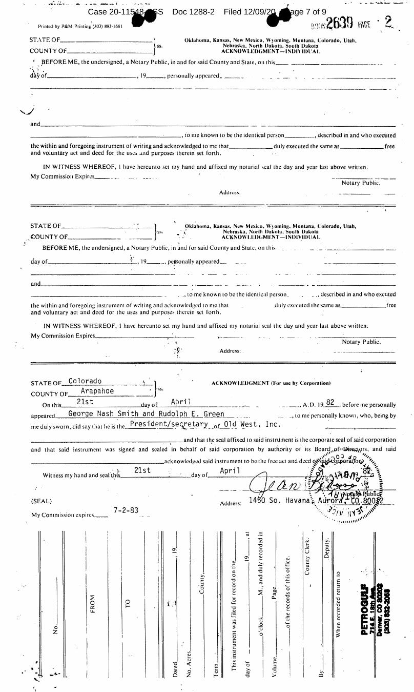
..,. .. ,. .:.:..,. .. .... .., _ • ., ~•-•-· C .. - ........... -... __ -- -.. ·? Printed by P&M Printing (303) 893-1681
STA TE OF ____________ }ss.
COUNTY OF _________ _
Oklahoma, Kansai;, New Mexico, W)omini:, Monlana, Colorado, Utah, Nebraska, North Dakota, South Dakota
ACKNOWtEDGMENT-INDl\ll>tAI.
_' .. ,BEFORE ME, the undersigned, a Notary Public, in and for said County and Stale, on 1his _____________ _
"\.'· . day of ____________ , 19 __ , personally appeared ____ _
- --------
and ____________________________ _
....,_
-------------------'----• to me known to be the identical person ____ , described in and who exeC\lted
the within and foregoing instrument of writing and acknowledged to me that ______ duly executed the same as ______ free and voluntary act and deed for the us..::. .md purposes therein set forth.
IN WITNESS WHEREOF, 1 have hereunto set my hand and affixed my notarial ,cal the day and year last above written.
My Commission Expires _____ _ Notary Public.
',
ST ATE OF __________ ------=:===·· }ss. Oklahoma, Kansas, New Mc:1.ico, W)omini:, Monlana, Colorado, Utah,
COUNTY OF______ _ ~ .\ Nebraska, Norlh l>akola, Soulh Dakota
ACKNOWLED(;MENT-INDIVIDlJAL . BEFORE ME, the undersigned, a Notary Public, in and for said County and State, on this
1· day of ____________ , 19 ___ , pcfwnal_ly appeared~
and _________________ _
. _,tome known to be the identical person_ _ _, described in and who excuted
the within and foregoing instrument of writing and acknowledged lo me that and voluntary act and deed for the uses and purposes therein set forth.
.duly executed the same as ______ free
IN WITNESS WHEREOF, I have hereunto set my hand and affixed my notarial seal the day and year last above written.
My Commission Expires __________ -,-~ Notary Public.
;~-- Address: (.
Colorado , ' STATEOF ___ A_r_a_p_a_h_o_e _______ , _· }ss. COUNTYOF ________ _
ACKNOWLEDGMENT (For use b) Corporation)
On this, ___ 2_l_s_t ______ day of __ A....c.p_r_i~l ____ _ _ ____ , A.D. 19~, before me personally
appeared George Nash Smith and Rudolph E. Green _,tome personally known, who, being by
me duly sworn, did say that he is the Pres i d~nt/ s_ec;re__!:_a ry _ .or_Q_l_<! ~est, Inc.
(SEAL)
My Commission expires __ 7-2-83
I ;;j C:
' "O -t >-. ,.,
; "O ,., "' 0 0 0.
u .,
"' \':'. o..i ;.,-, Cl ,., ..=::, u C: -5 ...:: :l
:l '- 0 C: "O 0 u 3 :'.:' 0 "O .:!:
C: "O C: -5 C: ... 0:: ... -:l 0 ._ :l 0 u ,., 0 QJ u \':'. ~ 00 V, 0:: ...
::>. ...
I
0. "O ... "O 0 0 Lt 0 0 ,.,
f-._
u "O ~ "O \':'. ... ~ ~ 0
...:: ,., u -5
,., V, -" ...
u 0:: 0 ._
~ 0 :: :u 0
z C:
I .c:
0 ~ ,., E ~
V) ;:; I ., C:
I ... ,.,
I
~ u .:!: '- E "O <I'. ,., E .c: 0 :l ,,
;;j 0 ... f- >-. 0 Ji,•
,., 0:: ;.,, .... Cl z f- "O ;;., cc '-" I
Case 20-11548-CSS Doc 1288-2 Filed 12/09/20 Page 7 of 9

.. - ...., __
;
Hr.
18.
.. ADDENDUM
Lessee acknowledges oj 1 anJ gas product ion OP,_~rations remov.e Lmd from use . for long pcricds of t imc. Furthermore, Lesscld agr1;es to. compensate Lessor for lanJ taken by the roa·d Lo the wel 1-bea<l (access ro:1d'. , t;·ank batteri_es, pipeline und r:roducing wL'll-hL'ad. Compensation sha~l be according to the' following schl:dule for each measured surface acre:
$1,5(10.0C per ":ic.re for land not producing cruµs. $2,000.0C per acre for .land producing grain. $2, SO(L OC per acre for land producing alfafa.
Measured 1 and area shall 1 be rounded upward in one-half i:1crements. Afte~ the prirrary term the above schedule sl1all increase or decrease henceforth at a rate consistent with the National Consumer Pri~e Index, as computed by the Department of Commen:e, Bureau of LaQ_q.r'and Statistics.
:•·~'
All1
tank battc.:ries and permanent fac.ilities wU1 be fenced to prevent injuries to livestc,ck ..
' .
" .
Subj cct L<· I i11 i Lal ions ;i;; 111:iy lie· imposed l,y L l1e O i I .111d <::is Conservation Com-·_,,,.--......_ mission of the Stale uf Colorado, al I drll I silc•s, at'<'l'ss roads, and pipeline locations which least i11LL:rfcre with Le:::;sur's operations and which have been previously ap1:rovcd in writing by Lessor. Lessor guaranLC!es that it will give LesseL' written approval for at' Least one dri_LI. sile in each of the following locations:
The Forti· one-half of the Southwest one-quarter, Section 11. The ~-outl: one-half of the Southwest one-quarter, Section 11, and the NortL one-half of thl! North one-half of the Northwest one-quarter, Section 1.4.
✓
19. Lessee shE.11 give Lessor a schedule of pl~mwd times when agents of the Lessor . . ~
plan to remove oil from premises. Further more, Lessee shall make a good faith effort to secure the signature of the witness upon "run tickets." Lessor must
. bear the 1:-urden of having its designated w.ti:ness at or near the tank batteries at the scLeduled time. Lessee shall provide Lessor or Lessor's agent with a copy of all "run tickets" for all oil removed from th~se premises. The purpose of this pE.ragraph is to prevent oil thievery.
,l
20. Lessee further agrees that immediately subs.equent to comp;Eetion·or abandonment of· drillir.g activities, such as but not l.i;lnited to rn:i<lways, slush pits and drill sitE, it will restore. all land utiljted for such explor.:1tion as nearly possible to its former condition. • :
21. Lessee. sh;..:) I n:;1ke availJhil' Lu LL•ssor any infunnation iL has or acquires relating, to watel'.' , nd water bearing z01H·s enl'OltlllL·ri:d in Lhe course• of drilling upon Lessor.' s land. In th·~ ,L·vent Lessee elects Lo plug anq abandon any well, Lessor sh,11 have the right, in accordance herewitl1, to take over the well for use
. <
as a water well. Prior to abandoning any wel 1, Lessee shall g·ive Lessor notic·e of intent to abandon and of the salvage value of casing materials in the well. Lessor she.JI. have·seventy-two (72) hours after receipt of such notice in which to notify Lvssl'e of Lessor '·s intention to take over the well. Hith respect to any such v,c•l l which 1.c·ssor has notified Lessee of its intention. to use as)~ water well, Lessee ski! l noL remove casing malerials or do-any such act which
. would impel r Lessor's ah i Ii Ly to use the abanclonc<l well as a water well. Wi._thin five (S) ca.ys of so taking llVL!r a wel L, Lessor slwll. pay ·Lessee in cash ~r certified fund~ the salvage value of all casing materials· left in the well, and shall assume all of Lessee's uhligations and liabilities accruing thereafter with respect tc'sai<l well •
-1-
, ' ., ...
.. "1f,r ~ ~,., ..... ••
Case 20-11548-CSS Doc 1288-2 Filed 12/09/20 Page 8 of 9
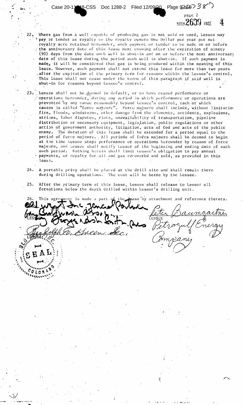
.. ~· ·•
>
----
,
;;;_ ;;). / 3 <,?" ') .. -. page 2
f\OOK263fJ :PAGE ·i 22 ~ Wher: g.as from a well c1-1pah I e of prod1:cing gas is not so Id or used, Lessee may
• pay_ :)r tender as royalty Lo Llie royal Ly 01,,·ners Orn . .! Dollar per year per net royalty acre reta.ine<l ti,_•rcundl'r, such paymvnl or tender Lo be made on or before the 3.nnivcrsary date of this lease next l'ns11ing after the expiration of ninety (90) days from the date stH·h we! I is shut-in and on or before· the next anniversar) date of this lease during the period such well i.s shut'"7in. If such payment is mad~~ it will be considered that gas is being produced witl1in the meaning of this leas:. However, such payment shall not extend t~is lease for more than two years
.after the expiration of tl1c primary tl'rm for reasons within the Lessee's control. ·This lease shall not cease un<lt•r the terns 9f this paragraph if .said well is shut-in for reasons beyond Lessee's contrul.
23. '. Less:e shall not he ;lj.l'Cilll'd in' dcfaul t, or Lo have ceased performar,ce or I l
:· oper3.tions lierv11nde·t:, ·during ;111y pL·riod in which pc•rformance or operations are · prev:ntecl 'hy any callse rl'asonab I y beyond I.L•sse<..'! 1 s control, each or which
caus:s is cal lecl "forcl' 111,ijcun•". Force majucre shal 1 include, without limitatio1 fire, f.loods, windstorms, other damage fro1{1 the elements, acciclents, explosionst stri.tes, la.bar disputes, riots, unavaila1)ility of transportation, pipeline distribution or necessary equipment, legislation, public regui~tions or other acti::m of government authority, litigation', acts of God and acts of the public enemy. The durat~on of t\1is lease shall he extended for a period equal to the peri:>d of· fon:c majcure •. All p~riods of force majeure shall be deemed to begin at t:1e time Lessee stops performance or operations hereunder by reason of force maje·.1re, and :..,l'Ssec shall nut i(y Lessor of ti\e beginning and ending date of each such period. Nothing lt-~rein shaJ 1 limit Lessee's obligation to pay annual paym:c!nts, or royalty for oil and gas r<.!('Ovc-rl::~<l :md sold, as provided in this
· leas3.
24. A portable privy shal 1 lw plan•<l at the drill site ancl shall remain there duri:1g dr il 1 ing operations. The cost will be borne by the Lessee.
25. After the primary term of this lease, Lessee shall release to Lessor all forma~ions below the depth clrilled within Lessor's drilling unit.
attachment .and reference thereto.
L ~ ... ~ .. ~ . .
~ I~-sAL1 ·' \. ~ , .
, ,. ' ..
', '·. ---,,I,_ " .... • .,....,--- j. • , . . . .. ,. ... .. ~ 't ,, ••••••• " 'r..01 &). •. 1,, . . 0 .... .. ~
\\';,i,", ...... :,: ....
•'
.,
Case 20-11548-CSS Doc 1288-2 Filed 12/09/20 Page 9 of 9