Embed Size (px)
Citation preview
i
SUBDIVISION REGULATIONS
FOR THE
SEVIER COUNTY PLANNING REGION
Adopted March 26, 1996
With Amendments through February 2011
Sevier Regional Planning Department 315 Prince Street
Sevierville, Tennessee 37862 865-453-3882
ii
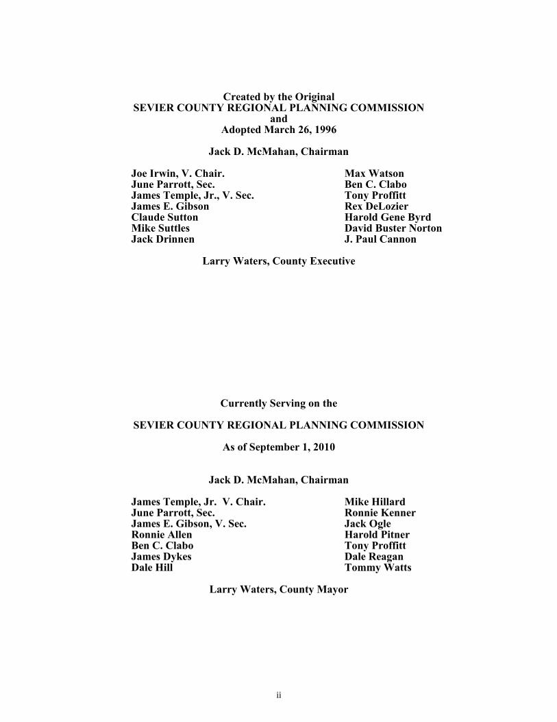
Created by the Original
SEVIER COUNTY REGIONAL PLANNING COMMISSION and
Adopted March 26, 1996
Jack D. McMahan, Chairman
Joe Irwin, V. Chair. June Parrott, Sec. James Temple, Jr., V. Sec. James E. Gibson Claude Sutton Mike Suttles Jack Drinnen
Max Watson Ben C. Clabo Tony Proffitt Rex DeLozier Harold Gene Byrd David Buster Norton J. Paul Cannon
Larry Waters, County Executive
Currently Serving on the
SEVIER COUNTY REGIONAL PLANNING COMMISSION
As of September 1, 2010
Jack D. McMahan, Chairman
James Temple, Jr. V. Chair. June Parrott, Sec. James E. Gibson, V. Sec. Ronnie Allen Ben C. Clabo James Dykes Dale Hill
Mike Hillard Ronnie Kenner Jack Ogle Harold Pitner Tony Proffitt Dale Reagan Tommy Watts
Larry Waters, County Mayor
iii
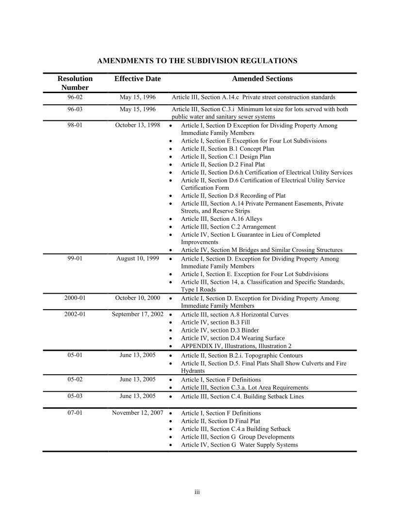
AMENDMENTS TO THE SUBDIVISION REGULATIONS
Resolution
Number
Effective Date Amended Sections
96-02 May 15, 1996 Article III, Section A.14.c Private street construction standards
96-03 May 15, 1996 Article III, Section C.3.i Minimum lot size for lots served with both
public water and sanitary sewer systems
98-01 October 13, 1998 Article I, Section D Exception for Dividing Property Among
Immediate Family Members
Article I, Section E Exception for Four Lot Subdivisions
Article II, Section B.1 Concept Plan
Article II, Section C.1 Design Plan
Article II, Section D.2 Final Plat
Article II, Section D.6.h Certification of Electrical Utility Services
Article II, Section D.6 Certification of Electrical Utility Service
Certification Form
Article II, Section D.8 Recording of Plat
Article III, Section A.14 Private Permanent Easements, Private
Streets, and Reserve Strips
Article III, Section A.16 Alleys
Article III, Section C.2 Arrangement
Article IV, Section L Guarantee in Lieu of Completed
Improvements
Article IV, Section M Bridges and Similar Crossing Structures
99-01 August 10, 1999 Article I, Section D. Exception for Dividing Property Among
Immediate Family Members
Article I, Section E. Exception for Four Lot Subdivisions
Article III, Section 14, a. Classification and Specific Standards,
Type I Roads
2000-01 October 10, 2000 Article I, Section D. Exception for Dividing Property Among
Immediate Family Members
2002-01 September 17, 2002 Article III, section A.8 Horizontal Curves
Article IV, section B.3 Fill
Article IV, section D.3 Binder
Article IV, section D.4 Wearing Surface
APPENDIX IV, Illustrations, Illustration 2
05-01 June 13, 2005 Article II, Section B.2.i. Topographic Contours
Article II, Section D.5. Final Plats Shall Show Culverts and Fire
Hydrants
05-02 June 13, 2005 Article I, Section F Definitions
Article III, Section C.3.a. Lot Area Requirements
05-03 June 13, 2005 Article III, Section C.4. Building Setback Lines
07-01 November 12, 2007 Article I, Section F Definitions
Article II, Section D Final Plat
Article III, Section C.4.a Building Setback
Article III, Section G Group Developments
Article IV, Section G Water Supply Systems
iv
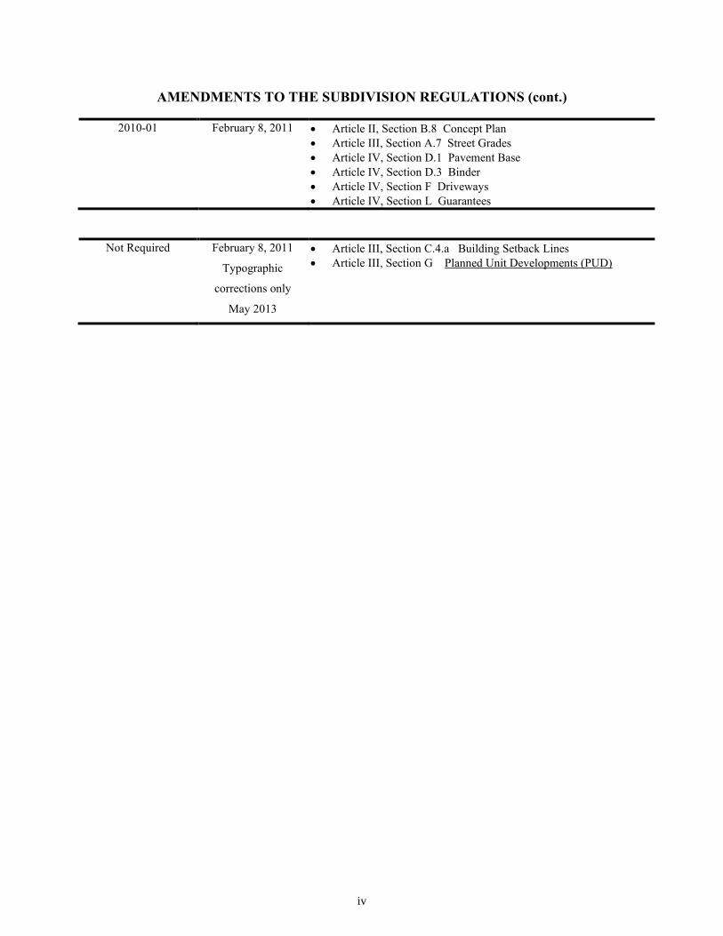
AMENDMENTS TO THE SUBDIVISION REGULATIONS (cont.)
2010-01 February 8, 2011 Article II, Section B.8 Concept Plan
Article III, Section A.7 Street Grades
Article IV, Section D.1 Pavement Base
Article IV, Section D.3 Binder
Article IV, Section F Driveways
Article IV, Section L Guarantees
Not Required February 8, 2011
Typographic
corrections only
May 2013
Article III, Section C.4.a Building Setback Lines
Article III, Section G Planned Unit Developments (PUD)
v
TABLE OF CONTENTS
ARTICLE PAGE
I. PURPOSE, AUTHORITY AND JURISDICTION 1
A. Purpose 1
B. Authority 1
C. Jurisdiction 1
D. Exception for Dividing Property Among Immediate Family Members 1
E. Exception for Four Lot Subdivisions 2
F. Definitions 2
II. PROCEDURE FOR PLAT APPROVAL 3
A. General 3
B. Concept Plan 4
C. Design Plan 5
D. Final Plat 6
III. GENERAL REQUIREMENTS AND MINIMUM STANDARDS OF DESIGN 11
A. Streets 11
B. Blocks 16
C. Lots 17
D. Public Use and Service Areas 19
E. Suitability of the Land 19
F. Variances 20
G. Planned Unit Developments (PUD) 20
H. Other Regulations 21
IV. DEVELOPMENT PREREQUISITE TO FINAL APPROVAL 22
A. Monuments or Corner Markers 22
B. Grading 22
C. Storm Water Control 23
D. Road Design Standards 24
E. Sidewalks 25
F. Installation of Utilities and Driveways 25
G. Water Supply System 26
H. Sanitary Sewers 26
I. Street Name Signs & Regulatory Warning Signs 26
J. Requirements for Acceleration and Deceleration
Lanes 26
K. Electric Transmission Lines 26
L. Guarantee in Lieu of Completed Improvements 27
M. Bridges and Similar Crossing Structures 27
V. ENFORCEMENT AND PENALTIES FOR VIOLATIONS 28
A. General 28
B. Enforcement 28
C. Penalties 28
VI. ADOPTION AND EFFECTIVE DATE 29
vi
TABLE OF CONTENTS continued
APPENDIX I. TALBOTT'S FORMULA 31
APPENDIX II. PRIME COAT REQUIREMENTS 33
APPENDIX III. ONE COURSE ASPHALTIC CONCRETE WEARING 35
SURFACE (PLANT MIXED)
APPENDIX IV ILLUSTRATIONS 38
ILLUSTRATION 1 MINIMUM STANDARDS OF DESIGN FOR STREETS 39
ILLUSTRATION 2 STREET GRADES, CURVES, AND ACCESS 40
ILLUSTRATION 3 SWITCHBACK DESIGN 41
ILLUSTRATION 4 T AND Y BACKAROUND DESIGN 42
ILLUSTRATION 5 TYPICAL ROADWAY SECTION 43

1
ARTICLE I.
PURPOSE, AUTHORITY AND JURISDICTION
A. Purpose
Land subdivision is the first step in the process of community development. Once land has been cut up into streets,
lots and blocks and publicly recorded, the correction of defects is costly and difficult. Subdivision of land sooner or
later becomes a public responsibility, in that roads and streets must be maintained and various public services
customary to urban or rural areas must be provided. The welfare of the entire community is thereby affected in
many important respects. It is therefore to the interest of the public, the developer and the future owners that
subdivisions be conceived, designed and developed in accordance with sound rules and proper minimum standards.
B. Authority
These subdivision regulations are adopted under authority granted by Sections 13-3-401 through 13-3-411 of the
Tennessee Code Annotated. The planning commission has fulfilled the requirements set forth in this act as
prerequisite to the adoption of such regulations. A certified copy of the Major Road Plan for the Sevier County
Planning Region is on file in the office of the Register of Sevier County, Tennessee.
C. Jurisdiction
These regulations shall govern all subdivision of land within the planning region of Sevier County, Tennessee now
or hereafter established and within these regulations, the term "subdivision" means the division of a tract or parcel of
land into two or more lots, sites or other divisions, requiring new street or utility construction, for the purpose
whether immediate or future, of sale or building development, and includes resubdivision and, when appropriate to
the context, relates to the process of subdividing or to the land or area subdivided, provided, however, that
"subdivision" does not include a division of any tract or parcel of land into two or more tracts or parcels when such
parts or parcels are five (5) acres or larger in size and do not require street or utility construction. Any owner of land
within this area wishing to subdivide land shall submit to the planning commission a plat of the subdivision
according to the procedures outlined in Article II, which plat shall conform to the minimum requirements set forth in
Article III. Improvements shall be installed as required by Article IV of these standards.
(Article I, D amended by resolution 98-01, effective 10/13/98)
(Article I, D amended by resolution 99-01, effective 8/10/99)
(Article I, D amended by resolution 2000-01, effective 10/10/00)
D. Exception for Dividing Property Among Immediate Family Members
Where an owner of property can demonstrate that a division of property is for the purpose of deeding a single parcel
of land to an immediate family member, and provided the deeded property meets the appropriate minimum lot size
and setback standards as established in Article III of these regulations, with either direct access to a public street or a
deeded private permanent easement to a public street, then the division of property shall be exempt from further
regulation by the regional planning commission. The width of the direct access easement or right of way within the
property being divided shall be determined as follows:
2
1. 30 feet minimum if the division creates no more than 2 parcels and the total of both is less than 5
acres.
2. 40 feet minimum if the division creates more than 2 parcels and the total of all parcels is greater
than 5 acres but less than 10 acres.
3. 50 feet minimum if the total of all parcels in more than 10 acres, regardless of the number of
parcels.
Any proposal for streets or utility improvements shall not be allowed under this section and must comply with all
terms found in subsequent sections of these regulations. Immediate family members shall include the mother,
father, son, daughter, brother, sister or grandchild of the property owner. The secretary of the planning commission
shall, upon review by the planning staff, and in the absence of any variance request, have the authority to sign any
plat meeting the terms of this section without presentation to the regional planning commission. The Planning staff
may offer recommendations, which may prevent or lessen any future difficulties if the property were subdivided and
sold to non-family members.
(Article I, E amended by resolution 98-01, effective 10/13/98)
(Article I, E amended by resolution 99-01, effective 8/10/99)
E. Exception for Four Lot Subdivisions
Where an owner of property can demonstrate that he or she is dividing four or fewer lots, all of which meet the
requirements of these regulations; with direct access to either an established county or state road, or a private
permanent easement which conforms with the private street standards established in Article III Section A.14, then
the secretary of the planning commission shall, upon review by the planning staff, and in the absence of any
variance request, have the authority to sign any plat meeting the terms of this section without presentation to the
regional planning commission. Any proposal for street or utility improvements shall not be allowed under this
section and must comply with all terms found in subsequent sections of these regulations.
(Article I, F amended by resolution 05-02, effective 6/13/2005)
(Article I, F amended by resolution 07-01, effective 11/12/2007)
F. Definitions
Building: Any structure, including all porches, decks and overhangs,built for the support, shelter, or
enclosure of persons, animals, chattels, or any personal property of any kind.
Public Water: Water service provided by either a municipality, utility district (as regulated by the Secretary
of State), or public utility (as regulated by the Tennessee Regulatory Authority).
Public Sanitary Sewer: Sanitary wastewater service provided by either a municipality, utility district (as
regulated by the Secretary of State), or public utility (as regulated by the Tennessee Regulatory
Authority).
Slope, Average, of Development: The percent rise of elevation from a point on the lowest contour line
within the proposed development to a point on the highest contour line within the proposed
development divided by the horizontal distance between these two points.
Slope, Average, of Lot: The percent change in elevation from the center of the front right-of-way line to the
center of the rear lot line divided by the horizontal distance between these two points.

3
ARTICLE II
PROCEDURE FOR PLAT APPROVAL
A. General
1. The procedure for review and approval of a subdivision plat consists of three (3) separate steps,
however, only two require appearances before the regional planning commission for review and
approval. The initial step is the preparation and submission to the planning commission of a
concept plan of the proposed subdivision for preliminary plat approval. The second step is the
preparation and submission to the technical staff of a design plan detailing the construction plans
of the proposed subdivision. The third step is the preparation and submission to the regional
planning commission of a final plat together with appropriate certificates required for final plat
approval. The final plat becomes the instrument to be recorded in the office of the Register of
Sevier County when duly signed by the secretary of the regional planning commission.
2. Any owner of land lying within the area of jurisdiction of the planning commission who wishes to
divide such land into two (2) or more lots, sites, or divisions, for the purpose, whether immediate
or future, of sale or building development, including resubdivision and, when appropriate to the
context, relating to the process of subdividing or to the land or area subdivided, shall submit a plat
of such proposed subdivision to the regional planning commission for approval and shall obtain
such approval prior to the filing of his subdivision plat for record. Any such plat of subdivision
shall conform to the minimum standards of design for the subdivision of land as set forth in
Article III of these regulations and shall be presented in the manner specified in the following
sections of this Article. No plat of a subdivision of land within the area of planning jurisdiction
shall be filed or recorded by the county register without the approval of the regional planning
commission as specified herein.
3. In order to secure review and approval by the regional planning commission of a proposed
subdivision, the prospective subdivider shall, prior to the making of any street improvements or
installations of utilities, submit to the planning commission a concept plan as provided in Section
B of this Article. On approval of said concept plan he may proceed with the preparation of the
design plan, final plat and other documents required in connection therewith as specified in
Section C of this Article and the improvements set forth in Article IV.
4. Sketch Plan Review. The subdivider shall consult early and informally with the planning
commission and its technical staff for advice and assistance before the preparation of the concept
plan and its formal application for approval. A very general sketch plan may be presented to the
planning commission at the request of the subdivider, but shall not be required for Concept Plan
approval. Pre-development coordination will enable the subdivider to become thoroughly familiar
with these regulations, the Major Street Plan and other official plans or public improvements
which might affect the area. Such informal review should prevent unnecessary and costly
revisions. The subdivider should use this opportunity to discuss problems with the development
and investigate appropriate alternatives with the regional planning commission and the technical
staff.
4
B. Concept Plan
(Article II, B, 1. amended by resolution 98-01, effective 10/13/98)
1. A concept plan shall be required on all developments except for minor subdivisions as noted in
Article II, Section B.3. The concept plan shall serve as preliminary plat approval. At least ten
(10) working days prior to the meeting at which it is to be considered, the subdivider shall submit
to the regional planning commission twenty (20) copies of a concept plan of the proposed
subdivision drawn to a scale of not less than one (1) inch equals one hundred (100) feet. The
concept plan shall show the entire property proposed for development and the stages in which the
development shall occur. A concept plan shall not be acceptable for submission unless it meets all
the required standards of design and unless it contains all the required information or a written
request for a variance from each specific deviation from the requirements with reasons therefore.
2. The concept plan shall meet the minimum standards of design as set forth in Article III and the
general requirements for the construction of public improvements as set forth in Article IV and
shall give the following information insofar as possible.
a. A title block indicating the proposed subdivision's name and location, date and graphic scale,
the name(s), address(es) and phone number(s) of the owner or owners, property assessor
parcel identification information, and the name, address, and phone number of the designer
of the plat who shall be a registered surveyor.
b. The general north orientation.
c. The location of existing property and easement lines, the names of adjoining property owners
or subdivisions, and all existing improvements of any type or purpose, including but not
limited to; streets, buildings, water courses, railroads, sewers, bridges, culverts, drain pipes,
dams, water and gas mains, public utility lines, drainage swales, and detention basins.
d. The general location of proposed utility layouts (sewers, water, gas, fire hydrants and
electricity) showing feasible connections to the existing or any proposed utility systems.
When such connections are not practicable, any proposed individual water supply and/or
sewage disposal system must be approved by the appropriate health authorities.
e. The proposed street names, and the locations and dimensions of proposed streets, alleys,
easements, parks, and other open spaces, reservations, lot lines, building setback lines and
utilities.
f. The approximate acreage of the land to be subdivided.
g. Location sketch map showing relationship of subdivision site to area.
h. The 100 year base flood elevation and limit line as defined on any applicable Flood
Insurance Rate Map prepared by the Federal Emergency Management Agency or other
recognized agency, along with any portion of the land being subdivided which is subject to
flood as defined in Article III, Section E shall be shown. In addition, physical features of the
site such as swamps, woods, natural waterways and other prominent features shall be shown.
(Article II, B, 2, i. Amended by Resolution 05-01, effective 6/13/2005)
i Contours at vertical intervals of not more than two (2) feet except when specifically not
required by the regional planning commission; such request must be made prior to the
submission of a concept plan. Contours at vertical intervals of not more than ten (10) feet

5
may be acceptable on plats where average slopes of the entire development exceed thirty
(30) percent.
3. Minor Subdivision. A minor subdivision is one which is completed in one phase and does not
require the construction of public improvements. A subdivider may omit the submission of a
concept plan, submitting only a final plat if all the following conditions are met:
a. The proposed subdivision does not contain more than ten (10) lots, sites, or divisions.
b. All public improvements as set forth in Article IV are already installed or because of the
nature of the development deemed not necessary by the regional planning commission. Any
construction, installation, or improvement of any public improvements shall require
submission of a concept plan as prescribed by Section B of Article II.
c. The subdivider has consulted informally with the regional planning commission and/or
planning staff for advice and assistance before preparation of a final plat and its formal
application for approval.
4. Within sixty (60) days after submission of a concept plan, the planning commission will review it
and indicate its approval, disapproval, or approval subject to modifications. If a concept plan is
disapproved, reasons for such disapproval will be stated in writing. If approved subject to
modifications, the nature of the required modifications will be indicated.
5. One (1) copy of the concept plan shall be retained in the regional planning commission files; one
(1) copy shall be retained by the planning commission staff; one (1) copy shall be returned to the
subdivider at the time of approval or disapproval with any notations as to required changes, if any.
6. The approval of the concept plan by the regional planning commission will not constitute
acceptance of the final plat and will not be indicated on the concept plan.
7. The approval of the concept plan shall lapse unless a final plat based thereon is submitted within
twelve (12) months from the date of such approval unless an extension of time is applied for and
granted by the regional planning commission.
(Article II.B.8 amended by resolution 2010-01, effective 02/08/11)
8. Following Concept Plan approval and prior to construction beginning, the developer or his
representative shall schedule a preconstruction meeting with the County Planner. This meeting
shall be held to discuss the work to be undertaken and the design and construction process related
to stormwater, wastewater, water, electric, roadway, and drainage requirements for the
construction process.
C. Design Plan
(Article II, C, 1. amended by resolution 98-01, effective 10/13/98)
1. The design plan shall consist of all detailed engineering design and construction drawings,
calculations and related documents necessary to construct the proposed subdivision in
conformance with the approved concept plan and these regulations. Any construction work
carried out by the subdivider prior to design plan approval, or contrary to an approved
plan, shall be at the subdivider’s own risk. The design plan shall be reviewed by the regional
planning commission technical staff and shall not require formal review by the regional planning
commission unless variances to the requirements of these regulations are requested by the
subdivider. At least thirty (30) days prior to the meeting at which final plat approval is to be
considered, the subdivider shall submit to the regional planning commission technical staff five
(5) copies of a composite design plan of the proposed subdivision for review by the county
planner, county road superintendent, county director of environment, county 911 director, and

6
other pertinent reviewing authorities required by these regulations. The design plan shall meet the
minimum standards of design as set forth in Article III and the general requirements for the
construction of public improvements as set forth in Article IV and shall give the following
information insofar as possible.
a. A sketch location map, number of lots and total acreage, subdivision name and unit number,
name(s), address(es), and phone number(s) of owners, date and scale, and property identification.
b. Final dimensions and bearings for all lot lines, tract boundary, roads and required easements
and lot numbers, and the building setbacks with distance from street right of way.
c. Location and size of all drainage facilities including ditches, culverts, pipes, catch basins,
and detention basins. All drainage facilities shall be shown in their final location. The
location of all utilities and related easements shall also be shown in their final location.
d. Watercourses, marshes, major rock outcroppings, woodlots, bridges, or other structures shall
be included on the design plan.
e. Topography with contours at vertical intervals of not more than twenty (20) feet. In the
event that the requirement for topographic information was waived during concept approval,
then this requirement will only apply to those areas associated with the construction of any
proposed improvements.
f. Drawings, documents, and calculations in compliance with the requirements of Article IV of
this document shall be required including, but not limited to the following:
i. roadway design including horizontal and vertical profiles,
ii. drainage plan,
iii. erosion and sedimentation control plan,
iv. utility plans.
2. Acceptance Statement. A statement certifying approval of the design plans and their conformance
with all applicable regulations for roads, drainage, water and sewers from each appropriate utility
and reviewing agency shall be submitted to the county planner prior to acceptance of the final plat
for regional planning commission consideration. The final plat may be placed on the regional
planning commission agenda for review, however, approval shall not be granted without all
acceptance statements required for the subdivision.
D. Final Plat
1. The final plat shall conform substantially to the concept plan as approved, and, if desired by the
subdivider, it may constitute only that portion of the approved concept plan which he proposed to
record and develop at the time, provided however, that such portion conforms to all requirements
of these regulations. A final plat shall not be acceptable for submission unless it contains all of the
required information or a written request for a variance from each specific deviation from the
requirements with reasons therefore.
(Article II, D, 2. amended by resolution 98-01, effective 10/13/98)
2. To allow sufficient time for review and processing by the regional planning commission and staff,
the subdivider shall submit twenty (20) copies of the final plat at least ten (10) working days prior
7
to the meeting at which it is to be considered. The plat shall be drawn to a scale of one (1) inch
equals one hundred (100) feet on sheets no larger than 24" x 36" in size. When more than one
sheet is required, an index sheet of the same size shall be filed showing the entire subdivision with
the streets lettered in alphabetical order as a key. When the plat has been approved by the regional
planning commission, one (1) copy shall be filled with the county register as the official plat of
record in accordance with subsection 8 of this section. One copy shall be retained in the records
of the regional planning commission; one copy shall be retained by the planning staff; and one
copy shall be provided to any utilities department or utility district as applicable.
3. The regional planning commission shall approve or disapprove this final plat within sixty (60)
days after its submission. If the plat is disapproved, the grounds for disapproval shall be stated
upon the records of the regional planning commission.
4. Approval of the final plat by the regional planning commission shall not constitute the acceptance
by the public of the dedication of any street or other public way or ground. A formal request for
acceptance must be made to the County Commission by the developer of the subdivision.
5. The final plat shall show:
a. The lines of all streets and roads, alley lines, building setback lines, lots numbered in
numerical order, reservations for easements, and any areas to be dedicated to public use or
sites for other than residential use with notes stating their purpose and any limitations.
b. Sufficient data to determine readily and reproduce on the ground the location, bearing, and
length of every street line, lot line, boundary line, block line and building line, whether
curved or straight, and including the precise north orientation. This shall include the radius,
central angle and tangent distance, chord bearing and chord distance for the centerline of
curved streets and curved property lines that are not the boundary of curved streets.
c. The area of all subdivided lots or tracts and of any land remaining.
d. All dimensions to the nearest one hundredth (100th) of a foot and angles to the nearest
minute.
e. Location and description of monuments.
f. The names and locations of adjoining subdivisions and streets and the location and
ownership of adjoining unsubdivided property.
g. Date, title, name and location of subdivision, graphic scale, and the precise north orientation.
h. Location sketch map showing site in relation to area.
i. The 100 year base flood elevation and limit line as defined on any applicable Flood
Insurance Rate Map prepared by the Federal Emergency Management Agency or other
recognized agency, along with any portion of the land being subdivided which is subject to
flood, as defined in Article III, Section E, shall be shown.
(Article II, D, 5, j and k. Amended by Resolution 05-02, effective 6/13/2005)
j. Location and size of culverts.
k. Location of fire hydrants.
8
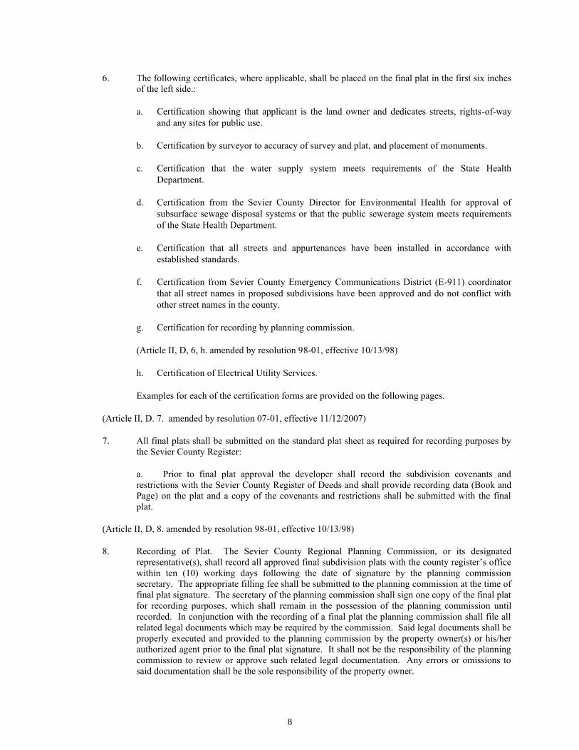
6. The following certificates, where applicable, shall be placed on the final plat in the first six inches
of the left side.:
a. Certification showing that applicant is the land owner and dedicates streets, rights-of-way
and any sites for public use.
b. Certification by surveyor to accuracy of survey and plat, and placement of monuments.
c. Certification that the water supply system meets requirements of the State Health
Department.
d. Certification from the Sevier County Director for Environmental Health for approval of
subsurface sewage disposal systems or that the public sewerage system meets requirements
of the State Health Department.
e. Certification that all streets and appurtenances have been installed in accordance with
established standards.
f. Certification from Sevier County Emergency Communications District (E-911) coordinator
that all street names in proposed subdivisions have been approved and do not conflict with
other street names in the county.
g. Certification for recording by planning commission.
(Article II, D, 6, h. amended by resolution 98-01, effective 10/13/98)
h. Certification of Electrical Utility Services.
Examples for each of the certification forms are provided on the following pages.
(Article II, D. 7. amended by resolution 07-01, effective 11/12/2007)
7. All final plats shall be submitted on the standard plat sheet as required for recording purposes by
the Sevier County Register:
a. Prior to final plat approval the developer shall record the subdivision covenants and
restrictions with the Sevier County Register of Deeds and shall provide recording data (Book and
Page) on the plat and a copy of the covenants and restrictions shall be submitted with the final
plat.
(Article II, D, 8. amended by resolution 98-01, effective 10/13/98)
8. Recording of Plat. The Sevier County Regional Planning Commission, or its designated
representative(s), shall record all approved final subdivision plats with the county register’s office
within ten (10) working days following the date of signature by the planning commission
secretary. The appropriate filling fee shall be submitted to the planning commission at the time of
final plat signature. The secretary of the planning commission shall sign one copy of the final plat
for recording purposes, which shall remain in the possession of the planning commission until
recorded. In conjunction with the recording of a final plat the planning commission shall file all
related legal documents which may be required by the commission. Said legal documents shall be
properly executed and provided to the planning commission by the property owner(s) or his/her
authorized agent prior to the final plat signature. It shall not be the responsibility of the planning
commission to review or approve such related legal documentation. Any errors or omissions to
said documentation shall be the sole responsibility of the property owner.

9
SUBDIVISION CERTIFICATION FORMS 1. CERTIFICATION OF OWNERSHIP AND DEDICATION
I (we) hereby certify that I am (we are) the owner(s) of the property shown and described hereon and that I (we)
hereby adopt this subdivision plat with my (our) free consent, establish the minimum building restriction lines, and
dedicate all streets, alleys, walks, park or other public ways and open space to public or private use as noted.
____________ ______________________ ________________________
Date Owner Owner
2. CERTIFICATE OF ACCURACY
I certify that this plat accurately depicts a true and correct survey made under my direct supervision, that it meets the
accuracy required by the regional planning commission, and that corner monuments have been placed as shown
hereon, to the specifications of the regional planning commission. I hereby certify that this is a category
survey and the ratio of precision of the unadjusted survey is 1: as shown hereon.
__________________ 20___ _____________________________
Date Registered Surveyor Registration #
3. CERTIFICATION OF APPROVAL OF WATER SYSTEMS
I certify that the water system installed, or proposed for installation fully meet the requirements of the Tennessee
State Health Department, and is hereby approved as shown.
_________________ 20___ ________________________________
Date Utility System Manager
4a. CERTIFICATION OF SEWERAGE SYSTEM I certify that the sewage disposal system installed, or proposed for installation, fully meet the requirements of the
Tennessee State Health Department and is approved as shown with all restrictions/conditions as noted (not required
if 4b is applicable).
________________, 20___ ________________________________ Date Utility System Manager
4b. CERTIFICATION OF SUBSURFACE DISPOSAL Subdivision is approved for subsurface sewage disposal. Owner/developer shall obtain from the
Commissioner/Health Authority or Representative a permit for each lot prior to any construction on the property.
The permit shall establish the maximum size dwelling and the specific location of the primary and the secondary
disposal areas. Owner/developer shall not do any construction or mutilation (cutting or filling) of the so designated
primary and secondary disposal area without the prior approval of the Commissioner, Health Authority or
Representative. (not required if 4a is applicable).
_____________________, 20___ ____________________________
Date Sevier County Director for Environmental Health
10
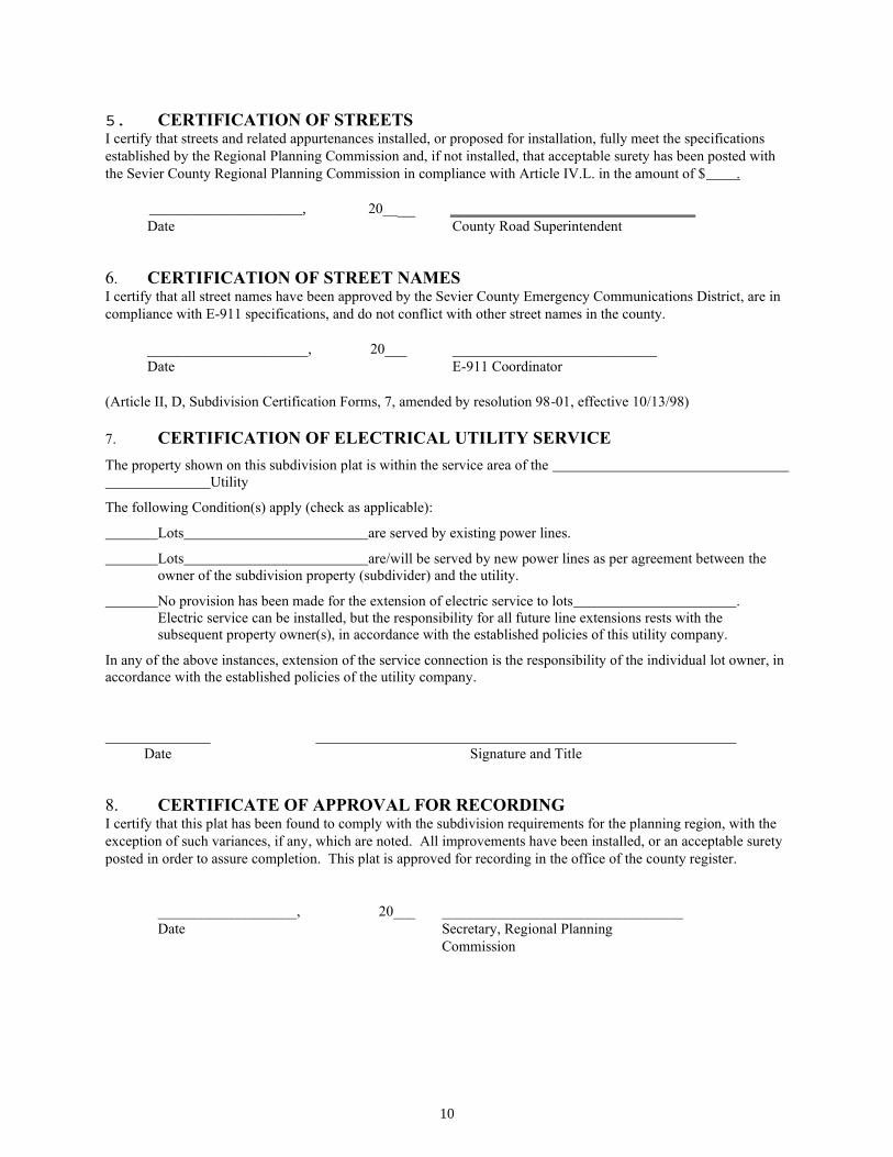
5. CERTIFICATION OF STREETS I certify that streets and related appurtenances installed, or proposed for installation, fully meet the specifications
established by the Regional Planning Commission and, if not installed, that acceptable surety has been posted with
the Sevier County Regional Planning Commission in compliance with Article IV.L. in the amount of $ .
_____________________, 20____ ____________________________ Date County Road Superintendent
6. CERTIFICATION OF STREET NAMES I certify that all street names have been approved by the Sevier County Emergency Communications District, are in
compliance with E-911 specifications, and do not conflict with other street names in the county.
______________________, 20___ ____________________________
Date E-911 Coordinator
(Article II, D, Subdivision Certification Forms, 7, amended by resolution 98-01, effective 10/13/98)
7. CERTIFICATION OF ELECTRICAL UTILITY SERVICE
The property shown on this subdivision plat is within the service area of the
Utility
The following Condition(s) apply (check as applicable):
Lots are served by existing power lines.
Lots are/will be served by new power lines as per agreement between the
owner of the subdivision property (subdivider) and the utility.
No provision has been made for the extension of electric service to lots .
Electric service can be installed, but the responsibility for all future line extensions rests with the
subsequent property owner(s), in accordance with the established policies of this utility company.
In any of the above instances, extension of the service connection is the responsibility of the individual lot owner, in
accordance with the established policies of the utility company.
Date Signature and Title
8. CERTIFICATE OF APPROVAL FOR RECORDING I certify that this plat has been found to comply with the subdivision requirements for the planning region, with the
exception of such variances, if any, which are noted. All improvements have been installed, or an acceptable surety
posted in order to assure completion. This plat is approved for recording in the office of the county register.
___________________, 20___ _________________________________
Date Secretary, Regional Planning
Commission
11
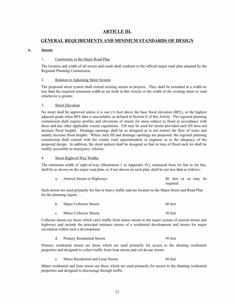
ARTICLE III.
GENERAL REQUIREMENTS AND MINIMUM STANDARDS OF DESIGN
A. Streets
1. Conformity to the Major Road Plan
The location and width of all streets and roads shall conform to the official major road plan adopted by the
Regional Planning Commission.
2. Relation to Adjoining Street System
The proposed street system shall extend existing streets or projects. They shall be extended at a width no
less than the required minimum width as set forth in this Article or the width of the existing street or road
whichever is greater.
3. Street Elevation
No street shall be approved unless it is one (1) foot above the base flood elevation (BFE), or the highest
adjacent grade when BFE data is unavailable, as defined in Section E of this Article. The regional planning
commission shall require profiles and elevations of streets for areas subject to flood in accordance with
these and any other applicable county regulations. Fill may be used for streets provided such fill does not
increase flood heights. Drainage openings shall be so designed as to not restrict the flow of water and
unduly increase flood heights. Where such fill and drainage openings are proposed, the regional planning
commission shall consult with the county road superintendent or engineer as to the adequacy of the
proposed design. In addition, the street pattern shall be designed so that in time of flood each lot shall be
readily accessible to emergency vehicles.
4. Street Right-of-Way Widths
The minimum width of right-of-way (Illustration 1 in Appendix IV), measured from lot line to lot line,
shall be as shown on the major road plan, or if not shown on such plan, shall be not less than as follows:
a. Arterial Streets or Highways 80 feet or as may be
required.
Such streets are used primarily for fast or heavy traffic and are located on the Major Street and Road Plan
for the planning region.
b. Major Collector Streets 60 feet
c. Minor Collector Streets 50 feet
Collector streets are those which carry traffic from minor streets to the major system of arterial streets and
highways and include the principal entrance streets of a residential development and streets for major
circulation within such a development.
d. Primary Residential Streets 50 feet
Primary residential streets are those which are used primarily for access to the abutting residential
properties and designed to collect traffic from loop streets and cul-de-sac streets.
e. Minor Residential and Loop Streets 40 feet
Minor residential and loop streets are those which are used primarily for access to the abutting residential
properties and designed to discourage through traffic.
12
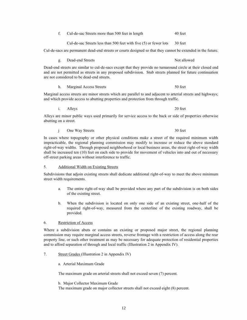
f. Cul-de-sac Streets more than 500 feet in length 40 feet
Cul-de-sac Streets less than 500 feet with five (5) or fewer lots 30 feet
Cul-de-sacs are permanent dead-end streets or courts designed so that they cannot be extended in the future.
g. Dead-end Streets Not allowed
Dead-end streets are similar to cul-de-sacs except that they provide no turnaround circle at their closed end
and are not permitted as streets in any proposed subdivision. Stub streets planned for future continuation
are not considered to be dead-end streets.
h. Marginal Access Streets 50 feet
Marginal access streets are minor streets which are parallel to and adjacent to arterial streets and highways;
and which provide access to abutting properties and protection from through traffic.
i. Alleys 20 feet
Alleys are minor public ways used primarily for service access to the back or side of properties otherwise
abutting on a street.
j One Way Streets 30 feet
In cases where topography or other physical conditions make a street of the required minimum width
impracticable, the regional planning commission may modify to increase or reduce the above standard
right-of-way widths. Through proposed neighborhood or local business areas, the street right-of-way width
shall be increased ten (10) feet on each side to provide for movement of vehicles into and out of necessary
off-street parking areas without interference to traffic.
5. Additional Width on Existing Streets
Subdivisions that adjoin existing streets shall dedicate additional right-of-way to meet the above minimum
street width requirements.
a. The entire right-of-way shall be provided where any part of the subdivision is on both sides
of the existing street.
b. When the subdivision is located on only one side of an existing street, one-half of the
required right-of-way, measured from the centerline of the existing roadway, shall be
provided.
6. Restriction of Access
Where a subdivision abuts or contains an existing or proposed major street, the regional planning
commission may require marginal access streets, reverse frontage with a restriction of access along the rear
property line, or such other treatment as may be necessary for adequate protection of residential properties
and to afford separation of through and local traffic (Illustration 2 in Appendix IV).
7. Street Grades (Illustration 2 in Appendix IV)
a. Arterial Maximum Grade
The maximum grade on arterial streets shall not exceed seven (7) percent.
b. Major Collector Maximum Grade
The maximum grade on major collector streets shall not exceed eight (8) percent.

13
(Article III.A.7.c amended by resolution 2010-01, effective 02/08/11)
c. Minor Collectors, Local, and Residential Streets
The maximum grade on minor collector, local and residential streets shall not exceed twelve (12)
percent. However, when special topographic or other conditions justify, the planning commission may increase the maximum allowable grade on local streets to fifteen (15) percent for the
maximum distance not to exceed 1200 feet, and to the maximum of eighteen (18) percent for a
maximum distance not to exceed 600 feet. Any street with a section constructed at 15-18% slope
shall design and install an emergency staging area adjacent to the roadway, with such area not to
exceed 3% slope and with a minimum dimension of 100 feet long by 20 feet wide. Development
within areas with streets developed at 15%-18% grade shall require compliance with zoning code
Article III, Section 313, in its entirety.
All streets designed at greater than 12% shall have proper drainage design prior to construction
including rip-rapped ditching, limited lot access on steep upslopes, and drainage crossovers at
regular intervals.
(Article III, A, 8 amended by resolution 2002-01, effective 09/17/02)
8. Horizontal Curves and Switchbacks
Where a deflection angle of more that ten (10) degrees in alignment of a street occurs, a curve or
reasonable long radius shall be introduced. On streets sixty (60) feet or more in width, the centerline radius
of curvature shall be not less than three hundred (300) feet; on other streets, not less than one hundred (100)
feet (Illustration 2 in Appendix IV). On curves of less than sixty (60) feet in radius or where deflection
angles of one hundred thirty (130) degrees or more are used, a “switchback” exists. “Switchbacks” shall
conform to Illustration 3 in Appendix IV. Guardrails may be required, upon the recommendation of the
county road superintendent, for all “switchbacks” and shall be installed in conformity to Section 705 of the
State of Tennessee Standard Specifications for Road and Bridge Construction.
9. Vertical Curves
Every change in grade shall be connected by vertical curve constructed so as to afford a minimum sight
distance of two hundred (200) feet, said distance being measured from the driver's eyes, which are assumed
to be four and one-half (4-1/2) feet above the pavement surface, to an object four (4) inches high on the
pavement (Illustration 2 in Appendix IV). Profiles of all roads showing natural and finished grades drawn
to a scale of not less than one (1) inch equals one hundred (100) feet horizontal, and one (1) inch equals
twenty (20) feet vertical, shall be required.
10. Tangents
A tangent of at least one hundred (100) feet in length shall be introduced between reverse curves on arterial
and collector streets.
11. Intersections
Street intersections shall be as nearly at right angles as is possible, and no intersection shall be at an angle
of less than sixty (60) degrees.
Property line radii at street intersections shall not be less than twenty five (25) feet, and where the angle of
street intersection is less than seventy-five (75) degrees, a greater curb radius may be required. Wherever
necessary to permit the construction of a curb having a desirable radius without curtailing the sidewalk at a
street corner to less than normal width, the property line at such street corner shall be rounded or otherwise
set back sufficiently to permit such construction.
14
12. Street jogs
Street jogs with center line offsets of less than one hundred twenty-five (125) feet shall not be allowed.
13 Cul-de-sac Streets
a. Minor terminal streets or courts designed to have one end permanently closed shall have a
turnaround having an outside roadway diameter of at least seventy (70) feet and a street right-of-
way diameter of at least ninety (90) feet at the closed end; however the planning commission may
approve an alternate designs using T and Y turnarounds having the corresponding right-of-way
and surface widths of the required street classification. (Illustration 4 in Appendix IV)
(Article III, A, 14 amended by resolution 96-02, effective 5/15/96)
(Article III, A, 14 amended by resolution 98-01, effective 10/13/98)
14. Private Permanent Easements, Private Streets, and Reserve Strips
Every lot of subdivided property shall be reasonably accessible and serviceable from a publicly dedicated
street or private permanent easement. There shall be no reserve strips controlling access to streets, except
where the control of such strips is definitely placed with the county under conditions approved by the
regional planning commission.
Private streets on private permanent easements may be permitted upon approval by the Sevier County
Regional Planning Commission. Said private streets and easements shall be established in accordance with
the provisions of this section. For the purposes of this section a private permanent access easement shall be
considered and developed as a private street where said easement provides access or service to two (2) or
more lots. The planning commission may however, approve the use of a simple shared driveway easement
between two (2) adjoining lots, provided it finds that the intent of this section is maintained.
a. Classifications and Specific Standards. All private street developments shall be classified as one
of the following three (3) types.
(Article III, A, 14, a, Type I amended by resolution 99-01, effective 8/10/99)
Type I. A Type I private street shall not exceeded 1200 feet in length, provide access to more
then ten (10) lots, or exceed a maximum grade at any point of twelve (12) percent. Unless
modified by this section, said streets shall be designed and improved in accordance with all
applicable provisions of Articles III and IV of these subdivision regulations. The minimum ROW
width of a Type I easement shall be at least forty (40) feet. The minimum improved street width
shall be at least eighteen (18) feet, not including required shoulders. The minimum driving
surface improvement standard for a Type I street shall be three (3) inches of gravel. At all
intersections of publicly maintained roads and Type I private streets with a positive slope from
five (5) percent to twelve (12) percent, the private street must be constructed to comply with all
provisions of Articles III and IV of these subdivision regulations for a length of 100 feet.
Type II. A Type II private street is intended to serve as a rural road and shall not be utilized to
provide access to lots of less then five (5) acres in size. There is no limitation on the number of
lots to be served by a Type II road, or on its length. Unless otherwise modified by this section,
said streets shall be designed and improved in accordance with all applicable provisions of
Articles III and IV of these subdivision regulations. The minimum ROW width of a Type II
easement shall be at least fifty (50) feet. The minimum improved street width shall be at least
twenty two (22) feet, not including required shoulders. The minimum driving surface
improvement standard for a Type II street shall be a six (6) inch course of compacted Type A
mineral aggregate base stone (TDOT grade D), applied without calcium additives, and laid in
accordance with Article IV Section D.1 of these regulations.
Type III. Type III private streets shall be designed and improved in accordance with all provisions
contained in Articles III and IV of these regulations. There are no limitations pertaining to
subdivision design and construction beyond those contained in Articles III and IV. The purpose of
15
the Type III classification is to allow a developer to complete a standard subdivision while
maintaining private ownership of the streets.
b. General Requirements. The following requirements pertain to all types of private street and
easement development.
i. All Private permanent easements and private streets shall be legally established in a
manor that will ensure access by emergency, utility, and other necessary public services.
Unless an alternative plan is approved by the planning commission, said easements shall
also provide for both current and future utility and drainage improvements to service the
proposed subdivision.
ii. Unless otherwise approved by the planning commission, all new private street easements
shall be platted on a separate, individual lot within the private subdivision development.
All lots within the proposed subdivision shall have a common interest in said street
easement lot, with control over said lot being exercised through a legally established
home owners association. For platting purposes this lot shall be designated (numbered)
as the last lot within the subdivision.
iii. Any resubdivision of properties served by private streets and easements shall be in
conformance with all provisions of this section. The total number of lots to be served,
easement lengths, and or lot sizes shall be restricted by the type of street easement
providing service to the properties in question.
All legal documentation pertaining to the property owners association, along with the
recorded plat, shall clearly note the classification of all private street easements present in
the subdivision, and all applicable restrictions regarding further resubdivision without
additional street improvements.
iv. Private permanent easements serving two or more lots (private streets) must be
maintained by the developer until a property owners association has been established. In
all cases where two (2) or more lots within a proposed development are to be served by a
private permanent easement, the developer shall be responsible for private street
maintenance until fifty (50%) percent of the development has been sold, at which time a
legally established property owners association shall be formed to ensure private street
maintenance. The final plat shall be accompanied by the necessary legal documents to
establish a property owners association to ensure the future maintenance of said road(s).
The association shall have the authority to levy assessments for road maintenance and the
power to impose liens, if necessary, to enforce such action. The Sevier County Regional
Planning Commission has no role in this process beyond requiring the establishment of
such legal instruments before final plat approval is granted.
v. In all instances were a new subdivision utilizing private streets is accessed by an existing
private permanent easement, or non-governmentally maintained right-of-way, a system of
legal agreements shall be established to provide for the maintenance of all said existing
private easements or rights-of-way, necessary to obtain direct access to a county road.
The subdivider/developer shall be responsible for establishing this system of maintenance
agreements with all applicable adjoining developments and/or property owners. The final
plat shall be accompanied by the necessary legal documents establishing or documenting
these maintenance agreements. The Sevier County Regional Planning Commission has
no role in this process beyond requiring the establishment of such legal instruments
before final plat approval is granted. The subdivider shall also be required to provide
documentation that there are no legal prohibitions against further subdivision with respect
to the existing private easements or rights-of-way, and that newly created lots have all
necessary rights to utilize said existing private easements, or rights-of-way. Furthermore,
where said existing private permanent easements or non-governmentally owned rights-of-
way do not meet the standards of this section the planning commission may require
additional improvements prior to final subdivision approval.
16
vi. The maintenance responsibilities of the developer or property owners association for
private streets shall continue until such time as the owners of said private street(s) have
improved the street to the public (county) street standard contained in these subdivision
regulations; including the full right-of-way width, drainage, base, and surface
requirements; have offered the improved street for dedication, the street has been
approved for acceptance by the planning commission and county road superintendent,
and accepted by the county commission. Improvement of a street to the public standard
includes all requirements contained in Articles III and IV of these regulations.
These responsibilities shall be clearly stated in all legal documentation pertaining to the
property owners association, and the following certification shall be placed on the final
plat.
CERTIFICATION OF PRIVATE PERMANENT EASEMENTS AND PRIVATE
STREETS
Certain roads within this subdivision are designated as private permanent easements and
streets under private ownership. It is acknowledged that said roads must be privately
maintained unless and until they are improved to the county road standard at the property
owner(s) expense, have been formally offered for dedication by the owner(s), approved
by the regional planning commission, and accepted by the Sevier County Commission.
Date
Owners
15. Street Names
Proposed streets which are obviously in alignment with others already existing and named shall bear the
names of existing streets. In no case shall the name for proposed streets duplicate existing street names,
irrespective of the use of the suffixes street, avenue, boulevard, drive, way, place, or court. The regional
planning commission can assist the subdivider in avoiding duplication. Each street name shall be approved
by the Sevier County E-911 Coordinator and such approval shall be shown on the plat.
(Article III, A, 16, amended by resolution 98-01, effective 10/13/98)
16. Alleys
Alleys shall not be provided except where the subdivider produces evidence satisfactory to the regional
planning commission of the need for alleys. Alleys are minor service ways providing a secondary means of
vehicular access to the rear or side of properties. Alleys generally have two (2) open ends, divide blocks,
and are not intended for general traffic circulation. When permitted, alleys shall be established as
permanent easements and shall not be dedicated for public acceptance.
B. Blocks
Subdivisions shall not be required to use grid designs with blocks, however, the following minimum
standards shall apply to ensure efficient traffic circulation, public service access, pedestrian circulation, and
emergency response.
1. Length
Blocks should not be less than four hundred (400) nor more than twelve hundred (1200) feet in length,
except as the regional planning commission considers necessary to secure efficient use of land or desired
features of street pattern. In blocks over eight hundred (800) feet in length the planning commission may

17
require one (1) or more public crosswalks of not less than ten (10) feet in width to extend entirely across
the block at locations deemed necessary.
2. Width
Blocks should be wide enough to allow two (2) rows of lots, except where reverse frontage on major streets
and roads is provided or where prevented by topographical conditions or size of the property; in which case
the regional planning commission will approve a single row of lots of minimum depth.
C. Lots
1. Adequate Building Sites
Each lot shall contain a building site not subject to flood as defined in Section E of this Article and outside
the limits of any existing easement or building setback lines required in Subsections 4 and 5 of this Section.
Land within a floodway, as defined in Section E of this Article, shall not be platted for building purposes.
Said land may be counted as part of the lot in computing lot sizes. Property below the 1002 contour on
Douglas Lake, or property platted within a private permanent road easement shall not be included when
calculating the total lot size.
(Article III, C, 2, amended by resolution 98-01, effective 10/13/98)
2. Arrangement
Insofar as practical, side lot lines shall be at right angles to straight street lines or radial to curved street
lines. Each lot must front for a minimum of fifty (50) feet upon a public (county) street, or permanent
private easement developed in accordance with the provisions of Article III Section A.14. Said frontage
shall provide a reasonable physical means of pedestrian and vehicular access between the lot and the public
street or private easement.
3. Minimum size
The size, shape and orientation of lots shall be such as the planning commission deems appropriate for the
type of development and use contemplated. Where public water and sanitary sewer systems are reasonably
accessible, the subdivider shall connect with such system and provide a connection to each lot. Where a
public sewer is not accessible, an alternate method of sewage disposal may be used, upon approval by the
regional planning commission subject to the lot size requirements where water is not available.
(Article III, C, 3. Amended by Resolution 05-02, effective 6/13/2005)
a.
i. All lots created in the subdivision, other than those not intended for development, shall
conform to the lot sizes and lot widths displayed in the table below. It should be noted
that where no public sanitary sewer is available, internal lot easement areas shall be
excluded from lot size calculations.
Average Lot
Slope
Minimum
Width at
Setback Line
Min. Area
W/ Public Water
& Sewer*
Min. Area
W/ Public Water
or Sewer**
Min. Area W/O
Public Water or
Sewer***
0 - 29.9% 50’ 7,500 sq. ft. 25,000 sq. ft. 30,000 sq. ft.
30 - 49.9% 100’ 15,000 sq. ft. 50,000 sq. ft. 2 acres
50% + 150’ 22,500 sq. ft. 75,000 sq. ft. 3 acres
* lots served by both public water and public sanitary sewer
** lots served by public water or served by public sanitary sewer, but not both
*** lots not served by public water and not served by public sanitary sewer

18
ii. The planning commission may reduce the minimum lot size and lot width for group
developments submitted under Section G, Group Developments where served by public
water and public sanitary sewer.
iii. The planning commission may require a larger lot size or allow a smaller lot size upon
the recommendation of the Sevier County Director of Environment and the County
Planner when not served by public water or public sanitary sewer, or not served by either.
iv. The minimum size lots to be served by a private source of water supply including private
wells shall be determined by the Sevier County Regional Planning Commission after
investigations of soil conditions, proposed sewerage system and depth of ground water.
The assistance of the Sevier County Health Department and the Soil Conservation
Service shall be sought in determining the appropriate size. Minimum lot widths at the
building setback line as noted in Section C.3.a.i. are determined necessary for the
protection from contamination of private water supplies, however, the Sevier County
Health Department requirements may be greater for individual lots.
b. Size of properties reserved or laid out for commercial or industrial purposes shall be adequate to
provide for the off-street service and parking facilities required by the type of use and
development contemplated. Platting of individual lots should be avoided in favor of an overall
design of the land to be used for such purposes.
4. Building Setback Lines
(Article III, C, 4. Amended by Resolution 05-03, effective 6/13/2005)
(Article III.C. 4.a. amended by resolution 07-01, effective 11/12/2007)
a. Minor residential streets, minor collector streets, cul-de-sac streets, and marginal access streets:
The minimum depth of building setback lines from the street right of way line shall not be less
than the distance listed in the table below, dependent on the average slope of the lot. The side and
rear setback line for such lots shall be no less than ten (10) feet. For lots 30,000 square feet in area
or larger, the side and rear setback area shall not be less than twenty-five (25’) feet.
Average Lot
Slope
Minimum Front
Building Setback
Line
Side and Rear
Setback Line
0 - 29.9% 20’ 10’
30 - 49.9% 10’ 10’
50% + 5’ 10’
b. Major collector streets:
The minimum depth of building setback lines from the street right of way line shall not be less
than forty (40) feet. The side and rear setback line for such lots shall be no less than ten (10) feet.
c. Arterial streets and highways:
The minimum depth of building setback lines from the street right of way line shall not be less
than fifty (50) feet unless a greater distance is deemed to be necessary by the Sevier County
Regional Planning Commission for the protection of contemplated development on the property.
The side and rear setback line for such lots shall be no less than ten (10) feet.
d. The developer is responsible for verifying the details of an existing easement with the party to
whom the easement has been granted or transferred prior to developing the initial version of the
subdivision. In the case of electric transmission lines where easement widths are not definitely
established, there shall be a minimum building setback line from the center of the transmission
line as follows:

19
Voltage of Line Minimum Building Setback
46 KV 37-1/2 feet
69 KV 50 feet
161 KV and over 75 feet
5. Corner Lots
Corner lots shall have extra width sufficient to permit the additional side yard requirements of the building
setback lines outlined above.
D. Public Use and Service Areas
Due consideration shall be given to the allocation of areas suitably located and of adequate size for
playgrounds and parks for local or neighborhood use as well as public service areas.
1. Public Open Spaces
Where a school, neighborhood park or recreation area or public access to water frontage, shown on an
official map or in a plan made and adopted by the regional planning commission, is located in whole or in
part in the applicant's subdivision, the regional planning commission may request the dedication or
reservation of such open space within the subdivision up to and including a total of ten (10) percent of the
gross area or water frontage of the plot, for park, school or recreation purposes.
2. Easements for Utilities
The regional planning commission may require easements, not exceeding ten (10) feet in width for poles,
wires, conduits, storm and sanitary sewers, gas, water mains or other utility lines along rear lot lines or side
lot lines if, in the opinion of the regional planning commission such action is desirable. Easements of the
same or greater width may be required along the lines of or across lots, where necessary for the extension
of existing or planned utilities.
3. Easements for Drainage
Where a subdivision, or lot is traversed by a watercourse, drainage way, channel, or stream there shall be
provided a storm water easement or drainage right-of-way for the purpose of widening, deepening,
relocating, improving, or protecting such drainage easement.
4. Community Assets
In all subdivisions due regard shall be shown for natural features, such as large trees and watercourses, and
for historical spots, and similar community assets which, if preserved, will add attractiveness and value to
the property.
E. Suitability of the Land
Land which the regional planning commission has found to be unsuitable for subdivision due to flooding,
bad drainage, steep slopes, rock formation, or other features likely to be harmful to the safety, health, and
general welfare of the future residents, shall not be subdivided unless adequate methods approved by the
planning commission are formulated by the developer for meeting the problems created by the subdivision
of such land.
Land subject to flooding and land deemed to be topographically unsuitable shall not be platted for
residential occupancy or for any other uses that may increase flood hazard, endanger health, life, or
property, or aggravate erosion. Such land within the platted area shall be set aside for such uses as shall not
be endangered by periodic or occasional inundation or shall not produce unsatisfactory living conditions.

20
All subdivision of property proposing construction of public utilities and facilities such as water supply or
sanitary sewage systems, shall be designed to minimize or eliminate infiltration of flood waters into the
system or discharges of the system into flood waters. Subdivisions shall be designed so that adequate
drainage is provided in order to reduce exposure of flood hazards.
Fill may not be used to raise lands in areas subject to flood unless the fill proposed does not restrict the
flow of water and unduly increase flood heights.
Definitions:
Base Flood: A flood having a one percent chance of being equaled or exceeded in any given
year.
Floodway: The channel of a river or other watercourse and the adjacent land areas that must be
reserved in order to discharge the base flood without cumulatively increasing the water surface
elevation more than one foot.
Highest Adjacent Grade: The highest natural elevation of the ground surface, prior to
construction, next to the proposed improvement.
F. Variances
Variances may be granted under the following conditions:
1. Where the subdivider can show that strict adherence to these regulations would cause unnecessary
hardship, and
2. Where the regional planning commission decides that there are topographical or other conditions
peculiar to the site, and a departure from these regulations will not destroy their intent. Any
variance thus authorized shall be stated in writing in the minutes of the regional planning
commission with the reasoning on which the departure is justified set forth.
3. The regional planning commission may vary any applicable provision of Article III where an
alternative development is proposed under the group housing provisions of these regulations.
(Article III. G amended by resolution 07-01, effective 11/12/2007)
G. Planned Unit Developments (PUD)
1. The planned unit development (PUD) provisions of this section only apply when a developer or
owner of property wishes to subdivide, plat, and record lots. These provisions are intended to
provide the developer flexibility from the strict application of typical subdivision standards where
a superior design is feasible and appropriate. Planned unit developments shall include multi
structure developments which divide property into lots, sites, or other divisions as defined in 13-3-
401 of the Tennessee Code and where the developer chooses to plat and record clustered lots.
2. The developer will be allowed to cluster building sites or lots which deviate from the minimum lot
area requirements for the individual lots on which structures are to be located. All open spaces,
recreational areas, drainage or other easements, reserve areas for septic systems, or other none
building areas shall be clearly indicated on the final plat as not for future subdivision, building or
development purposes. Appropriate legal instruments defining ownership, method of
maintenance, and schedule for maintenance of all open spaces, open-type recreational areas and
consolidated parking areas shall be required for approval.
3. All planned unit developments (PUD) shall have a water supply system as defined in Article IV.
Section G.

21
4. No planned unit development will be approved unless an adequate sanitary sewer system or
subsurface disposal system is included in the plans and approved by the Tennessee Department of
Public Health and the Sevier County Health Department.
5. No free standing buildings shall be located closer than fifty (50’) feet to any other building. The
building setback from the exterior property line shall be twenty-five (25’) feet.
6. All proposed public roads, utilities, drainage systems and erosion control systems shall be
constructed to standards as set forth in these regulations for public improvements. All proposed
private roads, utilities, drainage systems, and erosion control systems shall be constructed to the
minimum private improvement standards and shall have appropriate legal instruments defining
ownership, method of maintenance, and schedule for maintenance.
The following additional plans and schedules shall be submitted to the regional planning commission:
1. The location and legal description of the proposed development.
2. A development plan showing location of all buildings, lot lines, exterior setbacks, recreation and
open space areas, utilities, parking, and common-use facilities.
3. The location and dimensions of all points of entry and exit for cars.
4. Such other engineering and geographic data as may be required to permit the planning commission
to determine if the above regulations are being complied with.
5. Deed restrictions, joint ownership agreements, joint maintenance agreements, and other required
legal documentation.
H. Other Regulations
Sevier County does not currently enforce other land use or building regulations. In the event that the Sevier
County Commission adopts other regulations in the future, no final plat of land within the force and effect
of those regulations will be approved unless it conforms to such regulations.
Whenever there is a discrepancy between minimum standards or dimensions noted herein and those
contained in other official regulations, the highest standard shall prevail.

22
ARTICLE IV
DEVELOPMENT PREREQUISITE TO FINAL APPROVAL
A perfectly prepared and recorded subdivision or plat means little to a prospective lot buyer until he can see actual
physical transformation of raw acreage into lots suitable for building purposes and human habitation. Improvements
by the subdivider spare the community from a potential tax liability. The following tangible improvements are
required before final plat approval in order to assure the physical reality of a subdivision which approval and
recordation will establish legally.
Required Improvements
Every subdivision developer shall be required to grade and improve streets and alleys, and to install curbs,
monuments, sewers, storm water inlets and water mains, in accordance with specifications established by the
regional planning commission. The adopted requirements, whether in local regulations or in the following
standards, shall govern.
A. Monuments or Corner Markers
1. Iron pins of not less then one half (1/2) inch diameter and eighteen (18) inches long, with a flat
top, shall be set at all street corners, at all points where the street lines intersect the exterior
boundaries of the subdivision, and at angle points and points of curve in each street. The top of
the iron pins shall have a cap or tag of non-corrosive material with the surveyor's registration
number or company name stamped.
2. All other lot corners shall be marked with iron pins not less than one-half (1/2) inches in diameter
and eighteen (18) inches long.
B. Grading
All streets, roads and alleys shall be graded by the subdividers so that pavements and sidewalks can be constructed
to the required cross-section. Deviation from the above due to special topographical conditions, will be allowed
only with special approval of the planning commission. Where streets are constructed under or adjacent to existing
electric transmission lines, the nearest edge of the pavement shall be a minimum of fifteen (15) feet from any
transmission line structure and all grading for the street shall be done in a manner which will not disturb the
structure or result in erosion endangering the structure. In the case of electric transmission lines, the clearance from
the pavement to the nearest conductor shall meet the requirements of the National Electrical Safety Code.
1. Preparation: Before grading is started, the entire right-of-way area shall be cleared of all stumps,
roots, brush and other objectionable materials and all trees not intended for preservation.
2. Cuts: All tree stumps and similar organic material shall be completely removed from the
construction area. Boulders and other obstructions shall be removed to a depth of twelve (12)
inches below the subgrade. Rock, when encountered, shall be scarified to a depth of twelve (12)
inches below subgrade. All topsoil shall be removed and back filled with suitable material. No
grading shall be done when ground is frozen or muddy unless mud is removed and disposed of
outside of streets.
(Article VI, B, 3 amended by resolution 2002-01, effective 09/17/02)
3. Fill: All suitable material from roadway cuts may be used in the construction of fills, approaches,
or at other places as needed. Excess materials including organic materials, soft clays, etc., shall be
removed from the construction area. The fill shall be spread in layers not to exceed six (6) inches
loose and compacted by a sheep's foot roller or compactor with a minimum compaction of 95%.
The filling of utility trenches and other places not accessible to a roller shall be mechanically

23
tamped, and where water is used to assist compaction the water content shall not exceed the
optimum of moisture.
4. Slope of Banks: The finished slope on all banks shall not exceed a ratio of 2:1 for all materials
except solid rock. In the case of solid rock slopes or other special conditions, the planning
commission will accept the recommendation of the County Road Superintendent or Engineer.
5. Inspections: During the construction of any subdivision roads in the area of planning jurisdiction
the developer and/or his contractor shall be required to keep the Road Superintendent or Engineer
advised as to the progress being made. Such roads shall meet or exceed the standards required by
these subdivision regulations adopted by Sevier County. In addition, the following inspections
and/or approvals by the Sevier County Road Superintendent or Engineer shall be required:
(a) After clearing and stripping.
(b) Approval of the drainage plan.
(c) After grading and drainage are completed.
(d) After the stone base is in place, and
(e) During and after application of all asphalt materials.
The developer or his representative will be responsible for notifying the Road Superintendent or Engineer for each
inspection. When the plat is submitted to the regional planning commission for final approval, the Road
Superintendent or Engineer shall make a final inspection. His findings and recommendations as to approval of the
roads shall be reported in writing to the regional planning commission. In lieu of road improvements being
completed upon request for final approval of the plat, the regional planning commission shall ask the advice of the
Road Superintendent or Engineer in regard to the amount of the bond, certified check, or other means of guarantee
shall not be released by the regional planning commission until the recommendations of the Road Superintendent or
Engineer have been obtained as to the acceptability of the roads upon completion of construction.
C. Storm Water Control, Water Course Protection, and Erosion Control
A drainage plan shall be submitted as a part of the subdivision design plan indicating the direction of flow of all
storm water runoff. The following improvements or information shall be required and shown on the drainage plan.
Storm Water Control. An adequate drainage system, including storm sewers, necessary open ditches, pipes,
culverts, intersectional drains, open inlets, bridges, etc., shall be provided for the proper drainage of all surface
water. Cross drains shall be provided to accommodate all natural water flow, and shall be of sufficient length to
permit full width roadway and the required slopes. The size of openings to be determined by Talbott's formula
(Appendix I), but in no case shall the pipe be less then fifteen (15) inches. Cross drains shall be built on straight line
and grade and shall be laid on a firm base, but not on rock. Pipes shall be laid with the spigot end pointing in the
direction of the flow and with the ends fitted and matched to provide tight joints and a smooth, uniform invert. They
shall be placed at a sufficient depth below the roadbed to avoid dangerous pressure of impact, and in no case shall
the top of the pipe be less than one (1) foot below the roadbed. Where installed by the developer driveway cross
drains shall be no less than fifteen (15) inches.
Watercourse Protection. The definition of watercourse is any natural or artificial stream, river, creek, channel,
ditch, canal, conduit, culvert, drain, waterway, gully, ravine, street, roadway, or wash in which water flows in a
definite direction or course, either continuously or intermittently, and which has a definite channel, bed or banks,
and shall include any area adjacent thereto subject to inundation by reason of overflow of surface water.
All watercourses shall be maintained in order to carry storm water from adjacent properties or public rights-of-way.
The filling of any watercourse is prohibited unless the subdivider can successfully demonstrate that an alternative
approach will meet the intent of this section. The county highway department shall approve any alternative plan and
the filling of any existing watercourse.
24
Erosion Control. Effective erosion control measures shall be required during construction to eliminate
sedimentation on public rights-of-way or watercourses. The use of straw bales or silt fencing is typically the most
prevalent, however other suitable methods will be permitted.
D. Road Design Standards
(Article IV.D.1 amended by resolution 2010-01, effective 02/08/11)
1. Pavement Base
After preparation of the subgrade, (minimum compaction of 95%) the roadbed shall be surfaced
with material required by local standards; but of not lower classification than crushed rock, stone
or gravel. The size of the crushed rock or stone shall be that generally known as "crusher run
stone" from two and one-half inches down including dust sufficient to bond stone together.
Spreading of the stone shall be done uniformly over the area to be covered by means of
appropriate spreading devices and shall not be dumped in piles. After spreading, the stone shall be
rolled until thoroughly compacted and bonded together. The compacted thickness of the stone
roadway shall be as follows:
Residential 6"
Commercial 8"
Industrial 10"
The pavement base shall extend two feet wider than the required surface width on both sides of the
street. When ditches or swales are used in lieu of curbs, the road base shall extend as a four foot
shoulder on each side with two feet of stone base extending beyond the required wearing surface
on each side.
2. Prime Coat
After a thoroughly compacted base has been established, a prime coat shall be applied as specified
in Appendix II of these regulations.
(Article VI, D, 3 amended by resolution 2002-01, effective 09/17/02)
(Article VI. D. 3 amended by resolution 2010-01, effective 02/08/11)
3. Binder
A binder course consisting of asphalt concrete (307-B) shall be required for all roadways as
follows:
Residential 2.0"
Commercial 3.0”
Industrial 3.0"
Roads at greater than 12% 3.0”
(Article VI, D, 4 amended by resolution 2002-01, effective 09/17/02)
4. Wearing Surface
The wearing surface shall meet specifications as provided in Appendix III and the following
thickness:
Residential 1.5"
Commercial 2.0"
Industrial 2.0"
5. Minimum Pavement Widths and Cross Section
Minimum pavement widths between curbs shall be as follows:
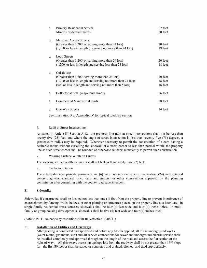
25
a. Primary Residential Streets 22 feet
Minor Residential Streets 20 feet
b. Marginal Access Streets
(Greater than 1,200' or serving more than 24 lots) 20 feet
(1,200' or less in length or serving not more than 24 lots) 18 feet
c. Loop Streets
(Greater than 1,200' or serving more than 24 lots) 20 feet
(1,200' or less in length and serving less than 24 lots) 18 feet
d. Cul-de-sac
(Greater than 1,200' serving more than 24 lots) 20 feet
(1.200' or less in length and serving not more than 24 lots) 18 feet
(500 or less in length and serving not more than 5 lots) 16 feet
e. Collector streets (major and minor) 26 feet
f. Commercial & industrial roads 28 feet
g. One Way Streets 14 feet
See Illustration 5 in Appendix IV for typical roadway section.
6. Radii at Street Intersections
As stated in Article III Section A.12., the property line radii at street intersections shall not be less than
twenty five (25) feet, and where the angle of street intersection is less than seventy-five (75) degrees, a
greater curb radius may be required. Wherever necessary to permit the construction of a curb having a
desirable radius without curtailing the sidewalk at a street corner to less than normal width, the property
line as such street corner shall be rounded or otherwise set back sufficiently to permit such construction.
7. Wearing Surface Width on Curves
The wearing surface width on curves shall not be less than twenty two (22) feet.
8. Curbs and Gutters
The subdivider may provide permanent six (6) inch concrete curbs with twenty-four (24) inch integral
concrete gutters; standard rolled curb and gutters; or other construction approved by the planning
commission after consulting with the county road superintendent.
E. Sidewalks
Sidewalks, if constructed, shall be located not less than one (1) foot from the property line to prevent interference of
encroachment by fencing, walls, hedges, or other planting or structures placed on the property line at a later date. In
single-family residential areas, concrete sidewalks shall be four (4) feet wide and four (4) inches thick. In multi-
family or group housing developments, sidewalks shall be five (5) feet wide and four (4) inches thick.
(Article IV. F. amended by resolution 2010-01, effective 02/08/11)
F. Installation of Utilities and Driveways
After grading is completed and approved and before any base is applied, all of the underground works
(water mains, gas mains, etc.) and all service connections for sewer and underground electric service shall
be installed completely and approved throughout the length of the road and across the flat section of the right-of-way. All driveways accessing upslope lots from the roadway shall be not greater than 15% slope
for the first 50 feet or shall be paved or concreted and drained, ditched, and tiled appropriately.
26
All utilities shall be installed within the cut road sections or if to be installed within the fill road sections
shall be installed following an engineer’s design plan prepared by a licensed Civil Engineer, and certified
as built per design by a licensed engineer.
(Article IV, G amended by resolution 07-01, effective 11/12/2007)
G. Water Supply System
The provision of a public water supply is deemed by the planning commission to be essential to the public welfare in
the case of all development contemplating the growth of homes in close proximity to each other. Accordingly the
provision of a public water supply system will be required in all subdivisions containing lots of less than thirty
thousand (30,000) square feet and/or lots of less than fifty (50) feet in width at the building setback line. An
exception may be granted in the case where a single small parcel is separated from a larger tract without the
intention of further subdivision. For lots 30,000 square feet in area or larger, a private water supply such as
individual wells, shared wells or a community well system is allowed provided the setback requirements in Article
III.C.a. are met.
The water supply system shall be constructed to serve all lots shown on the subdivision plat with water for both
domestic use and fire protection. All public water systems shall be constructed to the standards of the Tennessee
Department of Environment and Conservation (TDEC), the Sevier County Water Committee or their successor, and
the Utility Company providing the water service. Fire hydrants shall be installed where sufficient size line exists.
No subdivided lot shall be more than one thousand (1000) feet from a hydrant when they are installed in the
development.
H. Sanitary Sewers, Septic Systems, and Alternative Septic Systems
When a public sanitary sewer service is available, sanitary sewers shall be installed in such a manner as to serve
adequately all lots with connection to the public system.
Where lots cannot be economically connected with a public sanitary sewerage system, they must contain adequate
area for the installation of an approved septic tank and disposal fields and must be approved in writing by the Sevier
County Director of Environment. The planning commission shall accept alternative septic systems upon the
approval of the Sevier County Director of Environment. Experimental systems must have the approval of the State
Division of Ground Water Control.
I. Street Name Signs & Regulatory Warning Signs
Signs shall be installed by the developer and appear at all intersections in new residential subdivisions and
commercial/industrial developments including intersections with county roads. Appropriate regulatory and warning
signs shall be installed as is needed and shall conform to Uniform Traffic Control Manual guidelines.
J. Requirements for Acceleration and Deceleration Lanes
In order to provide for the safe and orderly movement of traffic on existing streets, the Sevier County Regional
Planning Commission may require a developer to construct such lanes for acceleration and Deceleration upon the
recommendation of the County Road Superintendent. The Superintendent's recommendation will be based on the
existing road widths, average daily traffic and safety conditions of the area.
K. Electric Transmission Lines
The subdivider shall provide for the necessary major electric distribution lines throughout the subdivision, serving
all lots shown on the subdivision plat, and adhering to the installation requirements of the responsible electric utility.
Certification by the electric company that improvement guarantees are in place shall be sufficient for final plat
approval.

27
(Article IV, L, amended by resolution 98-01, 10/13/98)
(Article IV.L.2. amended by resolution 2010-01, effective 02/08/11)
L. Guarantee in Lieu of Completed Improvements
No final subdivision plat shall be approved by the planning commission or accepted for record by the county register
of deeds until one of the following two conditions has been met:
1. All required improvements have been constructed in a satisfactory manner and approved by the
regional planning commission.
2. In the case of publicly dedicated improvements only, the regional planning commission has
accepted a letter of credit, security or performance bond from an approved surety or financial
institution. Other forms of financial guarantee such as a certified check or escrow account, may be accepted upon review and approval of the county attorney. Such guarantees shall be accepted by
the Regional Planning Commission only when the final road grade has been established and built
and inspected, all drainage and stormwater facilities are installed, and when all cross drains and
utilities within the roadway base have been installed, and certified as built per design by a licensed
engineer. The amount of the bond or other security shall be equal to the estimated cost of
installation of the required improvements, in order to insure that the required public improvements
may be made and utilities installed without cost to Sevier County in the event of default by the
subdivider. The conditions of such security or performance bond shall provide for the installation
of the improvements covered by such bond within a period of not to exceed eighteen (18) months;
provided however, that such period may be extended by the regional planning commission with
the consent of the parties thereto if the regional planning commission finds that the public interest
will not be adversely affected by such extension. If the regional planning commission should
decide at any time during the performance bond that the extent of the building development that
has taken place in the subdivision is not sufficient to warrant all the improvements covered by
such performance bond, that the required improvements have been installed as provided in this
section in sufficient amount to warrant reduction in the face amount of said bond, or that the
character and the extent of such development require additional improvements for any or all such
improvements; then the face value of such performance bond shall thereupon be reduced or
increased by an appropriate amount so that the new face amount will cover the cost in full of the
amended list of improvements.
Any owner or agent of any land may sell, transfer, or agree to sell any lot or lots shown on a plat
having been preliminary approved by the regional planning commission; provided the owner or
agent post an acceptable letter of credit, performance or security bond guaranteeing to the public
the actual construction and installation of the necessary improvements within the specified time
period. Sale of subdivision by auction does not exempt the subdivider from posting acceptable
security in lieu of completed improvements; however, if a parcel is sold as a whole and the
original subdivision plat approval(s) voided, the security or performance bond may be
immediately released by the regional planning commission.
(Article III, M, amended by resolution 98-01, 10/13/98)
M. Bridges and Similar Crossing Structures
All bridges and similar crossing structures shall be designed, constructed under the supervision of, and certified by
an engineer licensed and registered by the State of Tennessee. The design of all said structures shall conform with
sound and recognizable engineering principals, standards, and practices; and where applicable shall be in accordance
with the most recent edition of the Tennessee Department of Transportation’s “Standard Specifications for Road and
Bridge Construction”. The developer shall also be responsible for obtaining, and submitting copies to the planning
commission, of all necessary state or federal permits associated with the construction of said structures.
28
ARTICLE V
ENFORCEMENT AND PENALTIES FOR VIOLATIONS
A. General
The enforcement of these regulations and penalties for the unapproved recordation or transfer of land are provided
by state law in the authority granted by Public Acts of the State of Tennessee.
B. Enforcement
1. No plat or plan of a subdivision of land into two or more lots located within the area of planning
jurisdiction shall be admitted to the land records of Sevier County or received or recorded by the
County Registrar until said plat or plan has received final approval in writing by the planning
commission, as provided in Section 13-3-402, Tennessee Code Annotated.
2. No board, public officer, or authority shall light any street, or lay or authorize the laying of water
mains or sewers, or the construction of other facilities or utilities in any street located within the
area of planning jurisdiction unless such street shall have been accepted, opened or otherwise
received the legal status of a public street prior to the adoption of these regulations, or unless such
street corresponds in its location and lines to a street shown on a subdivision plat approved by the
planning commission, as provided in Section 13-3-406, Tennessee Code Annotated
C. Penalties
1. No county registrar shall receive, file, or record a plat of a subdivision within the planning region
without the approval of the planning commission as required in Section 13-3-402, Tennessee Code
Annotated, and any county registrar so doing shall be deemed guilty of a misdemeanor, punishable
as other misdemeanors as provided by law.
2. Section 13-3-410, Tennessee Code Annotated, provides that whoever being the owner or agent of
the owner of any land, transfers or sells or agrees to sell or negotiates to sell, such land by
reference to or exhibition of or by other use of a plat of subdivision of such land without having
submitted a plat of such subdivision to the planning commission and obtained its approval as
required before such plat be recorded in the office of the appropriate county register, shall be
deemed guilty of a misdemeanor, punishable as other misdemeanors as provided by the law; and
the description by metes and bounds in the instrument of transfer or other document used in the
process of selling or transferring shall not exempt the transaction from such penalties. The county,
through its county attorney or other official designated by the county commission, may enjoin
such transfer or sale or agreement by action for injunction.
3. Any building or structure erected or to be erected in violation of the subdivision regulations shall
be deemed an unlawful building or structure, and the building commissioner or solicitor of the
county or other official designated by the chief legislative body and/or the county attorney or other
official designated by the county commission may bring action to enjoin such erection or cause it
to be vacated or removed as provided in Section 13-3-411, Tennessee Code Annotated.
29
ARTICLE VI
ADOPTION AND EFFECTIVE DATE
A. Before adoption of these subdivision regulations, a public hearing as required by Section 13-3-403 and 13-
4-303, Tennessee Code Annotated, was afforded any interested person or persons. Notice of such hearing was
announced in a local paper, being of general circulation within the area of planning jurisdiction, and stating the time
and place for the hearing.
B. These rules and regulations and any amendment thereto shall be in full force and effect from and after their
adoption and effective date.
Sevier County Regional Planning Commission:
________________________ _________________ ________________
Chairman Adopted: Public Hearing
________________________
Secretary

30
APPENDICES

31
APPENDIX I
TALBOTT'S FORMULA

32
TALBOT'S FORMULA
FULL CIRCLE DRAINAGE TABLE
This chart is based on Talbot's Formula for determining correct culverts sizes for the area to be drained:
Diameter of
Culvert
in Inches
Area of
Waterway
Opening
in Sq. Ft.
Acres of
Mountainous
Country
Acres of
Rolling
Country
Acres of
Level
Country
15 1.227 1 6 11
18 1.767 2 9 18
24 3.142 5 20 39
30 4.909 8 36 71
36 7.068 14 59 115
42 9.621 20 89 175
48 12.556 29 125 250
54 16.000 40 175 345
60 19.635 55 230 455
66 23.760 70 295 585
72 28.274 85 375 735
78 33.183 105 460 910
84 38.484 130 560 1110
MULTIPLE CULVERT INSTALLATION
This table shows the number of smaller diameter culverts equal in water carrying capacity to that of the one culvert
of larger size. It is based on culverts laid on the same slope. Example: One 24" diameter culvert is equivalent to
three 15" inch culverts or two 18" culverts in water carrying capacity.
Diameter
in
Inches
15"
18"
21"
24"
30"
36"
42"
48"
54"
15" 1
18" 1.5 1
21" 2.2 1.4 1
24" 3 2 1.4 1
30" 5 3 2.3 1.7 1
36" 8 5 3.5 2.6 1.5 1
42" 11 7 5 3 2.2 1.4 1
48" 15 10 7 5 3 1.9 1.4 1
54" 19 13 9 6.5 4 2.6 1.8 1.3 1
60" 25 16 11 8 5 3.3 2.3 1.7 1.3
66" 29 20 14 10 6 4 2.8 2 1.6
72" 37 25 17 12 7.5 5 3.5 2.5 1.9
84" 53 35 25 18 11 7 5 3.6 2.8
33
APPENDIX II
PRIME COAT REQUIREMENTS
34
PRIME COAT REQUIREMENTS
After a thoroughly compacted and broomed base has been established, a prime coat shall be applied as follows:
Between April and November 15 at a temperature of 35 degrees or above, tar grade RT-2 or RT-1 inclusive, or MC-
1 or MC-2, shall be applied at the rate of four-tenths (4/10) gallon per square yard of base surface. The stone chips
graded from one-half (1/2) inch down to number eight (8) with no dust shall be applied at the rate of ten (10) to
fifteen (15) pounds per square yard, rolled until thoroughly compacted and left to cure for such time as the road
superintendent or engineer may direct but not less than seven (7) days.
35
APPENDIX III
ONE COURSE ASPHALTIC CONCRETE
WEARING SURFACE (PLANT MIXED)
36
ONE COURSE ASPHALTIC CONCRETE WEARING SURFACE (PLANT MIXED)
Description:
This wearing surface shall consist of aggregate and bituminous material mixed in a central plant, constructed on the
prepared base in accordance with these specifications and in conformity with the lines, grades, and typical cross
sections as shown on the accepted drawings.
Materials:
1. Liquid asphalt for the tack coat shall be grade RC-2.
2. Asphalt cement to be used in the asphaltic concrete shall be uniform in character, free from water and shall
not foam when heated to 350o F., and shall meet the following requirements for penetration:
Penetration at 77o F., 100 grams, 5 seconds - 100 to 120
No mineral matter other than that naturally contained in the asphalt shall be present.
3. Aggregate shall consist of fine gravel and sand, dis-integrated granite, or other similar granular materials.
The portion of the material retained on a No. 4 sieve shall be known as coarse aggregate, and that portion passing a
No. 4 sieve shall be known as filler.
4. The materials shall be graded and proportioned as follows:
Sieve Designation Passing Square Mesh Sieve
1 inch 100
3/4 inch 85-100
No. 4 60- 95
No. 10 45- 80
No. 200 5- 15
Asphalt by Weight 4 - 8
Construction Methods:
1. Apply Tack Coat: Immediately before placing the bituminous mixture, the existing surface shall be
cleaned of loose or deleterious material by sweeping with a power broom and hand broom. The surface shall be
thoroughly dry before applying the tact coat. When the existing surface has been put in proper condition, a tack coat
shall be applied to the surface at the rate of 0.1 gallon per square yard by a power distribution of approved type,
having a pressure of not less than forty (40) pounds per square inch. The bituminous mixture shall be spread and
finished immediately after the tack coat has been applied.
The finished thickness shall not be less than two (2) inches and shall not weigh less than two hundred twenty (220)
pounds per square yard per inch of compacted thickness.
2. Spreading and Finishing: Where cement, concrete, or masonry edging is not specified on the accepted
plans, suitable side forms or wood or steel shall be firmly fastened in place and shall be true to line and grade as
shown on the accepted plans. These forms shall remain in place until initial compaction has been obtained. The
bituminous mixture shall be delivered on the job at a temperature of not less than 250o F. Whenever practical, the
mixture shall be spread by means of an approved mechanical self-powered paver, capable of spreading the mixture
true to the line and grade and crown as shown on the accepted plans and cross sections. When the mixture is to be
spread by hand, it shall be deposited outside the area on which it is to be spread. Immediately thereafter it shall be
distributed into place by means of hot shovels and spread with hot rakes in a loose layer of uniform density and
correct depth. Loads shall not be dumped and distributed any faster than they can be properly handled by the

37
shovelers and rakers. The raking shall be carefully and skillfully done in such a manner that after the first passage
of the roller over the raked mixture a minimum amount of back patching will be required.
Placing of the mixture shall be as continuous as possible, and the roller shall pass over the unprotected edge of the
freshly laid mixture only when the laying of the course is to be discontinued for such length of time as to permit the
mixture to become chilled.
Longitudinal and transverse joints shall be well-bonded and sealed. If necessary to obtain this result, the joints shall
be cut back to the full depth of the previously laid course, painted with hot asphalt, and heated. Before placing the
mixture against them, all contact surfaces of curbs, gutters, headers, manholes, etc., shall be painted with a thin
uniform coating of hot asphalt cement or asphalt cement dissolved in naphtha.
After spreading, the mixture shall be thoroughly compacted by a three-wheel power driven roller, weighing not less
than ten (10) tons, as soon after being spread as it will bear the roller without undue displacement.
Rolling shall start longitudinally at the sides and proceed toward the center width of the rear wheel. The pavement
shall then be rolled diagonally in two directions with a tandem roller, weighing not less than ten (10) tons, the
second diagonal rolling shall cross the lines of the first. Along curbs, headers, manholes, and similar structures and
at all places not accessible to the roller, thorough compaction must be secured by means of hot tampers and at all
contacts of this character the joints between these structures and the surface mixture must be effectively sealed.
3. Seasonal Limits: No asphalt material shall be laid when the temperature of the air is 50o F. and falling nor
during unfavorable weather conditions.

38
APPENDIX IV
ILLUSTRATIONS