Embed Size (px)
Citation preview
Fords Documentaire ORSTOM
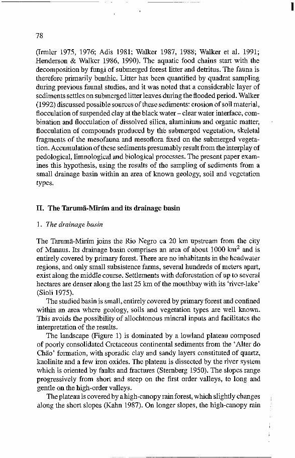
Cote: f3#9753 Ex: 1 Bioheochemistry33: 77-95,1996. @ 1996 Kluwer Academic Publishers. Printed in the Netherlands.
Sedimentation and pedogenesis in a Central Amazonian Black water basin
A. CHAUVEL’, I. WALKER2 and Y. LUCAS3 ’ Centre ORSTOM, 72 route d’dulnay, Laboratoire d’Ec$&ie des Sols Tropicaux, 93143 Bandy Cedex, France!. ’ Institute National de Pes&sas’da Atizazonia (INPA), Departamento de Ecologia, CP 478,69083 Manaus, qM, Bra&l; 3 ‘Univ&k de To&on-Var, Laboraidjre des Echanges Partl;culaires aux Interfaqs;?P !32,839$? Lf2 Garde Cedex, France
‘. ,/ )I ,
Received 14 July 1994 ac&eiteh-1. Novkm$r39&’ ‘, 1.. ‘,.. 8 3
: ,.,; ‘. :’
Key words: groun&&~~~~ovement, limnology, organo~irii~emi-cbi;l;jiCx,‘R~~,~egro, silica cycle, Tropical forest; ._ ,.,;. ,.“, ,bj’ :
.‘,,’ _. :.
Abstract..$ed&ntation rates were &tim&edin a Central Amazon&Black-water inundation forest. Sediment deposition on the’ forest grbund, remote from the river bed, during an annual flood period, is of the ordeiof 1 to 10 t&s p& hectare’, depending on water depth and duration of flooding. The sediments consisted of fine organic matter, kaolinite, quartz sands and biogenic particles of silica. Their genesis and deposition depend on the interplay between pedogenic, limnological and biological processes. Sediments derive primarily from the materials leached from the soils. Clay soils are the main source of dissolved silica, and the sandy soils are the main sources of organic coumpounds and mineral particles. The physical sedimentation of particles as quartz sand grains only occurs in the upper reaches of the studied river. In the flood plain, the sedimentation is due to the coagulation and deposition of combined mineral particles and humic substances, and to the biological precipitation of the silica leached from the soil by sponges.
I. Introduction
The sediment fill in the Amazonian river basins have resulted from the com- pl$x interplay of abiotic and biotic processes. This includes organic decom- pc#4tion on and within different soils, water infiltration and surface run-off,
L !wICathering or generation of minerals within the soils, ground water inflow,
#I- &&port and sedimentation of suspended solids and of dissolved inorganic ipE!I!!!z ‘&!d organic substances by the river, and biological and biochemical activities m====m:!j ” Ez ;; the aquatic biotope. ‘I s$ 11 All large Central Amazonian rivers and their flood plains are subject to : eo apnual inundation cycles. The highest water levels occur in June and lowest i-5 @es in November, the mean difference being about 8 m in Manaus. Flood ::-
F k I ‘&ins of the Rio Negro Basin are inundated by sediment-poor black water iSioli 1975,1984; Brinkmann 1986; Leenheer & Menezes-Santos 1980). /
1,: i p 1 The Tarum%Mirfm is a black water tributary of the Rio Negro. The biol- ogy of this river and of the related flood plain have been described previously
I I
1
78
(Irmler 1975, 1976; Adis 1981; Walker 1987, 1988; Walker et al. 1991; Henderson & Walker 1986, 1990). The aquatic food chains start with the decomposition by fungi of submerged forest litter and detritus. The fauna is therefore primarily benthic. Litter has been quantified by quadrat sampling during previous faunal studies, and it was noted that a considerable layer of sediments settles on submerged litter leaves during the flooded period. Walker (1992) discussed possible sources of these sediments: erosion of soil material, flocculation of suspended clay at the black water - clear water interface, com- bination and flocculation of dissolved silica, aluminium and organic matter, flocculation of compounds produced by the submerged vegetation, skeletal fragments of the mesofauna and mesoflora fixed on the submerged vegeta- tion. Accumulation of these sediments presumably result from the interplay of pedological, limnological and biological processes. The present paper exam- ines this hypothesis, using the results of the sampling of sediments from a small drainage basin within an area of known geology, soil and vegetation types.
1
II. The Tarumg-Mirim and its drainage basin
1. The drainage basin
The Tarumã-Mirim joins the Rio Negro ca 20 km upstream from the city of Manaus. Its drainage basin comprises an area of about 1000 km2 and is entirely covered by primary forest. There are no inhabitants in the headwater regions, and only small subsistence farms, several hundreds of meters apart, exist along the middle course. Settlements with deforestation of up to several hectares are denser along the last 25 km of the mouthbay with its ‘river-lake’ (Sioli 1975).
The studied basin is small, entirely covered by primary forest and confined within an area where geology, soils and vegetation types are well known. This avoids the possibility of allochtonous mineral inputs and facilitates the interpretation of the results.
The landscape (Figure 1) is dominated by a lowland plateau composed of poorly consolidated Cretaceous continental sediments from the ‘Alter do Chão’ formation, with sporadic clay and sandy layers constituted of quartz, kaolinite and a few iron oxides. The plateau is dissected by the river system which is oriented by faults and fractures (Sternberg 1950). The slopes range progressively from short and steep on the first order valleys, to long and gentle on the high-order valleys.
The plateau is covered by a high-canopy rain forest, which slightly changes along the short slopes (Kahn 1987). On longer slopes, the high-canopy rain
79
I
2
5
6
7
8
9
Sedlment 1 Podzol i Intermediate I CI8y latosol i I I zone I I
i
1-2 : Stream valley, not subject to annuai lnundatlons
9 : Adjacent to ttie river mouth bay Stations 5-8 : Under close canopy Inundaton forest
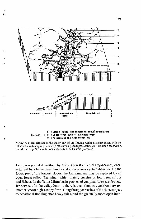
Figure I. Block diagram of the major part of the Tammã-Mirim drainage basin, with the litter/ sediment sampling stations (1-9), showing soil types. Stations 2-4 lie along headwaters outside the map. Sediments from stations 6,8, and 9 were processed.
forest is replaced downslope by a lower forest called ‘Campinarana’, char- acterised by a higher tree density and a lower average tree diameter. On the lower part of the longest slopes, the Campinarana may be replaced by an open forest called ‘Campina’, which mainly consists of low trees, shrubs and lichens. In the Taruã Mirim basin patches of campina forest are few and far between. In the valley bottom, there is a continuous transition between another type of high-canopy forest along the upper reaches of the river, subject to occasional flooding after heavy rains, and the gradually more open inun-
,
7
80
dation forest called ‘Igapó’ subject to regular, annual inundation (Guillaumet 1987, Walker 1987).
These changes in vegetation correspond to changes in soils, that have been detailed in previous studies (Lucas et al. 1984, Chauvel et al. 1987, Lucas et Chauvel 1992). The plateaux soils consist of thick, microaggregated kaolinitic horizons (more than 85 % kaolinite) overlying a quartzo-kaolinitic saprolite. They are classified as ‘Ferralsols’ (FAO 1990), ‘Xanthic Acrudox’ (Soil Survey Staff 1992), or ‘Latossolo amarelo dico, textura argilosa’ (Camargo et al. 1987). The soils turn progressively sandier downslope, and change into ‘Acrudoxic Kandiudult’ (Soil Survey Staff 1992), or ‘Podzólico vermelho- amarelo latoss6lico’ (Camargo et al. 1987)). On the lower part of long slopes, the soils consist of a thick, white quartz sand horizon, overlying the quartzo- kaolinitic saprolite. Organic matter accumulates at depth at the transition between the white sand and the saprolite, forming a black spodic horizon. These soils are classified as ‘Podzols’ (FAO 1990), ‘Quartzi Psamment’ (Soil Taxonomy), or ‘Podzols’ (Camargo et al. 1987). The ‘Campinarana’ may be associated to Psamments as well as Udults while ‘Campina’ in only found on Psamments.
The plateau soils have formed in place by progressive quartz dissolution and new generation of kaolinite and gibbsite (Irion 1984, Lucas et al. 1987). In the upper centimeters of the profile, roots and micro-organisms release various aggressive compounds into the soil solution, such as HN03, H2SO4 and water-soluble complexing acids, which facilitate the weathering of the mineral soil material, mainly kaolinite. Elements released by weathering are transported deeper into the profile. Aluminium is trapped as kaolinite and gibbsite, and the balance is a net loss of silica. The percolation of the soil solution is mainly vertical through the whole profile, down to the water-table at about 33 m depth. The annual variation of the level of this water table is no more than a few decimeters; its throughflow contributes to the clear water stream situated in the valley bottom. The amount of silica annually leached out of the soil was calculated as 24kg/ha/year (Lucas et al. 1993) from the mean silica concentration in stream waters that drain clayey ferralsols areas and from the amount of water that annually percolates through the soils (about 500 mm). As nearly half the Tarumã Mirím drainage basin is occupied by oxisol areas, more than 1000 t/year of dissolved silica are presumably carried into the river via the water table.
On the slopes, the above processes are influenced by lateral percolation. The lateral waterflow leaches more elements from the system, such as dis- solved aluminium, organo-metallic Al and Fe compounds and microparticles (Eyrolle et al. 1993). The balance is a net loss of aluminium resulting in a relative enrichment of Si02 in the form of quartz sand. Ever more material is
\
I
r
r‘
81
thus removed from the edge of the plateau, thus extending the slope. The soils turn progressively sandier, and podzolization develops on the lower slope. In situ experimentations show that podzolization is a currently active process on the slopes, particularly during the rainy season (Righi et al. 1990). The result of these processes is a soil transformation system (Lucas & Chauve1 1992), in which the sandy podzol slopes progressively replace the clayey ferralsol plateau. The cause of the transformation is internal and related to the lateral circulation of percolating water on the slopes. In podzols, the semi-permeable and shallow spodic horizon retains temporary perched ground water near the surface (few meters deep). This podzolic ground water, which is independent of the phreatic water, results in blackwater streams.
Since the various headwater streams originated at different periods, these pedogenetic processes are advanced to various degrees, and consequently, we find a mosaic of ferralsols associated with high-canopy forest and podzols associated with Campinas, with intermediate stages of transformation asso- ciated with Campinarana forest. Clayey ferralsols have a good capacity of water retention, which permits a high, permanent biological activity. The for- est litter is thus rapidly mineralized. Soil solution percolates through clayey materials characterized by high adsorption capacity. Drainage of these soils, therefore, gives rise to colourless, transparent ‘clear-water streams’. In the progressively more sandy soils, which are alternately dry and waterlogged, biological activity and the litter decomposition rate slow down. Hence, litter, humus and soluble organic compounds accumulate, notably during the dry season, while the increasing lateral percolation leads to the export of humic and fulvic acids with the drainage water. This gives the tea-coloured water of the ‘black-water streams’. The export of material is particularly intense in the transition zone; white sands contribute only a minor fraction of these compounds (Leenheer 1980; Klinge 1966).
2. The river
On the maps so far available, the Tarumã-Mirim appears about 50 km long. This does not include, however, the small-scale meanders all along the water course, which bring the total length closer to about 150 km. About 70% of the tributaries and headwater streams drain clay soils and hence carry clear water. The remaining streams originate in Campina and Campinarana forest and carry black water. The main river, therefore, looks like a typical black-water river, despite the relatively moderate content of humic substances in solution (Table 1). During prolonged dry periods (Aug.-Nov-Dec.), black water input from sandy soils decreases as compared to clear water input (Walker 1990). The data in Table 1 do not include such exceptional conditions. Slope is approximately 0.4 m.km-’, and mean water flow varies from about 0.2 to
82
Table I . Water characteristics in black and clear water affluents and in the mixed water of the main stream Tammã-Minin.
STREAMS pH Conductivity Dissolved humic compounds
~ f s ' n2 ~ f s n X f s n pS/cm mg/I
clearwater 4.4f 0.3 3 7.3 f 0.3 3 8.7 f 1.1 3 L
blackwater 3.3 f 0.1 2 19.2 f 1.3 2 48.7 f 2.8 2
mixedwater 4.5 hO.5 7 10.2h 1.4 7 12 1 I
' X f s = mean with standard deviation. * n = number of samples.
1 m.s-', depending on local topography and rainfall. Inundation of the flood- plain forest begins at the end of January and extends upstream to 1-2 km above station 5 (Figure 1) in June. The water stagnates until the end of July, and surface temperatures may, in the lower more open forest, reach 32"C, while the temperature of running streams remains close to 26°C.
3. Sampling sites (Figure I; Table 2)
Stations 1-4 are situated in the valleys, upstream from the flood plain. They are not subject to annual inundation, but are occasionally flooded following heavy rains. No sediment was processed from these sites. Stations 5-8 are situated in the annually flooded Igap6 forest, with a well developed litter layer covering the ground during the emersion phase. Station 9 is adjacent to the river mouthbay. This is a relatively open area with bare clay soil, a few tall living trees, many dead trees, and patches of abundant saplings where seeds have been deposited by the flood. For a more detailed report on litter deposition in stations 1-9 see Walker (1992).
t
t
III. Material and methods
1. Sampling
The litter samples were taken within the first 36 hours after the water receded from the sampling sites. All sites lie inside the forest, several meters from the river bank. By coincidence, there was no rain during these 36 hours that could have removed the sediments from the litter leaves.
7
83
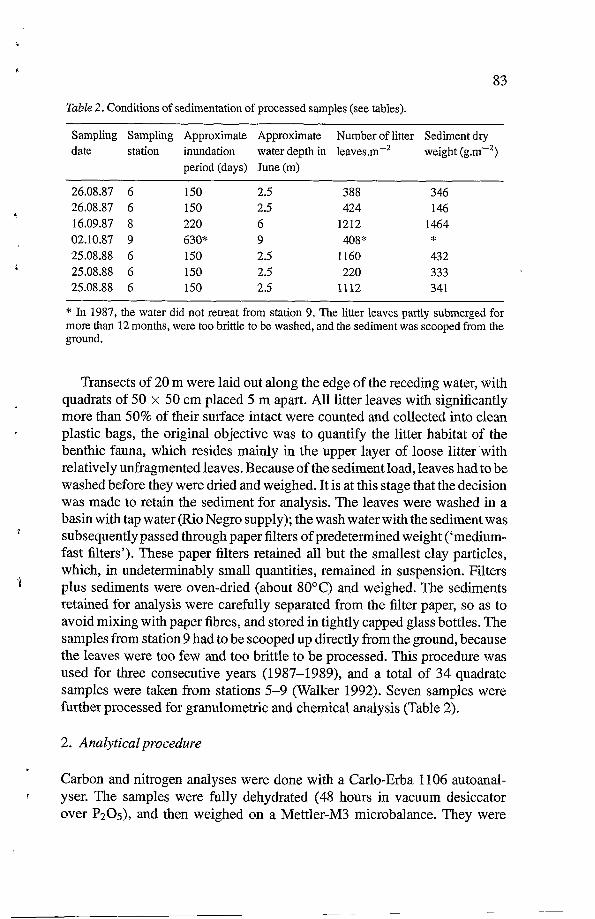
Table 2. Conditions of sedimentation of processed samples (see tables).
Sampling Sampling Approximate Approximate Number of litter Sediment dry date station inundation water depth in leaves.m-' weight (g.m-')
period (days) June (m) ~ ~~
26.08.87 6 150 2.5 388 346 26.08.87 6 150 2.5 424 146 16.09.87 8 220 6 1212 1464 02.10.87 9 630" 9 408* * 25.08.88 6 150 2.5 1160 432 25.08.88 6 150 2.5 220 333 25.08.88 6 150 2.5 1112 341
* In 1987, the water did not retreat from station 9. The litter leaves partly submerged for more than 12 months, were too brittle to be washed, and the sediment was scooped from the ground.
Transects of 20 m were laid out along the edge of the receding water, with quadrats of 50 x 50 cm placed 5 m apart. All litter leaves with significantly more than 50% of their surface intact were counted and collected into clean plastic bags, the original objective was to quantify the litter habitat of the benthic fauna, which resides mainly in the upper layer of loose litter 'with relatively unfragmented leaves. Because of the sediment load, leaves had to be washed before they were dried and weighed. It is at this stage that the decision was made to retain the sediment for analysis. The leaves were washed in a basin with tap water (Rio Negro supply); the wash water with the sediment was subsequently passed through paper filters of predetermined weight ('medium- fast filters'). These paper filters retained all but the smallest clay particles, which, in undeterminably small quantities, remained in suspension. Filters plus sediments were oven-dried (about 80°C) and weighed. The sediments retained for analysis were carefully separated from the filter paper, so as to avoid mixing with paper fibres, and stored in tightly capped glass bottles. The samples from station 9 had to be scooped up directly from the ground, because the leaves were too few and too brittle to be processed. This procedure was used for three consecutive years (1987-1989), and a total of 34 quadrate samples were taken from stations 5-9 (Walker 1992). Seven samples were further processed for granulometric and chemical analysis (Table 2).
2. Analytical procedure
Carbon and nitrogen analyses were done with a Carlo-Erba 1106 autoanal- Yser. The samples were fully dehydrated (48 hours in vacuum desiccator over P205), and then weighed on a Mettler-M3 microbalance. They were
r
84
burnt at 1050"C, the gaseous mixture was flushed and separated into the gas chromatographic column, and evaluated with a thermal conductivity detector equipped with a recorder integrator.
The humic and fulvic acids were isolated from sediments following Rouiller et al. 1994 three alkaline extractions with 1% Na4P207 in 0.1N NaOH. The humic acids were separated from fulvic acids by acidic coagula- tion with 1N HCl addition to pH 2.
A dehydrated 1 or 2 mg sediment sample was mixed with 200 mg of dehydrated KBr. The mixture was ground in an automatic grinder (Rotomill). Pellets were made with 200 mg of the mixture. The IR spectra were recorded with a Beckmann 4250 spectrophotometer in the ranges 4000-200 cm-' and 1000-0.4 cm-'.
L
1
IV. Results: characterization of the sediments
1. Quantity of sediment
The dry weight of sediments collected on the litter leaves varied from 146 to 1464 g.m- ' ~ depending on collection sites, micro-topography and the number of leaves (Walker 1992) (Table 2). The greatest quantities were collected in station 8 with its long inundation period. The quantities collected in 1987 and 1988 are of the same order of magnitude. They correspond to 1.5-14.5 t.ha-'.y-'per meter of water depth in June, in the Igap6 region. It may be argued that these sediments are carried into the Tarumã-Mirim basin by the rising flood of the Rio Negro, or else, that they are in part re-suspension from the forest floor. However, flooding by the Rio Negro system is associated with almost imperceptively slow flow velocities (January-June), which cannot stir up the surface layer of the soil. Moreover, the superficial root mat and litter layer secure the top soil inside the inundation forest. Relatively stronger flows are expected only in the vicinity of the river bed, where the slowly rising Rio Negro flood is braking the high-velocity flow of the river, which thus carries its sediments into the area of the inundation forest. The sediments in station 9 with sparse trees and open clay soils were not quantified. Partial resuspension may occur. Still, as the Rio Negro almost stagnates from March to July, while the TarumCMirím carries its highest water volume down-river during the coinciding rainy season, sedimentation would be expected to be more important than re-suspension.
The few samples da not, of course, allow for quantitative extrapolation of larger areas, but they indicate that sedimentation in Central Amazonian blackwater basins is not anegligible process, and needs thorough limnological analysis.
3
P
h
85
2. Particle-size distribution
Sand content in the sediment varied from 19 to 46% (Table 3), and fine particles of 50 to 200 pm in diameter made up the larger portion in all sand fractions. The percentage of sand decreases downstream, with smallest values in station 9, where water stagnates from May to July each year, and flow is low during the remaining months of inundation.
3. Mineral composition
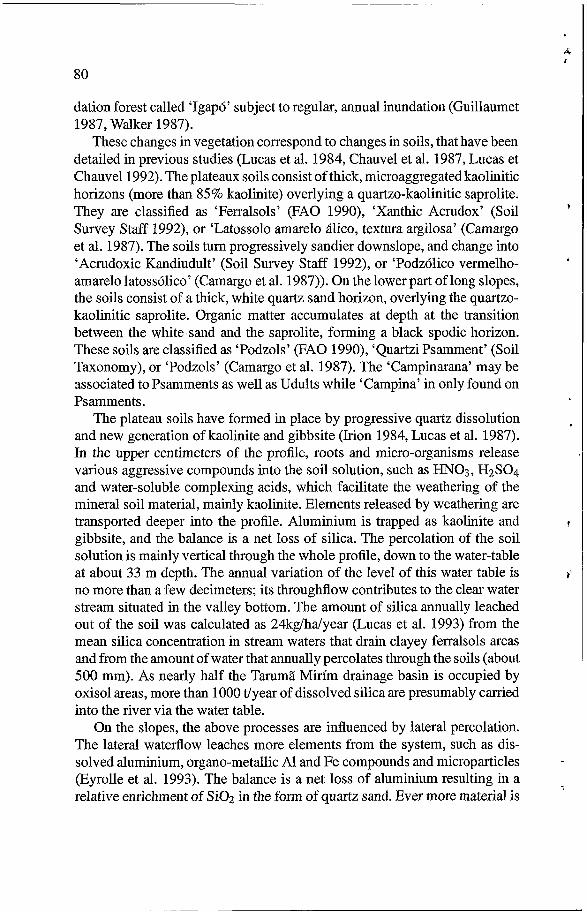
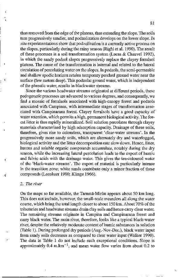
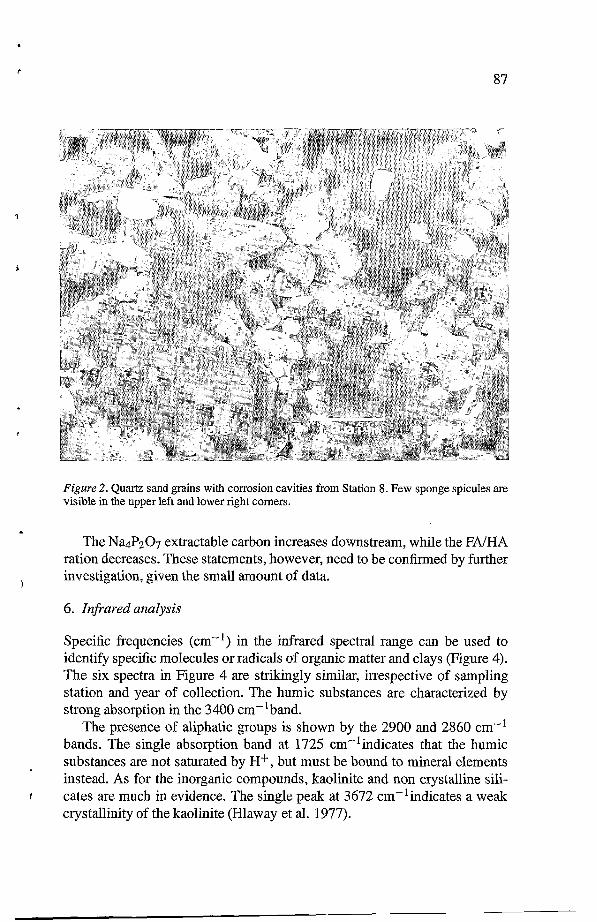
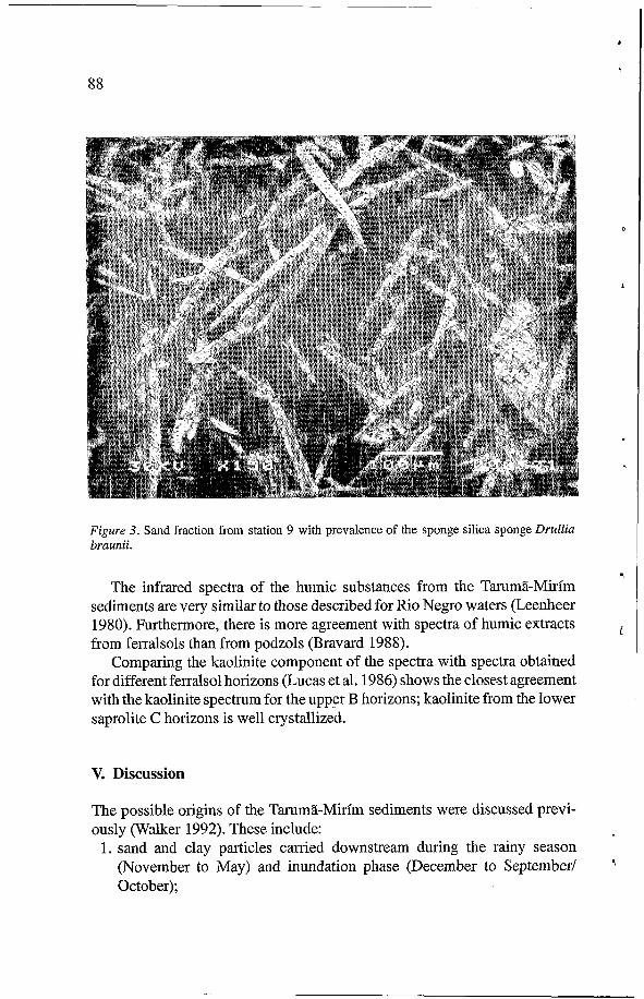
The X-ray diffractograms gave evidence of two compounds only, quartz and kaolinite. Observation of sands under the scanning microscope (Figures 2-3) showed two types of particles: (i) quartz sand granules with numerous cavities of dissolution, similar to particles described by Lucas et al. (1990) for ferralsols, and (ii) spicules of silica sponges. This latter fraction is insignificant in the upper station 6, and increases slightly in station 8. In station 9, sponge spicules are predominant. In fact, the trees of this region are densely colonized by large, round sponges (diameter up to 25 cm) of the species Drullia braunii.
4. Organic carbon and nitrogen
In all samples, carbon content was considerable and varied from 100 to 220 mg.g-’, while values in the soils of the region have less than 35 mg.g-’ (Bravard 1988). There was no correlation with limnological conditions at the sampling stations, nor with either clay or sand content of the sample. The C/N ratio of the sediment varied from 15 to 19 as compared to 11 to 14 for ferralsols, 17 to 69 for podzols, and 12 to 18 for intermediate soils.
5. Extractable l u ” components (Table 3)
Nap207 extractable carbon expressed in% of total carbon varied from 26% to 37%. The non-extractable carbon residues represented more than 60% of total carbon in all places. Similar analysis of the soils of the Tarumã-Mirim basin showed 29 to 40% extractable carbon in the different ferralsol horizons and in soils with decreasing clay content. In the podzols, values range from 50 to 70% in the humiferous topsoil horizons, and from 90 to 99% in the deep spodic horizons (Bravard 1988).
The ratio of fulvic to humic acid (FNHA) varied from 0.7 to 0.3. These values are considerably lower than those encountered in the topsoil horizons of soils in the drainage basin, which range from 2 to 8. The low ratios of the sediment samples are similar to those found in deep spodic podzol horizons, which range from 0.4 to 0.1 (Bravard 1988).
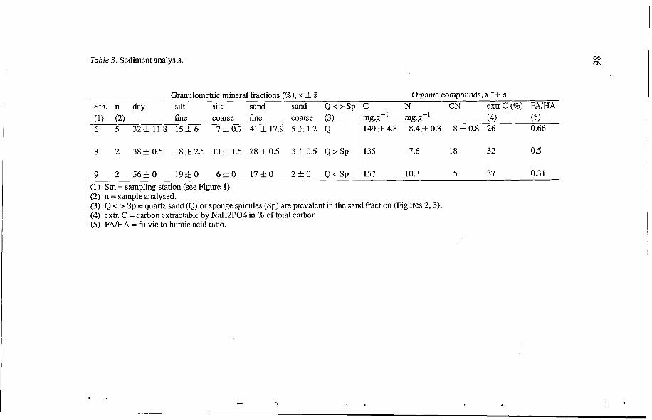
Table 3. Sediment analysis.
Granulomehic mineral fractions (%), x zt S Stn. n day silt silt sand sand Q < > S p (1) (2) fine coarse fine coarse (3) 6 5 323Z11.8 1 5 f 6 7zt0.7 413Z17.9 53Zl.2 Q
8 2 38Zt0.5 1 8 f 2 . 5 13Zt1.5 28Zt0.5 3Zt0.5 Q > S p
9 2 56ZtO 1 9 f 0 6 f O 17ztO 2 f 0 Q < S p (1) Stn = sampIing station (see Figure 1). (2) n = sample analysed.
Organic compounds, x -f s C N CN extrC(%) FNHA
149zt 4.8 8.4Zt 0.3 18 Zt 0.8 26 0.66 mg.g-' mg.g-' (4) (5)
135 7.6 18 32 0.5
157 10.3 15 37 0.3 1
(3) Q < z Sp = quartz sand (Q) or sponge spicules (Sp) are prevalent in the sand fraction (Figures 2,3). (4) extr. C = carbon extractable by NaH2P04 in % of total carbon. (5) FNHA = fulvic to humic acid ratio.
87
Figure 2. Quartz sand grains with corrosion cavities from Station 8. Few sponge spicules are visible in the upper left and lower right comers.
The Na4P207 extractable carbon increases downstream, while the FA/HA ration decreases. These statements, however, need to be confirmed by further investigation, given the small amount of data.
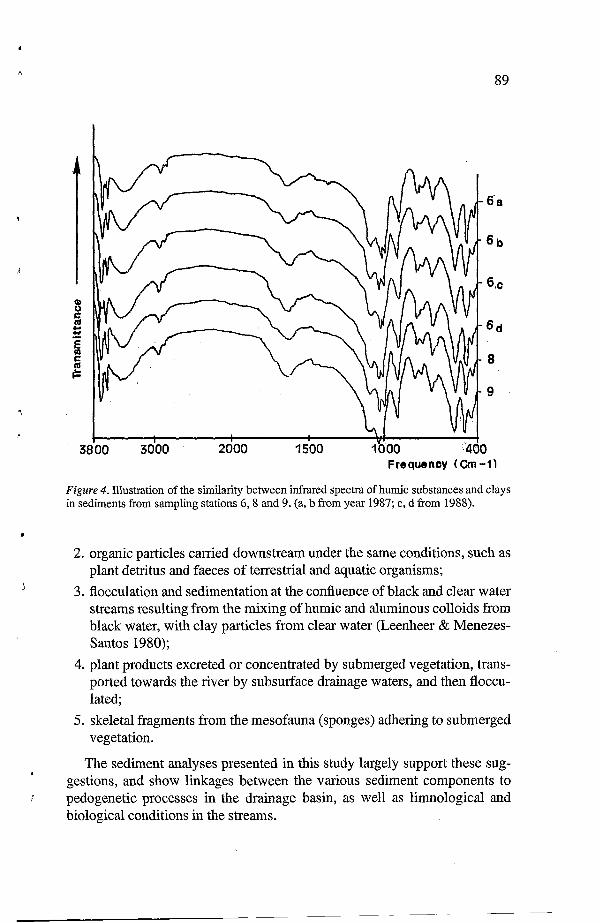
6. l i frayed analysis
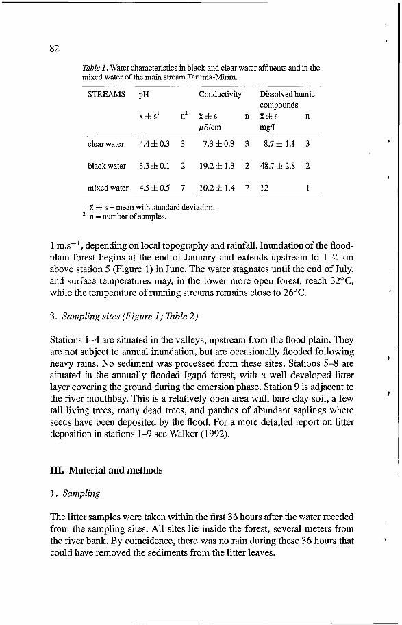
Specific frequencies (cm-') in the infrared spectral range can be used to identify specific molecules or radicals of organic matter and clays (Figure 4). The six spectra in Figure 4 are strikingly similar, irrespective of sampling station and year of collection. The humic substances are characterized by strong absorption in the 3400 cm-'band.
The presence of aliphatic groups is shown by the 2900 and 2860 cm-' bands. The single absorption band at 1725 cm-'indicates that the humic substances are not saturated by H+, but must be bound to mineral elements instead. As for the inorganic compounds, kaolinite and non crystalline sili- cates are much in evidence. The single peak at 3672 cm-'indicates a weak crystallinity of the kaolinite (Hlaway et al. 1977).
r
88
Figure 3. Sand fraction from station 9 with prevalence of the sponge silica sponge Drullia braunii.
The infrared spectra of the humic substances from the Tarumá-Mirim sediments are very similar to those described for Rio Negro waters (Leenheer 1980). Furthermore, there is more agreement with spectra of humic extracts from ferralsols than from podzols (Bravard 1988).
Comparing the kaolinite component of the spectra with spectra obtained for different ferralsol horizons (Lucas et al. 1986) shows the closest agreement with the kaolinite spectrum for the upper B horizons; kaolinite from the lower saprolite C horizons is well crystallized.
V. Discussion
The possible origins of the Tarumá-Mirim sediments were discussed previ- ously (Walker 1992). These include:
1. sand and clay particles carried downstream during the rainy season (November to May) and inundation phase (December to September/ October);
. 4
o
I
1
t
89
Frequency (Cm-i1
Figure 4. Illustration of the similarity between infrared spectra of humic substances and clays in sediments from sampling stations 6,8 and 9. (a, b from year 1987; c, d from 1988).
i
2. organic particles carried downstream under the same conditions, such as plant detritus and faeces of terrestrial and aquatic organisms;
3. flocculation and sedimentation at the confluence of black and clear water streams resulting from the mixing of humic and aluminous colloids from black water, with clay particles from clear water (Leenheer & Menezes- Santos 1980);
4. plant products excreted or concentrated by submerged vegetation, trans- ported towards the river by subsurface drainage waters, and then floccu- lated;
5. skeletal fragments from the mesofauna (sponges) adhering to submerged vegetation.
The sediment analyses presented in this study largely support these sug- gestions, and show linkages between the various sediment components to pedogenetic processes in the drainage basin, as well as limnological and biological conditions in the streams.
90
Pedogenetic processes
Studies of the soil mantles in the area (Lucas et al. 1984, Chauve1 et al. 1987) have shown that the stability of the plateau ferralsols, the evolution of slopes by leaching and podzolizing processes, and the valley development result in a net loss of organic and mineral constituents from the drainage basin to the river. This transportation of dissolved and suspended matter is related to two types of water flows identified in the basin. (i) the vertical drainage through plateau ferralsols is responsible for the transportation of great amounts of dissolved silica down to the water table, and then out towards the clear water streams. Because of the slow velocity of the vertical drainage (around 2 m.y-', Rozanski et al. 1991), the percolating water has a great residence time in soils and saprolite, and the dissolved silica content of the water increases by quartz dissolution. This results in a high dissolved silica content of clear water, around 2 mg.1-l (Furch 1984, Eyrolle 1994)] and (ii) the lateral drainage by the downslope subsurface flow and the perched podzol water table is respon- sible for the transportation of humic substances, organo-mineral compounds formed in the podzolization processes, and dispersed small mineral particles, kaolinite and quartz. This transportation occurs through sandy materials, with poorly reactive mineral surfaces, down to the black water streams. Because of the low residence time of the water, the dissolved silica content in spring black water is relatively low, around 0.8 mg.1-l (Eyrolle 1994). Export of small minerals particles is likely more intense from the intermediate zone between ferralsols and podzols (Figure I). The corrosion pattem of the quartz sand particles and the infrared spectra of the kaolinites of the Igap6 sediments (Figure 2) are characteristic of pedogenic material.
Limnological processes
Physical processes: sedimentation of inorganic compounds
The heavier particles settle in the upper part of the stream valleys, with steeper declivity and stronger flow. Quartz sand deposition decreases gradually down river becoming insignificant by station 9. Only a small portion of larger (>200 pm) sand particles reaches the Igap6 flood plain. During the exces- sively low water levels in November 1990 and 1991, it was possible to examine the sediments in the area of station 9, in the bed bottom of all tributaries, and in the whole flood plain down to the junction with the Tarumil- Mirim. In all the sites, the sediments consisted of fine, light brown mud exceeding 1 meter in depth in some areas when still covered with water (Walker, personal observation).
Chemical processes: clay JIocculation
91
Leenheer & Menezes Santos (1980) studied the sedimentation processes in the region of the ‘Arquipelago das Anavilhanas’, an island complex in the Rio Negro situated below the junction with the Rio Branco. They found that under the acid conditions of the Rio Negro, hydrophobic humic substances
Rio Branco. This leads to precipitation and sedimentation, and results in the kind of muddy sediment described above for Station 9. These processes likely occur in the Tarumã-Mirim flood plain. The Tarumã Mirím and its tributaries are acidic (Table 1) and contain humic compounds whose infrared spectra are similar to those described by Leenheer & Menezes Santos (1980). Some clear waters exhibit a slight Tindall effect, which indicates particles in suspension.
Such sedimentation would modify the organic matter characteristics along the river course. During inundations, the most recent, fine sediments are re- suspended, which permits renewed absorption of the more reactive organic compounds. Those would thus become less and less dispersible downstream. This process would explain:
1. a downstream increase of the humic fraction of the sediment, which can- not be explained by authigenic polymerization, since the waters in the lower Igap6 are relatively anoxic (Irmler 1975); there is likely polymer- ization as a result of clay absorption (Huang 1989);
2. a downstream decrease of the FNHA and the C/N ratios. C/N value is around 50-60 in black waters (Erte1 et al. 1986, Eyrolle 1994), and 18
(1986) showed that humic acids from black water are richer in nitrogen ( U N 15-60) than the fulvic acids from the same water (40-85). The hydrophilic compounds remain in suspension and may undergo further decomposition. The conditions in the Tarumã Mirím basin seem to agree with the general observation made by Hedges et al. (1986) according to which the finest organic particles of the Amazon Basin are ‘comparatively old, degraded and rich in immobilized nitrogen, and derive primarily from soils’.
The high content of organic materials in the Tarumã Mirím sediment (170-390 mg.g-’ dry weight as against < 60 mg.g-’ in the soils of the basin) indicates that organic materials accumulate on the flood plain of the Igap6. As seen before, part of this materials has pedogenic colloidal origin. Another part may come from litter and from its associated fauna, debris and soil organic matter carried by tributaries to the Igapó, as well as the litter fall of the Igapó forest itself. This part may contribute to the high percentage of carbon not extractable by pyrophosphate.
7 coming from the Rio Negro coagulate with clay particles coming from the
1
r
L and 15 in the sediments of Stations 6 and 9 respectively. Hedges et al.
i(
I

92
Biological processes: accumulation of sponge spicules
The silica spicules prevail in the sand fraction of the sediments of Station 9 (Figure 3). The absorption of silicium by sponges and sedimentation in the form of spicules is thus an intense process in the low reaches of the Tarumã Mirim, where long and massive annual inundations are guaranteed, and where a relatively open vegetation allows for the production of plankton that sustains the massive colonies of the sponge Drulia braunii. In a recent work carried out in a site closer to the Rio Solimões, Konhauser et al. (1992) show that algae may also contribute to silica precipitation. These observations reveal the respective roles of pedogenic processes, which dissolve silica from quartz, and limnological processes, which concentrate and settle this silica in the form of detrital particles. As the forest’s cycling of silica plays a key role in the stability of the soil clay minerals (Lucas et al. 1993), the silica cycle appears to be entirely controlled by the biological activity, from the soils to the river and the sediments.
Some other biological processes may affect the sedimentation in the black water streams. Microscopic organic particles are produced by litter shredders, mostly by chiromids and oligochaetes (Walker 1985, 1988, Walker et al. 1991). These components have not been quantified yet, but are likely to be substantial.
Conclusion
The sediments of Cretaceous age which occupy a large part of the middle Amazon basin are currently subject to processes of dissolution, complex formation and mobilisation (notably of Si, Al) under acidic organic conditions. This activity results in the genesis of a soil cover that ranges from clayey ferralsol to sandy podzol. The vertical flow of percolating water through the latosol supplies large amounts of silica to the river, and the lateral flow of percolating water through the sandy podzol allows simultaneous transport to the river of organic compounds and mineral particles, via temporarily perched water tables. The distinctive nature of the current sediments of the Tarumã Mirim, and also of the Rio Negro, is principally due to (i) the coagulation and deposition of combined mineral particles and humic substances; (ii) the biological precipitation by sponges of the silica leached from the soil.
Acknowledgements
This work has been supported by CNPq-INPA (Brazil), an by ORSTOM and the PEG1 program (France). The authors thank Dr F. Andreux and J.M. Portal
r 93
(Centre de PCdologie Biologique du CNRS) for laboratory support and for helpful suggestions and assistance with interpretation of results, and Dr. B. Forsberg (INPA, Manaus) and Y. Biot (INPNODA, Manaus) for critically reading and discussing the paper and for corrections of the English language.
References
F Adis J (1981) Comparative ecological studies of the terrestrial arthropod fauna in Central Amazonian inundation forest. Amazoniana 7: 87-173
Bravard S (1988) Podzolisation en Amazonie Brésilienne. Etude d’une séquence sol ferralli- tique - podzol de la région Nord de Manaus. Thesis, Univ. Poitiers, France
Bravard S. & Righi D (1991) Characterization of fulvic and humic acids from an oxisol- spodosol sequence of Amazonia, Brazil, Geoderma. 48: 15 1-162
Brinkmann WL (1986) Particulate and dissolved materials in the Rio Negro-Amazonas Basin. In: Sly PG (Ed) Sediments and water interactions (pp 1-12). Springer, New York, Berlin
Camargo MN, Klamt E & Kauffman JH (1987) Soil classification as used in Brazilian soil survey. ISRIC Annual report 1986, Wageningen
Chauve1 A, Lucas Y & Boulet R (1987) On the genesis of the soil mantle of the region of Manaus, Central Amazonia, Brazil. In: multi-author review. The dynamics of the amazo- nian terra firme forest. Experientia 43: 234-241
Ertel JR, Hedges JI, Devol AH, Richey JE & Goes Ribeiro MN (1986). Dissolved humic substances of the Amazon River System. Limnol. Oceanogr. 31: 739-754
Eyrolle F (1994) La fraction colloïdale organique dans les processus de transport des métaux dans les eaux de surface: application aux systèmes d’altération en milieu tropical (Brésil). Thesis, Université d’Aix-Marseille III, 334 pp
Eyrolle F, Fevrier D & Benaïm JY (1993) Etude par DPASV de l’aptitude de la matière organique colloïdale àfixer et transporter les métaux: exemple de bassins en zone tropicale.
FAO-UNESCO (1990) Soil map of the world. Revised Legend. World Soil Resources Report 60, FAO, Rome
Furch K (1984) Water chemisty of the Amazon Basin: the distribution of chemical elements among freshwaters. In Sioli H (Ed) The Amazon: Limnology and landscape ecology of a mighty tropical river and its basin. W. JunkPubl, Dordrecht
Guillaumet JL (1887) Some structural and floristic aspects of the forest. In: multi-author review. The dynamics of the amazonian terra firme forest. Experientia 43: 241-25 1
Hedges JI, Clark WA, Richey JE, Devol AH & Santos U de M (1986) Composition and fluxes of particulate organic material in the Amazon River. Limnol. Oceanogr. 31: 717- 738
Hedges JI, Ertel JR, Quay D, Grootes PM, Richey JE, Devol AH, Farwell GW, Schmidt FW & Salati E (1986) Organic Carbon-14 in the Amazon River system. Science 231: 1129- 1131
Henderson PA & Walker I (1990) Spatial organization and population density of the fish community of the litter banks within a Central Amazonian black-water stream. J. Fish Biol. 37: 401-41 1
Hlaway J, Jonas K, Elek S & Inezedi J (1977) Characterization of the cristallinity of the minerals by infrared spectrophotomebry and other instrumental methods. Clays and Clay Minerals 25: 451-466
Huang PM (1989) Catalytic role of metal oxides and oxihydroxides and short-range ordered minerals in the formation of humic substances. Clay Research 8: 91-98
r
L Environmental Technology 14: 701-717
r
94
Irion G (1 984) Sedimentation and sediment of amazonianrivers and evolution of the amazonian landscape since Pliocene times. In ‘The Amazon: limnology and landscape ecology of a mighty tropical river and its basin’. Monographiae Biologicae 56: 201-214
Irmler U (1975) Ecological studies of the aquatic soil invertebrates in three inundation forest of Central Amazonia, Amazoniana 5: 337-409
Irmler U (1976) Zusammensetzung, Besiedlungsdichte und Biomasse der Macrofauna des Bodens in der emersen Phase Zentralamazonisher Ueberschwemmungswälder. Biogeo- graphica 7: 79-99
Kahn F (1987) The distribution of palms as function of local topography in Amazonian terra firme forests. Experientia 43: 251-259
Konhauser KO, Mann H & Fyfe WS (1992) Prolific organic Si02 precipitation in a solute deficient river: Ria Negro, Brazil. Geology 20: 227-230
Leenheer JA (1980) Origin and nature of humic substances in the waters of the Amazon river basin. Acta Amaz6nica 10: 513-526
Leenheer JA &Menezes Santos Ude (1980) Considerações sobre os processos de sedimentação na águapreta acida do Rio Negro (Amazonia Central). Acta Amazônica 1 0 343-355
Lucas Y, Chauvel A, Boulet R, Ranzani G & Scatolini F (1884) Transição latossolos-podzois sobre a formação Barreiras na região de Manaus, Amazonia, Rev. Bras. Ci. Solo 8: 325- 335
Lucas Y, Chauvel A & Ambrosi JP (1986) Processes of aluminium and iron accumulation in latosols developed on quartz rich sediments from Central Amazonia (Manaus, Brazil). Proceedings of the 1 th Int. Symp Geochemistry and mineral formation in the Earth surface. Granada, Spain 16-26/3186: 289-299
Lucas Y, Boulet R, Chauvel A & Veillon L (1987) Systèmes sols ferrallitiques podzols en région amazonienne. In: Right D & Chauvel A (Ed) Podzols et podzolisation (pp 53-65). AFES et INRA, Plaisir et Paris
Lucas Y & Chauvel A (1992) Soil formation in tropically weathered terrains. In: Butt CRM & Zeegers H (Eds) Handbook of exploration geochemistry. Soil, laterite and saprolite geochemistry in mineral exploration of tropically weathered terrains (pp 57-76). Elsevier
Lucas Y, Luizão FJ, Chauvel A, Rouiller J & Nahon D (1993) The relation between biological activity of the rain forest and mineral composition of soils. Science 260: 521-523
Righi D, Bravard S, Chauvel A, Ranger J &Robert MI (1990) In situ study of soil processes in an oxisol-spodosol sequence of Amazonia (Brazil). Soil Science 150 438-445
Rouiller J, SouchierB, Brucknert S, Feller C, ToutainF & Vedy JC (1994) Méthodes d’analyses des sols. In: Bonneau M & Souchier B (Eds) Pédologie. 2-Constituants et propriétés des sols (pp 619-652). Masson
Rozanski K, Amguas-Araguas L, Plata Bedmar A, Franken W, Tancredi AC, & Tundis Vital A (1991) Downward movement of soil moisture in the central Amazon region traced by means of hydrogen isotopes. Proc. Intemational Symposium on the Use of Stable Isotopes in Plant Nutrition, Soil Fertility and Environmental Studies. IAEA-SM-3 13
Sioli H (1975) Tropical rivers: the Amazon. In: Whitton EA (Ed), River Ecology (pp 46 1-488). Univ. of Califomia Press, Berkeley
Sioli H (Ed) (1984) The Amazon. Dr. W. JunkPubl. Dordrecht (Holland) Soil Survey Staff (1992) Keys to Soil Taxonomy. SMSS Technical monograph 19. 5th ed.
Blacksburg, Virginia, 541p Stemberg HOR (1950). Valestectônicos na planície Amazônica. Rev. Bras. de Geogr. 12(4):
511-534 Walker I (1985) On the structure and ecology of the microfauna in the Central Amazonian
Walker I (1987) The biology of streams as part of Amazonian forest ecology. Experientia 43:
Walker I (1988) Study of bentic micro-faunal colonization of submerged litter leaves in the Central Amazonian blackwater stream Tarumã Mirírn (Tarumãzinho). Acta Limnol. Bras.
forest stream ‘Igarapé da Cachoeira’. Hydrobiologia 122: 137-152
279-287
2: 623-648
b
A
œ
i
I
95
Walker I & Ferreira MJ de N (1985) On the population dynamics and ecology of the shrimp species Crustacea, Decapoda, Natantia, in the Central Amazonian river T a r i " Mirím. Oecologia. 66: 264-270
Walker I, Henderson PA & Steny P (1991) On the pattems of biomass transfer in the ben- thic fauna of an Amazonian black water river, as evidenced by 32P label experiment. Hydrobiologia 215: 153-162
Walker I (1992) The benthic litter habitat with its sediment load in the inundation forest of the Central Amazonian river Tarumã Mirím. Amazoniana: 143-153
e