Embed Size (px)
Citation preview
Forecasting the water disaster for coal mining under sea area in the Beizao Coalmine, Shandong Province, China
Zhimin Xu, Yajun Sun
School of Resources and Geosciences, China University of Mining and Technology, [email protected]
Abstract
This paper presents a case study of risk assessment for coal mining under sea area in the Beizao Coalmine, Shandong Province, China. The coalmine is facing the risk of sea water inrush hazards because most of its panels under the Bohai Sea. To forecast water disaster, three important factors, including efficient aquifuge, water flowing fractured zone and the water pressure bearing capacity of aquifuge, are considered to assess the mining safety situation for Panel H2301 in the Beizao Coalmine. The efficient aquifuge is identified by lithological analysis and water chemical comparison between sea water and groundwater. The water flowing fractured zone under different mining conditions is obtained by statistically analyzing the field measurements, physical and numerical simulation. A formula is derived to calculate the height of water flowing fractured zone and a forecasting model is built with the aid of GIS. On the basis of these research, the safety mining condition is assessed and the upper mining limit of Panel H2301 has been proposed.
Key words: mining under sea area; risk assessment; water disaster forecast; underground water inrush
1 Introduction
There are over 2.5 billion tons of coal resources located under surface water bodies in China. In recent years, China has been a rich experience of coal mining under water body such as lake, river and reservoir (Compilation Commission 1997), (Sun YJ et al. 2008, 2009), (Xu ZM et al. 2010), (Liu CY et al. 2010), (Wu X et al. 2009), (Peng K et al. 2011). Coal mining under surface water has been successfully done in some locations but there have also been many water-inrush disasters caused by the surface water when the overburden strata were damaged by the coal mining.
In addition, there are six countries having the experience of coal mining under the sea area all over the world, they are Britain, Australia, Chile, Japan, Canada and China. At the early 1980s, nearly 60% of the coal production from 15000 of the underground coalmines in Britain was extracted from the sea area. Coal production from the sea area of Japan and Australia also accounts for a large proportion of the national coal production. In these countries, due to the special coal mining under the sea, mining activities were managed strictly by the government regulations and orders (John W et al. 1982), (Holla.Laxminarayan 1987), (Niskovskiy Y et al. 1996), (D.Robert Gill 2000), (Singh R N et al. 2001), (Singh R N et al. 2001), (Gandhe A et al. 2005), (Winter T C et al. 2008), (Winter T C et al. 2008), (Sun YJ et al. 2008, 2009), (Xu ZM et al. 2010).
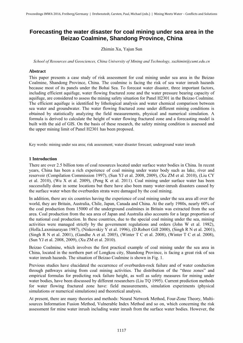
Beizao Coalmine, which involves the first practical example of coal mining under the sea area in China, located in the northern part of Longkou city, Shandong Province, is facing a great risk of sea water inrush hazards. The situation of Beizao Coalmine is shown in Fig. 1.
Previous studies have elucidated the occurrence of overburden-rock failure and of water conduction through pathways arising from coal mining activities. The distribution of the “three zones” and empirical formulas for predicting rock failure height, as well as safety measures for mining under water bodies, have been discussed by different researchers (Liu TQ 1995). Current prediction methods for water flowing fractured zone have: field measurements, simulation experiments (physical simulations or numerical simulations) and theoretical analysis.
At present, there are many theories and methods: Neural Network Method, Four-Zone Theory, Multi-sources Information Fusion Method, Vulnerable Index Method and so on, which concerning the risk assessment for mine water inrush including water inrush from the surface water bodies. However, the
Proceedings IMWA 2016, Freiberg/Germany | Drebenstedt, Carsten, Paul, Michael (eds.) | Mining Meets Water – Conflicts and Solutions
1117
water inrush assessment method from the surface water bodies has its own limitation because it considers few factors. Geographic Information System (GIS), is a multivariate method, which could study and management of spatial data. Supported by computer software and hardware, it can deal with geo-spatial data by geographical coordinates or spatial location for a variety of processing (Compilation Commission 1997), (Sun YJ et al. 2008).
This paper presents a case study of risk assessment for coal mining under sea area in the Beizao Coalmine, and deals with three key scientific problems: features of efficient aquifuge, height of the water flowing fractured zone and the water pressure bearing capacity of aquifuge, to present the water disaster forecasting results. On the basis of these researches, a forecasting model is built with the aid of GIS, and the safety mining condition under the Bohai Sea is aseessed and the upper mining limit of Panel No.H2303 has been proposed.
Weifang City
Jiaozhou City
Qingdao City
Lancun
Laizhou CityLaiyang
Zhaoyuan City
Taocun
Haiyang
WendengRongcheng
WeihaiCityYantai City
Penglai
Longkou City
Bohai Sea
Huanghai Sea
Beizao Coalmine Area
0 20 40km
38¡ã
120¡ã 121¡ã 122¡ã
120¡ã 121¡ã 122¡ã
38¡ã
37¡ã 37¡ã
Figure 1 The situation of Beizao Coalmine in Shandong Province
2 Geological Background
The major coal seam to be excavated in Beizao Coalmine is number 2 located in the Lower Tertiary System and the thickness ranges from 3.84 to 5.93 meters. The overburden rock consists of mudstone, sandy mudstone, calcareous mudstone, oil mudstone and oil shale, which are easy to be expanded when mudding and have perfect water insulation. The inflow of mine water ranges from 25 to 30 m3/h, among which the maximum is 42 m3/h when the aquifer was exposed in Beizao Coalmine.
The thickness of the overburden rock of No.2 coal seam is about 100 meters, which can usually interrupt hydraulic connection between coal measure strata and Quaternary water. According to the marl water observation results in Beizao and Liangjia Coalmine, the marl water level is decreased by almost 30 meters slowly, while the water level in Quaternary isn’t change. This result shows that there isn’t any significant hydraulic connection between Quaternary water and marl and marl-inter-bedded water.
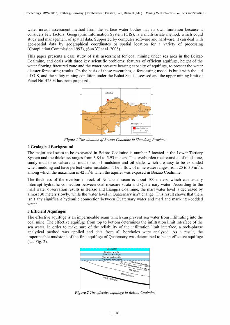
3 Efficient Aquifuges
The effective aquifuge is an impermeable seam which can prevent sea water from infiltrating into the coal mine. The effective aquifuge from top to bottom determines the infiltration limit interface of the sea water. In order to make sure of the reliability of the infiltration limit interface, a rock-phrase analytical method was applied and data from all boreholes were analyzed. As a result, the impermeable mudstone of the first aquifuge of Quaternary was determined to be an effective aquifuge (see Fig. 2).
Figure 2 The effective aquifuge in Beizao Coalmine
Proceedings IMWA 2016, Freiberg/Germany | Drebenstedt, Carsten, Paul, Michael (eds.) | Mining Meets Water – Conflicts and Solutions
1118
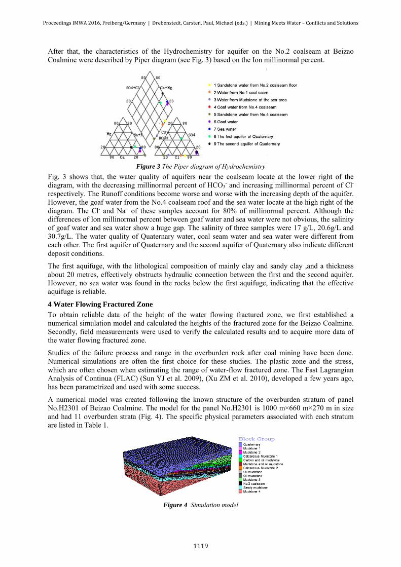
After that, the characteristics of the Hydrochemistry for aquifer on the No.2 coalseam at Beizao Coalmine were described by Piper diagram (see Fig. 3) based on the Ion millinormal percent.
Figure 3 The Piper diagram of Hydrochemistry
Fig. 3 shows that, the water quality of aquifers near the coalseam locate at the lower right of the diagram, with the decreasing millinormal percent of HCO3
- and increasing millinormal percent of Cl- respectively. The Runoff conditions become worse and worse with the increasing depth of the aquifer. However, the goaf water from the No.4 coalseam roof and the sea water locate at the high right of the diagram. The Cl- and Na+ of these samples account for 80% of millinormal percent. Although the differences of Ion millinormal percent between goaf water and sea water were not obvious, the salinity of goaf water and sea water show a huge gap. The salinity of three samples were 17 g/L, 20.6g/L and 30.7g/L. The water quality of Quaternary water, coal seam water and sea water were different from each other. The first aquifer of Quaternary and the second aquifer of Quaternary also indicate different deposit conditions.
The first aquifuge, with the lithological composition of mainly clay and sandy clay ,and a thickness about 20 metres, effectively obstructs hydraulic connection between the first and the second aquifer. However, no sea water was found in the rocks below the first aquifuge, indicating that the effective aquifuge is reliable.
4 Water Flowing Fractured Zone
To obtain reliable data of the height of the water flowing fractured zone, we first established a numerical simulation model and calculated the heights of the fractured zone for the Beizao Coalmine. Secondly, field measurements were used to verify the calculated results and to acquire more data of the water flowing fractured zone.
Studies of the failure process and range in the overburden rock after coal mining have been done. Numerical simulations are often the first choice for these studies. The plastic zone and the stress, which are often chosen when estimating the range of water-flow fractured zone. The Fast Lagrangian Analysis of Continua (FLAC) (Sun YJ et al. 2009), (Xu ZM et al. 2010), developed a few years ago, has been parametrized and used with some success.
A numerical model was created following the known structure of the overburden stratum of panel No.H2301 of Beizao Coalmine. The model for the panel No.H2301 is 1000 m×660 m×270 m in size and had 11 overburden strata (Fig. 4). The specific physical parameters associated with each stratum are listed in Table 1.
Figure 4 Simulation model
Proceedings IMWA 2016, Freiberg/Germany | Drebenstedt, Carsten, Paul, Michael (eds.) | Mining Meets Water – Conflicts and Solutions
1119
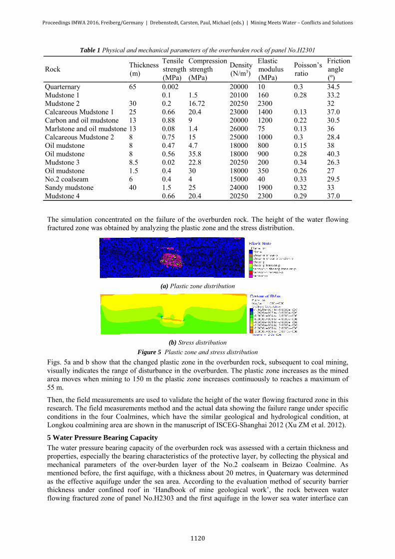
Table 1 Physical and mechanical parameters of the overburden rock of panel No.H2301
Rock Thickness
(m)
Tensile
strength
(MPa)
Compression
strength
(MPa)
Density
(N/m3)
Elastic
modulus
(MPa)
Poisson’s
ratio
Friction
angle
(º)
Quarternary 65 0.002 20000 10 0.3 34.5
Mudstone 1 0.1 1.5 20100 160 0.28 33.2
Mudstone 2 30 0.2 16.72 20250 2300 32
Calcareous Mudstone 1 25 0.66 20.4 23000 1400 0.13 37.0
Carbon and oil mudstone 13 0.88 9 20000 1200 0.22 30.5
Marlstone and oil mudstone 13 0.08 1.4 26000 75 0.13 36
Calcareous Mudstone 2 8 0.75 15 25000 1000 0.3 28.4
Oil mudstone 8 0.47 4.7 18000 800 0.15 38
Oil mudstone 8 0.56 35.8 18000 900 0.28 40.3
Mudstone 3 8.5 0.02 22.8 20250 200 0.34 26.3
Oil mudstone 1.5 0.4 30 18000 350 0.26 27
No.2 coalseam 6 0.4 4 15000 40 0.33 29.5
Sandy mudstone 40 1.5 25 24000 1900 0.32 33
Mudstone 4 0.66 20.4 20250 2300 0.29 37.0
The simulation concentrated on the failure of the overburden rock. The height of the water flowing fractured zone was obtained by analyzing the plastic zone and the stress distribution.
(a) Plastic zone distribution
(b) Stress distribution
Figure 5 Plastic zone and stress distribution
Figs. 5a and b show that the changed plastic zone in the overburden rock, subsequent to coal mining, visually indicates the range of disturbance in the overburden. The plastic zone increases as the mined area moves when mining to 150 m the plastic zone increases continuously to reaches a maximum of 55 m.
Then, the field measurements are used to validate the height of the water flowing fractured zone in this research. The field measurements method and the actual data showing the failure range under specific conditions in the four Coalmines, which have the similar geological and hydrological condition, at Longkou coalmining area are shown in the manuscript of ISCEG-Shanghai 2012 (Xu ZM et al. 2012).
5 Water Pressure Bearing Capacity
The water pressure bearing capacity of the overburden rock was assessed with a certain thickness and properties, especially the bearing characteristics of the protective layer, by collecting the physical and mechanical parameters of the over-burden layer of the No.2 coalseam in Beizao Coalmine. As mentioned before, the first aquifuge, with a thickness about 20 metres, in Quaternary was determined as the effective aquifuge under the sea area. According to the evaluation method of security barrier thickness under confined roof in ‘Handbook of mine geological work’, the rock between water flowing fractured zone of panel No.H2303 and the first aquifuge in the lower sea water interface can
Proceedings IMWA 2016, Freiberg/Germany | Drebenstedt, Carsten, Paul, Michael (eds.) | Mining Meets Water – Conflicts and Solutions
1120
look as water barrier, with a thickness about 39metres. Then compared with the required minimum thickness of the security barrier under seawater head pressure to decide whether the practical effective thickness meets the requirements for bearing seawater head. Evaluation formula is as follows:
)8(4
22 rLKPLrK
ALH (1)
where H is the safety thickness of the aquifuge (m), P is water pressure (MPa), L is the width of the panel (m), K is the tensile strength of rock (MPa), r is the density of rock (kg/m3) and A is the safety coefficient (ranges from 1.2 to 1.5).
The parameters of the panel No.H2303 are substituted into Eq.1, the required minimum thickness of the security barrier under the current sea water head pressure is 7.6 metres, which is much smaller than the thickness of the effective water barrier (39 metres).
According to the evaluation of water pressure bearing capacity of aquifuge, the leaving water barrier in panel No.H2303 is safety and can ensure safe mining.
6 Assessment for the Upper Mining Limit
The concept of the model for water inrush while mining under surface water is that water conducted fissures or cracks destroy the aquifuge and water percolates into coal mines through these fissures or rock cracks. On the other hand, mining under surface water will be safe if there is an effective aquifuge with a sufficient thickness between the lower limit interface of surface water infiltration and the upper limit interface of rock cracks resulting from mining.
Therefore, the upper mining limit assessment model from the basis of these researches (Xu ZM et al. 2012) and the National Regulations can be built by applying GIS as follows:
)1(26.583 3.0 mQsx emHH (2)
where Hsx is the level of the upper mining limit (m), HQ is the level of the Quaternary bottom (m), m is the mining thickness (m).
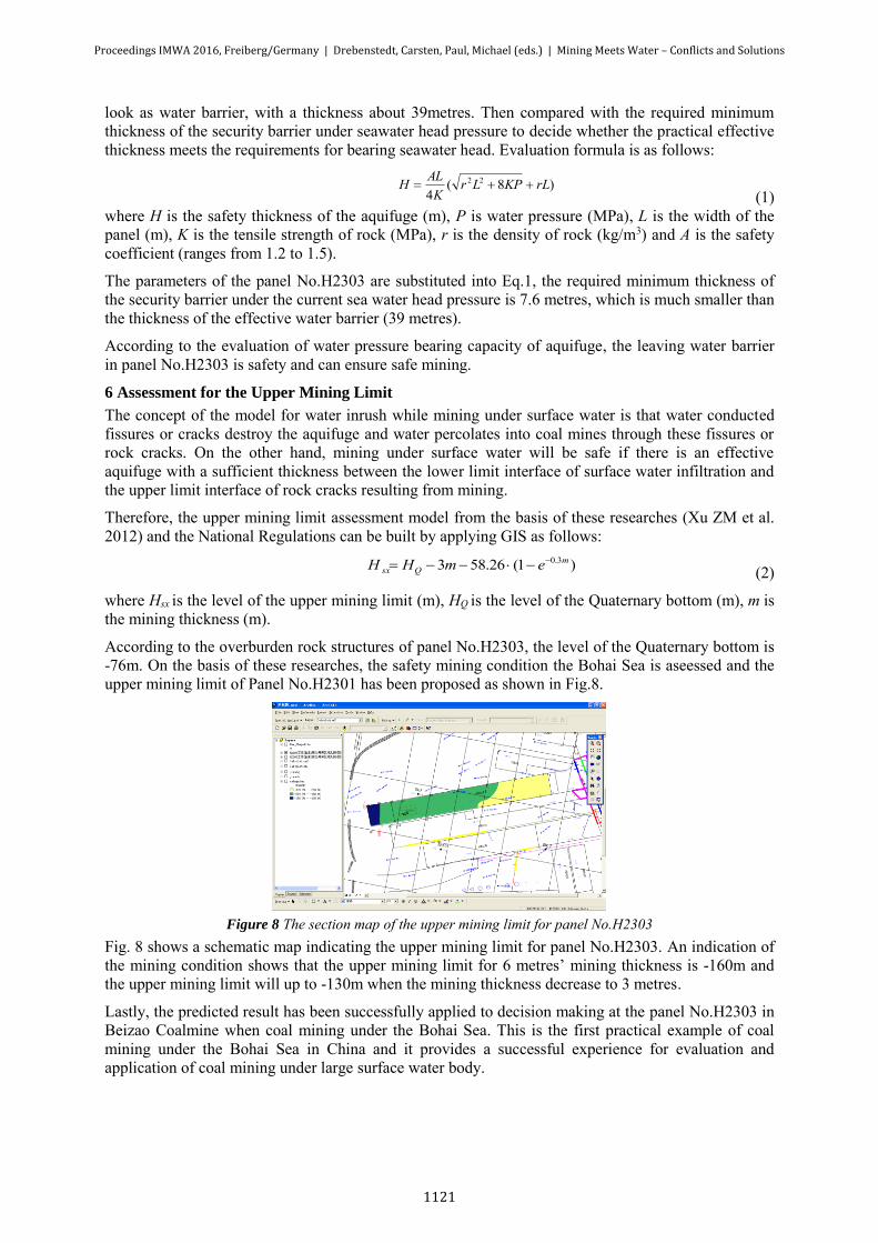
According to the overburden rock structures of panel No.H2303, the level of the Quaternary bottom is -76m. On the basis of these researches, the safety mining condition the Bohai Sea is aseessed and the upper mining limit of Panel No.H2301 has been proposed as shown in Fig.8.
Figure 8 The section map of the upper mining limit for panel No.H2303
Fig. 8 shows a schematic map indicating the upper mining limit for panel No.H2303. An indication of the mining condition shows that the upper mining limit for 6 metres’ mining thickness is -160m and the upper mining limit will up to -130m when the mining thickness decrease to 3 metres.
Lastly, the predicted result has been successfully applied to decision making at the panel No.H2303 in Beizao Coalmine when coal mining under the Bohai Sea. This is the first practical example of coal mining under the Bohai Sea in China and it provides a successful experience for evaluation and application of coal mining under large surface water body.
Proceedings IMWA 2016, Freiberg/Germany | Drebenstedt, Carsten, Paul, Michael (eds.) | Mining Meets Water – Conflicts and Solutions
1121
7 Conclusions
1) The effective aquifuge of sea water infiltration is the first aquifuge, an impermeable layer of mudstone of Quaternary, which effectively obstructs hydraulic connection between the Bohai Sea water and the overburden rock of the No.2 coalseam. Its reliability is verified by hydrochemistry analyzing.
2) The results of our field measurements and numerical simulation show that the range of the overburden rock failure zone shows an exponential relation with the coal thickness to be excavated. A new formula has been derived and used to calculate the maximum height for the water flowing fractured zone.
3) On the basis of these researches, a forecasting model is built with the aid of GIS, and the safety mining condition under the Bohai Sea is aseessed and the upper mining limit of Panel No.H2303 has been proposed.
Acknowledgements
The authors would like to acknowledge the financial support from the National basic research program of China (No. 2013CB227901) and the National Natural Science Foundation of China (No. 41502282); considerable thanks are due to the Beizao Coal Mine for its co-operation.
References
Compilation Commission. Mine water prevention experiences compilation of China. Beijing: China Coal Industry Publishing House,1997. (In Chinese)
Liu CY, Liu YJ; Yang Z (2010) Caving thickness effects on stability of coal-rock pillar against water on steep coal seam mining under water. ICMHPC - 2010 International Conference on Mine Hazards Prevention and Control:356-363.
Wu X, Wang, XG; Jiang XW (2009) A study on coal mining under large reservoir areas. Environmental Geology 57(3):675-683.
Peng K, Li X B, Peng SQ (2011) Optimization of frame stope structure parameters based on response surface method in under-sea mining. Journal of Central South University (Science and Technology) 42(8): 2417-2422. (In Chinese)
Sun YJ, Xu ZM, Dong QH.(2008) Forecasting water disaster for a coal mine under the Xiaolangdi reservoir. Journal of China University of Mining & Technology, 18(4): 516-520.
Sun YJ, Xu ZM, Dong QH (2009) Mornitoring and simulation research on development of water flowing fracture for coal mining under the Xiaolangdi reservoir. Chinese Journal of Rock Mechanics and Engineering 28(2): 238-245. (In Chinese)
Xu ZM, Sun YJ, Dong QH (2010) Predicting the height of water-flow fractured zone during coal mining under the Xiaolangdi reservoir [J]. Mining Science and Technology 20(3) 434–043.
Sun HX (1999) The prospect for the coal mining under sea area in China. China Coal 25(8):34-36. (In Chinese)
John W, Donald T, Kelvin K (1982) Some technical considerations when mining under bodies of water. West Virginia Univ,:241-248.
Holla.Laxminarayan.(1987) Design Of Mine Working Under Surface Waters In New South Wales. Bulletin and Proceedings-Australasian Institute of Mining and Metallurgy 3:45-50.
Niskovskiy Y, Vasianovich A (1996) Investigation of possibility to apply untraditional and ecologicaly good methods of coal mining under sea bed. In: Proceedings of the International Offshore and Polar Engineering Conference, Los Angeles: ISOPE : 51–53.
D.Robert Gill (2000) Hydrogelogic Analysis Of Streamflow In Relation to Underground Mining in Northern West Virginia. Morgantown, West Virginia
Singh R N, Jakeman M (2001) Strata monitoring investigations around longwall panels beneath the cataract reservoir. Mine Water and the Environment 20(2): 33–41.
Proceedings IMWA 2016, Freiberg/Germany | Drebenstedt, Carsten, Paul, Michael (eds.) | Mining Meets Water – Conflicts and Solutions
1122
Gandhe A, Venkateswarlu V, Gupta R N (2005) Extraction of coal under a surface water body- a strata control investigation. Rock Mechanics and Rock Engineering 38(5): 399–410.
Winter T C, Buso D C, Shattuck P C (2008) The effect of terrace geology on ground-water movement and on the interaction of ground water and surface water on a mountainside near Mirror Lake, New Hampshire, USA. Hydrological Processes 22(1): 21–32.
Liu TQ (1995) Influence of mining activities on mine rock mass and control engineering. Journal of China Coal Society (2): 1-5. (In Chinese)
Xu ZM, Sui WH (2012) Statistical prediction of overburden failure due to coal mining under sea area. ISCEG-Shanghai.
Proceedings IMWA 2016, Freiberg/Germany | Drebenstedt, Carsten, Paul, Michael (eds.) | Mining Meets Water – Conflicts and Solutions
1123


![WORKSHOP ON DISASTER RESILIENT CITIES: ADVANCES IN ... · WORKSHOP ON DISASTER RESILIENT CITIES: ADVANCES IN METEOROLOGICAL FORECASTING AND HAZARDS ASSESSMENT [Draft 3 July 2018]](https://img.pdfslide.net/doc/110x75/5f0910827e708231d4250f99/workshop-on-disaster-resilient-cities-advances-in-workshop-on-disaster-resilient.jpg)