Embed Size (px)
Citation preview

FORECASTING WINTER PRECIPITATION TYPE
A Review Prepared by Gary K. Schmocker
Winter WX Workshop – November 2008
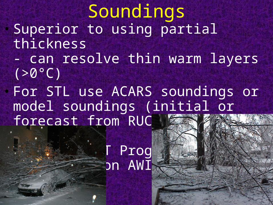
Soundings• Superior to using partial thickness
- can resolve thin warm layers (>0°C)• For STL use ACARS soundings or model
soundings (initial or forecast from RUC, NAM, LAPS, GFS, etc.)- use BUFKIT Program or display Bufr files on AWIPS
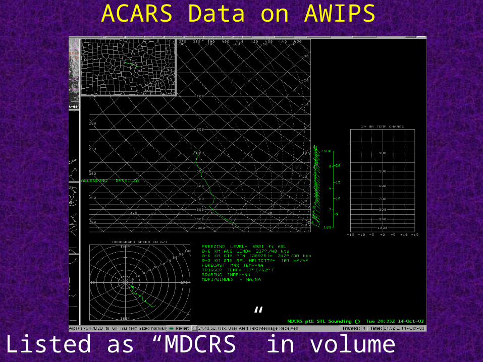
ACARS Data on AWIPS
Listed as “MDCRS” in volume browser
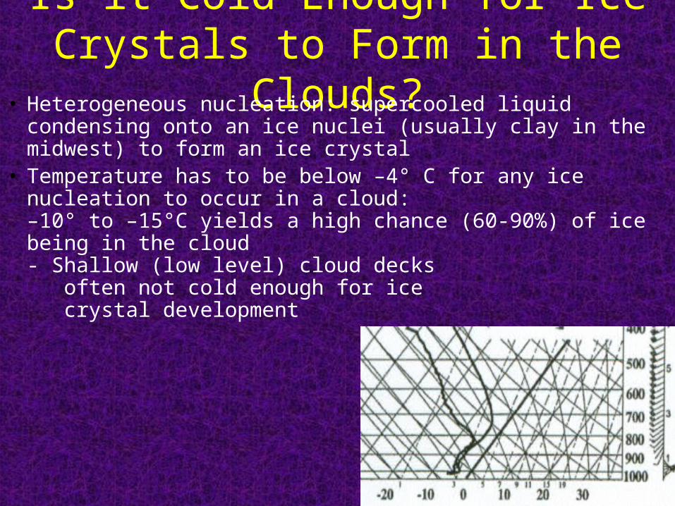
Is it Cold Enough for Ice Crystals to Form in the Clouds?
• Heterogeneous nucleation: supercooled liquid condensing onto an ice nuclei (usually clay in the midwest) to form an ice crystal
• Temperature has to be below –4° C for any ice nucleation to occur in a cloud:–10° to –15°C yields a high chance (60-90%) of ice being in the cloud - Shallow (low level) cloud decks often not cold enough for ice crystal development
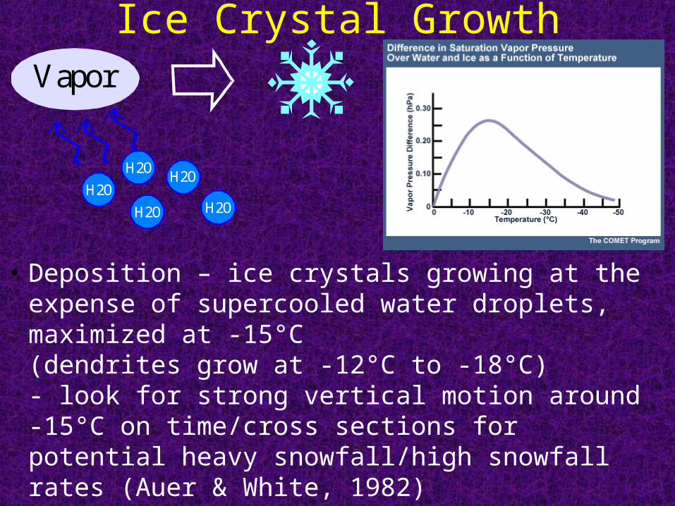
Ice Crystal Growth
• Deposition – ice crystals growing at the expense of supercooled water droplets, maximized at -15°C(dendrites grow at -12°C to -18°C)- look for strong vertical motion around -15°C on time/cross sections for potential heavy snowfall/high snowfall rates (Auer & White, 1982)
H2O
Vapor
H2OH2O
H2OH2O
H2O

Ice Crystal Growth (Continued) • Accretion or Riming – ice particles overtaking or capturing
supercooled liquid water droplets (lower portion of cloud, maximized in saturated layer with temperatures between 0°C and -10°C)- excessive riming produces graupel or snow pellets
• Rime splintering – Ice particle splintering during the freezing process produces more ice nuclei (maximizedat -5°C)
• Aggregation – ice particles colliding and coalescing to form snowflakes. Largest snowflakes occur with a deep moist isothermal layer near 0°C (below 700 mb).
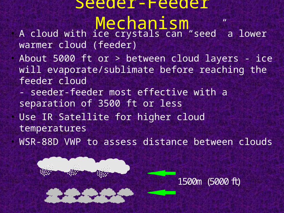
Seeder-Feeder Mechanism• A cloud with ice crystals can “seed” a lower warmer
cloud (feeder)• About 5000 ft or > between cloud layers - ice will
evaporate/sublimate before reaching the feeder cloud- seeder-feeder most effective with a separation of 3500 ft or less
• Use IR Satellite for higher cloud temperatures• WSR-88D VWP to assess distance between clouds
1500m (5000 ft)
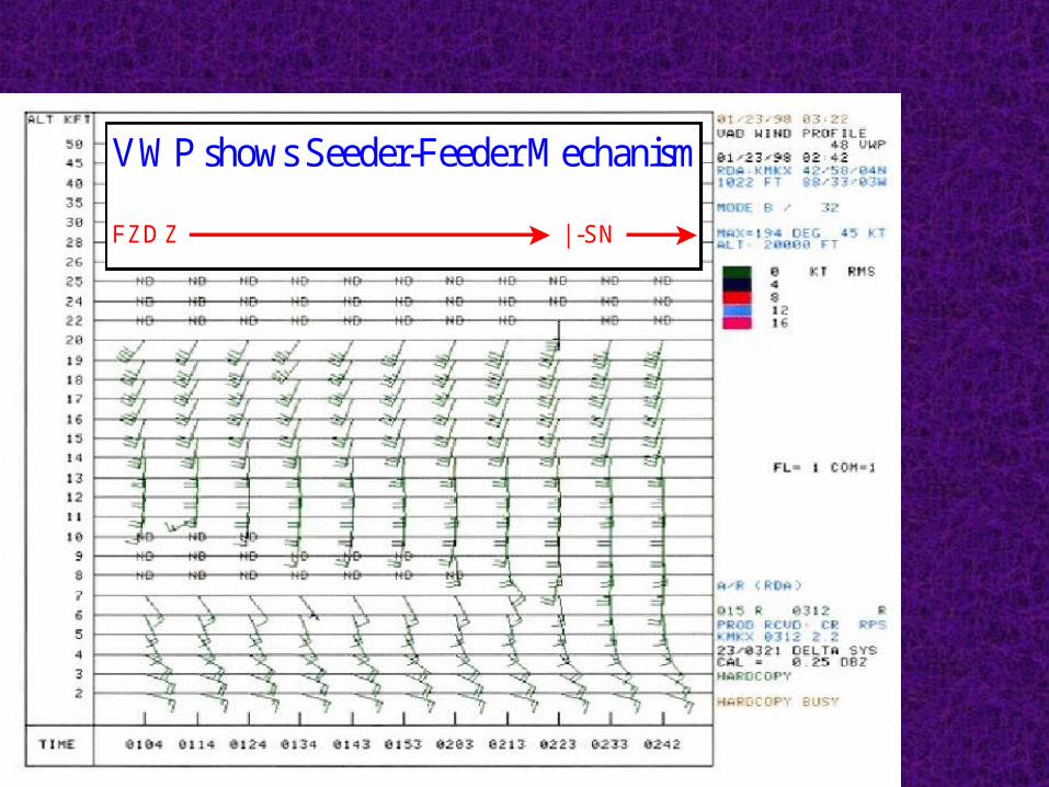
VWP shows Seeder-Feeder Mechanism
FZDZ | -SN
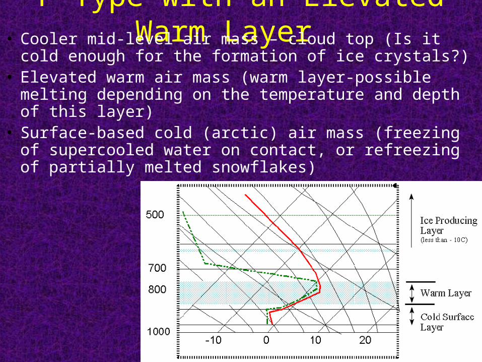
P-Type with an Elevated Warm Layer • Cooler mid-level air mass – cloud top (Is it cold enough for
the formation of ice crystals?)• Elevated warm air mass (warm layer-possible melting
depending on the temperature and depth of this layer)• Surface-based cold (arctic) air mass (freezing of
supercooled water on contact, or refreezing of partially melted snowflakes)
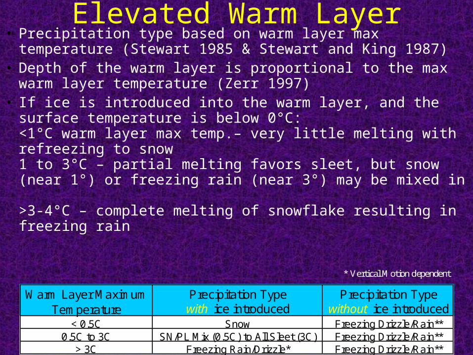
Elevated Warm Layer• Precipitation type based on warm layer max temperature (Stewart
1985 & Stewart and King 1987)• Depth of the warm layer is proportional to the max warm layer
temperature (Zerr 1997)• If ice is introduced into the warm layer, and the surface
temperature is below 0°C:<1°C warm layer max temp.– very little melting with refreezing to snow1 to 3°C – partial melting favors sleet, but snow (near 1°) or freezing rain (near 3°) may be mixed in >3-4°C – complete melting of snowflake resulting in freezing rain
Warm Layer Maximum Precipitation Type Precipitation TypeTemperature with ice introduced without ice introduced
< 0.5C Snow Freezing Drizzle/Rain**0.5C to 3C SN/PL Mix (0.5C) to All Sleet (3C) Freezing Drizzle/Rain**
> 3C Freezing Rain/Drizzle* Freezing Drizzle/Rain**
* Vertical Motion dependent
January 25th 2004 Winter Storm
• Most significant winter weather event of 2003/2004 Fall/Winter Season for LSX CWA
• FZRA began in STL at 12Z, changed to FZRAPL at 14Z, then to all PL by 16Z, and to SN around 1830Z.
• Synoptic Setup:- nearly E to W quasi stationary front well south of STL- STL on backside (SW) of Arctic ridge- low level WAA ahead of approaching SW flow shortwave trough- upper level divergence over area in right entrance region of ULJ streak
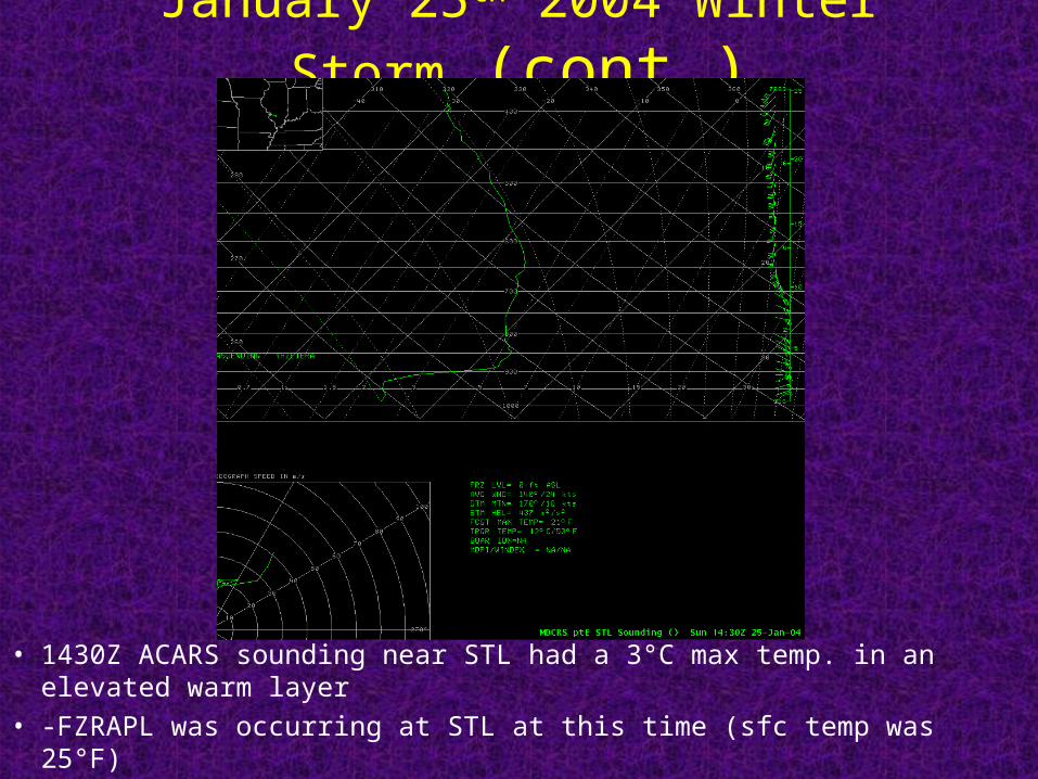
January 25th 2004 Winter Storm (cont.)
• 1430Z ACARS sounding near STL had a 3°C max temp. in an elevated warm layer
• -FZRAPL was occurring at STL at this time (sfc temp was 25°F)
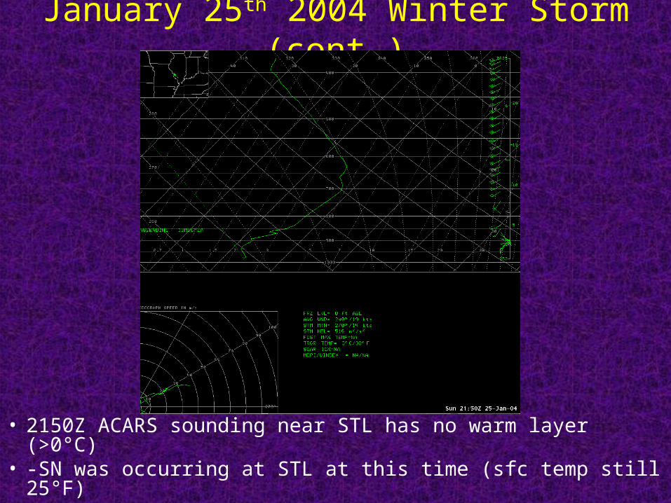
January 25th 2004 Winter Storm (cont.)
• 2150Z ACARS sounding near STL has no warm layer (>0°C)
• -SN was occurring at STL at this time (sfc temp still 25°F)
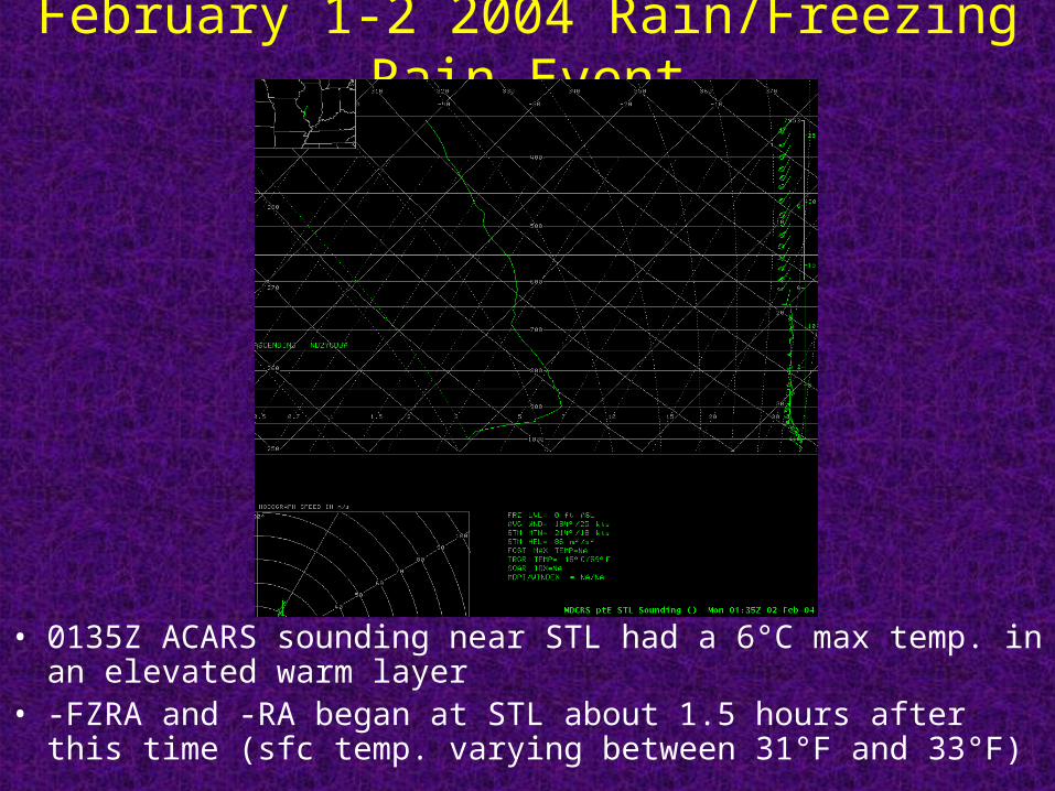
February 1-2 2004 Rain/Freezing Rain Event
• 0135Z ACARS sounding near STL had a 6°C max temp. in an elevated warm layer
• -FZRA and -RA began at STL about 1.5 hours after this time (sfc temp. varying between 31°F and 33°F)

Surface based Cold Layer • If there is complete melting of snowflakes in elevated
warm layer then freezing rain is expected with a sfc/ground temperature <=0°C with two possible exceptions:1.) if cold sfc layer is >= 2500 ft (750 m) deep & minimum temp. is <= - 6°C supercooled raindrops could refreeze to form ice pellets2.) if minimum temperaturein cold sfc layer < = -10°Cthen snow is possible asnew ice crystals can form& grow
Freezing rain• Freezing rain can occur with ground temp. >0°C
but air temp.<0°C, with freezing on elevated cold sfc (trees, power lines, cars)
• If ground is frozen but air temp. is slightly above 0°C then freezing rain can occur (ice accumulation on ground), at least temporarily- check soil and road sensor temps.
• Ice storm (>.25”of ice) usually requires:- surface temp. of 30°F or less - influx of colder (low level CAA) or drier air (evaporative cooling), or extremely cold and/or dry initial low-level air and cold soil temperatures to offset latent heat of freezing
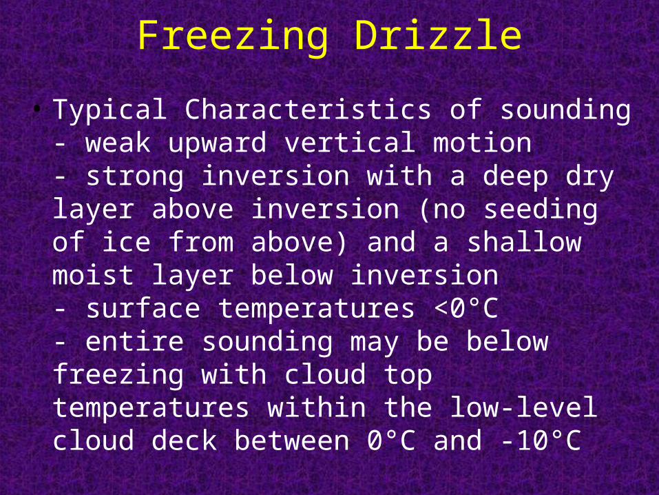
Freezing Drizzle
• Typical Characteristics of sounding- weak upward vertical motion- strong inversion with a deep dry layer above inversion (no seeding of ice from above) and a shallow moist layer below inversion- surface temperatures <0°C- entire sounding may be below freezing with cloud top temperatures within the low-level cloud deck between 0°C and -10°C
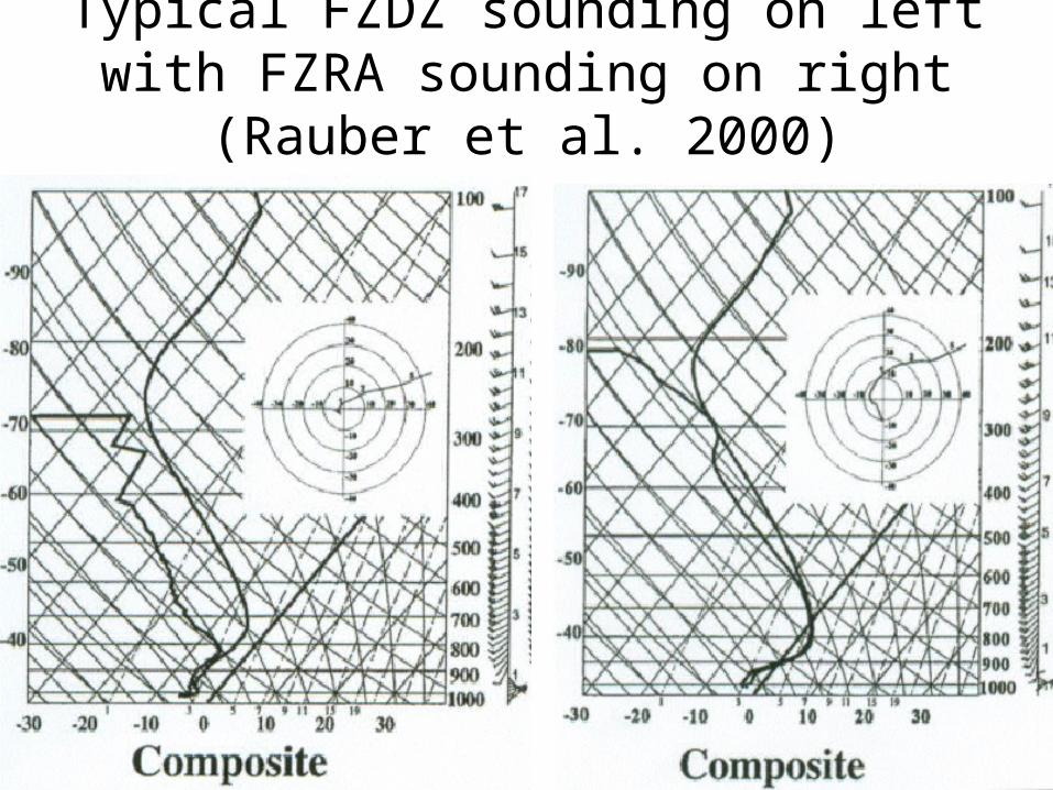
Typical FZDZ sounding on left with FZRA sounding on right (Rauber et al. 2000)
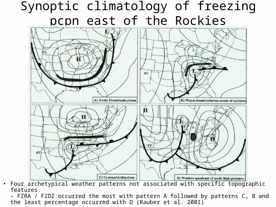
Synoptic climatology of freezing pcpn east of the Rockies
• Four archetypical weather patterns not associated with specific topographic features- FZRA / FZDZ occurred the most with pattern A followed by patterns C, B and the least percentage occurred with D (Rauber et al. 2001)
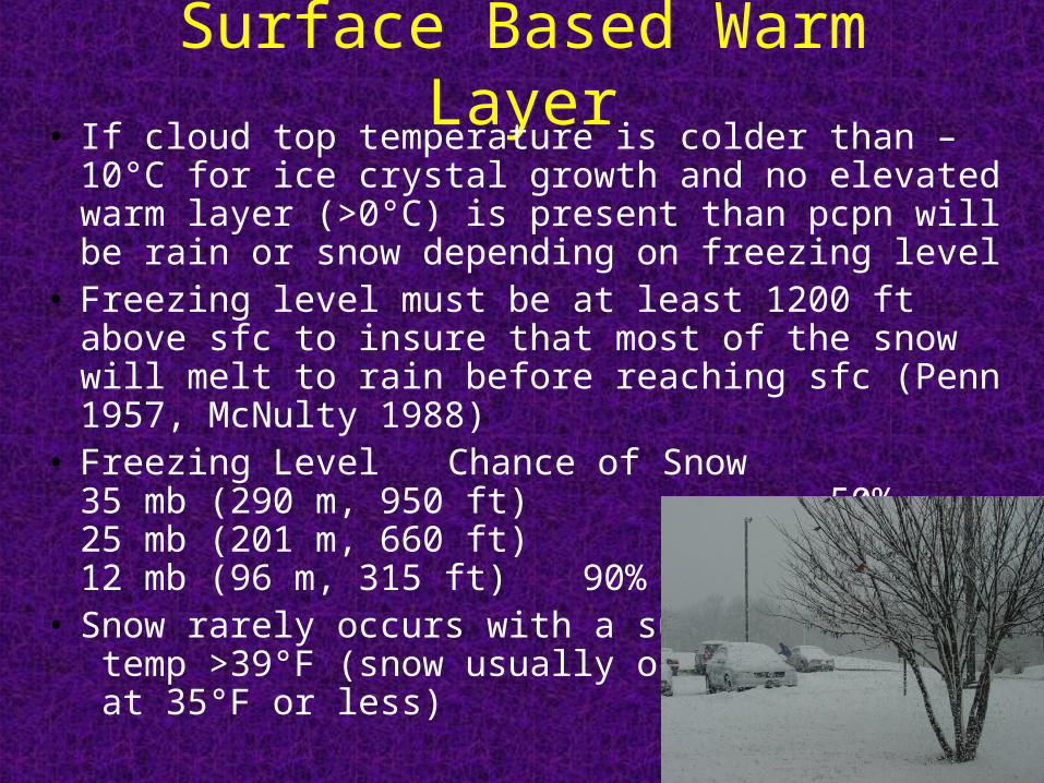
Surface Based Warm Layer• If cloud top temperature is colder than –10°C for ice
crystal growth and no elevated warm layer (>0°C) is present than pcpn will be rain or snow depending on freezing level
• Freezing level must be at least 1200 ft above sfc to insure that most of the snow will melt to rain before reaching sfc (Penn 1957, McNulty 1988)
• Freezing Level Chance of Snow35 mb (290 m, 950 ft) 50%25 mb (201 m, 660 ft) 70%12 mb (96 m, 315 ft) 90%
• Snow rarely occurs with a surface temp >39°F (snow usually occurs at 35°F or less)
Diabatic Processes that can Change the Temp. Profile
• Evaporative (Sublimate) Cooling- Use the wet-bulb temperature if precipitation is expected to fall through an unsaturated layer- May drop the temperature as much as 5-10°F/hruntil the air is saturated and the wet-bulb temperature is reached
• Melting- cooling occurs when snow falls through a warm layer (>0°C) and melts; most significant with heavy precipitation
• Solar Radiation – mainly affects the low-level temperatures (diurnal heating/nocturnal cooling)
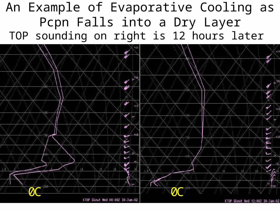
An Example of Evaporative Cooling as Pcpn Falls into a Dry Layer
TOP sounding on right is 12 hours later
0C 0C
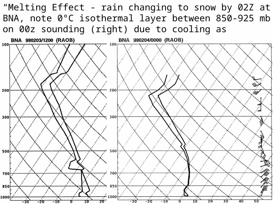
“Melting Effect”- rain changing to snow by 02Z at BNA, note 0°C isothermal layer between 850-925 mb on 00z sounding (right) due to cooling as snowflakes melted in sfc based warm layer
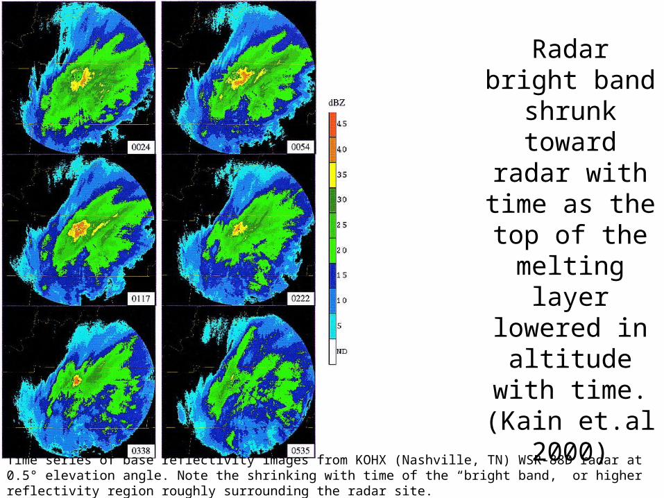
Radar bright band shrunk toward radar
with time as the top of the
melting layer lowered in
altitude with time. (Kain et.al
2000)
Time series of base reflectivity images from KOHX (Nashville, TN) WSR-88D radar at 0.5° elevation angle. Note the shrinking with time of the “bright band,” or higher reflectivity region roughly surrounding the radar site.
Consider the “Melting Effect” when:
• Low level temperature advection is weak- little to no WAA
• Steady rainfall of at least moderate intensity is expected for several hours- cooling due to melting will be strongest where precipitation rates are the highest- if model underestimates QPF (intensity/duration of pcpn) it will also underestimate the cooling due to melting
• Borderline rain/snow situation- surface temps not far from freezing/freezing level not too high

Other Mechanisms that can Change the Temperature Profile
• Pseudo-adiabatic cooling due to upward vertical motion• Thermal Advection
- strong WAA will create or advect in an elevated warm layer - WAA will not only warm the air but also is a forcing for upward vertical motion, pseudo-adiabatic lift will cool the layer, slowing the rate of warming - CAA combined with strong upward vertical motion due to forcings other than WAA (ie. PVA increasing with height, jet streak and/or frontogenetical circulations) & weakly stable or unstable conditions (CSI/elevated upright convection) can cause a rapid change over to snow
Pcpn Type and Intensity • Light (freezing) rain/drizzle can change to
sleet/snow whenever the intensity of the pcpn increases (stronger upward vertical motion) due to one or a combination of these effects of stronger upward vertical motion:- increased pseudo-adiabatic cooling- increased depth of cloud (colder cloud top)- larger snowflakes (take longer to melt)- increased cooling due to melting with heavier pcpn
• Watch out for elevated convection!- can change FZDZ to +SN

January 1-2, 1999 Case
• Major winter storm brought heavy snow to northeast MO, and a mix of snow, sleet and freezing rain to east central & southeast MO
• UIN : 12-13 inches, all snowSTL : 6-9 in., snow began at 17z Jan 1, changed to snow/sleet at 23z, freezing rain & sleet at 08z Jan 2, then back to snow at 11zCGI: snow began around 18z Jan 1, changed to freezing rain at 20z, than to rain at 06z Jan 2
• 45-60 kt LLJ brought strong temperature and moisture advection to MO ahead of a developing 850 mb low
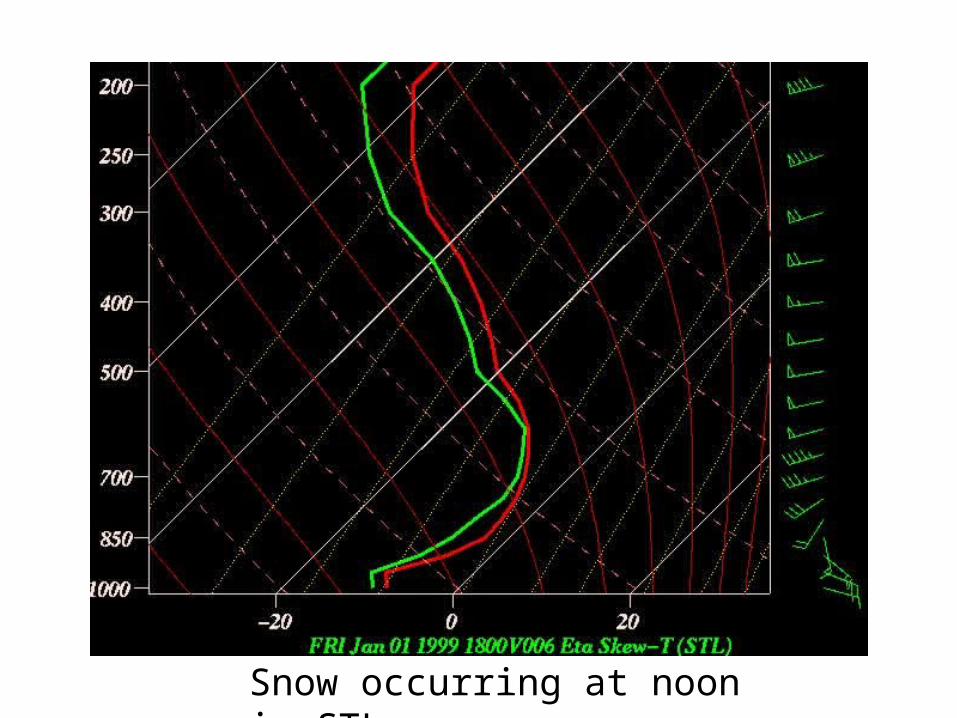
Snow occurring at noon in STL
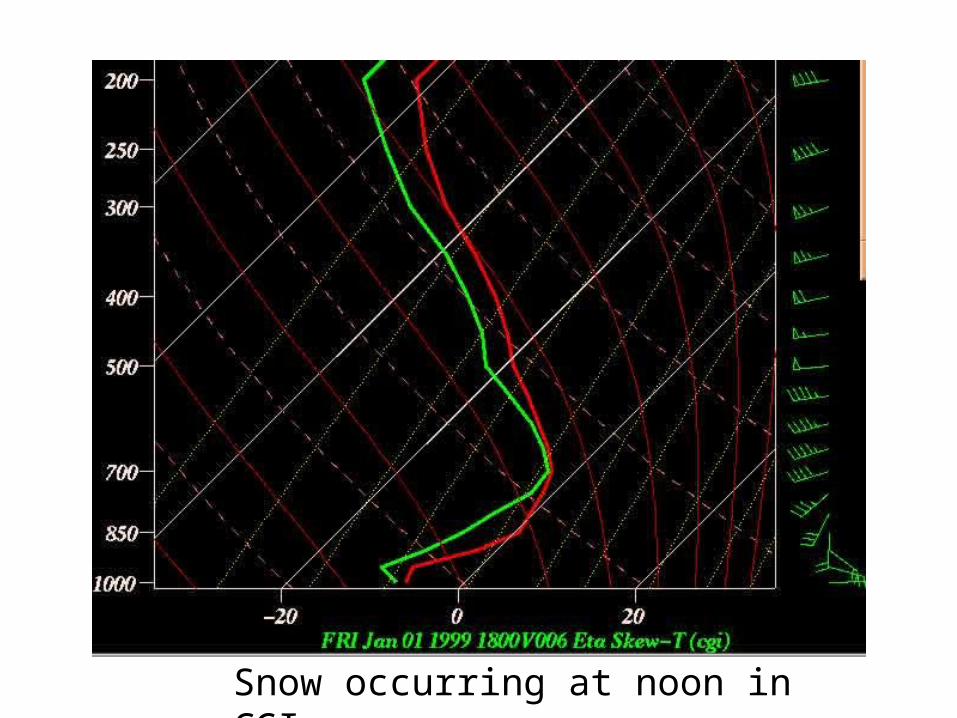
Snow occurring at noon in CGI

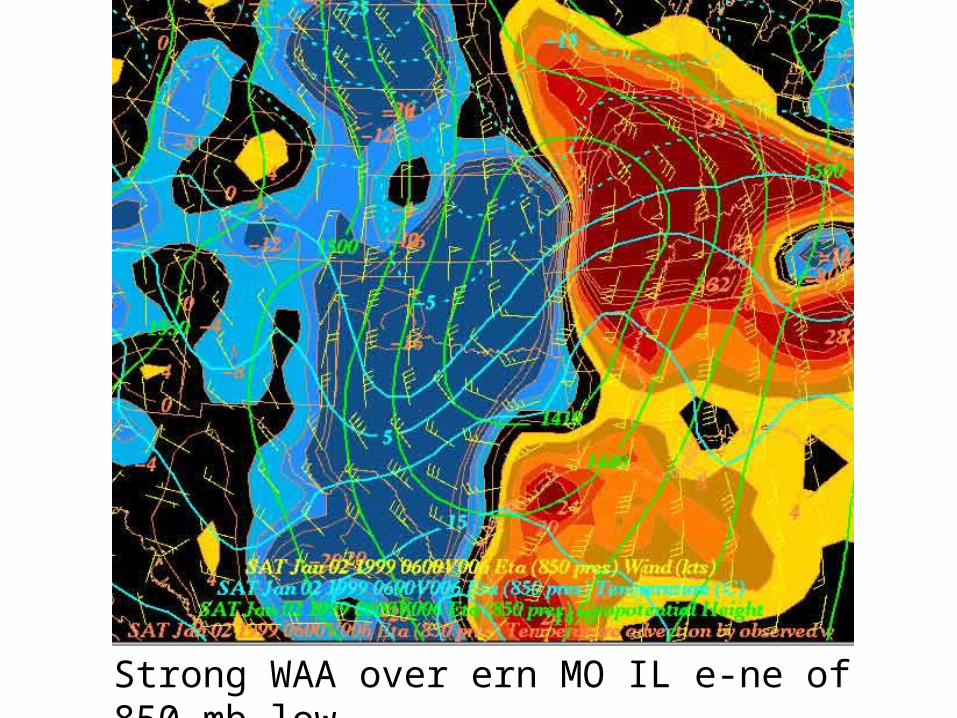
Strong WAA ahead of developing 850 mb low
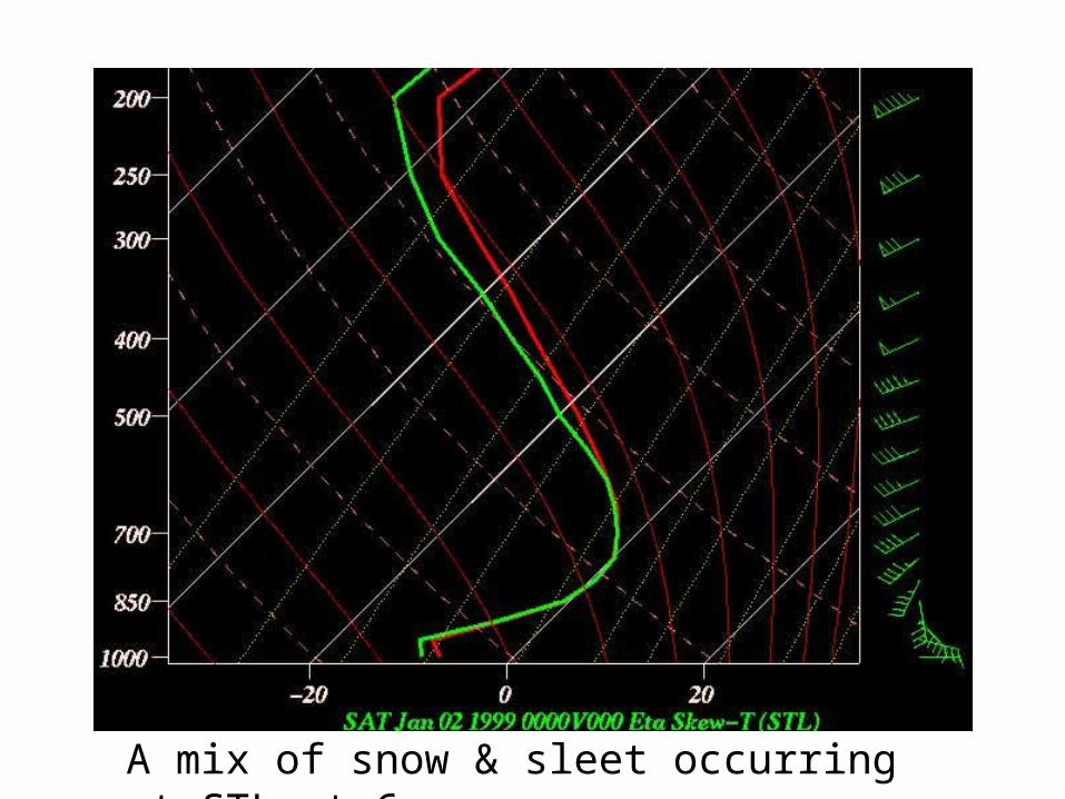
A mix of snow & sleet occurring at STL at 6 pm

Freezing rain occurring at CGI at 6 pm
Warm Layer MaximumTemperature
Strong WAA over ern MO IL e-ne of 850 mb low

A mix of snow & sleet occurring at STL at midnight
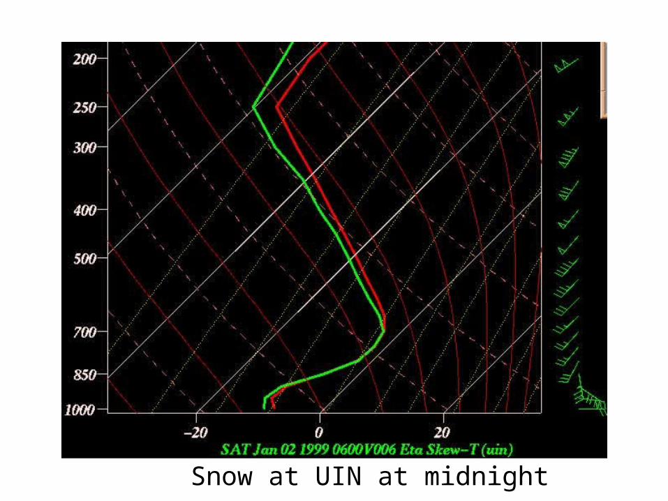
Snow at UIN at midnight
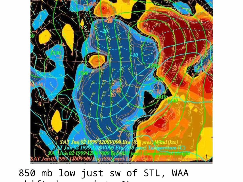
850 mb low just sw of STL, WAA shifted e-ne into IL
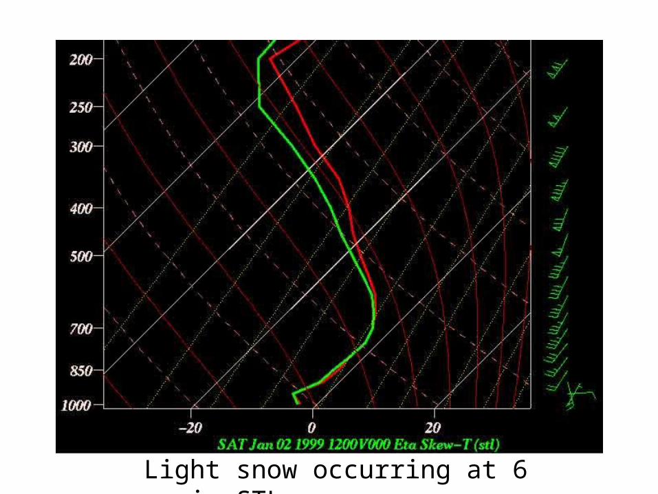
Light snow occurring at 6 am in STL
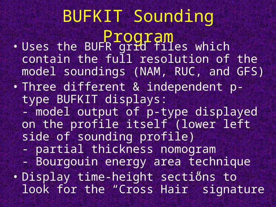
BUFKIT Sounding Program• Uses the BUFR grid files which contain the full
resolution of the model soundings (NAM, RUC, and GFS)
• Three different & independent p-type BUFKIT displays:- model output of p-type displayed on the profile itself (lower left side of sounding profile)- partial thickness nomogram- Bourgouin energy area technique
• Display time-height sections to look for the “Cross Hair” signature
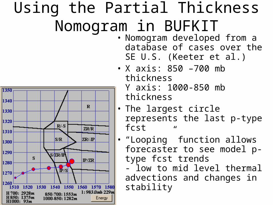
Using the Partial Thickness Nomogram in BUFKIT
• Nomogram developed from a database of cases over the SE U.S. (Keeter et al.)
• X axis: 850 –700 mb thicknessY axis: 1000-850 mb thickness
• The largest circle represents the last p-type fcst
• “Looping” function allows forecaster to see model p-type fcst trends- low to mid level thermal advections and changes in stability
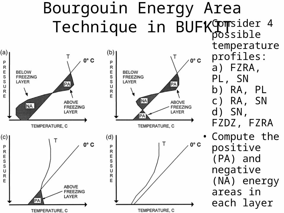
Bourgouin Energy Area Technique in BUFKIT • Consider 4
possible temperature profiles:a) FZRA, PL, SNb) RA, PLc) RA, SNd) SN, FZDZ, FZRA
• Compute the positive (PA) and negative (NA) energy areas in each layer
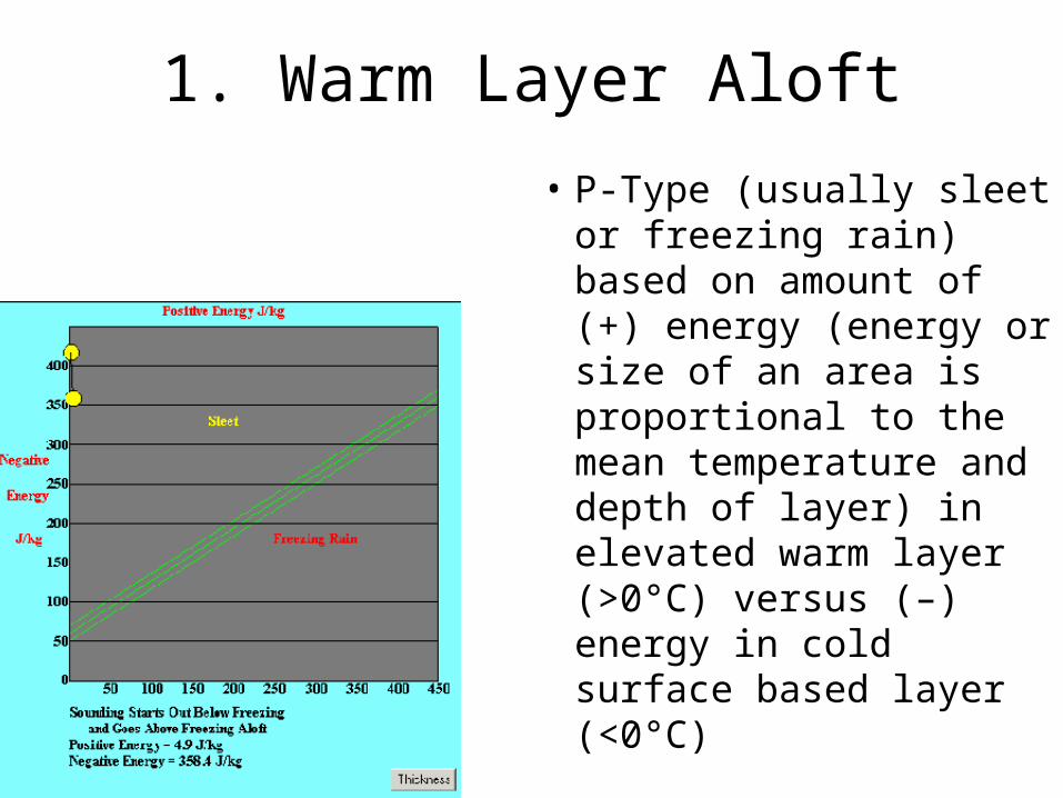
1. Warm Layer Aloft
• P-Type (usually sleet or freezing rain) based on amount of (+) energy (energy or size of an area is proportional to the mean temperature and depth of layer) in elevated warm layer (>0°C) versus (–) energy in cold surface based layer (<0°C)

2. SFC Based Warm Layer
• Uses both the height of the freezing level and the amount of (+) energy in the sfc based warm layer to determine p-type (either rain or snow)
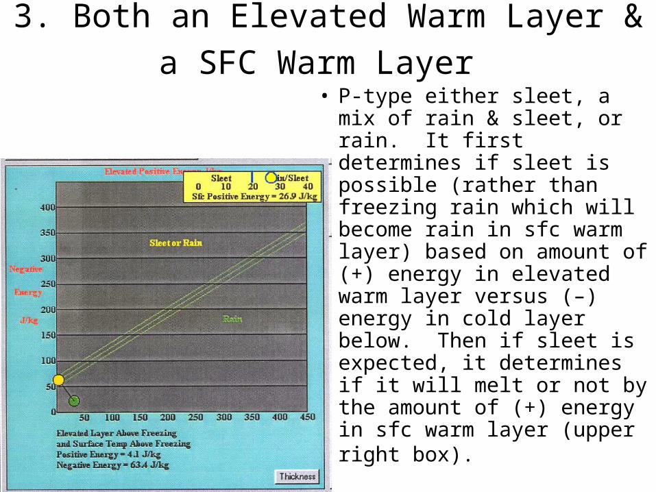
3. Both an Elevated Warm Layer & a SFC
Warm Layer • P-type either sleet, a mix of
rain & sleet, or rain. It first determines if sleet is possible (rather than freezing rain which will become rain in sfc warm layer) based on amount of (+) energy in elevated warm layer versus (–) energy in cold layer below. Then if sleet is expected, it determines if it will melt or not by the amount of (+) energy in sfc warm layer (upper right box).
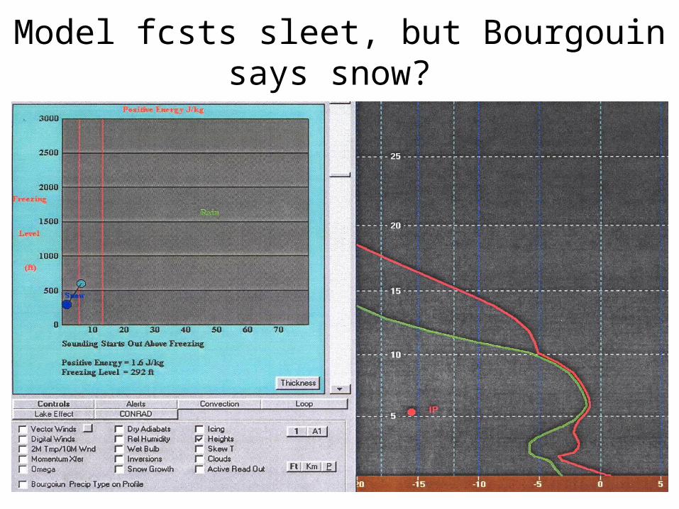
Model fcsts sleet, but Bourgouin says snow?
Concluding Remarks • First examine partial thickness • Look at current (RAOBS, ACARS, LAPS) and
forecast soundings (RUC, NAM, GFS on BUFKIT) nearest forecast location.
• Is cloud top temperature cold enough for ice crystal activation and growth (-10°C or less)?
• Is there an elevated or surface based warm layer present to melt the snowflakes?- determine maximum temperature of elevated warm layer or freezing height of sfc based warm layer
• What is the minimum temperature of a surface based cold layer (also sfc and ground temp.)?

Conclusion (cont.)• Use BUFKIT Program to help you determine p-type &
check for the “Cross Hair” Signature• Examine the current and forecast synoptic and mesoscale
environment to determine how the temperature profile may change with time:- expect evaporative (sublimate) cooling until saturated- cooling due to melting snowflakes in warm layer (could erode warm layer if pcpn heavy – elevated convection)- horizontal thermal advections (WAA, CAA)- pseudo-adiabatic cooling due to upward vertical motion (what are the magnitude and types of forcing mechanisms present)
• Look for temperature profile trends in model forecast soundings
References• Auer, A. H. Jr and J. M. White, 1982: The combined role of
kinematics, thermodynamics, and cloud physics associated with heavy snowfall episodes. J. Meteor. Soc. Japan, 60, pp 500-507.
• Baumgardt D., 2000: Wintertime cloud microphysics review. SOO NWS La Crosse, WI http://www.crh.noaa.gov/arx/micrope.html
• Baumgardt D., 2002: Precipitation type forecasting. WDTB Winter Weather Workshop
• Bourgouin, P., 2000: A method to determine precipitation types. Wea. Forecasting, 15, 583-592.
• Cantin A., D. Bachand: Synoptic pattern recognition and partial thickness techniques as a tool for precipitation types forecasting associated with a winter storm
References (cont.)• Czys, R. R., R. W. Scott, K. C. Tang, R. W.
Przybylinski, & M. E. Sabones, 1996: A physically based, nondimensional parameter for discriminating between locations of freezing rain and ice pellets. Wea. Forecasting, 11, 591-598.
• Funk, T., 2000: Determining winter precipitation type. SOO NWS Louisville, KY. http://www.crh.noaa.gov/lmk/soo/docu/precip_type.htm.
• Junker, W., 2000: Snow forecasting. HPC/NCEP. http://www.hpc.ncep.noaa.gov/research/snowfcst2/index.htm
• Kain, J. S., S. M. Goss, M. E. Baldwin, 2000: The melting effect as a factor in precipitation-type forecasting. Wea. Forecasting, 15, 700-714.

References (cont.)• Keeter K.: Introduction to forecasting predominate
precipitation type trends (TREND). www. meas.ncsu.edu/nws
• Lackmann G., 2002: Freezing and melting, precipitation type, and numerical weather prediction. COMET MCS/NWS Course
• Mahoney E., J. Waldstreicher, & T. Niziol, 2002: Using Bufkit to visualize precipitation amount and type. WDTB Winter Weather Workshop
• McNulty, R. P., 1988: Winter precipitation type. CR Technical Attachment 88-4. DOC/NOAA/NWS Central Region, Kansas City, MO, 9pp.
• Penn, S., 1957: The prediction of snow vs. rain. Forecasting Guide # 2, U.S. Weather Bureau,29pp
References (cont.)• Rauber R., L. Olthoff, M. Ramamurthy, & K. Kunkel, 2000:
The Relative importance of warm rain and melting processes in freezing precipitation events. Journal of Applied Met. Vol. 39, No. 7, pp.1185-1195.
• Rauber R., L. Olthoff, M. Ramamurthy, D. Miller, & K. Kunkel, 2001: A synoptic weather pattern and sounding-based climatology of freezing precipitation in the United States east of the Rocky Mountains. Journal of Applied Met. Vol. 40, No. 10, pp.1724-1747.
• Stewart, R.E., 1985: Precipitation types in winter storms. Pure Appl. Geophys., 123, 597-609.
• Stewart, R. E., 1992: Precipitation types in the transition region of winter storms. Bull. Amer. Meteor., 73, 287-295.

References (cont.)• Stewart, R. E., & P. King, 1987: Freezing precipitation in winter
storms. Mon. Wea. Rev., 115, 1270-1279.
• Waldstreicher J., 2002: The importance of snow microphysics for large snowfalls. WDTB Winter Weather workshop
• Wetzel, S.W., UW-Madison, An ingredients-based approach to forecasting winter season mid-latitude precipitation systems. http://speedy.meteor. wisc.edu /~swetzel/winter/ingredients.html.
• Zerr, R. J.: Freezing Rain: An observational and theoretical study. Journal of Applied Met., Dec 1997, pp.1647-1661.
• An introduction to winter precipitation nowcasting , NWSTC Kansas City, MO CD-ROM
• Winter Microphysics Topics @ http://meted.ucar.edu/norlat/snow/index.htm