Embed Size (px)
Citation preview
1 | P a g e
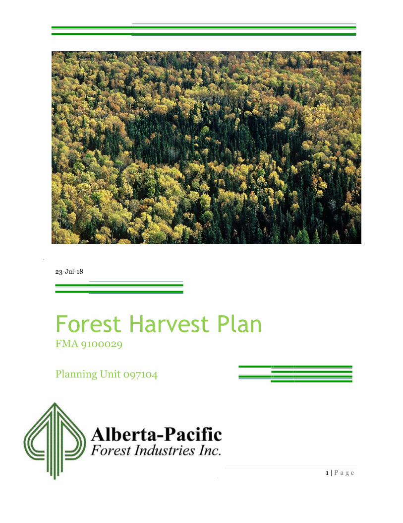
23-Jul-18
Forest Harvest Plan FMA 9100029
Planning Unit 097104

2 | P a g e
Forest Harvest Plan
Planning Unit 097104
Contents Introduction .............................................................................. 5
General Planning Unit Information /Design Considerations ..... 5
Operating Ground Rules ........................................................................................................................... 5
Maps .......................................................................................... 5
Block Information ..................................................................... 6
Field verification ........................................................................................................................................ 6
Understory Assessment ............................................................................................................................. 6
Structure Retention ................................................................................................................................... 8
Debris Management .................................................................................................................................. 8
Watercourse Protection............................................................. 9
Road Information ...................................................................... 9
Land Use Information………………………………………………………..11
Agreements ............................................................................................................................................... 11
Integration with Other Forest Users ......................................... 11
Integration with Other Harvest Operators .............................................................................................. 11
Registered Fur Management Areas (RFMAs) ......................................................................................... 11
Wildlife Management Unit(s) (WMU) ................................................................................................... 12
Indigenous Groups .................................................................................................................................. 12
Other Forest Users ................................................................................................................................... 13
Species and Areas of Concern ...................................................13
Sensitive Sites .......................................................................................................................................... 13
Forest Health ........................................................................................................................................... 13
OGR Deviations ....................................................................... 14

3 | P a g e
Understory Assessment ........................................................................................................................... 14
Road Deviations ....................................................................................................................................... 14
Forest Aesthetics ...................................................................................................................................... 14
Spatial Harvest Sequence Information / Variance Summary ............................................................... 15
Silviculture Information .......................................................................................................................... 16
List of Tables
Table 1: Block Summary ............................................................ 8
Table 2: Watercourse Crossing Summary .................................. 9 Table 3: Road Attributes .......................................................... 10 Table 4: Trapper Areas Table .................................................... 11 Table 5: Guide and Outfitters ................................................... 12 Table 6: Road Percent Deviations ............................................ 14

4 | P a g e
Appendices
Appendix 1 – FHP Overview Map
Appendix 2 – FHP Block Maps
5 | P a g e
Report
Introduction
Alberta – Pacific Forest Industries Inc. (Alberta – Pacific) submitted a Forest Harvest
Plan (FHP) for the harvest of deciduous and coniferous stands within planning unit
097104 in late May of 2018. This plan was approved in early June.
This amendment updates the original planning unit 097104 due to an increase in the
to the proposed mine site. Planning unit 097104 is located northeast of Fort McKay in
the Surface Mineable Area (SMA) within Forest Management Unit (FMU) A15.
Copies of this Forest Harvest Plan are available on the Alberta – Pacific website, at
www.alpac.ca
General Planning Unit Information /Design Considerations
This FHP has been validated by a Registered Forestry Professional of Alberta-Pacific
Forest Industries Inc.
This FHP includes maps and reports that clearly show and document the planned
harvest area boundaries, roads and water crossings within the Planning Unit.
This plan is being submitted for appraisal, for a 5-year FHP approval under the 2018
Alberta-Pacific Forest Industries Inc. (Alberta-Pacific) Annual Operating Plan (AOP).
Operating Ground Rules
Planning unit 097104 has been designed in accordance with the Northeast Alberta
Operating Ground Rules (OGRs), revised 2014 and the operating principles identified
in the 2017 Mineable Oil Sands Area (MOSA) plan. Alberta – Pacific is requesting
deviations from the OGRs due to the impending mine development. These requests,
along with corresponding information are listed under the applicable section and the
OGR Deviations section.
Maps
Individual block maps have been included in the submission package, outlining the
information pertinent to these blocks. A planning unit overview has been included in
the submission package. This map can be viewed in the Appendices of this document.

6 | P a g e
Block Information
A Block Summary Table has been included below outlining the expected volumes of
the harvest area.
Alberta – Pacific adheres to the 15/10 utilization standard for both deciduous stands, coniferous stands. Alberta- Pacific plans to complete cut-to-length operations for the coniferous volume within this planning unit to meet the needs of NFPL. These cut-to-length operations will adhere to the Alberta Log Scaling regulations and the Alberta Log Scaling Manual.
Field verification
The proposed blocks were ground verified by a field layout team in 2018. The layout
team provided planning support to assess timber quality, sensitive and historical sites,
operability of the harvest area, and classification of water courses within the Planning
unit boundary. Where applicable, the findings of the layout team have been noted in
the corresponding section of this report.
Understory Assessment
This area will be developed as a mine site within 5 years’ time, consequently no
understory assessments were conducted.
7 | P a g e
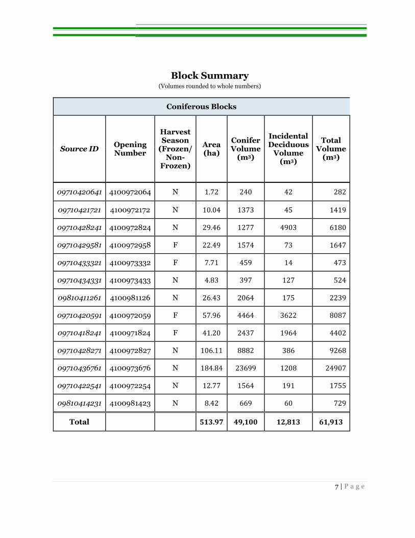
Block Summary (Volumes rounded to whole numbers)
Coniferous Blocks
Source ID Opening Number
Harvest Season
(Frozen/ Non-
Frozen)
Area (ha)
Conifer Volume
(m3)
Incidental Deciduous
Volume (m3)
Total Volume
(m3)
09710420641 4100972064 N 1.72 240 42 282
09710421721 4100972172 N 10.04 1373 45 1419
09710428241 4100972824 N 29.46 1277 4903 6180
09710429581 4100972958 F 22.49 1574 73 1647
09710433321 4100973332 F 7.71 459 14 473
09710434331 4100973433 N 4.83 397 127 524
09810411261 4100981126 N 26.43 2064 175 2239
09710420591 4100972059 F 57.96 4464 3622 8087
09710418241 4100971824 F 41.20 2437 1964 4402
09710428271 4100972827 N 106.11 8882 386 9268
09710436761 4100973676 N 184.84 23699 1208 24907
09710422541 4100972254 N 12.77 1564 191 1755
09810414231 4100981423 N 8.42 669 60 729
Total 513.97 49,100 12,813 61,913

8 | P a g e
Deciduous Blocks
Source ID Opening Number
Harvest Season
(Frozen/ Non-
Frozen)
Area (ha)
Deciduous Volume
(m3)
Incidental Conifer Volume
(m3)
Total Volume
(m3)
09710407231 4100970723 N 95 6,982 3,677 10,659
09710417631 4100971763 N 122 27,670 1,801 29,471
09710418331 4100971833 N 8 2,134 95 2,229
09710418841 4100971884 N 108 25,194 786 25,980
09710418871 4100971887 N 13 1,367 558 1,924
09710419451 4100971945 N 149 37,528 1,231 38,760
09710419711 4100971971 N 55 7,735 2,444 10,179
09710429631 4100972963 F 16 2,027 712 2,740
09810415731 4100981573 N 14 2,721 307 3,027
09810423341 4100982334 N 12 2,484 346 2,830
Total 592 115,842 11,958 127,800 Table 1: Block Summary This table provides a brief description of the proposed harvest blocks within the planning unit.
Structure Retention
No structure retention will be left due to the future mine development planned for this
area.
Debris Management
Planning unit 097104 is situated within Alberta’s Fire Control Zone number 40 as identified by Alberta Agriculture and Forestry (AAF).

9 | P a g e
Watercourse Protection
During the preliminary planning of planning unit 097104, potential watercourses were
identified using wet areas mapping, LiDAR data, aerial imagery, as well as the available
AVI data. The Fisheries and Wildlife Internet Mapping Tool (FWMIT) has confirmed
the presence of fish bearing watercourses in the area. Alberta Pacific Forest Industries
will conduct fish surveys of all watercourse crossings within the unit.
Where harvest blocks are in proximity to any potential watercourses, the field layout
team conducted field assessments utilizing the methodology and classification
standards outlined in Section 6.0 of the OGRs, Figure 1 and Table 1. In areas adjacent
to watercourses where no erosion hazard will exist after harvest no watercourse buffers
will be left.
Watercourse Crossing Summary Table
Road ID Road Crossing
Number Road Season Stream Class
RB09710407231 1291 N EPHEMERAL
RB09710420591 2047 N SMALL PERMANENT
RB09710420641 2063 N SMALL PERMANENT
Table 2: Watercourse Crossing Summary A list of inter-block road crossings over field verified watercourses within the planning unit.
Road Information
Overview maps have been attached showing roads in accordance with Section 3.4.6. of
the OGRs; all spatial data requirements have also been included with this submission.
Roads in areas that may have potential for erosion will be reclaimed, all other roads
will be left open to provide access for mine development activities.

10 | P a g e
Road Attributes Table
Source ID Opening Number
Block Area (ha)
Operations (Conifer/
Deciduous)
Harvest Season
(Frozen/ Non-
Frozen)
Road Percentage
09710420641 4100972064 1.72 C N 3.87
09710421721 4100972172 10.04 C N 9.45
09710428241 4100972824 29.46 C N 4.75
09710429581 4100972958 22.49 C F 2.03
09710433321 4100973332 7.71 C F 5.10
09710434331 4100973433 4.83 C N 7.44
09810411261 4100981126 26.43 C N 7.73
09710420591 4100972059 57.96 C F 4.34
09710419711 4100971971 55.41 D N 6.48
09710418241 4100971824 41.20 C F 4.16
09710419451 4100971945 149.32 D N 2.15
09710418331 4100971833 7.92 D N 0.00
09710418871 4100971887 13.34 D N 3.74
09710428271 4100972827 106.11 C N 4.64
09710436761 4100973676 184.84 C N 4.38
09710422541 4100972254 12.77 C N 7.29
09710418841 4100971884 107.98 D N 2.45
09710417631 4100971763 121.86 D N 3.14
09710407231 4100970723 94.65 D N 4.55
09710429631 4100972963 16.46 D F 4.87
09810415731 4100981573 13.52 D N 3.18
09810423341 4100982334 11.55 D N 5.54
09810414231 4100981423 8.42 C N 2.13
Table 3: Road Attributes: Summary of the proposed in-block roads of the planning unit. *No road percentage has been calculated for this block as road percentage has been attributed to block 09710418241.

11 | P a g e
Land Use Information
Agreements
A search of the Land Status Automated System (LSAS) and Digital Integrated
Dispositions (DIDs) yielded active dispositions within the FHP area. Any necessary
agreements with the disposition holder will be in place prior to the commencement of
harvest operations. None of the dispositions within the planning unit area will restrict
harvest operations in the FHP.
Integration with Other Forest Users
Integration with Other Harvest Operators
Alberta-Pacific is the only operator within this planning unit, Northland Forest
Products Ltd. has an active quota within FMU A15, this plan has been reviewed by
Northland Forest Products Ltd. and they have no concerns.
Registered Fur Management Areas (RFMAs)
This harvest plan is in the initial phase of mine development for this area. Due to the
development of the mine site and its effects within the planning unit, trapper
notifications have been completed by Suncor Energy for this plan, including the
notification of upcoming timber harvesting.
Trapper Areas Table Wild Life Management Unit 530
RFMA ID Notification Method Contact Method
2137 Suncor Energy Various
2331 Suncor Energy Various
Table 4: Trapper Areas Table RFMA holders affected by harvest operations.

12 | P a g e
Wildlife Management Unit(s) (WMU)
Planning unit 097104 falls within WMU 530. The Guides and Outfitters operating
within this unit have been sent notification, via registered mail, on the FHP design as
well as a timeline for the commencement of harvest operations.
Guide and Outfitters Table
WildLife Management Unit 530
OG ID Date Contact Method
1282 G May 16, 2018 Registered Mail
295 G May 16, 2018 Registered Mail
1212 G May 16, 2018 Registered Mail
1247 G May 16, 2018 Registered Mail
1215 G May 16, 2018 Registered Mail
923 G May 16, 2018 Registered Mail
344 G May 16, 2018 Registered Mail
388 G May 16, 2018 Registered Mail
401 GW May 16, 2018 Registered Mail
1252 G May 16, 2018 Registered Mail
453 GW May 16, 2018 Registered Mail
1236 G May 16, 2018 Registered Mail
1108 G May 16, 2018 Registered Mail Table 5: Guide and Outfitters List of Guide and Outfitters active in 530
Indigenous Groups
During the General Development Plan (GDP) process, Alberta – Pacific completes a
consultation with Indigenous groups every year as per the Government of Alberta
Consultation Policy. Consultation was completed for the expanded area prior to this
submission. There have not been any issues identified for the planning unit 097104
FHP submission.
Suncor Energy has also completed extensive consultation with local Indigenous Groups
affected by this plan.

13 | P a g e
Other Forest Users
No other forest user groups have been identified through the development of this plan.
Species and Areas of Concern
A FWIMT report was generated May 14, 2018. The report identified 2 species of
concern within this Planning Unit, Barred Owls and Barn Swallows. During the layout
phase of this plan no nests or cavities were identified.
Suncor Energy has been required to leave a 250-meter buffer on the Athabasca River.
This buffer contains large sized, old age timber. This buffer as well as exposed banks
along the Athabasca River should provide suitable habitat for both species within this
area.
A portion of this plan is within a Key Wildlife biodiversity zone (KWBZ), operations
within the KWBZ will be conducted in accordance with Section 7.7.5.7 of the OGRs.
Sensitive Sites
A review of the block design and landscape of the FHP was completed by professional
Archaeologists. Any sites identified as being of high historical significance (historical
resource sites), have been removed from the harvest design.
Upon completion of cutblock and road layout, a second review of the harvest blocks,
and temporary class 4 roads is completed to identify potential conflicts, and to
determine if any further changes are required to the planning unit.
If any sites are identified post submission, Alberta – Pacific will take the appropriate
action to protect these sites.
There were no rare plants identified, including significant areas of terrestrial lichen.
Forest Health
During the field verification of the FHP area, a team evaluated the current state of the
forest health in the area, as outlined in Section 10.1 of the OGRs.
No significant signs of disease or insect infestations were discovered.

14 | P a g e
OGR Deviations
Understory Assessment
This area will be developed as a mine site within 5 years’ time; Alberta- Pacific is
requesting a waiver of the obligation to protect understory in this area.
Road Deviations
The following table outlines the blocks which are greater than 7 hectares, with
potentially more than 5% road disturbance.
Road Percent Deviations Table (Volumes rounded to whole numbers)
Source ID Opening Number Road
Percentage
09710421721 4100972172 9.45
09810423341 4100982334 5.54
09710422541 4100972254 7.29
09710429631 4100972963 4.87
09810411261 4100981126 7.73
09710428241 4100972824 4.75
09710418241 4100971824 4.16
09710419711 4100971971 6.48
09710407231 4100970723 4.55
09710428271 4100972827 4.64 Table 6: Road Percent Deviations Blocks which may require roads exceeding the allotted 5% block disturbance
Forest Aesthetics
Alberta Pacific is requesting a waiver from Section 5.5 of the OGRs’ regarding forest
aesthetics as this area is planned to be developed into a mine site; no road side buffers
or planned retention will be left adjacent to Highway 63 to limit line of sight in blocks.
Lesser vegetation between the highway and the harvest blocks along the highway may
minimize line of sight within portions of the blocks adjacent to Highway 63.

15 | P a g e
Spatial Harvest Sequence Information / Variance Summary
This plan is located within the SMA and has no SHS, consequently, no variance
summary is included.

16 | P a g e
Silviculture Information
Silviculture declarations have not been included due to impending mine development.
Alberta-Pacific is requesting a waiver of reforestation obligations within this planning
unit.

17 | P a g e
Appendices
Appendix 1 – FHP Block Maps
Appendix 2 – FHP Overview Map