Embed Size (px)
Citation preview

1
introduction
In British Columbia, water issues are frequently at the forefront of public concern over forest manage-ment. Of highest concern are activities that might affect drinking water quality and supply, flooding, landslides, and fish habitat. Over the past 40 years, our knowledge of the effects of resource manage-ment on forest hydrology and geomorphology has steadily increased in British Columbia. Forest hy-drology research examines the ways in which forests and associated wildland vegetation affect the water cycle, including the effects on erosion, water quality, and microclimate (Hewlett and Nutter 1969). The study and practice of geomorphology is related to the processes that affect the development of landforms, and in a forest management context is concerned with landslides, erosion, and sediment transport.
The two disciplines are therefore inextricably linked and the dynamic interactions between hydrologic and geomorphic processes in forested landscapes affect watersheds, water resources, aquatic habitat, infrastructure, and public safety.
Forest hydrology and geomorphology research began in response to the need to understand how to protect watershed, water resource, and public values while harvesting timber. The purpose of this com-pendium is to provide a comprehensive summary of what we have learned about forest hydrology, geomorphology, and stream ecosystems in British Columbia. To provide context for the chapters that follow, this chapter reviews the evolution of forest hydrology research and practice in British Columbia focussing on basic processes, research, and practice.
Forest Hydrology in British Columbia: Context and History
history of watershed management in British columBia
Because the Crown owns most of the forested land in British Columbia, the ultimate responsibility for land management lies with the provincial govern-ment. The forest industry is charged with planning and implementing timber harvesting according to
policies set by government. Historically, the British Columbia Forest Service has been the lead agency in forest stewardship. Agencies1 representing watershed and fish habitat protection were the British Columbia Ministry of Environment’s Fish and Wildlife Branch
1 The names and responsibilities of the agencies involved with water and natural resources have continually changed over the years and currently include: the British Columbia Ministry of Environment, Ministry of Forests and Range, Ministry of Agriculture and Lands, Ministry of Health Services, Ministry of Healthy Living and Sport, and Ministry of Energy, Mines and Petroleum Resources; and Fisheries and Oceans Canada. First Nations organizations throughout British Columbia also play an active role in resource management.
Chapter 1
David A.A. Toews and Eugene D. Hetherington
2
(responsible for non-anadromous fish), the federal Department of Fisheries and Oceans (anadromous fish), and the provincial Water Rights Branch (com-munity watersheds). Originally, fish habitat pro-tection was the major focus of interactions among these agencies. Legislative authority provided by the federal Fisheries Act prohibited deposition of deleterious substances into streams and mandated the protection of fish habitat. Drinking water supply was (and continues to be) another important area of concern, particularly in watersheds designated as available for timber harvest. Conflicts between these values are most prominent in areas where inhabited private land and Crown forest land intermingle, particularly in the Okanagan, the Kootenays, and on Vancouver Island.
Conflicts between agencies regarding timber har-vesting and silvicultural practices, along with a com-mon interest in protecting watershed values, have provided the main stimuli for the development of watershed management guidelines and the initiation of forest hydrology and geomorphology research in British Columbia.
The 1960s
The 1960s—a time of growing environmental aware-ness—was a period of rapid expansion for the forest industry in British Columbia. At the same time, the need for forest hydrology research emerged in response to a general lack of knowledge about how to protect watershed values in areas of commer-cial timber harvesting activity. As operations and roads extended into watersheds, poor practices—for example, inappropriate skidding on steep slopes, operating machinery in stream channels, and constructing substandard roads and culverts—led to consequences such as excessive soil disturbance, muddy water, and landslides.
At a time when the forest industry focussed on harvesting and processing timber at the least cost, forest hydrology and geomorphology research in British Columbia was non-existent and therefore research from elsewhere was used to answer lo-cal questions. For example, the proceedings of an international hydrology symposium held in Penn-sylvania were used extensively (Sopper and Lull [editors] 1967). Some of the articles explained basic forest hydrology concepts, including the effects of harvesting on water yield and the effects of roads on sedimentation in streams. Results from the Alsea study in coastal Oregon, which documented the ef-
fects of harvesting on water quality, streamflow, and aspects of fish habitat, were also beginning to emerge (Brown and Krygier 1971; Harr et al. 1975).
To the best of our knowledge, the first attempt to establish a watershed study in British Columbia was the Genesee Creek project. This project was initiated in 1968 by the Department of Fisheries and Oceans on a salmon-rich stream flowing into Owikeno Lake near Rivers Inlet; however, it was discontin-ued in 1972 owing to the expense of working in a remote location and the impracticality of harvesting the upland watershed. The Genesee Creek project demonstrated the challenges involved in conducting watershed studies, including the need for a rigorous approach and for government and industry co- operation.
Dr. Walt Jeffrey of the Faculty of Forestry at the University of British Columbia is credited with ini-tiating forest hydrology research in British Colum-bia. Before Jeffrey’s arrival at the university in 1966, hydrology was only a minor component in one of the faculty’s courses. Jeffrey’s passion for forest hydrol-ogy extended beyond teaching undergraduates to acquiring funding and recruiting a strong cadre of capable graduate students. Forest hydrology teaching and research continues at the university; the richest legacy of the 1960s is the training of graduate stu-dents who have carried on the work in forest hydrol-ogy in British Columbia and across Canada.
Dr. Jeffrey publicly advocated for stream protec-tion. He described land use hydrology as a regional science and maintained that local studies were needed to appropriately apply lessons learned elsewhere (Jeffrey 1970). He set up research studies, encouraged others to do likewise, and supported land managers in applying results in their jurisdictions. In addi-tion, he recruited an experienced forest hydrology researcher from the U.S. Forest Service, Dr. Bert Goodell, who continued the research and teaching following Jeffrey’s untimely death in 1969. Faculty of Forestry researchers started the Jamieson/Elbow Creeks paired-watershed experiment (1968–1993) in the Seymour River catchment (Golding 1988, 1995), but it did not yield substantial results because of calibration and jurisdiction issues.
The 1970s
In the 1970s, governments and the forest industry responded to growing environmental awareness by hiring more staff and initiating new research proj-ects. For example, the first forest hydrologists were
3
hired by the Department of Fisheries and Oceans in 1971, the Canadian Forest Service in 1972, and the British Columbia Forest Service in 1975. In 1978, B.C. Forest Products Limited became the first forest company to hire a forest hydrologist. Key findings in forest hydrology were summarized in the proceed-ings of the 1970 symposium on forest land uses and stream environment (Krygier and Hall [editors] 1971) in Oregon. Although this document remained a significant reference for some time, pressure mount-ed within the research and forest management com-munities to produce local information that would be applicable to British Columbia.
A workshop on watershed management in Parksville in 1973 presented several important policy changes aimed at protecting water supplies. The most notable policy was the introduction of 11 stream protection directives that became known as “P” clauses. These were included in cutting permits as required. Key among the P clauses was the prohi-bition of the operation of machinery within stream channels and the deposition of polluting materials into streams. The clauses also required licensees to fell timber away from streams and construct bridges or culverts on every crossing. Although evidence suggests that operational staff worked towards im-proving watershed management, many unanswered questions remained.
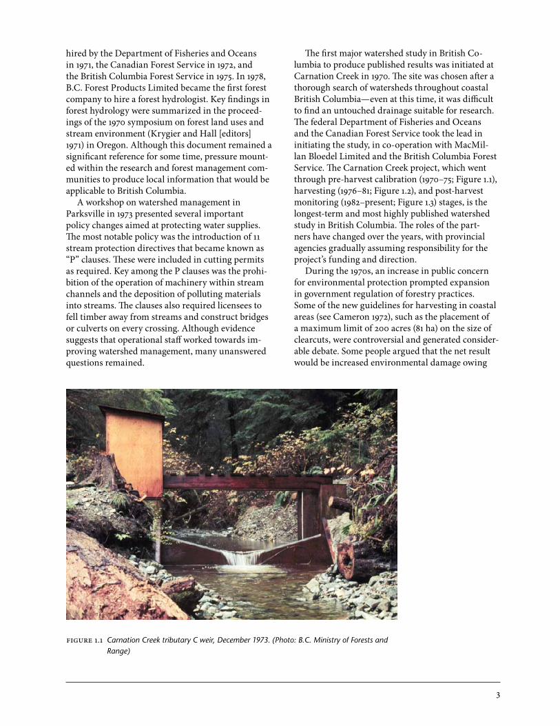
The first major watershed study in British Co-lumbia to produce published results was initiated at Carnation Creek in 1970. The site was chosen after a thorough search of watersheds throughout coastal British Columbia—even at this time, it was difficult to find an untouched drainage suitable for research. The federal Department of Fisheries and Oceans and the Canadian Forest Service took the lead in initiating the study, in co-operation with MacMil-lan Bloedel Limited and the British Columbia Forest Service. The Carnation Creek project, which went through pre-harvest calibration (1970–75; Figure 1.1), harvesting (1976–81; Figure 1.2), and post-harvest monitoring (1982–present; Figure 1.3) stages, is the longest-term and most highly published watershed study in British Columbia. The roles of the part-ners have changed over the years, with provincial agencies gradually assuming responsibility for the project’s funding and direction.
During the 1970s, an increase in public concern for environmental protection prompted expansion in government regulation of forestry practices. Some of the new guidelines for harvesting in coastal areas (see Cameron 1972), such as the placement of a maximum limit of 200 acres (81 ha) on the size of clearcuts, were controversial and generated consider-able debate. Some people argued that the net result would be increased environmental damage owing
figure 1.1 Carnation Creek tributary C weir, December 1973. (Photo: B.C. Ministry of Forests and Range)

4
figure 1.2 Logging on the Carnation Creek floodplain, 1976. (Photo: Natural Resources Canada, Canadian Forest Service)
figure 1.3 Carnation Creek weather station N (Photo: D. Spittlehouse)
to the extra roads required. The implementation of the guidelines led land managers to seek answers through research and thus they became more inter-ested in studies such as those at Carnation Creek.
A second important 1970s study was the Slim-Tumuch project east of Prince George, which was initiated in 1972 by the British Columbia Fish and Wildlife Branch, with participation from the federal fisheries agency (Brownlee et al. 1988). This was a short-term study with no pre-harvest calibration. Harvested watersheds were compared with unhar-vested watersheds. The objective was to evaluate the effects of timber harvesting on water quality, fish habitat, and fish populations. From a water-quality standpoint, one of the main findings was that most of the harvesting-related sediment entering streams came from a single source of lacustrine material, a result that might have been avoided if the road had been located elsewhere.
The published studies from elsewhere (e.g., Kry-gier and Hall [editors] 1972) and the unpublished presentations of the Carnation Creek and Slim-Tumuch projects conducted in the early 1970s had considerable influence on forest practices. At the time, the forest industry was rapidly expanding, and as new road systems were built in drainages without previous anthropogenic development, questions were raised about the potential impacts. Watershed management was based on a relatively simple referral system that allowed other agencies (e.g., the Depart-
5
ment of Fisheries and Oceans, British Columbia Fish and Wildlife Branch, and the provincial Water Rights Branch) to comment on harvesting propos-als before implementation. Because little was known about local resource values, the habitat protection biologists and other resource professionals practising at this time were sometimes at a loss when asked to make site-specific comments on harvesting proposals.
Also in the 1970s, efforts were under way to devel-op appropriate resource planning tools. For example, the folio system, which was developed in the Prince George Forest Region but was applied widely to other areas of the province, represented one attempt to identify critical resource issues more efficiently. The system required each agency to identify its important resource interests on transparent maps that could be placed over forest development plan maps. In practice, however, this system was often ineffective because of a lack of inventory data. Another project undertaken at the same time by the British Columbia Forest Service on Vancouver Island developed site-specific, stream-side management prescriptions (Moore 1978).
The 1970s also saw provincial agencies working on new multiple-resource inventories. The provincial Resource Analysis Branch of the Environment and Land Use Committee Secretariat was established to develop inventory methods for environmental resources other than timber. This program allowed considerable strides to be taken toward understand-ing the distribution and nature of various resources in British Columbia, including stream networks and surficial geology. Of note, surficial geologists in the Resource Analysis Branch and the forest industry developed methods for rating and mapping slope stability, and they trained many professionals in these methods. The resulting maps are now one of the main tools for those involved in watershed protection.
Innovations in slope stability mapping were also being made by the forest industry. In response to agency pressure and Fisheries Act charges related to landslides on steep land on Haida Gwaii (formerly the Queen Charlotte Islands), MacMillan Bloedel Limited pioneered a four-class slope stability map-ping and classification system. These maps focussed on identifying and appropriately managing unstable terrain. The efforts of the Resource Analysis Branch and industry eventually culminated in a widely adopted terrain mapping system (Howes and Kenk 1988). Another initiative resulted in the addition of environmentally sensitive areas to British Columbia Forest Service inventory maps.
In 1979, a historic conflict arose on Haida Gwaii concerning the approval for harvesting in the Riley Creek watershed, an area particularly prone to land-slides (Donnelly and Martin 1980). Initially, the De-partment of Fisheries and Oceans did not object to the original referral and the British Columbia Forest Service issued a cutting permit. The Department of Fisheries and Oceans reconsidered its stance follow-ing a significant storm in the fall of 1978 that resulted in landslides. Fisheries personnel notified the forest licensee that unless harvesting was suspended, the forest company would be charged under the Fisheries Act. When the company continued to log, a company official was charged with obstruction of justice and fallers were arrested. A major impasse resulted and senior politicians, including the Premier, the fed-eral Minister of Fisheries, and the Prime Minister, became involved. Finally, all parties concurred that harvesting could take place in the area provided that a safe method of doing so could be found. A steep portion of the block directly above a tributary stream was deleted from the cutting permit and the road system was deactivated immediately after the completion of harvesting.
This incident at Riley Creek proved to be piv-otal in shaping forest hydrology, geomorphology, and fish/forestry research in British Columbia. It led to the formation of the Fish-Forestry Interac-tion Program in 1981, which culminated in a final symposium 15 years later and led to the publication of the influential Land Management Handbook 41 (Hogan et al. [editors] 1998). Under the Fish-Forestry Interaction Program, many researchers partici-pated in projects on Haida Gwaii and this research contributed to the British Columbia Coastal Fisher-ies/Forestry Guidelines (B.C. Ministry of Forests et al. 1988). Among the many studies that were part of this project, the overall emphasis was on slope (Figure 1.4) and channel stability and the effects of harvesting on fish habitat in a geomorphically active environment (Figure 1.5).
As more information about forest hydrology became available in the 1970s, awareness of the ef-fects of large wood in streams and the importance of the structure of stream channels also increased. Scientists learned that the traditional forest hydrol-ogy topics of quantity, regime, and quality of water could not be viewed in isolation. Rather, these topics should be considered in conjunction with the stream channel. It became apparent that timber harvesting adjacent to stream channels could affect long-term stability of channels, even when no instream ac-

6
tivities occur. In other words, it was not enough to simply keep harvesting equipment out of streams.
Another intense topic of discussion was the effect of harvesting on rain-on-snow events on the Coast. It was known that infrequent fall and winter storms triggered most landslides, but it was not known empirically what role harvesting might play. A study on Haida Gwaii outlining the theoretical effects of harvesting on peak flow (Toews and Wilford 1978) led to considerable debate, and the recommendation that harvesting be limited to one-third of a water-shed within a 25-year period. This debate resulted in the initiation of a related study on Haida Gwaii,2 but during the 3 years of field monitoring no rain-on-snow events occurred. Following a series of technical problems, the project was discontinued. Beaudry and Golding (1987) undertook a more successful study on the topic in the Vancouver area.
With the objective of coming together to dis-cuss key issues in forest hydrology, an informal group called the “Friends of Forest Hydrology” was established in 1976. Although it has no constitu-tion, executive, budget, or proceedings, the group has continued to meet, usually annually, for the past 30 years. These gatherings resulted in many lively, informative discussions and field observations that have helped shape the practice of hydrology in Brit-ish Columbia (Figure 1.6).
The 1980s
The 1980s was a period of considerable research out-put. Projects initiated in the 1970s were producing results, and science-based watershed management policies were evolving. The Guidelines for Watershed Management of Crown Lands Used as Community Water Supplies (B.C. Ministry of Environment 1980) was released early in the decade. Developed by a multi-agency committee, the document identified 279 watersheds (excluding those in Vancouver and Victoria) that supplied water to 21% of the province’s population. A primary effect of these guidelines has been to increase the planning and water-protection efforts in community watersheds. The guidelines have been of particular importance in the Southern Interior, where community watersheds make up a significant portion of the provincial forest. The De-partment of Fisheries and Oceans released a parallel document that dealt with fish habitat called A Hand-book for Fish Habitat Protection on Forest Lands in British Columbia (Toews and Brownlee 1981). This
figure 1.4 Example of the effects of pre-1980s harvesting and road-building practices in unstable/erodible terrain, coastal British Columbia. (Photo: B.C. Ministry of Forests and Range)
figure 1.5 Debris from landslide in Carnation Creek, 1984. (Photo: B.C. Ministry of Forests and Range)
2 The results of these studies were not published.

7
handbook summarized the relevant literature, docu-mented planning procedures, and provided guide-lines in a format designed for use by fisheries officers and habitat protection specialists.
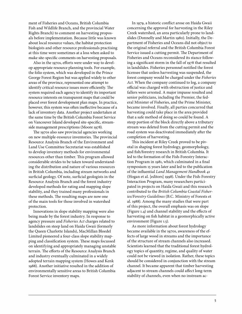
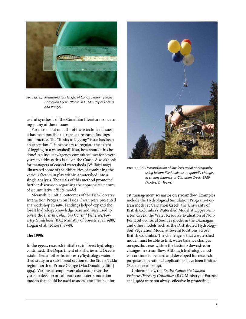
The earlier investment in Carnation Creek started yielding significant results, which were presented at major workshops in 1981 (Hartman [editor] 1982) and 1987 (Chamberlin [editor] 1988). At Carnation Creek, complex relationships between biological (Figure 1.7) and hydrological parameters such as stream temperature, stream water nutrients, and channel stability (Figure 1.8) came to be better understood. Land managers called for the translation of these results into guidelines. A workshop in 1983 led to the development and implementation of the British Co-lumbia Coastal Fisheries/Forestry Guidelines; these were subsequently refined in a second edition (B.C. Ministry of Forests et al. 1988). Both industry and government agreed to the guidelines, which were implemented with an intensive training program.
By the mid-1980s, the British Columbia Forest Service had hired research hydrologists in five of the province’s six forest regions and had given them
the dual role of undertaking research and providing operational advice. The British Columbia Min-istry of Environment and forest companies were also hiring specialized staff with interests in forest hydrology. New programs were set up to broaden the geographic scope of forest hydrology research in British Columbia. In the Nelson and Kamloops forest regions, the focus was on snow hydrology and the effects of harvesting on streamflow in snow-dominated watersheds. The Kamloops Forest Region and Weyerhaeuser Company Limited initi-ated the Upper Penticton Creek Experiment in 1982 (Winkler et al. 2008b). The Prince George Forest Region specifically focussed on harvesting effects in northern British Columbia, and the Prince Rupert Forest Region looked at channel and slope stabil-ity issues, particularly as these related to fish and forestry. Common concerns in British Columbia in-cluded mass wasting, surface erosion and sediment from roads, peak and low flows, limits to logging and rate of cut, and fish–forestry interactions (in-cluding the role of riparian areas and large organic debris in streams). Hetherington (1987) published a
figure 1.6 Demonstration of salt dilution gauging to measure streamflow in Fishtrap Creek, Friends of Forest Hydrology workshop, September 2005. (Photo: K. Turner)
8
useful synthesis of the Canadian literature concern-ing many of these issues.
For most—but not all—of these technical issues, it has been possible to translate research findings into practice. The “limits to logging” issue has been an exception. Is it necessary to regulate the extent of logging in a watershed? If so, how should this be done? An industry/agency committee met for several years to address this issue on the Coast. A workbook for managers of coastal watersheds (Wilford 1987) illustrated some of the difficulties of combining the various factors in play within a watershed into a single analysis. The trials of this method promoted further discussion regarding the appropriate nature of a cumulative effects model.
Meanwhile, initial outcomes of the Fish-Forestry Interaction Program on Haida Gwaii were presented at a workshop in 1986. Findings helped expand the forest hydrology knowledge base and were used to revise the British Columbia Coastal Fisheries/For-estry Guidelines (B.C. Ministry of Forests et al. 1988; Hogan et al. [editors] 1998).
The 1990s
In the 1990s, research initiatives in forest hydrology continued. The Department of Fisheries and Oceans established another fish/forestry/hydrology water-shed study in a sub-boreal section of the Stuart-Takla region north of Prince George (MacDonald [editor] 1994). Various attempts were also made over the years to develop or calibrate computer-simulation models that could be used to assess the effects of for-
est management scenarios on streamflow. Examples include the Hydrological Simulation Program–For-tran model at Carnation Creek, the University of British Columbia’s Watershed Model at Upper Pent-icton Creek, the Water Resource Evaluation of Non-Point Silvicultural Sources model in the Okanagan, and other models such as the Distributed Hydrology Soil Vegetation Model at several locations across British Columbia. The challenge is that a watershed model must be able to link water balance changes on specific areas within the basin to downstream changes in streamflow. Although hydrologic mod-els continue to be used and developed for research purposes, operational applications have been limited (Beckers et al. 2009).
Unfortunately, the British Columbia Coastal Fisheries/Forestry Guidelines (B.C. Ministry of Forests et al. 1988) were not always effective in protecting
figure 1.7 Measuring fork length of Coho salmon fry from Carnation Creek. (Photo: B.C. Ministry of Forests and Range)
figure 1.8 Demonstration of low-level aerial photography using helium-filled balloons to quantify changes in stream channels at Carnation Creek, 1989. (Photos: D. Toews)

9
figure 1.9 Investigating the Donna Creek landslide, 1992. (Photo: D. Hogan)
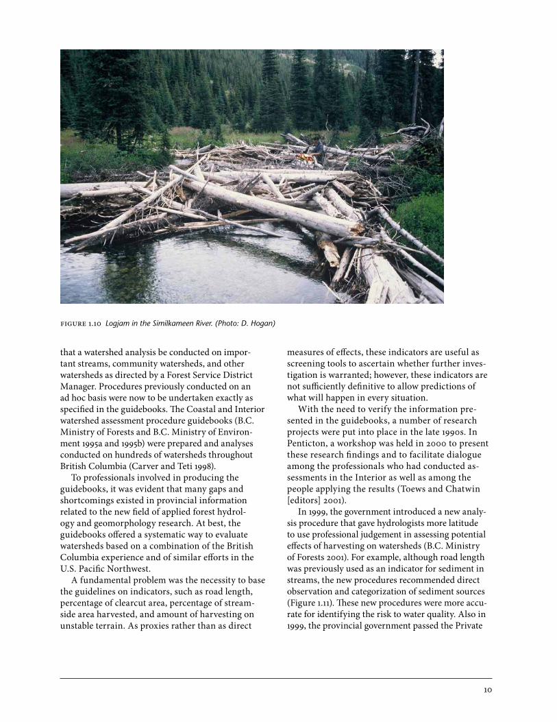
streams from damage (Moore and Bull 2004) (Figures 1.9, 1.10). A series of environmental audits reported that many small streams had been significantly affect-ed by timber-harvesting activities, and this spurred efforts by both government and industry to tighten procedures and undertake directed research on gully assessments and debris removal (Tripp 1998).
In the early 1990s, a crucial event in the develop-ment of harvesting guidelines occurred in Clayoquot Sound on the west coast of Vancouver Island. An alliance of environmental groups, First Nations, and private individuals protested the harvesting activi-ties in a specific area on the outer coast. The govern-ment responded by selecting a group of independent scientists to prepare a report to guide the protection of key resources in this area. In 1995, the Scientific Panel for Sustainable Forestry Practices in Clayo-quot Sound released its recommendations (Scientific Panel for Sustainable Forest Practices in Clayoquot Sound 1995). In this report, the Panel recommended that harvesting should continue but on a very lim-ited scale and under stringent guidelines.
Two very important forest policy initiatives were implemented in the 1990s. First, the provincial government called for the preparation of the Forest Practices Code of British Columbia Act and accom-panying guidebooks, which came into effect in 1995.
Second, in 1994, the government initiated Forest Renewal BC (Province of British Columbia 1994), an organization that launched several substantial programs to rehabilitate watersheds throughout the province. The previous decades of research paved the way for the preparation of the Forest Practices Code guidebooks and for the development of procedures for the Watershed Renewal Program of Forest Re-newal BC.
Forest Renewal BC established a significant legacy with two endowed chairs in forest hydrology at the University of British Columbia and two at the University’s Okanagan campus. In addition to the formal hydrology training at universities, the various road and stream rehabilitation field trials in all parts of British Columbia have resulted in an enhanced level of field expertise.
Before the implementation of the Forest Prac-tices Code, environmental guidelines from the provincial government had been more discretion-ary, with considerable latitude permitted in adapt-ing to a given situation. With the Forest Practices Code, however, the government set out to specify as precisely as possible, through legislation, regulations, and guidebooks, how forestry activities were to be carried out and how studies were to be undertaken. For example, the regulations in the Code required
10
that a watershed analysis be conducted on impor-tant streams, community watersheds, and other watersheds as directed by a Forest Service District Manager. Procedures previously conducted on an ad hoc basis were now to be undertaken exactly as specified in the guidebooks. The Coastal and Interior watershed assessment procedure guidebooks (B.C. Ministry of Forests and B.C. Ministry of Environ-ment 1995a and 1995b) were prepared and analyses conducted on hundreds of watersheds throughout British Columbia (Carver and Teti 1998).
To professionals involved in producing the guidebooks, it was evident that many gaps and shortcomings existed in provincial information related to the new field of applied forest hydrol-ogy and geomorphology research. At best, the guidebooks offered a systematic way to evaluate watersheds based on a combination of the British Columbia experience and of similar efforts in the U.S. Pacific Northwest.
A fundamental problem was the necessity to base the guidelines on indicators, such as road length, percentage of clearcut area, percentage of stream-side area harvested, and amount of harvesting on unstable terrain. As proxies rather than as direct
measures of effects, these indicators are useful as screening tools to ascertain whether further inves-tigation is warranted; however, these indicators are not sufficiently definitive to allow predictions of what will happen in every situation.
With the need to verify the information pre-sented in the guidebooks, a number of research projects were put into place in the late 1990s. In Penticton, a workshop was held in 2000 to present these research findings and to facilitate dialogue among the professionals who had conducted as-sessments in the Interior as well as among the people applying the results (Toews and Chatwin [editors] 2001).
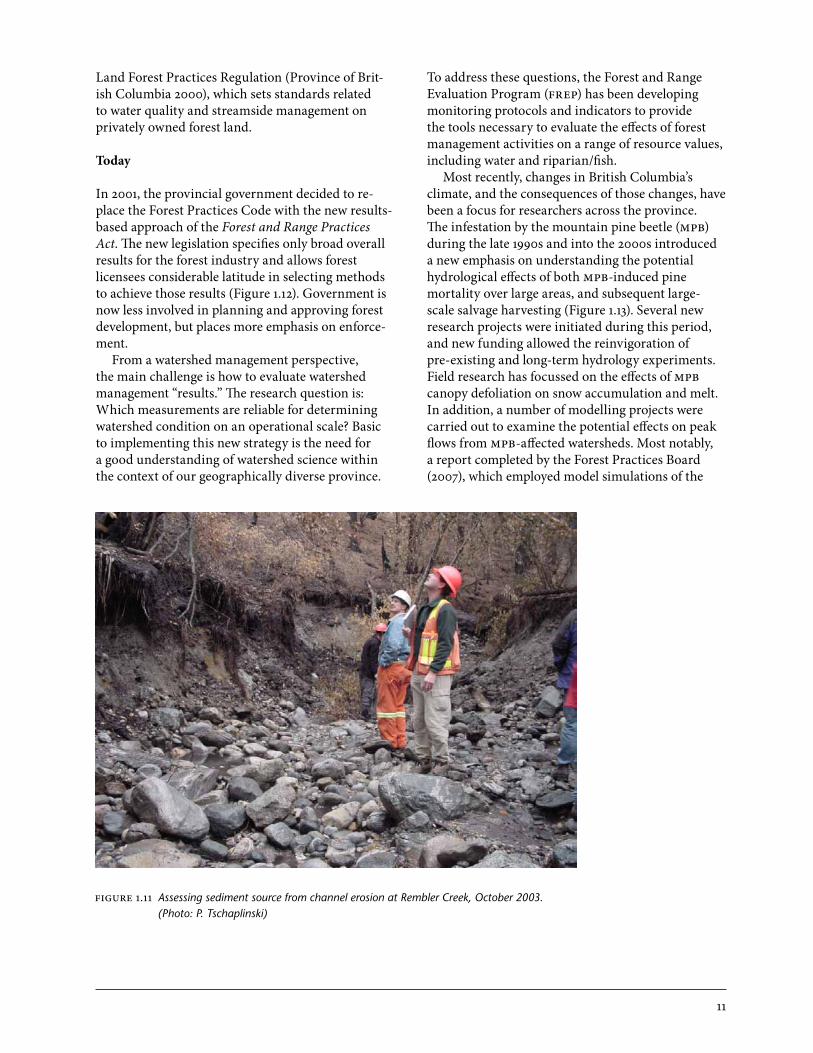
In 1999, the government introduced a new analy-sis procedure that gave hydrologists more latitude to use professional judgement in assessing potential effects of harvesting on watersheds (B.C. Ministry of Forests 2001). For example, although road length was previously used as an indicator for sediment in streams, the new procedures recommended direct observation and categorization of sediment sources (Figure 1.11). These new procedures were more accu-rate for identifying the risk to water quality. Also in 1999, the provincial government passed the Private
figure 1.10 Logjam in the Similkameen River. (Photo: D. Hogan)
11
Land Forest Practices Regulation (Province of Brit-ish Columbia 2000), which sets standards related to water quality and streamside management on privately owned forest land.
Today
In 2001, the provincial government decided to re-place the Forest Practices Code with the new results-based approach of the Forest and Range Practices Act. The new legislation specifies only broad overall results for the forest industry and allows forest licensees considerable latitude in selecting methods to achieve those results (Figure 1.12). Government is now less involved in planning and approving forest development, but places more emphasis on enforce-ment.
From a watershed management perspective, the main challenge is how to evaluate watershed management “results.” The research question is: Which measurements are reliable for determining watershed condition on an operational scale? Basic to implementing this new strategy is the need for a good understanding of watershed science within the context of our geographically diverse province.
To address these questions, the Forest and Range Evaluation Program (FREP) has been developing monitoring protocols and indicators to provide the tools necessary to evaluate the effects of forest management activities on a range of resource values, including water and riparian/fish.
Most recently, changes in British Columbia’s climate, and the consequences of those changes, have been a focus for researchers across the province. The infestation by the mountain pine beetle (MPB) during the late 1990s and into the 2000s introduced a new emphasis on understanding the potential hydrological effects of both MPB-induced pine mortality over large areas, and subsequent large-scale salvage harvesting (Figure 1.13). Several new research projects were initiated during this period, and new funding allowed the reinvigoration of pre-existing and long-term hydrology experiments. Field research has focussed on the effects of MPB canopy defoliation on snow accumulation and melt. In addition, a number of modelling projects were carried out to examine the potential effects on peak flows from MPB-affected watersheds. Most notably, a report completed by the Forest Practices Board (2007), which employed model simulations of the
Figure 1.11 Assessing sediment source from channel erosion at Rembler Creek, October 2003. (Photo: P. Tschaplinski)

12
FIGURE 1.12 Example of current riparian management practices. (Photo: B.C. Ministry of Forests and Range)
figure 1.13 Bonaparte Plateau north of Kamloops showing evidence of mountain pine beetle infestation on the landscape. (Photo: R.D. Winkler)
13
Baker Creek watershed near Quesnel, raised aware-ness about the potential changes to flood frequencies caused by the MPB infestation and subsequent sal-vage harvesting. Winkler et al. (2008a) and Redding et al. (2008) have summarized the results of research on the effects of the MPB on hydrology. Similarly, many researchers are currently active in the climate
summary
Since the mid-1960s, a great deal has been accom-plished—through research, practice, education, and policy development—in forest hydrology and geomorphology and in understanding the effects of forest resource management in British Columbia. Nevertheless, much remains to be learned. This com-pendium summarizes the extent of our knowledge
references
B.C. Ministry of Environment and Parks. 1980. Guidelines for watershed management of Crown lands used as community water sup-plies. Victoria, B.C.
B.C. Ministry of Forests. 2001. Coastal watershed assessment procedure guidebook (CWAP). Interior watershed assessment procedure guidebook (IWAP). 2nd ed. Ver. 2.1. Victoria, B.C. For. Pract. Code B.C. Guideb. www.for.gov.bc.ca/tasb/legsregs/fpc/FPCGUIDE/wap/WAPGdbk-Web.pdf (Accessed March 2010).
B.C. Ministry of Forests and B.C. Ministry of Envi-ronment. 1995a. Interior watershed assessment procedure guidebook (IWAP), level 1 analysis. B.C. Min. For., For. Pract. Br., Victoria, B.C. For. Pract. Code B.C. Guideb. www.for.gov.bc.ca/tasb/legsregs/FPC/fpcguide/IWAP/ iwap-toc.htm (Accessed March 2010).
_______. 1995b. Coastal watershed assessment procedure guidebook (CWAP), level 1 analysis. B.C. Min. For., For. Pract. Br., Victoria, B.C. For. Pract. Code B.C. Guideb. www.for.gov.bc.ca/tasb/legsregs/FPC/fpcguide/COASTAL/CWAPTOC.HTM (Accessed March 2010).
B.C. Ministry of Forests, B.C. Ministry of Envi-ronment and Parks, Federal Department of Fisheries and Oceans, and Council of Forest Industries of British Columbia. 1988. British Columbia coastal fisheries/forestry guidelines. 2nd edition. B.C. Ministry of Forests, Victoria, B.C.
Beaudry, P.G. and D.L. Golding. 1987. Snowmelt and runoff during rain-on-snow in forest and adja-cent clearcut. In: Snow property measurement workshop: April 1–3, 1985, Lake Louise, Alta. P.R. Kry (editor). Natl. Res. Counc. Can., As-soc. Comm. Geotech. Res., Ottawa, Ont. Tech. Memo. 140, pp. 285–311.
Beckers, J., B. Smerdon, and M. Wilson. 2009. Review of hydrologic models for forest man-agement and climate change applications in British Columbia and Alberta. FORREX Forum for Research and Extension in Natural Re-sources, Kamloops, B.C. FORREX Ser. No. 25. www.forrex.org/publications/forrexseries/fs25.pdf (Accessed March 2010).
Brown, G.W. and J.T. Krygier. 1971. Clear-cut logging and sediment production in the Oregon Coast Range. Water Resour. Res. 7:1189–1198.
change research field, analyzing historical data, developing modelling approaches, and extending information on how watershed processes in Brit-ish Columbia will likely change in the future (see Chapter 19, “Climate Change Effects on Watershed Processes in British Columbia”).
to 2010 and also identifies the knowledge gaps that currently exist in our understanding. In so doing, the authors hope to stimulate further gains in the understanding of forest hydrology, geomorphology, and stream ecosystems and the practical application of this knowledge to facilitate effective watershed management in British Columbia.
14
Brownlee, M.J., B.G. Shepard, and D.R. Bustard. 1988. Some effects of forest harvesting on water quality in the Slim Creek watershed in the Central Interior of British Columbia. Dep. Fish. Oceans, Pac. Reg., Vancouver, B.C. Can. Tech. Rep. Fish. Aquatic Sci. 1613.
Cameron, I.T. 1972. Planning guidelines for coast logging operations. B.C. Forest Service, Victo-ria, B.C.
Carver, M. and P. Teti. 1998. Illuminating the black box: a numerical examination of British Columbia’s watershed assessment procedures (level 1). In: Mountains to sea: human inter-action with the hydrologic cycle. CWRA 51st Annu. Conf., June 10–12, 1998, Victoria, B.C. Y. Alila (editor). Can. Water Resour. Assoc., pp. 104–113.
Chamberlin, T.W. (editor). 1988. Proceedings of the workshop: applying 15 years of Carnation Creek results. Carnation Creek Steering Com-mittee. Pac. Biol. Stn., Nanaimo, B.C.
Donnelly, T. and C. Martin. 1980. Fall rains at Ren-nel Sound. Telkwa Found. Newsl. 3(1):8–9.
Forest Practices Board. 2007. The effect of mountain pine beetle attack and salvage harvesting on streamflows. Victoria, B.C. Spec. Invest. Rep. No. FPB/SIR/16. www.for.gov.bc.ca/hfd/library/documents/bib106689.pdf (Accessed March 2010).
Golding, D.L. 1988. Jamieson Creek experimental watershed in the Greater Vancouver municipal catchments. In: Proc. Can. Hydrol. Symp. No. 17, Canadian research basins: successes, fail-ures, and future. Banff, Alta. Natl. Res. Counc. Can., Ottawa, Ont., pp. 229–236.
_______. 1995. Annotated bibliography of hydrology research in the Greater Vancouver Municipal Watersheds. Fac. For., Univ. British Columbia, Vancouver, B.C.
Harr, R.D., W.C. Harper, J.T. Krygier, and F.S. Hsieh. 1975. Changes in storm hydrographs after road building and clear-cutting in the Oregon coast range. Water Resour. Res. 11(3):436–444.
Hartman, G.F. (editor). 1982. Proceedings of the Car-nation Creek workshop: a 10-year review. Pac. Biol. Stn., Nanaimo, B.C.
Hetherington, E.D. 1987. The importance of forests in the hydrologic regime. Can. Bull. Fish. Aquat. Sci. 215:179–211.
Hewlett, J.D. and W.L. Nutter. 1969. An outline of forest hydrology. Univ. Georgia Press, Athens, GA.
Hogan, D.L., P.J. Tschaplinski, and S. Chatwin (edi-tors). 1998. Carnation Creek and Queen Char-lotte Islands fish/forestry workshop: applying 20 years of coastal research to management solutions. B.C. Min. For., Res. Br., Victoria, B.C. Land Manag. Handb. No. 41. www.for.gov.bc.ca/hfd/pubs/Docs/Lmh/Lmh41.htm (Ac-cessed March 2010).
Howes, D.E. and E. Kenk. 1988. Terrain classification system for British Columbia. Revised ed. B.C. Min. Environ., Rec. Fish. Br., and B.C. Min. Crown Lands, Surv. Resour. Mapp. Br., Vic-toria, B.C. MOE Manu. No. 10. www.env.gov.bc.ca/wld/documents/techpub/moe10/MOE10.pdf (Accessed March 2010).
Jeffrey, W.W. 1970. Hydrology of land use. In: Hand-book on the principles of hydrology. D.M. Gray (editor). Secretariat, Can. Natl. Comm. Int. Hy-drol. Decade, Ottawa, Ont., pp. 13.1–13.55.
Krygier, J.T. and J.D. Hall (editors). 1971. Forest land uses and stream environment: Proc. Symp., Oct. 19–21, 1970. Oregon State Univ., Dep. Fish. Wildl. and School For., and Contin. Educ. Publ., Corvallis, Oreg.
MacDonald, J.S. (editor). 1994. Proceedings of the Takla fishery/forestry workshop: a two year review. Fish. Oceans Can., Biol. Sci. Br., West Vancouver Lab., West Vancouver, B.C. Can. Tech. Rep. Fish. Aquat. Sci. No. 2007. www.for.gov.bc.ca/hfd/library/documents/bib74259.pdf (Accessed March 2010).
Moore, M.K. 1978. A decision making procedure for streamside management on Vancouver Island: a booklet for operational testing and use. B.C. Min. For., Res. Br., Victoria, B.C.
Moore, M.K. and G. Bull. 2004. Guidelines, codes, and legislation. In: Fishes and forestry: world-wide watershed interactions and management. T.G. Northcote and G.F. Hartman (editors). Blackwell Science Ltd., Ames, Iowa, pp. 707–728.

15
Province of British Columbia. 1994. Bill 32—1994, Forest Renewal Act. 1994 Legislative Ses-sion: 3rd Session, 35th Parliament. http://leg.bc.ca/35th3rd/3rd_read/gov32-3.htm
_______. 2000. Forest Land Reserve Act, Private Land Forest Practices Regulation. B.C. Regula-tion 318/99. [Repealed by the Private Managed Forest Land Act, SBC2003, c. 80, s. 53, effective August 3, 2004 (B.C. Reg. 371/2004)].
Redding, T., R. Winkler, P. Teti, D. Spittlehouse, S. Boon, J. Rex, S. Dubé, R.D. Moore, A. Wei, M. Carver, M. Schnorbus, L. Reese-Hansen, and S. Chatwin. 2008. Mountain pine beetle and watershed hydrology. In: Mountain pine beetle: from lessons learned to community-based solutions, Conf. Proc., June 10–11, 2008. B.C. J. Ecosyst. Manag. 9(3):33–50. www.forrex.org/publications/jem/ISS49/vol9_no3_MPB conference.pdf (Accessed March 2010).
Scientific Panel for Sustainable Forest Practices in Clayoquot Sound. 1995. Sustainable ecosystem management in Clayoquot Sound: planning and practice. Victoria, B.C. Rep. No. 5.
Sopper, W.E. and H.W. Lull (editors). 1967. Interna-tional symposium on forest hydrology. Per-gamon Press, New York, N.Y.
Toews, D.A.A. and M.K. Brownlee. 1981. A hand-book for fish habitat protection on forest lands in British Columbia. Dep. Fish. Oceans, Field Serv. Br., Land Use Unit, Vancouver, B.C.
Toews, D.A.A. and S. Chatwin (editors). 2001. Watershed assessment in the southern interior of British Columbia: workshop proceedings, March 9–10, 2000, Penticton, B.C. B.C. Min. For., Res. Br., Victoria, B.C. Work. Pap. No. 57. www.for.gov.bc.ca/hfd/pubs/Docs/Wp/Wp57.htm (Accessed March 2010).
Toews, D.A.A. and D.J. Wilford. 1978. Watershed management considerations for operational planning on TFL#39 (Blk 6a), Graham Island. Fish. Environ. Can., Vancouver, B.C. Can. Fish. Mar. Serv. Manuscr. Rep. No. 1473.
Tripp, D. 1998. Problems, prescriptions, and com-pliance with the coastal fisheries-forestry guidelines in a random sample of cutblocks in coastal British Columbia. In: Carnation Creek and Queen Charlotte Islands fish/forestry workshop: applying 20 years of coast research to management solutions. D.L. Hogan, P.J. Tschaplinski, and S.C. Chatwin (editors). B.C. Min. For., Res. Br., Victoria, B.C. Land Manag. Handb. No. 41, pp. 245–256. www.for.gov.bc.ca/hfd/pubs/Docs/Lmh/Lmh41.htm (Accessed March 2010).
Wilford, D.J. 1987. Watershed workbook: forest hy-drology sensitivity analysis for coastal British Columbia watersheds. B.C. Min. For., Prince Rupert For. Reg., Smithers, B.C.
Winkler, R., J. Rex, P. Teti, D. Maloney, and T. Red-ding. 2008a. Mountain pine beetle, forest prac-tices, and watershed management. B.C. Min. For. Range, Victoria, B.C. Exten. Note No. 88. www.for.gov.bc.ca/hfd/pubs/Docs/En/En88.pdf (Accessed March 2010).
Winkler, R., D. Spittlehouse, D. Allen, T. Redding, T. Giles, G. Hope, B. Heise, Y. Alila, and H. Voeckler. 2008b. The Upper Penticton Creek Watershed Experiment: integrated water resource research on the Okanagan Plateau. In: Proc. One Water – One Watershed Conf., Can. Water Resour. Assoc., Oct. 21–23, 2008, Kelowna, B.C., pp. 38–47.