Embed Size (px)
Citation preview
Tea ShopsForest of Bowland1
FOREST OFBOWLAND A place to enjoy and keep special
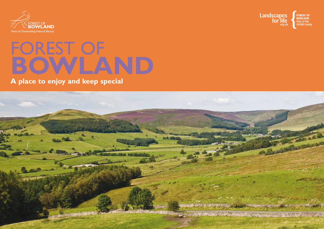
Forest of Bowland2 A Place to Enjoy and Keep Special
Expanses of sky above the wild dramatic sweep of open moorland.Gentle and tidy lowlands, criss-crossed with dry stone walls
and dotted with picturesque farms and villages. This is a
place like no other, a place with a strong sense of stepping
back in time to a forgotten part of the English countryside,
a place known as Bowland – the Forest of Bowland Area of
Outstanding Natural Beauty (AONB).
Situated in North West England, covering 803 square kilometres (300 sq miles) of rural
Lancashire and North Yorkshire, the Forest of Bowland
AONB is in two parts. The famous landmark of Pendle Hill
is geologically linked to the main upland block but separated
by the broad valley of the River Ribble. The area surrounding
this outlier is known locally as the Forest of Pendle, whilst
being under the umbrella of the Forest of Bowland Area of
Outstanding Natural Beauty title and designation.
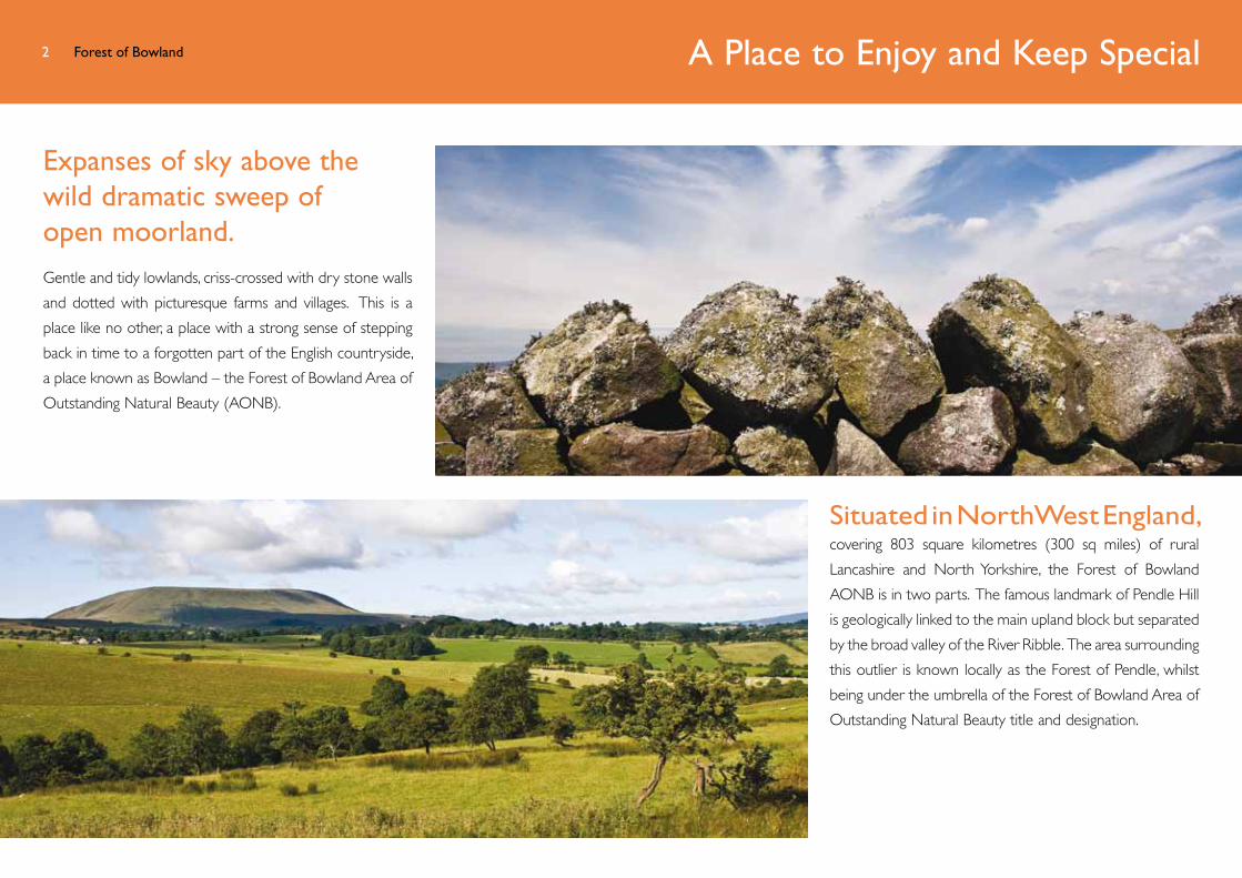
Forest of Bowland3 A Place to Enjoy and Keep Special
The Forest of Bowland AONB is protected by law to ensure the conservation and enhancement of its natural
beauty, not just for the present, but also for future
generations. AONBs have been regarded for generations
as treasured areas with special character, and are designated
for the quality of their landscapes. The Forest of Bowland
was designated as an Area of Outstanding Natural Beauty
in 1964 under the Wildlife and Countryside Act (1949) and
was recognised by the government as being of equal status
as National Parks by the Countryside and Rights of Way Act
(CRoW) 2000. Protective designation not only helps to
conserve and enhance the AONB’s natural beauty but also
seeks, as far as possible, to promote the social and economic
well-being of people that live and work within it.
Forest of Bowland4 A Living Landscape
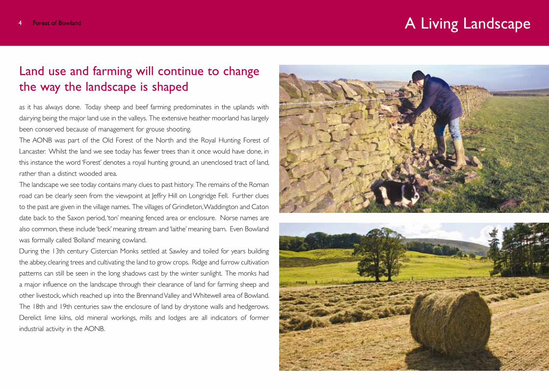
Land use and farming will continue to change the way the landscape is shaped as it has always done. Today sheep and beef farming predominates in the uplands with
dairying being the major land use in the valleys. The extensive heather moorland has largely
been conserved because of management for grouse shooting.
The AONB was part of the Old Forest of the North and the Royal Hunting Forest of
Lancaster. Whilst the land we see today has fewer trees than it once would have done, in
this instance the word ‘Forest’ denotes a royal hunting ground, an unenclosed tract of land,
rather than a distinct wooded area.
The landscape we see today contains many clues to past history. The remains of the Roman
road can be clearly seen from the viewpoint at Jeffry Hill on Longridge Fell. Further clues
to the past are given in the village names. The villages of Grindleton, Waddington and Caton
date back to the Saxon period, ‘ton’ meaning fenced area or enclosure. Norse names are
also common, these include ‘beck’ meaning stream and ‘laithe’ meaning barn. Even Bowland
was formally called ‘Bolland’ meaning cowland.
During the 13th century Cistercian Monks settled at Sawley and toiled for years building
the abbey, clearing trees and cultivating the land to grow crops. Ridge and furrow cultivation
patterns can still be seen in the long shadows cast by the winter sunlight. The monks had
a major influence on the landscape through their clearance of land for farming sheep and
other livestock, which reached up into the Brennand Valley and Whitewell area of Bowland.
The 18th and 19th centuries saw the enclosure of land by drystone walls and hedgerows.
Derelict lime kilns, old mineral workings, mills and lodges are all indicators of former
industrial activity in the AONB.

A Special Place for WildlifeForest of Bowland5
An area of national and international importance because of its unspoiled and richly diverse landscapes, wildlife and heritage, Bowland has outstanding heather moorland,
blanket bog, and rare birds. The deeply incised cloughs and wooded valleys are particularly characteristic of the Forest of
Bowland as are its well-managed sporting estates. The AONB also has semi-natural woodlands and wildflower meadows.
Thirteen per cent of the AONB is designated as a Site of Special Scientific Interest (SSSI) for its habitats and geological
features. The extensive heather moorlands of the fells are exceptionally important as a habitat for upland birds and have
been designated as a Special Protection Area (SPA) under the European Birds Directive in recognition of this.
The hen harrier is the bird symbolised on the Forest of Bowland AONB logo. The Forest of Bowland AONB is their most important
breeding locality in England and is therefore crucial for this
nationally threatened bird. Traditionally managed farmland
in the AONB is home to
significant populations of
wading birds, including lapwings,
curlews, redshanks and snipe.
Forest of Bowland6 Achieving Aspirations Through Partnership
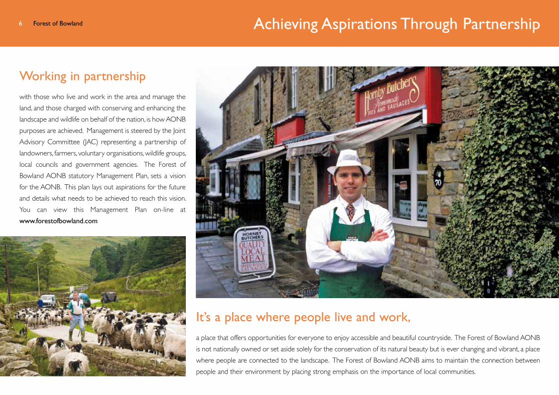
Working in partnershipwith those who live and work in the area and manage the
land, and those charged with conserving and enhancing the
landscape and wildlife on behalf of the nation, is how AONB
purposes are achieved. Management is steered by the Joint
Advisory Committee (JAC) representing a partnership of
landowners, farmers, voluntary organisations, wildlife groups,
local councils and government agencies. The Forest of
Bowland AONB statutory Management Plan, sets a vision
for the AONB. This plan lays out aspirations for the future
and details what needs to be achieved to reach this vision.
You can view this Management Plan on-line at
www.forestofbowland.com
It’s a place where people live and work,a place that offers opportunities for everyone to enjoy accessible and beautiful countryside. The Forest of Bowland AONB
is not nationally owned or set aside solely for the conservation of its natural beauty but is ever changing and vibrant, a place
where people are connected to the landscape. The Forest of Bowland AONB aims to maintain the connection between
people and their environment by placing strong emphasis on the importance of local communities.
Forest of Bowland7 A Place to Enjoy and Keep Special
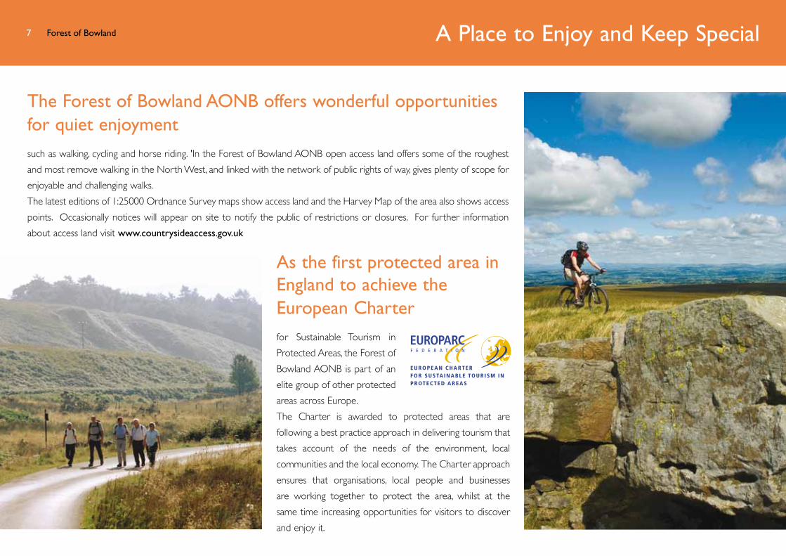
The Forest of Bowland AONB offers wonderful opportunities for quiet enjoyment such as walking, cycling and horse riding. 'In the Forest of Bowland AONB open access land offers some of the roughest
and most remove walking in the North West, and linked with the network of public rights of way, gives plenty of scope for
enjoyable and challenging walks.
The latest editions of 1:25000 Ordnance Survey maps show access land and the Harvey Map of the area also shows access
points. Occasionally notices will appear on site to notify the public of restrictions or closures. For further information
about access land visit www.countrysideaccess.gov.uk
As the first protected area in England to achieve the European Charter for Sustainable Tourism in
Protected Areas, the Forest of
Bowland AONB is part of an
elite group of other protected
areas across Europe.
The Charter is awarded to protected areas that are
following a best practice approach in delivering tourism that
takes account of the needs of the environment, local
communities and the local economy. The Charter approach
ensures that organisations, local people and businesses
are working together to protect the area, whilst at the
same time increasing opportunities for visitors to discover
and enjoy it.

Bowland AONB Map
0 1 2 3 4 5 6 7 8 9 10 km
0 1 2 3 4 5 6 Miles
0 1 2 3 4 5 6 7 8 9 10 km
0 1 2 3 4 5 6 MilesN
400m
HellifieldHellifield
For full information about facilities view an Interactive Map of the Forest of Bowland AONB at www.forestofbowland.com/interactivemap
Map Produced by Countryscape. Contains Ordnance Survey data © Crown copyright and database right 2012.
Heritage sitesA
B
C
D
E
F
G
H
I
J
K
L
Bleasdale CircleA
B
C
D
E
F
G
H
I
J
K
L
Browsholme HallA
B
C
D
E
F
G
H
I
J
K
L
Clitheroe Castle
A
B
C
D
E
F
G
H
I
J
K
L
Cromwell Bridge
A
B
C
D
E
F
G
H
I
J
K
L
Dalehead Church
A
B
C
D
E
F
G
H
I
J
K
L
Great Stone
A
B
C
D
E
F
G
H
I
J
K
L
Jubilee Tower
A
B
C
D
E
F
G
H
I
J
K
L
Pendle Heritage Centre
A
B
C
D
E
F
G
H
I
J
K
L
Ribchester Roman Museum
A
B
C
D
E
F
G
H
I
J
K
L
Sawley Abbey
A
B
C
D
E
F
G
H
I
J
K
L
Slaidburn Heritage Centre
A
B
C
D
E
F
G
H
I
J
K
L Whalley Abbey
Birding Locations
C
D
E
A
B
Roeburndale Woods
C
D
E
A
B Stocks Reservoir
C
D
E
A
B
AbbeysteadC
D
E
A
B
Pendle HillC
D
E
A
B
Barnacre Reservoir
0 1 2 3 4 5 6 7 8 9 10 km
0 1 2 3 4 5 6 Miles
0 1 2 3 4 5 6 7 8 9 10 km
0 1 2 3 4 5 6 MilesN
400m
HellifieldHellifield
0 1 2 3 4 5 6 7 8 9 10 km
0 1 2 3 4 5 6 Miles
0 1 2 3 4 5 6 7 8 9 10 km
0 1 2 3 4 5 6 MilesN
400m
HellifieldHellifield
0 1 2 3 4 5 6 7 8 9 10 km
0 1 2 3 4 5 6 Miles
0 1 2 3 4 5 6 7 8 9 10 km
0 1 2 3 4 5 6 MilesN
400m
HellifieldHellifield
0 1 2 3 4 5 6 7 8 9 10 km
0 1 2 3 4 5 6 Miles
0 1 2 3 4 5 6 7 8 9 10 km
0 1 2 3 4 5 6 MilesN
400m
HellifieldHellifield
0 1 2 3 4 5 6 7 8 9 10 km
0 1 2 3 4 5 6 Miles
0 1 2 3 4 5 6 7 8 9 10 km
0 1 2 3 4 5 6 MilesN
400m
HellifieldHellifield
0 1 2 3 4 5 6 7 8 9 10 km
0 1 2 3 4 5 6 Miles
0 1 2 3 4 5 6 7 8 9 10 km
0 1 2 3 4 5 6 MilesN
400m
HellifieldHellifield
0 1 2 3 4 5 6 7 8 9 10 km
0 1 2 3 4 5 6 Miles
0 1 2 3 4 5 6 7 8 9 10 km
0 1 2 3 4 5 6 MilesN
400m
HellifieldHellifield
0 1 2 3 4 5 6 7 8 9 10 km
0 1 2 3 4 5 6 Miles
0 1 2 3 4 5 6 7 8 9 10 km
0 1 2 3 4 5 6 MilesN
400m
HellifieldHellifield
0 1 2 3 4 5 6 7 8 9 10 km
0 1 2 3 4 5 6 Miles
0 1 2 3 4 5 6 7 8 9 10 km
0 1 2 3 4 5 6 MilesN
400m
HellifieldHellifield
Fishing Locations
Tea Shops
Information Centres
Parking
Historical Interest Sites
Viewpoints
Petrol Stations
Walking Route Start Points
Cycling Route Start Points
Elevation Height Above Sea Level
Station
Map Key
0 1 2 3 4 5 6 7 8 9 10 km
0 1 2 3 4 5 6 Miles
0 1 2 3 4 5 6 7 8 9 10 km
0 1 2 3 4 5 6 MilesN
400m
HellifieldHellifield
0 1 2 3 4 5 6 7 8 9 10 km
0 1 2 3 4 5 6 Miles
0 1 2 3 4 5 6 7 8 9 10 km
0 1 2 3 4 5 6 MilesN
400m
HellifieldHellifield

www.forestofbowland.com
Bowland Visitor Centre – Beacon Fell Country Park, 01995 640557
Barnoldswick – Fernlea Avenue, 01282 666704
Bentham – Town Hall, Station Road, 01524 262549
Clitheroe – Platform Gallery & Visitor Information Centre, Station Rd, 01200 425566
Colne – Boundary Mill Stores, 01282 856186
Garstang – Cherestanc Square, Off Park Hill Road, 01995 602125
Lancaster – The Storey, Meeting House Lane, 01524 582394
Pendle Heritage Centre – Park Hill, Barrowford, 01282 661701
Preston – The Guild Hall, 01772 253731
Settle – Town Hall, 07129 825192
Also visit:
Marketing Lancashire www.visitlancashire.com Welcome to Yorkshire www.yorkshire.com
Front cover photographs - Front cover photograph © Graham Cooper, www.forestofbowlandimages.com, Other photographs: © Graham Cooper, www.forestofbowlandimages.com, © Charlie Hedley/Natural England, © Tessa Bunny/Natural England, © Jon Sparks and female hen harrier © Richard Saunders, Natural England.
Lancashire County Council acts as the lead authority for the Forest of Bowland AONB Advisory Committee a partnership comprising: Lancashire County Council, North Yorkshire County Council, Craven District Council, Lancaster City Council, Pendle Borough Council, Preston City Council, Ribble Valley Borough Council, Wyre Borough Council, Lancashire Association of Parish and Town Councils, Yorkshire Local Councils Association, NWDA, DEFRA, Natural England, United Utilities plc, Environment Agency, Royal Society for the Protection of Birds (RSPB), Forest of Bowland Landowning and Farmers Advisory Group and the Ramblers Association.
Ordnance Survey Map Explorer OL41, Forest of Bowland &
Ribblesdale covers this area as well as a Harvey Map: Forest of
Bowland for walkers, cyclists and horserider.
Leaflet available in large text format on request.
For more information about the Forest of Bowland AONBvisit www.forestofbowland.com or stay in touch via twitter.com/forestofbowland
Forest of Bowland AONB, The Stables, 4 Root Hill Estate Yard, Whitewell Road, Dunsop Bridge, Lancashire, BB7 3AY
Tel: 01200 448000 email: [email protected]
All those enjoying the Forest of Bowland AONB are asked to follow the Countryside Code at www.countrysideaccess.gov.uk
and adhere to signs, particularly at sensitive times such as the lambing and birding nesting seasons during spring and summer.
For accommodation and places to go, visit our official website at www.forestofbowland.com where you can find our visitor guide, search for accommodation and
events in the area, browse our local products directory and well as downloading lots of walks in the area. Alternatively contact one of our local Tourist Information
Centres on the numbers listed below.