Embed Size (px)
Citation preview
7.2.23.2 West End—Woolloongabba district neighbourhood plan code
7.2.23.2.1 Application
(1) This code applies to assessing a material change of use, reconfiguring a lot, operational work or building work in the West End—Woolloongabba district neighbourhood plan area if:
(a) assessable development where this code is an applicable code identified in the assessment benchmarks column of a table of assessment for a neighbourhood plan (section 5.9); or
(b) impact assessable development.
(2) Land in the West End—Woolloongabba district neighbourhood plan area is identified on the NPM-023.2 West End—Woolloongabba district neighbourhood plan map and includes the following precincts:
(a) West End estate precinct (West End—Woolloongabba district neighbourhood plan/NPP-001);
(b) Mater Hill precinct (West End—Woolloongabba district neighbourhood plan/NPP-002):
(i) Mater Hill a sub-precinct (West End—Woolloongabba district neighbourhood plan/NPP-002a);
(ii) Mater Hill b sub-precinct (West End—Woolloongabba district neighbourhood plan/NPP-002b).
Editor's note—Part of the neighbourhood plan area is covered by the Woolloongabba priority development areas which Economic Development Queensland is responsible for planning under the Economic Development Act 2012.
(3) When using this code, reference should be made to section 1.5, section 5.3.2 and section 5.3.3.
Note—The following purpose, overall outcomes, performance outcomes and acceptable outcomes comprise the assessment benchmarks of this code.
Note—This neighbourhood plan includes a table of assessment with variations to categories of development and assessment. Refer to Table 5.9.68.A, Table 5.9.68.B, Table 5.9.68.C and Table 5.9.68.D.
7.2.23.2.2 Purpose
(1) The purpose of the West End—Woolloongabba district neighbourhood plan code is to provide finer grained planning at a local level for the West End—Woolloongabba district neighbourhood plan area.
(2) The purpose of the West End—Woolloongabba district neighbourhood plan code will be achieved through overall outcomes including overall outcomes for each precinct of the neighbourhood plan area.
(3) The overall outcomes for the neighbourhood plan area are:
(a) The major health institutions located in or adjoining the area, including the Mater and Princess Alexandra hospitals, remain as focal points for their important
Part 7 – Neighbourhood plans (West End–Woolloongabba) Effective 3 July 2017
services, facilities and employment opportunities and are enhanced by better access by all transport modes and the encouragement of ancillary uses such as offices and accommodation in and around these institutions to meet their growing needs.
Note—These State facilities are both designated as community infrastructure under Queensland Government jurisdiction.
(b) Views of significance to the City Centre and locality from the public realm are maintained and enhanced, including:
(i) across the West End peninsula to the City Centre and the ridgeline of the Taylor Ranges;
(ii) to significant landmarks within the locality;
(iii) to the Brisbane River.
(c) The Woolloongabba centre maintains its historically significant presence to Stanley Street and development accommodates active street frontages.
(d) The Mater Hospital includes major hospital and medical facilities as well as ancillary uses including administration, educational and research facilities, specialty services, and a range of other services for use by employees, patients and visitors to the hospital. Development of this site:
(i) ensures the scale and intensity of development is respectful of the existing heritage buildings on the site and of nearby residential and educational uses in terms of building heights, overshadowing and traffic impacts;
(ii) concentrates major hospital and medical facilities with a high-intensity built form and scale north of the existing heritage buildings to maximise access to and from car parking facilities and the Mater Hill busway station;
(iii) locates lower intensity ancillary uses that support the hospital and medical facilities in the southern portion of the site near Clarence Street.
(e) The Princess Alexandra Hospital is an important medical facility for Brisbane and the region with land immediately to the north of the site providing an opportunity for the development of education and research facilities that would service this and other institutions, such as universities. Development of this site:
(i) addresses the traffic implications of the development;
(ii) enhances walking and cycling access and integration with existing and future public transport;
(iii) focuses on the architectural treatment of the buildings and high-quality landscaping, given the high visibility of the site.
(f) Boggo Road Urban Village is a mixed use area including residential, retail, commercial, environmental research and recreational facilities. A busway station on the Eastern busway corridor links Buranda Busway Station with the University of Queensland. Development of this site has regard for the site’s residential neighbours and the heritage significance of the gaol. Any extension of Merton Road into this precinct is not consistent with the outcomes sought.
Part 7 – Neighbourhood plans (West End–Woolloongabba) Effective 3 July 2017
(g) Development is of a height, scale and form which is consistent with the amenity and character, community expectations and infrastructure assumptions intended for the relevant precinct, sub-precinct or site and is only developed at a greater height, scale and form where there is both a community need and an economic need for the development.
(4) West End estate precinct (West End—Woolloongabba district neighbourhood NPP-001) overall outcomes are:
(a) Dwelling houses are preserved in their current form, scale and setting, so the original historical character and pattern of development in this precinct of relatively intact, historically significant grouping of small 19th century and early 20th century workers cottages, characterised by 1-storey timber and tin detached dwelling houses on small narrow lots, is retained.
(5) Mater Hill precinct (West End—Woolloongabba district neighbourhood Plan NPP-002) overall outcomes are:
(a) Development in the Mater Hill a sub-precinct (West End—Woolloongabba district neighbourhood Plan NPP-002a):
(i) ensures that office and shop activities on sites fronting Stanley Street provide an active street frontage to reinforce the commercial building form of Stanley Street;
(ii) encourages residential uses on the upper storeys, given the sub-precinct’s location next to the Mater Hospital, the South Bank railway station and busway stations;
(b) Development in the Mater Hill b sub-precinct (West End—Woolloongabba district neighbourhood Plan NPP-002b):
(i) has hospital supporting uses such as outpatient services that are consistent with the outcomes sought on lower levels fronting Hancock Street, where impacts on surrounding residential uses are addressed;
(ii) encourages short-term accommodation given its location next to the Mater Hospital, and the South Bank railway station and busway stations.
7.2.23.2.3 Performance outcomes and acceptable outcomes
Table 7.2.23.2.3.A—Performance outcomes and acceptable outcomesPerformance outcomes Acceptable outcomes
General
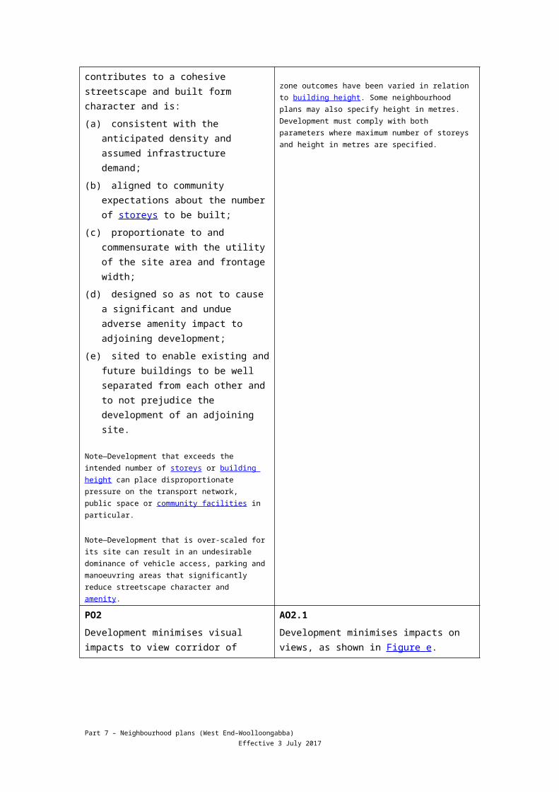
PO1Development is of a height, scale and form that achieves the intended outcome for the precinct, improves the amenity of the neighbourhood plan area, contributes to a cohesive streetscape and built form character and is:
(a) consistent with the anticipated density and assumed infrastructure demand;
AO1Development complies with the number of storeys and building height in Table 7.2.23.2.3.B.
Note—Neighbourhood plans will mostly specify maximum number of storeys where zone outcomes have been varied in relation to building height. Some neighbourhood plans may also specify height in metres. Development must comply with both parameters where maximum number of storeys and height in metres are specified.
Part 7 – Neighbourhood plans (West End–Woolloongabba) Effective 3 July 2017
(b) aligned to community expectations about the number of storeys to be built;
(c) proportionate to and commensurate with the utility of the site area and frontage width;
(d) designed so as not to cause a significant and undue adverse amenity impact to adjoining development;
(e) sited to enable existing and future buildings to be well separated from each other and to not prejudice the development of an adjoining site.
Note—Development that exceeds the intended number of storeys or building height can place disproportionate pressure on the transport network, public space or community facilities in particular.
Note—Development that is over-scaled for its site can result in an undesirable dominance of vehicle access, parking and manoeuvring areas that significantly reduce streetscape character and amenity.
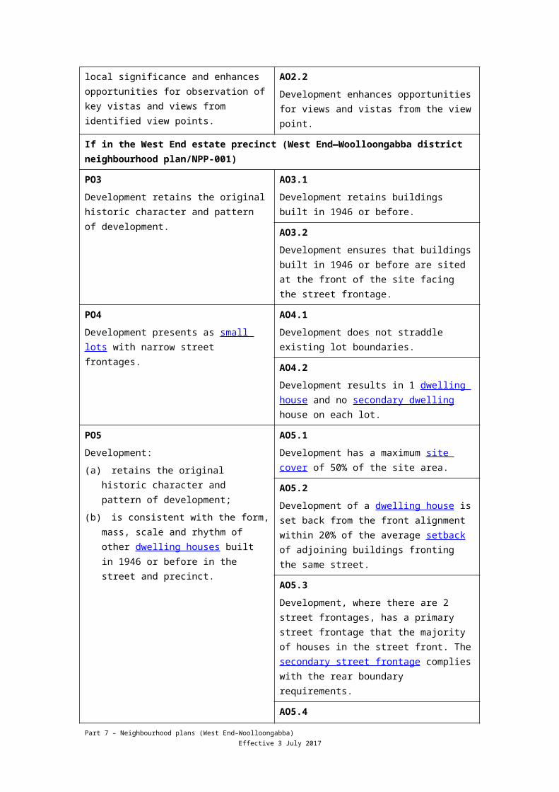
PO2Development minimises visual impacts to view corridor of local significance and enhances opportunities for observation of key vistas and views from identified view points.
AO2.1Development minimises impacts on views, as shown in Figure e .
AO2.2Development enhances opportunities for views and vistas from the view point.
If in the West End estate precinct (West End—Woolloongabba district neighbourhood plan/NPP-001)
PO3Development retains the original historic character and pattern of development.
AO3.1Development retains buildings built in 1946 or before.
AO3.2Development ensures that buildings built in 1946 or before are sited at the front of the site facing the street frontage.
PO4Development presents as small lots with narrow street frontages.
AO4.1Development does not straddle existing lot boundaries.
AO4.2Development results in 1 dwelling house and no secondary dwelling house on each lot.
PO5Development:
(a) retains the original historic character and pattern of development;
AO5.1Development has a maximum site cover of 50% of the site area.
AO5.2
Part 7 – Neighbourhood plans (West End–Woolloongabba) Effective 3 July 2017
(b) is consistent with the form, mass, scale and rhythm of other dwelling houses built in 1946 or before in the street and precinct.
Development of a dwelling house is set back from the front alignment within 20% of the average setback of adjoining buildings fronting the same street.
AO5.3Development, where there are 2 street frontages, has a primary street frontage that the majority of houses in the street front. The secondary street frontage complies with the rear boundary requirements.
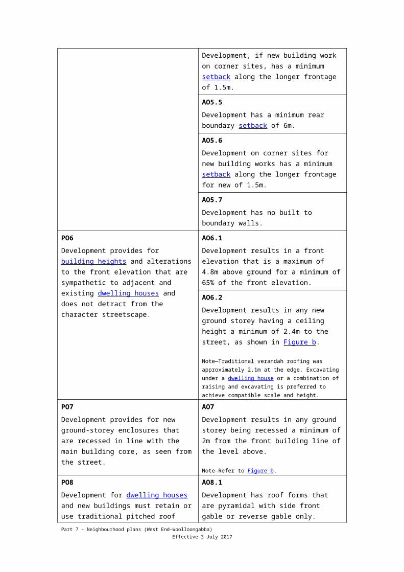
AO5.4Development, if new building work on corner sites, has a minimum setback along the longer frontage of 1.5m.
AO5.5Development has a minimum rear boundary setback of 6m.
AO5.6Development on corner sites for new building works has a minimum setback along the longer frontage for new of 1.5m.
AO5.7Development has no built to boundary walls.
PO6Development provides for building heights and alterations to the front elevation that are sympathetic to adjacent and existing dwelling houses and does not detract from the character streetscape.
AO6.1Development results in a front elevation that is a maximum of 4.8m above ground for a minimum of 65% of the front elevation.
AO6.2Development results in any new ground storey having a ceiling height a minimum of 2.4m to the street, as shown in Figure b.
Note—Traditional verandah roofing was approximately 2.1m at the edge. Excavating under a dwelling house or a combination of raising and excavating is preferred to achieve compatible scale and height.
PO7Development provides for new ground-storey enclosures that are recessed in line with the main building core, as seen from the street.
AO7Development results in any ground storey being recessed a minimum of 2m from the front building line of the level above.
Note—Refer to Figure b.
PO8Development for dwelling houses and new buildings must retain or use traditional pitched roof forms and architectural elements that:
AO8.1Development has roof forms that are pyramidal with side front gable or reverse gable only.
Part 7 – Neighbourhood plans (West End–Woolloongabba) Effective 3 July 2017
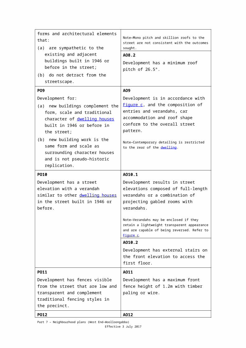
(a) are sympathetic to the existing and adjacent buildings built in 1946 or before in the street;
(b) do not detract from the streetscape.
Note—Mono pitch and skillion roofs to the street are not consistent with the outcomes sought.
AO8.2Development has a minimum roof pitch of 26.5°.
PO9Development for:
(a) new buildings complement the form, scale and traditional character of dwelling houses built in 1946 or before in the street;
(b) new building work is the same form and scale as surrounding character houses and is not pseudo-historic replication.
AO9Development is in accordance with Figure c, and the composition of entries and verandahs, car accommodation and roof shape conform to the overall street pattern.
Note—Contemporary detailing is restricted to the rear of the dwelling.
PO10Development has a street elevation with a verandah similar to other dwelling houses in the street built in 1946 or before.
AO10.1Development results in street elevations composed of full-length verandahs or a combination of projecting gabled rooms with verandahs.
Note—Verandahs may be enclosed if they retain a lightweight transparent appearance and are capable of being reversed. Refer to Figure c.
AO10.2Development has external stairs on the front elevation to access the first floor.
PO11Development has fences visible from the street that are low and transparent and complement traditional fencing styles in the precinct.
AO11Development has a maximum front fence height of 1.2m with timber paling or wire.
PO12Development of new buildings use lightweight materials that are sympathetic to other dwelling houses in the street built in 1946 or before.
AO12Development of new buildings use lightweight materials that are sympathetic to other dwelling houses in the street built in 1946 or before.
Note—Traditional materials are painted timber walls and corrugated metal roof sheeting.
PO13Development has parking that does not dominate the appearance and setting of the dwelling house when viewed from the street.
AO13.1Development on a site that does not have existing car parking does not require any new on-site car parking.
AO13.2Development has garages or carports that are not located between the front elevation and the front boundary, and are:
Part 7 – Neighbourhood plans (West End–Woolloongabba) Effective 3 July 2017
(a) located a minimum of 2m behind the building line;
(b) a maximum width of 3m.
AO13.3Development has other car parking that is single width only and is recessed 2m behind the building line.
Note—Refer to Figure b.
AO13.4Development has a maximum driveway crossover width of 3m.
If in the Mater Hill precinct (West End—Woolloongabba district neighbourhood plan/NPP-002), where in the Mater Hill a sub-precinct (West End—Woolloongabba district neighbourhood plan/NP-002a)
PO14Development is of a medium rise high-density form that provides a transition from the Mater Hospital to Vulture Street and maintains the predominance of the Mater Hospital.
AO14.1Development has a minimum site frontage of 25m.
AO14.2Development has a minimum site area of 1,000m2.
AO14.3Development has a maximum gross floor area of 200% of the site area.
AO14.4Development has a maximum building height of 6 storeys and 20m.
AO14.5Development has a minimum rear boundary setback of 6m.
PO15Development fronting Stanley Street:
(a) reflects the traditional commercial character of the street;
(b) provides vehicular access to sites on the southern side of Stanley Street only via Graham Street;
(c) comprises vehicular access that improves safety and alleviates traffic impacts;
(d) maintains an active street frontage.
AO15.1Development:
(a) is built to the street frontage;
(b) provides a 3 storey podium with levels above 12m set back 3m in accordance with Figure d;
(c) provides a continuous awning to the street.
AO15.2Development does not have vehicular access directly from Stanley Street.
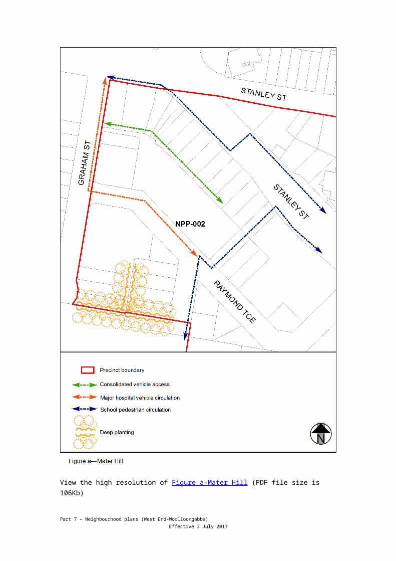
AO15.3Development consolidates vehicular access in accordance with vehicle routes in Figure a.
Part 7 – Neighbourhood plans (West End–Woolloongabba) Effective 3 July 2017
If in the Mater Hill precinct (West End—Woolloongabba district neighbourhood plan/NPP-002), where in the Mater Hill b sub-precinct (West End—Woolloongabba district NPP-002b)
PO16Development is of a medium rise, medium density residential form with building height limited to minimise overshadowing impacts to adjoining educational uses and maintain the predominance of the Mater Hospital.
AO16.1Development has a minimum site frontage of 20m.
AO16.2Development has a minimum site area of 800m2.
AO16.3Development has a maximum gross floor area of 200% of the site area.
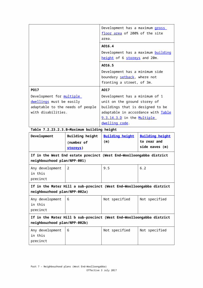
AO16.4Development has a maximum building height of 6 storeys and 20m.
AO16.5Development has a minimum side boundary setback, where not fronting a street, of 3m.
PO17Development for multiple dwellings must be easily adaptable to the needs of people with disabilities.
AO17Development has a minimum of 1 unit on the ground storey of buildings that is designed to be adaptable in accordance with Table 9.3.14.3.D in the Multiple dwelling code.
Table 7.2.23.2.3.B—Maximum building heightDevelopment Building height
(number of storeys)Building height (m) Building height to
rear and side eaves (m)
If in the West End estate precinct (West End—Woolloongabba district neighbourhood plan/NPP-001)
Any development in this precinct
2 9.5 6.2
If in the Mater Hill a sub-precinct (West End—Woolloongabba district neighbourhood plan/NPP-002a)
Any development in this precinct
6 Not specified Not specified
If in the Mater Hill b sub-precinct (West End—Woolloongabba district neighbourhood plan/NPP-002b)
Any development in this precinct
6 Not specified Not specified
Part 7 – Neighbourhood plans (West End–Woolloongabba) Effective 3 July 2017
View the high resolution of Figure a–Mater Hill (PDF file size is 106Kb)
Part 7 – Neighbourhood plans (West End–Woolloongabba) Effective 3 July 2017
Part 7 – Neighbourhood plans (West End–Woolloongabba) Effective 3 July 2017
Part 7 – Neighbourhood plans (West End–Woolloongabba) Effective 3 July 2017
View the high resolution of Figure e–Significant views (PDF file size is 450Kb)
Part 7 – Neighbourhood plans (West End–Woolloongabba) Effective 3 July 2017