Embed Size (px)
Citation preview
Former Thales Training and Simulation Land, Gatwick Road, Crawley Addendum Monitoring Report Surrey County Council
November 2014

Former Thales Training and Simulation Land, Gatwick Road, Crawley Addendum Monitoring Report
Atkins Former Thales Training and Simulation Land, Addendum Monitoring Report | Version
2.0 | November 2014 | 5128708
Notice
This document and its contents have been prepared and are intended solely for Surrey County Council’s information and use in relation to additional monitoring and assessment at the former Thales Training and Simulation Land at Gatwick Road, Crawley.
Atkins Limited (Atkins) assumes no responsibility to any other party in respect of or arising out of or in connection with this document and/or its contents.
Document history
Job number: 5128708 Document ref: 5128708/20140093/R002
Revision Purpose description Originated Checked Reviewed Authorised Date
Rev 1.0 Draft Report Dana Montgomery
Lauren Dombowsky
Robin Slade Jonathan Steeds
09 July 2014
Rev 2.0 Final Report Dana Montgomery
Lauren Dombowsky
Robin Slade Jonathan Steeds
05 November 2014
Client signoff
Client Surrey County Council
Project Former Thales Training and Simulation Land, Gatwick Road, Crawley
Document title Former Thales Training and Simulation Land, Addendum Monitoring Report
Job no. 5128708
Copy no.
Document reference
5128708/20140093/R002

Former Thales Training and Simulation Land, Gatwick Road, Crawley Addendum Monitoring Report
Atkins Former Thales Training and Simulation Land, Addendum Monitoring Report | Version
2.0 | November 2014 | 5128708
Table of contents
Chapter Pages
Glossary of Terms v
Executive Summary vi
1. Introduction 1 1.1. Background 1 1.2. Objectives 1 1.3. Assessment Scope and Report Structure 1 1.4. Study Limitations 2
2. Summary of the Atkins 2014 Ground Investigation 3
3. Background Information Review 4 3.1. Technical Note (Atkins, March 2014) 4 3.2. Additional Information 4
4. Additional Monitoring 5 4.1. Introduction 5 4.2. Methodology 5 4.3. Groundwater/Perched Water 6 4.4. Quality Assurance/Quality Control 7
5. Updated Controlled Waters Risk Assessment – Groundwater 8 5.1. Introduction 8 5.2. Methodology 8 5.3. Groundwater and Surface Water Results 9 5.4. Discussion 11
6. Updated Ground Gas Risk Assessment 13 6.1. Introduction 13 6.2. Methodology 13 6.3. Results 14 6.4. Discussion 15
7. Updated Conceptual Site Model 17
8. Conclusions and Recommendations 20 8.1. Conclusions 20 8.2. Recommendations 20
References 22
Figures 23
Appendices 24
Appendix A. Historical Information 25 A.1. Historical Plans 25 A.2. Historical Laboratory Results 26 A.3. Information from Demolition Contractor 27
Appendix B. Laboratory Results from Additional Monitoring 28
Appendix C. Monitoring Results 29 C.1. Groundwater Monitoring 29 C.2. Ground Gas Monitoring 30
Appendix D. Screening Spreadsheets 31

Former Thales Training and Simulation Land, Gatwick Road, Crawley Addendum Monitoring Report
Atkins Former Thales Training and Simulation Land, Addendum Monitoring Report | Version
2.0 | November 2014 | 5128708
D.1. Groundwater/Perched Water 31 D.2. Surface Water 32
Tables Table 4-1 Groundwater Monitoring ............................................................................................................ 6 Table 5-1 Groundwater Exceedances of the WQSs .................................................................................. 9 Table 5-2 Surface Water Exceedances of the WQS ............................................................................... 11 Table 6–1 Modified Wilson & Card Characteristic Situations ................................................................... 13 Table 6-2 Summary of Ground Gas Monitoring Results .......................................................................... 14 Table 6-3 Ground Gas Risk Assessment ................................................................................................. 15 Table 7-1 Updated Potential Pollutant Linkages (Controlled Waters and Ground Gas) ......................... 18
Figures Figure 1 Site Location Plan Figure 2 Site Investigation Plan (with Borehole Cross-Sections) Figure 3 Borehole Cross-Sections Figure 4 Site Investigation Plan Showing TCE/PCE Presence and Exceedances

Former Thales Training and Simulation Land, Gatwick Road, Crawley Addendum Monitoring Report
Atkins Former Thales Training and Simulation Land, Addendum Monitoring Report | Version
2.0 | November 2014 | 5128708
Glossary of Terms
Term Meaning/Definition
AOD above Ordnance Datum
Atkins Atkins Limited
bgl below ground level
BH borehole
BS British Standard
btc below top of casing (below the top of the standpipe)
BTEX benzene, toluene, ethylbenzene and xylene
CIRIA Construction Industry Research and Information Association
CLR Contaminated Land Report
CS Characteristic Situation
CSM conceptual site model
FFT Faithorn Farrell Timms LLP
GQRA generic quantitative risk assessment
GSV gas screening value
ha hectares
i2 i2 Analytical Limited
LOD limit of detection
OEL Occupational Exposure Limits
PAH polycyclic aromatic hydrocarbons
PCE tetrachloroethene
PPE personal protection equipment
PPL potential pollutant linkage
ppm parts per million
SCC Surrey County Council
sVOC semi-volatile organic compound
TCE trichloroethene
Thales Thales Group
TPH total petroleum hydrocarbons
UKAS United Kingdom Accreditation Service
VOC volatile organic compound
WQS water quality standards

Former Thales Training and Simulation Land, Gatwick Road, Crawley Addendum Monitoring Report
Atkins Former Thales Training and Simulation Land, Addendum Monitoring Report | Version
2.0 | November 2014 | 5128708
Executive Summary
Introduction Surrey County Council commissioned Atkins Limited via their agent Faithorn Farrell Timms LLP to undertake an intrusive land contamination ground investigation and subsequent generic quantitative risk assessment for a 4.15 hectare parcel of land located within Crawley, West Sussex formerly owned and operated by the Thales Group. A number of potential pollutant linkages (PPLs) were identified and additional groundwater, surface water and ground gas monitoring was recommended to refine the conceptual site model. This report presents the results of the additional monitoring undertaken from May to June 2014.
Additional Monitoring The additional groundwater, surface water and ground gas monitoring at the site was proposed to assess further the identified potential pollutant linkages related to controlled waters and ground gas generation. In particular the additional groundwater and surface water monitoring was aimed at establishing the presence of previously recorded chlorinated solvent contamination to help assess if a residual on-site source remains. The monitoring comprised:
Two rounds of groundwater monitoring and sampling from BH101, BH102, BH103, BH104 and historical locations BH2, BH4, BH6 and BH8. BH8 was previously unavailable during the ground investigation as it was flooded with surface water, which had ponded around the location, and a representative groundwater sample could not be taken. As a result of the drier weather since monitoring in early 2014 the borehole was found to be accessible and was monitored and sampled alongside the other monitoring locations;
Two rounds of surface water sampling from the adjacent Crawter’s Brook at locations upstream, midstream and downstream in relation to the site; and
Three rounds of ground gas monitoring from all boreholes listed above.
Controlled Waters A generic quantitative risk assessment was undertaken and Water Quality Standards (WQS) were selected. Exceedances of a number of WQS were noted across the site as a whole. A number of compounds were present above the WQS during the additional monitoring which were not identified during the previous works, including cadmium, copper, vinyl chloride and tetrachloromethane,
Tetrachloroethene (PCE) and trichloroethene (TCE) were recorded in a number of boreholes across the site with the highest concentrations in BH6. Concentrations of TCE were also encountered in the adjacent surface water feature down-gradient from the site, albeit in concentrations below the relevant WQS criteria. These results – with TCE present in the boreholes on site and in the down gradient surface water sample, along with PCE also present in a number of the boreholes – appear to indicate an on-site source of chlorinated solvent contamination. With the known historical electroplating works at the site and the associated effluent tank located in proximity to BH6, this could be a potential source of the chlorinated solvent contamination. The presence of vinyl chloride, a degradation product of PCE and TCE, may also be indicative of dechlorination of the solvents in the groundwater.
Ground Gas The additional monitoring provided further data in support of a Characteristic Situation (CS) 2 gas regime. CS2 implies ‘low risk’ from ground gas and requires gas protection measures amounting to two protection points for a commercial development. While gas screening values at the site are not generally elevated above the typical maximums for CS1, there were carbon dioxide concentrations recorded above trigger levels. The proposed building design will need to consider requirements for appropriate gas protection measures in line with the established gas regime.

Former Thales Training and Simulation Land, Gatwick Road, Crawley Addendum Monitoring Report
Atkins Former Thales Training and Simulation Land, Addendum Monitoring Report | Version
2.0 | November 2014 | 5128708
Recommendations Recommended initial further works are as follows. These works are aimed at establishing a more comprehensive dataset to ascertain whether a residual source of chlorinated solvent contamination remains on-site and if this is negatively impacting the adjacent Crawter’s Brook.
Additional sampling of Crawter’s Brook – an additional eight months of surface water monitoring is recommended through to February 2015, to obtain a calendar year’s worth of monitoring data. The sampling is recommended to be at a higher frequency during the remaining summer months, reducing to monthly through autumn and winter. This would be undertaken to build up a comprehensive dataset and to provide evidence with regards to potential impact to the adjacent water course which may be required by the regulatory authority (the Environment Agency) as part of the planning process for the site;
Soil vapour probe survey – in combination with the trial pitting below it is proposed that a soil vapour survey around BH6 and the former effluent tank is undertaken to ascertain whether there is an on-site residual source of chlorinated solvents. Should significant vapour concentrations be identified as a ‘spike’ in particular areas, this would indicate a potential on-site source and would help to focus further delineation, as required; and
Excavate additional shallow boreholes and a number of trial pits in the area around BH6 – depending on the findings of the initial soil vapour survey it is recommended that additional shallow boreholes and trial pits are advanced in the locations where the worst chlorinated solvent contamination is noted to delineate and/or assist with source removal. Should no source of contamination be encountered within this area, consideration should be given to installation of a further two to three boreholes along the site boundary in the eastern section (up-gradient) to determine if contamination is entering the site from an off-site source.
Based on the findings of the further ground gas monitoring and assessment, the proposed new office building design should include gas protection measures to address the confirmed Characteristic Situation 2 (low risk) ground gas regime. Such measures for an office development may include, for example, reinforced concrete cast in situ floor slab (suspended, non-suspended or raft with at least 1200 g DPM), beam and block or pre-cast concrete slab and minimum 2000 g DPM/reinforced gas membrane and/or underfloor venting.

Former Thales Training and Simulation Land, Gatwick Road, Crawley Addendum Monitoring Report
Atkins Former Thales Training and Simulation Land, Addendum Monitoring Report | Version
2.0 | November 2014 | 5128708 1
1. Introduction
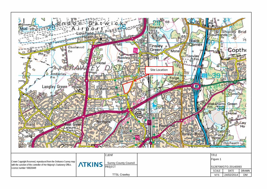
1.1. Background Atkins Limited (Atkins) was commissioned by Surrey County Council (SCC) via their agent Faithorn Farrell Timms LLP (FFT) to undertake an intrusive land contamination ground investigation and subsequent generic quantitative risk assessment (GQRA) for a 4.15 hectare (ha) parcel of land located within Crawley, West Sussex in early 2014 (see Figure 1 for a site location plan). The land parcel (herein referred to as ‘the site’) is located on Gatwick Road, to the north of the A2011, in Crawley, and was previously owned by the Thales Group (Thales) and was used by them as a training and simulation manufacturing facility. The previous ground investigation and risk assessment helped inform SCC’s decision to purchase the site from Thales in May 2014. It is understood the site is to be re-developed by SCC for office / commercial accommodation.
In order to carry out the land contamination risk assessment, Atkins utilised certain historical data for the site, supplied by SCC and Thales, including previous ground investigation data and findings, a land contamination risk assessment, various site inspection reports and additional chemical analyses, surveys and a demolition and site clearance report to support assessment of potential land contamination risks. The assessment focussed on human health and controlled waters (ground-/perched water and surface water) receptors. Additional data obtained during the 2014 ground investigation along with these historical data were used to form the basis of the GQRA for the site (Ref. 1).
This GQRA report identified a number of potential pollutant linkages (PPLs), including risks to human health, controlled waters, and property/services. Recommendations were made within the report, including additional groundwater, surface water, and ground gas monitoring to refine the conceptual site model and ascertain further the risks to controlled waters, human health and property from contaminants identified at the site. This addendum report provides the results of this additional monitoring and outlines any related changes to the previous risk assessment, including subsequent amendments to the recommendations made.
1.2. Objectives The principal objective of this report is to provide SCC with information regarding land contamination liabilities related to their ownership of the site, notably in terms of controlled waters/groundwater and ground gas at the site.
1.3. Assessment Scope and Report Structure The scope of works for this assessment was agreed in Atkins’ revised Offer of Services to Paul Smith of FFT (Ref. 2) and comprised the following key tasks. All works were undertaken in line with current guidance and legislation, following the UK risk-based, tiered approach to risk assessment of land contamination as outlined in Contaminated Land Report (CLR) 11 Model Procedures for the Management of Contaminated Land (Ref. 3).
Task 1: Background Information Review – collate and review background information for the site relating to the former solvent storage and use;
Task 2: Additional Monitoring – undertake additional groundwater monitoring and sampling, Crawter’s Brook sampling and ground gas monitoring; and
Task 3: Addendum Report – production of a concise addendum to our recent 2014 Ground Investigation report presenting the findings of the further monitoring.
The agreed scope did not include the production of a detailed remediation strategy. Task 1 was largely completed within a Technical Note (Ref. 4) issued to SSC in March 2014. This note outlined the additional information provided to Atkins by Thales after completion of the GQRA report, including additional information related to the historical storage and use of hazardous materials at the site while it was in operation. This information is outlined below; for the full details please refer to the Technical Note.

Former Thales Training and Simulation Land, Gatwick Road, Crawley Addendum Monitoring Report
Atkins Former Thales Training and Simulation Land, Addendum Monitoring Report | Version
2.0 | November 2014 | 5128708 2
This document represents Task 3 of the above and presents the findings of the other two tasks, particularly the additional monitoring (Task 2) as outlined above. The report contents are as follows:
Summary of previous Atkins investigation and findings – Chapter 2;
Summary of the background information review provided within the Technical Note and provision of any additional information gained during the addendum works – Chapter 3;
Presentation of the current monitoring methodology and results for groundwater levels– Chapter 4;
Comparison of groundwater and surface water data to relevant controlled waters assessment criteria – Chapter 5;
Ground gas assessment using both data collected during the recent Atkins ground investigation, historical data from previous assessments, and the additional monitoring under this scope – Chapter 6;
Presentation of an updated conceptual site model (CSM) based on the data assessments both within this report and the previous GQRA report and provision of remaining PPLs identified at the site – Chapter 7; and
Conclusions and recommendations – Chapter 8.
1.4. Study Limitations The assessment herein utilises historical data from a variety of sources. It is assumed these data are accurate and complete. Atkins accepts no liability with regards to these provided data.
It is noted that within the historical data a limited number of samples were analysed for semi-volatile organic compounds (SVOCs) or volatile organic compounds (VOCs). However, key contaminants benzene, toluene, ethylbenzene and xylene (BTEX) were included in a greater number of the analyses undertaken. Where historical data have been used, there may have been contaminants present which were not analysed.
The report draws upon data from intrusive investigation and monitoring of a relatively small proportion of the sub-surface conditions at the site. Inferences drawn from these assessments are subject to the inherent limitations of any such study.
This report should be read in light of the legislation, statutory requirements and/or industry good practice applicable at the time of the works being undertaken. Any subsequent changes in this legislation, guidance or design may necessitate the findings to be reassessed in the light of these circumstances.

Former Thales Training and Simulation Land, Gatwick Road, Crawley Addendum Monitoring Report
Atkins Former Thales Training and Simulation Land, Addendum Monitoring Report | Version
2.0 | November 2014 | 5128708 3
2. Summary of the Atkins 2014 Ground Investigation
Atkins completed a ground investigation and subsequent GQRA (Ref. 1) at Gatwick Road, Crawley in January and February 2014, designed to fill data gaps from the previous intrusive investigations undertaken at the site and to target potentially contaminative historical site uses such as storage tanks and electrical substations. This investigation included:
4 no. boreholes numbered BH101, BH102, BH103 and BH104 drilled and installed as dual groundwater and gas monitoring wells to a maximum depth of 8 m below ground level (bgl);
11 no. trial pits numbered TP101, TP102, TP103, TP104, TP105, TP105B, TP106, TP107, TP108, TP109 and TP110 excavated to a maximum depth of 2.7 m bgl;
One round of groundwater monitoring from contemporary and available historical boreholes;
Three rounds of ground gas monitoring of bulk gases (methane, carbon dioxide, carbon monoxide and oxygen), including flow rates, from all suitable boreholes across the site; and
One round of surface water monitoring from three locations along the adjacent Crawter’s Brook. A number of potentially significant PPLs were identified for the site based on the findings of the GQRA, including risks to controlled waters – most notably chlorinated solvents encountered within the groundwater during both historical and the 2014 monitoring and sampling, a low risk to property and services from ground gas generation, and risks to property and services from aggressive ground conditions. Asbestos was encountered in a number of the samples across the site within the Made Ground.
Additional monitoring and sampling of the groundwater at the site and the surface water in the adjacent Crawter’s Brook was recommended, along with review of any additional information about potential solvent storage historically undertaken at the site. Consultation with appropriate regulatory bodies was to be undertaken in an attempt to ascertain whether the condition of the groundwater at the site was a wider issue within the Gatwick Road area. In addition, supplementary rounds of gas monitoring were recommended in order to assess better the ground gas regime at the site. These additional works were then instructed in May 2014, the findings of which are found herein.

Former Thales Training and Simulation Land, Gatwick Road, Crawley Addendum Monitoring Report
Atkins Former Thales Training and Simulation Land, Addendum Monitoring Report | Version
2.0 | November 2014 | 5128708 4
3. Background Information Review
3.1. Technical Note (Atkins, March 2014) A review of additional information was undertaken within a Technical Note issued in March 2014 (Ref. 4). This comprised a review of plans of the former site, previously completed quantitative risk assessments, and additional groundwater and surface water monitoring results provided after the date of issue of the Atkins GQRA.
From the information provided the historical, potentially contaminative uses of the site during its operational phase by Thales were further clarified, which included a paint shop, hazardous materials storage, boiler house, machine shop, print room and manufacturing areas all historically present at the site. Notably on one of the drawings provided (Ref: DP-X CONTAM HIST), a number of areas around the site were identified as potential areas of contamination due to historical processes at the site, including a plextol (an acrylic resin) waste tank, traces of asbestos detected during demolition, an oil spill, oil contamination and storage tanks, paint shop, plating shop and plating effluent tank, machine shop, petrol tank and electrical transformers.
Historical groundwater and surface water sampling data provided by Thales indicated some concentrations of chlorinated solvents (notably tetrachloroethene (also known as tetrachloroethylene or PCE)) within one of the surface water samples (assumed to be upstream from the site based on the sample name). Both PCE and trichloroethene (also known as trichloroethylene or TCE) were present within historical groundwater samples from BH6 over a number of sampling events in 2011 and 2012.
The demolition company who undertook the demolition and clearance of the site in June to December 2010 indicated that one underground storage tank was removed during the works, and that there were no obvious signs of contamination in the surrounding soils after the excavation of this tank. All historical information utilised within this technical note is presented in Appendix A.
Electroplating, which appears to have been undertaken in the south western corner of the facility, can utilise chlorinated solvents such as PCE and TCE during the pre-treating and cleaning/degreasing stages of the process (Ref. 5) and notably could be present in waste storage, sumps and tanks. Given that BH6 – location of the historical PCE/TCE contamination within the groundwater – is in proximity to the historical electroplating shop and effluent tank, it was considered that this was a potential on-site source of chlorinated solvent contamination within the groundwater at the site.
3.2. Additional Information The Trading Standards department of West Sussex County Council was contacted to undertake a search of petroleum storage records at the site. This search (using the variable ‘Thales’) did not provide any historical records of petroleum storage at the site. However, it is known that petroleum storage was undertaken based on provided site plans and reports from the site.
Both West Sussex County Council and the Environment Agency were contacted to ascertain whether the chlorinated solvents encountered within the groundwater during the previous phase of works were indicative of a wider groundwater issue within the area of the site. West Sussex County Council referred the query to the Environment Agency and as of the date of this report no additional information has been received. Should any pertinent information be obtained after the date of this addendum report, this will be issued at that time along with any associated potential changes to any risk assessments therein.
Former Thales Training and Simulation Land, Gatwick Road, Crawley Addendum Monitoring Report
Atkins Former Thales Training and Simulation Land, Addendum Monitoring Report | Version
2.0 | November 2014 | 5128708 5
4. Additional Monitoring
4.1. Introduction The additional groundwater, surface water and ground gas monitoring at the site was proposed following the completion of the 2014 ground investigation to assess further the identified potentially significant PPLs related to controlled waters and ground gas generation. This monitoring was completed between May and June 2014 and comprised:
Two rounds of groundwater monitoring and sampling from BH101, BH102, BH103, BH104 and historical locations BH2, BH4, BH6 and BH8. BH8 was previously unavailable during the ground investigation as it was flooded with surface water, which had ponded around the location, and a representative groundwater sample could not be taken. As a result of the drier weather since monitoring in early 2014 the borehole was found to be accessible and was monitored and sampled alongside the other monitoring locations;
Two rounds of surface water sampling from the adjacent Crawter’s Brook at locations upstream, midstream and downstream in relation to the site; and
Three rounds of ground gas monitoring from all boreholes listed above. All works were completed by a suitably qualified Atkins environmental scientist and the methodology is presented in Section 4.2.
Sampling locations for the monitoring are shown on Figure 2.
4.2. Methodology The collection of groundwater and surface water samples during the monitoring works was undertaken using strict chain of custody protocols and samples were stored and transported to the testing laboratory, i2 Analytical (i2), a UKAS accredited laboratory, using dedicated couriers at approximately 4
oC. .
4.2.1. Groundwater Level Monitoring and Sampling Groundwater levels were monitored at the site on 20
th/21
st May 2014 and 4
th/5
th June 2014 alongside
collection of groundwater samples. Prior to sampling, all wells were purged of groundwater using an electric Whale Super Purger
TM submersible pump in order to gain representative groundwater samples.
The groundwater samples were submitted to i2 for analysis of the following:
Inorganic parameters: pH, total sulphate, electrical conductivity, ammonia as NH4;
Metals / metalloids: arsenic, boron, chromium, copper, lead, selenium, zinc, cadmium, mercury and nickel;
Chlorinated solvents, including PCE and TCE; and
Total organic carbon.
Groundwater analytical results are presented in Appendix B and groundwater monitoring data are included in Appendix C.
4.2.2. Surface Water Sampling Surface water sampling from Crawter’s Brook – located adjacent to the western boundary of the site – was undertaken on 20
th May 2014 and 5
th June 2014. One sample was taken from each of the upstream and
downstream (in relation to the site) locations as well as one adjacent to the middle of the site boundary.
The surface water samples were submitted for the same analysis as the groundwater samples, seen above in Section 4.2.1.
Former Thales Training and Simulation Land, Gatwick Road, Crawley Addendum Monitoring Report
Atkins Former Thales Training and Simulation Land, Addendum Monitoring Report | Version
2.0 | November 2014 | 5128708 6
4.2.3. Ground Gas Monitoring Ground gas conditions within all accessible boreholes were monitored using a discrete periodic (spot) monitoring technique, on 20
th May 2014, 5
th June 2014 and 20
th June 2014, with a total of six rounds
completed between both the previous works and these additional monitoring works. Monitoring was undertaken, where possible, during periods of low or decreasing atmospheric pressure within the constraints of the works programme. Gases measured included methane, carbon dioxide, oxygen, carbon monoxide, hydrogen sulphide, and the monitoring included borehole flow rate.
As BH8 was waterlogged during the previous phase of works but during the drier summer months was suitable for monitoring, a gas bung was installed on 20
th May and the borehole was subsequently monitored.
Gas monitoring data are presented in Appendix C.
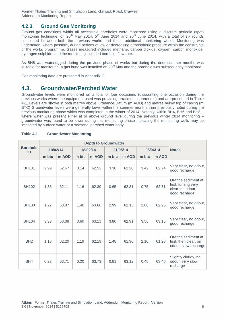
4.3. Groundwater/Perched Water Groundwater levels were monitored on a total of four occasions (discounting one occasion during the previous works where the equipment used was providing erratic measurements) and are presented in Table 4-1. Levels are shown in both metres above Ordnance Datum (m AOD) and metres below top of casing (m BTC) Groundwater levels were generally lower within the summer months than previously noted during the previous monitoring phase which was completed in the winter of 2014. Notably, within BH4, BH6 and BH8 – where water was present either at or above ground level during the previous winter 2014 monitoring – groundwater was found to be lower during this monitoring phase indicating the monitoring wells may be impacted by surface water or a seasonal perched water body.
Table 4-1 Groundwater Monitoring
Borehole ID
Depth to Groundwater
Notes 10/02/14 18/02/14 21/05/14 05/06/14
m btc m AOD m btc m AOD m btc m AOD m btc m AOD
BH101 2.99 62.67 3.14 62.52 3.38 62.28 3.42 62.24 Very clear, no odour, good recharge
BH102 1.35 62.11 1.16 62.30 0.65 62.81 0.75 62.71
Orange sediment at first, turning very clear, no odour, good recharge
BH103 1.27 63.87 1.46 63.68 2.99 62.15 2.88 62.26 Very clear, no odour, good recharge
BH104 3.33 63.38 3.60 63.11 3.80 62.91 3.56 63.15 Very clear, no odour, good recharge
BH2 1.18 62.20 1.19 62.19 1.48 61.90 2.10 61.28 Orange sediment at first, then clear, on odour, slow recharge
BH4 0.22 63.71 0.20 63.73 0.81 63.12 0.48 63.45 Slightly cloudy, no odour, very slow recharge

Former Thales Training and Simulation Land, Gatwick Road, Crawley Addendum Monitoring Report
Atkins Former Thales Training and Simulation Land, Addendum Monitoring Report | Version
2.0 | November 2014 | 5128708 7
Borehole ID
Depth to Groundwater
Notes 10/02/14 18/02/14 21/05/14 05/06/14
m btc m AOD m btc m AOD m btc m AOD m btc m AOD
BH6 0.03 65.31 0.04 65.30 1.41 63.93 1.14 64.20 Impacted by surface water during previous monitoring
BH8 - - - - 1.16 63.19 0.94 63.41 Borehole waterlogged during previous monitoring
The changing water levels between the winter 2014 monitoring phase and the additional monitoring within BH102 and BH103 are unexpected; within BH102 as water levels rose despite significantly drier conditions, and within BH103 while it was initially considered potentially to be perched water, current water levels indicate groundwater. In addition, the groundwater levels in BH8 are not consistent with those in BH101 and BH103, and would appear also to indicate perched water. Based on the groundwater levels in the boreholes, in the trial pits undertaken during the 2014 investigation, and on local topography, it is likely that there is a discontinuous perched water body at the site, potentially related to the buildings and tanks formerly located at the site. A selection of borehole cross-sections was created for the site and can be seen in Figures 2 and 3.
From the monitoring it appears general groundwater flow is in a north-westerly direction, towards the adjacent Crawter’s Brook and in the direction of flow of the brook. However, flow within the shallower discontinuous perched water body is variable with a mound recorded in BH6 and BH8. Groundwater elevations were lowest in BH2 within the south western section of the site.
4.4. Quality Assurance/Quality Control
4.4.1. Field Blanks A field blank water sample was analysed during both of the groundwater monitoring rounds. The field blank generally showed either the lowest concentrations across all samples of the constituents analysed, or were below the limit of detection. However, across both blanks low concentrations of chlorinated solvents were encountered in the laboratory results. The laboratory was consulted and the same deionised water was used for both blanks and may have had trace concentrations of chlorinated solvents. PCE was not detected above the MDL in the blanks; however TCE was detected in the blank within one of the additional monitoring rounds. In any further works, it should be requested that the laboratory uses previously unopened deionised water to eliminate any concerns regarding laboratory contamination with chlorinated solvents. It is not considered likely to be due to methods on site as all due care was taken to ensure the field blank was collected in an appropriate manner.
4.4.2. Duplicate Analysis Duplicate samples were collected during the surface water and groundwater monitoring rounds. The analytical results showed good correlation between the sample and the duplicate and comparison of the results from both to the applicable assessment criteria have the same result.

Former Thales Training and Simulation Land, Gatwick Road, Crawley Addendum Monitoring Report
Atkins Former Thales Training and Simulation Land, Addendum Monitoring Report | Version
2.0 | November 2014 | 5128708 8
5. Updated Controlled Waters Risk Assessment – Groundwater
5.1. Introduction The controlled waters assessment, including both data from the previous phase of works and this additional monitoring, has been designed to assess the potential risks posed to the identified controlled waters receptors from the migration of contaminants from identified potential on-site sources.
An assessment of historical groundwater and surface water results is available within the previous phase of works (Ref. 1); in summary, there were exceedances above the Water Quality Standards (WQS) for a number of polyaromatic hydrocarbons (PAHs), copper, nickel, and notably PCE and TCE within BH6. These chlorinated solvents were also found in BH6 across a number of rounds of monitoring from 2009 to 2012 (Ref. 4).
5.2. Methodology To assess potential risks to the identified controlled waters receptors a comparison of soil-derived leachate, groundwater and surface water concentrations against pertinent WQSs has been undertaken. The screening criteria for controlled waters assessment are dependent on the nature of the principal receptor. The nearest surface water body is Crawter’s Brook, located adjacent to the western boundary of the site. The general groundwater flow is considered to be in this direction based on survey data; however, it appears there may also be a discontinuous perched water body present at the site. The majority of the site is situated above unproductive strata unlikely to support significant aquifers for drinking water supply. Therefore, surface water is considered the key controlled waters receptor and the surface water and groundwater data were screened against the following criteria in order of preference (where the first is unavailable, the next source on the list was utilised):
UK Standards for the Protection of Surface Water Quality (Water Framework Directive);
UK Statutory Environmental Quality Standards for the Protection of Aquatic Life (Surface Water);
UK Non-statutory Environmental Quality Standards for the Protection of Aquatic Life (Surface Water);
UK Standards for the Protection of Fisheries (Freshwater);
UK/EU Standards for the Protection of Surface Waters Intended for the Abstraction of Drinking Water; and
UK Standard for Ensuring the Quality of Drinking Water Intended for Human Consumption (only when no surface water standard available and used for indicative screening purposes).
For certain standards the hardness of the water needs to be taken into account to select the appropriate criteria. The Southern Water website was consulted (Ref. 6) to determine water hardness in the area of the site and the hardness was given as ‘Medium’, which equates to approximately 117.5 mg/l CaCO3; this value was used for the selection of the WQS where needed.
While there are no WQS for a number of the specific PAH compounds, the value for naphthalene – as one of the more toxic PAH compounds – was used as a marker value in this assessment.
There are no WQS for individual total petroleum hydrocarbon (TPH) bands within the CWG. For the aromatic fractions, benzene, toluene and ethylbenzene guideline values have been used for the C5-C7, C7-C8 and C8-C10 bands, respectively.
Screening spreadsheets are presented in Appendix D.
Former Thales Training and Simulation Land, Gatwick Road, Crawley Addendum Monitoring Report
Atkins Former Thales Training and Simulation Land, Addendum Monitoring Report | Version
2.0 | November 2014 | 5128708 9
5.3. Groundwater and Surface Water Results
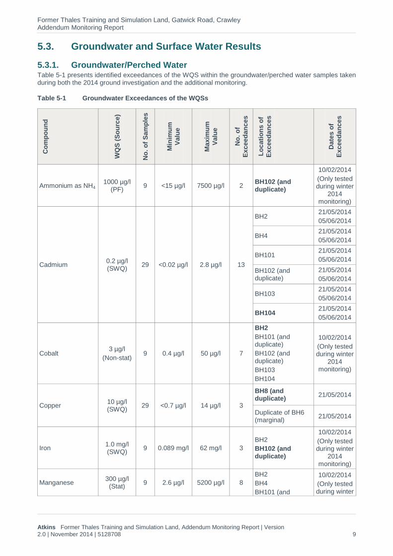
5.3.1. Groundwater/Perched Water Table 5-1 presents identified exceedances of the WQS within the groundwater/perched water samples taken during both the 2014 ground investigation and the additional monitoring.
Table 5-1 Groundwater Exceedances of the WQSs
Co
mp
ou
nd
WQ
S (
So
urc
e)
No
. o
f S
am
ple
s
Min
imu
m
Valu
e
Maxim
um
Valu
e
No
. o
f
Exc
eed
an
ces
Lo
cati
on
s o
f
Exc
eed
an
ces
Date
s o
f
Exc
eed
an
ces
Ammonium as NH4 1000 µg/l
(PF) 9 <15 µg/l 7500 µg/l 2
BH102 (and duplicate)
10/02/2014
(Only tested during winter
2014 monitoring)
Cadmium 0.2 µg/l (SWQ)
29 <0.02 µg/l 2.8 µg/l 13
BH2 21/05/2014
05/06/2014
BH4 21/05/2014
05/06/2014
BH101 21/05/2014
05/06/2014
BH102 (and duplicate)
21/05/2014
05/06/2014
BH103 21/05/2014
05/06/2014
BH104 21/05/2014
05/06/2014
Cobalt 3 µg/l
(Non-stat) 9 0.4 µg/l 50 µg/l 7
BH2
BH101 (and duplicate)
BH102 (and duplicate)
BH103
BH104
10/02/2014
(Only tested during winter
2014 monitoring)
Copper 10 µg/l (SWQ)
29 <0.7 µg/l 14 µg/l 3
BH8 (and duplicate)
21/05/2014
Duplicate of BH6 (marginal)
21/05/2014
Iron 1.0 mg/l (SWQ)
9 0.089 mg/l 62 mg/l 3
BH2
BH102 (and duplicate)
10/02/2014
(Only tested during winter
2014 monitoring)
Manganese 300 µg/l (Stat)
9 2.6 µg/l 5200 µg/l 8
BH2
BH4
BH101 (and
10/02/2014
(Only tested during winter

Former Thales Training and Simulation Land, Gatwick Road, Crawley Addendum Monitoring Report
Atkins Former Thales Training and Simulation Land, Addendum Monitoring Report | Version
2.0 | November 2014 | 5128708 10
Co
mp
ou
nd
WQ
S (
So
urc
e)
No
. o
f S
am
ple
s
Min
imu
m
Valu
e
Maxim
um
Valu
e
No
. o
f
Exc
eed
an
ces
Lo
cati
on
s o
f
Exc
eed
an
ces
Date
s o
f
Exc
eed
an
ces
duplicate)
BH102 (and duplicate)
BH103
BH104
2014 monitoring)
Nickel 20 µg/l (SWQ)
29 0.6 µg/l 120 µg/l 17
BH2
10/02/2014
21/05/2014
05/06/2014
BH4 21/05/2014
BH101 (and duplicate)
10/02/2014
21/05/2014
05/06/2014
BH102 (and duplicate)
10/02/2014
21/05/2014
05/06/2014
BH103
10/02/2014
21/05/2014
05/06/2014
BH104
10/02/2014
21/05/2014
05/06/2014
Tetrachloroethene (PCE)
10 µg/l (SWQ)
29 <1.0 µg/l 180 µg/l 11
BH6 (and duplicate)
21/05/2014
05/06/2014
BH102 (and duplicate)
10/02/2014
21/05/2014
05/06/2014
BH103 21/05/2014
05/06/2014
Trichloroethene (TCE)
10 µg/l (SWQ)
29 <1.0 µg/l 52.1 µg/l 4 BH6 (and duplicate)
21/05/2014
05/06/2014
Trichloromethane 2.5 µg/l (SWQ)
29 <1.0 µg/l 18.7 1 BH104 21/05/2014
Vinyl chloride 0.5 µg/l (DWS)
29 <1.0 µg/l 2.5 1 BH102 21/05/2014
Notes: BOLD indicates the maximum exceedance Source abbreviations: SWQ - UK Standards for the Protection of Surface Water Quality (Water Framework Directive)
SWQn – UK Standards for the Protection of Surface Water Quality (Water Framework Directive) for naphthalene SWQbk – half of the UK Standard for the Protection of Surface Water Quality (Water Framework Directive) for benzo(b)fluoranthene and benzo(k)fluoranthene of 0.03 µg/l PF – UK Standards for the Protection of Fisheries (Freshwater) Stat – UK Statutory WQSs for the Protection of Aquatic Life (Surface Water) Non-stat – UK Non- Statutory WQSs for the Protection of Aquatic Life (Surface Water)
Exceedances of a number of WQS were noted across the site as a whole, especially when compared to results from the ground investigation undertaken in early 2014, as during the summer, monitored water

Former Thales Training and Simulation Land, Gatwick Road, Crawley Addendum Monitoring Report
Atkins Former Thales Training and Simulation Land, Addendum Monitoring Report | Version
2.0 | November 2014 | 5128708 11
levels were lower and it is considered that more representative samples were obtained from the historical boreholes located at the site as these were not impacted by ponding surface water. In summary, BH102 recorded the highest number of maximum exceedances, BH6 recorded both PCE and TCE concentrations during both summer monitoring rounds and BH104 recorded the highest number of compounds with concentrations exceeding the relevant screening criteria. Exceedances were generally an order of magnitude higher than the WQS values.
5.3.2. Surface Water Table 5-2 presents the identified exceedances of the WQSs within the surface water samples collected as part of the 2014 ground investigation and the more recent additional monitoring. Samples were taken from up- and down-hydraulic gradient, as well as mid-stream, located approximately equidistant between the up- and downstream samples.
Table 5-2 Surface Water Exceedances of the WQS
Co
mp
ou
nd
WQ
S (
So
urc
e)
No
. o
f
Sam
ple
s
Min
imu
m
Valu
e
Maxim
um
Valu
e
No
. o
f
Exc
eed
an
ces
Lo
cati
on
s o
f
Exc
eed
an
ces
Copper 10 µg/l (SWQ)
12 6.8 µg/l 17 µg/l 5
SW-US (and duplicate)
SW-MS
SW-DS
Notes: BOLD indicates the maximum exceedance Source abbreviations: SWQ - UK Standards for the Protection of Surface Water Quality (Water Framework Directive)
Whilst there are exceedances of the WQS within the surface water from Crawter’s Brook for copper, it is not considered indicative of significant copper contamination as the exceedances were relatively marginal. In addition, the concentrations were highest within the upstream sample, also indicating a potential off-site source or general presence of dissolved copper within the wider Manor Royal Industrial Park area. The WQS selected for copper are for the annual average and the values are dependent on the hardness. The 95 % percentile WQS for copper is 40 µg/l.
In addition, it should be noted that concentrations of TCE were encountered in the surface water sample taken from the downstream location during both monitoring rounds undertaken during the summer of 2014 with concentrations ranging between 3.5 µg/l – 3.6 µg/l but did not exceed the WQS
5.4. Discussion It is considered that the monitoring and sampling undertaken during these additional summer 2014 works obtained more representative data than the groundwater monitoring completed during the ground investigation works in early 2014. This was due to the historical boreholes – some of which had historically shown exceedances though the data weren’t available for inclusion within the 2014 GQRA – likely being impacted by ponded surface water at the site. Notably BH8 was unavailable to be monitored during the 2014 ground investigation phase but was clear of surface water in the summer months, and the surface water ponded around the installation of BH6 was also no longer present.
In addition, a number of compounds were present above the WQS during the additional monitoring which were not identified during the previous works, including cadmium, copper, vinyl chloride and tetrachloromethane. While a number of these compounds were present in the groundwater at the site only copper was recorded as exceeding the guideline criteria within the surface water samples taken from the adjacent Crawter’s Brook. However the copper exceedances were not considered significant in terms of the site as it was identified in all samples including those collected from a location upgradient of the site, with this latter point recording the highest concentrations of copper. As such, the findings do not indicate a likely on-site source of copper contamination.

Former Thales Training and Simulation Land, Gatwick Road, Crawley Addendum Monitoring Report
Atkins Former Thales Training and Simulation Land, Addendum Monitoring Report | Version
2.0 | November 2014 | 5128708 12
PCE was recorded above the WQS in BH102 in all three monitoring rounds and in BH103 and BH6 in the two current monitoring rounds. TCE was recorded above the WQS in both current monitoring rounds within BH6, which is in line with the findings of historical monitoring within this borehole. BH6 showed the highest concentrations of TCE/PCE, with BH102 – considered potentially to be down gradient of BH6 – showing lower concentrations. Vinyl chloride, a degradation product of PCE / TCE, was also identified in the down-gradient location BH102 which indicates dechlorination of the solvents may be occurring on site.
Concentrations of TCE were also encountered in the surface water adjacent to the site, albeit in concentrations below the relevant WQS criteria. It was present at concentrations between 3.5 – 3.6 µg/l during both monitoring rounds in the surface water sample taken from the down gradient location from the site compared to a WQS of 10 µg/l. The brook was significantly lower in flow during the additional monitoring than during the monitoring undertaken earlier in the year, and therefore these samples are again likely to be more representative of the general surface water conditions with less seasonal dilution of potential contaminants. Refer to Figure 4 for a representation of PCE/TCE presence and exceedances within the groundwater and surface water samples from the site.
These results – with TCE present in the boreholes on site and in the down gradient surface water sample, along with PCE also present in a number of the boreholes – appear likely to indicate an on-site source of chlorinated solvent contamination. With the known historical electroplating works at the site and the associated effluent tank located in proximity to BH6 on the plans provided for review, this could be a potential source of the chlorinated solvent contamination. No details regarding the decommissioning of this tank was provided to Atkins, and it is not known whether it was above or below ground.
The limits of detection (LOD) for mercury and total cyanide are above the WQS values for these compounds. However, as none were detected above the LOD within groundwater samples, it is considered unlikely that these compounds are present in significant concentrations within the water environment at the site. The LOD for vinyl chloride changed between monitoring rounds based on laboratory analysis results, and there was one exceedance of the WQS in later rounds, while in the earlier monitoring rounds the LOD was above the WQS, as with mercury and total cyanide.

Former Thales Training and Simulation Land, Gatwick Road, Crawley Addendum Monitoring Report
Atkins Former Thales Training and Simulation Land, Addendum Monitoring Report | Version
2.0 | November 2014 | 5128708 13
6. Updated Ground Gas Risk Assessment
6.1. Introduction Guidance within CIRIA Report C665 (Ref. 7) and the Ground Gas Handbook (Ref. 8) has been used to provide an updated assessment of the ground gas regime at the site. CIRIA C665 considers two scenarios (Situation A and B); Situation A (modified Wilson & Card) is appropriate to high rise housing and housing with ground bearing slabs or rafts while Situation B (the NHBC ‘traffic light’ system) assumes a low rise housing development. Based on the proposed development for the site, the assessment approach outlined by Situation A, developed by Wilson & Card and incorporated into CIRIA C665, has been adopted. This approach uses gas screening values (GSVs) and maximum gas concentrations in order to classify a site’s gas regime in terms of potential risks to users/residents from gas generation.
6.2. Methodology The modified Wilson & Card methodology considers both concentrations of methane and carbon dioxide to generate GSVs for the site. These GSVs can then be used to assess the risk posed to proposed users/residents by gassing sites. To calculate the GSV, the following equation is used:
GSV (l/hr of gas) = borehole flow rate (l/hr) x gas concentration (%)
Using the GSVs and the maximum borehole concentrations, each borehole has been assessed in terms of recommended building protection measures appropriate for mitigating potential gas risk.
The modified Wilson & Card characteristic situations are shown below in Table 6–1:
Table 6–1 Modified Wilson & Card Characteristic Situations
Characteristic Situation
(CIRIA R149)
(Ref. 9)
Risk Classification
GSV
(CH4 or CO2)
(l/hr)
Additional Factors Typical Source of Generation
1 Very low <0.07
Typically CH4 ≤ 1% and/or CO2 ≤ 5%
Otherwise, consider increase to Situation 2
Natural soils with low organic content; ‘typical’ Made Ground
2 Low 0.07-0.7
Borehole flow rate not to exceed 70 l/hr.
Otherwise, consider increase to Situation 3
Natural soil, high peat/organic content; ‘typical’ Made Ground
3 Moderate 0.7-3.5 - Old landfill, inert waste; flooded mine working
4 Moderate to
high 3.5-15
Quantitative risk assessment required to evaluate scope of protective measures
Mine working susceptible to flooding; completed landfill
5 High 15-70 -
Unflooded, inactive shallow mine working
6 Very high >70 - Recent landfill
Former Thales Training and Simulation Land, Gatwick Road, Crawley Addendum Monitoring Report
Atkins Former Thales Training and Simulation Land, Addendum Monitoring Report | Version
2.0 | November 2014 | 5128708 14
Most of the environmental benchmarks available in risk assessment for the release to air of hydrogen sulphide and carbon monoxide are based on occupational exposure data (occupational exposure limits). Although this does not directly relate to the applicable human health receptor for this assessment, Occupational Exposure Limits (OELs) have been used in the first instance as a qualitative measure where concentrations of hydrogen sulphide and carbon monoxide are above zero (Ref. 10).
6.2.1. Generation of Gas Screening Values In accordance with the guidance, the GSVs have been calculated as follows:
Methane GSV: Calculated using the initial (peak) concentration of methane because the worst possible consequence of methane build-up is an instantaneous explosion, with the potential for considerable loss of life and property, which could occur at any time.
Carbon dioxide GSV: Calculated using the steady state concentration of carbon dioxide because, although the worst possible consequences of carbon dioxide build up is death, the event would require exposure over an extended period compared to an instantaneous methane explosion. As a result, the event could be more easily mitigated against by the actions of an affected person(s) – for example, by increasing ventilation within the space if they felt drowsy or nauseous.
The GSVs for the site have been calculated for each individual borehole using discrete spot monitoring undertaken from the boreholes completed during the historical and 2014 assessment and monitoring.
6.2.2. Field Methodology Spot monitoring of gas concentrations and flow was carried out on a total of six occasions for all available boreholes using an infra-red gas analyser (GA2000), and included borehole flow rate measurements. Monitoring was attempted during periods of falling pressure, and depth to groundwater was measured during a number of the monitoring rounds. Historical results from the 2008 site investigation are also included within this assessment.
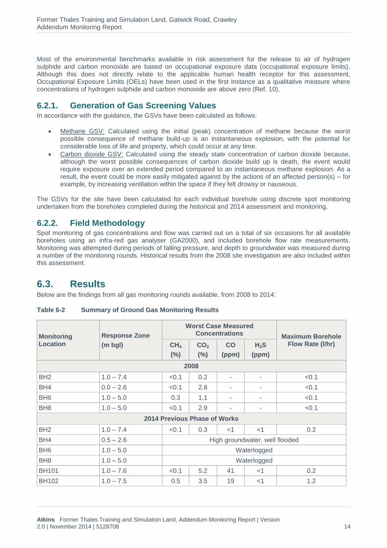
6.3. Results Below are the findings from all gas monitoring rounds available, from 2008 to 2014:
Table 6-2 Summary of Ground Gas Monitoring Results
Monitoring Location
Response Zone
(m bgl)
Worst Case Measured Concentrations
Maximum Borehole Flow Rate (l/hr) CH4
(%)
CO2
(%)
CO
(ppm)
H2S
(ppm)
2008
BH2 1.0 – 7.4 <0.1 0.2 - - <0.1
BH4 0.0 – 2.6 <0.1 2.8 - - <0.1
BH6 1.0 – 5.0 0.3 1.1 - - <0.1
BH8 1.0 – 5.0 <0.1 2.9 - - <0.1
2014 Previous Phase of Works
BH2 1.0 – 7.4 <0.1 0.3 <1 <1 0.2
BH4 0.5 – 2.6 High groundwater, well flooded
BH6 1.0 – 5.0 Waterlogged
BH8 1.0 – 5.0 Waterlogged
BH101 1.0 – 7.6 <0.1 5.2 41 <1 0.2
BH102 1.0 – 7.5 0.5 3.5 19 <1 1.2

Former Thales Training and Simulation Land, Gatwick Road, Crawley Addendum Monitoring Report
Atkins Former Thales Training and Simulation Land, Addendum Monitoring Report | Version
2.0 | November 2014 | 5128708 15
BH103 1.0 – 7.0 <0.1 1.0 49 <1 4.3
BH104 1.0 – 7.9 <0.1 3.4 2 <1 <0.1
2014 Additional Monitoring
BH2 1.0 – 7.4 <0.1 <0.1 3 <1 <0.1
BH4 0.5 – 2.6 <0.1 1.1 8 <1 <0.1
BH6 1.0 – 5.0 0.1 3.6 1 <1 <0.1
BH8 1.0 – 5.0 0.1 <0.1 <1 <1 <0.1
BH101 1.0 – 7.6 <0.1 6.9 5 <1 <0.1
BH102 1.0 – 7.5 0.2 0.3 6 <1 0.1
BH103 1.0 – 7.0 0.1 2.2 8 <1 <0.1
BH104 1.0 – 7.9 <0.1 9.0 3 <1 0.1
Note: The accuracy of the GA2000 infra-red gas analyser at these concentrations is; ±0.2 % for methane and ±0.1 % for carbon dioxide. For the GA5000 the accuracy for both methane and carbon dioxide is ±0.5 %.
Appendix C.2 provides the spot monitoring data.
The second round of monitoring undertaken in February was during a period of low pressure (991 mbar) and the fourth round undertaken in May was during a period of falling pressure (1001 to 1000 m bar during the time on site) and therefore the readings are considered representative of a variety of site conditions.
Flow rates were negligible across all monitoring rounds except within BH103 and BH102 during the previous phase of works.
Carbon monoxide was found in the majority of the boreholes up to a maximum of 41 parts per million (ppm) in BH101 during the first monitoring round on 7
th February 2014. In general, carbon monoxide concentrations
tapered off both during the monitoring round itself and between discrete monitoring rounds within each borehole to a maximum of 8 ppm during the additional 2014 monitoring.
Methane was encountered in very low concentrations, and carbon dioxide was recorded in concentrations between 0.3 % - 9.0 % in BH104. This borehole and BH101 showed concentrations above 5 % CO2 across the various monitoring rounds.
6.4. Discussion A summary of the modified Wilson and Card gas risk assessment is given below in Table 6-3.
Table 6-3 Ground Gas Risk Assessment
Monitoring Location
Worst Case Measured Concentrations (%)
Maximum Borehole Flow
Rate (l/hr)
Maximum Calculated GSV
(l/hr)
Applicable Characteristic Situation (CS) CH4 CO2
BH2 <0.1 0.3 0.2 0.0006 CS1
BH4 <0.1 2.8 <0.1 0.0028 CS1
BH6 0.3 3.6 <0.1 0.0036 CS1
BH8 0.1 2.9 0.1 0.0029 CS1
BH101 <0.1 6.9 0.2 0.0138 CS2
BH102 0.5 3.5 1.2 0.0420 CS1
BH103 0.1 2.2 4.3 0.0946 CS2
BH104 <0.1 9.0 0.1 0.0090 CS2

Former Thales Training and Simulation Land, Gatwick Road, Crawley Addendum Monitoring Report
Atkins Former Thales Training and Simulation Land, Addendum Monitoring Report | Version
2.0 | November 2014 | 5128708 16
The available data show a worst-case GSV of 0.0946 l/hr for BH103 – a ‘low risk’ at CS2. The concentrations of carbon dioxide in BH101 and BH104 were above the trigger level of 5 % for elevation to CS2 and as such the gas regime of CS2, or ‘low risk’, is assumed as this represents the worst case classification.
A CS2 gas regime requires gas protection measures amounting to two protection points for a commercial development or one protection point for an industrial development based on British Standard BS8485 (Ref. 11). The monitoring results support this assessment in that while gas levels at the site are not generally elevated above the typical maximums for CS1, there were carbon dioxide levels above trigger levels. The proposed building design will need to consider requirements for appropriate gas protection measures in line with the established gas regime.
Carbon monoxide was present in BH101 and BH103 over the OEL of 30 ppm for long-term exposure during the first monitoring round only, and tapered off as monitoring continued into 2014. It is therefore not considered to be indicative of a continuous source of carbon monoxide at the site.

Former Thales Training and Simulation Land, Gatwick Road, Crawley Addendum Monitoring Report
Atkins Former Thales Training and Simulation Land, Addendum Monitoring Report | Version
2.0 | November 2014 | 5128708 17
7. Updated Conceptual Site Model
The relevant controlled waters and ground gas related PPLs identified in the recent intrusive ground investigation and GQRA (Ref. 1) have been updated based on the results of the additional monitoring and the subsequent CSM is presented below in Table 7-1. Those PPLs discounted in the GQRA are not included here. PPLs which remain unchanged are not included herein, please refer to the intrusive ground investigation and GQRA (Ref. 1).
The updated controlled waters risk assessment identified a number of PPLs. There were exceedances of the WQS within the groundwater samples taken from the site, including in particular for PCE and TCE, with some TCE noted within the down gradient sample from the adjacent surface water body.
The ground gas risk assessment, which included six rounds of spot monitoring, allowed GSVs to be calculated for all boreholes monitored using methane and carbon dioxide concentrations. The GSVs and gas concentrations encountered are consistent with a CS2 or ‘low risk’ classification for the site.

Former Thales Training and Simulation Land, Gatwick Road, Crawley Addendum Monitoring Report
Atkins Former Thales Training and Simulation Land, Addendum Monitoring Report | Version 2.0 | November 2014 | 5128708 18
Table 7-1 Updated Potential Pollutant Linkages (Controlled Waters and Ground Gas)
Source Receptor Pathway Description
Category Description Category Description
Made Ground
Made Ground present across the majority of the site
Human health
Construction personnel on-site during any future redevelopment works
Migration of ground gas along preferential pathways and built up in confined/enclosed spaces resulting in build-up of toxic or explosive gases, or displacement of oxygen leading to asphyxiation
Site is classified as CS2, or ‘low risk’ ground gas regime. Applicable risk assessments and appropriate personal protective equipment (PPE) would be considered likely to mitigate any risks.
Former use of the site, including underground storage tanks and electrical substations
The site was previously used as a factory for the production of flight simulators. It included a number of tanks and substations located at the site.
Future office/industrial workers and visitors present at the site following redevelopment
Migration of ground gas along preferential pathways and built up in confined/enclosed spaces resulting in build-up of toxic or explosive gases, or displacement of oxygen leading to asphyxiation
Site is classified as CS2, indicating a ‘low risk’ ground gas regime. This indicates that some gas protection measures will be required for the buildings to be developed on site – these are likely to be incorporated into building design
Groundwater/ perched water
Groundwater/perched water situated below the site
Leaching/migration PCE/ TCE contamination was noted within the groundwater/perched water below the site in BH102, BH103 and BH6. While this contamination was not noted within the soils during either the current or historical assessments, it is possible that an on-site source is present as a result of the historical use and storage of chlorinated solvents. As more representative samples were able to be taken during the additional monitoring works along with the presence of a historical electroplating effluent tank at the site in proximity to BH6 noted on historical site plans, it is considered this is potentially a source of chlorinated solvent contamination at the site.
Alluvium Ground gas arising from Alluvium beneath the site
Human health Construction personnel on-site during any future redevelopment works
Migration of ground gas along preferential pathways and built up in confined/enclosed spaces resulting in build-up of toxic or explosive gases, or displacement of oxygen leading to asphyxiation
Site is classified as CS2, or ‘low risk’ ground gas regime. Applicable risk assessments and appropriate PPE would be considered likely to mitigate any risks.

Former Thales Training and Simulation Land, Gatwick Road, Crawley Addendum Monitoring Report
Atkins Former Thales Training and Simulation Land, Addendum Monitoring Report | Version 2.0 | November 2014 | 5128708 19
Source Receptor Pathway Description
Category Description Category Description
Alluvium Ground gas arising from Alluvium beneath the site
Human health Future office/ industrial workers and visitors present at the site after redevelopment
Migration of ground gas along preferential pathways and built up in confined/enclosed spaces resulting in build-up of toxic or explosive gases, or displacement of oxygen leading to asphyxiation
Site is classified as CS2, indicating a ‘low risk’ ground gas regime. This indicates that some gas protection measures will be required for the buildings to be developed on site – these are likely to be incorporated into building design
Groundwater/
Perched Water
Groundwater situated below the site
Crawter’s Brook
Surface water body located adjacent to the western boundary of the site
Lateral migration of groundwater/perched water
While no exceedances of PCE/ TCE contamination were noted within the surface water during either the current or historical monitoring, some TCE was encountered in only the down gradient surface water sample during both monitoring rounds undertaken in the summer of 2014. This, along with the exceedances of the WQS in the groundwater below the site from a number of boreholes, indicates there is potentially an on-site source of chlorinated solvents present at the site impacting groundwater quality.

Former Thales Training and Simulation Land, Gatwick Road, Crawley Addendum Monitoring Report
Atkins Former Thales Training and Simulation Land, Addendum Monitoring Report | Version
2.0 | November 2014 | 5128708 20
8. Conclusions and Recommendations
8.1. Conclusions
8.1.1. Additional Information Review Additional information provided to Atkins related to the site was largely reviewed within a technical note (Ref. 4) issued to SCC in March 2014. This included additional historical groundwater and surface water data, along with some site plans indicating historical features present during the site’s previous use by Thales. This included the presence of an electroplating shop with associated effluent tank, which is considered to be a potential on-site source for chlorinated solvents within the groundwater at the site. TCE/PCE contamination was noted within the historical data within BH6, situated in proximity to the electroplating area. It is unconfirmed whether the tank was above or below ground; however, it is assumed that it was likely above ground based on information provided by the demolition contractor stating only one below ground tank was removed from the site during the demolition works and this was from a different area of the site.
8.1.2. Controlled Waters Additional monitoring was undertaken of both groundwater and surface water at the site, and included purging of the historical boreholes to remove the impact of previous surface water ingress in order to obtain more representative samples of the groundwater on site. There were a number of historical and current exceedances of the applicable guideline criteria within the groundwater/perched water at the site, most notably for the chlorinated solvents PCE and TCE. Due to the presence of these compounds within the groundwater below the site and within the down gradient surface water sample during both monitoring rounds, it would appear there is an on-site source of chlorinated solvent contamination. Whether a residual source remains on site, i.e. an underground storage tank, or it was removed as part of the demolition works is unknown.
No exceedances of the WQS for PCE or TCE were recorded in Crawter’s Brook adjacent to the site. However, low concentrations of TCE were found during both monitoring rounds within the sample taken from down-gradient of the site. As this monitoring was undertaken at times of low flow – and therefore lower dilution – and was identified in the down-gradient sample only it would seem to indicate an on-site source of chlorinated solvents.
8.1.3. Ground Gas Based on the six rounds of gas monitoring completed, including readings taken during periods of low and falling pressure, the GSVs confirm the original classification of the site as Characteristic Situation 2, which implies low risk from ground gas. This gas regime requires gas protection measures amounting to two protection points for a commercial development, based on British Standard (BS) 8485 (Ref. 11). This classification is based on the recorded carbon dioxide concentrations which were present above the trigger level for CS2 (very low risk).
8.2. Recommendations Recommended initial further works are as follows. These works are aimed at establishing a more comprehensive dataset to ascertain whether a residual source of chlorinated solvent contamination remains on-site and if this is negatively impacting the adjacent Crawter’s Brook, the established principal controlled waters receptor at the site.
Additional sampling of Crawter’s Brook – it is recommended that an additional eight months of surface water monitoring is undertaken through to February 2015, in order to obtain a calendar year’s worth of monitoring data. Sampling would be accelerated during the summer months (July to September) and then decreased over the winter months. This is due to the seasonal dilution of the surface water body during periods of higher rainfall. This would be undertaken to build up a comprehensive dataset and to provide evidence with regards to potential impact to the adjacent water course which may be required by the regulatory authority (the Environment Agency) as part of the planning process for the site;

Former Thales Training and Simulation Land, Gatwick Road, Crawley Addendum Monitoring Report
Atkins Former Thales Training and Simulation Land, Addendum Monitoring Report | Version
2.0 | November 2014 | 5128708 21
Soil vapour probe survey – in combination with the trial pitting below it is proposed that a soil vapour survey around BH6 and the former effluent tank is undertaken in order to help ascertain whether there is an on-site source of chlorinated solvents. This would involve the completion of a number of narrow diameter probe holes into the sub-surface and collection and subsequent real-time analysis of vapour samples extracted from the probe holes. This rapid technique, which provides data in the field, can be used to delineate chlorinated solvent contamination in shallow soils / groundwater and help identify if a residual source of contamination exists on site. Should significant vapour concentrations be identified as a ‘spike’ in particular areas, this would indicate a potential on-site source and would help to focus further delineation, as required; and
Excavate additional shallow boreholes and a number of trial pits in the area around BH6 – depending on the findings of the initial soil vapour survey it is recommended that additional shallow boreholes and trial pits are advanced in the locations where the worst chlorinated solvent contamination is noted within the soil / groundwater – in an attempt to quantify the potential on-site source of contamination and potentially to undertake initial source removal. Should no source of contamination be encountered within this area, consideration should be given to installation of a further two to three boreholes along the site boundary in the eastern section (up-gradient) to determine if contamination is entering the site from an off-site source.
In addition, based on the findings of the further ground gas monitoring and assessment, the proposed new office building design should include gas protection measures to address a Characteristic Situation 2 (low risk) ground gas regime. Such measures for an office development may include, for example, reinforced concrete cast in situ floor slab (suspended, non-suspended or raft with at least 1200 g DPM), beam and block or pre-cast concrete slab and minimum 2000 g DPM/reinforced gas membrane and/or underfloor venting.

Former Thales Training and Simulation Land, Gatwick Road, Crawley Addendum Monitoring Report
Atkins Former Thales Training and Simulation Land, Addendum Monitoring Report | Version
2.0 | November 2014 | 5128708 22
References
1. Atkins Limited. Former Thales Training and Simulation Land (TTSL), Gatwick Road, Crawley. Ground Investigation and Generic Quantitative Assessment. Ref: 5128708/20140093/R001 Rev 2.0. March 2014.
2. Atkins Limited. Former Thales Training and Simulation Land (TTSL), Gatwick Road, Crawley – Additional Monitoring and Report, Revised Offer of Services. Ref: TTSL Crawley Additional Monitoring Offer/C002rev2. 2
nd May 2014.
3. Environment Agency. Model Procedures for the Management of Contaminated Land. CLR 11. 2004. 4. Atkins Limited. Technical Note: Review of Additional Information: Gatwick Road, Crawley. March 2014. 5. Department of Environment Industry Profile. Metal manufacturing, refining, and finishing works:
electroplating and other metal finishing works. 1995. 6. Southern Water. About your water. 2014. http://www.southernwater.co.uk/at-home/your-water/about-
your-water/water-hardness/, site visited 19/02/2014. 7. CIRIA. Assessing Risks Posed by Hazardous Ground Gases to Buildings. CIRIA Report C665. 2007. 8. Wilson, Card and Haines. The Ground Gas Handbook. July 2009. 9. CIRIA . Protecting development from methane. CIRIA Report R149. 1995. 10. HSE. Workplace Exposure Limits (EH40), Table 1: List of approved workplace exposure limits (as
consolidated with amendments October 2007). 2005. 11. British Standards Institute. BS8485:2007 – Code of Practice for the characterisation and remediation
from ground gas in affected developments. 2007.

Figures
Site Location
CLIENT TITLEFigure 1
PROJECT 5128708/GTG-20140093
Crown Copyright Reserved, reproduced from the Ordnance Survey map with the sanction of the controller of Her Majesty's Stationery Office. Licence number 100020449
Surrey County Council
TTSL Crawley 24/02/2014 DMSCALE DATE DRAWNNTS


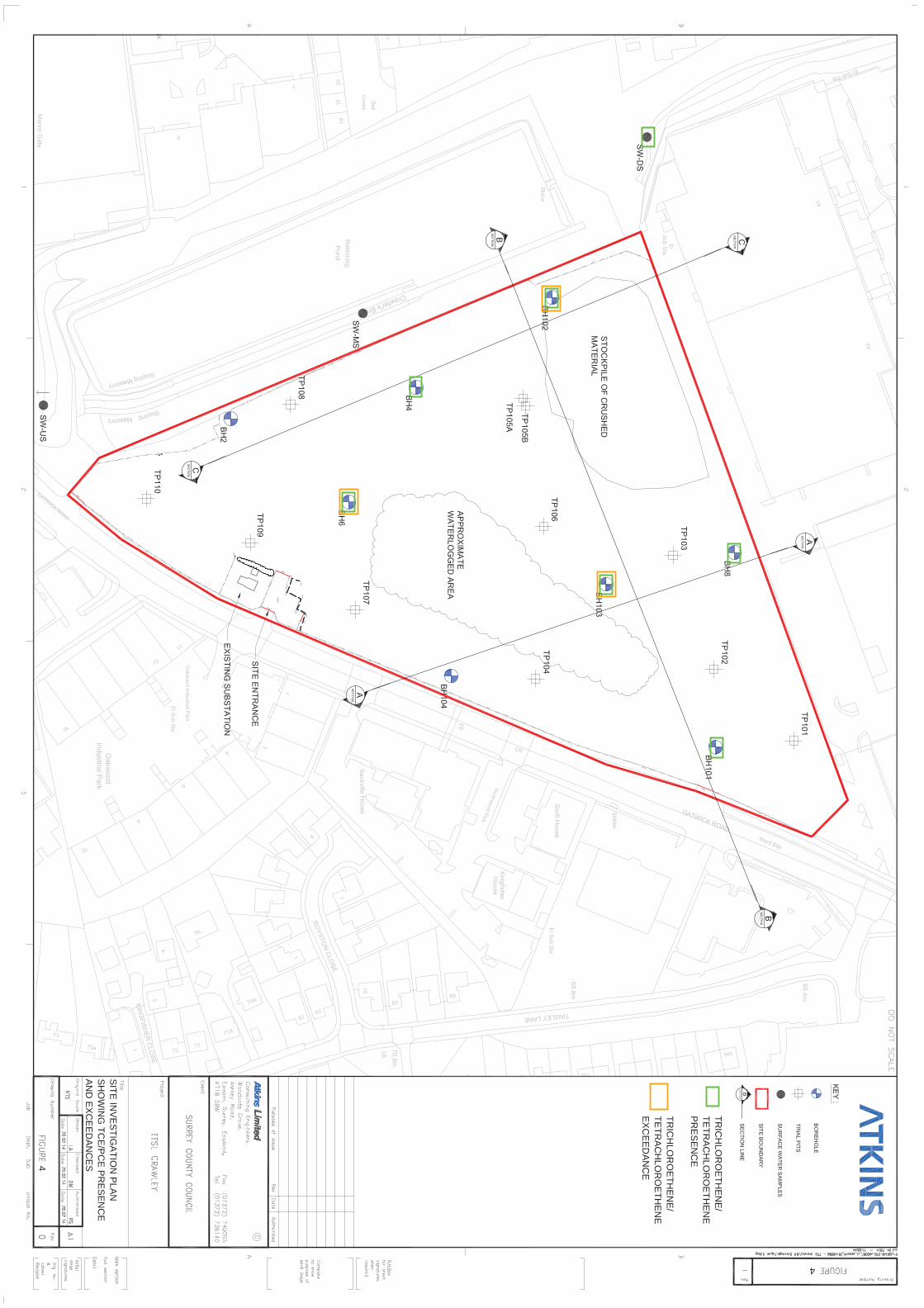
2
TRIC
HLO
RO
ETH
EN
E/
TETR
AC
HLO
RO
ETH
EN
E
PR
ES
EN
CE
TRIC
HLO
RO
ETH
EN
E/
TETR
AC
HLO
RO
ETH
EN
E
EX
CE
ED
AN
CE
4
SITE
INV
ES
TIGA
TION
PLA
N
SH
OW
ING
TCE
/PC
E P
RE
SE
NC
E
AN
D E
XC
EE
DA
NC
ES
4

Appendices

Former Thales Training and Simulation Land, Gatwick Road, Crawley Addendum Monitoring Report
Atkins Former Thales Training and Simulation Land, Addendum Monitoring Report | Version
2.0 | November 2014 | 5128708
Appendix A. Historical Information
A.1. Historical Plans