Embed Size (px)
Citation preview
FORTH PORTS LIMITED Document ID
FP PMSC OP 14-05 Authorised By
CHM Original Date
August 2011
Marine Guidelines & Port Information
Date Revised
January 2013 Revised By
HMFO Review Due
August 2014
- 1 -
Forth Ports Limited
Marine Guidelines and Port Information
August 2011
FORTH PORTS LIMITED Document ID
FP PMSC OP 14-05 Authorised By
CHM Original Date
August 2011
Marine Guidelines & Port Information
Date Revised
January 2013 Revised By
HMFO Review Due
August 2014
- 2 -
LIST OF AMENDMENTS
DATE PAGE NUMBER
January 2012 4, 37
Appendix C – Page 3
April 2012 15, 22, 23
Appendix A – Page 2
June 2012 4, 47
August 2012 40
Appendix A
Appendix C
November 2012 4, 22, 23, 37, 38, 39, 40, 53
Appendix A
Appendix C
January 2013 37, 38, 39
Appendix A – Page 2
Appendix C – Page 5
FORTH PORTS LIMITED Document ID
FP PMSC OP 14-05 Authorised By
CHM Original Date
August 2011
Marine Guidelines & Port Information
Date Revised
January 2013 Revised By
HMFO Review Due
August 2014
- 3 -
CONTENTS
1 RIVER FORTH
1.1 Forth Rail and Road Bridges Allowable Clearance Heights
1.2 Forth Rail Bridge South Arch
1.3 Barge Operations
1.4 Use of Boatmen
1.5 Testing Engines Astern Before Berthing at any Port, Harbour, Dock or
Terminal
1.6 Cruise Liners Anchoring off Hound Point
1.7 Vessels without Appropriate Navigational Charts
1.8 Hound Point Maximum Depth Draft
1.9 Navigating in Passage South of Oxcars Light
2 PORT OF GRANGEMOUTH
2.1 Docking and Sailing Guidelines and Voluntary Tug Code Introduction
2.2 Guidelines
2.2.1 Towage for First Time Calls (non standard vessels)
2.3 Towage Minimum Bollard Pull Requirements
2.4 Wind Parameters
2.5 Visibility Parameters
2.6 Management Plan
2.7 Eastern Channel Jetties – Passing Distance
2.8 LW Slack Dockings
2.9 Grangemouth Vessel Class Guidelines
2.10 Docking and Undocking Procedures for Vessels in the Proximity of
Transporter Cranes
3 PORT OF LEITH
3.1 Docking and Sailing Guidelines and Voluntary Tug Code Introduction
3.2 Guidelines
3.3 Towage Minimum Bollard Pull Requirements
3.4 Passenger Ship Guidelines
3.5 Coal Vessel Parameters
3.6 Wind Parameters
3.7 Visibility Parameter
3.8 Management Plan
4 PORT OF ROSYTH
4.1 Docking and Sailing Guidelines and Voluntary Tug Code Introduction
4.2 Guidelines
4.3 Towage Minimum Bollard Pull Requirements
4.4 Fender Information for “T” Berth
4.5 Wind Parameters
4.6 Visibility Parameters
4.7 Babcock’s Enclosed Dock
FORTH PORTS LIMITED Document ID
FP PMSC OP 14-05 Authorised By
CHM Original Date
August 2011
Marine Guidelines & Port Information
Date Revised
January 2013 Revised By
HMFO Review Due
August 2014
- 4 -
5 PORTS OF METHIL, KIRKCALDY, BURNTISLAND, INVERKEITHING
AND CROMBIE
5.1 Guidelines
5.2 Towage Minimum Bollard Pull Requirements - Crombie
5.3 Wind Parameters
5.4 Visibility Parameters
6 TOWAGE
6.1 Tug Fleet
6.2 Bollard Pull Required to Counteract Wind Beam on to Vessel
6.2.1 Determine Lateral Surface Area
6.2.2 Determine Wind Force on Vessel
6.2.3 Assess Bollard Pull Requirement
6.2.4 Work Example
6.3 ASD Tugs – Bow to Bow Towage
6.4 Towage Operations in Restricted Visibility
6.5 Towage Operations in Heavy Weather
7 PILOTAGE
7.1 Pilot Vessel Operations in Restricted Visibility
8 BRAEFOOT & HOUNDPOINT
8.1 Houndpoint Terminal
8.2 Braefoot Bay
Appendix A – Grangemouth – Ruling Depths and Under Keel Clearance
Appendix B – Leith – Ruling Depths and Under Keel Clearance
Appendix C – Rosyth & Fife Ports – Ruling Depths and Under Keel Clearance
Note: The criteria set out within this document have been agreed following risk assessment
and consultation with the appropriate parties. There may however be occasions when masters
or pilots have concerns over the prevailing conditions. They may therefore consider that it
would be prudent to abort the operation before the limits in these Guidelines are
reached. These decisions can only be made at the time by the master and pilot after assessing
the situation and the circumstances of any particular case. Masters and pilots are reminded
that discussion and agreement of an appropriate abort position is an integral part of every
passage plan.
FORTH PORTS LIMITED Document ID
FP PMSC OP 14-05 Authorised By
CHM Original Date
August 2011
Marine Guidelines & Port Information
Date Revised
January 2013 Revised By
HMFO Review Due
August 2014
- 5 -
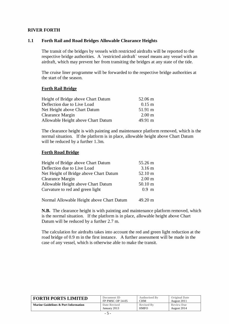
RIVER FORTH
1.1 Forth Rail and Road Bridges Allowable Clearance Heights
The transit of the bridges by vessels with restricted airdrafts will be reported to the
respective bridge authorities. A `restricted airdraft` vessel means any vessel with an
airdraft, which may prevent her from transiting the bridges at any state of the tide.
The cruise liner programme will be forwarded to the respective bridge authorities at
the start of the season.
Forth Rail Bridge
Height of Bridge above Chart Datum 52.06 m
Deflection due to Live Load 0.15 m
Net Height above Chart Datum 51.91 m
Clearance Margin 2.00 m
Allowable Height above Chart Datum 49.91 m
The clearance height is with painting and maintenance platform removed, which is the
normal situation. If the platform is in place, allowable height above Chart Datum
will be reduced by a further 1.3m.
Forth Road Bridge
Height of Bridge above Chart Datum 55.26 m
Deflection due to Live Load 3.16 m
Net Height of Bridge above Chart Datum 52.10 m
Clearance Margin 2.00 m
Allowable Height above Chart Datum 50.10 m
Curvature to red and green light 0.9 m
Normal Allowable Height above Chart Datum 49.20 m
N.B. The clearance height is with painting and maintenance platform removed, which
is the normal situation. If the platform is in place, allowable height above Chart
Datum will be reduced by a further 2.7 m.
The calculation for airdrafts takes into account the red and green light reduction at the
road bridge of 0.9 m in the first instance. A further assessment will be made in the
case of any vessel, which is otherwise able to make the transit.
FORTH PORTS LIMITED Document ID
FP PMSC OP 14-05 Authorised By
CHM Original Date
August 2011
Marine Guidelines & Port Information
Date Revised
January 2013 Revised By
HMFO Review Due
August 2014
- 6 -
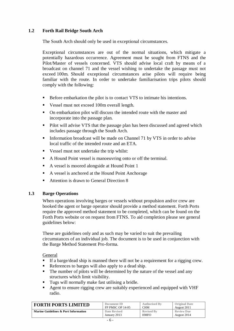
1.2 Forth Rail Bridge South Arch
The South Arch should only be used in exceptional circumstances.
Exceptional circumstances are out of the normal situations, which mitigate a
potentially hazardous occurrence. Agreement must be sought from FTNS and the
Pilot/Master of vessels concerned. VTS should advise local craft by means of a
broadcast on channel 71 and the vessel wishing to undertake the passage must not
exceed 100m. Should exceptional circumstances arise pilots will require being
familiar with the route. In order to undertake familiarisation trips pilots should
comply with the following:
Before embarkation the pilot is to contact VTS to intimate his intentions.
Vessel must not exceed 100m overall length.
On embarkation pilot will discuss the intended route with the master and
incorporate into the passage plan.
Pilot will advise VTS that the passage plan has been discussed and agreed which
includes passage through the South Arch.
Information broadcast will be made on Channel 71 by VTS in order to advise
local traffic of the intended route and an ETA.
Vessel must not undertake the trip whilst:
A Hound Point vessel is manoeuvring onto or off the terminal.
A vessel is moored alongside at Hound Point 1
A vessel is anchored at the Hound Point Anchorage
Attention is drawn to General Direction 8
1.3 Barge Operations
When operations involving barges or vessels without propulsion and/or crew are
booked the agent or barge operator should provide a method statement. Forth Ports
require the approved method statement to be completed, which can be found on the
Forth Ports website or on request from FTNS. To aid completion please see general
guidelines below:
These are guidelines only and as such may be varied to suit the prevailing
circumstances of an individual job. The document is to be used in conjunction with
the Barge Method Statement Pro-forma.
General
If a barge/dead ship is manned there will not be a requirement for a rigging crew.
References to barges will also apply to a dead ship.
The number of pilots will be determined by the nature of the vessel and any
structures which limit visibility.
Tugs will normally make fast utilising a bridle.
Agent to ensure rigging crew are suitably experienced and equipped with VHF
radio.
FORTH PORTS LIMITED Document ID
FP PMSC OP 14-05 Authorised By
CHM Original Date
August 2011
Marine Guidelines & Port Information
Date Revised
January 2013 Revised By
HMFO Review Due
August 2014
- 7 -
Methil
Inbound
Pilots as required
Rigging Crew
Sea tug to Methil Roads
Licensed tug/s to the berth (Sea tug may also remain fast for North Sea barges)
Outbound
Pilots as required
Rigging Crew
Licensed tug/s from the berth to Methil Roads. (Sea going may also be fast)
Burntisland
Inbound
One Pilot joins sea tug at Fairway Buoy/No.3 Buoy
Licensed tug escort from No.3 (available to pick up emergency towline)
Rigging crew and second pilot (if required) join barge at Burntisland Roads
Licensed tug/s take over tow to berth
Pilot transfers from sea tug to barge
Sea tug to remain until barge safely berthed
Outbound
Pilots as required
Rigging Crew
Licensed tug/s make fast at berth
At Burntisland Roads one pilot transfers to sea tug
Sea tug makes fast
Second pilot (if required) and rigging crew departs barge
Licensed tug escort to No.3 (available to pick up emergency towline)
Leith
Inbound
One Pilot joins sea tug at Fairway Buoy/Narrow Deep
Licensed tug escort from Narrow Deep (available to pick up emergency towline)
Rigging crew and, if necessary, second pilot join barge at Leith Roads
Two licensed tugs take over tow to berth
Pilot transfers from sea tug to barge
Sea tug to remain until barge safely berthed
Outbound
Pilots as required
Rigging Crew
Licensed tug/s make fast at berth
At Leith Roads one pilot transfers to sea tug
Sea tug makes fast
Rigging crew departs barge (and second pilot)
Licensed tug escort to Narrow Deep (available to pick up emergency towline)
FORTH PORTS LIMITED Document ID
FP PMSC OP 14-05 Authorised By
CHM Original Date
August 2011
Marine Guidelines & Port Information
Date Revised
January 2013 Revised By
HMFO Review Due
August 2014
- 8 -
Transfer of tow in the lock will not normally be considered owing to the possibility of
delays. In exceptional circumstances, the Harbour Master may grant permission
depending on the prevailing situation and conditions.
Rosyth
Inbound
One Pilot joins sea tug at Fairway Buoy/No.3 Buoy
Licensed tug escort from No.3 (available to pick up emergency towline)
Rigging crew and second pilot (if required) join barge in the vicinity of No.19
Buoy
Licensed tug/s take over tow to berth
Pilot transfers from sea tug to barge
Sea tug to remain until barge safely berthed
Outbound
Pilots as required
Rigging Crew
Licensed tug/s make fast at berth (The Sea going tug may be permitted to make
fast at a river berth in circumstances whereby the abilities of the tug are known to
the pilots. If so, a pilot must be present on the sea tug and at least one on the
barge. Two licensed tugs to be in attendance, at least one of which to be made fast
until No.19 buoy)
At No.19 buoy one pilot transfers to sea tug (if sea tug not made fast)
Sea tug makes fast (if not made fast at the berth)
Second pilot and rigging crew departs barge
Licensed tug escort to No.3 (available to pick up emergency towline)
Grangemouth
Inbound
One Pilot joins sea tug at Fairway Buoy/No.3 Buoy
Licensed tug* escort from No.3 (available to pick up emergency towline)
Rigging crew and, if necessary, second pilot join barge in the vicinity of No.19
Buoy. Licensed tug/s take over tow to berth (second licensed tug may or may not
be made fast)
Pilot transfers from sea tug to barge/lead tug
Second tug* (if required) to be made fast by Hen & Chickens
Sea tug to remain until barge safely berthed
Outbound
Pilots as required.
Rigging Crew
Two licensed tugs* make fast at berth and remain so until Hen & Chickens (the
tugs from berth should complete the job to buoy’s No.19/No.3)
Pilot transfer to lead tug in lock (if one pilot)
Second tug to remain fast or in attendance until sea tug made fast at No.19 Buoy
At No.19 buoy pilot transfers to sea tug
Sea tug makes fast
Rigging crew departs barge
FORTH PORTS LIMITED Document ID
FP PMSC OP 14-05 Authorised By
CHM Original Date
August 2011
Marine Guidelines & Port Information
Date Revised
January 2013 Revised By
HMFO Review Due
August 2014
- 9 -
Licensed tug escort to No.3 (available to pick up emergency towline)
Transfer of tow in the lock will not normally be considered owing to the possibility of
delays. In exceptional circumstances, the Harbour Master may grant permission
depending on the prevailing situation and conditions.
*Grangemouth Towage – the same licensed tugs should undertake the operation
from/to the berth to/from No.19/No.3 buoys.
Agents and operators of barges are reminded that only tugs licensed by Forth Ports
can undertake towage operations within the ports on the Forth. Crews from harbour
tugs are not contracted to either provide mooring ropes or act as riggers or boatmen
for the movement of barges/unmanned vessels. Harbour tugs will not be used to
transfer personnel, such transfers will be conducted by pilot boat for pilots and by
workboat for other personnel.
The barge proforma must be completed by the agent/operator and approved by the
pilot and FTNS before operations commence.
1.4 Use of Boatmen
The procedure adopted at all ports on the Forth with regard to a master/agent advising
that a vessel does not require the services of boatmen is as follows:
A risk assessment must have been carried out.
A copy of such a risk assessment must be available on the vessel.
The risk assessment must be approved by the Harbourmaster. In cases where a
risk assessment has been carried out but has yet to be approved, the vessel must
use boatmen to berth, thereafter the Harbour Master will consider such assessment
for final approval.
Pilots who are asked by Masters about the requirement for boatmen may quote
from this procedure or, alternatively, the matter can be referred to the appropriate
Harbour Master.
1.5 Testing Engines Astern Before Berthing at any Port, Harbour, Dock or Terminal
All vessels should test their engines astern before entering any lock system or
berthing at any port, harbour, dock or terminal.
Any defects or failure of the engine to go astern should be reported to FTNS and the
berthing/docking aborted.
1.6 Cruise Liners Anchoring off Hound Point
An anchorage will be made available adjacent to Hound Point, for cruise vessels
which due to their size cannot berth at Leith or Rosyth.
FORTH PORTS LIMITED Document ID
FP PMSC OP 14-05 Authorised By
CHM Original Date
August 2011
Marine Guidelines & Port Information
Date Revised
January 2013 Revised By
HMFO Review Due
August 2014
- 10 -
The position of the anchorage and any additional requirements for these vessels
will be published annually in a Notice to Mariners Firth of Forth.
Any vessel which cannot comply with the requirements of the Notice to Mariners
should notify the Harbour Master prior to the vessels arrival and ideally prior to,
or at the time of booking.
A pilot will remain onboard throughout to ensure, when requested to do so by
transiting traffic, that the vessel remains parallel to and clear of the main
navigational channel. Additionally, the pilot will ensure that the cruise vessel
remains two cables clear of No 19 Buoy at all times. VHF communication should
be maintained throughout both with FTNS and passing traffic.
All vessels over 300m LOA will require one tug to be fast throughout. All other
vessels require one tug fast aft, unless due to the manoeuvring characteristics of
the vessel, favourable weather conditions and following an assessment by the
Harbour Master the requirement for this tug is deemed unnecessary.
FTNS will advise other river users of the cruise vessels location through VHF
broadcasts as well as notification of periods when the cruise vessel may be
swinging into the navigational channel. Transiting traffic will normally pass to
the north of the anchored cruise vessel if it is safe and practical to do so and
should approach no closer then 200 metres at any time. FTNS will include this
requirement with traffic information.
Passenger tenders operating from the cruise liner should be appropriately crewed
by trained and experienced personnel. The cruise vessel should submit to the
Harbourmaster its risk assessment and method statement/operational procedure
document for these tenders at least four weeks prior to arrival. Tenders should
not approach within 100 metres of Hound Point or vessels moored at Hound Point
and all terminal regulations must be respected.
1.7 Vessels without Appropriate Navigational Charts
For a vessel to comply with the General Directions it is mandatory that vessels should
have the appropriate charts before commencing the river passage.
Pilots boarding vessels which do not have the appropriate charts should, for inbound
vessels, put the vessel to the nearest and most appropriate anchorage and for sailing
vessels not leave the berth.
Electronic Charts must be approved and have a back up (either a second approved
electronic system or charts).
Foreign charts are acceptable if they conform to the international numbering system.
Russian charts do not conform to the above standard but are recognised by the
Hydrographic Office.
FORTH PORTS LIMITED Document ID
FP PMSC OP 14-05 Authorised By
CHM Original Date
August 2011
Marine Guidelines & Port Information
Date Revised
January 2013 Revised By
HMFO Review Due
August 2014
- 11 -
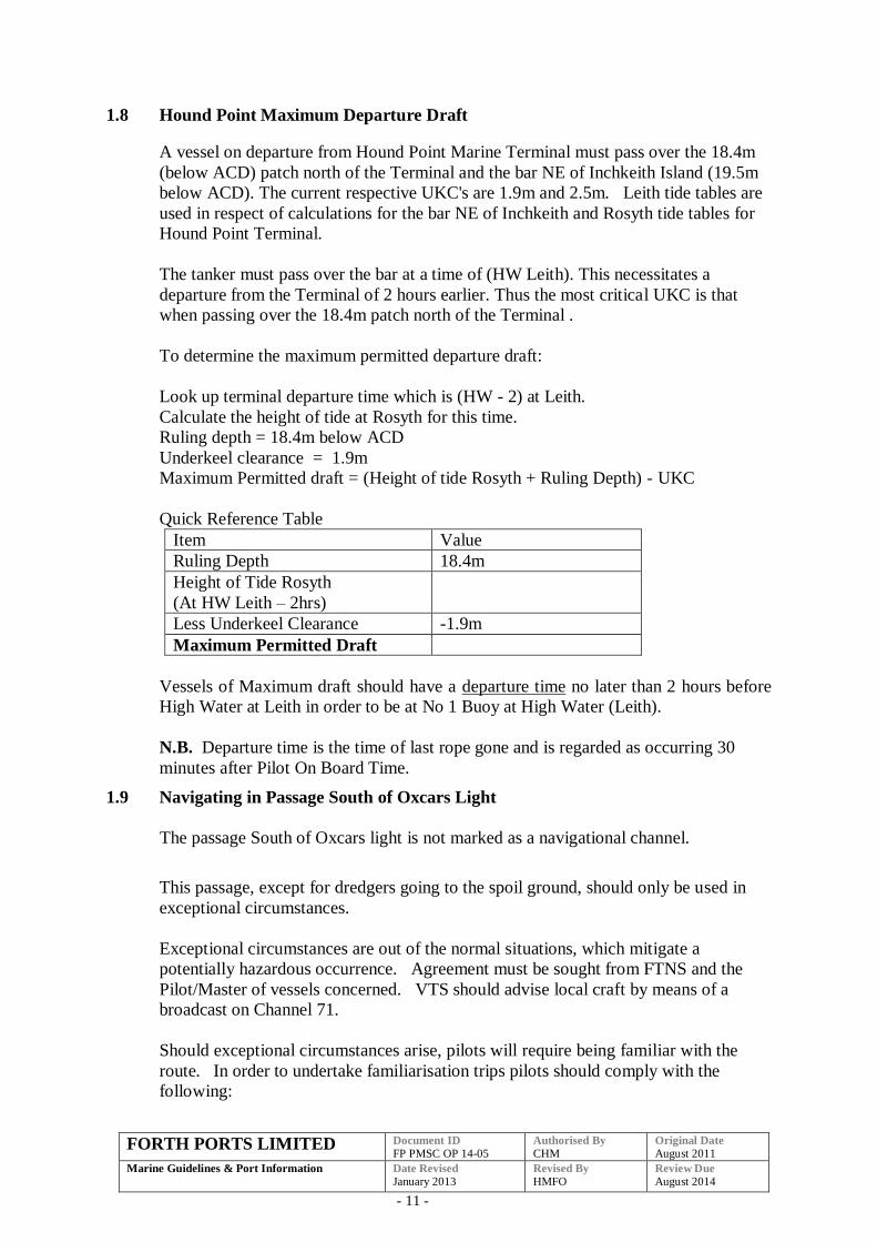
1.8 Hound Point Maximum Departure Draft
A vessel on departure from Hound Point Marine Terminal must pass over the 18.4m
(below ACD) patch north of the Terminal and the bar NE of Inchkeith Island (19.5m
below ACD). The current respective UKC's are 1.9m and 2.5m. Leith tide tables are
used in respect of calculations for the bar NE of Inchkeith and Rosyth tide tables for
Hound Point Terminal.
The tanker must pass over the bar at a time of (HW Leith). This necessitates a
departure from the Terminal of 2 hours earlier. Thus the most critical UKC is that
when passing over the 18.4m patch north of the Terminal .
To determine the maximum permitted departure draft:
Look up terminal departure time which is (HW - 2) at Leith.
Calculate the height of tide at Rosyth for this time.
Ruling depth = 18.4m below ACD
Underkeel clearance = 1.9m
Maximum Permitted draft = (Height of tide Rosyth + Ruling Depth) - UKC
Quick Reference Table
Item Value
Ruling Depth 18.4m
Height of Tide Rosyth
(At HW Leith – 2hrs)
Less Underkeel Clearance -1.9m
Maximum Permitted Draft
Vessels of Maximum draft should have a departure time no later than 2 hours before
High Water at Leith in order to be at No 1 Buoy at High Water (Leith).
N.B. Departure time is the time of last rope gone and is regarded as occurring 30
minutes after Pilot On Board Time.
1.9 Navigating in Passage South of Oxcars Light
The passage South of Oxcars light is not marked as a navigational channel.
This passage, except for dredgers going to the spoil ground, should only be used in
exceptional circumstances.
Exceptional circumstances are out of the normal situations, which mitigate a
potentially hazardous occurrence. Agreement must be sought from FTNS and the
Pilot/Master of vessels concerned. VTS should advise local craft by means of a
broadcast on Channel 71.
Should exceptional circumstances arise, pilots will require being familiar with the
route. In order to undertake familiarisation trips pilots should comply with the
following:
FORTH PORTS LIMITED Document ID
FP PMSC OP 14-05 Authorised By
CHM Original Date
August 2011
Marine Guidelines & Port Information
Date Revised
January 2013 Revised By
HMFO Review Due
August 2014
- 12 -
Before embarkation, the pilot is to contact FTNS to intimate his intentions.
On embarkation, the pilot will discuss the intended route with the Master and
incorporate into the passage plan.
Pilot will advise VTS that the passage plan has been discussed and agreed which
includes passage south of Oxcars light.
Information broadcast will be made on Channel 71 by VTS in order to advise
local traffic of the intended route and an ETA.
Attention is drawn to General Direction 10.
FORTH PORTS LIMITED Document ID
FP PMSC OP 14-05 Authorised By
CHM Original Date
August 2011
Marine Guidelines & Port Information
Date Revised
January 2013 Revised By
HMFO Review Due
August 2014
- 13 -
2 PORT OF GRANGEMOUTH
2.1 Docking and Sailing Guidelines and Voluntary Tug Code Introduction
The following revised Guidelines have been drawn up for the port of Grangemouth.
The Guidelines form part of the formal risk assessment process and are continuously
under review in the light of operational experience. There has been extensive
consultation between the Port Authority and the Forth Pilots while producing these
Guidelines.
It is not intended that these Guidelines are a rigid set of regulations or rules to be
followed on all occasions, they are intended as guide to ships masters, agents, pilots
and the Port Authority to allow safe and effective scheduling of vessels.
Further discussions on some occasions may be required between the Duty Pilot, Forth
and Tay Navigation Service and the vessel’s Master, taking into account the
prevailing weather and tidal conditions and any other special circumstances.
.
The final decision on the number of tugs required rest with the Master of the vessel, in
consultation with the pilot.
However the Port Authority reserves the right to require a vessel to take a tug or
comply with any special instruction which may be considered necessary according to
the particular circumstances of the case.
The following assumptions have been made in preparing these guidelines:
Standard Ship – single screw with no bow/stern thrusters, high efficiency rudder
or other manoeuvring aids.
Favourable weather conditions.
Tidal Ranges within predicted limits.
No adverse local activity and/or conditions.
Non-standard vessel will be assessed on an individual basis.
The Guidelines are presented in a tabular form, the tables contain an identification
letter indicating tidal constraints followed by a numerical indication of the number of
tugs recommended.
For ports with lock entrances the Guidelines refers to the requirement to enter/leave
the locks. Further consideration to tug requirement may need to be given depending
on berth location, side to, proximity of other berthed vessels and the table in 6.2.
FORTH PORTS LIMITED Document ID
FP PMSC OP 14-05 Authorised By
CHM Original Date
August 2011
Marine Guidelines & Port Information
Date Revised
January 2013 Revised By
HMFO Review Due
August 2014
- 14 -
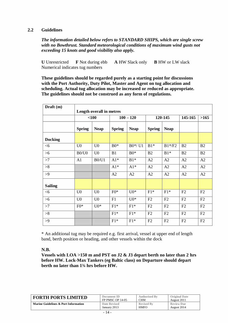
2.2 Guidelines
The information detailed below refers to STANDARD SHIPS, which are single screw
with no Bowthrust. Standard meteorological conditions of maximum wind gusts not
exceeding 15 knots and good visibility also apply.
U Unrestricted F Not during ebb A HW Slack only B HW or LW slack
Numerical indicates tug numbers
These guidelines should be regarded purely as a starting point for discussions
with the Port Authority, Duty Pilot, Master and Agent on tug allocation and
scheduling. Actual tug allocation may be increased or reduced as appropriate.
The guidelines should not be construed as any form of regulations.
Draft (m) Length overall in metres
<100 100 – 120 120-145 145-165 >165
Spring Neap Spring Neap Spring Neap
Docking
<6 U0 U0 B0* B0*/ U1 B1* B1*/F2 B2 B2
>6 B0/U0 U0 B1 B0* B2 B1* B2 B2
>7 A1 B0/U1 A1* B1* A2 A2 A2 A2
>8 A1* A1* A2 A2 A2 A2
>9 A2 A2 A2 A2 A2 A2
Sailing
<6 U0 U0 F0* U0* F1* F1* F2 F2
>6 U0 U0 F1 U0* F2 F2 F2 F2
>7 F0* U0* F1* F1* F2 F2 F2 F2
>8 F1* F1* F2 F2 F2 F2
>9 F1* F1* F2 F2 F2 F2
* An additional tug may be required e.g. first arrival, vessel at upper end of length
band, berth position or heading, and other vessels within the dock
N.B.
Vessels with LOA >150 m and PST on J2 & J3 depart berth no later than 2 hrs
before HW. Lock-Max Tankers (eg Baltic class) on Departure should depart
berth no later than 1¾ hrs before HW.
FORTH PORTS LIMITED Document ID
FP PMSC OP 14-05 Authorised By
CHM Original Date
August 2011
Marine Guidelines & Port Information
Date Revised
January 2013 Revised By
HMFO Review Due
August 2014
- 15 -
Tidal range: Spring ≥4.0m, Neap <4.0m
Scheduled times are: Inbound - Hen & Chickens, Departure – from berth
Under Keel Clearance: 0.6m
HW slack: Spring HW-2 to HW, Neap HW-3 to HW
LW slack: HW-6
Recommended Bollard Pull will be catered for in a separate document
Pilots should report to FTNS on vessel manoeuvrability after first visit for
comment entry into IPOS.
2.2.1 Towage for First Time Calls (non standard vessels)
Non standard ships (vessels with one or a combination of: bow/stern thruster; twin screw;
Becker rudder etc) have to be considered on a case by case basis. First time callers will
require an assessment in order to determine the vessel’s manoeuvring characteristics (see
2.9 below). First time callers with an LOA of 100m and over will therefore be required to
take at least one tug. For a sister ship of a vessel that has previously called the Duty
Harbour Master and Duty Pilot should be consulted regarding towage. Vessels less than
100m will not normally be allocated a tug. Should Masters however, require towage, they
are encouraged to be pro-active and request a tug in advance to avoid delays.
2.3 Towage Minimum Bollard Pull Requirement
The following table is a guide to the minimum combined bollard pull requirement for
tug allocation in conjunction with the “Forth Ports Docking and Sailing Guidelines
and Voluntary Tug Code”. As with the Code this table is a guideline and is not
intended as a rigid set of rules and regulations.
The Port of Grangemouth is normally served by two licensed harbour tugs of 37t BP.
The table is intended primarily to give guidance when other licensed harbour tugs of
different capacities may be deployed to the port. This might be the case over a busy
high water period or during dry docking of the harbour tugs normally based at the
port.
When allocating two or more tugs to a job consideration must be given to the mix of
tugs to ensure that there is an appropriate balance with the tugs employed.
1 Tug 2 Tugs
100m 19t 38t
100m - 120m 19t 38t
120m – 145m 19t 38t
145m – 165m 30t 45t
145m -165m 30t 45t
165m N/A 66t
FORTH PORTS LIMITED Document ID
FP PMSC OP 14-05 Authorised By
CHM Original Date
August 2011
Marine Guidelines & Port Information
Date Revised
January 2013 Revised By
HMFO Review Due
August 2014
- 16 -
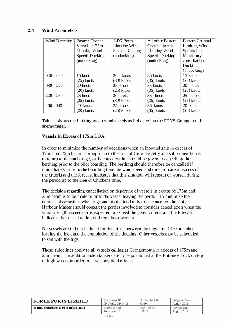
2.4 Wind Parameters
Wind Direction Eastern Channel
Vessels >175m Limiting Wind
Speeds Docking
(undocking)
LPG Berth
Limiting Wind Speeds Docking
(undocking)
All other Eastern
Channel berths Limiting Wind
Speeds Docking
(undocking)
Eastern Channel
Limiting Wind Speeds For
Mandatory
consultation
Docking (undocking)
040 – 080 15 knots
(25) knots
20 knots
(30) knots
35 knots
(35) knots
15 knots
(25) knots
080 – 220 20 knots (20) knots
25 knots (25) knots
35 knots (35) knots
20 knots (20) knots
220 – 260 25 knots
(25) knots
30 knots
(30) knots
35 knots
(35) knots
25 knots
(25) knots
260 - 040 20 knots (20) knots
25 knots (25) knots
35 knots (35) knots
20 knots (20) knots
Table 1 shows the limiting mean wind speeds as indicated on the FTNS Grangemouth
anemometer.
Vessels In Excess of 175m LOA
In order to minimize the number of occasions when an inbound ship in excess of
175m and 25m beam is brought up to the area of Crombie Jetty and subsequently has
to return to the anchorage, early consideration should be given to cancelling the
berthing prior to the pilot boarding. The berthing should therefore be cancelled if
immediately prior to the boarding time the wind speed and direction are in excess of
the criteria and the forecast indicates that this situation will remain or worsen during
the period up to the Hen & Chickens time.
The decision regarding cancellation on departure of vessels in excess of 175m and
25m beam is to be made prior to the vessel leaving the berth. To minimize the
number of occasions when tugs and pilot attend only to be cancelled the Duty
Harbour Master should consult the parties involved to consider cancellation when the
wind strength exceeds or is expected to exceed the given criteria and the forecast
indicates that this situation will remain or worsen.
No vessels are to be scheduled for departure between the tugs for a >175m tanker
leaving the lock and the completion of the docking. Other vessels may be scheduled
to sail with the tugs.
These guidelines apply to all vessels calling at Grangemouth in excess of 175m and
25m beam. In addition laden tankers are to be positioned at the Entrance Lock on top
of high waters in order to lessen any tidal effects.
FORTH PORTS LIMITED Document ID
FP PMSC OP 14-05 Authorised By
CHM Original Date
August 2011
Marine Guidelines & Port Information
Date Revised
January 2013 Revised By
HMFO Review Due
August 2014
- 17 -
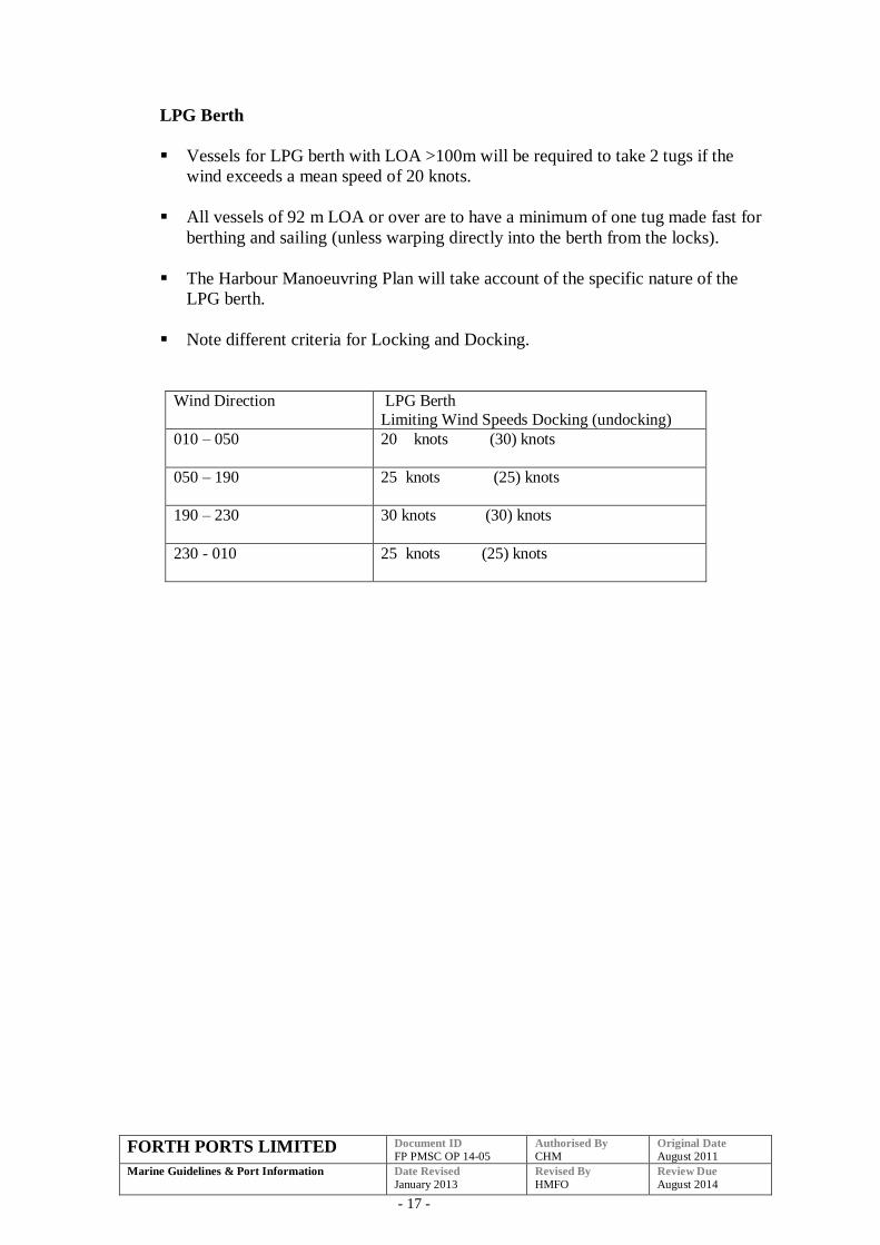
LPG Berth
Vessels for LPG berth with LOA >100m will be required to take 2 tugs if the
wind exceeds a mean speed of 20 knots.
All vessels of 92 m LOA or over are to have a minimum of one tug made fast for
berthing and sailing (unless warping directly into the berth from the locks).
The Harbour Manoeuvring Plan will take account of the specific nature of the
LPG berth.
Note different criteria for Locking and Docking.
Wind Direction LPG Berth
Limiting Wind Speeds Docking (undocking)
010 – 050 20 knots (30) knots
050 – 190 25 knots (25) knots
190 – 230 30 knots (30) knots
230 - 010 25 knots (25) knots
FORTH PORTS LIMITED Document ID
FP PMSC OP 14-05 Authorised By
CHM Original Date
August 2011
Marine Guidelines & Port Information
Date Revised
January 2013 Revised By
HMFO Review Due
August 2014
- 18 -
General
In the case of vessels transiting the Eastern Channel and vessels manoeuvring within
the Grange or Carron Docks when:
The mean wind exceeds the criteria given in Table 1 for vessels in excess of 175m
or
The wind is gusting to a speed at which a particular vessel would require a tug or
additional tug
1 Consultation must take place between Pilot, Master and Duty Harbour Master.
2 After consideration of the following factors (but not limited to these):
Wind direction and speed,
Vessel windage area,
Marine guidelines,
Forecast,
Berth alignment,
Berth occupation,
Tug availability,
Visibility,
Tidal conditions,
Manoeuvring Aids,
Vessel characteristics.
3 All parties must agree if the operation is to proceed.
4 If, after consultation, the Duty Harbour Master is not satisfied that the vessel
has sufficient towage, he will exercise his authority to issue a Special
Direction to the Master to require a tug or additional tugs to be made fast
before the vessel is given permission to move.
2.5 Visibility Parameters
Vessels are not permitted to enter the Port when the outer end of the East Lead in
Jetty cannot be seen from the Harbour Office.
Vessels are not permitted to leave the lock, berth or jetty in the Dock when No.2 Jetty
cannot be seen from the Harbour Office.
FORTH PORTS LIMITED Document ID
FP PMSC OP 14-05 Authorised By
CHM Original Date
August 2011
Marine Guidelines & Port Information
Date Revised
January 2013 Revised By
HMFO Review Due
August 2014
- 19 -
2.6 Management Plan
The following should be confirmed before manoeuvring in the Port of Grangemouth.
That a harbour manoeuvre plan has been prepared and agreed (where appropriate)
with the pilot.
That any defects, which may affect the safe navigation or manoeuvrability of the
vessel, are reported.
The maximum draft.
The following procedures should be adopted.
Inbound
On transferring from Channel 71 to Channel 14 to communicate with Grangemouth,
please pass the following information:
A harbour manoeuvre plan from the Hen & Chickens to the berth has been agreed.
The maximum draft.
Outbound
On seeking permission to depart from the berth please pass the following information:
A harbour manoeuvre plan has been agreed from the berth to the Hen & Chickens.
Any defects.
Maximum draft.
FORTH PORTS LIMITED Document ID
FP PMSC OP 14-05 Authorised By
CHM Original Date
August 2011
Marine Guidelines & Port Information
Date Revised
January 2013 Revised By
HMFO Review Due
August 2014
- 20 -
2.7 Eastern Channel Jetties – Passing Distance
In planning a vessel movement which involves proceeding past another vessel moored
at a jetty in the Eastern Channel, the pilot and/or Master (PEC Holder) should provide
for as great a separation distance as reasonable under the prevailing circumstances.
However, in any event, such a separation should be a distance of not less than the
beam of the passing vessel.
If it should appear during the planning of the pilotage movement that the maintenance
of such a separation distance is impossible, the pilot and/or Master (PEC holder)
should consult with the Harbour Master regarding berthing plans.
2.8 LW Slack Dockings
When calculating the max. acceptable draught for a LW slack docking, the predicted
tide height at actual LW is to be used.
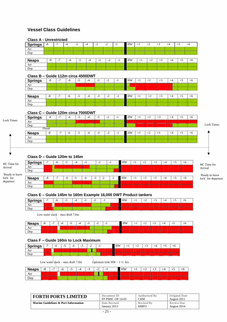
2.9 GrangemouthVessel Class Guidelines
Pilots will report to FTNS on vessel manoeuvrability after the first visit with a
recommendation that a vessel is allocated a class according to the following table.
This will be added to the vessel`s data in IPOS together with any tug requirements
and date of notation.
Eg “dd/mm/yyyy Class D One tug in; sail without”
The departure times indicated are those at which the vessel must be ready to
depart from the lock. An appropriate time interval must be allowed to cover transit
from berth to lock and running down in lock. In many cases this will be 45m but
more may be required depending on the vessel`s manoeuvrability and position
within the port e.g.
o Class D vessel SST on J2 required interval 45 mins Sailing window closes HW-30m latest off berth HW –1hr 15m
o Baltic Tanker on E1 required interval 1 hour Sailing window closes HW-45m latest off berth HW – 1 hr 45m
o Class E tanker PST on J2 or J3 required interval 1hr 15m Sailing window closes HW-45m latest off berth HW –2hr
o Class F Containership required interval 1hr 15m Sailing window closes HW-45m latest off berth HW –2 hrs
Calculate times to the nearest High Water
The Neap / Spring Interface is 4.0m with the exception of ‘Class B’ where it is
4.5m
FORTH PORTS LIMITED Document ID
FP PMSC OP 14-05 Authorised By
CHM Original Date
August 2011
Marine Guidelines & Port Information
Date Revised
January 2013 Revised By
HMFO Review Due
August 2014
- 21 -
Vessel Class Guidelines Class A - Unrestricted
Springs -8 -7 -6 -5 -4 -3 -2 -1 HW +1 +2 +3 +4 +5 +6
Arr
Dep
Neaps -8 -7 -6 -5 -4 -3 -2 -1 HW +1 +2 +3 +4 +5 +6
Arr
Dep
Class B – Guide 112m circa 4500DWT
Springs -8 -7 -6 -5 -4 -3 -2 -1 HW +1 +2 +3 +4 +5 +6
Arr
Dep
Neaps -8 -7 -6 -5 -4 -3 -2 -1 HW +1 +2 +3 +4 +5 +6
Arr
Dep
Class C – Guide 120m circa 7000DWT
Springs -8 -7 -6 -5 -4 -3 -2 -1 HW +1 +2 +3 +4 +5 +6
Arr
Dep
Neaps -8 -7 -6 -5 -4 -3 -2 -1 HW +1 +2 +3 +4 +5 +6
Arr
Dep
Class D – Guide 120m to 145m
Springs -7 -6 -5 -4 -3 -2 -1 HW +1 +2 +3 +4 +5 +6
Arr
Dep
Neaps -8 -7 -6 -5 -4 -3 -2 -1 HW +1 +2 +3 +4 +5 +6
Arr
Dep
Class E – Guide 145m to 160m Example 16,000 DWT Product tankers
Springs -7 -6 -5 -4 -3 -2 -1 HW +1 +2 +3 +4 +5 +6
Arr
Dep
Neaps -8 -7 -6 -5 -4 -3 -2 -1 HW +1 +2 +3 +4 +5 +6
Arr
Dep
Class F – Guide 160m to Lock Maximum
Springs -7 -6 -5 -4 -3 -2 -1 HW +1 +2 +3 +4 +5 +6
Arr
Dep
Neaps -8 -7 -6 -5 -4 -3 -2 -1 HW +1 +2 +3 +4 +5 +6
Arr
Dep
HC Time for
Arrival
`Ready to leave lock` for departure
Lock Times
Lock Times
HC Time for
Arrival
`Ready to leave
lock` for departure
Flood
Low water slack – max draft 7.0m
Optimum time HW – 1 ½ hrs Low water slack – max draft 7.0m
FORTH PORTS LIMITED Document ID
FP PMSC OP 14-05 Authorised By
CHM Original Date
August 2011
Marine Guidelines & Port Information
Date Revised
January 2013 Revised By
HMFO Review Due
August 2014
- 22 -
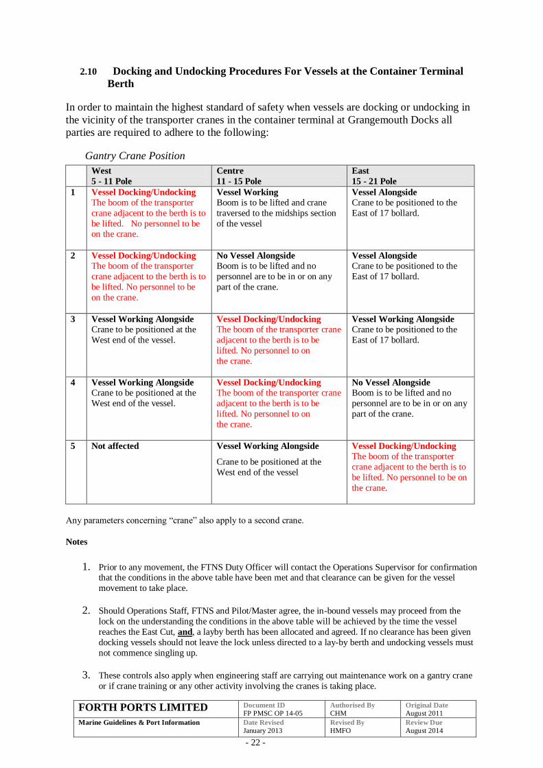
2.10 Docking and Undocking Procedures For Vessels at the Container Terminal
Berth
In order to maintain the highest standard of safety when vessels are docking or undocking in
the vicinity of the transporter cranes in the container terminal at Grangemouth Docks all
parties are required to adhere to the following:
Gantry Crane Position
West
5 - 11 Pole
Centre
11 - 15 Pole
East
15 - 21 Pole
1 Vessel Docking/Undocking The boom of the transporter
crane adjacent to the berth is to
be lifted. No personnel to be on the crane.
Vessel Working
Boom is to be lifted and crane
traversed to the midships section
of the vessel
Vessel Alongside Crane to be positioned to the
East of 17 bollard.
2 Vessel Docking/Undocking
The boom of the transporter
crane adjacent to the berth is to
be lifted. No personnel to be
on the crane.
No Vessel Alongside
Boom is to be lifted and no
personnel are to be in or on any
part of the crane.
Vessel Alongside Crane to be positioned to the
East of 17 bollard.
3 Vessel Working Alongside
Crane to be positioned at the
West end of the vessel.
Vessel Docking/Undocking
The boom of the transporter crane
adjacent to the berth is to be
lifted. No personnel to on
the crane.
Vessel Working Alongside
Crane to be positioned to the
East of 17 bollard.
4 Vessel Working Alongside
Crane to be positioned at the
West end of the vessel.
Vessel Docking/Undocking
The boom of the transporter crane
adjacent to the berth is to be
lifted. No personnel to on
the crane.
No Vessel Alongside
Boom is to be lifted and no
personnel are to be in or on any
part of the crane.
5 Not affected Vessel Working Alongside
Crane to be positioned at the
West end of the vessel
Vessel Docking/Undocking
The boom of the transporter
crane adjacent to the berth is to
be lifted. No personnel to be on
the crane.
Any parameters concerning “crane” also apply to a second crane.
Notes
1. Prior to any movement, the FTNS Duty Officer will contact the Operations Supervisor for confirmation that the conditions in the above table have been met and that clearance can be given for the vessel
movement to take place.
2. Should Operations Staff, FTNS and Pilot/Master agree, the in-bound vessels may proceed from the
lock on the understanding the conditions in the above table will be achieved by the time the vessel
reaches the East Cut, and, a layby berth has been allocated and agreed. If no clearance has been given
docking vessels should not leave the lock unless directed to a lay-by berth and undocking vessels must
not commence singling up.
3. These controls also apply when engineering staff are carrying out maintenance work on a gantry crane
or if crane training or any other activity involving the cranes is taking place.
FORTH PORTS LIMITED Document ID
FP PMSC OP 14-05 Authorised By
CHM Original Date
August 2011
Marine Guidelines & Port Information
Date Revised
January 2013 Revised By
HMFO Review Due
August 2014
- 23 -
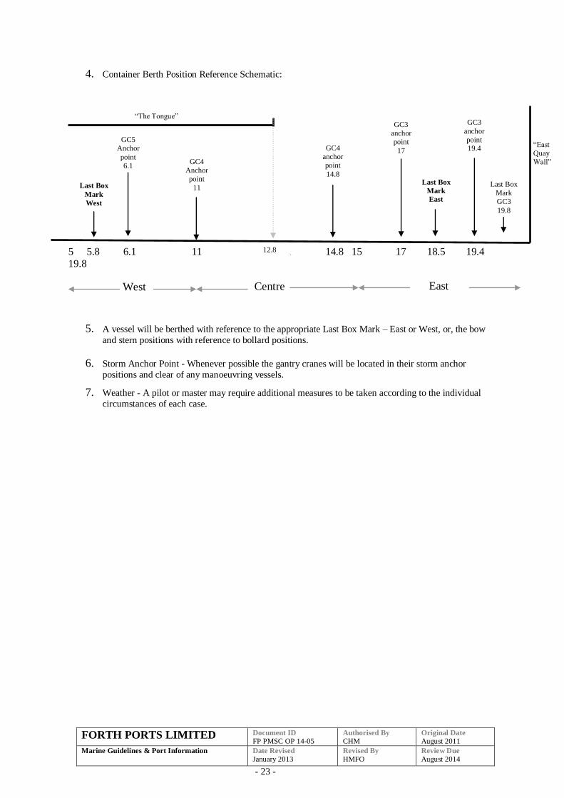
4. Container Berth Position Reference Schematic:
5 5.8 6.1 11 1 14.8 15 17 18.5 19.4
19.8
5. A vessel will be berthed with reference to the appropriate Last Box Mark – East or West, or, the bow
and stern positions with reference to bollard positions.
6. Storm Anchor Point - Whenever possible the gantry cranes will be located in their storm anchor
positions and clear of any manoeuvring vessels.
7. Weather - A pilot or master may require additional measures to be taken according to the individual
circumstances of each case.
“The Tongue”
12.8
Last Box
Mark
West
GC4
anchor
point
14.8
East
Last Box
Mark
East
GC3
anchor
point 19.4
West
Centre
GC3
anchor
point
17
Last Box
Mark
GC3
19.8
“East
Quay
Wall”
GC5
Anchor
point
6.1
GC4
Anchor
point
11
FORTH PORTS LIMITED Document ID
FP PMSC OP 14-05 Authorised By
CHM Original Date
August 2011
Marine Guidelines & Port Information
Date Revised
January 2013 Revised By
HMFO Review Due
August 2014
- 24 -
3 PORT OF LEITH
3.1 Docking and Sailing Guidelines and Voluntary Tug Code Introduction
The following revised Guidelines have been drawn up for the port of Leith.
The Guidelines form part of the formal risk assessment process and are continuously
under review in the light of operational experience. There has been extensive
consultation between the Port Authority and the Forth Pilots while producing these
Guidelines.
It is not intended that these Guidelines are a rigid set of regulations or rules to be
followed on all occasions, they are intended as a guide to ships masters, agents, pilots
and the Port Authority to allow safe and effective scheduling of vessels.
Further discussions on some occasions maybe required between the Duty Pilot, Forth
and Tay Navigation Service and the vessel’s Master, taking into account the
prevailing weather and tidal conditions and any other special circumstances.
.
The final decision on the number of tugs required rest with the Master of the vessel, in
consultation with the pilot.
However the Port Authority reserves the right to require a vessel to take a tug or
comply with any special instruction which may be considered necessary according to
the particular circumstances of the case.
The following assumptions have been made in preparing these guidelines:
Standard Ship – single screw with no bow/stern thrusters, high efficiency rudder
or other manoeuvring aids.
Favourable weather conditions.
Tidal Ranges within predicted limits.
No adverse local activity and/or conditions.
Non-standard vessel will be assessed on an individual basis.
The Guidelines are presented in a tabular form, the tables contain an identification
letter indicating tidal constraints followed by a numerical indication of the number of
tugs recommended.
For ports with lock entrances the Guidelines refers to the requirement to enter/leave
the locks. Further consideration to tug requirement may need to be given depending
on berth location, side to, proximity of other berthed vessels and the table in 6.2.
FORTH PORTS LIMITED Document ID
FP PMSC OP 14-05 Authorised By
CHM Original Date
August 2011
Marine Guidelines & Port Information
Date Revised
January 2013 Revised By
HMFO Review Due
August 2014
- 25 -
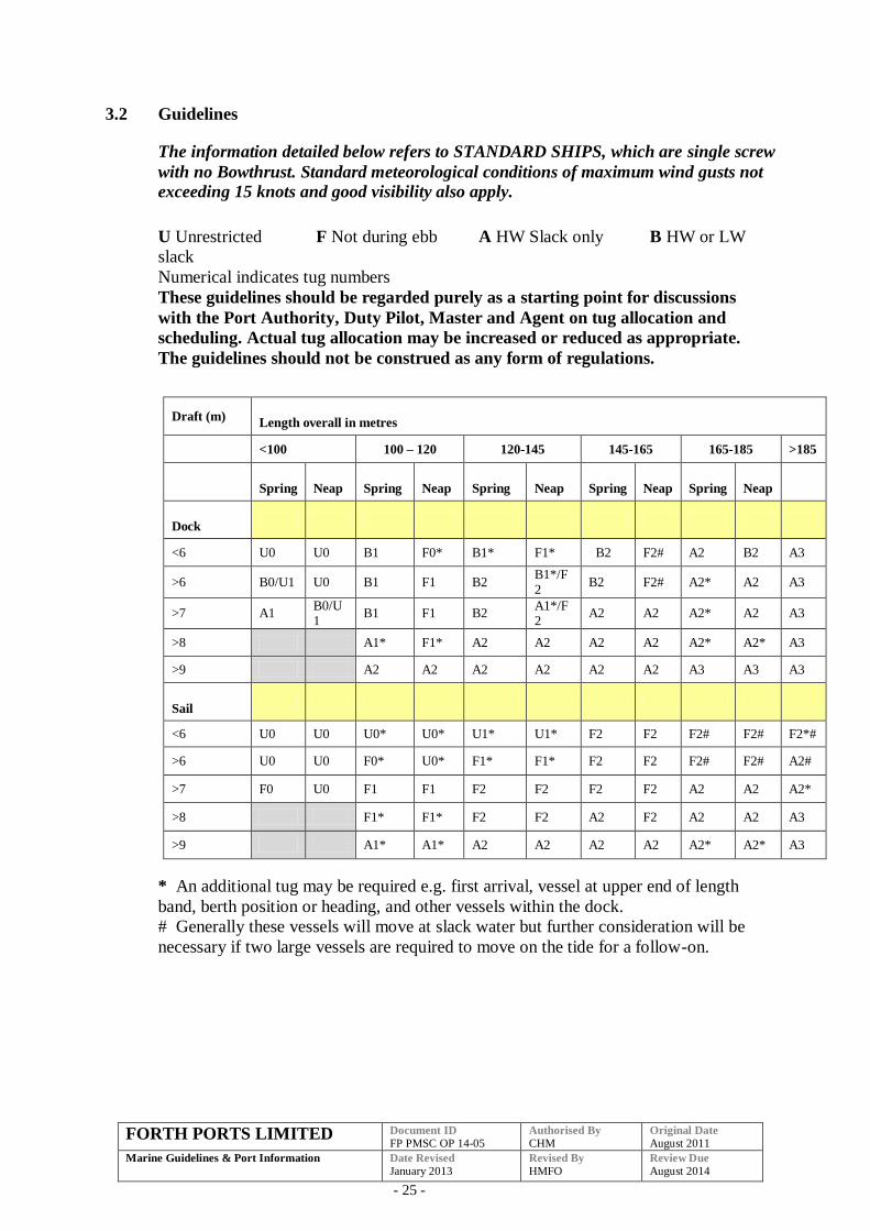
3.2 Guidelines
The information detailed below refers to STANDARD SHIPS, which are single screw
with no Bowthrust. Standard meteorological conditions of maximum wind gusts not
exceeding 15 knots and good visibility also apply.
U Unrestricted F Not during ebb A HW Slack only B HW or LW
slack
Numerical indicates tug numbers
These guidelines should be regarded purely as a starting point for discussions
with the Port Authority, Duty Pilot, Master and Agent on tug allocation and
scheduling. Actual tug allocation may be increased or reduced as appropriate.
The guidelines should not be construed as any form of regulations.
Draft (m) Length overall in metres
<100 100 – 120 120-145 145-165 165-185 >185
Spring Neap Spring Neap Spring Neap Spring Neap Spring Neap
Dock
<6 U0 U0 B1 F0* B1* F1* B2 F2# A2 B2 A3
>6 B0/U1 U0 B1 F1 B2 B1*/F2
B2 F2# A2* A2 A3
>7 A1 B0/U1
B1 F1 B2 A1*/F2
A2 A2 A2* A2 A3
>8 A1* F1* A2 A2 A2 A2 A2* A2* A3
>9 A2 A2 A2 A2 A2 A2 A3 A3 A3
Sail
<6 U0 U0 U0* U0* U1* U1* F2 F2 F2# F2# F2*#
>6 U0 U0 F0* U0* F1* F1* F2 F2 F2# F2# A2#
>7 F0 U0 F1 F1 F2 F2 F2 F2 A2 A2 A2*
>8 F1* F1* F2 F2 A2 F2 A2 A2 A3
>9 A1* A1* A2 A2 A2 A2 A2* A2* A3
* An additional tug may be required e.g. first arrival, vessel at upper end of length
band, berth position or heading, and other vessels within the dock.
# Generally these vessels will move at slack water but further consideration will be
necessary if two large vessels are required to move on the tide for a follow-on.
FORTH PORTS LIMITED Document ID
FP PMSC OP 14-05 Authorised By
CHM Original Date
August 2011
Marine Guidelines & Port Information
Date Revised
January 2013 Revised By
HMFO Review Due
August 2014
- 26 -
Tidal range: Spring ≥3½m, Neap <3½m
Scheduled times are: Inbound - Leith Approach Buoy, Outbound – from berth
Under Keel Clearance: Flood 1m, Ebb 1.5m and 0.5m in dock
HW slack: Docking – Leith Roads no later than HW-2; Sailing – Leave lock no later
than HW-1.5
HW slack Leith is about 1 to 1½ prior to HW
Recommended Bollard Pull will be catered for in a separate document
Pilots should report to FTNS on vessel manoeuvrability after first visit for comment
entry into IPOS.
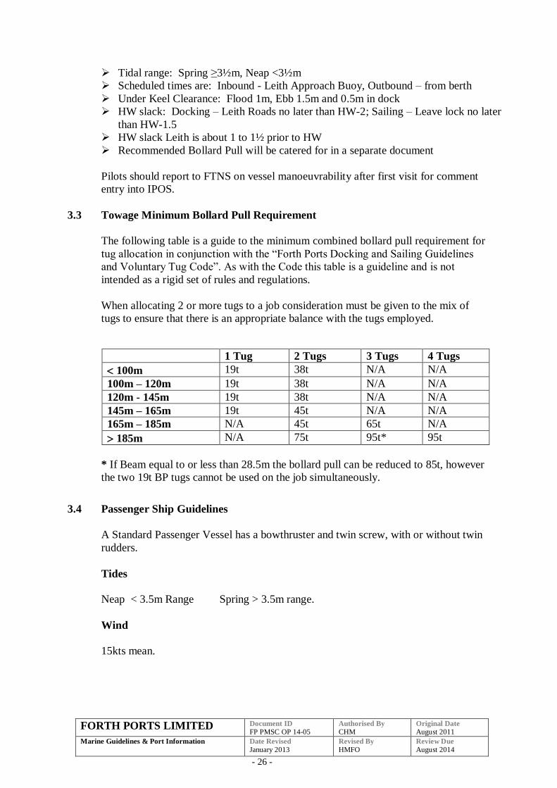
3.3 Towage Minimum Bollard Pull Requirement
The following table is a guide to the minimum combined bollard pull requirement for
tug allocation in conjunction with the “Forth Ports Docking and Sailing Guidelines
and Voluntary Tug Code”. As with the Code this table is a guideline and is not
intended as a rigid set of rules and regulations.
When allocating 2 or more tugs to a job consideration must be given to the mix of
tugs to ensure that there is an appropriate balance with the tugs employed.
1 Tug 2 Tugs 3 Tugs 4 Tugs
100m 19t 38t N/A N/A
100m – 120m 19t 38t N/A N/A
120m - 145m 19t 38t N/A N/A
145m – 165m 19t 45t N/A N/A
165m – 185m N/A 45t 65t N/A
185m N/A 75t 95t* 95t
* If Beam equal to or less than 28.5m the bollard pull can be reduced to 85t, however
the two 19t BP tugs cannot be used on the job simultaneously.
3.4 Passenger Ship Guidelines
A Standard Passenger Vessel has a bowthruster and twin screw, with or without twin
rudders.
Tides
Neap < 3.5m Range Spring > 3.5m range.
Wind
15kts mean.
FORTH PORTS LIMITED Document ID
FP PMSC OP 14-05 Authorised By
CHM Original Date
August 2011
Marine Guidelines & Port Information
Date Revised
January 2013 Revised By
HMFO Review Due
August 2014
- 27 -
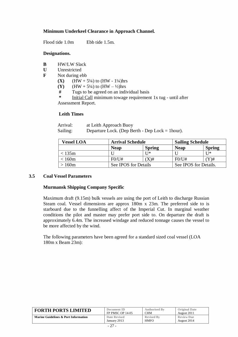
Minimum Underkeel Clearance in Approach Channel.
Flood tide 1.0m Ebb tide 1.5m.
Designations.
B HW/LW Slack
U Unrestricted
F Not during ebb
(X) (HW + 5¼) to (HW - 1¼)hrs
(Y) (HW + 5¼) to (HW – ½)hrs
# Tugs to be agreed on an individual basis
* Initial Call minimum towage requirement 1x tug - until after
Assessment Report.
Leith Times
Arrival: at Leith Approach Buoy
Sailing: Departure Lock. (Dep Berth - Dep Lock = 1hour).
Vessel LOA Arrival Schedule Sailing Schedule
Neap Spring Neap Spring
< 135m U U* U U*
< 160m F0/U# (X)# F0/U# (Y)#
> 160m See IPOS for Details See IPOS for Details.
3.5 Coal Vessel Parameters
Murmansk Shipping Company Specific
Maximum draft (9.15m) bulk vessels are using the port of Leith to discharge Russian
Steam coal. Vessel dimensions are approx 180m x 23m. The preferred side to is
starboard due to the funnelling affect of the Imperial Cut. In marginal weather
conditions the pilot and master may prefer port side to. On departure the draft is
approximately 6.4m. The increased windage and reduced tonnage causes the vessel to
be more affected by the wind.
The following parameters have been agreed for a standard sized coal vessel (LOA
180m x Beam 23m):
FORTH PORTS LIMITED Document ID
FP PMSC OP 14-05 Authorised By
CHM Original Date
August 2011
Marine Guidelines & Port Information
Date Revised
January 2013 Revised By
HMFO Review Due
August 2014
- 28 -
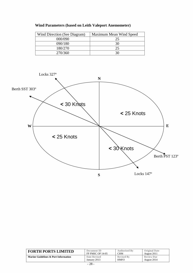
Wind Parameters (based on Leith Valeport Anemometer)
Wind Direction (See Diagram) Maximum Mean Wind Speed
000/090 25
090/180 30
180/270 25
270/360 30
< 30 Knots
< 30 Knots
Cau
ses
the
ves
sel
to
roll,
ther
eby
incr
easi
ng
the
draf
t;
The
mo
ve
me
nt
bet
wee
n
ship
and
tug
ma
y
cau
se
tow
line
s to
snat
ch
and
< 25 Knots
< 25 Knots
N
E
S
W
Locks 147º
Berth PST 123º
Berth SST 303º
Locks 327º
FORTH PORTS LIMITED Document ID
FP PMSC OP 14-05 Authorised By
CHM Original Date
August 2011
Marine Guidelines & Port Information
Date Revised
January 2013 Revised By
HMFO Review Due
August 2014
- 29 -
Towage
Wind Speed Arrive Minimum BP SST Depart
Minimum BP
PST Depart
Minimum BP
<15 Knots 2 x 30t
or
1 x 30t & 2 x 19t
2 x 19t 1 x 30t & 2 x 19t
>15 Knots 2 x 30t & 1 x 19t 1 x 19t & 1 x 30t 2 x 30t & 1 x 19t
>25 Knots 2 x 30t & 1 x 19t 2 x 30t 2 x 30t & 1 x 19t
Swell
Causes the vessel to roll, thereby increasing the draft;
The movement between ship and tug may cause towlines to snatch and
possibly part.
Port will generally close if swell >40cm which will prevent the caisson
gates from operating safely. This occurs during prolonged Easterly winds
and when the tide exceeds 9.5m.
Swell is difficult to predict and monitor. Decisions will be based on the
rise and fall on the gauge at Leith Locks and an assessment from the pilot
vessel. A decision to go ahead with a job based on an assessment from the
pilot vessel is no guarantee the docking will be successful; behaviour of
ship and tug and the caisson gates will be the final deciding factor.
Shifting
If a vessel requires to shift there are various factors to be considered:
Distance of the shift
Wind speed and direction
Proximity of other vessels and shoreside equipment
Although in certain conditions a vessel may shift along the berth without the
assistance of pilot, tugs or boatmen, on reviewing the conditions the
requirements of the port can include one or more of the following:
Use of boatmen
Pilot,
Tug/s
Shifting of shore cranes
The scale of requirements should involve a discussion between Pilots and
Harbour Master.
South Side Imperial
For all arrival and departures South Side Imperial should be free of shipping
for 100m measured from the Imperial cut.
FORTH PORTS LIMITED Document ID
FP PMSC OP 14-05 Authorised By
CHM Original Date
August 2011
Marine Guidelines & Port Information
Date Revised
January 2013 Revised By
HMFO Review Due
August 2014
- 30 -
3.6 Wind Parameters
The port will be closed to vessel movements when the mean wind speed measured on
the Leith anemometer is 40 knots and over.
3.7 Visibility Parameter
Vessels are not permitted to enter the Port when the outer end of the lead in jetty (FL
red 6 sec) cannot be seen from the Harbour Office.
Vessels are not permitted to enter the lock from the Dock when No.3 Gate cannot be
seen from the Harbour Office.
3.8 Management Plan
The following should be confirmed before manoeuvring in the Port of Leith.
That a harbour manoeuvre plan has been prepared and agreed (where appropriate)
with the pilot.
That any defects, which may affect the safe navigation or manoeuvrability of the
vessel, are reported.
The maximum draft.
The following procedures should be adopted
Inbound
On transferring from Channel 71 to Channel 12 to communicate with Leith, please
pass the following information:
A harbour manoeuvre plan from the Leith Approach Buoy to berth has been
agreed.
The maximum draft.
Outbound
On seeking permission to depart from the berth, please pass the following
information:
A harbour manoeuvre plan has been agreed from the berth to the Leith Approach
Buoy.
Any defects (as in 8.1.2).
Maximum draft.
FORTH PORTS LIMITED Document ID
FP PMSC OP 14-05 Authorised By
CHM Original Date
August 2011
Marine Guidelines & Port Information
Date Revised
January 2013 Revised By
HMFO Review Due
August 2014
- 31 -
4 PORT OF ROSYTH
4.1 Docking and Sailing Guidelines and Voluntary Tug Code Introduction
The following revised Guidelines have been drawn up for the port of Rosyth.
The Guidelines form part of the formal risk assessment process and are continuously
under review in the light of operational experience. There has been extensive
consultation between the Port Authority and the Forth Pilots while producing these
Guidelines.
It is not intended that these Guidelines are a rigid set of regulations or rules to be
followed on all occasions, they are intended as guide to ships masters, agents, pilots
and the Port Authority to allow safe and effective scheduling of vessels.
Further discussions on some occasions maybe required between the Duty Pilot, Forth
and Tay Navigation Service and the vessel’s Master, taking into account the
prevailing weather and tidal conditions and any other special circumstances.
.
The final decision on the number of tugs required rests with the Master of the vessel,
in consultation with the pilot.
However the Port Authority reserves the right to require a vessel to take a tug or
comply with any special instruction which may be considered necessary according to
the particular circumstances of the case.
The following assumptions have been made in preparing these guidelines:
Standard Ship – single screw with no bow/stern thrusters, high efficiency rudder
or other manoeuvring aids.
Favourable weather conditions.
Tidal Ranges within predicted limits.
No adverse local activity and/or conditions.
Non-standard vessel will be assessed on an individual basis.
The Guidelines are presented in a tabular form, the tables contain an identification
letter indicating tidal constraints followed by a numerical indication of the number of
tugs recommended.
For ports with lock entrances the Guidelines refers to the requirement to enter/leave
the locks. Further consideration to tug requirement may need to be given depending
on berth location, side to, proximity of other berthed vessels and the table in 6.2.
FORTH PORTS LIMITED Document ID
FP PMSC OP 14-05 Authorised By
CHM Original Date
August 2011
Marine Guidelines & Port Information
Date Revised
January 2013 Revised By
HMFO Review Due
August 2014
- 32 -
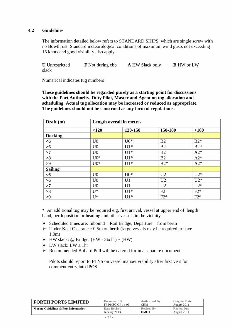
4.2 Guidelines
The information detailed below refers to STANDARD SHIPS, which are single screw with
no Bowthrust. Standard meteorological conditions of maximum wind gusts not exceeding
15 knots and good visibility also apply.
U Unrestricted F Not during ebb A HW Slack only B HW or LW
slack
Numerical indicates tug numbers
These guidelines should be regarded purely as a starting point for discussions
with the Port Authority, Duty Pilot, Master and Agent on tug allocation and
scheduling. Actual tug allocation may be increased or reduced as appropriate.
The guidelines should not be construed as any form of regulations.
Draft (m) Length overall in metres
<120 120-150 150-180 >180
Docking
<6 U0 U0* B2 B2*
>6 U0 U1* B2 B2*
>7 U0 U1* B2 A2*
>8 U0* U1* B2 A2*
>9 U0* U1* B2* A2*
Sailing
<6 U0 U0* U2 U2*
>6 U0 U1 U2 U2*
>7 U0 U1 U2 U2*
>8 U* U1* F2 F2*
>9 U* U1* F2* F2*
* An additional tug may be required e.g. first arrival, vessel at upper end of length
band, berth position or heading and other vessels in the vicinity.
Scheduled times are: Inbound – Rail Bridge, Departure – from berth
Under Keel Clearance: 0.5m on berth (large vessels may be required to have
1.0m)
HW slack: @ Bridge: (HW - 2¼ hr) ~ (HW)
LW slack: LW 1hr
Recommended Bollard Pull will be catered for in a separate document
Pilots should report to FTNS on vessel manoeuvrability after first visit for
comment entry into IPOS.
FORTH PORTS LIMITED Document ID
FP PMSC OP 14-05 Authorised By
CHM Original Date
August 2011
Marine Guidelines & Port Information
Date Revised
January 2013 Revised By
HMFO Review Due
August 2014
- 33 -
RoRo Specific
The ferry will require tugs as follows:
1 tug > 25 knots
2 tugs > 30 knots
> 40 knots the port will be closed to shipping movements.
Bookings should be made with FTNS on 01324 498584 or VHF Channel 71.
Bookings for tugs should be made at least 3 hours before tug is required.
The above is subject to the availability of tugs.
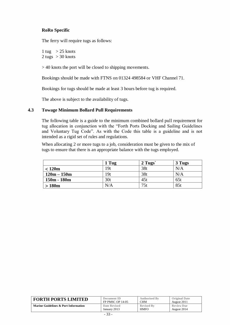
4.3 Towage Minimum Bollard Pull Requirements
The following table is a guide to the minimum combined bollard pull requirement for
tug allocation in conjunction with the “Forth Ports Docking and Sailing Guidelines
and Voluntary Tug Code”. As with the Code this table is a guideline and is not
intended as a rigid set of rules and regulations.
When allocating 2 or more tugs to a job, consideration must be given to the mix of
tugs to ensure that there is an appropriate balance with the tugs employed.
1 Tug 2 Tugs` 3 Tugs
120m 19t 38t N/A
120m – 150m 19t 38t N/A
150m - 180m 30t 45t 65t
180m N/A 75t 85t
FORTH PORTS LIMITED Document ID
FP PMSC OP 14-05 Authorised By
CHM Original Date
August 2011
Marine Guidelines & Port Information
Date Revised
January 2013 Revised By
HMFO Review Due
August 2014
- 34 -
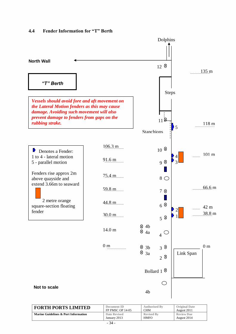
4.4 Fender Information for “T” Berth
North Wall
4b
66.6 m
30.0 m
75.4 m
59.8 m
44.8 m
106.3 m
0 m
91.6 m
Stanchions
Dolphins
135 m
38.8 m
Link Span
0 m
2
Bollard 1
42 m
101 m
“T” Berth
Steps
14.0 m
Not to scale
3
4
5
6
7
8
9
10
11
12
3a
3b
4a
4b
1
2
3
4
5
Denotes a Fender:
1 to 4 - lateral motion
5 - parallel motion
Fenders rise approx 2m
above quayside and
extend 3.66m to seaward
2 metre orange
square-section floating
fender
118 m
Vessels should avoid fore and aft movement on
the Lateral Motion fenders as this may cause
damage. Avoiding such movement will also
prevent damage to fenders from gaps on the
rubbing strake.
FORTH PORTS LIMITED Document ID
FP PMSC OP 14-05 Authorised By
CHM Original Date
August 2011
Marine Guidelines & Port Information
Date Revised
January 2013 Revised By
HMFO Review Due
August 2014
- 35 -
4.5 Wind Parameters
The port will be closed to vessel movements when the mean wind speed measured on
the Rosyth anemometer is 40 knots and over.
4.6 Visibility Parameters
The Port is closed to vessel movements if the visibility is reduced to:
5 cables or less for vessels in excess of 80 m LOA.
2 cables or less for vessels under 80m LOA.
RoRo ferry operations – 4 cables inbound and 2 cables outbound.
Rosyth Babcock’s
The dock is closed to vessels if visibility is less than 0.5 miles.
4.7 Babcock’s Enclosed Dock
For any large vessels bound for the enclosed dock operated by Babcock’s at Rosyth
the following schedule should be used:
The Rila size vessel 185m LOA 22.8m beam and approximate DWT 26,000 tonnes
are the maximum size for the lock entrance.
The “Peach Mountain” size 195m LOA 32.0m beam and approximately 40,000 DWT
are the maximum size for the Direct Entrance.
Vessels of greater dimensions will be subject to further planning meetings.
Inbound
Pilot on Board HW –3 hours 30 minutes
Tugs in Attendance HW –2 hours 30 minutes at No. 16 Buoy
Pass Rail Bridge HW –2 hours 15 minutes
Pass Beamer Rock HW –2 hours
Cross Sill HW –1 hour 30 minutes
Outbound
Pilot on Board 30 minutes before direct entrance gate opens.
For the lock entrance sailings should be scheduled for the vessel to clear the lock
before the ebb comes away, in line with the general guidelines for Rosyth.
Towage
Large vessels up to 185m LOA 22.8m beam and approximate DWT 26,000 tonnes.
FORTH PORTS LIMITED Document ID
FP PMSC OP 14-05 Authorised By
CHM Original Date
August 2011
Marine Guidelines & Port Information
Date Revised
January 2013 Revised By
HMFO Review Due
August 2014
- 36 -
Docking
3 tugs one of which must be at least 30 tonnes bollard pull.
Sailing
2 Tugs
Large vessels over 185m LOA 22.8m beam and approximate DWT 26,000 tonnes.
Docking
3 tugs 1 x 50 tonnes bollard pull and 2 x 30 tonnes bollard pull, or
4 tugs 1x 37 tonnes bollard pull, 1 x 30 tonnes bollard pull plus two others.
Sailing
3 tugs one of which must be at least 30 tonnes bollard pull
FORTH PORTS LIMITED Document ID
FP PMSC OP 14-05 Authorised By
CHM Original Date
August 2011
Marine Guidelines & Port Information
Date Revised
January 2013 Revised By
HMFO Review Due
August 2014
- 37 -
5 PORTS OF METHIL, KIRKCALDY, BURNTISLAND, INVERKEITHING
AND CROMBIE JETTY
5.1 Guidelines
Methil
Dockings and sailings carried out between HW –2 and HW providing there is
sufficient water.
A vessel may be allowed to sail shortly after HW if she is close to completing cargo
work and no other vessel is in port.
Vessels stemmed for Methil do not normally require tugs.
Methil Energy Park
Piloted vessels will only be permitted to berth at the Methil Energy Park facility if up
to date surveys have been conducted and that the quay including ladder are
maintained in a safe condition.
Guidance on Methil Energy Park Berths can be found in the Quayside Regulations.
An updated version of these guidelines can be found at:
http://www.scottish-enterprise.com/your-sector/energy/energy-how-we-can-
help/research-and-development-support/Fife-energy-park.aspx
Kirkcaldy
Berth has been declared level, dredged to Chart Datum in close approaches and Inner
Harbour and free from obstructions.
Berth is subject to regular bathymetric survey and the berth operator will ensure that
the berth is dredged as required to maintain depths to Chart Datum.
Harbour Master to be immediately advised by telephone in the event of any items,
however small that has entered the water. This is necessary to prevent any channel
obstruction or vessel damage.
Lock gates are no longer in use
Dockings and sailings will be carried out between HW-1 and HW providing there is
sufficient water
Vessels stemmed for Kirkcaldy do not normally require tugs.
Pilot will board in Kirkcaldy Roads.
Main entrance is 15.2 metres wide.
FORTH PORTS LIMITED Document ID
FP PMSC OP 14-05 Authorised By
CHM Original Date
August 2011
Marine Guidelines & Port Information
Date Revised
January 2013 Revised By
HMFO Review Due
August 2014
- 38 -
The maximum size of vessel normally accepted is LOA 85 metres and a Beam of 14
metres. Vessels out with these dimensions will be dealt with on a case-by-case basis.
Vessels are required to have an operational bow thruster.
Vessels will berth port side alongside as the preferred side on the Carr Mills berth.
Ruling depth 0.0m (Inner harbour and close approach channel dredged to Chart
Datum).
Under Keel Clearance 0.7m
Sill Height 0.65 below Chart Datum
Admiralty Chart Datum (LAT) is 3.55 below Ordnance Datum, Newlyn
Burntisland
Dockings and sailings carried out between HW –2 and HW providing there is
sufficient water.
Inverkeithing
Berthing at Timber Lay-by Berth East Ness Pier
Following a general visual inspection of the berths at Inverkeithing it has been
declared unsafe for pilots to berth or sail vessels from the timber jetty lay-by berth at
East Ness Pier due to its unsound condition.
As a consequence the owners/operators of this facility have been advised that vessels
will not be piloted either onto or off this jetty. The owners/operators have been
further advised that this jetty is within compulsory pilotage waters and any vessel
berthing or sailing from the jetty without a pilot will be in breach of the Pilotage
Directions.
Crombie
Crombie is located on the North side of the river between Rosyth and Grangemouth.
The jetty is operated by the Ministry of Defence and consists of two berths: South
berth with a minimum of 12 metres at low water, and North Berth with a minimum of
7.5 metres. There is an annual Hydrographic survey undertaken and dredging is
arranged as required to maintain minimum depths. Visiting ships are mostly naval or
Fleet Auxiliary. Bridge transit time for larger vessels will determine the berthing
time. Side too will be determined by the tidal state.
All port visits are preceded by signal LOGREQ (Logistics Requirement), giving 7
days notice. This will list all vessel requirements including Pilotage, tugs and line
handlers.
Crombie jetty operates on VHF channel 74 – call sign Crombie jetty.
FORTH PORTS LIMITED Document ID
FP PMSC OP 14-05 Authorised By
CHM Original Date
August 2011
Marine Guidelines & Port Information
Date Revised
January 2013 Revised By
HMFO Review Due
August 2014
- 39 -
A stand by tug is required at the jetty during cargo operations.
When a ship is alongside there is a speed restriction of 10 knots for passing vessels as
per General Direction 17.
5.2 Towage Minimum Bollard Pull Requirements – Crombie
The following table is a guide to the minimum combined bollard pull requirement for
tug allocation in conjunction with the “Forth Ports Docking and Sailing Guidelines
and Voluntary Tug Code”. As with the Code this table is a guideline and is not
intended as a rigid set of rules and regulations.
When allocating 2 or more tugs to a job consideration must be given to the mix of
tugs to ensure that there is an appropriate balance with the tugs employed.
1 Tug 2 Tugs
AFSH’s (Fort Austin/Rosalie) 30t N/A
AOR’s (Fort Victoria/George) N/A 60t
Fleet Tankers (Wave Knight/Ruler) 30t N/A
Galahad Class N/A 36t
Leaf Class N/A 60t
Diligence Class 18t N/A
Rover Class 30t N/A
CVS (Ark Royal/Invincible/Illustrious) N/A 60t
5.3 Wind Parameters
Methil
Port
Maximum wind speed 35 knots but reduced to 25 knots should there been an easterly
element to the direction.
Swell conditions to be determined by pre-assessment.
Energy Park Berth
Refer to latest edition of Energy Park Fife Quayside Regulations.
Barges – as per agreed parameters on the Barge Method Statement.
Vessels – to be determined by pre-assessment of swell conditions.
Kirkcaldy
Port
Maximum wind speed 20 knots, restrictions may be put in place with vessels LOA
greater than 80m.
FORTH PORTS LIMITED Document ID
FP PMSC OP 14-05 Authorised By
CHM Original Date
August 2011
Marine Guidelines & Port Information
Date Revised
January 2013 Revised By
HMFO Review Due
August 2014
- 40 -
Wind and swell conditions to be determined by pre-assessment.
Burntisland
Maximum wind speed 35 knots.
Inverkeithing
Maximum wind speed 35 knots.
Crombie
Maximum wind speed 30 knots.
5.4 Visibility Parameters
Methil
Vessels are not permitted to enter or leave the Port when the outer end of the
breakwater (Oc G 6 sec) cannot be seen from the Harbour master’s office at No.2
Dockhead.
Energy Park Fife
Vessels are not permitted to berth or depart when southern end of West Berth cannot
be seen from the northern end of East Berth.
Kirkcaldy
Vessels are not permitted to enter or leave the port when the outer breakwater (F1.R
5s) cannot be seen from the Carrs Mill berth.
Burntisland
Vessels are not permitted to enter or leave the Port when the outer end of the East
Breakwater (Fl (2) G sec) cannot be seen from the Harbour Office on the north side of
the Dock Gates.
Inverkeithing
The harbour is closed to vessel movements if the visibility is reduced to 2 cables or
less.
Crombie
Movements on and off the jetty will not be permitted unless the visibility of the jetty
is a minimum of 1 nautical mile.
FORTH PORTS LIMITED Document ID
FP PMSC OP 14-05 Authorised By
CHM Original Date
August 2011
Marine Guidelines & Port Information
Date Revised
January 2013 Revised By
HMFO Review Due
August 2014
- 41 -
6 TOWAGE
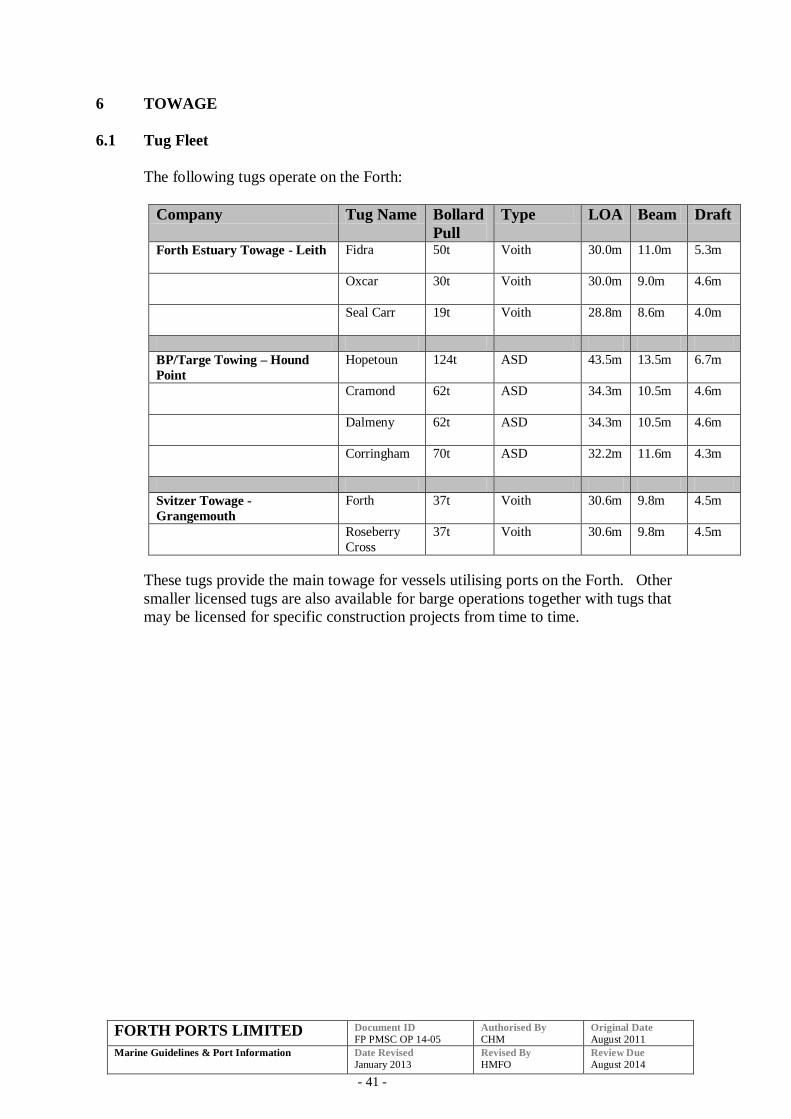
6.1 Tug Fleet
The following tugs operate on the Forth:
Company Tug Name Bollard
Pull
Type LOA Beam Draft
Forth Estuary Towage - Leith Fidra
50t Voith 30.0m 11.0m 5.3m
Oxcar
30t Voith 30.0m 9.0m 4.6m
Seal Carr
19t Voith 28.8m 8.6m 4.0m
BP/Targe Towing – Hound
Point
Hopetoun 124t ASD 43.5m 13.5m 6.7m
Cramond
62t ASD 34.3m 10.5m 4.6m
Dalmeny
62t ASD 34.3m 10.5m 4.6m
Corringham
70t ASD 32.2m 11.6m 4.3m
Svitzer Towage -
Grangemouth
Forth 37t Voith 30.6m 9.8m 4.5m
Roseberry
Cross
37t Voith 30.6m 9.8m 4.5m
These tugs provide the main towage for vessels utilising ports on the Forth. Other
smaller licensed tugs are also available for barge operations together with tugs that
may be licensed for specific construction projects from time to time.
FORTH PORTS LIMITED Document ID
FP PMSC OP 14-05 Authorised By
CHM Original Date
August 2011
Marine Guidelines & Port Information
Date Revised
January 2013 Revised By
HMFO Review Due
August 2014
- 42 -
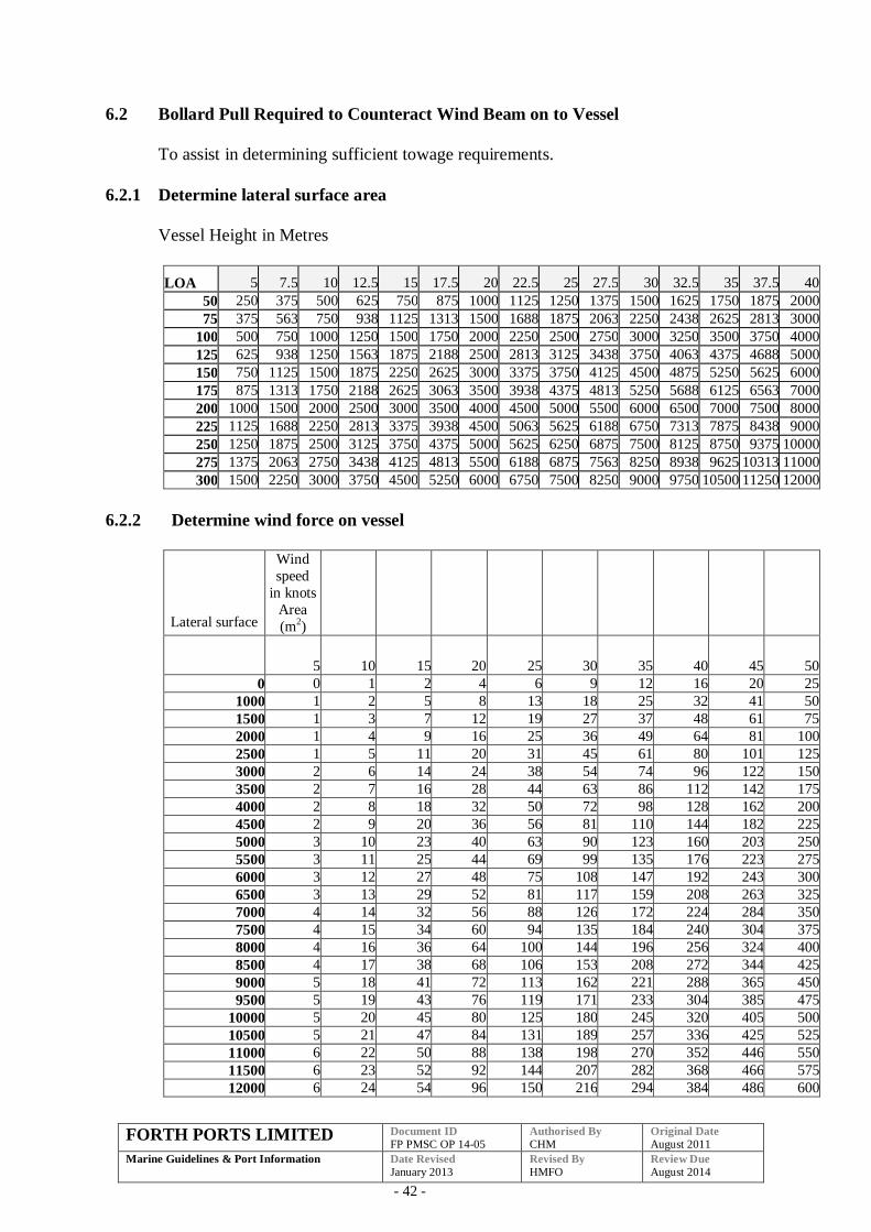
6.2 Bollard Pull Required to Counteract Wind Beam on to Vessel
To assist in determining sufficient towage requirements.
6.2.1 Determine lateral surface area
Vessel Height in Metres
LOA 5 7.5 10 12.5 15 17.5 20 22.5 25 27.5 30 32.5 35 37.5 40
50 250 375 500 625 750 875 1000 1125 1250 1375 1500 1625 1750 1875 2000
75 375 563 750 938 1125 1313 1500 1688 1875 2063 2250 2438 2625 2813 3000
100 500 750 1000 1250 1500 1750 2000 2250 2500 2750 3000 3250 3500 3750 4000
125 625 938 1250 1563 1875 2188 2500 2813 3125 3438 3750 4063 4375 4688 5000
150 750 1125 1500 1875 2250 2625 3000 3375 3750 4125 4500 4875 5250 5625 6000
175 875 1313 1750 2188 2625 3063 3500 3938 4375 4813 5250 5688 6125 6563 7000
200 1000 1500 2000 2500 3000 3500 4000 4500 5000 5500 6000 6500 7000 7500 8000
225 1125 1688 2250 2813 3375 3938 4500 5063 5625 6188 6750 7313 7875 8438 9000
250 1250 1875 2500 3125 3750 4375 5000 5625 6250 6875 7500 8125 8750 9375 10000
275 1375 2063 2750 3438 4125 4813 5500 6188 6875 7563 8250 8938 9625 10313 11000
300 1500 2250 3000 3750 4500 5250 6000 6750 7500 8250 9000 9750 10500 11250 12000
6.2.2 Determine wind force on vessel
Lateral surface
Wind
speed
in knots
Area
(m2)
5 10 15 20 25 30 35 40 45 50
0 0 1 2 4 6 9 12 16 20 25
1000 1 2 5 8 13 18 25 32 41 50
1500 1 3 7 12 19 27 37 48 61 75
2000 1 4 9 16 25 36 49 64 81 100
2500 1 5 11 20 31 45 61 80 101 125
3000 2 6 14 24 38 54 74 96 122 150
3500 2 7 16 28 44 63 86 112 142 175
4000 2 8 18 32 50 72 98 128 162 200
4500 2 9 20 36 56 81 110 144 182 225
5000 3 10 23 40 63 90 123 160 203 250
5500 3 11 25 44 69 99 135 176 223 275
6000 3 12 27 48 75 108 147 192 243 300
6500 3 13 29 52 81 117 159 208 263 325
7000 4 14 32 56 88 126 172 224 284 350
7500 4 15 34 60 94 135 184 240 304 375
8000 4 16 36 64 100 144 196 256 324 400
8500 4 17 38 68 106 153 208 272 344 425
9000 5 18 41 72 113 162 221 288 365 450
9500 5 19 43 76 119 171 233 304 385 475
10000 5 20 45 80 125 180 245 320 405 500
10500 5 21 47 84 131 189 257 336 425 525
11000 6 22 50 88 138 198 270 352 446 550
11500 6 23 52 92 144 207 282 368 466 575
12000 6 24 54 96 150 216 294 384 486 600
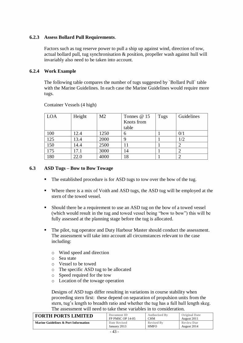
FORTH PORTS LIMITED Document ID
FP PMSC OP 14-05 Authorised By
CHM Original Date
August 2011
Marine Guidelines & Port Information
Date Revised
January 2013 Revised By
HMFO Review Due
August 2014
- 43 -
6.2.3 Assess Bollard Pull Requirements.
Factors such as tug reserve power to pull a ship up against wind, direction of tow,
actual bollard pull, tug synchronisation & position, propeller wash against hull will
invariably also need to be taken into account.
6.2.4 Work Example
The following table compares the number of tugs suggested by `Bollard Pull` table
with the Marine Guidelines. In each case the Marine Guidelines would require more
tugs.
Container Vessels (4 high)
LOA Height M2 Tonnes @ 15
Knots from
table
Tugs Guidelines
100 12.4 1250 6 1 0/1
125 13.4 2000 9 1 1/2
150 14.4 2500 11 1 2
175 17.1 3000 14 1 2
180 22.0 4000 18 1 2
6.3 ASD Tugs – Bow to Bow Towage
The established procedure is for ASD tugs to tow over the bow of the tug.
Where there is a mix of Voith and ASD tugs, the ASD tug will be employed at the
stern of the towed vessel.
Should there be a requirement to use an ASD tug on the bow of a towed vessel
(which would result in the tug and towed vessel being “bow to bow”) this will be
fully assessed at the planning stage before the tug is allocated.
The pilot, tug operator and Duty Harbour Master should conduct the assessment.
The assessment will take into account all circumstances relevant to the case
including:
o Wind speed and direction
o Sea state
o Vessel to be towed
o The specific ASD tug to be allocated
o Speed required for the tow
o Location of the towage operation
Designs of ASD tugs differ resulting in variations in course stability when
proceeding stern first: these depend on separation of propulsion units from the
stern, tug’s length to breadth ratio and whether the tug has a full hull length skeg.
The assessment will need to take these variables in to consideration.

FORTH PORTS LIMITED Document ID
FP PMSC OP 14-05 Authorised By
CHM Original Date
August 2011
Marine Guidelines & Port Information
Date Revised
January 2013 Revised By
HMFO Review Due
August 2014
- 44 -
Bow to bow towage operations involving ASD tugs should only take place at slow
speeds, 4 knots through the water or as agreed with the tug Master, and in wind
speeds of not more than Force 4 onshore, Force 5 Off shore, and with a significant
wave height of less than 1-2 m depending on direction.
This manoeuvre must not be rushed: tugs should be made fast as early as is
reasonably practical.
The tug Master should confirm to the Pilot that the design, handling
characteristics of his tug, together with his risk assessments and training are
appropriate for the operation. He should inform the Pilot immediately at any point
during the manoeuvre should he have any safety related concerns.
6.4 Towage Operations in Restricted Visibility
Forth Ports and terminal operators have parameters in place to ensure ports, docks or
terminals are closed to shipping movements due to restricted visibility. However,
there will be times when despite ports, docks or terminals being closed to vessel
movements towage operations will still be conducted in the river.
These procedures apply to all towage operations in the river being conducted in
restricted visibility.
Restricted visibility is all circumstances where visibility is, or is expected to, reduce
to a distance where the tugs normal ability to perform may be impaired. Such
restrictions in visibility could be due to fog, mist, snow, rain, sleet or any other
conditions which impair visibility.
In circumstances where restricted visibility exists, or is likely to exist, the Master/Pilot
and Tug Master shall as part of the passage plan and risk assessment process agree
how the operation will be conducted, what dangers are associated with towing in
restricted visibility and what risk reduction measures should be applied. When
completing this assessment the following should be considered:
Type of tug, propulsion method, towing from winch or hook and location of
winch/hook.
Proposed method of towing.
Operational status of navigational aids and equipment.
Minimum speed to maintain steerage of vessel to be assisted.
Movement of other vessels in the area.
Navigational characteristics of the particular area of the river/port including the
use of information from Vessel Traffic Services (VTS).
FORTH PORTS LIMITED Document ID
FP PMSC OP 14-05 Authorised By
CHM Original Date
August 2011
Marine Guidelines & Port Information
Date Revised
January 2013 Revised By
HMFO Review Due
August 2014
- 45 -
Contingency plan should visibility deteriorate after the tow has commenced and/or
if the tug has to disengage at any stage of the operation.
Minimum visibility for all towage operations is 370m (two cables) or the assisted
vessels length if greater, and such that the Master/Pilot can see the tug and the Tug
Master can see the towed vessel wheelhouse.
Should visibility fall below the minimum once a towage operation has commenced
the Pilot shall immediately reduce speed to a minimum safe speed and if safe to do so
take all way off the vessel. Following discussion with the tug master the contingency
plan discussed and agreed at the planning stage will be implemented. This could
include one or more of the following:
with all way off the vessel let go the tugs and anchor the vessel.
with all way off if required use the tugs to turn the vessel, let go the tugs and
the vessel proceeds either to an anchorage or to the outer estuary.
let go the tugs and have the tugs assist in a pushing mode.
with all way off the vessel allow under the pilots instructions the tugs to
manoeuvre the vessel. This may include using the tugs to maintain the vessels
position at a safe location in the river.
The agreed course of action should be fully communicated to FTNS.
All towage operations in restricted visibility should be conducted with the assisted
vessel maintaining minimum speed. An approximate maximum speed of 6 knots
should be considered. If a vessels minimum speed is higher than 6 knots this will be
a major factor to consider in the planning stage of the operation.
The Tug Master should immediately inform the Pilot/Master of any concerns that he
may have as to the safety of his tug and crew. The Pilot and Tug Master should take
immediate action to ensure the safety of both the tug and assisted vessel, if necessary
they should abort the operation as soon as it is safe to do so.
There should be a pro-active point that is made to highlight that a tug proceeding to a
job should report any lack of visibility and report such to FTNS and the vessel that
they are rendezvousing with.
FORTH PORTS LIMITED Document ID
FP PMSC OP 14-05 Authorised By
CHM Original Date
August 2011
Marine Guidelines & Port Information
Date Revised
January 2013 Revised By
HMFO Review Due
August 2014
- 46 -
Towage Operations in Heavy Weather
In circumstances where heavy weather (i.e. high winds and / or heavy swell) exists, or
is likely to exist, the Master/Pilot and Tug Master shall as part of the passage plan and
risk assessment process agree how the operation will be conducted, what hazards are
associated with the towage operation and what risk reduction measures should be
applied. When completing this assessment the following should be considered:
Sea and/or swell conditions at the intended operating area and the route to/from
same.
Wind speed, direction and trend i.e. rising, steady or falling.
State of tide and trend.
Information offered by latest weather forecast and other vessels in the area.
Type of tug, propulsion method, towing from winch or hook and location
of winch/hook.
Proposed method of towing, including likelihood of shock-load to towing gear.
Movement of other vessels in the area.
Navigational characteristics of the particular area of the river/port including the
use of information from Vessel Traffic Services (VTS).
Contingency plan should weather deteriorate before/after the tow has commenced
and/or if the tug has to disengage at any stage of the operation. This could include,
but not only be limited to, one or more of the following:
o Tugs do not make fast and remain on station to assist the vessel to a position
of safety.
o Tugs are let go and remain on station to assist the vessel to a position of
safety.
o Tugs are let go to assist in a pushing mode.
If there is likelihood that the weather conditions may pose a significant threat to the
Tug Crew/Tug/Towing Gear, the Tug Master should immediately inform the
Pilot/Master of any concerns that he may have. The Pilot and Tug Master should take
immediate action to ensure the safety of the assisted vessel/tug/tug crew and, if
necessary, the operation aborted as soon as it is safe to do so.
The agreed course of action should be fully communicated to FTNS.
When the tug is proceeding to a job in poor weather conditions, the tug master is to
make a pro-active report to discuss the weather conditions with FTNS, the Pilot and,
if necessary, the vessel with which they are rendezvousing.
FORTH PORTS LIMITED Document ID
FP PMSC OP 14-05 Authorised By
CHM Original Date
August 2011
Marine Guidelines & Port Information
Date Revised
January 2013 Revised By
HMFO Review Due
August 2014
- 47 -
7 PILOTAGE
7.1 Pilot Vessel Operations in Restricted Visibility
Forth Ports and terminal operators have parameters in place which require ports,
docks or terminals to be closed to shipping movements during periods of restricted
visibility. However, there will be times when despite ports, docks or terminals being
closed to vessel movements Pilot Vessel operations will still be conducted in the river.
Restricted visibility is all circumstances where visibility is, or is expected to, reduce
to a distance where the Pilot Vessels normal ability to perform may be impaired. Such
restrictions in visibility could be due to fog, mist, snow, rain, sleet or any other
conditions that impair visibility. In circumstances where restricted visibility exists, or
is likely to exist, the Pilot Vessel Coxswain shall as part of the passage plan and risk
assessment process decide how the operation will be conducted, what dangers are
associated with operating the Pilot Vessel in restricted visibility and what risk
reduction measures should be applied. When completing this assessment the
following points should be considered, along with others as deemed necessary in the
circumstances:
Allocation of extra time for the Pilot Vessel operation.
Conduct of the Pilot Vessel at a safe and appropriate speed.
Posting of additional lookout(s) onboard the Pilot Vessel.
Ensuring appropriate setup of navigational equipment on the Pilot Vessel.
Alteration of passage plan to incorporate increased passing distances.
Heightened risk when coming alongside a vessel.
Heightened communication with both VTS and the attended vessel.
The Pilot Vessel Coxswain should inform the Pilot/Master of any concerns that he
may have as to the safety of his vessel and the boarding/disembarking operation. If
necessary, the Pilot Vessel Coxswain should, in consultation with the Duty Pilot or at
night the next pilot on turn, abort the operation in conjunction with the “Suspension of
Operations” procedure in the Pilotage Code of Practice. As per this procedure, the
situation should be reviewed every hour to assess whether conditions are static,
deteriorating or improving.
Single manned vessel operations should be suspended when visibility falls below 1.5
cables (280m - Pilot Station to the Northern tip of the East Breakwater).
FORTH PORTS LIMITED Document ID
FP PMSC OP 14-05 Authorised By
CHM Original Date
August 2011
Marine Guidelines & Port Information
Date Revised
January 2013 Revised By
HMFO Review Due
August 2014
- 48 -
8 BRAEFOOT & HOUND POINT
8.1 Hound Point Marine Terminal
Hound Point Marine Terminal consists of three interconnected island structures
situated east of the Forth Bridge and is operated by BP. The terminal has 3 berths,
HP3 accommodates the vapour recovery and processing plant equipment, while HP1
& HP2 are utilised for the export of Forties Blend Crude Oil and capable of
accommodating vessels from 50,000 dwt up to VLCC’s at approx 350,000 dwt.
Hound Point is presently the largest exporting facility in Scotland.
Transit to the terminal is via the Forth Deep Water Channel. Vessels transiting the
river to berth at Hound Point will be assisted by towage from the Hound Point Tug
Fleet. The tug fleet is normally stationed at dedicated moorings in close proximity to
Hound Point Marine Terminal. These tugs are designed to provide a timely response
to an emergency at the terminal or vessels alongside.
Hound Point Marine Guidelines is a controlled document produced by BP. This
document contains information such as tidal and weather parameters, berthing
arrangements and manoeuvring plans and other pertinent information relating to the
transit and berthing of vessels at Houndpoint.
For further information please refer to the latest edition of BP Forties Pipeline
System - Houndpoint Marine guidelines.
8.2 Braefoot Bay
The Braefoot Marine Terminal consists of two jetties, located on the north shore north
of Incholm Island. Products produced at the Mossmoran Plant in Fife are exported at
the Braefoot Marine Terminal. The west jetty, operated by Shell, handles Propane,
Butane and Natural Gasoline with vessels up to 60,000m3 being accommodated. The
smaller east jetty, operated by Exxon, exports condensate and ethylene in vessels up to
20,000 tonnes deadweight.
Transit to and from the terminal is via the Forth Deep Water and Mortimer’s Deep.
Vessels transiting to Braefoot Bay will be assisted by tugs (including a standby tug
during the time a vessel is berthed) supplied by Forth Estuary Towage. Shell Marine
duty personnel organize and operate the marine activities at both Shell and Exxon
Jetties on behalf of Shell and Exxon respectively.
Braefoot Bay Marine Terminal Jetty Regulations & Information is a controlled
document produced by Shell Braefoot. This document contains information such as
tidal and weather parameters, berthing arrangements and maneuvering plans and other
pertinent information relating to the transit and berthing of vessels at Barefoot Bay
Marine Terminal.
For further information please refer to the latest edition of Braefoot Bay Marine
Terminal - Jetty Regulations & Information.
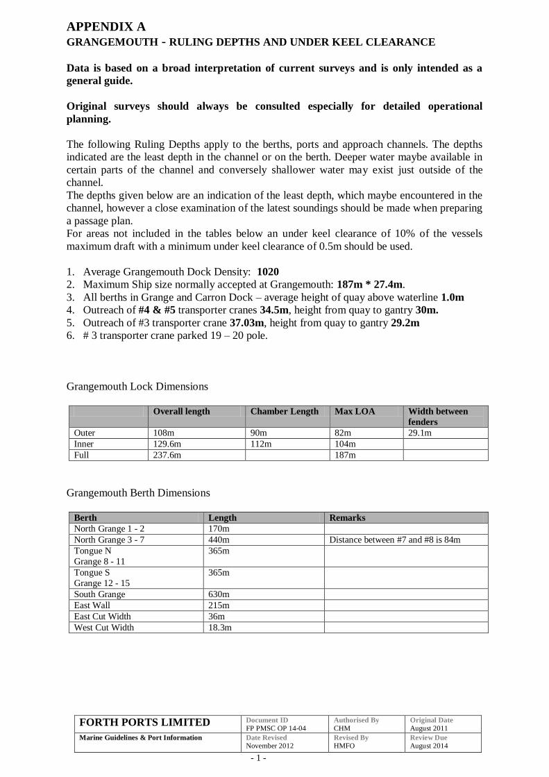
FORTH PORTS LIMITED Document ID
FP PMSC OP 14-04 Authorised By
CHM Original Date
August 2011
Marine Guidelines & Port Information
Date Revised
November 2012 Revised By
HMFO Review Due
August 2014
- 1 -
APPENDIX A
GRANGEMOUTH - RULING DEPTHS AND UNDER KEEL CLEARANCE
Data is based on a broad interpretation of current surveys and is only intended as a
general guide.
Original surveys should always be consulted especially for detailed operational
planning.
The following Ruling Depths apply to the berths, ports and approach channels. The depths
indicated are the least depth in the channel or on the berth. Deeper water maybe available in
certain parts of the channel and conversely shallower water may exist just outside of the
channel.
The depths given below are an indication of the least depth, which maybe encountered in the
channel, however a close examination of the latest soundings should be made when preparing
a passage plan.
For areas not included in the tables below an under keel clearance of 10% of the vessels
maximum draft with a minimum under keel clearance of 0.5m should be used.
1. Average Grangemouth Dock Density: 1020
2. Maximum Ship size normally accepted at Grangemouth: 187m * 27.4m.
3. All berths in Grange and Carron Dock – average height of quay above waterline 1.0m
4. Outreach of #4 & #5 transporter cranes 34.5m, height from quay to gantry 30m.
5. Outreach of #3 transporter crane 37.03m, height from quay to gantry 29.2m
6. # 3 transporter crane parked 19 – 20 pole.
Grangemouth Lock Dimensions
Overall length Chamber Length Max LOA Width between
fenders
Outer 108m 90m 82m 29.1m
Inner 129.6m 112m 104m
Full 237.6m 187m
Grangemouth Berth Dimensions
Berth Length Remarks
North Grange 1 - 2 170m
North Grange 3 - 7 440m Distance between #7 and #8 is 84m
Tongue N
Grange 8 - 11
365m
Tongue S
Grange 12 - 15
365m
South Grange 630m
East Wall 215m
East Cut Width 36m
West Cut Width 18.3m
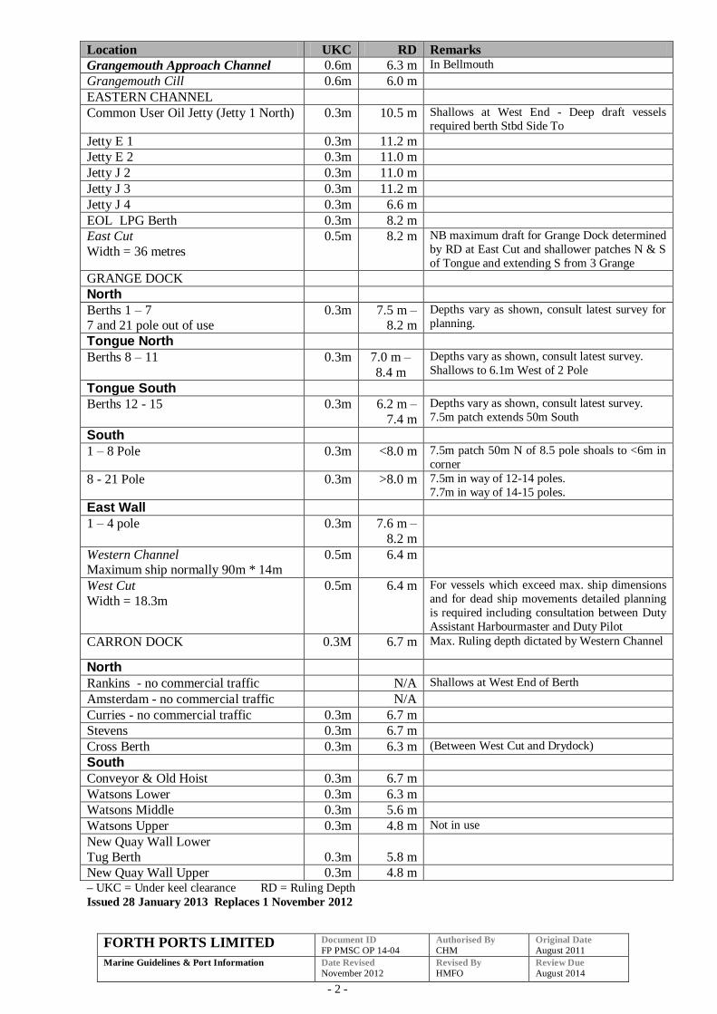
FORTH PORTS LIMITED Document ID
FP PMSC OP 14-04 Authorised By
CHM Original Date
August 2011
Marine Guidelines & Port Information
Date Revised
November 2012 Revised By
HMFO Review Due
August 2014
- 2 -
Location UKC RD Remarks
Grangemouth Approach Channel 0.6m 6.3 m In Bellmouth
Grangemouth Cill 0.6m 6.0 m
EASTERN CHANNEL
Common User Oil Jetty (Jetty 1 North) 0.3m 10.5 m Shallows at West End - Deep draft vessels
required berth Stbd Side To
Jetty E 1 0.3m 11.2 m
Jetty E 2 0.3m 11.0 m
Jetty J 2 0.3m 11.0 m
Jetty J 3 0.3m 11.2 m
Jetty J 4 0.3m 6.6 m
EOL LPG Berth 0.3m 8.2 m
East Cut
Width = 36 metres
0.5m 8.2 m NB maximum draft for Grange Dock determined
by RD at East Cut and shallower patches N & S
of Tongue and extending S from 3 Grange
GRANGE DOCK
North
Berths 1 – 7 7 and 21 pole out of use
0.3m 7.5 m – 8.2 m
Depths vary as shown, consult latest survey for
planning.
Tongue North
Berths 8 – 11
0.3m 7.0 m –
8.4 m
Depths vary as shown, consult latest survey.
Shallows to 6.1m West of 2 Pole
Tongue South
Berths 12 - 15 0.3m 6.2 m –
7.4 m
Depths vary as shown, consult latest survey.
7.5m patch extends 50m South
South
1 – 8 Pole 0.3m <8.0 m 7.5m patch 50m N of 8.5 pole shoals to <6m in
corner
8 - 21 Pole 0.3m >8.0 m 7.5m in way of 12-14 poles.
7.7m in way of 14-15 poles.
East Wall
1 – 4 pole 0.3m 7.6 m –
8.2 m
Western Channel Maximum ship normally 90m * 14m
0.5m 6.4 m
West Cut
Width = 18.3m
0.5m 6.4 m For vessels which exceed max. ship dimensions
and for dead ship movements detailed planning
is required including consultation between Duty
Assistant Harbourmaster and Duty Pilot
CARRON DOCK 0.3M 6.7 m Max. Ruling depth dictated by Western Channel
North
Rankins - no commercial traffic N/A Shallows at West End of Berth
Amsterdam - no commercial traffic N/A
Curries - no commercial traffic 0.3m 6.7 m
Stevens 0.3m 6.7 m
Cross Berth 0.3m 6.3 m (Between West Cut and Drydock)
South
Conveyor & Old Hoist 0.3m 6.7 m
Watsons Lower 0.3m 6.3 m
Watsons Middle 0.3m 5.6 m
Watsons Upper 0.3m 4.8 m Not in use
New Quay Wall Lower
Tug Berth
0.3m
5.8 m
New Quay Wall Upper 0.3m 4.8 m
– UKC = Under keel clearance RD = Ruling Depth
Issued 28 January 2013 Replaces 1 November 2012
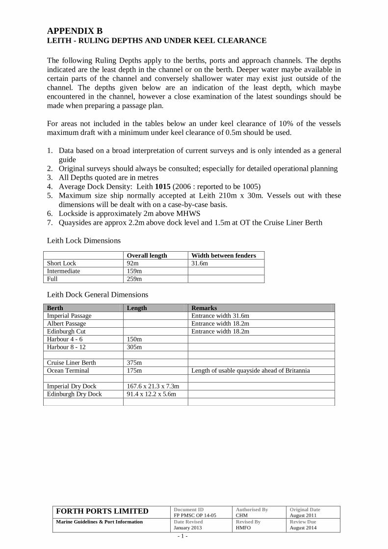
FORTH PORTS LIMITED Document ID
FP PMSC OP 14-05 Authorised By
CHM Original Date
August 2011
Marine Guidelines & Port Information
Date Revised
January 2013
Revised By
HMFO
Review Due
August 2014
- 1 -
APPENDIX B LEITH - RULING DEPTHS AND UNDER KEEL CLEARANCE
The following Ruling Depths apply to the berths, ports and approach channels. The depths
indicated are the least depth in the channel or on the berth. Deeper water maybe available in
certain parts of the channel and conversely shallower water may exist just outside of the
channel. The depths given below are an indication of the least depth, which maybe
encountered in the channel, however a close examination of the latest soundings should be
made when preparing a passage plan.
For areas not included in the tables below an under keel clearance of 10% of the vessels
maximum draft with a minimum under keel clearance of 0.5m should be used.
1. Data based on a broad interpretation of current surveys and is only intended as a general
guide
2. Original surveys should always be consulted; especially for detailed operational planning
3. All Depths quoted are in metres
4. Average Dock Density: Leith 1015 (2006 : reported to be 1005)
5. Maximum size ship normally accepted at Leith 210m x 30m. Vessels out with these
dimensions will be dealt with on a case-by-case basis.
6. Lockside is approximately 2m above MHWS
7. Quaysides are approx 2.2m above dock level and 1.5m at OT the Cruise Liner Berth
Leith Lock Dimensions
Leith Dock General Dimensions
Overall length Width between fenders
Short Lock 92m 31.6m
Intermediate 159m
Full 259m
Berth Length Remarks
Imperial Passage Entrance width 31.6m
Albert Passage Entrance width 18.2m
Edinburgh Cut Entrance width 18.2m
Harbour 4 - 6 150m
Harbour 8 - 12 305m
Cruise Liner Berth 375m
Ocean Terminal 175m Length of usable quayside ahead of Britannia
Imperial Dry Dock 167.6 x 21.3 x 7.3m
Edinburgh Dry Dock 91.4 x 12.2 x 5.6m
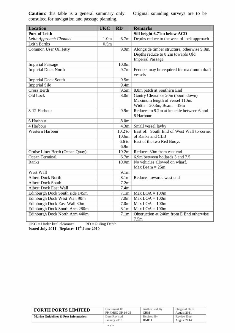
FORTH PORTS LIMITED Document ID
FP PMSC OP 14-05 Authorised By
CHM Original Date
August 2011
Marine Guidelines & Port Information
Date Revised
January 2013
Revised By
HMFO
Review Due
August 2014
- 2 -
Caution: this table is a general summary only. Original sounding surveys are to be
consulted for navigation and passage planning.
Location UKC RD Remarks Port of Leith Sill height 6.71m below ACD
Leith Approach Channel 1.0m 6.7m Depths reduce to the west of lock approach
Leith Berths 0.5m
Common User Oil Jetty 9.9m Alongside timber structure, otherwise 9.8m.
Depths reduce to 8.2m towards Old Imperial Passage
Imperial Passage 10.0m
Imperial Dock North 9.7m Fenders may be required for maximum draft
vessels
Imperial Dock South 9.5m
Imperial Silo 9.4m
Cross Berth 9.5m 8.8m patch at Southern End
Old Lock 8.0m Gantry Clearance 20m (boom down) Maximum length of vessel 110m.
Width = 20.3m, Beam = 19m
8-12 Harbour 9.9m Reduces to 9.2m at knuckle between 6 and
8 Harbour
6 Harbour 8.0m
4 Harbour 4.3m Small vessel layby
Western Harbour 10.2 to
10.6m
East of: South End of West Wall to corner
of Ranks and CLB
6.6 to
6.9m
East of the two Red Buoys
Cruise Liner Berth (Ocean Quay) 10.2m Reduces 30m from east end
Ocean Terminal 6.7m 6.9m between bollards 3 and 7.5
Ranks 10.0m No vehicles allowed on wharf.
Max Beam = 25m
West Wall 9.1m
Albert Dock North 8.1m Reduces towards west end
Albert Dock South 7.2m
Albert Dock East Wall 7.4m
Edinburgh Dock South side 145m 7.1m Max LOA = 100m
Edinburgh Dock West Wall 90m 7.0m Max LOA = 100m
Edinburgh Dock East Wall 80m 7.0m Max LOA = 100m
Edinburgh Dock South Arm 280m 8.1m Max LOA = 100m
Edinburgh Dock North Arm 440m 7.1m Obstruction at 240m from E End otherwise
7.5m UKC = Under keel clearance RD = Ruling Depth
Issued July 2011– Replaces 11th
June 2010
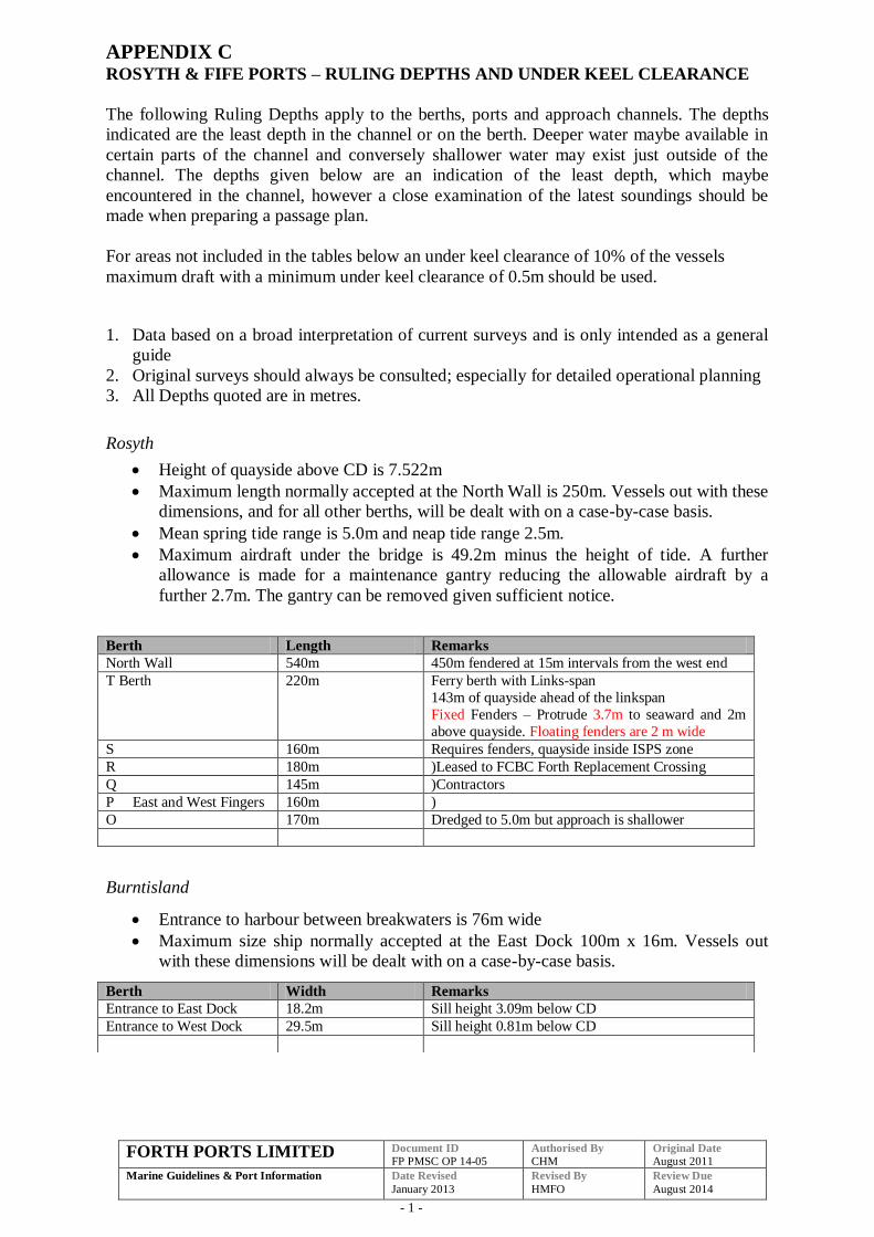
FORTH PORTS LIMITED Document ID
FP PMSC OP 14-05 Authorised By
CHM Original Date
August 2011
Marine Guidelines & Port Information
Date Revised
January 2013
Revised By
HMFO
Review Due
August 2014
- 1 -
APPENDIX C ROSYTH & FIFE PORTS – RULING DEPTHS AND UNDER KEEL CLEARANCE
The following Ruling Depths apply to the berths, ports and approach channels. The depths
indicated are the least depth in the channel or on the berth. Deeper water maybe available in
certain parts of the channel and conversely shallower water may exist just outside of the
channel. The depths given below are an indication of the least depth, which maybe
encountered in the channel, however a close examination of the latest soundings should be
made when preparing a passage plan.
For areas not included in the tables below an under keel clearance of 10% of the vessels
maximum draft with a minimum under keel clearance of 0.5m should be used.
1. Data based on a broad interpretation of current surveys and is only intended as a general
guide
2. Original surveys should always be consulted; especially for detailed operational planning
3. All Depths quoted are in metres.
Rosyth
Height of quayside above CD is 7.522m
Maximum length normally accepted at the North Wall is 250m. Vessels out with these
dimensions, and for all other berths, will be dealt with on a case-by-case basis.
Mean spring tide range is 5.0m and neap tide range 2.5m.
Maximum airdraft under the bridge is 49.2m minus the height of tide. A further
allowance is made for a maintenance gantry reducing the allowable airdraft by a
further 2.7m. The gantry can be removed given sufficient notice.
Burntisland
Entrance to harbour between breakwaters is 76m wide
Maximum size ship normally accepted at the East Dock 100m x 16m. Vessels out
with these dimensions will be dealt with on a case-by-case basis.
Berth Length Remarks
North Wall 540m 450m fendered at 15m intervals from the west end
T Berth 220m Ferry berth with Links-span
143m of quayside ahead of the linkspan
Fixed Fenders – Protrude 3.7m to seaward and 2m
above quayside. Floating fenders are 2 m wide
S 160m Requires fenders, quayside inside ISPS zone
R 180m )Leased to FCBC Forth Replacement Crossing
Q 145m )Contractors
P East and West Fingers 160m )
O 170m Dredged to 5.0m but approach is shallower
Berth Width Remarks
Entrance to East Dock 18.2m Sill height 3.09m below CD
Entrance to West Dock 29.5m Sill height 0.81m below CD

FORTH PORTS LIMITED Document ID
FP PMSC OP 14-05 Authorised By
CHM Original Date
August 2011
Marine Guidelines & Port Information
Date Revised
January 2013
Revised By
HMFO
Review Due
August 2014
- 2 -
Methil
Main Entrance to No.2 Dock is 15.2m wide
Maximum size vessel normally accepted is 100m x 14.0m beam. Vessels out with
these dimensions will be dealt with on a case-by-case basis.
Dock gates normally open three hours before high water.
Depth over the outer sill is 2.6m below chart datum (No.1 dock is 1.22m above the
sill at No.2)
Energy Park Fife
Berths owned by Scottish Enterprise
Maximum sized barges/vessels dictated by draft
For further information, please refer to latest edition of Energy Park Fife Quayside
Regulations.
Berth Length Remarks
East Quay 1 184m
West Quay 2 160m Under Construction (2012)
Kirkcaldy
Main entrance is 15.2 wide.
Maximum size vessel normally accepted is 85m x 14m. Vessels outwith these
dimensions will be dealt with on a case by case basis.
Port Side is the preferred side alongside at Carrs Milling.
The berth is a NAABSA Berth (Not Always Afloat but Safely Aground).
Pilot will board HW-1.
Lock gates are no longer in use.
Sill height 0.65m below Chart datum.
Berth Length Remarks
NE Berth Max Vessel 85m
Berth Length Remarks
Number 2 Dock
Cross berth 85m
No.1 (Hard Pad) 130m
No.2 (Central Farmers)* 82m
NE Corner 213m Travelling crane
No.6
Distance across dock between Hard Pad and South side is 121m
Distance across dock between Central Farmers and South side is 109m
Number 1 Dock
South side 173m
North side 136 + 58m
West (North) 43m
West (South) 43m
East side 82m
Distance across dock North to South side is 103m
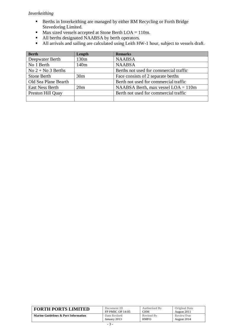
FORTH PORTS LIMITED Document ID
FP PMSC OP 14-05 Authorised By
CHM Original Date
August 2011
Marine Guidelines & Port Information
Date Revised
January 2013
Revised By
HMFO
Review Due
August 2014
- 3 -
Inverkeithing
Berths in Inverkeithing are managed by either RM Recycling or Forth Bridge
Stevedoring Limited.
Max sized vessels accepted at Stone Berth LOA = 110m.
All berths designated NAABSA by berth operators.
All arrivals and sailing are calculated using Leith HW-1 hour, subject to vessels draft.
Berth Length Remarks
Deepwater Berth 130m NAABSA
No 1 Berth 140m NAABSA
No 2 + No 3 Berths Berths not used for commercial traffic
Stone Berth 30m Face consists of 2 separate berths
Old Sea Plane Bearth Berth not used for commercial traffic
East Ness Berth 20m NAABSA Berth, max vessel LOA = 110m
Preston Hill Quay Berth not used for commercial traffic
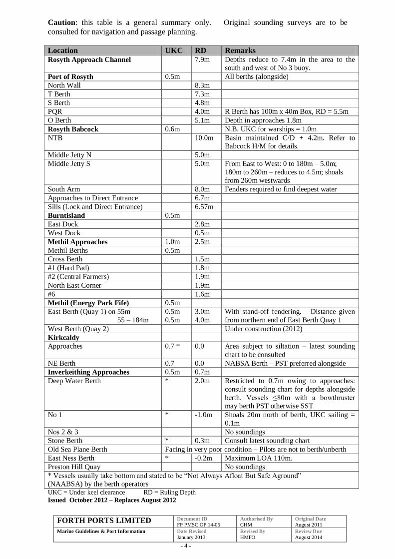
FORTH PORTS LIMITED Document ID
FP PMSC OP 14-05 Authorised By
CHM Original Date
August 2011
Marine Guidelines & Port Information
Date Revised
January 2013
Revised By
HMFO
Review Due
August 2014
- 4 -
Caution: this table is a general summary only. Original sounding surveys are to be
consulted for navigation and passage planning.
Location UKC RD Remarks
Rosyth Approach Channel 7.9m Depths reduce to 7.4m in the area to the south and west of No 3 buoy.
Port of Rosyth 0.5m All berths (alongside)
North Wall 8.3m
T Berth 7.3m
S Berth 4.8m
PQR 4.0m R Berth has 100m x 40m Box, RD = 5.5m
O Berth 5.1m Depth in approaches 1.8m
Rosyth Babcock 0.6m N.B. UKC for warships = 1.0m
NTB 10.0m Basin maintained C/D + 4.2m. Refer to Babcock H/M for details.
Middle Jetty N 5.0m
Middle Jetty S 5.0m From East to West: 0 to 180m – 5.0m;
180m to 260m – reduces to 4.5m; shoals from 260m westwards
South Arm 8.0m Fenders required to find deepest water
Approaches to Direct Entrance 6.7m
Sills (Lock and Direct Entrance) 6.57m
Burntisland 0.5m
East Dock 2.8m
West Dock 0.5m
Methil Approaches 1.0m 2.5m
Methil Berths 0.5m
Cross Berth 1.5m
#1 (Hard Pad) 1.8m
#2 (Central Farmers) 1.9m
North East Corner 1.9m
#6 1.6m
Methil (Energy Park Fife) 0.5m
East Berth (Quay 1) on 55m
55 – 184m
0.5m
0.5m
3.0m
4.0m
With stand-off fendering. Distance given
from northern end of East Berth Quay 1
West Berth (Quay 2) Under construction (2012)
Kirkcaldy
Approaches 0.7 * 0.0 Area subject to siltation – latest sounding
chart to be consulted
NE Berth 0.7 0.0 NABSA Berth – PST preferred alongside
Inverkeithing Approaches 0.5m 0.7m
Deep Water Berth * 2.0m Restricted to 0.7m owing to approaches:
consult sounding chart for depths alongside
berth. Vessels ≤80m with a bowthruster may berth PST otherwise SST
No 1 * -1.0m Shoals 20m north of berth, UKC sailing =
0.1m
Nos 2 & 3 No soundings
Stone Berth * 0.3m Consult latest sounding chart
Old Sea Plane Berth Facing in very poor condition – Pilots are not to berth/unberth
East Ness Berth * -0.2m Maximum LOA 110m.
Preston Hill Quay No soundings
* Vessels usually take bottom and stated to be “Not Always Afloat But Safe Aground” (NAABSA) by the berth operators UKC = Under keel clearance RD = Ruling Depth
Issued October 2012 – Replaces August 2012
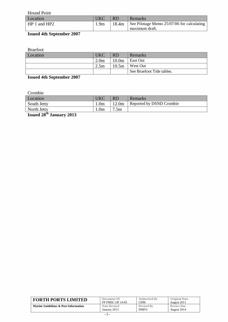
FORTH PORTS LIMITED Document ID
FP PMSC OP 14-05 Authorised By
CHM Original Date
August 2011
Marine Guidelines & Port Information
Date Revised
January 2013
Revised By
HMFO
Review Due
August 2014
- 5 -
Hound Point
Location UKC RD Remarks
HP 1 and HP2 1.9m 18.4m See Pilotage Memo 25/07/06 for calculating maximum draft.
Issued 4th September 2007
Braefoot
Location UKC RD Remarks
2.0m 10.0m East Out
2.5m 10.5m West Out
See Braefoot Tide tables.
Issued 4th September 2007
Crombie
Location UKC RD Remarks
South Jetty 1.0m 12.0m Reported by DSND Crombie
North Jetty 1.0m 7.5m
Issued 28th
January 2013