Embed Size (px)
Citation preview

François Dion, [email protected]
May 28, 2013
Summary of Recent Integrated Corridor Management (ICM) Development Efforts in the
United States

Summary of ICM Efforts
Corridor Lead Agencies
Activities
I-15 Diego SANDAG • ConOps and System Requirements developed in 2008
• Simulation evaluation in 2009-2010• System launched in spring 2013• Currently in evaluation phase
US-75 Dallas
DART • ConOps and System Requirements developed in 2008
• Simulation evaluation in 2009-2010• System launched in spring 2013• Currently in evaluation phase
I-80 Bay Area
MTC / Caltrans
• ConOps developed in 2010• Project groundbreaking in October 2012• Project expected to be completed summer 2015
I-95 / I-395 Virginia
Virginia DOT • ConOps developed in 2012• Currently developing deployment plan &
partnerships
I-394 Minneapolis
MnDOT • ConOps and System Requirements developed in 2008
• Simulation evaluation in 2009• No apparent activity since 2009
I-270 Maryland
Maryland DOT
• ConOps and System Requirements developed in 2008
• No apparent activity since 2008
2

I-15 San Diego3

Corridor4
21-mile section of I-15, north of San Diego
Key transportation networks I-15 freeway Parallel arterials
Center City Parkway (in Escondido) Pomerado Road (in Poway and San Diego) Black Mountain Road/ Kearny Villa Road (in
San Diego) Transit services
MTS bus network NCTD bus network NCTD Sprinter Commuter Rail

Partnering Agencies
US Department of Transportation Research and Innovation
Technology Administration (RITA) Federal Highway Administration
(FHWA) Federal Transit Administration
(FTA)
State agencies Caltrans, District 7 California Highway Patrol (CHP) Freeway Service Patrol
Regional agencies San Diego Association of
Governments (SANDAG)
5
Transit agencies San Diego Metropolitan Transit
System (MTS) North County Transit District
(NCTD)
Local cities San Diego, Poway, Escondido
Technical support Kimley-Horn Delcan Transport Simulation Systems
(TSS) University of California, Berkeley Cambridge Systematics Batelle Volpe Center

ICM Goals
Improve accessibility to travel options and attain an enhanced level of mobility
Enhance corridor safety
Provide travelers with informational tools enabling them to make smart travel choices within the corridor
Promote coordination among institutional partners
Manage the corridor holistically under both normal operating and incident/event conditions in a collaborative and coordinated way
6

Strategies Considered
System monitoring/data sharing Real-time freeway and arterial traffic monitoring Real-time bus transit monitoring Real-time traffic signal operations monitoring Weather monitoring
Freeway operations Traffic-responsive ramp metering Lane configuration on I-15 managed lane system Access policy to I-15 managed lane system
Arterial operations Traffic-responsive signal operation Freeway ramp/arterial traffic signal coordination
7

Strategies Considered
Transit operations Rerouting of transit vehicles around incidents Increases in transit service in response to event/incidents
Traveler information Integrated, multi-modal traveler information service Provision of comparative travel times along alternate
routes Provision of real-time park-and-ride space availability
information on freeways and approach routes
Incident/event management Simulation-based evaluation (microscopic modeling) of
potential traffic management alternatives
8

US-75 Dallas9

Corridor
20-mile section of the US-75 freeway northeast of downtown Dallas
Freeways US-75 freeway, with managed HOV
lanes
Parallel arterials Freeway frontage roads Greenville Avenue Coit Road
Transit services DART Bus Network DART Light Rail
10

Partnering Agencies
US Department of Transportation Research and Innovation Technology
Administration (RITA) Federal Highway Administration
(FHWA) Federal Transit Administration (FTA)
State agencies Texas Department of Transportation,
Dallas & Fort Worth Districts
Regional agencies North Central Texas Council of
Governments (NCTCOG) North Texas Tollway Authority (NTTA) Fort Worth Transportation Authority Dallas Regional Mobility Coalition
Transit agencies Dallas Area Rapid Transit (DART)
11
Airports Dallas/Fort Worth International
Airport
Local cities Dallas, Plano, Richardson, Highland
Park, University Park
Technical support Telvent Texas Transportation Institute (TTI) Southern Methodist University (SMU) University of Texas at Arlington Cambridge Systematics Batelle

ICM Goals
Increase corridor throughput
Improve travel time reliability
Improve incident management
Enable intermodal travel decisions
12

Strategies Considered
System monitoring/data sharing Regional information exchange network (SmartNET) Bluetooth traffic monitoring along freeway and two
diversion routes (40 locations, typically spaced 1-2 miles) Real-time monitoring of light rail location and passenger
count Weather monitoring
Freeway operations Predefined diversion plans to local arterials and/or light-rail
service in response to incidents HOV/HOT Lane Management
Arterial operations New signal timing plans for Greenville Avenue Development of event-specific signal timing plans Responsive traffic signal control
13
Traffic Detection Plan

Strategies Considered
Traveler information Multimodal traffic and transit 511 system with interactive voice
response system, public web access, and mobile application Real-time transit vehicle information (vehicle location, time to
arrive at next stop) Publication of parking availability information for 5 park-and-
ride lots along the LRT red line on the 511 system and CMS signs
Links to social media (Facebook, Twitter) Exploration of sponsorship options
Incident/event management Simulation-based evaluation (mesoscopic modeling) of
potential traffic management alternatives
14

I-80 Bay Area15

Corridor
20-miles section of I-80 from Bay Bridge to Carquinez Bridge
Key corridor networks I-80 freeway Parallel arterials
San Pablo Avenue Transit services
BART subway network AC Transit bus network
16
Partnering Agencies
State agencies Caltrans California Highway Patrol (CHP)
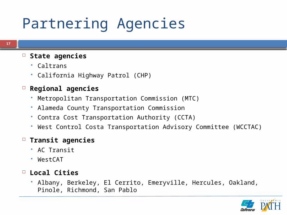
Regional agencies Metropolitan Transportation Commission (MTC) Alameda County Transportation Commission Contra Cost Transportation Authority (CCTA) West Control Costa Transportation Advisory Committee (WCCTAC)
Transit agencies AC Transit WestCAT
Local Cities Albany, Berkeley, El Cerrito, Emeryville, Hercules, Oakland, Pinole,
Richmond, San Pablo
17

ICM Goals
Provide traffic operation on the corridor that is equitable and balanced for both the freeway and arterials.
Integrate transportation system management activities to enhance safety and mobility for all travel modes
Enhance overall transit travel time during normal operations
Enhance trip reliability by providing consistent and predictable travel times on the freeway and local arterials
Avoid impacts on local arterials while managing access at on-ramps during peak periods on weekdays and weekends
Efficiently guide traffic naturally diverted to local arterials during major freeway incidents back to the freeway
Cooperatively operate, manage and maintain all ICM elements
18

ICM Goals
Cooperatively develop, implement, evaluate and revise strategies to ensure balanced benefits to local, regional, and inter-regional travelers
Cooperatively identify and address any adverse impacts in a timely fashion
Ensure on-going communication among partnering agencies for timely review and adjustment of activities as needed
Ensure timely and appropriate communication with the public, media, and elected officials
Monitor, evaluate, and report on project performance to ensure compliance with goals and objectives
Facilitate cooperative activities that ensure the sustainability of benefits from the project
19

Strategies Considered
Freeway operations Adaptive ramp metering with
preferential treatment to HOV vehicles End of queue warning Dynamic lane use signals Variable advisory speed signs Installation of CCTV cameras
Arterial operations Traffic signal system upgrade Signal synchronization/optimization Traffic detection along San Pablo Avenue
Transit operations Transit signal priority enhancements at
signalized intersections
20

Strategies Considered
Traveler information Dynamic information display boards showing
transit/traffic information Trailblazer signs along arterials to help traffic
go back to the freeway
Incident Management Freeway traffic rerouting through parallel
arterial Implementation of traffic signal flush plan to
provide additional capacity Traffic signal preemption for first responders
System integration Central system to operate all technologies
21
I-95/I-395 Virginia22

Corridor
52-mile section of I-95/I-395 between Spotsylvania Interchange and 14th Street Bridge near Washington DC
Major corridor assets I-95/I-395 freeway Transit services
Commuter rail along entire corridor Various bus services
Park-and-ride 40,771 spaces within corridor
Ridesharing services Carpools / Vanpools 6400 daily “slugs” (2008) Real-time ridesharing pilot
23
Partnering Agencies
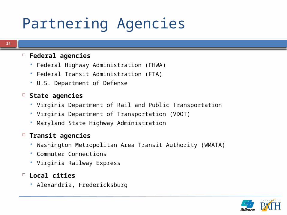
Federal agencies Federal Highway Administration (FHWA) Federal Transit Administration (FTA) U.S. Department of Defense
State agencies Virginia Department of Rail and Public Transportation Virginia Department of Transportation (VDOT) Maryland State Highway Administration
Transit agencies Washington Metropolitan Area Transit Authority (WMATA) Commuter Connections Virginia Railway Express
Local cities Alexandria, Fredericksburg
24

Partnering Agencies
Regional agencies Metropolitan Washington Council of Governments (MWCOG) Northern Virginia Regional Commission (NVRC) Northern Virginia Transportation Commission (NVTC) Potomac and Rappahannock Transportation Commission (PRTC) Arlington County Loudon County Prince William County Fairfax County Department of Transportation Dulles Area Transportation Association George Washington Regional Commission Metropolitan Area Transportation Operations Coordination (MATOC)
Universities University of Maryland Center for Transportation Technology
25

ICM Goals
Promote different travel options to achieve travel time savings and overall environmental benefits
Reduce travel time and congestion by managing travel demand in real-time
Reduce the economic cost of travel delays and congestion (from commuter, business and freight movement perspectives)
Reduce or eliminate primary or secondary
Specific volume reduction of 1800 vehicles per day on particularly congested days, targeted for travelers to the Mark Center complex in Alexandria
26
Strategies Considered
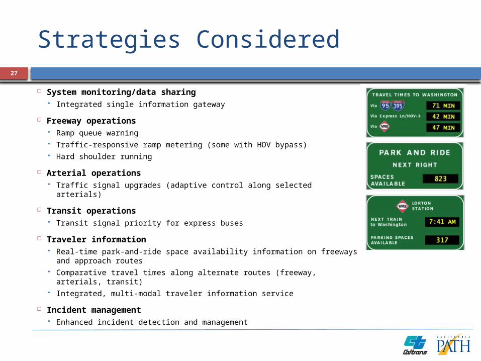
System monitoring/data sharing Integrated single information gateway
Freeway operations Ramp queue warning Traffic-responsive ramp metering (some with HOV bypass) Hard shoulder running
Arterial operations Traffic signal upgrades (adaptive control along selected arterials)
Transit operations Transit signal priority for express buses
Traveler information Real-time park-and-ride space availability information on freeways
and approach routes Comparative travel times along alternate routes (freeway, arterials,
transit) Integrated, multi-modal traveler information service
Incident management Enhanced incident detection and management
27

Deployment Strategy28

I-394 Minneapolis29

Corridor
26 mile section of the I-394/US-12 corridor west of Minneapolis
Corridor networks I-394 freeway, with HOV and HOT lanes Parallel arterials
Highway 55 Highway 7 Three parallel freeway connectors (I-494, Hwy
169, Hwy 100) Transit services
Metro Transit Plymouth Transit SouthWest Transit (commuter services from outside corridor to downtown)
Bicycle network Network of commuter bicycle routes.
30

Partnering Agencies
US Department of Transportation Federal Highway Administration
(FHWA)
State agencies Minnesota Department of
Transportation Minnesota State Patrol MnPASS Phase 2 Initiative Team
Regional agencies Metropolitan Council Hennepin County
Transit agencies Metro Transit Plymouth Metrolink SouthWest Transit
31
Local jurisdictions City of Minneapolis Local Police/Fire
Departments

ICM Goals
Maintain mobility and reliability Reduce the variation in travel times experienced by travelers Maintain options for travelers to effectively travel using personal vehicles, transit
or bicycles.
Maximize corridor-wide capacity utilization Monitor available capacity of roadways, transit, parking, and alternative
transportation options Encourage pattern changes (through information sharing or incentives) to better
utilize spare capacity
Event and incident management Inform travelers of incidents, their impacts, and available reroute or mode change
options Manage traffic around events through early notification and informed reactions
Holistic traveler information delivery Make travelers aware of their modal and route options. Inform travelers of options for avoiding or minimizing the impacts of travel delays
32

Strategies Considered
System monitoring Development of automated information exchange capabilities
among participating agencies Develop a corridor data clearinghouse collecting real-time
information on incident, infrastructure status, transit schedule adherence, parking availability, travel times along major routes
Freeway operations Development of alternate ramp metering strategies to address
special events and incidents Dynamic freeway shoulder use during incident or special events HOV ramp metering bypass Variable speed limit to maintain steady flow and prevent incidents Opening HOT lane to all traffic during incidents Additional CMS along freeway
33
Strategies Considered
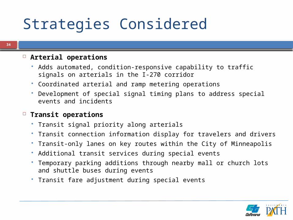
Arterial operations Adds automated, condition-responsive capability to traffic signals on
arterials in the I-270 corridor Coordinated arterial and ramp metering operations Development of special signal timing plans to address special
events and incidents
Transit operations Transit signal priority along arterials Transit connection information display for travelers and drivers Transit-only lanes on key routes within the City of Minneapolis Additional transit services during special events Temporary parking additions through nearby mall or church lots and
shuttle buses during events Transit fare adjustment during special events
34

Strategies Considered
Parking operations Parking fee adjustment during special events
Traveler information Add transit delays/schedule adherence and parking availability
information to existing 511 services Increased deployment of CMS at key arterial street locations to inform
travelers of conditions on arterial streets or to warn of incidents on freeways
Increased deployment of ATIS devices in parking garages
Incident management Integration of metro transit control center with CAD reports of
incidents
Payment system Attempt to combine HOT, parking, and transit payment system
35

I-270 Maryland36

Corridor
22 mile section of I-270, from the I-495 freeway (Beltway) to the Frederick County line
Major corridor assets I-270 freeway Parallel arterials
MD-355 Network of arterial and connector
routes Transit services
MARC Commuter Rail WMATA Metrorail systems WMATA Metrobus network Ride On local/commuter bus network MTA Commuter Bus network
37

Partnering Agencies
US Department of Transportation (USDOT) Federal Highway Administration (FHWA) Federal Transit Administration (FTA) Research and Innovative Technology Administration (RITA)
Maryland State Highway Administration (MDSHA)
Maryland Transit Administration (MTA)
Montgomery County Department of Public Works and Transportation (DPWT)
The University of Maryland (UMD)
Washington Metropolitan Area Transit Authority (WMATA)
38
ICM Goals
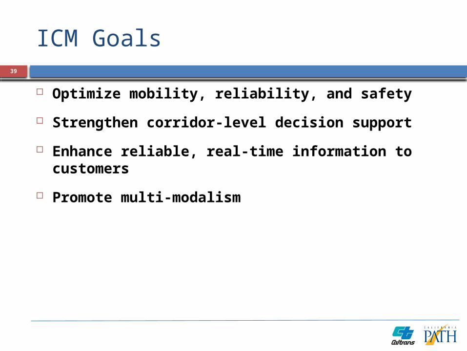
Optimize mobility, reliability, and safety
Strengthen corridor-level decision support
Enhance reliable, real-time information to customers
Promote multi-modalism
39

Strategies Considered
System monitoring Enhance capability to measure travel time reliability, delays,
incident severity, incident cleanup and recovery times, transit/parking utilization
Prototype and deploy an enhanced Regional Integrated Transportation Information System (RITIS)
Arterial operations Adds automated, condition-responsive capability to traffic
signals on arterials in the I-270 corridor
Traveler information Deliver computer-aided dispatch/automatic vehicle location
(CAD/AVL) status information to transit users Deliver parking availability information to commuters
40