Embed Size (px)
Citation preview

French Island National ParkOctober 1998
Management Plan

This Management Plan for French Island National Park is approved for implementation. Its purpose isto direct all aspects of management in the Park until the Plan is reviewed. A Draft Management Planfor the area was published in December 1997. Twenty-six submissions were received and have beenconsidered in developing this Approved Plan.
Copies of this Plan can be obtained from:
Parks Victoria378 Cotham RoadKEW VIC 3101
Parks Victoria Information Centre35 Whitehorse RoadDEEPDENE VIC 3103
NRE Information Centre8 Nicholson StreetEAST MELBOURNE VIC 3002
Parks Victoria113 Marine ParadeSAN REMO VIC 3925
For further information on the Plan, please contact:
Bob Brinkman, Chief Ranger - Mornington/Western Port DistrictParks VictoriaPt Nepean RoadDROMANA VIC 3936( 5987 2755

ii French Island National Park
Published in October 1998 by Parks Victoria378 Cotham Road, Kew, Victoria 3101
This Approved Plan was compiled by Ian Weir and Arnis Heislers under contract to Parks Victoria.
National Library of AustraliaCataloguing-in-Publication entry
Parks Victoria,French Island National Park management plan.
Bibliography.ISBN 0 7311 3130 4.
1. National parks and reserves - Victoria - Management.2. French Island National Park (Vic.). I. Title.
333.783099452
Cover: Clump Lagoon, French Island NP (Photo: Catherine Watson)
Printed on recycled paper to help save our natural environment

French Island National Park iii
FOREWORD
Although somewhat in the shadow of its smallerbut better-known neighbour Phillip Island,French Island in Western Port has severalclaims to fame. It is the only unincorporatedlocality in Victoria - that is, it has no municipalcouncil; it has few motor vehicles, and is agreat place for an escape to nature; it haswetlands of international significance; it has nofoxes; and it has Victoria’s only national parkentirely contained on an island.
French Island National Park, which occupiesabout two-thirds of the Island, covers more than11 000 hectares. It is one of our newestnational parks, having been proclaimed asrecently as June 1997, although a large part ofthe Park had been reserved as French IslandState Park from 1982. It has very high naturalvalues: mangrove and saltmarsh areas, habitatfor large numbers of migratory birds, a richnative flora including the remarkable total ofsome 100 orchid species, and fauna of nationaland international significance.
The Park does not attract large numbers ofvisitors at present, but for those seeking aremote, timeless and natural experience it willincreasingly become known as a specialattraction. This Plan calls for the provision ofappropriate low-key facilities in the Park suchas walking tracks, camping areas, drinkingwater, information and lookouts to cater for
visitors, and for the development of an overallTourism Strategy for French Island to integratethe provision of services and facilities withinand outside the Park. The over-riding aim,however, is to protect and enhance the specialvalues of the Park and Island.
The Plan explains in detail how the Park’snatural values will be protected and enhanced interms of fire management, weed and pestanimal control, soil conservation and research.It stresses that park management will bedeveloped in co-operation with private landholders on the Island through a French IslandCo-operative Neighbour Program, and that theinput of volunteers such as the Friends groupwill be encouraged.
I commend the Plan to you, and look forward tofurther, and increased, community involvementin its implementation.
Marie Tehan MPMinister for Conservationand Land Management
iv French Island National Park
APPROVED MANAGEMENT PLAN
This Approved Management Plan, preparedunder Section 17 of the National Parks Act1975 (Vic.) and is approved forimplementation. It provides the basis anddirection for the future management of theFrench Island National Park.
Acting Director ofNational Parks
During the Plan’s preparation there wasconsultation with key groups and individuals toseek input into resolving management issues.Twenty-six submissions were received on theDraft Management Plan. They were allcarefully considered when this Plan was beingprepared.
Chief ExecutiveParks Victoria

French Island National Park v
SUMMARY
French Island National Park (11 100 ha)protects wetlands of international significanceand is the only substantial representation in theState’s nature conservation reserve system ofthe land systems of the coastal sand plains andclayey-sand plains of Western Port.
In addition, it is the only national park inVictoria totally contained on an island. It hasoutstanding natural values and a high level ofprotection, largely due to its isolation.
The Park offers unique semi-remote recreationopportunities on the ‘doorstep’ of Melbournebecause of restricted access and low visitornumbers.
Mainland visitors to the Park are generally notpermitted to bring their own motor vehicles.Bus tours of the Island are available. The mainrecreation activities are walking, cycling,camping and nature and heritage study.
The Park covers about two-thirds of the Island,the remainder being mainly farmland. TheIsland is an ‘unincorporated locality’ (i.e. it hasno municipal council).
The protection of the Park and the successfulprovision of tourism support services, includingtransport and accommodation, depend uponclose liaison with the local community. All co-operative arrangements proposed in this Plan inrelation to the use of private land by the landholders are voluntary.
Protecting and enhancing the Park’s largelyundisturbed environments will be an importantmanagement goal, as will maintaining itsdistinctive character, offering a retreat from thepressures of urban life.
Significant management directions aresummarised below.
• The Park will be promoted as an importantconservation reserve, enhanced by itsisland location.
• Significant flora and fauna, includinghabitat for migratory water birds and sitesof threatened species of flora, will be givenspecial protection.
• Comprehensive management strategieswill be implemented to protect andenhance marine, freshwater and terrestrialcommunities.
• Priority will be given to Koalamanagement and restoration of habitat.
• Weed, pest animal and disease controlmeasures will be undertaken.
• A comprehensive fire management planwill be developed and implemented toserve the interests of the Park and theIslanders.
• The generally remote northern and easternsections of the Park and Barrallier, Pelicanand Rams Islands will be investigated fordesignation as Remote and Natural Areasunder Schedule 6 of the National ParksAct.
• Creation of a UNESCO BiosphereReserve, incorporating the Park and anyadjacent marine protected areas, will beinvestigated.
• A strategy for management of vehicularaccess within the Park is defined toimprove access routes for managementpurposes and use, and reduce impacts onthe Park.
• An attractive system of walking andcycling routes, with appropriate facilitiesfor day and overnight visitors, will beestablished.
• Facilities will be provided at key featuresin the Park to increase the enjoyment andunderstanding of visitors undertaking bustours.
• Provision of information to visitors aboutthe Park and French Island will beimproved.
• A voluntary Co-operative NeighbourProgram will be encouraged inpartnership with the local community.

vi French Island National Park

French Island National Park vii
CONTENTS
FOREWORD iii
SUMMARY v
1 INTRODUCTION 1
1.1 Location and planning area 11.2 Regional context 11.3 Significance of the Park 11.4 Creation of the Park 21.5 Legislation and guidelines 31.6 Park management aims 3
2 STRATEGIC DIRECTIONS 5
2.1 Park vision 52.2 Management directions 52.3 Zoning 6
3 RESOURCE CONSERVATION 10
3.1 Geological and landform features 103.2 Marine and intertidal environment 103.3 Vegetation 133.4 Fauna 143.5 Landscape 193.6 Cultural heritage 193.7 UNESCO Biosphere Reserves 20
4 PARK PROTECTION 22
4.1 Fire management 224.2 Pest plants and animals, and diseases 234.3 Soil conservation 26
5 THE PARK VISIT 27
5.1 The Park visitor 275.2 Visitor recreation activities and facilities 29
5.2.1 Vehicle access 295.2.2 Day use areas 325.2.3 Camping 325.2.4 Walking 345.2.5 Horse riding 365.2.6 Cycling 365.2.7 Fishing 375.2.8 Boating 375.2.9 Orienteering, rogaining and competitive events 385.2.10 Dogs 38

viii French Island National Park
5.3 Visitor information and interpretation 385.4 Commercial tourism operations 395.5 Public safety 40
6 COMMUNITY AWARENESS AND INVOLVEMENT 42
6.1 Friends and volunteers 426.2 Community awareness and Park neighbours 426.3 Schools, education and special interest groups 43
7 OTHER ISSUES 44
7.1 Authorised uses 447.2 Boundaries and adjacent uses 457.3 Park office, depot and residence 46
8 IMPLEMENTATION 47
REFERENCES 48
TABLES
1 Management zones and overlays 82 Management of sites of geomorphological significance 113 Management of threatened and significant fauna 174 Management of key waterbird breeding areas 185 Summary of recreation activities 296 Management of vehicle roads and tracks 317 Existing and proposed recreation facilities 338 Management of proposed walking tracks 359 Interpretation themes and locations 4010 Priority management strategies 47
APPENDICES
1 Threatened and significant flora 502 Areas of botanical significance 513 Threatened fauna 524 Wader feeding areas and high tide roosts 535 Special protection areas 546 Major environmental weeds 55
GLOSSARY 56
FIGURES
1 Regional locality plan End of Plan2 Management zones "3 Access and recreation management "

Introduction
French Island National Park 1
1 INTRODUCTION
1.1 Location and planning area
French Island National Park (11 100 ha whenfully proclaimed) is about 75 km south-east ofMelbourne in Western Port.
The Park comprises about two thirds of FrenchIsland (17 000 ha), the remainder being privateland used primarily for agricultural purposes.To the south in Western Port is Phillip Island,which is smaller.
The planning area covers the existing FrenchIsland National Park and an area of 175 ha inthe vicinity of Heifer Swamp which will beadded to the Park on 4 June 1999.
The seaward boundary of the Park is 150 moffshore from the mean high water mark. Thismeans that some 1100 ha of inter-tidal area areincluded in the Park.
1.2 Regional context
Port Phillip Bay, the Mornington Peninsula andWestern Port form the most popular informalrecreation area in Victoria, and the parks andreserves in this area are the setting for a widevariety of recreation activities. These includebeach activities such as surfing, swimming,scuba diving, walking, horse riding, hanggliding and coastal viewing.
It is estimated that there are about 5 millionvisitors a year to the parks in this region.
French Island National Park is the largestnational park in the Central Coastal Region butis a striking contrast to the rest of the region. Ithas almost no beaches and far more restrictedrecreation opportunities, constrained by itsrelative isolation with restricted access andsensitive environments unsuitable for intensiverecreation use. It has about 6 000 visitors ayear, making it the least visited Park in theregion.
French Island is the largest island along theVictorian coastline. It is about 2 km from themainland at its closest point, but has no linkingbridge or causeway.
The reliance of French Island on ferry andbarge transport has brought about a dramatic
contrast with both Phillip Island (which hasbridge access) and the mainland. This isclearly reflected in the following:
• the small size of the population (about 50permanent residents and some 120 part-timeresidents);
• the very limited extent of commercialdevelopment;
• the lack of services, including reticulatedelectricity and water supplies;
• the low standard of roads and tracks;
• the restriction on Park visitors bringing theirown motor vehicles to the Island and to thePark;
• the relatively undisturbed ecosystems.
Parks Victoria supports the Access Strategy ofthe Island, which restricts visitors frombringing their motorised vehicles onto theIsland.
The Park is unique in the region because it isclose to a large capital city, yet remains remoteand relatively undisturbed.
It contains one of the largest intact areas ofnative vegetation in the Western Port Region,and has highly significant botanical and faunalvalues.
1.3 Significance of the Park
French Island National Park makes a valuablecontribution to Victoria’s parks system, whichaims to protect viable representative samples ofthe State’s natural environments occurring onpublic land. Parks also provide opportunitiesfor visitors to enjoy and appreciate natural andcultural values, and many make importantcontributions to tourism.
The National Park is assigned the IUCNCategory II (National Parks) of the UnitedNations’ List of National Parks and ProtectedAreas. Category II areas are managedprimarily for ecosystem protection andrecreation.
The Park is also listed on the Register of theNational Estate as part of a larger area, in

Introduction
2 French Island National Park
recognition of its outstanding values andimportance as part of our heritage.
The landscape of French Island is classified bythe National Trust of Australia (Victoria). Thisclassification excludes the Tankerton area butincludes Elizabeth Island and Pelican andBarrallier Islands.
The significant features of the Park aresummarised below.
Natural values
• The only substantial representation of theland systems of the coastal sand plains andclayey-sand plains of Western Port withinthe State’s nature conservation reservesystem.
• Extensive mangrove and saltmarsh areasalong the north coast which are of Stategeomorphological importance.
• Part of the Western Port site listed underthe Convention on Wetlands ofInternational Importance especially asWaterfowl Habitat (the RamsarConvention).
• Habitat for a vast number of migratorybirds which are listed under the Japan-Australia Migratory Birds Agreement(JAMBA) and the China-AustraliaMigratory Birds Agreement (CAMBA).
• The sand spit along the west coast, is animportant research site for sedimentmovement and coastal dynamics.
• A rich flora with more than 580 species,including about 100 orchids and 12threatened species (appendix 1).
• Vegetation of at least State botanicalsignificance, with high qualityrepresentative samples of sand heathland,shrubby foothill forest, coastal heathland,coastal saltmarsh and swamp sedgeland,and grassland.
• Fauna of international and nationalsignificance, including more than 260species, whose conservation is enhancedby the Island’s isolation from the mainlandpreventing colonisation by foxes andlimiting the degree of habitat disturbance.
Cultural values
• Isolated evidence of Aboriginal use,particularly shell middens.
• Continuing association with Europeansettlement dating from 1854.
• Evidence of unsuccessful Governmentsettlement programs of the 1890s.
• Over 30 sites of historical interest,including old salt harvesting basins on thecoast, an isolated grave on Tortoise Headand an 1850s wattle and daub dwelling.
Tourism and recreation values
• Opportunities for walking, cycling,camping, nature and heritage study in a‘remote island’ environment.
• Spectacular wildflower displays andopportunities for viewing wildlife.
• Opportunities for minimal contact withother people, especially in the more remoteparts of the Park, because of the smallresident population, the few motor vehiclesand the generally low visitor numbers onthe Island.
• Panoramic views across Western Port tothe Mornington Peninsula, Phillip Island,and the South Gippsland Hills.
• A potential ‘unique niche market fornature-based tourism’ within a regionoffering a broad spectrum of recreationand tourism experiences.
• Excellent opportunities to interpret thePark’s outstanding natural values.
• The closeness of the Park to Melbourne,with rail transport to Stony Point and ferryaccess to the Island.
1.4 Creation of the Park
Since the first European settlement, about athird of the Island has been alienated from theCrown, primarily for agricultural and otheruses.
In 1971, the then Fisheries and WildlifeDivision produced recommendations in aninternal report for a French Island WildlifeReserve (Seebeck 1971) which provided a basis

Introduction
French Island National Park 3
for submission to the then LCC in 1974(Seebeck 1974).
The former LCC in its Final Recommendationsfor the Melbourne Study Area (LCC 1977)recommended that an area of about 8000 ha bereserved as French Island State Park and that itbe managed by the then Fisheries and WildlifeDivision. The Park was permanently reservedunder the Crown Land (Reserves) Act 1978(Vic.) in June 1982.
Subsequently, on 28 June 1988, the State Parkof 8300 ha was included on Schedule Three(Other Parks) of the National Parks Act as aresult of the National Parks (Amendment) Act1984 (Vic.), and transferred to the newSchedule Two B (State Parks) in 1989.
Following a review by the former LCC(completed in July 1994) and acceptance of itsrecommendations by Government, the NationalParks (Amendment) Act 1997 (Vic.) providedfor the reservation of French Island NationalPark, under Schedule Two (National Parks) ofthe National Parks Act. The enlarged FrenchIsland National Park(10 664 ha) was proclaimed on 4 June 1997and the SEC land at Red Bluff (261 ha)included in the Park on 15 July 1997. Land inthe vicinity of Heifer Swamp (175 ha) is to beadded to the Park in 1999. This area will ceaseto be available for use for duck hunting whenincluded in the Park.
1.5 Legislation and guidelines
The Park is reserved and managed under theprovisions of the National Parks Act. The Actrequires the Director to preserve and protect thenatural condition of the Park and its natural andother features and, subject to this, to providefor the use of the Park by the public forenjoyment, recreation and education. The Actalso provides for appropriate research.
The LCC Recommendations accepted byGovernment in relation to the National Park donot allow hunting of native species (duck), butgrazing by stock and slashing could bepermitted in the short-term for managementpurposes, at times and places to be determinedby the land manager.
The two Reference Areas, proclaimed under theReference Areas Act 1978 (Vic.), are managedin accordance with Ministerial directives andrelevant guidelines and plans. Within theseareas, which form a reference for comparativestudy purposes, natural processes are to beallowed to continue undisturbed.
The Park is managed in accordance with ParksVictoria guidelines for the management ofparks, and with other plans and guidelines,including:
• Dandenong Region Fire Protection Plan(CNR 1992);
• Code of Practice for Fire Management onPublic Land (CNR 1995a).
1.6 Park management aims
Sections 4 (Objects) and 17 of the NationalParks Act provide the main basis formanagement of the Park.
The following management aims are derivedfrom those sections and as such broadly governall aspects of park management.
Resource conservation
• Preserve, protect and enhance the naturalenvironment.
• Maintain, or where possible enhance,remote and natural values.
• Allow natural environmental processes tocontinue with the minimum of interference.
• Maintain biodiversity.
• Conserve features of archaeological,historical and cultural significance.
Park protection
• Protect human life, the Park and adjacentlands from damage by fire.
• Eradicate or otherwise control introducedplants, animals and diseases.
• Control effects of marine pollution(including oil spillage and beach litter)
The Park visit

Introduction
4 French Island National Park
• Provide opportunities for appropriaterecreation and tourism.
• Promote and encourage an appreciation,understanding and enjoyment of the Park’snatural and cultural values and itsrecreational opportunities.
• Encourage appropriate park use andvisitor behaviour, and foster aconservation ethic in visitors.
• Take reasonable steps to ensure the safetyof visitors.
Other
• Provide for and encourage scientificresearch, including surveys and monitoringthat will contribute to a betterunderstanding and management of thePark.
• Co-operate with local, State and interstategovernment authorities, the communityand other interested organisations to assistin the management of the Park.

Strategic directions
French Island National Park 5
2 STRATEGIC DIRECTIONS
2.1 Park vision
Future visitors to French Island National Parkfind the Park as an integral part of the totalexperience of visiting French Island. Itsinternational significance as a relativelyundisturbed core of the complex marine andterrestrial ecosystems of Western Port is widelyrecognised. Visitors are also aware of theimportant contribution the Park makes toVictoria’s national parks system because of itsisland status, outstanding natural values,absence of foxes, and lack of major diseases.
Overriding priority is given to the protection,restoration and maintenance of the Park’secosystems and significant natural and culturalfeatures.
The island location gives visitors a uniquediscovery experience through ferry travel andself-reliant exploration of a system of walksand cycling routes or guided tours to featuresand sites of interest. Feelings of remotenessand timelessness are supported by sensitivelydesigned and located facilities that enhanceenjoyment of the Park and appreciation of itsdiverse natural values. The proposed Remoteand Natural Area designation of a substantialpart of the Park under the National Parks Actensures that the ‘remote’ experience ispreserved for future generations.
The Friends group, volunteers, and other co-operative arrangements are encouraged toprotect the special values of the Park inconsultation with the community.
The Park makes an important contribution tothe local economy with community-based parksupport services, including provision oftransport for visitors, accommodation andmanagement assistance.
2.2 Management directions
Major management directions for the Park areoutlined below.
Resource conservation
• The wide range of habitats and ecosystemswill be managed to maintain and enhancebiodiversity.
• Flora and fauna will be given specialprotection and management whererequired.
• Hunting of native species and theharvesting of seagrass will cease.
• Urgent priority will be given to themanagement of Koalas, includingprotection and restoration of habitat.
• A plan will be developed for therestoration and maintenance of fresh-waterwetlands in the Park.
• Cultural heritage and landscape values,and sites of geomorphological significance,will be protected.
• The designation of the generally remotenorthern and eastern sections of the Park,and Barrallier, Pelican and Rams Islands,as Remote and Natural Areas underSchedule 6 of the National Parks Act, willbe sought.
• Voluntary co-operative management withlandholders outside the Park will beencouraged where this is likely to enhancespecial values (e.g. Koala habitat).
• The desirability and feasibility of creatinga UNESCO Biosphere Reserve, which willincorporate French Island National Parkand any adjacent marine protected areas asthe relatively undisturbed core area of theReserve, will be investigated.
Park protection
• Pest plant and animal control will givepriority to key species and key sites withthe objective, where appropriate, oferadication, in co-operation withlandholders.
• Priority will be given to preventing theintroduction of pests and diseases to theIsland.

Strategic directions
6 French Island National Park
• Access will be managed in accordancewith the current approved French IslandAccess Strategy.
• Fire management will integrate therequirements of significant flora andfauna, habitat management, pest plantcontrol and asset protection.
The Park visit
• The recreation opportunities provided forin the Park will be natural and culturalheritage appreciation, walking, cycling,boating and camping.
• The predominant experience to bepromoted will be a feeling of remotenessand untouched quality, without intrusivedevelopment.
• A comprehensive walking track andcycling route network will be provided,offering a range of half-day, one-day andlonger trips.
• Remote camping, with limited facilities,will be provided for in attractive settings inthe Park.
• The road and track network in the Parkwill be managed to give public vehicularaccess to strategic viewing locations nearPark boundaries, and to provide throughroutes in the western section.
• Local transport services to readilyaccessible areas will be encouraged.
• Appropriate tourism facilities and serviceson private land to complement Park visitswill be encouraged.
• The quality and extent of interpretationservices for visitors will be improved.
Community awareness and involvement
• Increased awareness and understanding ofthe Park and its values will be promoted.
• Visitors will be encouraged to respect therights of private property holders.
• A Co-operative Neighbour Program willbe developed, to benefit both privatelandholders and the Park.
Monitoring and research
• An Environmental Management Systemwill be introduced for managing thecomprehensive Park database, andenvironmental monitoring programs.
• The UNESCO Biosphere ReserveProgram will be utilised if appropriate(section 3.7) to provide a regional basisfor ecological and environmental research.
• The Park will be promoted for itsecological research opportunities.
2.3 Zoning
A park management zoning scheme has beendeveloped to:
• provide a geographic framework in which tomanage the Park (including the inter-tidalareas);
• indicate which management directions havepriority in different parts of the Park;
• indicate the types and levels of useappropriate throughout the Park;
• assist in minimising existing and potentialconflicts between uses and activities, orbetween these and the protection of parkvalues;
• provide a basis for assessing the suitabilityof future activities and developmentproposals.
Three management zones apply to the Park -Reference Area, Conservation, andConservation and Recreation. Overlays arealso used to indicate management requirementsadditional to those of the underlyingmanagement zones. There are four overlays -Special Protection Areas, a land usedesignation (proposed Remote and NaturalArea), Special Management (Rehabilitation)and Special Management (Koala Habitat).

Strategic directions
French Island National Park 7
Table 1 specifies the management zones andoverlay characteristics, and their locations areshown in figure 2. Special Protection Areas arelisted in appendix 5.
Section 4.2 covers amendments to theboundaries of the East Reference Area.

Strategic directions
TABLE 1 MANAGEMENT ZONES AND OVERLAYS
ZONES
CONSERVATION & RECREATION CONSERVATION REFERENCE AREA
AREA/LOCATION 2450 ha, 22% of the Park. Areas nearTankerton along the Coast and McLeodroads, around the boundary of the formerprison farm and part of Mosquito Creekarea.
8255 ha, 74.4% of the Park including allareas between high water mark and150 m seaward.
395 ha, 3.6% of the Park – North and EastReference Areas (section 4.2).
VALUES Important natural values and scope forrecreation opportunities.
Important and sensitive natural values andscope for low impact recreationopportunities.
Relatively undisturbed representative landtypes and associated vegetation.
GENERAL
MANAGEMENT AIM
Protect less sensitive natural environmentsand provide for sustainable dispersedrecreation activities and small-scalerecreation facilities without significantimpact on natural processes.
Protect sensitive natural environments andprovide for minimal impact recreationactivities and simple visitor facilities,subject to ensuring minimal interferenceto natural processes.
Protect viable samples of one or more landtypes that are relatively undisturbed forcomparative study with similar land typeselsewhere, by keeping all human interferenceto the minimum essential and ensuring as faras practicable that the only long-term changeresults from natural processes.
FIRE MANAGEMENT Fuel reduction and ecological burningusing minimal impact techniques.
Fuel reduction and ecological burningusing minimal impact techniques.
No fuel reduction burning; fire suppression inadjacent zones.
ACCESS Seasonal 2WD and 4WD public accessgenerally available.
Mainly management vehicle emergencyaccess only.
For approved scientific research only.
SIGNAGE Directional, identification, interpretationand information signs.
Minimal directional, identification,interpretation and information signs.
Not appropriate.

Strategic directions
Table 1 (cont)OVERLAY
SPECIAL PROTECTION AREA REMOTE AND NATURAL AREA SPECIAL MANAGEMENT
(REHABILITATION)SPECIAL MANAGEMENT
(KOALA HABITAT)
AREA/LOCATION 600 ha, approx. 5.4% of thePark (figure 2 and appendix5).
5600 ha, 50.5% of the Park.Proposed for reservation underSchedule Six of the NationalParks Act.
2500 ha, 22.5% of the Parkwith special management foreradication of pines,rehabilitation of cleared areasand rehabilitation of grasslandand enhancement of depletedforest/woodland.
100 ha, approximately 0.9% ofthe Park. Scatteredoccurrences of koala habitat.
VALUES Discrete significant areasrequiring special attention.
Significant remote and naturalarea. Opportunities for self-reliant recreation.
Degraded areas with significantvalues requiring specialmanagement.
Declining habitat due tooverpopulation by koalas aswell as deterioration from otheragents requiring specialmanagement.
GENERAL
MANAGEMENT AIM
Protect specific natural orcultural values in specificareas and sites where a specialmanagement focus is required.
Protect the Area’s remote andnatural attributes; preventfurther developments andupgrading of access, except asprovided for in thisManagement Plan.
Restore and enhance specialvalues with interimmanagement which includesgrazing by domestic stock andburning regimes, anderadication of pines.
Protect and restore areas tocreate viable units of habitat,and control size of koalapopulations.
FIRE MANAGEMENT Fuel reduction and ecologicalburning, minimal impact firesuppression techniques, noburning in special cases.
As per underlying managementzone.
Prescriptive burning taking intoaccount requirements ofunderlying zoning.
As per underlying managementzone.
ACCESS Usually restricted to protectparticular values.
As per underlying managementzone.
As per underlying managementzone.
As per underlying managementzone.
SIGNAGE Minimal interpretation signswhere appropriate.
Minimal interpretation signswhere appropriate.
As per underlying managementzone with special explanatorysigns.
As per underlying managementzone.

Resource conservation
10 French Island National Park
3 RESOURCE CONSERVATION
3.1 Geological and landformfeatures
French Island has low relief, with a centralblock of steep hills and gentle hills to the south-west. The maximum elevation is 98 m abovesea level at Mount Wellington. In the north-west there are extensive sand sheets, withswales and swamp deposits between ridgescontaining a remarkably intact and largenetwork of freshwater wetlands. The coast hasextensive mangrove areas and mudflats, sandspits and a complex of dunes, cliffs, and shoreplatforms of stones, gravels and sandsextending to mudflats. Tortoise Head, a formerbasalt island, has become linked to the mainisland by an isthmus of mangroves.
There are only four small creeks, largely tidal,on the Island.
The main geological elements are Mesozoicsediments, Tertiary basalt and sediments,Quaternary sands of aeolian origin, and morerecent Holocene swamp and intertidal deposits.
The most widespread soils in the Park aresandy, with smaller areas of clays and clayloams, and extensive peaty sands and clays inswamps and saltmarsh areas.
Eighteen sites of geological andgeomorphological significance have beenrecognised in the Park (table 2). The Islandfeatures the ‘last remaining extensive coastalarea (near Melbourne) in which naturalprocesses may be studied in relative isolationfrom the pressures of industrial, recreationaland urban development’ (Rosengren 1984).
Potential threats to these sites includequarrying, inappropriate coastal engineering,roadworks, dredging and spoil disposal,vegetation clearing and other activities leadingto soil disturbance.
Aims
• Protect the outstanding geomorphologicaland geological features, and maintain thenatural processes and functioning of thenatural aquatic ecosystems.
• Provide for the appreciation and study of thephysical features and associatedgeomorphological processes.
Management strategies
• Monitor and manage significant sites tominimise human impacts, in accordancewith table 2.
• Liaise with relevant Government agenciesto ensure that effective planning controlsand measures exist to restrict and controlworks in Western Port, so as to maintainthe coastal environment of the Park in itsnatural condition.
• Encourage geomorphological studies,particularly to enhance knowledge ofcoastal dynamics and appropriatemanagement for areas identified in table 2,and provide interpretative and educationalmaterial for the public.
3.2 Marine and intertidalenvironment
French Island is a central feature of theWestern Port sunkland. The tidal watershedaround the Island is a complex marine systemwhich has immense biological wealth due to thewide variety of habitat types present in the Bay,a variety which does not occur elsewhere inVictoria (Shapiro 1975). The tidal watershedto the north-east of Palmer Point is particularlysignificant for understanding the evolution ofWestern Port (Rosengren 1984).
The ‘zone of dynamic interaction of sea andland together with the associated biota’ hasbeen identified by Shapiro (1975) as animportant entity deserving special protection.The north coast of French Island and TortoiseHead, from the low water mark and extendinginland, were two such areas recommended forreservation by Shapiro. These two areas arenow largely within the Park boundary (150 m

Resource conservation
TABLE 2 MANAGEMENT OF SITES OF GEOMORPHOLOGICAL SIGNIFICANCE
AREA SIGNIFICANCE MANAGEMENT
*Palmer Point Sand Ridges State - display of relict geomorphic processes; illustrates value ofmangroves for stability of saltmarsh.
Avoid physical works; restrict access.
*River Point - Duck SplashMangroves & Saltmarsh
State - major mangrove and saltmarsh area important for study ofsedimentary processes.
Prevent mangrove disturbance, dredging and deposition ofdredge spoil in area.
Scrub Point & Chilcott Rocks Regional - significant ferruginous sandstone rock outcrops (2 sites). Discontinue extraction of rock.
*Tankerton to River Point State - sand drift and mangrove retreat illustrating shoreline physiography(rapid changes).
Monitor mangrove retreat and take action if stability ofnorth shoreline is threatened.
The Pinnnacles State - unique example of relatively undisturbed high crescent shapedaeolian dune.
Avoid new road works and vegetation clearing; managevehicular traffic.
Clump Lagoon Regional - complex wetland of two lakes and swamp terrain. Avoid soil disturbance within catchment.
Tankerton Creek Regional - example of natural shoreline erosion process and dynamics. Maintain area; allow natural processes to continue.
*Tortoise Head State - basalt promontory, sand spit and advancing mangroves, with largenumber of active geomorphic processes.
Protect from disturbance, including coastal engineeringsouth of Tankerton Jetty and construction works.
The Anchorage State - exposed contact zone between Tertiary and Mesozoic formations. Maintain area without modification.
Chesapeak Sand Ridges (partin private property)
Regional - paired spits/sand accretion zone. Protect from disturbance in collaboration with private landowner.
Rams Island & adjacent coast Local - example of a tombolo. Prohibit works and erection of any structures.
Red Bluff State - exposure of Lower Cretaceous structural features. Protect from disturbance and prevent unauthorisedcollection of fossil material.
Mosquito Creek Regional - saltmarsh terrace and chenier formation; geomorphic process. Allow natural processes to continue. Prevent drainage,clearing, grazing and construction.
*Freeman Point State - sandy cuspate foreland, coastal bluff and cliff. Protect from disturbance and prevent erection of structures.
*Blue Gum Point to Spit Point State - shoreline progradation and landform development. Prohibit coastal works between Palmer and FreemanPoints; allow natural processes to continue.
*Albions Point Regional -sedimentation processes affecting mangroves and saltmarsh. Maintain natural processes.
Barrallier Island Regional - gravely island which changes in response to storms. Protect from disturbances.
*indicates priority sites for study REFERENCE: Rosengren (1984)
Resource conservation
12 French Island National Park
off-shore from the mean high water mark).Together with the whole Bay and catchment,they need to be managed in an integratedmanner to ensure conservation and sustainableuse.
The intertidal areas and saline wetlands of thePark and Western Port are biologically ofnational and international significance (section3.4). They include:
• mangroves and extensive seagrass areas;
• unusually extensive saltmarshes, up to 1 kmwide. Compared to other areas in southernAustralia the saltmarshes are richer in plantspecies (some 40 species recorded), lessdisturbed and relatively weed-free, makingthem of national significance.
Potential risks to the environment may arisefrom a range of activities. Risks include oilspills and ballast water flushing from shippingand port activities, sediment movement overseagrass and mangroves from dredging andspoil disposal or coastal engineering, decline ofshoreline habitat from seagrass harvesting,water pollution and introduction of foreignspecies, as well as disturbance to fauna fromaquaculture in adjacent areas, and entry ofcontaminants and nutrients from effluent andstormwater drainage from the catchment.
Considerable amounts of sea-borne rubbish,largely from fishing boats, are deposited on thebeaches and saltmarsh areas (M. O’Brien pers.comm.). Litter such as fishing line and plasticmaterial poses significant environmentalthreats, particularly along the west coast.
The saltmarsh areas are vulnerable to damagefrom trampling, and from erosion andsedimentation if the protective mangroves aredestroyed.
Aquaculture was not provided for when thePark was established.
Commercial harvesting of seagrass cast onbeaches has occurred under PermissiveOccupancies for a number of years. Access tothe beach for this activity is at Chilcott Rocks,a high tide roost for birds, and harvestingoccurs over summer when birds breed in thearea. This activity is inappropriate alsobecause of the value of seagrass to shore birds
and for ameliorating wave action and sedimentmovement into seagrass beds, mangroves andsaltmarsh. In addition, saltmarsh and soils aredamaged by vehicles used for harvesting.
Aim
• Protect and maintain the quality of themarine and intertidal environment in thePark, in conjunction with adjacent waters.
Management strategies
• As a priority conserve seagrasses,intertidal flats, saltmarshes, mangroves,reefs and critical habitat for wading birdsand fish.
• Protect mangroves and saltmarsh areasfrom physical disturbance, includingtrampling, vehicle use, domestic stock,drainage and construction work.
• Discontinue seagrass harvesting in thePark.
• Liaise with other authorities responsiblefor management of Western Port and itscatchment, and provide input asappropriate for managing and reducingrisks to the marine environment(particularly pollution, sediment movementand introduction of introduced species).
• Develop and implement a program formonitoring the intertidal areas of the Parkto detect weed establishment, litter,chemical pollution and visitor impact, andtake appropriate action.
• Do not allow new coastal developmentworks (other than recreation facilitiesprovided for in this Plan) in the Park, and,through liaison with the responsibleauthorities, seek to minimise adverseimpacts from any such activities outside thePark, including aquaculture nearecologically sensitive sites such asthreatened bird roosts or breeding areas.
• Encourage the development andimplementation, in collaboration with otheragencies, of an education and

Resource conservation
French Island National Park 13
interpretation program on the ecologicalsignificance of Western Port whichpromotes responsible waste and rubbishdisposal and pollution control.
3.3 Vegetation
The Park forms one of the largest intact areasof native vegetation in the Western Portcatchment and within 100 km of Melbourne,largely because of the restricted access (Opie etal. 1984).
The botanical values are considered to be ofState significance. Twenty-nine vegetation sub-communities, now generally absent on themainland, within 10 major vegetationcommunities, are present (Opie et al. 1984).Two additional communities are either extinct(Blue Gum forest) or very reduced (MannaGum coastal woodland) (Vanderzee 1992).
The most significant land-based features, inaddition to the marine and intertidal valuesoutlined in section 3.2, are:
• very expansive and rich heathlands;
• remnant sclerophyll forest and woodlands,now limited in extent (valuable remnantsalso exist on private property);
• extensive freshwater swamp and ephemeralcommunities, largely drained elsewhere inthe region, consisting of four majorcommunities and six sub-communities(Vanderzee 1992).
The 580 native plant taxa recorded in the Parkcomprise 292 dicotyledons, 267monocotyledons and 21 ferns and fern allies(NPS database 1995). Notably there are fewentrenched weeds, and the destructiveCinnamon Fungus is absent from the Island(section 4.2).
About 160 native species, including about 100species of orchids, are considered significantbecause of their regional, State or nationalrarity, or unusual features.
Thirty-two species of native plants from theIsland are not recorded elsewhere in the region;26 of these are in the Park and 15 are onlypresent in the Park (Opie et al. 1984). ThePark’s rare or threatened and significant flora is
listed in appendix 1. At least 12 species arerare or threatened in Victoria, but can beconsidered secure in the Park. None is listed asthreatened under the Flora and FaunaGuarantee Act 1988 (Vic.), but one has beenrecommended for listing.
No plant communities are considered to bethreatened. Five sites of botanical significancehave been identified (Opie et al. 1984) becauseof the diverse range of communities or notablespecies present (appendix 2). Three of theseare confined to the Park, and two will bepredominantly in the Park when recent landacquisitions are incorporated.
A number of partly cleared areas in the Parkand areas scheduled for inclusion in the Parkrequire revegetation measures and conservationof important grassland species. These (definedas Rehabilitation Areas in figure 2) includeGartsides and Brella Spur, and Blue Gums (theformer SEC land) which has significant speciesregenerating in parts (Cameron 1996).
The wildflower display, and particularly theorchids, are a major visitor attraction.
The main influences which have affected thevegetation following European settlement are:
• burning, rabbit and stock grazing, and non-intensive agricultural practices;
• clearing of vegetation and construction ofroads, track and firebreaks;
• land drainage affecting the wetland system.Over 60 freshwater wetlands (most of whichare in the Park) remain on the Island;
• Koalas, insects and other causes degradingManna Gum and Swamp Gum.
Appropriate fire management is vital to enablecommunities to attain maturity, maintainspecies diversity and control invasive weedsand native species such as Coast Tea-tree andCoast Wattle (section 4.1).
The conservation and management of flora, aswell as all other resources, can be enhanced byencouraging research and monitoring, and useof an Environmental Management System.
Aims

Resource conservation
14 French Island National Park
• Conserve the indigenous vegetationcommunities in their natural condition, andmaintain natural ecological processes.
• Rehabilitate disturbed areas and providespecial protection and management tomaintain and/or enhance genetic and speciesdiversity.
• Provide for appropriate research andappreciation of the flora which involvesminimal disturbance to the environment.
Management strategies
• Seek reservation of the remote northernand eastern sections of the Park, includingBarrallier, Pelican and Rams Islands, as aRemote and Natural Area under Schedule 6of the National Parks Act (section 2.3 andfigure 2).
• Minimise disturbance to the vegetation,particularly the sites of botanicalsignificance (appendix 2) and sensitivecommunities such as swamps andephemeral wetlands, and threatened andsignificant species (appendix 1), byundertaking visitor management andeducation programs (sections 5.3 and 6.3).
• Encourage research (including collectionof oral records) and monitoring to improveunderstanding of the conservation status ofrare and threatened species andcommunities and their original condition,and the appropriate fire regimes forvegetation management.
• Establish a park-based EnvironmentalManagement System to record data, usingexisting systems where practicable, toimprove resource conservation.
• Prepare and implement a comprehensiveplan for vegetation management,particularly relating to fire ecology.
• Manage fire regimes to maintain thediversity of species and communities(including wildlife habitat), as specified insection 4.1.
• Maintain strategic areas (e.g. selectedfirebreaks and roadsides) for wildflowerviewing by visitors (section 5.2.2).
• Develop and implement, in collaborationwith NRE and Friends of French Island, aplan based on engineering surveys for therestoration and maintenance of freshwaterwetlands in the Park, and, under the Co-operative Neighbour Program (section6.2), encourage voluntary reinstatement ofdrained wetlands outside the Park.
• Develop plans for managing theRehabilitation Areas (figure 2), includingregeneration and maintenance of raregrassland species, using, whereappropriate, controlled stock grazing withelectric fencing, and selective use of fireand herbicides.
• Rehabilitate areas of dead and denudedManna Gum and Swamp Gum throughappropriate Koala management (section3.4), integrated with insect control andreplanting programs.
• Provide advice and assistance tolandholders to encourage conservation ofnative vegetation and wildlife habitat onprivate land, under the Co-operativeNeighbour Program (section 6.2).
3.4 Fauna
The Park is of national and internationalsignificance for fauna.
It is nationally significant because ‘it provides acontinuous range of habitats for fauna, whichsupports a higher diversity of animals than oncomparable mainland areas’ (Andrew et al.1984).
It is internationally significant because it is anintegral part of the extensive and interconnectedintertidal mudflats and wetlands of WesternPort, important for the conservation ofmigratory birds. The area is listed under theConvention on Wetlands of InternationalImportance, especially as waterfowl habitat (theRamsar Convention). Many of the birds usingthe area, such as the migratory waders, are also

Resource conservation
French Island National Park 15
listed under the JAMBA and CAMBAinternational agreements.
Western Port is one of Victoria’s mostimportant areas for wading birds, manythousands of birds foraging during summerover the exposed mudflats and shores (Loyn1975).
The Park supports over 230 species ofindigenous birds (about 130 land-based speciesand 64 migratory species, of which at least 115species have been recorded as breeding), 10species of indigenous mammals, 12 species ofreptiles (lizards and snakes) and at least 10species of frogs (NPS database 1995).
The invertebrate fauna is unsurveyed, but the‘intact’ terrestrial and aquatic environments arelikely to support a diverse assemblage ofspecies, potentially of major scientific interestin view of the island situation.
The vertebrate fauna includes over 20threatened species (excluding incidentalrecords), of which seven species are listedunder the Flora and Fauna Guarantee Act(appendix 3). Over 20 species depend on treehollows for breeding. Seven bird speciespresent in early records, including the Brolga,have not been recorded again (NPS database1995). Human disturbance, such as fromrecreation and bird banding for researchpurposes, poses a growing threat to rare speciesand fauna reliant on limited habitat for breedingor roosting.
As is typical of islands, the mammal fauna isdepauperate. Carnivorous marsupials,bandicoots, possums and large macropods areabsent. However, Long-nosed Potoroos occurin good numbers, the only extant population inthe Western Port region, probably largelybecause of the absence of the Red Fox (Seebeck1981; Lumsden et al. 1991). The effect of thelong period of isolation from the mainland ofspecies such as the Bush Rat and Swamp Raton the Island is of scientific interest.
Keeping foxes off the Island and controllingferal cats, which are a particular threat toground-dwelling fauna, are essential for theprotection of small mammals and ground-frequenting birds.
Koalas on the Island are derived from a fewanimals introduced in the 1880s. They are freeof the disease Chlamydia and continue to havea high reproductive rate. Despite an annualrelocation program, over-browsing of food treesand tree mortality is a major problem over thewhole Island. The habitat is scattered and onlyabout 20 percent is in the Park. The FrenchIsland population has major significance forKoala conservation in Victoria (Martin 1989)and has been the major source for thesuccessful Koala re-establishment program onthe mainland. Koalas in the Park are includedin Koala fertility control trials being conductedby NRE, through the Koala Working Group,using Ecoplan Ltd. to evaluate options forresolving over-browsing problems at varioussites in Victoria.
The Island has a small population of Sambar,which are protected wildlife under the WildlifeAct 1975 (Vic.), but exotic fauna under theNational Parks Act. Their impact on thevegetation, soils and wetlands appears to havebeen minimal, but no systematic assessment hasbeen made. Hunting is not permitted in thePark, but has occurred in the past.
Duck hunting on designated wetlands hasoccurred in the State Park in the past on theunderstanding that this practice would bereviewed when a management plan wasprepared. Duck hunting is not permitted in anynational park in Victoria. The inclusion in thePark of an area of former freehold in thevicinity of Heifer Swamp, where duck huntingis allowed, is deferred until June 1999, whenhunting on this land will cease.
The need to maintain the quality of the marinehabitat has been outlined in section 3.2.
Aims
• Ensure the conservation of indigenousterrestrial, freshwater and marine fauna.
• Maintain the terrestrial and aquaticecosystems in healthy condition.
• Meet international commitments of theRamsar Convention and the JAMBA andCAMBA agreements for protection ofwaterfowl and migratory wading birds.

Resource conservation
16 French Island National Park
• Provide for appropriate research andappreciation of wildlife, which involvesminimal disturbance.
Management strategies
• Develop and implement, with publicinvolvement, a comprehensive wildlifemanagement plan, with prescriptions forhabitat management (including appropriatefire regimes) and control of threats tomaintain viable populations of theindigenous species. In the interim,undertake actions for particular specieslisted in table 3.
• Manage species and potentially threateningprocesses listed under the Flora and FaunaGuarantee Act (including protection of theOrange-bellied Parrot and White-belliedSea-Eagle, and control of threats posed byferal cats), according to relevant Flora and Fauna Guarantee Action Statements
• Implement, with NRE support, strategies toconserve Koalas and their habitat,including:
• regular site assessment of habitatcondition to indicate browsing intensityand translocation requirements;
• immediate prevention of further treedefoliation by Koalas, involving suchmeasures as use of tree guards andpartial or total removal of Koalas fromdamaged sites;
• exclusion of domestic stock by fencingwhere necessary;
• replanting to replace lost trees and toenlarge or help link isolated trees andgroups of trees in cleared areas;
• monitoring and research to provide abasis for management;
• developing and providing informationand educational materials and signsaddressing Koala habitat, biology andmanagement, and advising of preferredlocations for Koala viewing;
• assisting with the implementation of theKoala fertility control trials.
• Assist development by NRE of a KoalaManagement Plan for its conservation onthe whole Island, in accordance with the
approved National Koala Strategy andstatewide plan for Victoria being developedby the Koala Working Group, based onresearch and involving habitat protectionand regeneration, and populationmanagement and maintenance atsustainable levels.
• Manage waterbird and seabird breedingsites designated as Special ProtectionAreas in accordance with table 4.
• Continue to maintain waterbird and waderfeeding and roosting areas (listed inappendix 4 and defined as SpecialProtection Areas) in a secluded andundeveloped condition, and protect thesefrom disturbance by public activities byrestricting access, avoiding nearbydevelopments, and by public education(section 3.2).
• Develop with NRE, appropriatemechanisms under the research permitsystem to avoid disturbance of wildlifeduring breeding and adverse impact of birdbanding.
• Encourage relevant research and surveysto determine the distribution and habitatrequirements of key species (particularlyinvertebrate species) in order to identifyany necessary protection or managementmeasures.
• Allow duck hunting only in the formerfreehold land near Heifer Swamp until3 June 1999.
• Determine the population level, distributionand impact of Sambar in the Park, andimplement appropriate control measures asand when necessary.

Resource conservation
TABLE 3 MANAGEMENT OF THREATENED AND SIGNIFICANT FAUNA
SPECIES STATUS ON FRENCH
ISLAND
HABITAT DISTRIBUTION MANAGEMENT
King QuailCoturnix chinensis
Uncommon resident;breeding.
Low, dense swampy heath,particularly recently burntareas. Ground nesting andfeeding.
Scattered locations, including HeiferSwamp margins. Nest site to north ofLink Rd is one of few recordedVictoria.
Identify key breeding sites.Control cats. Mosaic burning.Maintain swamps/rehabilitate.
Orange-bellied ParrotNeophema chrysogaster
Rare; winter migrant. Saltmarsh & swamp marginsduring winter.Ground feeding.
Over-winter records include BarrallierIs., West Coast, Tankerton, Bullock &Decoy Swamps, Heifer Swamp &Gartsides.
Protect saltmarsh and swamps fromdisturbance, and mangroves fromsedimentation. Control cats.Continue population monitoring.
Fairy TernSterna nereis
Uncommon; breeding. Sheltered sandy & rockycoastal areas.Ground nesting.
Nest on Rams Is. Tidal flooding andexcessive vegetation development canprevent nesting.
Maintain Rams Is. suitable for nestingby weeding and distribution ofshellgrit. Access for managementand research purposes only.
White-bellied Sea-EagleHaliaeetus leucogaster
Rare; in danger of localextinction; breeding.
Coastal waters.Tall eucalypts for nesting.
Nesting site near Red Bluff (the onlyknown site Melb. 2 Study Area, LCC1994); possible second site onnorthern part of island.
Protect nesting site and criticalvicinity from all disturbance (incl.bird banding). Access only formanagement and essential research.Check for location of new nest sites.Identify habitat requirements, definecritical habitat and protect/maintain.
Swamp SkinkEgernia coventryi
Localised. Tidal saltmarsh withabundance of driftwood, &heathy swampy areas.
Tortoise Head & Heifer Swamp. Provide controlled access to HeiferSwamp and protect habitat fromdisturbance. Access to Tortoise Headfor management and researchpurposes only.
Long-nosed PotorooPotorous tridactylus
Uncommon, present in low(natural) densities.
Heath-woodland/Open-forest. Scattered distribution; knownlocations being extended; majoritynow in Park, but significant habitat onprivate land.
Assess local habitat requirements.Define burning regime required forfood and shelter. Conduct trialburning and monitor to refinemanagement prescriptions. Assistlandholders to conserve habitat.
REFERENCES: Seebeck 1981; Andrew et al. 1984; Belcher & Hastings 1983; Lumsden et al. 1991; M. Douglas pers. comm.

Resource conservation
TABLE 4 MANAGEMENT OF KEY WATERBIRD BREEDING AREAS
AREA SPECIES AND SIGNIFICANCE MANAGEMENT
Freshwater swamps
Heifer & Little HeiferSwamps
Major colonies of Straw-necked & Australian White Ibis; also Royal Spoonbill,Little Pied Cormorant, Blue-billed Duck (uncommon in Victoria), AustralianShoveller, Lewin’s Rail, Baillon’s Crake and Spotless Crake.
Provide limited access and well located bird hide forpublic.
Clump Lagoon Pied Cormorants bred in 1980-81 (one of few known area in Victoria outsideMurray Basin); also Australian White and Straw-necked Ibis, Royal Spoonbill,and Little Pied and Little Black Cormorants.
Provide controlled access to bird hide and protect habitatfrom disturbance.
Stick Swamp Little Pied Cormorant, Blue-billed Duck, Straw-necked Ibis and Musk Duck. Access for management, monitoring and research only.
Bullock and DecoySwamps
Black Swan, Chestnut Teal and other ducks. Control access and protect habitat from disturbance.
Saline areas
The Duck Splash Australian Pelican (2nd largest of three regular breeding colonies in Victoria),and Australian Shelduck, Black Swan and Little Pied Cormorant in nearbymangroves.
Prohibit access during breeding and restrict access at allother times to protect from disturbance.
Palmer Point Pelican rookery in some years in saltmarsh at creek outlet. Also Black Swanand Australian Shelduck.
Prohibit access during breeding and protect habitat fromdisturbance.
Red Bill Creek Pied Cormorant (with 50 pairs in 1960) and small colony of Australian Pelicanin some years. Black Swan and Australian Shelduck breed regularly.
Restrict access and increase public awareness of need toavoid disturbance.
Fairhaven Black Swan and Australian Shelduck on saltmarsh. Restrict access and increase public awareness.
Tortoise Head Short-tailed Shearwater (3000+ burrows), Pied Oystercatcher, Caspian and FairyTern in small numbers, Black Swan and Australian Shelduck.
Discourage landing of boats and general access fromTankerton; increase public awareness.
Barrallier Island Pied Oystercatcher (one of few breeding sites in Western Port Bay), LittlePenguin and Crested Tern.
Protect from disturbance by boats and prohibit landing andland access; increase public awareness.
Rams Island Caspian and Fairy Tern (vulnerable in Victoria), and Pied Oystercatcher. Protect from disturbance by boats and prohibit all access;increase public awareness.
South coast foreshore Pied Oystercatcher Provide controlled access; increase public awareness.
REFERENCES: Andrew et al. 1984; Belcher & Hastings 1983; Loyn 1975; Lumsden et al. 1991; M. Douglas pers. comm.; D. Quinn pers. comm.

Resource conservation
French Island National Park 19
3.5 Landscape
The outstanding elements are island featuresand the setting in Western Port, extensiveundisturbed natural landscapes and seascapesgiving a sense of remoteness and timelessness.The Pinnacles offer one of the best viewinglocations in the Park.
Most of the Island has been classified by theNational Trust for its high landscape values inrecognition of these features.
Aspects which detract from the naturallandscape include pine trees and other exoticvegetation, roads and vehicular tracks in poorcondition, and poorly maintained structures(sections 7.2 and 7.3).
Developments within the Park and in adjacentareas, and management activities, have thepotential to affect landscape values.
Aim
• Protect the landscape and minimise impactson natural values, particularly as seen frommajor viewing points.
Management strategies
• Ensure that new developments, works andmanagement activities in the Park areplanned and designed to minimise impactson landscape values, in keeping with thecharacter of the Park and the Island, anddo not significantly impair internal andexternal views.
• Remove or ameliorate undesirable visualintrusions, such as pines in naturalsettings, where practicable (section 4.2).
• Assess the visual impact of structures androads in the Park, and options forameliorative actions, in conjunction withtheir value for management needs, and takeappropriate action.
3.6 Cultural heritage
The Bunurong language group of the PortPhillip and Western Port area is reported tohave utilised the Island’s plant and animalresources. Three client groups comprising theBurinyung-bulluk, Mayone-bulluk and Yallock-
bulluk fringed the Island, but records of theiruse of the Island are lacking (Barwick 1984).All animals tended to be hunted, fishing wasimportant, and egg collecting prompted travelto the Island (Gaughwin 1981). The coastalwetlands were the most productive, yieldinglarge quantities of oysters, mussels and othershellfish, as well as waterfowl and eggs such asswans’ eggs.
There is little available archaeologicalinformation and no recorded evidence ofpermanent occupation. A limitedarchaeological survey was conducted byGaughwin in 1981. Three sites (two shellmiddens and a stone scatter) have beenofficially recorded (Aboriginal AffairsVictoria), and there are records of additionalmiddens, stone scatters and several stone items(NPS database 1995; Rangers pers. comm.).Other sites are known to occur and needinvestigation.
A review of background information and a fieldsurvey is needed to determine adequately thearchaeological values present and managementor protection required.
All Aboriginal material is protected under theState Archaeological and Aboriginal RelicsPreservation Act 1972 (Vic.). In addition theAboriginal and Torres Strait IslanderHeritage Protection Act 1984 (Cwlth) givesbroader protection for Aboriginal culturalproperty, including places, objects and folkloreof particular significance to Aborigines.
The first reported sighting of French Island byEuropeans was by George Bass on 5 February1798. James Grant named Tortoise Head andBarrallier Island, during exploration of WesternPort in 1801. Members of a French expeditionfrom the ship Le Naturaliste were credited withdiscovering that French Island was an island inApril 1802. They named the Island IleFrancoise (‘Frances’s Island’), later incorrectlytranslated as French Island. The first Europeanoccupation was temporary, in April 1844, toproduce barilla (an alkali) from mangroves.The first lease of land was a pastoral run toWilliam and John Gairdner on 11 December1850. This was followed by furthersettlements, subdivisions, and such

Resource conservation
20 French Island National Park
ventures as salt harvesting. Records indicatethat the community suffered many hardshipsand a lack of facilities because of the isolationand wet or swampy conditions.
In the 1890s, seven settlements were establishedon the Island to give employment to people inthe Depression. All these settlements failedbecause of the remote conditions and thesettlers’ lack of farming skills.
The former McLeod Prison Farm, establishedin 1916, was closed in 1975 because of theincreasing number of escapes and growingcosts. This facility, now the privately ownedMcLeod Ecofarm and Historic Prison, is avisitor attraction which offers accommodation.
There are over 30 sites of historical interest inthe Park, including old salt harvesting basins onthe coast, an isolated grave at Tortoise Headand an 1850s wattle and daub dwelling locatedpartly in the Park. Many of these sites presentopportunities for interpretation and tourism(NPS database 1995).
Aims
• Preserve and protect archaeological andhistoric sites and features of significance,and where appropriate interpret particularfeatures.
• Improve understanding of the historic andcultural values and their significance.
Management strategies
• Initiate investigations and field surveys(through Aboriginal Affairs Victoria and inconsultation with the Wurundjeri TribeLand Compensation and Cultural HeritageCouncil) to identify the archaeologicalvalues present.
• Conduct investigations before starting anydevelopment works.
• Protect, interpret and manage Aboriginalsites and places in the Park in accordancewith Parks Victoria guidelines and inconsultation with Aboriginal AffairsVictoria and the Wurundjeri Tribe LandCompensation and Cultural HeritageCouncil.
• Encourage the assessment andinvestigation of sites and, whereappropriate, development of conservationplans for European heritage sites in thePark, with provision of appropriateinterpretation and tourism opportunities(section 5.3).
• Interpret the rich cultural history of thearea at appropriate locations in the Parkand at Tankerton (section 5.3).
3.7 UNESCO Biosphere Reserves
The international wetland values, relativelyundisturbed nature and isolation of the Park,and the need for co-operation with localcommunities to help protect these values,warrant consideration of the creation of aBiosphere Reserve within the Western PortRegion, which incorporates French Island.
The United Nations Educational, Scientific andCultural Organisation’s Seville Strategy(UNESCO 1995) describes Biosphere Reservesas ‘areas of terrestrial and coastal/ marineecosystems, or a combination thereof. Theseare internationally recognised within thestatutory framework of UNESCO’s Programon Man and the Biosphere’.
Biosphere Reserves should consist of arelatively undisturbed core area (protected fornature conservation values) surrounded byareas that have been modified in various waysby human activity (e.g. farming or portdevelopment) and resource utilisation (e.g.fishing and tourism). The inclusion of privateland in the Biosphere Reserve is purely on avoluntary basis.
The Park and any future marine protected areassatisfy these criteria and appear to be ideallysuited to forming part of such a reserve.
Reserves are nominated by nationalgovernments. Each reserve must meet a set ofminimum criteria and adhere to a set ofminimum conditions before being admitted tothe world network of reserves.
The purpose of the UNESCO BiosphereProgram is to help reconcile the conservation ofbiodiversity and biological resources with theirsustainable use. An effective Biosphere

Resource conservation
French Island National Park 21
Reserve involves management authorities andlocal communities working closely together.
As at March 1995, there were 324 reserves in82 countries, of which 12 are in Australia andthree in Victoria.
Each Biosphere Reserve is intended to fulfilthree complementary functions, as follows:
• a conservation function to preserve geneticresources, ecosystems and landscapes;
• a development function, to fostersustainable economic and humandevelopment;
• a logistic support function, to supportdemonstration projects, environmentaleducation and training, and research andmonitoring.
The role of the Park and any future marineprotected areas would be to provide therelatively undisturbed core of the Reserve. Theinclusion of other areas in the Reserve wouldneed to be subject to further investigation. Itcould include farmland with co-operativeprograms such as protecting Koala habitat orrevegetation under Landcare programs, andmarine and coastal reserves in the region withvarious forms of resource utilisation, includingaquaculture.
The benefits include:
• appropriate recognition of the internationalvalues of the area;
• promotion of co-operative arrangements;
• integrated management of the continuum ofnatural values on public and private landand marine areas in the Western PortRegion;
• encouragement of appropriate economicactivity (outside the Park), includingprovision of infrastructure services inaccord with achieving sustainabledevelopment;
• conduct of environmental studies andmonitoring which assist in the conservationof resources;
• establishment of demonstration projects andeducation programs;
• strengthening of links between communitiesand visitors to the region.
Aim
• Investigate creation of a Biosphere Reserveincorporating the planning area andsurrounding Western Port area.
Management strategies
• Liaise with relevant authorities and keystakeholders to assess the feasibility ofestablishing a Biosphere Reserve, with thePark and any adjacent marine protectedareas forming the relatively undisturbedcore area. Ensure participation of theFrench Island community in the feasibilityassessment.
• Subject to feasibility, seek in-principlesupport from the Government to initiatepreparation of a submission to the FederalGovernment recommending nomination ofthe area as a Biosphere Reserve.

Park protection
22 French Island National Park
4 PARK PROTECTION
4.1 Fire management
It is required under the National Parks Act to‘protect the Park from injury by fire’, andunder the Forests Act 1958 (Vic.) to undertakesufficient fire prevention and suppression worksto protect life and property.
The Code of Practice for Fire Management onPublic Land (CNR 1995a) provides theframework for addressing the threat of fire, andthe achievement of other land managementobjectives including the protection ofenvironmental values as far as practicable fromthe adverse effects of wildfire, suppressionmeasures and imposition of inappropriate fireregimes.
Fire management, particularly in the proposedRemote and Natural Area, needs to beconducted with a minimum of disturbance.
Construction of mineral earth fire lines in thePark generally has long-lasting adverse effectsbecause of its sandy and swampy nature, and isinappropriate in many areas. Following sitedisturbance, rehabilitation measures areimportant to minimise weed establishment andfacilitate natural regeneration.
Current fire protection measures for the Parkare specified under the Dandenong Region FireProtection Plan (CNR 1992), and theassociated three-year rolling prescribed burningplan for the Park. These are very broad, withprimary emphasis on fire protection rather thanmeeting ecological requirements.
Under the area’s previous land use by theIslanders the Park was burnt frequently, partsas often as every three to five years. Fires wereset and often allowed to burn away from settledareas until they went out. Although theincidence of wildfires has not been high (21records in the Park Register between 1930 and1995), there is the potential for a major wildfireto develop (eight fires have exceeded200 ha since 1969).
Although few areas have escaped fire, and thetime since the last wildfire is not known formuch of the Park, some areas in the north and
north-east appear not to have been burnt formore than 30 years.
The incidence of wildfires can be minimised byrestricting the use of wood-fuelled camp fires inthe Park, and increasing public awareness ofthe threat of fire.
Prescribed burning for fire protection andvegetation management has totalled about5000 ha in the last 10 years. This, togetherwith the system of internal roads and tracks andadjacent fire breaks, enables the risk ofwildfires spreading unchecked over large areasto be reduced.
Fire management in the Park requires a balancebetween meeting protection and ecologicalrequirements (sections 3.3 and 3.4). Theestablishment of monitoring programs is vital toimprove understanding of the ecological role offire and help upgrade fire planning andmanagement.
General evidence indicates that relativelyfrequent fires are required to maintain thediversity of communities such as heathlands.Areas where long-term exclusion of fires is apriority also need to be identified. Theseinclude existing long-unburnt communities,important for ecological reference, and alsofire-sensitive communities.
To protect the Park and private valuesadequately from damage by fire it is vital,particularly in view of the island situation, thatthe existing strong co-operative arrangementsfor fire protection with the local Country FireAuthority (CFA) continue to be encouraged.
Aims
• Protect life, property and park values fromdamage by fire.
• Minimise the impact of fire protection andsuppression measures on park values.
• Develop and maintain appropriate fireregimes to conserve the indigenous flora andfauna.

Park protection
French Island National Park 23
Management strategies
• Provide adequate fire fighting resources tocontain fires, taking into account theflammable vegetation and inability to moveadditional equipment quickly on to theIsland.
• Maintain co-operative arrangements withNRE and CFA to undertake prescribedburning and wildfire suppression.
• Initiate a review of fire protection andmanagement, in the context of ecologicalrequirements, and prepare acomprehensive strategic fire protectionplan for French Island (jointly with theCFA) which serves the interests of the Parkand the Islanders.
• Maintain an adequate network of roads andtracks, and associated fire breaks, to meetrequirements for fire protection,suppression and emergency purposes(section 5.2.1), including improveddrainage and maintenance of Link, Clumpand part of Causeway Roads.
• Prepare and implement, as a priority, adetailed plan for the ecologicalmanagement of fire, using fire regimeswhich maintain the diversity of species andcommunities (including wildlife habitat),and control invasive species such as CoastTea-tree. In the interim, maintain acomprehensive range of fire age classes(including protection of long unburnt areasin the heathland areas).
• Observe the environmental care principlesof the Code of Practice for FireManagement on Public Land, and as far aspracticable employ measures for firesuppression which minimise soildisturbance.
• Minimise construction of mineral earth firelines, where possible without threateningproperty or other values, by allowingwildfires to burn out to natural or pre-existing control lines.
• Consider use of a moving rotational systemfor slashed fire breaks to reduce long-termsite disturbance and the opportunity forweed invasion.
• Monitor before and after prescribedburning and after significant wildfires todetect vegetation changes, the impact offire suppression measures on park values,and the effectiveness of fire managementmeasures employed, and use thisinformation to improve fire managementpractices.
• Prepare and implement rehabilitation plansfollowing fires as necessary, as specified inthe Code of Practice for Fire Management.
• Encourage research which helps toimprove knowledge of ecologicalrequirements of the flora and fauna(sections 3.3 and 3.4).
• Publicise fire regulations and restrictions,and prohibit use of wood-fuelled camp firesthroughout the Park (section 5.5).
4.2 Pest plants and animals, anddiseases
The establishment of pest plants and animalsand diseases has generally been constrained bythe Island’s isolation and the nature of priorland use. Infestations of pest plants, withseveral exceptions (e.g. Cluster Pine), aregenerally still relatively restricted, and there is aunique opportunity to eradicate most of thesefrom the Park given prompt action andadequate resources. To optimise effectiveness,management and control programs need to havea whole-Island approach, with the voluntary co-operation of landholders.
Pest plants
Weeds are one of the greatest threats to thePark, particularly to herbaceous plants such asthe rich orchid flora. The main threat is fromweed spread near farmland, and alongroadsides, tracks and firebreaks. Weedinvasion is facilitated by disturbance to soil andvegetation cover by vehicles, machinery, hard-
Park protection
24 French Island National Park
hoofed animals, grazing and fire, and byintroduction through soil and gravels.
The Park is still remarkably weed-free (nonerecorded in 85 per cent of sampled vegetationquadrats by Opie et al. (1984) and theinfestations are mostly small and localised. Atotal of 180 introduced species has beenrecorded, of which up to 32 are consideredmajor environmental weeds (appendix 6).
Grassy and herbaceous weeds pose a majorthreat to the ground flora, but most could at thisstage be effectively and economicallycontrolled. Woody weeds with the greatestpotential to invade and spread in undisturbedbushland include pine trees, which are beingeffectively controlled through a major program,and Sweet Pittosporum.
Cluster Pine plantations and wildings hadinfested over 3 000 ha, concentrated in the eastof the Park, with a smaller area near the westcoast in the vicinity of the old Airstrip and onvarious private holdings. Most of theinfestations have been successfully treated in aprogram which began in 1989-90, using fellingand burning, with follow-up weeding toeradicate the pines and other weeds. Resultsare good, but some follow-up eradication isrequired. Felling of remnant mature pine treesadjacent to and within the McLeods Ecofarmand Historic Prison is required as soon aspossible to avoid reinfestation.
As the Cluster Pine control program includesthe southern part of the East Reference Area,and requires continued active management, theReference Area boundaries should perhaps bemoved to exclude the disturbed area.
Mature Mahogany Gums at Gartsides areseeding and spreading rapidly, and requirecontrol.
A significant number of other weeds arespreading noticeably. Well-established speciesof particular concern include Blackberry,Bridal Creeper, Boneseed and Cape Tulip.However, many localised species, such asSweet Vernal-grass and Sweet Pittosporum,will spread rapidly and become a majorproblem if not controlled. Vigilance to detectthe arrival and enable control of new species,such as Rice Grass (Spartina sp.), is vital. This
species has become established in variousestuaries of Western Port and has the potentialto invade the Island’s shoreline.
Pest animals
Notably, the Red Fox is absent from the Island,and its establishment and that of other newintroduced species must be guarded against.
Eight species of introduced birds and four ofintroduced mammals have become wellestablished in the Park (NPS database 1995).Those adversely affecting native species or theirhabitats are rabbits, feral cats, feral goats,Starlings, Blackbirds and Indian Mynahs, aswell as feral honeybees and European Wasps.A small population of the Greylag Goose iscentred on private property, and should not beallowed to spread. Rabbits and feral cats arewidespread and are the most serious pests.Swift action has prevented feral pigs, whichappeared in 1997, from becoming established inthe Park.
Under the Strategic Plan for the ApprovedRelease of Rabbit Calicivirus Disease inVictoria, French Island is a priority area for co-ordinated follow-up rabbit control tocomplement the effects of Rabbit CalicivirusDisease when it has passed through, as well asstrategic predator control to protect vulnerablewildlife.
It is estimated that there are several thousandferal cats on the Island (Rangers pers. comm.),which are a serious threat to fauna such as theOrange-bellied Parrot, Long-nosed Potoroo,King Quail, Shearwaters at breeding sites andPelican chicks. Effective control requires amajor co-ordinated program for the wholeIsland, coupled with preventing recruitment ofdomestic cats to the wild population. Thisbecomes particularly vital as rabbit numbersdecline due to the Rabbit Calicivirus Diseaseand associated control measures.
Straying domestic stock can also causesignificant damage. Such problems areincreased by the significant proportion ofabsentee landholders with stock on the Island.

Park protection
French Island National Park 25
Diseases
No major plant diseases have been recorded inthe Park or on the Island.
It is vital to prevent the establishment of newdiseases. This applies particularly to CinnamonFungus, which can be introduced by transportof infected soil, gravel or plant material. It killsmany native species, particularly heathlandspecies (as well as horticultural species). Thisfungus occurs on surrounding mainland areasand the risk of transfer to the Island is high.Actions to help prevent infestation includeincreasing public awareness of the threats, andappropriate precautionary measures such aspurchase of plants only from reputable sources,and use of plant, soil and road-making materialpreviously tested and certified clean. Wash-down facilities for earth-moving equipment andvehicles transported to the Island have beenproposed at Corinella as a hygiene measure, butthere are practical operating difficulties to beresolved.
The threat posed by Cinnamon Fungus to thePark’s vegetation, and the risk of rapid spreaddue to the nature of the soils, require vigilanceto detect any signs of its presence on the Island.
Aims
• Control, and where possible eliminate, pestplants and animals, using methods havingminimal adverse impact on the Park.
• Minimise opportunities for new pests anddiseases becoming established, particularlythe fox and Cinnamon Fungus.
Management strategies
• Continue the pine control program in thePark, and encourage the removal of pineson freehold land and road reserves.
• Develop and implement a pine removalprogram for the area abutting the McLeodEcofarm and Historic Prison, inconsultation with the property owners,which provides for the staged removal ofpines and replacement with native speciesby the year 2003. As part of this program,encourage the replacement of pines on thefarm.
• Seek to amend the boundaries of the EastReference Area to exclude pine infestations,Albions Track and an old tip site from theReference Area as approved by theReference Areas Advisory Committee andshown on figure 2.
• Survey and map the distribution of weeds inthe Park, and record on the EnvironmentalManagement System.
• Monitor the Park for any new weeds,including intertidal areas for Rice Grass,and establish a working party to map andinitiate control of any new arrivals.
• Develop a strategic weed management planfor the Park which targets areas andspecies for attention, with emphasis oneliminating localised species orinfestations, priorities for control ofspecies, and measures to prevent theestablishment of new infestations in thePark.
• In the interim, continue to control priorityweed species listed in appendix 6, withparticular emphasis on the control ofMahogany Gum, Bridal Creeper,Boneseed, Blackberry and grassy andherbaceous weeds.
• Investigate with the Island communityclassifying and declaring RegionallyRestricted Weeds for the Island, to restrictthe sale, planting and use on the Island ofspecies posing environmental threats.
• Minimise soil and vegetation disturbanceconducive to weed spread by controllingvehicular use of Park roads and tracks.
• Develop a strategic plan for the Park toeliminate goats and pigs, and eliminate orcontrol all other vertebrate pests andintroduced species such as Greylag Goose,with emphasis on feral cats and rabbits(capitalising on the release of theCalicivirus) under the Strategic Plan forRabbit Calicivirus Disease release inVictoria.

Park protection
26 French Island National Park
• Co-operate with the Island community indeveloping a contingency plan to eradicateany foxes arriving on the Island.
• Monitor and eradicate concentrations offeral honeybees and European Waspswhere practicable.
• Develop and implement an effectivestrategy to protect the Park frominfestation by Cinnamon Fungus,facilitated through a working group withcommunity representation, which takes intoaccount public education; monitoring;testing of soil, gravel or plant materialprior to its transport to the Island; andhygiene procedures for vehicles and earthmoving equipment transported by barge tothe Island, in accordance with ParksVictoria guidelines.
• Encourage the development of co-operativeprograms with landholders (section 6.2) forthe elimination or control of major pestplants and animals on the Island, and formonitoring to detect any arrival of newinvasive weeds and introduced animals,particularly foxes.
• Develop and implement a program toimprove public awareness about:
• threats posed by weeds, appropriatecontrol measures, and non-invasiveplant species recommended forplanting;
• threats posed by introduced animalsand the need to discourage the keepingof introduced species which may escape;
• responsible ownership (section 6.2) andcontrol of domestic and pet animals,particularly cats and dogs andwandering stock;
• the threat of Cinnamon Fungus andother diseases, and appropriate hygienemeasures (including signage).
4.3 Soil conservation
Soils in the Park are generally highly erodible,because of their sandy or prolonged wet andswampy nature. Any new developmentsundertaken need to reflect the land usecapability (section 5.1).
The main areas of degradation, or at risk ofdegradation, are along roads and tracks, atcoastal access points, and near swamps.Degradation at these sites is the result of illegaloff-road driving, vehicular use when wet, andthe poor standard of roads (section 5.2.1).
Wandering stock and stock droving has hadlocalised impact, and cattle grazing has causedsevere soil pugging and compaction in areas ofprevious farmland now incorporated in thePark. These activities will be restricted (section7.2), except for stock grazing where requiredfor management purposes.
Aim
• Prevent and control soil degradation, andrehabilitate degraded areas.
Management strategies
• Undertake rehabilitation measures andmaintain roads in accordance with table 6.
• Undertake any new developmentsaccording to Land Capability assessments.
• Regulate movement of domestic stock andmanagement activities to minimise damageto soil.

The Park visit
French Island National Park 27
5 THE PARK VISIT
5.1 The Park visitor
The Park offers visitors opportunities forwalking, cycling, camping, nature and heritagestudy in a ‘remote island’ environment.
Several ferry trips are run daily between StonyPoint on the mainland and Tankerton on FrenchIsland. In addition, a limited service includingcharters is available between Cowes on PhillipIsland and Tankerton.
The present level of about 8000 visitors a yearto the Island (6000 visitors to the Park) is lowerthan about a decade ago when larger ferriesbrought a total of about 14 000 visitors to theIsland, with a proportional number to the Park.
A limited visitor survey (Corbett et al. 1988)showed that most visitors to the Park camefrom the Melbourne area, were involved in aprofessional or clerical occupation and travelledwith family and/or friends - usually visiting theIsland for the first time and for only one day.On the other hand, some groups which stayovernight have visited the Park over a period ofup to 10 years or more.
Visitor services will continue to highlight thedistinctive visitor experiences and target thefollowing market segments:
• ‘natural adventurers’;
• ‘escape to nature’;
• ‘out and about seniors’.
In addition, continuing emphasis will be givento encouraging a wide range of groups to visitthe Park. These groups include organisationssuch as scouts, schools, walking clubs, bicycletouring groups and bird observers.
Tourism strategies are being prepared for theregion, but there is no detailed strategy forFrench Island. Because of the interdependenceof operators providing transport to the Islandand the operation of transport and supportfacilities on the Island, a detailed strategy isneeded to integrate the provision of serviceseffectively to optimise benefits to Park visitorsand operators.
Providing for the visitor
A visit to the Park is a memorable experience,with positive features such as lack of crowdingand opportunities to see relatively undisturbednature, and negative aspects in terms ofrestricted access and clouds of mosquitoesduring a large part of the year.
On arrival, a visitor’s first impression is the 30to 40 vehicles parked at the jetty - a veritablemuseum of old and rusty cars waiting to carrytheir owners to their properties on the Island.Behind this ‘display’ is the newly-constructedParks Victoria visitor shelter.
Parks Victoria is preparing a future directionsplan for the Tankerton Coastal Reserve (notpart of the Park).
An Access Strategy for the Island has beendeveloped and implemented in conjunction withthe local community and Governmentauthorities. This limits vehicle transport to,and use on, French Island in order to protect theIsland’s natural values and minimise wear andtear on the road system. A permit is requiredfor a visitor to take a vehicle onto the Island.Roads and tracks throughout are rough andgenerally poorly maintained.
As the capability of land for sustainable useover much of the Park is low, due to limitationsimposed by the sandy or dispersible soils andimpeded drainage, careful planning and costlyengineering solutions will be required to ensureproper location of facilities and theirmaintenance under intensive use.
With limited opportunity to bring their ownmotor vehicles to, or hire vehicles on, theIsland, visitors have the options of walking,cycling or using bus transport provided by touroperators on the Island.
The challenge in providing visitor services is tointegrate the presentation of the features insideand outside the Park and to preserve what hasmade French Island very special. These featureare:
• the natural attractions;
• remoteness from urban living, although onthe fringe of a city of more than threemillion people;

The Park visit
28 French Island National Park
• the feeling of being in a ‘time warp’, withlittle vehicular traffic, few facilities, pooraccess, and relatively undisturbed nature.
For day visitors wishing to see the Island’sattractions, guided bus tours take them to keyaccessible locations in the Park en route todestinations outside the Park, such as Koalahabitat along roads, the Bayview Chicory Kilnand the McLeod Ecofarm and HistoricalPrison.
‘Natural adventurers’ and those who wish toescape to nature tend to be self-reliant walkersand cyclists. They may use public bustransport on the Island to take them closer totheir destination before they becomeindependent travellers.
Day visitors have limited time available,governed by the arrival and departure times ofthe ferry.
For overnight visitors, camping will beprovided in a convenient and accessible locationin the Park, especially for family groups andolder people, to provide a hub from which theycan access circuit walks and cycle routes.
More active walkers and cyclists will haveaccess to a network of walking tracks andcycling routes for two-day and longer trips,serviced by two remote camping sites in thePark (and accommodation on private land).
The choice of private accommodation outsidethe Park ranges from camping to fully-servicedfacilities.
As very little of the Park is accessible to two-wheel drive vehicles, the Park will be promotedto encourage more adventurous andindependent visitors to stay overnight andexplore the Park by walking or cycling.
If the present character of the Island and thevalues of the Park are to be maintained,monitoring of visitor numbers and impacts isnecessary to guide future management.
Aims
• Provide for visitors in accordance with theabove overview of future management.
• Ensure minimal impact on the Park fromvisitor activities.
Management strategies
• Continue to support the Access Strategy forthe Island which restricts visitors frombringing their own motorised vehicles(including trail bikes) for recreational use.
• Ensure that the future directions plan forthe Tankerton Coastal Reserve establishesan aesthetically pleasing ‘gateway’ toFrench Island with provision for a range ofrecreational uses and facilities.
• Encourage the development of a tourismstrategy for French Island whichrecognises continuing constraints onaccess, integrates the provision ofopportunities within and outside the Park,promotes particular market segments, andprovides benefits to tour operators.
• Permit recreational activities inaccordance with table 5, and provideroutes for walking and cycling in the Park(figure 3).
• Undertake a risk assessment prior todevelopment of new facilities, which takesinto account potential impacts on naturaland cultural values, land capability forsustainable use, and safe practices forvisitors and staff (section 5.5).
• Provide and maintain appropriate facilitiesand services in the Park, which highlight,but are in keeping with, its distinctivecharacter (tables 7 and 8).
• Monitor visitor numbers and use to ensureadequate provision of facilities, consistentwith appropriate types and levels of use,and to control visitor impacts on thecharacter and values of the Park.

The Park visit
French Island National Park 29
TABLE 5 SUMMARY OF RECREATION ACTIVITIES
MANAGEMENT ZONES AND OVERLAYS
ACTIVITY 1 2 3 4 5 6 7
Picnicking - dispersed No Y Y Y No No NoCamping - designated sites only No YC YC YC No N/A NoWalking No Y Y Y YC No YPleasure driving* No YC YC YC No N/A N/A4WD driving* No YC YC YC No N/A N/ABicycle riding No YC YC No No No N/AHorse riding No No No No No No NoOrienteering/Rogaining No No No No No No NoFishing - marine and estuary N/A Y N/A N/A No N/A N/AIntertidal bait collecting N/A YC N/A N/A YC N/A N/AFirewood collection No No No No No No NoMotor boating(including mooring) N/A YC N/A YC YC N/A N/AWater-skiing and Jet-skiing N/A No No No No N/A N/AHunting No No No No No No NoDogs No No No No No No No
* Roads and tracks in the Park are subject to seasonal closures during the winter months.
KEY:1. Reference Zone 5. Special Protection Area2. Conservation Zone 6. Special Management Area (Rehabilitation)3. Conservation and Recreation Zone 7. Special Management Area (Koala Habitat)4. Proposed Remote and Natural AreaY: Yes YC: Conditional - refer to relevant section for detailsNo: Not appropriate N/A: Not applicable
• Encourage all Park visitors to adoptminimal impact techniques and to adhereto codes of conduct appropriate to theiractivity.
• Liaise with the French Island CommunityAssociation and the French Island TourismAssociation regarding the establishment ofnew visitor facilities in the Park.
• Apply current market surveys on visitorprofiles, patterns of behaviour,expectations and preferences, to assist inpark management.
5.2 Visitor recreation activitiesand facilities
5.2.1 Vehicle access
The main access routes for locals and visitorsalike are along the west coast of the Island viaCoast Road, and to the centre and south-eastcoast of the Island via Tankerton, Long Point,Mount Wellington, Mosquito Creek, Overpassand McLeod Roads (figure 3).
These roads are open all year round, but aregenerally in poor condition. Some improvedmaintenance would increase the comfort ofvisitors (and locals), lessen wear and tear onvehicles (including tour coaches) and make bikeriding easier.
Sections of Coast Road and McLeod Roads arein the Park (not on their road reserves) and as

The Park visit
30 French Island National Park
main roads for public access should beexcluded from the Park.
The existing network of roads and tracks in thePark has developed to provide seasonal access,avoid wet areas where practicable, cater formanagement and recreation activities includingdeer and duck hunting, and give access toformer private inholdings.
A number of the tracks are now overgrown orlittle used, and some rationalisation of access isdesirable.
There are sections of road reserve in the Parkwhich lead mainly to former private land nowincluded in the Park. The incorporation ofthese reserves into the Park will improvemanagement of the roads to ensure minimalimpacts on the Park. This action does notnecessarily mean closure of a road, but rather achange in status from road reserve to Park.
The key considerations in determining thestrategy for future motor vehicle traffic in thePark are outlined below.
• Nearly all the roads and tracks in the Parkare unformed and seasonally closed becauseof extensive wet and boggy sections whichare impassable.
• Many roads and tracks are on erosion-pronesandy soils and on side slopes, and theircondition is deteriorating with the currentlevel low levels of use and maintenance.
• Substantial improvement of key roads andtracks in the Park to a suitable standard tocater for the current level of use withoutdeterioration of park values requires capitalexpenditure and on-going annualmaintenance.
• Improvement and maintenance should takeinto account the importance of strategicroads and tracks for fire protection andsuppression.
• There are very limited resources on theIsland for road making and maintenance,and transport of road material onto theIsland is expensive and increases the risk ofinfection with Cinnamon Fungus.
• The social and recreational needs of theIsland community should be considered.
• Restriction on vehicle access greatly reducesthe risk of damage to very vulnerable nativeorchid areas which occur on fire breaks andalong roadsides, and which currently arebeing damaged by off-road traffic. Thisrestriction also reduces the spread of pestplants and diseases in the Park.
Aims
• Continue support for the French IslandAccess Strategy.
• Maintain an appropriate network of roadsand tracks in the Park, primarily formanagement and emergency purposes.
• Encourage visitors to use this network forwalking and cycling.
• Minimise the impact of vehicle use on thePark’s natural and cultural values.
Management strategies
• Support a strategy for improvedmaintenance of main roads outside thePark.
• Seek to excise sections of Coast Road andMcLeod Road from the Park so that theseroads are located entirely on road reserves.
• Implement the provisions of the FrenchIsland Access Strategy which provides forroad reserves that are bounded on bothsides by Park, and not required for legalaccess to private property, to beincorporated into the Park.
• Manage and permit the use of existingroads and tracks in the Park, in accordancewith table 6 and figure 3, as follows:
• provide for public vehicle accessthrough or within the Park only via LinkRoad, Causeway Road (south of LinkRd) and Clump Road, and from ClumpRoad to The Pinnacles Lookout car andbus park;

The Park visit
31 French Island National Park
TABLE 6 MANAGEMENT OF VEHICLE ROADS AND TRACKS
ROAD OR TRACK CLASS CURRENTSTATUS
PROPOSEDSTATUS
COMMENTS/USE
Clump Rd 4 O O/C Erosion-prone route with sections subject towaterlogging. Surfacing and drainage works.Investigate realignment of northern section toavoid extensive seasonally wet areas.
Pinnacles Track 2 O O/C Access to Pinnacles Lookout and car park forbus tours. Upgrade access and provide forbus parking, taking into account protection oforchid areas and drainage of wet areas.
Link Rd 4 O O/C Provide through route in Park. Surfacing anddrainage works. Investigate realignmentaround wet sections.
Causeway Rd 3 O O/C/MVO Former access to freehold land (now includedin the Park). Section south of Link Rd forpublic vehicle use and cycling. MVO onremaining section.
Mt Wellington Rd 3 O MVO Erosion-prone sections with significant flora.Close where bounded on both sides by Park.
Ridge Track 4 O MVO MVO to minimise erosion.
Centre Track 4 O - Duplicated by other access. Close andrevegetate.
Brella Spur Track 4 O MVO No through access. Erosion control anddrainage works.
Rain Point-GartsidesTrack
4 O MVO Erodible and wet; use as firebreak and toassist in Cluster Pine control.
Albions Track 4 MVO MVO No through access. MVO to protect EastReference Area.
Causeway Track 4 MVO MVO Access to East Reference Area.
Unnamed tracksbetween ChilcottRocks and Clump Rd
4 MVO MVO Erosion-prone and wet sections. MVO toprotect very sensitive flora in Pinnacles area.Use for walking circuit (with PinnaclesWalking Tk).
Unnamed swampaccess tracks fromClump Rd
4 O MVO MVO to protect wetlands and use for walkers.
Unnamed tracksfrom Coast Rd toHeifer Swamp
4 O MVO MVO following inclusion in Park.
Cemetery Track 3 O O
NOTE: 1. Causeway Rd and sections of Clump Rd and Link Rd are located on road reserves. 2. All Park roads and tracks are subject to seasonal closure.CLASS: 1. All vehicle - all weather STATUS: MVO - management vehicles and walkers only
2. All vehicle - dry weather only O - open to public vehicles3. 4WD - all weather4. 4WD - dry weather only
C - roads and tracks for cycling

The Park visit
32 French Island National Park
• improve maintenance of roadsdesignated for public use and develop aCode of Practice in consultation withthe local community to manage use andminimise environmental deterioration.
• Prohibit public vehicular use (includingtrail bikes) of all other roads and tracks inthe Park. Allow management vehicle onlyaccess (i.e. for emergency and managementuse) and access for public activitiesauthorised by permit which assist in parkmanagement.
• Continue seasonal closure of all Parkroads and tracks.
• Do not upgrade roads and tracks in theproposed Remote and Natural Area(section 2.3).
• Upgrade and standardise road and tracksignposting, including warning signs toprotect wildlife.
5.2.2 Day use areas
There is a lack of drinking water and facilitiescatering for day visitors in the Park. Mostvisitors who use the private tour servicesprovided have very little contact with the Park.Visitors who walk or cycle from Tankertongenerally follow public roads, and except for aPark brochure have little to guide them.Operation of the new visitor shelter atTankerton will improve this situation, but thereis a need to provide walking and cycling routesthat offer some separation from motor vehicletraffic.
The coastline, wetlands and key viewing points,coupled with the diversity of vegetation,wildlife and landscapes, are attractions whichoffer excellent potential for a system of walkingand cycling routes extending out fromTankerton. Planning of this system needs toconsider strategically located water points,recognise visitors’ time constraints imposed bythe schedule of the ferry services, and providefor both short and longer day trips.
There is potential for walking and cyclingroutes to significantly improve appreciation and
understanding of the Park’s values (section5.3).
Aims
• Establish and maintain day visitor facilitieswhich enhance visitor enjoyment andunderstanding of the Park and are consistentwith protecting park values.
• Where practicable, provide facilities suitablefor visitors with limited mobility.
Management strategies
• Collaborate in developing picnic facilitiesat Tankerton (including gas barbecues)outside the Park (section 5.1).
• Provide visitor facilities in accordance withtable 7, figure 3 and section 5.3.
• Improve opportunities and facilities atreadily accessible sites in the Park for tourgroups to access key features, e.g. ThePinnacles and wildflowers.
• Develop a network of walks and cycle ridesextending from Tankerton (sections 5.2.4and 5.2.6).
• Provide rest areas with seats, shelter andwater points at strategic locations alongthe walking and cycle routes. Use a shelterdesign which allows for water collection.
5.2.3 Camping
The peak visitor periods are December toJanuary, and Easter. Estimated campernights for 1995-96 were about 1000. Permitsare currently required and booking areadvisable.
The Park provides opportunities for campingfor individuals and small groups at Fairhavenon the coast some 5 km north of Tankertonalong the Coast Road. This site is accessibleto walkers and cyclists and is also served bybus tour operators on the Island.
More remote camping areas at Gartsides,Mount Wellington and Rain Point have beenclosed in recent years, primarily because of

The Park visit
French Island National Park 33
their inappropriate locations. There is a verylimited amount of boat-based camping along

The Park visit
34 French Island National Park
TABLE 7 EXISTING AND PROPOSED RECREATION FACILITIES
SITE TOILETS PICNIC
TABLES
FIRE
PLACES
WATER
SUPPLY
PARK
INFORMATION
WALK
TRACK
LOOKOUT CAMPING
Tankertonforeshore1
E P N E E P N N
Fairhaven E E N E P P N EGartsides N N N P P P N PRain Point N N N P P P N PBlue Gums N N N P P P P PTortoise Headview point
N N N N P P P N
The Pinnacleslookout
N N N N P P E N
Link tracklookout
N N N N P P P N
McLeod viewpoint
N N N N P P P N
1 Proposed facilities shown for the Tankerton foreshore (not included in the Park) are subject toa future directions plan currently being prepared.
KEY: E = existing facility; N = no facility; P = proposed facility
the shoreline of the Island, including Fairhavenand Spit Point. This activity, however, isrestricted by the general lack of boat access tothe shoreline abutting the Park, except at ornear high tide.
Outside the Park, there are camping sites at theBayview Chicory Kiln and the McLeodEcofarm and Historical Prison which can caterfor individuals and groups using the Park,especially larger groups.
The lighting of fires by visitors for cooking andwarmth poses an unacceptable risk to the Parkand private property, and firewood collectionhas caused damage to vegetation aroundcampsites.
Despite aims for visitors to be responsible fortheir own rubbish, rubbish collection isundertaken at Fairhaven, because of the hygieneand health issues associated with carryingrubbish on the ferry.
Aim
• Provide opportunities for accessible andremote camping experiences with limited
facilities in attractive settings, whileminimising impacts on park values.
Management strategies
• Continue to provide for readily accessiblecamping at Fairhaven, and upgrade andmaintain facilities.
• Allow remote camping within designatedareas at Gartsides (around the oldhomestead site), at Rain Point west of theformer campsite with access to theforeshore via steps and in the north-westcorner of Blue Gums, only outside thebreeding period of the White-bellied Sea-Eagle, i.e. from about December to June(figure 3).
• Develop a site plan for camping at BlueGums which covers access and facilities,and integrates recreation use withvegetation rehabilitation. Do not allowcamping during the breeding season of theWhite-bellied Sea-Eagle.

The Park visit
French Island National Park 35
• Monitor visitor use and impact at BlueGums and review arrangements asnecessary to ensure that the natural valuesof the site, habitat rehabilitation andprotection of the White-bellied Sea-Eagleare not compromised by public use.
• Remove the former camping facilities atGartsides, Mount Wellington and RainPoint, and rehabilitate the areas.
• Promote the use of private campingfacilities provided outside the Park,especially for large groups.
• Introduce a permit system and a peakseason booking system for all campingareas. Permits will be subject to a fee andconditions.
• Remove all fireplaces and prohibit thelighting of fires in the Park by visitors.Continue to permit use of portable fuelstoves for cooking.
• Introduce a ‘take your rubbish home’strategy for all areas except the designatedcamping site at Fairhaven.
• Prevent unauthorised vehicles from drivinginto the Fairhaven camping site.
• Promote minimal impact campingtechniques.
• Monitor designated camping areas toassess levels of use and environmentalimpacts.
5.2.4 Walking
At present, walking is mostly along roads andvehicular tracks, and some accessible areas ofcoastline. A major improvement inopportunities and visitor satisfaction wouldresult from the development of short and longroutes specifically for walking, where cyclistsand motor vehicles are excluded.
There is the potential to develop half-day andone-day walks, and longer routes in remotesettings, to offer a much wider range ofexperiences and exposure to what the Park has
to offer, than at present, particularly in relationto close viewing of wetlands and observing awide variety of bird life.
It is important to provide information to visitorsnot only on the opportunities which areavailable, but also on the likely time involved,so visitors can return to Tankerton in time tocatch the ferry.
The greatest challenge is to complete a threeday walking trip which takes in most parts ofthe Park. This walk can offer views of sectionsof the Park from vantage points, and also invarious directions across Western Port.
Camping areas are required at strategiclocations to facilitate this walk through thePark.
Some sections of the coastline are unsuitablefor public access because of their vulnerability(e.g. Saltmarsh Herbfield). In particularstrategic locations, where such sections couldprovide links in coastal walks, opportunities foralternative routes crossing private propertyshould be explored with adjacent landholders,with a view to negotiating public access withconditions that are satisfactory to all parties.
Aim
• Increase the range of bushwalkingopportunities in the Park while minimisingimpacts on park values.
Management strategies
• Provide and maintain new facilities forbushwalking in accordance with tables 7and 8, and figure 3.
• Continue to provide for walking along allroads, and management vehicle onlytracks.
• Subject to feasibility establish a 2-3 daycircuit walk including:
• provision of rest areas, shelters (withwater collection for drinking) and birdhides carefully sited at strategiclocations along routes;

The Park visit
French Island National Park 36
TABLE 8 MANAGEMENT OF PROPOSED WALKING TRACKS
NAME DISTANCE
(APPROX.)ADDITIONAL WORK REQUIREMENTS PROPOSED
STANDARD
Tankerton Nature Walk 4 km Identify route, construct track and threecrossings of Tankerton Ck, constructpathway and platform to view TortoiseHead, install interpretative signs.
B
Fairhaven Coastal Walk* 5 km Identify route which avoids ChilcottRocks and the beach immediately south,construct track, install markers andinterpretative signs.
B/C
Pinnacles Walking Track 4 km Identify route and construct track betweenvicinity of Chilcott Rocks and ThePinnacles.
B/C
West Coast WetlandsWalk*
3 km Identify route and construct track betweenFairhaven and Heifer Swamp Bird Hide.Boardwalks in wet areas.
B/C
Heifer-Pinnacles Walk 3 km Identify route and construct track.Boardwalks in wet areas.
B/C
Gartsides Track* 9 km Identify route and establish track betweenClump Lagoon and Gartsides.Boardwalks or corduroy in wet areas.Establish three creek crossings.
C/D
Brella Creek Track* 8 km Link track between Brella Spur andMcLeod Road. Construct creek crossing.
C/D
South Coast Walk* 7 km Define route between McLeod and BargeLanding. Establish Mosquito Creekcrossing. Other works to be determined.
C/D
Blue Gums Track* 6 km Route between Barge Landing and westend of Salt Mine Point Rd via Blue GumsCampsite.
C/D
Cemetery Track* 6 km Route between Mosquito Creek Road andThe Pinnacles. Define route by markers.
C/D
Mount Wellington CircuitWalk
4 km Define route by markers and installinterpretative signs.
C/D
NOTES: 1. All routes subject to environmental assessment and approval before construction.2. Track construction generally by slashing and mowing where necessary.3. See section 5.2.4 and figure 3 for further information on walks.4. All tracks routes defined by markers (and information signage).* Track sections forming part of a 2-3 day circuit walk around the Island.
STANDARD:B Well defined, benched and drained track up to 1 m wide; may have some steep sections.C Track, defined through use, which may be benched, drained and cleared in sections.D Walking track or path defined through use but having no basic construction.
• identifying strategic locations along thesouthern coastline where walking access
is desirable but impracticable throughthe Park, and negotiating alternative

The Park visit
French Island National Park 37
access with owners of adjacent privateproperty.
• Prepare walk notes and signpost routes asappropriate. Include estimates of timerequired to complete sections of the walks.
• Encourage minimal impact techniques forbushwalkers through publications, signsand promotion of codes of conduct.
5.2.5 Horse riding
A few local property owners have horses andthere is a small amount of horse riding in thePark. There are no commercial horse ridingoperators with a permit for this activity in thePark, but some horse riding tours on a limitedscale have been provided in the past.
Horses have the potential to disturb soil andspread weeds (sections 4.2 and 4.3). This isparticularly important in relation to many of thefirebreaks abutting roads and containingnumerous orchid species that can be displacedby grassy weeds. Also, many of the tracks arevulnerable to erosion, especially in wet areas.
Recognising that there are extensiveopportunities for horse riding on roads andproperties outside the Park, no provision ismade for horse riding in the Park.
Aims
• Minimise any environmental impactscaused by horse riding.
• Minimise conflict between horse riders andother Park users
Management strategies
• Exclude horse riding from the Park(horse riding can occur along CoastRoad and McLeod Road through thePark).
• Provide information on locations availablefor horse riding outside the Park.
5.2.6 Cycling
Cycling, including mountain bike riding, is apopular activity in the Park. The Park has anetwork of roads and tracks that offer cyclingopportunities.
Hire of bikes is available outside the Park atTortoise Head Guest House.
Larger numbers of bicycles, and particularlymountain bikes, may have some impacts onroads and management vehicle tracks,particularly in erosion-prone areas.
Aim
• Provide access for cycling while minimisingenvironmental damage and conflicts withother recreation activities.
Management strategies
• Allow cycling only on vehicle roads andtracks in the Park (in accordance withtable 6 and figure 3).
• Prohibit cycling on walking tracks.
• Apply seasonal and temporary closures ofroads and tracks as required.
• Allow camping by cyclists at Fairhaven andremote designated camping areas in thePark (section 5.2.3), and encourage othercamping at strategic locations outside thePark (e.g. at the McLeod Ecofarm andHistorical Prison and the Bayview RoadChicory Kiln).
• Prepare information on cycling, outliningopportunities and routes for both day andovernight rides. Include information onshort walks available to access Parkfeatures (e.g. Pinnacles Walk and theproposed bird hides at Clump Lagoon andHeifer Swamp) and water points.
• Encourage use of the ‘Mountain BikeCode’ (CNR 1994).
• Monitor the level of use by cyclists and thecondition of roads and tracks, and takeactions to minimise damage to the Park asnecessary.

The Park visit
38 French Island National Park
5.2.7 Fishing
There are three creeks whose small estuariesare in the Park – Redbill Creek, TankertonCreek and Mosquito Creek. These have verysensitive shorelines and are not usually fished.
The marine component of the Park (extending150 m seaward of mean high water mark) doesinclude some limited opportunities for fishingespecially at high tide from the shore-line orfrom boats where a channel comes close to theshore (e.g. Blakes Channel near TortoiseHead).
There is very little opportunity for commercialfishing in the Park because of the shallowdepths of the water and extensive mudflats.
The outcome of a Marine and CoastalInvestigation by the Environment ConservationCouncil may affect the use of waters abuttingthe Park.
Aim
• Provide opportunities in marine waters forfishing and bait collecting where it isconsistent with the protection of parkvalues.
Management strategies
• Allow recreational fishing and baitcollection, in accordance with ParkRegulations in marine areas of the Park,except those areas adjoining Rams andBarrallier Islands.
• Monitor the impact of fishing and baitcollection in the Park and take action asappropriate.
• Review management strategies for fishing,in accordance with Governmentconsideration of the EnvironmentConservation Council’s recommendations.
5.2.8 Boating
The potential for boating is limited by the lackof sufficiently deep water in the creeks andestuaries of the Park. It is also limited by thegenerally shallow tidal areas which make upmost of the area of Park below mean high watermark. A fringe of mangroves, particularly
along the north and north eastern coastline, is abarrier to boat access. However, access at highand low tides is available for boats at sevenpoints around the coast, namely Tankerton, theBarge Landing, McLeod Jetty, Tortoise Head,the slipway near Gairdners Cottage, Long Pointand Spit Point. In addition, there are another12 points in the Park, including Redbill Creekand Mosquito Creek, where access is availableat various levels above low tide. Boats aremoored at some of these locations (section7.1.1).
Boat landing at Rams, Barrallier and PelicanIslands and Tortoise Head is undesirablebecause of the impacts on sensitive habitats anddisturbance to waterbird and wader breeding,feeding and roosting (table 4 and appendix 4).
There is occasional use of jet-skis (departingfrom the mainland), and some Island residentswater-ski in the area off-shore from Tankerton.These activities may cause disturbance towaterbirds and waders. The potential forincreased recreational hovercraft activity in theBay, and impacts on sensitive habitats, need tobe considered.
Aim
• Provide opportunities for boating in thePark while minimising the environmentalimpact of the activity on sensitive shorelineareas.
Management strategies
• Encourage boat landings outside the Parkat Tankerton.
• Protect environmentally sensitive areas ofthe Park from the impacts of boatingactivities.
• Do not provide facilities onshore which willencourage boat landing in the Park forrecreation purposes.
• Prohibit boats approaching within 150 mof mean high water mark on Barrallier andRams Islands, except in an emergency orfor authorised research or management.

The Park visit
French Island National Park 39
• Discourage boat landing at Tortoise Headand Pelican Island, other than in anemergency or for authorised research ormanagement.
• Allow other current boat activities tocontinue pending a review of managementstrategies for boating, in accordance withGovernment consideration of theEnvironment Conservation Council’srecommendations.
• Encourage responsible rubbish removalthrough education to avoid beach andwater pollution (section 3.2).
5.2.9 Orienteering, rogaining and competitive events
There is a negligible demand for these activitiesin the Park. The extensive areas of wet heathmake a significant proportion of the Parkunsuitable. Much of the remainder of the Park,especially the coastal and wetland areas andassociated wildlife, is vulnerable to disturbanceassociated with off-track use.
Aim
• Do not provide for these activities in thePark.
Management strategy
• Redirect enquiries and applications forthese activities to Bayview Chicory Kilnand the McLeod Ecofarm and HistoricalPrison, or to other mainland areas in theregion.
5.2.10 Dogs
Dogs are generally not permitted in nationalparks.
Very few visitors bring dogs onto the Island.Dogs on the Island are predominantly workingdogs on farming properties.
There are many opportunities for walking andexercising dogs outside the Park, including thetwo foreshore areas at Tankerton and the BargeLanding site.
The beach at the Anchorage adjacent to theTankerton Estate area is occasionally used fordog walking.
Aim
• Prohibit dogs from the Park, to protect parkvalues, ensure public safety and enhance thevisitor experience.
Management strategies
• Do not permit dogs in the Park.
• Develop and implement an ongoingeducation strategy on the reasons forprohibiting dogs in the Park.
5.3 Visitor information andinterpretation
Provision of information and interpretationservices needs to be improved to ensure thatvisitors are fully aware of the Park’sopportunities and constraints. These includefire restrictions, safety issues (e.g. watersupply, first aid) and constraints such as thetime required to walk or cycle to particularPark features and return in time to catch theferry back to the mainland.
Pre-visit information about the Park at keymainland departure points for ferries (StonyPoint and Cowes jetties) and the vehicle barge(Corinella) also needs to be improved.
A new visitor information shelter has beenconstructed recently at Tankerton to provideinformation services to all visitors arriving atthe Tankerton Jetty. Information includesinterpretation displays.
Some information about the Park is provided onthe ferries. Rangers provide very limitedinterpretative services to visitors. Commercialbus tour operators also provide information onthe Park and its values.
Aims
• Orientate visitors to the Park and itsfeatures.
• Enhance visitors’ appreciation of the Parkand provoke interest in the area’s naturaland cultural environment.

The Park visit
40 French Island National Park
Management strategies
• Develop an interpretation plan for thePark.
• Develop day visitor facilities (nature walk,short walks and viewing points) atTankerton Creek, along the Coast Road,behind Tortoise Head, at The Pinnaclesand along McLeod Road to interpret thenatural and cultural history of the Parkand the Island (section 5.2.2).
• Provide information boards at departurepoints for visits to the Island (i.e. StonyPoint, Cowes and Corinella).
• Maintain information about the Park’sfeatures, use and protection of the Park,and visitor comfort and personal safety, atthe visitor shelter at Tankerton.
• Liaise with the regional tourism industry toprovide visitor information through touristinformation centres and destinations.
• Co-operate with the French Island TourismAssociation to provide visitor informationboth on and off the Island.
• Encourage mainland information serviceproviders to include information on theneed for insect repellents, sun lotion, waterand emergency arrangements.
• Minimise the use of signage in theproposed Remote and Natural Area of thePark.
• Encourage the implementation of a systemof road and track signs for the Island whichdirects visitors to attractions inside andoutside the Park and informs them ofdistances and expected times of outgoingand return trips back to Tankerton.
• Develop and maintain an interpretednature walk loop starting at Tankerton.
• Develop a brochure on walking, cyclingand camping covering the range ofopportunities available (table 5 andfigure 3).
• Use the themes shown in table 9 in thedevelopment of interpretative andeducation material for the Park, and makethese available using interpretative signs atkey locations within and outside the Park.
• Encourage the provision of interpretationprograms during peak visitor periods. Co-operate with ferry and commercial touroperators and local accommodation hoststo widen the range of information servicesavailable to Park visitors.
• Encourage the production of saleablematerials detailing the natural and culturalresources and recreation opportunities ofthe area.
• Monitor and maintain all interpretativefacilities, and undertake regular evaluationof information and interpretation programsrelated to the Park.
5.4 Commercial tourismoperations
The restriction on the public bringing their ownmotor vehicles onto the Island creates a specialneed for public transport and the provision oftours by commercial operators. Furthermore,the relative inaccessibility of most of the Park,coupled with the limited time available for mostvisitors, means that maximum use should bemade of key accessible sites along roads in andoutside the Park to interpret the values of thearea.
Well-organised tour groups can help tominimise impacts on the Park and interpret itsvalues.
Commercial accommodation is currentlyavailable on private land near the Park atTankerton, on the Coast Road, on BayviewRoad and at the McLeod Ecofarm and HistoricPrison.
There is an opportunity to further integraterecreation in the Park with support servicesoutside the Park, giving greater focus to theunique features of the Park and the Island.

The Park visit
41 French Island National Park
TABLE 9 INTERPRETATION THEMES AND LOCATIONS
THEME LOCATION
Maritime discovery Tankerton and Tortoise Head viewing point.
Geological and landform features Fairhaven, Tortoise Head viewing point.
Isolation as a resource The Pinnacles lookout and Link Road walking track viewingpoint.
Koala management Tankerton Road public hall.
European settlement McLeod viewing point, Star of Hope school site, former saltextraction sites.
Coastal ecology Blue Gums (former SEC land) viewing point and the LinkRoad walking track viewing point.
Wetlands The Pinnacles lookout, The Punt, Heifer Swamp Bird Hide,Duscher Swamp and the Clump Lagoon Bird Hide.
Biological diversity The Pinnacles lookout and Link Road walking track viewingpoint.
NOTE: A whole-Island approach is adopted in the presentation of themes because of the inaccessibility ofmost of the Park and the occurrence of important natural and cultural values outside the Park.
The operations of the ferries and bus tours andaccommodation owners in providing transport,guided tours and a diversity of accommodationare important support services to visitors.
Maintaining good relations with providers ofvisitor services is an important aspect of themanagement of the Park.
Aims
• Encourage commercial tourism services tobe provided, consistent with parkmanagement objectives.
• Monitor tourist use of the Park to ensurethat impacts are not detrimental.
Management strategies
• Encourage, support and co-operate withcommercial operators to provide services,facilities, and information for visitors,and to protect park values.
• Provide opportunities for vehicle guidedtours, public transport and guided walkingand cycling tours in accordance with ParksVictoria guidelines, and encourage use of
accommodation and support servicesoutside the Park, including cycle hire.
• Ensure that all commercial tour operatorsworking in the Park are licensed;encourage accreditation, assist in trainingin nature-based interpretation, and providefeedback to operators on research andinvestigations carried out in the Park.
5.5 Public safety
The climate (with lack of shelter from the sunand adverse weather), lack of fresh water andfacilities, and sometimes impenetrablevegetation, may present inherent dangers andrisks to Park visitors that may be increased byremoteness and limited access. Wildfire is apotential hazard during drier times of the year.
Aims
• Promote public safety in the use of the Park.
• Ensure that procedures are in place to assistin emergency situations.

The Park visit
42 French Island National Park
Management strategies
• Encourage visitors to seek information onactivities they intend to undertake.
• Require registration of intentions ofvisitors undertaking overnight trips into theproposed Remote and Natural Area of thePark, in association with the issue ofcamping permits.
• Ensure that visitors comply with year-round restrictions on camp fires (section4.1).
• Manage the Park in accordance with ParksVictoria guidelines for risk mitigation andemergency management.
• Prepare a Fire Response Strategy tominimise risks to Park visitors in the eventof fire, and ensure that staff andcommercial operators are briefed on thestrategy before each fire season.

Community awareness and involvement
43 French Island National Park
6 COMMUNITY AWARENESS AND INVOLVEMENT
6.1 Friends and volunteers
The Friends of French Island National Parkhave made very valuable contributions to parkmanagement, especially in pest plant controland inventory of resources. Groups such asfield naturalist clubs, bird observers and otherinterested groups and individuals also provideassistance, and their involvement will continueto be encouraged.
The section of Park on Bayview Roadcontaining the Park office and depot has amplespace for further development of supportfacilities. Other uses of the depot area aredescribed in section 7.3.
Aim
• Assist volunteer groups to undertakeappropriate management tasks in the Park.
Management strategies
• Continue to support the Friends group.
• Develop and evaluate a long-termvolunteer strategy which incorporates theskills and interests of volunteer groups inpark management activities, e.g. volunteerguides (including the reception of visitorsat the visitor information shelter atTankerton) and a park monitoringprogram.
• Improve facilities for volunteers at theoffice and depot in Bayview Road,including accommodation and plantnursery arrangements to support parkprograms.
6.2 Community awareness andPark neighbours
The Park presents an opportunity to increasethe economic well-being of the local communityand to increase awareness and understanding ofnatural and cultural values, ecologicalprocesses and sound land managementpractices.
A number of families on the Island have longlinks with many areas now incorporated intothe Park.
There are also important nature conservationand cultural values occurring on private landoutside the Park. For example, about 80 percent of the Koala habitat on the Island isoutside the Park. There are interesting culturalfeatures on private land, including chicory kilnsand remains of old buildings, which can beinterpreted from roadsides outside the Parkwithout entering private property.
The management of weeds, pest animals, fire,visitors, roads and tracks, and visitor use of theIsland, are major areas of common interest.
The lack of local government funding and highcosts of transport of materials and equipment tothe Island make co-operation with the Islandcommunity important.
Private landholders would be greatly assistedby action to control pest plants and animals onpublic land. Similarly, control on private landcan greatly reduce threats to the Park (section4.2).
Parks Victoria and NRE are involved in co-operative projects with landholders outside thePark. These include pest plant control(particularly removal of Cluster Pine) and theKoala management program.
Aims
• Increase awareness and knowledge of thePark, and maintain good relations withinlocal communities.
• Co-operate with landholders outside thePark in the protection of both privateproperty and public land from fire, pests andother hazards.
• Encourage conservation and sound landmanagement practices on private landadjoining the Park.
Management strategies
• Maintain liaison with local communitygroups and land owners, including the

Community awareness and involvement
44 French Island National Park
French Island Landowners ConsultativeGroup and the French Island CommunityAssociation Inc., and as appropriateinvolve them in relevant aspects ofplanning and managing the Park.
• Establish a French Island Co-operativeNeighbour Program involving voluntaryparticipation by landholders which:
• develops a comprehensive Koalamanagement strategy for the wholeIsland (section 3.4);
• investigates establishing a tree plantingprogram, involving volunteers, torehabilitate habitat;
• assists in the removal of pine trees onprivate land, and revegetation;
• establishes a cat control andresponsible ownership program, aprogram for the control or eliminationof major plant and other animal pests,and monitoring to detect arrival of newpests (e.g. foxes and Rice Grass) andmeasures to prevent their establishment(section 4.2);
• encourages private landholders tomanage their land in the interests ofnature conservation and land care,building on existing schemes such asLandcare, Land for Wildlife andConservation Covenants (Trust forNature);
• encourages codes of practice to beprepared for nature conservation onprivate land (e.g. revegetation andwetland management).
• Encourage organisations and individualsto become involved in volunteer work.
• Seek media coverage of co-operativeactivities and other items of generalinterest in relation to the Park.
6.3 Schools, education and specialinterest groups
French Island is currently not a populardestination for school groups because of a lackof awareness of what the Island has to offer andthe limitations on access to and on the Island.There is, however, the potential for greater useby schools and other education institutions ifsuch use were more actively promoted.
The Park has a special place in the system ofnational parks in Victoria as the only parkwhich is wholly located on an island. Thisfeature is an excellent basis for interpretingisolation as a very important attribute in thepreservation of the highly significant naturalvalues of a diverse range of ecosystems.
The Park can be seen as both a classroom andlaboratory, and as such can have particularappeal to special interest groups such as birdobservers, walkers and cycling clubs. Thispresents a special opportunity to developtargeted education programs, and encouragesgroups to contribute to monitoring and researchprograms.
Aims
• Promote the educational value of the Park toschools, tertiary institutions and specialinterest groups.
• Encourage participation in park monitoringand research programs.
Management strategies
• Encourage the development of suitableeducational materials for the Park.
• Increase awareness of opportunities foreducational visits to the Park.
• Support appropriate teacher training fieldprograms and in-services.
• Identify opportunities and encourageinvolvement of schools and special interestgroups in monitoring and researchprograms.

Other issues
45 French Island National Park
7 OTHER ISSUES
7.1 Authorised uses
7.1.1 Landholder access from the sea
There are eight landholders who currently usetheir own boats to travel between the mainlandand French Island. They moor their boats inthe Park as follows:
• Redbill Creek (4 landholders);
• North-west coast (2 landholders);
• Mosquito Creek (1 landholder);
• Anchorage Road (1 landholder).
Rights of access from the sea through the Parkfor landholders is provided for in the NationalParks Act. This access is subject to such termsand conditions as the Minister determines.
Aim
• Provide access for landholder boats whileminimising environmental damage to thePark.
Management strategies
• Permit mooring of boats in accordancewith the provisions of the National ParksAct. Establish permit conditions thatprovide for the following:
• specified location of moorings;• the maximum number of boats to be
accommodated;• structures to minimise impact on the
Park, provided at the landholder’sexpense (e.g. steps and boardwalks);
• routes for land and water access tomooring sites.
• minimisation of site specificenvironmental and landscape impacts.
• Monitor the impact of this activity on thePark, and review permits to ensure that thePark is protected.
7.1.2 Apiculture
The effects of feral honeybees on indigenousflora, fauna and natural processes are not fullyunderstood. There currently is no provision for
apiary sites in the Park but there are sitesoutside the Park on private land.
Aim
• Minimise the adverse effects of apicultureon park values.
Management strategy
• Do not provide for beekeeping in the Park.
7.1.3 Other uses
There are many navigation markers within thePark. The marker at the top of The Pinnacleshas deteriorated and requires maintenance.Some of the markers may have historicalsignificance although they may be no longerrequired for navigation purposes.
There are numerous groundwater test bores inthe Park, of which about 10 are measured somethree times annually. The aim of thesemeasurements is to establish the level ofgroundwater of French Island for use incomparative studies with levels measured onthe mainland which are influenced by humanactivities such as irrigation.
Defence Force training exercises occuroccasionally at various locations. A recentlanding exercise caused some damage to thesensitive coastline of the Park and requiredrestoration works.
There are some disused gravel pits in the Park.
The former LCC (1994) identified the FrenchIsland tip as a source for road making material,the removal of which should be integrated withrubbish disposal. The tip, formerly part of theState Park, was excised when the National Parkwas created.
Aims
• Ensure appropriate use and authorisation ofpublic utilities.
• Allow appropriate uses in the Park whenalternative sites are not available, subject tominimal impacts.

Other issues
46 French Island National Park
Management strategies
• Ensure that new and existing publicutilities, including the groundwater bores,are covered by a consent under Section 27of the National Parks Act in accordancewith Parks Victoria guidelines.
• Determine from the appropriate authoritiesthe future requirement for existingnavigation markers in the Park. Formalisethose which are still required, and seek topreserve those which have historicalsignificance.
• Allow appropriate Defence Force trainingin the Park in accordance with ParksVictoria guidelines.
• Obtain gravel and land fill from sourcesoutside the Park (section 4.2).
7.2 Boundaries and adjacent uses
French Island is an ‘unincorporated locality’,which means that it has no municipal councilbut is administered directly by the StateGovernment. The Minister for Planning is theresponsible authority for the French IslandPlanning Scheme.
The Planning Scheme provides for the use,development, protection and conservation ofland on the Island. This scheme, which iscurrently under review, has an important role inpreserving the character and conservationvalues of French Island.
The Park has an extensive interface withprivate property, particularly abutting thecoastline. Most of the surrounding freeholdland is used for grazing and cropping. Stockoccasionally strays into the Park and grazesillegally. This situation is exacerbated by someabsentee landholders who visit the Islandinfrequently.
A few private properties have traditionally usedthe Park as a ‘short cut’ to reach otherproperties or parts of the Island. A fewproperty owners very occasionally walk stockalong roads through the Park en route to otherproperties which they may own or lease.
There are three small sections of public land onthe French Island coastline that are not part ofthe Park. These are the Tankerton and BargeCoastal Reserves, and an easement at FreemanPoint opposite the McLeod Ecofarm andHistorical Prison which includes the jetty with alink to the private land. The Tankertonforeshore is the ‘gateway’ to the Park and thereis an opportunity to further improve facilitiesand the landscape to encourage visits.
The creation of a French Island BushlandReserve of 4 ha (C 63E) has been approved bythe Government. It offers views across the Bayand is comparatively accessible to Tankerton.
The McLeod Ecofarm and Historical Prison isa key visitor focus point on French Island, andmanagement liaison is desirable to providecomplementary opportunities for Park visitorson adjoining lands.
Aim
• Minimise conflicts between park values andneighbouring land use.
Management strategies
• Continue to adhere to the French IslandPlanning Scheme in its application inrelation to the Park, and support its roleoutside the Park in maintaining andprotecting the relative isolation and specialcharacter of the Island.
• Cease the walking of stock, other thanalong Coast Road and McLeod Road, inthe Park in three years from the date ofapproval of this Plan. In the interim, allowwalking of stock in the Park only ininstances where park values are notthreatened and use of an alternative routeoutside the Park will create undue hardshipor inconvenience to the stock owner.Establish an interim permit system withconditions that minimise impacts on thePark.
• Liaise with McLeod Ecofarm andHistorical Prison to facilitate continuedpublic vehicular access to Freeman Point

Other issues
French Island National Park 47
and to encourage sound management ofadjoining lands.
• Liaise with landholders and encouragethem to maintain fences and to take otherappropriate action to prevent stockstraying into the Park.
• Integrate planning and operation of thePark with other public land on FrenchIsland, including the French IslandBushland Reserve.
• Ensure that a current operations plan ismaintained for the rubbish tip thatminimises its impact on the Park.
7.3 Park office and depot
The Park office and depot and associatedbuildings are located on a block of the Park onBayview Road. The facilities are generally ingood condition and there is an extensive areaavailable for facilities supporting volunteergroups (chapter 6).
The role of the office for direct contact withvisitors is diminished with the development ofthe new visitor information shelter atTankerton.
The workshop is an integral part of the precinctand includes provision for fire fightingequipment and storage of hazardous materials.
Power is provided by a generating plant.
Location of the facilities on the site ishaphazard.
Facilities at the site are used for specialmanagement programs (e.g. Koalas) and havethe potential to support survey and researchactivities by Universities and special interestgroups.
Aims
• Efficiently co-ordinate administration,supervision and operations functionsassociated with the management of the Park.
• Minimise the impact of operations on thePark’s landscape.
Management strategies
• Maintain the office and depot and otherfacilities but review the location of the Parkoffice against the benefits of a consolidatedoffice at the Tankerton jetty.
• Improve facilities for volunteers andresearch at the office and depot.
• Prepare a site development plan thatrationalises use of the site for parkmanagement and volunteer functions, andpotential survey and research activities.

Implementation
French Island National Park 48
8 IMPLEMENTATION
A three-year rolling implementation program will be prepared for the Park to ensure efficientimplementation of this Plan. Priorities for management are identified in table 10 as an initial step in thisprocess.
TABLE 10 PRIORITY MANAGEMENT STRATEGIES
MANAGEMENT STRATEGIES SECTION IN PLAN
Resource conservationDiscontinue duck hunting and seagrass harvesting. 3.2, 3.4Manage and protect threatened species. 3.4Develop a wildlife management plan and manage threats. 3.4Develop and implement strategies for Koala management and habitatrestoration.
3.4
Protect waterbird feeding, breeding and roosting sites from disturbance. 3.4Develop and implement plans for vegetation management and rehabilitation ofdegraded or cleared areas. 3.3Protect significant cultural values and features. 3.6
Park protectionPrepare and implement a detailed plan for the ecological management of fireand protection of assets. 3.3, 4.1Continue the pine control program. 4.2Develop and implement a strategy to reduce risk of introduction of CinnamonFungus onto the Island, and monitor vegetation for symptoms. 4.2Develop and implement strategic pest plant and animal control plans. 4.2
The Park visitManage the Park road and track system as specified. 5.2.1Support the French Island Access Strategy. 5.2.1Develop a nature walk and new walking tracks and associated facilities. 5.2.2, 5.2.3, 5.2.4, 5.3Develop other visitor facilities as specified, and maintain. 5.2.2, 5.2.3, 5.2.4, 5.2.6Improve information and interpretation facilities and services. 5.3
Community awareness and involvementDevelop a long-term volunteer strategy. 6.1Encourage private operators to provide appropriate park support services. 5.4, 6.2Establish a French Island Co-operative Neighbours Program. 6.2
Monitoring and researchEstablish the Environmental Management System for data management andmonitoring programs. 3.3, 4.2Facilitate survey of invertebrate fauna, and flora and fauna research. 3.3, 3.4, 4.1Survey archaeological values (particularly prior to development works). 3.6Monitor visitor numbers and use. 5.1, 5.2
OtherInvestigate reservation of Biosphere Reserve with the Park as the undisturbedcore. 3.7

References
49 French Island National Park
REFERENCES
Andrew, D.L., Lumsden, L.F. and Dixon, J.M.1984, Sites of Zoological Significance inthe Westernport Region, E.S.P. No. 327,Department of Conservation, Forests andLands, Victoria.
Barwick, D. 1984, Mapping the past: an atlasof Victorian clans, 1835 - 1984, AboriginalHistory 8(1-2): 100.
Belcher, C. and Hastings, I. 1983,Management Prescriptions for Wildlife inFrench Island State Park, Arthur RylahInstitute for Environmental ResearchTechnical Report Series No. 3, Departmentof Conservation, Forests and Lands,Victoria.
Cameron, D. 1996, An Investigation into theBotanical Significance of GrasslandVegetation on the Open Grassy Paddocks ofthe State Electricity Commission Land nearRed Bluff, French Island, Department ofNatural Resources and Environment,Victoria, Report prepared for the PortPhillip Area (unpub.).
CNR 1992, Dandenong Region FireProtection Plan, Department ofConservation and Natural Resources,Victoria.
CNR 1994, Mountain Bike Code, Departmentof Conservation and Natural Resources,Victoria.
CNR 1995a, Code of Practice for FireManagement on Public Land, Departmentof Conservation and Natural Resources,Victoria.
Corbett, D., Dawes, C., James, M., andLeeson, R. 1988, A Visitor ManagementPlan for French Island State Park,Graduate School of Environmental Science,Monash University, Clayton.
Gaughwin, D. 1981, Sites of ArchaeologicalSignificance in the Westernport CatchmentVol 1, Westernport Bay EnvironmentalStudy E.S.P. No. 367, Ministry forConservation, Victoria.
LCC 1977, Melbourne Study Area FinalRecommendations, Land ConservationCouncil, Victoria.
LCC 1994, Melbourne Area District 2Review, Final Recommendations, LandConservation Council, Victoria.
Loyn, R. 1975, Report on the Avifauna ofWesternport Bay, Westernport BayEnvironmental Study 1973 - 1974 ProjectReport 4.4.8, Ministry for Conservation,Victoria.
Lumsden, L.F., Alexander, J.S.A., Hill, F.A.R.,Krasna, S.P. and Silveira, C.E. 1991, TheVertebrate Fauna of the Land ConservationCouncil Melbourne-2 Study Area, ArthurRylah Institute for Environmental ResearchTechnical Report Series No. 115,Department of Conservation andEnvironment, Victoria.
Martin, R. 1989, Draft Management Plan forthe Conservation of the Koala(Phascolarctos cinereus) in Victoria,Arthur Rylah Institute for EnvironmentalResearch Technical Report Series No. 99,Department of Conservation Forests andLands, Victoria.
NPS 1995, National Parks and ConservationReserves Guidelines and ProceduresManual, National Parks Service,Department of Conservation and NaturalResources, Victoria.
NPS database 1995, French Island NationalPark Register of Resources and Uses,Department of Natural Resources andEnvironment, Dromana. (Flora and faunaincludes data from NRE 1998a & 1998b,plus records of Quinn and Gordes.)
NRE 1998, Threatened Vertebrate Fauna inVictoria – 1998, Department of NaturalResources and Environment, Victoria.
NRE database 1998a, Atlas of VictorianWildlife, Department of Natural Resourcesand Environment, Victoria.

References
50 French Island National Park
NRE database 1998b, Flora InformationSystem, Department of Natural Resourcesand Environment, Victoria.
Opie, A.M., Gullan, P.K., van Berkel, S.C. andvan Rees, H. 1984, Sites of BotanicalSignificance in the Westernport Region,E.S.P. No. 328, Department ofConservation, Forests and Lands, Victoria.
Rosengren, N. 1984, Sites of Geological andGeomorphological Significance in theWesternport Region, E.S.P. No. 401,Department of Conservation, Forests andLands, Victoria.
Seebeck, J.H. 1971, Recommendations for aFrench Island Wildlife Reserve, Fisheries &Wildlife Department, Victoria.
Seebeck, J.H. 1974, Submission to the LandConservation Council on wildliferequirements in the Melbourne Study Area,Fisheries & Wildlife Department, Victoria.
Seebeck, J.H. 1981, A review of Potoroustridactylus (Kerr) (Marsupialia:Macropodidae): its distribution, status andhabitat preferences in Victoria, AustralianWildlife Research 8:285-306.
Shapiro, M.A. 1975, Westernport BayEnvironmental Study 1973-1974 (AbridgedVersion), Ministry for Conservation,Victoria.
UNESCO 1995, Biosphere Reserves SevilleStrategy Proceedings, United NationsEducational, Scientific and CulturalOrganisation.
Vanderzee, M.P., 1992, A VegetationAssessment of French Island State Park,Department of Conservation and NaturalResources, Victoria, A Report for theNational Parks Service (unpub.).
Personal communications
O’Brien, M. Parks, Flora and Fauna, NRE.
Pullen, A. Ranger, Parks Victoria.
Douglas, M. Ranger, Parks Victoria.
Quinn, D. Naturalist.
Gordes, C. & Gordes, F. Naturalists andmembers of Friends Group.

Appendices
51 French Island National Park
APPENDIX 1 THREATENED AND SIGNIFICANT FLORA
SCIENTIFIC NAME COMMON NAME STATUS FFG STATUS*
Threatened floraBurnettia cuneata Lizard Orchid RrCaladenia insularis French Island Spider-orchid Vv^Caladenia patersonii var.patersonii
Common Spider-orchid k
^Caladenia reticulata Veined Caladenia vLycopodiella serpentina Bog Clubmoss rMicrotis orbicularis Swamp Onion-orchid rOlearia viscosa Viscid Daisy bush rPrasophyllum frenchii Maroon Leek-orchid Ve Recommended listingPrasophyllum parviflorum Broad-lip Leek-orchid vPrasophyllum pyriforme s.s. Silurian Leek-orchid kPterostylis chlorogramma Green-striped Greenhood VvTetratheca stenocarpa Long Pink-bells RrThelymitra benthamiana Blotched Sun-orchid rThelymitra mucida Plum Orchid v
Regionally significant floraAgrostis venusta Misty Bent #Calochilus paludosus Red Beard-orchid #Chenopodium glaucum Glaucus Goosefoot #Comesperma calymega Blue-spike Milkwort #Danthonia geniculata Kneed Wallaby-grass #Hydrocotyle verticillata Shield Pennywort #Leucopogon lanceolatus Lance Beard-heath #Lilaeopsis polyantha Australian Lilaeopsis #Microtis atrata Yellow Onion-orchid #Mitrasacme distylis Tiny Mitrewort #Mitrasacme pilosa Hairy Mitrewort #Patersonia glabrata Leafy Purple Flag #Poa clelandii Matted Tussock-grass #Pomaderris lanigera Woolly Pomaderris #Pomaderris oraria Coast Pomaderris #Prasophyllum brevilabre Short-lip Leek-orchid #Prasophyllum odoratum Sweet Leek-orchid #Prasophyllum parviflorum Slender Leek-orchid #Schizaea fistulosa Narrow Comb-fern #Schoenus latelaminatus Medus Bog-sedge #Stylidium despectum Small Trigger Plant #Stylidium perspusillum Slender Trigger Plant #Villarsia reniformis Running Marsh-flower #Wolffia australiana Tiny Duckweed #
SOURCE: NRE database (1998b); Vanderzee (1992); F & C Gordes (pers. comm.).
STATUS:e - endangered in Victoria # - not recorded elsewhere in the Western Port catchmentk - poorly known in Victoria *- Status under the Flora and Fauna Guarantee Actr - rare in Victoria ^ - Taxonomy requires clarification.R - rare in Australiav - vulnerable in VictoriaV - vulnerable in Australia

Appendices
52 French Island National Park
APPENDIX 2 AREAS OF BOTANICAL SIGNIFICANCE
SITE SIGNIFICANCE MANAGEMENT NEEDS
Significant communities
Saltmarsh(WPC 21, 22 and 23)
Extensive, rich and little disturbed.Probably of National significance.
Minimise disturbance tocommunity and drainagesystem.
Mangroves(WPC 24)
Northern coast contains one of themost extensive, best developed andleast disturbed mangrove areas.
Minimise disturbance tocommunity and drainagesystem.
Swamps and ephemeralwetlands(WPC 14 and 15)
Good examples of communities nowlargely depleted elsewhere in Victoria.
Maintain existing drainagepattern unless study indicateschanges would be beneficial.
Significant quadrats
A rated Coastal Heathland(WPC 15.1 - 15.4; 11quadrats)
Either floristically rich, or containingrestricted species, or is one of the bestrepresentatives of its type.
Allow sites disturbed by pastpractices to recover anddevelop managementprescriptions.
A rated Leptospermummyrsinoides Heathland(WPC 8.3; 1 quadrat)
One of the best representatives of itstype.
As above.
A rated Damp SclerophyllForest(WPC 5.8; 1 quadrat)
Unusual, with restricted speciestypical of Wet Sclerophyllcommunities.
As above.
Significant sites
North Reference Area Contains most of the majorcommunities of French Island, someundisturbed swamps and ephemeralwetlands, and large areas of matureheathland.
As per Reference AreaManagement Plan.Adjust boundaries (see thisPlan).
East Reference Area Diverse vegetation, relativelyundisturbed and containing notablerestricted species, some from EastGippsland.
As per Reference AreaManagement Plan.Eradication of feral goats fromDores property is vital.
North East Central Area High quality Damp SclerophyllForest, largely cleared elsewhere.
Allow recovery from previousburning; develop managementprescriptions.
Stockyard Point - Red Bluff Damp Sclerophyll Forest andheathland, with native grasslandspecies of regional significance.
Develop prescriptions tomaintain important grasslandelements in equilibrium withwoody elements.
River Point East No description.
SOURCE: Opie et al. (1984); Vanderzee (1992).

Appendices
53 French Island National Park
APPENDIX 3 THREATENED FAUNA
SCIENTIFIC NAME COMMON NAME STATUS FFG STATUS
MammalsArctocephalus pusillus Australian Fur Seal VulPotorous tridactylus Long-nosed Potoroo lr(nt)
BirdsArdea alba Great Egret End LChlidonias hybridus Whiskered Tern lr(nt)Coturnix chinensis King Quail CE #Egretta garzetta Little Egret CE LFalco subniger Black Falcon EndHaliaeetus leucogaster White-bellied Sea-Eagle End # L AS(60)Larus pacificus Pacific Gull lr(nt)Lathamus discolor Swift Parrot End LNeophema chrysogaster Orange-bellied Parrot CE L AS(43)Numenius madagascariensis Eastern Curlew lr(nt)Nycticorax caledonicus Nankeen Night Heron VulOxyura australis Blue-billed Duck Vul NPachyptila turtur Fairy Prion lr(nt)Phalacrocorax fuscescens Black-faced Cormorant VulPhalacrocorax varius Pied Cormorant lr(nt) #Platalea regia Royal Spoonbill Vul #Porzana pusilla Baillon’s Crake Vul NRallus pectoralis Lewin’s Rail End # NSterna bergii Crested Tern lr(nt) #Sterna caspia Caspian Tern Vul # NSterna nereis Fairy Tern Vul # LSterna nilotica Gull-billed Tern End i NThinornis rubricollis Hooded Plover End i L
ReptileEgernia coventryi Swamp Skink Vul
SOURCE: NRE database (1997a); NRE 1998; Des Quinn pers. comm.
STATUS (NRE 1998):CE - Critically endangered in VictoriaEnd - Endangered in Victorialr(nt) - Lower risk (near threatened) in VictoriaVul - Vulnerable in Victoria.
# - recorded breeding in Parki - incidental occurrence only
FFG STATUS:L - Listed under the Flora and Fauna Guarantee ActN - Nominated for listing under the Flora and Fauna Guarantee ActAS(no.) - Action Statement published.

Appendices
French Island National Park 54
APPENDIX 4 WADER FEEDING AREAS AND HIGH TIDE ROOSTS
AREA MAIN SPECIES AND SIGNIFICANCE
Feeding AreasWest coast mudflats(Scrub Point and 10km south) - intertidal
Eastern Curlew, Terek Sandpiper, Red-necked Stint, Curlew Sandpiper,Royal Spoonbill and Australian White Ibis.
Mudflats of NWcorner (Scrub Pointand 5 km alongnorthern coast) -intertidal
Lesser Golden Plover, Terek Sandpiper, Eastern Curlew, Red-necked Stint,Curlew Sandpiper, Pied Oystercatcher, Double-banded Plover, Grey-tailedTattler and Australian White Ibis.
Blue Gum Point toSpit Point mudflats -intertidal
Red-necked Stint and Curlew Sandpiper.
Long Point to TortoiseHead (6 km) -intertidal
Mongolian Plover, Bar-tailed Godwit, Lesser Golden Plover, EasternCurlew, Red-necked Stint, Curlew Sandpiper, Royal Spoonbill andAustralian White Ibis.
Mud flats off the westcoast (Tea-tree Pt and2 km south - intertidal
Mongolian Plover.
North-west corner -terrestrial non-tidalarea
Double-banded Plover, Red-necked Stint, Curlew Sandpiper etc. - used whenregular intertidal areas are unavailable.
High Tide RoostsTortoise Head One of two most important high tide roosts in Western Port - including
Mongolian Plover, Eastern Curlew, Red-capped Plover, Curlew Sandpiper,Whimbrel, Red-necked Stint and Pied Oystercatcher.
Rams Island Second of two most important areas; coupled with Rhyll Inlet andinterchange with Tortoise Head - including Bar-tailed Godwit, RuddyTurnstone, Mongolian Plover, Large Sand Plover, Whimbrel, CurlewSandpiper, Eastern Curlew, Grey-tailed Tattler.
Barrallier Island Large area supporting some of the highest bird numbers in Western Port -including Grey-tailed Tattler, Terek Sandpiper, Greenshank, EasternCurlew, Curlew Sandpiper, Lesser-Golden Plover, Red-necked Stint andWhimbrel.
Bullock-DecoySwamps and DuckSplash
Alternative area to Barrallier Island - including same species.
Heifer Swamp andClump Lagoon
Important for ibis.
Mangroves offBarrallier Is. andadjacent coast
Cormorants, ibis, spoonbills and waders.
Blue Gum Point Most important for Red Knot (uncommon in other parts of Bay) andDouble-banded Plover.
Fairhaven and ChilcottRocks
Small roost for Pied Oystercatcher.

Appendices
French Island National Park 55
REFERENCES: Andrew et al. (1984); Belcher & Hastings (1983); Loyn (1975); Lumsden et al. (1983);M. Douglas pers. comm.; D. Quinn pers. comm.

Appendices
56 French Island National Park
APPENDIX 5 SPECIAL PROTECTION AREAS
NO. AREA PURPOSE
1 Heifer and Little Heifer Swamps Bird breeding and Swamp Skinkhabitat
2 Clump Lagoon Bird breeding
3 Stick Swamp Bird breeding
4 Bullock and Decoy Swamps Bird breeding and roosting
5 Gartsides Swamp and Mountain Hole Botanical values
6 Barrallier Island Bird breeding and roosting
7 Rams Island Bird breeding and roosting
8 Tortoise Head and mangroves/saltmarsh Bird breeding and roosting andSwamp Skink habitat
9 Stockyard Point - Red Bluff area Sea-Eagle breeding
10 Tankerton Creek Biological values
11 Redbill Creek Bird breeding and roosting andbiological values
12 The Duck Splash and Gartsides saltmarsh Bird breeding and feeding
13 Palmer Point creek and saltmarsh Bird breeding and roosting
14 Mosquito Creek Biological values
15 NW mangroves, mudflats and coastal area (north fromFairhaven)
Bird roosting and feeding
16 Chilcott Rocks Bird roosting
17 Off-shore from Tea-tree Point Bird feeding
18 Tortoise Head to Long Point coastline and mudflats Bird feeding
19 Blue Gum Point coastline and mudflats Bird feeding and roosting
20 Pinnacles area Orchids
21 Mount Wellington area Orchids
NOTE: Locations of Special Protection Areas are shown on figure 2.

Appendices
French Island National Park 57
APPENDIX 6 MAJOR ENVIRONMENTAL WEEDS
SCIENTIFIC NAME COMMON NAME
Aloe saponaria AloeAnthoxanthum odoratum Sweet Vernal-grassAsparagus officinalis AsparagusBriza maxima Large Quaking-grassBriza minor Lesser Quaking-grassChrysanthemoides monilifera BoneseedConyza bonariensis Tall FleabaneDittrichia graveolens StinkweedEchium plantagineum Paterson’s CurseErica lusitanica Spanish HeathEucalyptus botryoides Mahogany GumHolcus lanatus Yorkshire FogHomeria flaccida One-leaf Cape TulipHypochoeris glabra Smooth Cat’s EarHypochoeris radicata Cat’s EarJuncus acutus Sharp RushLycium ferocissimum African Box-thornMyrsiphyllum asparagoides Bridal CreeperPaspalum dilatatum PaspalumParaserianthes lophantha Cape WattlePhytolacca octandra Red Ink-weedPinus pinaster Cluster PinePinus radiata Monterey PinePittosporum undulatum Sweet PittosporumPolygala myrtifolia Myrtle-leaf MilkwortRosa rubiginosa Sweet BriarRubus discolor BlackberryRubus fruticosus spp. agg. BlackberrySenecio jacobaea RagwortUlex europaeus FurzeWatsonia bulbillifera Bulbil WatsoniaZantedeschia aethiopica White Arum Lily
Glossary
58 French Island National Park
GLOSSARY
CAMBA China -Australia Migratory Birds Agreement
CFA Country Fire Authority
IUCN International Union for the Conservation of Nature
JAMBA Japan -Australia Migratory Birds Agreement
LCC Land Conservation Council (now Environment ConservationCouncil)
MVO Management vehicles and walkers only
NRE Department of Natural Resources and Environment
SEC State Electricity Commission
UNESCO United Nations Educational, Scientific and CulturalOrganisation

FWY
PRINCES
FREEWAY
BASS
SOUTH
HIGHWAY
STRZELECKI
PRINCES
HWY
GIPPSLAND
HIGHWAYNEPEAN
HWY
MAROONDAH
HIGHWAY
●
●
●
●
●●
●●
●
●●
Warburton
Healesville
Foster
Wonthaggi
KorumburraCowes
Sorrento
Queenscliff
Frankston
Portsea
Geelong
●
●
Dandenong
Warragul
MELBOURNE
LANGWARRIN FFR
HAININGFARM
MT. WORTHSP
ARTHURSSEAT
SP
BUNYIP SP
WARRANDYTESP
YARRA RANGES NP
WOODLANDSHP
MORNINGTONPENINSULA
NP
DANDENONG RANGESNP
CHURCHILLNP LYSTERFIELD LAKE PARK
FIGURE 1 REGIONAL LOCALITY PLAN
★
Highway
Parks
FRENCH ISLAND NATIONAL PARK
KilometresG/5003.1
0 20
French Island
Phillip Island
PORT
PHILLIP
BAY
WESTERN PORT
8
FRENCHISLAND NP

●●
●
●
●
●
●
●
●●●
19
14
9
7
818
17
10
2016
13
5
12
21
2
4
11
15
1
6
3
North Reference Area
East Reference
Area
Proposed relocation of Reference Area
Proposed Conservation Zoneand Rehabilitation Area
ProposedReference Area
Major road
Secondary road
Vehicle track
Walking track
Park boundary
Proposed additions to Park
Figure 2 MANAGEMENT ZONES
ZONES
Reference Area
Reference Area - proposed relocation
Conservation and Recreation
Conservation (includes all Park Islands)
NB. All of the Park area extending from Mean High Water
Mark to 150 metres seaward is zoned Conservation.
OVERLAYS
Special Protection Areas - (see Appendix 5)
Remote and Natural Area (includes Barrallier,
Rams & Pelican Islands)
Rehabilitation Area
Koala Habitat Management Area
G / 5003.02
20
●
Ferry
Ferry
Cent
re
Trac
k
Brella
SpurTrack
Albion
s
Track
Rai
n P
oint
Gar
tsid
es T
rack
Ove
rpas
s
Roa
d
Barge Access Rd
Causeway
Roa
d
Long
Road
Cem
eter
y
Coa
st
Redbill RoadLink
Road
Salt Mine Point Road
MosquitoCreek Road
Wel
lingt
on Bayview
TankertonRoad
Road
BullockRoad
Poin
tR
oad
Clu
mp
Roa
d
Cau
sew
ay
Road
McLeod Road
Ridge Track
The
Anch
orag
e
McLeod Road
Track
Mou
ntThe Rest
The
Cen
trew
ay
Pinnacles Tk.Tk
.
FAIRHAVEN
TANKERTON
W E S T E R N P O R T
CORINELLA
BAYVIEW
LittleHeiferSwamp
DecoySwamp
BullockSwamp
ClumpLagoon
GartsidesSwamp
The Duck Splash
Mountain Hole
Stick Swamp
DeuscherSwamp
The Punt
The PrairieLongSwampHeifer
Swamp
Redbill
Creek
Brella
Creek
MosquitoCreekTank
erto
nC
k
PALMER POINT
BLUE GUM POINT
SPITPOINT
ALBIONS
FREEMAN POINT
STOCKYARDPOINT
TENBYPOINT
PECK POINT
RAMSISLAND
LONGPOINT
ELIZABETHISLAND
STOCKYARDPOINT
RED BLUFF
PELICAN ISLAND
SETTLEMENTPOINTTORTOISE
HEAD
Mt. Wellington(95.7m)
RIVER POINT
SCRUB POINT
BARRALLIERISLAND
BayviewChickory Kiln
Parks VictoriaOffice & Depot
Cemetery
GairdnersCottage
General Store& Post Office
TortoiseHeadLodge
Recreation Ground& Public Hall
PerserverancePrimary School
Barge Landing
TANKERTON JETTY(Ferry to Stony Point
and Cowes)
TEA TREEPOINT
JettyRain Point
FairhavenCamp Site
Gartsides
"The Cut"
The PinnaclesChilcottRocks
McLeod Eco Farm& Historic Prison
BlueGums
Cartography byNatural Resource Systems 1998
FRENCH ISLANDNATIONAL PARK
1 0 1 2 3
Kilometres
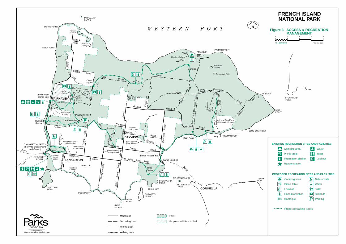
Major road
Secondary road
Vehicle track
Walking track
Park
Proposed additions to Park
PROPOSED RECREATION SITES AND FACILITIES
Camping area Nature walk
Picnic table Water
Lookout Toilet
Park information Bird hide
Barbeque Parking
Proposed walking tracks
EXISTING RECREATION SITES AND FACILITIES
Camping area Water
Picnic table Toilet
Information shelter Lookout
Ranger station
Figure 3 ACCESS & RECREATION MANAGEMENT
G / 5003.03
Ferry
Ferry
Cent
re
Trac
k
Brella
SpurTrack
Albion
s
Track
Rai
n P
oint
Gar
tsid
es T
rack
Ove
rpas
s
Roa
d
Barge Access Rd
Causeway
Roa
d
Long
Road
Cem
eter
y
Coa
st
Redbill RoadLink
Road
Salt Mine Point Road
MosquitoCreek Road
Wel
lingt
on Bayview
TankertonRoad
Road
BullockRoad
Poin
tR
oad
Clu
mp
Roa
d
Cau
sew
ay
Road
McLeod Road
Ridge Track
The
Anch
orag
e
McLeod Road
Track
Mou
ntThe Rest
The
Cen
trew
ay
Pinnacles Tk.Tk
.
FAIRHAVEN
TANKERTON
W E S T E R N P O R T
CORINELLA
BAYVIEW
LittleHeiferSwamp
DecoySwamp
BullockSwamp
ClumpLagoon
GartsidesSwamp
The Duck Splash
Mountain Hole
Stick Swamp
DeuscherSwamp
The Punt
The PrairieLongSwampHeifer
Swamp
Redbill
Creek
Brella
Creek
MosquitoCreekTank
erto
nC
k
PALMER POINT
BLUE GUM POINT
SPITPOINT
ALBIONS
FREEMAN POINT
STOCKYARDPOINT
TENBYPOINT
PECK POINT
RAMSISLAND
LONGPOINT
ELIZABETHISLAND
STOCKYARDPOINT
RED BLUFF
PELICAN ISLAND
SETTLEMENTPOINTTORTOISE
HEAD
Mt. Wellington(95.7m)
RIVER POINT
SCRUB POINT
BARRALLIERISLAND
BayviewChickory Kiln
Parks VictoriaOffice & Depot
Cemetery
GairdnersCottage
General Store& Post Office
TortoiseHeadLodge
Recreation Ground& Public Hall
PerserverancePrimary School
Barge Landing
TANKERTON JETTY(Ferry to Stony Point
and Cowes)
TEA TREEPOINT
JettyRain Point
FairhavenCamp Site
Gartsides
"The Cut"
The PinnaclesChilcottRocks
McLeod Eco Farm& Historic Prison
BlueGums
Cartography byNatural Resource Systems 1998
FRENCH ISLANDNATIONAL PARK
1 0 1 2 3
Kilometres