Embed Size (px)
Citation preview

FRESHWATER RESOURCE ECOLOGICAL ASSESSMENT
AS PART OF THE ENVIRONMENTAL ASSESSMENT AND
AUTHORISATION PROCESS FOR A WALKWAY IN THE
CARLSWALD VALLEY RESIDENTIAL DEVELOPMENT,
KYALAMI, GAUTENG PROVINCE
Prepared for
Century Property Development
July 2016
Prepared by: Scientific Aquatic Services Report author: A. Mileson Report reviewer: S. van Staden (Pr. Sci. Nat) Report reference: SAS 216149
Date: July 2016
Scientific Aquatic Services CC CC Reg No 2003/078943/23 Vat Reg. No. 4020235273 PO Box 751779 Gardenview 2047 Tel: 011 616 7893 Fax: 086 724 3132 E-mail: [email protected]

SAS 216149 July 2016
ii
EXECUTIVE SUMMARY
MANAGEMENT SUMMARY
Scientific Aquatic Services (SAS) was appointed to conduct a freshwater resource assessment, and to provide activity-specific rehabilitation measures, as part of the environmental assessment and authorisation process for the construction of the proposed pedestrian walkway, henceforth referred to as the “proposed linear development” within the Carlswald Valley Residential Estate, in Kyalami, Gauteng Province, henceforth referred to as the “study area”.
The freshwater resource identified within the study area was previously delineated by Wetland Consulting Services in 2006, and therefore, delineation of the resource did not form part of this study. The purpose of this study is to define the ecology of the freshwater resource in terms of characteristics, identifying and defining areas of increased Ecological Importance and Sensitivity (EIS), define the Present Ecological State (PES), and to define the ecological and socio-cultural service provision of the resource. The results of these assessments will then be utilised to ascertain a Recommended Ecological Category (REC). The detailed information generated as a consequence of these assessments is intended to guide the proposed project activities associated with the linear development traversing the freshwater resource, in order to ensure the ongoing functioning of the ecosystem, such that local and regional conservation requirements and the provision of ecological services in the local area are supported while considering the need for sustainable economic development.
The assessment took the following approach:
A desktop study was conducted, in which the freshwater resource was identified for on-site investigation. Consultation of relevant national and provincial databases formed part of this background study. The results of the desktop study are contained in Section 3 of this report;
A field assessment took place in July 2016, in order to ground-truth the identified freshwater resource within the study area. One freshwater resource was identified, and was classified according to the classification system (Ollis et. al., 2013) as an unchannelled valley bottom wetland, located predominantly in the northern portion of the study area, and traversing the study area from east to west.
The findings of the freshwater resource assessment indicates that the resource identified within the study area, which will be traversed by the proposed linear development, is deemed to be in a severely modified condition, and is therefore of considered to be of decreased ecological importance and sensitivity although it is likely to be sensitive to flow modifications. Based on the findings of the freshwater resource assessment and the results of the impact assessment, it is the opinion of the ecologist that although the potential exists for the proposed linear development to have a negative impact on the freshwater resource, impact significance can be greatly reduced by adherence to cogent, well-conceived and ecologically sensitive site development plans and construction methods. Mitigation and rehabilitation measures have therefore been developed in order to minimise perceived impacts on the receiving environment, as well as to improve ecological functioning and recreational value of the resource, providing all measures are implemented efficiently. It is the opinion of the specialist therefore that the proposed linear development be considered favourably, with the proviso that strict adherence to mitigation and rehabilitation measures is enforced, in order to ensure that the ecological integrity of the freshwater resource and the ecological and socio-cultural services it provides is not further compromised.

SAS 216149 July 2016
iii
The detailed results of the field assessment are contained in Section 4 of this report and are summarised in the table below.
Table A: Summary of the results of the field assessment
Present Ecological State (PES) Category
Ecological function and service provision
Ecological Importance and Sensitivity (EIS)
Recommended Ecological Class (REC)
D Intermediate B D
Following the assessment of the freshwater resources, an impact assessment was performed to ascertain the significance of perceived impacts on the receiving environment, in the event that the proposed development proceeds. Since the proposed development will traverse the freshwater resource, the probability that impacts will occur is considered ‘definite’. However due to the decreased ecological integrity and sensitivity of the resource, impact significance prior to the implementation of mitigation measures during construction is deemed to be of low levels, whilst without mitigation, impact significance during the operational phase will be of medium-low levels. However, efficient and effective implementation of well-designed mitigation measures can reduce impact significance during both phases to low levels. Mitigation and rehabilitation measures were developed to manage the perceived impacts on the freshwater resource, as outlined in Section 5 and Appendix F of this report. The following mitigation measures are considered particularly important: Pre-construction and construction:
Effective and strict erosion control throughout the construction phase is imperative. In this regard detailed erosion control measures are outlined in Section 5 of this report;
As it is absolutely unavoidable that the freshwater resource will be affected, especially during walkway construction, disturbance to the freshwater resource crossing must be minimised and suitable and adequate rehabilitation must take place. In this regard, very careful attention to the walkway design criteria will need to take place. Please refer to Section 5 for detailed recommendations pertaining to the design criteria necessary to achieve this objective;
In order to minimise the construction footprint and disturbances to the surrounding wetland areas, it is preferable that foundations for support poles be dug using hand tools or as small an augering machine as possible and that only essential personnel are permitted within the freshwater resource;
Due to the existing extent of alien vegetation proliferation, a comprehensive Alien Invasive Plan (AIP) is deemed an essential mitigation measure. This plan must encompass alien vegetation control during all phases of the proposed development, and must contain measures to ensure that all recruited alien vegetation as a result of disturbances during construction are eradicated; and
All areas where soils are exposed or destabilised need to be stabilised, preferably utilising soft engineering techniques as detailed in Section 5.
Post-construction and operational phase:
Following completion of construction, reprofiling of any disturbed soils must take place in order to tie-in with the natural topography of the surrounding areas. Revegetation with indigenous flora is especially important to ensure the ongoing ecological functioning of the resource;
Any areas where active erosion is observed must be immediately rehabilitated (re-shaping of slopes, revegetation with indigenous species where necessary, etc.) in such a way as to ensure that the hydrology and geomorphological characteristics of the area are re-instated to conditions which are as natural as possible;
The installation of educational signs encouraging responsible use of the freshwater resource should be posted at highly visible points along the proposed walkway;
Pollution control is particularly important, especially given the proximity of the freshwater resource to residences and the intended recreational use of the resource by residents. Further details pertaining to this aspect are provided in Section 5.

SAS 216149 July 2016
iv
Rehabilitation phase: Of primary importance is the ongoing control of erosion and sedimentation of the resource.
Recommendations have been made in Section 5 in order to achieve this objective. A monitoring programme should be implemented in order to detect any issues which may
arise such as incision and accumulation of debris around walkway support structures, proliferation of alien vegetation, etc.
In conclusion, whilst the freshwater resource is deemed to be in a heavily modified condition, primarily as a result of various historic and recent anthropogenic activities which have caused modifications to the geomorphology, vegetation and hydrological functioning of the system, further degradation of the resource should not be permitted. Whilst it is not feasible to completely avoid potential impacts as a consequence of constructing the proposed linear development, the need to prevent further degradation should not be seen as a fatal flaw, but rather as an opportunity to improve the present state of the wetland, whilst simultaneously providing a recreational facility to the residents of the residential estate within which the freshwater resource is located. Based on the findings of the freshwater resource assessment and the results of the impact assessment, it is the opinion of the ecologist that the significance of perceived impacts can be greatly reduced by adherence to cogent, well-conceived and ecologically sensitive site development plans, as discussed in Section 5 of this report. Therefore, it is the opinion of the specialist that the proposed linear development be considered favourably, with the proviso that strict adherence to mitigation and rehabilitation measures is enforced, in order to ensure that the ecological integrity of the freshwater resource and the ecological and socio-cultural services it provides is not further compromised.

SAS 216149 July 2016
v
DOCUMENT GUIDE
Relevant section in report
Details of the specialist who prepared the report Appendix G
The expertise of that person to compile a specialist report including a curriculum vitae Appendix G
A declaration that the person is independent in a form as may be specified by the competent authority
Appendix G
An indication of the scope of, and the purpose for which, the report was prepared Section 1.2
Assumption and limitations Section 1.3
A description of the methodology adopted in preparing the report Appendix C & D
The specific identified sensitivity of the site Section 4.4
Indicators considered during wetland delineation and parameters adopted in allocating a buffer for the resource
Section 4.4
A description of the findings and potential implications of such findings on the impact of the proposed activity, including identified alternatives, on the environment
Section 5
Management and mitigation measures for inclusion in the Environmental Management Programme (EMPr)
Section 5 and Appendix F
Any monitoring requirements for inclusion in the EMPr or environmental authorisation Section 5
Conclusion and opinion based on the results and impact assessments Section 6
References utilised for this study Section 7
Indemnity and terms of use of the report Appendix A
Legislative requirements Appendix B
Present Ecological State (PES), Ecoservices and Ecological Importance and Sensitivity (EIS) results
Appendix E

SAS 216149 July 2016
vi
TABLE OF CONTENTS
EXECUTIVE SUMMARY ...................................................................................................... ii DOCUMENT GUIDE ............................................................................................................. v TABLE OF CONTENTS ...................................................................................................... vi LIST OF FIGURES ............................................................................................................. vii LIST OF TABLES ............................................................................................................... vii GLOSSARY OF TERMS ................................................................................................... viii ACRONYMS ......................................................................................................................... x 1 INTRODUCTION ....................................................................................................... 1 1.1 Background ............................................................................................................... 1 1.2 Scope of Work ........................................................................................................... 5 1.3 Assumptions and Limitations ..................................................................................... 5 1.4 Legislative Requirements .......................................................................................... 6 2 ASSESSMENT APPROACH .................................................................................... 6 2.1 Freshwater Resource Field Verification ..................................................................... 6 2.2 Impact Assessment and Recommendations .............................................................. 7 3 RESULTS OF THE DESKTOP ANALYSIS ............................................................... 7 4 RESULTS ............................................................................................................... 13 4.1 Freshwater resource system characterisation .......................................................... 13 4.2 Vegetation Community Considerations .................................................................... 15 4.3 Field Verification Results ......................................................................................... 15 4.4 Delineation and Sensitivity Mapping ........................................................................ 18 5 IMPACT ASSESSMENT ......................................................................................... 18 5.1 Impact Analyses ...................................................................................................... 18 5.1.1 Mitigation hierarchy and considerations given to application of mitigation
measures ................................................................................................................ 18 5.1.2. Freshwater features impact discussion and essential mitigation measures ............. 19 6 CONCLUSION ........................................................................................................ 24 7 REFERENCES ........................................................................................................ 25 APPENDIX A - Indemnity .................................................................................................. 27 APPENDIX B - Legislation ................................................................................................ 28 APPENDIX C - Freshwater Resource Method of Assessment ....................................... 29 APPENDIX D - Impact Assessment Method of Assessment .......................................... 37 APPENDIX E - Assessment Results ................................................................................ 41 APPENDIX F - Impact Analysis and Mitigation Measures .............................................. 44 APPENDIX G - Specialists Details .................................................................................... 49

SAS 216149 July 2016
vii
LIST OF FIGURES
Figure 1: A digital satellite image depicting the location of the study area and proposed linear development in relation to the surrounding area. ...................................... 3
Figure 2: The study area and proposed linear development depicted on a 1:50 000 topographical map in relation to the surrounding area. ....................................... 4
Figure 3: Artificial wetlands associated with the study area and surrounding areas according to NFEPA (2011) ................................................................................ 9
Figure 4: Gauteng C Plan v3.3 (2011) indicating the CBA and ESA associated with the study area and the linear development. ............................................................ 10
Figure 5: Wetland and River Buffers associated with the study area and linear development according to the GDARD C-Plan v3.3 (2011). ............................. 11
Figure 6: Wetland feature associated with the study area and linear development as indicated by the CoJ Wetland layer (2014). ...................................................... 12
Figure 7: The location of the freshwater resource identified during the field assessment, as delineated by WET CS (2006) along with the recommended 15m buffer. .... 14
LIST OF TABLES
Table 1: Desktop data relating to the freshwater resource characteristics associated with the study area, linear development and surrounding region. ......................... 8
Table 2: Characterisation of the freshwater resource identified within the study area. ..... 13 Table 3: Summary of the assessment of the freshwater resource.................................... 16

SAS 216149 July 2016
viii
GLOSSARY OF TERMS
Alien vegetation: Plants that do not occur naturally within the area but have
been introduced either intentionally or unintentionally.
Vegetation species that originate from outside of the
borders of the biome -usually international in origin.
Alluvial soil: A deposit of sand, mud, etc. formed by flowing water, or
the sedimentary matter deposited thus within recent
times, especially in the valleys of large rivers.
Biodiversity: The number and variety of living organisms on earth, the
millions of plants, animans and micro-organisms, the
genes they contain, the evolutionary history and potential
they encompass and the ecosystems, ecological
processes and landscape of which they are integral parts.
Buffer: A strip of land surrounding a wetland or riparian area in
which activities are controlled or restricted, in order to
reduce the impact of adjacent land uses on the wetland or
riparian area.
Catchment: The area contributing to runoff at a particular point in a
river system.
Chroma: The relative purity of the spectral colour which decreases
with increasing greyness.
Delineation (of a wetland): To determine the boundary of a wetland based on soil,
vegetation and/or hydrological indicators.
Ecoregion: An ecoregion is a "recurring pattern of ecosystems
associated with characteristic combinations of soil and
landform that characterise that region”.
Facultative species: Species usually found in wetlands (76%-99% of
occurrences) but occasionally found in non-wetland areas.
Groundwater: Subsurface water in the saturated zone below the water
table.
Hydromorphic soil: A soil that in its undrained condition is saturated or
flooded long enough to develop anaerobic conditions
favouring the growth and regeneration of hydrophytic
vegetation (vegetation adapted to living in anaerobic
soils).
Hydrology: The study of the occurrence, distribution and movement of
water over, on and under the land surface.
SAS 216149 July 2016
ix
Hydromorphy: A process of gleying and mottling resulting from the
intermittent or permanent presence of excess water in the
soil profile.
Indigenous vegetation: Vegetation occurring naturally within a defined area.
Obligate species: Species almost always found in wetlands (>99% of
occurences).
Perennial: Flows all year round.
Ramsar: The Ramsar Convention (The Convention on Wetlands of
International Importance, especially as Waterfowl Habitat)
is an international treaty for the conservation and
sustainable utilisation of wetlands, i.e., to stem the
progressive encroachment on and loss of wetlands now
and in the future, recognising the fundamental ecological
functions of wetlands and their economic, cultural,
scientific, and recreational value. It is named after the city
of Ramsar in Iran, where the Convention was signed in
1971.
Seasonal zone of wetness: The zone of a wetland that lies between the Temporary
and Permanent zones and is characterised by saturation
from three to ten months of the year, within 50cm of the
surface.
Temporary zone of wetness: The outer zone of a wetland characterised by saturation
within 50cm of the surface for less than three months of
the year.

SAS 216149 July 2016
x
ACRONYMS
BAR Basic Assessment Report
CBA Critical Biodiversity Area
CoJ City of Johannesburg
CSIR Council of Scientific and Industrial Research
DWA Department of Water Affairs
DWAF Department of Water Affairs and Forestry
DWS Department of Water and Sanitation
EAP Environmental Assessment Practitioner
EIA Environmental Impact Assessment
EI Ecological Importance
EIS Ecological Importance and Sensitivity
ES Ecological Sensitivity
ESA Ecological Support Area
FEPA Freshwater Ecosystem Priority Areas
GDARD Gauteng Department of Agriculture and Rural Development
GIS Geographic Information System
HGM Hydro-geomorphic
MAP Mean Annual Precipitation
NEMA National Environmental Management Act
NFEPA National Freshwater Ecosystem Priority Areas
NWA National Water Act
PES Present Ecological State
REC Recommended Ecological Category
RQS Research Quality Services
SAIAB South African Institute of Aquatic Biodiversity
SANBI South African National Biodiversity Institute
SANParks South African National Parks
SAS Scientific Aquatic Services
subWMA Sub-Water Management Area
WMA Water Management Area
WRC Water Research Commission

SAS 216149 July 2016
1
1 INTRODUCTION
1.1 Background
Scientific Aquatic Services (SAS) was appointed to conduct a freshwater resource
assessment, and to provide activity-specific rehabilitation measures, as part of the
environmental assessment and authorisation process for the construction of the proposed
pedestrian walkway, henceforth referred to as the “proposed linear development” within the
Carlswald Valley Residential Estate, in Kyalami, Gauteng Province, henceforth referred to as
the “study area”. The study area is located approximately 0.6km west of the R55 roadway,
and is bordered by Tamboti Road in the south, and Acacia Road (a gravel road) in the west.
The Montecello Country Estate is located approximately 0.4km to the east, and the
Summerset Estate approximately 0.35km to the North. Figures 1 and 2 present the locality of
the study area and proposed linear development within the study area, in relation to the
surrounding properties.
The purpose of this report is to define the ecology of the freshwater resource located within
the study area and previously delineated by Wetland Consulting Services (WET CS) in 2006,
in terms of freshwater resource characteristics, defining areas of increased Ecological
Importance and Sensitivity (EIS), and to define the Present Ecological State (PES) of the
freshwater resource. In addition, this report aims to define the socio-cultural and ecological
service provision of the freshwater resource and the Recommended Ecological Category
(REC) for the freshwater resource. It is a further objective of this study to provide detailed
information to guide the proposed project activities associated with the linear development
traversing the freshwater resource, in order to ensure the ongoing functioning of the
ecosystem, such that local and regional conservation requirements and the provision of
ecological services in the local area are supported while considering the need for
sustainable economic development.
An impact assessment, considering the impact of the proposed linear development on the
freshwater resource associated with the study area will be conducted to determine the
significance of the potential impacts on the receiving aquatic environment in relation to the
proposed linear development. Following the impact assessment, proposed mitigation
measures will be developed to minimise the impacts, where possible, followed by an
assessment of the significance of the impacts after mitigation, assuming that they are fully
implemented.

SAS 216149 July 2016
2
In addition, rehabilitation measures, specific to the activities associated with the construction
and operation of the proposed walkway, will be provided to further aid in the management of
perceived impacts on the wetland resources which may occur as a result of the construction
of the proposed linear development. A Wetland Rehabilitation and Management Plan
(WRMP) was previously developed by SAS in August 20151, and therefore, all
recommendations contained in this report pertaining to the minimisation of perceived
impacts and rehabilitation of the freshwater resource must be implemented in conjunction
with those stipulated by SAS (2015).
This report, after consideration and a description of the ecological integrity of the freshwater
resource associated with the study area, must guide the Environmental Assessment
Practitioner (EAP) and authorities, by means of a reasoned opinion and recommendations,
as to the viability of the proposed linear development activities in relation to the freshwater
resource.
1 Scientific Aquatic Services (SAS). 2015. Wetland Rehabilitation and Management Plan for the wetland resource within the Carlswald
Valley Residential Development, Kyalami, Gauteng Province.

SAS 216149 July 2016
3
Figure 1: A digital satellite image depicting the location of the study area and proposed linear development in relation to the surrounding area.

SAS 216149 July 2016
4
Figure 2: The study area and proposed linear development depicted on a 1:50 000 topographical map in relation to the surrounding area.

SAS 216149 July 2016
5
1.2 Scope of Work
Specific outcomes in terms of this report are outlined below:
A background study of relevant national, provincial and municipal datasets (such as
the National Freshwater Ecosystem Priority Areas [NFEPA], 2011 database; DWS
RQS PES/EIS, 2014 database and the Gauteng Department of Agriculture and Rural
Development [GDARD] Gauteng Conservation Plan, (2011) was undertaken to aid in
defining the PES and EIS of the freshwater resources associated with the study area;
The freshwater resource delineation as well as the associated 15m wetland buffer
zone was delineated by WET CS (2006), and as such did not form part of the scope
of this study;
The freshwater resource classification assessment was undertaken according to the
Classification System for Wetlands and other Aquatic Ecosystems in South Africa.
User Manual: Inland systems (Ollis et al., 2013);
The EIS of the freshwater resource was determined according to the method as
adapted from DWA (1999) for floodplains;
The services provided by the freshwater resource in the study area were assessed
according to the method of Kotze et al. (2009) in which ecological and socio-cultural
service provision was defined;
The freshwater resource PES was assessed according to the resource-directed
measures guidelines of Macfarlane et al., (2008);
The environmental impacts of the proposed linear development on the freshwater
resource associated with the study area were determined; and
Management, mitigation and rehabilitation measures which should be implemented
during the various development phases to assist in minimising the impact on the
receiving environment were presented.
1.3 Assumptions and Limitations
The following assumptions and limitations are applicable to this report:
The assessment of the freshwater resource is confined to the study area, and does
not include the neighbouring and adjacent properties, which were only considered as
part of the desktop assessment;
The delineation of the freshwater resource as well as the allocation of a 15m buffer
zone was conducted by WET CS in 2006, and as such the resource was not
delineated during this study;

SAS 216149 July 2016
6
The data presented in this report is based predominantly on a single site visit
undertaken in July 2016, during the dry winter season. Although the area had
received some unseasonable rainfall during the preceding months, drought
conditions were experienced countrywide prior to and at the time of the assessment,
and therefore some floral indicator species may not have been identifiable at the time
of the assessment. Data collected during the assessment undertaken in August 2015
as part of the study to develop rehabilitation measures (SAS, 2015) was however
consulted; and
With ecology being dynamic and complex, certain aspects (some of which may be
important) may have been overlooked. However, it is expected that the proposed
development activities have been accurately assessed and considered, based on the
field observations and the consideration of existing studies and monitoring data in
terms of wetland ecology.
1.4 Legislative Requirements
The following legislative and provincial requirements were taken into consideration during
the assessment. A detailed description of these requirements is presented in Appendix B:
National Environmental Management Act (NEMA) (Act No. 107 of 1998); and
National Water Act (NWA) (Act No. 36 of 1998).
2 ASSESSMENT APPROACH
2.1 Freshwater Resource Field Verification
For the purposes of this investigation, the definition of a wetland habitat as defined in the
NWA (1998) was used: A wetland is “a land which is transitional between terrestrial and
aquatic systems where the water table is usually at or near the surface, or the land is
periodically covered with shallow water, and which land in normal circumstances supports or
would support vegetation typically adapted to life in saturated soil.”
A field assessment was undertaken in July 2016, during which a detailed assessment of the
freshwater resource delineated by WET CS (2006) was conducted. Factors affecting the
integrity of the freshwater resource were taken into consideration and aided in the
determination of the functioning of the freshwater resource and the ecological and socio-
cultural services provided by the freshwater resource. A detailed explanation of the methods
of assessment utilised are provided in Appendix C of this report.
SAS 216149 July 2016
7
2.2 Impact Assessment and Recommendations
Following the completion of the assessment, an impact assessment was conducted (please
refer to Appendix D for the method of approach) and recommendations were developed to
address and mitigate impacts associated with the proposed development. These
recommendations also include general management measures, along with activity specific
rehabilitation measures which apply to the proposed development. Mitigation measures have
been developed to address issues in all phases throughout the life of the operation including
planning, construction and operation. The detailed site specific mitigation and rehabilitation
measures are outlined in Section 5 of this report, whilst the general management measures,
which are considered to be best practice mitigation applicable to this project, are outlined in
Appendix F.
3 RESULTS OF THE DESKTOP ANALYSIS
The following section contains data accessed as part of the desktop assessment and are
presented as a “dashboard” report below (Table 1). The dashboard report aims to present
concise summaries of the data on as few pages as possible in order to allow for integration
of results by the reader to take place. Where required, further discussion and interpretation
is provided, and information that was considered to be of particular importance was
emboldened.
It is important to note that although all data sources used provide useful and often verifiable,
high quality data, the various databases used do not always provide an entirely accurate
indication of the study areas’ actual site characteristics at the scale required to inform the
Environmental Impact Assessment (EIA) process. However, this information is considered to
be useful as background information to the study. Thus, this data was used as a guideline to
inform the assessment and to focus on areas and aspects of increased conservation
importance.

SAS 216149 July 2016
8
Table 1: Desktop data relating to the freshwater resource characteristics associated with the study area, linear development and surrounding region.
Aquatic ecoregion and sub-regions in which the study area is located Detail of the study area and linear development in terms of the National Freshwater Ecosystem Priority Area (NFEPA) (2011) database
Ecoregion Highveld FEPACODE
The study area is located within a subWMA considered to be an upstream management catchment, and anthropogenic activities in these areas must be carefully controlled in order to prevent downstream degradation of FEPAS and Fish support areas (FEPACODE = 4.) Catchment Limpopo
Quaternary Catchment A21C
NFEPA Wetlands
The northern boundary of the study area is indicated to transect an artificial seep wetland, while a second artificial seep wetland is located ± 400 m west of the study area (Figure 3). Both these wetlands are considered to be in a Z3 ecological condition, meaning the wetlands are in a heavily to critically modified condition, and that the percentage of natural land cover is less than 25%.
WMA Crocodile (West) and Marico
subWMA Upper Crocodile
Dominant characteristics of the Highveld Ecoregion (Kleynhans et al., 2005)
Dominant primary terrain morphology Plains; Low Relief, Moderate Relief Wetland Vegetation Type Mesic Highveld Grassland Group 3 (Critically Endangered, receiving Zero Protection [SANBI, 2013])
Dominant primary vegetation types Dry Sandy Highveld Grassland
NFEPA Rivers The NFEPA database does not indicate the presence of any rivers within 500m of the study area. Moist Cool Highveld Grassland
Altitude (m a.m.s.l) 1100-2100, 2100-2300 (very limited) Detail of the study area and linear development in terms of the Gauteng Conservation Plan (C-Plan V3.3, 2011) (Figure 4 & 5)
MAP (mm) 400 to 1000
Critical Biodiversity Area
The majority of the study area as well as the linear development, falls within a CBA (Figure 4). The CBA is listed as an Important Area, particularly for “Red and Orange” listed plant habitat, and for Primary Vegetation. A CBA is an area considered important for the survival of threatened species and includes valuable ecosystems such as wetlands, untransformed vegetation and ridges.
Coefficient of Variation (% of MAP) <20 to 35
Rainfall concentration index 45 to 65
Rainfall seasonality Early to late summer Ecological Support Area
The northern boundary of the study area transects an ESA (Figure 4). An ESA provides connectivity and important ecological processes between CBAs and is therefore important in terms of habitat conservation. Mean annual temp. (°C) 12 to 20
Winter temperature (July) -2 – 22 C
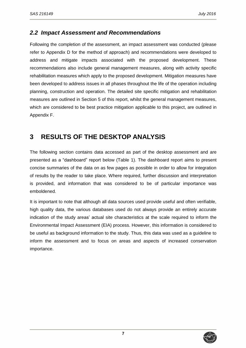
Wetland
The C-Plan indicates the presence of a wetland system traversing the study area, and the proposed linear development is also located within this wetland buffer (Figure 5). Gauteng C-Plan v3.3: “The Gauteng C-Plan v3.3 is designed to be used at a scale of approximately 1:50 000. Although it can be used at a finer scale, this requires specialist interpretation of the specific features identified in the systematic biodiversity plan”. The freshwater resource associated with the study area was therefore verified and delineated by WET CS (2006).
Summer temperature (Feb) 10 – 32 C
Median annual simulated runoff (mm) 5 to >250
Ecological Status of the most proximal sub-quaternary reach (DWS, 2014)
Sub-quaternary reach A21C-01195
Proximity to study area ± 1.5 km Northwest of the study area River
A non-perennial river buffer is identified by the C-Plan to be traversing the study area from east to west. The northern portion of the linear development is also located within this buffer (Figure 5). Assessed by expert? Yes
PES Category Median E
Urban Area The study area is located within the Urban Edge according to the C-Plan V3 (2011) (Figure 5). Although the Urban Area was rescinded as a policy document in the Gauteng Spatial Development Framework (2011), it nevertheless remains a useful indicator of where concentration [of development] should occur.
Mean Ecological Importance (EI) Class Low
Mean Ecological Sensitivity (ES) Class Moderate
Stream Order 1 Detail of the study area and linear development in terms of the City of Johannesburg Wetland Database (CoJ, 2014) Figure 6
Default Ecological Class (based on median PES and highest EI or ES mean)
Moderate (Class C) According to the CoJ Wetland Database layer a wetland feature traverses the study area, and encompass the entire northern and eastern portion of the study area. The linear development is located within this wetland buffer.

SAS 216149 July 2016
9
Figure 3: Artificial wetlands associated with the study area and surrounding areas according to NFEPA (2011)

SAS 216149 July 2016
10
Figure 4: Gauteng C Plan v3.3 (2011) indicating the CBA and ESA associated with the study area and the linear development.
SAS 216149 July 2016
11
Figure 5: Wetland and River Buffers associated with the study area and linear development according to the GDARD C-Plan v3.3 (2011).

SAS 216149 July 2016
12
Figure 6: Wetland feature associated with the study area and linear development as indicated by the CoJ Wetland layer (2014).

SAS 216149 July 2016
13
4 RESULTS
4.1 Freshwater resource system characterisation
In preparation for the field assessment, aerial photographs, digital satellite imagery and
provincial and national wetland databases (as outlined in Section 3 of this report) were used
to identify areas of interest at a desktop level. All possible measures were undertaken to
ensure that all freshwater resources occurring within the study area were assessed.
A single freshwater resource was identified within the study area, and was classified
according to the Classification System (outlined in Appendix C of this report). The
classification of this freshwater resource is summarised in Table 2 below, whilst the locality
of the resource as delineated by WET CS (2006) along with the 15m buffer as
recommended by WET CS (2006) is indicated in Figure 7.
Table 2: Characterisation of the freshwater resource identified within the study area.
Level 1: System Level 2: Regional Setting Level 3: Landscape unit Level 4: HGM Type
Inland System
Ecoregion: Highveld Aquatic Ecoregion WetVeg Group: Mesic Highveld Grassland Group 3
Valley floor: The typically gently sloping, lowest surface of a valley.
Unchannelled valley bottom wetland: A valley-bottom wetland without a river channel running through it

SAS 216149 July 2016
14
Figure 7: The location of the freshwater resource identified during the field assessment, as delineated by WET CS (2006) along with the recommended 15m buffer.

SAS 216149 July 2016
15
4.2 Vegetation Community Considerations
The floral community structure and composition of the freshwater resource has been
significantly transformed, with high levels of alien vegetation encroachment observed,
particularly within the temporary and seasonal zones. An increased abundance of
indigenous vegetation, improved habitat and lower levels of alien vegetation encroachment
was noted within the permanent zone however.
Dominant alien floral species observed during the site assessment include Tagetes minuta,
Bidens pilosa, Verbana bonariensis and Verbena aristigera in the temporary and seasonal
zones, whilst Persicaria sp. and Nasturtium officinale were observed within the permanent
zone. Indigenous species identified include Helichrysum spp., Typha capensis, Phragmites
australis and Kniphofia porphyrantha (although K. porphyrantha was not dominant).
4.3 Field Verification Results
The tables below summarise the findings of the field assessment in terms of relevant
aspects (hydrology, geomorphology and vegetation components) of freshwater ecology. The
details pertaining to the method of assessment used to assess the freshwater resource is
contained in Appendix C of this report and Appendix E presents the calculations for each of
the methods.

SAS 216149 July 2016
16
Table 3: Summary of the assessment of the freshwater resource.
Ecological & socio-cultural service provision graph:
HGM Unit Description
Unchannelled valley bottom; flowing east to west through the centre of the study area.
Fatal Flaw? N Photograph notes
Representative photographs of the freshwater resource in the vicinity of the proposed linear development showing the higher incidence of indigenous vegetation in the permanent zone (left). The photograph on the right shows clearing of vegetation up to the buffer zone of the freshwater resource.
PES discussion
PES Category: D The degree to which the hydrology, geomorphology and vegetation modules have been modified have significantly decreased the ecological integrity of the resource. Water inputs have been increased due to the increased incidence of impermeable surfaces in the catchment, whilst flow patterns have been altered as a result of altered topography and particularly the digging of an informal trench within the permanent zone. Sediment inputs are likely to have increased significantly due to the proximity of construction-related earthworks in the vicinity as well as decreased vegetation cover, and the vegetation has been significantly transformed as a result of alien plant invasion due to historical and recent disturbances to the soil profile.
Watercourse characteristics:
a) Hydraulic regime
The hydrological patterns of the freshwater resource have been altered primarily as a result of the rapid urbanisation of the surrounding areas, which has resulted in an increase in impermeable surfaces, resulting in increased water inputs to the resource in the form of stormwater runoff. Furthermore, a portion of the permanent zone has been informally canalised, in which water is retained but since the flow of water through this trench is impeded, the water has become stagnant. This may potentially have affected water flow between the permanent and seasonal zones of the resource.
Ecoservice provision
Intermediate: Considered of high importance for sediment trapping, nutrient and toxicant assimilation and erosion control, whilst flood attention and streamflow regulation capacity are deemed to be of moderate levels. Not considered important for delivering any harvestable resources or cultivated foods due to the locality within a highly urbanised environment. In its present state the resource is deemed to have low recreational and
b) Water quality
Comprehensive analyses of water quality did not take place however it is considered likely that the proximity of residential developments and the ongoing construction activities taking place is likely to have some impact on water quality, in particular turbidity and nutrient levels. The limited available surface water observed during the site assessment was stagnant and it was deduced from the presence of algae in the water that nutrient levels are likely to be relatively high.

SAS 216149 July 2016
17
educational value, however since it is located within a residential complex, the potential for these exists, should rehabilitation be effectively and efficiently implemented in order to improve the ecological integrity of the resource.
EIS discussion
EIS Category: B (High) Despite the decreased ecological integrity, valley bottom wetlands are generally considered to be sensitive to changes in flood peaks and flow volumes. Thus, although the freshwater resource may, in its present state, have diminished socio-cultural and hydro-functional importance, it may be considered sensitive to impacts such as increased water inputs which are deemed highly likely, given the rapid urbanisation and associated impermeable surfaces in the surrounding areas. The resource is also deemed to be of limited importance for habitat provision, and as a migratory corridor for smaller, less sensitive faunal species. Whilst the vegetation composition has been altered and there is a high incidence of alien vegetation, the applicable NFEPA WetVeg group is deemed by SANBI (2013) to be Critically Endangered, receiving Zero Protection.
c) Geomorphology and sediment balance
Historical agricultural activities are likely to have altered the topography and soil profiles of the freshwater resource, thus having an effect on the sediment budget. However, disturbances relating from recent construction activities in the vicinity of the freshwater resource are likely to have resulted in increased sediment loads entering the resource, as vegetation from surrounding terrestrial areas was cleared and soils exposed, thus increasing the potential for sediment-laden runoff to reach the resource. It was not possible to ascertain from the site assessment or inspection of available digital satellite imagery of the study area when the informal canal within the permanent zone was dug; however this has impacted the hydrological patterns of the freshwater resource to some extent as discussed above.
REC Category
Category D: This wetland is considered to be ecologically degraded, although could potentially still be sensitive to further impacts. Therefore, management measures should be implemented to ensure that present levels of ecological services and functioning of this feature are retained and are not permitted to deteriorate further and where possible, improved.
d) Habitat and biota
As discussed in Section 4.2 of this report, the vegetation component of the freshwater resource has been significantly transformed as a result of historical and recent disturbances to the soil profile, with alien vegetation proliferation considered to be at severe levels. Furthermore, the reduction in indigenous vegetation both within the freshwater resource and the surrounding terrestrial areas reduces the ability of the vegetation to recover. Nevertheless, some indigenous vegetation remains, primarily within the permanent zone of the resource, and it was apparent that this does provide some foraging and breeding habitat for a number of less sensitive faunal species, mostly avifauna.
Impact significance prior to mitigation
L (Construction) ML (Operation)
The proposed linear development will traverse the freshwater feature, and therefore, the probability of impacts occurring, albeit of limited severity is considered definite. Furthermore, due to the intended function of the linear development, the duration of impact during the operational phase will be permanent. Nevertheless, due to the decreased ecological integrity and sensitivity of the resource, as well as the relatively small area which will be occupied by the linear development, pre-mitigation impact significance is deemed to be low during construction, and medium-low during operations. With the implementation of cogent, well-designed mitigation measures, impact significance during both construction and operations can be reduced to low levels.
Business case, Conclusion and Mitigation Requirements: The freshwater resource located within the study area, which the proposed linear development will traverse, has undergone substantial modifications as a result of various historical and current anthropogenic activities, resulting in decreased ecological integrity, and therefore decreased sensitivity. Nevertheless, the resource may be sensitive to further negative impacts, and therefore further degradation should not be permitted. Since the resource is located within a residential complex, potential exists for the resource to be utilised by residents for recreational and educational purposes, whilst simultaneously performing various ecological services such as nutrient cycling, flood attenuation, sediment trapping and biodiversity maintenance. Therefore, it is strongly recommended that, should the proposed linear development be approved, cogent, well-conceived and ecologically sensitive mitigation measures (as set out in this report as well as in SAS, 2015) be implemented and adhered to, in order to prevent further degradation of the wetland as well as improving the overall ecological functioning and aesthetic appeal of the resource.
Impact significance post mitigation
L

SAS 216149 July 2016
18
4.4 Delineation and Sensitivity Mapping
Please refer to Figure 7 (in Section 4.1 of this report) for the delineation of the freshwater
feature undertaken by WET CS (2006).
5 IMPACT ASSESSMENT
This section presents the significance of potential impacts on the freshwater ecology within
the study area in relation to the proposed linear development. In addition, it also indicates
the required mitigation measures needed to minimise the impacts and presents an
assessment of the significance of the impacts, taking into consideration the available
mitigation measures and assuming that they are fully implemented.
5.1 Impact Analyses
5.1.1 Mitigation hierarchy and considerations given to application of
mitigation measures
Following the assessment of the freshwater resource within the study area, the mitigation
measures were compiled, as defined by the DEA et al. (2013), to serve as guidance
throughout the development phases. The points below summarise the factors considered in
the development of mitigation measures:
Since it is not possible to completely avoid or prevent all potential impacts associated
with the proposed linear development, it is essential to take all possible steps to
minimise the significance of these impacts. Thus, the mitigation measures developed
aim to reduce the immediate and long-term effects of perceived impacts on the
receiving environment, as well as to reduce the risk of latent impacts which may
potentially occur;
Whilst the freshwater resource to be traversed by the proposed linear development is
not considered to be particularly ecologically sensitive as a result of historical and
ongoing impacts (associated primarily with rapid urban development in the
catchment), this nevertheless does not mean that development should occur without
adequate mitigation to prevent further impacts;
Whilst all possible steps may be taken to reduce the effect of perceived impacts by
means of mitigation, in order to aid the recovery and restoration of ecological
processes which may have been interrupted during the construction phase,

SAS 216149 July 2016
19
rehabilitation (e.g. by means of restoring natural vegetation) is necessary. Therefore,
rehabilitation measures have been developed and are outlined in Section 5.1.3;
Potential exists to simultaneously improve the overall ecological functionality of the
resource and its aesthetic appeal, by means of strict adherence to the mitigation and
rehabilitation measures provided in this report, as well as those stipulated in the
WRMP developed by SAS (2015).
The following impacts must be prevented:
Increased sedimentation and pollution of the freshwater resource as a result of
construction and operational activities, and also as a result of disturbances to
soils during construction;
Compaction of freshwater resource soils due to indiscriminate movement of
construction vehicles within the resource during construction;
Pollution of surface water either due to possible inadequate mitigation during
construction, or as a result of using materials for the walkway which have been
incorrectly treated for use in watercourses/wetlands; and
Further alterations to the vegetation community composition as a result of
increased alien vegetation proliferation due to disturbances to soil profiles and
clearing of indigenous vegetation in the vicinity of the freshwater resource.
5.1.2. Freshwater features impact discussion and essential mitigation
measures
There are four key ecological impacts on watercourses that are anticipated to occur namely,
Loss of freshwater feature habitat and ecological structure;
Changes to the sociocultural and service provision;
Impacts on the hydrology and sediment balance of the freshwater features; and
Impacts on water quality.
Construction and operation of the proposed linear development may lead to these impacts.
However, these impacts can be minimized, provided the mitigation measures as stated in
this report (Section 5.1.2 and Appendix F) along with the recommended rehabilitation
measures (Section 5.1.3) are implemented and adhered to, in conjunction with those
measures stipulated in the WRMP (SAS, 2015).
According to the impact assessment calculations tabulated in Appendix F, the impact
significance ranges from low (construction) to medium-low (operation) levels prior to
SAS 216149 July 2016
20
mitigation, whereas if mitigation measures are implemented effectively, the impact
significance may be reduced to low significance levels throughout both phases.
Since the proposed linear development is planned to traverse the freshwater resource, the
probability of perceived impacts affecting the freshwater resource is deemed to be ‘definite’.
Whilst this may be reduced marginally by the careful implementation of ‘good house-
keeping’ measures such as prudent placement of erosion control measures (please refer to
Appendix F), it is not possible to completely avoid impacting on the freshwater resource.
Therefore, the proposed mitigation measures are aimed at reducing the significance of
perceived impacts as much as possible.
Based on the findings of the freshwater resource ecological assessment, the following are
deemed to be essential mitigation measures which must be implemented.
Pre-construction and construction phase:
Effective and strict erosion control throughout the construction phase is imperative.
Erosion berms should be installed to prevent gully formation and further siltation of
the freshwater resource, and all soil stockpiles should be placed outside of the
resource itself and its associated 15m buffer zone, and protected with a suitable
geotextile. There is already evidence of excess sediment deposits within the wetland,
and further degradation in this regard must be minimised and avoided. Erosion
controls must be regularly maintained, at minimum on a fortnightly basis, particularly
if rain is forecast or immediately following a rainfall event;
As it is absolutely unavoidable that the freshwater resource will be affected,
especially during walkway construction, disturbance to the freshwater resource
crossing must be minimised and suitably rehabilitated. In this regard, very careful
attention to the walkway design criteria will need to take place, with special mention
of the following:
Disturbances within the freshwater resource need to be minimised as far as
possible. In this regard the following key points are highlighted:
o The walkway should be raised, in order to allow for continuity of water flow,
prevent habitat loss and fragmentation, as well as reduce erosion and allow
for a smaller development footprint;
o The narrowest point in the freshwater resource should be identified and
potentially used as the crossing point if feasible;
o The walkway should span across the freshwater resource as much as
possible, thus limiting the quantity of support structures which need to be

SAS 216149 July 2016
21
installed within the boundaries of the resource, and particularly within the
permanent zone;
o The walkway should cross the resource at a 90 degree angle to minimise the
damage to wetland areas; and
o The walkway should be constructed, if feasible, using natural biodegradable
materials such as timber, or recycled plastic (‘plastic timber’) for example,
Trex® composite decking products.
The walkway design must ensure that no upstream ponding and no downstream
erosion and scouring occur;
The walkway design must ensure that no hindrance to terrestrial, or wetland
fauna occurs;
The support poles and subframe should be constructed using Chromated Copper
Arsenate (CCA) treated timber, which has been treated to a minimum H5 class (i.e. is
suitable for long-term use in freshwater environments). This will ensure the longevity
of the structure, as it will be protected from the effects of long-term exposure to
water, as well as pests such as wood-borers, thus minimising the need for
maintenance activities which may further impact the resource;
The foundations/holes for the support poles must preferably be dug using hand-tools,
in order to minimise the risk of soil compaction by construction vehicles, and reduce
the footprint area which will be disturbed. Only essential personnel must be permitted
within the wetland areas to carry out this task. Should it not be possible to exclude
vehicles from the wetland altogether, then any disturbed soils must be ripped and
reprofiled prior to seeding with indigenous floral species;
Due to the existing extent of alien vegetation proliferation, a comprehensive Alien
Invasive Plan (AIP) is deemed an essential mitigation measure. This plan must
encompass alien vegetation control during all phases of the proposed development,
and must contain measures to ensure that all recruited alien vegetation as a result of
disturbances during construction are eradicated;
The duration of impacts on the freshwater resource should be minimised as far as
possible by ensuring that the duration of time in which flow alteration and
sedimentation will take place is minimised;
Edge effects (impacts on areas beyond the construction footprint due to ineffective
care and management) during construction need to be strictly controlled through
ensuring good housekeeping and strict management of activities near the freshwater
resource or the associated buffer zone (please refer to Appendix F for ‘good
housekeeping’ measures);

SAS 216149 July 2016
22
Post-construction and operational phase:
Following completion of construction, reprofiling of any disturbed soils must take
place in order to tie-in with the natural topography of the surrounding areas, and must
be revegetated with indigenous gramminoid species such as Arundinella nepalensis,
Imperata cylindrica, Setaria sphacelata, Eragrostis gummiflua, E. chloromelas, and
E. curvula. Revegetation is especially important not only for erosion control and
aesthetic appeal, but also to restore important ecological processes with specific
mention of toxicant removal and nutrient cycling, as well as increasing the resource’s
capacity for flood attenuation and sediment trapping;
Any areas where active erosion is observed must be immediately rehabilitated (re-
shaping of slopes, revegetation with indigenous species where necessary, etc.) in
such a way as to ensure that the hydrology and geomorphological characteristics of
the area are re-instated to conditions which are as natural as possible;
Edge effects of construction activities including erosion and alien/ weed control need
to be strictly managed in these areas in order to prevent the spread of such species,
particularly since the proliferation of alien vegetation is already considered high;
Following completion of construction activities, educational signs encouraging
responsible use of the recreational opportunity provided by the freshwater resource
whilst simultaneously prohibiting detrimental activities such as littering, should be
posted at highly visible points along the proposed walkway;
Dustbins with an automatic seal design must be placed at regular intervals along the
walkway, and emptied at least twice per week; and
Pollution control is particularly important, especially given the proximity of the
freshwater resource to residences and the intended recreational use of the resource
by residents. Ongoing monitoring of the resource and any stormwater facilities which
into the resource is required, to ensure that any litter or solid wastes which do reach
the resource are removed in a timely manner.
Rehabilitation phase:
The rehabilitation measures outlined in the WRMP (SAS, 2015) remain applicable to
the proposed walkway, and must be implemented in conjunction with those stipulated
here;
Of primary importance is the ongoing control of erosion and sedimentation of the
resource. In order to achieve this over the long-term, the following is recommended:
Areas disturbed during construction must be reprofiled if necessary to tie in with
the natural topography of the area in order to minimise the risk of water erosion

SAS 216149 July 2016
23
occurring on any steep slopes and thus transporting additional sediment to the
freshwater resource;
Removal of any remaining alien vegetation, and the ongoing monitoring of alien
vegetation;
Concurrent revegetation with indigenous flora will ensure that any exposed soils
resulting from removal of alien vegetation is protected. Suggested floral species
which may be used include the indigenous gramminoid species mentioned
previously, Kniphofia spp., Eucomis spp., Crinum spp., Haplocarpha scaposa,
Helichrysum aureonitens, H. nudifolium, Hypoxis hemerocallidea, Zizphus
mucronata, Searsia lancea (=Rhus lancea), Searsia pyroides (=Rhus pyroides),
and Olea europaea ssp africana.
A monitoring programme should be implemented in order to detect any issues which
may arise such as incision and accumulation of debris around walkway support
structures, proliferation of alien vegetation, etc. Please refer to the WRMP (SAS,
2015) for details regarding the implementation of such a monitoring programme.

SAS 216149 July 2016
24
6 CONCLUSION
Scientific Aquatic Services (SAS) was appointed to conduct a freshwater resource
assessment, and to provide activity-specific mitigation and rehabilitation measures, as part
of the environmental assessment and authorisation process for the construction of the
proposed pedestrian walkway, within the Carlswald Valley Residential Estate, in Kyalami,
Gauteng.
The freshwater resource identified within the study area was previously delineated by
Wetland Consulting Services in 2006, and a Wetland Rehabilitation and Management Plan
(WRMP) for the freshwater resource was developed by SAS in August 2015. Therefore, the
delineation of the resource did not form part of this study.
The results of the assessment indicate that the freshwater resource is deemed to be in a
heavily modified condition, as a consequence of various historical and recent anthropogenic
activities including agriculture and urban development, which have resulted in altered
geomorphology and sediment budget, a transformed vegetation community, and altered
hydrology (e.g. increased water inputs due to decreased permeable surfaces in the
catchment). Due to the decreased ecological integrity of the resource, ecological service
provision is diminished, whilst socio-cultural service provision is greatly reduced primarily
due to the extent of urban development surrounding the resource. Nevertheless, despite the
decreased ecological integrity, further negative impacts and degradation should not be
permitted.
Based on the findings of the freshwater resource assessment and the results of the impact
assessment, it is the opinion of the ecologist that although the potential exists for the
proposed linear development to have a negative impact on the freshwater resource, impact
significance can be greatly reduced by adherence to cogent, well-conceived and ecologically
sensitive site development plans. Mitigation and rehabilitation measures have therefore been
developed in order to minimise perceived impacts on the receiving environment, as well as
to improve ecological functioning and recreational value of the resource, providing all
measures are implemented efficiently.
It is the opinion of the specialist therefore that the proposed linear development be
considered favourably, with the proviso that strict adherence to mitigation and rehabilitation
measures is enforced, in order to ensure that the ecological integrity of the freshwater
resource and the ecological and socio-cultural services it provides is not further
compromised.

SAS 216149 July 2016
25
7 REFERENCES
Department of Water Affairs and Forestry. 1999. South Africa Version 1.0 of Resource
Directed Measures for Protection of Water Resources. [Appendix W3].
Department of Water Affairs and Forestry. 2007. Manual for the assessment of a
Wetland Habitat Integrity for South African floodplain and channelled bottom wetland
types by M. Rountree (ed); C.P. Todd, C.J. Kleynhans, A.L. Batchelor, M. D. Louw,
D. Kotze, D. Walters, S. Schroeder, P. Illgner, M. Uys, and G.C. Marneweck. Report
No. N/0000/00/WEI/0407. Resource Quality Services, Department of Water Affairs
and Forestry, Pretoria, South Africa.
Department of Water and Sanitation (DWS). 2014. A Desktop Assessment of the Present
Ecological State, Ecological Importance and Ecological Sensitivity per Sub
Quaternary Reaches for Secondary Catchments in South Africa. Secondary: A2
Compiled by RQIS-RDM: Online available:
https://www.dwa.gov.za/iwqs/rhp/eco/peseismodel.aspx as retrieved in July 2016
Gauteng Department of Agriculture and Rural Development. 2011. GIS Data – C-Plan
Version 3.3
Gauteng Department of Agriculture and Rural Development. 2014. Technical Report for
the Gauteng Conservation Plan (Gauteng C-Plan v3.3). Gauteng Department of
Agriculture and Rural Development: Nature Conservation Directorate. Online
available: http://bgis.sanbi.org/gauteng/project.asp
Kleynhans C.J., Thirion C. and Moolman J. 2005. A Level 1 Ecoregion Classification
System for South Africa, Lesotho and Swaziland. Report No. N/0000/00/REQ0104.
Resource Quality Services, Department of Water Affairs and Forestry, Pretoria
Kotze D.C., Marneweck G.C., Batchelor A.L., Lindley D.S. and Collins N.B. 2009. WET-
EcoServices: A technique for rapidly assessing ecosystem services supplied by
wetlands. WRC Report No. TT 339/09. Water Research Commission, Pretoria.
Macfarlane D.M., Kotze D.C., Ellery W.N., Walters D., Koopman V., Goodman P. and
Goge C. 2008. WET-Health: A technique for rapidly assessing wetland health. WRC
Report No. TT 340/08. Water Research Commission, Pretoria.
National Environmental Management Act (NEMA) 107 of 1998
National Water Act (NWA) 36 of 1998.

SAS 216149 July 2016
26
Nel, JL, Driver, A., Strydom W.F., Maherry, A., Petersen, C., Hill, L., Roux, D.J,
Nienaber, S., Van Deventer, H., Swartz, E. & Smith-Adao, L.B. 2011. Atlas of
Freshwater Ecosystem Priority Areas in South Africa: Maps to support sustainable
development of water resources. Water Research Commission Report No. TT
500/11, Water Research Commission, Pretoria.
NFEPA: Driver, A., Nel, J.L., Snaddon, K., Murruy, K., Roux, D.J., Hill, L., Swartz, E.R.,
Manuel, J. and Funke, N. 2011. Implementation Manual for Freshwater Ecosystem
Priority Areas. Water Research Commission. Report No. 1801/1/11. Online available:
http://bgis.sanbi.org/nfepa/project.asp
Ollis, D.J., Snaddon, C.D., Job, N.M. & Mbona, N. 2013. Classification System for
Wetlands and other Aquatic Ecosystems in South Africa. User Manual: Inland
Systems. SANBI Biodiversity Series 22. South African Biodiversity Institute, Pretoria.
Rountree, M.W., Malan, H.L., and Weston, B.C. 2013. Manual for the Rapid Ecological
Reserve Determination of Inland Wetlands (Version 2.0). WRC Report No.
1788/1/12. Pretoria.
Scientific Aquatic Services (SAS). 2015. Wetland Rehabilitation and Management Plan for
the wetland resource within the Carlswald Valley Residential Development, Kyalami,
Gauteng Province. Unpublished Results.
Wetland Consulting Services (WET CS). 2006. Wetland Delineation Study Summerset
Extension 23 & 24: Midrand. Reference 276/2006.

SAS 216149 July 2016
27
APPENDIX A - Indemnity
INDEMNITY AND TERMS OF USE OF THIS REPORT
The findings, results, observations, conclusions and recommendations given in this report are based
on the author’s best scientific and professional knowledge as well as available information. The report
is based on survey and assessment techniques which are limited by time and budgetary constraints
relevant to the type and level of investigation undertaken and SAS CC and its staff reserve the right to
modify aspects of the report including the recommendations if and when new information may
become available from ongoing research or further work in this field, or pertaining to this investigation.
Although SAS CC exercises due care and diligence in rendering services and preparing documents,
SAS CC accepts no liability and the client, by receiving this document, indemnifies SAS CC and its
directors, managers, agents and employees against all actions, claims, demands, losses, liabilities,
costs, damages and expensed arising from or in connection with services rendered, directly or
indirectly by SAS CC and by the use of the information contained in this document.
This report must not be altered or added to without the prior written consent of the author. This also
refers to electronic copies of this report which are supplied for the purposes of inclusion as part of
other reports, including main reports. Similarly, any recommendations, statements or conclusions
drawn from or based on this report must make reference to this report. If these form part of a main
report relating to this investigation or report, this report must be included in its entirety as an appendix
or separate section to the main report.

SAS 216149 July 2016
28
APPENDIX B - Legislation
LEGISLATIVE REQUIREMENTS
National Environmental Management Act, 1998
The National Environmental Management Act (NEMA) (Act 107 of 1998) and the associated Regulations (GNR 982) as amended in 2014, states that prior to any development taking place within a wetland or riparian area, an environmental authorisation process needs to be followed. This could follow either the Basic Assessment Report (BAR) process (GNR 983) or the Environmental Impact Assessment (EIA) (GNR 984) process depending on the scale of the impact. Provincial regulations as set out in GNR 985 must also be considered. National Water Act, 1998
The National Water Act (NWA) (Act 36 of 1998) recognises that the entire ecosystem and not just the water itself in any given water resource constitutes the resource and as such needs to be conserved. No activity may therefore take place within a watercourse unless it is authorised by the Department of Water and Sanitation (DWS). Any area within a wetland or riparian zone is therefore excluded from development unless authorisation is obtained from the DWS in terms of Section 21 (c) & (i). However, according to General Notice 1199 as published in the Government Gazette No. 32805 of 2009, it must be noted that as defined by the Replacement General Authorisation in terms of Section 39 of the National Water Act, on account of the extremely sensitive nature of wetlands and estuaries, the section 21(c) and (i) water use General Authorisation does not apply to:
Any development within a distance of 500 meters upstream or downstream from the boundary of any wetland; and
Any estuary or any water resource within a distance of 500 meters upstream from the salt mixing zone of any estuary.

SAS 216149 July 2016
29
APPENDIX C - Freshwater Resource Method of Assessment
FRESHWATER FEATURE METHOD OF ASSESSMENT
1. Desktop Study
Prior to the commencement of the field assessment, a background study, including a literature review, was conducted in order to determine the ecoregion and ecostatus of the larger aquatic system within which the freshwater features present or in close proximity of the proposed study area are located. Aspects considered as part of the literature review are discussed in the sections that follow. 1.1 National Freshwater Ecosystem Priority Areas (NFEPA; 2011)
The NFEPA project is a multi-partner project between the Council of Scientific and Industrial Research (CSIR), Water Research Commission (WRC), South African National Biodiversity Institute (SANBI), DWA, South African Institute of Aquatic Biodiversity (SAIAB) and South African National Parks (SANParks). The project responds to the reported degradation of freshwater ecosystem condition and associated biodiversity, both globally and in South Africa. It uses systematic conservation planning to provide strategic spatial priorities of conserving South Africa’s freshwater biodiversity, within the context of equitable social and economic development.
The NFEPA project aims to identify a national network of freshwater conservation areas and to explore institutional mechanisms for their implementation. Freshwater ecosystems provide a valuable, natural resource with economic, aesthetic, spiritual, cultural and recreational value. However, the integrity of freshwater ecosystems in South Africa is declining at an alarming rate, largely as a consequence of a variety of challenges that are practical (managing vast areas of land to maintain connectivity between freshwater ecosystems), socio-economic (competition between stakeholders for utilisation) and institutional (building appropriate governance and co-management mechanisms).
The NFEPA database was searched for information in terms of conservation status of rivers, wetland habitat and wetland features present in the vicinity of or within the proposed study area.
2. Classification System for Wetlands and other Aquatic Ecosystems in South Africa
The freshwater features encountered within the proposed study area were assessed using the Classification System for Wetlands and other Aquatic Ecosystems in South Africa. User Manual: Inland Systems (Ollis et al., 2013), hereafter referred to as the “Classification System”. A summary of Levels 1 to 4 of the classification system are presented in Table C1 and C2, below.

SAS 216149 July 2016
30
Table C1: Proposed classification structure for Inland Systems, up to Level 3.
WETLAND / AQUATIC ECOSYSTEM CONTEXT
LEVEL 1: SYSTEM
LEVEL 2: REGIONAL SETTING
LEVEL 3: LANDSCAPE UNIT
Inland Systems
DWA Level 1 Ecoregions OR NFEPA WetVeg Groups OR Other special framework
Valley Floor
Slope
Plain
Bench (Hilltop / Saddle / Shelf)
Table C2: Hydrogeomorphic (HGM) Unit for the Inland System, showing the primary HGM Types at Level 4A and the subcategories at Level 4B to 4C.
FUNCTIONAL UNIT
LEVEL 4: HYDROGEOMORPHIC (HGM) UNIT
HGM type Longitudinal zonation/ Landform / Outflow drainage
Landform / Inflow drainage
A B C
River
Mountain headwater stream Active channel
Riparian zone
Mountain stream Active channel
Riparian zone
Transitional Active channel
Riparian zone
Upper foothills Active channel
Riparian zone
Lower foothills Active channel
Riparian zone
Lowland river Active channel
Riparian zone
Rejuvenated bedrock fall Active channel
Riparian zone
Rejuvenated foothills Active channel
Riparian zone
Upland floodplain Active channel
Riparian zone
Channelled valley-bottom wetland (not applicable) (not applicable)
Unchannelled valley-bottom wetland (not applicable) (not applicable)
Floodplain wetland Floodplain depression (not applicable)
Floodplain flat (not applicable)
Depression
Exorheic With channelled inflow
Without channelled inflow
Endorheic With channelled inflow
Without channelled inflow
Dammed With channelled inflow
Without channelled inflow
Seep With channelled outflow (not applicable)
Without channelled outflow (not applicable)
Wetland flat (not applicable) (not applicable)

SAS 216149 July 2016
31
Level 1: Inland systems
From the Classification System, Inland Systems are defined as aquatic ecosystems that have no existing connection to the ocean2 (i.e. characterised by the complete absence of marine exchange and/or tidal influence) but which are inundated or saturated with water, either permanently or periodically. It is important to bear in mind, however, that certain Inland Systems may have had a historical connection to the ocean, which in some cases may have been relatively recent.
Level 2: Ecoregions & NFEPA Wetland Vegetation Groups
For Inland Systems, the regional spatial framework that has been included at Level 2 of the classification system is that of DWA’s Level 1 Ecoregions for aquatic ecosystems (Kleynhans et al., 2005). There are a total of 31 Ecoregions across South Africa, including Lesotho and Swaziland. DWA Ecoregions have most commonly been used to categorise the regional setting for national and regional water resource management applications, especially in relation to rivers.
The Vegetation Map of South Africa, Swaziland and Lesotho (Musina & Rutherford, 2006) groups vegetation types across the country according to Biomes, which are then divided into Bioregions. To categorise the regional setting for the wetland component of the National Freshwater Ecosystem Priority Areas (NFEPA) project, wetland vegetation groups (referred to as WetVeg Groups) were derived by further splitting bioregions into smaller groups through expert input (Nel et al., 2011). There are currently 133 NFEPA WetVeg Groups. It is envisaged that these groups could be used as a special framework for the classification of wetlands in national- and regional-scale conservation planning and wetland management initiatives.
Level 3: Landscape Setting
At Level 3 of the Classification System, for Inland Systems, a distinction is made between four Landscape Units (Table C1) on the basis of the landscape setting (i.e. topographical position) within which an HGM Unit is situated, as follows (Ollis et al., 2013):
Slope: an included stretch of ground that is not part of a valley floor, which is typically located on the side of a mountain, hill or valley.
Valley floor: The base of a valley, situated between two distinct valley side-slopes. Plain: an extensive area of low relief characterised by relatively level, gently undulating or
uniformly sloping land. Bench (hilltop/saddle/shelf): an area of mostly level or nearly level high ground (relative to the
broad surroundings), including hilltops/crests (areas at the top of a mountain or hill flanked by down-slopes in all directions), saddles (relatively high-lying areas flanked by down-slopes on two sides in one direction and up-slopes on two sides in an approximately perpendicular direction), and shelves/terraces/ledges (relatively high-lying, localised flat areas along a slope, representing a break in slope with an up-slope one side and a down-slope on the other side in the same direction).
Level 4: Hydrogeomorphic Units
Seven primary HGM Types are recognised for Inland Systems at Level 4A of the Classification System (Table C2), on the basis of hydrology and geomorphology (Ollis et al., 2013), namely:
River: a linear landform with clearly discernible bed and banks, which permanently or periodically carries a concentrated flow of water.
Channelled valley-bottom wetland: a valley-bottom wetland with a river channel running through it.
Unchannelled valley-bottom wetland: a valley-bottom wetland without a river channel running through it.
Floodplain wetland: the mostly flat or gently sloping land adjacent to and formed by an alluvial river channel, under its present climate and sediment load, which is subject to periodic inundation by over-topping of the channel bank.
2 Most rivers are indirectly connected to the ocean via an estuary at the downstream end, but where marine exchange (i.e. the presence of seawater) or tidal fluctuations are detectable in a river channel that is permanently or periodically connected to the ocean, it is defined as part of the estuary.

SAS 216149 July 2016
32
Depression: a landform with closed elevation contours that increases in depth from the perimeter to a central area of greatest depth, and within which water typically accumulates.
Wetland Flat: a level or near-level wetland area that is not fed by water from a river channel, and which is typically situated on a plain or a bench. Closed elevation contours are not evident around the edge of a wetland flat
Seep: a wetland area located on (gently to steeply) sloping land, which is dominated by the colluvial (i.e. gravity-driven), unidirectional movement of material down-slope. Seeps are often located on the side-slopes of a valley but they do not, typically, extend into a valley floor.
The above terms have been used for the primary HGM Units in the classification system to try and ensure consistency with the wetland classification terms currently in common usage in South Africa. Similar terminology (but excluding categories for “channel”, “flat” and “valleyhead seep”) is used, for example, in the recently developed tools produced as part of the Wetland Management Series including WET-Health (Macfarlane et al., 2008), WET-IHI (DWAF, 2007) and WET-EcoServices (Kotze et al., 2009).
3. WET-Health
Healthy wetlands are known to provide important habitats for wildlife and to deliver a range of important goods and services to society. Management of these systems is therefore essential if these attributes are to be retained within an ever changing landscape. The primary purpose of this assessment is to evaluate the eco-physical health of wetlands, and in so doing to promote their conservation and wise management. Level of Evaluation Two levels of assessment are provided by WET-Health:
Level 1: Desktop evaluation, with limited field verification. This is generally applicable to situations where a large number of wetlands need to be assessed at a very low resolution; or
Level 2: On-site evaluation. This involves structured sampling and data collection in a single wetland and its surrounding catchment.
Framework for the Assessment A set of three modules has been synthesised from the set of processes, interactions and interventions that take place in wetland systems and their catchments: hydrology (water inputs, distribution and retention, and outputs), geomorphology (sediment inputs, retention and outputs) and vegetation (transformation and presence of introduced alien species). Units of Assessment Central to WET-Health is the characterisation of HGM Units, which have been defined based on geomorphic setting (e.g. hillslope or valley-bottom; whether drainage is open or closed), water source (surface water dominated or sub-surface water dominated) and pattern of water flow through the wetland unit (diffusely or channelled) as described under the Classification System for Wetlands and other Aquatic Ecosystems above. Quantification of Present State of a wetland The overall approach is to quantify the impacts of human activity or clearly visible impacts on wetland health, and then to convert the impact scores to a Present State score. This takes the form of assessing the spatial extent of the impact of individual activities and then separately assessing the intensity of the impact of each activity in the affected area. The extent and intensity are then combined to determine an overall magnitude of impact. The impact scores, and Present State categories are provided in the table below.

SAS 216149 July 2016
33
Table C3: Impact scores and categories of Present State used by WET-Health for describing the integrity of wetlands.
Impact category
Description Impact score range
Present State
category
None Unmodified, natural 0-0.9 A
Small Largely natural with few modifications. A slight change in ecosystem processes is discernible and a small loss of natural habitats and biota may have taken place.
1-1.9 B
Moderate Moderately modified. A moderate change in ecosystem processes and loss of natural habitats has taken place, but the natural habitat remains predominantly intact.
2-3.9 C
Large Largely modified. A large change in ecosystem processes and loss of natural habitat and biota and has occurred.
4-5.9 D
Serious The change in ecosystem processes and loss of natural habitat and biota is great, but some remaining natural habitat features are still recognisable.
6-7.9 E
Critical Modifications have reached a critical level and the ecosystem processes have been completely modified with an almost complete loss of natural habitat and biota.
8-10 F
Assessing the Anticipated Trajectory of Change As is the case with the Present State, future threats to the state of the wetland may arise from activities in the catchment upstream of the unit or within the wetland itself or from processes downstream of the wetland. In each of the individual sections for hydrology, geomorphology and vegetation, five potential situations exist depending upon the direction and likely extent of change (table below).
Table C4: Trajectory of Change classes and scores used to evaluate likely future changes to the present state of the wetland.
Change Class Description HGM
change score
Symbol
Substantial improvement
State is likely to improve substantially over the next 5 years 2 ↑↑
Slight improvement State is likely to improve slightly over the next 5 years 1 ↑
Remain stable State is likely to remain stable over the next 5 years 0 →
Slight deterioration State is likely to deteriorate slightly over the next 5 years -1 ↓
Substantial deterioration
State is expected to deteriorate substantially over the next 5 years -2 ↓↓
Overall health of the wetland Once all HGM Units have been assessed, a summary of health for the wetland as a whole need to be calculated. This is achieved by calculating a combined score for each component by area-weighting the scores calculated for each HGM Unit. Recording the health assessments for the hydrology, geomorphology and vegetation components provide a summary of impacts, Present State, Trajectory of Change and Health for individual HGM Units and for the entire wetland.

SAS 216149 July 2016
34
4. Wetland Function Assessment
“The importance of a water resource, in ecological social or economic terms, acts as a modifying or
motivating determinant in the selection of the management class”.3 The assessment of the ecosystem
services supplied by the identified freshwater features was conducted according to the guidelines as described by Kotze et al. (2009). An assessment was undertaken that examines and rates the following services according to their degree of importance and the degree to which the service is provided:
Flood attenuation Stream flow regulation Sediment trapping Phosphate trapping Nitrate removal Toxicant removal Erosion control Carbon storage Maintenance of biodiversity Water supply for human use Natural resources Cultivated foods Cultural significance Tourism and recreation Education and research
The characteristics were used to quantitatively determine the value, and by extension sensitivity, of the freshwater features. Each characteristic was scored to give the likelihood that the service is being provided. The scores for each service were then averaged to give an overall score to the freshwater features.
Table C5: Classes for determining the likely extent to which a benefit is being supplied.
Score Rating of the likely extent to which the benefit is being supplied
<0.5 Low
0.6-1.2 Moderately low
1.3-2 Intermediate
2.1-3 Moderately high
>3 High
5. Ecological Importance and Sensitivity (EIS) (Rountree & Kotze, 2013)
The purposed of assessing importance and sensitivity of water resources is to be able to identify those systems that provide higher than average ecosystem services, biodiversity support functions or are especially sensitive to impacts. Water resources with higher ecological importance may require managing such water resources in a better condition than the present to ensure the continued provision of ecosystem benefits in the long term (Rountree & Kotze, 2013). In order to align the outputs of the Ecoservices assessment (i.e. ecological and socio-cultural service provision) with methods used by the DWA (now the DWS) used to assess the EIS of other watercourse types, a tool was developed using criteria from both WET-Ecoservices (Kotze, et, al, 2009) and earlier DWA EIA assessment tools. Thus, three suites of important criteria for assessing the Importance and Sensitivity for wetlands were proposed, namely:
Ecological Importance and Sensitivity, incorporating the traditionally examined criteria used in EIS assessments of other water resources by DWA and thus enabling consistent assessment approaches across water resource types;
Hydro-functional importance, taking into consideration water quality, flood attenuation and sediment trapping ecosystem services that the wetland may provide; and
3 Department of Water Affairs and Forestry, South Africa Version 1.0 of Resource Directed Measures for Protection of Water Resources, 1999

SAS 216149 July 2016
35
Importance in terms of socio-cultural benefits, including the subsistence and cultural benefits provided by the wetland system.
The highest of these three suites of scores is then used to determine the overall Importance and Sensitivity category (Table C6) of the wetland system being assessed.
Table C6: Ecological Importance and Sensitivity Categories and the interpretation of median scores for biota and habitat determinants (adapted from Kleynhans, 1999).
EIS Category Range of Mean
Recommended Ecological
Management Class
Very high Wetlands that are considered ecologically important and sensitive on a national or even international level. The biodiversity of these wetlands is usually very sensitive to flow and habitat modifications.
>3 and <=4
A
High Wetlands that are considered to be ecologically important and sensitive. The biodiversity of these wetlands may be sensitive to flow and habitat modifications.
>2 and <=3
B
Moderate Wetlands that are considered to be ecologically important and sensitive on a provincial or local scale. The biodiversity of these wetlands is not usually sensitive to flow and habitat modifications.
>1 and <=2
C
Low/marginal Wetlands that are not ecologically important and sensitive at any scale. The biodiversity of these wetlands is ubiquitous and not sensitive to flow and habitat modifications.
>0 and <=1
D
6. Recommended Ecological Category (REC)
“A high management class relates to the flow that will ensure a high degree of sustainability and a low risk of ecosystem failure. A low management class will ensure marginal maintenance of sustainability, but carries a higher risk of ecosystem failure.” 4
The REC (Table C7) was determined based on the results obtained from the PES, reference conditions and EIS of the resource (sections above). Followed by realistic recommendations, mitigation, and rehabilitation measures to achieve the desired REC. A freshwater feature may receive the same class for the PES as the REC if the freshwater feature is deemed in good condition, and therefore must stay in good condition. Otherwise, an appropriate REC should be assigned in order to prevent any further degradation as well as enhance the PES of the freshwater feature.
Table C7: Description of REC classes.
Class Description
A Unmodified, natural
B Largely natural with few modifications
C Moderately modified
D Largely modified
4 Department of Water Affairs and Forestry, South Africa Version 1.0 of Resource Directed Measures for Protection of Water Resources 1999

SAS 216149 July 2016
36
7. Wetland Delineation
The delineation of the freshwater resource, and the allocation of a 15m buffer zone has been conducted by WET CS in 2006, and as such did not form part of the scope of work of the current study.

SAS 216149 July 2016
37
APPENDIX D – Impact Assessment Method of Assessment
METHOD OF IMPACT ASSESSMENT
In order for the EAP to allow for sufficient consideration of all environmental impacts, impacts were assessed using a common, defensible method of assessing significance that will enable comparisons to be made between risks/impacts and will enable authorities, stakeholders and the client to understand the process and rationale upon which risks/impacts have been assessed. The method to be used for assessing risks/impacts is outlined in the sections below.
The first stage of the risk/impact assessment is the identification of environmental activities, aspects and impacts. This is supported by the identification of receptors and resources, which allows for an understanding of the impact pathway and an assessment of the sensitivity to change. The definitions used in the impact assessment are presented below.
An activity is a distinct process or task undertaken by an organisation for which a responsibility can be assigned. Activities also include facilities or infrastructure that is possessed by an organisation;
An environmental aspect is an ‘element of an organizations activities, products and services which can interact with the environment’5. The interaction of an aspect with the environment may result in an impact;
Environmental risks/impacts are the consequences of these aspects on environmental resources or receptors of particular value or sensitivity, for example, disturbance due to noise and health effects due to poorer air quality. In the case where the impact is on human health or wellbeing, this should be stated. Similarly, where the receptor is not anthropogenic, then it should, where possible, be stipulated what the receptor is;
Receptors can comprise, but are not limited to, people or human-made systems, such as local residents, communities and social infrastructure, as well as components of the biophysical environment such as freshwater features, flora and riverine systems;
Resources include components of the biophysical environment; Frequency of activity refers to how often the proposed activity will take place; Frequency of impact refers to the frequency with which a stressor (aspect) will impact on the
receptor; Severity refers to the degree of change to the receptor status in terms of the reversibility of
the impact; sensitivity of receptor to stressor; duration of impact (increasing or decreasing with time); controversy potential and precedent setting; threat to environmental and health standards;
Spatial extent refers to the geographical scale of the impact; Duration refers to the length of time over which the stressor will cause a change in the
resource or receptor;
The significance of the impact is then assessed by rating each variable numerically according to the defined criteria (refer to the table below). The purpose of the rating is to develop a clear understanding of influences and processes associated with each impact. The severity, spatial scope and duration of the impact together comprise the consequence of the impact and when summed can obtain a maximum value of 15. The frequency of the activity and the frequency of the impact together comprise the likelihood of the impact occurring and can obtain a maximum value of 10. The values for likelihood and consequence of the impact are then read off a significance rating matrix and are used to determine whether mitigation is necessary6.
The assessment of significance is undertaken twice. Initial, significance is based on only natural and existing mitigation measures (including built-in engineering designs). The subsequent assessment takes into account the recommended management measures required to mitigate the impacts. Measures such as demolishing infrastructure, and reinstatement and rehabilitation of land, are considered post-mitigation.
5 The definition has been aligned with that used in the ISO 14001 Standard. 6 Some risks/impacts that have low significance will however still require mitigation

SAS 216149 July 2016
38
The model outcome of the impacts was then assessed in terms of impact certainty and consideration of available information. The Precautionary Principle is applied in line with South Africa’s National Environmental Management Act (No. 108 of 1997) in instances of uncertainty or lack of information, by increasing assigned ratings or adjusting final model outcomes. In certain instances, where a variable or outcome requires rational adjustment due to model limitations, the model outcomes have been adjusted.
Table D1: Criteria for assessing significance of impacts.
LIKELIHOOD DESCRIPTORS
Probability of impact RATING
Highly unlikely 1
Possible 2
Likely 3
Highly likely 4
Definite 5
Sensitivity of receiving environment RATING
Ecology not sensitive/important 1
Ecology with limited sensitivity/importance 2
Ecology moderately sensitive/ /important 3
Ecology highly sensitive /important 4
Ecology critically sensitive /important 5
CONSEQUENCE DESCRIPTORS
Severity of impact RATING
Insignificant / ecosystem structure and function unchanged 1
Small / ecosystem structure and function largely unchanged 2
Significant / ecosystem structure and function moderately altered 3
Great / harmful/ ecosystem structure and function Largely altered 4
Disastrous / ecosystem structure and function seriously to critically altered 5
Spatial scope of impact RATING
Activity specific/ < 5 ha impacted / linear features affected < 100m 1
Development specific/ within the site boundary / < 100ha impacted / linear features affected < 100m 2
Local area/ within 1 km of the site boundary / < 5000ha impacted / linear features affected < 1000m 3
Regional within 5 km of the site boundary / < 2000ha impacted / linear features affected < 3000m 4
Entire habitat unit / Entire system/ > 2000ha impacted / linear features affected > 3000m 5
Duration of impact RATING
One day to one month 1
One month to one year 2
One year to five years 3
Life of operation or less than 20 years 4
Permanent 5
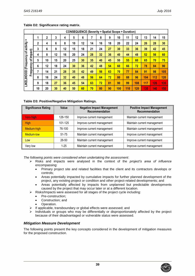
SAS 216149 July 2016
39
Table D2: Significance rating matrix.
1 2 3 4 5 6 7 8 9 10 11 12 13 14 15
2 4 6 8 10 12 14 16 18 20 22 24 26 28 30
3 6 9 12 15 18 21 24 27 30 33 36 39 42 45
4 8 12 16 20 24 28 32 36 40 44 48 52 56 60
5 10 15 20 25 30 35 40 45 50 55 60 65 70 75
6 12 18 24 30 36 42 48 54 60 66 72 78 84 90
7 14 21 28 35 42 49 56 63 70 77 84 91 98 105
8 16 24 32 40 48 56 64 72 80 88 96 104 112 120
9 18 27 36 45 54 63 72 81 90 99 108 117 126 135
10 20 30 40 50 60 70 80 90 100 110 120 130 140 150
LIK
EL
IHO
OD
(Fre
qu
ency
of a
ctiv
ity +
Fre
qu
ency
of i
mp
act)
CONSEQUENCE (Severity + Spatial Scope + Duration)
Table D3: Positive/Negative Mitigation Ratings.
Significance Rating Value Negative Impact Management Recommendation
Positive Impact Management Recommendation
Very high 126-150 Improve current management Maintain current management
High 101-125 Improve current management Maintain current management
Medium-high 76-100 Improve current management Maintain current management
Medium-low 51-75 Maintain current management Improve current management
Low 26-50 Maintain current management Improve current management
Very low 1-25 Maintain current management Improve current management
The following points were considered when undertaking the assessment: Risks and impacts were analysed in the context of the project’s area of influence
encompassing:
Primary project site and related facilities that the client and its contractors develops or controls;
Areas potentially impacted by cumulative impacts for further planned development of the project, any existing project or condition and other project-related developments; and
Areas potentially affected by impacts from unplanned but predictable developments caused by the project that may occur later or at a different location.
Risks/Impacts were assessed for all stages of the project cycle including:
Pre-construction;
Construction; and
Operation. If applicable, transboundary or global effects were assessed; and Individuals or groups who may be differentially or disproportionately affected by the project
because of their disadvantaged or vulnerable status were assessed.
Mitigation Measure Development
The following points present the key concepts considered in the development of mitigation measures for the proposed construction.

SAS 216149 July 2016
40
Mitigation and performance improvement measures and actions that address the risks and impacts7 are identified and described in as much detail as possible. Mitigating measures are investigated according to the impact minimisation hierarchy as follows:
Avoidance or prevention of impact;
Minimisation of impact;
Rehabilitation; and
Offsetting. Measures and actions to address negative impacts will favour avoidance and prevention
over minimisation, mitigation or compensation; and
Desired outcomes are defined, and have been developed in such a way as to be measurable events with performance indicators, targets and acceptable criteria that can
be tracked over defined periods, wherever possible.
Recommendations
Recommendations were developed to address and mitigate potential impacts on the wetland ecology associated with the proposed development within the study area.
7 Mitigation measures should address both positive and negative impacts

SAS 216149 July 2016
41
APPENDIX E – Assessment Results
PRESENT ECOLOGICAL STATE (PES), ECOSERVICES AND ECOLOGICAL
IMPORTANCE AND SENSITIVITY (EIS) RESULTS
Table E1: Presentation of the results of the WET-Health assessments applied to the unchannelled valley bottom wetland within the study area.
Hydrology Geomorphology Vegetation Overall PES Category
of the Resource PES category
Trajectory of change
PES category
Trajectory of change
PES category
Trajectory of change
D ↓ C ↓ D ↓ D
Table E2: Presentation of the results of the ecosystem services provided by the unchannelled valley bottom wetland within the study area.
Ecosystem service HGM Unit 1
Flood attenuation 1.8
Streamflow regulation 1.8
Sediment trapping 2.8
Phosphate assimilation 2.3
Nitrate assimilation 2.0
Toxicant assimilation 2.5
Erosion control 2.8
Carbon Storage 1.3
Biodiversity maintenance 1.7
Water Supply 0.8
Harvestable resources 0.0
Cultivated foods 0.0
Cultural value 0.0
Tourism and recreation 0.8
Education and research 0.8
SUM 21.2
Average score 1.4
Class Intermediate

SAS 216149 July 2016
42
Table E3: Presentation of the EIS assessment applied to the unchannelled valley bottom wetland within the study area.
Ecological Importance and Sensitivity Score (0-4) Confidence (1-5)
Biodiversity support A (average) (average)
0.67 3.00
Presence of Red Data species 1 3
Populations of unique species 0 3
Migration/breeding/feeding sites 1 3
Landscape scale B (average) (average)
1.40 4.20
Protection status of the wetland 0 5
Protection status of the vegetation type 4 4
Regional context of the ecological integrity 1 4
Size and rarity of the wetland type/s present 1 4
Diversity of habitat types 1 4
Sensitivity of the wetland C (average) (average)
2.33 3.33
Sensitivity to changes in floods 2 4
Sensitivity to changes in low flows/dry season 3 3
Sensitivity to changes in water quality 2 3
ECOLOGICAL IMPORTANCE & SENSITIVITY (max of A,B or C) (average of A, B or C)
Highest score: C 2.33
Hydro-Functional Importance Score (0-4) Confidence (1-5)
Reg
ula
tin
g &
su
pp
ort
ing
ben
efit
s
Flood attenuation 2 5
Streamflow regulation 2 5
Wat
er Q
ual
ity
En
han
cem
ent Sediment trapping 3 5
Phosphate assimilation 2 5
Nitrate assimilation 2 5
Toxicant assimilation 3 5
Erosion control 3 5
Carbon storage 1 5
HYDRO-FUNCTIONAL IMPORTANCE 2 5

SAS 216149 July 2016
43
Direct Human Benefits Score (0-4) Confidence (1-5)
Su
bsi
sten
ce
ben
efit
s Water for human use 1 5
Harvestable resources 0 5
Cultivated foods 0 5
5
Cu
ltu
ral
ben
efit
s Cultural heritage 0 5
Tourism and recreation 1 5
Education and research 1 5
DIRECT HUMAN BENEFITS 0.50 5

SAS 216149 July 2016
44
APPENDIX F – Impact Analysis and Mitigation Measures
IMPACT ANALYSIS AND MITIGATION MEASURES
General management and good housekeeping practices
The following essential mitigation measures are considered to be standard best practice measures applicable to development of this nature, and must be implemented during all phases of the proposed development activities, in conjunction with those stipulated in the individual tables in the following sections which define the mitigatory measures specific to the minimisation of impacts on wetland aquatic resources:
Development footprint
The foundation footprint of the proposed linear development should be kept as small as possible in order to minimise the extent of the impacted surface area. The construction footprint should be fenced off with danger tape or similar, and it must be ensured that the remainder of the freshwater resource (outside of the construction footprint area) is off-limits to non-essential construction vehicles and non-essential personnel, with contractor laydown areas, storage of construction materials and vehicles, and all other amenities to be placed outside the delineated freshwater resource and the associated 15m buffer zone;
Appropriate sanitary facilities must be provided for the life of the construction and all waste removed to an appropriate waste facility;
All hazardous chemicals should be stored in designated area which are not located near the freshwater resource;
No informal fires should be permitted in or near the construction area; Restrict construction to the non-rainy periods if possible to avoid sedimentation of the
watercourse and to minimise the severity of disturbance of the freshwater resource habitat; Access to the construction site should be limited to a single entry point to minimise
compaction of soils, loss of vegetation and increased erosion; Edge effects of activities, particularly erosion and alien/weed control need to be strictly
managed; and Ensure that an adequate number of litter bins are provided and ensure the proper disposal of
waste and spills.
Vehicle access
It must be ensured that all hazardous storage containers and storage areas comply with the relevant South African Bureau of Standards (SABS) standards to prevent leakage. All vehicles must be regularly inspected for leaks. Re-fuelling must take place on a sealed surface area to prevent ingress of hydrocarbons into the topsoil;
In the event of a vehicle breakdown, maintenance of vehicles must take place with care and the recollection of spillage should be practiced near the surface area to prevent ingress of hydrocarbons into topsoil and subsequent habitat loss; and
All spills should they occur, should be immediately cleaned up and treated accordingly. Records of spills and waste removal should be kept by the appointed ECO and submitted as part of the audit / monitoring report, as specified in the Environmental Management Programme (EMPr).
Soils
No stockpiles must be permitted within the freshwater resource or associated 15m buffer zone. All soil stockpiles must be protected by water diversion berms on the upgradient edge of the stockpile and a suitable geotextile such as Geojute or hessian sheeting, to avoid runoff and sediment from the stockpiles reaching the watercourse and/or riparian habitat;
Such stockpiles must either be removed or levelled following the completion of construction activities;
Storm water must be managed accordingly to ensure that no sediment deposits occur within the resource; and
Monitor areas close to the resource for erosion and incision, during site clearing in the pre-construction phase and throughout the construction phase.

SAS 216149 July 2016
45
Post-construction
Construction rubble must be collected and disposed of at a suitable landfill site.
Impact ratings on the wetland ecology
The tables below serve to summarise the anticipated impacts that might occur throughout the development phases, as well as the mitigations that must be implemented in order to maintain and enhance the freshwater features conditions.
IMPACT 1: LOSS OF FRESHWATER FEATURES HABITAT AND ECOLOGICAL STRUCTURE
Aspects and activities register
Pre-Construction Construction Operational
Potentially poor design of walkway leading to excessive placement of infrastructure within the freshwater
resource
Site clearing including the removal of vegetation, and associated
disturbances to soils, leading to increased runoff and erosion and consequent sedimentation of the
freshwater resource
Increased impermeable surfaces in the vicinity of the freshwater resource and
the greater catchment, leading to increased water volumes, erosion, and
altered flow patterns
Earthworks in the vicinity of and potentially within the freshwater
resource leading to increased runoff, erosion and altered flow patterns
Further erosion and sedimentation of the freshwater resource arising from
increased runoff, leading to loss of/alterations to habitat
Topsoil stockpiling adjacent to the freshwater resource and runoff from
stockpiles leading to increased sedimentation
Disposal of hazardous and non-hazardous waste materials including litter into freshwater resource areas
Movement of construction vehicles within freshwater resource areas
Disposal of hazardous and non-hazardous waste, including waste
material spills and refuse deposits into the freshwater resource areas
Unmanaged Probability of Impact
Sensitivity of receiving
environment Severity
Spatial scale
Duration of impact
Likelihood Consequence Significance
Construction Phase
5 2 3 2 2 7 7 49 (Low)
Operational Phase
5 2 2 1 5 7 8 56 (Medium-Low)
Managed Probability of Impact
Sensitivity of receiving
environment Severity
Spatial scale
Duration of impact
Likelihood Consequence Significance
Construction Phase
5 2 2 1 2 7 5 35 (Low)
Operational Phase
5 2 1 1 5 7 7 49 (Low)

SAS 216149 July 2016
46
IMPACT 2: CHANGES TO ECOLOGICAL AND SOCIO-CULTURAL SERVICE PROVISION
Aspects and activities register
Pre-Construction Construction Operational
Potentially poor planning with regards to the placement of infrastructure within the permanent zone of the
freshwater resource that could result in changes to the hydrological regime
Site clearing, including the removal of vegetation and associated disturbance of soils, leading to increased runoff and
erosion, consequent further sedimentation of freshwater resource
and loss of phosphate, nitrate and toxicant removal abilities due to
vegetation clearing
Increased impermeable surfaces in the vicinity of the watercourse and riparian
habitat and the greater catchment, leading to increased runoff and
erosion, and altered runoff patterns
Earthworks in the vicinity and potentially within the permanent zone of the freshwater resource leading to loss of flood attenuation abilities and
streamflow regulation capabilities
Further reduced capacity to support biodiversity as a result of increased
anthropogenic activity in the vicinity of the freshwater resource including
littering, and further proliferation alien floral species
Further reduced ability to support biodiversity due to vegetation clearing
and contamination of freshwater feature soils and water as a result of
waste rubble dumping, and increased sedimentation and alteration of natural
hydrological regimes.
Increased incidence of disposal of hazardous and non-hazardous waste materials into the freshwater resource
Soil stockpiling adjacent to the freshwater resource and runoff from such stockpiles may lead to further
sedimentation of the system
Unmanaged Probability of Impact
Sensitivity of receiving
environment Severity
Spatial scale
Duration of impact
Likelihood Consequence Significance
Construction Phase
5 2 3 2 2 7 7 49 (Low)
Operational Phase
5 2 2 1 5 7 8 56 (Medium-Low)
Managed Probability of Impact
Sensitivity of receiving
environment Severity
Spatial scale
Duration of impact
Likelihood Consequence Significance
Construction Phase
5 2 2 1 2 7 5 35 (Low)
Operational Phase
5 2 1 1 5 7 7 49 (Low)

SAS 216149 July 2016
47
IMPACT 3: LOSS OF HYDROLOGICAL FUNCTION AND SEDIMENT BALANCE
Aspects and activities register
Pre-Construction Construction Operational
Potentially poor planning with regards to the placement of infrastructure within the
permanent zone of the freshwater resource that could result in changes to
the hydrological regime
Site clearing and further removal of vegetation resulting in increased runoff which leads to erosion and alteration of the geomorphology of
the freshwater resource
Increased incidence of disposal of hazardous and non-hazardous waste materials into freshwater
resource, leading to blockages and altered flow patterns
Disturbance of soils and soil stockpiling adjacent to the freshwater resource, and runoff from stockpiles leading to further sedimentation of
the system
Earthworks in the vicinity of, and potentially within the permanent zone of the freshwater resource leading to incision, erosion and altered runoff
patterns
Movement of construction vehicles
within the freshwater resource resulting in soil compaction
Potential incorrect disposal of
hazardous and non-hazardous waste into the freshwater resource
Unmanaged Probability of Impact
Sensitivity of receiving
environment Severity
Spatial scale
Duration of impact
Likelihood Consequence Significance
Construction Phase
5 2 3 2 2 7 7 49 (Low)
Operational Phase
5 2 2 1 5 7 8 56 (Medium-Low)
Managed Probability of Impact
Sensitivity of receiving
environment Severity
Spatial scale
Duration of impact
Likelihood Consequence Significance
Construction Phase
5 2 2 1 2 7 5 35 (Low)
Operational Phase
5 2 1 1 5 7 7 49 (Low)

SAS 216149 July 2016
48
IMPACT 4: IMPACT ON WATER QUALITY
Aspects and activities register
Pre-construction Construction Operational
Potential inadequate planning of contractor camps, workshop areas and
provision of sanitary facilities
Earthworks in the vicinity of the freshwater resource leading to
increased runoff and erosion, and increased sediment inputs, potentially smothering wetland flora and altering
surface water quality
Potentially insufficient aftercare and maintenance of infrastructure leading to infrastructure failure and discarded
infrastructure within the freshwater resource
Topsoil stockpiling adjacent to freshwater resource and runoff from
stockpiles may lead to sedimentation of the system, thus increasing turbidity
Potential risk of contaminated runoff from the surface of the proposed
linear development, leading to pollution of surface water
Potential disposal of hazardous and
non-hazardous waste (particularly solid wastes) into the freshwater resource
Increased incidence of disposal of hazardous and non-hazardous waste
materials into freshwater resource, leading to pollution of surface water
Unmanaged Probability of Impact
Sensitivity of receiving
environment Severity
Spatial scale
Duration of impact
Likelihood Consequence Significance
Construction Phase
4 2 3 2 2 6 7 42 (Low)
Operational Phase
5 2 2 1 5 7 8 56 (Medium-Low)
Managed Probability of Impact
Sensitivity of receiving
environment Severity
Spatial scale
Duration of impact
Likelihood Consequence Significance
Construction Phase
4 2 2 1 2 6 5 30 (Low)
Operational Phase
5 2 1 1 5 7 7 49 (Low)
SAS 216149 July 2016
49
APPENDIX G – Specialists Details
1.(a)(i) Details of the specialist who prepared the report
Stephen van Staden MSc (Environmental Management) (University of Johannesburg)
Amanda Mileson N.Dip Nature Conservation (UNISA)
1.(a)(ii) The expertise of that specialist to compile a specialist report including a curriculum
vitae
Company of Specialist: Scientific Aquatic Services
Name / Contact person: Stephen van Staden
Postal address: 91 Geldenhuis Rd, Malvern East, Ext 1
Postal code: 1401 Cell: 083 415 2356
Telephone: 011 616 7893 Fax: 086 724 3132
E-mail: [email protected]
Qualifications MSc (Environmental Management) (University of Johannesburg) BSc (Hons) Zoology (Aquatic Ecology) (University of Johannesburg) BSc (Zoology, Geography and Environmental Management) (University of Johannesburg)
Registration / Associations Registered Professional Scientist at South African Council for Natural Scientific Professions (SACNASP) Accredited River Health practitioner by the South African River Health Program (RHP) Member of the South African Soil Surveyors Association (SASSO) Member of the Gauteng Wetland Forum

SAS 216149 July 2016
50
SCIENTIFIC AQUATIC SERVICES (SAS) – SPECIALIST CONSULTANT INFORMATION
CURRICULUM VITAE OF STEPHEN VAN STADEN
PERSONAL DETAILS
Position in Company Managing member, Ecologist, Aquatic Ecologist
Date of Birth 13 July 1979
Nationality South African
Languages English, Afrikaans
Joined SAS 2003 (year of establishment)
MEMBERSHIP IN PROFESSIONAL SOCIETIES
Registered Professional Scientist at South African Council for Natural Scientific Professions (SACNASP) Accredited River Health practitioner by the South African River Health Program (RHP) Member of the South African Soil Surveyors Association (SASSO) Member of the Gauteng Wetland Forum
EDUCATION
Qualifications
MSc (Environmental Management) (University of Johannesburg) 2002 BSc (Hons) Zoology (Aquatic Ecology) (University of Johannesburg) 2000 BSc (Zoology, Geography and Environmental Management) (University of Johannesburg) 1999
COUNTRIES OF WORK EXPERIENCE
South Africa – All Provinces Southern Africa – Lesotho, Botswana, Mozambique, Zimbabwe Eastern Africa – Tanzania West Africa – Ghana, Liberia, Angola, Guinea Bissau Central Africa – Democratic Republic of the Congo
SELECTED PROJECT EXAMPLES
Development compliance studies
Project co-leader for the development of the EMP for the use of the Wanderers stadium for the Ubuntu village for the World Summit on Sustainable Development (WSSD).
Environmental Control Officer for Eskom for the construction of an 86Km 400KV power line in the Rustenburg Region.
Numerous Environmental Impact Assessment (EIA) and EIA exemption applications for township developments and as part of the Development Facilitation Act requirements.
EIA for the extension of mining rights for a Platinum mine in the Rustenburg area by Lonmin Platinum.
EIA Exemption application for a proposed biodiesel refinery in Chamdor.
Compilation of an EIA as part of the Bankable Feasibility Study process for proposed mining of a gold deposit in the Lofa province, Liberia.
EIA for the development of a Chrome Recovery Plant at the Two Rivers Platinum Mine in the Limpopo province, South Africa.
Compilation of an EIA as part of the Bankable Feasibility Study process for the Mooihoek Chrome Mine in the Limpopo province, South Africa.
Mine Closure Plan for the Vlakfontein Nickel Mine in the North West Province.
Specialist studies and project management
Development of a zero discharge strategy and associated risk, gap and cost benefit analyses for the Lonmin Platinum group.
Development of a computerised water balance monitoring and management tool for the management of Lonmin Platinum process and purchased water.
The compilation of the annual water monitoring and management program for the Lonmin Platinum group of mines.

SAS 216149 July 2016
51
Analyses of ground water for potable use on a small diamond mine in the North West Province.
Project management and overview of various soil and land capability studies for residential, industrial and mining developments.
The design of a stream diversion of a tributary of the Olifants River for a proposed opencast coal mine.
Waste rock dump design for a gold mine in the North West province.
Numerous wetland delineation and function studies in the North West, Gauteng and Mpumalanga Kwa-Zulu Natal provinces, South Africa.
Hartebeespoort Dam Littoral and Shoreline PES and rehabilitation plan.
Development of rehabilitation principles and guidelines for the Crocodile West Marico Catchment, DWAF North West.
Aquatic and water quality monitoring and compliance reporting
Development of the Resource Quality Objective framework for Water Use licensing in the Crocodile West Marico Water Management Area.
Development of the Resource Quality Objectives for the Local Authorities in the Upper Crocodile West Marico Water Management Area.
Development of the 2010 State of the Rivers Report for the City of Johannesburg.
Development of an annual report detailing the results of the Lonmin Platinum groups water monitoring program.
Development of an annual report detailing the results of the Everest Platinum Mine water monitoring program.
Initiation and management of a physical, chemical and biological monitoring program, President Steyn Gold Mine Welkom.
Aquatic biomonitoring programs for several Xstrata Alloys Mines and Smelters.
Aquatic biomonitoring programs for several Anglo Platinum Mines.
Aquatic biomonitoring programs for African Rainbow Minerals Mines.
Aquatic biomonitoring programs for several Assmang Chrome Operations.
Aquatic biomonitoring programs for Petra Diamonds.
Aquatic biomonitoring programs for several coal mining operations.
Aquatic biomonitoring programs for several Gold mining operations.
Aquatic biomonitoring programs for several mining operations for various minerals including iron ore, and small platinum and chrome mining operations.
Aquatic biomonitoring program for the Valpre bottled water plant (Coca Cola South Africa).
Aquatic biomonitoring program for industrial clients in the paper production and energy generation industries.
Aquatic biomonitoring programs for the City of Tshwane for all their Waste Water Treatment Works.
Baseline aquatic ecological assessments for numerous mining developments.
Baseline aquatic ecological assessments for numerous residential commercial and industrial developments.
Baseline aquatic ecological assessments in southern, central and west Africa.
Lalini Dam assessment with focus on aquatic fish community analysis.
Musami Dam assessment with focus on the FRAI and MIRAI aquatic community assessment indices.
Wetland delineation and wetland function assessment
Wetland biodiversity studies for three copper mines on the copper belt in the Democratic Republic of the Congo.
Wetland biodiversity studies for proposed mining projects in Guinea Bissau, Liberia and Angola in West Africa.
Terrestrial and wetland biodiversity studies for developments in the mining industry.
Terrestrial and wetland biodiversity studies for developments in the residential commercial and industrial sectors.
Development of wetland riparian resource protection measures for the Hartbeespoort Dam as part of the Harties Metsi A Me integrated biological remediation program.
Priority wetland mammal species studies for numerous residential, commercial, industrial and mining developments throughout South Africa.
Terrestrial ecological studies and biodiversity studies
Development of a biodiversity offset plan for Xstrata Alloys Rustenburg Operations.
Biodiversity Action plans for numerous mining operations of Anglo Platinum throughout South Africa in line with the NEMBA requirements.
Biodiversity Action plans for numerous mining operations of Assmang Chrome throughout South Africa in line with the NEMBA requirements.
Biodiversity Action plans for numerous mining operations of Xstrata Alloys and Mining throughout South Africa in line with the NEMBA requirements.
Biodiversity Action plan for the Nkomati Nickel and Chrome Mine Joint Venture.
Terrestrial and wetland biodiversity studies for three copper mines on the copper belt in the Democratic Republic of the Congo.
Terrestrial and wetland biodiversity studies for proposed mining projects in Guinea Bissau, Liberia and Angola in West Africa.
Numerous terrestrial ecological assessments for proposed platinum and coal mining projects.
Numerous terrestrial ecological assessments for proposed residential and commercial property developments throughout most of South Africa.
Specialist Giant bullfrog (Pyxicephalus adspersus) studies for several proposed residential and commercial development projects in Gauteng, South Africa.

SAS 216149 July 2016
52
Specialist Marsh sylph (Metisella meninx) studies for several proposed residential and commercial development projects in Gauteng, South Africa.
Project management of several Red Data Listed (RDL) bird studies with special mention of African grass owl (Tyto capensis).
Project management of several studies for RDL Scorpions, spiders and beetles for proposed residential and commercial development projects in Gauteng, South Africa.
Specialist assessments of terrestrial ecosystems for the potential occurrence of RDL spiders and owls.
Project management and site specific assessment on numerous terrestrial ecological surveys including numerous studies in the Johannesburg-Pretoria area, Witbank area, and the Vredefort dome complex.
Biodiversity assessments of estuarine areas in the Kwa-Zulu Natal and Eastern Cape provinces. Impact assessment of a spill event on a commercial maize farm including soil impact assessments.
Fisheries management studies
Tamryn Manor (Pty.) Ltd. still water fishery initiation, enhancement and management.
Verlorenkloof Estate fishery management strategising, fishery enhancement, financial planning and stocking strategy.
Mooifontein fishery management strategising, fishery enhancement and stocking programs.
Wickams retreat management strategising.
Gregg Brackenridge management strategising and stream recalibration design and stocking strategy.
Eljira Farm baseline fishery study compared against DWAF 1996 aquaculture and aquatic ecosystem guidelines.

SAS 216149 July 2016
53
SCIENTIFIC AQUATIC SERVICES (SAS) – SPECIALIST CONSULTANT INFORMATION
CURRICULUM VITAE OF AMANDA MILESON
PERSONAL DETAILS
Position in Company Ecologist
Date of Birth 15 February 1978
Nationality Zimbabwean
Languages English
Joined SAS 2013
MEMBERSHIP IN PROFESSIONAL SOCIETIES
Member South African Wetland Society Member Gauteng Wetland Forum
EDUCATION
Qualifications N.Dip Nature Conservation (UNISA) To be completed in 2016
COUNTRIES OF WORK EXPERIENCE
South Africa – Gauteng, Mpumalanga, Free State, North West, Limpopo, Northern Cape, Eastern Cape Zimbabwe
SELECTED PROJECT EXAMPLES
Wetland Assessments
Wetland assessment as part of the environmental authorisation process for the Anglo Platinum Der Brochen Project, Limpopo Province
Wetland assessment as part of the environmental authorisation process for the proposed Tharisa North eastern waste rock dump, North West Province
Wetland assessment as part of the environmental authorisation process for the proposed Yzermyn Coal Mining Project near Dirkiesdorp, Mpumalanga
Wetland assessment as part of the environmental authorisation process for the Mzimvubu Water Project, Eastern Cape
Wetland assessment as part of the environmental authorisation process for the proposed expansion of mining operations at the Langkloof Colliery, Mpumalanga
Wetland assessment as part of the proposed water management process at the Assmang Chrome Machadodorp Works, Mpumalanga
Wetland assessment as part of the water use licencing process for the proposed development in Rooihuiskraal Ext 24, Centurion, Gauteng
Wetland assessment as part of the environmental authorisation process for the proposed road crossings on The Hills EcoEstate, Midrand, Gauteng
Wetland ecological assessment as part of the Section 24G application process for the Temba Water Purification Plant
Wetland assessment and offset studies for the Optimum Colliery Kwagga North Project, Mpumalanga
Wetland assessment and delineation as part of the environmental authorisation process for the proposed development of a mall adjacent to the M10 Road in Mahube Valley, Mamelodi, Gauteng
Wetland assessment as part of the environmental authorisation process for the proposed construction of a sewer system in Ekangala Township, Gauteng
Terrestrial Assessments
Investigation of specialist biodiversity aspects required by GDARD in the vicinity of the Apies River, downstream of the proposed construction of new outlet works at the Kudube (Leeuwkraal) Dam in Temba, Gauteng

SAS 216149 July 2016
54
Terrestrial Ecological Scan as part of the environmental authorisation process for three proposed bridge upgrades near Edenvale, Gauteng
Terrestrial Ecological Scan as part of the environmental authorisation process for the proposed Dalpark Ext 3 filling station development, Gauteng
Rehabilitation Projects
Wetland rehabilitation and management plan for The Hills EcoEstate, Midrand, Gauteng
Riparian rehabilitation and management plan for The Diepsloot River, Riversands, Gauteng
Riparian rehabilitation and management plan for the Apies River in the vicinity of the proposed construction of new outlet works at the Kudube (Leeuwkraal) Dam in Temba, Gauteng
Wetland rehabilitation and management plan for the Dorothy Road wetland, Midrand, Gauteng
Wetland Rehabilitation and Management Plan for the Wetland Resources in the vicinity of the Proposed Treated Effluent Pipeline and Discharge of Treated Wastewater from the Refengkgotso Waste Water Treatment Works (WWTW) near Deneysville, Free State Province
Riparian Rehabilitation Plan for a portion of the Swartspruit River, Kempton Park, Gauteng Province
Environmental Control Officer
Monthly specialist Environmental Control Officer (ECO) function for the monitoring of riparian crossings at Riversands Country Estate Development, Gauteng

SAS 216149 July 2016
55
1.(b) a declaration that the specialist is independent in a form as may be specified by the competent authority I, Stephen van Staden, declare that –
I act as the independent specialist in this application; I will perform the work relating to the application in an objective manner, even if this results in
views and findings that are not favourable to the applicant; I declare that there are no circumstances that may compromise my objectivity in performing
such work; I have expertise in conducting the specialist report relevant to this application, including
knowledge of the relevant legislation and any guidelines that have relevance to the proposed activity;
I will comply with the applicable legislation; I have not, and will not engage in, conflicting interests in the undertaking of the activity; I undertake to disclose to the applicant and the competent authority all material information in
my possession that reasonably has or may have the potential of influencing - any decision to be taken with respect to the application by the competent authority; and - the objectivity of any report, plan or document to be prepared by myself for submission to the competent authority;
All the particulars furnished by me in this form are true and correct
---------------------------------------------------------------------------
Signature of the Specialist