Embed Size (px)
Citation preview

Friday 24 September 2021NIGHT
Time of Issue: 2200 hours ISTALL INDIA WEATHER SUMMARY AND FORECAST BULLETIN
Significant Weather Features
♦ The Well Marked Low Pressure Area over eastcentral & adjoining northeast Bay of Bengal concentrated into a Depression and lay centered at 1730 hrs IST of today, the 24th September 2021, over east-central and adjoining northeast Bay of Bengal near Lat. 18.3°N and Long. 91.2°E, about 670 km east-southeast of Gopalpur (Odisha) & 740 km east of Kalingapatnam (Andhra Pradesh). It is likely to intensify into a Deep Depression during next 12 hours and intensify further thereafter. It is likely to move initially west-northwestwards during next 24 hours and west-southwestwards thereafter and cross south Odisha- north Andhra Pradesh coasts between Vishakhapatnam & Gopalpur around Kalingapatnam by evening of 26th September, 2021.
♦ Under the influence of the cyclonic circulation over Saurashtra & neighbourhood, a Low Pressure Area has formed over Northeast Arabian Sea & adjoining coastal areas of Pakistan with the associated cyclonic circulation extending upto 4.5 km above mean sea level tilting southwestwards with height.
♦ Monsoon trough lies to the south of its normal position and likely to remain so during next 5 days.
Under the influence of the above systems:
i) 25th Sept.: Heavy rainfall at isolated places very likely over Odisha and Coastal Andhra Pradesh.
ii) 26th Sept.: Heavy to very heavy falls at a few places & extremely heavy falls at isolated places very likely over south Odisha and north coastal Andhra Pradesh; heavy to very heavy falls at isolated places over Telangana and heavy falls at isolated places over north interior Odisha, Chhattisgarh & Telangana.
iii) 27th Sept.: Heavy to very heavy & extremely heavy falls at isolated places very likely over south Chhattisgarh; heavy to very heavy falls at isolated places over Odisha & Telangana and heavy rainfall at isolated places over coastal West Bengal.
iv) The fishermen are advised not to venture into east-central & adjoining northeast Bay of Bengal and Andaman Sea on 24th and 25th Sept. and into northwest & adjoining westcentral Bay of Bengal and along & off Odisha, West Bengal & North Andhra Pradesh coasts till 27th Sept.
v) Fairly widespread to widespread rainfall with isolated heavy falls very likely over East Rajasthan, West Madhya Pradesh, Gujarat state and Konkan & Goa during next 5 days. Isolated very heavy falls is also very likely over Gujarat Region on 25th, 26th & 27th; over Saurashtra & Kutch on 26th & 27th September, 2021.
vi) Rainfall activity is very likely to increase over Kerala & Mahe with fairly widespread to widespread rainfall and isolated heavy falls from 25th September, 2021 and over Lakshadweep area from 26th September, 2021.
Main Weather Observations
♦ Rainfall/Thundershowers observed (from 0830 hours IST to 1730 hours IST of today): at many places over over Andaman & Nicobar Islands; at a few places over Madhya Pradesh, East Uttar Pradesh, Haryana, Chandigarh & Delhi and Saurashtra & Kutch and at isolated places over Jammu, Kashmir, Ladakh, Gilgit, Baltistan & Muzaffarabad, Uttarakhand, West Uttar Pradesh, Rajasthan, Gujarat Region, Bihar, Assam & Meghalaya, Odisha, Maharashtra,
Coastal Andhra Pradesh & Yanam, North Interior Karnataka and Tamilnadu, Puducherry & Karaikal.♦ Heavy rainfall observed (from 0830 hours IST to 1730 hours IST of today): Very Heavy rainfall at isolated places over Andaman & Nicobar Islands and heavy rainfall at isolated places over Gujarat Region.
♦ Rainfall Amount recorded (from 0830 hours IST to1730 hours IST of today)(2 cm or more): Long Islands-13, Surat-8, Dwarka-5, Valprai-4, Malanjkhand-3; Gwalior, Betul and Aurangabad-2 each.
♦ Thunderstorm observed (from 0830 hours IST to1730 hours IST of today): at isolated places over Uttrakhand, Uttar Pradesh, Rajasthan, Gujarat State , Madhya Pradesh, Bihar, Gangetic West Bengal, Assam & Meghalaya, Odisha, Vidharbha, Coastal Andhra Pradesh & Yanam and Kerala & Mahe.
♦ Maximum Temperature Departures as on 24-09-2021: Maximum temperatures are appreciably above normal (3.1°C to 5.0°C) at most places over Assam & Meghalaya; at a few places over Sub-Himalayan West Bengal & Sikkim, Bihar and Nagaland, Manipur, Mizoram & Tripura; at isolated places over Gangetic West Bengal; above normal (1.6°C to 3.0°C) at many places over Jharkhand, Odisha and Kerala & Mahe; at a few places over Tamilnadu, Puducherry & karaikal and at isolated places over East Madhya Pradesh.They are markedly below normal (-5.0°C or less) at isolated places over West Rajasthan; appreciably below normal (-3.1°C to -5.0°C) at many places over Saurashtra & Kutch and West Uttar Pradesh; at isolated places East Rajasthan and West Madhya Pradesh; below normal (-1.6°C to -3.0°C) at many places over Haryana, Chandigarh & Delhi and Marathwada; at a few places over Gujarat Region and Madhya Maharashtra and at isolated places over West Uttar Pradesh, East Madhya Pradesh and Andaman & Nicobar Islands and near normal over rest parts of the country. Today, the highest maximum temperature of 37.0°C reported at Itanagar (Arunachal Pradesh).
♦ Minimum Temperature Departures as on 24-09-2021: Minimum temperatures are appreciably above normal (3.1°C to 5.0°C) at isolated places over Jammu, Kashmir, Ladakh, Gilgit, Baltistan & Muzaffarabad, Rajasthan; above normal (1.6°C to 3.0°C) at many places over Uttarakhand, Madhya Pradesh and Sub-Himalayan West Bengal & Sikkim ; at a few places over Assam & Meghalaya and at isolated places over Himachal Pradesh, Gujarat State, and Madhya Maharshtra.They were below normal (-1.6°C to -3.0°C) at isolated places over Gangetic West Bengal, Coastal Andhra Pradesh and Tamil Nadu, Puducherry & Karaikal and near normal over rest parts of the country. Today, the lowest minimum temperature of 18.5°C reported at Bulsar (Gujarat Region) over the plains of the country.
* Red color warning does not mean "Red Alert" Red color warning means "Take Action". Forecast and Warning for any day is valid from 0830 hours IST of day till 0830 hours IST of next day
For more details kindly visit www.imd.gov.in or contact : +91 11 24631913, 24643965, 24629798 (Service to the Nation since 1875)

Meteorological Analysis (Based on 1730 hours IST)
♦ The well marked low pressure area over eastcentral & adjoining northeast Bay of Bengal concentrated into a Depression and lay centered at 1730 hrs IST of today, the 24th September 2021, over east-central and adjoining northeast Bay of Bengal near Lat. 18.3°N and Long. 91.2°E, about 670 km east-southeast of Gopalpur (Odisha) & 740 km east of Kalingapatnam (Andhra Pradesh). It is likely to intensify into a Deep Depression during next 12 hours and intensify further thereafter. It is likely to move initially west-northwestwards during next 24 hours and west-southwestwards thereafter and cross south Odisha- north Andhra Pradesh coasts between Vishakhapatnam & Gopalpur around Kalingapatnam by evening of 26th September, 2021.
♦ Under the influence of the cyclonic circulation over Saurashtra & neighbourhood, a Low Pressure Area has formed over Northeast Arabian Sea & adjoining coastal areas of Pakistan with the associated cyclonic circulation extending upto 4.5 km above mean sea level tilting southwestwards with height.
♦ The Monsoon trough at mean sea level now passes through centre of Low Pressure Area over Northeast Arabian Sea & adjoining coastal areas of Pakistan, Shajapur, Jabalpur, Sambalpur and thence southeastwards to the centre of Depression over eastcentral and adjoining northeast Bay of Bengal.
♦ The cyclonic circulation over northeast Madhya Pradesh & adjoining south Uttar Pradesh extending upto 4.5 km above mean sea level persists.
♦ The cyclonic circulation over south Coastal Andhra Pradesh & neighbourhood between 1.5 km & 2.1 km above mean sea level persists.
♦ The Western Disturbance as a trough between 3.1 km & 5.8 km above mean sea level roughly along Longitude 62°E to the north of 30°N persists.
♦ A cyclonic circulation is likely to develop over Northeast & adjoining Eastcentral Bay of Bengal around 27th September. It is likely to move northwestwards and reach West Bengal coast during subsequent 48 hours.
Weather Forecast for next 5 days * upto 0830 hours IST of 29th September, 2021
♦ Meteorological sub-division wise detailed 5 days precipitation forecast is given in Table-1.
♦ No significant change in maximum temperatures over most parts of the country during next 5 days.
Weather Outlook for subsequent 2 days from 29th September, 2021 to 01st October, 2021
♦ Fairly widespread to widespread rainfall likely over Central, east and northeast India, along the west coast & islands; scattered to fairly widespread rainfall over remaining south peninsular India and isolated to scattered rainfall over rest parts of the country.
* Red color warning does not mean "Red Alert" Red color warning means "Take Action". Forecast and Warning for any day is valid from 0830 hours IST of day till 0830 hours IST of next day
For more details kindly visit www.imd.gov.in or contact : +91 11 24631913, 24643965, 24629798 (Service to the Nation since 1875)

Weather Warning during next 5 days *
24 September (Day 1): ♦ Heavy to very heavy rainfall very likely at isolated places over Saurashtra & Kutch and Heavy rainfall at isolated places over Uttar Pradesh, Rajasthan, Madhya Pradesh, Marathwada, Coastal Andhra Pradesh & Yanam, Telangana, Andaman & Nicobar Islands, Gujarat region and Tamilnadu, Puducherry & Karaikal.
♦Thunderstorm accompanied with lightning very likely at isolated places over Uttarakhand, Haryana, Chandigarh & Delhi, Uttar Pradesh, East Rajasthan, Madhya Pradesh, Vidarbha, Chhattisgarh, Jharkhand, Gangetic West Bengal, Odisha, Assam & Meghalaya, Nagaland, Manipur, Mizoram & Tripura, Madhya Maharashtra, Marathwada, Coastal Andhra Pradesh & Yanam, Telangana, Rayalseema and Tamilnadu, Puducherry & Karaikal.
♦ Squally wind (wind speed 40-50 kmph to gusting 60 kmph) likely over the Southwest & Westcentral Arabian Sea, Southwest & adjoing Southeast Bay of Bengal, Gulf of Mannar & Comorin area. Strong wind ( wind speed 40-50 kmph gusting to 60 kmph) very likely over Gujarat coast. Fishermen are advised not to venture into these areas.
♦ Squally wind (speed reaching 45-55 kmph gusting to 65 kmph) likely over Eastcentral and adjoining northeast Bay of Bengal and Andaman sea. Sea condition will be rough to very rough over eastcentral & adjoining northeast Bay of Bengal. Fishermen are advised not to venture into sea over eastcentral & adjoining northeast Bay of Bengal, Andaman Sea, Northwest & adjoining Westcentral Bay of Bengal and along & off Odisha-West Bengal-north Andhra Pradesh coasts.
25 September (Day 2): ♦ Heavy to very heavy rainfall very likely at isolated places over Gujarat Region and heavy rainfall at isolated places over Uttar Pradesh, East Rajasthan, West Madhya Pradesh, Odisha, Saurashtra & Kutch, Konkan & Goa, Coastal Andhra Pradesh & Yanam, Andaman & Nicobar Islands, Kerala & Mahe and Tamilnadu, Puducherry & Karaikal.
♦ Thunderstorm accompanied with lightning very likely at isolated places over Uttarakhand, Uttar Pradesh, East Rajasthan, Madhya Pradesh, Vidarbha, Chattisgarh, Jharkhand, Gangetic West Bengal, Odisha, Madhya Maharashtra, Marathwada, Coastal Andhra Pradesh & Yanam, Telangana, Kerala & Mahe and Tamilnadu, Puducherry & Karaikal.
♦ Squally Wind (wind speed 40-50 kmph to gusting 60 kmph) very likely over the Southwest & Westcentral Arabian Sea, Northeast & Eastcentral Bay of Bengal, Andaman sea, Southwest and adjoining Bay, Gulf of Mannar & Comorin area and (speed reaching 50-60 kmph gusting to 70 kmph) over Northwest and adjoining Westcentral Bay of Bengal and along & off Odisha - North Andhra Pradesh coasts. Sea condition will be rough to very rough over Northwest & adjoining Westcentral Bay of Bengal and along & off Odisha-West Bengal-north Andhra Pradesh coasts. Fishermen are advised not to venture into sea over eastcentral & adjoining northeast Bay of Bengal, Andaman Sea, Northwest & adjoining Westcentral Bay of Bengal and along & off Odisha-Gangetic West Bengal-north Andhra Pradesh coasts.
26 September (Day 3): ♦ Heavy to very heavy rainfall at a few places with extremely heavy falls at isolated places very likely over south & coastal Odisha and North Coastal Andhra Pradesh & Yanam; Heavy to very heavy rainfall very likely at isolated places over Gujarat State and and heavy rainfall at isolated places over East Rajasthan, West Madhya Pradesh, Konkan & Goa, Madhya Maharashtra, Chhattisgarh, Andaman & Nicobar Islands, north interior Odisha, Telangana, Kerala & Mahe and Lakshadweep.
♦ Thunderstorm accompanied with lightning very likely at isolated places over Uttarakhand, Uttar Pradesh, East Rajasthan, Jharkhand, Gangetic West Bengal, Madhya Maharashtra, Marathwada, Coastal Andhra Pradesh & Yanam, Telangana, Kerala & Mahe, Lakshadweep and Tamilnadu, Puducherry & Karaikal.
♦ Squally wind (wind speed 40-50 kmph to gusting 60 kmph) very likely over the Southwest & Westcentral Arabian Sea, Gujarat coast, Gulf of mannar & Comorin and Lakshadweep area. Fishermen are advised not to venture into these areas.
♦Strong wind (wind speed 40-50 kmph gusting to 60 kmph) very likely over Southwest & adjoining Southeast Bay of Bengal, (speed reaching 60-70 kmph gusting to 80 kmph) over Northwest & adjoining Westcentral Bay of Bengal and along & off Odisha-West Bengal-North Andhra Pradesh coasts. Sea condition will be rough to very rough over Northwest & adjoining Westcentral Bay of Bengal and along & off Odisha-West Bengal-north Andhra Pradesh coasts. Fishermen are advised not to venture into these areas.
27 September (Day 4):♦ Heavy to very heavy rainfall with extremely heavy falls at isolated places likely over south Chhattisgarh; Heavy to very heavy rainfall at isolated places over Odisha, Telangana & Gujarat State; heavy rainfall at isolated places over Uttrakhand, West Madhya Pradesh, Vidarbha, Gangetic West Bengal, Konkan & Goa, Madhya Maharashtra, Marathwada, Coastal Andhra Pradesh & Yanam, Andaman & Nicobar Islands, Kerala & Mahe and Lakshadweep.
♦ Thunderstorm accompanied with lightning likely at isolated places over Haryana, West Uttar Pradesh, East Rajasthan, Marathwada, Coastal Andhra Pradesh & Yanam, Kerala & Mahe, Lakshadweep and Tamilnadu, Puducherry & Karaikal.
♦ Squally weather (wind speed 40-50 kmph to gusting 60 kmph) likely over the Southwest & Westcentral Arabian Sea. Strong wind speed 40-50 kmph gusting to 60 kmph) likely over Gujarat coast, Gulf of mannar & Comorin area. Fishermen are advised not to venture into these areas.
♦ Strong wind (speed 40-50 kmph gusting to 60 kmph) likely over Southwest & adjoing Southeast Bay of Bengal, (speed reaching 45-55 kmph gusting to 65 kmph) very likely over Northwest Bay of Bengal and along & off north Andhra Pradesh-Odisha-West Bengal coasts. Sea condition will be rough to very rough over Northwest Bay of Bengal and along & off Odisha-north Andhra Pradesh coasts. Fishermen are advised not to venture into these areas.
28 September (Day 5): ♦ Heavy rainfall likely at isolated places over Uttarakhand, Madhya Pradesh, Vidarbha, Chhattisgarh, Gangetic West Bengal, Odisha, Gujarat state, Konkan & Goa, Madhya Maharashtra, Marathwada, Coastal Andhra Pradesh & Yanam, Telangana and Kerala & Mahe. Thunderstorm accompanied with lightning likely at isolated places over Haryana, West Uttar Pradesh, East Rajasthan, Coastal Andhra Pradesh & Yanam, Kerala & Mahe, Lakshadweep and Tamilnadu, Puducherry & Karaikal.
♦ Squally weather (wind speed 45-55 kmph to gusting 65 kmph) likely northeast and adjoin eastcentral Bay of Bengal. Squally weather (wind speed 40-50 kmph to gusting 60 kmph) likely over the Southwest & Westcentral Arabian Sea. Strong wind ( wind speed 40-50 kmph gusting to 60 kmph) likely over Gujarat coast. Fishermen are advised not to venture into these areas.
Kindly download MAUSAM APP for location specific forecast & warning, MEGHDOOT APP for Agromet advisory and DAMINI APP for Lightning Warning & visit state MC/RMC websites for district wise warning.
* Red color warning does not mean "Red Alert" Red color warning means "Take Action". Forecast and Warning for any day is valid from 0830 hours IST of day till 0830 hours IST of next day
For more details kindly visit www.imd.gov.in or contact : +91 11 24631913, 24643965, 24629798 (Service to the Nation since 1875)
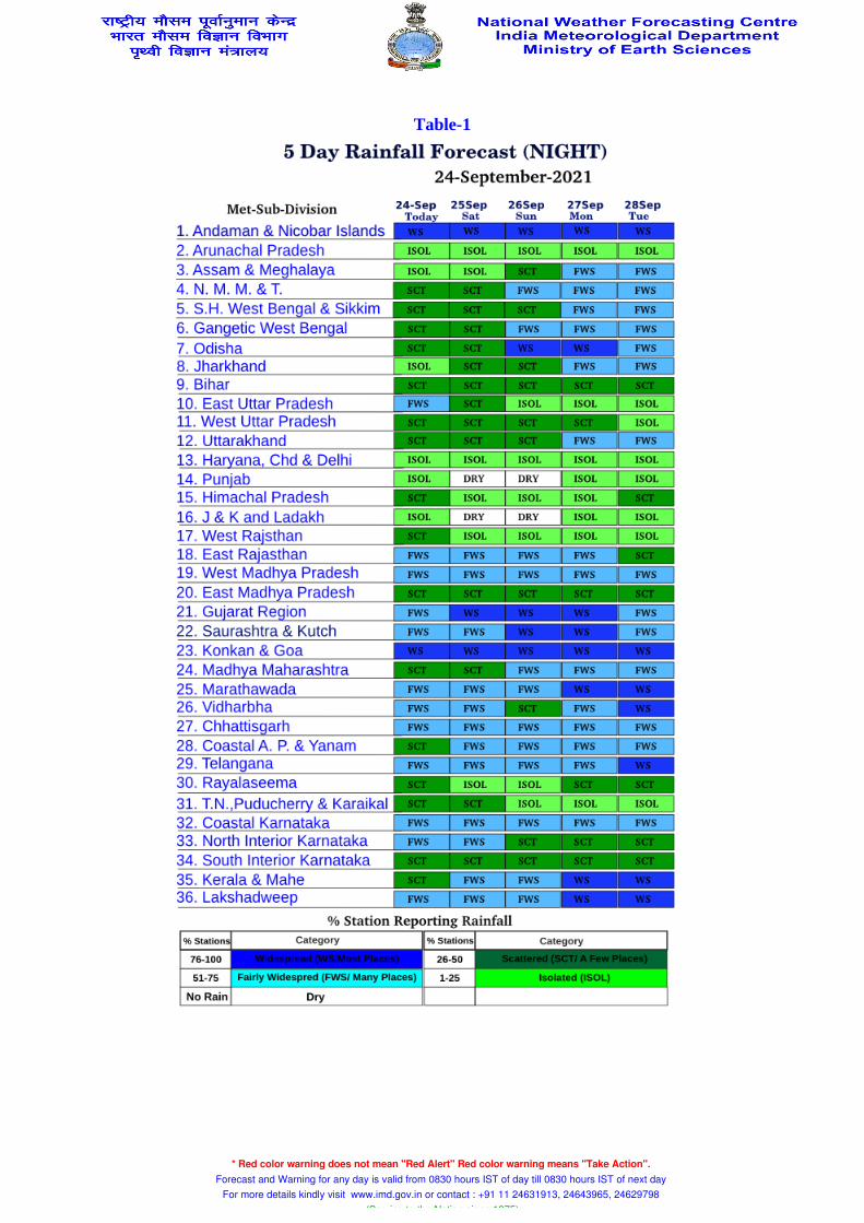
Table-1
* Red color warning does not mean "Red Alert" Red color warning means "Take Action". Forecast and Warning for any day is valid from 0830 hours IST of day till 0830 hours IST of next day
For more details kindly visit www.imd.gov.in or contact : +91 11 24631913, 24643965, 24629798 (Service to the Nation since 1875)

Fig. 1: Accumulated Rainfall (mm) during past 24 hours
* Red color warning does not mean "Red Alert" Red color warning means "Take Action". Forecast and Warning for any day is valid from 0830 hours IST of day till 0830 hours IST of next day
For more details kindly visit www.imd.gov.in or contact : +91 11 24631913, 24643965, 24629798 (Service to the Nation since 1875)

Fig. 2: Maximum Temperature during past 24 hours
* Red color warning does not mean "Red Alert" Red color warning means "Take Action". Forecast and Warning for any day is valid from 0830 hours IST of day till 0830 hours IST of next day
For more details kindly visit www.imd.gov.in or contact : +91 11 24631913, 24643965, 24629798 (Service to the Nation since 1875)

Fig. 3: Minimum Temperature during past 24 hours
* Red color warning does not mean "Red Alert" Red color warning means "Take Action". Forecast and Warning for any day is valid from 0830 hours IST of day till 0830 hours IST of next day
For more details kindly visit www.imd.gov.in or contact : +91 11 24631913, 24643965, 24629798 (Service to the Nation since 1875)

Fig. 4 : Departure from Normal of Maximum Temperatures
* Red color warning does not mean "Red Alert" Red color warning means "Take Action". Forecast and Warning for any day is valid from 0830 hours IST of day till 0830 hours IST of next day
For more details kindly visit www.imd.gov.in or contact : +91 11 24631913, 24643965, 24629798 (Service to the Nation since 1875)
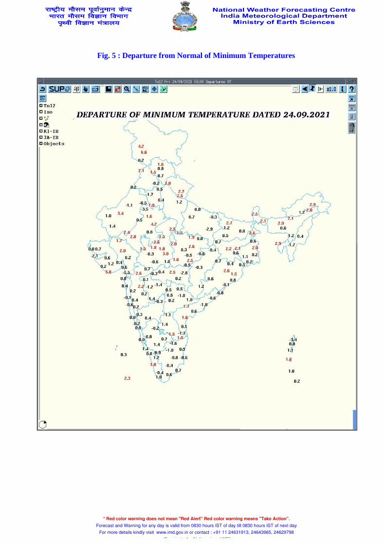
Fig. 5 : Departure from Normal of Minimum Temperatures
* Red color warning does not mean "Red Alert" Red color warning means "Take Action". Forecast and Warning for any day is valid from 0830 hours IST of day till 0830 hours IST of next day
For more details kindly visit www.imd.gov.in or contact : +91 11 24631913, 24643965, 24629798 (Service to the Nation since 1875)

Friday 24 September 2021
24 September (Day 1): ♦ Heavy to very heavy rainfall very likely at isolated places over Saurashtra & Kutch and Heavy rainfall at isolated places over Uttar Pradesh, Rajasthan, Madhya Pradesh, Marathwada, Coastal Andhra Pradesh & Yanam, Telangana, Andaman & Nicobar Islands, Gujarat region and Tamilnadu, Puducherry & Karaikal.
♦Thunderstorm accompanied with lightning very likely at isolated places over Uttarakhand, Haryana, Chandigarh & Delhi, Uttar Pradesh, East Rajasthan, Madhya Pradesh, Vidarbha, Chhattisgarh, Jharkhand, Gangetic West Bengal, Odisha, Assam & Meghalaya, Nagaland, Manipur, Mizoram & Tripura, Madhya Maharashtra, Marathwada, Coastal Andhra Pradesh & Yanam, Telangana, Rayalseema and Tamilnadu, Puducherry & Karaikal.
♦ Squally wind (wind speed 40-50 kmph to gusting 60 kmph) likely over the Southwest & Westcentral Arabian Sea, Southwest & adjoing Southeast Bay of Bengal, Gulf of Mannar & Comorin area. Strong wind ( wind speed 40-50 kmph gusting to 60 kmph) very likely over Gujarat coast. Fishermen are advised not to venture into these areas.
♦ Squally wind (speed reaching 45-55 kmph gusting to 65 kmph) likely over Eastcentral and adjoining northeast Bay of Bengal and Andaman sea. Sea condition will be rough to very rough over eastcentral & adjoining northeast Bay of Bengal. Fishermen are advised not to venture into sea over eastcentral & adjoining northeast Bay of Bengal, Andaman Sea, Northwest & adjoining Westcentral Bay of Bengal and along & off Odisha-West Bengal-north Andhra Pradesh coasts.
* Red color warning does not mean "Red Alert" Red color warning means "Take Action". Forecast and Warning for any day is valid from 0830 hours IST of day till 0830 hours IST of next day
For more details kindly visit www.imd.gov.in or contact : +91 11 24631913, 24643965, 24629798 (Service to the Nation since 1875)

Saturday 25 September 2021
25 September (Day 2): ♦ Heavy to very heavy rainfall very likely at isolated places over Gujarat Region and heavy rainfall at isolated places over Uttar Pradesh, East Rajasthan, West Madhya Pradesh, Odisha, Saurashtra & Kutch, Konkan & Goa, Coastal Andhra Pradesh & Yanam, Andaman & Nicobar Islands, Kerala & Mahe and Tamilnadu, Puducherry & Karaikal.
♦ Thunderstorm accompanied with lightning very likely at isolated places over Uttarakhand, Uttar Pradesh, East Rajasthan, Madhya Pradesh, Vidarbha, Chattisgarh, Jharkhand, Gangetic West Bengal, Odisha, Madhya Maharashtra, Marathwada, Coastal Andhra Pradesh & Yanam, Telangana, Kerala & Mahe and Tamilnadu, Puducherry & Karaikal.
♦ Squally Wind (wind speed 40-50 kmph to gusting 60 kmph) very likely over the Southwest & Westcentral Arabian Sea, Northeast & Eastcentral Bay of Bengal, Andaman sea, Southwest and adjoining Bay, Gulf of Mannar & Comorin area and (speed reaching 50-60 kmph gusting to 70 kmph) over Northwest and adjoining Westcentral Bay of Bengal and along & off Odisha - North Andhra Pradesh coasts. Sea condition will be rough to very rough over Northwest & adjoining Westcentral Bay of Bengal and along & off Odisha-West Bengal-north Andhra Pradesh coasts. Fishermen are advised not to venture into sea over eastcentral & adjoining northeast Bay of Bengal, Andaman Sea, Northwest & adjoining Westcentral Bay of Bengal and along & off Odisha-Gangetic West Bengal-north Andhra Pradesh coasts.
* Red color warning does not mean "Red Alert" Red color warning means "Take Action". Forecast and Warning for any day is valid from 0830 hours IST of day till 0830 hours IST of next day
For more details kindly visit www.imd.gov.in or contact : +91 11 24631913, 24643965, 24629798 (Service to the Nation since 1875)
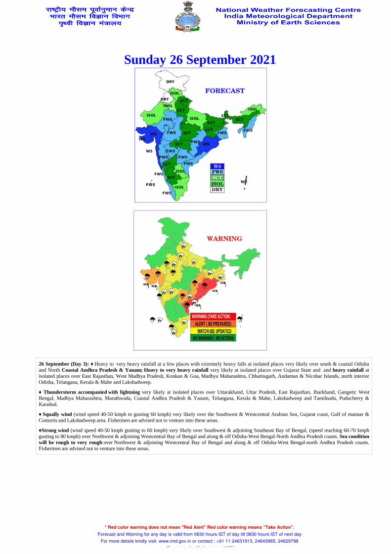
Sunday 26 September 2021
26 September (Day 3): ♦ Heavy to very heavy rainfall at a few places with extremely heavy falls at isolated places very likely over south & coastal Odisha and North Coastal Andhra Pradesh & Yanam; Heavy to very heavy rainfall very likely at isolated places over Gujarat State and and heavy rainfall at isolated places over East Rajasthan, West Madhya Pradesh, Konkan & Goa, Madhya Maharashtra, Chhattisgarh, Andaman & Nicobar Islands, north interior Odisha, Telangana, Kerala & Mahe and Lakshadweep.
♦ Thunderstorm accompanied with lightning very likely at isolated places over Uttarakhand, Uttar Pradesh, East Rajasthan, Jharkhand, Gangetic West Bengal, Madhya Maharashtra, Marathwada, Coastal Andhra Pradesh & Yanam, Telangana, Kerala & Mahe, Lakshadweep and Tamilnadu, Puducherry & Karaikal.
♦ Squally wind (wind speed 40-50 kmph to gusting 60 kmph) very likely over the Southwest & Westcentral Arabian Sea, Gujarat coast, Gulf of mannar & Comorin and Lakshadweep area. Fishermen are advised not to venture into these areas.
♦Strong wind (wind speed 40-50 kmph gusting to 60 kmph) very likely over Southwest & adjoining Southeast Bay of Bengal, (speed reaching 60-70 kmph gusting to 80 kmph) over Northwest & adjoining Westcentral Bay of Bengal and along & off Odisha-West Bengal-North Andhra Pradesh coasts. Sea condition will be rough to very rough over Northwest & adjoining Westcentral Bay of Bengal and along & off Odisha-West Bengal-north Andhra Pradesh coasts. Fishermen are advised not to venture into these areas.
* Red color warning does not mean "Red Alert" Red color warning means "Take Action". Forecast and Warning for any day is valid from 0830 hours IST of day till 0830 hours IST of next day
For more details kindly visit www.imd.gov.in or contact : +91 11 24631913, 24643965, 24629798 (Service to the Nation since 1875)

Monday 27 September 2021
27 September (Day 4):♦ Heavy to very heavy rainfall with extremely heavy falls at isolated places likely over south Chhattisgarh; Heavy to very heavy rainfall at isolated places over Odisha, Telangana & Gujarat State; heavy rainfall at isolated places over Uttrakhand, West Madhya Pradesh, Vidarbha, Gangetic West Bengal, Konkan & Goa, Madhya Maharashtra, Marathwada, Coastal Andhra Pradesh & Yanam, Andaman & Nicobar Islands, Kerala & Mahe and Lakshadweep.
♦ Thunderstorm accompanied with lightning likely at isolated places over Haryana, West Uttar Pradesh, East Rajasthan, Marathwada, Coastal Andhra Pradesh & Yanam, Kerala & Mahe, Lakshadweep and Tamilnadu, Puducherry & Karaikal.
♦ Squally weather (wind speed 40-50 kmph to gusting 60 kmph) likely over the Southwest & Westcentral Arabian Sea. Strong wind speed 40-50 kmph gusting to 60 kmph) likely over Gujarat coast, Gulf of mannar & Comorin area. Fishermen are advised not to venture into these areas.
♦ Strong wind (speed 40-50 kmph gusting to 60 kmph) likely over Southwest & adjoing Southeast Bay of Bengal, (speed reaching 45-55 kmph gusting to 65 kmph) very likely over Northwest Bay of Bengal and along & off north Andhra Pradesh-Odisha-West Bengal coasts. Sea condition will be rough to very rough over Northwest Bay of Bengal and along & off Odisha-north Andhra Pradesh coasts. Fishermen are advised not to venture into these areas.
* Red color warning does not mean "Red Alert" Red color warning means "Take Action". Forecast and Warning for any day is valid from 0830 hours IST of day till 0830 hours IST of next day
For more details kindly visit www.imd.gov.in or contact : +91 11 24631913, 24643965, 24629798 (Service to the Nation since 1875)

Tuesday 28 September 2021
28 September (Day 5): ♦ Heavy rainfall likely at isolated places over Uttarakhand, Madhya Pradesh, Vidarbha, Chhattisgarh, Gangetic West Bengal, Odisha, Gujarat state, Konkan & Goa, Madhya Maharashtra, Marathwada, Coastal Andhra Pradesh & Yanam, Telangana and Kerala & Mahe. Thunderstorm accompanied with lightning likely at isolated places over Haryana, West Uttar Pradesh, East Rajasthan, Coastal Andhra Pradesh & Yanam, Kerala & Mahe, Lakshadweep and Tamilnadu, Puducherry & Karaikal.
♦ Squally weather (wind speed 45-55 kmph to gusting 65 kmph) likely northeast and adjoin eastcentral Bay of Bengal. Squally weather (wind speed 40-50 kmph to gusting 60 kmph) likely over the Southwest & Westcentral Arabian Sea. Strong wind ( wind speed 40-50 kmph gusting to 60 kmph) likely over Gujarat coast. Fishermen are advised not to venture into these areas.
* Red color warning does not mean "Red Alert" Red color warning means "Take Action". Forecast and Warning for any day is valid from 0830 hours IST of day till 0830 hours IST of next day
For more details kindly visit www.imd.gov.in or contact : +91 11 24631913, 24643965, 24629798 (Service to the Nation since 1875)