Embed Size (px)
Citation preview
1
Development of the East Frisian Islands over the last 1000 yearsDevelopment of the East Frisian Islands over the last 1000 years
Natural and anthropogenic impact at Natural and anthropogenic impact at the East Frisian coast the East Frisian coast -- last 1000 last 1000 years and future perspectivesyears and future perspectives
Alexander BartholomäSenckenberg Institute
Development of the East Frisian Islands over the last 1000 yearsDevelopment of the East Frisian Islands over the last 1000 years
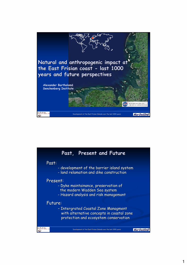
PastPast, , PresentPresent and Futureand Future
PastPast::-- developmentdevelopment of of thethe barrierbarrier islandisland systemsystem-- land land relamationrelamation and and dikedike constructionconstruction
PresentPresent::-- DykeDyke maintainancemaintainance, , preservationpreservation of of thethe modern modern WaddenWadden SeaSea systemsystem
-- HazardHazard analysisanalysis and and riskrisk managemantmanagemant
Future:Future:-- IntergratedIntergrated CoastalCoastal Zone Zone ManagmentManagment
withwith alternative alternative conceptsconcepts in in coastalcoastal zonezoneprotectionprotection and and ecosystemecosystem conservationconservation
2
Development of the East Frisian Islands over the last 1000 yearsDevelopment of the East Frisian Islands over the last 1000 years
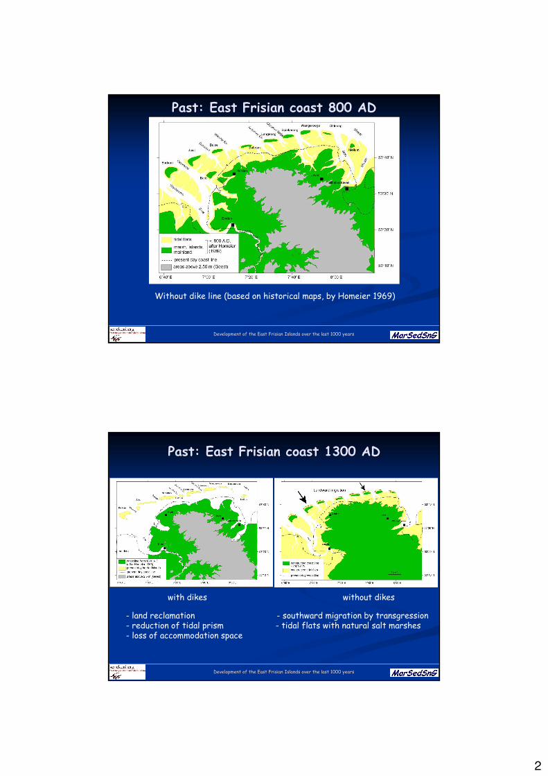
PastPast: East : East FrisianFrisian coastcoast 800 AD800 AD
Without dike line (based on historical maps, by Homeier 1969)
Development of the East Frisian Islands over the last 1000 yearsDevelopment of the East Frisian Islands over the last 1000 years
PastPast: East : East FrisianFrisian coastcoast 1300 AD1300 AD
with dikes without dikes
- land reclamation - southward migration by transgression- reduction of tidal prism - tidal flats with natural salt marshes- loss of accommodation space
3
Development of the East Frisian Islands over the last 1000 yearsDevelopment of the East Frisian Islands over the last 1000 years
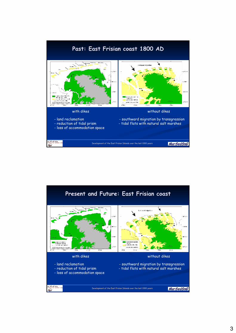
PastPast: East : East FrisianFrisian coastcoast 1800 AD1800 AD
with dikes without dikes
- land reclamation - southward migration by transgression- reduction of tidal prism - tidal flats with natural salt marshes- loss of accommodation space
Development of the East Frisian Islands over the last 1000 yearsDevelopment of the East Frisian Islands over the last 1000 years
PresentPresent and Future: East and Future: East FrisianFrisian coastcoast
with dikes without dikes
- land reclamation - southward migration by transgression- reduction of tidal prism - tidal flats with natural salt marshes- loss of accommodation space
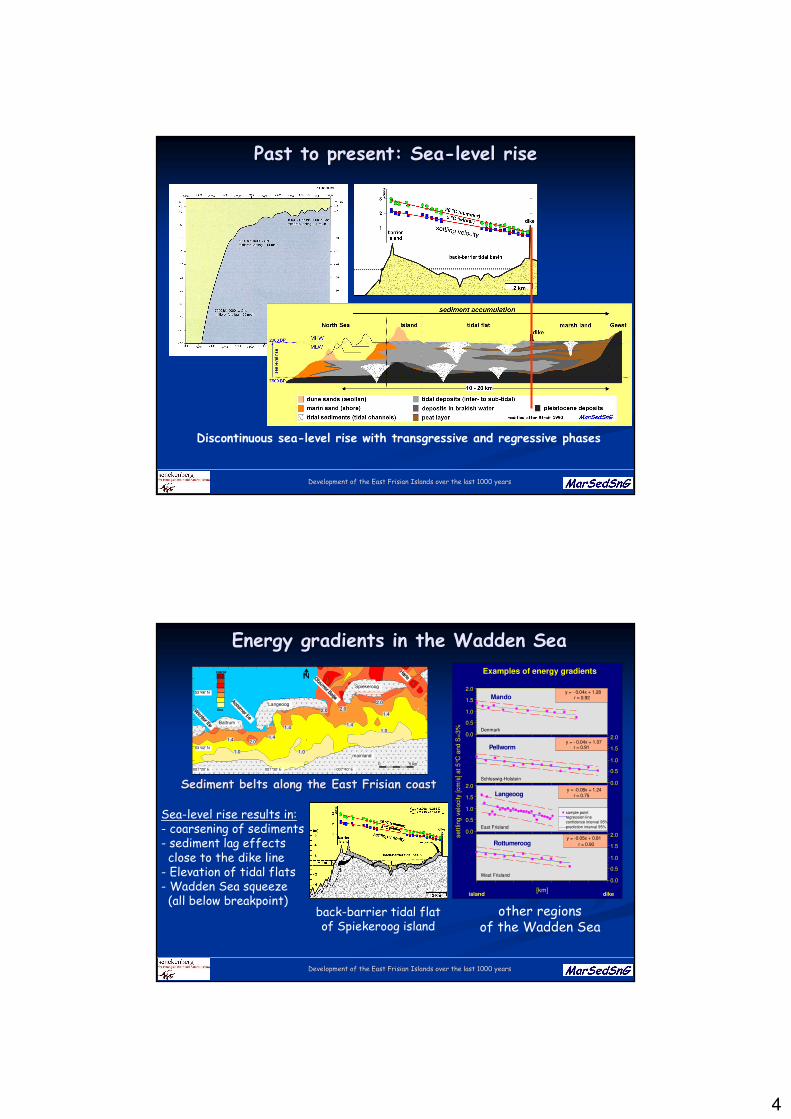
4
Development of the East Frisian Islands over the last 1000 yearsDevelopment of the East Frisian Islands over the last 1000 years
PastPast to to presentpresent: : SeaSea--levellevel riserise
Discontinuous sea-level rise with transgressive and regressive phases
Development of the East Frisian Islands over the last 1000 yearsDevelopment of the East Frisian Islands over the last 1000 years
M
Pellworm
Langeoog
Rottumeroog
y = - 0.04x + 1.28r = 0.92
y = - 0.04x + 1.07r = 0.91
y = -0.08x + 1.24r = 0.75
y = -0.05x + 0.81
r = 0.90
R
V
V
P
Pellworm
Langeoog
Rottumeroog
y = - 0.04x + 1.28r = 0.92
y = - 0.04x + 1.07r = 0.91
y = -0.08x + 1.24r = 0.75
y = -0.05x + 0.81
r = 0.90
Examples of energy gradients
sample pointregression lineconfidence interval 95%
prediction interval 95%
sett
ling v
elo
city [cm
/s] at 5°C
and S
=3%
island dike
Mando
[km]
0.0
1.5
0.5
2.0
1.0
0.0
1.5
0.5
2.0
1.0
0.0
1.5
0.5
2.0
1.0
0.0
1.5
0.5
2.0
1.0
Denmark
Schleswig-Holstein
East Frisland
West Frisland
Energy Energy gradientsgradients in in thethe WaddenWadden SeaSea
other regionsof the Wadden Sea
Sea-level rise results in:- coarsening of sediments- sediment lag effectsclose to the dike line
- Elevation of tidal flats- Wadden Sea squeeze(all below breakpoint)
53°42' N
53°46' N
007°20' E 007°30' E 007°40' E
Langeoog
Baltrum
Spiekeroog
mainland
0 5 km
1.4
1.4
1.4
1.4
1.4
1.0 1.0
1.0
2.0
2.0 2.0
2.0
coarse
fine
Sediment Sediment beltsbelts alongalong thethe East East FrisianFrisian coastcoast
back-barrier tidal flatof Spiekeroog island
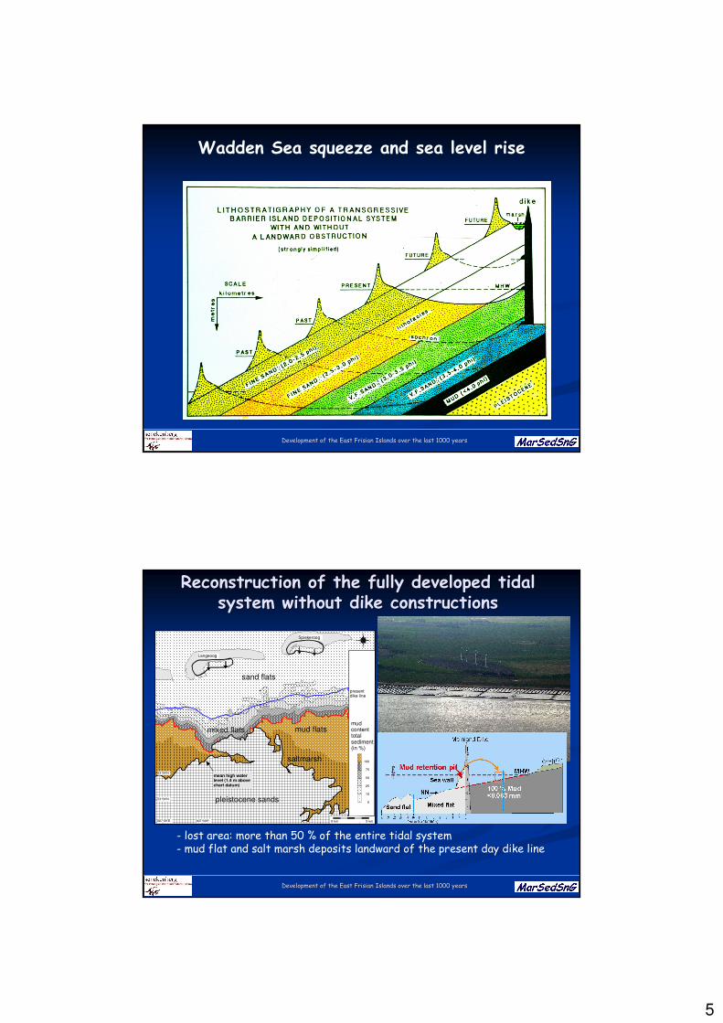
5
Development of the East Frisian Islands over the last 1000 yearsDevelopment of the East Frisian Islands over the last 1000 years
Wadden Sea squeeze and sea level rise
Development of the East Frisian Islands over the last 1000 yearsDevelopment of the East Frisian Islands over the last 1000 years
ReconstructionReconstruction of of thethe fullyfully developeddeveloped tidaltidalsystem system withoutwithout dikedike constructionsconstructions
presentdike line
pleistocene sands
N
W E
S
53°36'N
53°34'N
007°25'E 007°30'E 0 km 5 km
0
10
25
50
75
100
Langeoog
mud flats
Spiekeroog
mudcontenttotalsediment(in %)
saltmarsh
sand flats
mixed flats
mean high water level (1.4 m abovechart datum)
- lost area: more than 50 % of the entire tidal system- mud flat and salt marsh deposits landward of the present day dike line
6
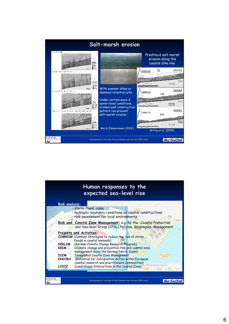
Development of the East Frisian Islands over the last 1000 yearsDevelopment of the East Frisian Islands over the last 1000 years
SaltSalt--marshmarsh erosionerosion
Preditecd salt-marsherosion along thecoastal dike line
Wittig et al. (2004)
With summer dikes ordammed retention pits
Under certain wave &water-level conditions,broken-wall constructionpatters can preventsalt-marsh erosion
Mai & Zimmermann (2002)
Development of the East Frisian Islands over the last 1000 yearsDevelopment of the East Frisian Islands over the last 1000 years
Human Human responsesresponses to to thetheexpectedexpected seasea--levellevel riserise
Risk analysis:- storm-flood risks- hydraulic boundary conditions at coastal constructions- risk assessment for local environments
Risk and Coastal Zone Management: e.g. by the „Coastal Protectionand Sea-level Group (CPSL) Policies, Strategies, Management
Projekts and Activities:COMRISK (Common Strategies to reduce the risk of storm
floods in coastal lowlands)DEKLIM (German Climate Change Research Program)KRIM (Climate change and preventive risk and coastal zone
management along the German North Coast)ICZM Integrated Coastal Zone ManagementENCORA (Initiative for Coordination Action within European
coastal research and practitioners communities)LOICZ (Land-Ocean Interactions in the Coastal Zone)
7
Development of the East Frisian Islands over the last 1000 yearsDevelopment of the East Frisian Islands over the last 1000 years
BreakpointBreakpoint analysisanalysis (CPSL 2001/2005)(CPSL 2001/2005)
Moderate increase in sea level :
≤ 3mm/year for large basins≤ 6 mm/year for small basins
≤ 8.5 mm/year for salt marshes3 – 6 mm/ year pioneer zone
- present dynamic equillibrium still active
- Increase of duration of tidal inundationimplies stronger sediment accumulationon tidal flats and salt marshes (longersettling period)
- Elevation of tidal flats; and expansion ofsalt marshes
Major sea-level rise:
- massive erosion of salt marshes- in sandy areas, erosion rate increases between250% (6mm/yr) and 330% (8.5mm/yr)
- fore-shore erosion, retreat of barrier islands
Changes in wave and /or tide-domminated sections are not considered
Development of the East Frisian Islands over the last 1000 yearsDevelopment of the East Frisian Islands over the last 1000 years
Main Main topicstopics of of coastalcoastal protectionprotectionand and managementmanagement
Sea dikes
Salt-marsh management
Habitatmaintenance
Outbanking of summer polders
Dunemanagement
Sand nourishmentDike strenghening over the last centuries
time: height / lenght / volume
2000: 7.8 m / 105 m / 325 m³
1955: 5.9 m / 56 m / 149 m³
1200: 1.0 m / 5.5 m / 3 m³
1600: 3.0 m / 19 m / 32 m³
2100: 8.5 m / 150 m / 500 m³ ????
1900: 4.8 m / 33 m / 82 m³
8
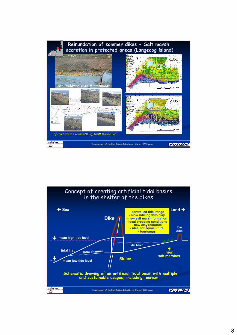
Development of the East Frisian Islands over the last 1000 yearsDevelopment of the East Frisian Islands over the last 1000 years
Reinundation of sommer dikes - Salt marshaccretion in protected areas (Langeoog island)
by courtesy of Freund (2006), ICBM Marine Lab.
accumulation rate 5 cm/month
Nordsee
Niederlande Deutschland
Helgoland
Däne mark
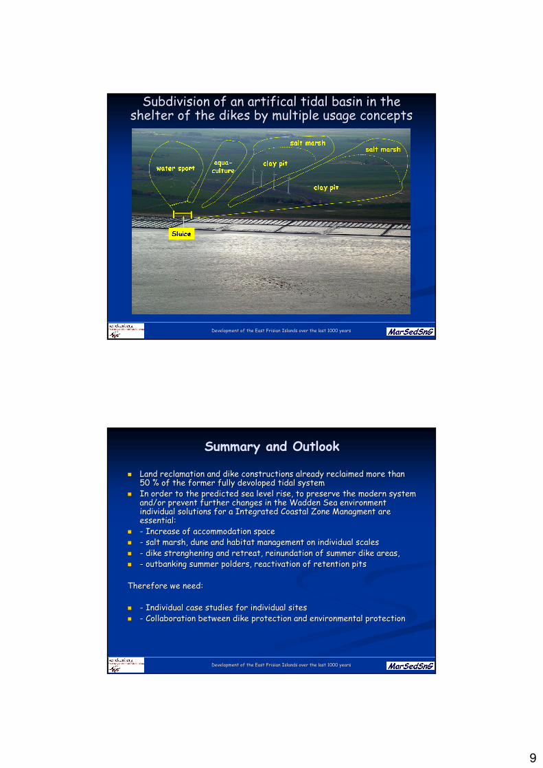
Development of the East Frisian Islands over the last 1000 yearsDevelopment of the East Frisian Islands over the last 1000 years
ConceptConcept of of creatingcreating artificialartificial tidaltidal basinsbasinsin in thethe sheltershelter of of thethe dikesdikes
Schematic drawing of an artificial tidal basin with multipleand sustainable usages, including tourism.
Dike
Sluice
mean high-tide level�
- controlled tidal range- slow infilling with clay
- new salt marsh formation- ideal breeding conditions
- new clay resource- ideal for aquaculture
- tourismus
lowdike
♣♣♣
����new
salt marshes
tidal flat
Sea Land ����
tidal channel
�mean low-tide level
tidal basin
9
Development of the East Frisian Islands over the last 1000 yearsDevelopment of the East Frisian Islands over the last 1000 years
Subdivision of an Subdivision of an artificalartifical tidaltidal basinbasin in in thethesheltershelter of of thethe dikesdikes byby multiple multiple usageusage conceptsconcepts
Development of the East Frisian Islands over the last 1000 yearsDevelopment of the East Frisian Islands over the last 1000 years
Summary and Outlook
�� Land Land reclamationreclamation and and dikedike constructionsconstructions alreadyalready reclaimedreclaimed moremore thanthan50 % of 50 % of thethe formerformer fullyfully devolopeddevoloped tidaltidal systemsystem
�� In order to In order to thethe predictedpredicted seasea levellevel riserise, to , to preservepreserve thethe modern modern systemsystemand/orand/or preventprevent furtherfurther changeschanges in in thethe WaddenWadden SeaSea environmentenvironmentindividualindividual solutionssolutions forfor a a IntegratedIntegrated CoastalCoastal Zone Zone ManagmentManagment areareessential:essential:
�� -- IncreaseIncrease of of accommodationaccommodation spacespace�� -- saltsalt marshmarsh, dune and , dune and habitathabitat managementmanagement on on individualindividual scalesscales
�� -- dikedike strengheningstrenghening and and retreatretreat, , reinundationreinundation of of summersummer dikedike areasareas,,�� -- outbankingoutbanking summersummer polderspolders, , reactivationreactivation of of retentionretention pitspits
ThereforeTherefore wewe needneed::
�� -- IndividualIndividual casecase studiesstudies forfor individualindividual sitessites�� -- CollaborationCollaboration betweenbetween dikedike protectionprotection and and environmentalenvironmental protectionprotection


![[Pieter Meijes Tiersma] Frisian Reference Grammar](https://img.pdfslide.net/doc/110x75/577c80461a28abe054a7fc0d/pieter-meijes-tiersma-frisian-reference-grammar.jpg)