Embed Size (px)
Citation preview

METRO WEST REDEVELOPMENT
METRO WEST GARAGE
WITH RETAIL
RETAILCENTER
W MULBERRY STREET
W FRANKLIN STREET
FREM
ON
T AVE
MLK
BLV
D
W SARATOGA STREET
N S
CH
RO
ED
ER
ST
N A
RLIN
GTO
N AV
E
RECREATIONALFIELDS
PASSIVEPARK
LOT ‘C’FUTURE
DEVELOPMENTPARCEL
HERITAGECROSSINGGATEWAY
ARCHDIOCESEK-8 SCHOOL
CENTERWEST
DEVELOPMENT
W LEXINGTON STREET
W FAYETTE STREET
WEST BALTIMORE REVIVALPHASE 1 ILLUSTRATIVE PLAN
REVISED
ON-RAMP
REVISEDOFF-RAMP
0 25 50 100 200
N G
RE
EN
E S
T
INTERIMLANDSCAPE
BERM
INTERIMLANDSCAPE
BERM
MULTI-USE TRAILEXTENSION
MULTI-USE TRAILEXTENSION
MULTI-USE TRAILEXTENSION
MULTI-USE TRAILEXTENSION
MLK BLVDMULTI-USE
TRAIL
MLK BLVDMULTI-USE
TRAIL
INTERSECTION RE-ALIGNMNET
ULI Baltimore Metro West TAPJune 26-27, 2018
An Urban Land Institute Technical Assistance Panel
ULI Baltimore On behalf of the Baltimore Development Corporation
from a Highway to Nowhere to the Road to Revival
Healing a Scar, Reconnecting Our City

Met
ro W
est T
APfrom a Highway to Nowhere
to the Road to Revival
AcknowledgmentsMayor Catherine Pugh
The Baltimore Development Corporation President William Cole
The Baltimore City Department of Planning
The Baltimore City Department of Transportation
Baltimore Public Markets Corporation
University of Maryland, Baltimore
Market Center Merchants Association
Downtown Partnership of Baltimore
Heritage Crossing Residents Association
Harlem Park Neighborhood Council
Bromo Arts & Entertainment District
Southwest Partnership
Caves Valley Partners
TAP Panelists
• Chair, Brad Rogers, South Baltimore Gateway Partnership
• Joshua Bauman, EDSA, Inc.
• Mary Burkholder, BAE Urban Economics
• Veronica Perry McBeth, Kittelson Associates
• Jennifer Zielinski Missett, Biohabits Sustainability Planning
• James Sink, Mayan Rykiel Landscape Architecture & Design
• Paul Sturm (writer), City Center Residents Association
ULI Baltimore Chair
• Kim Clark, Baltimore Development Corporation
ULI Baltimore Staff
• Lisa Norris
• Danielle Dunlap
Baltimore Development Corporation Staff
• Raven Thompson

3
Healing a Scar, Reconnecting Our City
Table of ContentsAcknowledgments 2
About ULI Baltimore 4
About ULI Baltimore’s TAP Program 4
Our Assignment 5
Key Questions 5
Description of Study Area 6
Observations and Stakeholder Comments 6
From Highway to Nowhere to Road to Revival: The Right Vision - A Realistic Plan 9
Phasing 11
The Necessity of Full Stakeholder Involvement and Shared Leadership 14
Back to the Future: A Lesson from the Past 16
ACKN
OWLE
DGM
ENTS
/ TA
BLE
OF C
ONTE
NTS

Met
ro W
est T
APfrom a Highway to Nowhere
to the Road to Revival
About ULI BaltimoreULI Baltimore is the local Baltimore metropolitan regional District Council for the Urban Land Institute, serving Central Maryland and other parts of the state through its outreach efforts. We are a nonprofit 501(c)(3) organization.
As a trusted source for timely and unbiased land use information, ULI Baltimore provides a critical link to the improvement of state and local land use policy and development practices. ULI is a nonprofit research and education organization supported by its members. As the preeminent,
multidisciplinary real estate forum, ULI facilitates the open exchange of ideas, information and experience among local, national and international industry leaders and policy makers dedicated to creating better places.
Founded in 1936, the Institute now has more than 40,000 members worldwide, representing the entire spectrum of land use and real estate development disciplines in private enterprise and public service. The mission of the Urban Land Institute is to provide leadership in the responsible use of land to create and sustain thriving communities worldwide.
About ULI Baltimore’s TAP ProgramThe objective of ULI Baltimore’s Technical Assistance Panel (TAP) program is to provide expert, multidisciplinary advice on land use and real estate issues facing public agencies and nonprofit organizations in the Baltimore Region. Like ULI District Councils throughout the country, ULI Baltimore utilizes its broad membership base to administer one or two-day panels and offer objective and responsible advice to local stakeholders and decision makers on a diverse set of land use issues. These issues can range from site-specific projects to public policy strategies. The flexibility of the TAP program enables ULI Baltimore to present a customized approach for each TAP, one that allows panelists to study and address specific contextual issues.
The Baltimore Development Corporation and a consortium of stakeholders engaged ULI Baltimore to convene a Technical Assistance Panel with the purpose of examining revitalization strategies for the Route 40 “Highway To Nowhere” corridor, including West Mulberry Street and West Franklin Street, bookended by the West Baltimore MARC station at Smallwood Street to the west and the Metro West redevelopment site at North Greene Street to the east. The Route 40 corridor, along with West Mulberry and West Franklin, currently serves as major east-west commuter route between Downtown Baltimore and West Baltimore as well as areas further west.
The two-day TAP convened on June 26, 2018 at the University of Maryland, Baltimore on West Lombard Street. The Panel spent the morning touring the study area; the afternoon was devoted to

5
Healing a Scar, Reconnecting Our City
ABOU
T UL
I BAL
TIM
ORE
/ OUR
ASS
IGNM
ENTinterviewing stakeholders, and the evening included an open public meeting for soliciting broader
community input followed by a working dinner.
On the second day, the Panel re-convened to share what they had learned, hear from additional stakeholders and formulate their recommendations. Stakeholders and the general public were invited to hear the Panel’s presentation at the end of the day.
Our AssignmentThe Route 40 corridor, along with the two ostensibly-residential streets that run alongside it, is a main thoroughfare for ingress and egress to Downtown Baltimore. While serving the purpose of getting people from outside the city and West Baltimore into and out of downtown, the construction of a below grade highway in the 1970’s divided the neighborhoods along its path, without connecting to the larger interstate system as planned.
This TAP was commissioned to confront two critical issues occurring at two different scales. The first issue was localized and practical: to investigate the continuing need for the on-and-off ramps at the end of this “Highway to Nowhere” (Route 40) and explore the potential development opportunities that could arise if they are demolished. The second was broader and more complex: to propose a new future for the Route 40 corridor, and develop a coherent strategy for making it a reality. Joining these tasks together, we would follow up the promise laid out a decade ago in the West Baltimore MARC Station Master Plan, to finally create a “Highway to Somewhere”.
Key QuestionsWe began with the following questions:
1. Should we abandon the “Highway to Nowhere” and reuse the right of way in some fashion by putting all the traffic onto Franklin and Mulberry Streets?
2. Should ramps over Martin Luther King, Jr. Boulevard be removed from their east terminus on Franklin and Mulberry Streets to connection with old Route 40 on the other side of MLK?
3.What should happen with the land made usable by the ramps coming down? Should a portion be folded into the Metro West redevelopment? What about the large plot across MLK Boulevard?
4. Should the redevelopment of the Metro West site be linked with the redevelopment of Lexington Market in some way?
5. Is there an opportunity to create a stronger connection between Metro West and the West Baltimore MARC station, west of the Metro West site?

Met
ro W
est T
APfrom a Highway to Nowhere
to the Road to Revival
Description of Study AreaThe study area encompasses three major components: the highway, the West Baltimore MARC station, and the Metro West complex, along with Franklin and Mulberry streets. The Highway, originally planned as a spur to Interstate 70 – the long since cancelled Interstate 170, now known as “The Highway to Nowhere” – has been a key element in many plans to revitalize West Baltimore. The existing on and off ramps have been the center of most of the aforementioned plans for adaptive reuse and/or redevelopment. The ramps were included in order to bypass Martin Luther King, Jr. (MLK) Boulevard for seamless integration further into downtown. The most recent iteration for reuse of the depressed 1.39 mile stretch of highway included rail lines and stops for the now cancelled $2.2 billion Baltimore Red Line east-west light rail, creating an opportunity for other adaptive reuse concepts to be developed.
The MARC StationThe West Baltimore MARC station is well utilized with more than 20,000 riders a day passing through on the Penn Line between Baltimore and Washington D.C. As part of the $135 million BaltimoreLink project, the station has received several recent upgrades, transforming into a true transit hub and transfer station with shelters, real-time information signs, ticket vending machines, bike racks, carshare access, improved pedestrian crossings and public art. The facility has also been able to utilize part of Route 40 to create additional parking for its growing ridership, while also alleviating parking congestion in the surrounding residential communities. In addition, $3.75 million in federal funds through the Ladder STEP program provided upgrades to the streets (from Fulton to Calhoun) surrounding the transit hub. These enhancements included landscaping, ADA compliant sidewalks and crosswalks, lighting, and bike/walking paths.
Aerial View

7
Healing a Scar, Reconnecting Our City
DESC
RIPT
ION
AND
OBSE
RVAT
IONS
Metro WestThe original 600,000 square foot Metro West Federal Building was completed in 1980 to house the Office of Central Records Operations of the Social Security Administration. The complex fills two city blocks from West Saratoga to West Franklin Streets with a sky bridge connecting the two buildings across West Mulberry Street. Today the 11-acre, 1.1 million square foot site sits largely unused and is ripe for redevelopment that ties into other efforts to revitalize the west side of downtown. It has recently been purchased by a local developer.
Observations and Stakeholder CommentsFrom the beginning of our work together, the TAP panel was cognizant of a key theme which would inform our discussions, public presentation and recommendations. Baltimore has historically been
“A City of Barriers” – a city that despite its relatively compact physical size and high population density, has evolved in ways that both physically and emotionally separate its citizens from one another. When our panel got off the bus on our first morning tour to walk around the Heritage Crossing neighborhood, we were immediately struck by the walls and hill built to separate the community from its surroundings – and the surrounding area from the community.
Martin Luther King, Jr. Boulevard is, in many ways, a failure by every measure. It is not an efficient highway that swiftly moves vehicles; it is not a leafy, well maintained boulevard that attracts development; it is not an attractive neighborhood street; and it is not an inviting gateway into the city.
That said, MLK makes an excellent barrier. It is a physical barrier, discouraging pedestrian traffic between downtown and the neighborhoods. But it is also a market barrier, distorting the real estate market by driving down property values to its west. And, perhaps most disappointingly, it is a generator of more and more barriers.
The combination of loud traffic and poor pedestrian conditions drive adjacent landowners to turn their back on the street, and erect a variety of barriers – walls, fences, and berms. This retraction, in turn, turns MLK into a negative space, unclaimed by any neighborhood. And in any urban environment, unclaimed spaces will inevitably attract a transient population: those with nowhere else to go, and those who wish to be unseen. This reinforces the perceived need to build barriers to protect the surrounding neighborhoods.
Unsurprisingly, this transient population is particularly concentrated under the Route 40 overpass, which provides shade and shelter. As a result, the City has forced to erect even more barriers, in an ongoing effort to exclude the homeless. The net effect is public space that is literally for no one.
The same truth holds for Route 40, which is paradoxically neither a meaningful highway nor a functional part of the urban fabric. When walking along Franklin Street on the north edge of “The Highway to Nowhere,” it became perfectly clear how the below grade highway acts as a barrier between the two parallel streets of Franklin and Mulberry. What should be a short one-block walk for residents along either street to socialize with neighbors or play with friends is anything but. The neighborhoods of Harlem Park and Poppleton are fundamentally divided from one another, with disastrous consequences for an already destabilized housing market plagued by a history of
Met
ro W
est T
APfrom a Highway to Nowhere
to the Road to Revival
racism, redlining, and economic decline. It is impossible to imagine sustained investment in these communities without confronting the chasm between them.
One panel member commented on the contrast between Baltimore and two other port cities with similar land area and population size – Boston and San Francisco. Both cities not only have a much more vibrant street life than Baltimore, but also have multiple shared spaces which the diversity of their population comfortably occupies together. Although much of this is the result of comprehensive, reliable public transportation systems whose regular users span the two cities’ socio-economic and racial spectrums, the contrast further illustrates Baltimore’s historic “culture of separation” in place of a “culture of connection.”
Our panel’s observations were repeatedly reinforced throughout our stakeholder interviews. One city official talked about Baltimore’s “east-west divide” which has kept residents separated by the side of the city where they grew up. A planner at the University of Maryland, Baltimore (UMB) referred to the “Highway to Nowhere” as a “scar on West Baltimore” adding that UMB initiated its own shuttle service because “our students and staff because didn’t feel safe riding public transportation with people from outside the university community.” And the president of the Heritage Crossing Residents Association spoke about street conditions between her neighborhood and downtown as “an impediment to shopping at places like Lexington Market,” which has been struggling to attract a cross-section of Baltimore residents and visitors despite housing some of Baltimore’s most iconic and well-known food vendors.
Others with whom we spoke referred to Martin Luther King, Jr. Boulevard as a “moat” surrounding the “island” of downtown. Residents of our study area spoke in almost desperate terms about their need for a grocery store, retail shops, recreation areas -- outdoors and indoors -- and something aesthetically appealing in their neighborhood. The developer who now owns the Metro West complex spoke about the need to make the streets around the buildings “come alive.”
Our panel heard a clear, compelling and consistent message from stakeholders throughout this area that things must change; that the status quo is not serving anyone’s interests and needs – and, going forward, won’t serve Baltimore City, its residents, businesses and institutions – if we are to be a thriving, vibrant community and region in the 21st century.
“The solution to scarcely populated public spaces in Baltimore is not a strategy of reduction which bans or further discriminates against the less fortunate. Instead, what is needed is a strategy of addition: More people, more uses to make spaces inviting and safe for even more people to go out into streets, parks and plazas.”
Klaus Philipsen, Community Architect & past ULI Baltimore TAP panelist
9
Healing a Scar, Reconnecting Our City
METRO WEST REDEVELOPMENT
METRO WEST GARAGE
WITH RETAIL
RETAILCENTER
W MULBERRY STREET
W FRANKLIN STREET
FREM
ON
T AVE
MLK
BLV
D
W SARATOGA STREET
N S
CH
RO
ED
ER
ST
N A
RLIN
GTO
N AV
E
RECREATIONALFIELDS
PASSIVEPARK
LOT ‘C’FUTURE
DEVELOPMENTPARCEL
HERITAGECROSSINGGATEWAY
ARCHDIOCESEK-8 SCHOOL
CENTERWEST
DEVELOPMENT
W LEXINGTON STREET
W FAYETTE STREET
WEST BALTIMORE REVIVALPHASE 1 ILLUSTRATIVE PLAN
REVISED
ON-RAMP
REVISEDOFF-RAMP
0 25 50 100 200
N G
RE
EN
E S
T
INTERIMLANDSCAPE
BERM
INTERIMLANDSCAPE
BERM
MULTI-USE TRAILEXTENSION
MULTI-USE TRAILEXTENSION
MULTI-USE TRAILEXTENSION
MULTI-USE TRAILEXTENSION
MLK BLVDMULTI-USE
TRAIL
MLK BLVDMULTI-USE
TRAIL
INTERSECTION RE-ALIGNMNET
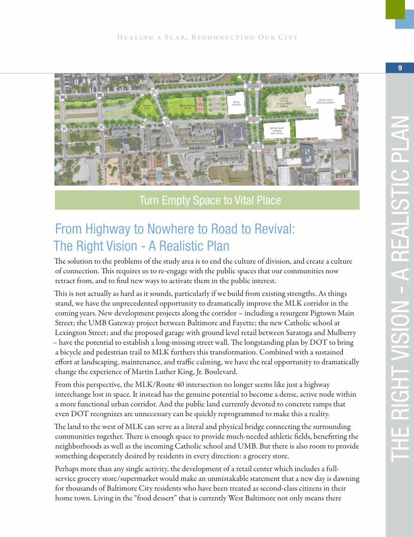
From Highway to Nowhere to Road to Revival:The Right Vision - A Realistic PlanThe solution to the problems of the study area is to end the culture of division, and create a culture of connection. This requires us to re-engage with the public spaces that our communities now retract from, and to find new ways to activate them in the public interest.
This is not actually as hard as it sounds, particularly if we build from existing strengths. As things stand, we have the unprecedented opportunity to dramatically improve the MLK corridor in the coming years. New development projects along the corridor – including a resurgent Pigtown Main Street; the UMB Gateway project between Baltimore and Fayette; the new Catholic school at Lexington Street; and the proposed garage with ground level retail between Saratoga and Mulberry
– have the potential to establish a long-missing street wall. The longstanding plan by DOT to bring a bicycle and pedestrian trail to MLK furthers this transformation. Combined with a sustained effort at landscaping, maintenance, and traffic calming, we have the real opportunity to dramatically change the experience of Martin Luther King, Jr. Boulevard.
From this perspective, the MLK/Route 40 intersection no longer seems like just a highway interchange lost in space. It instead has the genuine potential to become a dense, active node within a more functional urban corridor. And the public land currently devoted to concrete ramps that even DOT recognizes are unnecessary can be quickly reprogrammed to make this a reality.
The land to the west of MLK can serve as a literal and physical bridge connecting the surrounding communities together. There is enough space to provide much-needed athletic fields, benefitting the neighborhoods as well as the incoming Catholic school and UMB. But there is also room to provide something desperately desired by residents in every direction: a grocery store.
Perhaps more than any single activity, the development of a retail center which includes a full-service grocery store/supermarket would make an unmistakable statement that a new day is dawning for thousands of Baltimore City residents who have been treated as second-class citizens in their home town. Living in the “food dessert” that is currently West Baltimore not only means there
Turn Empty Space to Vital Place
THE
RIGH
T VI
SION
- A
REA
LIST
IC P
LAN

Met
ro W
est T
APfrom a Highway to Nowhere
to the Road to Revival
is limited access to healthy or fresh food for residents without their own cars, but also results in multiple health problems and shortened lifespans.
The practical challenge, of course, has been to make a compelling economic case that a grocery store is viable in West Baltimore. However, this site has the potential to merge the buying power of West Baltimore with that of the growing population of downtown, along with the tens of thousands of employees and students at UMB and the huge traffic volumes passing by MLK and Route 40.
If growth continues at the predicted pace, we believe West Baltimore residents together with the rapidly growing residential population in Baltimore’s traditional downtown core could a support a 30,000-35,000 square foot grocery store at the intersection of Route 40 & Martin Luther King Boulevard. This new retail center with its grocery anchor could attract consumers from all sides if the physical connections between downtown and West Baltimore are “bridged” in the way we envision. Then, once the Metro West site begins to fill in, Lot C can be developed as a complimentary site across the (now less-threatening) street, completing the transformation of this intersection into a vibrant urban node.
Meanwhile, this new anchor point can serve as the basis for carefully stitching back together the neighborhoods on either side of the highway. As part of the redevelopment of this site, we recommend rebuilding Fremont Avenue, ending the absurd block-long rupture of this street. Then Franklin and Mulberry can each be converted back to calmer residential streets with wide sidewalks and slower, two-way traffic. This can be complimented by the further extension of the walking and exercise trail to connect with MLK. And, as this work is completed, targeted rehabs and new construction can be phased in to take advantage of this new street condition. This process should move from East to West, extending the strength of Heritage Crossing and the new development parcel until it stabilizes the corridor and creates a compelling economic case for the long-awaited TOD around the MARC station.
Then, gradually, the Highway to Nowhere itself can be transformed. First, the highway can become a calmer, narrower boulevard. This would free up space for natural and recreational uses (or, depending upon market conditions, even new development) while maintaining eyes on the space for safety. Over the long term, we can imagine a gradual transformation of the chasm into a valley – a unique urban feature that serves neighborhood needs, treats stormwater, provides habitat, and still serves as a right-sized transportation corridor. All this can be done while maintaining a 20’ corridor in case the Red Line (or something similar) ever returns.
11
Healing a Scar, Reconnecting Our City
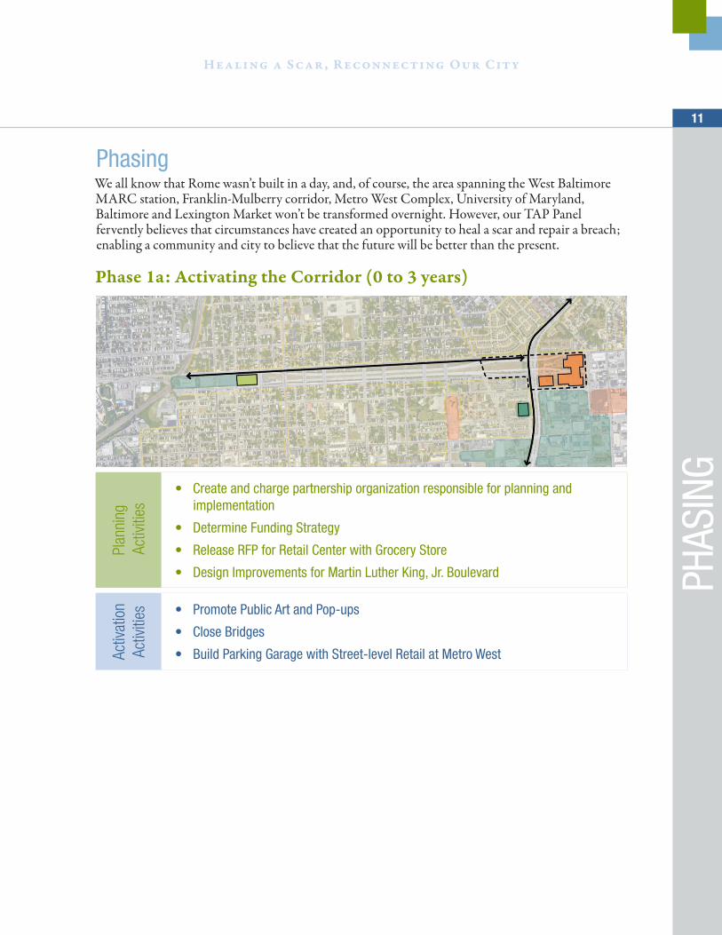
PhasingWe all know that Rome wasn’t built in a day, and, of course, the area spanning the West Baltimore MARC station, Franklin-Mulberry corridor, Metro West Complex, University of Maryland, Baltimore and Lexington Market won’t be transformed overnight. However, our TAP Panel fervently believes that circumstances have created an opportunity to heal a scar and repair a breach; enabling a community and city to believe that the future will be better than the present.
Phase 1a: Activating the Corridor (0 to 3 years)
Plan
ning
A
ctivi
ties
• Create and charge partnership organization responsible for planning and implementation
• Determine Funding Strategy
• Release RFP for Retail Center with Grocery Store
• Design Improvements for Martin Luther King, Jr. Boulevard
Activ
atio
n Ac
tiviti
es • Promote Public Art and Pop-ups
• Close Bridges
• Build Parking Garage with Street-level Retail at Metro West
PHAS
ING

Met
ro W
est T
APfrom a Highway to Nowhere
to the Road to Revival
Phase 1b: Strengthening the East End Anchor (3 to 5 years)
Rem
ove
the
Barri
ers • Take down bridges
• Reconnect Freemont Avenue
• Reconfigure the intersections of MLM Boulevard with Franklin & Mulberry Streets
Crea
te
Anch
ors
• Build the retail center with grocery store
• Build the recreation amenities
Phase 2: 5 to 10 years
Conn
ectin
g Ea
st to
Wes
t • Rehabilitate vacant row homes and infill vacant lots along West Franklin and Mulberry Streets
• Convert West Franklin and Mulberry back to “neighborhood” streets
• Implement two-way traffic, traffic calming and expanded sidewalks
• Plan for transitioning the “Highway to Nowhere” to a corridor for people and nature
• Remain aware of plans for Amtrak’s Northeast Corridor tunnel and track realignment between the West Baltimore MARC and Penn Stations
• Allow sufficient right-of-way for possible revival of the Red Line light rail or other rapid transit along the West Franklin/Mulberry corridor

13
Healing a Scar, Reconnecting Our City
PHAS
ING
Phase 3: 10+ years
Real
izing
a v
ibra
nt, t
hrivi
ng,
heal
thy
com
mun
ity
• Rebuild West Baltimore MARC Station to accommodate track and tunnel realignment
• Plan and incentivize transit-oriented development (TOD) in the West Baltimore MARC station area
• Develop lot on East Side of MLK
• Create a beautiful boulevard
• Include paths for walking and biking
• Create public gathering places
• Create community gardens and other neighborhood amenities
• Treat stormwater runoff
• Create urban habitat

Met
ro W
est T
APfrom a Highway to Nowhere
to the Road to Revival
METRO WEST REDEVELOPMENT
METRO WEST GARAGE
WITH RETAIL
RETAILCENTER
W MULBERRY STREET
W FRANKLIN STREET
FREM
ON
T AVE
MLK
BLV
D
W SARATOGA STREET
N S
CH
RO
ED
ER
ST
N A
RLIN
GTO
N AV
E
RECREATIONALFIELDS
PASSIVEPARK
LOT ‘C’FUTURE
DEVELOPMENTPARCEL
HERITAGECROSSINGGATEWAY
ARCHDIOCESEK-8 SCHOOL
CENTERWEST
DEVELOPMENT
W LEXINGTON STREET
W FAYETTE STREET
WEST BALTIMORE REVIVALPHASE 1 ILLUSTRATIVE PLAN
REVISED
ON-RAMP
REVISEDOFF-RAMP
0 25 50 100 200
N G
RE
EN
E S
T
INTERIMLANDSCAPE
BERM
INTERIMLANDSCAPE
BERM
MULTI-USE TRAILEXTENSION
MULTI-USE TRAILEXTENSION
MULTI-USE TRAILEXTENSION
MULTI-USE TRAILEXTENSION
MLK BLVDMULTI-USE
TRAIL
MLK BLVDMULTI-USE
TRAIL
INTERSECTION RE-ALIGNMNET
Metro West Plan
The Necessity of Full Stakeholder Involvement and Shared LeadershipOur TAP panel believes the success of this strategy depends upon a process which assures that all stakeholders are at the table and includes neighborhood residents in shared leadership. The legacy of planning the “Highway to Nowhere” and the nearly fifty-year scar it created illustrates the pitfalls of excluding residents from the planning process.
We propose creating an organization (e.g. “The West Baltimore Revival Partnership” or something similar) to oversee and coordinate planning and implementation of the extraordinary opportunity before us. The Partnership could either be a forum for collaboration between existing entities, or even incorporate as a nonprofit entity itself if this made sense over time.
The Partnership would be comprised of, but not limited to, representatives from the following stakeholders:
• Community Associations including Heritage Crossing Residents Association, City Center Residents Association, Poppleton Now, Franklin Square, Seton Hill, Harlem Park, Towns at the Terraces, Fayette Street Outreach, Southwest Partnership
• Anchor Institutions including the University of Maryland, Baltimore, University of Baltimore, University of Maryland Medical Systems, Bon Secours
15
Healing a Scar, Reconnecting Our City
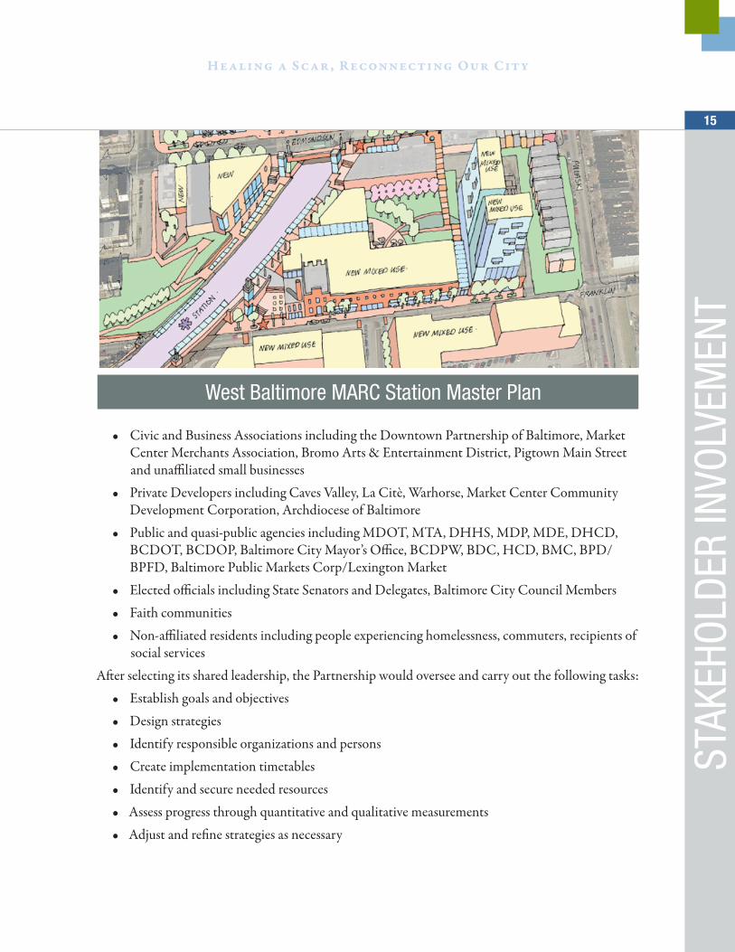
West Baltimore MARC Station Master Plan
STAK
EHOL
DER
INVO
LVEM
ENT
• Civic and Business Associations including the Downtown Partnership of Baltimore, Market Center Merchants Association, Bromo Arts & Entertainment District, Pigtown Main Street and unaffiliated small businesses
• Private Developers including Caves Valley, La Citè, Warhorse, Market Center Community Development Corporation, Archdiocese of Baltimore
• Public and quasi-public agencies including MDOT, MTA, DHHS, MDP, MDE, DHCD, BCDOT, BCDOP, Baltimore City Mayor’s Office, BCDPW, BDC, HCD, BMC, BPD/BPFD, Baltimore Public Markets Corp/Lexington Market
• Elected officials including State Senators and Delegates, Baltimore City Council Members
• Faith communities
• Non-affiliated residents including people experiencing homelessness, commuters, recipients of social services
After selecting its shared leadership, the Partnership would oversee and carry out the following tasks:
• Establish goals and objectives
• Design strategies
• Identify responsible organizations and persons
• Create implementation timetables
• Identify and secure needed resources
• Assess progress through quantitative and qualitative measurements
• Adjust and refine strategies as necessary
Met
ro W
est T
APfrom a Highway to Nowhere
to the Road to Revival
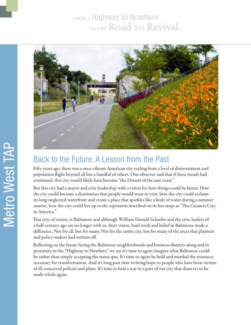
Back to the Future: A Lesson from the PastFifty years ago, there was a once vibrant American city reeling from a level of disinvestment and population flight beyond all but a handful of others. One observer said that if these trends had continued, this city would likely have become “the Detroit of the east coast.”
But this city had a mayor and civic leadership with a vision for how things could be better. How the city could become a destination that people would want to visit; how the city could reclaim its long-neglected waterfront and create a place that sparkles like a body of water during a summer sunrise; how the city could live up to the aspiration inscribed on its bus stops as “The Greatest City in America.”
That city, of course, is Baltimore and although William Donald Schaefer and the civic leaders of a half-century ago are no longer with us, their vision, hard work and belief in Baltimore made a difference. Not for all, but for many. Not for the entire city, but for many of the areas that planners and policy-makers had written off.
Reflecting on the future facing the Baltimore neighborhoods and business districts along and in proximity to the “Highway to Nowhere,” we say it’s time to again imagine what Baltimore could be rather than simply accepting the status quo. It’s time to again be bold and marshal the resources necessary for transformation. And it’s long past time to bring hope to people who have been victims of ill-conceived policies and plans. It’s time to heal a scar in a part of our city that deserves to be made whole again.

17
Healing a Scar, Reconnecting Our City
A LE
SSON
FRO
M T
HE P
AST
/ CON
TACT
For more information, contact:
Lisa Norris, ULI Baltimore District Council Coordinator
Office: 410.844.0410 | Cell: 443.824.4246
baltimore.uli.org


![Guide to Nowhere [nº 6] Bogotá](https://img.pdfslide.net/doc/110x75/579074481a28ab6874af2de8/guide-to-nowhere-no-6-bogota.jpg)