Embed Size (px)
Citation preview
Draft as of 4/30/13
1
From GPS and Virtual Globes to Spatial1 Computing - 2020: The Next Transformative Technology
A Community Whitepaper resulting from the 2012 CCC Spatial Computing 2020 Workshop
1. Introduction Spatial computing encompasses the ideas, solutions, tools, technologies, and systems that
transform our lives and society by creating a new understanding of spaces, their locations, places, as well as properties; how we know, communicate, and visualize our relation to places in a space of interest; and how we navigate through those places. From virtual globes to consumer global navigation satellite system devices, spatial computing is transforming society. We’ve reached the point where a hiker in Yellowstone, a schoolgirl in DC, a biker in Minneapolis, and a taxi driver in Manhattan know precisely where they are, know the locations and details of nearby points of interest, and know how to efficiently reach their destinations. Large organizations already use spatial computing for site selection, asset tracking, facility management, navigation and logistics. Scientists use the Global Positioning System (GPS) to track endangered species and better understand animal behavior, while farmers use GPS for precision agriculture to increase crop yields and reduce costs. Virtual globes [18] such as Google Earth and NASA World Wind are being used in classrooms to teach children about their local neighborhoods and the world beyond in an enjoyable and interactive way. In the wake of recent natural disasters (e.g., Hurricanes Sandy, tsunami in Japan), Google Earth’s service has allowed millions of people to access imagery to help in disaster response and recovery services [37].
These tools are just the tip of the iceberg. In the coming decade, spatial computing researchers will be working to develop a compelling array of new geo-related capabilities. For example, where GPS route finding today is based on shortest travel time or travel distance, companies are now experimenting with eco-routing, finding routes that reduce fuel consumption. Smart routing that avoids left turns has already saved UPS over three million gallons of fuel annually and reduced green house gas emissions [31]. Such savings can be multiplied many times over when eco-routing services become available for consumers and other fleet owners (e.g., public transportation). New geo-related capabilities will also change how we use the Internet. Currently, users access information based on keywords and references, but a large portion of information has an inherent spatial component. Storing and referencing data by location may allow for more intuitive searching and knowledge discovery. It would then be possible to draw correlations and find new information based on relative locations, rather than keywords. The incorporation of location information for Internet users, documents, and servers will allow a flourishing of services designed around enhanced usability, security and trust.
The expected economic benefits of these and other spatial computing technologies are significant. According to a recent McKinsey report, location-based services will provide a significant portion of the estimated 150,000 new deep-analytical jobs and 1.5 million data-savvy manager and analyst positions needed for the upcoming push by companies into big-data analysis [32]. Along with that, a potential consumer surplus of “$600 billion annually” is possible through the use of personal location data [32].
While such opportunities are undoubtedly exciting, they also raise a host of new challenges for spatial computing that will need to be addressed with creativity, dedication, and financial resolve. The rest of this document lays out our view of the key issues and is organized as follows: Section 2 presents the changes to spatial computing that have emerged since the turn of the century. Section 3 details exciting future opportunities and challenges. In Section 4, we tackle the sensitive issue of geo-privacy policy and propose a set of “conversation-starters” to help stakeholders begin to find common ground. Section 5 closes with an appeal for increased US investment and institutional support for spatial computing research. Background about this document (and the process that created it) is given in Section 6. A list of 1 Spatial computing is used in a broad sense to include spatio-temporal computing and non-geographic spaces.
Draft as of 4/30/13
2
contributors to this document is presented in Appendix A. Appendix B covers emerging application attributes and Appendix C presents representative organizations in Spatial Computing. Finally, Appendix D outlines a list of representative computer science questions, Appendix E covers emerging platform trends and Appendix F presents spaces of interest to spatial computing.
2. The Changing World of Spatial Computing In the late 20th century, almost all maps in the US were produced by a small group of highly
trained people in government agencies and surveying companies. Only a few sophisticated groups such as the Department of Defense or oil exploration groups used GIS technologies. These groups depended on highly specialized software such as ArcGIS and Oracle Spatial for editing or analyzing geographic information and their expectations did not extend much beyond the distribution of paper maps and their electronic counterparts. As summarized by Table 2.1, recent advances in spatial computing have changed this situation completely. Today, “everyone” is a mapmaker and every phenomenon is observable, “everyone” uses location-based services, and every platform is location-aware. The very success of these technologies has raised users’ expectations of spatial computing in the future. At the same time, new fears concerning the potential misuse of location data are also being raised. Rising expectations and privacy concerns are at the heart of the challenges facing spatial computing research in the coming decade. We describe these challenges in more detail as follows.
Table 2.1: Changes to Spatial Computing
Late 20th Century The New Reality Maps were produced by a few highly trained people in government agencies and surveying companies
Everyone is a mapmaker and every phenomenon is observable
Only sophisticated groups (e.g., Department of Defense, oil exploration) used GIS technologies
Everyone uses location-based services
Only specialized software (e.g., ArcGIS, Oracle SQL) could edit or analyze geographic information
Every platform is location aware
User expectations were modest (e.g., assist in producing and distributing paper maps and their electronic counterparts)
Rising expectations due to vast potential and risks
Everyone is a mapmaker and every phenomenon is observable: The fact that users with cell
phones and access to the Internet now number in the billions is a new reality of the 21st century. Increasingly, the sources of geo-data are now smart-phone users who are likely untrained in GIS technology (e.g., Mercator projection, World Geodetic System, etc) and largely hobbyists (e.g., volunteer geographic information providers). This means data quality may be uncertain since the public may not be trained in making and verifying specific measurements and may unwittingly contribute erroneous information. For example, adding street names to a map may not require much training but conflating maps from two sources may require more training. Every phenomenon is also becoming observable in the sense that the set of sensors are getting richer for 3D mapping (e.g., LiDAR, ground-penetrating radar) and broader spectrums at finer resolutions are being captured. This affords the ability to observe more phenomena at higher levels of precision, but presents new challenges based on the increased data volume, variety, and veracity that are exceeding the capacity of current spatial computing technologies.
Everyone uses location-based services: The proliferation of web-based technologies, cell-phones, consumer GPS-devices, and location-based social media have facilitated the widespread use of location-based services. Internet services such as Google Earth and OpenStreetMap have brought GIS to the masses (e.g., Google Earth has received over a billion downloads [73]). With cell-phones and consumer GPS-devices, services such as Enhanced-911 (E-911) and navigation applications are

Draft as of 4/30/13
3
consumed by billions of individuals. Facebook check-in and other location-based social media are also used by over a billion people around the world.
Every platform is location aware: Spatial computing and cell-phones continue to influence each other due to the increasing need by individuals to know their spatial context, use navigation applications, etc. Recently, smart phone sales have eclipsed those of personal computers [74]. As a result, computing platforms are being increasingly shaped by cell-phones, and thus by spatial computing. This new reality will require reimagining the various layers of the computing stack. Support for geospatial notions within the general computing eco-system has been rich at the application level (e.g., hundreds of projections are supported by ArcGIS) but more support will be needed at lower layers (e.g., operating system, runtime system) for next-generation spatial computing. Support for geospatial notions will be needed for computer network security. The possibility exists that secured GPS circuits will be needed on-chip and that geodetic and Internet infrastructure will be linked.
Expectations are rising and so are the risks: In recent years, spatial computing has fulfilled many societal needs. Localization services, navigation aids, and interactive maps have arguably exceeded users’ expectations. Their intuitive basis and ease of use have earned these products a solid reputation. Consumers do not doubt the potential of spatial computing to reduce greenhouse gas emissions, strengthen cyber-security, improve consumer confidence and otherwise address a whole host of other societal problems. However, the very success of spatial computing technologies also raises red flags among users. Geo-privacy concerns must be addressed to avoid spooking citizens, exposing economic entities to liability, and lowering public trust. Sustainable geo-privacy policy must emerge from civil society. The needs of policy stakeholders must be balanced to ensure public safety as well as economic prosperity. Conversation starters centering on special cases such as emergencies are needed to initiate the extremely challenging but necessary geo-privacy policy discussion. 3. Research Opportunities and Challenges
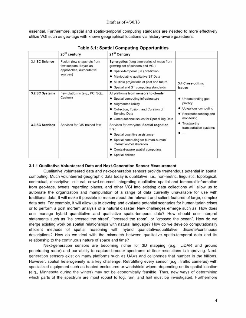
While spatial computing has been shown to have tremendous value for society, significant challenges emerge from its recent transformations. In this section we will illuminate these challenges via four core areas of spatial computing: science, systems, services and crosscutting as detailed in Table 3.1. First, overcoming the challenges of everyone being a mapmaker and every phenomenon being observable will require SC science to move from fusion of data from a few trusted sources to synergizing data across numerous volunteers. Second, facilitating the use of location-based services by everyone will afford widely available services for everyone as opposed to services for only the GIS-trained few. Third, surmounting the challenge of equipping every platform to be location-aware will move spatial computing from a few platforms (e.g., PCs) to all platforms (e.g., sensors, clouds). Other opportunities due to rising expectations are crosscutting such as geo-privacy and ubiquitous computing.
3.1 SC Sciences: From Fusion to Synergetics
Historically, SC (e.g., mapping) science dealt with geographic data from highly trained GIS professionals in authoritative organizations with data quality assurance processes. Today, an ever-increasing volume of geographic data is coming from average citizens via check-ins, tweets, geo-tags, geo-reports from Ushahidi [87], and donated GPS tracks. Volunteered geographic information (VGI) raises challenges related to data quality, trustworthiness, bias, etc. Such data requires transformation of traditional data fusion ideas into a broader data synergetics paradigm, addressing many new issues. For example, manipulating qualitative spatio-temporal data is needed to reason about and integrate the qualitative spatial and temporal information that may be gleaned from VGI (e.g., geo-tags, geo-reports, etc.). Spatio-temporal prediction may assist in inferring the described location of a tweet from its content. Additionally, since contending narratives in VGI data may lead to alternative maps of a common area from different perspectives, handling multiple competing spatial descriptions from the past and future is
Draft as of 4/30/13
4
essential. Furthermore, spatial and spatio-temporal computing standards are needed to more effectively utilize VGI such as geo-tags with known geographical locations via history-aware gazetteers.
Table 3.1: Spatial Computing Opportunities
20th century 21st Century 3.1 SC Science Fusion (few snapshots from
few sensors, Bayesian approaches, authoritative sources)
Synergetics (long time-series of maps from growing set of sensors and VGI) ● Spatio-temporal (ST) prediction ● Manipulating qualitative ST Data ● Multiple projections of past and future ● Spatial and ST computing standards
3.4 Cross-cutting issues ● Understanding geo-
privacy ● Ubiquitous computing ● Persistent sensing and
monitoring ● Trustworthy
transportation systems ● …
3.2 SC Systems Few platforms (e.g., PC, SQL, Custom)
All platforms from sensors to clouds ● Spatial computing infrastructure ● Augmented reality ● Collection, Fusion, and Curation of
Sensing Data ● Computational issues for Spatial Big Data
3.3 SC Services Services for GIS-trained few Services for everyone: Spatial cognition first ● Spatial cognitive assistance ● Spatial computing for human-human
interaction/collaboration ● Context-aware spatial computing ● Spatial abilities
3.1.1 Qualitative Volunteered Data and Next-Generation Sensor Measurement
Qualitative volunteered data and next-generation sensors provide tremendous potential in spatial computing. Much volunteered geographic data today is qualitative, i.e., non-metric, linguistic, topological, contextual, descriptive, cultural, crowd-sourced. Integrating qualitative spatial and temporal information from geo-tags, tweets regarding places, and other VGI into existing data collections will allow us to automate the organization and manipulation of a range of data currently unavailable for use with traditional data. It will make it possible to reason about the relevant and salient features of large, complex data sets. For example, it will allow us to develop and evaluate potential scenarios for humanitarian crises or to perform a post mortem analysis of a natural disaster. New challenges emerge such as: How does one manage hybrid quantitative and qualitative spatio-temporal data? How should one interpret statements such as “he crossed the street”, “crossed the room”, or “crossed the ocean”. How do we merge existing work on spatial relationships with natural language? How do we develop computationally efficient methods of spatial reasoning with hybrid quantitative/qualitative, discrete/continuous descriptions? How do we deal with the mismatch between qualitative spatio-temporal data and its relationship to the continuous nature of space and time?
Next-generation sensors are becoming richer for 3D mapping (e.g., LiDAR and ground penetrating radar) and our ability to capture broader spectrums at finer resolutions is improving. Next-generation sensors exist on many platforms such as UAVs and cellphones that number in the billions. However, spatial heterogeneity is a key challenge. Retrofitting every sensor (e.g., traffic cameras) with specialized equipment such as heated enclosures or windshield wipers depending on its spatial location (e.g., Minnesota during the winter) may not be economically feasible. Thus, new ways of determining which parts of the spectrum are most robust to fog, rain, and hail must be investigated. Furthermore
Draft as of 4/30/13
5
questions such as: “what energy sources (e.g., solar, vibration, heat, etc.) are most efficient across various geographies, sensors, and climates of interest?”, must be addressed. 3.1.2 Spatio-temporal Prediction
Geospatial information can also be helpful when making spatio-temporal predictions about a broad area of issues including the next location of a car, the risk of forthcoming famine or cholera, or the future path of a hurricane. Models may also predict the location of probable tumor growth in a human body or the spread of cracks in silicon wafers, aircraft wings, and highway bridges. Such predictions would challenge the best of machine learning and reasoning algorithms, including leveraging geospatial time series data. We see rich problems in this realm. Many current statistical techniques assume independence between observations and stationarity of phenomena. However, spatio-temporal data often violates these common assumptions. Novel techniques accounting for spatial auto-correlation (the degree of dependency among observations in a geographic space), domain-specific models, and non-stationarity may enable more accurate predictions.
How may machine-learning techniques be generalized to address spatio-temporal challenges of auto-correlation, non-stationarity, heterogeneity, multi-scale, etc.? How can frequent spatio-temporal patterns be mined despite transaction-induced distortions (e.g., either loss or double-counting of neighborhood relationships)? How can new techniques remain computationally efficient while incorporating auto-correlation, spatial uncertainty [34, 46], physics-based models, and non-stationarity? How can spatio-temporal data be analyzed without compromising privacy? 3.1.3 Synthesizing Multiple Viewpoints of Past, Present, & Future
Given the wide variety of sources, it is not easy to synergize data across sources, fusing various types of spatial data, synthesizing new information from the available data, and conflating or combine related sources of spatial data. Automating map comparisons to identify differences across competing perspectives will enable data analytics on multi-source spatial data. For example, comparing and visualizing the various geo-political claims on the South China Sea requires extensive analysis of past and present claims by a number of legal entities. On the surface this synergetics problem may appear to be traditional data integration but the problem has more structure in the context of spatio-temporal data, which may allow a larger degree of automation and computational efficiency. The domain semantics offers constraints such as a common, finite, and continuous embedding space (e.g., the surface of the Earth), thus allowing for interpolation and autocorrelation. Of equal importance is the challenge of how to semantically annotate data and define metadata in a way that ensures its meaning will be reconstructible by future generations [62].
In order to support all of these tasks, it will first be necessary to develop representations that capture both the data and any associated metadata about multiple views of past, present, and future. How can we incorporate provenance, accuracy, recency, and the semantics of the data? Given a rich representation of the data with diverse views, what new techniques are needed to exploit all of this metadata to integrate and reason about the diverse available sources? To produce new sources that can be accurately described? The integration and analysis techniques must also deal with the various modalities and resolutions of the data sources. 3.1.4 Spatial and Spatio-temporal Computing Standards
Spatial data can be used more effectively if events, objects, and names can be easily associated with known geographical locations. These locations can be countries, states, cities, or well known named places. In this context, there are two main challenges: how to associate an event to a known location using some kind of text and location matching algorithm, and once a match is made in two different systems, how to identify if they both map to the same location. The first problem is well known and
Draft as of 4/30/13
6
several commercial solutions exist to solve this problem. The second problem is relatively new and requires support from the standard bodies. For example, a document might have a reference to Bombay and a geo-extraction tool can identify that the document is referring to the business capital of India. Once this association is made, the tool might tag the document with the text “Bombay, India” (before 1996). Another tool looking at the same document might tag it with the text “Mumbai, India” (since 1996). When this sort of information is exchanged, further processing is required to reconcile the fact that both documents refer to the same location.
Which sub-areas of spatial computing are ripe for standardization i.e., where is consensus emerging on a set of common concepts, representations, data-types, operations, algebras, etc.? Which spatial computing sub-areas have the greatest standardization needs from a societal perspective (e.g., emergency responders)? How may consensus be reached in areas of greatest societal need? 3.2 SC Systems: From Sensors to Clouds
In the 20th century, the public face of spatial computing was represented by SC systems such as ESRI Arc software and Oracle Spatial Databases. Today, all levels of the computing stack in SC systems are being influenced by the fact that every platform is location-aware due to the widespread use of smart-phones and web-based virtual globes. Spatial computing infrastructure will be needed to support spatial computing at lower layers of the computing stack so that spatial data types and operations may be appropriately allocated across hardware, assembly languages, Operating System (OS) kernels, runtime systems, network stacks, database management systems, geographic information systems, and application programs. Augmented reality innovations will be needed to accommodate devices such as eyeglass displays and smart-phones for automated, accurate, and scalable retrieval, recognition, and presentation of augmented information. Sensing opportunities exist for providing pervasive infrastructure for real-time centimeter-scale localization for emergency response, health management, and real-time situation awareness for water and energy distribution. Computational issues for Spatial Big Data will create new research for cloud computers by addressing the size, variety, and update rate of spatial datasets that currently exceed the capacity of commonly used spatial computing technologies to learn, manage, and process data with reasonable effort. 3.2.1 Spatial Computing Infrastructure
Internet infrastructure consists of hardware and software systems essential to Internet operation. Location is fast becoming an essential part of Internet services, with HTML 5 providing native support for locating browsers. “Check-in” and other location-based services are becoming increasingly popular in social networks such as Facebook and FourSquare. Geo-location services (e.g., Quova, IP2Location) are increasingly popular for jurisdiction regulation compliance, geo-fencing for digital rights management, fraud-detection, etc. Current localization techniques on the Internet rely on distance-bounding protocols (e.g., ECHO, broadcast with limited geographic footnote) using networks of transmitter, receivers, computers, cameras, power meters, etc. Spatial computing infrastructure can be expanded throughout the computing stack (e.g., OS, Network, Logical, Physical) to enable routers, servers, even TV’s, to locate themselves in the world and provide location-based services (e.g., evacuation targeting to TV’s based on location).
Next-generation infrastructure will enable higher resolution applications, scalability and reliability, and new representation and analysis on more complex domains. Which spatial primitives must be implemented in silicon chips for secure authentication of location (similar to encryption-on-chip)? Can we utilize graphical processing units (GPU) for spatial computations? How can upper-layer software (e.g., OS, GIS applications) take advantage of GPU support without specialized coding? Could we integrate the National Geodetic Survey (ground-based location broadcasts for GPS) with the Internet to more accurately use distance-bounding protocols for location estimation? What is the appropriate allocation of spatial data types and operations across hardware, assembly language, OS kernel, run-time systems,
Draft as of 4/30/13
7
network stack, database management systems, geographic information systems and application programs?
3.2.2 Augmented Reality
Augmented reality (AR) enriches our perception of the real world by overlaying spatially-aligned media in real time. More specifically, it alters real-time images of the world by adding computer graphics and overlays to convey past, present or future information about a place, from one or multiple perspectives and sources. It already is used in a variety of places, such as heads-up displays in airplanes and has become popular with smartphone applications. Augmented reality will play a crucial role in assisted medicine (e.g., clinical, surgical as well as diagnostic and therapeutic), training and simulation (e.g., medicine, military, engineering, teaching, etc.), in-situ architecture, engineering, and construction, civil/urban planning, in-situ contextualized learning, and intelligence amplification.
The new spatial computing research challenges in this space stem from the need for new algorithms as well as cooperation between users and the cloud for full 3D position and orientation pose estimation of people and devices and registration of physical and virtual things. What are natural interfaces leveraging all human senses (e.g., vision, hearing, touch, etc.) and controls (e.g., thumbs, fingers, hands, legs, eyes, head, and torso) to interact with augmented reality across different tasks? How can we capture human bodies with their full degrees of freedom and represent them in virtual space? Can we provide automated, accurate, and scalable retrieval/recognition for AR, presentation/visualization of augmented information, and user interfaces that are efficient, effective, and usable? What are the most natural wearable AR displays (e.g., watches, eyewear, cell-phones) for different tasks (e.g., driving, walking, shopping)? How do we visualize and convey uncertainty about location, value, recency, and quality of spatio-temporal information? How can ubiquitous interactive room-scale scanning and tracking systems change the way in which we interact with computers and each other? How do we visualize alternative perspectives about a contested place from different stakeholders?
3.2.3 Collection, Fusion, and Curation of Sensing Data
Due to rapid improvements and cost reductions in sensor technology, the amount of sensor data available is exploding and much of this sensor data has a spatial component to it. In the past, datasets traditionally consisted of values along a single dimension (e.g., space or time). As we begin to collect detailed data along both dimensions, we need new techniques to collate and process this data. Currently we are able to conduct economical, time persistent monitoring of a location by placing a sensor at that location. We also have the ability to do economical, space persistent monitoring by using a sensor to scan a location or space periodically. However, inexpensive, space-time persistent monitoring of a large area (e.g., country) over long durations (e.g., year, decade) remains an open problem despite recent advances such as Wide-area motion imagery (WAMI). The transformative potential of this technology is large in that it can provide pervasive infrastructure for real-time centimeter-scale localization for things such as emergency response and health management, real-time situation awareness for societal scale applications, such as water and energy distribution.
How do we create the infrastructure for the continuous and timely collection, fusion, and curation of all of this spatio-temporal data? How do we develop participatory sensing system architectures to support the multi-spectral and multi-modal data collection through both physical and virtual means; can we increase spatio-temporal resolution to achieve real-time decimeter scale localization? How do we exploit existing sensor networks for capturing and processing events? 3.2.4 Computational issues for Spatial Big Data
Increasingly, location-aware datasets are of a volume, variety, and velocity that exceed the capability of spatial computing technologies. Spatial Big Data (SBD) examples include trajectories of cell-
Draft as of 4/30/13
8
phones and GPS devices, vehicle engine measurements, temporally detailed road maps, etc. Spatial Big Data poses an enormous set of challenges in terms of analytics, data processing, capacity, and validation. Specifically, new analytics and systems algorithms are needed that deal with partial data (as the data is distributed across data centers), and the ability to compute global models from partial (local) models is essential. Also needed are novel ways of validating global models computed from local models as well as processing streaming data before the data is refreshed (e.g., traffic, GPS).
Spatial Big Data requires a next-generation computational infrastructure that minimizes data movement and performs in-situ analysis (before data hits secondary storage) and data summarization of the most frequently used, or intermediate results; it creates a plethora of new technology with transformative potential. Can SBD be used to remove traditional issues with spatial computing, such as the common problem of users specifying neighborhood relationships (e.g., adjacency matrix in spatial statistics) by developing SBD-driven estimation procedures? How might we take advantage of SBD to enable spatial models to better model geographic heterogeneity, e.g., via spatial ensembles of localized models? Lastly, how can we modify traditional big data tools (e.g., Hadoop) to calculate spatial algorithms, which tend to be iterative and interdependent (a problem for the MapReduce framework due to the expensive Reduce step)? 3.3 SC Services: Spatial Cognition First
Previously, SC services were defined for a small number of GIS-trained professionals who shared a specialized technical language, not understood easily by the general public. With average users becoming mapmakers and using location-based services, there is a great need to understand the psychology of spatial cognition [75]. Such understanding will improve the use and design of maps and other geographic information products by a large fraction of society. Further research on spatial cognitive assistance is needed to explore ideas such as landmark-based routing for individuals who cannot read maps or for navigating inside a new space such as a building or campus where not all areas (e.g., walkways) are named. Understanding group behavior in terms of participative planning (e.g., collaboration on landscape, bridge, or building design) or smart mobs for coordinating location movement will also enhance SC services for groups of people, as opposed to individuals. Context (e.g., who is tweeting, where they are, physical features in the situation, etc.) should also be brought into each of these scenarios to investigate new opportunities for tweet interpretation for warning alerts during emergencies such as natural disasters (e.g., Hurricane Sandy). New ways of improving the public’s spatial abilities (e.g., navigation, learning spatial layouts, reading maps, etc.) for different groups (e.g., age-group, drivers vs. non-drivers, etc.) must be further investigated to leverage some of these opportunities. 3.3.1 Spatial Cognitive Assistance
Spatial cognition is the study of knowledge and beliefs held by the general public (in contrast to people trained in GIS technology) about location, size, distance, direction and other spatial properties of places and events in the world [75]. As the community of spatial computing technology users grows (to billions), it is crucial that user interfaces employ spatial cognitive language understood by the general public in user interfaces. For example, navigation maps on cell-phones use egocentric map orientation (e.g., the top of the map points east if the user is heading east instead of the north-up orientation used by professionals). Second, spatial skills (e.g., localizing, orienting, and reading maps) differ across individuals. Third, spatial information of interest depends on the task at hand. The importance of matching the spatial tool with the spatial abilities of the user has been well documented, with the appropriate feature set varying greatly with the spatial domain [57]. For example, an automated method to provide routing information not based on street names and addresses but on major landmarks aligns much better with traditional human spatial cognition. Spatial systems are now being specialized for a myriad of users including drivers, bicycle riders (both on-street and trail), wheel-chair users, public transit riders, etc.
Draft as of 4/30/13
9
While providing greater capabilities, there are ways in which the spatial knowledge once held by users has been given over to the system. Spatial cognitive assistance can greatly improve human task performance but also has long-term risks such as de-skilling of the human, promoting a deficit of spatial awareness, and vulnerability to infrastructure failure. Thus, the challenge of spatial cognitive assistance lies in (1) determining which cognitive skills are important to preserve, and which may be allowed to atrophy, (2) identifying the trade-offs between task performance and skill retention (and robustness to disaster), (3) designing spatial cognitive assistance to improve users’ knowledge and skills (not just immediate task performance), and (4) developing means of evaluating the effectiveness of spatial cognitive assistance systems Investigating what it will take to avoid these problems will be an important undertaking in realizing the potential gains of improving the knowledge and skills of technology users in the population, increasing task engagement while reducing distraction and improving safety, and improving the robustness of the population to disasters and infrastructure failure.
3.3.2 Spatial Computing for Human-Human Interaction/Collaboration
Human-centered spatial computing is a fundamental and overarching set of principles that govern the design, implementation, and use of spatial technologies that go far beyond the design of effective user interfaces. It promises new interactive environments for improving quality of life for all humans (e.g., enabling human to human interaction via spatial technology). Already, spatial computing has enabled new types of interaction with location-based social media, organizing activities such as Smart Mobs (spontaneous groupings of people for a single purpose such as coordinating location movement) and Participative Planning (e.g., collaborative design of a landscape, bridge, etc.). It points towards the augmentation of human cognition through the careful design of technologies to improve natural spatial abilities and discourage atrophy of key critical talents and skills. Research in this area could lead to dramatic advances in multiple fields, including more effective management of and response to emergency situations, the minimization of the technology gap between diverse segments of the population, the efficient and ethical use of crowdsourcing and social sensors for spatial data, and making energy consumption transparent in order to empower users to conserve resources with less effort, potentially saving billions of dollars every year.
Key research directions include understanding spatial human interaction in small (e.g., proximal interactions) and large (crowd-sourcing, flash-crowds) settings. Additional questions that merit investigation are: How are geo-social groups formed? How are geo-social groups spatio-temporally organized? What are the spatio-temporal signatures of group behaviors of interest (e.g., compliant, non-compliant)? What are the factors that influence spatio-temporal cognition? What are the dynamics of spatial cognition in a group? What are the shared perceptions of space and time?
3.3.3 Context-aware Spatial Computing Context broadly refers to the set of circumstances or facts that surround a particular event or situation (e.g., who is tweeting or speaking, where they are, physical features in the situation, etc.). The spatio-temporal context of a person or device includes their location, places, trajectory, as well as related locations, places, and trajectories. Today, spatial computing systems often use the current location of a user to customize answers. For example, a search by a traveler for a gas station or ATM often lists the nearby instances but the context of the route and destination may enhance the place recommendation so that gas stations or ATMs that the traveler has already passed are not recommended.
Interesting future research directions in spatial cognition that account for context include investigating how average users interpret Tobler’s first law of geography, i.e., the notion that “Everything is related to everything else, but near things are more related than distant things” [78], as a basis for map visualization (spatialization) of other information (e.g., news topics). Do people assume that distances between items in visualizing a map are proxies for similarities between items? In general, do maps and
Draft as of 4/30/13
10
geographic context affect the spatial cognition, abilities, and skills of people, and local populations? If spatial cognition varies across different geo-context (e.g., places, countries, regions), how should spatial computing systems accommodate the geographic heterogeneity? How may one predict the favorite places for a person in a new city based on his/her home city trajectories in a privacy protected manner? Next-generation spatial computing will aim to identify the fundamental axes/dimensions of context-aware computing (space, time, and purpose), as well as include common variables, taxonomies, and frameworks to fuse the fundamental axes. Future technologies will strive towards building systems, products, hardware, methods, and services that can ally/differentiate computation along these axes. Finally, there is an important exception to Tobler’s first law, known as teleconnections, which will also demand attention. Teleconnections (e.g., El Niño/La Niña events) play a crucial role in climate science and must also be accounted for in next-generation spatial computing systems. 3.3.4 Improving Spatial Abilities and Skills Developing Spatial Abilities and Talent in US Students?
Spatial abilities include navigation, learning spatial layouts as well as mental rotation, transformation, scaling and deformation of physical objects across space-time (e.g., spatial reasoning), etc. Spatial skills strongly predict who will go into and succeed in science, technology, engineering, and math (STEM) fields [79]. While spatial skills are a particularly important component of scientific literacy, they are often overlooked. As the National Science Board [58] recently observed, “a talent highly valuable for developing STEM [science, technology, engineering, math] excellence—spatial ability—is not measured and hence missed” (p. 9). As it stands, the United States is facing challenges in educating and developing enough citizens who can perform jobs that demand skills in STEM domains, which is a national priority. Spatial training programs may help to increase the number of students who choose to go into STEM fields. New ways of improving the public’s spatial abilities via developing STEM in K-12, undergraduate, and graduate programs for different groups (e.g., age-groups, drivers vs. non-drivers, etc.) must be further investigated to leverage some of the new opportunities in spatial computing.
Significant challenges lie in how to improve the knowledge and skills of technology users in the population. How do we increase spatial task engagement and reduce distraction, while improving safety? How do we improve STEM learning and spatial thinking? How do we effectively structure educational opportunities to serve students talented in spatial ability? How may STEM talent be further developed by using new advances in spatial computing? Which spatial skills are weakened from use of spatial computing (e.g., map localization)? Which are strengthened? How may spatial computing be designed to further strengthen spatial abilities of interest to STEM disciplines? 3.4 Cross-Cutting Issues and Interfaces
Emerging spatial computing sciences, systems, and services give unprecedented opportunities for research and application developments that can revolutionize our ways of life and in the meantime lead to new spatial-social questions about privacy. An example of the potential may be seen in the ubiquity of GPS-enabled devices (e.g., cell-phones) and location-based services. As localization infrastructure and map data sets reach indoors, there is expectation that the support that existed for an outdoor context will also be available indoors. An example of the risks is the issue of geo-privacy. While location information (GPS in phones and cars) can provide great value to users and industry, streams of such data also introduce privacy concerns of stalking and geo-slavery [10, 56]. Computer science efforts at obfuscating location information to date have largely yielded negative results. Thus, many individuals hesitate to indulge in mobile commerce due to concern about privacy of their locations, trajectories and other spatio-temporal personal information [28]. Spatial computing research is needed to address many questions such as “whether people reasonably expect that their movements will be recorded and aggregated...”? [42]. 3.4.1 Ubiquitous Computing
Draft as of 4/30/13
11
Ubiquitous computing-computing from outdoor to indoor, geo-spatial to bio-spatial and spatial-aware to spatial-contextualized-is computing everywhere, anytime. Despite worldwide availability, GPS signals are largely unavailable indoors, where human beings spend 90% of the time. In the late 20th century, our spatial-context access was about 10% of our lives but with the ubiquity of GPS-enabled devices (e.g., cell phones) and location-based services, the new reality in the 21st century will see our spatial context being close to 90% of our lives leveraging localization via cell-phone towers and Wi-Fi transmitters. As localization infrastructure and map data sets reach indoors and inside the human body (innerspace), there is an expectation that the support that existed for an outdoor context will also be available indoors and in innerspace. For example, visitors to an office building may expect GPS service on their phone to lead to them to a particular room in the building. How do notions such as nodes, edges, shortest paths, average speed, etc., translate in an indoor context? In other words, localization infrastructure and map data sets are being challenged to keep up with us wherever we go. How should scalability, where architectures are faced with handling massive amounts of spatial data in real time be addressed? How may the spatiotemporal data collected at various resolutions be served (commensurate with the application requirements)? How do we verify the quality of the spatiotemporal data, enabling error propagation that flows with the served data?
Although spatial databases have traditionally been used to manage geographic data, the human body is another important low-dimensional physical space that is extensively measured, queried and analyzed in the field of medicine. The 21st century promises a spatio-temporal framework for monitoring health status over the long term (via dental X-rays, mammograms, etc.) or predicting when an anomalous decay or growth will change in size. A spatial framework may play an important role in improving health-care quality by providing new avenues of analysis and discovery on the progression of disease and the treatment of pathologies (e.g., cancer). Answering long term questions based on spatial medical data sets gathered over time poses numerous conceptual and computational challenges such as developing a reference frame analogous to latitude/longitude for the human body, implementing location determination methods to know where we are in the body, developing routing techniques in a continuous space where no roads are defined to reduce the invasiveness of certain procedures, defining and capturing change across two images for understanding trends, and scalability to potential petabyte- and exabyte-sized data sets. Developing a reference frame for the human body entails defining a coordinate system to facilitate looking across snapshots. Rigid structures in the body such as bone landmarks provide important clues as to the current spatial location in relation to soft tissues. This has been used in Stereotactic surgery to locate small targets in the body for some action such as ablation, biopsy or injection [71, 72]. Although the reference frame might be useful in defining a coordinate system, location determination is needed to pinpoint specific coordinates in the body. An analogy is using GPS to determine one’s location on the earth. If we know our location in the body, it becomes possible to answer routing questions but routing based on the body’s spatial network over time is a difficult task given that the space is continuous. An example of this problem is to find the shortest path to a brain tumor that minimizes tissue damage. What are corresponding definitions of shortest path weight and paths for routing in the human body? 3.4.2 Persistent Sensing and Monitoring Advances in Sensing and Monitoring will enable the next frontier in human and environmental health. For example, tele-health is a critically emerging market that is expected to become a significant portion of the $2.5 trillion health-care market. Supporting emerging applications of sensor-based environmental monitoring with relevance to human security and sustainability will be of critical importance. The possibilities are endless and include micro-robots within the human body for real-time and active health monitoring; detecting, extracting, modeling, and tracking anomalies and abnormalities (new phenomena); large-scale monitoring and modeling of the surrounding environment to study its effect on public health; and empowering the interactions between the physical and virtual worlds, e.g., through augmentation, personalization, context awareness, immersion, and integration. The research challenges
Draft as of 4/30/13
12
stem from modeling user intent and behavior, presenting outcomes of user inquires using new 3D interfaces that provide understandable context and enable early error detection, on-demand disparate data integration that evolves with emergent behavior, and real-time data analysis, modeling, and tracking of human and environmental events and phenomena.
The late 20th century saw focus mainly on historical records or very short-term forecasts of a few days. The 21st century requires future projections for the medium term extrapolating sensor data via geographical models such as with climate data. Challenging questions emerge such as: How do we conceptualize the spatio-temporal world measured by sensors? How do we explain sensor-observed spatio-temporal phenomena through the application of appropriate methods of analysis, and models of physical and human processes? How do we use spatio-temporal concepts to think about sensor-observed spatio-temporal phenomena, and to seek explanations for spatio-temporal patterns and phenomena? What are scalable and numerically robust algorithms for spatial statistical modeling? What are algorithm design paradigms [91] for spatio-temporal problems that are NP-hard? Or that violate the dynamic programming assumptions of stationary ranking of candidates? 3.4.3 Trustworthy Localization and Transportation Systems
Spatial Computing should produce tools, procedures, and an infrastructure for rapid development, evaluation, and deployment of Intelligent Transportation Systems. With potential savings of 2.9 billion gallons of wasted fuel, six million crashes per year, 4.2 billion hours of travel delay, and $80 billion in the cost of urban congestion, next-generation trustworthy intelligent transportation systems have tremendous societal impact and transformative potential [32]. In order to realize increased safety, optimized travel, reduced accidents and fuel consumption, and increased mobility of objects, there are several challenges that must be overcome including understanding the privacy issues that users have in sharing their spatio-temporal trajectories and creating a trusted environment for the release of location data; online auditing that enables users to verify the usage of their location, activity, and context data (who is using the user’s data and for what purpose and at what time); establishing quality-based user contracts that mandate systems to offer quality guarantees with error correction mechanisms; and enabling collaborative use of spatial computing systems by communities of location-based social network users.
A significant research challenge toward the realization of trustworthy transportation systems is to develop privacy-preserving protocols for efficiently aggregating spatio-temporal trajectory data with the goal of providing information about motion flows without revealing individual trajectories. Another major research direction toward enabling trust in transportation systems is the verification of the integrity and completeness of the results of geospatial queries to defend not only against inadvertent data loss and corruption (e.g., caused by faulty hardware and software errors) but also against malicious attacks (e.g., aimed at causing traffic congestion). Relevant research should evaluate recent advances in applied cryptography and secure data management, such as authenticated data structures (e.g., [63]), differential privacy (e.g., [64]), and oblivious storage (e.g., [65]) in the context of spatial computing needs, e.g., location authentication and geo-fencing of entities. How can we ensure location authentication and authenticity despite GPS-spoofing and other location manipulation technology? Even if location authentication is secure, is it robust and precise enough to guarantee usability for consumers? What type of location authentication is possible without requiring all-new Internet infrastructure? 3.4.4 Understanding Geo-Privacy Concerns
Spatial computing has been advanced by the state of the art technologies in GPS devices and wireless communications. On the end-user side, the widespread use of smart-phones, handheld devices and tablets has added new dimensions to spatial and temporal computing. Every click on a smart-phone bears information about the individual’s behavior. Every screen touch and every step we take with a smart-phone in our pocket indicates where we’ve been and where we’re heading, what we’ve been doing

Draft as of 4/30/13
13
and what we plan to do, where we live and where we work, the places we visit and the movies we watch, our likes and our dislikes, what we do on our own and what we do jointly with friends [89]. The future calls for data management systems that pay attention to the knowledge discovery and behavior mining of individuals given their spatio-temporal footprints. At the same time, however, addressing user geo-privacy concerns will have to remain a priority. Individuals and groups are keenly interested in the ability to seclude geospatial information about themselves and thereby reveal their geospatial information selectively. Already, many location-based services are held back in the marketplace due to perceived threats to user privacy. Optimists predict that a new generation of location-based services can be built while the individual user privacy is fully respected. Others fear that the geo-privacy problem is a dead end and that the only feasible solution is to “secure” users’ personally identifying information (PII), including their location, in cages that are accessible by (and only by) trusted parties.
It is difficult to put personal location data into the existing US privacy framework [90]. Competing interests battle between greater precision, accuracy and timeliness of spatial data and personal privacy. A number of congressional bills have been proposed based on the principles of “Fair Information Practices” [90]. Some key elements of this idea include: notice and transparency, consent, integrity and accountability. However, this raises a number of questions: How do you provide adequate notice on mobile devices? How about proper consent? What and how long should information be stored? More broadly: When does localization (e.g., GPS-tracking) lead to privacy violation? Is reducing spatio-temporal resolution sufficient to discourage stalking and other forms of geo-slavery? How do we characterize the trade-off between privacy and utility of spatio-temporal data? How may societal needs (e.g., tracking infectious disease) be served? 4. Geo-Privacy Policy
United States policy makers have the opportunity to leapfrog other countries in the global race to establish a new geo-privacy paradigm to develop a consensus across civil society, public safety, and economic prosperity. Such consensus will increase the likelihood that the United States will establish industry clusters in the geo-privacy realm, without spooking consumers. If we don’t clarify soon what can and can’t be done with users’ geo-data, we will lack the legislation and directives needed to protect US jobs as well as its competitive advantage on a global scale as many European countries have already began work in this area [88].
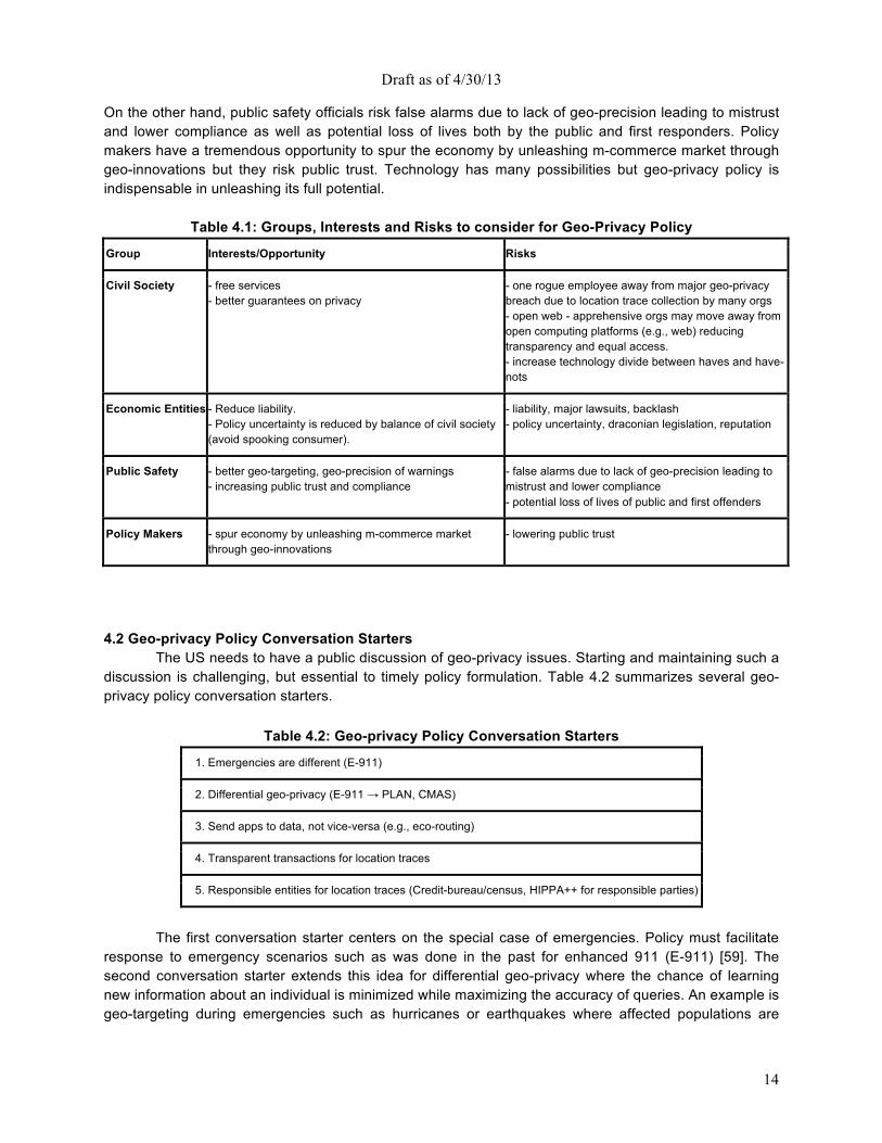
4.1 Geo-privacy Groups, Interests, and Risks Given the competing interests and risks among stakeholders, it is extremely challenging to develop geo-privacy policies acceptable to all groups. There is a need for deep conversations spanning these groups to identify common ground. We suggest a few possible approaches to start the conversation towards finding common ground. As summarized in Table 4.1, sustainable geo-privacy policy emerges from the balance of civil society, economic prosperity, public safety, and policy makers.
Geo-privacy policy affects civil society, economic prosperity, public safety, and policy makers. Civil society may reap the rewards of location-based services and other spatial computing related technologies while being provided with certain basic protections. Economic prosperity groups are concerned with reducing liability amid policy uncertainty. Geo-privacy policy is critical due to the increased consumer concern about intrusion into their daily lives and the mounting pressure on Internet giants such as Facebook, Google, and Microsoft to adjust to the new mobile world. For example, the New York Times (NYT) reported: “Making money will now depend on how deftly tech companies can track their users from their desktop computers to the phones in their palms and ultimately to the stores, cinemas and pizzerias where they spend their money. It will also depend on how consumers — and government regulators — will react to having every move monitored.” Public safety will benefit from improved geo-targeting and geo-precision during emergencies and increasing public trust and compliance.
Draft as of 4/30/13
14
On the other hand, public safety officials risk false alarms due to lack of geo-precision leading to mistrust and lower compliance as well as potential loss of lives both by the public and first responders. Policy makers have a tremendous opportunity to spur the economy by unleashing m-commerce market through geo-innovations but they risk public trust. Technology has many possibilities but geo-privacy policy is indispensable in unleashing its full potential.
Table 4.1: Groups, Interests and Risks to consider for Geo-Privacy Policy
Group Interests/Opportunity Risks
Civil Society - free services - better guarantees on privacy
- one rogue employee away from major geo-privacy breach due to location trace collection by many orgs - open web - apprehensive orgs may move away from open computing platforms (e.g., web) reducing transparency and equal access. - increase technology divide between haves and have-nots
Economic Entities - Reduce liability. - Policy uncertainty is reduced by balance of civil society (avoid spooking consumer).
- liability, major lawsuits, backlash - policy uncertainty, draconian legislation, reputation
Public Safety - better geo-targeting, geo-precision of warnings - increasing public trust and compliance
- false alarms due to lack of geo-precision leading to mistrust and lower compliance - potential loss of lives of public and first offenders
Policy Makers - spur economy by unleashing m-commerce market through geo-innovations
- lowering public trust
4.2 Geo-privacy Policy Conversation Starters
The US needs to have a public discussion of geo-privacy issues. Starting and maintaining such a discussion is challenging, but essential to timely policy formulation. Table 4.2 summarizes several geo-privacy policy conversation starters.
Table 4.2: Geo-privacy Policy Conversation Starters
1. Emergencies are different (E-911)
2. Differential geo-privacy (E-911 → PLAN, CMAS)
3. Send apps to data, not vice-versa (e.g., eco-routing)
4. Transparent transactions for location traces
5. Responsible entities for location traces (Credit-bureau/census, HIPPA++ for responsible parties)
The first conversation starter centers on the special case of emergencies. Policy must facilitate
response to emergency scenarios such as was done in the past for enhanced 911 (E-911) [59]. The second conversation starter extends this idea for differential geo-privacy where the chance of learning new information about an individual is minimized while maximizing the accuracy of queries. An example is geo-targeting during emergencies such as hurricanes or earthquakes where affected populations are
Draft as of 4/30/13
15
warned without the need to store their locations (e.g., the Commercial Mobile Alert System (CMAS)). The third conversation starter advocates sending applications to data on personal devices (e.g., cellphones, vehicle-embedded personal computers) instead of vice-versa, which has tremendous promise in facilitating fuel-saving eco-routing services as otherwise people may hesitate to send their GPS trace information to a third party. Geo-privacy risks are minimized assuming such applications are tested and certified to avoid data leaks. The fourth conversation starter is that of maintaining transparent transactions where information such as the location traces and volume of transactions are made available to an individual by entities that collect such information. Additionally, the purposes for which such information is collected should be specified up front (i.e., before or at collection) and the subsequent use of location traces should only be for the previously agreed upon purposes. The fifth conversation starter is the creation of responsible entities for storing location traces (e.g., the credit bureau or census) for publishing geo-statistics while protecting confidentiality. For example, geo-statistical data such as hourly population counts of different areas could be aggregated to support urban planning, traffic management, etc. The idea is to not widely distribute any of the GPS-tracks and instead “secure” the user’s personally identifying information, including location, in caches that are accessible by (and only by) trusted parties or applications that are sent to the data. This is a unique discipline, as it requires experts from both a data mining and security perspective. 4.3 Cross cutting benefits of geo-privacy policy
Policy makers have had a major impact on policies enabling spatial computing technology which have resulted in capabilities such as enhanced 911 (E-911) [59] for linking with appropriate public resources, GPS for use by the general public, and CMAS. Great opportunities lay ahead in the leveraging of users’ locations and expected routes in proactive services and assistance, ad impressions, and healthcare. Many of these benefits are evident from a 2011 McKinsey Global Institute report estimating savings of “about $600 billion annually by 2020” in terms of fuel and time saved [32] by helping vehicles avoid congestion and reduce idling at red lights or left turns. With proper geo-privacy policies in place, spatial computing may more effectively assist vehicles avoid congestion via next-generation routing services. Eco-routing may leverage various forms of Spatial Big Data to compare routes by fuel consumption or greenhouse gas emissions rather than total distance or travel-time. Policy makers have an opportunity to improve consumer confidence in the use of eco-routing by paving the way for the construction of a new generation of location based services while fully respecting the individual user privacy. Additionally, privacy policy would assist in strengthening cyber security by reliable location of Internet entities to support location-based security policies and mechanisms. 5. Final Considerations
Spatial computing promises an astonishing array of opportunities for researchers and entrepreneurs alike during the coming decade. However, societal impact needs to be taken into account. It is vital that US policymakers clarify users’ geo-privacy rights. Without that it will be difficult for spatial computing to achieve its full transformative potential. We must also acknowledge the unique and daunting computational challenges that working with spatio-temporal data poses.
Successfully harnessing the potential of these datasets will require significant US investment and funding of spatial computing research. Currently most spatial computing projects are too small to achieve the critical mass needed for major steps forward. It is Federal agencies need to strongly consider funding larger and bolder efforts involving a dozen or more faculty groups across multiple universities. Bolder ideas need to be pursued perhaps by leveraging existing mechanisms such as: NSF/CISE Expeditions in Computing, NSF Science and Technology Centers (STC), NSF Engineering Research Centers (ERC), US-DoD Multi-disciplinary University Research Initiative (MURI), NIH Program Project Grants (P01), US-
Draft as of 4/30/13
16
DoT University Transportation Centers (UTC), US-DoE Advanced Scientific Computing Research (ASCR) Centers, and US-DHS Centers of Excellence.
Furthermore, spatial computing scientists need more institutional support on their home campuses. Beyond one-time large grants, it will be necessary to institutionalize spatial computing research programs to leverage enduring opportunities as acknowledged by a large number of research universities establishing GIS centers (akin to computer centers of the 1960s) on campus to serve a broad range of research endeavors including climate change, public health, etc. NSF/CISE can establish computer science leadership in this emerging area of critical national importance by creating a dedicated enduring research program for spatial computing parallel to CNS, IIS, and CCF, given its cross-cutting reach.
A number of agencies have research initiatives in spatial computing (e.g., the National Cancer Institute's Spatial Uncertainty: Data, Modeling, and Communication, the National Geospatial-Intelligence Agency’s Academic Research Program (NARP)). However, spatial computing and the agencies themselves could benefit from multi-agency coordination to reduce competing projects and facilitate interdisciplinary and inter-agency research. Spatial computing has already proven itself as a major economic opportunity to our society and further spatial computing research can capitalize on a number of upcoming opportunities.
Draft as of 4/30/13
17
6. About this Document This document is a direct outcome of the CCC visioning workshop From GPS and Virtual Globes
to Spatial Computing-2020, held at the National Academies’ Keck Center, Sept. 10th-11th, 2012 and was created in response to the need to arrive at a convergence of interdisciplinary developments across geography, computer science, cognitive science, environmental science, etc. The workshop sought to promote a unified agenda for spatial computing research and development across U.S. agencies, industries (e.g., IBM, Microsoft, Oracle, Google, AT&T, Garmin, ESRI, UPS, Rockwell, Lockheed Martin, Navteq, etc.), and universities. The workshop program exhibited diversity across organizations (e.g., industry, academia, and government), disciplines (e.g., geography, computer science, cognitive science, environmental science, etc.), topics (e.g., science, service, system, and cross-cutting), and communities (e.g., ACM SIGSPATIAL, UCGIS, the National Research Council’s Mapping Science Committee, etc.).
The program consisted of opening remarks from the CCC and National Science Foundation (NSF) during which spatial computing was defined, and community consensus and the challenges of diversity were articulated. There was a panel on disruptive technologies (graphics and vision, interaction devices, LiDAR, GPS modernization, cell phones, indoor localization, internet localization, and cloud computing) as well as a panel on national priorities [comprising officials from the Department of Defense (DoD), Department of Energy (DoE), Department of Transportation's (DoT) Research and Innovative Technology Administration (RITA), National Institute of Environmental Health Sciences (NIEHS) within the National Institutes of Health (NIH), NASA, Department of Homeland Security (DHS) Science and Technology Directorate (S&T), and NSF's EarthCube, and chaired by White House Office of Science and Technology Policy (OSTP) Senior Advisor to the Director Henry Kelly]. The program featured breakout sessions grouped by SC science, system, services and cross-cutting areas. The workshop concluded with a synthesis and reflection during which the success in bringing multiple disparate communities together was acknowledged and missing topics (e.g., national grid reference systems, measurement databases, etc.) were identified.
We thank the Computing Community Consortium (CCC), including Erwin Gianchandani, Kenneth Hines and Hank Korth for guidance and valuable feedback. We thank Michael Evans, Dev Oliver, and Kim Koffolt for crucial contributions to the proposal, workshop organization, and report. We also thank the advising committee and the organizing committee for their direction and leadership.
Table 6.1: Organizing Committee Peggy Agouris, George Mason University
Walid Aref, Purdue University
Michael F. Goodchild, University of California Santa Barbara
Erik Hoel, Environmental Systems Research Institute (ESRI)
John Jensen, University of South Carolina
Craig A. Knoblock, University of Southern California
Richard Langley, University of New Brunswick
Ed Mikhail, Purdue University
Shashi Shekhar, University of Minnesota
Ouri Wolfson, University of Illinois at Chicago
May Yuan, University of Oklahoma
Draft as of 4/30/13
18
Appendix: Table of Contents
Appendix A: Contributors 19
Appendix B: Emerging Application Attributes 21
Appendix C: Representative Organizations 23
Appendix D: Representative Spatial Computer Science Questions 24
Appendix E: Emerging Platform Trends 26
Appendix F: Example Spaces of Interest to Spatial Computing 27
References 30
Draft as of 4/30/13
19
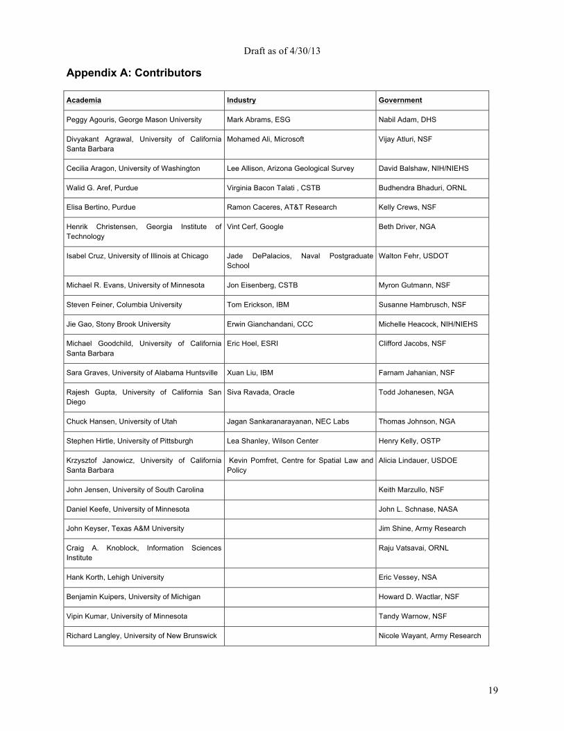
Appendix A: Contributors Academia Industry Government
Peggy Agouris, George Mason University Mark Abrams, ESG Nabil Adam, DHS
Divyakant Agrawal, University of California Santa Barbara
Mohamed Ali, Microsoft Vijay Atluri, NSF
Cecilia Aragon, University of Washington Lee Allison, Arizona Geological Survey David Balshaw, NIH/NIEHS
Walid G. Aref, Purdue Virginia Bacon Talati , CSTB Budhendra Bhaduri, ORNL
Elisa Bertino, Purdue Ramon Caceres, AT&T Research Kelly Crews, NSF
Henrik Christensen, Georgia Institute of Technology
Vint Cerf, Google Beth Driver, NGA
Isabel Cruz, University of Illinois at Chicago Jade DePalacios, Naval Postgraduate School
Walton Fehr, USDOT
Michael R. Evans, University of Minnesota Jon Eisenberg, CSTB Myron Gutmann, NSF
Steven Feiner, Columbia University Tom Erickson, IBM Susanne Hambrusch, NSF
Jie Gao, Stony Brook University Erwin Gianchandani, CCC Michelle Heacock, NIH/NIEHS
Michael Goodchild, University of California Santa Barbara
Eric Hoel, ESRI Clifford Jacobs, NSF
Sara Graves, University of Alabama Huntsville Xuan Liu, IBM Farnam Jahanian, NSF
Rajesh Gupta, University of California San Diego
Siva Ravada, Oracle Todd Johanesen, NGA
Chuck Hansen, University of Utah Jagan Sankaranarayanan, NEC Labs Thomas Johnson, NGA
Stephen Hirtle, University of Pittsburgh Lea Shanley, Wilson Center Henry Kelly, OSTP
Krzysztof Janowicz, University of California Santa Barbara
Kevin Pomfret, Centre for Spatial Law and Policy
Alicia Lindauer, USDOE
John Jensen, University of South Carolina Keith Marzullo, NSF
Daniel Keefe, University of Minnesota John L. Schnase, NASA
John Keyser, Texas A&M University Jim Shine, Army Research
Craig A. Knoblock, Information Sciences Institute
Raju Vatsavai, ORNL
Hank Korth, Lehigh University Eric Vessey, NSA
Benjamin Kuipers, University of Michigan Howard D. Wactlar, NSF
Vipin Kumar, University of Minnesota Tandy Warnow, NSF
Richard Langley, University of New Brunswick Nicole Wayant, Army Research

Draft as of 4/30/13
20
Chang-Tien Lu, Virginia Tech Mark Weiss, NSF
Dinesh Manocha, University of North Carolina Maria Zemankova, NSF
Edward M. Mikhail, Purdue Li Zhu, NIH/NCI
Harvey Miller, University of Utah
Joe Mundy, Brown University
Dev Oliver, University of Minnesota
Rahul Ramachandran, UA Huntsville
Norman Sadeh, CMU
Shashi Shekhar, University of Minnesota
Daniel Z. Sui, Ohio State
Roberto Tamassia, Brown University
Paul Torrens, University of Maryland
Shaowen Wang, University of Illinois at Urbana-Champaign
Greg Welch, University of North Carolina
Ouri E. Wolfson, University of Illinois at Chicago
Mike Worboys, University of Maine
May Yuan, University of Oklahoma
Avideh Zakhor, University of California Berkeley
Draft as of 4/30/13
21
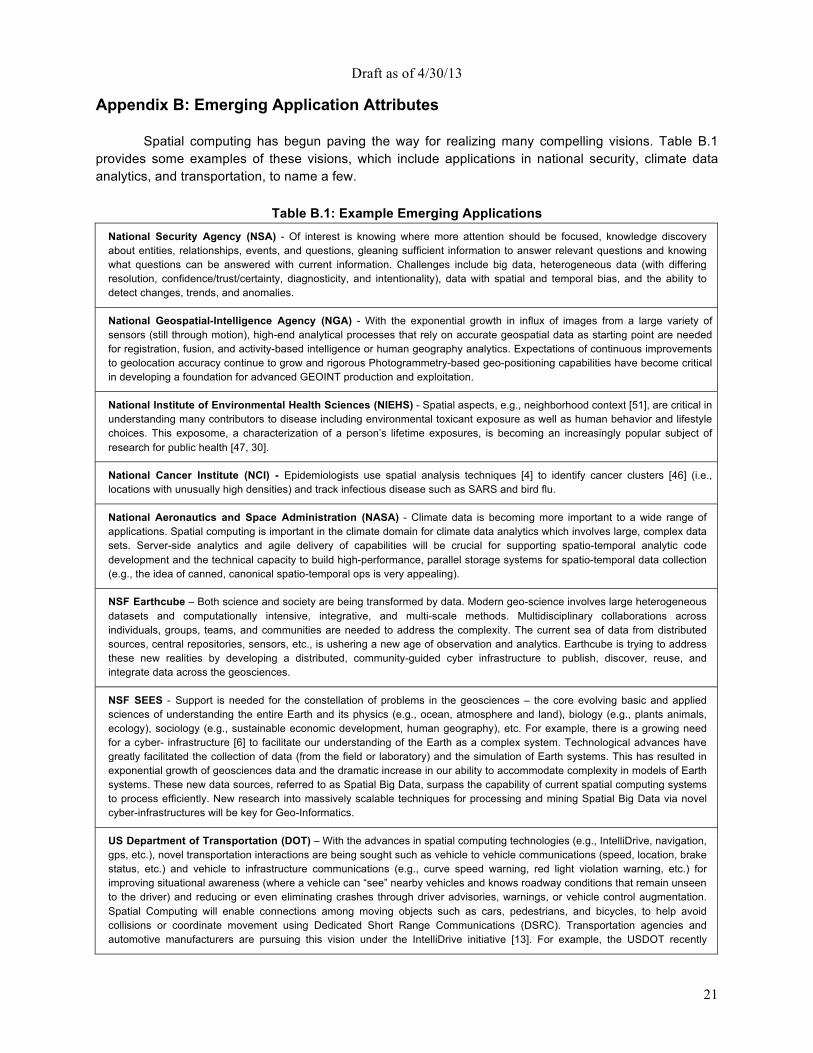
Appendix B: Emerging Application Attributes
Spatial computing has begun paving the way for realizing many compelling visions. Table B.1 provides some examples of these visions, which include applications in national security, climate data analytics, and transportation, to name a few.
Table B.1: Example Emerging Applications National Security Agency (NSA) - Of interest is knowing where more attention should be focused, knowledge discovery about entities, relationships, events, and questions, gleaning sufficient information to answer relevant questions and knowing what questions can be answered with current information. Challenges include big data, heterogeneous data (with differing resolution, confidence/trust/certainty, diagnosticity, and intentionality), data with spatial and temporal bias, and the ability to detect changes, trends, and anomalies.
National Geospatial-Intelligence Agency (NGA) - With the exponential growth in influx of images from a large variety of sensors (still through motion), high-end analytical processes that rely on accurate geospatial data as starting point are needed for registration, fusion, and activity-based intelligence or human geography analytics. Expectations of continuous improvements to geolocation accuracy continue to grow and rigorous Photogrammetry-based geo-positioning capabilities have become critical in developing a foundation for advanced GEOINT production and exploitation.
National Institute of Environmental Health Sciences (NIEHS) - Spatial aspects, e.g., neighborhood context [51], are critical in understanding many contributors to disease including environmental toxicant exposure as well as human behavior and lifestyle choices. This exposome, a characterization of a person’s lifetime exposures, is becoming an increasingly popular subject of research for public health [47, 30].
National Cancer Institute (NCI) - Epidemiologists use spatial analysis techniques [4] to identify cancer clusters [46] (i.e., locations with unusually high densities) and track infectious disease such as SARS and bird flu.
National Aeronautics and Space Administration (NASA) - Climate data is becoming more important to a wide range of applications. Spatial computing is important in the climate domain for climate data analytics which involves large, complex data sets. Server-side analytics and agile delivery of capabilities will be crucial for supporting spatio-temporal analytic code development and the technical capacity to build high-performance, parallel storage systems for spatio-temporal data collection (e.g., the idea of canned, canonical spatio-temporal ops is very appealing).
NSF Earthcube – Both science and society are being transformed by data. Modern geo-science involves large heterogeneous datasets and computationally intensive, integrative, and multi-scale methods. Multidisciplinary collaborations across individuals, groups, teams, and communities are needed to address the complexity. The current sea of data from distributed sources, central repositories, sensors, etc., is ushering a new age of observation and analytics. Earthcube is trying to address these new realities by developing a distributed, community-guided cyber infrastructure to publish, discover, reuse, and integrate data across the geosciences.
NSF SEES - Support is needed for the constellation of problems in the geosciences – the core evolving basic and applied sciences of understanding the entire Earth and its physics (e.g., ocean, atmosphere and land), biology (e.g., plants animals, ecology), sociology (e.g., sustainable economic development, human geography), etc. For example, there is a growing need for a cyber- infrastructure [6] to facilitate our understanding of the Earth as a complex system. Technological advances have greatly facilitated the collection of data (from the field or laboratory) and the simulation of Earth systems. This has resulted in exponential growth of geosciences data and the dramatic increase in our ability to accommodate complexity in models of Earth systems. These new data sources, referred to as Spatial Big Data, surpass the capability of current spatial computing systems to process efficiently. New research into massively scalable techniques for processing and mining Spatial Big Data via novel cyber-infrastructures will be key for Geo-Informatics.
US Department of Transportation (DOT) – With the advances in spatial computing technologies (e.g., IntelliDrive, navigation, gps, etc.), novel transportation interactions are being sought such as vehicle to vehicle communications (speed, location, brake status, etc.) and vehicle to infrastructure communications (e.g., curve speed warning, red light violation warning, etc.) for improving situational awareness (where a vehicle can “see” nearby vehicles and knows roadway conditions that remain unseen to the driver) and reducing or even eliminating crashes through driver advisories, warnings, or vehicle control augmentation. Spatial Computing will enable connections among moving objects such as cars, pedestrians, and bicycles, to help avoid collisions or coordinate movement using Dedicated Short Range Communications (DSRC). Transportation agencies and automotive manufacturers are pursuing this vision under the IntelliDrive initiative [13]. For example, the USDOT recently
Draft as of 4/30/13
22
announced a challenge to explore the question: “When vehicles talk to each other, what should they say?”, aiming to make driving safer and more efficient [1].
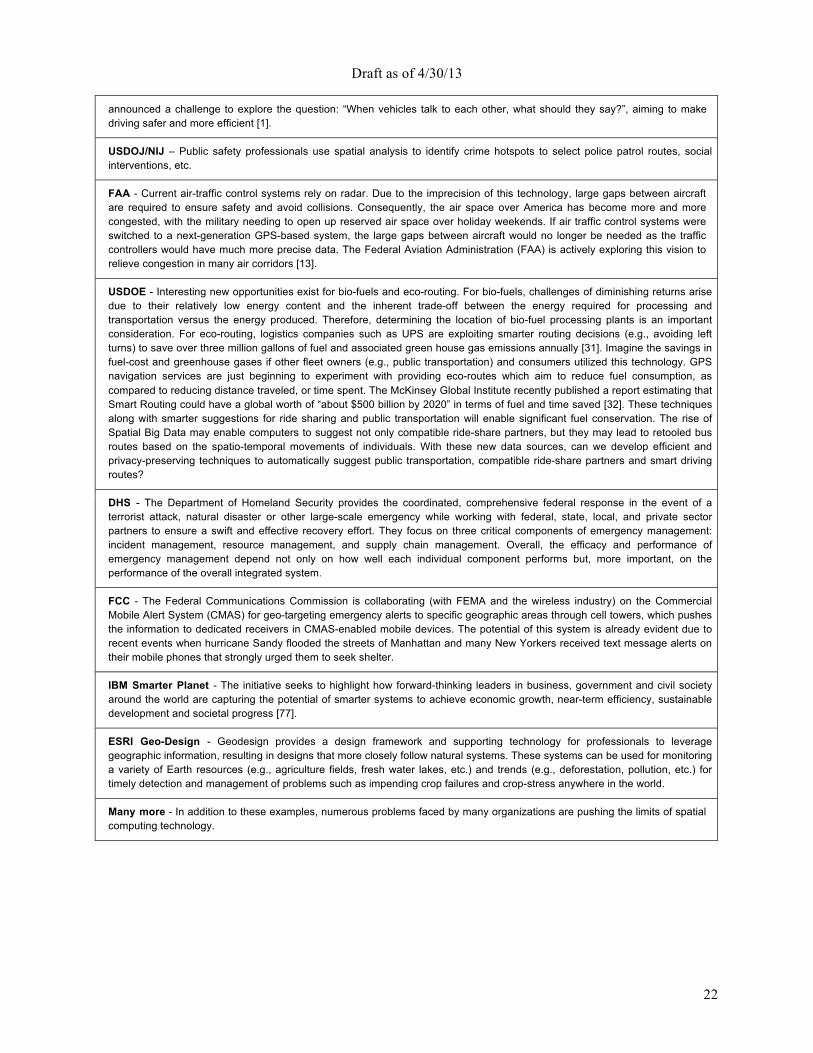
USDOJ/NIJ – Public safety professionals use spatial analysis to identify crime hotspots to select police patrol routes, social interventions, etc.
FAA - Current air-traffic control systems rely on radar. Due to the imprecision of this technology, large gaps between aircraft are required to ensure safety and avoid collisions. Consequently, the air space over America has become more and more congested, with the military needing to open up reserved air space over holiday weekends. If air traffic control systems were switched to a next-generation GPS-based system, the large gaps between aircraft would no longer be needed as the traffic controllers would have much more precise data. The Federal Aviation Administration (FAA) is actively exploring this vision to relieve congestion in many air corridors [13].
USDOE - Interesting new opportunities exist for bio-fuels and eco-routing. For bio-fuels, challenges of diminishing returns arise due to their relatively low energy content and the inherent trade-off between the energy required for processing and transportation versus the energy produced. Therefore, determining the location of bio-fuel processing plants is an important consideration. For eco-routing, logistics companies such as UPS are exploiting smarter routing decisions (e.g., avoiding left turns) to save over three million gallons of fuel and associated green house gas emissions annually [31]. Imagine the savings in fuel-cost and greenhouse gases if other fleet owners (e.g., public transportation) and consumers utilized this technology. GPS navigation services are just beginning to experiment with providing eco-routes which aim to reduce fuel consumption, as compared to reducing distance traveled, or time spent. The McKinsey Global Institute recently published a report estimating that Smart Routing could have a global worth of “about $500 billion by 2020” in terms of fuel and time saved [32]. These techniques along with smarter suggestions for ride sharing and public transportation will enable significant fuel conservation. The rise of Spatial Big Data may enable computers to suggest not only compatible ride-share partners, but they may lead to retooled bus routes based on the spatio-temporal movements of individuals. With these new data sources, can we develop efficient and privacy-preserving techniques to automatically suggest public transportation, compatible ride-share partners and smart driving routes?
DHS - The Department of Homeland Security provides the coordinated, comprehensive federal response in the event of a terrorist attack, natural disaster or other large-scale emergency while working with federal, state, local, and private sector partners to ensure a swift and effective recovery effort. They focus on three critical components of emergency management: incident management, resource management, and supply chain management. Overall, the efficacy and performance of emergency management depend not only on how well each individual component performs but, more important, on the performance of the overall integrated system.
FCC - The Federal Communications Commission is collaborating (with FEMA and the wireless industry) on the Commercial Mobile Alert System (CMAS) for geo-targeting emergency alerts to specific geographic areas through cell towers, which pushes the information to dedicated receivers in CMAS-enabled mobile devices. The potential of this system is already evident due to recent events when hurricane Sandy flooded the streets of Manhattan and many New Yorkers received text message alerts on their mobile phones that strongly urged them to seek shelter.
IBM Smarter Planet - The initiative seeks to highlight how forward-thinking leaders in business, government and civil society around the world are capturing the potential of smarter systems to achieve economic growth, near-term efficiency, sustainable development and societal progress [77].
ESRI Geo-Design - Geodesign provides a design framework and supporting technology for professionals to leverage geographic information, resulting in designs that more closely follow natural systems. These systems can be used for monitoring a variety of Earth resources (e.g., agriculture fields, fresh water lakes, etc.) and trends (e.g., deforestation, pollution, etc.) for timely detection and management of problems such as impending crop failures and crop-stress anywhere in the world.
Many more - In addition to these examples, numerous problems faced by many organizations are pushing the limits of spatial computing technology.
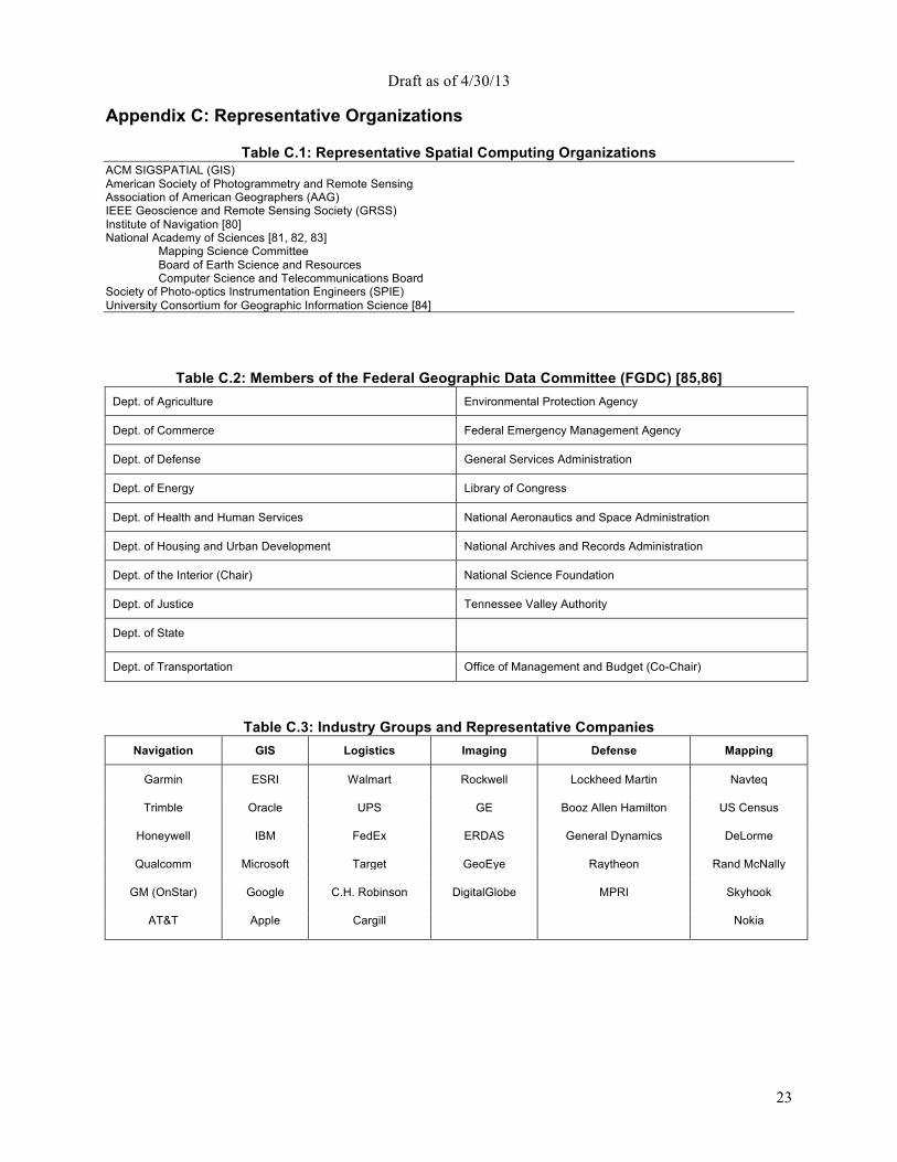
Draft as of 4/30/13
23
Appendix C: Representative Organizations
Table C.1: Representative Spatial Computing Organizations ACM SIGSPATIAL (GIS) American Society of Photogrammetry and Remote Sensing Association of American Geographers (AAG) IEEE Geoscience and Remote Sensing Society (GRSS) Institute of Navigation [80] National Academy of Sciences [81, 82, 83]
Mapping Science Committee Board of Earth Science and Resources Computer Science and Telecommunications Board
Society of Photo-optics Instrumentation Engineers (SPIE) University Consortium for Geographic Information Science [84]
Table C.2: Members of the Federal Geographic Data Committee (FGDC) [85,86] Dept. of Agriculture Environmental Protection Agency
Dept. of Commerce Federal Emergency Management Agency
Dept. of Defense General Services Administration
Dept. of Energy Library of Congress
Dept. of Health and Human Services National Aeronautics and Space Administration
Dept. of Housing and Urban Development National Archives and Records Administration
Dept. of the Interior (Chair) National Science Foundation
Dept. of Justice Tennessee Valley Authority
Dept. of State
Dept. of Transportation Office of Management and Budget (Co-Chair)
Table C.3: Industry Groups and Representative Companies Navigation GIS Logistics Imaging Defense Mapping
Garmin ESRI Walmart Rockwell Lockheed Martin Navteq
Trimble Oracle UPS GE Booz Allen Hamilton US Census
Honeywell IBM FedEx ERDAS General Dynamics DeLorme
Qualcomm Microsoft Target GeoEye Raytheon Rand McNally
GM (OnStar) Google C.H. Robinson DigitalGlobe MPRI Skyhook
AT&T Apple Cargill Nokia
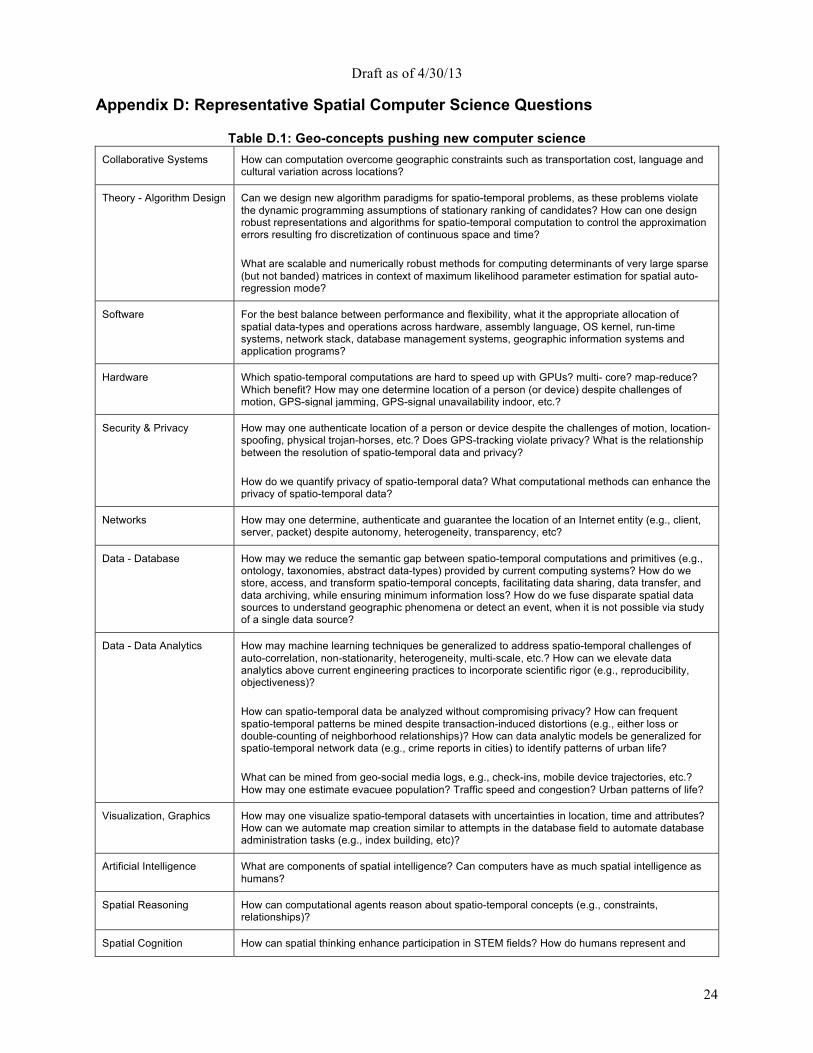
Draft as of 4/30/13
24
Appendix D: Representative Spatial Computer Science Questions
Table D.1: Geo-concepts pushing new computer science Collaborative Systems How can computation overcome geographic constraints such as transportation cost, language and
cultural variation across locations?
Theory - Algorithm Design Can we design new algorithm paradigms for spatio-temporal problems, as these problems violate the dynamic programming assumptions of stationary ranking of candidates? How can one design robust representations and algorithms for spatio-temporal computation to control the approximation errors resulting fro discretization of continuous space and time? What are scalable and numerically robust methods for computing determinants of very large sparse (but not banded) matrices in context of maximum likelihood parameter estimation for spatial auto-regression mode?
Software For the best balance between performance and flexibility, what it the appropriate allocation of spatial data-types and operations across hardware, assembly language, OS kernel, run-time systems, network stack, database management systems, geographic information systems and application programs?
Hardware Which spatio-temporal computations are hard to speed up with GPUs? multi- core? map-reduce? Which benefit? How may one determine location of a person (or device) despite challenges of motion, GPS-signal jamming, GPS-signal unavailability indoor, etc.?
Security & Privacy How may one authenticate location of a person or device despite the challenges of motion, location-spoofing, physical trojan-horses, etc.? Does GPS-tracking violate privacy? What is the relationship between the resolution of spatio-temporal data and privacy? How do we quantify privacy of spatio-temporal data? What computational methods can enhance the privacy of spatio-temporal data?
Networks How may one determine, authenticate and guarantee the location of an Internet entity (e.g., client, server, packet) despite autonomy, heterogeneity, transparency, etc?
Data - Database How may we reduce the semantic gap between spatio-temporal computations and primitives (e.g., ontology, taxonomies, abstract data-types) provided by current computing systems? How do we store, access, and transform spatio-temporal concepts, facilitating data sharing, data transfer, and data archiving, while ensuring minimum information loss? How do we fuse disparate spatial data sources to understand geographic phenomena or detect an event, when it is not possible via study of a single data source?
Data - Data Analytics How may machine learning techniques be generalized to address spatio-temporal challenges of auto-correlation, non-stationarity, heterogeneity, multi-scale, etc.? How can we elevate data analytics above current engineering practices to incorporate scientific rigor (e.g., reproducibility, objectiveness)? How can spatio-temporal data be analyzed without compromising privacy? How can frequent spatio-temporal patterns be mined despite transaction-induced distortions (e.g., either loss or double-counting of neighborhood relationships)? How can data analytic models be generalized for spatio-temporal network data (e.g., crime reports in cities) to identify patterns of urban life? What can be mined from geo-social media logs, e.g., check-ins, mobile device trajectories, etc.? How may one estimate evacuee population? Traffic speed and congestion? Urban patterns of life?
Visualization, Graphics How may one visualize spatio-temporal datasets with uncertainties in location, time and attributes? How can we automate map creation similar to attempts in the database field to automate database administration tasks (e.g., index building, etc)?
Artificial Intelligence What are components of spatial intelligence? Can computers have as much spatial intelligence as humans?
Spatial Reasoning How can computational agents reason about spatio-temporal concepts (e.g., constraints, relationships)?
Spatial Cognition How can spatial thinking enhance participation in STEM fields? How do humans represent and

Draft as of 4/30/13
25
learn cognitive maps? What is impact of GPS devices on human learning? What is the SC impact of changing to a mobile ego-centric frame of reference from an earth-centric frame such as latitude, longitude, and altitude?
Human Computer Interaction
How can user interfaces exploit the new generation of miniature depth cameras that will be integrated with mobile and wearable devices? What kinds of interaction tasks can be performed more efficiently and more accurately with these systems? How can ubiquitous interactive room-scale scanning and tracking systems change the way in which we interact with computers and each other? How can we create user interfaces that bridge the gap between spatial computing "in the small" (typically on indoor desktop systems with stereo displays and precise 3D tracking) and spatial computing "in the large" (typically outdoors using coarse GNSS on mobile/wearable devices)?
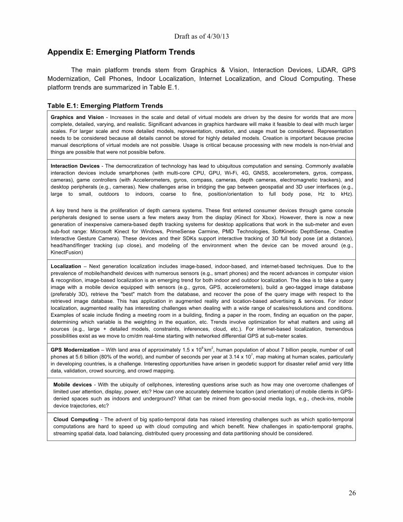
Draft as of 4/30/13
26
Appendix E: Emerging Platform Trends
The main platform trends stem from Graphics & Vision, Interaction Devices, LiDAR, GPS Modernization, Cell Phones, Indoor Localization, Internet Localization, and Cloud Computing. These platform trends are summarized in Table E.1. Table E.1: Emerging Platform Trends
Graphics and Vision - Increases in the scale and detail of virtual models are driven by the desire for worlds that are more complete, detailed, varying, and realistic. Significant advances in graphics hardware will make it feasible to deal with much larger scales. For larger scale and more detailed models, representation, creation, and usage must be considered. Representation needs to be considered because all details cannot be stored for highly detailed models. Creation is important because precise manual descriptions of virtual models are not possible. Usage is critical because processing with new models is non-trivial and things are possible that were not possible before.
Interaction Devices - The democratization of technology has lead to ubiquitous computation and sensing. Commonly available interaction devices include smartphones (with multi-core CPU, GPU, Wi-Fi, 4G, GNSS, accelerometers, gyros, compass, cameras), game controllers (with Accelerometers, gyros, compass, cameras, depth cameras, electromagnetic trackers), and desktop peripherals (e.g., cameras). New challenges arise in bridging the gap between geospatial and 3D user interfaces (e.g., large to small, outdoors to indoors, coarse to fine, position/orientation to full body pose, Hz to kHz).
A key trend here is the proliferation of depth camera systems. These first entered consumer devices through game console peripherals designed to sense users a few meters away from the display (Kinect for Xbox). However, there is now a new generation of inexpensive camera-based depth tracking systems for desktop applications that work in the sub-meter and even sub-foot range: Microsoft Kinect for Windows, PrimeSense Carmine, PMD Technologies, SoftKinetic DepthSense, Creative Interactive Gesture Camera). These devices and their SDKs support interactive tracking of 3D full body pose (at a distance), head/hand/finger tracking (up close), and modeling of the environment when the device can be moved around (e.g., KinectFusion)
Localization – Next generation localization includes image-based, indoor-based, and internet-based techniques. Due to the prevalence of mobile/handheld devices with numerous sensors (e.g., smart phones) and the recent advances in computer vision & recognition, image-based localization is an emerging trend for both indoor and outdoor localization. The idea is to take a query image with a mobile device equipped with sensors (e.g., gyros, GPS, accelerometers), build a geo-tagged image database (preferably 3D), retrieve the "best" match from the database, and recover the pose of the query image with respect to the retrieved image database. This has application in augmented reality and location-based advertising & services. For indoor localization, augmented reality has interesting challenges when dealing with a wide range of scales/resolutions and conditions. Examples of scale include finding a meeting room in a building, finding a paper in the room, finding an equation on the paper, determining which variable is the weighting in the equation, etc. Trends involve optimization for what matters and using all sources (e.g., large + detailed models, constraints, inferences, cloud, etc.). For internet-based localization, tremendous possibilities exist as we move to cm/dm real-time starting with networked differential GPS at sub-meter scales.
GPS Modernization – With land area of approximately 1.5 x 10⁸ km2, human population of about 7 billion people, number of cell phones at 5.6 billion (80% of the world), and number of seconds per year at 3.14 x 10⁷, map making at human scales, particularly in developing countries, is a challenge. Interesting opportunities have arisen in geodetic support for disaster relief amid very little data, validation, crowd sourcing, and crowd mapping.
Mobile devices - With the ubiquity of cellphones, interesting questions arise such as how may one overcome challenges of limited user attention, display, power, etc? How can one accurately determine location (and orientation) of mobile clients in GPS-denied spaces such as indoors and underground? What can be mined from geo-social media logs, e.g., check-ins, mobile device trajectories, etc?
Cloud Computing - The advent of big spatio-temporal data has raised interesting challenges such as which spatio-temporal computations are hard to speed up with cloud computing and which benefit. New challenges in spatio-temporal graphs, streaming spatial data, load balancing, distributed query processing and data partitioning should be considered.
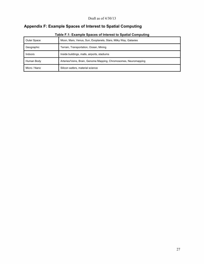
Draft as of 4/30/13
27
Appendix F: Example Spaces of Interest to Spatial Computing
Table F.1: Example Spaces of Interest to Spatial Computing Outer Space Moon, Mars, Venus, Sun, Exoplanets, Stars, Milky Way, Galaxies
Geographic Terrain, Transportation, Ocean, Mining
Indoors Inside buildings, malls, airports, stadiums
Human Body Arteries/Veins, Brain, Genome Mapping, Chromosomes, Neuromapping
Micro / Nano Silicon wafers, material science
Draft as of 4/30/13
28
References [1] Department of Transportation. Connected Vehicle Technology Challenge. http://goo.gl/fP8nd, 2011. [2] S. Abdallah, S. Thompson, J. Michaelson, N. Marks, N. Steuer, et al. The Happy Planet Index 2.0: Why good lives don’t have to cost the Earth. London: nef (the new economics foundation), 2009. [3] Advances in Spatial and Temporal Databases: 12th International Symposium, SSTD 2011. Challenge and Vision Track. Springer. http://sstd2011.cs.umn.edu/, 2011. LNCS 6849. [4] A. AH, G. SY, M. C, and D. R. AV. A review of spatial methods in epidemiology, 2000-2010. Annual review of public health, 33:107-22, 2012. [5] ArcWatch. Designing GeoDesign. http://goo.gl/j31OV, 2011. [6] D. Atkins. Revolutionizing science and engineering through cyberinfrastructure: Report of the national science foundation blue-ribbon advisory panel on cyberinfrastructure. 2003. [7] J. Bruder. In Groupon’s $6 Billion Wake, a Fleet of Start-Ups. http://goo.gl/bO0Er, 2011. NY Times. [8] CCC. Discovery and Innovation in Health IT. http://cra.org/ccc/healthit.php, 2009. [9] J. Clapper. Geospatial-intelligence basic doctrine. National Geospatial Intelligence Agency, 2004. [10] J. Dobson and P. Fisher. Geoslavery. Technology and Society Magazine, IEEE, 22(1):47-52, 2003. [11] D. M. Ewalt. Google is everywhere. http://goo.gl/U7iJC, 2005. Forbes. [12] M. Faulkner, M. Olson, R. Chandy, J. Krause, K. Chandy, and A. Krause. The next big one: Detecting earthquakes and other rare events from community-based sensors. In Information Processing in Sensor Networks (IPSN), 2011 10th International Conference on, pages 13-24. IEEE, 2011. [13] Federal Aviation Administration. Next Generation Air Transportation System. http://goo.gl/Xme87. [14] Federal Highway Administration. IntelliDrive: Safer. Smarter. Greener. http://goo.gl/54rBe, 2011. Publication Number: FHWA-HRT-10-004. [15] P. Folger. Geospatial information and geographic information systems (GIS): Current issues and future challenges. DIANE Publishing, 2010. Congressional Research Service. [16] V. Gewin. Mapping opportunities. Nature, 427(6972):376-377, 2004. [17] E. Gianchandani. SSTD 2011 Vision & Challenge Track Winners Announced. http://goo.gl/ercG6, 2011. The Computing Community Consortium Blog. [18] A. Gore. The digital earth: Understanding our planet in the 21st century, given at the California science center, Los Angeles, California, on january 31, 1998, 1998. [19] V. Gunturi, E. Nunes, K. Yang, and S. Shekhar. A critical-time-point approach to all-start-time lagrangian shortest paths: a summary of results. Proc. SSTD, 2011. [20] L. Hornby. China unveils its own version of google earth. http://goo.gl/JzE2W, 2010. Reuters. [21] Inside GNSS. GNSS Systems Reports. http://goo.gl/uh8f4, 2011. [22] Institute of Navigation. http://goo.gl/quqSX. [23] E. F. Jerome C. Glenn, Theodore J. Gordon. State of the Future. The Millennium Project, 2011. [24] E. Kamar, E. Horvitz, and C. Meek. Mobile opportunistic commerce: mechanisms, architecture, and application. In Proceedings of the 7th international joint conference on Autonomous agents and multiagent systems-Volume 2, pages 1087-1094. International Foundation for Autonomous Agents and Multiagent Systems, 2008. [25] A. S. Kathryn Zickuhr. 28% of American adults use mobile and social location-based services. http://goo.gl/atyd8, 2011. Pew Internet. [26] J. L. Ki-Joune Li. Indoor spatial awareness initiative and standard for indoor spatial data. Proceedings of IROS 2010 Workshop on Standardization for Service Robot, 2010. Taiwan. [27] A. Krause, E. Horvitz, A. Kansal, and F. Zhao. Toward community sensing. In Proceedings of the 7th international conference on Information processing in sensor networks, pages 481-492. IEEE Computer Society, 2008. [28] J. Krumm. A survey of computational location privacy. Personal and Ubiquitous Computing, 13(6):391-399, 2009. [29] G. Lindsay. Cisco's big bet on new Songdo: Creating cities from scratch. http://goo.gl/2huIc, 2010. [30] P. Lioy and S. Rappaport. Exposure science and the exposome: an opportunity for coherence in the environmental health sciences. Environmental health perspectives, 119(11):a466, 2011. [31] J. Lovell. Left-hand-turn elimination. http://goo.gl/3bkPb, 2007. New York Times. [32] J. Manyika et al. Big data: The next frontier for innovation, competition and productivity. McKinsey Global Institute, May, 2011. [33] R. McMaster and E. Usery. A research agenda for geographic information science, volume 3. CRC Press, 2005. University Consortium for Geographic Information Science. [34] National Institutes of Health (NIH). Spatial Uncertainty: Data, Modeling, and Communication (R01). http://grants.nih.gov/grants/guide/pa-files/PA-11-238.html, 2011. [35] National Research Council. IT roadmap to a geospatial future. National Academies Press, 2003. [36] National Research Council. Priorities for GEOINT research at the National geospatial-intelligence agency. National Academies Press, 2006. ISBN: 9780309101493. [37] National Research Council. Successful Response Starts with a Map: Improving Geospatial Support for Disaster Management. National Academies Press, 2007. ISBN: 0309103401 / 0-309-10340-1.
Draft as of 4/30/13
29
[38] National Research Council. New Research Directions for the National Geospatial-Intelligence Agency. National Academies Press, 2010. ISBN: 0309158656 / 0-309-15865-6. [39] National Research Council. Understanding the changing planet: Strategic directions for the geographical sciences. National Academies Press, 2010. ISBN: 9780309150750. [40] New York Times. IBM Starts to Build Greener, 'Smarter' Planet in Iowa. http://goo.gl/BhGZu, 2009. [41] New York Times. Digital Help for Haiti. http://goo.gl/yYn66, 2010. [42] New York Times. Justices Say GPS Tracker Violated Privacy Rights. http://www.nytimes.com/2012/ 01/24/us/police-use-of-gps-is-ruled-unconstitutional.html, 2011. [43] NSF. Earth Cube. http://www.nsf.gov/geo/earthcube/, 2011. [44] Office of Management and Budget. Coordination of Geographic Information and Related Spatial Data Activities. http://goo.gl/9n5tm, 2010. [45] D. Oliver and D. Steinberger. From geography to medicine: exploring innerspace via spatial and temporal databases. Advances in Spatial and Temporal Databases, pages 467-470, 2011. [46] L. Pickle, M. Szczur, D. Lewis, and D. Stinchcomb. The crossroads of GIS and health information: a workshop on developing a research agenda to improve cancer control. International journal of health geographics, 5(1):51, 2006. [47] S. Rappaport. Implications of the exposome for exposure science. Journal of Exposure Science and Environmental Epidemiology, 21(1):5-9, 2010. [48] J. Schiller and A. Voisard. Location-based services. Morgan Kaufmann, 2004. [49] S. Shekhar, M. R. Evans, J. M. Kang, and P. Mohan. Identifying patterns in spatial information: A survey of methods. Wiley Interdisc. Rew.: Data Mining and Knowledge Discovery, 1(3):193-214, 2011. [50] S. Shekhar and H. Xiong. Encyclopedia of GIS. Springer, New York, 2008. [51] Y. Thomas, D. Richardson, and I. Cheung. Geography and drug addiction. Springer Verlag, 2009. [52] United States Air Force. GPS III. http://www.losangeles.af.mil/library/factsheets/factsheet.asp?id=18830, 2011. [53] Waze Mobile. http://www.waze.com/. [54] Wikipedia. Google goggles. Wikipedia, the free encyclopedia, 2012. [Online; accessed 20-August-2012]. [55] T. Yuan and W. Kuo. Spatial defect pattern recognition on semiconductor wafers using model-based clustering and bayesian inference. European Journal of Operational Research, 190(1):228-240, 2008. [56] S. Feiner, The importance of being mobile: Some social consequences of wearable augmented reality systems, Proc. IEEE Int. Workshop on Augmented Reality 1999, http://dx.doi.org/10.1109/IWAR.1999.803815 [57] Waller, D. & Nadel, L. (Eds). (2012). Handbook of Spatial Cognition. Washington, DC: APA Press. [58] National Science Board. (2010). Preparing the next generation of STEM innovators: Identifying and developing our nation's human capital (Report N. NSB-10-33). Retrieved from http://www.nsf.gov/nsb/stem/innovators.jsp [59] Enhanced 9-1-1, http://en.wikipedia.org/wiki/Enhanced_9-1-1 [60] The New York Times, “In Mobile World, Tech Giants Scramble to Get Up to Speed”, October 22, 2012, http://goo.gl/4vOss [61] K. Janowicz and P. Hitzler (2012): The Digital Earth as Knowledge Engine. Semantic Web Journal, 3(3), pp. 213-221. [62] C. Schlieder: Digital heritage: Semantic challenges of long-term preservation. Semantic Web 1(1-2): 143-147 (2010) [63] Michael T. Goodrich, Duy Nguyen, Olga Ohrimenko, Charalampos Papamanthou, Roberto Tamassia, Nikos Triandopoulos, Cristina Videira Lopes: Efficient Verification of Web-Content Searching Through Authenticated Web Crawlers. PVLDB 5(1), 920-931, 2012. [64] Cynthia Dwork: A firm foundation for private data analysis. Commun. ACM 54(1), 86-95, 2011. [65] Michael T. Goodrich, Michael Mitzenmacher, Olga Ohrimenko, Roberto Tamassia: Privacy-preserving group data access via stateless oblivious RAM simulation. SODA, 157-167, 2012. [66] E. Bertini, D. Lalann: Investigating and reflecting on the integration of automatic data analysis and visualization in knowledge discovery. ACM SIGKDD Explorations Newsletter, Vol. 11, No. 2, pp. 9-18, 2010. [67] Isabel F. Cruz, Matteo Palmonari, Federico Caimi, Cosmin Stroe:Towards ''On the Go'' Matching of Linked Open Data Ontologies,'' IJCAI Workshop Discovering Meaning On the Go in Large & Heterogeneous Data (LHD-11), pp. 37-42, 2011. [68] Maria Luisa Damiani, Elisa Bertino, Barbara Catania, and Paolo Perlasca: GEO-RBAC: A Spatially Aware RBAC, ACM Transactions on Information and System Security (TISSEC), Volume 10, Issue 1, February 2007. [69] Isabel F. Cruz, Rigel Gjomemo, Benjamin Lin and Mirko Orsini: A Constraint and Attribute Based Security Framework for Dynamic Role Assignment in Collaborative Environments, CollaborateCom, Springer, pages 322-339, 2008 [70] Google. Map layers for Hurricane Sandy, Google CrisisMap. http://google.org/crisismap/sandy-2012. 2012. [71] Stereotactic surgery, Wikipedia, http://goo.gl/dDa6C [72] Chin, Lawrence S., and William F. Regine, eds. Principles and practice of stereotactic radiosurgery. Springer, 2008. [73] Huffingon Post, Google Earth Celebrates 1 Billion Downloads With A New Site, http://www.huffingtonpost.com/2011/10/05/google-earth-celebrates-1_n_995824.html, Accessed on January 15, 2013 [74] PCMag.com, Smartphone Shipments Surpass PCs for First Time. What's Next? http://www.pcmag.com/article2/0,2817,2379665,00.asp, Accessed January 15, 2013 [75] Montello, D. R. (2001). Spatial cognition. In N. J. Smelser & P. B. Baltes (Eds.), International Encyclopedia of the Social & Behavioral Sciences (pp. 14771-14775). Oxford: Pergamon Press. [76] SBIR. Developing Capabilities for the Visualization and Analysis of Qualitative Data within Geographic Information Systems. A10-108 (Army).
Draft as of 4/30/13
30
[77] Smarter Planet. (2013, January 10). In Wikipedia, The Free Encyclopedia. Retrieved 15:49, January 18, 2013, from http://en.wikipedia.org/w/index.php?title=Smarter_Planet& oldid=532336184 [78] Tobler W., (1970) "A computer movie simulating urban growth in the Detroit region". Economic Geography, 46(2): 234-240. [79] Uttal, D. & Cohen, C., Spatial thinking and STEM education: When, why and how?, Psychology of Learning and Motivation (B. Ross, Ed.), 2012 [80] Institute of Navigation. http://goo.gl/quqSX. [81] National Research Council. IT roadmap to a geospatial future. National Academies Press, 2003. [82] National Research Council. Priorities for GEOINT research at the National Geospatial-intelligence Agency. National Academies Press, 2006. ISBN: 9780309101493. [83] National Research Council. New Research Directions for the National Geospatial-Intelligence Agency. National Academies Press, 2010. ISBN: 0309158656 / 0-309-15865-6. [84] R. McMaster and E. Usery. A research agenda for geographic information science, volume 3. CRC Press, 2005. University Consortium for Geographic Information Science. [85] P. Folger. Geospatial information and geographic information systems (GIS): Current issues and future challenges. DIANE Publishing, 2010. Congressional Research Service. [86] Office of Management and Budget. Coordination of Geographic Information and Related Spatial Data Activities. http://goo.gl/9n5tm, 2010. [87] J. Heinzelman, and C. Waters, Crowdsourcing Crisis Information in Disaster-Affected Haiti, US Inst. of Peace, 2010. [88] European commission. Regulation of the European parliament and of the council. Brussels, 25.1.2012. [89] Stephen B. Wicker. 2012. The loss of location privacy in the cellular age. Commun. ACM 55, 8 (August 2012), 60-68. DOI=10.1145/2240236.2240255 [90] Pomfret, Kevin. GeoTargeted Alerts: Potential Impact of Privacy Concerns. National Academy of Sciences. Washington D.C. February 21st, 2013. http://www.spatiallaw.com/Uploads/Privacy_talk.pdf [91] Har Peled, S. Geometric approximation algorithms. (2011). American Mathematical Society.