Embed Size (px)
Citation preview
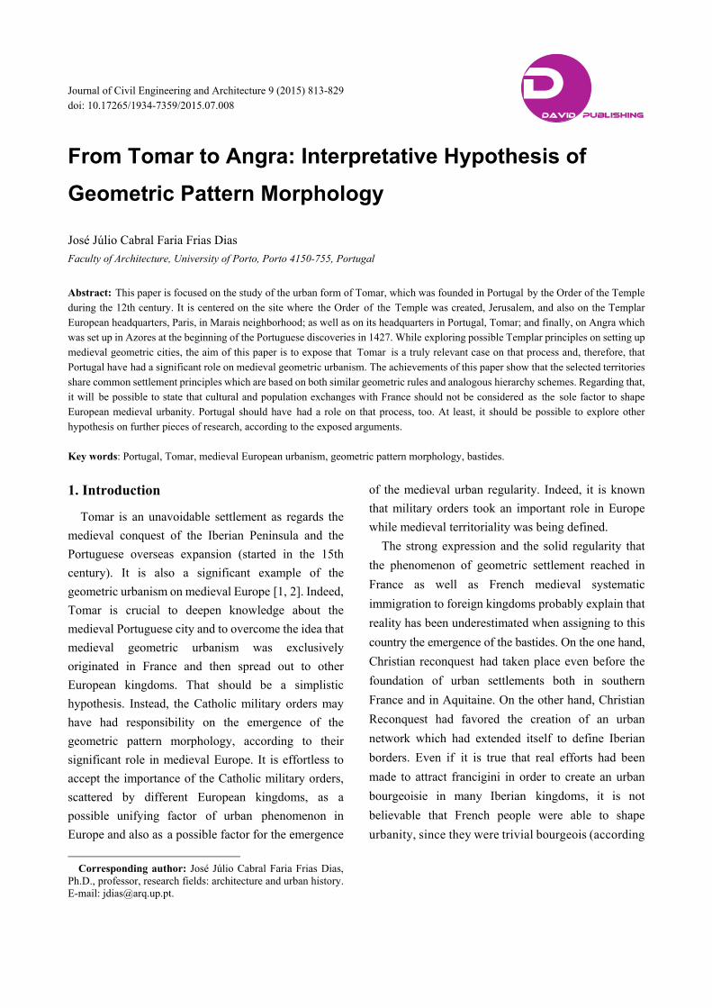
Journal of Civil Engineering and Architecture 9 (2015) 813-829 doi: 10.17265/1934-7359/2015.07.008
From Tomar to Angra: Interpretative Hypothesis of
Geometric Pattern Morphology
José Júlio Cabral Faria Frias Dias
Faculty of Architecture, University of Porto, Porto 4150-755, Portugal
Abstract: This paper is focused on the study of the urban form of Tomar, which was founded in Portugal by the Order of the Temple during the 12th century. It is centered on the site where the Order of the Temple was created, Jerusalem, and also on the Templar European headquarters, Paris, in Marais neighborhood; as well as on its headquarters in Portugal, Tomar; and finally, on Angra which was set up in Azores at the beginning of the Portuguese discoveries in 1427. While exploring possible Templar principles on setting up medieval geometric cities, the aim of this paper is to expose that Tomar is a truly relevant case on that process and, therefore, that Portugal have had a significant role on medieval geometric urbanism. The achievements of this paper show that the selected territories share common settlement principles which are based on both similar geometric rules and analogous hierarchy schemes. Regarding that, it will be possible to state that cultural and population exchanges with France should not be considered as the sole factor to shape European medieval urbanity. Portugal should have had a role on that process, too. At least, it should be possible to explore other hypothesis on further pieces of research, according to the exposed arguments. Key words: Portugal, Tomar, medieval European urbanism, geometric pattern morphology, bastides.
1. Introduction
Tomar is an unavoidable settlement as regards the
medieval conquest of the Iberian Peninsula and the
Portuguese overseas expansion (started in the 15th
century). It is also a significant example of the
geometric urbanism on medieval Europe [1, 2]. Indeed,
Tomar is crucial to deepen knowledge about the
medieval Portuguese city and to overcome the idea that
medieval geometric urbanism was exclusively
originated in France and then spread out to other
European kingdoms. That should be a simplistic
hypothesis. Instead, the Catholic military orders may
have had responsibility on the emergence of the
geometric pattern morphology, according to their
significant role in medieval Europe. It is effortless to
accept the importance of the Catholic military orders,
scattered by different European kingdoms, as a
possible unifying factor of urban phenomenon in
Europe and also as a possible factor for the emergence
Corresponding author: José Júlio Cabral Faria Frias Dias,
Ph.D., professor, research fields: architecture and urban history. E-mail: [email protected].
of the medieval urban regularity. Indeed, it is known
that military orders took an important role in Europe
while medieval territoriality was being defined.
The strong expression and the solid regularity that
the phenomenon of geometric settlement reached in
France as well as French medieval systematic
immigration to foreign kingdoms probably explain that
reality has been underestimated when assigning to this
country the emergence of the bastides. On the one hand,
Christian reconquest had taken place even before the
foundation of urban settlements both in southern
France and in Aquitaine. On the other hand, Christian
Reconquest had favored the creation of an urban
network which had extended itself to define Iberian
borders. Even if it is true that real efforts had been
made to attract francigini in order to create an urban
bourgeoisie in many Iberian kingdoms, it is not
believable that French people were able to shape
urbanity, since they were trivial bourgeois (according
D DAVID PUBLISHING
From Tomar to Angra: Interpretative Hypothesis of Geometric Pattern Morphology
814
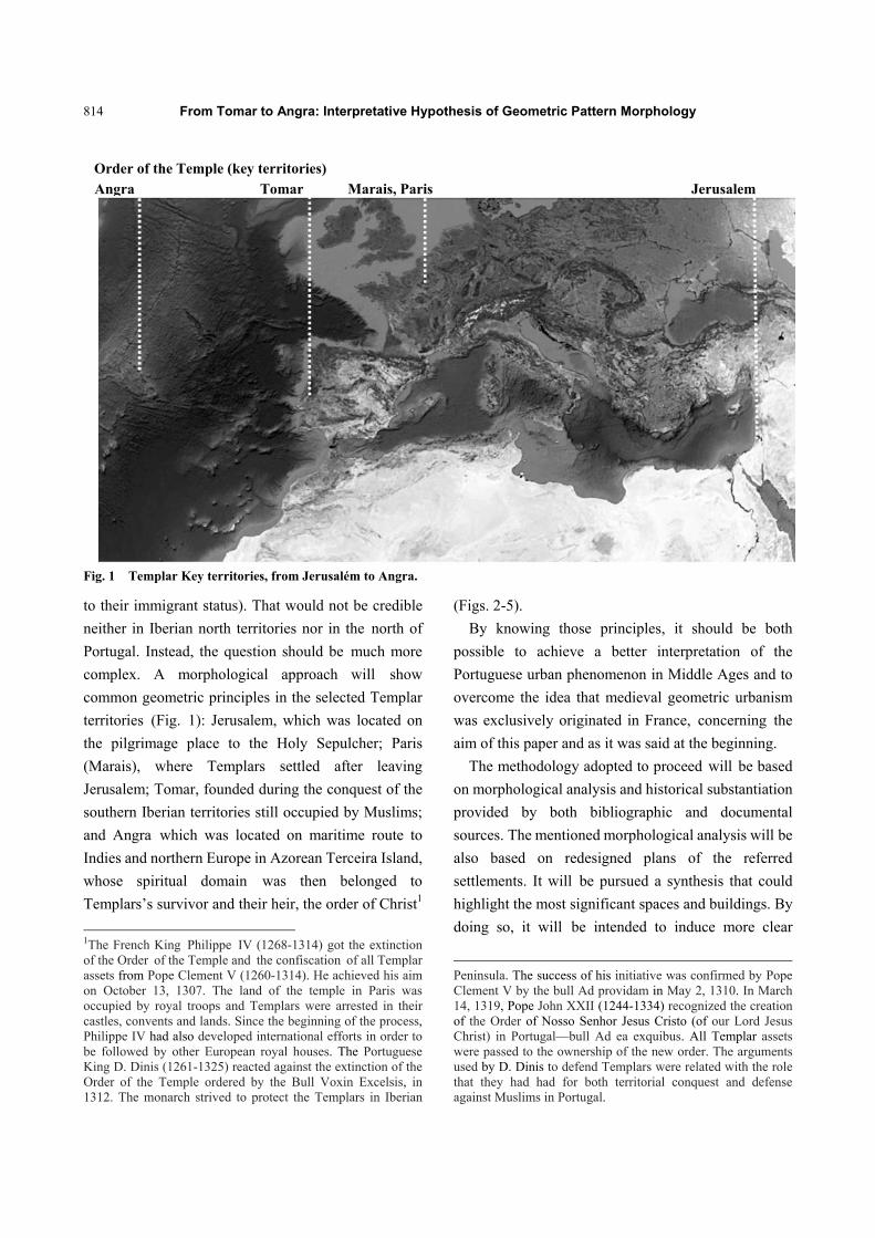
Fig. 1 Templar Key territories, from Jerusalém to Angra.
to their immigrant status). That would not be credible
neither in Iberian north territories nor in the north of
Portugal. Instead, the question should be much more
complex. A morphological approach will show
common geometric principles in the selected Templar
territories (Fig. 1): Jerusalem, which was located on
the pilgrimage place to the Holy Sepulcher; Paris
(Marais), where Templars settled after leaving
Jerusalem; Tomar, founded during the conquest of the
southern Iberian territories still occupied by Muslims;
and Angra which was located on maritime route to
Indies and northern Europe in Azorean Terceira Island,
whose spiritual domain was then belonged to
Templars’s survivor and their heir, the order of Christ1
1The French King Philippe IV (1268-1314) got the extinction of the Order of the Temple and the confiscation of all Templar assets from Pope Clement V (1260-1314). He achieved his aim on October 13, 1307. The land of the temple in Paris was occupied by royal troops and Templars were arrested in their castles, convents and lands. Since the beginning of the process, Philippe IV had also developed international efforts in order to be followed by other European royal houses. The Portuguese King D. Dinis (1261-1325) reacted against the extinction of the Order of the Temple ordered by the Bull Voxin Excelsis, in 1312. The monarch strived to protect the Templars in Iberian
(Figs. 2-5).
By knowing those principles, it should be both
possible to achieve a better interpretation of the
Portuguese urban phenomenon in Middle Ages and to
overcome the idea that medieval geometric urbanism
was exclusively originated in France, concerning the
aim of this paper and as it was said at the beginning.
The methodology adopted to proceed will be based
on morphological analysis and historical substantiation
provided by both bibliographic and documental
sources. The mentioned morphological analysis will be
also based on redesigned plans of the referred
settlements. It will be pursued a synthesis that could
highlight the most significant spaces and buildings. By
doing so, it will be intended to induce more clear
Peninsula. The success of his initiative was confirmed by Pope Clement V by the bull Ad providam in May 2, 1310. In March 14, 1319, Pope John XXII (1244-1334) recognized the creation of the Order of Nosso Senhor Jesus Cristo (of our Lord Jesus Christ) in Portugal—bull Ad ea exquibus. All Templar assets were passed to the ownership of the new order. The arguments used by D. Dinis to defend Templars were related with the role that they had had for both territorial conquest and defense against Muslims in Portugal.
Order of the Temple (key territories)
Angra Tomar Marais, Paris Jerusalem
From Tomar to Angra: Interpretative Hypothesis of Geometric Pattern Morphology
815
deductions about urban development in each case and
in data crossing.
2. Arguments
In his book New Towns of Middle Age, professor
Beresford states that the word bastida is used in its
Latin-script to refer almost every urban French
settlements. He also states that this word was never
used in England nor in Wales [3]. Nevertheless, A. E. J.
Morris says that it is an unjustified restriction [3]. The
Author asserts that the word bastide should be used to
refer every medieval settlement.
In line with those arguments, Pierre Lavedan also
denies the French origin of the bastides [4]. Balbas
asserted, furthermore, that only a comparison between
France and Norh of Spain would favor stronger
approaches to this matter [5] (Fig. 6).
Among misconceptions, some historical facts did
not bring this issue into light. The approximation
between the different countries concerning the
medieval regular settlement has been a consequence of
the apparent closeness to France in that matter. Even so,
it is not possible to assume that it would be possible to
unify the urban phenomenon in question under a
unique cause. It is true that some invariants might be
responsible for the misreading. It is known that the
bastides obey to seven basic principles on all occasions.
They are settlements founded from no pre-existences,
which result from a predefined plan and they also
present a geometric pattern of elongated blocks
morphologically. Moreover, they present an
orthogonal grid formed by perpendicular and parallel
streets which define constant sized blocks, whose
dimensions are based on simple geometric proportions.
In addition, a square takes a central position in the plan,
regarding the cross of the most important streets.
Furthermore, the town hall is located on that place
which is also crossed by the streets that connect the city
entrance with a gate in the fortified citadel. That square
could be, instead, crossed by a street that connected
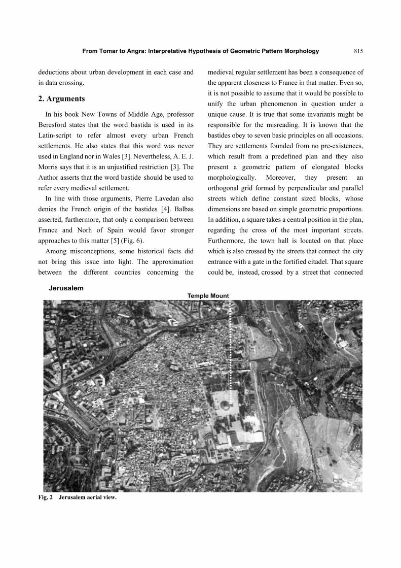
Fig. 2 Jerusalem aerial view.
From Tomar to Angra: Interpretative Hypothesis of Geometric Pattern Morphology
816
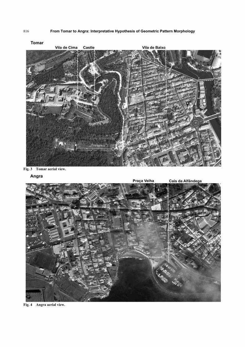
Fig. 3 Tomar aerial view.
Fig. 4 Angra aerial view.
From Tomar to Angra: Interpretative Hypothesis of Geometric Pattern Morphology
817
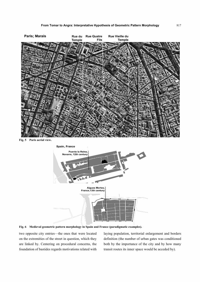
Fig. 5 Paris aerial view.
Fig. 6 Medieval geometric pattern morphology in Spain and France (paradigmatic examples).
two opposite city entries—the ones that were located
on the extremities of the street in question, which they
are linked by. Centering on procedural concerns, the
foundation of bastides regards motivations related with
laying population, territorial enlargement and borders
definition (the number of urban gates was conditioned
both by the importance of the city and by how many
transit routes its inner space would be acceded by).
From Tomar to Angra: Interpretative Hypothesis of Geometric Pattern Morphology
818
Nevertheless, there are other causes that can be
highlighted as active features for creating
independence from France regarding medieval
urbanism principles. Focusing on settlement problems,
it is obvious that the need of setting up cities based on
pragmatic and non-programmed concerns is much
more effective to approximate different expressions
and locations of medieval regular urbanism than the
misread dependence of France. It means that an
intuitive and empirically proven effectiveness of the
morphological paradigm in question (the geometric
pattern) is more relevant to its spread in Europe than
any dependency of any country. Indeed, the
hippodamian morphology shows it clearly as it exposes
the capacity of geometric principles in providing the
most proper proposals concerning ex novo urban
foundations.
Besides, it is true that a linear layout is rather
different from a reticular settlement. The first one
obeys to the spatial notion of medieval man. He sees
spatial structure as the link between two points like a
path to a certain point in the space. This is due to an
incapacity to read structured space on a physically and
continuous basis. That kind of linking spatial points is
not necessarily homogeneous, although it is done in
straight way. Indeed, it reveals the lack of an effective
spatial conceptualization, which depends on
abstractness. As a consequence of the capacity for
abstraction, the space would be understood as
continuous and dependent on geometry instead. But
that would happen later on. Indeed, at the Renaissance
and on the treatises, the aesthetics and conceptual
concerns reached a higher place, rather than centering
on pragmatic matters as it had happened in medieval
Europe. On these arguments, an opposition is not
present between two models: one is creation and the
other one foundation. Differently, a post-medieval
conceptualization of the street as a whole space is
mostly exposed which is structured by a set of facades
that bring precise limits to urban space. This different
notion emerged as solid new understanding values
underlying modern urbanism. In Portugal, that was the
time of King Manuel I (1495-1521). But before,
Portuguese medieval urban phenomenon had, likewise,
rational concerns as a purpose, instead of looking at the
plan as an eloquent expression by itself.
To precisely understand the arguments brought up to
this paper, it is fundamental to have present that the
major irregularity of the Iberian bastides (when
compared with the French ones) is not due to major
disability hold by settlers. It may be differently
understood that peninsular kingdoms had mostly acted
over already existent settlements. That commitment
significantly gave less freedom to impose urban form
over the territory, which was a limitation reflected on
urban layouts. Besides, the lack of material resources
and population often brought less effectiveness to urban
processes, which resulted in less regularity as well.
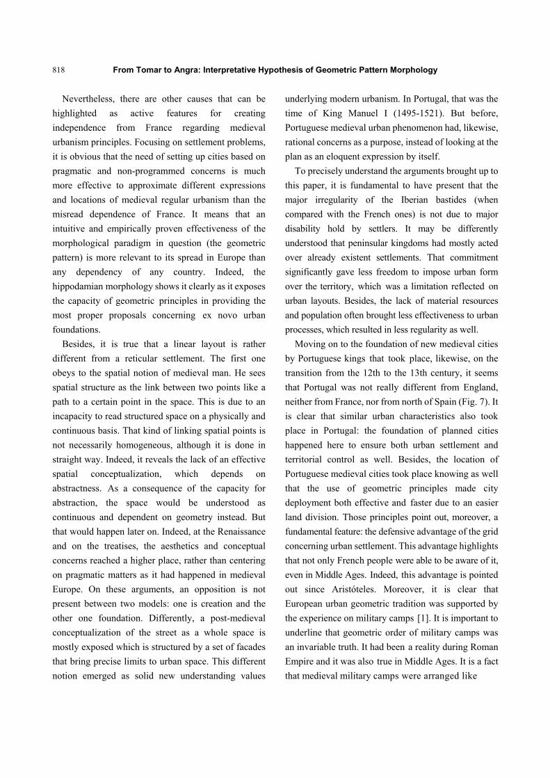
Moving on to the foundation of new medieval cities
by Portuguese kings that took place, likewise, on the
transition from the 12th to the 13th century, it seems
that Portugal was not really different from England,
neither from France, nor from north of Spain (Fig. 7). It
is clear that similar urban characteristics also took
place in Portugal: the foundation of planned cities
happened here to ensure both urban settlement and
territorial control as well. Besides, the location of
Portuguese medieval cities took place knowing as well
that the use of geometric principles made city
deployment both effective and faster due to an easier
land division. Those principles point out, moreover, a
fundamental feature: the defensive advantage of the grid
concerning urban settlement. This advantage highlights
that not only French people were able to be aware of it,
even in Middle Ages. Indeed, this advantage is pointed
out since Aristóteles. Moreover, it is clear that
European urban geometric tradition was supported by
the experience on military camps [1]. It is important to
underline that geometric order of military camps was
an invariable truth. It had been a reality during Roman
Empire and it was also true in Middle Ages. It is a fact
that medieval military camps were arranged like
From Tomar to Angra: Interpretative Hypothesis of Geometric Pattern Morphology
819
Fig. 7 Medieval geometric pattern morphology in Portugal (paradigmatic examples).
settlements, according to precise rules based on a
clear understanding of urban space [5]. A paradigmatic
example of that reality is given by King Alfonso X, el
sabio (1221-1284), in Las Siete Partidas2. Protracted
sieges had effectively shown that the enunciated
principles by Alfonso X did not remain as solely
theoretical propositions. Some descriptions on military
camps that took place during protracted sieges are an
evidence of it. The first Crónica General3 is a good
example: written in late 13th century, it relates that
Fernando’s III (1201-1252)4 camp took place around
2Alfonso X el Sabio (the Wise) was King of Castile and Leon from 1252 until his death. He was born in 1221, in Toledo, and died in 1284, in Seville. His court was a meeting place of both Galician-Portuguese and Provencal poets and also an important focus of cultural influence in Iberian Peninsula. He had not been successful as a politician, however, he was a profoundly learned man and an admirable scholar. Alfonso was versed in natural sciences, jurisprudence and classical languages. Las Siete Partidas was a codification of laws, which had been the most important collection of Spanish law for centuries. 3Crónica General (General Chronic) is an historiographical account written in vernacular and driven by Alfonso X (1221-1284). Although it had been begun about 1270, the project was progressively phased out after 1275. It is assumed that the first 565 or 616 chapters would be completed during the reign of Alfonso X. However, the manuscripts reveal the intervention of writers from different eras. 4Leonese and Castilian King, son of Alfonso IX of León, Fernando III, was probably born in 1201 and died in 1252.
Seville to conquer the city, in 1248, and that it was
settled with streets and squares. It is also meaningful
that the siege to Seville was organized with Templar
involvement [6]. It is meaningful, above all, that it was
possible to witness Templar presence close to that kind
of geometric settlement at the time. In this context, it is
also relevant to notice that, after two centuries
founding new settlements in Medieval Europe, the
geometric regularity was solely effective during the
period of Templar affirmation in different European
kingdoms.
That closeness between the Order of the Temple and
the geometric urbanism was also a reality in Portugal.
However, this fact must be clearly understood.
Testifying a widespread power basis, the Order of the
Temple was territorial and administrative responsible
for extensive parts of Portugal [7]. According to that, D.
Gualdim Pais (1118-1195), master of the Order of the
Temple between 1158 and 1195, grants the first and the
second charters to Tomar.
That reality is truly important. Since this order had a
territorial independent administrative organization not Those two kingdoms were definitely unified under his reign. It was also during his reign that was established a code of laws for all areas.
From Tomar to Angra: Interpretative Hypothesis of Geometric Pattern Morphology
820
only in Portugal, it is unsurprising that Templars made
use of a precise range of architectural models and
typologies. The rotunda or its variations with an
octagonal plan was a kind of church that was
widespread in many territories—Tomar, London, Paris,
Metz, Laon, Segovia and Palestine as it was stated by
Régine Pernoud [8]. The author also states that
typological invariants were also used in rural areas:
similar to Cistercian farms and priories [8]. Even if
Templar churches obeying to a centred or polygonal
plan were a minority, even if this kind of plan was not a
Templar exclusive use—as it is referred by Elie
Lambert, demystifying Viollet le Duc’s ideas
(1811-1879) [8]—the truth shows that it is possible to
witness the use of a Templar alternative type to that one.
It is applied on the majority of Templar churches:
rectangular plan topped by flat or semi-circular apse.
Besides France, Portugal was marked by that reality as
well. All Portuguese temples revealed the same spatial
structure: headboard of a unique chapel and a single
rectangular nave [9].
All the arguments set above bring up a fundamental
question. Knowing that the Order of the Temple took
an important role in European foundation of new cities
(which in many cases remained under the
administration of the military order in question), it is
possible not to believe that the urban structuring
principles applied under the king’s authority are the
same as the ones used in territorial areas under
Templar’s power and administration. It means that,
considering their experience and role in territorial
enlargement, it is not credible that Templars would not
be able to settle new towns on their own. Furthermore,
two other facts are truly meaningful in the context: on
the one hand, it is known that Templars made use of
their own typologies in religious architecture and, on
the other hand, that geometric settlement was part of
the inheritance of the military camps tradition. Thus, it
is acceptable to explore Templar’s participation in the
process of setting up geometric urban foundations.
Indeed, this is a valid hypothesis since the different
arguments give support to a basic idea: at this point, it
is easily acceptable that medieval geometric urbanism
was not a French exclusive creation. It is clear that
other factors should have been present on the
widespread of that urban model over medieval Europe
rather than the usually considered ones.
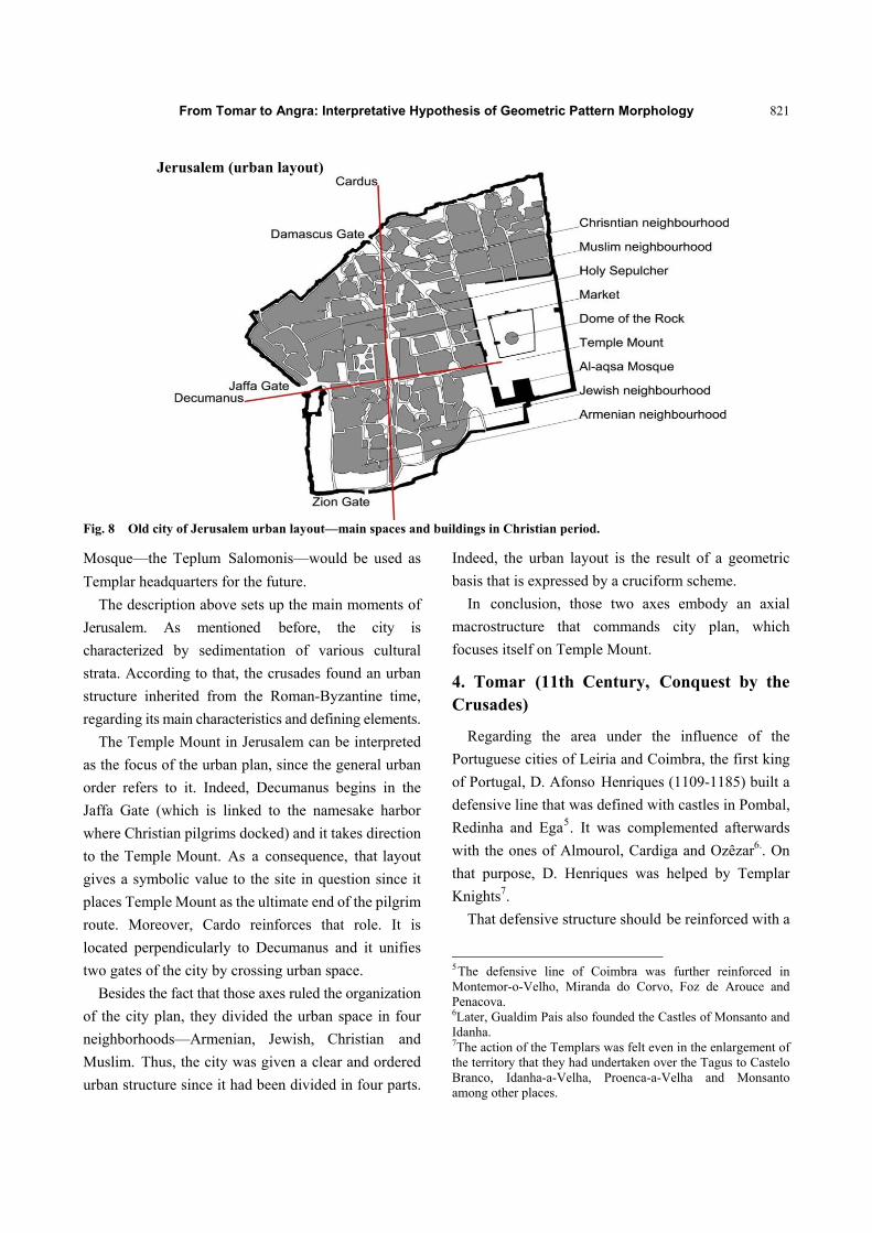
3. Jerusalém (10th Century, Conquest by the Crusades)
Jerusalem (Fig. 8) was the capital of a Christian
kingdom from 1099 (the date of its conquest) to 1187
and later on from 1229 to 1244. Thus, city development
does not result from a linear and continuous process.
The primitive city of David was originated in 1004
B.C. Although it had a defensive wall already, it could
not resist to several periods of occupation and
destruction. The Muslim occupancy and Jewish follow
one another until Jerusalem fell under the dominance of
Roman Empire. The original Holy Sepulchre Church
must be underlined as one of the most significant
testifies of the Roman-Bizantine period. It is the most
important Christian building in the city and it was
consecrated to worship in 335 A.D.
Later on, in 614 A.D., the majority of the urban
structure as well as the byzantine building were
destroyed. It happened when Persians took control of
the city in alliance with Jews. Nevertheless, Jews and
Christians were under Muslim dominance a decade
after. Jerusalem was then consecrated as the third city
in Muslim cities hierarchy, after Meca and Medina.
That lasted for 450 years. As it was mentioned before,
the crusaders took the city in 1099 and they offered,
afterwards, many incentives in order to attract new
settlers.
The westernized era was there reflected on an
intensive building activity. The reuse of the Temple
Mount was one of the most significant signs of it, due
to its impressive aspect which was recognized by
Christians. Thus, it was converted into a Christian
place. The Dome of the Rock received a new meaning
as a Christian temple: Templum Domini. The al-Aqsa
From Tomar to Angra: Interpretative Hypothesis of Geometric Pattern Morphology
821
Fig. 8 Old city of Jerusalem urban layout—main spaces and buildings in Christian period.
Mosque—the Teplum Salomonis—would be used as
Templar headquarters for the future.
The description above sets up the main moments of
Jerusalem. As mentioned before, the city is
characterized by sedimentation of various cultural
strata. According to that, the crusades found an urban
structure inherited from the Roman-Byzantine time,
regarding its main characteristics and defining elements.
The Temple Mount in Jerusalem can be interpreted
as the focus of the urban plan, since the general urban
order refers to it. Indeed, Decumanus begins in the
Jaffa Gate (which is linked to the namesake harbor
where Christian pilgrims docked) and it takes direction
to the Temple Mount. As a consequence, that layout
gives a symbolic value to the site in question since it
places Temple Mount as the ultimate end of the pilgrim
route. Moreover, Cardo reinforces that role. It is
located perpendicularly to Decumanus and it unifies
two gates of the city by crossing urban space.
Besides the fact that those axes ruled the organization
of the city plan, they divided the urban space in four
neighborhoods—Armenian, Jewish, Christian and
Muslim. Thus, the city was given a clear and ordered
urban structure since it had been divided in four parts.
Indeed, the urban layout is the result of a geometric
basis that is expressed by a cruciform scheme.
In conclusion, those two axes embody an axial
macrostructure that commands city plan, which
focuses itself on Temple Mount.
4. Tomar (11th Century, Conquest by the Crusades)
Regarding the area under the influence of the
Portuguese cities of Leiria and Coimbra, the first king
of Portugal, D. Afonso Henriques (1109-1185) built a
defensive line that was defined with castles in Pombal,
Redinha and Ega5. It was complemented afterwards
with the ones of Almourol, Cardiga and Ozêzar6.. On
that purpose, D. Henriques was helped by Templar
Knights7.
That defensive structure should be reinforced with a
5The defensive line of Coimbra was further reinforced in Montemor-o-Velho, Miranda do Corvo, Foz de Arouce and Penacova. 6Later, Gualdim Pais also founded the Castles of Monsanto and Idanha. 7The action of the Templars was felt even in the enlargement of the territory that they had undertaken over the Tagus to Castelo Branco, Idanha-a-Velha, Proenca-a-Velha and Monsanto among other places.
Jerusalem (urban layout)
From Tomar to Angra: Interpretative Hypothesis of Geometric Pattern Morphology
822
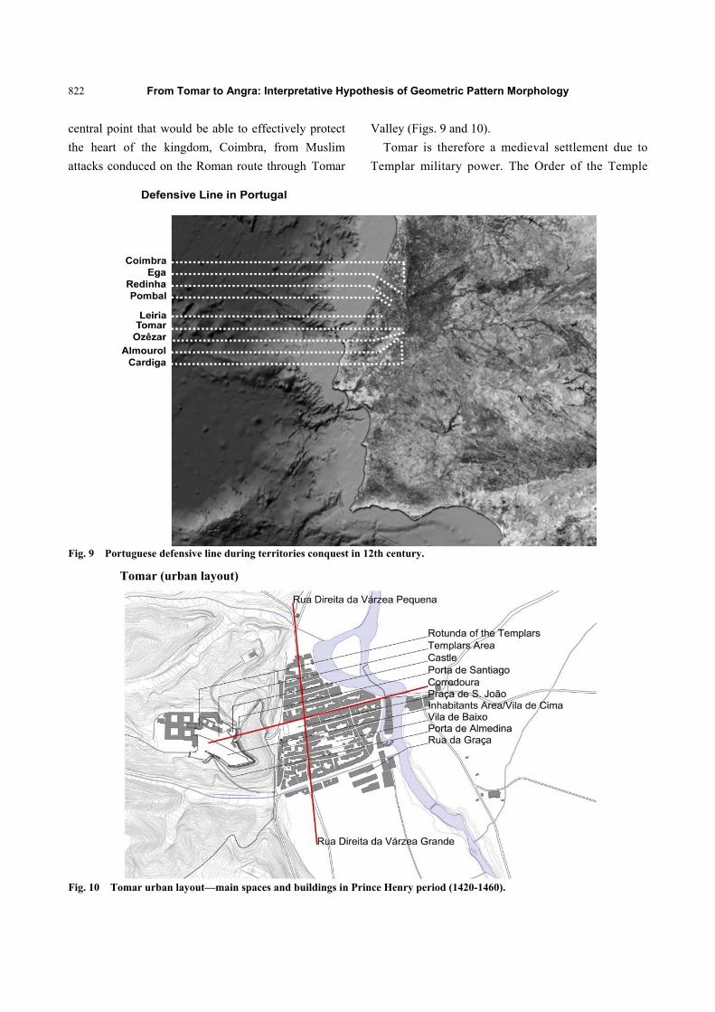
central point that would be able to effectively protect
the heart of the kingdom, Coimbra, from Muslim
attacks conduced on the Roman route through Tomar
Valley (Figs. 9 and 10).
Tomar is therefore a medieval settlement due to
Templar military power. The Order of the Temple
Fig. 9 Portuguese defensive line during territories conquest in 12th century.
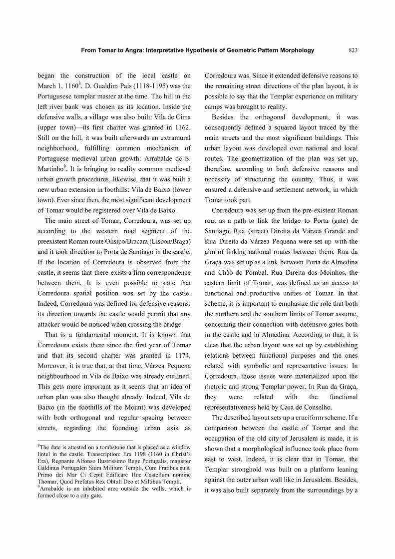
Fig. 10 Tomar urban layout—main spaces and buildings in Prince Henry period (1420-1460).
Tomar (urban layout)
From Tomar to Angra: Interpretative Hypothesis of Geometric Pattern Morphology
823
began the construction of the local castle on
March 1, 11608. D. Gualdim Pais (1118-1195) was the
Portugusese templar master at the time. The hill in the
left river bank was chosen as its location. Inside the
defensive walls, a village was also built: Vila de Cima
(upper town)—its first charter was granted in 1162.
Still on the hill, it was built afterwards an extramural
neighborhood, fulfilling common mechanism of
Portuguese medieval urban growth: Arrabalde de S.
Martinho9. It is bringing to reality common medieval
urban growth procedures, likewise, that it was built a
new urban extension in foothills: Vila de Baixo (lower
town). Ever since then, the most significant development
of Tomar would be registered over Vila de Baixo.
The main street of Tomar, Corredoura, was set up
according to the western road segment of the
preexistent Roman route Olisipo/Bracara (Lisbon/Braga)
and it took direction to Porta de Santiago in the castle.
If the location of Corredoura is observed from the
castle, it seems that there exists a firm correspondence
between them. It is even possible to state that
Corredoura spatial position was set by the castle.
Indeed, Corredoura was defined for defensive reasons:
its direction towards the castle would permit that any
attacker would be noticed when crossing the bridge.
That is a fundamental moment. It is known that
Corredoura exists there since the first year of Tomar
and that its second charter was granted in 1174.
Moreover, it is true that, at that time, Várzea Pequena
neighbourhood in Vila de Baixo was already outlined.
This gets more important as it seems that an idea of
urban plan was also thought already. Indeed, Vila de
Baixo (in the foothills of the Mount) was developed
with both orthogonal and regular spacing between
streets, regarding the founding urban axis as
8The date is attested on a tombstone that is placed as a window lintel in the castle. Transcription: Era 1198 (1160 in Christ’s Era), Regnante Alfonso Ilustríssimo Rege Portugalis, magister Galdinus Portugalen Sium Militum Templi, Cum Fratibus suis, Primo dei Mar Ci Cepit Edificare Hoc Castellum nomine Thomar, Quod Prefatus Rex Obtuli Deo et Miltibus Templi. 9Arrabalde is an inhabited area outside the walls, which is formed close to a city gate.
Corredoura was. Since it extended defensive reasons to
the remaining street directions of the plan layout, it is
possible to say that the Templar experience on military
camps was brought to reality.
Besides the orthogonal development, it was
consequently defined a squared layout traced by the
main streets and the most significant buildings. This
urban layout was developed over national and local
routes. The geometrization of the plan was set up,
therefore, according to both defensive reasons and
necessity of structuring the country. Thus, it was
ensured a defensive and settlement network, in which
Tomar took part.
Corredoura was set up from the pre-existent Roman
rout as a path to link the bridge to Porta (gate) de
Santiago. Rua (street) Direita da Várzea Grande and
Rua Direita da Várzea Pequena were set up with the
aim of linking national routes between them. Rua da
Graça was set up as a link between Porta de Almedina
and Chão do Pombal. Rua Direita dos Moinhos, the
eastern limit of Tomar, was defined as an access to
functional and productive unities of Tomar. In that
scheme, it is important to emphasize the role that both
the northern and the southern limits of Tomar assume,
concerning their connection with defensive gates both
in the castle and in Almedina. According to that, it is
clear that the urban layout was set up by establishing
relations between functional purposes and the ones
related with symbolic and representative issues. In
Corredoura, those issues were materialized upon the
rhetoric and strong Templar power. In Rua da Graça,
they were related with the functional
representativeness held by Casa do Conselho.
The described layout sets up a cruciform scheme. If a
comparison between the castle of Tomar and the
occupation of the old city of Jerusalem is made, it is
shown that a morphological influence took place from
east to west. Indeed, it is clear that in Tomar, the
Templar stronghold was built on a platform leaning
against the outer urban wall like in Jerusalem. Besides,
it was also built separately from the surroundings by a
From Tomar to Angra: Interpretative Hypothesis of Geometric Pattern Morphology
824
walled structure. Likewise, that structure refers to the
enclosure of the temple wall itself in Jerusalem, and to
the second curtain wall, in Tomar. In both cases, the
Templar stronghold was the highest place inside the
walls.
It was also inside the walls that the Dome of the
Rock (Templum Domini of the Templars) and the
Rotunda of the Templars were located. They were
placed on the left hand side in Jerusalem as well as in
Tomar. Instead, the Templar accommodations, the old
Templum Salominis, on the al-Aqsa Mosque in
Jerusalem, and the Redoubt Templar with castle in
Tomar, can be seen on the right hand side.
Beyond that, it is shown that the Temple Mount is an
open platform detached from the remaining urban plan
in Jerusalem. And in a similar basis, it is seen that the
Templar area was located in the northern sector of the
walled enclosure of Tomar. In both cases, the Templar
headquarters were, likewise, separated from the
inhabitants’ area.
It is also seen that the city of Jerusalem takes form
from two axes that intersect each other at right angles.
That way, a geometric scheme is formed by which the
general city settlement is defined: one of those axes
links Jaffa gate to the most symbolic local place—in
other words, it links city entrance to Temple Mount.
The other axis, perpendicular to the first one,
physically relates the gate of Damascus with the gate of
Zion crossing city space.
Similar principles can be observed in Tomar. A path
whose origin was located outside the bridge was
directed towards the castle, up the slope, giving access
to Porta de Santiago. Besides, Rua Direita da Várzea
Grande and Rua Direita da Várzea Pequena took a
spatial position which is almost perpendicular to that
first urban axis—Corredoura. Therefore, this spatial
scheme is similar to the one formed by Decumanus and
Cardo in Jerusalem.
Beyond that, it is seen that the city market is located
in the intersection of Roman-Byzantine axis of
Jerusalem and it is also possible to notice a similar
urban scheme in Tomar. Indeed, two fairs took
annually place in Praça (square) de S. João since
Middle Ages. Besides, this square was located in the
intersection of Corredoura with both Rua Direita da
Várzea Grande and Rua Direita da Várzea Pequena.
In the end, it is possible to point out that the urban
layout based on the existence of citadel (Alcáçova) and
inhabitants’ area outside the walls (Almedina) spreads
out from Jerusalem to Tomar, doing so with precise
principles that shape both the interior of the defensive
walls and Vila de Baixo.
5. Angra (15th Century—Foundation)
The first islands in Azores were discovered in 1427
in the context of the Portuguese Discoveries. That
happened when sighting Santa Maria and São Miguel
and “probably, five more islands successively” as
Oliveira Marques states (Fig. 11) [10].
In 1431-1432, Gonçalo Velho (both knight
and navigator in the house Infante D. Henrique 10
(1394-1460) and friar of the Order of Christ) arrived in
two referred islands. The expedition he led was
promoted by D. Henrique with the purpose of
beginning the permanent and final settlement in Azores.
Nevertheless, the year commonly accepted for the
discovery of the Terceira Island is 1447 and its name
corresponds to the chronological order in the discovery
process.
In 1460, the spirituality in that archipelago was held
by the Order of Christ [11]. This fact definitively
approximates Azores and Templars’ heirs11.
10Son of King D. João I (1357-1433), Prince Henrique was born in Oporto in 1394 and died in 1460. He became known as navigator, as his cognomen. This epithet was due to his involvement in Portuguese discoveries. He had an active role on the first expansionist travel and always stayed connected to this period of history of Portugal, with its decisive action in North Africa and in the Atlantic. 11Answering Dom Henriques’s request, Pope Calist III has already issued bulla Inter Cætera in March 13, 1456, which confirms bulla Romanus Pontifex issued by Pope Nicolau V. It grants the power, dominion and spiritual jurisdiction over the lands, ports, islands and places already acquired and those who were to be conquered by Dom Henrique from Africa to the Indies as they were subtracted from the Muslims and conquered to Christian religion.
From Tomar to Angra: Interpretative Hypothesis of Geometric Pattern Morphology
825
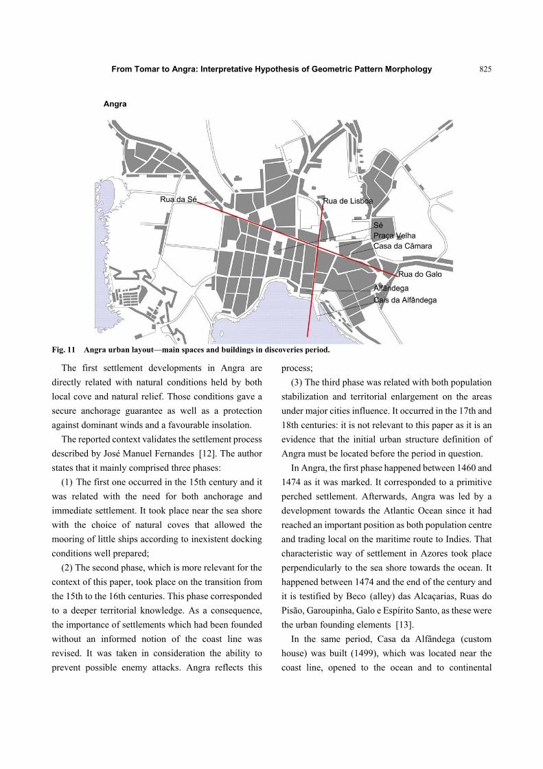
Fig. 11 Angra urban layout—main spaces and buildings in discoveries period.
The first settlement developments in Angra are
directly related with natural conditions held by both
local cove and natural relief. Those conditions gave a
secure anchorage guarantee as well as a protection
against dominant winds and a favourable insolation.
The reported context validates the settlement process
described by José Manuel Fernandes [12]. The author
states that it mainly comprised three phases:
(1) The first one occurred in the 15th century and it
was related with the need for both anchorage and
immediate settlement. It took place near the sea shore
with the choice of natural coves that allowed the
mooring of little ships according to inexistent docking
conditions well prepared;
(2) The second phase, which is more relevant for the
context of this paper, took place on the transition from
the 15th to the 16th centuries. This phase corresponded
to a deeper territorial knowledge. As a consequence,
the importance of settlements which had been founded
without an informed notion of the coast line was
revised. It was taken in consideration the ability to
prevent possible enemy attacks. Angra reflects this
process;
(3) The third phase was related with both population
stabilization and territorial enlargement on the areas
under major cities influence. It occurred in the 17th and
18th centuries: it is not relevant to this paper as it is an
evidence that the initial urban structure definition of
Angra must be located before the period in question.
In Angra, the first phase happened between 1460 and
1474 as it was marked. It corresponded to a primitive
perched settlement. Afterwards, Angra was led by a
development towards the Atlantic Ocean since it had
reached an important position as both population centre
and trading local on the maritime route to Indies. That
characteristic way of settlement in Azores took place
perpendicularly to the sea shore towards the ocean. It
happened between 1474 and the end of the century and
it is testified by Beco (alley) das Alcaçarias, Ruas do
Pisão, Garoupinha, Galo e Espírito Santo, as these were
the urban founding elements [13].
In the same period, Casa da Alfândega (custom
house) was built (1499), which was located near the
coast line, opened to the ocean and to continental
From Tomar to Angra: Interpretative Hypothesis of Geometric Pattern Morphology
826
Portugal. Still in that period, Casa da Câmara (town
hall) was erected in a complementary location to
Castelo de S. Luís (Castle of Saint Luís). Thus, this
building almost embodied a civilian hillside
contraposition to the military one. It gave, therefore,
support to the paradigmatic dichotomy Alta
Militar/Baixa civil—military upper town/civilian
lower town—that recurrently took place in Portuguese
late medieval urbanism. On hillside, likewise, the link
between Angra and its hinterland was defined. That
was ensured by Rua do Galo and Rua da Sé12. These
two streets are extremely relevant as they embodied an
axis that put in connection with each other—Praça
Velha and Largo da Sé. Moreover, they gave support to
their perpendicularly intersection held by Rua de
Lisboa. That street was directioned to Praça Velha and
to Casa da Alfândega by its extension over Rua de S.
João towards the sea. Once the axial urban pattern was
determined by that scheme, seven further streets would
be defined. As they would be crossed by other streets,
an almost perpendicular and parallel scheme would be
set up.
According to the described process of Angra urban
growth, it was set up a similar logic to that one already
focused. Indeed, Angra urban structure is based on an
axial system of references analogous to the one of
Tomar. It is meant that both the principles and the
symbolism that put in relation the more meaningful key
spaces and the most significant buildings are truly close:
Rua de Lisboa (Rua Direita), Rua da Sé13 e do Galo;
Cais da Alfândega (custom house quay), Praça Velha;
and Casa da Câmara. Moreover, urban axiality
determines urban layout composition through a
structure of elongated blocks, what happened in Angra
and in Tomar as well.
It the end, it is clear that the intersection point of the
urban axes locates the market as an important urban
place. That reality can be either seen in Angra, Tomar
or Jerusalem. It embodied a correspondence between 12Praça is a square. Largo is a wide urban area at the confluence of more than two streets. 13Sé is a cathedral.
urban principles that can be seen, furthermore, in a
wider range of rules and spaces of those three
settlements as it was marked above.
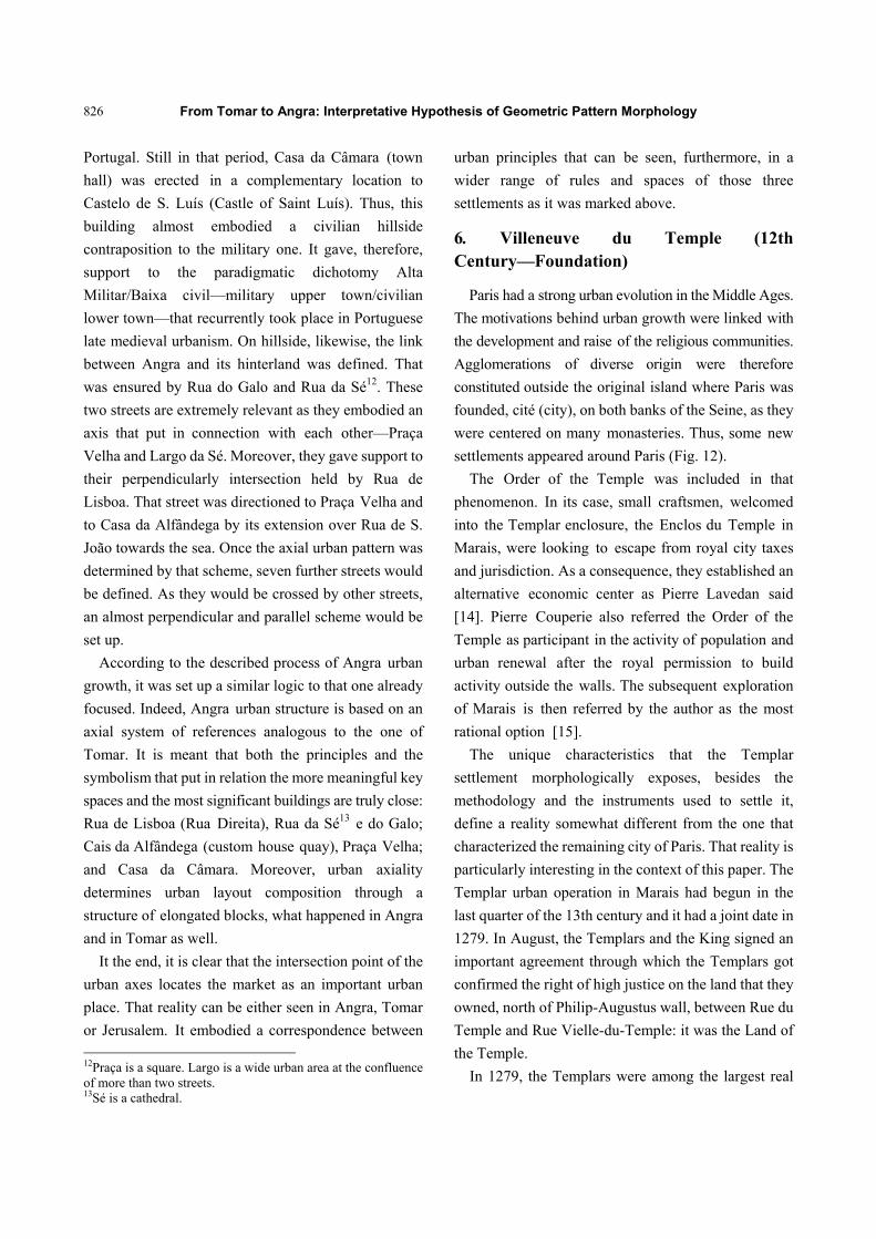
6. Villeneuve du Temple (12th Century—Foundation)
Paris had a strong urban evolution in the Middle Ages.
The motivations behind urban growth were linked with
the development and raise of the religious communities.
Agglomerations of diverse origin were therefore
constituted outside the original island where Paris was
founded, cité (city), on both banks of the Seine, as they
were centered on many monasteries. Thus, some new
settlements appeared around Paris (Fig. 12).
The Order of the Temple was included in that
phenomenon. In its case, small craftsmen, welcomed
into the Templar enclosure, the Enclos du Temple in
Marais, were looking to escape from royal city taxes
and jurisdiction. As a consequence, they established an
alternative economic center as Pierre Lavedan said
[14]. Pierre Couperie also referred the Order of the
Temple as participant in the activity of population and
urban renewal after the royal permission to build
activity outside the walls. The subsequent exploration
of Marais is then referred by the author as the most
rational option [15].
The unique characteristics that the Templar
settlement morphologically exposes, besides the
methodology and the instruments used to settle it,
define a reality somewhat different from the one that
characterized the remaining city of Paris. That reality is
particularly interesting in the context of this paper. The
Templar urban operation in Marais had begun in the
last quarter of the 13th century and it had a joint date in
1279. In August, the Templars and the King signed an
important agreement through which the Templars got
confirmed the right of high justice on the land that they
owned, north of Philip-Augustus wall, between Rue du
Temple and Rue Vielle-du-Temple: it was the Land of
the Temple.
In 1279, the Templars were among the largest real
From Tomar to Angra: Interpretative Hypothesis of Geometric Pattern Morphology
827
Fig. 12 Villeneuve du Temple urban layout—main spaces and buildings in 12th and 13th centuries.
estate owners in the city. Their properties essentially
consisted of blocks or simple set of houses, scattered
through the medieval city, especially north of the Seine,
both inside and outside the wall. The limits were given
by Rue Vielle-du-Temple, to the east; Rue
Roix-de-Sicile and Rue Saint-Croix-de-la-Bretonnerie, to
the south; and Rue du Temple, to the west.
Taking advantage of their possessions on the right
bank of the Seine, more than just a suburban new
Templar settlement did arise in the new context of
urban transformation in Paris. Even today, it is possible
to confirm the intent of the operation and to notice
patent parallelism and orthogonality between the streets.
In that context, the Templars got permission from
Philippe IV, le Beau14 (1268-1314), to open another
14Philippe developed a policy towards the centralization of political power. During his reign, important historical events
entry on the defensive walls. Thus, Porte de Chaume
joins Porte du Temple and Porte Barbette as an access
point to Villeneuve du Temple. Since it is located in
the centre of the settlement, it was given a reason to
open a new street. An effective communication
between Paris and the main axes of the new
urbanization was obtained. Therefore, Rue Neuve du
Temple, Rue Nouvelle Poterne, or simply Rue de la
Porte Nouvelle was the epithet that marked the new
central axis of the Templar settlement. This street
existed since the year of 1288. However, its name had
been changed to Rue du Chaume from late 16th
century on.
took place such as transferring the Pope’s residence to Avignon. His aim was the one of looking to put the papacy in dependence on France. In line with that policy, Philippe took control of much of Templar assets, after the extinction of the Order of the Temple.
Rue Richard-des-Poulies
Rue Pastourelle
Rue du Noyer
Rue Jean-I’Hulllier
Rue des Bouchers
Porte du Temple
Rue du Temple
Rue des Blancs-Manteaux
Rue du Plâtre
Rue de la Bretonnerie
Rue Dame Agacs
Rue La-Buschière
Rue de la Verrerie
Rue du Franc-Nurier
Rue Bourg-Thibourg
Rue du Puits
Rue des Singes
Rue du Roi de-Sicile
Rue de la Porte-du-Chaume
Rue Quatre-Fils Hemon
Porte du Chaume
Rue du Chantier
Rue de Paradis
Poterne Barbette
Vieille rue du Temple
Rue des Poulies
Philippe-Auguste
Rue des Rosiers
Rue des Ecouffes
Rue des Marivaux
Enclos du Temple
From Tomar to Angra: Interpretative Hypothesis of Geometric Pattern Morphology
828
Including that new street, there were nine further
streets traced. Among them, five began on Temple
Street, whose orientation takes direction to eastbound:
Rue Richard de Pouliers was already decided in 1282.
It was inhabited in 1292 and referred from 1296 on;
Rue Jean de Saint-Quentin was already inhabited in
1292 and cited from 1296 on; Rue Jean L'Huillier (now
called Rue des Hudriettes) was cited from 1287 on;
Rue Noyer existed since 1297 (it is now disappeared);
Rue des Etuves (now named Rue Braque) was already
inhabited in 1282 and cited from 1296 on [16] .
To the east of Rue de la Porte Nouvelle, other new
streets were traced. These ones were directed to Rue
Vielle-du-Temple: Rue du Paradis (partially coincident
with the current Rue Franc-Bourgeois) existed since
1288 on; Rue du Chantier was cited from 1293 on, it
extends Rue des Etuves and still exists, however, it is
somewhat different now; Rue des Quatre Fils-Hemom
(now named Rue Quatre Fils) was cited from 1305 on.
Moving on to the context of this paper, it is seen that
the new Templar settlement urban structure, in the
Parisian Marais neighborhood, is defined according to
a property division that guarantees morphological
regularity. It is also possible to point out an almost
orthogonal urban structure which was sustained by two
axes and to confirm as well that one of them took
direction from one of the city gates to Enclos du
Temple. Therefore, it is possible to state that common
urban principles are identifiable in the layout of
Jerusalém, Tomar, Angra and Marais. Indeed, these
principles hold, likewise, the tracing of Villeneuve du
Temple in Paris.
7. Conclusions
History proves that “the regular form of the city is as
old as the art of set a city” [17]. In other words, it is
possible to state that whenever there is a strong power
established, urbanism happens as always, orthogonal.
Furthermore, it is known that “the military
function conditioned the formation of most medieval
towns...” [5].
These statements give support to the arguments
shown before. As it is believable, the insularization of
an urban model imported from Jerusalem is noticed,
which enters Portugal through Tomar.
The conclusion is that the Roman-Byzantine
tradition inherited from the East marked the course of
both the Templars and their Portuguese heirs—the
Order of Christ (founded in Portugal in 1318)—doing
so from the East to Europe and from Tomar to Angra.
The definition of that urban model is based on an
urban structure made by an axial urban composition of
elongated regular blocks, whose origins and
destinations are identifiable on notable points of urban
space. Its formalization is built by linking the most
relevant urban entry with the representative centre of
power or, instead, with the civil or religious-military
ones. That urban scheme was also built by linking two
other city entries between them—the ones that put
together major transit routes of both local and national
territories. That occurred perpendicularly to the first
axis referred above.
Indeed, the urban form of Tomar took definition
from the major transit routes. In a prosaic basis, the
geometric urban principles took in consideration both
local defensive precepts and the need of linking and
defending the territory as a whole—at the time,
Portugal was being conceived and consolidated as an
independent nation.
The words above may deny the most traditional way
of looking at medieval geometric pattern morphology,
which usually reveals that urban regularity had firstly
been thought in France and then it was scattered over
Europe, due to cultural and population exchanges and
as an exportation of ideas. Indeed, Tomar brings up a
contribution to overcome that idea and to put Portugal,
likewise, in line with other countries, with a relevant
role on developing the geometric pattern morphology
phenomenon in medieval Europe.
It the end, the travelling from the East to the West
and from Tomar to Angra shows that it should be
possible to identify stronger settlement principles of
From Tomar to Angra: Interpretative Hypothesis of Geometric Pattern Morphology
829
shaping geometric urban form in Middle Ages, rather
than simply accept those ones that have remained
dependent on French immigration. Indeed, by an
interpretative context enlargement, the diverse
arguments may have exposed an alternative possibility
of reading geometric European urbanism in Middle
Ages. At least, it is possible to open alternative paths
on researching on this issue. Regarding its regularity
and closeness to Order of the Temple, Tomar is truly
relevant to that purpose for it allows an alternative
approximation to Portuguese settlement processes and
also to European ones as a consequence.
References
[1] Gaspar, J. 1969. “A Morfologia de Padrão Geométrico na Idade Média (The Geometric Pattern Morphology in Middle Ages).” Separata da Finisterra-Revista Portuguesa de Geografia (Annex of Finisterra-Portuguese Magazine of Geography) 4 (8): 198-215. (in Portuguese)
[2] Dias, J. C. 1999. “A Evolução Urbana de Tomar: Da Margem Esquerda à Margem Esquerda Fixando a Margem Direita ou uma Leitura Crítica dos Acontecimentos (Urban Evolution of Tomar: From Left Bank to Left Bank Setting Right Bank or a Critical Reading of Events).” M.Sc. dissertation, Faculty of Architecture of University of Porto. (in Portuguese)
[3] Morris, A. E. J. 1991. Historia de la Forma Urbana—Desde sus Orígenes Hasta la Revolución Industrial (History of Urban Form—From its Origins Until the Industrial Revolution). Barcelona: Gustavo Gili. (in Spanish)
[4] Lavedan, P. 1926. Histoire de L’ Urbanisme: Antiquité-Moyen Age (The History of Urban Planning: Antiquity-Middle Ages). Paris: Henri Laurens Éditeur. (in French)
[5] Balbas, L. T., Goitia, F. C., Vera, L. C., and Lasarte, P. B. 1954. Resumen Histórico del Urbanismo en España (Historical Summary of Urbanism in Spain). Madrid: Instituto de Estudos de Administracion Local (Institute of Studies of Local Administration). (in Spanish)
[6] Galán, J. E. 1994. Los Templários y Otros Enigmas Medievales (The Templars and Other Medieval Enigma). Barcelona: Planeta. (in Spanish)
[7] Marques, A. H. O., Serrão, J., and Dias, J. J. A. 1987. Portugal do Renascimento à Crise Dinástica in Nova História de Portugal (Portugal from Renaissance to Dynastic Crisis in New History of Portugal). Lisboa: Editorial Presença (Presença Publisher). (in Portuguese)
[8] Régine, P. 1974. Les Templiers (The Templars). Paris:
Presses Universitaires de France (University Press of
France). (in French)
[9] Dias, P. 1979. Visitações da Ordem de Cristo de 1507 a 1510 (Visitations of the Order of Christ 1507-1510). Coimbra: Faculty of Arts of University of Coimbra. (in Portuguese)
[10] Marques, A. H. 1985. História de Portugal (History of
Portugal). Lisbon: Palas Editors. (in Portuguese)
[11] Sousa, J. S. 1991. A Casa Senhorial do Infante D.
Henrique (The Manor House of Prince Henry). Lisbon:
Livros Horizonte. (in Portuguese)
[12] Fernandes, J. M. 1996. Cidades e Casas da Macaronésia
(Cities and Houses of Macaronesia). Porto:
FAUP-publicações. (in Portuguese)
[13] Fernandes, J. M. 1988. Angra do Heroísmo. Colecção
Cidades e Vilas de Portugal (Angra do Heroismo.
Collection Towns and Villages of Portugal). Lisbon:
Editorial Presença. (in Portuguese)
[14] Lavedan, P. 1967. Histoire de Paris (History of Paris).
Paris: Presses Universitaires de France. (in French)
[15] Couperie, P. 1968. Paris au Fil du Temps (Paris in the
Time Line). Paris: J. Cuénot: (in French)
[16] Etienne, G. 1975. “La Villeneuvedu Temple à Paris aux
XIII et XIV Esiécles (Villeneuve du Temple in Paris in
the Thirteenth and Fourteenth Centuries.).” Presented at
Actes du 100e Congrés des Sociétés Savantes (Minutes
of 100th Congress of Research Societies), Paris. (in
French)
[17] Portas, N. 1985. “Interrogações Sobre as Especificidades
das Fundações Urbanas Portuguesas (Interrogations about
the Specifics of Portuguese Urban Settlements).” In
Estudos de Arte e História—Homenagem a Artur Nobre
de Gusmão (Studies of Art and History—Tribute to Artur
Nobre de Gusmão), edited by Vega, L. Lisboa: Vega. (in
Portuguese)