Embed Size (px)
Citation preview

Page 27 of 34
Berita Sedimentologi MARINE GEOLOGY OF INDONESIA
Number 32 – April 2015
Frontier Exploration Using an Integrated Approach of
Seafloor Multibeam, Drop Core and Seismic Interpretation
– A Study Case from North Banggai Sula Farid Ferdian
Saka Energi Indonesia
Corresponding author: [email protected]
EXTENDED ABSTRACT
Exploration in frontier areas is always challenging
and has resulted in the development of various
new technologies including georeferenced, high resolution seafloor multibeam bathymetry and
backscatter. The multibeam bathymetry data
provides sea floor depth information, while the
backscatter data records the amount of acoustic
energy received by the sonar after interactions with
the sea floor and are used to infer seabed features
and materials. Interpretation of these new dataset combined with piston cores and seismic data have
been conducted in the offshore of North Banggai
Sula. This integrated approach has been termed as
SeaSeepTM technology.
Figure 1. Regional Structures Map (After Ferdian, 2010 and Ferdian et al., 2010).
Page 28 of 34
Berita Sedimentologi MARINE GEOLOGY OF INDONESIA
Number 32 – April 2015
In 2007, TGS-NOPEC with co-operation of Migas has conducted Indodeep multi-client project which
is comprised of acquiring seafloor multibeam
bathymetry and backscatter, seafloor piston cores
and regional 2D seismic survey across the frontier
areas of Eastern Indonesia, including the study area presented here (Figure 1). Subsequent
publications on the application of these new data (e.g. Decker et al., 2009; Noble et al., 2009; Orange
et al., 2009; Riadini et al., 2009; Ferdian et al.,
2010; Rudyawan et al., 2011 etc.) have given a
new understanding of the geology and hydrocarbon
prospectivity of these frontier areas. One of the publications, entitled “Evolution and hydrocarbon
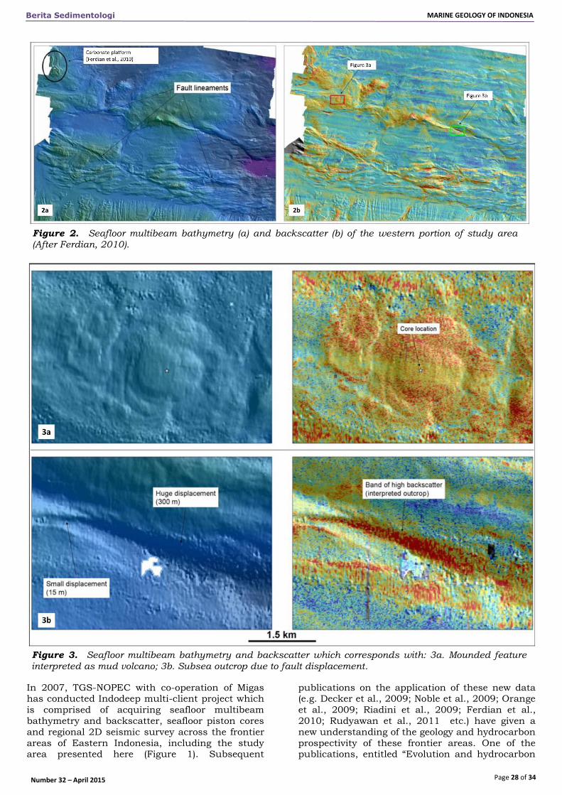
Figure 2. Seafloor multibeam bathymetry (a) and backscatter (b) of the western portion of study area (After Ferdian, 2010).
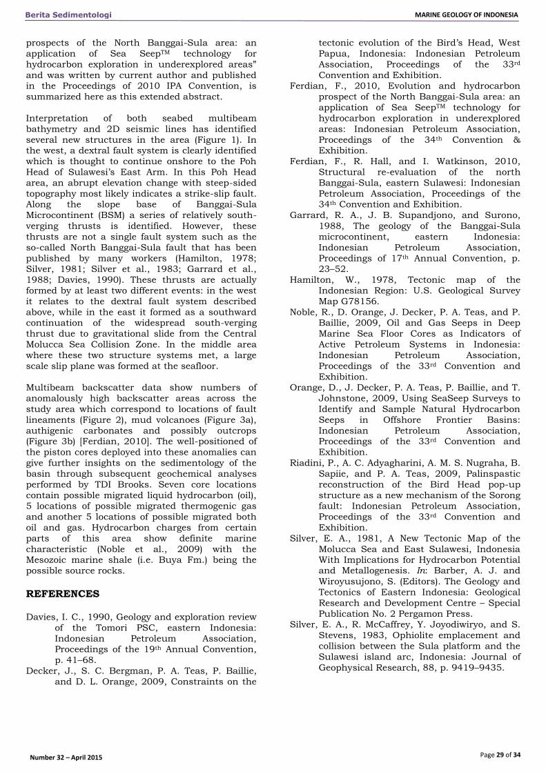
Figure 3. Seafloor multibeam bathymetry and backscatter which corresponds with: 3a. Mounded feature
interpreted as mud volcano; 3b. Subsea outcrop due to fault displacement.
Page 29 of 34
Berita Sedimentologi MARINE GEOLOGY OF INDONESIA
Number 32 – April 2015
prospects of the North Banggai-Sula area: an
application of Sea SeepTM technology for
hydrocarbon exploration in underexplored areas”
and was written by current author and published in the Proceedings of 2010 IPA Convention, is
summarized here as this extended abstract.
Interpretation of both seabed multibeam
bathymetry and 2D seismic lines has identified
several new structures in the area (Figure 1). In the west, a dextral fault system is clearly identified
which is thought to continue onshore to the Poh
Head of Sulawesi’s East Arm. In this Poh Head
area, an abrupt elevation change with steep-sided
topography most likely indicates a strike-slip fault. Along the slope base of Banggai-Sula
Microcontinent (BSM) a series of relatively south-
verging thrusts is identified. However, these
thrusts are not a single fault system such as the
so-called North Banggai-Sula fault that has been
published by many workers (Hamilton, 1978; Silver, 1981; Silver et al., 1983; Garrard et al.,
1988; Davies, 1990). These thrusts are actually
formed by at least two different events: in the west
it relates to the dextral fault system described
above, while in the east it formed as a southward continuation of the widespread south-verging
thrust due to gravitational slide from the Central
Molucca Sea Collision Zone. In the middle area
where these two structure systems met, a large
scale slip plane was formed at the seafloor.
Multibeam backscatter data show numbers of
anomalously high backscatter areas across the
study area which correspond to locations of fault
lineaments (Figure 2), mud volcanoes (Figure 3a),
authigenic carbonates and possibly outcrops (Figure 3b) [Ferdian, 2010]. The well-positioned of
the piston cores deployed into these anomalies can
give further insights on the sedimentology of the
basin through subsequent geochemical analyses
performed by TDI Brooks. Seven core locations
contain possible migrated liquid hydrocarbon (oil), 5 locations of possible migrated thermogenic gas
and another 5 locations of possible migrated both
oil and gas. Hydrocarbon charges from certain
parts of this area show definite marine
characteristic (Noble et al., 2009) with the Mesozoic marine shale (i.e. Buya Fm.) being the
possible source rocks. REFERENCES Davies, I. C., 1990, Geology and exploration review
of the Tomori PSC, eastern Indonesia:
Indonesian Petroleum Association, Proceedings of the 19th Annual Convention,
p. 41–68.
Decker, J., S. C. Bergman, P. A. Teas, P. Baillie,
and D. L. Orange, 2009, Constraints on the
tectonic evolution of the Bird’s Head, West
Papua, Indonesia: Indonesian Petroleum
Association, Proceedings of the 33rd
Convention and Exhibition. Ferdian, F., 2010, Evolution and hydrocarbon
prospect of the North Banggai-Sula area: an
application of Sea SeepTM technology for
hydrocarbon exploration in underexplored
areas: Indonesian Petroleum Association,
Proceedings of the 34th Convention & Exhibition.
Ferdian, F., R. Hall, and I. Watkinson, 2010,
Structural re-evaluation of the north
Banggai-Sula, eastern Sulawesi: Indonesian
Petroleum Association, Proceedings of the 34th Convention and Exhibition.
Garrard, R. A., J. B. Supandjono, and Surono,
1988, The geology of the Banggai-Sula
microcontinent, eastern Indonesia:
Indonesian Petroleum Association,
Proceedings of 17th Annual Convention, p. 23–52.
Hamilton, W., 1978, Tectonic map of the
Indonesian Region: U.S. Geological Survey
Map G78156.
Noble, R., D. Orange, J. Decker, P. A. Teas, and P. Baillie, 2009, Oil and Gas Seeps in Deep
Marine Sea Floor Cores as Indicators of
Active Petroleum Systems in Indonesia:
Indonesian Petroleum Association,
Proceedings of the 33rd Convention and
Exhibition. Orange, D., J. Decker, P. A. Teas, P. Baillie, and T.
Johnstone, 2009, Using SeaSeep Surveys to
Identify and Sample Natural Hydrocarbon
Seeps in Offshore Frontier Basins:
Indonesian Petroleum Association, Proceedings of the 33rd Convention and
Exhibition.
Riadini, P., A. C. Adyagharini, A. M. S. Nugraha, B.
Sapiie, and P. A. Teas, 2009, Palinspastic
reconstruction of the Bird Head pop-up
structure as a new mechanism of the Sorong fault: Indonesian Petroleum Association,
Proceedings of the 33rd Convention and
Exhibition.
Silver, E. A., 1981, A New Tectonic Map of the
Molucca Sea and East Sulawesi, Indonesia With Implications for Hydrocarbon Potential and Metallogenesis. In: Barber, A. J. and
Wiroyusujono, S. (Editors). The Geology and
Tectonics of Eastern Indonesia: Geological
Research and Development Centre – Special
Publication No. 2 Pergamon Press. Silver, E. A., R. McCaffrey, Y. Joyodiwiryo, and S.
Stevens, 1983, Ophiolite emplacement and
collision between the Sula platform and the
Sulawesi island arc, Indonesia: Journal of
Geophysical Research, 88, p. 9419–9435.