Embed Size (px)
Citation preview

A
s
4
1
CALENDAR ITEM
C42
MINUTE ITEM This Calendar Item No. ef~ was approvet
Minite Item No. ft. by the California State I Comm1ss1on by a vote of 3 to LJ at its /fi /7 /9~- meeting. - -
PRC 7868
12/07/95 W24529
Young
RECREATIONAL PIER LEASE APPLICANT:
Walt S. Hoefler and Mary R. Hoefler 15122 Sperry· Lane Saratoga, California 95076
LOCATION: Submerged land in Lake Tahoe, El Dorado County
EXHIBITS: A. Site and Location Map. B. Negative Declaration/Mitigation Monitoring Plan.
AB 884: NIA.
OTHER PERTINENT INFORMATION:
This lease is conditioned on the Lessee's obtaining authorization from the Tahoe Regional Planning Agency for the existing buoy by December 7, 1997.
RECOMMENDED ACTION:
IT IS RECOMMENDED THAT THE COMMISSION:
CEQA FINDING: (PIER)
1. CERTIFY THAT A NEGATIVE DECLARATION, ND# 665, SCH# 95022043, WAS PREPARED FOR THIS PROJECT PURSUANT TO THE PROVISIONS OF THE CEQA AND THAT THE COMMISSION HAS REVIEWED AND CONSIDERED THE INFORMATION CONTAINED THEREIN.
-1-CALENDAR PAGE 112
MINUTE PAGE 2 (ob L

CALENDAR ITEM NO. C42 (CONT'D)
2. ADOPT THE NEGATIVE DECLARATION AND DETERMINE THAT THE PROJECT, AS APPROVED, WILL NOT HAVE A SIGNIFICANT EFFECT ON THE ENVIRONMENT.
3. ADOPT THE MITIGATION MONITORING PLAN, AS CONTAINED IN EXHIBIT "B", ATTACHED HERETO.
4. FIND THAT THIS ACTIVITY IS CONSISTENT WITH THE USE CLASSIFICATION DESIGNATED FOR THE LAND PURSUANT TO PUBLIC RESOURCES CODE SECTION 6370, ET SEQ.
CEQA FINDING: (Buoy) 1. FIND THAT THE ACTIVITY IS EXEMPT FROM THE REQUIREMENTS OF THE
CEQA PURSUANT TO 14 CAL. CODE REGS. 15061 AS A CATEGORICALLY EXEMPT PROJECT, CLASS 3, CONSTRUCTION OF SMALL STRUCTURES, 2 CAL. CODE REGS. 2905 (C) (3).
SIGNIFICANT LANDS INVENTORY FINDING:
FIND THAT THIS ACTIVITY IS CONSISTENT WITH THE USE CLASSIFICATION DESIGNATED FOR THE LAND PURSUANT TO PUBLIC RESOURCES CODE SECTION 6370, ET SEQ.
AUTHORIZATION: AUTHORIZE ISSUANCE TO WALT S. HOEFLER AND MARY R. HOEFLER, OF A TEN-YEAR RECREATIONAL PIER LEASE FOR THE STATE'S SOVEREIGN LANDS BELOW THE ELEVATION OF 6223.0 FEET LAKE TAHOE DATUM UNDER APPLICANT'S PIER AND BUOY AS DEPICTED ON EXHIBIT "A" ATTACHED AND BY REFERENCE MADE A PART HEREOF, BEGINNING DECEMBER 7, 1995; NO MONETARY CONSIDERATION PURSUANT TO PUBLIC RESOURCES CODE SECTION 6503.5.
-2-CALENDAR PAGE 112.1
MINUTE PAGE 2003

ST([l Pit.CS
a: w
a:' a: 8 8. +I +I io ~ :
a: w Q,l a: 0 0 I- I-
10' s
STEtl SltPS ~.10_~
l'OIDER Pl.ES
PIERHEAD SECTION I 60'±
I. 20· I 15·
N.T.S.
~,~~~~~,r--"-~~--~-~ BOATLl~T
I .
ONCRETE FOOTING (ALTERNATIVE)
PLAN
35'
DECK ELEV. 6232.0 -r
BO'±
13 ::i:· a: w 0:
I~ I
Lake Tahoe
0 z ii: 0 o>::::Eo 0 ::> w zm o j::: ::i: (/) ~ x w
w ~ < ..J
g•
WOOD JOIST
. ···sit:n: Pl..E PUS 10 BE Ft "'IH SlEEl BEAM
6223.0' L.T.D.
BOTIOM 6220.0±
PROFILE 8349 Meeks Bay Ave.
LOCATION MAP
Lake Tahoe
NO SCALE
This Exhibit is solely for purposes of generally defining the lease premises, and is not intended to be, nor shall it be construed as, a waiver or limitation of any State interest in the subject or any other property.
WAI KWAY SECTION N.T.5. \
NO SCALE
EXHIBIT II A"
w 24529
APN 16 - 081 - 06
Lake Tahoe
EL DORADO COUNTY
I I
LA KIE
TA H o: E
•.
.2

STATE OF CALIFORNIA
STATE LANDS COMMISSION GRAY DAVIS. Lieutenant Governor KATHLEEN CONNELL. Controller RUSSELLS. GOULD. Director of Finance
February 15, 1995
EXHIBIT 'B'
PETE WILSON. Gotlflrnor
EXECUTIVE OFFICE 1 807 - 13th Street Sacramento. CA 95814-7187
ROBERT C. HIGHT Executive Officer
File: W 24529 ND665
SCH: 95022043
NOTICE OF PUBLIC REVIEW AND INTENT TO ADOPT A
PROPOSED NEGATIVE DECLARATION (SECTION 15073 CCR & SECTION 21092 PRC)
A Negative Declaration has been prepared pursuant to the requirements of the California Environmental Quality Act (Section 21000 et seq., Public Resources Code), the State CEQA Guidelines (Section 15000 et seq., Title 14, California Code Regulations), and State Lands Commission Regulations (Section 2901 et seq., Title 2, California Code Regulations) for a project application currently being processed by the staff of the State Lands Commission.
This document is attached for your review. Comments should be addressed to the State Lands Commission office shown above with attention to the undersigned. All comments must be received by March 17 , 1995.
The Negative Declaration will be considered for adoption at a meeting of the State Lands Commission no earlier than March 17, 1995. You will be notified of the date and location at least IO days prior to the meeting.
Should you have any questions or need additional information, please call the undersigned at (916) 324-4715.
WN 1v1s1 Environmental Planning and Management
Attachment
CALENDAR PAGE 112.3
MINUTE PAGE Z 0 (o5

STATE OF CALIFORNIA
STATE LANDS COMMISSION GRAY DAVIS. Lieutenant Governor KATHLEEN CONNELL. Controller RUSSELLS. GOULD. Director of Finance
PROPOSED NEGATIVE DECLARATION
Project Title: Hoefler Pier Reconstruction/Relocation
Proponent: Walt S. Hoefler - c/o Vail Engineering Corporation
PETE WILSON. Governor
EXECUTIVE OFFICE 1807 - 13th Street Sacramento. CA 95814-7187
ROBERT C. HIGHT Executive Officer
File: W 24529
ND 665
Project Location: 8349 Meeks Bay Avenue, APN: 16-081-06, Lake Tahoe, El Dorado County
Project Description: Remove an existing 35' wooden pier, side laders and davit; realign and reconstruct a 35' pier with wooden deck and steel pilings; construct a steel stairway in lieu of a catwalk; replace the davit with a new low-level boatlift. Construction access will occur from the lake side of the pier using a rubber-tired barge with pile driver.
Contact Person: Judy Brown. Telephone: (916) 324-4715
This document is prepared pursuant to the requirements of the California Environmental Quality Act (Section 21000 et seq:, Public Resources Code}, the State CEQA Guidelines (Section 15000 et seq., Title 14, California Code Regulations), and the State Lands Commission regulations (Section 2901 et seq., Title 2, California Code Regulations).
Based upon the attached Initial Study, it has been found that:
/_/
;_x_;
this project will not have a significant effect on the environment.
mitigation measures included in the project will avoid potentially significant effects.
CALENDAR PAGE 112.4
MINUTE PAGE L(o{o&J

STATE LANDS COMMISSION
ENVIRONMENTAL IMPACT ASSESSMENT CHECKLIST - PART II Form 13.20 (7/82) File Ref.: W 24529
I. BACKGROUND INFORMATION
A. Applicant:
WALTS. HOEFLER C/O VAIL ENGINEERING CORP
PO BOX 879
TAHOE CITY CA 96145
B. Checklist Date: 01 I 23 I 95
C. Contact Person: -----"J""'U~D'-'Y'-""B...,R,,.O'""W,,_.N......._ _________________ -'--------
Telephone: ....1C_;:_9...,,16<--J--..:.32=..:4::;...-4;;,,.7t..Jl....,5'----
D. Purpose: PROPOSED PIER AND BOATLIEf RECONSTRUCTION· RETENTION Of ONE EXISTING MOORING BUOY
E. Location: APN: 16 - 081 - 06: 8349 MEEKS BAY AVENUE. LAKE TAHOE. EL DORADO COUNTY
F. Description: ___ ___..R...,E::.:.M..,,Oo<-V,_,,,E""-'-'A.._N~E....,X .... IS....,T_..IN.......,.G_W"'""""O"""O""D'""'E.,_N'-""35.:....'~P_._IE .... R..._ . ._.S...,I ..... P,,._E._.L..,Au.D~P .... E=R.,,,S_..A...,N...,,D"'--'D""'A.....,_VLJIT._,,· ...... R,...E .... A,..,.Ld.l:lo.!G~N_.A~N~[
RECONSTRUCT A 35' PIER TO CONFORM TO USACOE LOT LINE PROJECTION SETBACKS: CONSTRUCT A STEEL
STAIRWAY ON THE SW SIDE OF THE PIERHEAD IN LIEU OF A CATWALK· REPLACE THE DAVIT WITH A NEW LOW·
LEVEL BOA TUFT.
G. Persons Contacted:----------------------------------
COLEEN SHADE TAHOE REGIONAL PLANNING AGENCY
JIM LAWRENCE TAHOE REGIONAL PLANNING AGENCY
MARK ZUMSTEG CALIFORNIA PEPARTMENT OF FISH AND GAME
II. ENVIRONMENTAL IMPACTS. (&plain all "yes" and "maybe" answers)
A. Earth. Will the proposal result in: Yes Maybe No
I. Unstable earth conditions or changes in geologic substructures? ........................ .
2. Disruptions, displacements, compaction, or overcovering of the soil? . . . . . . . . . . . . . . . . . . . .
3. Change in topography or ground surface relief features?. . . . . . . . . . . . . . . . . . . . . . . . . . . . . .
4. The destruction, covering, or modification of any unique geologic or physicai features?
5. Any increase in wind or water erosion of soils, either on or off the site? IF===============:a.A
6. Changes in deposition or erosion of beach sands, or changes in siltation, ~~~Hlsi~h may modify the channel of a river or stream or the bed of the ocean or a bay, inlet, or lake. . ..
MINUTE PAGE 7. Exposure of all people or property to geologic hazards such as earthqua.Kes, an s 1 es,
mudslides, ground failure, or similar hazards? .................................. .
112.s

B. Air. Will the proposal result in: Yes Mayhe N,,
I. Substantial air emissions or deterioration of ambient air quality? . . . . . . . . . . . . . . . . . . . . . . . . . 2. The creation of objectional odors? ............................................ . 3. Alteration of air movement, moisture or temperature, or any change in climate, either locally or regionally?_
C. Water. Will the proposal result in:
1. Changes in the currents, or the course or direction of water movements, in either marine or fresh waters?_ 2. Changes in absorption rates. drainage panems, or the rate and amount of surface water runoff! ..... . 3. Alterations to the course or flow of flood waters? . . . . . . . . . . . . . . . . . . . . . . . . . . . . . . . .. 4. Change in the amount of surface water in any water body? ............................ . 5. Discharge into surface waters, or in any alteration of surface water quality, including but not
limited to temperature, dissolved oxygen or turbidity? ............................... . 6. Alteration of the direct on or rate of flow of ground waters? ............................. _ 7. Change in the quantity of ground waters, either through direct additions or withdrawals, or through
interception of an aquifer by cuts or excavations? . . . . . . . . . . . . . . . . . . . . . . . . . . . . . . . . . . . . 8. Substantial reduction in the amount of water otherwise available for public water supplies? ....... '. 9. Exposure of people or property to water-related hazards such as flooding or tidal waves? ......... . JO. Significant changes in the temperature, flow or chemical content of surface thermal springs? ....... .
D. Plant Life. Will the proposal result in:
1. Change in the diversity of species, or number of any species of plants (including trees, shrubs, grass, crops, and aquatic plants)? ........................................ .
2. Reduction of the numbers of any unique, rare or endangered species of plants? .............. . 3. Introduction of new species of plants into an area, or in a barrier to the normal replenishment of
existing species?. . . . . . . . . . . . . . . . . . . . . . . . . . . . . . . . . . . . . . . . . . . . . . . . . . . . . ..... 4. Reduction in acreage of any agricultural crop? . . . . . . . . . . . . . . . . . . . . . . . . . . . . . . . . ·
E. Animal Life. Will the proposal result in:
I. Change in the diversity of species, or numbers of any species of animals (birds, land animals including reptiles, fish and shellfish, benthic organisms, or insects)? ........... .
2. Reduction of the numbers of any unique, rare or endangered species of animals? .............. . 3. Introduction of new species of animals into an area, or result in a barrier to the migration
or movement of anima.ls? ................ ·. . . . . . . . . . . . . . . . . . . . . . . . . . . . . . . . . . . 4. Deterioration to existing fish or wildlife habitat? ............................... .
F. Noise. Will the proposal result in:
I. Increase in existing noise levels? ........................................ . 2. Exposure of people t-0 severe noise levels? ........................................ .
G. Light and Glare. Will the proposal result in:
1. The production of new light or glare?
H. Land Use. Will the proposal result in:
1. A substantial alteration of the present or planned land use of an area?
I. Natural Resources. Will the proposal result in:
I . Increase in the rate of use of any natural resources? . . . . . . . . . . . . . . . . . . . . . . . . . . . . . . . . . . __x 2. Substantial depletion of any nonrenewable resources? . . . . . . . . . . . . . . . . . . . . . . . . . . . . . . . . ~
CALENDAR PAGE 112. 6
MINUTE PAGE ZloloCO -2-

J. Risk of Upset. Does the proposal result in:
I. A risk of an explosion or the release of hazardous substances (including, but not limited to, oil, pesticides, chemicals, or radiation) in the event of an accident or upset conditions? ................. .
2. Possible interference with emergency response plan or an emergency evacuation plan? ................ .
K. Population. Will the proposal result in:
I. The alteration, distribution, density, or growth rate of the human population of the area? ............ .
L Housing. Will the proposal result in:
1. Affecting existing housing, or create a demand for additional housing? .......................... .
M. Transportation/Circulation. Will the proposal result in:
1. Generation of substantial additional vehicular movement? ................................... . 2. Affecting existing parking facilities, or create a demand for new parking? ......................... . 3. Substantial impact upon existing transponation systems? . . . . . . . . . . . . . . . . . . . . . . . . . . . . . . . . . . . . . 4. Alterations to present panerns of circulation or movement of people and/or goods? ................... . 5. Alterations to waterborne, rail, or air traffic? ............................................ . 6. Increase in traffic hazards to motor vehicles, bicyclists, or pedestrians? .......................... ..
N. Public Services. Will the proposal have an effect upon, or result in a need for new or altered governmental services in any of the following areas:
l. Fire protection? . . .......................................................... . 2. Police protection? .............................................................. . 3. Schools? ................................................................... . 4. Parks and other recreational facilities? ............................................... . 5. Maintenance of public facilities, including roads? ........................................ .. 6. Other governmental services? ...................................................... .
0. Energy. Will the proposal result in:
l. Use of substantial amounts of fuel or energy? ........................................... . 2. Substantial increase in demand upon existing sources of energy. or require the development of new sources? .
P. Utilities. Will the proposal result in a need for new systems, or substantial alterations to the following utilities:
1. Power or natural gas? . . . . . ................................................... . 2. Communication systems? ....................................................... . 3. Water? .................................................................. . 4. Sewer or septic tanks? . . . . . . . . . . . . . . . . . . . . . . . . . . . . . . . . . . . . . . . . . . . . . . . . . . . . . . . . . . . 5. Storm water drainage? .......................................................... . 6. Solid waste and disposal? .............. · ....................................... .
Q. Human Health. Will the proposal result in: .· l. Creation of any health hazard or potential health hazard (excluding mental health)? ................ . 2. Exposure of people to potential heath hazards? ........................................ .
R. Aesthetics. Will the proposal result in:
1. The obstruction of any scenic vista or view open to the public, or will the proposal result in the creation of an aesthetically offensive site open to public view? . . . . . ......................... .
Yes Maybe No
-3-CALENDAR PAGE 112. 7
MINUTE PAGE 2lolP>

S. Recreation. Will the proposal result in:
1. An impact upon the quality or quantity of existing recreational opponunities? . . . . . . . . . . . . . . . . . . . ...
T. Cultural Resources
1. Will the proposal result in the alteration of or the destruction of a prehistoric or historic archeological site? ..
2. Will the proposal result in adverse physical or aesthetic effects to a prehistoric or historic building, structure, or object? .................................................... .
3. Does the proposal have the potential to cause a physical change which would affect unique ethnic cultural values? . . . . . . . . . . . . . . . . . . ............................................ .
4. Will the proposal restrict existing religious or sacred uses within the potential impact area? ............ .
U. Mandatory Findings of Significance.
1. Does the project have the potential to degrade the quality of the environment, reduce the habitat of a fish or wildlife species, cause a fish or wildlife population to drop below self-sustaining levels. threaten to eliminate a plant or animal community, reduce the number or restrict the range of a rare or endangered plant or animal or eliminate important examples of the major periods of California history or prehistory? ......... .
2. Does the project have the potential to achieve shon-term, to the disadvantage of long-term, environmental goals?". .................................................................. .
Yes
3. Does the project have impacts which are individually limited, but cumulatively considerable? ............ _
4. Does the project have environmental effects which will cause substantial adverse effects on human beings, either directly or indirectly? ................. · ........................... .
III. DISCUSSION OF ENVIRONMENTAL EVALUATION (See Comments A1tached)
IV. PRELIMINARY DETERMINATION
On the basis of this initial evaluation:
Maybe No
_ I find the proposed project COULD NOT have a significant effect on the environment, and a NEGATIVE DECLARATION will be prepared.
x_ I find that although the proposed project could have a significant effect on the environment, there will not be a significant effect in this case because the mitigation measures described on an attached sheet have been added to the project. A NEGATIVE DECLARATION will be prepared.
I find the proposed project MAY have a significant effect on the environment, and an ENVIRONMENTAL IMPACT REPORT is required.
./
r ..... r ·7 c;.:... Date: ... · I GI 1 _, 112.8
For 2070 Form 13.20 (7/82)
PROJECT DESCRIPTION
Applicant proposes to remove. relocate and reconstruct an existing 35' recreational pier. A steel stairway will be constructed on the SW side of the pierhead in lieu of a catwalk. The existing davit will be replaced with a new low-level boat lift. The project will be removed and reconstructed as indicated in Attachment A. project narrative and construction method.
Removal and reconstruction will be accomplished using a rubber-tired barge with a pile driver. Caissons or sleeves will be used while pile driving. Anchorage of the barge will be to the existing structure and/or by lake anchors to ensure adequate stabilization of barge. Iflow water exists at the time of reconstruction. barge access and construction activity would occur Within the width of the proposed pier plus the width of the barge.
All construction wastes will be collected onto the barge and disposed at an approved location. Small boats and tarps will be used under construction areas in order to prevent discharge of materials into lake waters.
The pier and buoy are proposed to be permitted by the State Lands Commission. The mooring buoy is represented by the applicant as an existing project which has been in place prior to enactment of CEQA. The mooring buoy has been acknowledged by TRP A. see Attachment E.
ENVIRONMENTAL SETTING
The proposed project is located in Meeks Bay, El Dorado County (APN: 16-081-06), lakeward of 8349 Meeks Bay Avenue, Lake Tahoe. The upland terrain from the pier to the residence is a steep bluff, see Attachment C.
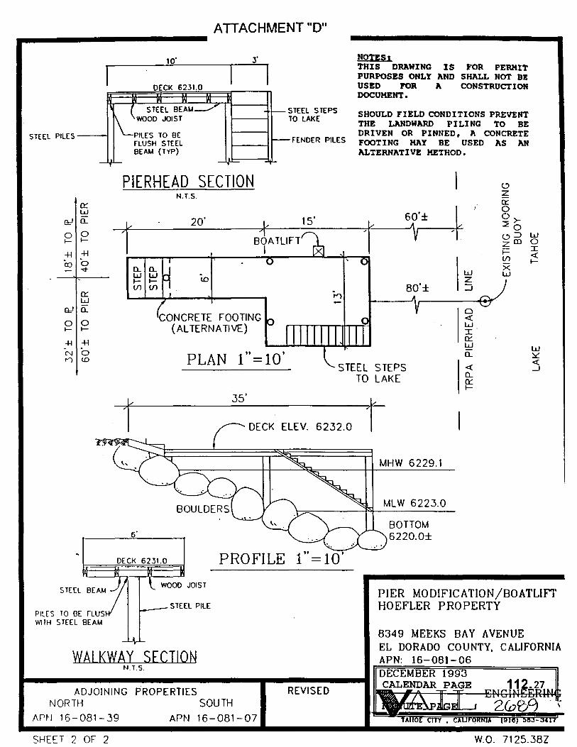
The pier to be removed and reconstructed is supported by piling driven into the lakebed substrate which consists of boulders, see Attachments C and D. The substrate of the project site was site verified by TRPA staff and characterized as "prime fish habitat", Attachment "F".
The projected site was checked within the TRP A 1993 Shorezone Inventory to ascertain if the project was capable of supporting the California-listed plant species, Tahoe Yellow Cress. The database indicated that the project site did not contain nor was the substrate capable of supporting Tahoe Yellow Cress.
There are seven or more recreational piers located to the north of this project and approximately three to four recreational piers located to the south of this project. The piers mentioned are on successively adjacent parcels and are comparative in length to this project.
CALENDAR PAGE 112. 9
MINUTE PAGE ZG 7 I

III. DISCUSSION OF ENVIRONMENT AL EV ALU A TI ON HOEFLER PIER RELOCATION/RECONSTRUCTION
A Earth
I. Stability, Geologic Substructures
This project involves complete removal and realignment of the existing wooden piles and recreational pier structure and replacement with steel piles, wooden decking and a steel stairway. During placement of new steel piles, concrete footings may be used in .. lieu of driving the piles into the substrate to stabilize the pier structure where pilings cannot be driven due to the number of boulders in the area. No significant impacts have been identified.
2. Compaction, Overcovering of the Soil
As discussed in A 1., above, old wooden pilings will be removed and new steel pilings will be placed. The proposed alignment of the pier will coincide with TRPA and United States Army Corps of Engineers setback requirements. The substrate area to be covered by the reconstructed pier would be new, but the size of structure and amount of area to be covered would be equivalent to that occupied by the previous pier structure. No significant impacts have been identified.
3. Topography
There are no known changes to the ground surface to accomplish this project. No impacts have been identified.
4. Geologic Features
The lake bed substrate at the project location is comprised of large boulders. Concrete footings may be used during placement of the new pilings if pilings cannot be driven due to the existence of boulders. No significant impacts have been identified.
5. Wind, Water Erosion of Soils
Access to perform the reconstruction work will be achieved from the lake side of the project by a rubber-tired barge. Access to the pier from the upland bluff-top residence is via an existing steep foot path. The proposed project which includes realignment and reconstruction of the existing recreational pier would not have an impact to erosion or depositional processes which would normally occur in a boulder substrate. The project is located within the body of the lake. No stream inlets are present within the project
2 CALENDAR PAGE 112.10
MINUTE PAGE 26 7 L

influence area. No significant impacts have been identified.
6. Erosion, Deposition
No significant impacts are anticipated, refer to discussion in A.5., above.
7. Geologic Hazards
There are no known geologic hazards at or near the project site. No significant impacts are anticipated.
B. Air
1. Emissions/Deterioration
This project would involve the use of a barge and pile driver. The amphibious watercraft will access the site from the lake side of the project. Some emissions will result from the construction equipment. This impact will be minor and temporary, lasting during the repair activity which may take several weeks. Continued operation of the applicant's boat for the use of the pier and buoy would be a minor contribution to the cumulative air emissions within the Lake Tahoe Basin. The California Environmental Protection Agency has been evaluating air emissions from boat engines and is taking steps to minimize air emissions from boat usage. No significant impacts are anticipated from this proposed project.
2. Objectionable Odors
This project does not propose the use of any hazardous materials for the reconstruction of the existing pier. Some odors will be experienced from emissions of the waterborne vessel and equipment used to drive the piles. The pile driving activity is anticipated to take approximately ten working days. Continued use of the pier and buoy would create some odors as boats arrive and leave. The existing and proposed use of this pier and buoy is for the applicant only. No commercial activity is proposed at the project site. The impacts are considered to be insignificant.
3. Air Movement, Moisture, Temperature, Climate
This project does not propose the placement of any structure which would affect the air movement, moisture or temperature, or any change in climate, locally or regionally. No significant impacts would occur.
3 CALENDAR PAGE 112.11
MINUTE PAGE 2Jo73
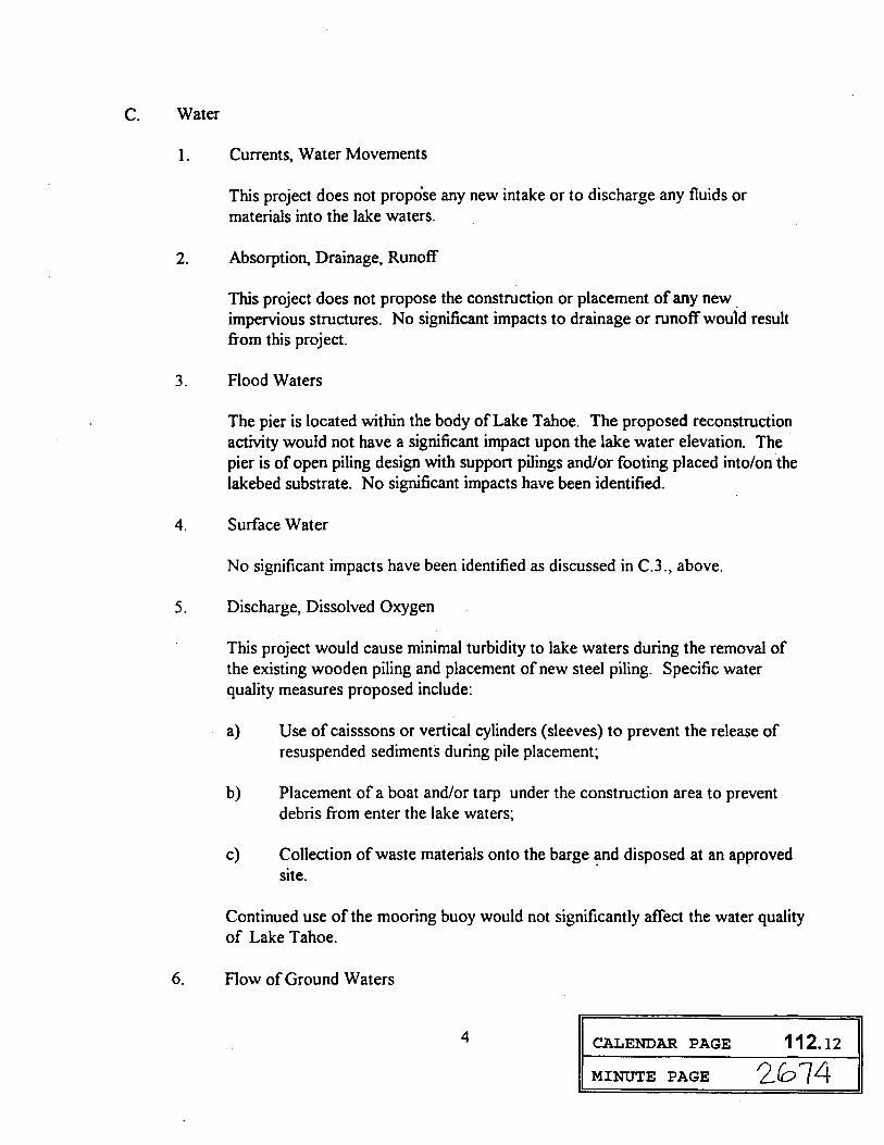
C. Water
I. Currents, Water Movements
This project does not propo'se any new intake or to discharge any fluids or materials into the lake waters.
2. Absorption, Drainage, Runoff
This project does not propose the construction or placement of any new . impervious structures. No significant impacts to drainage or runoff would result from this project.
3. Flood Waters
The pier is located within the body of Lake Tahoe. The proposed reconstruction activity would not have a significant impact upon the lake water elevation. The pier is of open piling design with support pilings and/or footing placed into/on the lakebed substrate. No significant impacts have been identified.
4. Surface Water
No significant impacts have been identified as discussed in C.3., above.
5. Discharge, Dissolved Oxygen
This project would cause minimal turbidity to lake waters during the removal of the existing wooden piling and placement of new steel piling. Specific water quality measures proposed include:
a) Use of caisssons or vertical cylinders (sleeves) to prevent the release of resuspended sedimenfs during pile placement~
b) Placement of a boat and/or tarp under the construction area to prevent debris from enter the lake waters~
c) Collection of waste materials onto the barge ~nd disposed at an approved site.
Continued use of the mooring buoy would not significantly affect the water quality of Lake Tahoe.
6. Flow of Ground Waters
4 CALENDAR PAGE 112.12
MINUTE PAGE 2Jol4

New steel pilings would replace the existing wooden pilings. The pilings would be driven into the lake bed a minimum of 6' or to the point of refusal and/or concrete footings will be used as necessary where boulders prevent pile driving. The pier is located within the body of Lake Tahoe. Reconstruction activity would not affect the flow of ground water. The existing mooring buoy anchor rests on the lake bottom and would also not affect flows of ground water. No significant impacts have been identified.
7. Quantity of Ground Waters
This project does not propose to extract or use existing ground water; therefore, there would be no impact on ground water quantity.
8. Reduction of Public Water Supplies
This project does not propose the extraction, use or contamination of water used for an existing public water supply. No impacts have been identified.
9. Water-Related Hazards
The proposed project involves the total reconstruction and realignment of an existing recreational pier. No expansion is proposed which could be determined to be a water-related hazard. Other piers exist within the vicinity with comparable length. The existing mooring buoy has been in place for a number of years and has been acknowledged by TRP A. No significant impacts have been identified.
10. Temperature, Flow or Chemical Content
There are no known thermal springs in the vicinity of this project; therefore no impact is anticipated.
D. Plant Life
1. Diversity of Species
The proposed lakebed disturbance for the total recon~truction and realignment of this pier will occur from approximately elevation 6234 lakeward, which is above the high water elevation of Lake Tahoe. The lake bed substrate is primarily boulders. The wooden pilings to be removed may have served as substrate for a now established sessile plant population. Replacement of the pilings will cause a minor population loss of aquatic plants at the site.
5 CALENDAR PAGE 112.13
MINUTE PAGE 2075

Placement of the new steel pilings could furnish new substrate for sessile aquatic plants. This impact would be minimal as the site is dominated by boulders and can furnish habitat for sessile aquatic plants.
2. Endangered Species
The proposed area of lake bed disturbance will occur from lake elevation 6233' lakeward. According to the 1993 Tahoe Regional Planning Agency shoreline survey, the project site does not contain habitat suitable to support the Californialisted Tahoe Yellow Cress, an endangered plant species. The project site contains predominantly small boulders 1-3 feet in diameter with some 5' or more.' Access to the site to conduct the reconstruction activity will take place from the lakeside of the pier by an amphibious rubber-tired barge with pile driver. No materials will be stored on the lake bed between elevation 6223' and elevation 6229' LTD. There would be no impacts to endangered species resulting from this project.
3. Introduction of Plants
Removal of the old wooden pilings may disturb sessile aquatic plants growing on them. New steel pilings will provide additional area for sessile aquatic plants to populate. The project is located in an area containing mostly small boulders which can provide a great amount of habitat for sessile aquatic plants. The mooring buoy anchor rests on· the lake bottom. No significant impacts have been identified.
4. Reduction of Agricultural Crops
The pier and mooring buoy are located within the body of Lake Tahoe. No agriculture or aquaculture activities are conducted in this area. There would be no impact.
E. Animal Life
1. Animal Species Diversity
The proposed project is located in prime fish habitat according to TRP A staff site verification.
Replacement of the existing pier pilings could affect access to the lake bottom by burrowing organisms. Replacement of the existing pilings could impact fish and benthic organisms which were attracted to the pilings for grazing and shelter. Construction activity may be limited by the California Department of Fish and
6 CALENDAR PAGE 112.14
MINUTE PAGE 207(o

Game through issuance of a Streambed Alteration Agreement required to be obtained by the applicant for the conduct of this project.
TRPA has conditioned the use of the mooring buoy to be seasonally used between May 2 and October 14 of each year.
No significant impacts have been identified.
2. Rare Species
This Iakebed substrate at the project site is predominantly small to large boulders. Timing of the construction activity for this project within a fish habitat area may be limited by the California Department offish and Game through issuance of the Streambed Alteration Agreement required to be obtained by the applicant prior to construction. No significant impacts have been identified.
3. New Species
This project does not propose the introduction of any new animaJ species into Lake Tahoe. There would be no impacts in this issue area.
4. Habitat Deterioration
F. Noise
The reconstruction activity would cause a temporary disturbance to fish habitat during the driving of new steel piling. The project area is located in a fish feeding and escape cover habitat. Timing of construction may be limited by the California Department offish and Game through issuance of the Streambed Alteration Agreement, required to be obtained by the applicant prior to construction. Continued use of the pier once reconstructed should not have any detrimental impact upon existing fish habitat. Continued use of the mooring buoy float and anchor, now to be seasonal use, should not have a significant impact upon fish habitat. No significant impacts have been identified.
1. Noise Increases
The proposed project would cause periodic, moderate increases to existing noise levels during the driving of steel pilings. Noise from pile driving activity may occur during work days for two to three weeks. Periodic intermittent increases in noise levels may be experienced during the continued use of the recreational pier for recreational boating. These impacts would be considered temporary, and
7 CALENDAR PAGE 112.1s
MINUTE PAGE 2Co77

insignificant.
2. Severe Noise
Noise from pile driving activity may expose persons within the vicinity to periodic episodes of extreme noise levels. These noise increases may last seconds or minutes in duration. These brief occurrences are not considered to be significant impacts, as they are exempted under the Noise Limitations standards set forth in TRP A Code of Ordinances when TRP A has issued a construction permit; however, the temporary construction activity must take place between 8:00 a.m. and 6:30 p.m .. Periodic, brief increases to the existing noise levels would occur adjacent to the recreational pier and mooring buoy when motorized boat engines are used. Noise standards are monitored and enforced through TRP A ordinances. No significant impacts have been identified.
G. Light and Glare
1. New light or glare
The proposed project would be constructed during the hours of 8:00 a.m. to 6:30 p.m. No lighting for construction activity has been proposed. Colors proposed for the placement of the steel pilings, steel walkway and low-level boat lift must be of earth-tone color, and will be approved through compliance with TRP A permit conditions. No significant impacts have been identified.
H. Land Use
1. Alteration of the Present or Planned Land Use
This project does not propose new land uses at this location which would alter local use patterns. The pier to be reconstructed and relocated is proposed to be replaced within appropriate setbacks within the water influence area of the applicant's upland littoral property. No expansion of the pier is proposed. No significant impacts have been identified.
I. Natural Resources
1-2. Rate of Use ofNatural Resources/ Depletion of Nonrenewable Resources
The proposed reconstruction of the existing recreational pier and continued
8 CALENDAR PAGE 112.16
MINUTE PAGE 207B

seasonal use of the mooring buoy would not increase the rate of use of any natural resource, or loss of non-renewable resources. The pier would continue to be used for private recreational use of the applicant. No new facilities are proposed which would have a significant impact on the use of natural resources.
J. Risk of Upset
1. Explosion
Risk of explosion of fuel could occur during reconstruction of the pier or boat usage of the mooring buoy; however, TRPA permit conditions provide precautions to minimize this possibility. Such precautions include: no discharge of petroleum products into the Lake and, no containers of fuel, paint or hazardous materials may be stored on the pier. No significant impacts have been identified.
2. Emergency Response Plan
The recreational pier has existed at this location for many years. The proposed reconstruction and realignment of this pier does not include any extensions or modification to the dimensions of the pier which would interfere with any existing emergency response plan for this area. The mooring buoy is located approximately 80 feet from the end of the recreational pier and a distance of approximately 20 feet beyond the identified TRP A pierhead line. TRP A has acknowledged the mooring buoy as an existing facility, and has permitted its use to be seasonal between May and October. No significant impacts have been identified.
K. Population
1. Alteration, Distribution, Density, or Growth Rate
The proposed project is a replacement and realignment of an existing facility which is an accessory use to the existing upland residence. There would be no liveaboard vessels or increases in local population resulting from this project.
L. Housing
1. Affect Existing Housing/Demand for Additional Housing
The proposed project would not have any effects in this issue area. As indicated in K. l ., above, it is an accessory use to the existing upland residence, and it is used for private recreational purposes of the applicant. No 'significant impacts have
9 CALENDAR PAGE 112.17
MINUTE PAGE

been identified.
M. Transportation/Circulation
I . Vehicular Movement
The project site will be accessed from the lake for reconstruction of the pier; therefore, there would be no additional vehicular movement within the project area to conduct this project. No new vehicular movement is anticipated for the continued use of the recreational pier, as no new capacity nor change in use is proposed. No significant impacts have been identified.
2. Parking
No new parking is proposed or required to conduct the proposed reconstruction activity. Parking is available for the applicant's use at the upland residence. No significant impacts have been identified.
3. Transportation Systems
No significant impacts have been identified, refer to discussion in M.1., above.
4. Circulation
The recreational pier would be removed, realigned and reconstructed with the same dimensions as the previous pier. Realignment is proposed to bring the pier location more into conformance with TRP A placement standards. Construction access will be obtained from the lake side of the pier. There would be no new impacts to the circulation or movement of people and/or goods. The existing mooring buoy will be used seasonally as indicated by TRPA permit #940299.
5. Traffic
Construction traffic will be minimized through lakeside access to reconstruct the pier. No new impacts are anticipated to waterborne traffic, as the realignment of the pier has been determined to be adequate and thus the TRP A permit has been issued. Please refer to attachment "D", showing 40' io the adjacent pier to the north and 60' to the adjacent pier to the south from the proposed pier's center line. No significant impacts have been identified.
6. Hazards
IO CALENDAR PAGE 112 .18
MINUTE PAGE ZGBO

The proposed repair activity and access to the pier site would occur in the body of the Lake, therefore, no impacts to motor vehicles, bicyclists or pedestrians would occur. Continued use of the pier and mooring buoy within the body of the Lake would create no new impacts to this issue area.
N. Public Services
1.-6. Fire, Police, Schools, Parks, Public Facilities, Other Governmental Services
0. Energy
The proposed reconstruction of an existing recreational pier would occur within the same water influence area and include the same dimensions. Continued use of the pier and mooring buoy would not have a new effect on public services. No new facilities are proposed which would have a significant impact upon any of these issue areas.
1. Use
Minor amounts of fuel and electrical power would be required to conduct the reconstruction of the existing pier. These impacts would be temporary, lasting several weeks. Continued use of the existing pier and mooring buoy would not create a significant demand upon the existing sources of energy or require the development of new sources of energy.
2. Demand
As discussed in 0.1., above, no significant impacts have been identified.
P. Utilities
1.-6. Power, Communication Systems, Water, Sewer, Storm Drainage, Solid Waste
The proposed reconstruction of the existing pier and_.retention of the mooring buoy would not significantly increase these issue areas. There is an existing residential dwelling located on the bluffiop of the littoral property from which the pier presently extends. All needed services are provided for the residential dwelling. No significant features are proposed which would require a change to the existing utility systems.
11 CALENDAR PAGE 112.19
MINUTE PAGE 2G01

Q. Human Health
1.-2. Creation/Exposure to Health Hazard
Reconstruction of the existing recreational pier is needed in order to maintain a safe structure for the use of the applicant. All materials used are conditioned and enforced by TRP A and CDFG ordinances and regulations. Construction materials have been described in Project Description preceding environmental issue discussion. No significant impacts have been identified.
R. Aesthetics
The reconstruction activity will occur within the shoreline area where other similarly sized recreational piers occur with similar features and design. Colors to be used for the pier, stairway and boatlift will be regulated by the conditional TRP A permit requiring earthtoned colors that blend rather than contrast with the surrounding environment. No new significant impacts to the scenic view have been identified. Use of the mooring buoy has been conditioned by the TRP A permit to require seasonal use between May and October of each year. This condition may improve the visual appearance of this water influence area.
S. Recreation
Reconstruction of the existing recreational pier would occur totally within the water influence area of the applicant's littoral property. This should not impact adjacent recreational uses within the shoreline area. The existing mooring buoy has been acknowledged as an existing facility by TRPA (refer to Attachment E) and conditioned by TRPA for seasonal use as indicated in R., above. The pier to be reconstructed will remain the same length. No significant impacts have been identified.
T. Cultural Resources
1.4. Prehistoric/Archaeological Sites
The proposed pier repair activity will occur from approximately elevation 6233' waterward of the low water elevation 6223' (LTD). There are no known archaeological or ethnic sites at this location. Impacts to the lakebed anticipated from this proposed reconstruction activity are minor and would not require excavation of earth materials. The mooring buoy anchor rests on the lake bottom. No significant impacts are anticipated to prehistoric or archaeological features. ·
12 CALENDAR PAGE 112.20
MINUTE PAGE

U. Mandatory Findings of Significance
I . Degradation of the Environment
The pier to be reconstructed is located in a fish habitat area designated by TRP A to be feed and escape cover. The proposed repair activity may be limited as appropriate by the California Department of Fish and Game through issuance of the Streambed Alteration Agreement, required to be obtained by the applicant. The mooring buoy use has been conditioned by TRP A to be seasonal use between May and October of each year. No significant impacts have been identified.
2. Environmental Goals
The impacts which would be caused by the pier reconstruction/realignment and retention of the mooring buoy would be minimized as a result of the incorporation of project modifications such as: accessing the site from the lake side for pile driving; placing tarps or small boats under the construction area to prevent debris from entering the lake; using caissons or steel sleeves to prevent the resuspension of sediments during the pile ·driving activity; conducting the repair work in accordance with the CDFG Streambed Alteration Agreement; and seasonal use of the mooring buoy. It does not appear that environmental goals would be jeopardized by this proposed project.
3. Cumulative Impacts
The proposed reconstruction activity and retention of the pier and mooring buoy would not create any significant impacts as indicated in environmental issue areas described above.
4. Adverse Impacts
The proposed pier reconstruction activity and retention of the mooring buoy would not produce any significant adverse effects to human beings or the environment as discussed in the environmental issue areas above. In addition, this project will be monitored by the staff of the Tahoe Regional Planning Agency and the State Lands Commission to ensure project modifications are implemented.
13 CALENDAR PAGE 112 ·. 21
nLl~O, 2.. MINUTE PAGE l.LJ U v

I.
2.
3.
Impact:
MONITORING PROGRAM HOEFLER PIER RECONSTRUCTION
8349 Meeks Bay Avenue APN: 16-081-06, El Dorado County
W24529
The proposed repair activity will occur within designated fish habitat and may disturb it.
Project Modification: . The construction activity will be limited to the period July I - October 15, as designated by the California Department offish and Game through issuance of a Streambed Alteration Agreement. If disturbed sediments are found at the end of the reconstruction activity, the affected areas will be hand rolled and/or rock cobble will be hand picked in order to reconsolidate the shoreline/lakebottom sediments.
Project Monitoring:
Impact:
Staff of the State Lands Commission, or its designated representative, will be notified prior to the start of construction and will inspect the project site periodically, coordinate this activity with other responsible agencies, and upon conclusion of the project, ensure project modifications are and have been implemented.
Access to the pier site is via a steep upland bluff and may therefore disturb the soils and vegetation during repair activities.
Project Modfiication: The pier site will be accessed from the water via an amphibious barge with pile driver. No storage of equipment or materials is proposed on the beach. All storage of materials will be on the existing structure or on the barge.
Project Monitoring:
Impact:
Staff of the State Lands Commission, or its designated representative, will periodically monitor the project site and coordinate with other responsible agencies to ensure project modifications are implemented.
The proposed repair activity may have the potential to create a discharge into lake waters affecting the water quality of the lake.
14 CALENDAR PAGE 112.22
MINUTE PAGE 2G54

Project Modification: During the proposed repair activity, tarps or small boats will be placed under the construction area to prevenet debris from entering the lake. Caissons or steel sleeves will be used to prevent the resuspension of sediments during the driving of piles.
Project Monitoring: Staff of the State Lands Commission, or its designated representative, will periodically monitor the project site and coordinate with other responsible agencies to ensure project modifications are implemented.
15 CALENDAR PAGE
MINUTE PAGE
112.23
2Co55

( (
'·
A TI ACHMENT "A"
W.0. 7125.38Z
•'
RE: PIER MODIFJCATION/BOATLIFf- HOEFLER PROPERlY EL DORADO COUN1Y APN: 16-081~06
. I
PROJECT NARRATIVE
..
. . '
I . • .
,·
· .
The project involves removing an existing non-conforming pier and realigning, rec.onstructing, and modifying it to conform with agency standards. No increase in size -or height is being propc)sed for this pier. The reconstruction will utilize steel piles and l?carns, wood joists and decking. A steel · stairway into the lake is propoied in lieu of a catwalk to facilitate boat access from the end of the pier as large boulders along the shoreline prohibit access along the south side of the pier: .The davit will be removed and a low level boatlift installed. Construction will incorporate measures to enhance scenic quality along this portion of the lake (see sub111itta) drawings). · ·
CONSTRUCTION METHOD
The demolitio~ and construction activity associated with this pier is to be performed by-a rubber-tired barge v.ith a pile driver. Caissons or sleeves will be. used if sediment is resuspended while pile driving. Anchorage of the barge will be to the existing structure imd/or by Jake anchors to ensure adequate stabiliz.ation of barge. During low water seasons, barge llcceSs and construction activity around the structure will be restricted to a"•footprint• establish~ ~y the. width of either t~e existing or proposed pier plus the·width of the barge placed adjacent toil This access •footprint• will minimiz.e, to the greatest extent feasible, disturbance to the lakebottom and shoreline. All construction wa.Stes will be collected onto -the barge and dispo5ed of at the nearest dumpster or sanitary landfill site. Storage of construction materials directly on the shoreline or within 50 feet of the beach bluff will be prohibited. Small boats and tarps will be utilized under -oonstruction areas in order to prevent discharge of con5tructio-n waste or materials to the lake. If disturbed Jakebottom sediments are found as a result of construction activities, the affected areas v.ill be hand rolled and/or rock cobble will be hand picked in order to rcconsolidate ·the shoreline/)akebottom sediments. .
' .
'·
CALENDAR PAGE 112.24
VAIL ENGINE:ERJNG CORPORATION MINUTE PAGE

NOTES: THIS PIER IS PROPOSED TO BE BROUGHT INTO CONFORMANCE WITH THE AGENCY REQUIREMENTS.
THIS DRAWING IS FOR PERMIT PURPOSES ONLY AND SHALL NOT BE USED FOR A CONSTRUCTION DOCUMENT.
I I / ~4,,1 /
A TT AC HM ENT "B"
/§ /~"(-I
q;"t"
/~ 1~~
~ /
U.S. COAST GUARD APPROVED BUOY
MHW
MLW
CONCRETE BLOCK (8 CF MIN.) _ _,....-,.....,. .
:.c.;.: : .. ·:·~·\· . .:: {.:.: ?.:":}:?=. BUOY DETAIL
N.T.S.
ADJOINING PROPERTIES NORTH SOUTH
APN: 16-081-39 APN: 16-081-07
SHEET 1 OF 2 .·
REVISED
0 v II
I. ..... w ...J <( CJ (/)
LOCATION MAP
PIER MODIFICATION/BOATLIFT HOEFLER PROPERTY
8349 MEEKS BAY AVENUE EL DORADO COUNTY, CALlFORNIA
112 .25
2/oB7
W n 71 ')s:; ~R7

ATTACHMENT "C"
.. ,. '\ . . l
112.26
STEEL PILES _ __.
ATTACHMENT "D"
10'
PILES TO BE rLUSH STEEL BEAM (TYP)
PIERHEAD SECTION N.T.S.
20'
tO
CONCRETE FOOTING (ALTERNATIVE)
STEEL STEPS TO LAKE
FENDER PILES
NOTES I THIS DRAWING IS FOR PERMIT PURPOSES ONLY AND SHALL NOT BE USED FOR A CONSTRUCTION DOCUMENT.
SHOULD FIELD CONDITIONS PREVENT THE LANDWARD PILING TO BE DRIVEN OR PINNED, A CONCRETE FOOTING MAY BE USED AS AN ALTERNATIVE METHOD.
60'±
~
80'±
w z _J
0 <{ w I et: w (L
<-' z et: 0 o>-~o <-' ::> zm j:::: (/)
x w
w 0 I <{ I-
PLAN 1''=10' STEEL STEPS
TO LAKE <{ (L
et:
35' r DECK ELEV. 6232.0
PROFILE 1" = 10'
WALKWAY SECTION N.T.S.
ADJOINING PROPERTIES REVISED NORTH SOUTH
/\rt·I 16-081-39 APN 16-081-07
SHEET 2 OF 2
r MHW 6229.1
MLW 6223.0
BOTTOM 6220.0±
I-
PIER MODIFICATION/BOATLIFT HOEFLER PROPERTY
8349 MEEKS BAY AVENUE EL DORADO COUNTY, CALIFORNIA APN: 16-081-06 DECEMBER 1993 CALENDAR PAGE
W.O. 7125 .. 38Z

I \
TAHOE REGIONAL PLANNING AGENCY
308 Dorla Court Elks Point. Nevada
July 19, 1993
Kr. Lee Roessler P.O. Box 5848 Tahoe City, CA 96145
P 0 Box 1038 Zephyr Cove. Nevada 89448-1038
ATTACHMENT "E"
Subject: Acknowledgement of one existing buoy, APN 016-081-061, El Dorado County
Dear Kr. Roessler:
(i02) 588-4547 Fax (7021 588-4527
Based on evidence found in aerial photos, Tahoe Regional Planning Ageney (TRPA) has been able to determine that one buoy did exist prior to the adoption date of the TRPA shorezone Ordinances (27 May 1976).
I This letter officially acknowledges the one existing buoy for APN 16-081-06. There is no need for the owner to pursue a TRPA permit in addition to this acknowledgement. We do request, as a part of this acknowledgement, that the buoy be removed at the end of each boating season. Keep in mind that any relocation of buoy require a permit.
Please do not hesitate to call me if you have any questions regarding this matter.
Sincerely,.
Jim awrence Associate Planner Project Review Division
cc: Judy Ludlow, California State Lands Commission Ron Perrault, California State Fish and Game Department Brad Hubbard, U.S. Army Corps of Engineers
CALENDAR PAGE 112. 28
MINUTE PAGE zeogo Planning for the Prctect1on of our Lal<e and Land

.a.n..o"-r' ~lV.NAL !'LANNING I{ .NCY 9 %~\C-~ P.O. Boa 1031 'wl
- --195 U.S. Hlghw1y 50 Zephyr Cove. Ntv1d1 89Ul·1031 R· 1J! .. ~-f!41\f ~ n Round Hiii. Ztphyr Covt, NV FISH HABITAT VERIFICATION REQUEST FORM 1Cl5f1"'$'-l I:_ ~J
(lHPACT DETERHINATIONS) :· , 994 . J\PK 1L• HOEFLER PIER PROJECT, c/o VAIL ENGINEERING, ATTN: TOD CARR ~N•' tmoe R~i;m ~
Hailing Address• P.O. BOX 879 Cltyt IAHOF CTTY~NlHO
Namet
I
--=C:.:.A ______ Zip• 96145 Phone a 916/583-34111 F C £f IVE D f
State 1
I
.I lf l 1 5 iJZi ATTACHMENT "F" LOCATION or FIELD CH£C~
J\ssessor's Par.eel tiumbers ~1~6_-0;;.;8;;.;l;...--=0~6 __________ County• EtrDOllib-~~·.-.;.:·.T"··~1
Street and It 8349 MEEKS BAY AVE.
55 . Lot •• Subd!vlelons MEEKS BAY VISTA ------------------------ ______ ..;;_;;..;.;...;__;..~;;.;.;..---------------Description of site (color of structure, di1tln9ulshin9 features, landmark•, eteJ1 ....
OLD WOODEN PIER WITH EXISTING BOAT HOIST LOC~TED ON PIERHEAD.
Describe how lot can be recognized from off-ehore ln a boat1 STEEP, ROCKY
SHORELINE. ACCESS PATH M[ANDERS THROUGH BACKSHOBE SHRUB
UOTE1 PLEASE PROVIDE 1' WRITTEH PROJECT DESCRIPTION 7'ND PROJECT SITE l'LAN. Field verifications cost $50.00 and can only be performed when the shoreline l• accessible either by land or by boat. Lot9 whleh are dlffleult to locate (l.e., no adjacent development, no natural landmarks, large lot9, mu1t have corner• staked and identified. TRPA staff mu aceea• to th
Oat•~ re of Property Ovner or J.uthori~ed ent
Not Required tA Required EIS Required
9/26/89 roRMS: Impact Determinations CALENDAR PAGE· 112.29
MINUTE PAGE