Embed Size (px)
Citation preview
Law of the Sea Reports, Vol. 3 (2012) No. 1
- 1 -
FUNDAMENTAL PRINCIPLE OF “WITHOUT PREJUDICE” IN SUBMISSIONS
TO THE UN CLCS IN NORTHEAST AND SOUTHEAST ASIA
Barbara Kwiatkowska*
FUNDAMENTAL PRINCIPLE OF “WITHOUT PREJUDICE” IN THE CLCS
WORK. – NORTHEAST AND EAST ASIA - CHINA, JAPAN, REPUBLIC OF
KOREA. – THE SPECIAL CASE OF OKINOTORISHIMA - JAPAN, CHINA,
REPUBLIC OF KOREA. – SOUTHEAST ASIA - CHINA, MALAYSIA,
VIETNAM, BRUNEI, INDONESIA, PHILIPPINES. – ANNEX: MAPS OF
THE MOST RELEVANT DISPUTED AREAS.
Fundamental Principle of “Without Prejudice” in the CLCS Work
The UN Commission on the Limits of the Continental Shelf (CLCS) is an international treaty body formed pursuant to Annex II of the 1982 UN Convention on the Law of the Sea (hereinafter UNCLOS),1 and composed of 21 technical - not legal, but
This Article was received on June 3, 2012, and accepted for publication on August 6, 2012. * Barbara Kwiatkowska is Professor of International Law of the Sea. Between 1985-2009 she was Deputy Director, and in 2009-2012 Senior Fellow, of the Netherlands Institute for the Law of the Sea (NILOS) at the Faculty of Law, Economics and Governance - School of Law at the Utrecht University, The Netherlands. Prof. Kwiatkowska was nominated by the Netherlands as UNCLOS Annex VII Arbitrator and she is the author of Decisions of the World Court Relevant to the UNCLOS (2010), as well as longstanding contributor to the ASIL International Maritime Boundaries series and the author of over 150 articles devoted to a wide range of issues of international environmental law and the law of the sea, with particular reference to international jurisprudence of the ICJ, Arbitral Tribunals and the ITLOS. Email: [email protected]. 1 United Nations Convention on the Law of the Sea (UNCLOS) of 10 December 1982 [in force: 16 November 1994], 1833 UNTS 397, reprinted in (1982) 21 ILM 1261. For the current status of the Convention and the Agreement for the Implementation of Its Part XI, see UNDOALOS website available at http://www.un.org/Depts/los/. Generally, see Bernard H. Oxman, “The Territorial Temptation: A Siren Song at Sea” (2006) 100 AJIL 830-851; U.S. Legal Adviser John B. Bellinger (2005-2009), “The United States and the UNCLOS” of 3 November 2008, available at www.state.gov/s/l/rls/111587.htm; Speeches of UN Secretary-General Ban Ki-Moon and IJMCL’s Editor-in-Chief Prof. David Freestone on the Occasion of World Oceans Day of 8 June 2011, available at http://www.un.org/apps/news/story.asp?NewsID=38652&Cr=oceans&Cr1, and also http://www.un.org/News/Press/docs/2011/sgsm13619.doc.htm, also available at http://www.unmultimedia.org/tv/webcast/2011/06/daily-press-briefing-and-guest-professor-david-freestone-on-the-occasion-of-world-oceans-day.html, and http://www.uncsd2012.org/rio20/, and http://untreaty.un.org/cod/avl/faculty/Freestone.html, and http://www.un.org/en/events/oceansday/index.shtml; 66th UNGA Adopts Two Oceans Resolutions, UN Doc.GA/11185, of 6 December 2011, available at http://www.un.org/News/Press/docs//2011/ga11185.doc.htm; 30th UNCLOS Anniversary 1982-2012, available at http://www.un.org/apps/news/story.asp?NewsID=41531&Cr=oceans&Cr1, and http://untreaty.un.org/cod/avl/ha/uncls/uncls.html, and http://www.un.org/law/avl/; UN Rio+20 Ocean Declaration of 16 June 2012, available at http://www.uncsd2012.org/rio20/, http://www.globaloceans.org/sites/udel.edu.globaloceans/files/RioOceanDeclaration.pdf, and http://www.un.org/Depts/los; infra note 6.
Kwiatkowska/Fundamental Principle of “Without Prejudice” in Submissions to the UN CLCS…
2
technical - experts in the fields of geology, geophysics or hydrography, whose function is to consider the data submitted by coastal States concerning the outer limits of their continental shelf beyond 200 nautical miles, the so-called Outer Continental Shelf, and to make Recommendations on those limits in accordance with UNCLOS Article 76 and the CLCS Rules of Procedure.2 Due to its fundamental obligation not to prejudice any disputes – or more broadly any matters – concerning maritime boundaries and other related issues, the CLCS’ consideration of the large number of sixty Submissions presented so far, and its hosting of some forty more Preliminary Submissions (Information) of coastal states – and numerous pertaining Notes Verbales of other states concerned – on the limits of their outer continental shelves beyond 200 nautical miles, is like a “United Nations Laboratory.” This circumstance has been importantly stimulating future resolutions by means of bilateral (sometimes trilateral) negotiations of treaties and/or submitting of disputes to the International Court of Justice (ICJ) and other judicial and arbitral fora.
The Preliminary Submissions are not formally considered by the CLCS, but they were allowed as means of overcoming financial constraints of developing states in meeting the CLCS deadline. These Preliminary Submissions can also occasionally be used as means for testing reactions- prior to actual Submissions - by other states to disputed claims. For example, three Preliminary Partial Submissions were filed in 2009: by France on its islands of Saint Pierre and Miquelon off the Canadian coast, which perhaps should not have any outer continental shelf at all; by China on the East China Sea disputed with Japan and South Korea; and by Mauritius on the Chagos Archipelago disputed with Britain.3
2 CLCS Scientific and Technical Guidelines, UN Docs CLCS/11 & 11/Add.1 of 13 May & 3 September 1999 and 11/Corr.1 of 24 February 2000; The Date of Commencement of the 10-Year Period, SPLOS/72 of 29 May 2001; Rules of Procedure, CLCS/40 of 2 July 2004; Legal Opinion of UN Under-Secretary-General for Legal Affairs Nicolas Michel [http://untreaty.un.org/ola], CLCS/46 of 7 September 2005; Training Manual for Delineation of the Outer Limits of the Continental Shelf Beyond 200 Nautical Miles and for Preparation of Submissions to the Commission on the Limits of the Continental Shelf (UNDOALOS 2006); Rules of Procedure, CLCS/40/Rev.1 of 17 April 2008 and some 59 actual and 40 prospective Submissions (and related Notes Verbales by other states) made pursuant to UNCLOS Article 76 at www.un.org/Depts/los/clcs_new/clcs_home.htm, as marked in “Table of Claims to Maritime Jurisdiction as of 31 July 2010", UN Law of the Sea Bulletin 53-71 (2010 No.73), available at www.un.org/Depts/los/. For latest analyses of the CLCS work, see D.R. Rothwell, “Issues and Strategies for Outer Continental Shelf Claims,” (2008) 23 International Journal of Marine and Coastal Law (IJMCL) 185-211, available at www.brill.nl/estu; L.D.M. Nelson, “The Settlement of Disputes Arising From Conflicting Outer Continental Shelf Claims,” (2009) 24 IJMCL 409-422; A. Oude Elferink, “Impact of Other States on the Establishment of Outer CS Limits,” (2009) 24 IJMCL 535-556; Tina Schoolmeester & Elaine Baker (eds.), Continental Shelf: The Last Maritime Zone (UNEP-GRID-Arendal 2009), available at http://www.unep.org/dewa/pdf/AoA/Continental_Shelf.pdf; R. Meese, “Bilan détape au 12 mai 2009 des demandes d’extension du plateau continental a la CLPC,” in: Les implications juridiques de la ratification de la Convention des Nations Unies sur le droit de la mer (Université Mohammed V-Souissi 2010) 247-281. Judge Nelson was the Chairman and Alex Oude Elferink was the Rapporteur of Report on the Legal Issues of the Outer Continental Shelf, in: 71st ILA Conference - Berlin, 16-21 August 2004, 773-825 (London 2004) and Report on the Legal Issues of the Outer Continental Shelf, in 72nd ILA Conference - Toronto, 4-8 June 2006 215-253 (London 2006), as completed at 74th ILA Conference - The Hague, 15-20 August 2010 at http://www.ila2010.org/; Coalter G. Lathrop, “Continental Shelf Delimitation Beyond 200 Nautical Miles: Approaches Taken by Coastal States Before the CLCS,” in: International Maritime Boundaries (ASIL IMB), Vol. VI (2011), 4139-4160, available at http://www.brill.nl/international-maritime-boundaries-2. 3According to the 18th SPLOS Decision, UN Doc. SPLOS/183 (20 June 2008), Preliminary Information indicative of the outer CS (referred to hereinafter for reasons of practical convenience as “Preliminary Submission”) may satisfy the deadline requirements under Article 4 of UNCLOS Annex II and SPLOS/72
Law of the Sea Reports, Vol. 3 (2012) No. 1
- 3 -
The fundamental duty of coastal states and the CLCS with respect to the determination of the continental shelf limits without affecting boundary delimitation is expressly laid down in UNCLOS Article 76(10) providing that:
The provisions of this article are without prejudice to the question of delimitation of the continental shelf between States with opposite or adjacent coasts.”
While not expressly formulated in UNCLOS, a similar principle has also evolved in customary international law with respect to UNCLOS Article 121 on Regime of Islands as follows:
The provisions of Article 121, including its paragraph 3 applying to the so-called Rocks, are without prejudice to the questions relating to unresolved disputes concerning sovereignty over insular territory and to the delimitation of maritime zones of islands between States with opposite or adjacent coasts pursuant to UNCLOS Articles 15, 74 and 83.4
Okinotorishima, which is included in Japan’s Submission to the CLCS, forms a single exception in that - as is discussed further below - it keeps being protested by China and South Korea for reasons not related to delimitation but to its nature as potential Article 121(3) rock. Otherwise, the issue of eventual application of the rocks-principle under Article 121(3) does not arise in practice, unless in the context of specific territorial and maritime delimitation disputes. In view of the significance of maritime boundary delimitations for "permanent" determination of the "final and binding" outer limits of the continental shelf, the principle of Article 76(10) that this determination is without prejudice to the delimitation of the continental shelf, as mirrored by Article 134(4) and the customary law based principle
(2001), avilable at www.un.org/Depts/los/; but such Preliminary Submission shall not be considered by the CLCS (http://www.un.org/Depts/los/clcs_new/commission_preliminary.htm) and is without prejudice to the actual Submission and its consideration by the CLCS pursuant to UNCLOS Article 76 at http://www.un.org/Depts/los/clcs_new/commission_submissions.htm & www.un.org/Depts/los/clcs_new/clcs_home.htm. All references in this article to actual Submissions are to their Executive Summaries which are available at the CLCS website. 4 For travaux préparatoires of Article 121 during the Third UN Conference on the Law of the Sea (UNCLOS III), see J.R. Stevenson and B.H. Oxman, “The Third United Nations Conference on the Law of the Sea: The 1974 Caracas Session,” (1975) 69 AJIL 1-30, at 24-25; and “The 1975 Geneva Session”, id., at 763, 786; The Law of the Sea - Regime of Islands: Legislative History of Part VIII (Article 121) of the United Nations Convention on the Law of the Sea, UN Sales No.E.87.V.II (1988); S.N. Nandan CBE and Shabtai Rosenne (eds.), United Nations Convention on the Law of the Sea 1982 - A Commentary, Vol. III (Virginia Center for Oceans Law & Policy 1995) 321-339, hereinafter: Virginia Commentary. See also J.M. van Dyke, J. Morgan and J. Gurish, “The Exclusive Economic Zone of the Northwestern Hawaiian Islands: When Do Uninhabited Islands Generate an EEZ?” (1988) 25 San Diego Law Review 425-494; B. Kwiatkowska and A.H.A. Soons, “Entitlement to Maritime Areas of Rocks Which Cannot Sustain Human Habitation or Economic Life of Their Own,” (1990) 21 Netherlands Yearbook of International Law (NYIL) 139-181; S. Karagiannis, “Les Rochers qui ne se prêtent pas à l'habitation humaine ou à une vie économique propre et le droit de la mer,” (1996) 29 Revue Belge de Droit International 559-624; J.I. Charney, “Rocks That Cannot Sustain Human Habitation,” (1999) 93 AJIL 863-878, as preceded by his thoughts drawn on Article 121(3) rocks shortly upon entry into force of the UNCLOS in 1994, in: J.I. Charney, “Central East Asian Maritime Boundaries and the Law of the Sea”(1995) 89 AJIL 724, at 732-735; R.R. Churchill and A.V. Lowe, The Law of the Sea (3rd Ed. 1999) 49-50, 150-151, 163-164; C.R. Symmons, Ireland and the Law of the Sea (2nd Ed. 2000) 73-78, 144-153; J.L. Jesus, “Rocks, New-Born Islands, Sea Level Rise and Maritime Space,” in: J.A. Frowein (ed.), Liber Amicorum Ambassador Tono Eitel (2003) 579-603, 584; J.M. van Dyke, “The Republic of Korea's Maritime Boundaries”(2003) 18 IJMCL 509-540, available at http://www.brill.nl/estu; J.M. van Dyke, “Legal Issues Related to Sovereignty over Dokdo/Takeshima and Its Maritime Boundary,” (2007) 38 Ocean Development and International Law (ODIL) 157-224; P. Siousiouras & I. Tsouros, “Island Regime in the Context of the Montego Bay Convention on the Law of the Sea,” (2009) 60 Revue Hellenique de Droit International 2007, 359-370.
Kwiatkowska/Fundamental Principle of “Without Prejudice” in Submissions to the UN CLCS…
4
applying to Article 121 quoted above, is further reinforced by Article 9 of the UNCLOS Annex II and the famous Rule 46 of the CLCS Rules of Procedure and its corresponding Annex I on “Submissions in Case of a Dispute Between States with Opposite or Adjacent Coasts or in Other Cases of Unresolved Land or Maritime Disputes.”
Of those provisions, only CLCS Rule 46 refers to disputes. This means that: * under UNCLOS Article 76(10) and Article 9 of UNCLOS Annex II and the CLCS Rule 46, the determination of the outer continental shelf must be without prejudice to boundary delimitations of the outer continental shelf generally.
But that: * under CLCS Rule 46 and its Annex I, this determination must in addition be without prejudice to disputes over such boundary delimitations and to other cases of unresolved land or maritime disputes.
The question arises whether this means that CLCS Rule 46 expands intentions of the UNCLOS to disputes. The answer is no, it does not. Although UNCLOS Article 76(10) and Article 9 of UNCLOS Annex II do not expressly refer to disputes, they clearly imply that outer continental shelf determination must be without prejudice to both disputed and undisputed boundaries and related matters. It may also be noted that UNCLOS Article 76(10) and other provisions referred to above, are what the Virginia Commentary calls “savings provisions for all questions” regarding continental shelf delimitation, in which the CLCS must not get involved itself. It must determine the limits of outer continental shelf beyond 200 nautical miles, but it must not effect any delimitations between two or more states.5 This is echoed by United States Fact Sheet on Outer Continental Shelf stating that: “The CLCS has no mandate to settle boundary disputes, nor can it make any decisions that will bias future resolution to such disputes. Any boundary disagreements must be resolved between the States themselves.”6
5 Virginia Commentary, supra note 4, Vol. II (Martinus Nijhoff 1993), pp. 837-890: UNCLOS Article 76, at p. 883: UNCLOS Article 76(10), also noting at pp. 848-853 that the wording of Article 76(10) remained the same in the 1975 U.S. and Evensen Group’s proposals, the 1976 proposal of Ireland, which drew on elements from the U.S. and Evensen’s texts, and in all other ensuing drafts until their inclusion into UNCLOS; pp.1000-1018: UNCLOS Annex II; p.1017: Article 9 of UNCLOS Annex II; pp. 1023-1025: UNCLOS III Final Act’s Annex II; and Vol. VI (Martinus Nijhoff 2002), pp. 85-86: UNCLOS Article 134(4). 6 U.S. Fact Sheet on Extended Continental Shelf (ECS), para. 6 of 9 March 2009, available at www.state.gov/e/oes/rls/fs/2009/120185.htm, and Defining the Limits of the U.S. Continental Shelf at www.state.gov/e/oes/continentalshelf/index.htm; U.S. Office of Ocean and Polar Affairs at http://www.state.gov/e/oes/ocns/opa/index.htm. On the importance given to the CLCS by the United States, see the 2009 CLCS Recommendations on Mexico’s 2007 Partial (Western Gulf of Mexico) Submission endorsing coordinates of the 2000 Mexico/USA Treaty and the U.S. Notes Verbales concerning Submissions of Russia, Brazil, Australia, Argentina, Cuba and Japan at CLCS website, supra note 2; Bahamas’ Preliminary Submission of 12 May 2009, para. 17 at http://www.un.org/Depts/los/clcs_new/submissions_files/preliminary/bhs2009preliminaryinformation.pdf & http://www.un.org/Depts/los/clcs_new/commission_preliminary.htm, and Bahamas/USA Maritime Delimitation, Including Their Outer CS Beyond 200 Miles at http://www.un.org/depts/los/nippon/unnff_programme_home/fellows_pages/fellows_papers/turnquest_0506_bahamas.pdf; U.S. EEZ and Extended Continental Shelf of 7 June 2011 at http://www.heritage.org/research/reports/2011/06/un-convention-on-the-law-of-the-sea-erodes-us-sovereignty-over-us-extended-continental-shelf, http://continentalshelf.gov/ & http://continentalshelf.gov/media/ECSposterDec2010.pdf; U.S. BOEM Outer Continental Shelf Oil and Gas Leasing Program for 2012-2017 of 8 November 2011, available at http://www.offshore-mag.com/index/article-
Law of the Sea Reports, Vol. 3 (2012) No. 1
- 5 -
The wording of UNCLOS Article 76(10), CLCS Rule 46 and other “savings provisions” mentioned before, leave no doubt that the CLCS - as a technical and not judicial
body - must not prejudice determination of both disputed and undisputed maritime boundaries, and that this determination can be effected at any time through the consent-based procedures - of states’ own choice or compulsory - of dispute settlement pursuant to UNCLOS Part XV. The basic rationale of such practice stems from the fundamental rule that: “The delimitation of sea areas has always an international aspect” and, thus, cannot be established unilaterally, but must be effected by states jointly or by judicial/arbitral fora concerned.7 There is nowhere in the UNCLOS or CLCS Rules any indication in support of the misconceived suggestion made by Faroes Legal Adviser Mr. Kunoy in 2010 (and opposed by this author in 2011), that the ICJ or any other courts cannot assume jurisdiction over delimitation of the outer continental shelf beyond 200 nautical miles, until after this outer shelf was first determined by the CLCS.8 To the contrary, the wording of all the respective “savings provisions” and their interpretation by the Virginia Commentary, as well as vast state practice of filing Submissions with the CLCS, seem to be clear in suggesting that, as confirmed in the 2006 UNCLOS Annex VII Barbados/Trinidad & Tobago (Jurisdiction and Merits) Award, and the 2012 ITLOS Bangladesh v. Myanmar Bay of Bengal Maritime Delimitation Judgment, the CLCS’ determination must in no way encroach upon existing and future delimitations, nor must it prejudice other land or maritime disputes, which can thus well be adjudicated-arbitrated or otherwise resolved:
* prior, or in parallel to, or sometimes in a follow-up to the CLCS’ involvement.9
display/7142251034/articles/offshore/regional-reports/us-gulf-of-mexico/2011/November/boem-announces_proposed.html; US Senate's UNCLOS Hearings of 23 May 2012, available at http://www.foreign.senate.gov/hearings/the-law-of-the-sea-convention-treaty-doc-103-39-the-us-national-security-and-strategic-imperatives-for-ratification, http://www.jag.navy.mil/organization/code_10_law_of_the_sea.htm, http://www.europolitics.info/external-policies/obama-makes-push-to-ratify-un-law-of-sea-treaty-art335073-44.html & http://wherepoliticsstops.wordpress.com/2012/05/23/crying-unclos/, and 14 June 2012, available at http://www.foreign.senate.gov/hearings/the-law-of-the-sea-convention-treaty-doc-103-39-perspectives-from-the-us-military-am & http://www.foreign.senate.gov/hearings/the-law-of-the-sea-convention-treaty-doc-103-39-pm, especially by Ambassador John Negroponte at http://www.foreign.senate.gov/imo/media/doc/Negroponte_Testimony.pdf. Canada’s CLCS deadline is in November 2013, while the 10-year time limit of the USA will only start running after its accession to the UNCLOS in the future. 7 B. Kwiatkowska, Decisions of the World Court Relevant to the UN Convention on the Law of the Sea (2nd Revised Edition 2010), 108-109, available at http://www.weltbild.de/3/16362589-1/buch/decisions-of-the-world-court-relevant-to-the-un-convention.html & http://www.brill.nl/decisions-world-court-relevant-un-convention-law-sea. 8 See unfounded suggestions of B. Kunoy, “The Admissibility of a Plea to an International Adjudicative Forum to Delimit the Outer Continental Shelf Prior to the Adoption of Final Recommendations by the CLCS,” (2010) 25 IJMCL 237-270, available at http://www.brill.nl/estu; and discussion of his inspiration by the Southern Banana Hole practice, infra notes 12-14. Mr. Kunoy's incorrect views were countered in Professor B. Kwiatkowska’s Farewell Lecture at Utrecht University Law School of 9 December 2011, available at http://igitur-archive.library.uu.nl/law/2012-0321-200600/UUindex.html and the correct approach was meanwhile also confirmed by the 2012 ITLOS Bangladesh v. Myanmar Bay of Bengal Judgment, infra note 11, paras. 184, 231, 327, 328, 330, 362, 382, 469, available at www.itlos.org. 9 For correct analysis, see Kwiatkowska, supra note 8, and Lathrop (2011), supra note 2, at 4147. On central significance of territorial issues and land and maritime boundaries in international law and jurisprudence, see Malcolm N. Shaw, International Law (Cambridge 6th Edition 2008) 495-498: Boundary treaties and boundary awards, 590-607: Maritime delimitation, available at http://www.cambridge.org/gb/knowledge/isbn/item2327693/?site_locale=en_GB.
Kwiatkowska/Fundamental Principle of “Without Prejudice” in Submissions to the UN CLCS…
6
Should the ICJ, any other court, or even states themselves, proceed to delimit the outer continental shelf beyond 200 nautical miles prior to the CLCS determination, the CLCS review - notwithstanding whether such boundaries do or do not border on the International Seabed Area - will be limited to being informed about or to using such boundary lines, as the CLCS did with lines of the 2000 Mexico/USA Treaty in its 2009 Recommendations on the Western Gulf of Mexico Submission.
The CLCS Rule 46 and all provisions of its Annex I are being applied in practice by the CLCS, both to disputed and non-disputed boundary delimitations, and within compatible implementation of the fundamental principle laid down in UNCLOS Article 76(10) quoted above. Coastal states are obliged to assure the CLCS that the Submission will not prejudice matters relating to the delimitation of boundaries between States. One of the possible forms of these assurances is to make only a Partial Submission excluding the disputed part of the outer continental shelf beyond 200 nautical miles, as provided for in paragraph 3 of Annex I of the CLCS Rules of Procedure.
These Partial Submissions demonstrate that the ICJ or other courts (or coastal states themselves) are thus competent to effect delimitation of the outer continental shelf in areas which are excluded from this Partial Submission and are thus not subject to the CLCS determination. Such exclusion can be directly effected by the coastal states concerned. For example, as is further discussed below, China made at first only a 2009 Preliminary Partial Submission (East China Sea), and the Philippines only a 2009 Partial (Benham Rise) Submission, which both envisaged their further Partial Submissions on the hotly disputed South China Sea involving Spratly and Paracel Rocks, covered so far by controversial Submissions of Vietnam and Malaysia. Nicaragua’s 2010 Preliminary Partial Submission stated that it will consider further determination of the outer continental shelf beyond 200 nautical miles in the southwestern part of the Caribbean Sea only after - not as Mr. Kunoy suggests before, but after - the ICJ has rendered its Nicaragua v. Colombia Territorial and Maritime Dispute (Merits) Judgment in the future. The same effect was implied by Peru’s 2010 Note Verbale on Chile’s Preliminary Submission in the context of the pending ICJ Peru v. Chile Maritime Delimitation case.
Alternatively, exclusion of the disputed and/or not yet delimited areas from the CLCS consideration can occur as a result of protests of other states parties to such disputes/delimitations. For instance, France’s 2007 Partial Submission (French Guyana and New Caledonia), requested the CLCS – only as a result of Vanuatu’s protest – to exclude from the CLCS’ consideration the region involving Hunter and Matthew rocks disputed by France with Vanuatu.
Another possibilities of assuring that a Submission will not prejudice disputed or undisputed maritime delimitations or other unresolved land or maritime disputes include:
* non-consideration (deferral) of a Submission, * or consideration of a Submission with prior consent of all parties to such pending delimitations and disputes, as provided for by paragraphs 5 and 6 of Annex I to the CLCS Rule 46.
As is further discussed below, Japan filed its 2008 Submission upon consent of both the United States and Palau with respect to not prejudicing Japan/U.S. Northern Marianas and
Law of the Sea Reports, Vol. 3 (2012) No. 1
- 7 -
Japan (Okinotorishima)/Palau maritime delimitations, respectively, and the ensuing 2009 Palau’s Submission specified that it did not prejudice bilateral maritime delimitations between Palau and Japan, Indonesia, Philippines and Micronesia. The preliminary and actual Submissions of ECOWAS member states – Nigeria, Ghana, Cote d’Ivoire, Benin and Togo – and their accompanying Notes Verbales, were all filed pursuant to the ECOWAS Understanding of their “no objection” (a prior consent) to the CLCS making its Recommendations on their Submissions without prejudice to the prospective delimitations of these states in the Gulf of Guinea. Such prospective delimitations of the Gulf of Guinea/ECOWAS and other West and East African states – whether disputed or undisputed – are all qualified in their Submissions as disputes falling within the ambit of Rule 46 and Annex I of the CLCS Rules of Procedure. Similarly, the Caribbean practice – also occurring in South and Southeast Asia and elsewhere – illustrates that, notwithstanding alleged Absence of Disputes (as claimed in their Submissions), coastal states feel obliged – for as long as their disputed and undisputed maritime delimitations or other land or maritime disputes are pending – to obtain prior consent of other states concerned for the purpose of their Submissions.
If a maritime delimitation or other dispute was already resolved before a particular Submission was filed with the CLCS, consent of another party is not being sought for the purposes of that Submission. For example, Mexico did not seek prior consent of the United States for its 2007 Partial (Western Gulf of Mexico) Submission, because this Submission was preceded by the 2000 Mexico/USA Treaty. Barbados, on the other hand, did not seek prior consent of Trinidad & Tobago for its 2008 Submission, because this Barbadian Submission was preceded by the UNCLOS Annex VII Barbados/Trinidad & Tobago (Jurisdiction and Merits) Award.10
In the case of Submissions in the Bay of Bengal, Bangladesh was not asked for a prior consent and, therefore, it protested against the 2008 Submission of Myanmar and the 2009 Partial (Bay of Bengal-Arabian Sea) Submission of India, which were both made without prejudice to their outstanding maritime delimitations, even though neither Myanmar nor India admitted existence of any disputes between them and other states. By means of its two Applications, Bangladesh then instituted two UNCLOS Annex VII Bay of Bengal Arbitrations against Myanmar and India, of which Bangladesh v. Myanmar was rechanneled
10 UNCLOS Annex VII Barbados/Trinidad & Tobago Maritime Delimitation (Jurisdiction and Merits), Award of 11 April 2006, available at PCA, www.pca-cpa.org/; (2006) 45 ILM 800; XXVII UNRIAA 147, http://untreaty.un.org/cod/riaa/cases/vol_XXVII/147-251.pdf & www.un.org/law/riaa; the Award’s dispositif with maps, in UN Law of the Sea Bulletin 99-106 (2006 No.61); Statements upon the Award’s delivery of 11 April 2006 at www.barbados.gov.bb/Docs/FISHERIES_DISPUTE.pdf; 17 April 2006, available at www.thetobagonews.com/index.pl/article?id=6536488; 10 August 2007, available at www.tobagonews.com/index.pl/article?id=12978214; summary of the 2006 Award’s decisions, available at www.asil.org/ilib060428.cfm; UN Secretary-General Oceans Report, Doc. A/61/63/Add.1, paras. 175-176 (2006), available at www.un.org/Depts/los. See also the analysis by B. Kwiatkowska, “The 2006 Barbados/Trinidad and Tobago Case Report,” (2007) 101 AJIL 149-157, and her “Tribute in Remembrance of Louis B. Sohn at the ASIL Symposium on 24 October 2006," (2007 No. 3) 39 George Washington International Law Review (GWILR) 573-620, reprinted at www.allbusiness.com/government/government-bodies-offices-law-courts/8896208-1.html & http://heinonline.org/HOL/Page?handle=hein.journals/gwilr39&div=26&g_sent=1&collection=journals; updated as of 15 March 2010 at NILOS, www.uu.nl/nilos/onlinepapers; R. Churchill, “Dispute Settlement Under the UNCLOS: Survey for 2006"(2007) 22 IJMCL 463, at 470-483; and main text accompanying infra note 14.
Kwiatkowska/Fundamental Principle of “Without Prejudice” in Submissions to the UN CLCS…
8
in 2010 to the ITLOS as its inaugural maritime delimitation case. In its ensuing 2011 Submission, Bangladesh assured the CLCS that this Submission covered the overlapping areas of the shelf beyond 200 nautical miles, but was without prejudice to any matters forming the subject of the parallel Annex VII Bangladesh v. India and ITLOS Bangladesh v. Myanmar proceedings. However, Myanmar’s Note Verbale protested Bangladesh’s Submission on the ground that Bangladesh has no shelf beyond 200 nautical miles, not even any shelf up to 200 nautical miles. It remains to be seen whether the CLCS will wait for this Annex VII case being resolved first and if it will only issue thereafter its Recommendations on Submissions of Myanmar (2008), India (2009) and Bangladesh (2011).11 The 2012 ITLOS Bangladesh v. Myanmar Bay of Bengal Maritime Delimitation Judgment reaffirmed in any event the approach of the UNCLOS Annex VII Barbados/Trinidad & Tobago (Jurisdiction and Merits) 2006 Award of upholding jurisdiction over the delimitation of the outer continental shelf beyond 200 nautical miles notwithstanding then still pending Submissions of the parties to the CLCS. [Editorial Note: there is no consistency in the reference to 2006 UNCLOS…placing the date before the acronym is misleading]. Alternatively to Partial Submissions excluding disputed areas and/or to full-fledged Submissions covering disputed areas subject to consent of all states concerned, two or more coastal states can agree to make Joint or Separate Submissions, according to paragraph 4 of the CLCS Annex I [Editorial Note: splitting verb formats is extremely confusing for the reader]. The 2002 Seychelles/Tanzania EEZ-CS Delimitation Agreement was supplemented by their 2011 Memorandum of Understanding spelling out a no prejudice to each of their Submissions (of 2009 and 2012), pursuant to UNCLOS Article 76(10), in areas where there could be potential overlaps. An interesting variation of such Agreement was provided by the 2006 Denmark (Faroes)/Iceland/Norway Interim Outer Continental Shelf Agreement, which provisionally delimited their shelves beyond 200 nautical miles in the Northeast Atlantic’s Southern Banana Hole, subject to the future confirmation and adjustment of these claims by the CLCS Recommendations.12 It appears that it was this Southern Banana Hole practice that most
11 UNCLOS Annex VII Bangladesh v. India Bay of Bengal Arbitration, available at http://www.pca-cpa.org/showpage.asp?pag_id=1376; Statement by the CLCS Chairman, UN Doc.CLCS/72, paras. 19-22 (16 September 2011), available at http://www.un.org/Depts/los; ITLOS Bangladesh v. Myanmar Bay of Bengal Maritime Delimitation Judgment of 14 March 2012, Case No.16, which upheld the Tribunal’s jurisdiction over delimitation of the outer continental shelf beyond 200 miles and which applied the equidistance/relevant circumstances method to delimitation both up to (EEZ/CS) and beyond (CS) 200 miles, available at http://www.itlos.org/index.php?id=108, and PR at http://www.itlos.org/fileadmin/itlos/documents/press_releases_english/pr_175_engf.pdf, and Statement of Bangladesh of 14 March 2012 at http://www.mofa.gov.bd/index.php?option=com_content&view=article&id=168&catid=43&PRid=549 & http://ilcurry.wordpress.com/2012/03/15/itlos-issues-judgment-in-bangladeshmyanmar-delimitation-dispute/ and GAR at http://www.globalarbitrationreview.com/news/article/30405/tribunal-explores-outer-waters-its-jurisdiction/, http://www.volterrafietta.com/newsletter/vf.2012.0322.html, http://internationallawobserver.eu/2012/03/15/judgment-in-bangladesh-myanmar-maritime-boundary-dispute/, http://www.foleyhoag.com/NewsCenter/PressCenter/2012/03/Bangladesh-Prevails-in-Maritime-Boundary-Dispute-with-Myanmar.aspx & http://www.hydro-international.com/news/id5389-Judgment_on_BangladeshMyanmar_Maritime_Boundary.html. 12 O. Jensen, “Norway’s Outer Continental Shelf Limits in the Arctic”, Security Brief of the Norwegian Atlantic Committee (4-2010) at http://www.atlanterhavskomiteen.no/files/atlanterhavskomiteen.no/Documents/Publikasjoner/KortInfo/2010/kortinfo%204%202010%20korr.pdf; O. Jensen, “Norway’s Submission and the CLCS Recommendations”, in: Davor Vidas (ed.), Law, Technology and Science for Oceans in Globalization (2010) 521-538, available at
Law of the Sea Reports, Vol. 3 (2012) No. 1
- 9 -
likely inspired the Faroese Legal Adviser to searching for arguments against upholding, by the ICJ or other courts, of jurisdiction over the outer continental shelf delimitation prior to issuing by the CLCS of its Recommendations.13 However, while the coastal states of the Southern Banana Hole were of course welcomed to withhold their outer continental shelf delimitations until after the CLCS issued its Recommendations, this – as was stated earlier – cannot be extended to denying jurisdiction of the ICJ or other courts (such as was the UNCLOS Barbados/Trinidad & Tobago Arbitral Tribunal and the ITLOS in Bangladesh v. Myanmar Bay of Bengal case), until after the CLCS completed its work; the judicial/arbitral settlements or direct negotiations leading to treaties can indeed take place prior, in parallel, or sometimes in a follow-up, to the CLCS’ involvement.14 Northeast and East Asia - China, Japan, Republic of Korea From amongst East Asian developing states, only China and the Republic of Korea filed Preliminary Submissions of 11 May 2009 with the CLCS, each of which Submissions was protested by Japan in two (identical) Notes Verbales of 23 July 2009. By mid-2012, a China/Republic of Korea Joint Submission to the CLCS was reportedly under preparation with a view to countering Japan's growing maritime assertiveness. The Republic of Korea has been involved in a dispute with Japan over Takeshima/Tok-do (Liancourt) Rocks and a dispute with China over Ieodo/Suyan (Socotra) Rock. China has been involved in a dispute with Japan over Senkaku/Diaoyu (Fishing or Pinnacle) Islands. Japan, on its part, filed its actual Submission on 12 November 2008, which was questioned in unusual protests by China and the Republic of Korea on account of Japan’s use of Okinotorishima. All the islands involved in these disputes potentially fall within an ambit of the rocks-principle as set out in UNCLOS Article 121(3).15 The Republic of Korea’s 2009 Preliminary Partial (East China Sea) Submission was confined only to a part of the outer CS limits within the 1974 Japan/Korea Joint Development Zone (JDZ) located out to the Okinawa Trough and it was consulted by Korea with both China and Japan, in parallel to their ongoing negotiations on maritime boundary delimitations in this region. Korea’s Submission assured the UN Secretary-General, as well as China and Japan that this Submission was consistent with UNCLOS Article 76(10) by stating that “without prejudice to the question of delimitation of the continental shelf in the East China Sea, and is without prejudice to any agreement between Korea and any other State as well as the rights of any State not party to any such agreement.”16
http://www.fni.no/doc&pdf/OYJ_Ch_28_offprint.pdf. 13 See supra note 8. 14 See supra note 9. 15 On the intimate relationship between UNCLOS Article 121(3) and maritime boundary delimitation, see our proposed Article 121(4) supra note 4; infra notes 45, 50. 16 Republic of Korea’s 2009 Preliminary (East China Sea) Submission and Japan’s Note Verbale of 23 July 2009, available at http://www.un.org/Depts/los/clcs_new/submissions_files/preliminary/kor_2009preliminaryinformation.pdf, http://www.un.org/Depts/los/clcs_new/commission_preliminary.htm & http://www.un.org/Depts/los/clcs_new/clcs_home.htm; 1974 Japan/Republic of Korea JDZ Treaty [in force: 22 June 1978], 1225 UNTS 113-136; ASIL IMB Vol. I, Report No. 5-12, at 1057-1089 (1993) at http://www.brill.nl/international-maritime-boundaries-3; Korea/Japan Dispute at www.american.edu/ted/ice/korea-japan-islands.htm & www.geocities.com/mlovmo/page4.html; Van Dyke,
Kwiatkowska/Fundamental Principle of “Without Prejudice” in Submissions to the UN CLCS…
10
Japan’s Note Verbale of 23 July 2009 reserved its right to make additional comments on the Republic of Korea’s position in the future and it meanwhile stressed that:
It is indisputable that the establishment of the outer limits of the continental shelf beyond 200 miles in an area comprising less than 400 miles and subject to the delimitation of the continental shelf between the States concerned cannot be accomplished under the provisions of the UNCLOS.
This passage implies that were the Republic of Korea and/or China to proceed with a Partial (East China Sea) Submission, Japan would request the CLCS to refrain from making Recommendations on such a Submission.17 The implementation of the 1974 Japan/Republic of Korea JDZ and accompanying Continental Shelf Agreements (ending the delimitation where the Rocks begin to influence the equidistance line) has been complicated by the longstanding dispute over two tiny, uninhabited Takeshima/Tok-do (Liancourt) Rocks (151 meters apart) of a combined area of 0.23 square kilometers and 168.5 meters height, which are covered by Japan’s straight baselines (Point 79 not conforming with UNCLOS),18 and lie midway from the fish/oil-rich East China Sea/Sea of Japan (50 miles east of the Korean Ullung-do and 90 miles the north-west of the Japanese Oki Islands), and which serve as a fishing station, have a territorial post erected by the Japanese Coast Guard in 1953, a lighthouse and a helicopter landing pad built in 1954 by Korea, which also built there a wharf in 1996. The Republic of Korea has, moreover, kept on Liancourt Rocks some 50 Korean marine police (since President Rhee’s 1952 “Peace Line” Declaration), declared the Rocks “a nature monument” in 2002, and installed there the first private Korea Telecom line in 2005. The number of visitors at Takeshima/Tok-do has increased from 1,673 in 2004 to 40,000 in 2005.19 After certain “The Republic of Korea’s Maritime Boundaries, ” (2003), supra note 4, at 523-528, 535; Kwiatkowska (2010), supra note 7, at 123; Clive Schofield, Andi Arsana & Robert van de Poll, “The Outer Continental Shelf in the Asia-Pacific Region”, in: D. Vidas (ed.), Law, Technology and Science for Oceans in Globalisation (2010) 568-569; China/Republic of Korea Joint Submission to the UN CLCS of 9 July 2012, available at http://ph.news.yahoo.com/korea-china-agree-joint-maritime-claim-against-japan-041001697.html; First ICSID South Korea Arbitration of 12 July 2012 at http://www.globalarbitrationreview.com/news/article/30679/counsel-lined-first-icsid-claim-against-south-korea/. 17 Id., Japan’s Note Verbale of 23 July 2009 on Korea’s 2009 Preliminary (East China Sea) Submission. 18 For Japan’s 15 "groupings" of straight baselines under the 1977 Law No. 30 on the Territorial Sea and Contiguous Zone as Amended by the 1996 Law No.73, which cover 162 segments, of which 28 per cent exceeds the 24-mile maximum segment length, including over 10 per cent of segments longer than 48 miles, such as 57-mile segment between Point B and Takeshima/Tok-do Point 79 (Group 9), where there is no "fringe of islands along the coast in its immediate vicinity" required by UNCLOS Article 7(1), see Limits in the Seas No.120 - Japan at 7-8 (1998), available at http://www.state.gov/e/oes/ocns/opa/c16065.htm. For parliamentary discussions on using Takeshima as a basepoint, see S. Oda and H. Owada, “Annual Review of Japanese Practice (1976-1977),” (1985) 28 Japanese Annual of International Law (JAIL) 59, 132-134. On enclosure under South Korea’s 1977 Law on Territorial Sea and Contiguous Zone as Amended by the 1995 Law and the 1978 TS/CZ Enforcement Decree as Amended by the 1996 Decree, of all the islands and rocks off the southern and western coasts – except large inhabited Cheju-do, see at http://en.wikipedia.org/wiki/Cheju-do – by South Korea's excessive straight baselines (Points 6-18, ranging from 12 to 29 miles distant from the mainland and exceeding the maximum 24-mile segment length), see Limits in the Seas No.121 - South Korea, at 4-6, including Map (1998), available at http://www.state.gov/e/oes/ocns/opa/c16065.htm; J.A. Roach and R.W. Smith, “Straight Baselines: The Need for a Universally Applied Norm, ” (2000) 31 ODIL 47, 61-62, and Map at 79, noting that in its reply to the U.S. protest, South Korea considered that its baselines conform to the UNCLOS Article 7 as they do not depart to an appreciable extent from the general direction of the coastline; Van Dyke (2003), supra note 4, at 517, noting objections raised by China and Japan with respect to the legality of South Korean baselines; Van Dyke (2007), supra note 4. 19 Liancourt Rocks, see http://en.wikipedia.org/wiki/Liancourt_Rocks, noting that while over 900 Korean and 2,000 Japanese citizens list Takeshima/Tok-do as their residence, only two people (a married Korean couple) are
Law of the Sea Reports, Vol. 3 (2012) No. 1
- 11 -
inconclusive attempts at reaching a resolution in mid-2006, the rocky outcrops of Takeshima/Tokdo (Liancourt) have stirred renewed controversies in mid-2008, when South Korea recalled its Ambassador from Tokyo as a protest against Japan’s announcement that its sovereignty over Takeshima was to be included in a handbook for junior high schools; it was followed by Korea’s ban of the sale of Japanese condoms, seeking to relabel the name "Sea of Japan" into "East Sea" at Russian and other maps, slaughtering live pheasants (Japan's national bird) outside the Japanese Embassy in Seoul, and enhancing habitability of the rocks (so far inhabited by two civilians and 50 policemen), by setting up a maritime science research center/team, digging wells to self-produce potable water, giving wider access by the public, developing tourism (through building a marine hotel and other means), holding military exercises near disputed islands, developing energy resources such as gas hydrates near these rocks and building a solar power facility upon them, as well as applying for UNESCO World Heritage Site status for the Takeshima/Tokdo Rocks.20
actual permanent residents; “Takeshima Is Japanese Territory,” available at www.pref.shimane.jp/section/takeshima/eng/top.html, and Japan MFA, available at www.mofa.gov.jp/region/asia-paci/takeshima/position.html; “Tok-do Is Korean Territory,” available at www.korea.net/News/Issues/issueView.asp?issue_no=45, and “National Park”, available at http://kn.koreaherald.co.kr/SITE/data/html_dir/2002/08/24/200208240008.asp. On escalation of the Japan/South Korea dispute as a result of Japan's Bill of 23 February 2005 proposing to set up a symbolic prefectural ordinance establishing 22 February as Takeshima Day, which infuriated South Korea and revived Japan's proposal to submit their dispute to the ICJ, see “Seoul Warns Japan over Island Row,” of 17 March 2005, available at http://news.bbc.co.uk/1/hi/world/asia-pacific/4357183.stm; Japan-South Korea Ties on the Rocks, including Map, of 23 March, available at www.atimes.com/atimes/Japan/GC23Dh03.html; 20 June 2005, available at http://news.bbc.co.uk/1/hi/world/asia-pacific/4109666.stm; South Korea's Plan to Deploy a Mobile-Phone Station on Takeshima Rocks of 1 September 2005, available at www.cellular-news.com/story/13755.php. On the crisis caused by South Korea's plan in late 2005 to name in Korean the seabed features around Takeshima (having Japanese names since 1978) at the International Hydrographic Office's Conference to be held in Germany in June 2006 and by designating $ 36 million for improving facilities on the Rocks and researching the area, as responded by Japan's announcement on 4 April of undertaking maritime survey in the disputed area, and as followed by Japan/Korea Talks in Seoul on 1-2 May, see 25 April 2006 at http://news.bbc.co.uk/1/hi/world/asia-pacific/4941190.stm; 27 April at http://yaleglobal.yale.edu/display.article?id=7320; 1 May at http://english.people.com.cn/200605/01/eng20060501_262526.html; UN Secretary-General Kofi Annan's Visit to South Korea, 14-16 May at www.un.org/News/Press/docs/2006/sgt2490.doc.htm, and Japan, 16-19 May 2006, at www.un.org/News/Press/docs/2006/sgt2491.doc.htm; South Korea/Japan JDZ Proposal of 26 May 2006, available at www.rigzone.com/news/article.asp?a_id=32542, and Inconclusive Talks of 5 September 2006 at www.rigzone.com/news/article.asp?a_id=35854. 20 “South Korea Steps Up Pressure over Dokdo,” of 16 July 2008, available at www.bernama.com/bernama/v3/news_lite.php?id=346531; “Seoul to Ask Russia to Relabel Sea of Japan on Maps,” of 16 July 2008, available at http://en.rian.ru/world/20080716/114112519.html; “Island Row Hits Japanese Condoms,” of 17/18 July 2008, available at http://news.bbc.co.uk/2/hi/asia-pacific/7511065.stm & http://english.aljazeera.net/news/asia-pacific/2008/07/20087183593714312.html; Seoul Lays Out Plans to Protect Dokdo Territory of 21/22 July 2008, at www.asianewsnet.net/news.php?id=363&sec=1, www.todayonline.com/articles/266409.asp & www.asianewsnet.net/news.php?id=384&sec=1; 1 August 2008 at www.rigzone.com/news/article.asp?a_id=64989 and Map at www.rigzone.com/news/image_detail.asp?img_id=5185&a_id=64989; “South Korea to Build Solar Power Unit on Dokdo,” of 7 August 2008, available at www.planetark.org/dailynewsstory.cfm/newsid/49702/story.htm; “South Korea/Japan Territorial Dispute Reemerges,” of 21 July 2011, available at http://www.voanews.com/english/news/asia/Japan-South-Korea-Territorial-Dispute-Flaring-Again-125940114.html, and 4 August 2011, available at http://articles.latimes.com/2011/aug/04/world/la-fg-south-korea-island-20110804; “UNESCO World Heritage List,” available at http://whc.unesco.org/en/list & http://en.wikipedia.org/wiki/Liancourt_Rocks. After South Korean President’s Visit to Takeshima of 10 August 2012, at http://www.voanews.com/content/south-korean-president-visits-islets-disputed-with-japan/1483744.html & http://www.bbc.co.uk/news/world-asia-19204852, the following news were published:
Kwiatkowska/Fundamental Principle of “Without Prejudice” in Submissions to the UN CLCS…
12
The Republic of Korea has also been involved in a dispute with China over the submerged Ieodo/Suyan (Socotra) Rock, 4.6 meters below sea level at low-tide, which each of these states claims to be situated in its own 200-mile EEZ, not yet delimited with another; the Socotra Rock, which lies 149 kilometers (93 nautical miles) southwest of Marado, Korea, and 245 kilometers (153 nautical miles) northeast of Haijiao Island, China (and approximately 275 kilometers or 172 nautical miles from the nearest Japanese island of Torishima). It was discovered in 1900 by the British merchant vessel Socotra, and it holds the Ieodo Ocean Research Station and a helipad, built in 1995-2001, by South Korea, despite China’s objections. The island was officially designated as Ieodo by the Korea Institute of Geology on 26 January 2001, followed by China’s Foreign Ministry claiming these Korean unilateral activities to be illegal.21 China’s 2009 Preliminary Partial (East China Sea) Submission provided four profile lines (each of which includes six points from A to F) extending seawards from selected basepoints and it asserted that the outer limits of China’s CS in the East China Sea are located along the axis of the Okinawa Trough. However, as these areas are within 200-nautical mile zone of neighboring Japan, para. 11 of China’s Preliminary Submission specified, in accordance with UNCLOS Articles 74 and 83, that:
11. Following its consistent position, China will, through peaceful negotiation, delimit the continental shelf with States with opposite or adjacent coasts by agreement on the basis of international law and the equitable principles.22
Japan’s Note Verbale of 23 July 2009 was prompt in reserving its right to make additional comments on China’s position in the future and meanwhile stressing that:
It is indisputable that the establishment of the outer limits of the continental shelf beyond 200 miles in an area comprising less than 400 miles and subject to the delimitation of the continental shelf between the States concerned cannot be accomplished under the provisions of the UNCLOS.
This passage implies that were China to proceed with the Partial (East China Sea) Submission, Japan would request the CLCS to refrain from making Recommendations on such Submission.23 It is noteworthy that the discoveries of oil deposits in 1970 and the Chunxiao gas field in 2004 have led China and Taiwan to contesting Japan’s sovereignty over eight tiny, uninhabited Senkaku/Diaoyu (Fishing or Pinnacle) Islands (of 2.5 square miles in total), including five larger islands. These islands are Uotsuri, Kuba, Minami Kojima, Kita Kojima and Taisho, of which only Outsuri is larger than one square mile and possesses a lighthouse
“Japan Reaffirms Its Intention to Take Takeshima Rocks Dispute with South Korea to the ICJ,” of 11 August 2012, available at http://www.aljazeera.com/news/asia-pacific/2012/08/2012811121058944233.html, http://www.presstv.ir/detail/255611.html & http://www.japantimes.co.jp/rss/nn20120811x1.html, and 27 August 2012, available at http://www.channelnewsasia.com/stories/eastasia/view/1222412/1/.html. 21 Socotra Rock, at http://en.wikipedia.org/wiki/Socotra_Rock; Choon-ho Park, “The Changeable Legal Status of Islands and ‘Non-Islands’ in the New Law of the Sea: Some Instances in the Asia-Pacific Region,” in: D.D. Caron and H.N. Scheiber (eds.), Bringing New Law to Ocean Waters (2004) 483, 489. 22 China’s 2009 Preliminary Partial (East China Sea) Submission and Japan’s Note Verbale of 23 July 2009, available at http://www.un.org/Depts/los/clcs_new/submissions_files/preliminary/chn2009preliminaryinformation_english.pdf, and http://www.un.org/Depts/los/clcs_new/commission_preliminary.htm & http://www.un.org/Depts/los/clcs_new/clcs_home.htm; Schofield, Arsana & van de Poll (2010), supra note 16, at 566-567; China/Republic of Korea Joint Submission to the UN CLCS of 9 July 2012, available at http://ph.news.yahoo.com/korea-china-agree-joint-maritime-claim-against-japan-041001697.html. 23 Id., Japan’s Note Verbale of 23 July 2009 on China’s 2009 Preliminary Partial (East China Sea) Submission.
Law of the Sea Reports, Vol. 3 (2012) No. 1
- 13 -
since 1978, with all those islands lying some 100 nautical miles east north-east of Taiwan, 200 nautical miles east of the Chinese mainland and 170 nautical miles west of Okinawa and being separated from the Japanese Ryukyu Islands by the Okinawa Trough, and with waters around Senkakus/Diaoyus being maintained as Free Fishing Zones under the 1997 China/Japan Fisheries Agreement and being covered by the 2008 China/Japan JDZ Agreement (Principled Consensus).24 The 1992 Law on the Territorial Sea and the Contiguous Zone (Article 2) of China and its 1996 Declaration upon its’ UNCLOS
24 The land areas of all Senkaku/Diaoyu features are as follows: Uotsuri - 1 square mile; Kuba - 0.4 square mile; Minami Kojima - 0.18 square mile; Kita Kojima - 0.12 square mile; Taisho - 0.06 square mile; and three rocks: Okinokitawa - 0.005 square mile; Okinominamiiwa - 0.002 square mile; Tobise - 0.00002 square mile; “American Defense Commitments and Asian Island Disputes” (1998), available at www.boundaries.com/US-Asia.htm; “Japanese MFA,” available at www.mofa.go.jp/region/asia-pacific/senkaku/senkaku.html; Senkaku/Diaoyu Islands at www.globalsecurity.org/military/world/war/senkaku.htm, www.wikinfo.org/wiki.php?title=Senkaku_Islands & www.american.edu/TED/ice/diaoyu.htm; S. Wei Su, “The Tiaoyu/Senkaku Islands,” (2005) 36 ODIL 45-61; E. Denk, “Interpreting a Geographical Expression in the 1895 Shimonoseki Treaty and the Senkaku/Diaoyu Islands Dispute,” (2005) 20 IJMCL 97-116, available at www.brill.nl/estu; Giuifang (Julia) Xue, “Bilateral Fisheries Agreements in the China Seas” (2005) 36 ODIL 363-374, noting at 367-369, that to the north of Free Fishing Zones around disputed Senkakus/Diaoyus, the 1997 China/Japan Fisheries Agreement established the Provisional Measures Zone (PMZ) covering overlapping 200-mile EEZs of the parties. On escalation of the dispute, including over the Chunxiao gas field in the East China Sea and JDZ proposals, see the news article on 9 October 2003, available at http://english.peopledaily.com.cn/200311/13/eng20031113_128219.shtml; on 23 March 2004, available at http://news.bbc.co.uk/2/hi/asia-pacific/3567787.stm; and the China MFA Statement of 19 January 2005 at www.fmprc.gov.cn/eng/xwfw/s2510/t180397.htm. On tension caused by Japanese Coast Guard's taking over the lighthouse on Uotsuri Island, see, “Japan Severly Violates Chinese Sovereignty,” of 12 February 2005, available at www.fmprc.gov.cn/eng/zxxx/t183696.htm & http://english.peopledaily.com.cn/200502/12/eng20050212_173523.html. On the continuing Chunxiao field controversy, see “Asian Giants Keep Up War of Words,” of 14 April 2005, available at http://news.bbc.co.uk/1/hi/world/asia-pacific/4443307.stm; 27 May at http://china.org.cn/english/2005/May/130110.htm; 15 July 2005 at www.fmprc.gov.cn/eng/zxxx/t203976.htm & http://news.bbc.co.uk/1/hi/world/asia-pacific4681823.stm; 1 December 2005 at www.rigzone.com/news/article.asp?a_id=27416; China/Japan JDZ Talks of 9 January 2006 at www.rigzone.com/news/article.asp?a_id=28388; 7 March 2006 at www.rigzone.com/news/article.asp?a_id=30055; China Doesn't Accept Japan's Equidistance of 21 April 2006 at www.rigzone.com/news/article.asp?a_id=31470 & http://news.bbc.co.uk/2/hi/asia-pacific/4915178.stm; UNSG Kofi Annan's Visit to South Korea, 14-16 May at www.un.org/News/Press/docs/2006/sgt2490.doc.htm and Japan, 16-19 May 2006 at www.un.org/News/Press/docs/2006/sgt2491.doc.htm, China, 19-23 May, Vietnam, 23-24 May 2006, available at www.un.org/News/Press/docs/2006/sgt2492.doc.htm & www.un.org/News/Press/docs/2006/sgt2493.doc.htm; “China/Japan Talks,” of 19 February 2007, available at www.rigzone.com/news/article.asp?a_id=41463 & boundaries in Senkaku area at www.rigzone.com/news/image_detail.asp?img_id=4221&a_id=41463; “China/Japan Chunxiao Gas JDZ,” of 18-19 June 2008, available at http://en.epochtimes.com/news/8-6-27/72597.html, www.chinadaily.com.cn/bizchina/2008-06/25/content_6794064.htm, www.rigzone.com/news/article.asp?a_id=63346 & boundaries in Senkaku Area at www.rigzone.com/news/image_detail.asp?img_id=4990&a_id=63346, http://news.bbc.co.uk/2/hi/asia-pacific/7463492.stm, http://news.bbc.co.uk/2/hi/business/7461043.stm & www.chinadaily.com.cn/bizchina/2008-06/19/content_6775982.htm; “Senkakus Dispute Shelved, Yet Again,” of 17 December 2008, at http://atimes.com/atimes/China/JL17Ad01.html; “China Urges Japan,” of 6 January 2009, available at http://english.people.com.cn/90001/90776/90883/6568233.html; Xinjun Zhang, “Why the 2008 Sino-Japanese Consensus on the East China Sea Has Stalled?” 42 ODIL 53-65 (2011); “Japan Builds Up Forces Near Disputed Senkaku Islands,” of 4 October 2011, available at http://blogs.voanews.com/breaking-news/2011/10/05/japan-builds-up-forces-near-disputed-island-chain/; “China Protests Japan’s Visit to Senkakus/Diaoyus,” of 3 January 2012, available at http://www.fmprc.gov.cn/eng/xwfw/s2510/t892708.htm, http://www.voanews.com/english/news/asia/Japanese-Lawmakers-Visit-Island-Also-Claimed-by-China-136578498.html & http://www.bbc.co.uk/news/world-asia-16390899.
Kwiatkowska/Fundamental Principle of “Without Prejudice” in Submissions to the UN CLCS…
14
ratification expressly reaffirmed China’s sovereignty over the disputed Senkaku/Diaoyu, Penghu, Pratas/Dongsha, Paracel/Xisha and Spratly/Nansha Islands; in the area of Senkakus/Diaoyus (enclosed by normal baselines of both Japan and Taiwan), which involves the pending China/Japan EEZ/CS delimitation, the straight baselines of both China along this part of its mainland, and Japan around its Ryukyu (Nansei) Islands, do not conform with UNCLOS’ "deeply indented" coastline and "fringe of islands" requirements.25 Upon deposition by Japan on 14 March 2008 of its charts with the UN Secretary-General, China protested on 14 May 2008 Japan’s chart marking Diaoyu Islands as Senkaku Shoto and their TS as violating the sovereignty of China and being null and void, with these arguments having been rejected in Japan’s Reply of 20 June 2008, which asserted that Senkakus are "inherent territories of Japan" and that Japan’s chart in question is legitimate.26 For these reasons, Japan’s Note Verbale of 23 July 2009 also protested against China’s 2009 Preliminary Partial (East China Sea) Submission to the CLCS quoted before.27 In 2010, Japan/China ties have grown strained over a September 8th collision between a Chinese fishing boat and two Japanese Coast Guard vessels near the disputed Senkakus. Japan released the 14-member crew and thereafter the Chinese captain from Japanese custody, but has rejected China’s demand for an apology and compensation for allegedly unlawful holding of a Chinese fishing boat captain.28
25 China's 1992 Law on the TS/CZ and 1996 TS Baseline Declaration, in UN Law of the Sea Bulletin 24 (1992 No.21), 37 (1996 No.32) & Limits in the Seas No.117 - China (1996), at 7 (also referring at 8, to China’s straight baselines around the disputed Paracel/Xisha Islands) and Japan’s 1977 Law No. 30 on the TS/CZ as Amended by the 1996 Law No.73, in Limits in the Seas No.120 - Japan (1998), at 7 (Groups 6-8) at http://www.state.gov/e/oes/ocns/opa/c16065.htm, both quoted supra note 18; Japan’s Law, also in UN Law of the Sea Bulletin 78 (1997 No.35) and as Amended by Cabinet Order No. 434 of 2001, in UN Law of the Sea Bulletin 71 (2008 No.66); Ryukyu Islands at http://en.wikipedia.org/wiki/Ryukyu; Limits in the Seas No.127 - Taiwan at 13-14 (2005) at http://www.state.gov/e/oes/ocns/opa/c16065.htm; emphasis on equitable principles in China’s 1996 Declaration upon the UNCLOS Ratification, UN Law of the Sea Bulletin 8 (1996 No. 31) and on equidistance in Japan’s 1996 EEZ/CS Acts No. 140 (Articles 1-2), id. 36 (1997 No. 33) and No. 74 (Articles 1-2), id. 94 (1997 No. 35) at www.un.org/Depts/los/; Z. Keyuan, “China's Exclusive Economic Zone and Continental Shel,” (2001) 25 Marine Policy 71, 77-81, noting at 74, that unusual reaffirmation in China’s 1998 EEZ/CS Act of its "historic rights" (Article 14), UN Law of the Sea Bulletin 28 (1998 No. 38) is related to China’s territorial and maritime claims in the South China Sea based upon the controversial U-shaped line drawn in the Chinese map published by the Chinese Government in 1947 with a view to indicating the ownership of the islands within it, although the term "historic rights" (which may carry a broader meaning than, and even include, "historic waters") goes beyond this; A. Oude Elferink, “The Islands in the South China Sea,” (2001) 32 ODIL 169-190; Van Dyke (2003), supra note 4, at 517-519, 529, noting protests of Asian states against both China’s and Japan’s excessive straight baselines; China/Japan boundary calculations by V. Prescott & C. Schofield, The Maritime Political Boundaries (2005) 436-441, and Figure 18.5 at 627 at http://www.brill.nl/maritime-political-boundaries-world, made - like in all other cases covered by their book - without regard to the effect of excessive straight baselines drawn by both states in this area; Sam Bateman, Ian Storey & Carl Ungerer, “Making Mischief: The Return of the South China Sea Dispute,” of 16 December 2010, pp.10-16, available at http://www.aspi.org.au/publications/publication_details.aspx?ContentID=275&pubtype=-1. 26 Notes Verbales of China of 14 May 2008 and of Japan of 20 June 2008, in UN LOSIC 17-18 (2008 No. 28), available at www.un.org/Depts/los/. 27 See supra notes 22-23. 28 “China/Japan Tension Grows After Shipping Collision Near Senkakus” of 13 September 2010, available at http://www.time.com/time/world/article/0,8599,2017768,00.html; 17 September 2010, at http://www.telegraph.co.uk/news/worldnews/asia/japan/8008102/Tensions-between-China-and-Japan-rise-over-disputed-gas-field.html; “Japan Rejects China’s Demand for Apology,” of 25 September 2010, available at http://www.voanews.com/english/news/Japan-Rejects-Chinas-Demand-for-Apology-103780014.html; “China’s Statement on Diaoyu Islands,” of 4 July 2011, available at http://www.fmprc.gov.cn/eng/xwfw/s2510/t836628.htm; “Japan’s Protest Against Hampering by China of
Law of the Sea Reports, Vol. 3 (2012) No. 1
- 15 -
The Special Case of Okinotorishima - Japan, China, Republic of Korea East of the Japanese Ryukyu Island chain and the Senkakus/Diaoyus, about 1,080 nautical miles south of Tokyo and midway between Taiwan and Guam (hosting an important U.S. military base) lie – some 1,280 meters apart – four barren Okinotorishima (Offshore Bird) Islets, which are located in a coral reef (of 3 square miles) and the low-tide nature of which (0.1 to 0.2 meters above high-tide) was as of 2005 protected by Japan at the expense of US $ 600 million, including 280 million spent on encasing these features in (25 meters in height) concrete, covering one of them with a $ 50 million titanium net, installing radar and drawing plans to build a $ 1 million lighthouse and an Ocean Thermal Energy Conversion (OTEC) system, with a view to countering China’s position that Okinotorishima is, under Article 121(3), not entitled to the 163,000 square miles of its EEZ claimed by Japan.29 Japan’s position that the Okinotorishima rocks are a full-fledged island under UNCLOS Article 121(1)-(2) was importantly reinforced in its 2008 Submission to the CLCS, where of the six regions, in which Japan claims outer continental shelf beyond 200 nautical miles, Okinotorishima Island was included within the Southern Kyushu-Palau Ridge (KPR) Region. This took place subject to assurance of Palau’s Note Verbale of 15 June 2009 that it had no objection to the CLCS considering and making Recommendations on this part of Japan’s Submission, without prejudice to delimitation of Japan/Palau outer CS in the future.30 Marine Scientific Research in Japanese EEZ Around Senkakus,” of 20 February 2012, available at http://www.bbc.co.uk/news/world-asia-17093549; “Could Senkakus Be Sold?,” of 19 April 2012, available at http://www.bbc.co.uk/news/world-asia-17766257; “China/Japan Discuss Senkakus,” of 16 May 2012, available at http://www.bbc.co.uk/news/world-asia-china-18082168; “Japan's Senkakus Protest v. China,” of 11 July 2012, available at http://www.bbc.co.uk/news/world-asia-china-18792556. 29 Note that Okinotorishima provides a single instance of reliance on Article 121(3) by China without these potential rocks being involved in maritime boundary delimitation with that state. See Okinotorishima at http://en.wikipedia.org/wiki/Okinotorishima, listing: Higashikojima (Eastern Islet of 1.6 square meters), Kitakojima (Northern Islet of 6.4 square meters), and Minamikojima (artificial Southern Islet) and noting that the fourth rock is even smaller; A.L. Silverstein, “Okinotorishima: Artificial Preservation of a Speck of Sovereignty,” (1990) 16 Brooklyn Journal of International Law 409-431; Choon-ho Park, “The Changeable Legal Status of Islands and Non-Islands,” (2004), supra note 21, at 488, noting that given its mid-oceanic location, Okinotorishima would entitle Japan to claim an area of 430,000 square kilometers, which is larger than Japan’s own land territory of 370,000 square kilometers; N. Onishi, “2 Rocks in Hard Place for Japan and China,” International Herald Tribune of 11 July 2005, available at www.iht.com/articles/2005/07/10/news/japan.php, noting placing on Okinotorishima in June 2005 of an official address plaque “1 Okinotori Island, Ogasawara Village, Tokyo”; “Chinese Warships” of 11 September 2005, available at www.iht.com/articles/2005/09/11/news/rivals.php, emphasizing serious threat of China-Taiwan unification to Japan due to most of Japan's oil being shipped through 2 sealanes - one directly south of Taiwan and another further south; “Planning an OTEC System Around Okinotorishima,” of 5 January 2006, available at www.yomiuri.co.jp/dy/national/20060105TDY01003.htm. 30 Japan’s 2008 Submission - Section 4: Relevant Maritime Delimitations; Southern Kyushu-Palau Ridge (KPR) Region - Okinotorishima Island, at 4, 6 [Map - KPR], 8 referring to Palau's assurance [as confirmed by Palau's Note Verbale of 15 June 2009], and KPR Region at 9-11, and China’s Note Verbale of 6 February 2009 contesting inclusion of Okinotorishima as Article 121(3) rock in Japan’s Submission, as well as Note Verbale of the United States of 22 December 2008 stating that in areas from Haha Shima and Minami-Tori Shima Islands, the CLCS Recommendations on Japan’s Submission will be without prejudice to the U.S. outer CS limit and Japan/U.S. Northern Marianas boundary delimitation; and Note Verbale of South Korea of 27 February 2009, stating that Okinotorishima is an Article 121(3) rock, but that its consideration does not fall within the CLCS mandate, and Notes Verbales of China of 3 August 2011 and South Korea of 11 August 2011, reaffirming their requests that the CLCS takes no action on the part of CLCS Draft Recommendations related to Okinotorishima,
Kwiatkowska/Fundamental Principle of “Without Prejudice” in Submissions to the UN CLCS…
16
Prior to consent to Japan's Submission given by Palau, as the only (mini-)state involved in maritime delimitation in the Okinotorishima area, it was contested by China’s Notes Verbales of 6 February 2009, 3 August 2011, and 5 April 2012, on the ground that "the so-called Oki-no-Tori Shima Island is in fact a rock as referred to in Article 121(3) of the UNCLOS" and that its EEZ/CS would illegally encroach upon the extent of the International Sea-Bed Area which is the “Common Heritage of Mankind” and which all UNCLOS States Parties are obliged to respect.31 As China found inclusion of "the rock of Oki-no-Tori" [referred to by China without using "shima" - "island"] to be incompatible with UNCLOS Article 121(3), it requested the CLCS not to take any action on those CS portions both within and beyond 200 nautical miles, which are measured according to Japan’s Submission from the rock of Oki-no-Tori.32 The South Korean Notes Verbales of 27 February 2009, 11 August 2011, and 5 April 2012, respectively, stated that Okinotorishima is an Article 121(3) rock, but that its consideration does not fall within the CLCS mandate.33 Palau’s 2009 Submission to the CLCS reiterated that it did not prejudice the future Palau/Japan Outer CS Beyond 200 Miles Delimitation Agreement and likewise any such future Agreements between Palau/Indonesia, Palau/Philippines and Palau/Micronesia. With regards to the Palau/Japan boundary, Palau’s 2009 Submission stressed that:
5.5 The extension of Palau's continental shelf in the North Area along the Palau-Kyushu Ridge,
available at www.un.org/Depts/los/clcs_new/submissions_files/submission _jpn.htm; Statements of Japan to the 63rd UNGA of 4 December 2008, available at www.un.org/News/Press/docs//2008/ga10793.doc.htm; and to the SPLOS of 25 June 2009, infra; Statements by the CLCS Chairman, UN Docs CLCS/64 (1 October 2009), CLCS/66 (30 April 2010), CLCS/70 (11 May 2011), reiterating that since the CLCS had no role on matters relating to the legal interpretation of UNCLOS Article 121, the CLCS instructed its Subcommission to proceed with the consideration of the full Submission of Japan, an that the CLCS shall, however, not take action on the Okinotorishima-related part of Japan’s Submission until the CLCS decides to do so in August 2011, and UN Doc.CLCS/72 (16 September 2011), deferring further in paras. 11-15 consideration of Draft Recommendations and also deferring further in paras. 37-40 CLCS’ seeking advice from UN Legal Counsel Patricia O’Brien on matters of interpretation by the CLCS of UNCLOS provisions other than Article 76, e.g., rocks principle of Article 121(3); Schofield, Arsana & van de Poll (2010), supra note 16, at 551-554, and Figure 29.4 [Japan] & 560-561 [Palau]; Notes Verbales of China and South Korea of 5 April 2012 and Japan of 9 April 2012 and CLCS Recommendations, Section IV.A, paras. 6, 15-20, of 19 April 2012, on Japan’s 2008 Submission at http://www.un.org/News/Press/docs/2012/sea1965.doc.htm, www.un.org/Depts/los/clcs_new/submissions_files/submission _jpn.htm & http://www.un.org/Depts/los/clcs_new/commission_submissions.htm; UN Doc. CLCS/74, paras. 16-21 (30 April 2012), stating (in para. 19) that due to the 5:8:3 vote, the CLCS considered that it would not be in a position to take action on the parts of the Recommendations relating to the Southern Kyushu-Palau Ridge (KPR) Region until such time as the matters referred to in the Notes Verbales referred to above had been resolved, available at www.un.org/Depts/los/clcs_new/clcs_home.htm & www.un.org/Depts/los/; “UN Approves Japan's Submission, But Postpones Okinotorishima Claim,” of 29 April 2012 [with Map], available at http://www.asiaone.com/News/AsiaOne%2BNews/Asia/Story/A1Story20120429-342721.html, http://en.ce.cn/National/Politics/201205/17/t20120517_23331088.shtml & http://www.japantimes.co.jp/rss/nn20120428x1.html. 31 Id., China's Notes Verbales on Japan’s 2008 Submission of 6 February 2009, 3 August 2011 & 5 April 2012, available at http://www.un.org/Depts/los/clcs_new/submissions_files/submission_jpn.htm, which did not raise the issue of artificial adjustment of Okinotorishima's low-tide nature. 32 Id. Note also speculations that Chinese vessels have been mapping the seabed near Okinotorishima Islands over which American warships might pass on their way from the U.S. military base at Guam to Taiwan. 33 Id., Republic of Korea's Notes Verbales on Japan’s 2008 Submission of 27 February 2009, 11 August 2011 and 5 April 2012 and Japan's Reply to China and Korea of 9 April 2012, available at http://www.un.org/Depts/los/clcs_new/submissions_files/submission_jpn.htm. “China and the Republic of Korea Also Challenge Japan by Investing Through Russia into Disputed Kuril Islands,” of 14 May 2012, available at http://www.japantimes.co.jp/rss/nn20120514b1.html; and at http://en.rian.ru/trend/kurils/; China/Republic of Korea Joint Submission to the UN CLCS of 9 July 2012, supra note 16.
Law of the Sea Reports, Vol. 3 (2012) No. 1
- 17 -
where potential overlap exists, is the subject of consultations between Palau and Japan. Palau's Submission of, and the Commission's consideration of and recommendation on, this area is without prejudice to the question of the delimitation of the continental shelf beyond 200 miles between Palau and Japan. The Government of Japan has indicated to the Government of the Republic of Palau that it has no objection to the Commission considering and making Recommendations on this part of the Submission, without prejudice to such delimitation.34
China's attempt to include Article 121(3) into the Agenda of UNCLOS States Parties (SPLOS) failed, as both SPLOS and CLCS were not considered to be appropriate fora for determining the content of this provision.35 To reinforce its claim, Japan submitted on 19 January 2010 a bill to the Congress proposing the protection of the coastlines of remote islands, including Okinotorishima, as again protested by China.36 Notwithstanding its protests against Japan, on 26 December 2009, China itself enacted its Island Protection Law and in February 2010 China completed construction of 13 permanent facilities – stone tablets and lighthouses – on islands, rocks and reefs in the East and South China Seas, with a view to clarifying its territorial waters’ baselines in these oil- and fish-rich areas.37 And notwithstanding its protests against Japan with respect to Okinotorishima, the Republic of Korea has intensified efforts to enhance habitability of Takeshima/Tok-do (Liancourt) Rocks
34 Palau’s 2009 Submission to the CLCS, Section 5: Outstanding Maritime Delimitations at p. 8, Note Verbale of the Philippines of 4 August 2009 and Note Verbale of Palau of 22 July 2010, available at www.un.org/Depts/los/clcs_new/submissions_files/submission_plw_41_2009.htm; Statement by the CLCS Chairman, UN Doc. CLCS/68 (17 September 2010), available at www.un.org/Depts/los/clcs_new/clcs_home.htm & www.un.org/Depts/los/; Palau/Philippines infra note 55; Palau/Micronesia Maritime Boundaries Treaty of 5 July 2006, ASIL/IMB, Vol. VI (2011), Report No.5-31, at 4348,, available at http://www.brill.nl/international-maritime-boundaries-2; Schofield, Arsana & van de Poll (2010), supra note 16, Figure 29.4 at 551. See also “Palau Contemplates Seeking ICJ Advisory Opinion on Environmental Damage” [on responsibilities of states under international law to ensure that activities carried out under their jurisdiction or control that emit greenhouse gases (GHGs) do not damage other states], of 22 September 2011, available at http://www.un.org/apps/news/story.asp?NewsID=39710&Cr=pacific+island&Cr1 , http://gadebate.un.org/ & http://www.unmultimedia.org/photo/gallery.jsp?query=Palau; 28 September 2011, available at http://www.nytimes.com/gwire/2011/09/28/28greenwire-island-nation-girds-for-legal-battle-against-i-60949.html; UN Press Conference on Request for ICJ Advisory Opinion on Climate Change of 3 February 2012, available at http://www.un.org/News/briefings/docs//2012/120203_ICJ.doc.htm. 35 UN Docs SPLOS/196 (China's Note Verbale - 22 May 2009) and SPLOS/L.60 (Ivory Coast and Pakistan - 22 May 2009); SPLOS, SEA/1919 of 25 June 2009, Statements of China, Ivory Coast, Japan and Romania, stating that consideration of UNCLOS Article 121(3) falls beyond the mandates of CLCS and SPLOS, at 3-4, available at www.un.org/News/Press/docs//2009/sea1919.doc.htm; Statement by the CLCS Chairman, UN Doc. CLCS/64 (1 October 2009), available at www.un.org/Depts/los/clcs_new/clcs_home.htm & www.un.org/Depts/los/. 36 “China Dismisses Japan’s Claim to Okinotorishima,” of 20 January 2010, available at http://english.peopledaily.com.cn/90001/90776/90883/6873407.html. 37 On China’s practice, see infra notes 60-61. Note that with a view to reducing vulnerability of tiny islands and rocks to their use by terrorists and pirates, India has envisaged by March 2009 73 new coastal police stations and by early 2010 – it has envisaged fitting all lighthouses along its 7,516 km-long coastline with radars, cameras and AIS system and setting up Coast Guard stations on the Andaman and Nicobar Islands. See India’s Notification on Baselines System: West Coast, East Coast, Andamans & Nicobars, and Lakshadweep Islands of 11 May 2009, UN Law of the Sea Bulletin 26-31 (2010 No. 71) and its Corrigendum, UN Law of the Sea Bulletin 80 (2010 No. 72), available at www.un.org/Depts/los/, and at http://en.wikipedia.org/wiki/Andaman_Island; also available at http://en.wikipedia.org/wiki/Nicobar_Islands; “India Sets Up Coast Guard Station at Andaman and Nicobar Islands,” of 28 January 2010, available at www.bernama.com/bernama/v5/bm/newsworld.php?id=471922; “India’s Coast Guard to Fit All Lighthouses with Radars,” of 28 January 2010, available at www.bernama.com/bernama/v5/bm/newsworld.php?id=471922 & http://english.people.com.cn/90001/90777/90851/6882018.html; USA/India Counter-Terrorism of 19 July 2011 available at http://www.bbc.co.uk/news/world-south-asia-14182709 and also available at http://www.voanews.com/english/news/asia/Clinton-Says-US-India-United-in-Terror-Fight-125797003.html.
Kwiatkowska/Fundamental Principle of “Without Prejudice” in Submissions to the UN CLCS…
18
referred to above, and to re-channel them into full island category.38 Similar efforts have been intensified during the preparation of Partial Submission to the CLCS by Indonesia in regard of 88 small islets (of 0.02 up to 200 square kilometers), straddling boundaries that Indonesia shares with 10 states (Australia, India, Malaysia, Palau, Papua New Guinea, the Philippines, Singapore, Thailand, Timor-Leste, and Vietnam), and being subjected to a transmigration program, which aims at populating these islands and rocks and thereby providing them with entitlement to the EEZ/continental shelf.39 Meanwhile, China’s and the Republic of Korea’s Notes Verbales of 6 and 27 February 2009, respectively, referred to above have not prevented the CLCS from instructing a Subcommission, which was set up in October 2009 to deal with Japan’s 2008 Submission, to also consider this Submission’s part related to Okinotorishima. The CLCS decision at the same time in 2009 and 2011 and in 2012 (by a 5:8:3 vote) that it would not take action on the Recommendations of this Subcommission in respect of the part related to Okinotorishima until a later point, demonstrates the CLCS’ hesitation whether a dispute over UNCLOS Article 121(3) is a dispute in the sense of Annex I of the CLCS Rules of Procedure. If the CLCS believed that Okinotorishima is an Annex I dispute, China’s and the Republic of Korea’s Notes Verbales of 2009 and 2011 would have directly prevented the CLCS from considering the Okinotorishima-related part of Japan’s 2008 Submission.40
What will the CLCS ultimately do? Will the CLCS consider the Article 121(3) dispute – which in the case of Okinotorishima uniquely does not involve any delimitation dispute with protesting states – to fall within the ambit of UNCLOS Article 76(10) and Article 9 of its Annex II as well as Rule 46 and Annex I of the CLCS Rules of Procedure? And will the CLCS, therefore, given China’s and Korea’s Notes Verbales, reject its Subcommission’s Recommendations on the first Southern Kyushu-Palau Ridge (KPR) Region of Japan’s 2008 Submission where Okinotorishima is located? Or will the CLCS consider the Article 121(3) dispute – especially because Okinotorishima does not uniquely involve any delimitation dispute with protesting states – as not falling within the scope of all “savings provisions” specified above, and will the CLCS, therefore, disregard China’s and Korea’s Notes Verbales and adopt Recommendations on the first Southern Kyushu-Palau Ridge (KPR) Region of Japan’s 2008 Submission, where Okinotorishima is located? A question arises concerning whether Rule 46 and Annex I, covers disputes other than maritime/land delimitations and territorial questions, such as the dispute over the status of Okinotorishima as Article 121(3) rock. The Rule provides: “In case there is a dispute in the delimitation of the continental shelf between opposite or adjacent States or in other cases of unresolved land or maritime disputes”, and also “in other cases of unresolved land or maritime disputes.” The language of Rule 46 and Annex I of the CLCS Rules of Procedure seems sufficiently broad in to regard Okinotorishima, despite the fact that it uniquely does not involve any delimitation dispute, to belong to “other cases of unresolved land or maritime disputes.” If this interpretation was accepted, China’s and Korea’s Notes Verbales of 2009 38 Ironically, in its dispute with Japan over Takeshima/Tok-do (Liancourt) Rocks, Republic of Korea maintains that these are Article 121(3) rocks as well, supra notes 18-20. 39 On the 2008 Indonesia’s Partial (North West of Sumatra) Submission, see infra note 54. 40 UN Docs CLCS/62, para. 54 (20 April 2009), CLCS/64, paras. 23-26 (1 October 2009), and CLCS/72, paras. 11-15 (16 September 2011), available at www.un.org/Depts/los/clcs_new/clcs_home.htm & www.un.org/Depts/los/; as analyzed by A. Oude Elferink, “The Continental Shelf in the Polar Regions,” 40 Netherlands Yearbook of International Law (NYIL) 121-181, at 147-149 (2009). See also supra notes 4, 15.
Law of the Sea Reports, Vol. 3 (2012) No. 1
- 19 -
and 2011 would result in non-adoption by the CLCS of Recommendations on the first Southern Kyushu-Palau Ridge (KPR) Region of Japan’s 2008 Submission, where Okinotorishima is located. The CLCS decided in April 2012 by a 5:8:3 vote that it will not take action on the part of the KPR Region involving Okinotorishima, but added that this will continue until such time as the matters referred to in the Notes Verbales of China and Korea had been resolved.
However, there is a strong argument that both the wording and state practice in the CLCS with respect to Rule 46 and Annex I of the CLCS Rules of Procedure reinforce the fundamental principles of UNCLOS Article 76(10), which is clearly confined to “the question of delimitation of the continental shelf,” and Article 9 of UNCLOS Annex II, which is clearly confined to “matters relating to delimitation of boundaries.” Therefore, since Okinotorishima uniquely [amongst numerous actual and potential Article 121(3) rocks referred to before] does not involve any maritime delimitation other than with Palau, which gave its prior consent to Japan’s 2008 Submission, but since it does involve Japan’s dispute with China and the Republic of Korea over Okinotorishima’s legal status as Article 121(3) rock, the CLCS could consider this dispute as not covered by UNCLOS Article 76(10) and other “saving provisions” analyzed before, and it could disregard China’s and the Republic of Korea’s objections and adopt Recommendations on the first Southern Kyushu-Palau Ridge (KPR) Region of Japan’s 2008 Submission, where Okinotorishima is located, without prejudice to the future Japan/Palau delimitation. This solution would seem to be especially appropriate given that the three states concerned are also involved in contradicting claims with respect to the potential Article 121(3) rocks of Takeshima/Tok-do (Liancourt), Socotra and Senkaku/Diaoyu Islands discussed earlier.41 Alternatively, as Alex Oude Elferink suggested, the CLCS could not include the outer limit line off Okinotorishima in its Recommendations based on reasons similar to those that were apparent in the CLCS’ rejection in the case of Australia’s Sub-Antarctic Macquarie, Heard and McDonald Islands (covered by the Kerguelen Plateau Region) of two points (732a and 960a), located on the 200-mile limit off the Australian Antarctic Territory (AAT); this rejection occurred with a view to avoiding by the CLCS to expand its work to issues unrelated to UNCLOS Article 76 and Annex II and not to prejudice any “matters related to delimitation between states or application of other parts of the UNCLOS or any other treaties.”42 As Okinotorishima does not involve any maritime delimitation dispute, the CLCS
41 China’s and the Republic of Korea’s 2009 and 2011 Notes Verbales on Japan’s 2008 Submission, supra notes 31-33; and discussion of disputes over Takeshima/Tok-do (Liancourt), Socotra and Senkaku/Diaoyu Islands in section on Northeast and East Asia - China, Japan, Republic of Korea in this article supra. 42 Oude Elferink (2009), supra note 40, at 149, 172-175; Rothwell (2008), supra note 2, at 207-209; A. Serdy, “Towards Certainty of Seabed Jurisdiction Beyond 200 Miles from the TS Baseline: Australia’s Submission to the CLCS,” (2005) 36 ODIL 201-217; Australia’s 2004 Submission, of which 3 (out of 10 in total) regions – AAT, Kerguelen Plateau and Three Kings Ridge – involve outstanding delimitations, and 2008 CLCS Recommendations, paras. 5 & 53 at http://www.un.org/Depts/los/clcs_new/submissions_files/submission_aus.htm & http://www.un.org/Depts/los/clcs_new/commission_submissions.htm; www.ga.gov.au/news/index.jsp#clcs & www.ga.gov.au/image_cache/GA11214.pdf; Australia’s Maritime Jurisdiction Map Series at http://www.ga.gov.au/amsis/index.jsp & http://www.ga.gov.au/marine/jurisdiction/map-series.html; http://en.wikipedia.org/wiki/Macquarie_Island, http://whc.unesco.org/en/list/629, http://en.wikipedia.org/wiki/Heard_Island_and_McDonald_Islands, http://whc.unesco.org/en/list/577; Final Commonwealth Marine Reserves Networks (3.1 Million Square Km) Proposals of 14 June 2012 at http://www.environment.gov.au/minister/burke/2012/mr20120614.html & http://www.voanews.com/content/autralia-creates-world-largest-maritime-reserve/1210914.html; Australia’s
Kwiatkowska/Fundamental Principle of “Without Prejudice” in Submissions to the UN CLCS…
20
rejection would need to be based on concern with not prejudicing “application of other parts of the UNCLOS“ (in this case, Article 121(3)).
If for whatever reason, the Recommendations of the Subcommission on the Okinotorishima related part of Japan’s 2008 Submission were not adopted by the CLCS, the question would arise whether the CLCS could seek – proprio motu or on Japan’s request – a legal expert opinion on Okinotorishima’s status as Article 121(1)-(2) island, and not as a potential UNCLOS Article 121(3) rock, in pursuance of Rule 57 on Advice by Specialists of the CLCS Rules of Procedure. This Rule has been invoked by Britain’s Note Verbale of 11 January 2011, when seeking expert legal advice on its 2008 Partial (Ascension Island) Submission, which was rejected by the CLCS.43 The usefulness of such legal expert advice could be illustrated by uncertainties surrounding the 2010 CLCS Recommendations on the UK’s Partial (Ascension Island) Submission, and in the context of the rejection in the 2008 CLCS Recommendations (Australia), of fixed points 732a and 960a of Heard and McDonald Islands referred to above. It could be assumed that expert legal advice could clarify puzzling acceptance in these 2008 Recommendations of points 665 to 732 of the outer CS of these Islands, although these points are also within the outer limit of the CS beyond 200 nautical miles of the AAT continental shelf submitted by Australia.44 However, given interpretative ambiguities inherent in Article 121(3), which are also apparent in conflicting claims of Japan, China and the Republic of Korea over Takeshima/Tok-do (Liancourt) Rocks, Socotra Rock and Senkaku/Diaoyu Islands, any expert legal advice pursuant to the CLCS Rules of Procedure (Rule 57) in the particular case of Okinotorishima, would not seem to be feasible.45 It is, therefore, to be hoped that the CLCS will ultimately disregard China’s and Korea’s Notes Verbales because the issue of Article 121(3) rocks not involving delimitation disputes falls outside the scope of disputes under CLCS Annex I, and that it will adopt its Subcommission’s Recommendations on the Okinotorishima related part (the first Southern Kyushu-Palau Ridge (KPR) Region) of Japan’s Submission, without prejudice – pursuant to
Oil and Gas Maps at www.rigzone.com/news/image_results.asp?r_id=4. 43 UK’s 2008 Partial (Ascension Island) Submission, CLCS 2010 Recommendations (Ascension), rejecting Britain’s 2008 Partial Submission, as protested by the UK Note Verbale of 11 January 2011, which suggested that the CLCS request expert legal advice pursuant to Rule 57 of the CLCS Rules of Procedure, which however was rejected by the CLCS Chairman who stated that the UK could instead make a revised or new Partial (Ascension Island) Submission - No. 11, available at http://www.un.org/Depts/los/clcs_new/submissions_files/submission_gbr.htm, http://www.un.org/Depts/los/clcs_new/commission_submissions.htm; Statement by CLCS Chairman, UN Doc. CLCS/66 (30 April 2010), available at www.un.org/Depts/los/clcs_new/clcs_home.htm; UN Dismisses UK Claim to Ascension” of 24 June 2010, available at www.guardian.co.uk/world/2010/jun/24/ascension-island-oil-exploration/print & http://www.allvoices.com/contributed-news/6228668-un-stops-uk-oil-exploration-in-island-territory-clear-message-by-un; Statement by CLCS Chairman, UN Doc.CLCS/70, paras. 66-67 (11 May 2011), available at http://www.un.org/Depts/los/clcs_new/clcs_home.htm & www.un.org/Depts/los; Lathrop (2011), supra note 2, noting that UK’s 2008 Partial Submission (Ascension Island) is rare example of a Submission that does not implicate any international boundary relationship; available at http://en.wikipedia.org/wiki/St._Helena & http://en.wikipedia.org/wiki/Ascension_Island. 44 Oude Elferink (2009), supra note 40, at 174. See also Legal Opinion of UN Under-Secretary-General for Legal Affairs Nicolas Michel [http://untreaty.un.org/ola], CLCS/46 (7 September 2005), available at www.un.org/Depts/los/clcs_new/clcs_home.htm. 45 See our comments on UNCLOS Article 121(3) and suggested customary law Article 121(4) in the main text accompanying supra notes 4 and 15. On disputes over Takeshima/Tok-do (Liancourt) Rocks, Socotra Rock and Senkaku/Diaoyu Islands, see section on Northeast and East Asia - China, Japan, Republic of Korea supra. On legislation of both China and Japan reinforcing their claims to islands, rocks and reefs, see supra notes 36-39.
Law of the Sea Reports, Vol. 3 (2012) No. 1
- 21 -
UNCLOS Article 76(10) – to the Japan/Palau delimitation referred to above.46
Southeast Asia - China, Malaysia, Vietnam, Brunei, Indonesia, Philippines
Paragraph 10 of its 2009 Preliminary Partial (East China Sea) Submission provides that:
10. China reserves its right to make Submissions on the outer limits of the continental shelf that extends beyond 200 miles in the East China Sea and in other sea areas (emphasis added),
This language can be construed as presaging another China’s Partial (South China Sea) Submission.47 Such a Submission, however, seems for the time being to be unlikely given China’s notorious U-shaped line claim with a view to indicating its ownership of Spratly/Nansha (Truong Sa/Kalayaan), Paracel/Xisha (Hoang Sa) and Scarborough/Huangyan Dao within this U-line and given that South China Sea disputes are long-standing, multi-state, and involve valuable resources in addition to other strategic considerations.48 The largest of Spratly/Nansha (Truong Sa/Kalayaan) Islands is a sandy cay, Itu Aba/Taiping Island, which is elliptical in shape of 1.4 kilometers in length and 0.4 kilometers in width (and average altitude of 3.8 meters), with a land area of only 489,600 square meters. The cay forms part of the Tizard Bank/Zheng He Reefs (one of 7 reefs in the Spratlies), and it was claimed by France as part of French Indochina in 1887 and first occupied on 10 April 1930. It was invaded by Japan during WW II and converted to a submarine base, and it has been occupied by Taiwan since September 1956, but also claimed by China, Vietnam and the Philippines. Itu Aba/Taiping is located about 1,000 kilometers south of Taiwan and 35 kilometers south-southwest of the Philippine-occupied Loiata/Kota Island. It hosts around 200 Taiwanese Coast Guard personnel and 600 Taiwanese soldiers, has abundant flora and fauna, serves as a rest stop for Taiwanese fishermen and is fitted with a lighthouse, radio and Taiwan’s Central Weather Bureau stations, two water wells and a new [built in 2006-2007] 1,150-meter airstrip on which a C-130 Hercules transporter airplane first landed on 21 January 2008, followed by a visit of Taiwan’s President Chen Shui Bian, accompanied by a significant naval force on 2 February 2008.49
46 See main text accompanying supra notes 40-41. 47 China’s 2009 Preliminary Partial (East China Sea) Submission, para. 10, available at http://www.un.org/Depts/los/clcs_new/submissions_files/preliminary/chn2009preliminaryinformation_english.pdf, supra. 48 Lathrop (2011), supra note 2, at 4153. On China’s U-shaped line claim, see supra note 25. 49 “Taiwan Asserts Claim to Taiping Island in Spratlys” of 28 June 2008, available at www.manilatimes.net/national/2008/june/28/yehey/top_stories/20080628top7.html, www.manilastandardtoday.com/?page=politics3_june28_2008 & www.tribune.net.ph/headlines/20080628hed5.html; Itu Aba/Taiping Island at http://en.wikipedia.org/wiki/Taiping_Island, www.globalsecurity.org/military/world/taiwan/taiping.htm, noting that as Taiwan’s garrison is stationed on Itu Aba on a permanent basis, building of roads and military installations is an important task; www.425dxn.org/dc3mf/namyit.html & www.425dxn.org/dc3mf/ituaba.html. For overview of insular features comprised by Spratly Islands, see Paper by Marius Gjetnes, “The Legal Regime of Islands in the South China Sea,” (Oslo University Faculty of Law 2000) 74-92;
Kwiatkowska/Fundamental Principle of “Without Prejudice” in Submissions to the UN CLCS…
22
The disputed and longstanding claims over Spratly/Nansha (Truong Sa/Kalayaan) and Paracel/Xisha (Hoang Sa) Islands prompted the Joint Malaysia/Vietnam Submission to the CLCS of 6 May 2009 and Vietnam’s Partial (North Area) Submission of 7 May 2009. The provocative Joint Submission divided all of the CS beyond 200 nautical miles located in the gap between the EEZs of these two states, without any account of any possible rights of China, Brunei and the Philippines, and without any account of any possible EEZ/CS of any of the Spratly Islands, thus implying that they are all rocks, pursuant to UNCLOS Article 121(3). In the event that their maritime zones were extended, this could in fact eliminate any outer CS in this part of South China Sea.50 Vietnam’s Partial (North Area) Submission asserted the Absence of Disputes and that this Submission was “without prejudice to the maritime delimitation between Vietnam and other relevant costal States.” Moreover, the Submission indicated that “Vietnam has undertaken efforts to secure the non-objection of the other relevant coastal States.” Unlike in all other Submissions discussed in this article, Vietnam did not name any “other relevant coastal States.” The 2009 Joint Malaysia/Vietnam Submission also did not name any other relevant states, but it did admit that “there are unresolved disputes in the Defined Area of this Joint Submission” and it cautiously assured the CLCS, “to the extent possible, that this Joint Submission will not prejudice matters relating to the delimitation of boundaries between States with opposite or adjacent coasts”, and that Malaysia/Vietnam “have undertaken efforts to secure the non-objection of the other relevant coastal States.”
Nevertheless, by means of Notes Verbales of 13 April 2009, 7 May, and 13 May
http://en.wikipedia.org/wiki/Spratley_Islands#Tabular_listing_of_features_showing_country_possessions & http://en.wikipedia.org/wiki/South_China_Sea_Islands; List of Occupied Spratly Islands obtained by e-mail of 4 July 2008 from Daniel J. Dzurek, Washington D.C. [E-mail: [email protected]]; “Taiwan Legislators Visit Taiping Island,” of 1 May 2012, available at http://www.asianewsnet.net/home/news.php?id=30103&sec=1, http://www.interaksyon.com/article/30699/taiwanese-lawmakers-visit-spratlys & http://www.chinapost.com.tw/taiwan/national/national-news/2012/05/01/339620/Legislators-visit.htm; “Global Security Claims to Paracels and Spratlies,” available at www.globalsecurity.org/military/world/war/spratly-claims.htm; and “Spratlys-Paracels Maps,” available at http://www.spratlys.org/maps/1/paracel_spratly_88.jpg. 50 Vietnam’s 2009 Partial (North Area) Submission to the CLCS, ignoring Paracel Islands and regarding Vietnam’s outer CS to the north of the Joint Submission’s area, Section 4: Absence of Disputes, and Malaysia/Vietnam's 2009 Joint Submission, ignoring Spratly Islands, Section 4: Disputes; China's Notes Verbales of 13 April 2009, 7 May and 13 May 2009, Vietnam’s Notes Verbales of 8 May and 18 August 2009, Malaysia's Notes Verbales of 20 May and 21 August 2009, Indonesia’s Note Verbale of 8 July 2010, Philippines’ Notes Verbales of 4 August 2009 and 5 April 2011, China’s Note Verbale of 14 April 2011, and Vietnam’s Note Verbale of 3 May 2011, available at www.un.org/Depts/los/clcs_new/submissions_files/submission_vnm_37_2009.htm, www.un.org/Depts/los/clcs_new/submissions_files/submission_mysvnm_33_2009.htm; Statement by the CLCS Chairman, UN Doc. CLCS/64 (1 October 2009), noting the deferral of Vietnam's 2009 Partial (North Area) Submission and Malaysia/Vietnam's 2009 Joint Submission, available at www.un.org/Depts/los/ & www.un.org/Depts/los/clcs_new/clcs_home.htm; Republic of Korea/Vietnam Agreement to Exploit South China Sea off the Coast of Vietnam with Map of China’s U-Claim, of 2 June 2009, available at http://www.stratfor.com/memberships/139265/analysis/20090602_south_korea_vietnam_deal_explore_contested_waters; Bateman et al. (2010), supra note 25, at pp.10-16; Schofield, Arsana & van de Poll (2010), supra note 16, at 555 [Figure 29.6: Outer CS Submissions in the South China Sea], 558-559 [Joint Malaysia/Vietnam Submission], 560 [Vietnam’s Partial (North Area) Submission]; Tran Truong Thuy (ed.), The South China Sea: Towards a Region of Peace, Security and Cooperation (Diplomatic Academy of Vietnam: The Gioi Publishers 2011), available at http://www.thegioipublishers.com.vn/en/home/; Nguyen Hong Thao and Ramses Amer, “Coastal States in the South China Sea and Submissions to the CLCS,” (2011) 42 ODIL 245-263; Lathrop (2011), supra note 2, expecting that until China and the Philippines withdraw their objections or join Malaysia/Vietnam's 2009 Joint Submission, consideration of this Joint Submission will continue to be deferred; references to Article 121(3) rocks, supra note 15.
Law of the Sea Reports, Vol. 3 (2012) No. 1
- 23 -
2009, China forcefully protested Vietnam’s 2009 Partial (North Area) Submission and Malaysia/Vietnam’s 2009 Joint Submission. China argued on the ground of its well known view of its "indisputable sovereignty over the islands in the South China Sea and the adjacent waters", as replied by the Philippines in reliance on its own sovereignty over the Kalayaan (Spratly) Islands, and by Vietnam in reliance on its own indisputable sovereignty over the Hoang Sa (Paracel) and Truong Sa (Spratly) Archipelagos, making China's claims null and void, as again protested by China’s Note Verbale of 14 April 2011 and as rejoined by Vietnam’s Note Verbale of 3 May 2011.51 Vietnam’s Foreign Affairs Ministry also reaffirmed its sovereignty over Paracels and Spratlys while protesting on 28 November 2009 against renewed intrusion of China’s fishery patrol ships into the disputed areas, and against a Chinese vessel having intentionally cut a submerged cable of a Vietnamese oil survey ship on 26 May 2011 while it was conducting seismic tests, as followed by Vietnam’s official visit to the ICJ-PCA on 27 September 2011 and by Vietnam’s Law on Paracel and Spratly Islands of 21 June 2012.52
51 Id. 52 See “China Warns Vietnam over Spratly Pipeline,” of 11 April 2007, available at www.tribune.net.ph/business/20070411bus1.html; “China Opposes any Act (Exxon Mobil-PetroVietnam) Violating Its Sovereignty,” of 22 July 2008, available at www.chinadaily.com.cn/china/2008-07/22/content_6867983.htm & www.atimes.com/atimes/China_Business/JG23Cb01.html; “Vietnam Workshop on South China Sea,” of 27 November 2009, available at www.thanhniennews.com/politics/?catid=1&newsid=53908; and “Vietnam Opposes Chinese Ships as Hoang Sa (Paracel) and Truong Sa (Spratly) Islands,” of 28 November 2009, available at www.thanhniennews.com/politics/?catid=1&newsid=53978 & http://vietnamnews.vnagency.com.vn/showarticle.php?num=01POL281109; “Vietnam Fishing Vessel Sinks,” of 16 December 2010, available at http://english.peopledaily.com.cn/90001/90776/90883/7233380.html; “US-China Presidents Statement,” of 19 January 2011, available at http://www.whitehouse.gov/blog/2011/01/19/president-obama-welcomes-president-hu-china-white-house, http://www.fmprc.gov.cn/eng/zxxx/t788173.htm, http://www.bbc.co.uk/news/world-us-canada-12230982, http://www.voanews.com/english/news/Hu-Heads-to-Congress-to-Face-Toughest-Critics--114259269.html; “Rise of South China Sea Tensions and the U.S. Continues to Promote Dialogue Between the Disputed Parties,” of 5 June 2011, available at http://www.voanews.com/english/news/asia/China-Irks-Neighbors-as-Tensions-Rise-in-South-China-Sea-123197918.html, http://articles.cnn.com/2011-06-04/world/china.gates.visit_1_gates-statement-robert-gates-military-to-military-ties?_s=PM:WORLD & http://www.bbc.co.uk/news/world-asia-pacific-13661779; China’s Statement of 9 June 2011, available at http://www.fmprc.gov.cn/eng/xwfw/s2510/t829427.htm; China/USA Dialogue of 27 June 2011 http://www.voanews.com/english/news/China-Welcomes-New-Channel-for-Dialogue-With-US-124580784.html; “Philippines Rachets Up Pressure on China,” of 11 July 2011, available at http://www.voanews.com/english/news/asia/Filipino-Government-Rachets-Up-Pressure-on-China-Over-South-China-Dispute--125342653.html; “Vietnam Affirms Its Indisputable Sovereignty over Hoag Sa and Truong Sa Archipelagos,” of 19 September 2011, available at http://www.mofa.gov.vn/en/tt_baochi/pbnfn/ns110919145333; “ICJ Press Release No.2011/29 on Visit of Vietnam to the ICJ of 27 September 2011,” available at http://www.icj-cij.org/presscom/files/3/16713.pdf; and “Visit of Vietnam to the PCA,” of 27 September 2011, available at http://www.pca-cpa.org/shownews.asp?nws_id=320&pag_id=1261&ac=view; China/USA Dialogue of 15 February 2012 at http://www.bbc.co.uk/news/world-asia-china-17036070, http://www.voanews.com/english/news/asia/China-Chinese-US-Leaders-Have-Frank-In-Depth-Exchange-of-Views-139345848.html, http://www.voanews.com/english/news/asia/Chinas-Xi-Begins-US-Visit-139242748.html & http://edition.cnn.com/2012/02/14/world/asia/china-us-vp-visit/index.html; South China Sea Tension of 22 April 2012 at http://www.voanews.com/content/naval-exchange-stirs-troubled-waters-in-south-china-sea-148497865/370066.html; “Vietnam's Law on Paracel and Spratly Islands,” of 21 June 2012, available at http://www.voanews.com/content/fresh-tensions-build-up-between-vietnam-china/1275420.html; “Vietnam and Philippines Protest China's New Military Base and New City of Sansha in the Disputed Paracel Islands,” of 22-23 July 2012, available at http://www.bbc.co.uk/news/world-asia-china-18949941, http://www.voanews.com/content/china_approves_city_council_military_base_in_disputed_islands/1442780.ht
Kwiatkowska/Fundamental Principle of “Without Prejudice” in Submissions to the UN CLCS…
24
Whereas the 2009 Joint Malaysia/Vietnam Submission excluded any eventual rights to any Spratlies/Nansha (Truong Sa/Kalayaan) of China, Brunei and the Philippines, Brunei nevertheless filed its Preliminary Submission of 12 May 2009 before the CLCS. The Submission envisages a full Bruneian Submission in respect of the outer CS (the Northwest Borneo Shelf, the Northwest Borneo Trough and the Dangerous Grounds), which is already subject to the Malaysia/Vietnam Joint Submission discussed above; Brunei’s Preliminary Submission notes that there may exist areas of potential overlapping entitlements in respect of its outer CS beyond 200 nautical miles and that following all other Submissions filed with the CLCS, Brunei’s Preliminary Submission “is made without prejudice to any future delimitation of boundaries with other States.”53
In view of strong protests and counter-protests concerning Vietnam’s 2009 Partial (North Area) Submission and Malaysia/Vietnam’s 2009 Joint Submission discussed above, it appears likely that they will not be considered by the CLCS, and that Brunei will not proceed with its actual Submission, which – as it follows from Brunei’s 2009 Preliminary Submission referred to above – would overlap with the South China Sea area already covered by the Joint Malaysia/Vietnam Submission. Further submissions were announced in Indonesia’s Partial (North West of Sumatra) Submission of 16 June 2008, which noted that “Submissions of the outer limits of the extended continental shelf of Indonesia in other areas will be made at a later stage”.54
ml, http://www.nytimes.com/2012/07/25/world/asia/nations-at-impasse-over-south-china-sea-group-warns.html & http://www.voanews.com/content/philippines-slams-chinese-establishment-of-city-in-south-china-sea/1443944.html and http://en.wikipedia.org/wiki/South_China_Sea_Islands. 53 Brunei’s 2009 Preliminary Submission, paras. 12 & 26, ignoring some Spratly Islands in calculation of 200-mile and Outer CS limits, available at http://www.un.org/Depts/los/clcs_new/submissions_files/preliminary/brn2009preliminaryinformation.pdf, http://www.un.org/Depts/los/clcs_new/commission_preliminary.htm, http://www.un.org/Depts/los/clcs_new/clcs_home.htm; Schofield, Arsana & van de Poll (2010), supra note 16, at 555 [Figure 29.6: Outer CS Submissions in the South China Sea], 569-570 [Brunei’s Preliminary Submission]. On the disputed Louisa Reef/Terumbu Samarang Barat Kecil, see V. Prescott & C. Schofield, The Maritime Political Boundaries (2005) 453-454, 457, and Figure 18.12 at 634, who consider Louisa Reef as a part of the Spratlies, available at http://www.brill.nl/maritime-political-boundaries-world. 54 Indonesia’s Partial (North West of Sumatra) Submission of 16 June 2008, Section 2 and Section 5: Absence of Disputes, Notes Verbales of India of 25 March 2009, and Indonesia of 30 April 2009, confirming in reply to India’s Note, that the 2008 Submission is without prejudice to outer CS delimitation to be effected by extension of the equidistance drawn by the 1974-1977 India (Southern Nicobar Islands)/Indonesia (Sumatra) Continental Shelf Agreements, which gave full effect to all islands and rocks, and CLCS Recommendations of 27 March 2011 on Indonesia’s Submission, available at http://www.un.org/Depts/los/clcs_new/submissions_files/submission_idn.htm, http://www.un.org/Depts/los/clcs_new/commission_submissions.htm; Statement by the CLCS Chairman, UN Doc.CLCS/70 (11 May 2011), available at http://www.un.org/Depts/los/clcs_new/clcs_home.htm & www.un.org/Depts/los/; Indonesia’s Note Verbale of 7 August 2009 on Australia’s 2004 Submission and the 2008 CLCS Recommendations on Australia’s Submission, available at http://www.un.org/Depts/los/clcs_new/submissions_files/submission_aus.htm, www.ga.gov.au/news/index.jsp#clcs & www.ga.gov.au/image_cache/GA11214.pdf, supra note 42; Schofield, Arsana & van de Poll (2010), supra note 16, at 543-545 [Australia and Figure 29.2]; Federated States of Micronesia’s 2009 Preliminary Partial (Eauripik Rise and Mussau Ridge) Submission, paras. 5-6, 9 at http://www.un.org/Depts/los/clcs_new/submissions_files/preliminary/fsm_preliminaryinfo.pdf and Papua New Guinea’s 2009 Preliminary Partial (Mussau Ridge and Eauripik Rise) Submission, paras. 5-6, 8 at http://www.un.org/Depts/los/clcs_new/submissions_files/preliminary/png_preliminaryinfo.pdf & http://www.un.org/Depts/los/clcs_new/commission_preliminary.htm, as involving overlapping boundaries with Indonesia; Schofield, Arsana & van de Poll (2010), supra note 16, at 550-551 [Indonesia’s Partial Submission], 555 [Figure 29.6: Outer CS Submissions in the South China Sea], 565 [Micronesia’s 2009 Preliminary Partial
Law of the Sea Reports, Vol. 3 (2012) No. 1
- 25 -
Palau’s 2009 Submission announced that it did not prejudice a future Palau/Indonesia Outer CS Delimitation Agreement and any future Agreements between Palau/Japan (Okinotorishima), Palau/Philippines and Palau/Micronesia, referred to before. In its Note Verbale of 4 August 2009, the Philippines noted its overlapping EEZ and outer CS with Palau and requested that the CLCS refrain from considering Palau’s Submission until after Palau and the Philippines have discussed and resolved their disputes; in reply, Note Verbale of Palau of 22 July 2010 recalled that its 2009 Submission had been duly notified in advance to the Philippines as being without prejudice to a future Palau/Philippines outer CS delimitation, which was not a subject of any dispute, and that the Philippines government was invited to engage in negotiations on a possible boundary with Palau.55
In parallel to preparing the Philippines’ Partial (Benham Rise) Submission to the CLCS, it was debated whether to exclude or to enclose the disputed Scarborough Reef/Huangyan Dao – along with Spratlies/Nansha (Truong Sa/Kalayaan) – by the Philippines archipelagic baselines. The uninhabited Scarborough/Huangyan Dao Reef, which is disputed by China, Taiwan and the Philippines, lies 137 nautical miles from the west coast of Luzon and was used by the U.S. military in the 1990s. The Reef comprises chains of reefs and rocks, including South Rock (10 feet high), with a total area of 150 square kilometers, which would generate an EEZ/CS area of 54,000 square miles, and the longstanding use of which by fishermen from all its three claimants justifies, in Victor Prescott's and Clive Schofield’s view, its exclusion from Article 121(3) rocks category; even though, were Scarborough Reef to be awarded to the sovereignty of China (which includes Scarborough Reef into geographically separate and low-tide Macclesfield/Zhongsha Bank56), the Philippines would likely advocate its discounting as a basepoint for drawing of the equidistant boundary.57
Submission]. See also “Indonesia/Malaysia Delimitation Talks,” of 12 September 2010, available at http://www.channelnewsasia.com/stories/afp_asiapacific/view/1080693/1/.html and “Indonesia/Malaysia Oil,” of 15 February 2011, available at http://www.rigzone.com/news/article.asp?a_id=104196 and Map at: http://www.rigzone.com/news/image_detail.asp?img_id=3267&a_id=104196. On Indonesia’s efforts to increase habitability of its potential UNCLOS Article 121(3) rocks, see supra note 39. 55 Notes Verbales of the Philippines and Palau of 4 August 2009 and 22 July 2010, respectively, on Palau’s 2009 Submission, available at www.un.org/Depts/los/clcs_new/submissions_files/submission_plw_41_2009.htm; Statement by the CLCS Chairman, UN Doc. CLCS/72, para. 18 (16 September 2011), available at www.un.org/Depts/los/clcs_new/clcs_home.htm, supra note 34; Schofield, Arsana & van de Poll (2010), supra note 16, at 551: Figure 29.4 and at 560-561 [Palau], noting that the Western part of Palau’s 2009 Submission is constructed by a Hedberg line from 128 points and is limited by Philippine’s 200-mile limits, and covers about 27,704 square km (Figure 29.4). 56 China includes Scarborough Reef into geographically separate and low-tide Macclesfield/Zhongsha Bank, which is claimed by China, Taiwan and the Philippines and is located 80 miles east of the Paracel Islands, distantly [about 280 miles] southwest of the Pratas Islands, 270 miles west of the Luzon, 290 miles east of Vietnam and north of the Spratly Islands. See http://en.wikipedia.org/wiki/Macclesfield_Bank; Limits in the Seas No.127 - Taiwan's Maritime Claims (U.S. Department of State 2005), at 14, available at http://www.state.gov/e/oes/ocns/opa/c16065.htm, stating that while Taiwan claims the normal baseline for Macclesfield Bank [even though Taiwan depicts TS/CZ only around Scarborough Reef], this Bank is submerged at high-tide and as it lies seaward of the outer TS of an island, it cannot have TS of its own. 57 V. Prescott & C. Schofield, The Maritime Political Boundaries (2005) 28-31, 433-435, and Figure 18.4 at 626 (2005), available at http://www.brill.nl/maritime-political-boundaries-world, also noting that were the Philippines to hold Scarborough Reef, a line of equidistance based on it would still be 140 miles from the nearest Chinese territory in the Xisha Qundao (Paracel Islands), which lies 150 miles from Hainan Dao that might be considered part of the Chinese mainland; the Scarborough Reef Maps are available at www.iglou.com/n4gn/sr/maps.html, noting 3 rocks it comprises; see also http://pubs.wri.org/pubs_content_text.cfm?ContentID=86; and http://en.wikipedia.org/wiki/Scarborough_Shoal.
Kwiatkowska/Fundamental Principle of “Without Prejudice” in Submissions to the UN CLCS…
26
The Philippine Archipelagic Baselines Act No. 9522 eventually provided – despite of protests from China, Vietnam and Taiwan – that baselines around the disputed Scarborough Reef/Huangyan Dao and Spratlies/Nansha (Truong Sa/Kalayaan), would be determined under “the UNCLOS regime of islands.” Therefore, in its Note Verbale of 13 April 2009, China protested Philippine Act No. 9522 of 10 March 2009 Amending Archipelagic Baselines Act No. 3046 of 17 June 1961, as Amended by Act No. 5446 of 18 September 1968, on the ground that the above 2009 Act illegally claims Huangyan Dao Island/Scarborough Reef (referred to in this Act as Bajo de Masinloc), and some islands and reefs of Spratly/Nansha Islands (referred to as Kalayaan Island Group) of China as “areas over which the Philippines likewise exercises sovereignty and jurisdiction.” China’s Note reiterated that any claim to territorial sovereignty over Huyangyan Island and Nansha Islands by any state other than China is null and void.58
Philippines’ Partial (Benham Rise) Submission to the CLCS of 8 April 2009, clearly related only to the Benham Rise, which is located to the east of Luzon in the Pacific Ocean and which is not subject to any maritime boundary disputes; but its Sections 3.3-3.4 envisaged future Submissions in the hotly disputed South China Sea by providing that:
3.3 Exercise of the Option of Partial Submission
As a gesture of good faith, the Philippines makes this Partial Submission in order to avoid creating or provoking maritime boundary disputes where there none, or exacerbating them where they may exist, in areas where maritime boundaries have not yet been delimited between opposite or adjacent coastal States. This is to build confidence and promote international cooperation in the peaceful and amicable resolution of maritime boundary issues. It does not in any manner prejudice the position of any coastal States.
58 F.V. Maragay, “Philippines’ Archipelagic Baselines,” of 12 August 2008, available at www.manilastandardtoday.com/?page=politics2_aug12_2008; A.R. Remo, “Memo to Congress: Pass Baselines Bill Before UN CLCS Deadline,” of 19 August 2008, available at http://newsinfo.inquirer.net; “Philippine Senate Vows Quick Act on Baselines,” of 6 January 2009, available at www.manilastandardtoday.com/?page=politics2_jan6_2009; “Philippines Baselines Bill OK’d,” of 10 February 2009, available at www.tribune.net.ph/headlines/20090210hed5.html & www.nhandan.com.vn/english/news/060209/domestic_v.htm; “Philippines Archipelagic Baselines Act No. 9522,” of 1 March 2009, available at www.senate.gov.ph/lis/pdf_sys.aspx?congress=14&type=republic_act, www.op.gov.ph/directives/RA9522.pdf, www.inquirer.net/map_api/spratlys, www.senate.gov.ph/lis/committee_rpt.aspx?congress=14&q=225 & www.senate.gov.ph/lisdata/57785137!.pdf; and together with China’s Note Verbale of 13 April 2009, in UN Law of the Sea Bulletin 32 [Act No.9522] & 58 [China’s Note Verbale] (2009 No.70), available at www.un.org/Depts/los/; V.L. Forbes, “Philippines’ Archipelagic Baseline System Under Act No. 9522,” 16 MIMA Bulletin 12-15 (Kuala Lumpur 2009 No.2); Concurring Opinion of Judge Velasco Jr., Fns 38 & 46 [quoting B. Kwiatkowska, “Archipelagic Regime in Practice in the Philippines and Indonesia - Making or Breaking International Law?” (1991) 6 IJMCL 1-32] to Supreme Court’s of the Philippines Judgment of 16 July 2011, Upholding Constitutionality of the Republic Act No. 9522 Adjusting Philippine Archipelagic Baselines and Classifying Baselines Regime of Nearby Territories, available at http://www.senate.gov.ph/lisdata/57785137!.pdf, http://www.senate.gov.ph/lis/committee_rpt.aspx?congress=14&q=225, http://dfa.gov.ph/main/; “Scarborough Reef Belongs to the Philippines,” of 11 April 2012, available at http://dfa.gov.ph/main/index.php/newsroom/dfa-releases/5164-philippines-asserts-sovereignty-over-panatag-scarborough-shoal; and 20 April 2012 at http://globalnation.inquirer.net/34031/ph-sovereignty-based-on-unclos-principles-of-international-law; “The World Court Has No Jurisdiction over Scarborough Dispute,” of 27 April 2012, at http://globalnation.inquirer.net/34967/world-court-has-no-jurisdiction-over-scarborough-row-expert and “Scarborough Standoff,” at http://www.interaksyon.com/scarborough-standoff, http://en.wikipedia.org/wiki/Scarborough_Shoal & http://www.president.gov.ph/default.aspx.
Law of the Sea Reports, Vol. 3 (2012) No. 1
- 27 -
3.4 Reservation of the Right to Make Other Submissions in the Future
Accordingly, this Partial Submission is made with reference to the Benham Rise Region along the Pacific coast and does not include other areas. The Philippines expressly reserves its right to make other Submissions for such other areas of the continental shelf beyond 200 miles at a future time in conformity with the provisions of Annex I to the Rules of Procedure of the CLCS.59
The foregoing reservation and commitment by the Philippines have been interpreted as envisaging its possible South China Sea Submission that would cover the disputed Scarborough Reef/Huangyan Dao and Spratlies/Nansha (Truong Sa/Kalayaan) in the future. In view of all these actual and prospective South China Sea Submissions, China enacted on 26 December 2009 its Island Protection Law, referred to before, and in February 2010 China completed construction of 13 permanent facilities – stone tablets and lighthouses – on islands, rocks and reefs in the East and South China Seas, with a view to clarifying its territorial waters’ baselines in these oil- and fish-rich areas.60 By December 2010, China has constructed – in the disputed Spratlys area – a lighthouse on low-tide Subi Reef/Zhubi Dao, which Chinese troops are occupying (using 3-story buildings, wharfs and helipad), but is being claimed by the Philippines and Vietnam, at 16 nautical miles southwest of Philippine-occupied Thitu (Pagasa) Island.61
59 Philippines’ 2009 Partial (Benham Rise) Submission to the CLCS, Section 3.5: Absence of Disputes and Sections 3.3-3.4 quoted in the main text above and the CLCS Recommendations of 12 April 2012, available at http://www.un.org/News/Press/docs/2012/sea1965.doc.htm & www.un.org/Depts/los/clcs_new/submissions_files/submission_phl_22_2009.htm; Statements by the CLCS Chairman, UN Docs CLCS/64 (1 October 2009) and CLCS/74, paras. 32-36 (30 April 2012), available at www.un.org/Depts/los/clcs_new/clcs_home.htm & www.un.org/Depts/los/; Philippines’ Notes Verbales of 4 August 2009 and 5 April 2011, China’s Note Verbale of 14 April 2011, and Vietnam’s Note Verbale of 3 May 2011 on Vietnam’s 2009 Partial (North Area) Submission and Malaysia/Vietnam's 2009 Joint Submission, available at http://www.un.org/Depts/los/clcs_new/submissions_files/submission_vnm_37_2009.htm & www.un.org/Depts/los/clcs_new/submissions_files/submission_mysvnm_33_2009.htm, supra note 50, http://www.un.org/Depts/los/clcs_new/commission_submissions.htm & www.un.org/Depts/los/clcs_new/clcs_home.htm; Sam Bateman et al. (2010), supra note 25, at 10-16 at http://www.aspi.org.au/publications/publication_details.aspx?ContentID=275&pubtype=-1; Schofield, Arsana & van de Poll (2010), supra note 16, at 554 [Philippines' Partial (Benham Rise) Submission], 555 [Figure 29.6: Outer CS Submissions in the South China Sea]; “Philippines Rachets Up Pressure on China,” of 11 July 2011, available at http://www.voanews.com/english/news/asia/Filipino-Government-Rachets-Up-Pressure-on-China-Over-South-China-Dispute--125342653.html; “South China Sea Tension,” of 22 April 2012, supra note 52; “CLCS Recommendations on Benham Rise: How the Shelf Was Won,” of 28 July 2012, available at http://www.abs-cbnnews.com/-depth/07/28/12/benham-rise-how-shelf-was-won & http://www.interaksyon.com/article/39278/un-publication-completes-ph-ownership-over-benham-rise---namria. 60 China Island Protection Law [with 94% of China islands being uninhabited] of 26 December 2009 [in force: 1 March 2010], in: (2010) 25 IJMCL 425-436; China Builds 13 Lighthouses and Stone Tablets on Islands and Reefs of 10 February 2010, available at http://en.ce.cn/National/Politics/201002/09/t20100209_20943090.shtml & http://english.people.com.cn/90001/90776/90785/6891430.html. On this and similar practice of other states with respect to potential UNCLOS Article 121(3) rocks, see supra notes 36-39. 61 “China Builds Lighthouse on Subi Reef in Spratlys,” of 8 December 2010, available at http://ph.yfittopostblog.com/2010/12/08/china-builds-lighthouse-on-phl-claimed-territory-in-spratlys/ & http://en.wikipedia.org/wiki/Subi_Reef and Spratlys-Paracels Maps at http://www.spratlys.org/maps/1/paracel_spratly_88.jpg; “China Harasses Oil Exploration Vessel of Philippines in the Reed Bank (out of Spratlies),” of 5 March 2011, available at http://www.voanews.com/english/news/Philippines-Says-China-Harrassed-Oil-Exploration-Vessel-117457638.html; “Rise of South China Sea Tensions and the U.S. Continues to Promote Dialogue Between the Disputed Parties,” of 5 June 2011, available at http://www.voanews.com/english/news/asia/China-Irks-Neighbors-as-Tensions-Rise-in-South-China-Sea-123197918.html & http://www.bbc.co.uk/news/world-asia-pacific-13661779; China’s Statement of 9 June 2011, available at
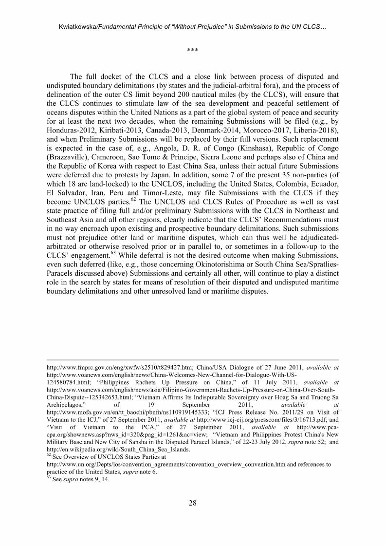
Kwiatkowska/Fundamental Principle of “Without Prejudice” in Submissions to the UN CLCS…
28
***
The full docket of the CLCS and a close link between process of disputed and undisputed boundary delimitations (by states and the judicial-arbitral fora), and the process of delineation of the outer CS limit beyond 200 nautical miles (by the CLCS), will ensure that the CLCS continues to stimulate law of the sea development and peaceful settlement of oceans disputes within the United Nations as a part of the global system of peace and security for at least the next two decades, when the remaining Submissions will be filed (e.g., by Honduras-2012, Kiribati-2013, Canada-2013, Denmark-2014, Morocco-2017, Liberia-2018), and when Preliminary Submissions will be replaced by their full versions. Such replacement is expected in the case of, e.g., Angola, D. R. of Congo (Kinshasa), Republic of Congo (Brazzaville), Cameroon, Sao Tome & Principe, Sierra Leone and perhaps also of China and the Republic of Korea with respect to East China Sea, unless their actual future Submissions were deferred due to protests by Japan. In addition, some 7 of the present 35 non-parties (of which 18 are land-locked) to the UNCLOS, including the United States, Colombia, Ecuador, El Salvador, Iran, Peru and Timor-Leste, may file Submissions with the CLCS if they become UNCLOS parties.62 The UNCLOS and CLCS Rules of Procedure as well as vast state practice of filing full and/or preliminary Submissions with the CLCS in Northeast and Southeast Asia and all other regions, clearly indicate that the CLCS’ Recommendations must in no way encroach upon existing and prospective boundary delimitations. Such submissions must not prejudice other land or maritime disputes, which can thus well be adjudicated-arbitrated or otherwise resolved prior or in parallel to, or sometimes in a follow-up to the CLCS’ engagement.63 While deferral is not the desired outcome when making Submissions, even such deferred (like, e.g., those concerning Okinotorishima or South China Sea/Spratlies-Paracels discussed above) Submissions and certainly all other, will continue to play a distinct role in the search by states for means of resolution of their disputed and undisputed maritime boundary delimitations and other unresolved land or maritime disputes.
http://www.fmprc.gov.cn/eng/xwfw/s2510/t829427.htm; China/USA Dialogue of 27 June 2011, available at http://www.voanews.com/english/news/China-Welcomes-New-Channel-for-Dialogue-With-US-124580784.html; “Philippines Rachets Up Pressure on China,” of 11 July 2011, available at http://www.voanews.com/english/news/asia/Filipino-Government-Rachets-Up-Pressure-on-China-Over-South-China-Dispute--125342653.html; “Vietnam Affirms Its Indisputable Sovereignty over Hoag Sa and Truong Sa Archipelagos,” of 19 September 2011, available at http://www.mofa.gov.vn/en/tt_baochi/pbnfn/ns110919145333; “ICJ Press Release No. 2011/29 on Visit of Vietnam to the ICJ,” of 27 September 2011, available at http://www.icj-cij.org/presscom/files/3/16713.pdf; and “Visit of Vietnam to the PCA,” of 27 September 2011, available at http://www.pca-cpa.org/shownews.asp?nws_id=320&pag_id=1261&ac=view; “Vietnam and Philippines Protest China's New Military Base and New City of Sansha in the Disputed Paracel Islands,” of 22-23 July 2012, supra note 52; and http://en.wikipedia.org/wiki/South_China_Sea_Islands. 62 See Overview of UNCLOS States Parties at http://www.un.org/Depts/los/convention_agreements/convention_overview_convention.htm and references to practice of the United States, supra note 6. 63 See supra notes 9, 14.
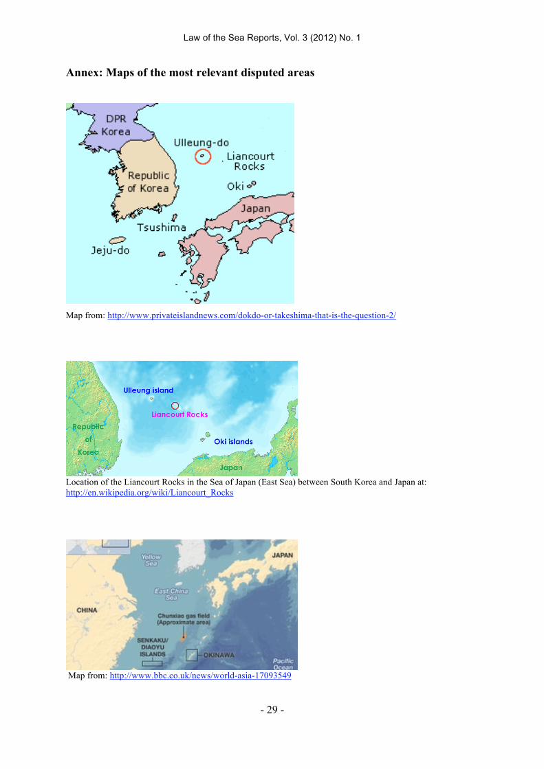
Law of the Sea Reports, Vol. 3 (2012) No. 1
- 29 -
Annex: Maps of the most relevant disputed areas
Map from: http://www.privateislandnews.com/dokdo-or-takeshima-that-is-the-question-2/
Location of the Liancourt Rocks in the Sea of Japan (East Sea) between South Korea and Japan at: http://en.wikipedia.org/wiki/Liancourt_Rocks
Map from: http://www.bbc.co.uk/news/world-asia-17093549
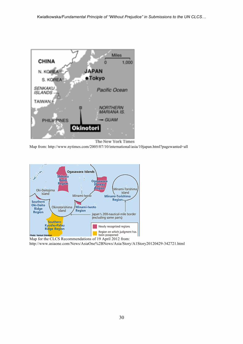
Kwiatkowska/Fundamental Principle of “Without Prejudice” in Submissions to the UN CLCS…
30
Map from: http://www.nytimes.com/2005/07/10/international/asia/10japan.html?pagewanted=all
Map for the CLCS Recommendations of 19 April 2012 from: http://www.asiaone.com/News/AsiaOne%2BNews/Asia/Story/A1Story20120429-342721.html
Law of the Sea Reports, Vol. 3 (2012) No. 1
- 31 -
Map from: Philippines Seeks US Muscle on South China Sea of 9 February 2012 at: http://www.bbc.co.uk/news/world-asia-16926554


![The Fundamental Holographic Uncertainty Principle and its ......World Scientific News 50 (2016) 33-48 -34- 1. INTRODUCTION The holographic principle [1] is the fundamental principle](https://img.pdfslide.net/doc/110x75/612225a1d6a5797f2f2dfe34/the-fundamental-holographic-uncertainty-principle-and-its-world-scientific.jpg)